
Geospatially enabled enterprise asset management -...
12
Geospatially enabled enterprise asset management IBM Software Tivoli March 2010
Transcript of Geospatially enabled enterprise asset management -...
Geospatially enabledenterprise assetmanagement
IBM Software
Tivoli
March 2010
2 Geospatially enabled enterprise asset management
Contents
2 Executive summary
3 Introduction
4 GIS and enterprise asset management
5 Usage scenarios
6 Benefits of geospatially enabled asset management
6 Maximo Spatial Asset Management
6 Maximo Spatial Asset Management use case
8 Key features of Maximo Spatial Asset Management
9 Architecture overview
10 Eliminating data duplication
10 The ESRI-IBM alliance
11 About Maximo software from IBM
11 About Tivoli software from IBM
12 For more information
Executive summaryGeographic information systems (GIS) already play a majorrole across utilities, energy, government, transportation,telecommunications and many other asset-intensive industriesby providing the capability to gather and summarize dataabout the diverse geographic locations and movements ofstrategic assets.
As GIS systems move from departmental, desktop-based solu-tions based on proprietary architectures to enterprise systemsbased on technology standards, organizations now have theopportunity to “spatially enable” a wide range of enterpriseapplications, including enterprise asset management solutions.Spatially enabled applications can support complex data analysis based on geographic location, such as representingdata on maps in various spatial or geographic contexts, anddetermining proximity, adjacency and other location-basedrelationships among objects.
By combining GIS with enterprise asset management businessprocesses in a modern, service-oriented architecture (SOA), aparticularly powerful geospatial solution can be created—onethat enables decision makers across the enterprise to makebetter-informed decisions, helping organizations increase pro-ductivity and efficiency while improving service to customers.
IBM Maximo® Spatial Asset Management was the first solution that unified the full functionality of industry-leadingGIS and enterprise asset management (EAM) in a thoroughlymodern architecture based on Java™, XML and Web services.With access to the full feature set of the industry-leadingESRI ArcGIS Server, its capabilities go far beyond the genera-tion of static maps that typify traditional GIS/EAM integra-tions. For example, Maximo Spatial Asset Managementsupports queries like “Show me the locations of any unitswithin one mile of this failed unit’s location that have not yetbeen inspected this year,” or “Show me the units most likelyto be affected in the event of a flood in this area.”
3IBM Software
Organizations that own, operate and/or manage geographi-cally dispersed assets can accrue significant business benefitsby further leveraging the tremendous value of their GIS-related investments in this way. Maximo Spatial AssetManagement enables enterprise asset management users toview assets in a geospatial context, so they can more easily anddynamically visualize the spatial relationships among managedassets and the roads, buildings, pipelines, and other mappedfeatures around them, empowering levels of awareness andinsight that dry numbers alone cannot provide. Similarly, awide range of asset-related data becomes available to GISusers to enrich their decision-making context as well. Noduplication of data is required to support this unified view ofasset and geospatial data.
This paper offers an overview of the key features and businessbenefits of the Maximo Spatial Asset Management solution, aswell as a high-level description of its architecture.
IntroductionGeographic location is a fundamental reference point in thephysical world. As enterprise business systems evolve to moreaccurately reflect real-world conditions, the capability to rep-resent location has become increasingly critical.
GIS software creates, organizes, maintains, analyzes and visualizes information related to location. Among these corecapabilities, mapping—i.e., the visualization of location-baseddata—is by far the most recognizable function that GIS sys-tems perform. Other fundamental GIS capabilities that arehighly valuable in the asset management context include prox-imity functions to more quickly determine adjacency, nearness,shortest distance, shortest path and other related functions.
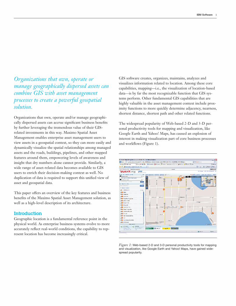
The widespread popularity of Web-based 2-D and 3-D per-sonal productivity tools for mapping and visualization, likeGoogle Earth and Yahoo! Maps, has caused an explosion ofinterest in making visualization part of core business processesand workflows (Figure 1).
Figure 1: Web-based 2-D and 3-D personal productivity tools for mappingand visualization, like Google Earth and Yahoo! Maps, have gained wide-spread popularity.
Organizations that own, operate or manage geographically dispersed assets cancombine GIS with asset managementprocesses to create a powerful geospatialsolution.
4 Geospatially enabled enterprise asset management
While GIS technology has long been valued for its capabilityto display features (such as pipes, wires and buildings) and tohelp reduce costs by enhancing decision making, the value oftraditional desktop-based GIS has often been limited to workgroup, project or departmental-level activities within theenterprise. GIS applications have largely been robust, verti-cally integrated, client/server systems that are optimized tosupport specific business workflows like utility asset manage-ment, land or natural resources management, linear assetmanagement, and many similar applications.
However, the geospatial data and analytical capabilities thatGIS technology makes possible are now beginning to be leveraged by an ever-wider range of business users, as GISimplementations evolve from proprietary architectures to networked, server-based solutions that leverage SOAs andWeb controls.
GIS and enterprise asset managementGeospatial technology and data can extend the capabilities ofasset and service management systems in a number of funda-mental ways, including:
Enhancing spatial context. Along with time, location is a fun-damental reference point for countless human activities. Inasset and service management systems, location data providesa useful context that makes other asset-related data moremeaningful. For example, the capability to visualize the loca-tions of recent asset failures on a map can provide the contextneeded to spot a trend that might well be missed by looking ata table of data.
Geospatial technology and data can extend the capabilities of asset and servicemanagement systems in a number of fundamental ways.
Improving measurement capabilities. Geospatial data canhelp us understand the physical relationships among assets,such as the distance between them for routing purposes. Thisdata also makes it possible to judge proximity, such as deter-mining if something is “nearby” or “within” something else.
Extending modeling options. Analyzing and visualizinggeospatial patterns can help identify trends and predict futureevents with greater accuracy. The ability to analyze unifiedGIS/asset management data sets enables you to ask questionssuch as: What unpaved roads washed out due to floodingmore than twice in the past year? Is this the result of land usechanges in those areas, resulting in increased runoff and, if so,might it make sense to pave those roads?
Deeper knowledge about asset locations. Many organizationswith widely dispersed assets, such as municipal water utilities,electric and gas distribution utilities, and departments oftransportation, find it useful to track the locations of assetsover time. GIS provides a robust framework for managingthese types of data to better support asset management activi-ties, from documenting efforts to complying with federal man-dates on gas pipelines, to the ability to more quickly locateopen work orders pertaining to nearby assets when a crew fin-ishes a job early.
Greatly improved visualization capabilities. Visually display-ing location data on maps is the most familiar, and often themost valuable, use of geospatial technology. Applying thiscapability to strategic assets has a vast range of implicationsfor improving business performance.
5IBM Software
Usage scenariosGeospatially enabled asset management systems better supportcustomer service, work order management, emergency (out-age) response, mobile dispatch and more. A geospatiallyenabled asset management system permits users to know thatan asset exists (as well as information about its condition, cost,maintenance history, etc.) and precisely where it is on a mapand in relationship to other assets of various types.
In government public safety operations, for example, geospa-tially enabled asset management systems are the key IT components that support core business information needs,from a “common operating picture” of current assets and theircondition to “situational awareness” dashboards that displayhow and where assets are deployed in real time.
There are numerous other applications, such as thosedescribed below, where the capability to dynamically combineGIS and asset management data is particularly powerful.
Work planning, scheduling and execution. Using a map inter-polated from GIS and asset location data, planners are able tovisualize current and potential work locations for decision-making purposes. They can, for instance, pinpoint the locationof a single utility pole among thousands and automaticallygenerate a work order to repair or replace it.
Geospatially enabled asset management sys-tems better support customer service, workorder management, emergency response,mobile dispatch and more.
Locating assets for inspection, maintenance and repair. Atlarge facilities, such as a military base, it can be challenging tolocate assets for preventive and corrective maintenance activi-ties. A geospatially enabled asset management system can cre-ate a map on which asset locations, including their GlobalPositioning System (GPS) coordinates, are color-coded toindicate condition, exposure, time since last maintenance, etc.Combining geospatial referents with desired asset attributeshelps coordinate inspection and maintenance activities andserves as a basis for planning routes and optimizing resources.
Call center. Using a GIS-based map, call center agents canmore rapidly pinpoint trouble locations by entering a keyidentifier (nearest intersection or cross street, customeraddress, etc.). The agent can then check whether other troublehas been reported nearby, whether a crew is assigned, and thestatus of the existing work order(s). The GIS can show therelated infrastructure, thus providing a more comprehensiveview of the situation. If needed, the agent can initiate a newwork request.
Decision support. Enterprise decision makers can leverageGIS-based mapping capabilities in combination with assetmanagement data to facilitate investment planning or otherforms of analysis. For example, upon viewing a map showingthe locations of all pipe repair work orders on water mainsover a specified period, managers can better determinewhether it makes economic sense to replace the water main.Both “outside plant” and “inside plant” analyses are enabledby a single system, simplifying high-level analysis and model-ing efforts.
6 Geospatially enabled enterprise asset management
Benefits of geospatially enabled assetmanagementBy leveraging extended asset management capabilities, govern-ment and commercial enterprises can derive fundamental,cross-functional benefits from geospatially enabling their assetand work management business processes. These potentialbenefits include:
Cost savings through greater efficiency. Streamlining workand scheduling activities, such as the logistics of maintainingassets, can help organizations save labor, time and materials.
Better informed decision making. Knowing more aboutwhere assets are located spatially and relative to one anothernaturally improves both tactical and strategic decision making,from better route selection to improved long-range planningof inspection, maintenance and repair activities.
Enhanced communication and collaboration. Maps and visu-alizations created using GIS data make it possible for individu-als and teams to view and understand situations more quicklyand completely. Maps provide an intuitive, visual frameworkfor conceptualizing, understanding and determining activities.Ultimately, “the map becomes the report,” illustrating keyrelationships and insights in an intuitive, visual manner thatstakeholders can better relate to.
Creation of new business value. Through its support for newforms of data analysis and insight, geospatially enabling theasset management system can help drive new sources of busi-ness value and possibly even change how business is done. Bycreating a single source of information, all disciplines in theorganization have access to the same information at the sametime, eliminating the need to track data in multiple locationsor synchronize asset attributes between the GIS and assetmanagement systems.
Maximo Spatial Asset Management is ageospatially enabled asset managementsolution that makes the power of desktopGIS directly available to enterprise assetmanagement users.
Maximo Spatial Asset ManagementMaximo Spatial Asset Management is a geospatially enabledasset management solution that enables users to visualize allassets and work in a geospatial context to help optimizeresources and decisions enterprise-wide.
While the integration of asset and work management withGIS is not a new idea, the technology approach taken by thissolution, and the capabilities it delivers, represent a new levelof innovation, usability and business value. Combining theArcGIS Server from ESRI with the Maximo asset manage-ment solution using standards-based, service-oriented technology common to both architectures, Maximo SpatialAsset Management makes the power of desktop GIS directlyavailable to enterprise asset management users. It offers aseamless user experience that incorporates map-based userinterfaces, dynamic access to GIS data and interoperabilitywith other GIS systems and data sets.
Maximo Spatial Asset Management use caseMaximo Spatial Asset Management can help organizationsidentify and plan work by enabling call center agents, supervi-sors and others to more easily locate assets geographically and
7IBM Software
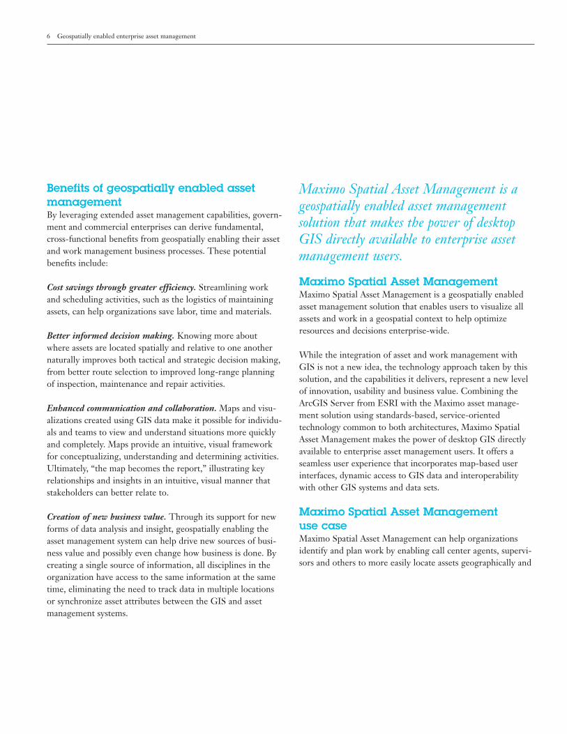
Figure 3: Viewing the infrastructure agents can determine the exact loca-tion of the hydrant.
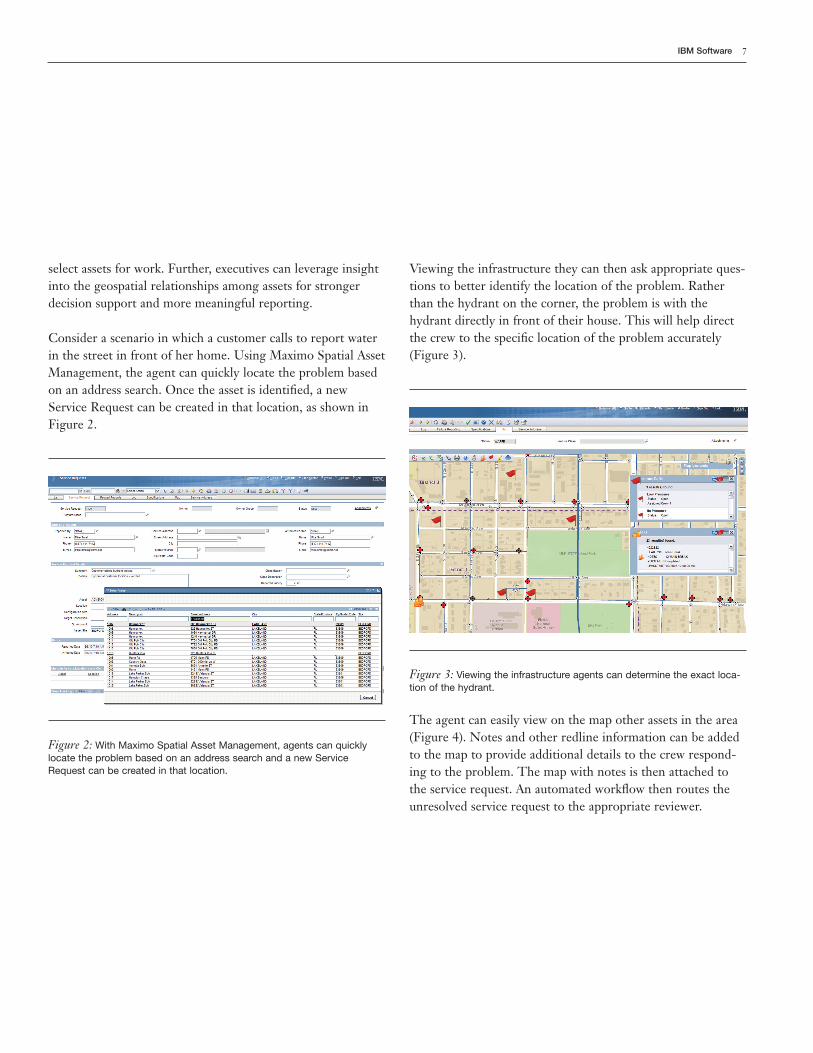
The agent can easily view on the map other assets in the area(Figure 4). Notes and other redline information can be addedto the map to provide additional details to the crew respond-ing to the problem. The map with notes is then attached tothe service request. An automated workflow then routes theunresolved service request to the appropriate reviewer.
Viewing the infrastructure they can then ask appropriate ques-tions to better identify the location of the problem. Ratherthan the hydrant on the corner, the problem is with thehydrant directly in front of their house. This will help directthe crew to the specific location of the problem accurately(Figure 3).
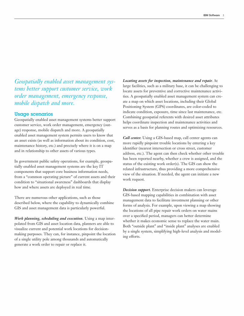
Figure 2: With Maximo Spatial Asset Management, agents can quicklylocate the problem based on an address search and a new ServiceRequest can be created in that location.
select assets for work. Further, executives can leverage insightinto the geospatial relationships among assets for strongerdecision support and more meaningful reporting.
Consider a scenario in which a customer calls to report waterin the street in front of her home. Using Maximo Spatial AssetManagement, the agent can quickly locate the problem basedon an address search. Once the asset is identified, a newService Request can be created in that location, as shown inFigure 2.
8 Geospatially enabled enterprise asset management
Key features of Maximo Spatial AssetManagementGoing far beyond simply publishing static images of assetlocations, embedding ArcGIS Server Java controls directlyinto the Maximo software provides access to the full power ofGIS for spatial analysis, tracing, location-based services, etc.,from within the Maximo application. This uniquely rich andpowerful functional integration reflects the investments bothESRI and IBM have made in component architectures.
Any Maximo entity can be spatially enabled: Assets, ServiceRequests, Locations, and Work Orders are currently enabled.This allows work orders and service requests to be createddirectly on maps. Results sets from Maximo software queriescan be viewed on maps, or selected from maps to form resultssets in the Maximo application.
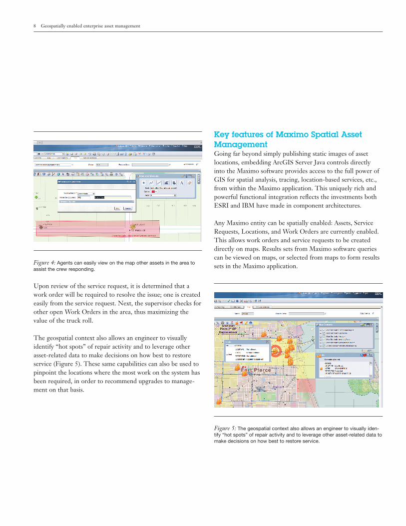
Figure 5: The geospatial context also allows an engineer to visually iden-tify “hot spots” of repair activity and to leverage other asset-related data tomake decisions on how best to restore service.
Figure 4: Agents can easily view on the map other assets in the area toassist the crew responding.
Upon review of the service request, it is determined that awork order will be required to resolve the issue; one is createdeasily from the service request. Next, the supervisor checks forother open Work Orders in the area, thus maximizing thevalue of the truck roll.
The geospatial context also allows an engineer to visuallyidentify “hot spots” of repair activity and to leverage otherasset-related data to make decisions on how best to restoreservice (Figure 5). These same capabilities can also be used topinpoint the locations where the most work on the system hasbeen required, in order to recommend upgrades to manage-ment on that basis.
9IBM Software
● GIS data entered in the Maximo application can be editedby the standard ESRI desktop applications.
● Because of its SOA-based architecture and ArcGIS compo-nents, Maximo Spatial Asset Management can leverage datafrom virtually any external GIS data source. Examplesinclude GPS Automatic Vehicle Location (AVL) feeds totrack resources, assets, and tools, and data from services suchas Federal Emergency Management Agency (FEMA) forflood plain data, census data, and data in other Web servicescompatible formats.
The Maximo Spatial Asset Management solution is a dynamicframework for unified, enterprise-scale, geospatially enabledenterprise asset management. This means that when ESRIcreates new features for its ArcGIS product family, MaximoSpatial Asset Management users can enjoy seamless, immedi-ate access to these features.
Maximo Spatial Asset Management leverages the full feature set of the industry-leading ESRI ArcGIS Server.
Architecture overviewThe Maximo asset management solution, developed by theMaximo business unit within the IBM Tivoli® software brand,is the industry’s leading enterprise asset management solution.ArcGIS Server is the state of the art in GIS from ESRI.
To combine the power and business value of these two industry-leading solutions, Maximo Spatial Asset Managementtakes advantage of the component architecture in ArcGISServer software. ESRI ArcObjects and IBM Maximo BusinessObjects, both Java-based, are utilized in combination with
● Maximo Spatial Asset Management provides a valid geospa-tial context for all asset and location types: Linear (roads,rails, pipelines, power lines, waterways); Area/Polygon(buildings, roofs, forests, service areas, campuses, offices);and Points (poles, hydrants, meters, signs, transformers,houses).
● Maximo Spatial Asset Management supports geocoding—the capability to convert street addresses and similar locationdata into latitude/longitude (GPS) coordinates, and viceversa. This capability is the foundation for capturing assetlocation data in the field using GPS.
● Maximo Spatial Asset Management could support tracingnetworks—the capability to spatially relate the componentsof a pipeline system or network, taking into account thedirection of “flow” of the gas, water, electricity, etc. Thiscapability is the foundation for determining which cus-tomers will be affected by maintenance activities and otherservice interruptions.
● Maximo Spatial Asset Management could support enhancedrouting or route planning capabilities by providing core GISrouting capabilities in combination with rich asset manage-ment data such as maintenance and other historical data.
● Maximo Spatial Asset Management gives asset managementusers the ability to more conveniently edit certain GIS-based data elements from within the familiar Maximo soft-ware interface.
● When working with GIS data in the Maximo application, allMaximo Administration Controls are supported (Security,Organizations, Sites, Stored Queries, Preferences, etc.).There is no need to set up special security for MaximoSpatial Asset Management; for instance, a maintenanceworker can see the GPS coordinates of a customer but willnot be able to access the customer’s account data.
10 Geospatially enabled enterprise asset management
Eliminating data duplicationCurrently, many systems require you to copy or synchronizeGIS data to work with it in other applications, introducingsignificant IT complexity and cost. Maximo Spatial AssetManagement offers full flexibility in how organizations set uptheir GIS and asset management database instances. Complexqueries across database instances are supported without theneed for data duplication or synchronization.
When a relationship exists between a feature class in the GISenvironment and an asset in the Maximo application, the twocan be linked and viewed together within the Maximo Maptab. GIS maps and data are not duplicated; instead, the mostcurrent data is dynamically accessed on request.
ESRI ArcGIS Server also includes powerful data interoper-ability extensions that allow Maximo Spatial AssetManagement to interoperate with a number of competitiveGIS systems. In addition, ArcGIS Server can “read” some 70 data types and interoperate with the great majority of them.
The ESRI-IBM allianceFor more than 20 years, IBM and ESRI have offered integrated, enterprise-scale spatial information managementand geospatial analytic solutions for large government andcommercial organizations. Over 10 years ago, the two firmsestablished an ongoing Strategic Alliance partnership thatcombines the strengths of both companies: IBM’s worldwideleadership in information technology, SOA, server hardwareand business consulting services; and ESRI’s 40 years of lead-ership in GIS software solutions, function, industry domainexpertise and services skills.
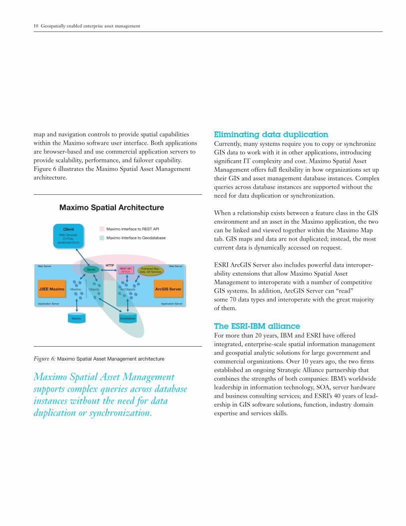
Maximo
Maximo
Servlet REST APIJS/DoJo
Published Map,Data, GP Services
Geodatabase
Objects ArcObjectsJ2EE Maximo
HTTP
ArcGIS Server
Web Server Web Server
Application Server Application Server
Client
Maximo Spatial Architecture
Maximo Interface to REST API
Maximo Interface to GeodatabaseWeb Browser
DHTMLJavaScript/DoJo
Figure 6: Maximo Spatial Asset Management architecture
map and navigation controls to provide spatial capabilitieswithin the Maximo software user interface. Both applicationsare browser-based and use commercial application servers toprovide scalability, performance, and failover capability. Figure 6 illustrates the Maximo Spatial Asset Managementarchitecture.
Maximo Spatial Asset Management supports complex queries across databaseinstances without the need for data duplication or synchronization.
11IBM Software
About Maximo software from IBMIBM Maximo software was recently named the #1 marketshare and technology leader by ARC Advisory Group in its2009 EAM/CMMS Solutions Worldwide Outlook—MarketAnalysis and Forecast Through 2013.1 IBM Maximo softwareis used by many of the world’s top companies to efficientlymanage how they buy, maintain and retire assets—such as production equipment, facilities, transportation and IThardware and software—in a wide variety of industries includ-ing utilities, manufacturing, energy, pharmaceutical, andtelecommunications. IBM Maximo software builds uponIBM’s strategy to leverage business consulting, IT services andsoftware to develop repeatable tools that help clients optimizeand transform their businesses.
About Tivoli software from IBMTivoli software provides a set of offerings and capabilities insupport of IBM Service Management, a scalable, modularapproach used to deliver more efficient and effective servicesto your business. Helping meet the needs of any size business,Tivoli software enables you to deliver service excellence insupport of your business objectives through integration andautomation of processes, workflows and tasks. The security-rich, open standards-based Tivoli service management platform is complemented by proactive operational manage-ment solutions that provide end-to-end visibility and control.It is also backed by world-class IBM Services, IBM Supportand an active ecosystem of IBM Business Partners. Tivoli customers and business partners can also leverage each other’s best practices by participating in independently runIBM Tivoli User Groups around the world. To learn more,visit www.tivoli-ug.org
Our Strategic Alliance partnership ensures a commitment toour customers and partners in a number of critical ways:
● Provides innovative, comprehensive business solutions likeMaximo Spatial to our joint customers comprised of bothoff-the-shelf software products and spatial services.
● Defines a collaborative business environment comprised ofdeep, development-level technical exchange, customer sup-port, and geospatial and SOA services engagement.
● IBM’s Spatial Services consultants can help implement and integrate Maximo, Maximo Spatial and ESRI ArcGISServer to enable greater visibility and facilitate better deci-sion making.
● Maintains close corporate communications to move quicklyto address the business challenges of joint customers wheregeospatial data and/or functionality are important.
● Leverages the strengths of ESRI’s geospatial toolset andservices capabilities and IBM’s strengths in enterprise assetmanagement software, IT middleware, services, and hardware to forge innovative, competitive, leading business solutions.
● Develops recognized leadership as a closely coordinated,technology and business team in the geospatial enterpriseapplications marketplace.
Together, IBM and ESRI provide unmatched GIS-enabledasset management solutions and services that may be lever-aged by leading organizations to realize new business value,enhance business workflows, and lower costs.
Please Recycle
The customer is responsible for ensuring compliance with legalrequirements. It is the customer’s sole responsibility to obtain advice ofcompetent legal counsel as to the identification and interpretation ofany relevant laws and regulatory requirements that may affect thecustomer’s business and any actions the customer may need to take tocomply with such laws. IBM does not provide legal advice or representor warrant that its services or products will ensure that the customer isin compliance with any law or regulation.
1 According to ARC Advisory Group’s 2009 EAM/CMMS SolutionsWorldwide Outlook (Market Analysis and Forecast Through 2013).
TIW14001-USEN-01
© Copyright IBM Corporation 2010
IBM CorporationSoftware GroupRoute 100Somers, NY 10589U.S.A.
Produced in the United States of AmericaMarch 2010All Rights Reserved
IBM, the IBM logo, ibm.com, Maximo and Tivoli are trademarks orregistered trademarks of International Business Machines Corporation inthe United States, other countries, or both. If these and otherIBM trademarked terms are marked on their first occurrence in thisinformation with a trademark symbol (® or ™), these symbols indicateU.S. registered or common law trademarks owned by IBM at the time this information was published. Such trademarks may also be registered or common law trademarks in other countries. A current list ofIBM trademarks is available on the Web at “Copyright and trademarkinformation” at ibm.com/legal/copytrade.shtml
Other product, company or service names may be trademarks or servicemarks of others.
References in this publication to IBM products and services do not implythat IBM intends to make them available in all countries in whichIBM operates.
Product data has been reviewed for accuracy as of the date of initialpublication. Product data is subject to change without notice. Anystatements regarding IBM’s future direction and intent are subject tochange or withdrawal without notice, and represent goals and objectives only.
THE INFORMATION PROVIDED IN THIS DOCUMENT ISDISTRIBUTED “AS IS” WITHOUT ANY WARRANTY, EITHEREXPRESS OR IMPLIED. IBM EXPRESSLY DISCLAIMS ANYWARRANTIES OF MERCHANTABILITY, FITNESS FOR APARTICULAR PURPOSE OR NON-INFRINGEMENT.IBM products are warranted according to the terms and conditions of the agreements (e.g. IBM Customer Agreement, Statement of LimitedWarranty, International Program License Agreement, etc.) under whichthey are provided.
For more informationTo learn more about IBM Maximo Spatial Asset Management,please contact your IBM representative or IBM BusinessPartner, or visit:
ibm.com/maximospatialibm.com/tivoli/maximo
Additionally, IBM Global Financing can tailor financing solu-tions to your specific IT needs. For more information on greatrates, flexible payment plans and loans, and asset buyback anddisposal, visit: ibm.com/financing