Geophysical Survey Report Produced for CgMs Consulting...
17
Magna Park II – Plot 2 Lutterworth, Leicestershire Geophysical Survey Report Produced for CgMs Consulting Project code LTL141 14 th April 2015 R Fry, Geophysicist BA(Hons) MSc PhD MJ Roseveare, Senior Geophysicist BSc(Hons) MSc MEAGE FGS MCIfA ArchaeoPhysica Ltd Kitchener’s, Home Farm, Harewood End, Hereford HR2 8JS Tel. +44 (0) 1989 730 564 www.archaeophysica.com
Transcript of Geophysical Survey Report Produced for CgMs Consulting...

Magna Park II – Plot 2 Lutterworth, Leicestershire
Geophysical Survey Report
Produced for CgMs Consulting
Project code LTL141
14th April 2015
R Fry, Geophysicist BA(Hons) MSc PhD
MJ Roseveare, Senior Geophysicist BSc(Hons) MSc MEAGE FGS MCIfA
ArchaeoPhysica Ltd Kitchener’s, Home Farm, Harewood End, Hereford HR2 8JS
Tel. +44 (0) 1989 730 564 www.archaeophysica.com

LTL141 Magna Park II – Lutterworth, LeicestershireAP_LTL141_Whole Area_Report_F.odt © ArchaeoPhysica Ltd 2015 Page ii
Non-Technical SummaryA magnetic survey was commissioned by CgMs Consulting to prospect land adjacent to Magna Park, Lutterworth, Leicestershire for buried structures of archaeological interest.
The survey has identified several areas of potential archaeological interest within the survey area, especially within fields 1, 2, 4, 5, 9, 16, 17 & 21. Within these fields, linear and curvilinear anomalies of enhanced magnetic field are extensive, especially surrounding the DMV and over higher regions. It seems likely that these anomalies of archaeological interest are either associated with the Romano-British findspots, or the Medieval settlement here.
Throughout the fields (especially field 2, 4 & 5) there is extensive evidence of medieval ridge and furrow cultivation, which in some areas, helps to define the probable field system pattern from this period.
Digital DataItem Sent to Sent dateCAD – Vector Elements Simon Mortimer 1st April 2015
AuditVersion Author Checked DateInterim R Fry, MJ Roseveare 1st April 2015Draft Final R Fry, MJ Roseveare ACK Roseveare 14th April 2015Final R Fry, MJ Roseveare MJ Roseveare 29th April 2015RevisionOASIS
- magnetics, electromagnetics, electrical resistance, GPR, topography, landscape & GIS -

LTL141 Magna Park II – Lutterworth, LeicestershireAP_LTL141_Whole Area_Report_F.odt © ArchaeoPhysica Ltd 2015 Page iii
Table of Contents1 Introduction...............................................................................................................................11.1 Location.........................................................................................................................................11.2 Constraints & variations..................................................................................................................12 Context.......................................................................................................................................12.1 Archaeology...................................................................................................................................12.2 Environment..................................................................................................................................23 Methodology...............................................................................................................................23.1 Survey...........................................................................................................................................2
3.1.1 Technical equipment..............................................................................................................23.1.2 Monitoring & quality assessment.............................................................................................2
3.2 Data processing.............................................................................................................................33.2.1 Procedure..............................................................................................................................3
3.3 Interpretation resources.................................................................................................................33.4 Interpretive classes........................................................................................................................3
3.4.1 Introduction..........................................................................................................................33.4.2 Agriculture – boundaries........................................................................................................43.4.3 Agriculture – cultivation..........................................................................................................43.4.4 Agriculture – drains................................................................................................................43.4.5 Archaeology – fills..................................................................................................................43.4.6 Archaeology – other discrete..................................................................................................43.4.7 Archaeology – structures........................................................................................................43.4.8 Archaeology – zones..............................................................................................................53.4.9 Geology – discrete.................................................................................................................53.4.10 Geology – zones..................................................................................................................53.4.11 Services...............................................................................................................................53.4.12 Texture................................................................................................................................5
3.5 Standards & guidance.....................................................................................................................54 Discussion...................................................................................................................................64.1 Introduction...................................................................................................................................64.2 Principles.......................................................................................................................................6
4.2.1 Instrumentation.....................................................................................................................64.3 Character & principal results...........................................................................................................6
4.3.1 Archaeology..........................................................................................................................74.3.2 Land use...............................................................................................................................94.3.3 Geology and data character – overview ................................................................................10
4.4 Conclusions..................................................................................................................................104.5 Caveats........................................................................................................................................114.6 Bibliography & selected reference..................................................................................................115 Appendices...............................................................................................................................135.1 Project metadata..........................................................................................................................135.2 Archiving......................................................................................................................................135.3 ArchaeoPhysica............................................................................................................................13
5.3.1 The company.......................................................................................................................135.3.2 Senior Geophysicist: Martin J Roseveare, MSc BSc(Hons) MEAGE FGS MCIfA...........................145.3.3 Operations Manager: Anne CK Roseveare, BEng(Hons) DIS MISoilSci......................................145.3.4 Geophysicist: Robert Fry, PhD MSc BA(Hons).........................................................................145.3.5 Geophysicist: Samuel Purvis, MSc BSc(Hons) ........................................................................14
- magnetics, electromagnetics, electrical resistance, GPR, topography, landscape & GIS -

LTL141 Magna Park II – Lutterworth, LeicestershireAP_LTL141_Whole Area_Report_F.odt © ArchaeoPhysica Ltd 2015 Page 1
1 IntroductionLand adjacent to Magna Park, Lutterworth, Leicestershire was surveyed to prospect for buried structures of archaeological interest. Approximately 189.5 hectares was surveyed across multiple agricultural fields.
1.1 Location
Country EnglandCounty LeicestershireNearest Settlement LutterworthCentral Co-ordinates 450715, 285597
1.2 Constraints & variations
Across the site, the survey has been successfully conducted where possible. As mentioned in an earlier report from the same overall survey (Fry & Roseveare, 2015), the centre of field 14 was unable to be surveyed as it was too waterlogged and soft to be traversed practically and safely. Field 22 was also not surveyed due to issues with access and livestock contained within. At the time of writing the report, field 7 (scheduled DMV) has not yet been surveyed. A report on this area will follow separately.
2 Context
2.1 Archaeology
The survey area has been subject to a desk-based assessment by CgMs Consulting (2014) and is summarised below. The summary of the assessments states that the survey area “........contains the archaeological remains of a possible Roman villa, an area of Romano-British occupation activity and the Scheduled and non-Scheduled remains of Bittesby Deserted Medieval Settlement, which has Late Saxon origins. Assessment of the study site also indicates it has an unknown potential for significant Prehistoric evidence and a negligible potential for post-medieval/medieval evidence.”
The evidence for prehistoric activity comprises flint find-spots recovered to the west of the medieval settlement of Bittesby by fieldwalking survey. A Palaeolithic flint (MLE 16462) was recovered along with a scatter of later Neolithic and Bronze Age flints (MLE1711).
There is more evidence for Roman activity within the survey area, with a possible villa with tessellated floor and bath (MLE 1230) referred to in antiquarian accounts as being discovered during the railway construction. Roman pottery is recorded in the immediate vicinity of the possible villa (MLE16461). Approximately 400metres to the east of the railway line a large quantity of Roman finds, including building debris, suggests another area of potential settlement activity (MLE21337).
The scheduled (SM17034) and non-scheduled (MLE1226 and MLE1230) medieval settlement of Bittesby occupies the central area of the site. A small area of magnetic survey (ELE 4713) was undertaken on the western side of the railway embankment opposite the scheduled area; the results showing further remains of potential medieval settlement.
The settlement was surrounded by an agricultural landscape and the location of direction of ridge and furrow field systems has been recorded by the Leicestershire HER. OS mapping from 1886-7 onwards shows the removal of a few field boundaries and other changes towards the southern end near Bittesby House as the World War II air base was constructed.
- magnetics, electromagnetics, electrical resistance, GPR, topography, landscape & GIS -

LTL141 Magna Park II – Lutterworth, LeicestershireAP_LTL141_Whole Area_Report_F.odt © ArchaeoPhysica Ltd 2015 Page 2
2.2 Environment
Soils UKSO Slowly permeable seasonally wet slightly acid but base-rich loamy and clayey soils (18)
Superficial 1: 50000 BGS Oadby Member - Diamicton (ODT) across majority of site. Alluvium - Clay, Silt, Sand And Gravel (ALV) along NW edge of site.
Bedrock 1:50000 BGS Blue Lias Formation - Mudstone And Limestone (BLI)Topography Gently undulating 100-125m OD, multiple local minor high pointsHydrology Impeded drainage, expected agricultural tile drains, moling & subsoilingCurrent Land Use Mixed agriculturalHistoric Land Use Mixed agricultural, settlementVegetation Cover Stubble, bare soil, grassSources of Interference Potential from services, traffic on A5
The response of magnetic survey is dependent upon the soil’s ability to support magnetic susceptibility enhancement and therefore the parent material and land use. The response from soils derived from mudstone is presumed to be muted but satisfactory and will depend upon the overlying superficial cover. Over limestone, the response may be variable, however it is also dependant on the overlying superficial cover.
Diamicton gravels usually provide a smoothly variable background texture associated with relatively non-magnetic soils against which anomalies from archaeological sources tend to be of variable contrast. It is common for magnetic field anomalies associated with linear features such as ridge and furrow cultivation to have irregular magnitudes across an area and therefore the production of a coherent plan of buried structures is sometimes not possible. For this site specifically, the archaeological interpretation is not thought to have been affected.
3 Methodology
3.1 Survey
3.1.1 Technical equipment
Measured variable Magnetic flux density / nTInstrument Array of Geometrics G858 Magmapper caesium magnetometersConfiguration Non-gradiometric transverse array (6 sensors, ATV towed)Sensitivity 0.03 nT @ 10 Hz (manufacturer’s specification)QA Procedure Continuous observationSpatial resolution 1.0m between lines, 0.3m mean along line interval
3.1.2 Monitoring & quality assessment
The system continuously displays all incoming data as well as line speed and spatial data resolution per acquisition channel during survey. Rest mode system noise is therefore easy to inspect simply by pausing during survey, and the continuous display makes monitoring for quality intrinsic to the process of undertaking a survey. Rest mode test results (static test) are available from the system.
- magnetics, electromagnetics, electrical resistance, GPR, topography, landscape & GIS -
LTL141 Magna Park II – Lutterworth, LeicestershireAP_LTL141_Whole Area_Report_F.odt © ArchaeoPhysica Ltd 2015 Page 3
3.2 Data processing
3.2.1 Procedure
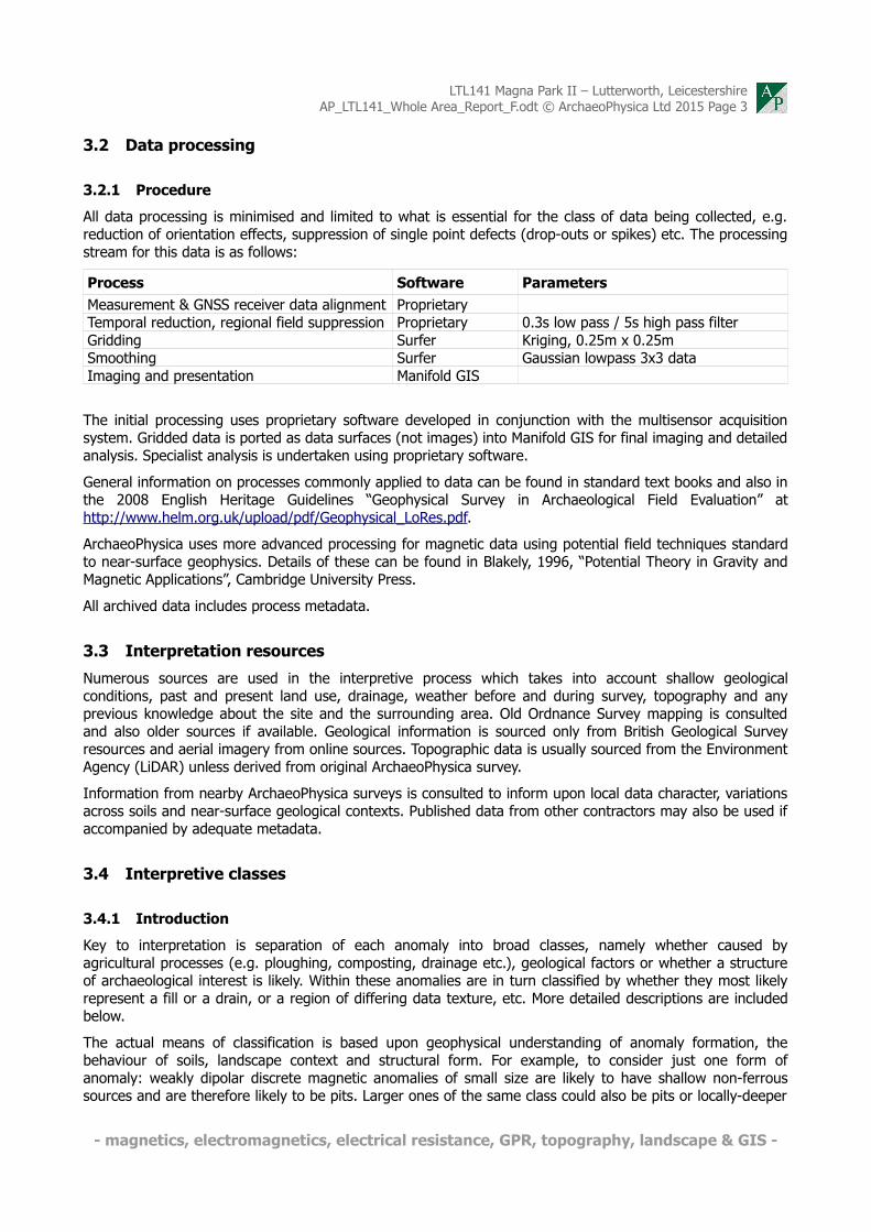
All data processing is minimised and limited to what is essential for the class of data being collected, e.g. reduction of orientation effects, suppression of single point defects (drop-outs or spikes) etc. The processing stream for this data is as follows:
Process Software ParametersMeasurement & GNSS receiver data alignment ProprietaryTemporal reduction, regional field suppression Proprietary 0.3s low pass / 5s high pass filterGridding Surfer Kriging, 0.25m x 0.25mSmoothing Surfer Gaussian lowpass 3x3 dataImaging and presentation Manifold GIS
The initial processing uses proprietary software developed in conjunction with the multisensor acquisition system. Gridded data is ported as data surfaces (not images) into Manifold GIS for final imaging and detailed analysis. Specialist analysis is undertaken using proprietary software.
General information on processes commonly applied to data can be found in standard text books and also in the 2008 English Heritage Guidelines “Geophysical Survey in Archaeological Field Evaluation” at http://www.helm.org.uk/upload/pdf/Geophysical_LoRes.pdf.
ArchaeoPhysica uses more advanced processing for magnetic data using potential field techniques standard to near-surface geophysics. Details of these can be found in Blakely, 1996, “Potential Theory in Gravity and Magnetic Applications”, Cambridge University Press.
All archived data includes process metadata.
3.3 Interpretation resources
Numerous sources are used in the interpretive process which takes into account shallow geological conditions, past and present land use, drainage, weather before and during survey, topography and any previous knowledge about the site and the surrounding area. Old Ordnance Survey mapping is consulted and also older sources if available. Geological information is sourced only from British Geological Survey resources and aerial imagery from online sources. Topographic data is usually sourced from the Environment Agency (LiDAR) unless derived from original ArchaeoPhysica survey.
Information from nearby ArchaeoPhysica surveys is consulted to inform upon local data character, variations across soils and near-surface geological contexts. Published data from other contractors may also be used if accompanied by adequate metadata.
3.4 Interpretive classes
3.4.1 Introduction
Key to interpretation is separation of each anomaly into broad classes, namely whether caused by agricultural processes (e.g. ploughing, composting, drainage etc.), geological factors or whether a structure of archaeological interest is likely. Within these anomalies are in turn classified by whether they most likely represent a fill or a drain, or a region of differing data texture, etc. More detailed descriptions are included below.
The actual means of classification is based upon geophysical understanding of anomaly formation, the behaviour of soils, landscape context and structural form. For example, to consider just one form of anomaly: weakly dipolar discrete magnetic anomalies of small size are likely to have shallow non-ferrous sources and are therefore likely to be pits. Larger ones of the same class could also be pits or locally-deeper
- magnetics, electromagnetics, electrical resistance, GPR, topography, landscape & GIS -

LTL141 Magna Park II – Lutterworth, LeicestershireAP_LTL141_Whole Area_Report_F.odt © ArchaeoPhysica Ltd 2015 Page 4
topsoil but if strongly magnetic could also be hearths. Strongly dipolar discrete anomalies are in all cases likely to be ferrous or similarly magnetic debris, although small repeatedly heated and in-situ hearths can produce similar anomalies.
3.4.2 Agriculture – boundaries
Coherent linear dipolar enhancement of magnetic field strength marking ditch fills, narrow bands of more variable magnetic field or changes in apparent magnetic susceptibility, are all included within this category if they correlate with boundaries depicted on the Tithe Map or early Ordnance Survey maps. If there is no correlation then these anomaly types are not categorised as a field boundaries.
3.4.3 Agriculture – cultivation
Banded variations in apparent magnetic susceptibility caused by a variable thickness of topsoil, depositional remanent magnetisation of sediments in furrows or susceptibility enhancement through heating (a by product of burning organic matter like seaweed) tend to indicate past cultivation, whether ridge-based techniques, medieval ridge and furrow or post medieval 'lazy beds'. Modern cultivation, e.g. recent ploughing, is not included.
3.4.4 Agriculture – drains
In some cases it is possible to identify drainage networks either as ditch-fill type anomalies (typically 'Roman' drains), noisy or repeating dipolar anomalies from terracotta pipes or reduced magnetic field strength anomalies from culverts, plastic or non-reinforced concrete pipes. In all cases identification of a herring bone pattern to these is sufficient for inclusion within this category.
3.4.5 Archaeology – fills
Any linear or discrete enhancement of magnetic field strength, usually with a dipolar character of variable strength, that cannot be categorised as a field boundary, cultivation or as having a geological origin, is classified as a fill potentially being of archaeological interest. Fills are normally earthen and include an often invisible proportion of heated soil or topsoil that augments local magnetic field strength. Inverted anomalies are possible over non-earthen fills, e.g. those that comprise peat, sand or gravel within soil. This category is subject to the 'habitation effect' where, in the absence of other sources of magnetic material, anomaly strength will decrease away from sources of heated soil and sometimes to the extent of non-detectability.
Former enclosure ditches that contained standing water can promote enhanced volumetric magnetic susceptibility through depositional remanence and remain detectable regardless of the presence of other sources of magnetic material.
3.4.6 Archaeology – other discrete
This category is secondary to fills and includes anomalies that by virtue of their character are likely to be of archaeological interest but cannot be adequately described as fills. Examples include strongly magnetic bodies lacking ferrous character that might indicate hearths or kilns. In some cases anomalies of ferrous character may be included.
3.4.7 Archaeology – structures
On some sites the combination of plan form and anomaly character, e.g. rectilinear reduced magnetic field strength anomalies, might indicate the likely presence of masonry, robber trenches or rubble foundations. Other types of structure are only included if the evidence is unequivocal, e.g. small ring ditches with doorways and hearths. In some circumstances a less definite category may be assigned to the individual anomalies instead.
- magnetics, electromagnetics, electrical resistance, GPR, topography, landscape & GIS -
LTL141 Magna Park II – Lutterworth, LeicestershireAP_LTL141_Whole Area_Report_F.odt © ArchaeoPhysica Ltd 2015 Page 5
3.4.8 Archaeology – zones
On some sites it is possible to define different areas of activity on the basis of magnetic character, e.g. texture and anomaly strength. These might indicate the presence of middens or foci within larger complexes. This category does not indicate a presence or absence of anomalies possibly of archaeological interest.
3.4.9 Geology – discrete
On some sites, e.g. some gravels and alluvial contexts, there will be anomalies that can obscure those potentially of archaeological interest. They may have a strength equal to or greater than that associated with more relevant sources, e.g. ditch fills, but can normally be differentiated on the basis of anomaly form coupled with geological understanding. Where there is ambiguity, or relevance to the study, these anomalies will be included in this category.
3.4.10 Geology – zones
Not all changes in geology can be detected at the surface, directly or indirectly, but sometimes there will be a difference evident in the geological data that can be attributed to a change, e.g. from alluvium to tidal flat deposits, or bedrock to alluvium. In some cases the geophysical difference will not exactly coincide with the geological contact and this is especially the case across transitions in soil type.
3.4.11 Services
All overheard (OH) and underground (UG) services are depicted where these are detectable in the data or may influence aspects of the interpretation.
3.4.12 Texture
Geophysical data varies in character across areas, due to a range of factors including soil chemistry, near surface geology, hydrology and land use past and present. Where these variations are of interest or relevance to the study they are included in this category.
3.5 Standards & guidance
All work was conducted in accordance with the following standards and guidance:
• David et al, “Geophysical Survey in Archaeological Field Evaluation”, English Heritage, 2008.
• “Standard and Guidance for Archaeological Field Evaluation”, Institute for Archaeologists, 2008.
In addition, all work is undertaken in accordance with the high professional standards and technical competence expected by the Geological Society of London and the European Association of Geoscientists and Engineers.
All personnel are experienced surveyors trained to use the equipment in accordance with the manufacturer’s expectations. All aspects of the work are monitored and directed by fully qualified professional geophysicists.
- magnetics, electromagnetics, electrical resistance, GPR, topography, landscape & GIS -

LTL141 Magna Park II – Lutterworth, LeicestershireAP_LTL141_Whole Area_Report_F.odt © ArchaeoPhysica Ltd 2015 Page 6
4 Discussion
4.1 Introduction
The sections below first discuss the geophysical context within which the results need to be considered and then specific features or anomalies of particular interest. Not all will be discussed here and the reader is advised to consult the graphical elements of this report.
4.2 Principles
In general, topsoil is more magnetic than subsoil which can be slightly more magnetic than parent geology, whether sands, gravels or clays, however, there are exceptions to this. The reasons for this are natural and are due to biological processes in the topsoil that change iron between various oxidation states, each differently magnetic. Where there is an accumulation of topsoil or where topsoil has been incorporated into other features, a greater magnetic susceptibility will result.
Within landscapes soil tends to accumulate in negative features like pits and ditches and will include soil particles with thermo-remanent magnetization (TRM) through exposure to heat if there is settlement or industry nearby. In addition, particles slowly settling out of stationary water will attempt to align with the ambient magnetic field at the time, creating a deposit with depositional remanent magnetization (DRM).
As a consequence, magnetic survey is nearly always more a case of mapping accumulated magnetic soils than structures which would not be detected unless magnetic in their own right, e.g. built of brick or tile. As a prospecting tool it is thus indirect. Fortunately, the mechanisms outlined above are commonplace and favoured by human activity and it is nearly always the case that cut features will alter in some way the local magnetic field.
4.2.1 Instrumentation
The use of the magnetic sensors in non-gradiometric (vertical) configuration avoids measurement sensitisation to the shallowest region of the soil, allowing deeper structures, whether natural or otherwise to be imaged within the sensitivity of the instrumentation. However, this does remove suppression of ambient noise and temporal trends which have to be suppressed later during processing. When compared to vertical gradiometers in archaeological use, there is no significant reduction in lateral resolution when using non-gradiometric sensor arrays and the inability of gradiometers to detect laminar structures is completely avoided.
Caesium instrumentation has a greater sensitivity than fluxgate instruments, however, at the 10 Hz sampling rate used here this increase in sensitivity is limited to about one order of magnitude.
The array system is designed to be non-magnetic and to contribute virtually nothing to the magnetic measurement, whether through direct interference or through motion noise. There is, however, some limited contribution from the towing ATV.
4.3 Character & principal results
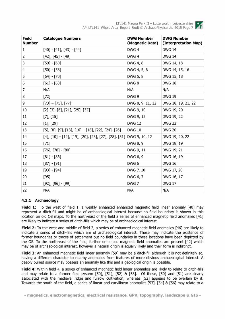
The table below is provided as a quick reference to the magnetic field anomalies mentioned within the interpretation. Due to the scale of the site, each field has been discussed individually under the headings of archaeology, land-use and geology. The conclusion summarises the results from the entire survey.
- magnetics, electromagnetics, electrical resistance, GPR, topography, landscape & GIS -
LTL141 Magna Park II – Lutterworth, LeicestershireAP_LTL141_Whole Area_Report_F.odt © ArchaeoPhysica Ltd 2015 Page 7
Field Number
Catalogue Numbers DWG Number (Magnetic Data)
DWG Number (Interpretation Map)
1 [40] - [41], [43] - [44] DWG 4 DWG 14
2 [42], [45] - [49] DWG 4 DWG 14
3 [59] - [60] DWG 4, 8 DWG 14, 18
4 [50] - [58] DWG 4, 5, 6 DWG 14, 15, 16
5 [64] - [70] DWG 5, 8 DWG 15, 18
6 [61] - [63] DWG 8 DWG 18
7 N/A N/A N/A
8 [72] DWG 9 DWG 19
9 [73] – [75], [77] DWG 8, 9, 11, 12 DWG 18, 19, 21, 22
10 [2]-[3], [6], [21], [25], [32] DWG 9, 10 DWG 19, 20
11 [7], [15] DWG 9, 12 DWG 19, 22
12 [1], [29] DWG 12 DWG 22
13 [5], [8], [9], [13], [16] – [18], [22], [24], [26] DWG 10 DWG 20
14 [4], [10] – [12], [19], [20], [23], [27], [28], [31] DWG 9, 10, 12 DWG 19, 20, 22
15 [71] DWG 8, 9 DWG 18, 19
16 [76], [78] - [80] DWG 9, 11 DWG 19, 21
17 [81] - [86] DWG 6, 9 DWG 16, 19
18 [87] - [91] DWG 6 DWG 16
19 [93] - [94] DWG 7, 10 DWG 17, 20
20 [95] DWG 6, 7 DWG 16, 17
21 [92], [96] - [99] DWG 7 DWG 17
22 N/A N/A N/A
4.3.1 Archaeology
Field 1: To the west of field 1, a weakly enhanced enhanced magnetic field linear anomaly [40] may represent a ditch-fill and might be of archaeological interest because no field boundary is shown in this location on old OS maps. To the north-east of the field a series of enhanced magnetic field anomalies [41] are likely to indicate a series of ditch-fills which may be of archaeological interest.
Field 2: To the west and middle of field 2, a series of enhanced magnetic field anomalies [46] are likely to indicate a series of ditch-fills which are of archaeological interest. These may indicate the existence of former boundaries or traces of settlement but no field boundaries in these locations have been depicted by the OS. To the north-east of the field, further enhanced magnetic field anomalies are present [42] which may be of archaeological interest, however a natural origin is equally likely and their form is indistinct.
Field 3: An enhanced magnetic field linear anomaly [59] may be a ditch-fill although it is not definitely so, having a different character to nearby anomalies from features of more obvious archaeological interest. A deeply buried source may possess an anomaly like this and a geological origin is possible.
Field 4: Within field 4, a series of enhanced magnetic field linear anomalies are likely to relate to ditch-fills and may relate to a former field system [50], [51], [52] & [58]. Of these, [50] and [51] are clearly associated with the medieval ridge and furrow cultivation, whereas [52] appears to be overlain by it. Towards the south of the field, a series of linear and curvilinear anomalies [53], [54] & [56] may relate to a
- magnetics, electromagnetics, electrical resistance, GPR, topography, landscape & GIS -

LTL141 Magna Park II – Lutterworth, LeicestershireAP_LTL141_Whole Area_Report_F.odt © ArchaeoPhysica Ltd 2015 Page 8
former settlement by the Roman road, of which only those parts that seem associated with evidence for settlement are clear. Probable elements of the same complex, but further away, e.g. [56] and [58] are much less magnetic and correspondingly less well understood, a fairly normal response due to decreasing magnetic susceptibility away from sources of heat and biological sources of magnetic enhancement. Two curvilinear parallel enhanced magnetic field anomalies [55] seem to define a former track connecting with the deserted medieval settlement to the north.
Field 5: To the south of field 5, a series of enhanced magnetic field curvilinear anomalies have been identified [68], [69] & [70] which may form enclosed boundary ditch-fills. An enhanced magnetic field linear anomaly from field 4 [51] appears to join onto this complex. To the north-east of the field some enhanced magnetic field anomalies and changes in data texture have been identified [65], [66] & [67] which may relate to activity which may also be of interest. [66] appears to be a relatively non-magnetic structure and could be a large drain or culvert whereas area [67] seems to mark disturbed soil or debris within the soil. Both could be the result of railway-era groundworks.
Field 6: Two enhanced magnetic field linear anomalies [62] & [63] may be ditch-fills.
Field 7: Currently unsurveyed. Scheduled DMV.
Field 8: An enhanced magnetic field linear anomaly [72] may be a ditch-fill and could be of archaeological interest, especially as the trajectory of the linear appears to mirror the tree boundary outside the field. It may be that this anomaly represents a continuation of a large sub-circular (or semicircular) feature.
Field 9: An enhanced magnetic field linear anomaly [73] may be a ditch-fill and could be of archaeological interest. Within the eastern part of the field, a series of linear and curvilinear anomalies [75], may relate to a former settlement or agriculture and is of archaeological interest. The anomalies appear to spread south-west, into field 16.
Field 10: An enhanced magnetic field linear anomaly [2] may be a ditch-fill.
Field 11: No anomalies of archaeological interest detected.
Field 12: Two parallel enhanced magnetic field linear anomalies [1] may represent ditch-fills and may mark a pathway or field boundaries.
Field 13: No anomalies of archaeological interest detected.
Field 14: No anomalies of archaeological interest detected.
Field 15: No anomalies of archaeological interest detected.
Field 16: An extensive network of enhanced magnetic field linear and curvilinear anomalies extends through this field and into field 17 to the south, and field 9 to the north. The anomalies appear to extend through the central ridge of these fields. The central concentration of anomalies is marked at [78], and appears to be connected to anomalies [81], [82], [84] & [85] to the south-west. Linear anomalies [76] & [79] conversely appear to extend north-east through the extant field boundary to feature [75] in field 9, and may relate to path or trackways connecting these likely settlements.
Field 17: Likewise, the series of curvilinear enhanced magnetic field anomalies [81] – [85] appear to connect and relate to [78]. The entire complex of anomalies of archaeological interest appear to extend into the DMV in field 7 to the south-west.
Field 18: Within field 18, potential anomalies of archaeological interest have been identified at [88]. These may be ditch-fills associated with structures, and may be of archaeological interest.
Field 19: No anomalies of archaeological interest detected.
Field 20: No anomalies of archaeological interest detected.
Field 21: Within field 21, some enhanced magnetic field linear anomalies have been detected which are likely to represent ditch-fills or boundaries and may be of archaeological interest [92]. [96] & [97]. To the southern area within field 21, an enhanced magnetic field linear anomaly [98] is also likely to represent a ditch-fill which may have marked a boundary. Attached to this linear anomaly, are a curvilinear enclosure and
- magnetics, electromagnetics, electrical resistance, GPR, topography, landscape & GIS -

LTL141 Magna Park II – Lutterworth, LeicestershireAP_LTL141_Whole Area_Report_F.odt © ArchaeoPhysica Ltd 2015 Page 9
a circular anomaly of archaeological interest [99].
Field 22: Not surveyed.
4.3.2 Land use
Field 1: Within the west of field 1, many weakly enhanced linear magnetic field anomalies are present, at a diagonal (North-West - South-East) parallel orientation which are likely to represent field drains. Within the remaining area of the field, further weakly enhanced magnetic field linear anomalies are present at a North-South orientation, and mark ridge and furrow ploughing. The anomaly caused by the ridge and furrow is further enhanced at [44], which may indicate a shallower topsoil within this area. This is unlikely to be related to the textural change [43] within the data and an increase of enhanced magnetic field anomalies is thought to be due to a large pit, said locally to have been excavated for sand when the nearby railway was built. This is also identified on the 1887 Ordnance Survey (OS) map of the area.
Field 2: At varying orientations, groups of parallel weakly enhanced magnetic field linear anomalies are present within field 2, and mark ridge and furrow cultivation across ancient field systems. Within the northern edge of the field, the data texture changes slightly [45] which may be an indication of a change in the soil depth and may also mark areas of seasonal waterlogging, situated as it is by a stream. Similar textural changes are apparent within the field, highlighted by [47], [48] & [49] which may also be due to the same processes.
Field 3: Within field 3, two enhanced magnetic field linear anomalies represent former field boundaries, depicted within the 1886 OS map. An area of textural variation within the data [60] is likely to be associated with seasonal waterlogging.
Field 4: Worthy of note within this field are the series of weakly enhanced magnetic field linear anomalies which represent further ridge and furrow cultivation. The change in orientation between these groups of linear anomalies are likely to represent the layout of a historic field system. An area of enhanced magnetic field anomalies to the south-east [57] is likely to represent modern dumping or levelling material.
There is also natural banding in the magnetic field strength, most likely due to natural variations in the clay. Some of these, e.g. north of [54] are strongly magnetic.
Field 5: Within this field, the ridge and furrow continues through from field 4. An enhanced curvilinear anomaly running through the field is likely to represent a field drain or old field boundary. Areas of textural variation within the field are indicated at [64], [66], [67] & [69] which may represent changes in soil cover and seasonal waterlogging.
Field 6: Contains traces of ridge and furrow and field drains, however the concentration of these features is less than at other fields. Within an area towards the old railway line [61], a series of enhanced magnetic field anomalies are likely to represent disturbance or building material associated with the railway itself.
Field 7: Currently unsurveyed.
Field 8: A series of weakly enhanced magnetic field linear anomalies extend at a north-east – south-west orientation and represent ridge and furrow cultivation.
Field 9: Further traces of ridge and furrow cultivation extent through the field. Field drains are indicated at [77] and [74].
Field 10: An area of enhanced magnetic field anomalies [6] are likely to represent ridge and furrow cultivation. Strongly enhanced and reduced magnetic field linear anomalies [21] and [32] are likely to represent modern services.
Field 11: An area of weakly enhanced magnetic field anomalies [7] are likely to represent ridge and furrow cultivation. A field drain extends parallel to the northern boundary [15].
Field 12: The background texture from the middle to the east of this field is relatively 'flat' and may be affected from the existing warehouses across the road to the south-east. This change may also be indicative of a change in historic agricultural land use within the field.
- magnetics, electromagnetics, electrical resistance, GPR, topography, landscape & GIS -

LTL141 Magna Park II – Lutterworth, LeicestershireAP_LTL141_Whole Area_Report_F.odt © ArchaeoPhysica Ltd 2015 Page 10
Field 13: Within the field, a group of enhanced magnetic field linear anomalies [16], [17] & [18] represent field boundaries depicted within OS mapping from 1886-1965. A strongly enhanced and reduced linear [22] also extends through the field and may mark a modern service. Similar to the other fields surrounding, weakly enhanced magnetic field linear anomalies exist which are either ridge and furrow cultivation [8], [9], & [24], or field drains [13].
Field 14: An area of weakly enhanced magnetic field anomalies [10] & [11], are likely to represent ridge and furrow cultivation. Various field drains extend through the field [12] & [14]. Strongly variable linear magnetic field anomalies [19], [20] & [31] represent underground services.
Field 15: An area to the north of field 15 has a variable background data texture, and has been highlighted [71]. This change in data texture is likely to indicate an artificial change in soil depth or be geological in origin.
Field 16: Within the field, an enhanced magnetic field linear anomaly extends across the field, and represents a field boundary depicted within OS maps from 1886. A series of strongly enhanced and reduced magnetic field anomalies form a line, which may represent a service or old fence line.
Field 17: Within the north west extent of the field, a series of strongly enhanced and reduced magnetic field anomalies form a line, which may represent a service or former fence line. Weakly enhanced magnetic field linear anomalies within this field have been identified as ridge and furrow.
Field 18: A series of strongly enhanced and reduced magnetic field anomalies form a line extending eastwards from the extant farm buildings, which may represent a service. To the south of this, a field boundary, depicted on the 1887 OS map can also be seen within the data. A large area of increased magnetic field anomalies can be seen within the data, highlighted at [87]. This marks out the route of the railway embankment which once passed through the field. An area of weakly enhanced magnetic field [91] is presumed to be associated with the railway. An area of strong magnetic disturbance [90] seems to be due to debris spread from the former railway embankment.
Field 19: Many weakly enhanced parallel magnetic field linear anomalies represent ridge and furrow cultivation. An area of enhanced magnetic field anomalies [93] & [94] is thought to be modern in origin.
Field 20: Many weakly enhanced parallel magnetic field linear anomalies represent ridge and furrow cultivation. An area of enhanced magnetic field anomalies [94] & [95] is thought to be modern in origin.
Field 21: An enhanced magnetic field linear anomaly extends through the middle of this field, and is likely to be a former field boundary. Next to the main road to the south-west extent of the field, a number of enhanced magnetic field anomalies can be seen. These are due to passing vehicles from the main road.
Field 22: Not surveyed.
4.3.3 Geology and data character – overview
The magnetic susceptibility of the site is relatively weak, however it has been suitable for the detection of anomalies which may be of archaeological interest. The data character is varied across the survey area, such variations may be due to changes in soil type, depth or hydrology. Areas indicated at [24], [25], [26] & [27] [45], [47], [48], [49], [60] & [95] highlight textural variations within the data which are likely to relate to natural magnetic enhancement due to natural deposition of soils or seasonal water-logging. The data on the south-east edge of the dataset (closest to the extant warehouses at Magna Park) appears to have a 'flatter' texture, likely to be an effect from the warehouses nearby, approximately bounded by [28], [29] & [30].
4.4 Conclusions
The survey has identified several areas of potential archaeological interest within the survey area, especially within fields 1, 2, 4, 5, 9, 16, 17 & 21. Within these fields, linear and curvilinear anomalies of enhanced magnetic field are extensive, especially surrounding the DMV and over higher regions. It seems likely that these anomalies of archaeological interest are either associated with the Romano-British findspots, or the Medieval settlement here.
- magnetics, electromagnetics, electrical resistance, GPR, topography, landscape & GIS -

LTL141 Magna Park II – Lutterworth, LeicestershireAP_LTL141_Whole Area_Report_F.odt © ArchaeoPhysica Ltd 2015 Page 11
Throughout the fields (especially field 2, 4 & 5) there is extensive evidence of medieval ridge and furrow cultivation, which in some areas, helps to define the probable field system pattern from this period.
It is apparent that the 'habitation effect', whereby magnetic susceptibility decreases away from cultural sources of magnetic enhancement, is present within these relatively low susceptibility soils. This being the case, there is the likelihood that marginal and non-settlement related features may be less obvious in the data than those connected with settlement and industry.
4.5 Caveats
Geophysical survey is a systematic measurement of some physical property related to the earth. There are numerous sources of disturbance of this property, some due to archaeological features, some due to the measuring method, and others that relate to the environment in which the measurement is made. No disturbance, or ‘anomaly’, is capable of providing an unambiguous and comprehensive description of a feature, in particular in archaeological contexts where there are a myriad of factors involved.
The measured anomaly is generated by the presence or absence of certain materials within a feature, not by the feature itself. Not all archaeological features produce disturbances that can be detected by a particular instrument or methodology. For this reason, the absence of an anomaly must never be taken to mean the absence of an archaeological feature. The best surveys are those which use a variety of techniques over the same ground at resolutions adequate for the detection of a range of different features.
Where the specification is by a third party ArchaeoPhysica will always endeavour to produce the best possible result within any imposed constraints and any perceived failure of the specification remains the responsibility of that third party.
Where third party sources are used in interpretation or analysis ArchaeoPhysica will endeavour to verify their accuracy within reasonable limits but responsibility for any errors or omissions remains with the originator.
Any recommendations are made based upon the skills and experience of staff at ArchaeoPhysica and the information available to them at the time. ArchaeoPhysica is not responsible for the manner in which these may or may not be carried out, nor for any matters arising from the same.
4.6 Bibliography & selected reference
Aspinall et al, 2008. “Magnetometry for Archaeologists”, Geophysical Methods for Archaeology, Altamira Press
Blakely, 1996, “Potential Theory in Gravity and Magnetic Applications”, Cambridge University Press
CgMs, 2014 “Project Atlantis Magna Park Phase 4 Lutterworth Leicestershire: Archaeological Desk-based Assessment” Unpublished
David et al, 2008, “Geophysical Survey in Archaeological Field Evaluation”, English Heritage
Fry, R., Roseveare, MJ., 2015, Magna Park II – Plot 1, Lutterworth, Leicestershire – Geophysical Survey Report. ArchaeoPhysica. Hereford.
Gaffney et al, 2002, “Technical Note 6: The use of geophysical techniques in archaeological evaluations”, Institute for Archaeologists
Hancock, A., 2008 'Archaeological Desk-Based Assessment and Geophysical Survey: Land Adjacent to Bittesby House, Bittesby, Leicestershire', Unpublished Archaeological Services & Consultancy report ASC:905/BBH/2
Milsom, 2003, “Field Geophysics”, 3rd edition, The Geological Field Guide Series, Wiley
Roseveare, A., 2014, “Lutterworth Magna Park, Leicestershire: Specification for Geophysical Survey” ArchaeoPhysica. Hereford.
Schmidt, A., 2013, “Geophysical Data in Archaeology: A Guide to Good Practice”, ADS
- magnetics, electromagnetics, electrical resistance, GPR, topography, landscape & GIS -

LTL141 Magna Park II – Lutterworth, LeicestershireAP_LTL141_Whole Area_Report_F.odt © ArchaeoPhysica Ltd 2015 Page 12
Scollar, 1990, “Archaeological Prospecting and Remote Sensing”, Topics in Remote Sensing 2, Cambridge University Press
Tarling et al (ed.), 1999, “Palaeomagnetism and Diagenesis in Sediments”, Geological Society, London, Special Publications, 151
Telford et al, 1990, “Applied Geophysics”, 2nd Edition, Cambridge University Press
- magnetics, electromagnetics, electrical resistance, GPR, topography, landscape & GIS -

LTL141 Magna Park II – Lutterworth, LeicestershireAP_LTL141_Whole Area_Report_F.odt © ArchaeoPhysica Ltd 2015 Page 13
5 Appendices
5.1 Project metadata
Project Name Magna Park II – Lutterworth, LeicestershireProject Code LTL141Client CgMs ConsultingFieldwork Dates October 2014 – March 2015Field Personnel S Purvis, D Rouse, R FryData Processing Personnel R FryReporting Personnel R Fry, MJ RoseveareDraft Report Date 14th April 2015Final Report Date 29th April 2015
5.2 Archiving
ArchaeoPhysica maintains an archive for all its projects, access to which is permitted for research purposes. Copyright and intellectual property rights are retained by ArchaeoPhysica on all material it has produced, the client having full licence to use such material as benefits their project. Access is by appointment only and some content is restricted and not available to third parties
Archive formation is in the spirit of Schmidt, A., 2013, “Geophysical Data in Archaeology: A Guide to Good Practice”, ADS.
ArchaeoPhysica has a policy of contributing in time to the ADS Grey Literature library, usually after about six months post-dating release of the report. In addition, extracts of data images may be used, without reference to their source, in marketing and similar material. In these cases anything that might identify the project or client is removed.
5.3 ArchaeoPhysica
5.3.1 The company
ArchaeoPhysica has provided geophysical survey to archaeologists since 1998 and is consequently one of the oldest specialist companies in the sector. It has become one of the most capable operations in the UK, undertaking 1000 hectares of magnetic survey per annum. In addition 2D & 3D electrical, low frequency electromagnetic and radar surveys are regularly undertaken across the UK, also overseas. ArchaeoPhysica is the most established provider of caesium vapour magnetic survey in Europe, and holds probably the largest archaeological archive of total field magnetic data in the world. Unusually for the archaeological sector, key staff are acknowledged qualified geophysical specialists in their own right and regularly contribute to in-house and other research projects. For a number of years the company taught applied geophysics to Birkbeck College (London) undergraduate and post-graduate archaeology students, and developed a new and comprehensive course for the College.
All work is undertaken by qualified and experienced geophysicists who have specialised in the detection and mapping of near surface structures in archaeology and other disciplines using a wide variety of techniques. There is always a geophysicist qualified to post-graduate level on site during fieldwork and all processing and interpretation is undertaken under the direct influence of either the same individual or someone of similar qualifications and experience.
ArchaeoPhysica meets with ease the requirements of English Heritage in their 2008 Guidance “Geophysical Survey in Archaeological Field Evaluation” section 2.8 entitled “Competence of survey personnel”. The company is one of the most experienced in European archaeological prospection and is a key professional player. It only employs people with recognised geoscience qualifications and capable of becoming Fellows of
- magnetics, electromagnetics, electrical resistance, GPR, topography, landscape & GIS -

LTL141 Magna Park II – Lutterworth, LeicestershireAP_LTL141_Whole Area_Report_F.odt © ArchaeoPhysica Ltd 2015 Page 14
the Geological Society of London, the Chartered UK body for geophysicists and geologists.
5.3.2 Senior Geophysicist: Martin J Roseveare, MSc BSc(Hons) MEAGE FGS MCIfA
Martin specialised (MSc) in geophysical prospection for shallow applications at the University of Bradford in 1997 and has worked in commercial geophysics since then. He was elected a Fellow of the Geological Society of London in 2009 and is also a full member of the Institute of Archaeologists. He has taught applied geophysics for Birkbeck College's archaeological degree students for a number of years. Professional interests outside archaeology include the application of geophysics to agriculture, also geohazard monitoring and prediction. He also has considerable practical experience of the improvement and integration of geophysical hardware and software. At ArchaeoPhysica Martin carries overall responsibility for all things geophysical and is often found writing reports or buried in obscure software and circuit diagrams. He was elected onto the EuroGPR and CIfA GeoSIG committees in Autumn 2013.
5.3.3 Operations Manager: Anne CK Roseveare, BEng(Hons) DIS MISoilSci
On looking beyond engineering, Anne turned her attention to environmental monitoring and geophysics and has since been applying specialist knowledge of chemistry & fluid flow to soils. She is member of the British Society of Soil Science and is interested in the use of agricultural applications of geophysics. Anne was the founding editor of the International Society for Archaeological Prospection (ISAP) and has spent many years walking fields in parallel lines. Much of her time now is spent managing complicated scheduling and logistics for ArchaeoPhysica, overseeing safety procedures and data handling, while dreaming of interesting places around the world to undertake surveys, including researching the urban archaeology of Asia.
5.3.4 Geophysicist: Robert Fry, PhD MSc BA(Hons)
Rob studied Archaeology B.A.(Hons.) at the University of Reading from 2004-07. His research was heavily influenced by geophysical techniques, and he helped organise and lead the magnetic survey of Silchester Roman Town. Following university, he joined the British School at Rome, conducting surveys in Spain, Italy and Libya. After working briefly as a geophysicist at Wessex Archaeology, Rob became Project Officer of The Silchester Mapping Project at the University of Reading. Since then, he has gained an MSc in Archaeological Prospection from the University of Bradford and recently completed his Doctorate with a thesis titled “Time-lapse geophysical investigations over known archaeological features using electrical resistivity imaging and earth resistance”. Rob is currently also the editor of ISAP News. At ArchaeoPhysica Rob is normally found in the field or in the office besieged by colossal quantities of survey data.
5.3.5 Geophysicist: Samuel Purvis, MSc BSc(Hons)
Sam studied Archaeology at The University of Bradford before progressing to a Masters in Archaeological Prospection. His primary research focus is on electromagnetic methods of shallow survey and is an expert with the newest multicoil electromagnetic instrumentation. Sam's main role at ArchaeoPhysica is technical, collecting high quality data, maintaining systems and keeping the show on the road.
- magnetics, electromagnetics, electrical resistance, GPR, topography, landscape & GIS -