Geophysical and Geotechnical Techniques: … the construction. These techniques can provide the...
4
Geophysical and Geotechnical Techniques: Complementary Tools in Studying Subsurface Features Haydar Baker 1* , Amir Gabr 1 & Mohamed Djeddi 2 1 UAE University, P.O.Box 15551, Al-Ain, UAE 2 USTHB, Laboratoire de Géophysique, Alger, Algeria Summary During site characterization for any construction project, certain hesitation and uncertainty attitude from the Geotechnical Engineers always existed towards the role of geophysical surveys; and the question which is always being asked on how the geophysical techniques can help and be useful to the geotechnical studies and to site selection procedures. In this paper the important role of the geophysical methods is demonstrated through case studies, and how the geotechnical and geophysical techniques should be considered as complementary techniques. The results of geophysical survey can serve as guidelines for placing the geotechnical boreholes and the geotechnical data can be used to ground truth geophysical results. Examples from the United Arab Emirates and different parts of the world are given. A reference is given to the initiative of Abu Dhabi Emirate to make the geophysical survey mandatory for obtaining the building permit for any type of construction. Introduction Geotechnical data is one important tool among others considered by engineers in their designs. However, it is known that the geotechnical data can in some cases be misleading and/or leads to various damages in the buildings’ structures or in certain cases leads to catastrophes if there are no complementary systems of control. In other cases, geotechnical investigation could encounter complex subsurface conditions which require the use of geophysical technique to enhance the borehole data (Earley and Rudenko, 1988; Baker & Gabr 2011, Khaldaoui et al 2011). Engineers can build on any type of ground even on water without any problem by making special designs of basement and supports which are adapted to the “ground” conditions. Therefore, when a failure occurs in a building’s structure, whose fault is it? Is it because of the design or is it because of the wrong ground truth information given to the engineers? To answer such questions and to avoid such discrepancy the geophysical techniques should be considered by the geotechnical engineers as their primary tools. The geophysical methods are non-invasive and non- destructive. The use of the existing different geophysical techniques such as Shallow Seismic Refraction, Multichannel Analysis of Surface Waves (MASW), Seismic Tomography, Electrical Resistivity Tomography (ERT), Electromagnetic (EM), Ground Penetrating Radar (GPR) and others have been proven to be very effective in studying the near surface features and give the answers to various civil engineering problems encountered during and after the construction. These techniques can provide the physical parameters of the site and the subsurface model. However, the geophysical techniques remain dependant on cost-effectiveness and site conditions, i.e. the required depth of investigation, the site accessibility and the area, the nature of soil cover, the lithology, the groundwater, etc… As a fact when utilizing the geophysical techniques in order to study the subsurface conditions of any construction site it is strongly recommended or necessary to use two or more geophysical techniques to provide more detailed information about the subsurface structures and lithology, in addition verification/calibration boreholes are also required. The depth of the boreholes should at least be equal to the investigation depth of the employed geophysical technique. Many papers and case studies have been published on the role of geophysics in solving geotechnical problems but the doubt on the technical ability is being repeated by some to the present day. Indeed, geotechnical drilling gives detailed lithological and physical parameters of the site but it remains limited because of its small fingerprint and cannot be generalized to the whole area of the site even when a number of boreholes were drilled in the site and correlation was performed. The reasons are mainly due to the distance between the wells and the drilling depth. Positioning three to four boreholes in triangular or square settings would give excellent information on the lithology but it can easily miss a cavity or other geologic structure, e.g. fault, at the center ICEG 2015 2 Downloaded 12/16/16 to 216.63.246.110. Redistribution subject to SEG license or copyright; see Terms of Use at http://library.seg.org/
Transcript of Geophysical and Geotechnical Techniques: … the construction. These techniques can provide the...
Geophysical and Geotechnical Techniques: Complementary Tools in Studying Subsurface Features Haydar Baker1*, Amir Gabr1 & Mohamed Djeddi2 1UAE University, P.O.Box 15551, Al-Ain, UAE 2USTHB, Laboratoire de Géophysique, Alger, Algeria Summary During site characterization for any construction project, certain hesitation and uncertainty attitude from the Geotechnical Engineers always existed towards the role of geophysical surveys; and the question which is always being asked on how the geophysical techniques can help and be useful to the geotechnical studies and to site selection procedures. In this paper the important role of the geophysical methods is demonstrated through case studies, and how the geotechnical and geophysical techniques should be considered as complementary techniques. The results of geophysical survey can serve as guidelines for placing the geotechnical boreholes and the geotechnical data can be used to ground truth geophysical results. Examples from the United Arab Emirates and different parts of the world are given. A reference is given to the initiative of Abu Dhabi Emirate to make the geophysical survey mandatory for obtaining the building permit for any type of construction. Introduction Geotechnical data is one important tool among others considered by engineers in their designs. However, it is known that the geotechnical data can in some cases be misleading and/or leads to various damages in the buildings’ structures or in certain cases leads to catastrophes if there are no complementary systems of control. In other cases, geotechnical investigation could encounter complex subsurface conditions which require the use of geophysical technique to enhance the borehole data (Earley and Rudenko, 1988; Baker & Gabr 2011, Khaldaoui et al 2011). Engineers can build on any type of ground even on water without any problem by making special designs of basement and supports which are adapted to the “ground” conditions. Therefore, when a failure occurs in a building’s structure, whose fault is it? Is it because of the design or is it because of the wrong ground
truth information given to the engineers? To answer such questions and to avoid such discrepancy the geophysical techniques should be considered by the geotechnical engineers as their primary tools. The geophysical methods are non-invasive and non-destructive. The use of the existing different geophysical techniques such as Shallow Seismic Refraction, Multichannel Analysis of Surface Waves (MASW), Seismic Tomography, Electrical Resistivity Tomography (ERT), Electromagnetic (EM), Ground Penetrating Radar (GPR) and others have been proven to be very effective in studying the near surface features and give the answers to various civil engineering problems encountered during and after the construction. These techniques can provide the physical parameters of the site and the subsurface model. However, the geophysical techniques remain dependant on cost-effectiveness and site conditions, i.e. the required depth of investigation, the site accessibility and the area, the nature of soil cover, the lithology, the groundwater, etc… As a fact when utilizing the geophysical techniques in order to study the subsurface conditions of any construction site it is strongly recommended or necessary to use two or more geophysical techniques to provide more detailed information about the subsurface structures and lithology, in addition verification/calibration boreholes are also required. The depth of the boreholes should at least be equal to the investigation depth of the employed geophysical technique. Many papers and case studies have been published on the role of geophysics in solving geotechnical problems but the doubt on the technical ability is being repeated by some to the present day. Indeed, geotechnical drilling gives detailed lithological and physical parameters of the site but it remains limited because of its small fingerprint and cannot be generalized to the whole area of the site even when a number of boreholes were drilled in the site and correlation was performed. The reasons are mainly due to the distance between the wells and the drilling depth. Positioning three to four boreholes in triangular or square settings would give excellent information on the lithology but it can easily miss a cavity or other geologic structure, e.g. fault, at the center
ICEG 2015 2
Dow
nloa
ded
12/1
6/16
to 2
16.6
3.24
6.11
0. R
edis
trib
utio
n su
bjec
t to
SEG
lice
nse
or c
opyr
ight
; see
Ter
ms
of U
se a
t http
://lib
rary
.seg
.org
/
Geophysical and Geotechnical Techniques: Complementary Tools in Studying Subsurface Features
of the setting. The advantage of the geophysical survey is that it gives a high resolution spatial coverage. Since 2009 Al Ain City Municipality has requested the geophysical survey for all construction projects in the region. In 2011, the Municipality in collaboration with the UAE University conducted phase 1 of the Geozoning Project during which a reconnaissance geological, geotechnical, hydrogeological and geophysical surveys were conducted. The results were presented as a map which divides Al Ain region into zones of possible risk where the implementation of the geophysical techniques and the number of methods to be used in each zone are compulsory. In 2014, the Department of Municipality Affairs of Abu Dhabi Emirate issued a decree making the geophysical survey mandatory along with the geotechnical drilling to obtain the building permit for any type of construction in the Emirate. Case Studies - The role of geophysical techniques: 1. Residential and Commercial Compound in
Oran, Algeria:
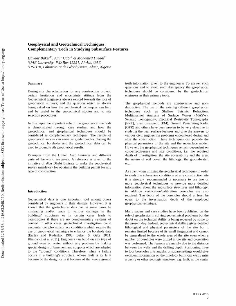
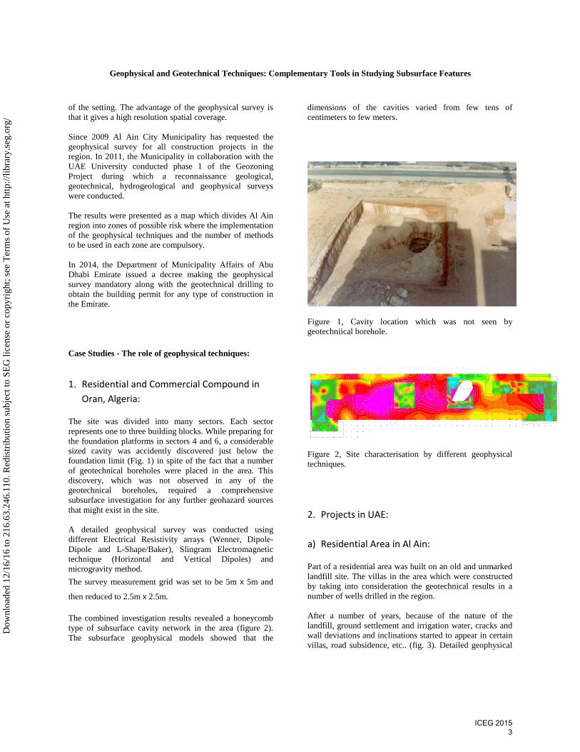
The site was divided into many sectors. Each sector represents one to three building blocks. While preparing for the foundation platforms in sectors 4 and 6, a considerable sized cavity was accidently discovered just below the foundation limit (Fig. 1) in spite of the fact that a number of geotechnical boreholes were placed in the area. This discovery, which was not observed in any of the geotechnical boreholes, required a comprehensive subsurface investigation for any further geohazard sources that might exist in the site. A detailed geophysical survey was conducted using different Electrical Resistivity arrays (Wenner, Dipole-Dipole and L-Shape/Baker), Slingram Electromagnetic technique (Horizontal and Vertical Dipoles) and microgravity method. The survey measurement grid was set to be 5m х 5m and
then reduced to 2.5m х 2.5m. The combined investigation results revealed a honeycomb type of subsurface cavity network in the area (figure 2). The subsurface geophysical models showed that the
dimensions of the cavities varied from few tens of centimeters to few meters.
Figure 1, Cavity location which was not seen by geotechniical borehole.
Figure 2, Site characterisation by different geophysical techniques.
2. Projects in UAE:
a) Residential Area in Al Ain:
Part of a residential area was built on an old and unmarked landfill site. The villas in the area which were constructed by taking into consideration the geotechnical results in a number of wells drilled in the region. After a number of years, because of the nature of the landfill, ground settlement and irrigation water, cracks and wall deviations and inclinations started to appear in certain villas, road subsidence, etc.. (fig. 3). Detailed geophysical
ICEG 2015 3
Dow
nloa
ded
12/1
6/16
to 2
16.6
3.24
6.11
0. R
edis
trib
utio
n su
bjec
t to
SEG
lice
nse
or c
opyr
ight
; see
Ter
ms
of U
se a
t http
://lib
rary
.seg
.org
/
Geophysical and Geotechnical Techniques: Complementary Tools in Studying Subsurface Features
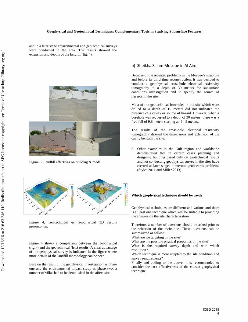
and in a later stage environmental and geotechnical surveys were conducted in the area. The results showed the extension and depths of the landfill (fig. 4).
Figure 3, Landfill effectives on building & roads.
Figure 4, Geotechnical & Geophysical 3D results presentation. Figure 4 shows a comparison between the geophysical (right) and the geotechnical (left) results. A clear advantage of the geophysical survey is indicated in the figure where more details of the landfill morphology can be seen. Base on the result of the geophysical investigation as phase one and the environmental impact study as phase two, a number of villas had to be demolished in the affect site.
b) Sheikha Salam Mosque in Al Ain:
Because of the repeated problems in the Mosque’s structure and before its third time reconstruction, it was decided to conduct a geophysical cross-hole electrical resistivity tomography to a depth of 30 meters for subsurface conditions investigation and to specify the source of hazards in the site. Most of the geotechnical boreholes in the site which were drilled to a depth of 10 meters did not indicated the presence of a cavity or source of hazard. However, when a borehole was requested to a depth of 30 meters; there was a free-fall of 9.8 meters starting at -14.5 meters. The results of the cross-hole electrical resistivity tomography showed the dimensions and extension of the cavity beneath the site. 3. Other examples in the Gulf region and worldwide
demonstrated that in certain cases planning and designing building based only on geotechnical results and not conducting geophysical survey in the sites have created at later stages numerous geohazards problems (Styles 2011 and Miller 2013).
Which geophysical technique should be used? Geophysical techniques are different and various and there is at least one technique which will be suitable to providing the answers on the site characterization. Therefore, a number of questions should be asked prior to the selection of the technique. These questions can be summarized as follow: What are we targeting in the site? What are the possible physical properties of the site? What is the required survey depth and with which resolution? Which technique is more adapted to the site condition and survey requirements? Finally and adding to the above, it is recommended to consider the cost effectiveness of the chosen geophysical technique.
ICEG 2015 4
Dow
nloa
ded
12/1
6/16
to 2
16.6
3.24
6.11
0. R
edis
trib
utio
n su
bjec
t to
SEG
lice
nse
or c
opyr
ight
; see
Ter
ms
of U
se a
t http
://lib
rary
.seg
.org
/
Geophysical and Geotechnical Techniques: Complementary Tools in Studying Subsurface Features
Conclusions For the past few years it has been demonstrated that whenever geophysical data were properly acquired, processed and interpreted, it can give detailed informative subsurface geologic model. The site geophysical models can be used as guidelines to geotechnical boreholes implantation and detailed correlation between the boreholes sites. It has been demonstrated that by conducting geophysical survey prior to geotechnical drilling can be a cost effective approach.
References Baker H & Gabr A., 2011, Using Geophysical and Geotechnical Techniques to Delineate a Landfill in a Residential Area. First International conference of Engineering Geophysics. EAGE Conference Proceedings, EG38. Earley K.H. and Rudenko D., 1988. Use of Geophysical Methods in a Geotechnical Investigation. Proceedings: Second International Conference on Case Histories in Geotechnical Engineering, June 1-5, 1988, St. Louis, Mo., Paper No. 2.64. Khaldaoui F, Djeddi M, Abtout A & Baker H., 2011, Geophysical Investigation to Characterize Geological Risks – Detecting Zones of Dissolution in Karst Areas of Algeria. Second International conference of Engineering Geophysics. EAGE Conference Proceedings, EG37. Styles P, 2011, Environmental Geophysics: Its role in the planning of 21st Century Cities. First International conference of Engineering Geophysics. EAGE Conference Proceedings, Keynote Presentation. Miller R, 2013, Near-Surface Applied Geophysics: Unraveling the mysteries and identifying the hazards beneath the ground we walk on. Second International conference of Engineering Geophysics. EAGE Conference Proceedings, Keynote Presentation.
ICEG 2015 5
Dow
nloa
ded
12/1
6/16
to 2
16.6
3.24
6.11
0. R
edis
trib
utio
n su
bjec
t to
SEG
lice
nse
or c
opyr
ight
; see
Ter
ms
of U
se a
t http
://lib
rary
.seg
.org
/