Lithologic, Hydrothermal Alteration and Structural Mapping ...

U.S Geological Survey U.S. Department of the Interior
Geology, Mineralization, and Hydrothermal Alteration and Relationships to Acidic and Metal-Bearing Surface Waters in the Palmetto Gulch Area, Southwestern Colorado
By
Dana J. Bove, Jeffery P. Kurtz, and Winfield G. Wright
Open-File Report 02-275
This report is preliminary and has not been reviewed for conformity with U.S. Geological Survey editorial standards nor with the North American Stratigraphic Code. Any use of
product names in this publication is for descriptive purposes only and does not imply endorsement by the U.S. Government.

Table of Contents
ABSTRACT........................................................................................................................ 4
INTRODUCTION............................................................................................................... 5
METHODS.......................................................................................................................... 6
GEOLOGY AND MINERALIZATION OF THE STUDY AREA ................................... 7
Regional Geology............................................................................................................ 7
Volcanic Stratigraphy...................................................................................................... 8
Intrusive Rocks.............................................................................................................. 10
Structure of the Study Area........................................................................................... 11
Geology of Mineral Deposits in the Palmetto Gulch Area ........................................... 11
Alteration Assemblages................................................................................................. 14
DUMP LEACHATE STUDIES........................................................................................ 15
STREAM SEDIMENT SAMPLES .................................................................................. 17
DISCUSSION AND CONCLUSIONS............................................................................. 17
Water Quality Data and Relationship to Geology and Mineralization ......................... 17
REFERENCES CITED..................................................................................................... 20
List of Figures
Figure 1. Generalized geologic map of the western San Juan Mountains area, showing
the general locality of the Palmetto Gulch study area. Geology modified from
Lipman and others (1986) and Bove and others (2001).
Figure 2. Location map showing reconnaissance water quality data sites. Data is
presented in table 5.
List of Tables
Table 1. Geochemistry of rocks, vein, and dump material from the Palmetto Gulch area.
Table 2. Geochemical data by ICP-AES for composite dump samples from the Palmetto Gulch area.
2

Table 3. X-ray diffraction data for rock and mineralized samples showing relative abundances of phases.
Table 4. Leachate analyses (ICP-MS) of select mine dumps in Palmetto Gulch area.
Table 5. Reconnaissance water quality data from Palmetto Gulch area.
Plates
Plate 1. Geologic map of the Palmetto Gulch area, Hinsdale and Ouray Counties,
Colorado
3

Geology, Mineralization, and Hydrothermal Alteration in the Palmetto Gulch Area, Southwestern Colorado and Relationships to Acidic and Metal-Bearing Surface Waters
Dana J. Bove1, Jeffrey P. Kurtz2, and Winfield G. Wright3
ABSTRACT
The Palmetto Gulch area is affected by low pH and metal-bearing drainage from
abandoned mines, and perhaps, from natural weathering around vein zones. To
investigate these anthropogenic and potential natural sources of acidity and metals, we
mapped the geology, veins, and hydrothermally altered areas; conducted mine dump
leachate studies; and collected reconnaissance water quality data. Several small
abandoned mines are present in the Palmetto Gulch area that produced small amounts of
relatively high-grade silver ore from fault-controlled polymetallic vein deposits. These
veins are hosted in lavas, breccias, and related volcaniclastic sediments that ponded
within the 28 Ma San Juan-Uncompahgre caldera complex. These rock units generally
have conformable contacts and have shallow dips to the northwest. Lava flows of
pyroxene andesite, which host the Roy-Pray mine, are massive near their base and
typically grade upward into tightly jointed rock with 2-15 cm joint spacing. In general,
most hydrothermally altered rock within the Palmetto Gulch area is restricted to
envelopes surrounding the mineralized veins and faults. Composite zones of vein-related
alteration vary from about 50 to 80 m wide along the high ridgelines and narrow to less
than 10 to 15 m beneath an elevation of about 5,462 m. Where unaffected by surficial
oxidation, these altered zones contain as much as 7 to 10 volume percent finely-
disseminated pyrite. The majority of rocks in the area were affected by regional and
vein-related propylitic alteration. These greenish-colored rocks have alteration products
consisting of chlorite, illite, and calcite; and feldspars are typically weakly altered. Most
of these rocks have detectable amounts of calcite, while as much as 11 percent by weight
was detected in samples collected during this study.
1 U.S. Geological Survey, Geologic Division, Denver, Colorado 2 Environmental and Mining Systems Incorporated, Longmont, Colorado 3 U.S. Geological Survey, Water Resources Division, Durango, Colorado
4

Leach tests were performed on five dump samples from the Wyoming, Roy Pray,
and the Palmetto mines. Values of pH from the leachate samples ranged from 3.07 to
3.85 for the 5 minute field-leach test with sulfate concentrations as much as 234 mg/L in
the Roy Pray leachate. The Roy Pray dump sample produced the highest concentrations
in aluminum (8,340 �g/L), copper (1,150 �g/L), iron (3,870 �g/L), manganese (8,740
�g/L), and zinc (15,500 �g/L). However, leachable lead concentrations were highest in
samples from the Wyoming mine with 729 �g/L from the 5 minute leach and 8,300 �g/L
in the 18 hour modified EPA leach. The leachate data indicates that all of the sampled
dumps could potentially contribute to low pH and metal-rich runoff in this high alpine
environment. However, the small to moderate size of these dumps (estimated less than
40,000 metric tons) should also be considered while assessing these potential
contributions.
Water quality data for the Palmetto Gulch area is highly variable with pH values
ranging from about 2.92 to 7.55, and specific conductance varying from 100 to 1,800
�s/cm. Mine discharge from the Roy Pray adit is associated with nearly the lowest pH
(2.92) and highest conductivity (1,775 �s/cm) values in the Palmetto Gulch watershed.
In contrast, water draining calcite-bearing propylitic-altered rock west of the Miner‘s
Bank vein has pH values from 6.21 to 7.32 with specific conductivities of 110 to 242
�s/cm. Spring data from the easternmost tributary of Palmetto Gulch suggests that
undisturbed vein and related alteration zones can produce acidic water with specific
conductance at least as high as 300 �s/cm. Low angle bedding planes and contacts as
well as low angle faults may be important pathways for near-surface spring waters in the
Palmetto Gulch area.
INTRODUCTION
This report is part of an integrated study by the U.S. Geological Survey (USGS)
to provide the geologic framework for the Palmetto Gulch area in the Henson Creek
watershed, southwestern Colorado. This study was initiated at the request of the U.S.
Bureau of Land Management (BLM) for the purpose of understanding potential sources
of metals and low pH to the surrounding watershed. Studies conducted by the USGS
included geologic mapping with specific detail on hydrothermal alteration, structural
5

geology, and vein and disseminated mineral deposits. These studies, which aid in the
understanding of non-mining and anthropogenic sources of metals and acidity within
local surface waters, are critical for the interpretation of specific metal loads as identified
by BLM stream tracer studies.
METHODS
Geologic mapping of lithologic units was based on the stratigraphy established by
Lipman (1976a) in a regional map covering this area. Geologic contacts, veins, faults,
and other features were located by standard field methodologies using an altimeter and a
1:24,000 topographic base map. The location of springs, seeps, mine openings such as
adits and shafts, and prospects were similarly located, although many of these features
were also verified by GPS. Thirty-five samples of variably altered rock and vein material
were collected in the field. Twenty-five of these samples were analyzed for 40 elements
by ICP-AES at a contract laboratory using the procedures of Briggs and Fey (1996). In
addition, these samples were analyzed for carbonate carbon by coulometric titration and
fluorine by ion selective electrode. Standard whole-rock X-ray analyses were conducted
on the above 25 samples to confirm clay, sulfide, and primary mineralogies.
Five composite mine dump samples were collected from the Palmetto, Roy Pray,
and Wyoming mines for leach analysis. Each mine dump was visually inspected for
internal segregation of waste material; however, each of the dumps was generally
homogenous in composition, and was thus sampled as an integral unit. A non-grid
composite sample was collected from the five waste piles following the procedures
outlined in Hageman and Briggs (2000). According to this method, 30 random sample
increments from the upper 15 cm weathered surface of each dump were collected. All
fragments > 4 cm were discarded and all increments were placed into a 2-gallon plastic
bucket and mixed. The composite sample was then sieved to pass a 2 mm stainless steel
screen and the < 2 mm fraction was saved for laboratory leach testing. Leach testing was
conducted using both the five minute field-leach test and the 18 hour modified version of
the EPA Method 1312 (SPLP) of Hageman and Briggs ( 2000). The dilution factor used
during these experiments was 1 part rock to 20 parts water. Following extraction, the
leachates from both experimental methods were filtered and an unfiltered aliquot of each
6

sample was measured for pH and specific conductance (Hageman and Briggs, 2000).
The leachates were analyzed by ICP-MS (Lamothe and others, 1999) at USGS
laboratories in Denver, Colorado.
Reconnaissance water quality data were obtained at 41 sites during September of
1999. Field measurements at each site included discharge, specific conductance, pH, and
water temperature. Dissolved oxygen was measured at eight sites. Methodologies for
these procedures are discussed in Mast and others (2000).
GEOLOGY AND MINERALIZATION OF THE STUDY AREA
Regional Geology The Palmetto Gulch study area is located within the western part of San Juan
Volcanic field, which covered much of south-central Colorado during Oligocene and
Miocene time (Steven, 1975). Volcanic activity, which was comprised of intermediate
composition lava flows and pyroclastic eruptions, commenced about 35 Ma and
continued to about 30 Ma (Lipman and others, 1970; Steven and Lipman, 1976).
Between approximately 30 and 27 Ma, volcanism was dominated by extensive silicic
ash-flow eruptions from concurrently forming calderas. These major pyroclastic sheets
along with associated lavas and intrusions are thought to represent the tapping of high-
level magmas during the waning stages of a major batholith beneath the San Juan
volcanic field (Steven and Lipman, 1976; Plouff and Pakiser, 1972). Magmatism in the
San Juan volcanic field shifted at about 25 Ma from largely intermediate composition,
calc-alkaline volcanics to a bimodal assemblage of silicic alkali basalt and high-silica
rhyolite, which continued intermittently to about 5 Ma.
The study area is situated along the north-central margin of the San Juan-
Uncompahgre calderas (fig. 1), which simultaneously collapsed and erupted about 28 Ma
(Steven and Lipman, 1976; Bove and others, 2001). This large composite volcanic
structure formed within a cluster of older andesitic stratovolcanoes (Lipman and others,
1973) and has a prominent northeast to southwest elongation. This elongation may
reflect structural control of the complex by a major zone of crustal weakness, such as
7

faults of the Colorado Mineral belt, which project through this area (Tweto and Sims,
1963; Luedke and Burbank, 1968; Hon and others, 1986).
Collapse of the San Juan and Uncompahgre calderas was accompanied by thick
accumulations of pyroclastic material (Eureka Member of the Sapinero Mesa Tuff) that
ponded within the subsiding calderas. Insliding of debris from the steep caldera walls
caused these calderas to expand well beyond their initial structural boundaries (Lipman,
1976b; Hon and others, 1986). The septum that initially divided the San Juan and
Uncompahgre calderas also caved away at this time, causing a complete merging into the
San Juan-Uncompahgre caldera complex. Volcanic activity continued in this area for
several million years as indicated by the accumulation of dacitic to andesitic lavas and the
eruption of the Crystal Lake tuff from the Silverton caldera (fig. 1). Collapse of the
Silverton caldera at 27.6 Ma accompanied resurgence of the older San Juan-
Uncompahgre calderas (Lipman and others, 1973; Bove and others, 2001). During this
time period, several other regional ash-flow sheets, such as the Fish Canyon and
Carpenter Ridge Tuffs (Tof on fig. 1)were erupted from calderas in the central San Juan
volcanic field, and ponded within the Uncompahgre caldera.
Late bimodal igneous activity in the western San Juan Mountains is characterized
by rocks of the 23 Ma Lake City caldera and by a linear trend of dacitic to rhyolitic
intrusive rocks extending north of Lake City to Red Mountain Pass (fig. 1). Although
most of the rocks along this trend are intrusive, the presence of 19 to 15 Ma extrusive
rhyolite domes (rhyolite to dacite intrusions, fig. 1) and associated tuffs near the study
area demonstrates that the paleo-ground surface at that time was near the stratigraphic
horizon currently at about 5,726 m (13,000 ft) in elevation (Hon and others, 1986).
Volcanic Stratigraphy The oldest rocks exposed within the Palmetto Gulch area are comprised of a thick
sequence of biotite dacite lavas of the Burns Member of the Silverton Volcanics (plate 1;
unit Tsb). These lavas were erupted along the margins of the San Juan-Uncompahgre
calderas from multiple vent areas (Lipman and others, 1973). In the vicinity of the study
area, the Burns Member lavas are at least 300 m thick; the unit generally dips gently to
the north-northwest and gradually thins toward the north (Maher, 1983). In outcrop, the
8

Burns dacitic lavas are light to dark gray in color and contain phenocrysts of plagioclase,
augite, and biotite, in a microcrystalline groundmass (Burbank and Luedke, 1969). This
units forms low rounded hills and where modified by glaciation (i.e. Redcloud Gulch),
forms steep, blocky cliffs.
The pyroxene andesite Member of the Silverton Volcanics (pyroxene andesite)
crops out extensively within the study area. This unit usually lies conformably above the
Burns Member, however, the Henson Member may sometimes lie beneath due to
extensive interbedding of these units (plate 1). In the Palmetto Gulch area, the pyroxene
andesite consists of four discreet lavas flows separated by zones of andesitic flow breccia
(Maher, 1983). These flows are massive near their base and typically grade upward into
tightly jointed rock (2-15 cm spacing (Maher, 1983). The tops of the flows commonly
contain amygdules, which are comprised of chlorite, calcite, and chalcedony. These
lavas generally show well-developed flow-banding, especially at the contact between
flows and near the basal contact with the underlying Burns Member lavas (Maher, 1983).
The pyroxene andesite is porphyritic and contains large euhedral lath-shaped or equant
phenocrysts of plagioclase comprising up to 35 percent of the rock (Maher, 1983).
Augite and hypersthene phenocrysts are typically equant grains and make up more than
10 percent of the rock. Some augite grains are as large as 1 cm across. Olivine
phenocrysts are mostly fine-grained and altered to iddingsite; hornblende is characterized
by euhedral laths as long as 1 cm. About 40 percent of the rock consists of an aphanitic
groundmass made up mostly of plagioclase microlites and trace accessory minerals
(Maher, 1983).
The Henson Member of the Silverton Volcanics for the most part conformably
overlies the pyroxene andesite (plate 1). In the study area, the Henson Member mostly
consists of light-green to gray tuffaceous sandstone (Maher, 1983; Hon and others, 1986).
These sediments are mostly thin-bedded and consist of very fine-grained rock fragments
and weathered phenocrysts. Grains are typically poorly sorted , angular to sub-rounded,
and less than 0.1 mm across (Maher, 1983).
These units of the Silverton Volcanics are overlain by poorly welded distal flows
of the 28 Ma Fish Canyon Tuff (plate 1) from the La Garita caldera in the central San
Juan Mountains (Hon and others, 1986). This ash-flow sheet ponded within the San
9

Juan-Uncompahgre caldera, probably near the margins of the resurgent dome. The Fish
Canyon Tuff is mostly gray to tan and contains about 30 percent phenocrysts of sanidine
and plagioclase feldspar, quartz, biotite, and hornblende, and pyroxene (Maher, 1983).
Much of this unit is highly altered and bleached where it is exposed in the study area
(plate 1).
Although the Palmetto Gulch study area is located near the western margin of the
27.4 Ma Silverton caldera, no rocks related to that caldera are exposed in the immediate
vicinity.
Intrusive Rocks Intrusive rocks in the study area consist of a small stock at Engineer Mountain
and several small rhyolite intrusions and dikes (plate 1). The Engineer Mountain stock is
a porphyritic dacite (unit Tdp, plate 1) and contains distinctive sanidine megacrysts up to
4 cm long in a gray aphanitic groundmass. Other phenocrysts include plagioclase,
resorbed quartz, and minor biotite. This intrusion is similar in age and composition to
other 23 Ma dacite porphyry intrusions in the Red Mountain-Lake City area and in the
vicinity of Red Mountain Pass, near Silverton (Hon and others, 1986; Bove and others,
2001). The dacitic intrusions at Lake City and near Silverton are spatially and genetically
associated with important acid-sulfate alteration and related mineralization (Bove and
others, 2001). The small rhyolite intrusions and dikes exposed in the study area are fine-
grained felsites that are devoid of obvious phenocrysts. The dikes are typically less than
2 m wide and several have narrow glassy chilled margins. All the rhyolite dikes (unit
Trd, plate 1), including the small plug near Redcloud Gulch (unit Tri, plate 1), are
bleached and altered along their margins. These high-silica intrusions are localized along
a N40E trending zone of rhyolites of similar age and composition that extend from just
north of the study area, 5 km further to the southwest (Hon and others, 1986; Bove,
USGS, field notes, 2001). Previous workers have demonstrated that these high-silica
rhyolites were coeval and perhaps genetically associated with important vein
mineralization in the western San Juan Mountains (Lipman and other, 1976; Maher,
1983; Hon and others, 1986; Bartos, 1993).
10

Structure of the Study Area The Palmetto Gulch area lies along the structural margins of the San Juan-
Uncompahgre and Silverton calderas (fig. 1). It also lies just outside or near the
northwest margins of the prominent northeast-trending zone of tensional faults known as
the Eureka graben (fig. 1); these structures formed along the crest of the resurgent dome
of the San Juan-Uncompahgre calderas (Lipman and others, 1973; Lipman, 1976a). This
zone is most structurally complex about 5 to 7 km to the southeast of the study area,
where it intersects faults thought to be related to collapse of the Silverton caldera and the
resurgent dome of the San Juan and Uncompahgre calderas (Steven and Lipman, 1976;
Hon and others, 1983). The prominent faults of the Palmetto Gulch area generally trend
about N30E, have no offset to very little normal displacement, and dip steeply to the east
(Kelley, 1946; Lipman, 1976a; Maher, 1983)(plate 1). Many of these structures were
filled with quartz veins and associated sulfides, and typically show evidence of post-
mineralization faulting.
Geology of Mineral Deposits in the Palmetto Gulch Area The Palmetto Gulch area hosts a series of veins that filled structures related to the
northeast-trending Eureka graben (plate 1). These veins, which range from 0.1 to 5 m
wide, contain silver and base-metal ores that were commonly brecciated by post-ore
faulting and cemented by barren quartz. Approximately $1,000,000 in ore (value at time
of production) was mined between 1880 and 1920 from the Frank Hough ($600,000),
Polar Star ($250,000), Palmetto ($150,000), and Wyoming ($50,000?) mines )(Kelley,
1946; Hon and others, 1986), all of which are located in or adjacent to the Palmetto
Gulch drainage (plate 1).
The Frank Hough mine was the only mine in the Palmetto Gulch area to make a
substantial profit, producing about 350,000 ounces of silver, 1,600 ounces of gold, and
2,500 ounces of copper (Kelley, 1946; Hon and others, 1986). Ore minerals were
localized along a northeast-trending fault that cuts tuffaceous sandstone of the Henson
Member (plate 1). Mine workings are reported to extend over a 90 m vertical range
following an ore zone that widened from about 5 to 10 m with increasing depth
(Ransome, 1901; Hon and others, 1986). The width of the ore zone greatly exceeded that
11

of the fault, and ore descriptions indicate an origin by replacement of the surrounding
wall rock (Ransome, 1901; Kelley, 1946). Ore material on the dump is comprised of a
fine-granular aggregate of quartz intergrown with chalcopyrite, pyrite, tetrahedrite, minor
galena, and rare hessite (Ag2Te)(Kelley, 1946; Hon and others, 1986); chalcocite
reportedly occurs as a secondary mineral (Ransome, 1901; Hon and others, 1986). A
sample of ore material collected from the mine dump contained 1,000 ppm silver, 2,000
ppm lead, > 90,000 ppm copper and arsenic, 1,500 ppm zinc, and 1,000 ppm bismuth
(no. 722, Fischer and others, 1968). Propylitic-altered country rock sampled near the
mine (table 1, this study; sample no. 721, Fischer and others, 1968) has elevated copper
content (120 to 500 ppm) but does not display anomalous amounts of other elements
detected in the above-mentioned dump sample. The very-high copper and low lead and
zinc values from this mine are not typical of polymetallic veins of the western San Juan
Mountains (Hon and others, 1986).
The Polar Star, Palmetto, and Wyoming mines produced ores that are much more
typical of the polymetallic deposits in the region. These deposits were localized along
0.1 to 5 m wide quartz-filled fissures hosted in the pyroxene andesite and Burns Members
of the Silverton Volcanics (plate 1). The best ores were reportedly associated with zones
of flow breccias between individual flow units (Kelley, 1946). The upper portions of
these veins were especially rich in silver ores containing ruby silver and acanthite in a
vuggy quartz matrix (Ransome, 1901; Kelley, 1946; Hon and others, 1986). Base-metal
sulfides of galena, sphalerite, chalcopyrite, and tetrahedrite-tennantite were relatively
sparse in this upper zone, but became increasingly more abundant at depths greater than
90 m beneath the ground surface (Ransome, 1901; Hon and others, 1986). Silver
diminished in the lower workings of these mines (< 12 ounces/ton), which contained ores
rich in pyrite and quartz (Ransome, 1901).
The Polar Star mine (plate 1) was first opened in 1880 and produced about 1,700
tons of ore through 1892 (Kelley, 1946). The ore, which was hand picked, averaged 0.12
ounces of gold and 72 ounces of silver per ton (Kelley, 1946). The Palmetto Mine, which
was located along the northern extension of the same vein as the Polar Star (Miner‘s
Bank Vein, plate 1), operated from 1880 until 1891; early production figures from this
mine are not well documented. However, unpublished records from exploration work in
12

the late 1960‘s estimate ore reserves of about 18,000 tons averaging 13 ounces of silver
per ton (Hassler and Ebbley, 1969). A composite dump sample from the Roy Pray mine
(plate 1), also located on the Miner‘s Bank vein, contains 24 ppm silver, 420 ppm
arsenic, 10 ppm cadmium, 280 ppm copper, 2,300 ppm lead, and 1,700 ppm zinc (table
2). Composite samples from two mine dumps from the Palmetto mine averaged 70 ppm
silver, 930 ppm arsenic, <2 ppm cadmium, 70 ppm copper, 190 ppm molybdenum, 970
ppm lead, and 250 ppm zinc (table 2). A grab sample of ore material from the shaft
dump (sample PG9; plate 1) contains 530 ppm silver, 260 ppm arsenic, 210 ppm copper,
316 ppm molybdenum, 3,820 ppm lead, and 4,320 ppm zinc (table 1). This sample
contained major amounts of pyrite, galena, sphalerite, and trace? tetrahedrite (table 3).
The Wyoming Mine, which exploited the Emperor Wilhelm vein (plate 1),
operated intermittently from 1901 through 1920 (Maher, 1983). Total production was
about 150 tons of hand sorted ore averaging 1.1 ounces gold, 190 ounces silver, 9 percent
lead, 1 to 1.5 percent bismuth, 10 to 15 percent zinc, and trace amounts of copper
(Kelley, 1946; Maher, 1983). Composite samples from the upper and lower mine dumps
(plate 1; PG01WUD, PG01WLD) average 155 ppm silver, 110 ppm arsenic, 15 ppm
cadmium, 45 ppm copper, 2,160 ppm lead, and 2,740 ppm zinc (table 2). In contrast, a
sample of hand-picked ore material contains 870 ppm silver, 140 ppm arsenic, 300 ppm
cadmium, 12,600 ppm copper, 31,000 ppm lead, and 57,700 ppm zinc (table 1; sample
PG15). Ore minerals identified in this sample were galena, sphalerite, chalcopyrite, and
minor pyrite (table 3).
The Hoffman, Flower of San Juan, and several unnamed quartz veins (plate 1) are
subparallel to the Miner‘s Bank and Emperor Wilhelm veins. Outcrops of these veins are
generally characterized by banded or cockscomb quartz with fine-grained pyrite, sericite,
and rare base-metal sulfides. Only a few small adits, shallow shafts, and prospect pits
were observed along these structures. Waste dumps associated with these exploits are
generally less than about 30 m2 and rarely more than 1m in depth. Vein and altered
material from these structures show anomalous silver (≤ 150 ppm), arsenic (≤ 450 ppm),
copper (≤ 350 ppm), and lead (≤ 2,600 ppm)(table 1). Reports by Kelley (1946) indicate
that 16 tons of silver-rich ore were shipped from small open cuts on and around the
13

Hoffman vein (plate 1). No other production records have been found for workings along
these veins in the Palmetto Gulch area.
Alteration Assemblages In general, most hydrothermally altered rock within the Palmetto Gulch area is
restricted to envelopes surrounding the mineralized veins and faults (plate 1). One major
exception, however, is an elongate zone (120 m by 1,300 m) of highly bleached, weak
sericitic-altered (WSP) rock that extends along the Engineer Mountain divide, mostly
superimposed on Fish Canyon Tuff. Nearly all the rocks in the study area were affected
by low-grade regional metamorphism or propylitization due to thermal events related to
the San Juan-Uncompahgre and later Silverton calderas. The timing of this alteration
event is roughly constrained to about 28.2-27.5 Ma–the ages of these respective
calderas–and preceding most ore mineralization by 5-15 Ma (Lipman and others, 1973;
Bove and others, 2001). Rocks of the regional propylitic mineral assemblage are green to
light green and contain varying amounts of chlorite, calcite, and illite, in the presence of
metastable to stable primary feldspar crystals; mafic phenocrysts within these lavas are
characteristically altered to pea-green mixtures of fine-grained illite and chlorite, with
tiny clusters of magnetite and hematite. In contrast, zones of hydrothermal propylitic-
altered rock (plate 1) generally contain small amounts of fine-grained pyrite within the
rock groundmass and along fractures. These rocks also may contain less calcite than
their regional counterparts, and plagioclase grains are typically more altered. The
hydrothermal propylitic assemblage formed contemporaneously with vein activity and
post-dates the regional propylitic assemblage. Calculated calcite abundances as
determined from analytical data, range from 3 to 11 weight percent (6 percent average) in
both regional and hydrothermal propylitic altered samples (table 1).
Composite zones of vein-related alteration vary from about 50 to 80 m wide along
the high ridgelines (plate 1; fig. p1 and fig. p2) and narrow to less than 10 to 15 m
beneath an elevation of about 5,462 m (12,400 ft)(plate 1; fig. p3 and fig. p4). The vein
alteration assemblage changes outward from a quartz-sericite pyrite (QSP) zone nearest
the veins (3-15 m wide), into bleached and softer, weak-sericite-altered rocks (3-15 m
wide), and finally into a marginal hydrothermal propylitic zone (up to 25 m wide). X-ray
14

diffraction data (table 3) indicates that the inner QSP assemblage is highly silicified,
contains finely disseminated pyrite or jarosite, and minor to trace amounts of pyrophyllite
and dickite. The weak sericite assemblage contains abundant sericite after plagioclase
and mafic grains, although potassium feldspar minerals are stable to weakly altered.
These rocks are generally not silicified, and where unoxidized contain as much as 7 to 10
volume percent finely-disseminated pyrite. Minor to trace amounts of kaolinite are only
rarely present within these weakly sericitic-altered rocks (table 3). However, earlier
studies of the Polar Star mine (along the southern extension of the Miner‘s Bank vein)
have shown a bleached zone adjacent to the vein containing abundant kaolinite, diaspore,
and about 7 weight percent disseminated pyrite (Ransome, 1901). These argillized and
highly pyritic zones extend to depths of at least 220 m below the surface (Ransome,
1901).
The elongate zone of weak sericitic-altered rock (WSP) near the Engineer Pass
divide (plate 1(blue dot pattern); fig. p5) is not related to an exposed vein structure.
However, these rocks are present along the margins of the mineralized and highly altered
Engineer breccia pipe complex (Maher, 1983; Hon and others, 1986), located in the
unmapped area northwest of Palmetto Gulch (plate 1). This bleached zone of WSP-
altered rocks is nearly identical in mineralogy and overall character to the WSP
envelopes around the polymetallic veins.
A small zone of highly silicified, acid-sulfate-altered rock is exposed immediately
north of Engineer Mountain (plate 1; red hachures). These rocks are characterized by
abundant fine-grained quartz, dickite, and minor to trace amounts of pyrophyllite.
Disseminated pyrite is mostly oxidized within this zone, which is cut by a number of 1 to
5 cm quartz-pyrite veins. This small alteration zone and the wider vein alteration
envelopes at the present day ridgelines likely mark a near-surface environment where
high level acid-sulfate fluids were dominant at the time of hydrothermal alteration.
DUMP LEACHATE STUDIES
Leach tests were performed on five dump samples from the Wyoming, Roy Pray,
and the Palmetto mines (plate 1; fig. p6 and fig. p7; table 4). Due to private land status,
the sulfide-rich Hough mine dump was not sampled. All of the sampled dumps were of
15

small to moderate size ranging from an estimated 10,000 to 40,000 metric tons. Major
and minor mineralogy of the < 2 mm composite dump material as determined by X-ray
diffraction study include quartz, sericite, jarosite (possibly Pb-bearing), goethite, gypsum,
sanidine, and sphalerite; trace amounts of alunogen (Al2(SO4)3ּ17H2O), cerrussite
(PbCO3), and coquimbite (Fe2(SO4)3 ּ9H2O) were also identified while x-ray amorphous
iron hydroxides and unidentified copper oxide minerals are also present. Although
metal-bearing soluble salts are also likely present on these dumps (Desborough and
others, 1999), their abundances are generally too low to be detected by X-ray diffraction
of the composite samples.
Values of pH from the leachate samples ranged from 3.07 to 3.85 for the 5 minute
field-leach test. Leachable sulfate concentrations4 were highest in the sample from the
Roy Pray dump (234 mg/L), while the Wyoming dumps generated 10-30 mg/L sulfate.
The Roy Pray dump (plate 1) produced the highest concentrations in aluminum (8,340
�g/L), copper (1,150 �g/L), iron (3,870 �g/L), manganese (8,740 �g/L), and zinc (15,500
�g/L). Concentrations of arsenic, cadmium, and lead in this sample, although elevated,
were less than 100 �g/L. Abundances of aluminum, copper, iron, and manganese were
considerably lower in the other four dump leachates, while zinc concentrations ranged
from 120 to 1,800 �g/L. Leachable lead concentrations were relatively high in samples
from the Wyoming mine with 730 �g/L from the 5 minute leach to 8,330 �g/L in the 18
hour modified EPA leach. These anomalously high concentrations are notable and would
not be predicted as the bulk lead composition in all mine dump samples was generally
similar (table 2). The high concentrations of lead within the Wyoming dump samples
probably reflects the presence of cerussite (PbCO3), which typically forms by oxidation
of galena in the upper levels of polymetallic veins in this area (Ransome, 1901; Hon and
others, 1986). Galena, which is much less soluble than cerussite, would generally not
yield much lead to the leach solutions (Desborough and others, 1999). The leachate data
indicate that all of the sampled dumps could potentially contribute to low pH and metal-
rich runoff in this high alpine environment. These tailings are probably the most
susceptible to leaching during summer storm events, which rapidly dissolve metal-rich
salts that form within the dump piles (Plumlee and others, 1999). Historical production
4 All analyzed results represent total concentrations that could be leached from the material
16

records and reconnaissance data from the Hough mine (see above discussion) suggest that
the associated tailings pile could also be a potential source of low pH water and leachable
metals, especially copper.
STREAM SEDIMENT SAMPLES
Stream sediment samples taken from drainages in the Palmetto Gulch area have
anomalous amounts of the base-metal elements copper, zinc, and lead, as well arsenic
(see table 2 in Hon and others, 1986). As shown on plate 1, copper abundances within
these sediments range from 1,000 to 3,500 ppm along the tributary below the Hough
mine, whereas, 750 to 2,200 ppm zinc is present in most of these drainages. It is likely
that these high metal concentrations are related to fluvial tailings and to colloidal coatings
within the bed sediments (Church and others, 1997). Accumulations of fluvial tailings
within the stream beds are most likely in stream reaches with low gradients such as
directly below the Hough and Roy-Pray mines (plate 1). Metals from these sediments
and colloidal coatings could be a potential source of dissolved metals, especially during
low pH summer storm events (Smith and Huyck, 1999). Further study of these metal-
bearing sediments would be warranted if mine dump reclamation was to be undertaken in
the Palmetto Gulch area.
DISCUSSION AND CONCLUSIONS
Water Quality Data and Relationship to Geology and Mineralization Reconnaissance water quality data for the Palmetto Gulch area (fig. 2, table 5) is
highly variable with pH values ranging from about 3.21 to 7.55, and specific conductance
varying from 110 to 1,775 �s/cm (plate 1). Mine discharge from the Roy-Pray adit is
associated with the nearly lowest pH and highest conductivity values in the Palmetto
Gulch watershed (pH=3.34; conductivity =1,775 �s/cm; WPALM 15; table 5).
Unpublished geochemical data from this same site shows high concentrations of
dissolved aluminum (16.3 mg/L), manganese (28 mg/L), zinc (8 mg/L), and sulfate (980
mg/L)(B. Hite, BLM, 2002, written commun.). Mine discharge from the Hough mine
also has low pH (3.72) and high conductivity (1,690 �s/cm; WPalm 1, table 5). Based on
17

dump geochemistry and stream sediment data, these highly conductive waters are
assumed to be high in dissolved metals. A tributary below the Wyoming mine also has
low pH (3.96; WPalm 32, fig. 2, table 5)) and moderately elevated conductivity (360),
while the mine pool from a nearby adit on the Emperor Wilhelm vein (plate 1) has a pH
of 4.03 and conductivity of 580 �s/cm (Wpalm 33, fig. 2, table 5). In contrast to these
data, water draining regional propylitic-altered rock west of the Miner‘s Bank vein has
pH values from 6.21 to 7.32 with specific conductivities of 110 to 242 �s/cm (plate 1).
Unpublished geochemical data from a sample in the upper reaches of Palmetto Gulch,
where it drains propylitic-altered rock, shows measurable alkalinity, and contains 240
mg/L sulfate, and 3 �g/L zinc (B. Hite, BLM, 2002, written commun.). As shown on
plate 1, pH decreases while conductivity increases downstream along this stream segment
due to the influence of adjacent mines or prospects. A spring draining along the
projection of the Miner‘s Bank vein (plate 1) had a pH of 3.29 and conductivity of 1,120
�s/cm (sample Wpalm26, table 5).
It is notable that pH is relatively high (6.63) at a tributary site (Wpalm 7, table 5)
just 250 meters below the draining Hough mine. These high pH values are probably
related to interaction with hydrothermal and regional propylitic-altered rock that contains
abundant calcite (plate 1; table 1). Conductivity data along this stream segment to a point
above the Palmetto mine (plate 1) ranges from 260 to 280 �s/cm Wpalm7 and 8, table 5).
However, reconnaissance data indicates that this stream segment is susceptible to sharp
drops in pH during summer storm events. During one such event in late summer of 2001
(at a point just above the Palmetto mine, plate 1), pH dropped from 6.90 to 3.90, while
specific conductivity increased from 280 to 380 �s/cm. These changes appear to have
been influenced by runoff over the Hough mine dump, about 600 m upstream. It is also
possible that fluvial tailings and colloidal-adsorbed metals within these bed sediments
(below the Hough site) could also be remobilized during these low pH events.
The easternmost tributary of Palmetto Gulch drains the Hoffman and a parallel
vein (plate 1). Two small springs in the headwaters of this tributary drain an 80 m-wide
alteration zone enveloping these mineralized veins (plate 1). These springs have pH
values of 4.16 and 4.43 with specific conductivities of 220 and 240 �s/cm (Wpalm36 and
38). Although the westernmost of these springs (Wpalm36) may be impacted by the
18

small prospects just above (see section on geology of mineral deposits), the eastern spring
appears to be unaffected by mining or exploration activity (Wpalm38). A small spring
located < 100 m downstream of rock sample site PG17 (plate 1, fig. p9; sample
Wpalm40, table 5) emanates along trend of an unnamed mineralized vein, about 50 m
east of the Hoffman structure. This spring had a measured pH of 4.01 and a specific
conductivity of 535 �s/cm (Wpalm40, table 5). A small dry prospect about 3 m wide by
3 m deep is located along this same vein structure, about 130 m upslope of the spring
(plate 1, figure p8). In addition, a small exploratory adit (plate 1) with a 3 m by 2 m-
wide dump is situated about 80 m down slope of the spring site. Near the adit, the quartz-
filled vein contains about 1 percent fine-grained pyrite, sericite, and a trace of
chalcopyrite. Although these small prospects do not appear to have an impact on the
spring water, such influence cannot be entirely ruled out. Unlike the Miner‘s Bank and
Emperor Wilhelm veins to the west, there is no field or historical indication of significant
underground workings along these eastern-most vein structures. Water in the tributary
just below the spring and small adit, had a pH of 4.15 and conductivity of 328 �s/cm
(Wpalm41, table 5). The streambed within this reach is coated with a white precipitate,
possibly due to mixing of low and high pH waters during spring runoff. A stream
sediment sample taken along this tributary, immediately above the junction with upper
Palmetto Gulch (plate 1), contains 430 ppm copper, 115 ppm lead, 2,170 ppm zinc, and
300 ppm arsenic (no. 2339; Weiland and others, 1980). This data indicates that some of
these more soluble constituents could also be elevated within the stream water due to
interaction with mineralized vein material exposed along this drainage. A spring along
the Flower of San Juan vein, just above the mainstem of Palmetto Gulch shows the
natural influence of this mineralized vein structure (plate 1, fig. p3). This small spring
had a pH of 3.92 and a conductivity of 282 �s/cm.
Several small springs discharge at the contact between the Burns and the
overlying pyroxene andesite lavas in the vicinity of the Roy Pray adit (plate 1). These
spring waters were clear with pH values ranging from 5.45 to 6.57 and conductivities
from 120 to 130 �s/cm (samples Wpalm 11 and 12, table 5; S. Paschke, U.S. Geological
Survey, oral commun., 2002). In addition, water seeping along a highly jointed and
fractured zone near the Roy-Pray portal was also relatively clear and had pH values
19

ranging from 5.60 to 6.00 (S. Paschke, U.S. Geological Survey, oral commun., 2002;
Stover, 2002). Studies by Stover (2002) suggest that these highly fractured and jointed
rocks near the Roy Pray portal represent the upper 30 m of broken rock that underlies the
ground surface in this area. Another possible for this densely fractured and jointed zone,
however, could be a lithologic change within the pyroxene andesite to flows
characterized by tightly-spaced, sheeted jointing (see above section on volcanic
stratigraphy; Maher, 1983). According to Stover (2002), the dilute water observed along
this fractured zone may be linked to water flowing at the ground surface within the
watershed.
The discharge of springs at the Burns and pyroxene andesite contact, below the
Roy Pray mine (plate 1), indicates that low angle bedding planes and contacts may also
act as pathways for near-surface waters. In addition, several springs in the western part
of the study area discharge in bedrock along low angle foliation or bedding planes (plate
1). The possible control of such low-angle structures on hydraulic conductivity is also
suggested by previous underground mapping studies of the Roy Pray mine, which
document substantial amounts of water discharging along a low-angle fault (<30 degrees)
along the Miner‘s Bank drift, several hundred meters south of the Roy Pray cross-cut
(Hassler and Ebbley, 1969). More definitive resolution of these observations and theories
could be resolved by detailed fracture-flow and hydrologic studies in this area. Such
studies would be warranted if plugging of the Roy Pray adit is considered as leakage
could occur along many springs in the area or along the many mine openings on the
Miner‘s Bank structure (plate 1).
REFERENCES CITED
Bartos, P.J., 1993, Comparison of gold-rich and gold-poor quartz-base metal veins,
western San Juan Mountains, Colorado: The Mineral Point area as an example:
Society of Economic Geologists Newsletter, no. 15, 11 p.
Bove, D.J., Hon, K., Slack, Budding, K.E., Slack, J.F., and Yeoman, R.A, 2001,
Geochronology and geology of late Oligocene through Miocene volcanism and
mineralization in the western San Juan Mountains, Colorado: U.S. Geological
Survey Professional Paper 1642, 30 p.
20

Burbank, W.S., and Luedke, R.G., 1969, Geology and ore deposits of the Eureka and
adjoining districts San Juan Mountains, Colorado: U.S. Geological Survey
Professional Paper 535, 73 p.
Church, S.E, Kimball, B.A., Fey, D.L., Ferderer, D.A., Yager, T.J., and Vaughn, R.B.,
1997, Source, transport, and partitioning of metals between water, colloids, and
bed sediments of the Animas River, Colorado: U.S. Geological Survey Open-File
Report 97-151, 136 p.
Desborough, G.A., Leinz, R.W., Smith, K.S, Hageman, P.L, Fey, D.L, and Nash, J.T.,
1999, Acid generation and metal mobility of some metal-mining related wastes in
Colorado: U.S. Geological Survey Open-File Report 99-322, 19 p.
Fischer, R.P., Luedke, R.G., Sheridan, M.J., and Raabe, R.G., 1968, Mineral resources of
the Uncompahgre primitive area, Colorado: U.S. Geological Survey Bulletin
1261-C, 91 p.
Hageman, P.L., and Briggs, P.H., 2000, A simple field leach test for screening and
qualitative characterization of mine waste dump material on abandoned mine
lands: U.S. Geological Survey Open-File Report 00-0015, 13 p.
Hassler, J.W., and Ebbley, N.E., 1969, Geologic map and report for the Roy Pray vein,
Roy Pray Mine, Hinsdale County Colorado: Roy Pray and Associates
unpublished geologic mapping from U.S. Bureau of Land Management files,
Docket 6630.
Hon, Ken, Bove, D.J., and Grauch, V.J.S., 1986, Geology and mineral deposits of the
region surrounding the American Flats Wilderness Study Area, western San Juan
Mountains, Colorado: U.S. Geological Survey Open-File Report 86-431, 36
Kelley, V.C, 1946, Geology, ore deposits, and mines of the Mineral Point, Poughkeepsie,
and Upper Uncompahgre districts, Ouray, San Juan, and Hinsdale Counties,
Colorado: Colorado Scientific Society Proceedings, v. 14, no. 7, p. 289-466.
Lamothe, P.J., Meier, A.L., Wilson, S., 1999, The determination of forty-four elements in
aqueous samples by inductively coupled plasma-mass spectrometry: U.S.
Geological Survey Open-File Report OF-99-0151, 14 p.
21

Lipman, P.W., 1976a, Geologic map of the Lake City caldera area, western San Juan
Mountains, southwestern Colorado: U.S. Geological Survey Map I-862, scale
1:48,000.
Lipman, P.W., 1976b, Caldera-collapse breccias in the western San Juan Mountains,
Colorado: Geological Society of America Bulletin, v. 87, p. 1397-1420.
Lipman, P.W., Steven, T.A., Luedke, R.G., and Burbank, W.S., 1973, Revised volcanic
history of the San Juan, Uncompahgre, Silverton, and Lake City calderas in the
western San Juan Mountains, Colorado: U.S. Geological Survey Journal of
Research, v. 1, p. 627-642.
Maher, B.J., 1983, Geology, geochemistry, and genesis of the Engineer Pass intrusive
complex, San Juan Mountains, Colorado: Fort Collins, Colorado State
University, unpublished M.Sc. thesis, 226 p.
Mast, M.A, Evans, J.B, Leib, K.J., and Wright, W.G., 2000, Hydrologic and water quality
data at selected sites in the upper Animas River watershed, southwestern,
Colorado, 1997-1999: U.S. Geological Survey Open-File Report 00-53, 20 p.
Plouff, Donald, and Pakiser, L.C., 1972, Gravity study of the San Juan Mountains,
Colorado: U.S. Geological Survey Professional Paper 800-B, p. B183-B190.
Plumlee, G.S., Smith, K.S, Mountour, W.H., Ficklin, W.H., and Mosier, E.L., 1999,
Geologic controls on the composition of natural waters and mine waters draining
diverse mineral-deposit types in Filipek, L.H., and Plumlee, G.S., eds., The
environmental geochemistry of mineral deposits Part B: Case studies and research
topics: Society of Economic Geologists, Reviews in Economic Geology, v. 6B, p
373-432.
Ransome, F.L, 1901, A report on the economic geology of the Silverton quadrangle,
Colorado: U.S. Geological Survey Bulletin 182, 265 p.
Smith, K.S., and Huyck, H.L, 1999, An overview of the abundance, relative mobility,
bioavailability, and human toxicity of metals in Plumlee, G.S. and Logsdon, M.J.
eds., The environmental geochemistry of mineral deposits Part A: Processes,
techniques, and health issues: Society of Economic Geologists, Reviews in
Economic Geology, v. 6A, p 29-70.
22

Steven, T.A., 1975, Middle Tertiary volcanic field in the southern Rocky Mountains in
Curtis, B.F., ed., Cenozoic history of the southern Rocky Mountains: Geological
Society of America Memoir 144, p. 75-94.
Steven, T.A., and Lipman, P.W., 1976, Calderas of the San Juan volcanic field,
southwestern Colorado: U.S. Geological Survey Professional Paper 958, 35 p.
Stover, B.K, 2002, Roy Pray Mine, report of geologic investigation, unpublished report,
Hayward-Baker Inc., 10 p.
Tweto, Ogden, and Sims, P.K., 1963, Precambrian ancestry of the Colorado mineral belt:
Geological Society of America Bulletin, v. 74. p. 991-1014.
Weiland, E.F., Johnson, S.A., and Grauch, R.I., 1980, Stream-sediment geochemical
survey of the Bureau of Land Management‘s American Flats-Silverton Planning
Unit in southwest (Lake City) Colorado: U.S. Geological Survey Open-File
Report 80-541, 111 p.
23

121212
MzPz
Mafic lava (16-21 m.y.)
Rhyolite-dacite intrusions (10-23 Ma)
Lake City caldera fill (22.9 Ma)
Post-caldera intrusions (25-26 Ma)
San Juan-Uncompahgre and Silverton caldera complex (27.6-28.4 Ma)Regional ash-flow sheets and minor lavas (27-30 Ma)
Late to middle Tertiary volcanic rocks
Mesozoic and Paleozoic sedimentary rocks
Prevolcanic rocks
Contact
Proterozoic rocks (1.4-1.8 Ga) Gunnison
River
Ute-Ulaymine
Te
Tof
Tof
TeTe
Tof
Te
Te
Tof
Te
Tof
Te
Tof
EngineerPass
MatterhornPeak stock
Ouray
Tof
Capitol City
Henson Creek
LakeCity
Iron Bedsintrusions
Red Mtn
Lake
Fork
ShermanEureka
Eureka
Te
Silverton
Gladstone
RedMtnPass
Ophir
Ophir stock
Telluride
Sneffelsstock
107 30'107 45'37 45'
38 00'
Tof
Te
EXPLANATION
Fault-Bar and ball on downthrown side
Anim
asR
iver
Unpcompahgre Peak
Palmetto GulchStudy Area
Silverton caldera
Lake City
caldera
graben
oo o
o
Lavas, breccias, and related volcaniclastic rocks
0 10 20km
Figure 1. Generalized geologic map of the western San Juan Mountains area, showing the general locality of the Palmetto Gulch area. Geology modified from Lipman and others (1986) and Bove and others (2001)

107.5940
107.5560
37.9850
37.9850
0 0.2
kilometers
0.4
31
28
27
22
20
1819
17 12
16
15 14
13
11
7 5
31
2
6
8
9
10
21
2324 25
29
30
32 33
34
36
37
40
4
41 39
26
35 38
37.9650 37.965
0
107.5940 107.5560
Figure 2. Location map showing reconnaissance water quaility data sites. Data is presented in table 5.

Table 1. Geochemistry of rocks, vein, and dump material from the Palmetto Gulch area. Weight percent calcite was calculated from percent carbonate carbon.
Field No. Sample Description Calcite % Carbonate C % F % AL % CA % FE %
PG1 bleached and weak sericitic-altered Tf 0 <0.003 735 6.39 0.05 1.13 PG4a very weakly altered rhyolite dike 0 <0.003 363 5.91 0.17 0.43 PG4b sericitic altered margins of rhyolite dike, no sanidine 0 <0.003 364 6.54 0.13 0.52 PG5 WSP-altered zone adjacent to rhyolite dike on Hoffman vein; k-feldspar stable 0 <0.003 925 3.93 0.05 2.11 PG6 bleached and weak sericitic-altered Tf 0 <0.003 407 6.98 0.06 0.28 PG8 grab dump material from lower Palmetto adit 0 <0.003 285 2.55 0.03 4.23 PG9 grab dump material from lower Palmetto shaft 0 <0.003 212 1.41 0.05 3.5 PG10 highly altered and silicified Tf with dickite, minor pyrophyllite, and svanbergite cut by qtz veins 0 <0.003 1310 3.14 0.03 0.31 PG11 strongly propylitized Tsh, major calcite, no stable feldspar 11.11 1.33 1100 7.54 4.52 5.34 PG12 green propyltized Tsh, stable plagioclase, metastable biotite, minor calcite 3.07 0.37 654 5.29 1.41 1.96 PG13a 35 ft wide QSP zone adjacent veinTap 0 <0.003 990 2.66 0.05 1.62 PG13b 15-20 ft vein zone with sulfides-Miner's Bank vein at top of ridge 0 <0.003 190 0.98 0.03 0.6 PG13c 35 ft zone bleached and softer zone periph to A) w/felsite dike 0 <0.003 978 4.15 0.06 0.69 PG13d 75 ft str prop zone Tap on margins of zone, intense prop to wk sericitic; no plag 0.05 0.01 1020 9.30 0.57 7.08 PG14 dump material on Miner's Bank vein, shaft 0.05 0.01 78 0.80 0.02 5.13 PG15 Wyoming Mine upper dump 0 <0.003 121 0.93 0.02 2.89 PG16 Hoffman qtz vein and QSP Tbb with pyrite 0 <0.003 652 4.37 0.23 3.03 PG22 mix of QSP Tap and vein material from Miner's Bank dump (prospect) 0.02 <0.003 237 3.53 0.03 1.34 PG23 qtz vein, Flower of San Juan, moslty quartz, trace pyrite 0 <0.003 <20 0.86 0.02 0.61 PG24 vein and altered wallrock; unamed vein east of Emperor Wilhelm 0.02 <0.003 461 4.87 0.03 1.75 PG25 bleached WSP altered Tbb adjacent to vein with some dissem pyrite 0.02 <0.003 948 8.49 0.04 2.4 PG27 WSP- altered and bleached Tbb 6 ft zone next to Flower of San Juan vein 0.02 <0.003 856 9.03 0.06 2.86 PG28 chloritic altered Tsh (strong prop) near shaft, trace pyrite?, minor calcite, no stable plagioclase 5.41 0.65 1020 7.49 2.42 7.21 PG29 Hough dump, WS wallrock 7-10% dissem py, hily silic replacement ore, w/massive py 0.02 <0.003 656 2.84 0.05 3.28 PG30 propylitic-altered Tap near Tsh contact, mafics to chlor-illite, plagioclase still stable; major calcite 5.95 0.72 632 7.44 2.67 4.42

Table 1. cont'd
Field No.
PG1 PG4a PG4b PG5 PG6 PG8 PG9 PG10 PG11 PG12 PG13a PG13b PG13c PG13d PG14 PG15 PG16 PG22 PG23 PG24 PG25 PG27 PG28 PG29 PG30
K % MG % NA % P % TI % MN PPM AG PPM AS PPM AU PPM BA PPM BE PPM BI PPM CD PPM CO PPM CR PPM
4.23 0.12 0.09 0.09 0.18 45 <2 124 <8 653 1 <50 <2 <2 <2 3.85 0.04 2.39 0.01 0.06 235 <2 <10 <8 300 9 <50 <2 <2 <2 5.26 0.05 2.17 0.01 0.07 127 <2 <10 <8 274 8 <50 <2 <2 <2 1.83 0.22 0.03 0.03 0.20 114 184 449 <8 176 1 <50 <2 4 3 6.07 0.19 0.14 0.02 0.21 72 <2 26 <8 1280 1 <50 <2 <2 3 1.15 0.09 0.02 0.01 0.08 48 891 323 <8 72 <1 <50 6 8 7 0.63 0.09 0.02 0.01 0.07 27 532 255 <8 35 <1 <50 27 7 5 0.04 <0.005 0.02 0.05 0.02 11 5 107 <8 102 <1 <50 <2 <2 <2 2.89 1.22 0.13 0.12 0.46 943 <2 <10 <8 367 2 <50 <2 18 7 1.97 0.49 0.50 0.07 0.12 457 <2 <10 <8 438 1 <50 <2 5 <2 1.21 0.11 0.02 0.02 0.17 46 7 196 <8 239 <1 <50 <2 <2 3 0.09 0.01 0.01 0.03 0.04 33 13 95 <8 184 <1 <50 <2 <2 <2 1.91 0.20 0.02 0.02 0.18 58 <2 43 <8 204 <1 <50 <2 <2 2 3.58 1.11 0.02 0.20 0.66 637 <2 <10 <8 288 2 <50 <2 23 16 0.31 0.03 0.02 0.01 0.01 135 322 3280 <8 34 <1 <50 501 9 6 0.37 0.05 0.02 0.02 <0.005 202 869 139 <8 69 <1 <50 299 8 3 1.84 0.08 0.03 0.13 0.23 83 17 88 <8 707 1 <50 <2 13 5 3.01 0.08 0.04 0.01 0.19 63 256 526 <8 458 <1 <50 3 4 3 0.46 0.04 0.02 0.01 0.03 72 29 419 <8 149 1 <50 <2 <2 <2 4.31 0.25 0.05 0.08 0.15 300 16 6630 <8 920 <1 <50 <2 3 2 7.23 0.49 0.08 0.05 0.26 128 <2 664 <8 1590 1 <50 <2 3 4 7.74 0.39 0.10 0.10 0.34 157 <2 74 <8 1560 <1 <50 <2 4 5 3.30 2.29 0.03 0.15 0.64 1060 <2 10 <8 433 <1 <50 2 25 11 1.17 0.15 0.01 0.06 0.20 66 75 1770 <8 92 <1 159 <2 9 8 0.57 1.26 4.40 0.18 0.47 661 <2 19 <8 204 <1 <50 <2 16 12

Table 1. cont'd
Field No.
PG1 PG4a PG4b PG5 PG6 PG8 PG9 PG10 PG11 PG12 PG13a PG13b PG13c PG13d PG14 PG15 PG16 PG22 PG23 PG24 PG25 PG27 PG28 PG29 PG30
CU PPM MO PPM NB PPM ND PPM NI PPM PB PPM SR PPM ZN PPM
6 <2 10 23 <3 9 43 9 3 2 40 12 <3 18 36 23 3 3 38 13 <3 23 35 31
794 4 <4 10 <3 614 114 81 6 <2 15 21 <3 7 81 10
414 99 7 11 <3 2320 30 746 211 316 4 <9 4 3820 19 4320 223 2 <4 16 <3 203 351 21 46 <2 20 36 11 20 166 117 7 <2 8 20 <3 6 128 36 8 14 6 15 <3 31 56 7 10 104 <4 <9 <3 610 79 8 3 <2 8 20 <3 19 31 18 57 <2 26 40 16 17 22 114
1310 21 4 <9 <3 57100 14 96200 12600 28 <4 <9 <3 31000 15 57700 347 5 8 30 7 2600 162 108 230 85 6 18 <3 1020 51 774 3 77 <4 <9 <3 40 19 17 9 12 <4 16 <3 20 94 16 11 <2 13 28 <3 28 102 38 9 <2 14 28 <3 13 90 24 65 <2 21 35 15 13 84 109
3880 28 10 10 7 179 276 42 123 <2 11 37 10 12 493 77

Table 2. Geochemical data by ICP-AES for composite dump samples (<2 mm) from the Palmetto Gulch area. Leachate analyses as shown in Table 3 were perfomed on splits of these composite samples.
Field No. Sample Description AL % CA % FE % K % MG % NA % P % TI % MN PPM AG PPM AS PPM AU PPM BA PPM
PG01WUD WYOMING MINE UPPER DUMP 9.43 0.05 1.65 4.45 0.61 0.05 0.04 0.23 161 238 88 <8 534 PG01WLD WYOMING MINE LOWER DUMP 8.23 0.07 2.65 4.12 0.56 0.06 0.09 0.20 246 71 133 <8 527 PG01UP ROY PRAY MINE DUMP 7.46 0.27 5.91 4.17 0.37 0.06 0.12 0.30 595 24 418 <8 532 PG01LPAD LOWER PALMETTO MINE ADIT DUMP 8.78 0.19 5.83 4.31 0.51 0.10 0.16 0.40 354 27 1090 <8 499 PG01LPMS LOWER PALMETTO MINE SHAFT DUMP 8.04 0.28 4.82 4.18 0.47 0.06 0.13 0.39 257 111 760 <8 785
cont'd BE PPM BI PPM CD PPM CO PPM CR PPM CU PPM MO PPM NB PPM ND PPM NI PPM PB PPM SR PPM ZN PPM
PG01WUD WYOMING MINE UPPER DUMP 2 <50 25 3 5 46 23 11 28 <3 2870 68 4180
PG01WLD WYOMING MINE LOWER DUMP 1 <50 7 3 6 42 49 9 22 <3 1450 39 1290
PG01UP ROY PRAY MINE DUMP <1 <50 12 4 15 281 16 18 32 <3 2300 71 1700
PG01LPAD LOWER PALMETTO MINE ADIT DUMP 1 <50 <2 5 11 67 120 21 33 <3 741 83 319
PG01LPMS LOWER PALMETTO MINE SHAFT DUMP <1 <50 <2 3 15 71 251 18 32 <3 1190 72 179

Table 3. Xray diffraction data for rock and mineralized samples showing relative abundances of each phase. nd, not determined. WSP=weak sericitic; QSP=quatz-sericite-pyrite; AS=acid-sulfate; HPROP=hdrothermal propylitic; Dump=grab sample from dump.
Field No. Sample Despcription assemblage quartz % intensity 20.8 2-theta qtz quartz
PG1 bleached and weak sericitic-altered Tf WSP nd 3197 major PG4a very weakly altered rhyolite dike WSP nd 2439 major PG4b sericitic altered margins of rhyolite dike, no sanidine QSP nd 4032 major PG5 WSP-altered zone adjacent to rhyolite dike on Hoffman vein; k-feldspar stable WSP nd 2156 major PG6 bleached and weak sericitic-altered Tf WSP nd 2801 major PG8 grab dump material from lower Palmetto adit Dump nd 4857 major PG9 grab dump material from lower Palmetto shaft Dump nd 5570 major PG10 highly altered and silicified Tf with dickite, minor pyrophyllite, and svanbergite cut by qtz veins AS 82 6173 major PG11 strongly propylitized Tsh, major calcite, no stable feldspar HPROP nd 1557 major PG12 green propyltized Tsh, stable plagioclase, metastable biotite, minor calcite HPROP nd 3976 major PG13a 35 ft wide QSP zone adjacent veinTap Vein Alt (QSP) nd 5615 major PG13b 15-20 ft vein zone with sulfides-Miner's Bank vein at top of ridge Vein nd 6180 major PG13c 35 ft zone bleached and softer zone periph to A) w/felsite dike WSP nd 3966 major PG13d 75 ft str prop zone Tap on margins of zone, intense prop to wk sericitic; no plag HPROP nd 1407 major PG14 dump material on Miner's Bank vein, shaft Dump nd 7770 major PG15 Wyoming Mine upper dump Dump nd 4203 major PG16 Hoffman horn qtz vein and QSP-altered Tbb with fine-grained pyrite QSP/Vein nd 3960 major PG22 mix of QSP Tap and vein material from Miner's Bank dump (prospect) QSP/Vein nd 10569 major PG23 qtz vein, Flower of San Juan, moslty quartz, trace pyrite Vein nd 7600 major PG24 vein and altered wallrock; unamed vein east of Emperor Wilhelm Vein/WSP nd 3542 major PG25 bleached WSPP altered Tbb adjacent to vein with some dissem pyrite WSP nd 1750 major PG27 WSP- altered and bleached Tbb 6 ft zone next to Flower of San Juan vein WSP nd 1447 major PG28 chloritic altered Tsh (strong prop) near shaft, trace pyrite, minor calcite, no stable plagioclase HPROP nd 1378 major PG30 propylitic-altered Tap near Tsh contact, plagioclase still stable; major calcite HPROP nd 1500 major

Table 3. cont'd
Field No. plagioclase kspar biotite chlorite kaolinite dickite pyrophyllite alunite svanbergite calcite sericite 1M sericite 2M1 illite-1MD
PG1 v-major major PG4a v-major/san minor PG4b major PG5 v-major trace PG6 v-major major PG8 major minor PG9 major PG10 major(18%) trace PG11 major major major PG12 minor major minor minor major PG13a minor trace PG13b minor trace ? PG13c major PG13d major major PG14 PG15 minor PG16 major PG22 major minor PG23 minor minor PG24 major ? minor-trace major PG25 v-major major PG27 v-major minor major PG28 major minor major PG30 v-major major major trace
Table 3. cont'd
Field No. jarosite pyrite rutile anatase galena sphalerite tetrahedrite chalcopyrite hydrocerussite
PG1PG4aPG4bPG5PG6PG8PG9PG10PG11PG12PG13aPG13b minorPG13cPG13dPG14PG15PG16PG22 tracePG23PG24 tracePG25PG27 trace?PG28PG30
minor trace
major minor? major minor major major major trace? <1%
trace
minor minor
minor trace
minor minor major trace minor trace major major major major trace minor trace trace
minor trace
trace? trace ?
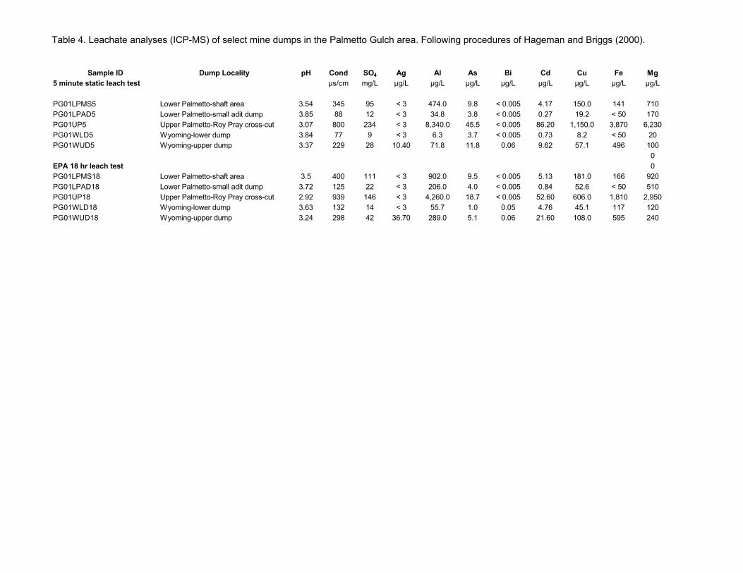
Table 4. Leachate analyses (ICP-MS) of select mine dumps in the Palmetto Gulch area. Following procedures of Hageman and Briggs (2000).
Sample ID Dump Locality 5 minute static leach test
PG01LPMS5 Lower Palmetto-shaft area PG01LPAD5 Lower Palmetto-small adit dump PG01UP5 Upper Palmetto-Roy Pray cross-cut PG01WLD5 Wyoming-lower dump PG01WUD5 Wyoming-upper dump
EPA 18 hr leach test PG01LPMS18 Lower Palmetto-shaft area PG01LPAD18 Lower Palmetto-small adit dump PG01UP18 Upper Palmetto-Roy Pray cross-cut PG01WLD18 Wyoming-lower dump PG01WUD18 Wyoming-upper dump
pH Cond SO4 Ag Al As Bi Cd Cu Fe Mg µs/cm mg/L µg/L µg/L µg/L µg/L µg/L µg/L µg/L µg/L
3.54 345 95 < 3 474.0 9.8 < 0.005 4.17 150.0 141 710 3.85 88 12 < 3 34.8 3.8 < 0.005 0.27 19.2 < 50 170 3.07 800 234 < 3 8,340.0 45.5 < 0.005 86.20 1,150.0 3,870 6,230 3.84 77 9 < 3 6.3 3.7 < 0.005 0.73 8.2 < 50 20 3.37 229 28 10.40 71.8 11.8 0.06 9.62 57.1 496 100
0 0
3.5 400 111 < 3 902.0 9.5 < 0.005 5.13 181.0 166 920 3.72 125 22 < 3 206.0 4.0 < 0.005 0.84 52.6 < 50 510 2.92 939 146 < 3 4,260.0 18.7 < 0.005 52.60 606.0 1,810 2,950 3.63 132 14 < 3 55.7 1.0 0.05 4.76 45.1 117 120 3.24 298 42 36.70 289.0 5.1 0.06 21.60 108.0 595 240

Table 4. cont'd
Sample ID 5 minute static leach test
PG01LPMS5 PG01LPAD5 PG01UP5 PG01WLD5 PG01WUD5
EPA 18 hr leach test PG01LPMS18 PG01LPAD18 PG01UP18 PG01WLD18 PG01WUD18
Mn Mo Pb Sb Se U Zn µg/L µg/L µg/L µg/L µg/L µg/L µg/L
485 1.51 0.40 3.67 < 1 0.40 521 54 0.42 0.20 2.09 < 1 0.05 124
8,740 0.60 7.90 0.57 < 1 1.29 15,500 9 0.22 41.40 20.80 < 1 0.01 202 23 0.25 729.00 60.40 < 1 0.03 1,840
779 1.63 0.64 3.21 < 1 0.56 688 198 0.57 2.80 1.98 < 1 0.14 199
4,900 0.20 36.70 0.77 < 1 0.86 8,740 96 < 0.2 1,050.00 9.69 < 1 0.04 904 59 < 0.2 8,330.00 26.20 < 1 0.06 4,260

Table 5. Reconnaissance water quality data from Palmetto Gulch area.
Site Longitude Latitude Altitude Description Date pH SC,
uS/cm T, oC DO,
mg/L DOsat, mg/L
Qest, ft3/sec Remarks
WPalm1 -107.582127 37.973552 12,620 North Palmetto below Hough 9/28/1999 3.72 1,690 1.1 13.2 14.2 0.005 WPalm2 -107.580238 37.974211 12,560 Spring east of Hough 9/28/1999 7.15 220 1.4 0.001 No visual evidence of mining impact WPalm3 -107.581028 37.974307 12,520 Spring east of Hough 9/28/1999 7.55 780 2.9 0.001 No visual evidence of mining impact WPalm4 -107.581127 37.974588 12,520 Trib below Engineer Pass (mining-affected?) 9/28/1999 4.65 440 1.8 0.15 White precips blw mixing zone WPalm5 -107.579433 37.976239 12,440 Spring from bedded Tsh 9/28/1999 6.78 110 1.4 0.001 No visual evidence of mining impact WPalm6 -107.578767 37.976009 12,420 Bigl big spring from intrusive (green xtals) 9/28/1999 7.32 242 2.1 12 15.2 0.05 WPalm7 -107.578995 37.976286 12,420 North Palmetto Gulch above spring at Palm6 9/28/1999 6.63 268 1.9 0.2 WPalm8 -107.576073 37.977698 12,380 North Palm. G. below Engineer Pass road 9/28/1999 6.9 280 3.6 0.5 WPalm9 -107.575581 37.977059 12,380 Spring on trail 9/28/1999 6.96 232 3.3 0.001 No visual evidence of mining impact WPalm10 -107.574743 37.970263 12,620 Wyoming Mine, drainage tunnel below shaft 9/28/1999 6.21 198 3.6 7.1 13.8 0.02 Large mine workings area, blw cirque basin WPalm11 -107.575197 37.972735 12,360 Spring south of BLM mine 9/28/1999 5.45 120 3.1 12.4 13.7 0.01 Moss, algae WPalm12 -107.574994 37.973079 12,320 Spring near confluence w/ middle Palm. G. 9/28/1999 6.57 130 5.5 0.01 Across (south) from BLM mine dump WPalm13 -107.574506 37.973444 12,320 Drainage from workings of BLM mine 9/28/1999 3.21 1,525 6.9 0.04 Kill zone, red precips WPalm14 -107.573656 37.973721 12,320 Middle Palm. G. below BLM mine 9/28/1999 3.93 600 5.7 0.3 Red/orange precips WPalm15 -107.574912 37.973380 12,360 BLM mine drainage 9/28/1999 3.34 1,775 2.7 12.2 15.1 0.01 Bright orange precips WPalm16 -107.574385 37.973400 12,360 Seep adjacent to adit 9/28/1999 5.97 370 9.5 0.001 WPalm17 -107.576278 37.972966 12,460 Red spring in canyon abv BLM mine 9/28/1999 3.29 1,120 2.6 0.002 Some mixed drainage from shafts that worked vein structure WPalm18 -107.577050 37.973063 12,500 Middle Palm. G. upstream from 17 9/28/1999 5.4 338 5 0.2 White precips, natural above here except for small shaft (site 21) WPalm19 -107.577388 37.973013 12,520 Spring in canyon above 18 9/28/1999 6.7 172 6 0.002 No visual evidence of mining impact WPalm20 -107.578299 37.972255 12,550 Middle Palm G. below peat fan 9/28/1999 5.62 315 7 0.15 White precips WPalm21 -107.580889 37.971875 12,620 Water in shaft in drainage above peat fan 9/28/1999 6.08 405 2.2 Water level 3 ft below surface WPalm22 -107.581345 37.972158 12,640 Upper Middle Palm. G. above mines 9/28/1999 6.78 200 5 0.05 WPalm23 -107.566185 37.979810 11,680 Palm. G. below confluence of upper 3 tribs 9/30/1999 4.23 345 2.9 9.1 1.5 White precips WPalm24 -107.567600 37.979497 11,720 North trib Palm. Guch near confluence 9/30/1999 3.86 226 5.9 0.5 WPalm25 -107.567774 37.978804 11,720 South trib Palm. Gulch near confluence 9/30/1999 3.68 440 1.1 1.0 White precips WPalm26 -107.567679 37.978351 11,800 Spring near confluence 9/30/1999 3.92 282 5.7 0.005 No visual evidence of mining impact; along FSJ vein WPalm27 -107.569481 37.976498 11,980 Big spring in fractured rocks 9/30/1999 3.97 175 2.6 0.01 WPalm28 -107.569707 37.976880 12,000 Middle Palm. G. below BLM mine 9/30/1999 3.85 545 3 0.75 Red/orange precips, lots of water comes in between WPalm29 -107.568827 37.975503 12,020 South trib PalmG 9/30/1999 3.96 300 6 0.25 No precips WPalm30 -107.570491 37.973163 12,160 South Palm G. above vein structure 9/30/1999 3.94 332 4.1 0.25 WPalm31 -107.570959 37.973237 12,160 Trib from Wyoming at South Palmetto Gulch 9/30/1999 3.81 252 8.3 0.08 WPalm32 -107.573138 37.972493 12,420 Wyoming trib below cliffs (the "red streak") 9/30/1999 3.96 360 1.8 Water mostly in the subsurface, sampled drips WPalm33 -107.572222 37.972341 12,480 Mine pool, yellow precipitates 9/30/1999 4.03 565 2 0.001 Drips enter mine 100 ft from entrance WPalm34 -107.571909 37.970258 12,460 Spring draining grey rocks 9/30/1999 5.25 242 5.5 5.1 6.8 0.002 No visual evidence of mining impact WPalm35 -107.571945 37.969733 12,520 Possible drainage from uppermost prospects, 9/30/1999 4.42 182 3.7 5.2 6.5 0.001 Red precips, could be spring WPalm36 -107.573204 37.969277 12,540 Source spring of South Palm. Gulch 9/30/1999 4.43 220 7.5 0.003 Uncertain if mining-impacted WPalm37 -107.572770 37.967624 12,640 Spring along vein structure above mines 9/30/1999 4.05 185 5.3 0.001 No visual evidence of mining impact WPalm38 -107.572770 37.967624 12,700 Spring below cirque basin 9/30/1999 4.16 240 10.5 0.002 No visual evidence of mining impact, red white precips WPalm39 -107.571888 37.970669 12,400 Big spring, see discussion in text 9/30/1999 4.19 195 8.1 0.05 Blue/white precips blw confl w/ red mainstem, WPalm40 -107.571001 37.970846 12,400 Big spring, see discussion in text 9/30/1999 4.01 535 5.4 0.05 WPalm41 -107.570858 37.971288 12,390 South Palmetto Gulch 9/30/1999 4.15 328 7.1 0.1 Blue/white precips, stream clears up way before