GEOLOGY AND GRADIENT WELLS 2007...Geology and gradient wells 3 Saemundsson FIGURE 2: The high...
11
Presented at Short Course II on Surface Exploration for Geothermal Resources, organized by UNU-GTP and KenGen, at Lake Naivasha, Kenya, 2-17 November, 2007. GEOTHERMAL TRAINING PROGRAMME Kenya Electricity Generating Co., Ltd. GEOLOGY AND GRADIENT WELLS Kristján Saemundsson ISOR – Iceland GeoSurvey Grensásvegur 9 108 Reykjavík ICELAND [email protected] ABSTRACT Drilling of gradient wells is a method used in exploration of both high- and low- temperature geothermal fields. The applicability of the method depends on the permeability of the subsurface rock and the depth to ground water. Low permeability is a prerequisite for the method to give reliable results because it is very important to avoid disturbance from internal flow of water inside the well. The drilling depth is accordingly anywhere from a few tens of metres to a few hundred metres. The latter may be necessary in areas of young or unaltered volcanics and low ground water level (such rocks are also as a rule costly to drill and secure from caving in). In fracture controlled low-temperature fields shallow boreholes come out best. This method has been applied also in high-temperature geothermal fields both as a regional survey and as testing the validity of indirect evidence (from geology or resistivity) of a potential. It is clear that knowledge of the hydrological conditions of the prospect area is needed, and also familiarity with the basic principles of hydrogeology. 1. LOW-TEMPERATURE GEOTHERMAL FIELDS In low-temperature areas gradient boreholes need to be no deeper than 30-60 m if the permeability is low. The regional geothermal gradient must be known also as a basis for recognizing thermal anomalies. The greater the difference the better the prospects for success. The method has proved most useful in areas where the geothermal system is confined to a fracture of local extent. In Iceland many exploitable geothermal systems have been discovered by this method where there were no surface manifestations (Figures 1 and 2). Fracture controlled geothermal systems can develop anywhere, also in areas of low geothermal gradients including the continental average (~30°C/km). Drilling of gradient boreholes is in a way an extension of a ground temperature survey (temperature measured at 50-100 cm depth). In Iceland this method has been applied both in low-and high- temperature geothermal fields, partly with a different purpose in mind, however. In the low- temperature areas the method is used to outline the areal extent of an anomaly, its size and shape with the purpose of siting a hot water borehole (Figures 3, 4 and 5). In high-temperature fields the method has been applied only once in Iceland, in one of the smallest by area (Reykjanes) to estimate its thermal output (Figure 6). However, the main profit there was of a different kind, i.e. giving a basis to
Transcript of GEOLOGY AND GRADIENT WELLS 2007...Geology and gradient wells 3 Saemundsson FIGURE 2: The high...

Presented at Short Course II on Surface Exploration for Geothermal Resources,
organized by UNU-GTP and KenGen, at Lake Naivasha, Kenya, 2-17 November, 2007.
GEOTHERMAL TRAINING PROGRAMME Kenya Electricity Generating Co., Ltd.
GEOLOGY AND GRADIENT WELLS
Kristján Saemundsson
ISOR – Iceland GeoSurvey
Grensásvegur 9
108 Reykjavík
ICELAND
ABSTRACT
Drilling of gradient wells is a method used in exploration of both high- and low-
temperature geothermal fields. The applicability of the method depends on the
permeability of the subsurface rock and the depth to ground water. Low
permeability is a prerequisite for the method to give reliable results because it is
very important to avoid disturbance from internal flow of water inside the well.
The drilling depth is accordingly anywhere from a few tens of metres to a few
hundred metres. The latter may be necessary in areas of young or unaltered
volcanics and low ground water level (such rocks are also as a rule costly to drill
and secure from caving in). In fracture controlled low-temperature fields shallow
boreholes come out best. This method has been applied also in high-temperature
geothermal fields both as a regional survey and as testing the validity of indirect
evidence (from geology or resistivity) of a potential. It is clear that knowledge of
the hydrological conditions of the prospect area is needed, and also familiarity with
the basic principles of hydrogeology.
1. LOW-TEMPERATURE GEOTHERMAL FIELDS
In low-temperature areas gradient boreholes need to be no deeper than 30-60 m if the permeability is
low. The regional geothermal gradient must be known also as a basis for recognizing thermal
anomalies. The greater the difference the better the prospects for success. The method has proved most
useful in areas where the geothermal system is confined to a fracture of local extent. In Iceland many
exploitable geothermal systems have been discovered by this method where there were no surface
manifestations (Figures 1 and 2). Fracture controlled geothermal systems can develop anywhere, also
in areas of low geothermal gradients including the continental average (~30°C/km).
Drilling of gradient boreholes is in a way an extension of a ground temperature survey (temperature
measured at 50-100 cm depth). In Iceland this method has been applied both in low-and high-
temperature geothermal fields, partly with a different purpose in mind, however. In the low-
temperature areas the method is used to outline the areal extent of an anomaly, its size and shape with
the purpose of siting a hot water borehole (Figures 3, 4 and 5). In high-temperature fields the method
has been applied only once in Iceland, in one of the smallest by area (Reykjanes) to estimate its
thermal output (Figure 6). However, the main profit there was of a different kind, i.e. giving a basis to

Saemundsson 2 Geology and gradient wells
record changes, first decline of surface activity over a period of 40 years followed by a dramatic
increase after beginning of steam production on a large scale.
FIGURE 1: Thermal gradient at Arnarstadir, West Iceland. The bedrock is zeolitized Miocene basalt
lavas of very low permeability. Two shallow boreholes, 1500 m apart, show near surface regional
gradient, versus local anomalously high gradient. Such high values as found in SN-1 can only be
explained by an underlying geothermal system. There are no surface indications of a geothermal
system in this area.
Geology and gradient wells 3 Saemundsson
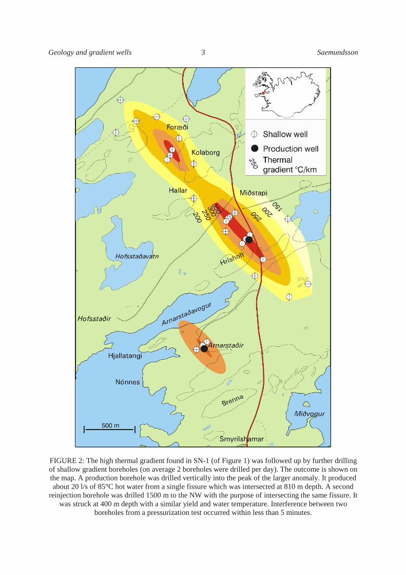
FIGURE 2: The high thermal gradient found in SN-1 (of Figure 1) was followed up by further drilling
of shallow gradient boreholes (on average 2 boreholes were drilled per day). The outcome is shown on
the map. A production borehole was drilled vertically into the peak of the larger anomaly. It produced
about 20 l/s of 85°C hot water from a single fissure which was intersected at 810 m depth. A second
reinjection borehole was drilled 1500 m to the NW with the purpose of intersecting the same fissure. It
was struck at 400 m depth with a similar yield and water temperature. Interference between two
boreholes from a pressurization test occurred within less than 5 minutes.

Saemundsson 4 Geology and gradient wells
As regards basin reservoirs it would be sufficient to compile data on the sedimentary fill, and
permeability of the different sedimentary units and their facies changes. Many basins have been targets
in oil prospection (in particular molasse basins). The second main issue here is the geothermal
gradient. The Hungarian basin e.g. gives high but variable values (50-70°C/km) (Rybach and Muffler,
1981). Basic information on such parameters often exists but may not be open as it is owned by private
companies. Faults may add significantly to permeability and dilute a brine fluid (commonly found in
basin fills) by recharge from precipitation.
FIGURE 3: South Iceland Seismic Zone (a transform fracture zone) connects the two rift zones in
South Iceland. It is characterized by a conjugate set of N-S and ENE-WSW faults. They are shown
white where active and blue where extinct, indicating a former position north of the present location.

Geology and gradient wells 5 Saemundsson
FIGURE 4: Example of a soil temperature survey. The locality is in the western part of the South
Iceland Seismic Zone (SISZ). Warm springs are found in drainage ditches dug in a wet bog. Soil
temperatures of over 10°C at 60 cm depth are shown in pink. Holt to the northeast and east are hills
where Pliocene bedrock (basalt) is exposed. The survey was made in December. The trend of the
thermal anomalies follows the trend of earthquake fissures which are the main targets for hot water
drilling in the SISZ. Two en-echelon segments of a N-S main right lateral strike-slip fault were found.

Saemundsson 6 Geology and gradient wells
FIGURE 5: Temperature profile of SH-3 (of Figure 4). Plenty of 59°C hot water was found in a fissure
from 70-120 m depth. The fissure was permeable down to ~250 m but the temperature inverted below
120 m, indicating lateral flow from higher ground to the North.
2. HIGH-TEMPERATURE GEOTHERMAL FIELDS – FROM GRADIENT WELLS
TO EXPLORATORY DRILLING
For interpretation it is important to know the basic character of a high-temperature geothermal system.
Typically there is boiling groundwater at some depth from which steam and gas are boiled off to
escape at the surface (fumaroles, solfataras, mud pots hot ground), or possibly get drowned in a
perched, near surface aquifer (in areas of sedimentary cover, Kaldakvísl). At low altitude the reservoir
water may flow out forming flats of silica sinter deposited from boiling springs, often with geyser-
activity (spout intermittently).

Geology and gradient wells 7 Saemundsson
Drilling of gradient wells is sometimes applied in high-temperature areas. Gradient boreholes may be
shallow or deep depending on the nature of the near surface rock. Preferably they should reach well
down into near impermeable rock (due to alteration). Shallow boreholes (<100 m) in permeable rocks
are not likely to yield temperatures much higher than 100°C, but they may show meaningful areal
temperature variations and thus extend surface indications downwards (example from Djibouti,
Stieltjes, 1976). In Iceland 40-60 years ago shallow wells were drilled in the midst of fumarole fields
Námafjall, Hengill, Krýsuvík, Reykjanes, (Figure 6) using inappropriate equipment, and insufficient
casing.
FIGURE 6: Ground temperature survey of Reykjanes, a high-temperature geothermal field at the tip of
the Reykjanes Peninsula, SW-Iceland. The bedrock is Holocene basalt lavas. The first boreholes (RN-
1-4) were drilled in the hottest part of the field. They all failed due to overpressure and insufficient
casing (collapse). Borehole 5 was drilled to the east of the thermal anomaly. It failed also because of
caving in of unaltered and unstable rock. It was drilled close to a fault and ended at 100 m. The first
successful borehole (RN-8) was drilled into altered hyaloclastite 100 m northeast of the hot area. The
hyaloclastite is part of a NE-SW ridge system (constructional features show up in height contours).
It proved later to be the main upflow zone of the field.
The main purpose was to produce steam and locate a good production zone. Most of the boreholes
ended in blow-up and/or collapse. Their depth varied from less than 100 m to over 300 m.
Temperature logs were obtained only from the last ones drilled. Some of those boreholes have been
Saemundsson 8 Geology and gradient wells
blowing to this day. At Námafjall they emit dry steam and attract tourists not knowing how they came
about. At that time a few boreholes, interestingly some of the first ones, were also drilled on more
stable ground well away from the fumaroles (Krýsuvík). Those could be kept under control and they
yielded valid information about subsurface temperature, in fact were useful gradient boreholes as
planned. Those early attempts failed because knowhow was insufficient to complete a shallow
borehole into a steam zone underlying a highly active fumarole field. The subsurface extent and trend
of such a field, however, could have been judged from the thermal gradient in boreholes drilled into
altered rock some distance away.
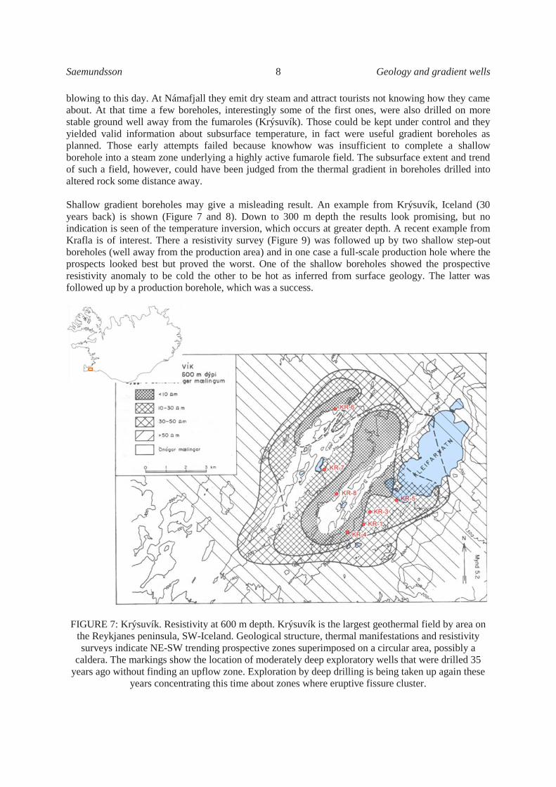
Shallow gradient boreholes may give a misleading result. An example from Krýsuvík, Iceland (30
years back) is shown (Figure 7 and 8). Down to 300 m depth the results look promising, but no
indication is seen of the temperature inversion, which occurs at greater depth. A recent example from
Krafla is of interest. There a resistivity survey (Figure 9) was followed up by two shallow step-out
boreholes (well away from the production area) and in one case a full-scale production hole where the
prospects looked best but proved the worst. One of the shallow boreholes showed the prospective
resistivity anomaly to be cold the other to be hot as inferred from surface geology. The latter was
followed up by a production borehole, which was a success.
FIGURE 7: Krýsuvík. Resistivity at 600 m depth. Krýsuvík is the largest geothermal field by area on
the Reykjanes peninsula, SW-Iceland. Geological structure, thermal manifestations and resistivity
surveys indicate NE-SW trending prospective zones superimposed on a circular area, possibly a
caldera. The markings show the location of moderately deep exploratory wells that were drilled 35
years ago without finding an upflow zone. Exploration by deep drilling is being taken up again these
years concentrating this time about zones where eruptive fissure cluster.

Geology and gradient wells 9 Saemundsson
In Iceland the method (drilling of gradient wells
or shallow exploratory wells) is not used as an
early step in subsurface exploration, except where
resistivity alone indicates a resource. Gradient
boreholes or more often deep exploratory
boreholes are drilled to follow up surface
exploration if the results of the various methods
correlate tolerably well.
A geothermal gradient map was compiled of the
Campi Flegrei geothermal field, west of Napoli,
Italy, from 30 to 140 m deep water wells (Corrado
et al. 1998). Figure 10 shows the result. High but
variable gradients were found within the caldera.
Correlation of the local anomalies with small
magma bodies as suggested by the authors seems
rather doubtful. Viewed against other information
such as structural features, hydrology, and the
occurrence of geothermal surface manifestations
the map seems to add little to the deep structure of
the field. On the other hand it is a good basis for
monitoring changes both associated with natural
unrest and exploitation if such come about (deep
drilling has revealed temperatures of 300-400°C
below 1500m depth).
The lessons to be learned are that gradient or
exploratory wells should be drilled down to at least
500-1000 m. Such wells are usually drilled vertically.
Inclined wells in the deeper range would be
appropriate in rift zones, especially for the purpose of
testing the permeability of vertical (or near vertical)
fissures and dykes. Such may act as high-
permeability anomalies and optimal feed zones
(Hengill, Eldvörp). The most important information
to be gained would be a temperature profile of the
prospect area as compared with the alteration state of
the rock. A misfit (high alteration state but low rock
temperature) may indicate cooling of the system (due
to old age and exhaustion of the heat source) or a
drop in water level (hydrostatic pressure) which
might have occurred in the course of geological time
Think of pluvial periods (high lake stands) in low
latitudes equivalent to glacial periods at high
latitudes.
FIGURE 8: Temperature logs of exploration
wells at Krýsuvík, shown in Figure 6. Down to
300 m depth none of the wells indicated the
temperature inversion which occurred at
greater depth. Gradient wells of 300 and in
some cases 500 m depth would in this case
have been misleading.
FIGURE 9: Resistivity map of Krafla at
900 m depth. The outline of the Krafla
caldera is shown. Drilling of a gradient
well into the anomaly east of the caldera
proved it to be cold, probably an extinct
part of the geothermal system from the
time of its „youth“. A deep well drilled
into the large anomaly which extends
furthest south showed it to be a hot
outflow zone. A sharp temperature
inversion occurred below it, contrasting
with high temperature alteration of the
rock mass, but in accord with the high
resistivity. The outflow is restricted to the
uppermost permeable 500-800 m metres
showing up as a low resistivity zone.

Saemundsson 10 Geology and gradient wells
FIGURE 10: Geothermal gradient map of the Campi Flegrei high temperature goethermal field, Italy.
The field is located in the northern half of a caldera. The map seems to be rather a blunt tool for
concluding about deeper structure of the field, but may prove significant in volcano surveillance. Deep
drilling (2000-2500 m wells have been drilled revealed temperatures of between 300 and 400°C. From
: Corrado et al. 1998.
It is important at an early stage of geothermal prospection to investigate the hydrology of the
surrounding region such as precipitation, catchment area (for likely recharge), and depth to ground
water level, general flow direction and content of dissolved solids (get access to data from appropriate
authorities). The last is an important issue to avoid locating deep wells in outflow areas too far off
from upwelling geothermal plumes. The ground water level may be low (at several hundred metres
depth) under large volcanic edifices which host a geothermal system. One way to get at them is by
directional drilling.
Fumaroles are an indication of a boiling reservoir. Intensive fumarole activity and widespread hot
ground (several hectares in extent) point to a steam zone at shallow depth (Figure 11 Námafjall). Such
conditions call for precautions and an appropriate casing program when drilled into. In Iceland blow
outs occur under such conditions from time to time and are always time consuming and costly.
Temperature profiles are different in vapour dominated systems (nearly constant temperature with
depth) versus water dominated systems where temperature increase is likely to more or less follow the
boiling point curve at shallow depth. Temperature inversion commonly occurs, always indicating a
marginal location or a mushroom character spread or outflow (Figure 11).
Geology and gradient wells 11 Saemundsson
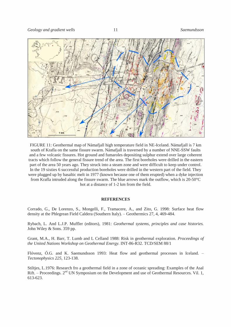
FIGURE 11: Geothermal map of Námafjall high temperature field in NE-Iceland. Námafjall is 7 km
south of Krafla on the same fissure swarm. Námafjall is traversed by a number of NNE-SSW faults
and a few volcanic fissures. Hot ground and fumaroles depositing sulphur extend over large coherent
tracts which follow the general fissure trend of the area. The first boreholes were drilled in the eastern
part of the area 50 years ago. They struck into a steam zone and were difficult to keep under control.
In the 19 sixties 6 successful production boreholes were drilled in the western part of the field. They
were plugged up by basaltic melt in 1977 (known because one of them erupted) when a dyke injection
from Krafla intruded along the fissure swarm. The blue arrows mark the outflow, which is 20-50°C
hot at a distance of 1-2 km from the field.
REFERENCES
Corrado, G., De Lorenzo, S., Mongelli, F., Tramacere, A., and Zito, G. 1998: Surface heat flow
density at the Phlegrean Field Caldera (Southern Italy). – Geothermics 27, 4, 469-484.
Rybach, L. And L.J.P. Muffler (editors), 1981: Geothermal systems, principles and case histories.
John Wiley & Sons. 359 pp.
Grant, M.A., H. Barr, T. Lumb and L Celland 1988: Risk in geothermal exploration. Proceedings of
the United Nations Workshop on Geothermal Energy. INT-86-R32. TCD/SEM 88/1
Flóvenz, Ó.G. and K. Saemundsson 1993: Heat flow and geothermal processes in Iceland. –
Tectonophysics 225, 123-138.
Stiltjes, L.1976: Research fro a geothermal field in a zone of oceanic spreading: Examples of the Asal
Rift. – Proceedings. 2nd
UN Symposium on the Development and use of Geothermal Resources. Vil. 1,
613-623.