GEOLOGY AND GBOUND-WATEB EESOUECES OF ...UNITED STATES DEPARTMENT OF THE INTERIOR Harold L. Ickes,...
130
UNITED STATES DEPARTMENT OF THE INTERIOR Harold L. Ickes, Secretary GEOLOGICAL SURVEY W. C. Mendenhall, Director Water-Supply Paper 778 GEOLOGY AND GBOUND-WATEB EESOUECES OF WEBB COUNTY, TEXAS BY JOHN T AND JAMES R, DAT Prepared iSrcoep ENGINEERING EXPERIMENT AND MECHANICAL BOARD OF ith the THE AGRICULTURAL and the TEXAS UNITED STATES GOVERNMENT PRINTING OFFICE WASHINGTON: 1937 For sale by the Superintendent of Documents, Washington, D. C. -------- Price 30 cents
Transcript of GEOLOGY AND GBOUND-WATEB EESOUECES OF ...UNITED STATES DEPARTMENT OF THE INTERIOR Harold L. Ickes,...

UNITED STATES DEPARTMENT OF THE INTERIOR Harold L. Ickes, Secretary
GEOLOGICAL SURVEY W. C. Mendenhall, Director
Water-Supply Paper 778
GEOLOGY AND GBOUND-WATEB EESOUECES OF WEBB COUNTY, TEXAS
BY
JOHN T AND JAMES R, DAT
Prepared iSrcoep
ENGINEERING EXPERIMENT AND MECHANICAL
BOARD OF
ith the
THE AGRICULTURAL and the TEXAS
UNITED STATES
GOVERNMENT PRINTING OFFICE
WASHINGTON: 1937
For sale by the Superintendent of Documents, Washington, D. C. -------- Price 30 cents


CONTENTS
PageAbstract_______________________________________________________ 1Introduction______________________________________________________ 2
Purpose of investigation________________________________________ 2Acknowledgments. ____________________________________________ 2Location of area___--_---__------_____-__-__-___---__-_-_______ 3Topography and drainage_____-___-_____-________--__-__-_--___ 3
Breaks of the Rio Grande-_--________--______--___-_--_____ 4Dentonio Plain_____.____________________________________ 4Nueces Basin_____________________________________________ 4Aguilares Plain____________________________________________ 5Bordas escarpment___________________.____________________ 5Drainage,____ __ ________________________________________ 5
Vegetation__ _______________________________ _ ______________ 6Transportation.__-___--_______-_________--__-_____.______--__- 6Agriculture. __________________________________________________ 6Maps._______________________________________________________ 7Climate._-__-__--___--_-_--_-____-__-_-_-__---_________-_____ 7Previous work_______________________________________________ 9
General geology__-____----________--________-______-_-________-__. 9Source and disposal of the ground water_______.______________________ 12General artesian conditions._________-______---________-__-_-___-_-_ 13Ground-water conditions in Webb County____________________________ 13Geologic formations and their water-bearing properties _________________ 14
Tertiary system _______________________________________________ 14Eocene series____________________________________________ 14
Wilcox group_________________________________________ 14Indio formation___________________________________ 14
Claiborne group_______________________________________ 16Carrizo sand._____________________________________ 16Mount Selman formation___________________________ 19
Bigford member_______________________________ 20Post-Bigford beds____._-_._-________-____. 32
Cook Mountain formation_________--__________--___ 42Yegua formation_________________________________ 55Jackson formation_________________________________ 58
Oligocene (?) series__._____________________________________ 62Frio clay_____________________!_____________ 62
Miocene (?) series._______.________________________________ 64Catahoula tuff_____________________________ 64
Pliocene series___________________________________________ 69Goliad sand___________________________________ 69
Tertiary (?) system...____________________________ 72Pliocene (?) series________________.__._____---___________ 72
Uvalde gravel______________________-_._.______________ 72m
IV ILLUSTRATIONS
Geologic formations and their water-bearing properties Continued.Quaternary system___________________________________________ 73
Recent series___________________________________________ 73Alluvium. ____________________________________________ 73
Mineral resources________________________________________________ 74Coal___ __________________________________________ 74Gravel.____________________________________________________ 74Oil and gas__.________________________________________________ 74
Summary of conclusions__________________________________________ 75Well tables.._________________________________________ 76Index. ______.____________________ 103
ILLUSTRATIONS
Page .PLATE 1. Areal geologic and hydrologic map and cross sections of Webb
County, Tex _________________________ In pocket2. A, Breaks of the Rio Grande near Palafox; B, Breaks of the Rio
Grande near Palafox; alluvial flat shown in top of view; C, Dentonio Plain near Galvan ranch_______________________ 2
3. A, Bordas escarpment near Mirando City; B, Beds of the Jackson formation upturned and faulted 1.3 miles south of Corpus Christi highway on Retama Creek ________________ 3
4. A, Contact of Indio formation and Carrizo sand at mouth of Chupadero Creek;x B, Alternating shale and sandstone strata of Indio formation on Borrego Creek______________________ 18
5. A, Indurated sandstone of Carrizo formation at Rocktown, southeast of Chupadero ranch; B, Carrizo sand on Mexican side of Rio Grande south of Chupadero ranch._________ __ 18
6. A, Juan Rey Spring, Chupadero ranch; B, Open prairie countrycharacteristic of outcrop of Carrizo sand, Chupadero ranch___ 18
7. Correlation of the Carrizo sand in typical wells in northwesternWebb County, showing depth below sea level _____ 18
&. A, Bigford strata near mouth of San Cirile Creek; B, Bigfordstrata half a mile above mouth of San Cirile Creek________ 34
9. A, Cuesta formed by hard sandstone bed in post-Bigford part of Mount Selman formation, half a mile south of Pilotes ranch; B, Exposures of Santo Tomas and related coal beds 4 miles south east of Palafox_______________________________________ 35
10. A, Fossiliferous shale and sandstone near base of the Cook Mountain formation on the Laredo-Dolores road at the west fork of Sambarieto Creek; B, Sandstone and shale in top of middle part of Cook Mountain formation 2.9 miles southeast of Laredo post omce______--__________--__-__-______---_ 42
11. Correlation of Mount Selman, Cook Mountain, Yegua, and Jackson formations and water sands in typical wells in northern Webb County_______ _____________________ 58
12. A, Oyster bed and clay near base of Yegua formation 7.5 miles east of Laredo post office; B, Typical Yegua clay 8.7 miles east of Laredo post office___________-___-___-_____-_______--_ 58

ILLUSTRATIONS V
Fag* FIOUKE 1. Map of Texas showing location of Webb County__________ 3
2. Composite columnar section of Bigford member of MountSelman formation showing fossil horizons and coal beds___ 23
3. Composite columnar section of post-Bigford part of MountSelman formation showing fossil horizons and coal beds____ 33
4. Composite columnar section of Cook Mountain formationshowing predominance of sand and sandstone members. _____ 43
5. Sketch map showing location of measured sections of CookMountain formation__________________________________ 45
6. Composite columnar section of Yegua formation showing pre dominance of clay________________________ 56
INSERTPage
Rock formations in Webb County, Tex., and their water-bearing properties. 14


GEOLOGY AND GROUND-WATER RESOURCES OF WEBB COUNTY, TEXAS
By JOHN T. LONSDALE and JAMES R. DAY
ABSTRACT
Webb County is in southwestern Texas and is a part of the Winter Garden district. The purpose of the investigation here recorded was to determine the source, quantity, and quality of the ground water used for irrigation and other purposes in the area.
The rock formations exposed are of Tertiary and Quaternary age and dip Gulfward at a greater angle than the slope of the land surface, resulting in north- south belts of outcropping formations. This general structure is modified by anticlines and faults, which, however, do not affect greatly the movement of ground water. In order from oldest to youngest the exposed formations are the Indio formation (850 feet thick), of Wilcox age; Carrizo sand (250 feet thick), Bigford member of the Mount Selman formation (660 feet thick), post-Bigford beds of the Mount Selman formation (1,165 feet thick), Cook Mountain formation (670 feet thick), and Yegua formation (670 feet thick), of CMborne age; Jackson formation (1,500 feet thick) and Frio clay (250 feet thick), of Oligocene (?) age; Catahoula tuff (750 feet thick), of Miocene (?) age; Goliad sand (100 feet thick), of Pliocene age; Uvalde gravel (25 feet thick), of Pliocene (?) age; and stream deposits of Quaternary age.
The chief water-bearing formations in the area are the Carrizo sand, Cook Mountain formation, Catahoula tuff, Goliad sand, and local stream deposits. The Carrizo sand crops out in the northwestern part of the area and furnishes shallow wells in the outcrop area and deeper nonflowing wells east of the outcrop. Water from this formation is of good quality, and wells of large yield could be obtained from the formation in a considerable area. Maps accompanying the report show the outcrop of the sand and the altitude at which it will be encountered in wells.
The Cook Mountain formation contains large amounts of sand and sandstone and is an important aquifer for domestic water supply and to some extent for irrigation water supply. The water is of variable quantity and quality, and some is highly mineralized. Water from this formation is used for irrigation near Encinal and Laredo. Flowing wells are obtained in low areas in northeastern Webb County, but the water is generally too highly mineralized for irrigation.
The Catahoula tuff yields water for domestic and industrial use and to a very slight extent for irrigation in the extreme southeastern part of the county. Flow ing wells are obtained in a small area near Bruni. The water generally is highly mineralized.
The Goliad sand is an important source of water for domestic and stock uses in the area of its outcrop in the southeastern part of the county. The water is of variable quality, and the yield of the wells is not very great. The water is gen erally suitable for domestic use but should not be used for irrigation except after careful testing.
1

2 GKOUND WATER OF WEBB COUNTY, TEXAS
Quaternary stream deposits in the northeastern part of the county are a source of small amounts of water suitable for domestic use. The wells are shallow.
The investigation showed that the ground waters from all the formations except the Carrizo sand are of variable quality and generally are highly mineral ized. Precautions to be taken in using these waters for irrigation are described.
INTRODUCTION
PURPOSE OF INVESTIGATION
This report covers the results of an investigation in Webb County, Tex., which was undertaken as part of a State-wide study of the underground-water resources of Texas. The investigation was made by the Geological Survey in cooperation with the Texas Board of Water Engineers and the Engineering Experiment Station of the Agricultural and Mechanical College of Texas. The report is designed to be a practical guide to the ground-water resources of the county, with special reference to the supply of ground water available for irrigation. Many problems of geology and stratigraphy in the area are not considered, because they have little or no bearing on the ground-water supply. The field work occupied June, July, and August in both 1931 and 1932.
ACKNOWLEDGMENTS
The writers are indebted to many persons who contributed informa tion and assistance in the field and assisted in the preparation of the report. Well logs and well data were supplied by several residents of the county, among them Mr. W. E. Smith, of Laredo; Mr. Ed Roebuck, of Encinal; and Mr. J. B. Finlay, of the Callaghan ranch. Mr. N. W. Jones, county agent of Webb County, extended many courtesies and gave information concerning the agricultural conditions in the area. Messrs. D. D. Davis and Reuben Davis furnished infor mation concerning coal-mining operations near Dolores. Geologists working in the area, Messrs. Olin G. Bell, F. C. Owen, G. B. Gerhardt, and R. Ryan, gave freely of their geologic information relating to the area. Miss JuJia A. Gardner, of the Geological Survey, identified fossils collected in the area and collaborated in the field work in July and August, 1932. Mr. A. N. Sayre, also of the Geological Survey, who was making a similar investigation in Duval County, spent several days in the field with the writers and gave material assistance in many ways. Mr. W. N. White, who is in charge of the ground-water study in Texas, exercised general supervision of the investigation and gave timely advice and assistance. The investi gation was made under the general direction of Mr. O. E. Meinzer, geologist in charge of the division of ground water in the Geological Survey.

U. S. GEOLOGICAL SURVEY WATER-SUPPLY PAPER 778 PLATE 2
A. BREAKS OF THE RIO GRANDE NEAR PALAFOX.
B. BREAKS OF THE RIO GRANDE NEAR PALAFOX.
Alluvial flat shown in top of view.
C. DENTONIO PLAIN NEAR GALVAN RANCH.

U. S. GEOLOGICAL SURVEY WATER-SUPPLY PAPER 778 PLATE 3
A. BORDAS ESCARPMENT NEAR MIRANDO CITY.
B. BEDS OF THE JACKSON FORMATION UPTURNED AND FAULTED 1.3 MILES SOUTHOF CORPUS CHRISTI HIGHWAY ON RETAMA CREEK.
D, Downthrow; U, upthrow; Al, alluvium.
INTRODUCTION 3
LOCATION OF AREA
Webb County lies in southwestern Texas (see fig. 1) and comprises a part of the district that is commonly called the Winter Garden area,1 the boundaries of which are rather loosely defined. Webb County has an area of 3,219 square miles. Laredo, with a population of 32,618 in 1930, is the only large city in the county and is an impor tant entry point between the Republic of Mexico and the United
FIGURE 1. Map of Texas showing location of Webb County.
States. Mirando City, Oilton, Bruni, and Dolores are the chief smaller settlements.
TOPOGRAPHY AND DRAINAGE
Webb County lies within the Coastal Plain, which in this part of Texas extends from the Edwards Plateau to the Gulf of Mexico. The county possesses more varied topography than most of the other Coastal Plain counties in southwestern Texas, because of the features of erosion that have been produced by the Rio Grande and its trib-
i Mortensen, E., The Winter Garden region of Texas: Texas Agr. Exper. Circ. 62, p. 1, 1933.

4 GROUND WATER OF WEBB COUNTY, TEXAS
utaries in the western part of the county and the presence of the Bordas escarpment in the southeastern part. The general southeastward slope characteristic of the Coastal Plain is interrupted by these features and by small westward-facing cuestas resulting from the differential erosion of unequally resistant and slightly tilted beds. A consideration of the topography of the Rio Grande region led Trowbridge to recognize, as major topographic divisions in Webb County, the breaks of the Rio Grande, the Nueces Basin, the Dentonio Plain, the Aguilares Plain, and the Bordas escarpment.2 A clear conception of these divisions aids in forming a picture of the geography of the area.
Breaks of the Rio Grande. A belt of land along the Rio Grande that has been intricately dissected by the river and its tributaries is called the breaks of the Rio Grande. In Webb County the belt is from 3 to 15 miles wide and is the roughest part of the country. Along the Rio Grande the lands included in the breaks are from 50 to 125 feet above the river. At some distance from the river they reach a maximum altitude of about 300 feet above it. Streams that enter the Rio Grande in this area are actively eroding. This is indicated by the character of their valleys, which near the Rio Grande are generally narrow and steep-walled but with distance from the river decrease in depth and steepness. The breaks, therefore, form a belt of land cut by a great northwest-southeast trench, the valley of the Rio Grande, and by numerous transverse trenches, the valleys of the tributaries. Cultivable lands are not common in this area, although a few small tracts are found. Views of the breaks are shown in plate 2, A and B.
Dentonio Plain. The breaks of the Rio Grande merge on the north and northeast into a nearly flat upland, the Dentonio Plain, which forms the divide between the Rio Grande and the Nueces River. This division is most typically a plain in the area around^ the Brown ranch, in the northwestern part of the county, where the upland has little or no drainage, has practically no relief, and lacks abundant brush. The character of the topography is indicated by local names, such as Llano [Prairie] Pasture. Farther to the east and southeast the divide between the two rivers is somewhat dissected and the plainlike character is not so evident. Nevertheless, the divide represents a distinct topographic division extending across the area from northwest to southeast. A view of the plain near the Gal van ranch is shown in plate 2, C.
Nueces Basin. About half of the county, comprising most of the northern and north-central parts, is drained by tributaries of the Nueces River. These tributaries as a rule are longer and their valleys are broader and shallower than those of the Rio Grande. Some of them
> Trowbridge, A. C., Tertiary and Quaternary geology of the lower Rio Grande region, Texas: Geol. Survey Bull. 837, pp. 15-24, 1932.

INTRODUCTION 5
head within 12 or 15 miles of the Rio Grande. The lands in the Nueces Basin as a rule are comparatively level and therefore are quite in contrast with those in the breaks of the Rio Grande. Many of the valleys contain extensive deposits of alluvium; those in the valley of Prieto Creek are several miles wide and more than 40 feet thick.
Aguilares Plain. A belt of country several miles wide west of the Bordas escarpment and drained by the Rio Grande is known as the Aguilares Plain. The area is underlain largely by clay or shale with minor amounts of harder rocks. As a result a rolling topography with fairly wide valleys and narrow divides has been developed. The area is too varied in character and has too much relief to be properly classed as a plain. However, it is a topographic unit fairly distinct from sur rounding areas and merits a separate designation. It is bounded on the west by the rougher country of the breaks of the Rio Grande.
Bordas escarpment. The Bordas escarpment is a prominent topo graphic feature in the southeastern part of the county. It crosses the county in a general northeast-southwest direction from the east county line near Moglia to the south county line near the Aviators oil field. Its position is shown on plate 1 as the contact between the Goliad and Catahoula formations.
The Bordas escarpment is the west face of a cuesta caused by the resistance to erosion of the Goliad sand and underlying formations. It is a notable topographic feature standing from 100 to 200 feet above the Aguilares Plain. The highest point on the escarpment, near Ojuelos, has an altitude of 1,004 feet; the Aguilares Plain at Aguilares, several miles west of the escarpment, has an altitude of about 660 feet. The top of the cuesta is a plain having a gentle slope to the east, called by Trowbridge the Hebbronville Plain. Consequently, the escarp ment is noticeable only from the west. An excellent view of it can be obtained from the overpass on the highway west of Aguilares.
In some areas the cuesta does not end in a single escarpment but is continued in two or more lower escarpments flanking the highest point. The lower escarpments are usually formed from hard and resistant beds in the Catahoula formation, and the highest escarpment is usually formed from beds of the Goliad sand. A view of the Bordas escarpment is shown in plate 3, A.
Drainage. The Rio Grande is the only perennial stream in this region. The other streams have a flashy, intermittent flow, although the larger ones contain isolated pools of water even in dry periods. The largest tributaries of the Rio Grande in Webb County are San Ambrosia, San Lorenzo, Espada, Santa Isabel, Chacon, and Dolores Creeks. The chief tributaries of the Nueces River are Carrizitos, Parida, Salado, and Prieto Creeks.

() GROUND WATER OF WEBB COUNTY, TEXAS
VEGETATION
The native vegetation reflects to a degree the semiarid character of the climate. Most of the uncleared areas are covered with a growth of varying density of scrub trees or chaparral. On the divides between the streams the trees consist dominantly of mesquite, but on the low lands near the larger streams pecan, live oak, cypress, willow, and cane are found. The chaparral consists chiefly of blackbrush, cat- claw, juahillo, scrub mesquite, and prickly pear and other types of- cactus. A variety of grasses grow in open spaces among the trees and chaparral. The character of the vegetation in any locality is influ enced by the type of soil produced by the weathering of the underlying formations. A thin growth of chaparral and an abundance of prickly pear and grasses are found on the outcrops of formations composed dominantly of clay. A dense growth of chaparral usually is found on outcrops composed of both sand and clay, and a scattered growth of trees of more than average size is found on outcrops that are domi nantly sandy. Gravel-covered areas invariably support dense growths of chaparral.
TRANSPORTATION
Webb County is traversed by the International-Great Northern Railroad from San Antonio to Laredo; the Texas Mexican Railway from Corpus Christi to Laredo; and the Rio Grande & Eagle Pass Railway from Laredo to the coal-mining district around Dolores.
The county is provided with good trunk automobile roads State highway 2 from San Antonio to Laredo along the line of the Inter national-Great Northern Railroad, State highway 12A from Corpus Christi to Laredo, and State highway 4 from Laredo to the lower Rio Grande Valley and Brownsville, following closely the course of the river. A good automobile road also extends from Laredo northwest to the Pilotes ranch. Secondary automobile roads and ranch roads, many of them graded and open for travel except in very wet weather, connect all parts of the area.
AGRICULTURE
Land in Webb County is used chiefly for stock raising, and large areas probably will always be devoted to this use because of the char acter of the land, the small amount of rainfall, and the lack of water suitable for irrigation. Farming is on the increase, however, and per haps eventually most of the land suitable for agriculture will be cultivated. Farming operations in the county at the time of the investigation were mostly restricted to a belt of land a few miles wide along the International-Great Northern Railroad, to lands adjacent to or near the Rio Grande, and to isolated tracts along the Texas Mexican Railway. Irrigation with water from the Rio Grande is carried on in certain areas near this stream, and irrigation with water

INTRODUCTION 7
from wells has been developed to some extent along the International- Great Northern Kailroad and in isolated small areas in the southern and southeastern parts of the county. The lands irrigated from wells are shown on plate 1.
The production of winter vegetables and citrus fruit under irrigation from the Rio Grande and to a lesser extent from wells has become an important industry in the area. According to Mortensen,3 1.9 percent of the total area of Webb County was under cultivation in 1929. Below is a table compiled from his paper showing the kinds of crops raised and the acreage devoted to each:
Farm acreage of crops raised in Webb County, Tex., in 1929
Acres Alfalfa.. ___--_____--___-_-_- 331Beans (threshed)_____________ 45Corn.._____________________ 2,351Cotton_______________ 13, 047Cowpeas-___________________ 16Oats_______________ 934Peanuts. ____-_____---_-_____ 2Sorghums_------------__-_ 3, 981Beans, snap_-____--_-_--____ 162Beets__--_-----------_-___ 68Broccoli__ _-___---____-__-_ 150Cabbages.__________________ 67
Carrots-__-_ Corn, sweet. Lettuce_____ Muskmelons.
Acresr _____________ 81--_----_--___ 11_____________ 22_____________ 53
Onions, dry__________________ 3, 344Onions, green_________________ 266Spinach________-_____________ 1, 005
_-__-____---_____ 100_________________ 50
Watermelons-..,-_--___--__-_ 124Miscellaneous vegetables _______ 11Fruits____ .-_._________ 550
MAPS
Plate 1 shows the areal geology and hydrologic data for the area including the location of record wells, land irrigated with water from wells, and depths to the top of the Carrizo sand for part of the area. The base map was compiled from tactical maps of the United States Army Engineers, from land maps, and from compass traverses.
CLIMATE
Texas is remarkable for its great variety of climate. The extreme eastern part of the State has an average annual rainfall of more than 45 inches. The precipitation decreases gradually from east to west, however, the annual average being less than 30 inches at San Antonio and less than 20 inches at Eagle Pass. In Webb County records are available only for Laredo. The average annual rainfall for the whole county probably is about 20 inches.
The seasonal range in temperature in the area is fairly large. Summer temperatures are frequently higher than 100°, whereas dur ing the winter there is generally at least one killing frost. During the period of record the growing season at Laredo has ranged from 225 to 354 days and averaged 293 days. Observations made intermittently since 1871 record a minimum temperature of 5° above zero.
3 Mortensen, E., op. cit,, p. 4.

8 GROUND WATER OF WEBB COUNTY, TEXAS
In most years there is some rain every month. The heaviest precipitation occurs from April to October, but for any given month there is considerable variation from year to year. There is a tendency for the precipitation to be concentrated in heavy rains, which fre quently cause floods. Tables showing available records of rainfall at Laredo, Webb County, and at Encinal, in La Salle County, which adjoins Webb County on the north, are given below. These stations are in the main irrigation districts. Records at other stations in this part of Texas are given in reports of the United States Weather Bureau.
Monthly, annual, and average precipitation, in inches, at Laredo and Encinal, Tex.
Laredo, Webb County
1891 1893 1894 1912 1913 1914-.-.-... __ ...1915 1916 1917 1918 1919 1920 1921-.-.......-.-...1922 .. ...... ...1923 1924 ...........1925 . .1926 __ ..--.-. 1927 .1928 1929
Jan.
1.502.03.16
.55
.023.571.63.20
01.121.87.16.10.38.59.27
4.21.68
2.36.23.37
1.05
Feb.
0.00.46
1.09.88.21
00.70
2.55.11
Tr..23
5.80
00.75
2.42.62.81
.89
Mar.
2.250
.251.33.75
00.28
1.33.21
1.08.15
2.19.18
1.622.051.29.34
1.77.74
.90
Apr.
4.55Tr.
.012.202.16.34.25
1.122.69.05.20.96.38
08.11
1.73.92.55
1.49
1.08
May
8.001.69
2.2912.204.15.07
1.474.552.962 1 C
2.44
3 9ft
1.074.141.10
4.883 4.fi
3.75
June
1.001.02
5.18.53
0.15
0.84
4.871.492 O7
5.441.16
1.24
.15
.982 01
1.71
July
0.94
.60
.3403.80.15.18
10.29.68
1.071.99.43
0.15
3.59.38.95.88.21
1.40
Aug.
6.41
1.482.804.764.741.471.69.06.79
Tr..40.90
03.52.46
1.57.52
Tr..14
1.67
Sept.
0.62
5.93.31
2.143.71.97.53
10.151.206.402.248.652.347.44.04
1.002.601.593.51
3.23
Oct.
0.05
5.684.184.503.58.06
2.309.661.65.12
1.562 100.84
2.90.69.85.85
6.74
2.54
Nov.
0.74
.291.104.79.04.35
01.446.14
800.62
2.49
1.911.34.33
2.931.313.65
1.51
Dec.
0.19
2.45.84.80
0
.38
.76
.010.01
2.103.352.361.422.361.62.15
1.11
Ann.
14. 15
25.0030.3822.5118.374.57
14.0152.53
13.8418.86
21.3124.06
25.6416.2223.99
20.84
Encinal, La Salle County
1907 190S-.--.-.-...-...1909 1910 1911 . .1912 ......_...1913 1914 1915. 1916 1917... .... ... ......1918..---. ___ ....1919.. .......1920 .......1921. . .1922........ ........1923 ..........1924 __ ..... .......1925.. ...1926.. ...........1927 .........1928 ............
1 929... .............1 930 ...........
0.35Tr.1.13.35
01.15
2.00.60.34.20
1.843.38.30.37.70.52.08
3.20.89
3.40.24.59
98
0.20.75.081.43.701.69
1.02.01
0.28
1.79.38.28.757.872.050.35.55
2.80.10.48
1.07
0.97.29.78
2.16
.11
.50
.24
.502.78.361.223.803.61.58
4.153.331.02.27
2.311.45
1.50
8.75.74.35
2.09
0
5.52.521.17.78
2.60Tr.1.071.10.87.69.161.12.44.70.70
2.39
1.61
1 084.32
.633.65
1.19.62
2.69
.023 993.35
.80
3.203.50
2.37
0.18.991.670e QK
0Tr.
.355.90
1.169.79.82
Tr..98
1.14fM
1.124.01
1.82
3.821.811.24
0
03.73.58.14
4.59.67
1 341.562.03.01.20
7.76.80.91.63.73
1.63
2.133.271.00
0
1.229.46.03.11
1.662.78Tr..86
1.1101.751.18.751.20.04Tr.
1.43
1.9801.09
.40
2.252.713.302.7711.651.924.612.908.355.626.36.791.853.671.26.58
3.20
2.062.18.501.33
4.20
7.302.00.82
02.687.741.42.05
4.671.52.221.703.8010.90.19.42
3.72
2.70
2.211.37.37.46
.12
6.100.50.402.052.161.24.23.84
3.360.92.98.071.223.533.75
1.45
0.3801.94.71
1.85
.08001.29.890.33.08
3.772.101.951.571.272.592.37.16
1.11
23.0114.9812.07
21.57
15.3919.476.7213.8546.9515.8713.2828.2634.0318.4120.6227.3920.4822.6315.9221.36
20.87

GENERAL GEOLOGY
Frost data at stations in southwestern Texas
9
Station
Fort Melntosh _______________
Length of
record (years)
63821468
10
Average date of
last killing frost in spring
Feb. 26Feb. 27Feb. 23Feb. 14
Feb. 23
Average date of
first killing frost in autumn
Dec. 6Nov. 26
Dec. 4
Nov. 24
Averagelength ofgrowing season last kill ing frost to first killingfrost
(days)
283272286293285274
Latest date of killing frost in spring
Mar. 23
Apr. 5
Mar. 25Mar. 17
Earliest date of killing frost in autumn
Nov. 15Oct. 20Oct. 30Oct. 28Nov. 2Nov. 13
PREVIOUS WORK
No previous work on the ground-water resources of Webb County has been published except a report by Taylor 4 covering all of south western Texas. Taylor's report lists only two wells in Webb County.
A large number of papers and reports describing the geology of southwestern Texas, including Webb County, have been published. These include both pioneer work and later more detailed work. Trowbridge 5 has listed most of these publications, and it is not necessary to cite all of them here. Recent reports of great importance that will be mentioned frequently in the present report are those by Bailey 6 and Trowbridge. 7 Other reports will be cited in the appro priate sections.
GENERAL GEOLOGY
The rock formations exposed in Webb County are of Tertiary and Quaternary age. Upper Cretaceous formations have been encoun tered in deep wells drilled for oil in the northwestern part of the area, and they probably everywhere underlie the exposed formations. There are many problems of stratigraphy and correlation in the area, but most of them are not within the scope of this report. Plate 1 shows the outcrops of the formations except deposits of late Pliocene (?) and Quaternary gravel and Recent alluvium, which ordinarily do not contain notable supplies of ground water and therefore are not important in a consideration of the ground-water resources. Plate 1 also shows cross sections in which the structure of the area is delineated. The geologic table at page 14 shows the relations and characteristics of the several formations present.
« Taylor, T. U., Underground waters of the Gulf Coastal Plain of Texas: Geol. Survey Water-Supply Paper 190,1907.
s Trowbridge, A. C., op. cit., pp. 2-7.« Bailey, T. L., The Gueydan, a new middle Tertiary formation from the southwestern Coastal Plain of
Texas: Texas Univ. Bull. 2645,1926.' Trowbridge, A. C., A geologic reconnaissance in the Gulf Coastal Plain of Texas near the Rio Grand*:
Geol. Survey Prof. Paper 131, pp. 86-107,1923. '

10 GROUND WATER OF WEBB COUNTY, TEXAS
The Upper Cretaceous formations are believed to be unimportant with reference to ground-water supply, because they are generally encountered at depths that are too great for economical drilling. Hence no attempt is made here to give detailed descriptions or cor relations of these formations. No oil test well has penetrated to the bottom of the Tertiary formations in Webb County east of the Inter national-Great Northern Railroad.
The Oakville sandstone and Lagarto clay are not shown on plate 1, either on the map or in the cross sections. In areas northeast of Webb County these formations are present between the Catahoula and Goliad formations, and geologic maps of Webb County by Trow- bridge and Bailey show the Oakville sandstone cropping out along the face of the Bordas escarpment.
In the course of the present work the conclusion has been reached that the Oakville sandstone does not occur in Webb County. The rocks that have been classified as Oakville in previous reports are now considered to be either Goliad, Catahoula, or chalcedonic dikes and plugs. It is possible that the Oakville and Lagarto formations are present beneath the Goliad sand in the extreme eastern part of Webb County, as the Goliad overlaps older formations. Well logs and other available data, however, do not yield conclusive evidence with regard to the question.
The general geologic structure of the area is comparatively simple. The most prominent feature is a general Gulfward dip of the forma tions, at a greater angle than the slope of the land surface. The direction of the dip is somewhat variable, being essentially east in the northwestern and north-central parts of the county and north east in the southern part, southeast of Laredo. The general structure of the Webb County area is a consequence of its position in the Rio Grande embayment. This feature was a basin of deposition during Tertiary time, and when subsequently the region was elevated the basin character was retained in the structure of the rocks. Webb County is on the southwest flank of the Rio Grande embayment^ and accordingly the rock formations generally dip east, southeast, or northeast into the basin.
A considerable number of minor structural features are super imposed upon the general simple structure of the area. These minor features cause local reversals in direction and amount of dip and strike of the formations, but they do not greatly affect the occurrence or movement of the ground water. Those mapped during the course of the field work are briefly discussed below and are shown on plate 1.
1. A fault affecting strata of the Cook Mountain formation is exposed 6 miles northwest of Laredo, in a bluff along the Rio Grande, and has been traced for 1 mile northeast from the river. The dis placement of the strata is about 60 feet. The fault is shown in the cross sections on plate 1.

GENERAL GEOLOGY H
2. A gentle anticlinal fold occurs in the vicinity of Dolores, Darwin, Santo Tomas, and Minera. This has caused north dips in the strata near Darwin and Santo Tomas. Altitudes on key horizons are 20 feet higher in the vicinity of Minera and Darwin than a few miles northwest. This fold has caused the contact of the Bigford member with overlying Mount Selman strata to swing eastward in this vicinity.
3. A small thrust fault is exposed just south of sec. 28, 0.1 mile south of the goat-camp crossing on San Lorenzo Creek, in the north western part of the county. The fault plane dips 8° at the bottom and 19° at the top and has a strike of N. 15° W. The displacement is about 2 feet.
4. A fault is exposed in the Thomas pasture 3 miles east of the road between Dolores and the Pilotes ranch and 3 miles north of the old Wayne ranch. The fault strikes N. 13° W. and has a maximum dis placement of 25 feet.
5. Two faults cut the Cerritos Blancos north of Dolores. One has a strike of N. 30° E., with a displacement of 70 to 90 feet and the up- thrown side on the east. The other strikes due north and has a dis placement of 60 feet and an upthrow on the east.
6. A fault occurs 1 mile south of the Cerritos Blancos. The strike is N. 13° E., and the displacement is 15 to 25 feet, with the upthrown side on the southeast.
7. A fault 1% miles south of the Tordillo ranch strikes N. 19° E., and the displacement is 20 feet with the upthrown side on the south east.
8. A fault 0.6 mile northwest of Minera strikes N. 10° W., and the displacement is 2 feet, with the upthrown side on the east. It cuts the Santo Tomas coal bed.
9. At a point 0.4 mile west of the coal prospect on Espada Creek and 1.4 miles east of Little Apache Hill a sandstone stratum dips 45° W. There is little or no indication of displacement of the strata.
10. Several small faults with displacements of 4 feet or less are reported in the coal mines at Dolores, Darwin, and Minera.
11. Southeast of Encinal an eastward swing of the Cook Mountain- Yegua contact seems to indicate the presence of a nose or decrease in the amount of dip. The dip changes from about 1° to horizontal, or possibly there is a slight reversal of the dip.
12. A fault on Retama Creek 1.4 miles south of the Corpus Christi highway strikes N. 70° W., and the upthrow is to the northeast. The fault plane dips 52° SW. Steep dips in ashy beds of the Jackson formation 1 mile east of this point may be a continuation of the same fault. A view of the fault is shown in plate 3, B.
13. A small fault is exposed on the road leading north from Bruni at a point 3.1 miles south of the Gates ranch.
14. The presence of siliceous dikelike bodies of rock in the eastern part of the Callaghan ranch may indicate unusual structural condi-
105575 37 2

12 GROUND WATER OF WEBB COUNTY, TEXAS
tions. There are also indications of unusual structural conditions along the contact of the Yegua and Jackson deposits east and southeast of the Callaghan ranch headquarters. No detailed mapping of these features has been done.
In the eastern part of the area numerous anticlinal folds and faults have caused accumulations of petroleum and natural gas. These have been described in detail by Trowbridge.8 Deussen 9 has described an uplift of about 200 feet centering around Oilton (Torrecillas) as the Torrecillas uplift. At this point the base of the Goliad sand is much higher than elsewhere. It is possible that the productive oil and gas structural features of the region are related in origin to the Torrecillas uplift.
Probably many additional faults and anticlines are present in the area. Exposures in many places suggest such conditions, but detailed mapping of these features was beyond the scope of this report, espe cially in areas where the strata are not water bearing.
SOURCE AND DISPOSAL OF THE GROUND WATER
The fundamental principles governing the occurrence and movement of ground water have been discussed in detail by Meinzer, 10 and only essential statements will be made in this section of the report.
The ground water is derived chiefly from the water that falls as rain or snow. A part of this water runs off directly in streams to the sea, a part evaporates, a part is consumed by plants, and a part sinks to the ground-water table and enters the zone of saturation. Most of the water in the zone of saturation is eventually returned to the surface through springs or wells or is discharged by plants or through evaporation from the soil when it approaches the surface. Some water, however, percolates directly into the sea. The water table differs in altitude from place to place and fluctuates as a result of variation in rainfall, evaporation, and other climatic conditions.
The porous rocks below the water table are as a rule saturated with water and yield water to wells sunk into them wherever the rocks are of such a texture that the water is free to move into the wells. In the more permeable rocks, such as coarse sandstone and gravel, the water is free to move under the influence of gravity, but in the less permeable rocks, such as shale and fine-grained sandstone, molecular attraction tends to retard movement of the water.
s Trowbridge, A. C., op. cit. (Bull. 837), pp. 237-251.9 Deussen, Alexander, Geology of the Coastal Plain of Texas west of Brazos River: Geol. Survey Prof.
Paper 126, pp. 124-126, 1924.10 Meinzer, O. E., The occurrence of ground water in the United States, with a discussion of principles:
Geol. Survey Water-Supply Paper 489, 1923; Outlines of ground-water hydrology: Geol. Survey Water- Supply Paper 494, 1923.

GROUND-WATER CONDITIONS 13
GENERAL ARTESIAN CONDITIONS
The conditions governing artesian water are discussed in numerous reports of the United States Geological Survey u and State geological surveys and in many textbooks of geology. If a permeable stratum in an inclined position, lying between relatively impervious or water tight strata, receives water from rainfall or stream flow at its outcrop, the water entering it will move under the influence of gravity down the dip of the stratum and will tend to accumulate under hydrostatic pressure. Flowing wells may be obtained where the pressure is ^sufficient to raise the water to the surface. Whether flowing wells can T>e obtained in any particular locality that is underlain by an artesian .stratum will depend on the difference in altitude and the horizontal distance between that locality and the outcrop area, and also on the effectiveness of the confining beds.
In an artesian system in general, the source of water is that entering ;at the outcrop of the permeable formation. The artesian system loses water through springs or other natural discharge and through wells .sunk to the permeable formation. If the amount of water lost from the artesian system in any period exceeds the recharge during the :sarne period the head will become lower. If too many wells are sunk the head may decline so much that the water will have to be raised by pumping from so great a depth that the cost of pumping may become excessive. Thus there is a limit to the economical develop ment of any artesian system. This limit is approached or may already be exceeded if the water levels in wells become lower and lower from year to year, and such overdevelopment will affect unfavorably all who use water from the artesian system.
GROUND-WATER CONDITIONS IN WEBB COUNTY
The structure of the rocks in Webb County is favorable for the occurrence of artesian water, but the conditions are such that in only a few localities can flowing artesian wells be obtained. In the greater part of the county the water in wells rises to levels considerably above the permeable bed but not to the surface.
The formations are composed largely of permeable sandstone inter- bedded with relatively impermeable clay and shale. Except in locali ties where there are notable folds or faults, the rocks dip to the east, southeast, or northeast. Successively younger formations are en- countered in crossing the county from west to east, or from northwest to southeast. Each formation has an outcrop area, from which it extends toward the east, southeast, or northeast, below the younger formations', to progressively greater depths below the surface (pi. 1).
" Chamberlin, T. C., The requisite and qualifying conditions of artesian wells: Geol. Survey 5th Ann. Rept., pp. 125-173, 1885. Fuller, M. L., Summary of the controlling factors of artesian flows: Gecl. .Survey Bull. 319.1908.

14 GROUND WATER OF WEBB COUNTY, TEXAS
Thus the formations that appear at the surface in the northwestern part of the county occur at depths of several thousand feet in the- central part, and formations that appear at the surface in the central part of the county occur at depths exceeding 2,000 feet in the eastern part. The Carrizo sand, for example, reaches a depth of more than 2,500 feet near Webb, and the Cook Mountain formation reaches a depth of more than 2,000 feet on the Green Martin ranch.
The Cook Mountain formation has been more extensively exploited- for water than any other formation in the area, but the Carrizo sand is potentially more productive. Considerable supplies of water are also obtained from the Catahoula and Goliad formations and, in thfr vaJleys of some of the streams, from alluvium. Flowing artesian wells are obtained in small areas from the Cook Mountain and Catahoula formations. The Carrizo sand possesses fairly uniform characteristics over fairly wide areas, and the hydrologic characters of the formation can be accurately delineated (pi. 1). The other water-yielding forma tions vary considerably in lithology and stratigraphy from place to place, and the aquifers in them cannot be as accurately described as- that of the Carrizo.
GEOLOGIC FORMATIONS AND THEIR WATER-BEARINGPROPERTIES
A generalized section of the geologic formations that underlie this area is given in the accompanying table. The formations are listed in the order in which they lie beneath the surface, each successive- formation being older than the one above it.
Following is a discussion of the formations, giving the areal extent of their outcrop areas, their general features as regards lithology and petrography, paleontology, thickness, and dip, and the quality and quantity of water that they yield. The formations are discussed in the order in which they were laid down and in which the outcrops are successively crossed in traveling from west to east or northwest to- southeast across the area.
TERTIARY SYSTEM
EOCENE SERIES
WILCOX GROUP
INDIO FORMATION
Areal extent. The Indio formation crops out in a small triangular area in the extreme northwestern part of the county (pi. 1). It is exposed along the Rio Grande from the north boundary of the county southeastward to a point near Frijolita Spring, on the Chupadero ranch, a distance of about 10 miles. The formation lies unconformably beneath the Carrizo sand.

Rock formations in Webb County, Tex., and their water-bearing properties
System
Quaternary.
Tertiary (?).
Tertiary.
Series
Recent.
Pliocene (?).
Pliocene.
Miocene (?).
Oligocene (?).
Eocene.
Group, formation, and member
AllUT
-UncoiUvalc
ium.
le gravel.
Qoliad sand.
Catahoula tuff.
Frio clay.
Jackson formation.
! 1
wo-cox
group.
Yegua formation.
Cook Mountain formation.
Upper part.
Mount __Selman forma
tion. Bigford member.
Carrizosand.
Indio formation.
Maxi mum thick ness (feet)
50
25
100
750
250
1,500
670
070
1,165
660
250
1850
Lithologic character
Stream-deposited sand, gravel, and silt.
Gravel, conglomerate, sand, and caliche.
Reddish sand, caliche, and conglomerate with minor amounts of clay. Sand and conglomerate may be indurated toquartzite.
Predominantly pyroclastic rocks; tuffa- eeous sandstone and conglomerate, whitish tuff, grayish and pinkish silic- ifted tuff, purplish and greenish ben- tonitic clay. Minor amounts of non- volcanic sandstone and clay are pres ent. Sandstone beds up to 20 feet in thickness.
Greenish and grayish clay and sandy clay.
Grayish, green, and buff clay, gray to buff sandy clay, buff to light-grayish sandstone, light-gray to white ashy sandstone, and Ughtgray to white vol canic ash. Ashy beds contain plant fossils. Scanty invertebrate fauna.
Gray to yellowish and chocolate-brown clay, sandy clay, thin beds of sand stone, secondary gypsum, and lime stone concretions.
Sandstone, glauoonitic sandstone, glau- conitic marl, and clay. Some of the clay fa gypsiferous. Lower half dorni- nantly sandy; upper half dominantly clay. Many fossiliferous beds with rich faunas.
Dominantly clay with minor beds of sandstone. Goal beds common. Spar ingly fossiliferous.
Baric-brown to buff and gray gypsifer- ons day, thin-bedded to massive vari colored sandstone, concretionary lime stone, lignite, and cannel coal. Spar- ingly fossiliferous.
Gray to buff medium to eoarse sandstone with minor lenses of clay and shale.
Thin sandstone, laminated carbonaceous clay and shale, afid lignite.
Ground-water conditions
Alluvium along streams yields variable amounts of water. Quality varies, but in some places the water is suitable for domestic use.
Not known to yield water.
Sand and conglomerate yield variable amounts of water at shallow depths la southeastern part of county. Quality variable; usually suitable for domestic use.
Outcrop areas yield very little water, f n general highly mineralized. Jft south eastern Webb County wells 160 to 400 feet deep yield considerable quantities of water, some highly mineralized but some suitable for domestic use and irri gation. Flowing wells obtained near Bruni.
Not known to yield water.
Yields variable amounts of highly min eralized water.
Yields small quantities of highly miner alized water.
Sandstone of lower part constitutes'im- portant aquifer, yielding variable amounts of water of variable quality. Some Cook Mountain water suitable for irrigation. Flowing wells obtained in low areas in northeastern part of Webb County.
Yields small amounts of highly mineral ized water.
Sandstone supplies moderate amounts of water that & generally too salty for any use except stock.
Generally yields large quantities of water suitable for all uses.
Yields small quantities of highly rainer- alieed water suitable only for stock.
> 250 feet exposed in Webb County.106676-37 (Face p. 14)


GEOLOGIC FORMATIONS 15
Lithology. The Indio formation consists chiefly of thin-bedded or laminated sandy shale and shaly sandstone with subordinate amounts of purer shale, clay, and sandstone. The sandstone is gray, yellow, or chocolate brown and is generally medium- to fine-grained. The clay and shale are gray or brown and in many places are stained yel low. Locally they show very fine laminations and can be classed as paper shales. Carbonaceous material is not uncommon in the forma tion. Lignite beds are found in some places, and biscuit-shaped con- cretions are common.
Thickness. The total thickness of the Indio formation in a well in Dimmit County, which adjoins Webb County on the north, has been estimated by Getzendaner 12 as 815 or 877 feet. Only the upper 250 feet is exposed in Webb County.
Fossils. The formation contains a few species of Foraminifera and larger forms and fossil leaves, but no collections have been made from localities in Webb County.13
Sections. Numerous sections of the formation are exposed along the Rio Grande and its tributaries. A section exposed at the junction of the east fence of the Indio ranch and the Rio Grande, 2.9 miles south -east of the northwest corner of Webb County, is probably typical of the formation as developed in Webb County.
Section of Indio formation at junction of east fence of Indio ranch and Rio GrandeFeet
Sandstone in beds as much as 4 inches thick ________________ 4Gypsiferous sandstone and shale, in paper-thin laminations,
stained yellow_--__.____________________-___-_-______ 2 l/zMassive sandstone with horizontal thin ferruginous layers. ___ 4 Sandstone in beds as much as 4 inches thick______________ 6
West of the Chupadero ranch the road crosses San Ambrosia Creek on a layer of fine-grained quartzitic sandstone containing small fer ruginous concretions. Above the sandstone is gray and brown non- calcareous shale with concretions 2 feet or less in diameter.
An unusually instructive section showing the contact between the Indio and the Carrizo sand was observed on San Ambrosia Creek 200 yards below the mouth of Chupadero Creek. There the Carrizo, con sisting of massive gray sandstone and shaly thin-bedded sandstone, overlies with an irregular contact the Indio, which consists of lami nated or thin-bedded sandstone and shale with a dip of 5° to 8° (pi. 4, A). 14 Trowbridge either did not see this section or considered the sandstone to be a part of the Indio. A similar section in Mexico a few miles south of the Chupadero ranch headquarters, on the Arroyo del Article about a mile above its junction with the Rio Grande, has
12 Trowbridge, A. O., op. cit., p. 38. »Idem, p. 39. " Idem, p. 41.

16 GROUND WATER OF WEBB COUNTY, TEXAS
been described by Baker.15 The unconformity is not evident irr exposures along the Kio Grande between the mouth of San Ambrosia Creek and the old Sullivan ranch, which appear generally in a bluff 40 to 80 feet high consisting of Carrizo sand with poorly exposed shale and sandstone of the Indio at the base. The Sullivan Spring,, Frijolita Springs (pi. 1), and other springs that are unnamed issue at, the contact of the two formations.
Water supply. The Indio formation does not furnish good water- Wells that are drilled to the thicker sand beds of the formation, as for example well 1 (see well tables and pi. 1), yield small amounts of water, which generally is salty but can be used for stock.
CLAIBORNE GROUP
CAEEIZO SAND
Extent and character of outcrop. The Carrizo sand crops out in the- northwestern part of Webb County in a belt 2 to 3 miles wide extend ing from the Dimmit County line south to the Rio Grande (pi. l) r wholly within the Chupadero ranch. Much of the area is marked by a rolling topography, very sandy soil, and scattered trees and grass^ (pi. 6, B}. The formation is unconformable on the underlying India formation and conformable below the Bigford member of the Mount- Selman.
Lithology. The Carrizo sand consists almost entirely of sandstone but contains minor amounts of clay or shale. The sandstone is on th& average coarser than that of any other formation in this area. It is- generally light brown but locally medium brown, reddish, or light gray. Usually the sand is poorly cemented but with an appreciable amount of clay matrix. Locally it is cemented to quartzite or indu rated sandstone, forming notable erosional features, as at Rocktownr southeast of the Chupadero ranch (pi. 5, A). Cross-bedding is com mon but is restricted to small areas. In extended outcrops the for mation appears to be massive with little or no evidence of bedding. This is especially well shown in a bluff on the Mexican side of the Rio Grande (pi. 5, B}. In places the lower part of the formation is thin- bedded. Ferruginous sandstone occurs in beds a few inches thick,, producing a ferruginous shingle. One such bed is near the lower con tact of the formation west of the Chupadero ranch.
Clay or shale is present in the formation as thin lenticular beds. The road from the Chupadero ranch house to the Sullivan ranch house crosses an exposure of 6 to 8 feet of laminated gray sandy shale. The Juan Rey Spring (pi. 6, A) owes its origin to a lens of slightly car bonaceous shale about 6 feet thick in the Carrizo.
Laboratory tests and field observations show the sand and sand stone to be highly porous. Summaries of petrographic analyses of representative samples are given below.
15 Baker, C. L., quoted in Trowbridge, A. C., op. cit, p. 46.

GEOLOGIC FORMATIONS 17
Petrographic analysis of Carrizo sand from Juan Rey Spring
Lithology and mineralogy. A friable light-gray massive sandstone, highly porous and practically lacking in cement. Has a slightly salt and pepper appear ance under the microscope. Clear, pink, and brown quartz and chert constitute about 98 percent. Feldspar, mostly microcline, constitutes about 1 percent, and heavy minerals (garnet, zircon, i]menite, tourmaline, and muscovite), a fraction of 1 percent.
Size and shape. Grains characteristically angular and subangular, practically none rounded or subrounded. Mechanical analysis: 0.589 to 0.295 millimeter, 33 percent; 0.295 to 0.147, 61 percent; 0.147 to 0.074, 3 percent; less than 0.074, 3 percent.
Petrographic analysis of Carrizo sand 2 miles south of road from Chupadero ranch to Smith & Woodward ranch, on creek flowing from Loza Tank
Lithology and mineralogy. Argillaceous calcareous )ight-gray massive sand stone. Firmly cemented with irregular fracture. Clear, smoky, and rose quartz constitute about 97 percent, clay minerals and calcite about 3 percent. Heavy minerals include zircon, tourmaline, pyrite, rutile, garnet, muscovite, and leucoxene.
Size and shape. Grains characteristically angular and subangular, very few subrounded. Mechanical analysis: Larger than 1.65 millimeters, a fraction of 1 percent; 1.65 to 0.999, a fraction of 1 percent; 0.999 to 0.589, a fraction of 1 percent; 0.589 to 0.295, 22 percent; 0.295 to 0.147, 68 percent; 0.147 to 0.074, 3 percent; less than 0.074, 6 percent.
Petrographic analysis of Carrizo sand near contact with Bigford member, half a mile northeast of road junction 1.3 miles east of Jardin windmill
Lithology and mineralogy. Argillaceous light rusty-brown massive sandstone, highly porous and poorly cemented. Clear and rose quartz and chalcedony, 98 percent; feldspar (microcline and plagioclase) and clay pellets 2 percent. Heavy minerals include limonite, muscovite, and garnet.
Size and shape. Grains characteristically angular and subangular. Mechan ical analysis: 0.999 to 0.589 millimeter, 1 percent; 0.589 to 0.295, 43 percent; 0.295 to 0.147, 52 percent; 0.147 to 0.074, 2 percent; less than 0.074, 2 percent.
In these samples 90 to 95 percent of the grains have sizes ranging from 0.147 to 0.589 millimeter. A very few large sand grains are found in most samples. Trowbridge 16 gives the analyses of five samples of Carrizo sand on the Rio Grande at the Sullivan ranch house, which conform generally to the descriptions given above.
Thickness. The thickness of the Carrizo sand is estimated to range from 125 to 250 feet. The width of the outcrop varies, and it is difficult to measure a complete section of the formation. The dip, estimated from well records, is 108 feet to the mile in the northern part of the outcrop area in this county. Near the Rio Grande, where the formation appears to have the least thickness, higher dips may occur, accounting for the thinner section.
Sections. No complete section of the Carrizo sand is available. Exposures of the lower part of the formation are found along San Ambrosia Creek and have been mentioned in the discussion of the Indio formation. From the mouth of San Ambrosia Creek to the
Trowbridge, A. C., op. cit., p. 62.

18 GROUND WATER OF WEBB COUNTY, TEXAS
Sullivan ranch there is a cliff of the sandstone 40 feet high. Back from the cliff a few chimneylike or houselike hills of the sandstone stand 10 to 25 feet above the general surface. These are due to local cementation of the sandstone and reach their greatest development 2 miles southeast of the Chupadero ranch, at Rocktown. At the Juan Rey Spring about 35 feet of coarse white massive but slightly cross-bedded sandstone overlies a carbonaceous shale, which causes the spring to appear (pi. 6, A).
On. the Mexican side of the Rio Grande 2 miles downstream from the Juan Rey Spring there is a rounded bluff of bare sandstone of similar character. The contact of the Carrizo sand with the Bigford member of the Mount Selman formation is exposed in a number of places, and sections showing the contact are given in the discussion of the Bigford member.
Water supply. The Carrizo sand supplies water to shallow wells in the area of its outcrop and to deeper wells in a considerable area to the east of the outcrop. Wells 2, 3, 4, and 5 (pi. 1 and well tables) are in the outcrop area. They are from 105 to 250 feet deep, and none of them are cased to the bottom. Wells 2 and 3 are said to have been drilled through the Carrizo sand into the Indio formation, but the table of analyses (p. 102) shows the water from well 2 to be of good quality. Apparently it is derived entirely from the Carrizo. The water from well 5 (analysis also shown in the table) contains a some what higher proportion of dissolved minerals than that from well 2.
No exact data are available as to the yield of wells in the outcrop area of the Carrizo sand. All the wells are fitted with cylinder pumps and windmills, and the water levels in them are not appreciably lowered by this method of pumping. The similarity to conditions in other areas where the Carrizo sand is a source of water indicates that wells of fairly large yield can be obtained.
East of the outcrop area wells 6, 7, 10, 11, 13, 14, 15, 17, 18, and 19 obtain water from the Carrizo sand. Wells 11 and 13 yield water of inferior quality but are reported to have once supplied better water. It is believed that these wells are contaminated with Bigford and higher Mount Selman waters because of insufficient or defective casings. Well 14 yields water that is comparatively fresh and soft. (See analysis, p. 102.) Wells 18 and 19 are new wells which are thought to penetrate the Carrizo sand. The water from these wells apparently is of good quality. Well 45 yields abundant water to the pump and was drilled through the Carrizo sand. The well is an abandoned oil test well, and the exact horizon from which the water is obtained is not known, because the casing was shot at several points. It is probable that the water is a mixture from several horizons.
The level to which water rises in the wells drilled to the Carrizo sand varies. The water levels in wells 2, 3, 4, and 5, all in the outcrop area, range from 58 to 67 feet below the surface. In the area east of the

TJ. S. GEOLOGICAL SURVEY WATER-SUPPLY PAPER 778 PLATE 4
A. CONTACT OF INDIO FORMATION AND CARRIZO SAND AT MOUTH OF CHUPADEROCREEK.
/i. ALTERNATING SHALE AND SANDSTONE STRATA OF INDIO FORMATION ONBORREGO CREEK.

TJ. S. GEOLOGICAL SURVEY WATER-SUPPLY PAPER 778 PLATE 5
A. INDURATED SANDSTONE OF CARRIZO FORMATION AT ROCKTOWN, SOUTHEASTOF CHUPADERO RANCH.
B. CARRIZO SAND ON MEXICAN SIDE OF RIO GRANDE SOUTH OF CHUPADERO RANCH.

U. S. GEOLOGICAL SURVEY WATER-SUPPLY PAPER 778 PLATE 6
A. JUAN REY SPRING, CHUPADERO RANCH.
The spring is formed by a shale lens in the Carrizo sand.
B. OPEN PRAIRIE COUNTRY CHARACTERISTIC OF OUTCROP OF CARRIZO SAND,CHUPADERO RANCH.


TJ. S. GEOLOGICAL CURVET WATER-SUPPLY PAPER 778 PLATE 7
CORRELATION OF THE CARRIZO SAND IN TYPICAL WELLS IN NORTHWESTERN WEBB COUNTY, SHOWING DEPTH BELOW SEA LEVEL.


GEOLOGIC FORMATIONS 19
outcrop most of the Carrizo wells are on the high land along the Nueces and Rio Grande divide, and the water levels are farther beneath the surface than in the outcrop area, reaching a depth of 270 feet in well 11. It is probable, however, that in the region near the Apache ranch wells drilled in the Carrizo either will flow or the water level in them will rise nearly to the surface.
In addition to the wells mentioned above several other wells that penetrate the Carrizo are listed in the table of well records. These are abandoned oil test wells, which, together with those mentioned, have been used to delineate the underground position of the forma tion. On plate 1 contours are drawn showing the depth to the Carrizo sand in part of the area of its outcrop. Unfortunately, insufficient wells are available to construct complete contours for all of the area beneath which the Carrizo may be found at depths that would justify drilling for water. The correlation of the Carrizo sand in some of the wells mentioned is shown on plate 7. Plates 1 and 7 taken together can be used to guide drilling operations in the area east of the outcrop where the contours on the top of the Carrizo sand are shown. 16*
MOUNT SELMAN FORMATION
During the last few years there has been considerable discussion and controversy regarding the correlation and nomenclature of the lower Eocene strata in southwestern Texas. Until recently the Carrizo sand and Bigford "formation", along with the Indio formation, were con sidered to be of Wilcox age and were so mapped and described by Trowbridge in his report of 1923. Subsequent to that time extensive work by petroleum geologists and geologists of the United States Geological Survey has led to the opinion that the Carrizo and Bigford strata are of Claiborne age. In his report of 1932 Trowbridge makes substantially the above statement, and the geologic map of Texas published in 1932 shows the Carrizo sand and Bigford "formation" as Claiborne.
The present work makes available additional evidence bearing on this matter. This includes a distinct angular unconformity between the Carrizo sand and Indio formation and collections of invertebrate fossils from the Bigford and Mount Selman. The fossiliferous zones were mostly discovered by the junior author and were traced in detail wherever exposed. They are shown on plate 1. The fossils were
in* The structural map of Texas (Texas Univ. Bull. 3401, pi. 1,1936) can be used to supplement the con tours shown on plate 1 of this report. The contours on the structural map of Texas show the depth below sea level of the top of the Carrizo sand in Webb County, based on oil test wells drilled since the completion of this work. The figures on the contour lines of that map should not be confused with those on plate 1 of this report, which show depths below the surface of the ground.

20 GROUND WATER OF WEBB COUNTY, TEXAS
examined by Julia A. Gardner and pronounced Claiborne in age. Her summary with regard to the collections follows:
The Bigford fauna of Webb County is clearly the ancestral fauna of the later imperfectly recorded Mount Selman fauna of the same area. It has very little in common, however, with that of the lower Mount Selman to the north and east for example, with the Reklaw of Gonzales and Bastrop Counties. Closer affinities may possibly be established with the faunas of northern Mexico, for the Webb County assemblages lived and were buried in an embayment isolated in some manner from that to the northeast but opening to the southeast across Nuevo Leon and Tamaulipas.
On the basis of the new evidence the strata below the Cook Moun tain formation and above the Carrizo sand are classed as the Mount Selman formation, of Claiborne age. The formation is divided into the Bigford member, essentially the same as the Bigford "formation" of Trowbridge, and the post-Bigford beds, essentially the same as the Mount Selman of Trowbridge.
BIGPORD MEMBER
Areal extent. The Bigford member of the Mount Selman formation crops out in the western part of Webb County in a belt with a maximum width of 7% miles. It is exposed along the Rio Grande from a point south and slightly east of the Chupadero ranch to a point near Dolores, where it passes across the river (pi. 1). The greater part of the out crop area is comparatively rough and broken, with dense growths of chaparral. Numerous exposures are found in the many ravines and gullies. The contact of the Bigford member with the Carrizo sand is exposed along the hills east and south of the Loza tank, 5 miles south east of the Chupadero ranch, and is conformable, with a gradation from the coarser sandstone of the Carrizo to the clayey sandstone and clay of the Bigford. The contact of the Bigford member with the overlying beds of the Mount Selman formation is an arbitrary line located at that point in the section where the more sandy Bigford strata change to those of a more argillaceous nature. This contact in the area west of the Pilotes ranch is essentially that of Trowbridge. 17 The actual line of contact is drawn on a thin fossiliferous sandstone stratum 16 feet above a coal bed exposed at the prospect west of the Pilotes ranch. This fossiliferous bed or its equivalent has been traced in detail for several miles to the north of the coal prospect, and south east of it to the point where the bed crosses the Rio Grande near Dolores. A comparison of plate 1 and the geologic map accompanying the report by Trowbridge shows that the present work includes in the Bigford member, in the region near Palafox, sandstone beds classed as Mount Selman by Trowbridge. The detailed mapping carried on in the present investigation also results in the placing of the San Pedro coal in the Bigford member and the Santos Tomas coal in the overlying beds of the Mount Selman.
» 7 Trowbridge, A. 0., op. cit., pi. 7.

GEOLOGIC FORMATIONS 21
Lithology and paleontology. The Bigford member is composed of dark-brown to buff and gray gypsiferous clay, thin-bedded to massive varicolored sandstone, concretionary limestone, lignite, and cannel coal. Sandstone makes up about 25 percent of the member but occurs in relatively prominent escarpments, so that it appears to be present in greater amounts than is actually the case. The sandstone is gen erally fine-grained and exhibits a considerable range in color, including pastel shades of pink and purple. Most of it is argillaceous and of relatively low porosity. Individual beds reach a maximum of 40 feet in thickness. Cross-bedding is not common. Several of the fine-grained sandstones contain remains of invertebrates or plants. Eight fossil zones have been mapped, two of which are traceable across the county.
Eleven coal beds more than 6 inches thick in this member have been mapped. The thickest bed is the San Pedro, which has a maxi mum thickness of 2 feet. Both cannel coal and lignite are found in this i>ed. The cannel coal has been mined at Dolores and nearby places.
The outcrop of the San Pedro bed is shown on plate 1. In the mines at Dolores and nearby this bed is 60 feet below the fossiliferous stratum at the top of the Bigford member. It is not a continuous bed of cannel coal, and the interval between it and the top of the Bigford is not constant. In places, instead of one bed of cannel coal, several thin beds of lignite occupy the general zone of the San Pedro bed. At a coal prospect west of the Pilotes ranch a bed of cannel coal occurs 16 feet below the fossiliferous bed. At the old crossing of Espada Creek, 3 miles south of the coal prospect, a coal bed crops out 41 feet below the fossiliferous stratum. It seems best, therefore, to regard a zone 16 to 60 feet below the top of the Bigford member as the San Pedro zone. The fossiliferous stratum has been traced throughout the area and is a reliable reference bed.
Much of the clay in the Bigford is sandy, but some of the beds are nearly pure clay, usually gypsiferous. The clay and sandy clay do not show the laminated character so pronounced in the Indio forma tion. The limestone is gray or yellow and concretionary. Individual beds rarely reach 1 foot in thickness. Below are given petrographic analyses of sandstones representative of the range shown in the member.
Petrographic analysis of Bigford sandstone 5 miles southeast of Chupadero ranch, near road to Smith & Woodward ranch
Lithology and mineralogy. A very fine buff argillaceous sandstone with abundant small plant fragments. Minerals are quartz, clay minerals, zircon, apatite, glauconite (?), rutile, tourmaline, plagioclase, biotite, chlorite, and muscovite.
Size and shape. Grains characteristically angular to subangular. Mechanical analysis: 0.147 to 0.295 millimeter, a fraction of 1 percent; 0.074 to 0.147, 4 per-

22 GROUND WATER OF WEBB COUNTY, TEXAS
cent; smaller than 0.074, 94 percent. Another sample from the same locality^ shows percentages as follows: 0.074 to 0.147 millimeter, 2 percent; smaller than 0.074, 98 percent.
Petrographic analysis of Bigford sandstone 0.4 mile northwest of Loza tank, Chupadero-Ranch
Lithology and mineralogy. Fine-grained massive buff sandstone. Quartz con stitutes about 99 percent, plagioclase and heavy minerals about 1 percent. Heavy minerals include zircon, rutile, tourmaline, leucoxene, magnetite, ilmenite, and apatite.
Size and shape. Grains characteristically angular to subangular. Mechanical analysis: 0.147 to 0.295 millimeter, a fraction of 1 percent; 0.074 to 0.147, 8 per cent; smaller than 0.074, 91 percent.
Petrographic analysis of Bigford sandstone half a mile south of Loza tank, Chupadervranch, on east-west fence
Lithology and mineralogy. Medium- to fine-grained soft argillaceous light yellowish-gray sandstone, with minute white flakes scattered throughout. A few small elongated clay nodules are present. Gray and smoky quartz constitute about 98 percent; plagioclase, microcline, and clay minerals about 2 percent. Heavy minerals include tourmaline, zircon, apatite, rutile, muscovite, biotite,. and garnet.
Size and shape. Grains characteristically subangular and subrounded, with a few rounded grains. Mechanical analysis: 0.147 to 0.295 millimeter, 65 percent; 0.074 to 0.147, 21 percent; less than 0.074, 14 percent.
Petrographic analysis of Bigford sandstone on bluff SYz miles south of Tordillo windmill and 1.3 miles southeast of northwest corner of lower Tordillo pasture
Lithology and mineralogy. Fine-grained compact gray sandstone with irregular brown laminations. Quartz constitutes about 98 percent, plagioclase about 2 percent. Heavy minerals include rutile, zircon, ilmenite, magnetite, leucoxene, and tourmaline.
Size and shape. Grains characteristically angular and subangular, a few sub- rounded. Mechanical analysis: 0.295 to 0.589 millimeter, 1 percent; 0.147 to 0.295, 3 percent; 0.074 to 0.147, 41 percent; smaller than 0.074, 55 percent.
Petrographic analysis of Bigford sandstone 0.75 mile north of Guajalote windmill and 6 miles south of Chupadero ranch house
Lithology and mineralogy. Fine-grained buff to purplish argillaceous sandstone with low porosity. Quartz constitutes about 96 percent, clay minerals 3 percent, plagioclase and microcline 1 percent. Heavy minerals include pyrite, zircon, tourmaline, muscovite, rutile, and apatite (?).
Size and shape. Grains characteristically angular and subangular, a few sub- rounded. Mechanical analysis: 0.147 to 0.295 millimeter, a fraction of 1 percent; 0.074 to 0.147, 36 percent; smaller than 0.074, 63 percent.
Thickness and dip. The thickness of the Bigford member in a composite section measured along the Rio Grande is 660 feet. The dip as observed at the surface is variable. A number of minor folds
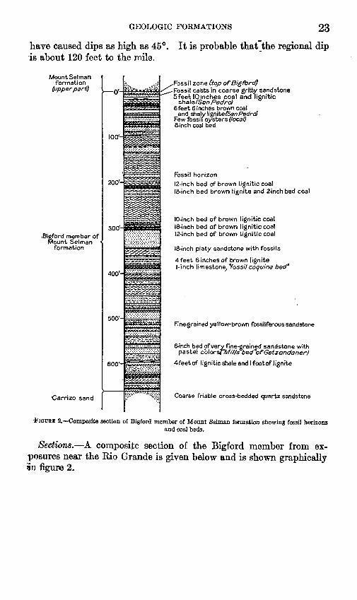
GEOLOGIC FORMATIONS 23"have caused dips as high as 45°. It is probable that"the regional dip is about 120 feet to the mile.
Mount Selmanformation
(upper part)
Sigford member ofMount Selman
formation
Carrizo sand
200-
300*-
400'-
500'-
600'-
,Fossil zone (top of Bigford) -Fossil casts in coarse gritty sandstone Sfeet 10 inches coal and lignitic
sha\efSar>Pedro) 6feet 6 inches brown coal
and shalylignite/SanPedrcJ Few fossi I oysters (local) 8-inch coal bed
Fossil horizon12-inch bed of brown lignitic coal18-inch bed brown lignite and 2-inch bed coal
10-inch bed of brown lignitic coal 18-inch bed of brown lignitic coal 12-inch bed of brown lignitic coal
18-inch platy sandstone with fossils
4feet 6 inches of brown lignite 1-inch limestone, "fossil coquina bed"
Fine-grained yellow-brown fossiliferoussandstone
6-inch bed of very fine-grained sandstone with pastel cblorsrH^///s bed"ofGetzendaner)
4feetof lignitic shale and I foot of lignite
Coarse friable cross-bedded quartz sandstone
f IGUEE 2. Composite section of Bigford member of Mount Selman formation showing fossil horizonsand coal beds.
Sections. A composite section of the Bigford member from ex posures near the Rio Grande is given below and is shown graphically In figure 2.

24 GROUND WATER OF WEBB COUNTY, TEXAS
Composite section of Bigford member in northern Webb County
Ft. in,Thin-bedded fine-grained gray sandstone interbedded with
gray sandy shale and shaly sand. At top, hard fine grained layer about half an inch thick and fossiliferous. 6
Ledge of massive, very irregular pinkish and purplish-gray fine-grained banded and pitted sandstone, locally fos- siliferous--._______________________________________ 5 6
Thin beds of gray fine-grained sandstone with alternate beds of soft purplish shaly sand-.__--________________ 1
Soft purplish shaly sand with yellow streaks_____._______ 1Finely laminated thin-bedded fine-grained purplish-black
hard lignitic shale; weathers gray white_._____________ 1Coal and lignitic shale (Upper San Pedro coal)__________ 5 10Brown and bluish-gray clay_.____-____________________ 8Layers of limonite and gray sandy shale________________ 2Light-brown mealy-textured, slightly gritty iron-stained
and coated ledge of sandstone, locally fossiliferous____ 2Brown and gray clay________________________.________ 9Light-brown and some blackish-brown lignite (Lower San
Pedro coal)..____________________________________ 6 &Brown lignitic sand-_--____-_-____-____------__-_____ 2Soft massive, jointed sandstone, weathering buff-gray ____ 3 6-Greenish-gray and brown clay_________________________ 6Ledge of buff-gray fine-grained sandstone in massive beds
2 inches to 1 foot thick, finely laminated, with car bonaceous material between laminae, micaceous. ______ 8 6-
Yellow-greenish shaly sandstone and shale grading downinto irregular yellow-streaked buff-gray clay. _________ 5 6-
Black lignitic coal_____.____________________________._ 8^Blackish and gray-brown clay_________________________ 4Ledges of fairly hard fine-grained irregularly laminated
gray sandstone____________________________________ 5Rusty-brown and gritty gray and brown sandstone______. 5Gray and brown clay and sandy clay__..____________-__ 9Gray and brown gypsiferous clay___________________.__ 19Gray and brown clay___________________-_______-__-.- 5Soft mealy-textured gray sandstone____________________ 1 6-Soft ledge of mealy-textured gray sandstone with rounded
yellow silty and limy boulders 1 foot thick at top _______ 11Brown clay and covered_______________________.______ 30Soft brown and gray shale and clay.____.__________-___ 5Sticky and crumbly gray-brown clay.__________________ 10Purplish-gray clay___________________________________ 3 6-Hard massive bed of purplish-gray and brown sandstone,
locally fossiliferous.______________________________ 1Soft poorly bedded fine-grained gray sand with lignitic
streaks and plant roots; fossils at top.-___________-___ 3Very soft gray and brown sand_-_____-_____-_-___---_- 3Purplish-brown and gray gypsiferous clay________-_____- 18Bedded brown lignite_____________________________-__ 1Brown clay_______________________-______________-_- 2Dark-brown lignite; about 2 inches of coal._____________ 1 6-Deep-brown gypsiferous clay._________________________ 20

GEOLOGIC FORMATIONS 25
Composite section of Bigford member in northern Webb County Continued
Ft. z>. Flat of brown gypsiferous clay and other soft material,
about.___________________________________________ 55 ±Soft brown sand-__-__-_______________-____--____-_._ 3Brown lignite.______________________________________ 10Soft shaly lignitic purplish sandstone.__________________ 5Shaly gray thin-bedded sandstone.____________________ 1Lignite____-___-_____-____-______-_-_--__------__-__ 1 6Brown sandy shale and clay_________________-____-___ 2 6Brown lignite_______________________________________ 1Soft gray cross-bedded sandstone and sandy series_._____ 40Light-yellow and grayish-brown, very thin-bedded hard
platy fossiliferous sandstone ________________________ 1 6Brown gypsiferous clay_______________________________ 16Gray and yellow shale and sand_______________________ 4Lignite-_----__---___-_-----__-----__--------__-_--- 4 6Soft brown and gray sand, shale, and clay______________ 13Fossil coquina at south and fossiliferous sandstone bed
at north under associated yellow concretionary limestone bed ________________J___ _______________________ 1
Poorly bedded soft crumbly sand-__--_________________ 3Brown and gray gypsiferous clay and some lignite_______ 6Soft medium-grained gray sand__-_________-________-_ 9Brown gypsiferous clay and purplish-gray and brown
shale________-_-_____________-_________________-__ 14Thin ripple-marked beds of gray distorted hard fossilif
erous sandstone_________-_________________________ 1Gray and yellow mottled massive sandstone.___________ 3Gray and yellow-brown shale and shaly sandstone and
limonite. _ ________________________________________ 10Flat; probably clay and shale and soft sand____________ 25Purplish and brown thin-bedded medium-grained sandstone
with alternate gray and brown shale_________________ 18Harder thin-bedded medium-grained sandstone with
limonite__ _ _______________________________________ 5Purple, gray, and yellow thin-bedded sand and shale with
alternate clay and limonite laminae __________________ 6Soft gray bedded fine-grained sandstone._______________ 5Very hard massive yellow ledge of concretionary lime
stone.-. _________________________________________ 3Very hard quartzitic blue-gray sandstone ledge; broad
beds with irregular purple streaks ___________________ 1Gray and yellow mottled fine-grained soft sandstone.____ 9Soft, rather massive medium-grained brown sandstone___ 5 Shaly brown and gray sand and clay___._______________ 5Thin-bedded gray sandstone and associated yellow con
cretionary limestone_______. _______________________ 4Rusty-brown and purplish iron concretionary bed.______ 4Thin beds of brownish-gray fossiliferous sandstone_______ 2Thin-bedded gray and yellow-brown laminated sandstone. 6 Yellow cone-in-cone and concretionary limestone bed_ _ _ _ 2Gray-brown clay____________________________________ 5Concretionary iron bed over fairly thin beds of crumbly
grayish and yellowish-brown sandstone.._____________ 11

26 GROUND WATER OF WEBB COUNTY, TEXAS
Composite section of Bigford member in northern Webb county ContinuedFt. in.
Brown sandy clay_______.___________________________ 17Hard ledge of medium-grained micaceous banded sand
stone __________ __ _____ 6Purple and gray shaly sand_________________________ 5Purplish and gray fairly soft fine-grained sandstone____ 1Very thin bedded gray and brown fine-grained sandstone. 12 Gray, brown, and yellow shaly sand, shale, and limonite__ 11 Gray sandy clay_____________________________________ 3Very hard fine-grained crystalline dark-gray calcareous
sandstone boulders_-__-_-_-_-----_----_----_---__- 1Local lignitic shale and lignite______-__-_______________ 5Gray thin-bedded sandstone______-__---__-_-_-___-___ 1Coarse-grained crystalline, poorly bedded sandstone ledges. 7 Thin beds of sand and shale with limonite_. ____________ 15Ledge of hard fine-grained iron-stained gray sandstone___ 1 Alternating beds of thin yellow and gray sands..._______ 6Brownish-gray clay__________________________________ 5Brownish sandy clay and clayey sand __________________ 4Alternating beds of gray shale and clay._______________ 12Thin beds of soft buff to gray and yellow-brown fine
grained micaceous sandstone having poorly preserved leaf imprints; clay flakes between the massive beds____ 5
Gray-brown sticky clay____________________________ 5Dark-brown friable coarse-grained standstone.__________ 1Fine-grained gray shaly sand, platy gray shale, and
limonite______________________ ___________________ 3
659 3
Detailed sections from various localities are given below. The first section[.is at the contact of the Carrizo sand and the Bigford member.
Section of Carrizo sand and Bigford member 0.8 mile south of Loza tank, Chupadero ranch, northern Webb County
Bigford member of Mount Selman formation: peetPurple, gray, and brown medium-grained sandstone __ 2Thin-bedded gray and brown sandstone___ ____-_.__ 12Covered_______________________-_-_-_-___-----_--_-- 11Gray sandy clay______________________-----___-_--- 3Hard fine-grained dark-gray calcareous sandstone boulder. 1Covered___________________________________ __ 16Fine-grained gray sandstone ledge_____________________ 1Covered________________________________________ 15Shale and sandstone___________--_______---_----_--_- 13Alternating beds of shale and sandstone..._____________ 12Covered_____________________ _________________ 5Thin-bedded medium-grained gray sandstone with leaf
imprints _____________________ __________ 8Dark-brown coarse-grained friable sandstone __________ 1Gray argillaceous sandstone________________________ _ 3
Carrizo sand: Very coarse friable yellow-brown and white, poorlybedded to massive sandstone_________-_-___,__-___----_- 18

GEOLOGIC FORMATIONS 27
This section illustrates the gradation from the Carrizo sand to the Bigford member. Another section showing the same features, at a locality closer to the Rio Grande, is given below.
Section of Carrizo sand and Bigford member on west flank of hill 0.9 mile north ofJuan Rey Spring, Chupadero ranch
Feet Uvalde gravel (cap of hill)________________________________ 25Bigford member of Mount Selman formation:
Soft yellow and gray mottled fine-grained sandstone _____ 2Platy fine-grained gray sandstone_--_--_---_--___---_-_ 7 Gray and brown shale and clay___--____---__-_-----__- 3Brown and gray shaly sandstone ______________________ 2Soft thin-bedded fine-grained sandstone with leaf imprints
and clay nodules._________________________________ 5Grayish-brown sticky clay.______-_-___-_-_____--____- 5Covered.___________________________________________ 5Platy gray sandstone, gray paper shale and limonite. _ _ _ _ 4Concretionary fine-grained gray sandstone with limonitic
sandstone_ ______________________________________ %Carrizo sand:
Cross-bedded and poorly bedded gray medium-grainedpoorly cemented iron-stained sandstone._____________ 1
Poorly bedded and cross-bedded gray and yellowish-browncoarse-grained sandstone_______-____-___-___-_-____ 11
Dark-brown iron-stained coarse-grained friable sandstone. 5 Coarse-grained yellowish-brown, brown, and gray poorly
bedded friable sandstone______-____________________ 18Zone of sandstone boulders.__________________________ 4Coarse-grained poorly cemented gray sandstone_________ 8
Section of Bigford member on east bank of Rio Grande at Bigford (Cuatralvo) ranch
[Dip i°]Feet
Soft gray cross-laminated fine-grained sandstone.____________ 5Greenish-gray and yellowish-brown clay and thin-bedded shaly
sandstone___________________________________________ 7Hard massive iron-stained sandstone with worm borings____ 4 Soft yellow-brown and gray laminated shaly sandstone_____._ 3Gray and brown iron-stained sandstone.____________________ 3Beds of grayish-brown laminated fine-grained sandstone 6
inches thick_________________________________________ 2Thin-bedded hard and soft laminated yellowish-brown shaly
sandstone__ _ _ _______________________________________ 5Yellowish-gray and brown iron-stained shale and clay_-______ 9Medium-grained finely laminated hard gray sandstone.______ 2Soft gray and brown fine-grained sandstone.________________ 3
The section given above was measured at the type locality of the Bigford member. Trowbridge 18 has described a section from the same general locality. The large proportion of sandstone in the sec tion is notable. The clay or shale strata of the Bigford do not form
is Trowbridge, A. C., op. cit. (Bull. 837), p. 74. 105575 37 3

28 GROUND WATER OF WEBB COUNTY, TEXAS
good exposures but are usually covered in slopes. In the first deep ravine southeast of the Bigford ranch a section of typical clay is exposed, as shown below.
Section of Bigford member in arroyo 0.8 mile east of Bigford ranch, 250 yards abovemouth
FeetSilt.. -___-_-__-_-_-__-_-____________________-_-_-_- 1Gravel_________________________________________________ 1-4Shaly calcareous sandstone_-__-______________-------_---- 1%Calcareous shale______________________________-_______-_- 6Calcareous sandstone_______________________________-_-_- 1-3Calcareous shaly sandstone.______________________________ 1Calcareous shale_____________________________-___________ 8
In this section the shale is bluish gray when fresh but weathers to a dark greenish gray. The weathering produces nodular lumps as much as 4 inches in diameter, and this seems to be characteristic of much of the clay or shale of the member. In this section a few plant impressions are present along with a small amount of lignitic material.
Excellent sections of the lower Bigford strata are exposed tin San Lorenzo Creek. One of the sections is given below.
Section of Bigford member 1 mile upstream from mouth of San Lorenzo Creek
Ft. in. Reddish to brownish and buff fine micaceous sandstone.
Bottom 4 feet thin-bedded, platy. Upper 2 feet thin- bedded, brown. Center 4 feet massive, with beds 2 feet 6 inches or less in thickness. A line of ferruginous cal careous concretions near center.____________________ 10
Chocolate-brown sandy shale, weathering light gray andgrading into beds above___________________________- 14 10
Sandstone consisting of three members, upper 2 feet 10 inches, middle 7 inches, bottom 3 feet 9 inches. Upper and lower members fine-grained, purplish when fresh, yellowish buff on weathering, minute lignite streaks, micaceous, and with plant remains and fucoidlike mark ings, jointed into rectangular blocks; selenite on joint planes.--__________________________________---_-__ 7 2
Chocolate-brown micaceous sandy shale, with line of cal careous concretions at base____i____________-------- 6 2
Sandy platy argillaceous sandstone; grades into underlying beds; plant remains on bedding planes; weathers light gray; noncalcareous-____________________________--- 7 2
Dark-gray to black shale showing many bedding planes, usually outlined with yellowish stain and about 2 inches apart; weathers buff to gray, often with white salt ef florescence; noncalcareous_________________________- 3
Bottom of creek; massive light-gray fine-grained sandstone with a few shelly reddish to purplish indurated layers 2 inches or less in thickness; noncalcareous.__________ 9
At 150 feet above the base of the Bigford there is a thin fossil zone that is prominent near the Rio Grande in the southern part of the

GEOLOGIC FORMATIONS 29
Chupadero ranch. Below this zone is an alternating succession of thin beds of shale, clay, fine-grained sandstone, and all gradations between sand and clay. Limonitic shingle is very prominent, and the weathered slopes of most of the hills in this belt are yellowish to red. The lowest cannel coal in the Bigford occurs in the lower part of these strata, about 65 feet above the'base of the member. The following section is typical of this portion of the Bigford:Section of lower part of Bigford member on east bank of Rio Grande 1% miles north
of the mouth of San Lorenzo CreekFt. in.
Very hard gray sandstone which forms a ledge._________ 2Massive single hard ledge of yellow concretionary lime
stone. ___________________________________________ 3Brown clay and shaly brown sand_____________________ 7 .Brown and purplish concretionary iron beds.___________ 4Brown clay and thin brown fossiliferous sandstone.-_____ 4Yellow cone-in-cone and concretionary limestone bed____ 2Brown sticky clay____-______________________-__.____ 9Dark coarse-grained sandstone and deep-brown concretion
ary bed__________________________________________ 6Purplish gypsiferous shale and brown sandy shale_.____ 3Hard brown coarse-bedded sandstone.________________ 2 6Soft fine-grained brown, gray, and lavender sandstone in
beds 3 to 6 inches thick separated by gypsum laminae which give it a banded appearance.________________ 4
Gray and yellow-brown, poorly bedded and thin-beddedshaly sand______________________________________ 6 4
Lavender shale and yellow sandy shale with gypsum laminae._________________________________________ 18
Yellow-brown and gray, partly laminated sandstone.---. 2 8 Jointed gray, slightly bedded fine-grained sandstone.__ _ 1 4 Fine-grained yellow-mottled thin-bedded to massive
sandstoneledge___________________________________ 4Lavender shale with yellow and brown shaly sand.______ 9Yellow-gray jointed soft shaly sandstone.______________ 13Brown lignitic sand__________________________________ 4Black jointed cannel coal_____________________________ 1Yellow-brown shaly lignite....______________________ 1 6Hard yellow-gray massive sandstone ledge._____________ 1Brown and gray sandy shale__________________________ 1 6Yellow, brown, and gray mottled massive sandstone. _ _ _ _ 2Gray and yellow-brown shaly sandstone and sand_______ 12
The middle and upper Bigford strata are characterized by more true clay, smaller amounts of sandy clay and limonitic material, and more thin coal beds. The following section just above the middle of the Bigford illustrates these characteristics. Views of Bigford strata from this locality are shown on plate 8.

30 GROUND WATER OP WEBB COUNTY, TEXAS
Section of middle part of Bigford member at mouth of San Cirile Creek, at Rio Grande, 3 miles north of Old Apache ranch
Ft. in. Soft brown clay with some layers of dark-brown flaggy
fossiliferous sandstone 1 inch thick. _______ ___________ 2Hard fine-grained light bluish-gray massive sandstone. __ 6 Two hard layers of yellow-brown and gray mottled fine
grained massive sandstone with root and stem imprints. 1 Thick beds of partly cross-bedded massive fine-grained
bluish-gray micaceous sandstone,___________________ 3Slightly irregular fine-grained micaceous sandstone,
weathering yellow-brown and purplish banded brown__ 3 Dirty-brown and dull gray-brown soft fine-grained sand-
stone____________________________________________ 1 6Laminated and shaly brown and gray mottled clay______ 4Hard ledge of very fine-grained laminated yellowish and
blue-gray sandstone._______________________________ 8Thin beds composing a ledge of very fine-grained finely
laminated yellow and bluish-gray sandstone__________ 5 6Shaly gray sandstone, shale, and gray limonitic clay_____ 5Soft massive buff-gray fine-grained sand___ ____________ 4Blue and greenish-gray laminated and jointed gypsiferous
clay____________________________________ 9 6Yellow and brown flaky and shaly jointed lignite________ 10Smutty brownish-gray lignitic fine-grained massive sand
stone -________-_-__________--______----_-----__-_ 1Hard ledge of yellow-brown and gray banded fine-grained,
massive sandstone.________________________________ 2Brown and greenish-brown gypsiferous clay _____________ 3Black and brown clayey lignite__--_-__----_____------- 11Medium-hard yellow-brown massive medium-grained,
slightly friable and partly laminated sandstone. _______ 4Gray-brown and yellowish lignite, clay, and shale________ 1 3Yellow and rusty-brown lignite, jointed and slightly shaly,
with gypsum and yellow powder in joints and betweenlaminae.________-_________-____-__----------_-_-_ 2 2
Gray flaky shale...__________________________________ 2Xaminated and jointed layers of gray and brown shale and
sandstone with gypsum layers_-___________-___--__-_ 1Soft massive, slightly mealy-textured dull-yellow and
brownish-gray sandstone.__________________________ 2Gray and brown mottled gypsiferous clay ______ _________ 2Green and gray clay and sandy shale, with layers of yellow
ferruginous silty sand._____________________________ 2Dark-blue and blackish-gray clay__--__-_-___-__-______ 6Greenish and blue-gray clay__________________________ 5Soft yellow and greenish-gray massive sandstone in beds
2 inches to 1 foot thick, some partly laminated________ 6
The following two sections are typical of the upper Bigford. The first gives the fossil zone at the top of the Bigford and the highest coal in the San Pedro zone underneath it. The second gives the fossil zone at the top of the Bigford, a fossil zone just below the top, and the upper and lower coal and goes down almost to a prominent sand stone in the upper Bigford, shown in figure 2.

GEOLOGIC FORMATIONS 31
Section at coal prospect 3 miles west of Pilotes ranch
Shaly gray sandstone and shale; top hard, fine-grained M- * n-0.5 inch fossiliferous________________________________ 6
Massive pinkish and purplish fine-grained banded andpitted sandstone__________________________________. 5 6
Thin beds of gray fine-grained sandstone alternating withsoft purplish clay__________________________________ 1
Soft purplish shale with yellow streaks_________________ 1Fine laminated thin-bedded purplish-black lignitic shale. _ 1Black cannel coal__________________________________ 1 2Brownish soft coal______--______________-_-____-____- 6Brownish lignitic coal_______-______.-_---_________-_- 10Impure lignite_____________________________________ 3 4Reddish mottled gray and brown joint clay.____________ 5
ictwn of Mount Selman formation on south bluff on large creek 1.4 miles northwestof San Pedro Hill
Ft. in. Ledge of irregular massive pinkish-brown medium-grained
gritty, partly iron-stained sandstone. ________________ 4Beds of fine-grained purple, gray, and brown banded sand
stone 2 to 6 inches thick____________________________ 5Soft thin-bedded sand and shale, partly covered-________ 9Bigford member:
Thin flaggy yellow-gray fossiliferous sandstone._____ 1Ledge of mealy gray and brown white-speckled sand
stone with a few hard round boulders____________ 4Thin-bedded fine-grained purplish-gray and brown
sandstone___________________________________ 5Thin-bedded and shaly brown sandstone with limon-
ite_--________________-____________________-__ 5Fine-grained purplish-gray and brown mottled, yellow-
stained fossiliferous sandstone___________________ 6Purplish-gray, brown, and yellow mottled massive fine
grained irregular wavy-banded sandstone.________ 1 6Thin-bedded micaceous gray-white sandy shale and
sandstone ____________________________________ 2Lignite and cannel coal (Upper San Pedro coal) _____ 1Purplish and gray clay_ __________________________ 3 6Thin-bedded platy iron-stained gritty brown sand
stone ________________________________________ 4Hard massive gray-white fine-grained irregular sand
stone in thin beds-_____________________________ 4Blackish lignitic clay___________________________ 3 6Brown and gray clay___________________________ 7 6Gritty, glistening irregular gray and brown sandstone
ledge, limonite-coated__________________________ 2Brown clay.____________________________________ 2Dark-purplish and yellow-brown limonitic concre
tions. ________________________________________ 6Soft buff, gray, and yellow-gray fine-grained thin-
bedded sandstone____________________________ 8Lignite (Lower San Pedro coal)_____-______-_____- 2 +

32 GROUND WATER OF WEBB COUNTY, TEXAS
Many additional sections could be given, but the general character of the Bigford member is shown in the sections presented above. The' fossil horizons and coal beds are accurately located on plate 1.
Water supply. The Bigford member in Webb County is not known to yield water that is suitable for domestic use or irrigation. Well 9 and probably well 16 (see table of water analyses, p. 102) derive water from the member, and the water from both wells is too salty for any use except stock. As noted in the discussion of the water supply of the Carrizo sand, wells that pass through the Bigford into the Carrizo and are improperly cased eventually become contaminated with salt water.
The Carrizo sand is the logical source of water in the outcrop area of the Bigford. It can be reached by wells at depths ranging from a few feet in the western part of the area to somewhat less than 1,000 feet in the eastern part. From plates 1 and 7 the depth to the Carrizo in any part of the area can be approximately determined.
POST-BIGFORD BEDS
Areal extent. The post-Bigford part of the Mount Selman forma tion (see p. 20) crops out in a belt from 9 to 23 miles wide in central- western Webb County (pi. 1). Good exposures are found in the breaks of the Rio Grande, but north of the breaks exposures are not abundant. The upper boundary of the formation shown on plate 1 is essentially the same as that of Trowbridge. 19 It is placed in that part of the section where the strata become more sandy and more fossiliferous.
The outcrop area of the post-Bigford part of the Mount Selman is characterized by a gently rolling topography with sparse vegetation except on gravel-covered hills. Scattered cuestas and isolated promi nent hills are formed by hard sandstone beds, of which a hill half a mile south of the Pilotes ranch is an example. This landmark is shown on plate 9, A.
Lithology. The post-Bigford part of the Mount Selman formation consists of yellow, brown, gray, and dark-gray clay, varicolored sand stone, concretionary limestone, lignite, and cannel coal. Much of the clay is gypsiferous and contains rare concretions of barite. In a com posite section of this part of the formation sandstone beds make up 10 percent of the total thickness, but a good many of the clay beds are somewhat sandy. There are seven coal beds 6 inches or more thick, but of these the Santo Tomas coal is the only one of commercial im portance. Three fossil zones have been mapped and are shown on plate 1. They are not as persistent as those of the Bigford member. The position of the coal and fossil zones in the section is shown in figure 3.
" Trowbridge, A. C., op. cit. (Bull. 837), pi. 7.

GEOLOGIC FORMATIONS 33
Cook Mountain formation
Mount Selman formation
(upper p^rQ
Bigford member of Mount Selman
formation
o-
100-
200-
300-
400-
500-
600-
700-
800-
900-
1000-
1100-
!i;... v,.....jg
^ ± ^
: ::.'.: '.:-^-^r-^-_^=T-. .TT^-r--:
-O£3^Z-
- 1 ^zrurr ^^-^:
"r-rTrrr^rrr
^S^
a~-^pr-^-?f^-L! M-l ' '-! '
^
~:IrIiI:~i-c
lliil
^_-^^-_ _=~ iSc: IHI:-^-^^"
.-. ^TW.W?:. :-=
^ ga^BSa^fa
=r;2
==:i
=ni
^$^^
,2-foot bed of lignite and lignitlc clay
-7yrr7r 77Tf Nonmarine fossil horizon (local)
16-inch coal' bed
=dl2-inch bed of clayey coal
"2-'inch nonmarine fossil bed4foot sandstone with marine fossil castsieHnch coal bed]Binch coal bed I (&.. + Tnma^I4inch coal bed (*anto lomas>I2-inch coal bedjMarine fossil horizon (top ofBigford)
FIGURE 3. Composite columnar section of upper part of Mount Selman formation showing fossil zones andcoal beds.

34 GROUND WATER OP WEBB COUNTY, TEXAS
The Santo Tomas coal is cannel coal and is mined at Dolores. At this place the coal bed is 90 feet above the San Pedro coal and 30 feet above the fossiliferous stratum at the top of the Bigford. North of the Dolores area the Santo Tomas bed is traceable into four or five thinner beds which are lignite in some places and cannel coal in others. It is probably preferable to speak of the Santo Tomas zone rather than the Santo Tomas coal bed except in the area near Dolores. Sections given farther on illustrate this point. An exposure of the Santo Tomas and associated coal beds is shown on plate 9, B.
Petrographic analyses of the sandstones, selected to show the range in texture, are given below.
Petrographic analysis of post-Bigford sandstone from hill 1.3 miles east of Tordilloranch
Lithology and mineralogy. Buff argillaceous sandstone with irregular reddish mottling, poorly cemented, low porosity. Quartz constitutes 97 percent, clay minerals and plagioclase 3 percent. Heavy minerals include magnesite, ilmenite, leucoxene, rutile, zircon, tourmaline, and muscovite.
Size and shape. Grains characteristically angular and subangular, a few sub- rounded. Mechanical analysis: 0.147 to 0.295 millimeter, 2 percent; 0.074 to 0.147, 64 percent; smaller than 0.074, 34 percent.
Petrographic analysis of post-Bigford sandstone 0.3 mile south of Wayne ranch
Lithology and mineralogy. Argillaceous massive brownish sandstone. Poorly cemented, of medium porosity, with irregular fracture. Iron-stained quartz con stitutes about 97 percent, clay minerals about 3 percent. Heavy minerals include zircon, tourmaline, leucoxene, ilmenite, magnetite, rutile, and garnet.
Size and shape. Grains characteristically subangular to subrounded. Mechan ical analysis: 0.295 to 0.589 millimeter, a fraction of 1 percent; 0.147 to 0.295, 85 percent; 0.074 to 0.147, 9 percent; smaller than 0.074, 4 percent.
Petrographic analysis of post-Bigford sandstone on Laredo-Dolores road at crossingof Santo Tomas Creek
Lithology and mineralogy. Argillaceous calcareous yellowish-gray sandstone, poorly cemented and of low porosity. Smoky, white, and gray quartz constitutes about 92 percent, calcite 5 percent, clay minerals 3 percent. Heavy minerals include zircon, tourmaline, leucoxene, ilmenite, magnetite, rutile, apatite, pyrite, and biotite.
Size and shape. Grains characteristically subangular and subrounded. Me chanical analysis: 0.147 to 0.295 millimeter, 51 percent; 0.074 to 0.147, 24 per cent; less than 0.074, 25 percent.
Petrographic analysis of post-Bigford sandstone on north side of San Pedro Hill
Lithology and mineralogy. Hard massive argillaceous sandstone of low porosity. Buff with brown, reddish, and purplish mottling. Clear, rose, and smoky quartz and chert constitute about 95 percent, clay minerals 5 percent. Heavy minerals include zircon, rutile, tourmaline, leucoxene, pyrite, ilmenite, magnetite, and muscovite.
Size and shape. Grains characteristically subangular and subrounded. Me chanical analysis: 0.589 to 0.999 and 0.295 to 0.589 millimeter, a fraction of 1 percent; 0.147 to 0.295, 65 percent; 0.074 to 0.147, 27 percent; smaller than 0.074, 7 percent.

U. S. GEOLOGICAL SURVEY WATER-SUPPLY PAPER 778 PLATE 8
A. B1GFORD STRATA NEAR MOUTH OF SAN CIRILE CREEK.
B. BIGFORD STRATA HALF A MILE ABOVE MOUTH OF SAN CIRILE CREEK.

U. S. GEOLOGICAL StJEVEY WATER-SUPPLY PAPER 778 PLATE 9
A CUESTA FORMED BY HARD SANDSTONE BED IN POST-Blu* u±lD PART OF MOUNT SELMAN FORMATION HALF A MILE SOUTH OF PILOTES RANCH.
B. EXPOSURES OF SANTO TOMAS AND RELATED COAL BEDS 4 MILES SOUTHEAST OFPALAFOX.

GEOLOGIC FORMATIONS 35
Petrographic analysis of post-Bigford sandstone.on Laredo-Dolores road at crossing ofSanto Tomas Creek
Lithology and mineralogy. A medium-grained argillaceous micaceous banded yellowish sandstone, incoherent, with medium porosity. Contains small clay particles of same size as quartz grains. Gray and smoky quartz constitutes about 90 percent, muscovite and clay about 10 percent. Heavy minerals include leucoxene, rutile, zircon, pyrite, garnet, magnetite, ilmenite, biotite, and tour maline.
Size and shape. Grains characteristically subangular and subrounded. Me chanical analysis: 0.147 to 0.295 millimeter, 1 percent; 0.074 to 0.147, 79 percent; smaller than 0.074, 20 percent.
Thickness and dip. A composite section of the post-Bigford strata compiled from measured sections along the Rio Grande is 1,165 feet thick. The dip is about 90 feet to the mile.
Sections. A composite section of the post-Bigford strata is given below and is shown in graphic form in figure 3.
Composite section of post-Bigford part of Mount Selman formationFt. in.
Ledge of fine-grainc d massive yellow-brown and yellow mottled gray mica ;eous sandstone____-_____--.___-___ 4
Soft yellow-brown shale and massive sandstone and alter nating shale_--_______________________________--___ 5
Yellow, gray, and brown clay and shale with iron concre- tions-____________________________________________ 21
Purple, gray, and brown soft massive sandstone and alter nating iron-stained gypsif erous shale _________________ 4
Hard silty and limy concretionary yellow-gray boulders __ 1 Gray shale and sand_________________________________ 6Deep-brown and dull-green sand and thin-bedded sand
stone.. ___________________________________________ 6Soft brown sandstone and alternating gray shale.-_______ 1Gray and brown iron-stained gypsif erous sandy shale____ 12Soft rusty-brown thin-bedded sand.___________________ 1Gray, brown, and yellow laminated iron-stained gypsif erous
clay and sandy shale_______________________________ 8Brown, gray-pink, and purplish shale and clay__________ 25Soft fine-grained yellow mottled gray massive sandstone. _ 6 Fine-grained brown sandstone forming a soft ledge__.____ 6Soft massive yellow-brown sand_-____-___________--___ 7Soft ledge of yellow-brown and gray bedded sandstone. __ 5 Soft yellow-brown massive argillaceous sand ____________ 10Gray and brown mottled shaly clay____________________ 18Purplish-gray and brown gypsiferous iron-stained sandy
clay___________ _______________________________ 19Poorly bedded sandstone with a few hard boulders 6
inches in diameter.________________________________ 16Gray, brown, and yellow mottled gypsiferous jointed clay. 17 Mostly clay covered by river alluvium, about.__________ 100Soft massive poorly bedded gray sandstone _____________ 4 6Blue-gray jointed clay_________________________^____ 4Soft reddish, rusty-brown, and gray argillaceous sand____ 4Blue-gray jointed clay__._____________________________ 6

36 GROUND WATER OF WEBB COUNTY, TEXAS
Composite section of post-Bigford part of Mount Selman formation Continued
Ft. in.Soft yellow, brown, and gray argillaceous sandstone____ 6 Blue-gray shale and jointed clay..__________ _________ 6Platy hard crystalline thin blue-gray sandstone________ 2Bony black coal____________^____________________ 7Blue-black lignitic clay_________________________ 1 6Yellow-gray argillaceous sand______________-_-_-____-_ 2Covered.___________________________________________ 10Thick-bedded and laminated hard gray sandstone- ______ 4Gray clay with some limonite and gypsum, about______ 15Soft irregular highly cross-bedded gray sandstone._______ 5Medium-hard ripple-marked bedded gray sandstone____ 3 Blue-gray joint clay._______________________________ 3Brown and gray clay and partly covered, about_________ 70Brown and gray clay with some yellow limestone concre
tions, about.____________________________________ 30Brown iron-stained gritty irregular sandstone, with local
nonmarine fossils__________________________________ 1Purple, gray, and brown thin-bedded to massive soft fine
grained sandstone____-_______________----__---____ 13Sandy gray and brown clay and shale with gypsiferous
laminations.______________________________________ 4Brown, gray, pink, and purplish mottled gypsiferous clay_ 46 Hard single ledge of massive fine-grained buff and gray
sandstone, in places yellow-stained.________________ 1Yellow-brown, gray, pink, and purplish clay ____________ 30Brown and gra# clay, mostly covered-_________________ 55Brown clay_________________________________________ 5Soft ledge of massive gray-brown sandstone...__________ 2Gray and brown mottled jointed clay._________________ 15Soft massive gray sandstone__________________________ 12Blue-gray jointed clay____________-_______________ 10Brown clay and some yellow concretionary limestone, but
mostly covered________________________________ 120Soft massive ledge of purplish-gray sandstone, stained
pink and yellow brown________________________.____ 3Blue-gray and brown gypsiferous clay and a few yellow
limestone concretions______________________-_----__ 29Yellow limestone concretionary bed____________________ 6Soft thin-bedded and cross-bedded mealy gray sandstone __ 17 Brown clay_________________________________________ 17Clay, slight dip, about_______________________________ 15Brown gypsiferous clay_____________________________ 16Shaly gray and platy buff fine-grained sandstone and
some yellow-gray limestone concretions.______________ 2Brown gypsiferous clay_____________________________ 7Thin-bedded yellow-brown gritty iron-stained sandstone, _ 3 Shaly gray sandstone and shale______________________ 3Brown and gray clay_______________________________ 5 6Very irregular rusty-brown iron-stained sandstone with
worm borings_____________________________________ 6Brown iron-stained gritty sandstone___________________ 2Brown and gray clay and sandy shale._________________ 6 6

GEOLOGIC FORMATIONS 37
Composite section of post-Bigford part of Mount Selman formation Continued
Ft. in. Soft gray sand and shaly sand_______________________ 3Shaly gray and brown sand and clay ________________ 13Soft gray sand________________________________ __ 3Brown and gray clay, partly covered ______________ 53Coal seam, mostly clay_____________________________ 4Brown clay_________________ _____________________ 3 6Shaly gray sandstone___________-___-___-_-___--_____ 1Ledge of mealy gray massive sandstone-________---____ 1Thin-bedded gray sandstone and gray shaly sandstone
with alternate gray and brown clay__________________ 4Local ledge of hard yellow and gray boulders____________ 1Gray clay.______-___________--__-_--_-_----_---____ 4Gritty yellow mottled iron-stained fine-grained sandstone. _ 1 Soft ledge of fine-grained and light purplish-brown to buff-
gray bedded sandstone___--____-__--_-_-__----_-___ 10Soft fine-grained purplish-gray and brown sand with yellow
iron-stained gypsum laminations___________________ 4Blue, gray, and brown clay________________-__---_--__ 12Clayey coal bed_______________________-_-_-__-_____- 1Gray and green-brown clay_________-_---_--__________ 32Hard ledge of buff-gray wavy laminated massive fine
grained micaceous sandstone, local___________________ 2Greenish-gray and brown-mottled clay_________________ 18Medium- to coarse-grained yellow-brown cross-bedded and
gritty soft sandstone with yellow limestone concretions. _ 17 Brown gypsiferous clay_____________________________ 10Wavy bands of gypsum crystals, almost continuous and
above clay____________________--_-_--__--_-_---_-_ 6Soft fine-grained and mealy gray sandstone with gypsum
laminations and a few yellow limestone concretions.___ 2 6 Brown and gray gypsiferous clay___-______-_-------__- 9Thin hard slaty gray silty sandstone with dwarf fossils,
chara seeds, and nonmarine fossils___________________ 2Soft fine-grained and gray thin-bedded yellow-mottled gray
and brown sandstone; a few fossils at the base..______ 4Greenish-gray and brown clay___--_____-_____________- 5 6Coal, local.________________________________Gray and brown clay________________________ ,Brown shale and slaty bony coal._____________ Black cannel coal (main Santo Tomas coal)_____ D 1 ZOIieBrown clay________________________________
1 48 6
62 971 2Brown shaly coal, local____________________
Brown gypsiferous clay with a little soft brown sandstone at the base___________________________________-___ 13
Coal, locaL___________________________________-_-___ 1Hard massive yellow-stained bluish and purplish-gray
sandstone. __ _ ___________________________________ 2Soft shaly and thin-bedded yellow-stained gray sandstone. _ 4 6 Brown clay_________________________________________ 4
The lower part of the post-Bigford strata is composed mainly of clay with a few thin sandstone beds and several coal beds which are more or less local and which together make up the Santo Tomas coal

38 GROUND WATER OF WEBB COUNTY, TEXAS
zone. A few feet above the Upper Santo Tomas coal is a thin bed carrying nonmarine fossils and chara seeds, which is persistent for several miles. The following section gives these beds and their relative position with regard to the section and contact with the Bigford.
Section of lower part of the post-Bigford strata of the Mount Selman formation and of the Bigford member exposed on Santo Tomas tract 0.7 mile south of Laredo- Dolores road at north fence of Santo Tomas tract, 1.2 miles east of south bend ofRio Grande, and 5 miles east-southeast of Palafox
Ft. in.Gravel cap_ _ ______________________________________ 2Post-Bigford strata:
Brown gypsiferous clay _ ________________________ 9Soft ledge of pinkish-gray mealy sandstone. ________ 1Brown and blue-gray gypsiferous clay _ _____________ 12Ledge of limonite and concretionary gypsum with thin
flaggy sandstone containing chara seed and non-marine fossils. __________-_-_______-__--_---__- 2
Black clayey coaL________________-----_-__------ 8Green and gray-brown, very gypsiferous clay_ ______ 6 6Black and yellow flaky coal __ _ ____________________ 1 4Gray and brown clay---_________--___--____---__- 3 6Yellow, brown, and gray shaly sandstone and lignitic
shale.. _________ _ _ _ ____ ______________ 2 6Black and brown coal (joints N. 31° E.) (main Santo
Tomas coa]) __________________________________ 2Greenish-gray and brown clay with a little green-brown
shaly sandstone and chocolate-brown brokenlimonitic clay fragments--_-_-_-_-_---__--_---_- 17
Black coal_-_._ __ _____________________________ 1 2Brown bony coal. _______________________________ 1 8Yellow-gray and gray shale and shaly sand. ________ 7
Bigford member:Thin hard yellow sandstone fragments with fossils. __ 2 Shaly brown sand_-_________-___-__----_---_---_- 2Brown clay and shale_-_____________--___-__--___ 23Fragments of yellow, brown, and gray shaly sand
stone and gritty limonitic sandstone _____________ 3Ledge of fine-grained gritty gray-yellow mottled
--__________________ _______________ 3
The following section is typical of the lower portion of the post- Bigford part of the Mount Selman formation and shows the strata from the coals up to the first prominent sandstone member.

GEOLOGIC FORMATIONS 39
Section of lower part of the post-Bigford strata of the Mount Selman formation ex posed on west bluff of Espadillo Creek half a mile north of Minera and 0.2 mile east of Rio Grande
Gravel cap.Post-Bigford strata: Ft- -
Coarse-grained gritty brown cross-bedded soft sand stone _________________________________________ 17
Brown gypsiferous clay..-,_______________________ 10Wavy bands of gypsum crystals, almost continuous,
with interbedded brown clay.___________________ 6Soft fine-grained and some mealy gray sandstone beds
with gypsum laminations and a few yellow lime stone concretions______________________________ 2 6
Brown and gray gypsiferous clay__________________ 9Thin flaggy hard sandstone with chara seed and non-
marine fossils. ________________________________ 2Soft fine-grained gray thin-bedded yellow-mottled
iron-stained sandstone and mealy gray sandstone. _ 4 Greenish-gray and brown gypsiferous clay __________ 5 6Black coal_____-_____-_-_______-___-_______-_-__ 1 4Gray and brown clay____________________________ 8 6Brown shaly coal_______-_____-___-___-__________ 6Black coal (main Santo Tomas coal)_______________ 2 9Brown clay_____________________________________ 7Brown shaly coal________________________________ 1 2Brown gypsiferous clay with some sandstone ledges
at base_______________________________________ 13Hard black bony coal ____________________________ 1Soft yellow-mottled shale and thin-bedded fine
grained gray sandstone____-_______-__-__-_____- 1
The following section is also in the lower part of the post-Bigford strata and is typical of the Pilotes ranch area. The upper sandstone of this section was traced for several miles.
Section of the lower part of the post-Bigford beds of the Mount Selman formation on point south of east fork of Espada Creek 1.3 miles northeast of upper road crossing, northeast of Pilotes ranch
Gravel cap.Post-Bigford strata: Feet
Brown clay_________________________________________ 8Soft thin-bedded mealy sandstone_____________________ 4Soft gray shaly clay__________________________________ 4Soft mealy gray sandstone with round yellow concretions
of limestone and silty boulders_____________________ 4Gray and brown clay________________________________ 51Very soft gray and brown mealy massive sandstone ______ 8Ledge of massive cross-bedded micaceous, relatively soft
gray, brown, and pinkish-white specked mealy sand stone in beds 6 inches to 3 feet thick_________________ 18
Bluish-gray and brown gypsiferous clay ________________ 15
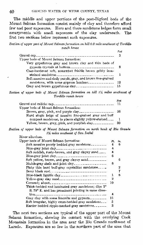
40 GROUND WATER OF WEBB COUNTY, TEXAS
The middle and upper portions of the post-Bigford beds of the Mount Selman formation consist mainly of clay and therefore afford few and poor exposures. Here and there sandstone ledges form small escarpments with small exposures of the clay underneath. The first two sections below represent such exposures.
Section of upper part of Mount Selman formation on hill 0.3 mile southeast of Tordilloranch house
Feet Gravel cap..__________________________________________ 3Upper beds of Mount Selman formation:
Very gypsiferous gray and brown clay and thin beds of gypsum crystals at bottom_---_______-_____-________ 9
Case-hardened soft, somewhat friable brown gritty iron- stained sandstone--_______-----------------_--_--__ 1
Soft massive and shaly purple, gray, and brown fine-grained sandstone, with some gypsum laminae.-_____________ 12
Gray and brown gypsiferous clay______________________ 15
Section of upper beds of Mount Selman formation on hill l}i miles southwest ofTordillo ranch house
Feet Gravel and caliche cap___________________________________ 11Upper beds of Mount Selman formation:
Brown, gray, pink, and purple clay____________________ 36Hard single ledge of massive fine-grained gray and buff
compact sandstone, in places slightly yellow-stained. 1 Yellow, brown, gray, pink, and purplish clay.___________ 30
Section of upper beds of Mount Selman formation on north bank of Rio Grande 1% miles southeast of San Isabel
River alluvium.Upper beds of Mount Selman formation: Ft. in.
Soft massive poorly bedded gray sandstone _________ 4 6Blue-gray joint clay____________________________ 4Soft reddish, rusty-brown, and gray clayey sand __ 4 Blue-gray joint clay____________________________ 6Soft yellow, brown, and gray clayey sand.__________ 6Bluish-gray shale and joint clay___________________ 6Platy thin hard buff-gray crystalline sandstone____. 2Bony black coal__________________________----__- 7Blue-black lignitic clay________________-------_-- 1 6Yellow-gray clay sand_____^_._______-_-_---_ .__ 2Covered; about.___________-__--------_------_-- 10Thick-bedded and laminated gray sandstone; dips 1°
S. 70° E. and has prominent jointing in same direc tion________________________________________ 4
Gray clay with some limonite and gypsum__________ 15Soft irregular, highly cross-bedded gray sandstone. __ 5 Harder bedded ripple-marked gray sandstone _______ 3
The next two sections are typical of the upper part of the Mount Selman formation, showing its contact with the overlying Cook Mountain formation in the area near the Rio Grande northwest of Laredo. Exposures are so few in the northern part of the area that

GEOLOGIC FORMATIONS 41
no good section of the strata immediately below the Cook Mountain contact can be given.
Section on southward-facing escarpment half a mile northwest of El Pico HillFeet
Caliche and gravel cap_________________________________ 3Cook Mountain formation: Ledge of fine-grained massive
yellow-brown and gray-yellow mottled micaceous sandstone_ 4 Upper part of Mount Selman formation:
Soft brown shaly to massive fine-grained sandstone and yellow and greenish-gray thin-bedded sandstone with alternate beds of blue-gray shale and clay and iron- stained sandy shale_________________-_--__-____-___ 5
Yellow, gray, and brown clay and shale with iron con- cretions____________-_-______-_______--____-______ 21
Purple, gray, and brown soft massive sand and alternate shale with iron and gypsum concretions ______________ 4
Hard silty and limy concretionary yellow-gray boulders __ 1 Gray shale and sand_________________________________ 6Deep-brown and dull-green sand and thin-bedded sand
stone____________________________________________ }{Soft brown sandstone and alternate gray shale._________ 1Gray and brown sandy shale with iron and gypsum con
cretions __________________________________________ 12Soft rusty-brown thin-bedded sand ____________________ 1Gray, brown, and yellow laminated clay and. sandy shale
with iron and gypsum concretions___________________ 8
Section on south bluff of creek 0,6 mile southeast of El Pico Hill
Cook Mountain formation: Feet Purplish-brown lignitic shale______-_-_____-_------__-_ 1Massive fine-grained irregular yellow and gray mottled
sandstone, unconformable on the underlying sandstone. 4 Massive pink, reddish-brown, and gray medium-grained
friable sugary sandstone, forming a single ledge._______ 5Covered.___________________________________________ 15Very thin bedded to massive yellow and gray mottled
irregular fine-grained sandstone with much yellow ironoxide___ ________________________________________ 7
Ledges of soft pink, gray, and brown medium-grainedfriable laminated sandstone in beds 4 to 6 inches thick __ 3
Yellow and gray mottled rusty irregular sandstone______ 4Soft dull-brown fine- to medium-grained, loosely cemented
sandstone in beds 2 to 6 inches thick, with alternatelayers of yellow and gray mottled shaly sand 1 to 3inches thick_____________________________________ 6}_
Upper part of Mount Selman formation:Soft, very thin bedded shaly yellow and gray mottled sand
to massive lavender and yellow sandy shale-__________ 2Darker-greenish and blackish-gray and yellow, brown, and
gray mottled sandy shale and lignitic shale.__________ 4Blackish, bluish-gray, irregularly yellow-mottled gyp- ' siferous jointed sandy shale and clay and bluish-black
shaly sand___________________________-_____-____-_ 20

42 GROUND WATER OF WEBB COUNTY, TEXAS
Water supply. The water obtained from the post-Bigford part of the Mount Selman formation by wells in Webb County is scanty and of poor quality. The sandstones generally are thin, and the rocks commonly contain considerable gypsum and other soluble minerals. In the outcrop area of this part of the formation water is generally obtained either from earthen reservoirs or tanks in which storm waters are impounded or from wells drilled to the Carrizo sand. An analysis of water from one well (no. 66) in this part of the Mount Selman formation is given on page 102.
Wells 74, 75, 91, and 99 (see table, p. 92) are drilled in the upper beds of the Mount Selman. The wells are 425 feet in maximum depth and yield small amounts of salty or bitter water suitable for stock. Well 76, east of the outcrop area (see pi. 1), is 207 feet deep and prob ably penetrates to the upper beds of the Mount Selman. The well yields small amounts of potable water, which, however, may be coming from the Cook Mountain formation.
Several wells in the northern part of the outcrop area in Webb County have been drilled through the post-Bigford beds and the underlying Bigford member into the Carrizo sand. According to report these wells encountered a few water-bearing sands above the Bigford member, but the water in them was invariably salty. Close to the western boundary of the outcrop area the wells reached the Carrizo sand at depths of 1,208 to 1,350 feet. In the eastern part of the outcrop area well 19 reached the Carrizo sand at 2,074 feet. In the southern part of the outcrop area few wells have been drilled to the Carrizo sand. Two oil test wells, 20 and 74, encountered the Carrizo sand at depths of 1,610 and 1,708 feet, respectively. In well 20 a water sand was encountered at 970 feet in the post-Bigford part of the Mount Selman. In well 74 water sands were encountered at depths of 800, 1,075, and 1,340 feet, the first two in the post-Bigford beds and the third in the Bigford member. No information is avail able as to the character of the water in these sands.
COOK MOUNTAIN FORMATION
General features. The Cook Mountain formation crops out hi a belt 10 to 18 miles wide extending in a north-south direction through the central part of the county (pi. 1). The Missouri Pacific Railroad follows approximately the center of the outcrop area from the north county line to Laredo. South of Laredo the complete outcrop is not present in Webb County, some of it being on the west side of the Rio Grande in Mexico. From the north county line to the vicinity of Webb the topography is rolling and does not have much relief. From Webb to the south county line the outcrop area is included in the breaks of the Rio Grande and is rougher. The formation-supports a dense growth of chaparral. The lower contact is generally marked

U. S. GEOLOGICAL SURVEY WATER-SUPPLY PAPER 778 PLATE 10
A. FOSSILIFEROUS SHALE AND SANDSTONE NEAR BASE OF THE COOK MOUNTAIN FORMATION ON THE LAREDO-DOLORES ROAD AT THE WEST FORK OF SAMBARIETO CREEK.
B. SANDSTONE AND SHALE IN TOP OF MIDDLE PART OF COOK MOUNTAIN FORMATION 2.9 MILES SOUTHEAST OF LAREDO POST OFFICE.


GEOLOGIC FORMATIONS
by a gentle westward-facing cuesta. The Cook Mountain is conform able on the upper part of the Mount Selman formation.
Lithology. The Cook Mountain formation is composed of sand, sandstone, clay, thin limestone, and marl. Most of the sandstone is medium-grained, but there is a considerable variation in grain size. The sandstone is brown, red, gray, or green, and much of it is glau- conitic and weathers into bright-red sandy soil. Here and there
Yegua formation
Cook Mountain, formation
Mount Selmanformation
(upper part)
100'-
200'-
300'-
400-
500'-
600'-
I&foot oyster bed in glauconitic sand
115-inch Turritella zone
116-inch Turritella nasuta zone
-4-foot oyster bed in glauconitic Sandstone
lOysters in sands and sandy shales
==:Dark sandy shale with concretions
FIGURE 4. Composite columnar section of the Cook Mountain formation showing predominance of sandand sandstone members.
sandstone beds are indurated to quartzite. The clay is yellowish, grayish, greenish, or chocolate-colored and includes minor lenses of bentonite. Much of the limestone is concretionary, and in places it is a marl rather than massive limestone. Fossils are abundant in the formation.
Sandstone is the most abundant constituent of the Cook Mountain formation. In the composite section shown in figure 4 it constitutes
105575 37 1

44 GROUND WATER OF WEBB COUNTY, TEXAS
more than 50 percent of the formation. This section represents conditions in the Laredo region, where exposures are most abundant. Farther north there is relatively more clay in the upper third of the formation. This results in a belt of clay lands in the eastern part of the outcrop area, in the northern part of the county, greatly in con trast to the sandy soil in other parts of the area.
Laboratory analyses. The sandstone and sand vary considerably in texture. Probably the average is medium- to fine-grained. Samples that have been analyzed show 68 to 88 percent of the grains from 0.074 to 0.250 millimeter, 10 to 30 percent less than 0.074 millimeter, and about 2 percent larger than 0.250 millimeter. The grains are angular to subangular, with few rounded grains except for glauconite in the glauconitic varieties. The minerals present include quartz, feldspar, glauconite, tourmaline, zircon, muscovite, magnetite, ilmenite, staurolite, garnet, rutile, and leucoxene.
Thickness and dip. The thickness of the formation in the sections measured near Laredo is 630 feet. It is probably greater in the northern part of the county, and in wells east of the outcrop area the formation reaches a thickness of 875 feet. The dip is about 85 feet to the mile.
Sections. The composite section in figure 4 is compiled from sec tions measured at intervals along the Rio Grande above Laredo and from sections along Chacon Creek east of Laredo and along the Corpus Christi-Laredo highway. This section represents conditions in the general -region of Laredo and probably is approximately representa tive of the Cook Mountain farther north and south. Unfortunately, continuous or even discontinuous exposures of the formation are not present in other areas.
The composite section shows a relatively large proportion of sandy beds. In the northern part of the county, from the general locality of Webb to the north county line, a large proportion of shale or clay is found in the upper part of the formation, and the sands of the upper part are more argillaceous than in the Laredo region. This condition is probably due to the presence of a clay lens in the Webb region that is overlapped farther south.
Detailed sections from which the composite section was compiled are given below. The first four sections are in great detail and are available through the cooperation of Julia A. Gardner. It is possible to correlate these sections by reference to the fossiliferous beds present. When this is done it is found that the section is not of uniform thick ness in its various parts, owing, no doubt, to lensing of members. The location of these sections is shown in figure 5. Views of exposures of Cook Mountain strata are shown on plate 10.

GEOLOGIC FORMATIONS 45
FIGTJBE 5. Sketch map showing location of measured sections of Cook Mountain formation.
^Section of Cook Mountain and Mount Selman formations along Sambarieio Creek
[Location 1, fig. 5]
Cook Mountain formation: Ft. in.17. Bedded, loosely cemented greenish-yellow fine
grained glauconitic sand with some thinner- bedded shaly sand; some cross-bedding and scattered clayey sand.______________________ 22 8
16. Indurated fossiliferous sandstone with Oslrea, Callocardia astartoides, and a rather large Ce- rithium, highly ornamented _________________ 1 3
15. Bedded and cross-bedded sand and clay, very sim ilar to those beneath, the cross-bedded sand occupying the upper 1 to 2 feet; a few Ostrea-. 14

46 GROUND WATER OF WEBB COUNTY, TEXAS
Section of Cook Mountain and Mount Selman formations along Sambarieto Creek- Continued
[Location 1, fig. 5]
Ft. in.14. Highly fossiliferous glaueonitic, strongly cross-
bedded, firmly indurated greenish-gray sand, weathering dark brownish gray and breaking with a hackly fracture; contact conspicuously undulated; unconformity also suggested by the large pellets of glauconite, the trashy character of shell fragments, and pipes above and below the contact but not crossing it. Horizontal veinlets of calcite common. Contains Ostrea, Callocardia, Natica dumblei, Cornulina, Phos.-- 3
13. Massive to thick-bedded, very fine, slightly glau conitic brown-weathering sand with a few shaly partings and lenses of brilliantly colored ribbon sand-_-__--_-____-_.______________________ 11 6
12. Thin-bedded ferruginous glauconitic sand; the bedding planes in the lower part of the section wavy and dark brown; the sand above more massive and greenish gray__--_-_-_-______--- 6
11. Sandy hackly shale dusted with copiapite and interwoven wavy bedding planes stained brown; upper beds more sandy, mottled gray and brown in the unweathered section and grading into beds above,___________________________ 9
10. Thick-bedded sand and thin shale; sand light- ;olored (gray and buff), weathering dark. Salt incrustations-------------------------- 21 6
9. Purple casehardened sandstone, the upper surface very uneven, with tabular and fucoidal excres cences ____________________________________ 1
8. Massive salmon-colored and brownish-red sand, not cemented, fine-grained, consisting mainly of glittering transparent quartz grains with smaller amounts of rose-colored quartz, glau conite, and dark-colored minerals; contact with overlying bed undulated, emphasized by part ings of thin clay; 4-inch onion concretions of indurated sandstone; others much larger not so well formed. Limonite pipes at right angles to contact and many fucoidal markings parallel to bedding__------_____--__-_-___-____--_- 5 10
7. Chocolate-brown shales dusted with yellow,weathering purplish brown, gypsiferous__-_-__ 3 8
6. Sugary fine-grail, ed light-gray to lavender-brown sand and sandstone, mottled, thick-bedded, with a curious wormy weathering and tubular impressions and molds, parallel with the bed ding; a few interbedded sandy shales.__-___-_ 13 5
5. Fine-grained light-gray lenticular quartzitic sand stone, weathering smooth, dark, and flaggy, recrystallized faces that shine like muscovite and numerous dark specks, in part glauconite.. 1 8

GEOLOGIC FORMATIONS 47
Section of Cook Mountain and Mount Selman formations along Sambarieto Creek Continued
[Location 1, fig. 5]Ft. in.
4. Fine-grained light-gray sandstone, the well-defined beds from a fraction of an inch to 8 inches in
. thickness, commonly friable, stained with iron oxide; some of the thin beds, particularly in the lower portion, sunburned or casehardened and fucoidal; lower thin-bedded series about 1 foot thick and more resistant than the beds imme diately above___ _______-__..__--_-__________ 13 6
Mount Selman formation:3. Very sandy shale, mottled lavender and reddish
brown, netted with wavy bedding planes that are darker brown than the beds they separate; the sandy shale grading upward into a lighter- gray, more horizontally bedded fine argillaceous sandstone; upper 2 feet carrying numerous plant impressions, light gray and dusted with copia- pite; gypsum commonly present along the bed ding planes__-__________-____-__-___-______ 6
2. Sand and sandy shale, glauconitic, medium-gray, weathering brownish, carrying flattened con cretions (mud balls?) as much as 3 inches in diameter.._ ___-____-__----_____--_-_-____- 5
1. Dark-gray to black sandy shale, grading upward into mottled gray sandy shale carrying trans versely elongate biscuit-shaped concretions as much as 14 inches across. Concretions gray, weathering buff, medium-grained, firmly ce mented, glauconitic, the glauconite grains small and light green ____________________________ 2 8
Section of Cook Mountain formation in first arroyo 1.2 miles south of SambarietoCreek
[Location 2, fig. 5]Ft. in.
14. Oysterbed________________________________-_____ 1 613. Yellowish-brown, loosely ceoiented bedded sandstone;
terraced weathering.______-__---__-____----__-_ 812. Resistant ferruginous sandstone, apparently unfos-
silif erous -_-___--___--_-_____-__._______---____ 611. Bedded yellow sand; a part of the section obscured,
loosely cemented, very fine grained, with minute specks of glauconite; terraced weathering._-._-_-_- 61 6
10. Massive flaggy sandstone, highly indurated, locally cross-bedded, with highly fossiliferous layers and pockets. Callocardia conspicuously abundant ______ 1 3
9. Bedded but not indurated yellow sand grading down into a firmly indurated pavement sandstone break ing into flags that cross the arroyo at N. 30° E.; sur face of the pavement irregular and scooped into shallow hollows________________________________
8. Yellowish-brown, poorly bedded sandstone, fine grained and sugary, loosely indurated_______-_____ 19

48 GROUND WATER OF WEBB COUNTY, TEXAS
Section of Cook Mountain formation in first arroyo 1.2 miles south of SambarietoCreek Continued
[Location 2, fig. 5]Ft. in.
7. Indurated sandstone forming the bed of the broad arroyo; gray weathered surface netted with fucoids 1 to 2 inches in diameter, parallel to the bedding plane and reticulate; a few small Ostrea alabamiensis and C0mwfoVia?________________________________ 2 2
6. Thinly laminated micaceous granular glauconitic sand stone, fossiliferous__________- __________________ 9 6
5. Shaly sand with copiapite and iron oxide stains outlin ing the bedding planes; very prominent steeply dipping joint planes__________________-____-____ 10
4. Fine-grained micaceous glauconitic yellow and brown sand, well bedded, thin to rather thick, weathering bright red._________________________ 20
3. Cross-bedded sand, locally quartzitic, with large and irregular pellets of glauconite and pipes that do not cross the contact with bed beneath; probably bed 14 of section 1.________________________________ 2
2. Massive sandstone, weathering brownish yellow, lami nated. ________________________________________ 6
1. Hackly glauconitic sandy shale, weathering red on the cleavage planes, concretionary and spalling off the rounded face of the arroyo scarp________________ 24
Section of Cook Mountain formation at Faria pump[Location 3, fig. 5] Feet
7. Resistant ledge-making sandstone, apparently unfos-siliferous ______________________________________ 2
6. Chocolate-brown shale dusted with copiapite and stained with limonite; highly gypsiferous. The rounded con tours and purplish coloring, together with the limonite shingle upon the upper surface, make them conspicuous topographically. __________________________________ 11
5. Soft terraced yellow-brown sand, the beds a few inches thick and commonly coated with caliche along the exposed surfaces__________________________________ 42
4. Highly glauconitic greenish-gray sand with a seedy weathering, concretionary, the concretions as much as 4 feet across and highly fossiliferous in the pockets and outer layers; weathering surface dark grayish black, but the sand within is commonly light gray and friable; Ostrea, Callocardia astartoides, Volutocorbis, Architec- tonica, Cerithium webbi possibly the most characteristic fossils. Probably equivalent to bed 15 of section 1 and beds 6 and 7 of section 2__-_____________-____---___ 4
3. Harsh, somewhat clayey yellow-brown and red sand, obscurely or not at all bedded, carrying pecan-sized concretions; mottled pink and lavender on the outcrop; steeply dipping joint cracks filled with gypsum and limonite_ ________________________________________ 22.

GEOLOGIC FORMATIONS 49
Section of Cook Mountain formation at Faria pump Continued
[Location 3, fig. 5]Feet
2. Bedded sand; the upper part of the section highly colored, red mottled with unstained gray sand; both the red and the gray very fine grained and friable; mostly angular transparent quartz grains with a few dark specks of glauconite and possibly some mica; a few limonite pipes and partings_-_-_________-__________------______-- 18}_
I. Thin-bedded sand and sandy shale, iron-stained along the bedding planes, incrusted with salt in many places, the sand fine-grained, sugary, and yellow-brown__________ 11
Section of Cook Mountain formation on hill 1 mile northeast of the Texas Mining & Smelting Co.'s smelter through Manadas Creek to the Rio Grande
[Location 4, fig. 5]Feet
16. Closely packed but not indurated, very fine grained sand stone; the component grains mostly angular clear or amber quartz, with numerous small rounded glauconite grains; sandstone bedded and protected on the top of the hill by gravel and caliche_____________________- 15
15. Indurated concretionary, highly calcareous sandstone, holding up the hill; packed with Turritella nasuta and Mesalia, with Venericardia, large and small Natica dumblei, and other gastropods and bivalves present in smaller numbers__-_____________________-________ 1J4
14. Yellowish-brown and gray glauconitic sandstone, very similar to that overlying the concretionary bed but less uniform in color and composition; very harsh, mottled, with some pockets of clear gray sand and numerous small flakes of muscovite; the upper 5 feet forming a narrow bench, protected by the hard bed above; the lower 15 feet or so covered______________ 20
13. Indurated layer not differing greatly from that above; slightly coarser grain, more closely packed and for that reason more resistant, grayish rather than yellow- brown, carrying less yellow quartz; glauconitic______ 1
12. Very fine grained ferruginous sand, weathering to a brighter red than the sand above and thinner-bedded upon the weathered surface; limonite shingle._______ 5
II. Sandy shale with ferruginous partings and limonite shingle with a few sand beds, one of them at least 2 feet in thickness. Bed for the most part covered, and as the gradient of Manadas Creek is very low, the thickness is only an approximation._______________________ 15
10. Very fine closely packed sand, greenish black when wet; irregularly netted both horizontally and diagonally with gypsum seams; doubtless of very recent forma tion. ___________________________________________ 3
9. Fine-grained sand and sandy shale, weathering in long, deep furrows parallel to the stream channel; all angles rounded off; potholes in the process of formation. Largely covered_______________________ 12

50 GROUND WATER OF WEBB COUNTY, TEXAS '
Section of Cook Mountain formation on hill 1 mile northeast of the Texas Mining & Smelting Co.'s smelter through Manadas Creek to the Rio Grande Con.
[Location 4, fig. 5]Feet
8. Dense indurated sandstone blocks or slabs with a cross- bedded layer in the middle packed with Turritella nasuta; other species represented but less abundantly; slabs commonly break in the middle, leaving the f ossil- iferous portion exposed and weathering in cross section; Ostrea present in the same bed but slightly lower. This unit forms the bed of the arroyo directly upstream from the railroad bridge and is exposed along the east bank of Manadas Creek to a point a little below the bridge on the Mines road, where it caps and protects the sand and shale___-_-_-_---------___-__ 16
7. Sand and sandy shale, increasingly carbonaceous and lignitic toward the base and downstream; copiapite dusted along the bedding planes.__________________ 17
6. Indurated fossiliferous glauconitic sand bedding the stream, with a maximum thickness of 18 inches, play ing out abruptly in the carbonaceous shale and leaving no trace in the subsequent section; Ostrea the most common fossil; other forms present include Cerithium webbi, Pseudoliva, Natica dumblei, Callocardia, and a colonial coral. Equivalent of bed 4 of Faria pump section, bed 6 of section in first arroyo south of Sam- barieto, and bed 16 of Sambarieto section______-___- 18
5. Carbonaceous shale series continuous downstream with bed 7 and indistinguishable from it; separated from it upstream by bed 6. Dip 2}.° S. 30° E_____________ 14
4. Fine-grained glauconitic yellowish-brown sand, firmly packed but not indurated, massive in section but weathering with an obscure bedding; deeply furrowed parallel to the stream channel; thickness only approxi mate. __-____-____-______________--___---_-_---- 28
3. Glauconitic sandstone carrying many impressions of "fucoids" in branching compressed tubes an inch or two across, parallel to the bedding plane; enormous concretions of cross-bedded, apparently unfossiliferous sandstone weathering in curious honeycomb shapes locally present in the upper portion____.-___-_-___-- 5
2. Sharply denned, highly indurated calcareous sandstone, finished like a paving block above and below; the looser, more glauconitic medial portion packed with fossils; a small Callocardia the dominant form; Cerith ium webbi, Oculina, Fusinus, Ncttica dumblei, Pseudo liva (2 species), turritids, and other species of a prolific and diversified fauna present. A rather large piece of fossil wood also noted-___________________________ 3
1. Closely packed dark greer-ish-black glauconitic fucoidal sand with dark-gray sandy concretions a foot or more in diameter and horizontally laminated; glauconite grains of various sjzes present, and usually an oyster or some other organism suggesting an organic nucleus. Pyrite concretions not quite so large as golf balls also present in considerable numbers ___________________ 5

GEOLOGIC FORMATIONS 51
The section below was measured east of Laredo. It is extended to include the contact with the overlying Yegua formation. Bed 15 of section 4 given above is probably correlative with the lowest bed shown in this section. This section and the four previously given show, therefore, a complete section of the formation.
Section along Corpus Christi highway from a point 4-4 miles east of Chacon Creek west to a point 0.6 mile east of Chacon Creek
Yegua formation: Ft. in.Oyster bed._____________________________________ 2Yellow selenitic clay_____________________________ 3 4Oyster bed_________-__-__-----________---______- 1Yellow-brown gypsif erous clay ____________________ 10 7
Cook Mountain formation:Yellow gypsiferous sandy shale with limestone c«6n-
cretions ______________________________________ 14Purple and green clay___________________________ 17Brown clay________-______________________-_____ 11Greenish and reddish gypsiferous sandy clay________ 8Green sandy clay________________________________ 6Green and yellow sandstone.._________-_-____--_ 34Green glauconitic sandstonc____________________-__ 11Glauconitic green sandstone with oysters___________ 8Greenish and yellowish argillaceous sandstone. ______ 53Greenish glauconitic sandstone____________________ 1Gray and yellow gypsiferous clay __________________ 33Red and gray medium-grained sandstone.__________ 15Yellow medium-grained sandstone _________________ 27Brown fine-grained sandstone__________-__-_---__- 10Gray gypsiferous clay____________________________ 21Medium-grained soft yellow sandstone_____-____-_- 19Gray sandy shale-___-______-__-________-_-____-_ 16Yellow medium-grained sandstone with thin streaks of
clay_-_.____________________________________ 22Thin-bedded red sandstone-______________________ 2Interbedded gray shale and sandstone._____________ 8Thin-bedded yellow sandstone.-___________________ 2Gray sandy shale._______________________________ 8Soft yellow sandstone____________________________ 10Gray clay______________._______________________ 4Yellow and gray cross-bedded sandstone, with fossil
bed at base_______-_________-_______-_--___-__ 6
Sections along the Mount Selman-Cook Mountain contact in areas north of Laredo are given below. Notes on sections along the upper contact are given in the discussion of the Yegua contact.
Section J^.l miles east of Spohn ranch
Cook Mountain formation: Feet Reddish-brown sugary sandstone_______----_________-_ 6Yellowish-brown and gray banded and friable soft sand
stone. ____________________________________________ 5Mount Selman formation: Gray shale and clay and shaly sand,
with veinlets of gypsum, about___________________________ 20

£2 GROUND WATER OF WEBB COUNTY, TEXAS
Section 2% miles southeast of Jefferies ranch
Cook Mountain formation: Feet Red and reddish-brown soft, poorly cemented sugary sand
stone in beds 4inches to 1 foot thick__________________ 5Thin-bedded dull-gray and brown sugary sandstone and
shaly sandstone with limonite stains __________________ 5Mount Selman formation: Gray and brown mottled clay. ______ 3
A section showing conditions in the basal part of the formation is given below:
Section of basal part of Cook Mountain formation 2.8 miles northeast of Clifton ranchand 5% miles west slightly south of Green siding
Feet Brownish-yellow sandstone, f ossilif erous ____________________ 1Yellowish-brown and gray sandstone_______-_-_-_-__--_-_-_ 7Calcareous f ossilif erous sandstone _.____-___-_-_-_---_-----_ 1Compact fine-grained yellowish-browa micaceous sandstone _. _ _ 8
Near this locality in the creek north of the Clifton ranch occurs a bed 1 foot thick of creamy-gray bentonite. The bed cannot be traced beyond the exposure in the creek.
North of the breaks of the Rio Grande exposures of the Cook Mountain are generally not as abundant or of as great vertical extent. The contact of the Mount Selman and the Cook Mountain is generally marked by a cuesta, along which there are many small sections. These generally show brown and red sandstone of the Cook Mountain formation overlying clay, sandy clay, and grayish or brownish sand stone of the Mount Selman.
Exposures of thick sections of the middle and upper part of the formation are lacking in the northern part of the outcrop area. Ce- rrito Prieto, a prominent hill 4 miles northwest of Cactus, is capped with 5 feet of massive porous, highly fossiliferous limestone, beneath which is 25 feet of soft fine-grained greenish-brown, slightly glauconitic sandstone and shale. The fossiliferous limestone crops out again at the San Roman ranch and probably is equivalent to the sandstone exposed on the highway 1 mile north of Chilton. Northwest of Encinal there are many shallow exposures showing sandstone, fossilif erous sandstone, and a few ledges of fossiliferous limestone.
Trowbridge 20 has described a number of sections of the formation in Webb County in addition to these mentioned here. Most of these sections are in localities in the breaks of the Rio Grande and are correlative with the first five sections given above.
Sections in wells. The drillers' logs of wells 40,45, 61, 88, 96,125, and 129 (see pp. 88, 94, 96) show the character of the Cook Mountain forma tion in different parts of the county, both in the outcrop area and down the dip where it is under cover. Wells 40, 61, and 129 are drilled in the outcrop area and do not penetrate to the Mount Selman formation.
20 Trowbridge, A. C., op. cit. (Bull. 837), pp. 107-124.

GEOLOGIC FORMATIONS 53
The logs of these wells show alternating beds of sandstone and clay, which are characteristic of the middle and lower parts of the formation throughout the outcrop area in Webb County.
Well 45 is a deep* oil test, and only part of the log is shown. The beds are classified as Cook Mountain from the surface to a depth of 409 feet and as Mount Selman below that depth. The log shows that there is a distinct difference in the lithology, the Mount Selman forma tion containing more shale and clay, and the Cook Mountain more sandstone. Well 125, in the southern part of the outcrop area, illus trates much the same condition. In this well the contact of the Cook Mountain and Mount Selman is at 278 feet, and there is again a change to more shaly beds in the lower formation.
Well 88 illustrates the character and thickness of the beds en countered in wells drilled into the Cook Mountain formation down the dip to the east of the outcrop area. The correlation of the beds is difficult because of the lack of detail in the log, but it is believed that the lower 605 feet is Cook Mountain and that all above that depth is Yegua. The thickening of the formations down the dip and the relatively large proportions of clay in the upper part of the Cook Mountain are shown by this log. Well 96 shows a somewhat clearer division of Yegua and Cook Mountain strata. The contact is at 477 feet, and the strata below this depth contain more sandstone beds than those above. Well 136 is the deepest well in Webb County drawing water from the Cook Mountain. The beds in the upper 2,143 feet in this well are thought to belong to the Jackson and Yegua formations, and the water sand from 2,143 to 2,160 feet is thought to be Cook Mountain.
Water supply. The Cook Mountain formation is an important source of water for domestic use and irrigation and a potential source of water for additional irrigation. The composite columnar section -of the formation (fig. 4) shows several beds of sand or sandstone that are water-bearing. Although this section represents conditions near Laredo, it is also generally representative of the formation elsewhere in Webb County.
Successful wells are obtained in the Cook Mountain formation over practically all of its outcrop area and for considerable distances to the east of the outcrop. The wells range in depth from less than 100 feet to 2,300 feet. Plate 11 shows tentative correlations of wells in the northern part of the county, based on wells for which accurate data are available.
Of the wells represented in this plate wells 27, 29, and 61 are in the outcrop area, well 27 being about 4 miles east of the Mount Selman- Cook Mountain-Yegua contact. Wells 27 and 29 penetrate three beds of water-bearing sand, the top of the principal bed being en countered at depths of 373 and 458 feet, respectively. Well 61 pene trates several beds of water-bearing sands, the best one 12 feet thick,

54 GROUND WATER OF WEBB COUNTY, TEXAS
at depths of 538 to 550 feet. This well is used for irrigation. Wells 65, 88, 90, and 136 are east of the outcrop area and pass through Jackson and Yegua strata before encountering the water-bearing sands of the Cook Mountain formation. From 'the diagram it will be seen that the formation and its water-bearing sands are found at progressively greater depths to the east of the outcrop area.
In the vicinity of Laredo and to the south of it successful wells are obtained in the Cook Mountain at depths ranging from 72 to 600 feet, depending on the location of the well and character of the section which it encounters. For example, well 123, 72 feet deep, just north of the city limits of Laredo, encountered salt water at a depth of 25 feet but from 28 to 72 feet penetrated a sand that yields sufficient fresh water to irrigate half an acre. Well 124, in the eastern part of Laredo, is 250 feet deep, and its principal supply comes from 35 feet of water bearing sand at 200 to 235 feet. The principal water-bearing bed in well 131 is from 350 to 375 feet deep. In most of the wells more than one water sand was found, and in general the lower sands supply more and better water than the upper sands. Data on additional wells are given in the table of well records and on plate 1.
The level of the water in wells drilled to the Cook Mountain forma tion varies greatly. Well 88 is a flowing well. In nonflowing wells for which records were obtained levels range from 25 to 186 feet below the ground, depending on the depth of the well and its location. In general in the outcrop area the water level in the shallow wells is higher than in the deeper wells. In the deeper wells used for irrigation the depth from which the water must be raised ranges from 100 to 150 feet, from one end of the outcrop area to the other. East of the outcrop area the water levels in Cook Mountain wells are generally less than 100 feet below the surface, and in those wells that are located in the valleys they are very much less.
Few accurate measurements of the yield of wells in the Cook Moun tain formation are available. Most of the wells are pumped by wind mills, and drillers' estimates of the yield range from 5 to 45 gallons a minute. A few wells are equipped with irrigation pumps whose dis charge has been accurately gaged. Well 68 is reported by the owner to have been pumped at the rate of 150 gallons a minute for 21 days and nights, the yield amounting to 216,000 gallons, or slightly more than two-thirds of an acre-foot, each 24 hours. The water level in this well, which normally stands at 100 feet, was drawn down to 165 feet during the pumping. The well draws water from three water bearing sands. It is reported that wells 57 to 61 have each been pumped at the rate of 175 gallons a minute for several days, but there is no record of the amount of the draw-down during the pumping. Other wells used for irrigation are reported to have been pumped at rates ranging from 45 to 90 gallons a minute for comparatively long periods without failure.

GEOLOGIC FORMATIONS 55
Available analyses (27, 32, 41, 57, 78a, 86, 88, 108, 131, and 136, p. 102) indicate that the amount of dissolved solids in Cook Mountain waters varies widely but averages rather high, with sodium bicar bonate, sodium sulphate, and sodium chloride as major constituents. Waters of this character can be used for irrigation only under favorable conditions, good natural drainage being especially important. The sandy soils overlying the lower and middle part of the Cook Mountain formation are best adapted to irrigation with these waters. The clayey and black soils are poorly drained and are not so well adapted. It is important that the crops irrigated should not be too susceptible to injury by salts in the water.
The following precautions should be observed before installing per manent plants for large-scale irrigation with Cook Mountain waters:
1. The water from each water-bearing sand penetrated by the well should be analyzed, and waters of inferior quality should be cased off.
2. Lands that are naturally well drained should be selected for irrigation, and provision should be made to employ farming methods tending to increase the natural drainage.
3. Irrigation should be tried on the land on an experimental scale with the crop which it is desired to produce for a sufficient time to indicate whether the water is suitable for permanent irrigation.
YEGUA FORMATION
Areal extent. The Yegua formation crops out in a somewhat irreg ular belt averaging about 5 miles in width, extending in a north-south direction completely across the east-central part of the county. (See pi. 1.) The lands of the area are used chiefly for stock raising.
The contact of the Yegua with the Cook Mountain shown on plate 1 is essentially the same as that shown by Trowbridge. 21 It is placed at the point in the section where the sandy glauconitic strata of the Cook Mountain change to more argillaceous strata. A prominent bed of oysters (pi. 12, A) occurring 10 to 45 feet above the actual contact has been traced practically across the county and makes an excellent key horizon for the contact. The contact of the formation with the overlying Jackson formation as here mapped differs from that shown by Trowbridge. The Jackson contains notable amounts of volcanic ash and fragmental igneous rocks, and the lowest stratum of volcanic ash has been taken as marking the contact. This restricts the outcrop area of the Yegua to much narrower limits than those shown by Trowbridge. The formation is apparently conformable on the underlying Cook Mountain formation.
Litfiology. The Yegua formation is composed predominantly of dark-gray, greenish, purplish, and reddish gypsiferous carbonaceous clay and sandy clay. There are minor beds of grayish sandstone and
" Trowbridge, A. C., op. cit. (Bull. 837), pi. 7.

56 GROUND WATER OF WEBB COUNTY, TEXAS
thin beds of concretionary limestone. Oyster reefs are not uncommon, but other fossils have not been observed. A composite columnar section of the formation is shown in figure 6. It will be seen from this figure that sandstone is a very minor constituent, a condition bearing directly on the water-bearing properties of the formation. A view of typical Yegua strata is shown on plate 12, B.
Jackson I formation I_
f formation
Cook Mountain formation
100'-
200'-
300'-
400'-
500'-
eoo:-
XS*sZS&i££
! 5-inch oystar bed
: 2-foot oyster bed ' 1-foot oyster bed
FIGURE 6. Composite columnar section of the Yegua formation showing predominance of clay.
Thickness and dip. The thickness of the formation in a section measured along the Corpus Christi-Laredo highway east of Laredo is 670 feet. The dip is about 85 feet to the mile.
Sections. A section of the Yegua formation measured along the Corpus Christi highway east of Laredo is given below, and a graph of the section is given in figure 6.

GEOLOGIC FORMATIONS 57
Section along Corpus Christi highway east of Laredo between points 8.1 miles and 4-3 miles east of Chacon Creek
Ft. in.Jackson formation: White volcanic ash_________________ 10Yegua formation:
Yellowish-brown sandy clay______________________ 30Purple sandy clay_______________________________ 101Gray argillaceous sand_____-________________-____ 3Purple sandy clay_______________________________ 12Gray sandy clay_____..___________________________ 7Purple gypsiferous sandy clay___________________ 17Gray gypsiferous sandy clay._____________________ 26Brown sandy clay_______________________________ 10Purple gypsiferous clay___________________________ 26 9Gray argillaceous sand-__________________________ 11Green sandy clay_____________________________.__ 10 3Purple gypsiferous clay_________________________ 12Green, purple, and yellow gypsiferous clay________ 10 5Purple gypsiferous clay_________________________ 11Green sandy clay________________________________ 6Purple gypsiferous clay_________________________ 17Brown and purple gypsiferous clay________________ 12Purple gypsiferous clay___________________ 51 6Brown and purple gypsiferous clay ________________ 51Purple sandy clay_______________________________ 9Yellow gypsiferous sandy clay_____________________ 17Brown sandy clay.______________________________ 27 5Gray fine-grained argillaceous sand________________ 7 5Brown gypsiferous clay___._______________________ 5Green gypsiferous clay___________________________ 40Brownish argillaceous sand____________-____-_____ 26Oyster bed______________________________________ 5Brown gypsiferous sandy clay_________________. . _ 7Gray fine-grained sand___________________________ 14Yellowish clay-streaked sand______________________ 6Yellowish-brown sandy clay_____________________ 28Yellowish-brown gypsiferous sandy clay____________ 9Yellowish-brown clay.___________________________ 3Yellowish-brown gypsiferous sandy clay ____________ 15Yellowish-brown sandy clay_____________________ 10Yellowish-brown sandy clay with boulders-_________ 3Oyster bed____________________________________ 2Yellow gypsiferous sandy clay___________________ 3- 5Oyster bed____________________________________ 1
Cook Mountain formation: Yellow-brown sandy clay___ 10 7
Sections of the base of the formation are found at several places. These show sand, sandy clay, and the oyster bed already mentioned

58 GROUND WATER OF WEBB COUNTY, TEXAS
and in many places a thin bed of concretionary yellow limestone. One of these sections that is probably typical is given below:
Section of Yegua formation on road 5.2 miles northwest of Callaghan ranch
Feet
Yellow sandy gypsiferous clay_____________________________ 8Oyster bed with concretionary limestone__________________ 6Laminated gray gypsiferous clay__________________________ 2Lignitic chocolate-brown gypsiferous clay_________________ 2Green clay____________________________________________ 3
Exposures of the upper contact are rare. Generally the overlying sandstone or volcanic ash of the Jackson formation forms a low cuesta, beneath which is a low area with purplish and grayish soil evidently derived from the weathering of clay. Exposures are scanty and invariably consist of clay or sandy clay.
Water supply. There, is very little sandstone in the Yegua forma tion, and the beds are generally gypsiferous. The prospects of ob taining potable water in the formation are therefore practically neg ligible. Wells 95 and 97 are thought to obtain water from the Yegua. Both yield salty water which livestock will drink.
In the outcrop area of the Yegua water of fair quality can usually be obtained by drilling through the formation into the underlying Cook Mountain formation. However, some of the beds in the Cook Mountain in this area yield poor water. The depth to the Cook Mountain sands in this area ranges from 200 to 1,000 feet.
JACKSON FORMATION
Areal extent. The Jackson formation crops out in a belt 15 to 17 miles wide extending in a north-south direction across the eastern part of the county (pi. 1). Its lower boundary is marked by a bed of volcanic ash or ashy sandstone, which usually forms a distinct though small escarpment or cuesta. The upper boundary or contact with the Frio clay is placed at the point in the section where the more sandy Jackson strata give way to strata with few sandstone beds, few or no ash beds, and no fossils. Both the upper and lower contacts shown on plate 1 differ greatly from those shown by Trowbridge, 22 as he included parts of the Jackson and Frio of this report in his Yegua and Fayette. The Jackson is conformable with both the Yegua formation and the Frio clay.
The outcrop area of the Jackson formation comprises about 750 square miles, devoted almost completely to ranching with only a few small farms. Part of the area consists of open prairie land, especially in the northern part, but much of it is covered with dense chaparral. A rolling topography is characteristic.
Lithology. The Jackson formation consists of grayish-green and buff clay, gray and buff sandy clay, buff and light-grayish sandstone,
22 Trowbridge, A. C., op. cit. (Bull. 837), pi. 7.

U. S. GEOLOGICAL SURVEY WATER-SUPPLY PAPER 778 PLATE
CORRELATION OF MOUNT SELMAN, COOK MOUNTAIN, YEGUA, AND JACKSON FORMATIONS IN TYPICAL WELLS IN NORTHERN WERR COUNTY.


U. S. GEOLOGICAL SURVEY WATER-SUPPLY PAPER 778 PLATE 12
A. OYSTER BED AND CLAY NEAR BASE OF YEGUA FORMATION 7.5 MILES EAST OFLAREDO POST OFFICE.
B. TYPICAL YEGUA CLAY 8.7 MILES EAST OF LAREDO POST OFFICE.


GEOLOGIC FORMATIONS 59
light-gray and white ashy sandstone, and light-gray and white vol canic ash or partly hydrated ash. (See pi. 3, B.) Limestone concre tions are not uncommon, and opalized and silicified wood is abundant.
The sandstone is medium-grained, generally micaceous, and usually contains a whitish bentonitic or ashy clay matrix. Minerals probably derived from igneous rocks, such as feldspars, amphiboles, and pyroxenes, are common, so that some of the sandstone is arkose. Beds more than a few feet thick are not observed in the exposures, and the total amount of sandstone is a small part of the whole for mation. Many of the sandstone beds are fossiliferous.
Much of the clay is bentonitic and grades into the ashy sandstone. Greenish and buff colors are common on fresh exposures, but weath ered surfaces or soils are often purplish. Oyster beds are found here and there in the clay.
Two occurrences of a type of rock unusual in the formation have been found in section 2063,11 miles east slightly south of the Callaghan ranch, and ua section 1433, 6 miles northeast of the Callaghan-Junco ranch. The rock is very fine grained, massive, dark gray, and partly chalcedonized. Under the microscope it shows a variety of mineral grains, including feldspars and hornblende in a matrix of silica and calcite. These rocks possibly occur as veins or dikes, but the evidence at the exposures is not conclusive.
Thickness and dip. The thickness of the Jackson is estimated to be about 1,500 feet. The dip is about 80 feet to the mile.
Sections. A section showing the contact of the Jackson and Yegua formations has been given in the discussion of the Yegua. In general, exposures along the contact of the two formations are rare. The ash stratum marking the contact in the section mentioned above can be traced only a few miles in either direction. South of this point the contact shows ashy sandstone overlying clay, and in many places the contact is obscured by wind-blown sand. To the north the contact is marked by a slight but distinct escarpment, along which are scattered outcrops of sandstone, clay, and ashy sandstone, with only rarely thin ash beds.
A section of the contact is exposed 2 miles southeast of the Callaghan ranch. Here the escarpment shows 1 foot of sandstone, underlain by 10 feet of clay and 3 feet of ash. A section about 100 feet above the base of the Jackson is exposed 4.6 miles northeast of the Callaghan- Becerra ranch and consists of 6 feet of massive coarse gray sandstone with borings and tubes overlying brownish gypsiferous clay. The same sandstone crops out 1% miles north of the point in sec. 1334.
Small sections showing the strata in the middle part of the formation are exposed in many places. Much of the middle part is composed of clay, and the sandy strata are thin or soft and nonresistant. Expo sures of a few feet of sandstone, ashy sandstone, and clay are found northeast and east of the Callaghan ranch, in sees. 1333, 1335, 35,1814,
105575 37 5

60 GROUND WATER OF WEBB COUNTY, TEXAS
and 252 and at the Volpe ranch. In the central and southern parts of the county similar exposures occur in sec. 1744. South of the Texas Mexican Railway the exposures are much the same as those already mentioned. One of the best found is at the Muraya ranch, where the section exposed shows 3 to 5 feet of ashy biotite-bearing sandstone overlying 20 feet of bentonitic brown and green clay and 7 to 10 feet of sandy gypsiferous clay with thin sandstone lenses. A section 1.2 miles south of the Corpus Christi highway, on Retama Creek, shows 8 to 10 feet of thin-bedded sandstone exposed in a fault previously mentioned and shown on plate 3, B. An abandoned clay pit south of the Corpus Christi highway near Reiser shows a maximum of 12 feet of grayish-green compact gypsiferous clay that weathers yellow. It contains yellowish-graj7" septarian limestone concretions 1 foot in diameter. Oysters and silicified wood not in place were also observed at this locality.
Section of Jackson formation east of road 1 % miles north of Yates caliche ranch
Ft. in. White platy ash._______________________-_._-_.__ 2 6Olive-green bentonitic clay__-_-____________-_-_-_--___ 2White ash__________________________________________ 8Olive-green bentonitic clay with sand lenses_____ ________ 7Coarse brownish-gray speckled sandstone_-__---_------- 2 6Gypsiferous olive-green and reddish clay______________ 12
A section near the one given above was measured by Bailey 23 and tentatively assigned to the fGueydan 24 (Catahoula tuff) with the qualification that the strata exposed might be Fayette (of Jackson age). There appears no question now that the section given by Bailey and the foregoing section belong to the Jackson formation. Both are in the strike of an extensive section of ash, sandstone, and clay from which plant fossils of Jackson age have been collected.25 Bailey's section is repeated below:
Section of bluff in sec. 853, Webb County, 18 miles north of Mirando City
Ft. in.Lamellar, somewhat sandy fine-textured nonvesicular white
trachyte (?) tuff. This rock has a slaty appearance pro duced by a set of low-angle joint fractures, which cut the bedding planes at slight angles. Vertical rectangular jointing is also well developed_____-_____------_-_-_- 3
» Bailey, T. L., op. cit., p. 79.24 A dagger (t) preceding a geologic name indicates that the name has been abandoned or rejected for use
in classification in publications of the Geological Survey. Quotation marks, formerly used to indicate abandoned or rejected names, are now used only in the ordinary sense.
25 Ball, O. M., personal communication. Dr. Ball states that plant fossils from this locality submitted to him by geologists of the Magnolia Petroleum Co. are of Fayette age.

GEOLOGIC FORMATIONS 61
Section of bluff in sec. 853, Webb County, 18 miles north of Mirando City Contd.
Ft. in.Creamy to greenish-gray, very gypsiferous soft plastic
bentonitic clay--_-_-_-------_-_-_--_--_-__------__ 2 6White or creamy-white platy-bedded friable, somewhat
vesicular tuff____________________________________ 1 6Massive, closely jointed greenish-gray gypsiferous, some
what sandy clay containing a few horizontal streaks with a pinkish color. Becomes predominantly pink near the base_____________________________________ 6
Very irregularly bedded and lenticular, somewhat plicated light-gray friable medium-grained sandstone which is darker gray on exposed surfaces. This bed shows a few minor crumplings. It is cut by many thin selenite veins, especially along bedding planes. Some satin spar is present in vertical lines_____________________________ 2 3
Rather massive pinkish-gray soft argillaceous sandstone or sandy clay. This sandstone becomes sun-cracked on exposure, like clay. Contains many seams of selenite along bedding and vertical joint planes. Base not ex- posed__________________________________________ 3 6
Outcrops believed to be a part of the section characterized by ash or ashy sandstone mentioned above are found both north and south of the sections given. To the north such outcrops occur near the Trammel ranch, in sec. 864; near the Puertocito ranch, in sec. 1976; 3% miles east of the Las Pintas ranch, in sec. 423; and near the old Adami ranch ruins, in sec. 16. To the south scattered exposures of the material are found nearly to Aguilares. South of Aguilares the con tinuation of this ash section is not plain, and ash exposures are not so abundant. It is possible that ash exposures in sees. 596 and 736 belong at this horizon, and ashy sandstone is exposed in the Garcia pasture, 5 miles southwest of the outcrop in sec. 736. The ash zone is prominently exposed again in northern Zapata County.
A section in the Moguellitos Hills, in the northern part of Webb County, is given below. This is very similar to the sections con taining ash already described but is several hundred feet lower, being approximately in the middle of the formation. Only a few small exposures of impure ashy material have been found along the strike of this section.
Section of Jackson formation on east side of Moguellitos Hills, in northeastern WebbCounty
Ft. in. White harsh fine-grained leaf-bearing ash_ _ _____________ 5Olive-green gypsiferous clay_.-_____.______-___________ 15Platy dull brownish-gray fine to medium ashy sandstone- _ _ 9 Olive-green gypsiferous clay, to bottom______-_--_--_-__ 1
Sections at the upper contact of the Jackson formation are rarely exposed. The contact is marked by a change from sandy clay and

(J2 GROUND WATER OF WEBB COUNTY, TEXAS
sandstone of the Jackson to clay of the Frio formation. The contact passes through a region in which many of the hills are covered with Uvalde gravel, so that exposures are rare and only a few feet in thick ness. At the ruins of the old Adami ranch, in sec. 16, in the north eastern part of the county, 6 to 8 feet of thin-bedded ashy sandstone and clay is exposed. This section, however, is probably 150 feet below the top of the Jackson. In sec. 491, on Prieto Creek, 2 feet of platy sandstone is exposed. Fossils have been reported from this locality,26 but none were found during the present investigation.
Water supply. The Jackson formation does not yield good water in Webb County, and in its outcrop area storm-water reservoirs or tanks are largely depended upon to furnish water. A number of wells have been drilled for water in the Jackson, but these yield only small amounts of salt water for example, wells 90, 135, and 136. It is reported that a well drilled into the Jackson near the Neal ranch, north of Aguilares, supplied good water. However, the well was lost through caving, and this report cannot be verified.
The Jackson formation holds little or no promise as a source of potable water in Webb County. Its unsuitability as an aquifer is probably due largely to the large amount of clay in the strata and to the fact that the sands are bentonitic and relatively impermeable. In the western part of the outcrop area wells drilled to sandstones of the Cook Mountain formation yield water for stock. In the eastern part of the area the sandstones of the Cook Mountain formation lie at depths of about 2,000 feet, and it is problematic whether or not the water available in them is satisfactory either in quality or in quantity.
OLIQOCENE (?) SERIES
FKIO CIAY
Nomenclature. There has been considerable discussion recently of the nomenclature and correlation of the Frio clay and the formations immediately overlying it. This matter has been summarized by Trowbridge,27 who shows that the usage of the term "Frio" has varied from time to time. Originally the term included all the strata in southwestern Texas overlying the Fayette sandstone and underlying the Oakville sandstone. Later, through the work of Bailey, 28 the original Frio was divided into a lower nonvolcanic unit, which he called "Frio clay", and an upper volcanic unit, which he called the t"Gueydan formation." The geologic map of Texas issued by the Geological Survey in 1937 follows the divisions made by Bailey except that the upper volcanic unit is named "Catahoula tuff." This usage is followed in the present report. The Frio clay, accord ingly, is a series of essentially nonvolcanic clay strata overlying the Jackson formation and underlying the Catahoula tuff.
SB Banks, T. W., personal communication.« Trowbridge, A. O., op. cit. (Bull. 837), pp 156-159.« Bailey, T. L., op. cit., pp. 42-52.

GEOLOGIC FORMATIONS 63
Areal extent. The Frio clay crops out in a belt in eastern Webb County extending south-westward from the northeast corner of the county to a point about 14 miles west of the southeast corner of the county (pi. 1). The outcrop is about 12 miles wide in the north eastern part of the county and gradually narrows to a width of about 1% miles in the southern part. The variation in width is probably the result of an overlap of the formation by the overlying Cataboula tuff. On plate 1 the contacts of the Frio clay with the Jackson forma tion and Catahoula tuff are shown by dotted lines, indicating that the boundaries have been located only approximately. An unconformity between the Frio and Catahoula is recognized in Duval County, but in Webb County there is no easily distinguishable break between the formations, and exposures are rare. Furthermore, much of the out crop area is covered with dense chaparral, which makes observations difficult. The area is devoted entirely to ranching.
Lithology. The formation consists of clay of various colors, but green, yellow, and pink are most common. Sandy clay is present to a moderate extent. Some of the clay appears to be bentonitic, but as a group the clays are distinctly nonvolcanic in character. Gypsum and small calcareous concretions are common. The formation is not fossiliferous.
Thickness and dip. No accurate measurements of the Frio clay in Webb County are available. In parts of the county estimates based on the width of the outcrop area and sections in wells place the thickness at about 250 feet. In the southern part of the county the formation is apparently overlapped, and the thickness is less than 250 feet. In the northern part of the outcrop area the thickness may be considerably greater than 250 feet. The dip is about 80 feet to the mile.
Sections. Because of the soft nature of the Frio strata few exposures are found. Road cuts and ravines show rare small exposures of a few feet. Sections of this kind are found 9% to 10 miles north of Oilton, in sec. 10. Here exposures of 3 to 5 feet of greenish or olive-green clay are shown in ditches. Similar exposures are found 400 yards southeast of the Yeager ranch house. Throughout the outcrop area excavations made for storm-water reservoirs or tanks generally expose fresh gray-green or pinkish clay. In general, the outcrop area is marked by clayey soils and the absence of hard rocks.
Water supply. The Frio clay is not known to yield water in Webb County. So far as known no wells have been obtained in the forma tion, and the predominance of clay strata is believed to preclude the possibility of its supplying water to wells.

(54 GROUND WATER OF WEBB COUNTY, TEXAS
MIOCENE (?) SERIES
CATAHOULA TUFF
Nomenclature. The relation of the Catahoula tuff to the Frio clay is discussed on page 62. The Catahoula by definition comprises the volcanic strata underlying the Oakville sandstone and overlying the nonvolcanic Frio clay. This group of strata was called by Bailey the fGueydan formation, with members called Fant, Soledad, and Chusa. Bailey recognized that his fGueydan, or at least part of it, was equiva lent to the Catahoula sandstone of eastern Texas. More detailed work in recent years has yielded additional evidence on the correlation of the two formations, so that at present the equivalence of the Cata houla sandstone and Bailey's fGueydan is generally accepted. The geologic map of Texas, issued by the Geological Survey in 1937, maps the strata in question as Catahoula tuff, the time equivalent of the Catahoula sandstone. This usage is followed in the present report.
In the present report the members of the Catahoula tuff are not mapped separately. It is thought that strata belonging to the Fant tuff member and Soledad volcanic conglomerate member are present in Webb County and that no strata of the Chusa tuff member are present. The separation of these members, however, has little bearing on the problems of underground water supply.
Areal extent. The Catahoula tuff crops out in a belt flanking the Bordas escarpment on the west, northwest, and north. The width of the outcrop belt ranges from a fraction of a mile in the southern part of the county to 17 miles along the east county line (pi. 1). The con tact of the formation with the underlying Frio clay is shown on plate 1 as a dotted line, indicating that the boundary is only approximately located. The contact with the overlying Goliad sand is the very irregular line of the Bordas escarpment, the upper part of which is essentially the contact between the two formations. It is probable that in the southern part of the outcrop area the Catahoula tuff is overlapped by the Goliad sand, which would account for the narrow ness of the belt of outcrop near the south county line. Furthermore, as the Goliad overlaps the Oakville sandstone, the Catahoula is in contact with the Goliad rather than the Oakville in the exposed sections in Webb County.
The outcrop area of the formation is one of rolling topography, covered generally by dense chaparral. A few prominent hills or ridges are due to resistant sandstone. Numerous spurs and low points in front of the main Bordas escarpment are composed of such material and owe their origin to its presence. The outcrop area is devoted entirely to ranching.
Bailey believed that strata belonging to the Oakville sandstone are present along the face of the Bordas escarpment, and he has shown

GEOLOGIC FORMATIONS 65
these on his map. In the present report the rocks so mapped are referred partly to the Catahoula and partly to the Goliad. So far as known, Oakville strata do not crop out in Webb County, though it must be admitted that the correlation of certain sandstone and conglomerate strata along the Bordas escarpment is a difficult matter and that possibly the correlations used in the present report are not final. Trowbridge considered that exposures of silicified sandstone and conglomerate near Mirando City belong to the Oakville. In the present report these are held to be silicified Catahoula tuffaceous sandstone, silicified Goliad sandstone, and chalcedonic plugs and dikes.
Lithology. The Catahoula tuff, as the name implies, is composed predominantly of pyroclastic rocks. These include tuffaceous sand stone and conglomerate, whitish tuff, grayish and pinkish silicified tuff, and purplish and greenish bentonitic clay. Nonvolcanic sand stone and clay are present to a minor extent.
Bailey 29 divided his f Gueydan formation on lithologic grounds into three members, from bottom to top as follows:
Fant tuff (characterized by mud flows).Soledad volcanic conglomerate sandstone and tuff.Chusa argillaceous tuff and tuffaceous clay.
As Bailey has shown, the lithology of these members varies consid erably along the strike, and it is not practicable to separate them in Webb County. It is believed that only rocks of the Fant and Soledad are present in Webb County and that it is better to speak of these rocks as corresponding in lithology to those of the type Fant or Soledad rather than as belonging specifically to those members.
In W'ebb County probably the most abundant Catahoula rocks are light-colored tuff, bentonitic tuff, and bentonitic clay. These rocks are not greatly different from the ashy members of the Jackson formation. In weathering they produce pinkish and grayish soils and generally a topography of little relief. Crusts and veinlets of opal or silica are common, and in a few exposures the tuff is com pletely silicified to a chertlike green or pinkish porcellanite. There is a complete gradation between the types mentioned.
Sandstone and tuffaceous sandstone are locally prominent in the formation and are sufficiently abundant to yield water. These rocks vary greatly in character from place to place, and there is a gradation from the sandy into tuffaceous fine-grained material. Here and there the sandstone occurs in beds 25 feet thick, massive, cross-bedded, and firmly cemented. The most common type of this sort is buff coarse grained sandstone with varicolored grains and a prominent ash or bentonitic matrix. Exposures of rock of this kind are found on the Bordas escarpment directly south of the Dos Hermanos Hills and on the ridge southeast of the Gates ranch. Some samples from these
» Bailey, T. L., op. cit., p. 65.

QQ GROUND WATER OF WEBB COUNTY, TEXAS
localities are conglomeratic, but not so coarse as the conglomerates described from the Soledad Hills.30 Individual beds of the sandstone are traceable only a few miles and appear to be lenses in the finer- grained tuff and clay of the formation. In many localities less cohe rent sandy strata are present. These are generally of low porosity, owing to the presence of a prominent fine ashy or clay matrix.
Thickness and dip. The maximum thickness of Catahoula tuff exposed in Webb County is placed at 750 feet and is found in the area north of Moglia. In the southern part of the outcrop area, where the formation is overlapped, the thickness exposed does not exceed 100 feet. In wells in the eastern part of the county the thickness of the formation probably exceeds 1,000 feet, although because of the sim ilarity to the Frio and Jackson strata it is difficult to assign the forma tion limits in wells. The thickness is placed as 935 feet in the log of the Carolina Texas Barnsley No. 2 well, about 7 miles north-northeast of Oilton. (See p. 82.) The dip is about 80 feet to the mile.
Sections. Many sections of the Catahoula tuff are exposed, but the best ones are found along the face of the Bordas escarpment and in the area north of Moglia. The section at the southern part of the Dos Hermanos Hills, north of Moglia, is given below.
Section at south hill of Dos Hermanos, % miles north of Moglia
Goliad sand: Feet Conglomerate cemented with caliche ___________________ 5Medium-grained light-gray incoherent sandstone, _______ 3
Catahoula tuff:Pinkish, white, and chocolate-brown, highly jointed ash,
silicified in places and with crusts of opal.____________ 12Grayish and greenish ashy clay with ash pebbles, interbedded
with brownish to buff tuffaceous sandstone, partly silicified and with few ash pebbles_______________________________ 15
The sandstone beneath the conglomerate near the top of the section was assigned by Bailey to the Oakville but along with similar occur rences is here considered Goliad. The beds classed as Catahoula are probably included in Bailey's Soledad member.
In the area south of Mirando City, where the Bordas escarpment passes out of Webb County, the Goliad and Catahoula are well exposed. In an area of about 4 square miles there are minor differ ences in the section. A generalized section showing conditions present is given below.
*> Bailey, T. L., op. cit, p. 80.

GEOLOGIC FORMATIONS 67
Generalized section along Bordas escarpment 11 miles south of Mirando City Goliad sand: Feet
Caliche and sandy caliche_________________________ 0-10White to light-buff sandstone, in part chalcedonized,
with palisade weathering.________________________ 20-25Silicified gravel conglomerate, grading laterally into
sandstone as above._____________________________ 20Catahoula tuff:
Yellowish, buff, and purple clay_____________________ 10Clay and gray to buff medium-grained tuffaceous sand
stone_________________________________________ 40
This section, like the preceding one, shows the contact of the Goliad and Catahoula and illustrates the extensive silicification that is common in the Goliad.
A number of good but small exposures are found on the road north from Oiltori. In sec. 1012, 0.6 mile north of the pipe line crossing the road, silicified ash with crusts of opal and chalcedony imme diately underlies the caliche of the Goliad. One mile north of the pipe line 18 inches of soft friable medium-grained grayish-green sandstone is exposed. The sandstone consists of varicolored grains of several kinds of material, cemented with ash. It is probably of the Soledad type. Small exposures of soft sandstone and tuff are found here and there on the road from Moglia to the Gates ranch, and good exposures of white tuff and grayish tuffaceous clays are present in sees. 56 and 57, southwest of the Gates ranch.
Well sections. The log of the Carolina Texas Oil Co.'s Barnsley No. 2 well, given on page 82, covers a complete section of the forma tion. This log shows a relatively large thickness of sand in beds as much as 25 feet thick alternating with clay and gumbo. The thick ness of the Catahoula in this well is placed at 935 feet, but, as stated above, the determination of the exact thickness is difficult.
The logs of seven wells (141, 142, 143, 169, 170, 171, 178, and 188) drilled for water in the southeastern part of the county are also given on pages 80, 81, 82. None of these wells pass through the Catahoula tuff. The rocks penetrated by the wells consist of alternating beds of sand, clay, and gumbo. The individual sand strata can be correlated only over small areas and apparently are not continuous.
Water supply. -The tuffaceous sandstones constitute the water bearing beds in the Catahoula. In the outcrop area only a few wells are known to obtain water from the formation, and the water is of variable quality. In this area wells in the Catahoula on the Gates ranch yield salt water suitable for stock, and a well (178) belonging to the Crown Central Petroleum Co. at camp headquarters, south of Mirando City, yields a supply of water sufficient for the domestic use of the camp.
In the area east of the Bordas escarpment the Catahoula yields water to wells 150 to 400 feet deep which pass into it through the
(J8 GROUND WATER OF WEBB COUNTY, TEXAS
overlying Goliad sand. Examples are wells 152 to 172, 175, 176, 188, and 189. (See pp. 98,100.) Wells 152 to 167 belong to a battery of 22 wells on the Long tract at Oilton, which are pumped to supply several oil fields, the water being piped as much as 7 miles. Of these wells, 16 are 310 feet deep and may derive water from the Catahoula, while the other 6 (146 to 151) are 75 feet deep and derive water from the overlying Goliad sand. Two water-bearing beds were encountered in these wells the first at a depth of 75 feet, at the bottom of the Goliad, and the second at a depth of about 300 feet, in the Catahoula, no water of consequence being found between. The wells are pumped from two central power plants, one equipped with a 30-horsepower and the other with a 35-horsepower gas engine, and each well is equipped with an oil-field pump jack and cylinder pump. This battery of wells has been pumped over long periods at the rate of 80,000 gallons a day and is reported to have a capacity of 200,000 gallons a day. The deep wells of the group are said to yield more water than the shallow ones. The static water levels in the deep wells stand at about 125 feet below the surface and in the shallow wells at about 78 feet below the surface. Well 188, in the southern most part of the area, is 405 feet deep and at the bottom penetrates 25 feet of water sand presumably belonging to the Catahoula. The well supplies water for domestic use and drilling operations to the Magnolia Petroleum Co.'s camp in the Albercas field. The yield of the well was not ascertained. Wells 170, 171, and 172, belonging to the Houston Oil Co., near Bruni, obtain water from the Catahoula, the depth to the top of the principal water-bearing bed in them ranging from 270 to 277 feet. In well 171 a higher sand yielding brackish water was penetrated. The sands in these wells are higher in the geologic section than those in the Oilton area. Well 171 has yielded 336,000 gallons a day under pump, and the other wells can be pumped at essentially the same rate. Well 172 was originally a flowing well, but the static water level in it now stands about 5 feet below the surface.
In the town of Bruni the water supply is derived from well 173, in the Catahoula tuff. The well is 273 feet deep and originally flowed. The water level in it could not be measured but is reported to be slightly below the surface. The well is pumped at the rate of 12,600 gallons a day, which is probably less than its capacity. Well 174 is one of four wells owned by the Texas Mexican Kailway at Bruni. These wells are 231 feet deep and penetrate 6 feet of water sand at the bottom. They originally had a flow of 8 gallons a minute, but now the static water level in them is 44 feet below the surface.
At the tank farm of the Humble Pipe Line Co. southeast of Bruni two wells (175 and 176) draw water from the Catahoula tuff. Well 175 is 365 feet deep and originally had a flow of 25 gallons a minute but now has a flow only when nearby wells are idle and then discharges

GEOLOGIC FORMATIONS (59
only about 1 gallon a minute. It appears that the water sands in this well are correlative with those encountered in the wells at Bruni and are higher in the geologic section than those encountered in other wells discussed above. Data on additional wells in the Catahoula tuff will be found in the well tables.
Plate 1 shows the approximate boundaries of the area around Bruni in which it is believed that flowing wells can be obtained in the Catahoula. The boundaries are drawn from inadequate data and may be materially in error. The area of flow is smaller than it once was, and it is probable that flows of much volume can be obtained only on very low lands in the valleys.
A consideration of the available data shows that in Webb County the Catahoula tuff will generally yield water to wells. Individual beds of water-bearing sand are not continuous in the formation under wide areas, but in all localities thus far drilled such beds have been encountered. The sands are thin and are not very permeable, but in areas where the formation is overlain by the Goliad sand, which is relatively permeable, considerable water enters it by percolation through the Goliad. Existing wells, however, indicate that usually only moderate amounts of water can be obtained from the Catahoula.
The water from the Catahoula tuff is of variable quality. It generally possesses a slight taste and contains more than 1,000 parts per million of dissolved solids, with sodium carbonate and chloride as major constituents. The water has been used successfully to irri gate grass and small vegetable gardens, but it has been found to be injurious to such plants as roses and strawberries. The Houston Oil Co. has irrigated a tract of citrus trees 3 years with water from the Catahoula, and it appears that the water has possibilities for vegeta tion of this kind. It must be kept in mind that wells in different localities will yield waters of different characteristics. Analyses of water from wells 145, 170, 175, 178, and 188 and from one well in the group numbered 152-167 are given in the table on page 102.
All the precautions mentioned in the discussion of Cook Mountain waters should be taken before permanent pumping plants are in stalled in the Catahoula area. If this is done, it is probable that the least mineralized water yielded by some of the wells in the Catahoula tuff may be successfully used for the irrigation of tracts of a few acres.
PLIOCENE SERIES
GOLIAD SAND 31
Outcrop area. The Goliad sand crops out in southeastern Webb County in the Hebbronville Plain, an area bounded on the west and
»' This formation is fully defined in Texas Univ. Bull. 3232, pp. 750-761, 782, 1933.

70 GROUND WATER OF WEBB COUNTY, TEXAS
north by the Bordas escarpment. (See pi. 1 and p. 5.) The plain slopes gently southeastward and is characterized by shallow valleys and red sandy soils. In some places the lands of this area are com paratively open, with only a scattered growth of mesquite, but in others they are covered with dense chaparral.
Lithology. The Goliad sand includes a considerable variety of rocks. The most common are gray, buff, brown, or red sand, sand stone, silicified sandstone, conglomerate, quartzitic conglomerate, and caliche or secondary limestone. Clay or shale is present in expo sures to only a slight extent and is not prominent in logs of wells in the formation.
Thickness and dip. The thickness of the Goliad sand ranges from 30 to 100 feet, and it is possible that greater thicknesses are present in the extreme eastern part of the county. Along the Bordas escarp ment the exposed thickness ranges from 20 to 60 feet. Thicknesses as determined in several wells are given below:
Feet Well 170, Houston Oil Co., at club house near Bruni____-____- 75Well 171, Houston Oil Co., at tank farm near BrunL_________ 50Wells 146 to 167, J. D. Long, used for municipal supply at Oil-
ton __________________________________________________ 75Well 188, Magnolia Petroleum Co., Albercas oil field_________ 103Well 177, J. F. Ross, used for municipal supply at Los Ojuelos- 48
It appears from these figures that the thickness of the formation is variable and that it was deposited on an erosion surface of slight relief.
The dip of the formation is only slightly more than the dip of the slope of the land surface, 10 to 20 feet to the mile.
Sections. Sections along the Bordas escarpment showing the contact of the Goliad sand and the Catahoula tuff are given on pages 66 and 67. These show the prominence of sand and gravel in the formation and show that the gravel present occurs in lenses grading laterally into sand. The gravel is generally but not invariably near the bottom of the formation.
One of the best sections of the Goliad sand is found at the water plant at Los Ojuelos and is given below.
Section of Goliad sand at Los Ojuelos water plantFeet
Sand with lumps and nodules of caliche, partly massive, partly bedded with cross-bedding-___________________________ 27
Cemented gravel-______________________________________ 5Loose sand and gravel_________________________________ 1}_Gravel._________________________________._ 3
This section is available because of the unusual type of the water plant, which consists of an inclined shaft to the water-bearing gravel and a horizontal gallery in the gravel. The bottom of the formation is not exposed, but the bottom of the shaft is very near the contact with the underlying Catahoula tuff.

GEOLOGIC FORMATIONS 71
Section 1.8 miles north slightly east of Bruni Ft- «« Caliche._ ___________________________________________ 4Coarse brownish to buff cross-bedded sandstone with ca
liche cement______________________________________ 5Fine white caliche.__________________________________ 3Green clay, weathering pink__________________________ 3
The clay or shale in the bottom of this section is tentatively re ferred to the Goliad, but possibly it is a clay bed in the Catahoula. The question of the presence of the Lagarto and other unexposed formations beneath the Goliad is discussed on page 10.
Additional exposures of the formation are found in many places but are only a few feet in thickness. The character is best seen in the well sections discussed below.
Well sections Drillers' logs of wells 142, 143, 169, 170, 171, and 188 (see pp. 80, 81, 82) show sections of the Goliad sand. In well 142, near the Bordas escarpment, the upper 54 feet is Goliad. The section contained a bed of caliche 1 foot beneath the surface, but the rest of the section was sand and gravel. The lowest Goliad strata encoun tered were gravel. Well 143, only a short distance from 142, pene trated a similar Goliad section. Well 169 found 55 feet of Goliad. The upper part of the section corresponds to those already given, but below the upper sand and gravel 45 feet of yellow sticky shale was encountered, probably Catahoula tuff.
Well 170, near Bruni, encountered 6 feet of clay at 41 feet and en tered the Catahoula tuff at 75 feet. No gravel was recorded in the well log. Well 171, only a short distance away, shows a different section, encountering gravel at 18 feet and gumbo and shale at 50 feet. The top of the Catahoula tuff is considered to be the red gumbo at 50 feet, which probably corresponds to the pink shale of well 170. Well 188, in the Albercas field, in the southern part of the outcrop area, encountered 103 feet of Goliad. The section does not show caliche but includes 26 feet of shale at 57 feet.
The well sections cited and reports of well drillers show that the Goliad consists largely of sand and gravel with minor amounts of clay. The gravel is not everywhere present, grading laterally into sand. Secondary limestone is usually but not invariably present. Drillers report that it is seldom found beneath the shallow undrained depres sions characteristic of the surface in the Goliad outcrop area. These depressions are thought to be due to solution of the secondary limestone, which has resulted in the formation of a modified karst topography.
Water supply. Supplies of water sufficient for stock and domestic use are obtainable over most of the outcrop area of the Goliad sand, and in several places rather large supplies have been developed from this formation. The water is generally obtained from beds of gravel and sand near the bottom of the formation at depths of less than 100 feet.

72 GROUND WATER OF WEBB COUNTY, TEXAS
Data relating to numerous wells in the Goliad are shown in the tables of well records and drillers' logs.
Kanch wells usually are pumped with a windmill and yield 2 to 20 gallons a minute. Larger wells with oil-field pumping equipment yield as much as 35 gallons a minute. Wells 179 to 185 best illustrate this type of well and a practice that must be followed to insure large sup plies of water. In this installation there are 7 wells of 6-inch diameter, located in a circle about 100 yards in diameter. The wells are fitted with oil-field 4-inch cylinder pumps, and all are pumped by one 20- horsepower engine by the ordinary oil-pumping methods. These wells have been pumped to supply 120,000 gallons of water a week. The yield during the time of pumping is about 35 gallons a minute. There is a similar installation in the eastern part of Oilton, but here most of the wells obtain water from the Catahoula tuff, so that no accurate figures are available on the yield from the Goliad.
Mirando City obtains its water supply from the Goliad sand at a water plant at Los Ojuelos (well 177). Here an inclined shaft was dug to the water level, not far above the top of the Catahoula tuff. The lower part of the shaft is excavated in the gravel and sand con taining the water, and leading from the shaft is a drift 150 feet long with a cross section 5 by 4 feet. The water level is 32 feet below the surface, which is about the top of the drift, so that the drift acts as a storage reservoir and also furnishes a large surface for inflow of the water. A power pump with a capacity of 30 gallons a minute is in stalled a few feet above the water level in the shaft. The plant is operated only as needed to supply Mirando City and nearby field operations. The total consumption is about 900,000 gallons a month. During pumping the water level is drawn down 3 feet, but it returns to the original level when pumping ceases.
The quality of water from the Goliad sand is variable. The water often has a decided taste and in general is somewhat highly mineral ized, in some places being too highly mineralized for use. The pre cautions mentioned in the discussion of Cook Mountain waters should be observed in using these waters for irrigation.
TEBTIABY (?) SYSTEM
PLIOCENE (?) SERIES
UVALDE GRAVEL
Isolated masses of sand, gravel, and caliche, rather universally dis tributed over Webb County west of the Bordas escarpment, are here called "Uvalde gravel." These materials are similar to the sand and gravel of the Goliad but are found at considerably lower altitudes and hence are probably younger. They are regarded as being equivalent in age to the high-level gravel near Uvalde.
The Uvalde gravel consists of coarse gravel or gravel and sand, in places cemented with caliche, and occurs as caps of hills. Scattered

GEOLOGIC FORMATIONS 73
outcrops of essentially pure caliche are also referred to the Uvalde, as they occur in the same topographic position and as this material is generally present as a cement in the exposures of gravel. The iso lated occurrences of the Uvalde gravel are only a few feet thick and are not a source of water. They are not shown separately on plate 1, and only one or two occurrences are discussed below.
One of the best exposures of Uvalde gravel is at Green siding on the Missouri Pacific Railroad north of Laredo, where the sand and gravel have been quarried for construction material. The section shows 20 feet of sand and gravel with caliche cement. The upper part is es sentially a limestone conglomerate. Lower in the section are lenses of sand and gravel, conspicuously cross-bedded. Pebbles in the con glomerate beds range from less than 1 inch to 6 inches in diamater.
The Dos Hermanos Hills, on the Espejo ranch in the northwestern part of Webb County, are capped with caliche of considerable varia tion in density and porosity. Below the caliche is calcareous clay. Trowbridge 32 considers these occurrences to be spring deposits. The evidence for this is not conclusive, especially when it is considered that the springs must have issued through the underlying thick clay section of the Mount Selman formation. Other hills in the same region show somewhat similar features, and it is doubtful if the origin of these can be assigned to spring deposits.
QUATERNARY SYSTEM
RECENT SERIES
ALLUVIUM
Fine sand, gravel, and silt of recent age have been deposited in the stream valleys of Webb County. Much of the valuable agricultural land near the Rio Grande is of this sort and is used for intensive truck farming. Valleys of the larger streams in the northern part of the county, tributary to the Nueces River, also contain alluvial deposits. Prieto Creek is a noteworthy example. In the Rio Grande Valley the alluvial material occurs in terraces, which have been discussed by Trowbridge.33
Numerous sections of the alluvial material are exposed along the Rio Grande and range in thickness from a few feet to 100 feet. These usually show fine grayish-brown silt and minor amounts of sand. At a locality near the Central Power & Light Co.'s transformer station, in the northern part of Laredo, the alluvial material includes beds of gravel that have been quarried for use in construction.
Wells in the alluvium yield small amounts of water. In the Laredo area wells 1 mile from the river pass through 40 feet of alluvium that contains one water sand yielding a very small quantity of salty water.
« Trowbridge, A. C., op. cit. (Bull. 837), pp. 191 192. »Idem, pp. 219-225.

74 GROUND WATER OF WEBB COUNTY, TEXAS
In the valley of Prieto Creek, iu the northeastern part of the county, the alluvium is about 25 feet thick. Well 134 is 18 feet deep and obtains a small supply of water suitable for domestic use.
Where the Cook Mountain or other aquifers can be reached al moderate depths the alluvium does not constitute the best source of water, but in areas such as the outcrop area of the Jackson formation the alluvium may be the only source of potable underground water. In such areas under favorable conditions it will yield a small amount. The wells, however, should not be drilled into the underlying forma tions, which yield water unsuitable for domestic use.
MINERAL RESOURCESCOAL
The coal resources of the Dolores-Santo Tomas area in Webb County have been described in detail by Ashley.34 He shows the can- nel coal to be of bituminous rank, high in volatile matter, low in mois ture, and with a very high percentage of nitrogen. The present work has added detailed mapping of the coal outcrops and sections at vari ous localities. Plate 1 shows that the Santo Tomas coal does not crop out north of Palafox and that the San Pedro coal does not crop out south of Palafox. Since the time of Ashley's report several deep wells have been drilled in the northwestern part of Webb County. These give no evidence of the extension of coal beds into the extreme northern part of the county. It is probable that the statements of Ashley and Durable 35 with regard to the extent of the cannel coal beds must be modified.
GRAVEL
The quarrying operations for gravel at Green siding near Laredo have already been mentioned. The Goliad sand and the Recent deposits afford an abundant supply of this material.
OIL AND GAS
No attempt is made here to describe the structural and stratigraphic features of the several oil and gas fields of Webb County, which are beyond the scope of this report. The fields are described at some length by Trowbridge,36 McFarland,37 and Brace.38
3« Ashley, G. H., The Santo Tomas cannel coal, Webb County, Tex.: Geol. Survey Bull. 691-1, pp. 251-270,1919.
" Dumble, E. T., Report on the brown coal and lignite of Texas, pp. 188-189, Texas Geol. Survey, 1892.36 Trowbridge, A. C., op. cit. (Bull. 837), pp. 237-251." McFarland, P. W., Laredo district, Texas: Structure of typical American oil fields, vol. 1, pp. 389-408,
1929.38 Brace, O. L., Factors governing accumulation of oil and gas in Miranda and Pettus districts, Gulf
Coastal Texas, and their application to other areas: Am. Assoc. Petroleum Geologists Bull., vol. 15, pp. 755-786,1931.

GROUND WATER OF WEBB COUNTY, TEXAS 75
SUMMARY OF CONCLUSIONS
In Webb County water supplies can be obtained from the Carrizo sand, Cook Mountain formation, Catahoula tuff, and Goliad sand and locally from valley fill. The Carrizo sand has the greatest po tential value as a source of water for irrigation, as well as for domestic use and for stock. Practically everywhere in the region wells in the Carrizo sand yield abundant supplies of good water. In Dimmit County, which adjoins western Webb County on the north, thous ands of acres of valuable crops are irrigated with water from this sand. In its outcrop area in Webb County water of good quality is found in wells at depths ranging from 100 to 200 feet. Down the dip to the east wells reach the sand at increasingly greater depths, but it is estimated that water could be economically obtained in the Carrizo from a belt 10 to 12 miles wide paralleling the outcrop. Although a large part of this belt consists of rough land, it contains small areas of tillable land that could be irrigated. Analyses of water from three wells in the Carrizo sand (2, 5, and 14) are given in the table of analyses (p. 102). Wells 2 and 5 are in the outcrop area and are comparatively shallow. Well 14 is east of the outcrop and is 1,425 feet deep.
The sand in the lower part of the Cook Mountain formation is the second most important source of ground water in the county. In the central and eastern parts of the outcrop area and in a narrow belt to the east of the outcrop large quantities of water are obtained from wells in this formation, and some of the water is suitable for irrigation on the sandy soil of parts of these areas. The table of water analyses shows the mineral character of water from nine wells in the county that derive water from the Cook Mountain formation (27, 32, 41, 57, 72a, 86, 88, 108, and 131).
In the outcrop areas of the Catahoula tuff moderate supplies of water of variable quality can be obtained. In the outcrop area of the Goliad sand shallow wells yield moderate supplies of water which is of variable quality but is usually suitable for domestic use and may be satisfactory for irrigation; and deeper wells, some of which flow from the underlying Catahoula tuff, usually yield rather highly mineralized water. Valley-fill materials yield small quantities of water in some parts of the county.
The water from wells in the Cook Mountain formation and Goliad sand should be tested by chemical analyses or by actual use on an experimental scale over a considerable period of time before costly irrigation works are constructed to make use of them. No good water is obtained from shallow wells in the outcrop areas of the Mount Selman, Yegua, and Jackson formations and the Frio clay. Deep wells sunk through the Jackson to the Cook Mountain formation will yield water that is generally suitable for domestic use and stock.
105575 37 6
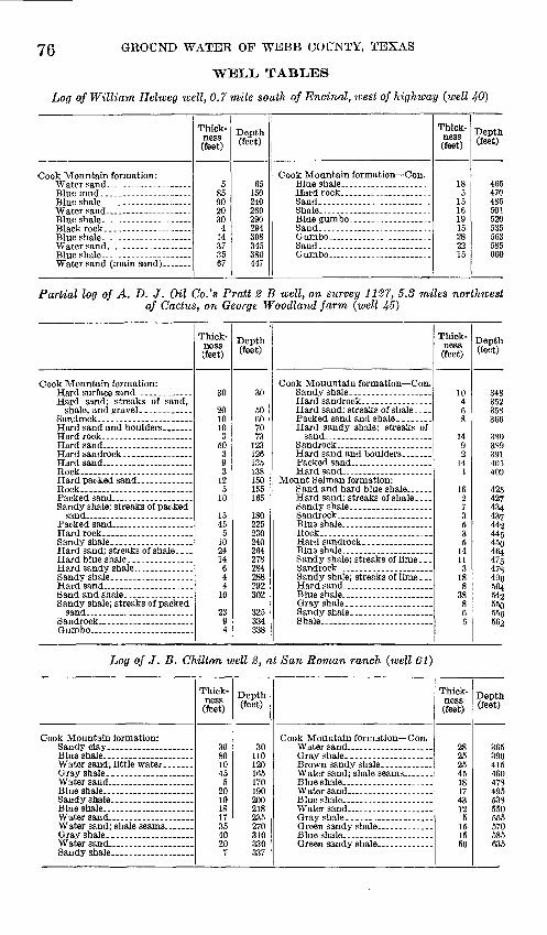
76 GROUND WATER OF WEBB COUNTY, TEXAS
WELL TABLES
Log of William Helweg well, 0.7 mile south of Encinal, west of highway (well 40}
Cook Mountain formation:
Thick ness (feet)
58590203fi
4
VI
3567
Depth (feet)
65150240
290294308345380447
Cook Mountain formation Con.
Sand. _ ..-
Sand.- -----------------
Thick ness (feet)
185
15161915282215
Depth (feet)
465470485501520535563585600
Partial log of A. D. J. Oil Co.'s Pratt 2 B well, on survey 1127, 5.3 miles northwest of Cactus, on George Woodland farm (well 45}
Cook Mountain formation:
Thick ness (feet)
30
201010
350
393
125
10
1545
5102414644
10
2394
Depth (feet)
30
50607073
123126135138150155165
180225230240264278284288292302
325334338
Cook Mouuntain formation Con.
Hard sandy shale; streaks of
Rock- -_--_ ._-__ _
Thick ness (feet)
10
8
1499
4
162
353
14
3188
388
6
Depth (feet)
348QKO
366
3S9OQ1
4254274344.0*7
44944 K,AKn
47547s4Qc
Ho
550CE«
662
Log of J. B. Chilton well 2, at San Roman ranch (well 61)
Cook Mountain formation:
Thick ness (feet)
30801045
5201018
354020
7
Depth (feet)
30110
165170190
218235270310
337
Cook Mountain formation Con.
Thick ness" (feet)
28OK
4518174°.
51515Kn
Depth (feet)
365qon
460478AQK
538550555570585635

WELL TABLES 77i)f Mantus well of Callaghan Land & Pastoral Co., 8 miles northeast of ranch
headquarters (well 88)
Yegua formation: Soil.............. ...........
Red and blue shale ____ ...
Hard gray formation; breaks
Sand
Thick ness (feet)
1840
120100
14520
Depth (feet)
o2060
180280285
430450
Yegua formation Continued.
Cook Mountain formation:
Thick ness (feet)
2015
10837
t)CK
465lOf|
Depth (feet)
590605713
7701,025
1,035i 'tfwi1,630
Log of Callaghan Land & Pastoral Co.'s well 6y2 miles southeast of Webb (well 96)
Yegua formation:
ders
Sandy shale; streaks of pack
Thick ness
(feet)
3412
25223218
123620
12
225
18
31
Depth (feet)
3446
5681
103]35153360172208228
262267285
316
Yegua formation Continued.
Thick ness (feet)
2820
810
121818
g
3318291564
16
Depth (feet)
344364372390402420438447
480498527542548552568
Log of Callaghan Land & Pastoral Co.'s well 12% miles east of Green siding (well 107)
Jackson formation:
Thick ness (feet)
53550
4901 QA
25
Depth (feet)
54090
580710735
Yegua formation Continued.
Thick ness
(feet)
25
14015020
23040
Depth (feet)
760
9001,0501,0701,3001,340
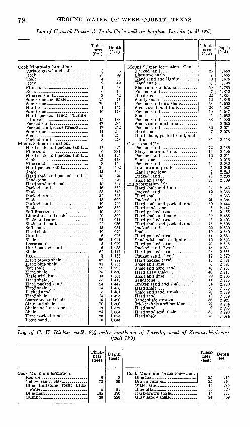
78 GROUND WATER OF WEBB COUNTY, TEXAS
Log of Central Power & Light Co.'s well on heights, Laredo (well 125)
Cook Mountain formation:
Rock
Shale
Mount Selman formation:
Shale
Shale------- __ - _ - _ - __
Thick ness (feet)
62349163
2579
15471714
8
476
9423
3614182
IS
1683321510
1020
221519
985
62
67
2275
5524
514
7019242010
Depth (feet)
629qq
43495277
156157
188235252266970
278
325331425448
492606524
560643675690700
870son914936951970976
1,0741,0793,0851, 147
1 999
1,3501,363
1,442
1,4611,475
1,5601,5791,603
Mount Selman formation Con.
Carrizo sand(?):
Thick ness (feet)
710
CQ
4722
6300
3849qo
35
7214
16
43oq
128
60
on
152210
1223
24
156
40
54902610
299
35
Depth (feet)
1,658
1,6751,7061,7651 Qi o
1,834
1 9091,9371 9471 Q*\9
1,9909 (\1Q
2,0719 fi7S
2,113
2,1852,1999 91 1
2 900
2,236
9 QHO
9 34.3
2,3639 ^84.
2 4442,447
2,4859 4CTC
2,508
2,5409 f\S19 *\Q^
2,616O «31
2,672
2 fiQO
9 7fi32 7432,7652,7769 fi3fl
2 ocq
9 S7O
2,8899 O9*\9 0^4
2,9983,074
Log of C. E. Richter well, miles southeast of Laredo, west of Zapata highway (well 129)
Cook Mountain formation:
Thick ness (feet)
879
5105
30
Depth (feet)
880
85190220
Cook Mountain formation Con.
Thick ness (feet)
25
15351524
Depth (feet)
245270285320335-359

WELL TABLES
Log of L. S. Boltz well, 21 miles north of Oilton (well 136}
79
Jackson formation:
Sand and gravel ________Shale
Shale ... .... __ . _______
Lime __ ____________
Gumbo- _________ .....Lime and pyrites ..... ....
Shale ... ... . ..
Hard lime.. __ __ _ ___
Hard sandy shale mixed with
Lime boulders and pyrites. _
Thick ness (feet)
26195
110
3610
1004050287246
4028
654
634
82
851242
85
10252530
54511is27
821
54
226102025
2
154
684
Depth (feet)
264550
160164200210310350400428500504510550578584638644678686688773785827835840850875900930935980991
1,0041,0311,0521,0601,0811,0861,0901,0941,0961,1221,1321,1521,1771,179
1,1941,198
1,2661,270
Jackson formation Continued.
Shale
White lime, boulders, and
Gumbo _ ---___--. _ .... ....Hard sandy shale and lime _ .
Yegua formation:
Lime, boulders, and pyrites. ..
Shale and boulders. ___ ....
GumboShale and boulders. . ___ .
Hard sand; shale core ..........Sand .
Limerock _ _____ __.___._ _
Sandy shale... ______ . ...Shale and boulders. _____ ..
Shale and boulders; gas show-
Hard lime and pyrites _ .. ....
Cook Mountain formation:
Thick ness (feet)
8
422
340
3383697
347
6413
81251
6
442010666
224
2135
79
108
11232
4227
68556
4494
17
Depth (feet)
1,278
1,2821,3041,3071,3471,3501,3881,4241,4331,4401,4741,4811,5451,5461,549
1,5571,5691,6201,626
1,6701,6901,7001,7061,7121,7181,7401,7441,7651,8001,8071,8161,8261,8341,9461,9491,9511,9931,9952,0022,0702,0752,0802,0862,1302,1392,143
2,160
Log of well 7 miles north of Oilton, in Carolina-Texas field below escarpment (well 140)
Catahoula tuff: Clay.. .... ...
Thick ness (feet)
9.56
14.5
Depth (feet)
9.515.530
Catahoula tuff Continued.
Thick ness (feet)
102
23
Depth (feet)
404265

80 GROUND WATER OF WEBB COUNTY, TEXAS
Log of Rosenberg well 3.8 miles north of Oilton, in survey 270 (well
Catahoula tuft: Soil
Shale
Shale
Shale.-..-..-..-.-.... ___ ..
Shale _ ........... __ - ......
Sand-.-.... __ ..-.---.--.-..
Shale . .. . -
Thick ness (feet)
2
q883
2128
176
1419
16
161660
Depth (feet)
210is212932535563808680
104116132133149165215227
Catahoula tuft Continued.
Sand...... __ ...--. _ .....Shale.-.-. _ . _ . _
Shale. _ .
Shale.. -- ____ .
Thick ness (feet)
8310
193
2414
71212121046
4125
315
Depth (feet)
310320321330333357371378390402414424428434475477482513518
Log of Rosenberg water well 2% miles northeast of Oilton, in survey 888 (well
Goliad sand: Soil ............
Thick ness (feet)
1
35104
Depth (feet)
15
405054
Catahoula tuff:
Thick ness (feet)
74
Depth (feet)
6165
Log of Rosenberg water well 2 l/z miles northeast of Oilton, in survey 388 (well 143)
Goliad sand: Soil
Shale . _ ........
Thick ness (feet)
33
01
Q
16
187
1315
Depth (feet)
36
374662
8007
100115
Catahoula tuft Continued:
Shale
Thick ness
(feet)
35801018152715155
15
Depth (feet)
150230240258273300315330335350

WELL TABLES 81
Log of A. G. Long well 2.8 miles southeast of Oil{on, in survey 1009 (well 169}
Qoliad sand:
Catahoula tuft:
Thick ness (feet)
66
249
10
455
10262
2775
1870
Depth(feet)
612364555
100105115141143170177182200270271
Catahoula tuft Continued:
Sand-.---.------ -.... _ . _
Sand.--..... _____ .
Thiek- ness (feet)
912
12523
515917
46457
68
Depth(feet)
280292293295300302305356361370371378424428433440508
Log of Houston Oil Co.'s well l.S miles northwest of Bruni, at Hoco Club (well 170)
Goliad sand: Sand. -.-....... ...............
Clay.. .............. ........
Thick ness (feet)
338
67
21
Depth (feet)
41475475
Catahoula tuft:
Thick ness (feet)
100451337
Depth(feet)
175220233270
Log of Houston Oil Co.'s well 1 mile northwest of Bruni, at Hoco tank farm (well 171)
Qoliad sand:
Hard sandrock ________ .Catahoula tuft:
Thick ness (feet)
3159
23
65
Depth (feet)
3182750
115
Catahoula tuff Continued.
Thick ness (feet)
605525
73
12
Depth(feet)
175230255262265277
Log of Crown Central Petroleum Co.'s water well, 4 miles south of Mirando City(well 178)
Catahoula tuff:
Clay. ... .
Thick ness (feet)
108
27
Depth (feet)
101Q
45
Catahoula tuff Continued.
Thick ness (feet)
84712
Depth (feet)
53100112

82 GROUND WATER OF WEBB COUNTY, TEXAS
Log of Magnolia Petroleum Co.'s water well in Albercas field (well 188)
Goliad sand: Clay and gravel ________
Shale.... ....... _ . ___ ....Sand and gravel ...............
Catahoula tuff:Shale .. .....................
Thick ness (feet)
33242620
153
Depth (feet)
33
83103
256
Catahoula tuff Continued.
Sand..... ... ...Shale.....-.. .. ... -. -.
Thick ness (feet)
2361172325
Depth(feet)
279340357380405
Log of Carolina Texas Oil Co.'s Barnsley No. 2 well, on survey 268, about 7 milesnorth-northeast of Oilton
Catahoula tuff: Sand _______ . _____ .
Eock... .......................
Sand. _____________
Rock _____________
Rock....................... .
Thick ness (feet)
OK
00
OK
32720102025
5202520KK
2901
24QQ
447
25
Depth (feet)
608588
115
145
19019591 >%
260
34407 e
ACkf.
490497
570595
Catahoula tuff Continued.
Rock _______________
Shale
Shale - -
Thick ness (feet)
319
2069214520
31235282720
2530304030
1022860
1249
uPepth(feet)
626635655724745790810813825860888915935
960990
1,0201,0601,0901,1921,2201,280
1,2921,2961,305


Rec
ords
of
wel
ls i
n W
ebb
Cou
nty,
Tex
.
[All
wel
ls d
rille
d ex
cept
as
note
d un
der
"Eem
arks
"]
No. 1 3 4 fi fi 7 8 ft in n 12 13 14 15 Ifi 17 18 19 20 22
Loc
atio
n
ture
. C
hupa
dero
ran
ch,
6.7
mile
s ea
st-s
outh
east
of
head
quar
ters
, in
Loz
a pa
stur
e.
tank
.
line.
past
ure.
Enc
inal
, 11
.2 m
iles
nort
hwes
t of
, 1.
5 m
iles
sout
h of
cou
nty
line-
_ _
Ow
ner
or n
ame
do- -
... -
do.-
..
. -
. .
do
.--..
.-
d
o-
-do.-
- ------
..
do
-
Co.
d
o..
-
N.
H. B
row
n
d
o..
.
d
o-
d
o.
-...
-do
-- ..
.
Mrs
. F.
W. S
bu
tte
Dri
ller
..d
o--
- - .
- d
o-.-
. .....
-do_ _
-d
o-.-
..
....
. ..
... -
do.-
- ..
. .... .
.
E.
B. O
wen
s
do
pora
tion
.
d
o-. .
J. L
. W
atk
ins
---
-do
Dat
e co
m
plet
ed
1908
1901
1908
1902
1902
1915
1924
1930
1930
1930
1923
1908
1907
Top
ogra
phic
si
tuat
ion
Fla
t be
low
hil
ls...
d
o
Fla
t .
Fla
t su
rrou
nded
by
hill
s.
Fla
t -
d
o..
d
o .
doF
lat .
Val
ley-
.
d
o .
Fla
t
.d
o.-
--- -.
... -
do..
- d
o--- -
... .
-do-.
..
..
Alti
tu
de
abov
e se
a le
vel
(fee
t)
605
645
715
635
640
655
635
545
812
810
801
692
730
700
660
650±
700±
600
700±
680
Dep
th
Of
wel
l (f
eet)
315
210
250
150
190
300
390
600
300
1,45
0
1,26
03,
388
1,38
71,
425
1,65
51,
387
1,55
0
1,81
42,
126
300
150
Dia
m
eter
of
wel
l (i
nche
s)
Q
1
6 §
6 D
5 ~£
8"^
6 o hr
i 8
^6
^
6 M
7 W
7 td
5 o
6 5
6 S
6 3 "
8^^
8 i-3
........
g
e n VI

Rec
ords
of
wel$
$ in
Web
b C
ount
y, '
fex.
Con
tinu
ed
No. 1 2 3 4 5 6 7 8 9 10
11 12
13 14
15
16 17
18 19 20
21
22
Pri
ncip
al w
ater
-bea
ring
bed
Dep
th
to to
p of
bed
(f
eet)
305
320
1,26
0
1,35
0
1,42
5 1.
S41
1,34
2
1,55
0 1,
785
2,08
8
Thi
ck
ness
(f
eet) 24 27
38
Cha
ract
er o
f m
ater
ial
Fin
e sh
aly
sand
- W
hite
san
d.-
_ -_
Sand
d
o..
do-
Geo
logi
c ho
rizo
n
Indio
...... ..
...
- .do..-...-
..
do
....
....
..
.... .d
o.. .
..d
o-..
....
...d
o..
..
...
Big
ford
--
d
o-.
. ..
.
do-.
Mou
nt
Selm
an
(Big
ford
mem
be
r).
do..
. _ .d
o. _
__
_ ..
. .
do..
Dep
th
to
whi
ch
wel
l is
case
d (f
eet) 20
20 20
20 20 20
1,38
7
1,81
4
2,12
6 20
Wat
er l
evel
Abo
ve
or b
e
low
sur
fa
ce o
r be
nch
m
ark
(fee
t)
-12
5
-60
-61
-58
-67
-69
.5
-67
.5
-16
8
-22.7
-2
15
-270.3
-145
.9
-124.5
-21
0
-19
4.2
-2
09
-75
-48
Dat
e of
m
easu
rem
ent
June
5,
193
1 ...-
-do--
.-...
Jun
e 7,
193
1 Ju
ne
5,19
31
June
7,
193
1 Ju
ne
10, 1
931
Jun
e 9,
193
1 Ju
ne
4, 1
931
June
19
, 193
1 Ju
ne
11,1
931
June
19
, 193
1
Jun
e 22
, 193
1
Jun
e 23
, 193
1
Aug
. 15
,193
1
Aug
. 1,
1931
A
ug.
15,1
931
Aug
. 15
,193
2 d
o..
Met
hod
of li
ft »
W, C
.-
W, C
.
W,C
-
W, C
.
W, C
W
, C
W
, C
W, C
H
,C
.W
,C -
W,C
-
W, C
-
W, C
W, C
W, C
.
W, C
W, C
-
W, C
Cap
ac
ity
of
pum
p (g
allo
ns
a m
in
ute)
Yie
ld
(gal
lo
ns a
m
in
ute)
Dra
w-d
own
Fee
t
Non
e
Non
e
Dur
atio
n of
test
14 h
ours
-
Use
of w
ater
2
S ..
. D
,S .
S ....
. ....
S
S.-
..
S
S..
. .........
S..
. ..... ..
..S ...
.
S D,S
--
N ..
. -
D.S
.-..
.
S--- ---
S.......
-
S -
.... ..
.D
,S ..... .
N ..
.
N ..
..
D,S
... .....
.D
, S
. --.
..
Rem
arks
Sal
ty w
ater
. W
ell
on o
utcr
op o
f C
arri
zo
sand
. D
o.
Wel
l on
out
crop
of
Car
rizo
sa
nd,
cave
d to
105
fee
t.
San
d re
port
ed a
s bl
ack.
V
ery
salt
y.
Qua
lity
im
prov
es
wit
h
pum
ping
; on
ce m
uch
bet
te
r; c
asin
g pr
obab
ly f
aul
ty
. A
band
oned
oil
test
. W
ater
ex
cell
ent
unti
l fe
w
year
s ag
o.
Cas
ing
prob
ab
ly f
ault
y.
Aba
ndon
ed o
il te
st.
Sal
ty w
ater
.
Oth
er s
ands
(at
1,1
90-1
,218
and
1,32
4-1,
342
feet)
yi
elde
d ba
d w
ater
. O
ther
sa
nds
(at
1,19
5-1,
230
and
1,44
5-1,
460
feet)
yi
elde
d ba
d w
ater
. A
band
oned
oil
test
.
Cav
ed t
o 90
fee
t.
See
foot
note
s at
end
of
tabl
e.00

Rec
ords
of
wel
ls i
n W
ebb
Cou
nty,
T
ex. C
on
tin
ued
[All
wel
ls dr
illed
exc
ept a
s no
ted
unde
r "R
emar
ks"]
00 O5
No. 23 ?4 25 2fi
28 29 30 31 32 33 34 35
Loca
tion
Enc
inal
, 6
mile
s w
est s
light
ly n
orth
of- _
__
__
__
__
_ _
___
__
__
Ow
ner o
r nam
e
Mrs
. F
.W. S
hu
tte
d
o-
__
do __
S. A
. Jam
es _
_ ..
.
Dri
ller
.. d
o.
....
... .
....
.W
. C
. Hil
l. .
....
...
W.
C. H
ill.
..
....
.
do
L. H
. Wat
kin
s .
.. .
Dat
e co
m
plet
ed
1927
1909
1928
1Q
OQ
1910
1930
1907
1925
1908
1917
1902
1892
Top
ogra
phic
si
tuat
ion
Fla
t...
..... ..
. ...
d
o
Fla
t...
- d
o.
.F
lat
d
o... ...
.F
lat
...
. ...
...
..d
o
... .
...
d
o
-d
o..
. ...
....
...
Alti
tu
de
abov
e se
a le
vel
(fee
t)
680
700±
70C
±70
0±70
0-1-
760±
760±
750±
750±
710±
705±
690±
740±
Dep
th
of
wel
l (f
eet)
200
200
Ort
rt
300
Af\
l
473
400
oAn
152
150
900±
Dia
m
eter
of
wel
l '
(inch
es)
Q
Oo
S8
a6
°8
_j
10 S
8 W
66 g
6 ^
4 <- W
W O o

Rec
ords
of
wel
ls i
n W
ebb
Cou
nty,
Tex.
Con
tinu
ed
No. 23
24 25
26
27 28
29 30 31
32 33
34 3,5
Pri
ncip
al w
ater
-bea
ring
bed
Dep
th
to t
op
of b
ed
(fee
t)
373
180
458
340
190
130
126
300
Thi
ck
ness
(f
eet) 20 14
15 25 20
24
Cha
ract
er o
f m
ater
ial
San
d.... ........
....
.do
...........
- d
o...........
- d
o...._
__
....
-do . .
..do
-do...........
--.d
o......
-do ..
....
d
o ..
... ..
d
o... -
-..-d
o
Geo
logi
c ho
rizo
n
Coo
k M
ounta
in.
.do
-
do
.... .
.do .
..... ..
.d
o .... ..
.
..d
o ... .
...
. .d
o. -.._
d
o .......
... -
do ..
....
.
d
o.
.do ...
..... .
.do . ..
d
o
Dep
th
to
whi
ch
wel
l is
case
d (f
eet) 21
10 10 400 10 470 20 20
20 20
20
Wat
er l
evel
Abo
ve
or b
e
low
sur
fa
ce o
r be
nch
m
ark
(fee
t)
-44
86
-105
-1
08
-119
-17
0
-16
0
-12
0
-85
-10
2
-93
-9
0
Dat
e of
m
easu
rem
ent
Aug
. 15
, 19
32
....
. do ..
.
-d
o ..
..A
ug.
20,1
932
Aug
. 15
,193
2
Aug
. 20
,193
2 A
ug.
15,1
932
Aug
. 20
,193
2
Aug
. 22
,193
2
Aug
. 19
,193
2
Aug
. 15
,193
2- d
o ..
.. ..d
o ..
Met
hod
of li
ft i
G.C
.
W, O
...
W, C
...
W, C
...
W, C
...
W, C
W
, C
...
G, 0
W,
G, C
.
G, D
G, C
W. C
...
Cap
ac
ity o
f pum
p
(gal
lons
a
min
ut
e)
.........
38 32 38
Yie
ld
(gal
lo
ns a
m
in
ute) 50
25 25 35
38 32 38 13
15
Dra
w-d
own
Fee
t 90 40 63
Dur
atio
n of
tes
t
12ho
urs.
2% h
ours
Use
of
wat
er 2
N........ ....
D,
S, I
....
...
D,
S. .
..... .
.D
, S
... .
.....
D, S
... .
.....
S ....
D, S
....... ..
D, I
D,
S, I
D,
S, I
....
...
D,
S..
._ _
..S
...
....
D, S
...
...
Rem
arks
Use
d fo
r ir
riga
tion
of
10
ac
res
of o
nion
s in
192
7.
Irri
gati
on
of
peac
hes
and
plum
s ki
lls
tree
s.
No
ad
vers
e ef
fect
on
citr
us.
Oth
er s
ands
at
112-
115
and
180-
188
feet
. W
ater
lev
el
at
tim
e dr
ille
d re
port
ed
as 9
3 fe
et.
Yie
ld s
mal
l. O
ther
san
d at
170
-173
fee
t. W
ater
leve
l at t
ime
dril
led
repo
rted
as
70 f
eet.
Oth
er s
ands
at
90-9
1,
124-
13
1,
and
190-
234
feet
. P
umpe
d 48
da
ys
at
38
gall
ons
a m
inut
e w
itho
ut
fail
ure.
Ir
riga
tes
15 a
cres
of
oni
ons,
cab
bage
s, to
mp-
to
es.
Oth
er
sand
at
12
0 fe
et.
Pum
ped
36
days
at
32
ga
llon
s a
min
ute
wit
ho
ut
fail
ure.
O
ther
san
ds a
t 90
-110
and
12
0-13
5 fe
et.
Pum
ped
84
days
at
38 g
allo
ns a
min
u
te w
itho
ut f
ailu
re.
Irri
ga
tes
6 ac
res
of v
eget
able
s.
Inju
res
plan
ts.
See
foot
note
s at
end
of t
able
.0
0
Rec
ords
of
wel
ls i
n W
ebb
County
, T
ex.
Co
nti
nu
ed
[All
wel
ls d
rille
d ex
cept
as
note
d un
der
"Rem
arks
"]
No. 36 37 38 39 40 41 4? 43 44 4f
i47 49
Loc
atio
n
. d
o
_ -
do
hous
e.
Enc
inal
. 3.
7 m
iles
sout
hwes
t of
, wes
t of
hig
hway
______ ..
...
Ow
ner
or n
ame
A.
E.
Sch
letz
e....
_ .
do. .. ..
. ........
.....d
o .
....
....
....
.B
. B
. D
unba
r ___ .
......d
o.. ... .
....
....
.....d
o.......... .
...
J. M
. Sa
linas
. _ ..
. ...
Dri
ller
J. L
. W
atk
ins
.... .
A.
E. S
chle
tze. ..
E.
A. S
ch
letz
e
L
. H
, W
atk
ins
d
o . . ...
...
L. H
. W
atk
ins
... .
.do
.
.... ..
. ...
L.
H. W
atk
ins
Dat
e co
m
plet
ed
1928
1926
1929
1911
1928
1926
1925
1922
1924
1905
1917
1929
Top
ogra
phic
si
tuat
ion
Flat.
. d
o..
....
....
...
Fla
t
d
o..
..
....
..... .
.do
..
. .....
Hil
ltop
. ...........
.....d
o .
Alti
tu
de
abov
e se
a le
vel
(fee
t)
750±
800±
560±
540±
540±
530±
700
690
670
650
550
550
535
Dep
th
of
wel
l (f
eet)
300
250
685
401
600
AC\C\
600
203
250
418
295
750
Dia
m
eter
of
wel
l (i
nche
s) 8 5 12 8 10 8 8 6 6 12 6 6 6 10
00
00

Rec
ords
of
wel
ls i
n W
ebb
Cou
nty,
Tex
. C
on
tin
ued
No. 37 38 :w 40 41 4? 43 44 45 46 47 48 49
Pri
ncip
al w
ater
-bea
ring
bed
Dep
th
to t
op
of b
ed
(fee
t) 90 615
300
Thi
ck
ness
(f
eet) on 10 70 67 20
Cha
ract
er o
f m
ater
ial
Sand
. ...
....
....
.....d
o..
...
...
... .
.do.
San
d .
........
Geo
logi
c ho
rizo
n
.. do . .
d
o .
.. ..
...
-....d
o .
..... d
o
.... .-
..d
o
...-
...
. ..d
o .
.... ..
.
do ........
... .
.do-
....
..
..
do
.. ..
.
....
.do
....
....
...
. .d
o.
...
..
Dep
thto
whi
ch
wel
l is
case
d (f
eet)
on
n 40 685 40 A
nn 40 Af\
4ft
20 20 100 20
Wat
er le
vel
Abo
veor
be
lo
w s
ur
face
or
benc
h
mar
k(f
eet)
__
QC
-93
-100 -67H
-67*
18
-87
-10
0
_ 1
4.n
-60
-60
-35
-60?
Dat
e of
m
easu
rem
ent
_
do
..
.A
ug.
20,1
932
Aug
. 1,
1932
.....d
o ..
.-....d
o ..
.
July
20
,193
2
.d
o
-d
o
.d
o....
d
o.
Rep
orte
d. ..
..
Met
hod
of li
ft i
0, C
W, C
...
D, E
-
W, C
...
E, C
. E
, D
W, C
-..
W,C
-_
W, C
..-
w, c
...
W, C
.
Cap
ac
ity o
fpum
p
(gal
lons
a
min
ut
e)
Yie
ld(g
al
lons
a
min
ut
e) 90 225
Dra
w-d
own
Fee
t
280
Dur
atio
n of
tes
t
Use
of
wat
er 2
N. .
....
....
..
D,
S. .
....
...
I...... .
.
D, S
...
...
D, I .....
D,
S, I
I ........
S ... .
.....
-S
...
.. ..
..
D,S
.. .......
D, a
.. ...
....
N. ..
....
..
S . __ .
N ... .
.....
Rem
arks
feet
cas
ed o
ff.
Irri
gate
d10
acr
es o
f on
ions
, 19
29.
tabl
es.
Oth
er
sand
s at
200
and
400
feet
, ca
sed
off.
tabl
es
in
1929
. O
ther
sand
s at
240
-260
and
308
-34
3 fe
et.
175-
195
feet
.
Sli
ghtl
y b
itte
r.
2 w
ells
100
feet
apa
rt,
one
dril
led
in19
05 b
y W
. B
urru
s.
liabl
e in
form
atio
n as
to
wat
er s
and,
pos
sibl
y C
a-rn
zo.
For
mer
ly
used
fo
r ir
riga
ti
on.
Do.
See
foot
note
s at
end
of t
able
.
00
CP

Rec
ords
of w
ells
in
Web
b C
ount
y, T
ex. C
onti
nued
[All
wel
ls d
rille
d ex
cept
as
note
d un
der
"Rem
arks
"]
CO
O
No. so 51 53 53 54 55 5f
i57 58 59 fiO 61 m fi3 64 65
Loca
tion
d
o. -. ... ..
.... . ... _
..d
o......... .
....
....
....
....
....
....
.. .
..
..........
....
.. .
....
.do
....
....
....
....
....
....
....
....
....
....
....
....
....
...
....
....
. .
.do
.- .
-_..-
.-_-
.-._
._._
_.._
_.__
____
____
_.._
_.__
_.__
...._
__ .
.do
....
....
. .
..........................................
....
....
..-
do
..............
...............
..
....
....
. ....
Chi
lton,
0.5
mile
eas
t of
_____ . _
__
_
______
. ___
Chi
lton,
3 m
iles
sout
heas
t of.
.. _ _
______________
__
__
_
Ow
ner o
r nam
e
d
o...
-do
-d
o
J.
B.
Chil
ton.
-d
o...
.....d
o.... .. .
. d
o ...- ..
......d
o .
....
.. ..
. .
....
.do
..
. ..
...
.. .d
o...
... ..
....
.d
o
....
.do.
..
Dri
ller
do
F. E
. R
oebu
ck...
. ...
.
J. B
. C
hil
ton
- d
o... ..
... .
....
... .
d
o... .......... ..
.. d
o. ..
do
....
. do
..
....
... .
.do
..... ..
...
d
o . .
Dat
e co
m
plet
ed
1927
1929
1929
1906
1924
1926
1926
1926
1926
1926
1929
1929
Top
ogra
phic
si
tuat
ion
Pla
t... ..
. .....
. ..
do .
.....
..
do
..
......
Hil
lto
p _
....
Fla
t... ..
....
.....d
o ..
..H
illt
op
Fla
t
... .
.do
. ..
......
.H
illt
op
..
.. .d
o .
.... ..
...
Fla
t.
....
.do
. .
......
... .
.do ..
..
Alti
tu
de
abov
e se
a le
vel
(fee
t)
540
535
525
500
700
665
680
585
585
560
560
597
595
585
540
567
Dep
th
of
wel
l (f
eet)
400
600
600
270
265
420
470
630
630
1,08
063
025
025
060
060
0
Dia
m
eter
of
wel
l (in
ches 6 10 10 m 6 7 10 10 10 10 12 5 8 10 10
1-3 M
> CO

Rec
ords
of w
ells
in
Web
b C
ount
y, T
ea;.
Con
tinu
ed
No. 50 51
52 53
54
55
56 57 58
59 60
61 62
63
64
65
Pri
ncip
al w
ater
-bea
ring
bed
Dep
th
to t
op
of b
ed
(fee
t)
380
540
480
200
225
(3) (») 53
8
(')
(3) 50
0
Th
ick
ne
ss
(fee
t) 20 40
15 70 40
(3)
« (8) 12
<*>
(») 10
0
Cha
ract
er o
f m
ater
ial
San
d. _
__ . _
_
....
.do
...........
do
...
.....d
o...........
San
d.... ..
....
..
(8)
Sand _
(')
(*)
San
d ____ . .
..
Geo
logi
c ho
rizon
Coo
k M
ount
ain,
do.. . ..
.. d
o..
. ...
....
.
do
d
o ..
... .
d
o
..... .
do.... .
d
o ..
.. .
- d
o.
.....d
o...........
..d
o..
....
.
....
. do
..
...
..d
o..
. d
o... ..
.....d
o.-
,,.
Dep
th
to
whi
ch
wel
l is
case
d (f
eet)
300 60
70 270
200
470
630
630
740
630
....
...
Wat
er le
vel
Abo
ve
or b
e
low
sur
fa
ce o
r be
nch
m
ark
(fee
t)
-70
-60
-60
-123
-186
-1
17.8
-117
.8
-130
-130
-1
33. 6
-14
8-1
06
-72.7
-1
18. 7
Dat
e of
m
easu
rem
ent
Aug
. 15
,193
2
do.... .
....
do.
.. ..
...
July
10
,193
1 _
_ do
....
....
-do..
Rep
orte
d __
.d
o..
....
..
July
10
,193
1
do.
July
11
,193
1 do
. ...
....
Met
hod
of li
ft'
E,
C..
..
O, D
-...
G, D
.
W, C
...
W, C
. W
fl
E, D
....
E, D
....
E,
D..
_.
E, D
E, D
_
W,
C ..
.W
, C
_._
W, C
...
W, C
,..
Cap
ac
ity o
f pum
p
(gal
lons
a
min
ute
)
. ... 17
5
175
175
176
175
.........
Yie
ld
(gal
- Io
ns a
m
in
ute) 50 15
0 12
5
175
175
175
....
...
Dra
w-d
own
Feet
....
...
Dur
atio
n of
test
....
....
..
Use
of w
ater
*
D, 8.. ..
....
.
D. .
..........
I __ ......
8 ..
...
N
.
S ..
. ...
D, S
.._ ...
I ..
.....
I ..
.I ..
.. ..
I ..
....... .
D, I
D ..
. ...
.
S.
..
.S
-.-
.-,.. .
Rem
arks
Tw
o w
ells
, 15
fe
et
apar
t,
wit
h w
alki
ng b
eam
. Use
d fo
r ir
riga
tion
in
1929.
Oth
er s
ands
at
150-
152
feet
(b
itte
r)
and
270-
273
feet
(f
air)
. U
sed
for
irri
gati
on i
n 1
929.
O
ther
san
ds a
t 40
0-45
0 an
d 49
5-51
7 fe
et (
dry)
. S
alty
. S
ligh
tly
bit
ter.
S
ligh
tly
brac
kish
.
Has
pum
ped
seve
ral
days
w
itho
ut f
aili
ng.
Do.
H
as
pum
ped
seve
ral
days
w
ithout
fail
ing,
w
ater
le
vel
coul
d no
t be
mea
s
ured
. O
ther
sa
nds
at
110-
120,
16
5-17
0,
218-
235,
23
5-27
0,
310-
330,
33
7-36
5,
415-
460,
478
-495
, an
d 5
38-
550
feet
. N
o w
ater
bel
ow 7
40 fe
et.
Wel
ls 5
7-61
equ
ippe
d w
ith
Dow
nie
No.
33
do
uble
- st
roke
pum
ps a
nd 1
5-, 2
0-,
and 2
5-ho
rsep
ower
mot
ors.
Slig
htly
sal
ty.
Oth
er s
ands
at
250
and
400
feet
.
H B
See
foot
note
s at e
nd o
f tab
le.
CD

92 GROUND WATER OF WEBB COUNTY, TEXAS
ContinvuRemarks"]
§ =M
1 11 ! i i^ ^fca' >®1a -oi?» _®
«o 3t» it^ 7*. -a^ CO
<£> 1
oo 3 *"e <i
goa? oo<ooo<o& <o<o oo<o<o<o<o o-.oto.ooooS S t>oft« .§f*.??p°^s
111 ill^ ^^ 03 ^-"N '
Topographic situation
*gS.^ o ©H "3,
-
iQ
®
flS
1P0
aJ
I
-
iO CO >O (N CO *O (N "***
mn
c
?
1«t-
tr Mez"
i
raSco
00
| @S§ SS8S§S §SSii5|co1 IN"
S §S3 8113
O £*»
i >sssss §^
1̂.de Cam ilasarza.
'C
g"w®&
miles west of. miles west of 3 miles north
l| If°2 ° ^
^pq Ra
c 4^
>2 o
^
1fl*3
M "w c c
6!I1j
i
! "oi 1i Jh' a I
c
J
O
io Grande Oil
Co.
«
A c5 1 w C <
5 ^
,
c c
0539
fe fl
.c
«
~
4^ Z p
J ft S<^i
,,I
£"£? S
1
c c c T:
8a
. S. Owens...
rt
1=1
5 SM« C
3 CM0
"o fc"S °
c c c c T: T:
?39-)
Si§3j
c c c c r T:
"c
^ «[>,.»
c cC"C .
,-j3>
O
125 '§ §
I ^^ +sJ5 " * ^ ^ ^"o ® ^ c§K^.t^J rS"£ «^ w "w *o D 'c'^-*J 'c'^Si
oot>«-at«"a *
»H gw^ gangs'-1 <M»oiN«)g" rH 03 03 S 00 00 t^ C*i O ^ _ri^rt_ri_fl_fl
Htllls » »* gggggi II^IISSS o o o SS'3 'S ffl CD a "S -73 r3r3'3r3r3'3 csc3o3o3<so3 <Bo3,~ titiiCii'-,. 53 a a as a a a OOOOOO DOI? ^^^^^D DOOOOO
| 1 §0§g§?:s BRS Kg^els Scsasss

Rec
ords
of
wel
ls i
n W
ebb
Cou
nty,
Tex
. C
onti
nued
No. 66
67
68 69
70 71 72
73 74
75
76
77
78 78
a 79 80 81
82
83
84
85
Pri
ncip
al w
ater
-bea
ring
bed
Dep
th
to to
p of
bed 47
5
242
600
255
480
340
400
400
900
400
235
235
Thi
ck
ness
(f
eet) 49
10 15
10 16
Cha
ract
er o
f m
ater
ial
San
d
..d
o
d
o..
.. d
o.
.....d
o.... .
.. d
o....... .
..
Sand_ ..
.....d
o..........
d
o..
._
..d
o..
...
..... d
o..
.. .
.. d
o...
Geo
logi
c ho
rizo
n
Mou
nt S
elm
an
d
o .
....
...
Coo
k M
ount
ain.
....
. do.
. .
.d
o..
.. .
..
.... .do.... ...
... -
.do
....
.
..... d
o..
... .
.. ..
d
o..
....
. ...
Mou
nt S
elm
an?.
C
ook
Mou
ntai
n.
..... d
o......
.do
....
..
do
......
Mou
nt S
elm
an?.
C
ook
Mou
ntai
n.
..... d
o.... .
_
do
. ...
...
.. d
o..
........
Dep
th
to
whi
ch
wel
l is
case
d (f
eet)
535 20
16
3
600
265
485
356
404
405
1,38
2
240
240
Wat
er le
vel
Abo
ve
or b
e
low
sur
fa
ce o
r be
nch
m
ark
(fee
t)
-218
-2
12-1
00 -39
-122
-112
-13
0
-73
-62
-15
0
-18
8
-17
5
-152
-18
0
-28
Dat
e of
m
easu
rem
ent
July
15
,193
1 ..
do
July
20
,193
2
July
10
,193
1 Ju
ly
20,1
932
**
July
25
,193
2
Aug
. 1,
1931
.....d
o....
.-
do.. .
Aug
. 10
,193
2
Aug
. 10
,193
2 A
ug.
5, 1
931
Aug
. 5.
1931
Met
hod
of li
ft»
W, C
...
W, C
...
E, D
.
W, C
...
W, C
.-.
W,
C ..
.
W, C
...
W, C
W,
C.-
-W
, C
...
W, C
W
, C
-.
W, C
W, C
...
W, C
-.W
, C
-_W
, C
W
, C
...
W. C
Cap
ac
ity o
f pum
p
(gal
lons
a
min
ut
e) 150
Yie
ld
(gal
lo
ns a
m
in
ute) 15
0 20 8 20 8 9 25 4 8 8 12
Dra
w-d
own
Fee
t 65
Dur
atio
n of
test
11 d
ays-
Use
of
wat
er «
S...... .
S .
D,
S, I -
D,S
. ........
D,
S. .
.......
S....... .....
S.. ..
.. ..
.S
_ ..
N ..
..S D
, S
....
S .
S
S ..
..
S_
.
D,
S__
._ ..
...
S -
S
....
S .. _
S
..
. ...
Rem
arks
Bit
ter.
Equ
ippe
d w
ith
Key
ston
e do
uble
18
-inc
h st
roke
pu
mp
and
25-h
orse
pow
er
mot
or.
Oth
er
sand
s at
27
1-28
0 an
d 40
2-41
2 fe
et.
Sev
eral
sa
nds,
ex
act
posi
ti
on n
ot k
now
n.
Oth
er s
ands
, at
410
an
d 2
10
feet
. S
alty
. A
noth
er
sand
at
12
0 fe
et;
salt
y.
Aba
ndon
ed o
il te
st.
Bit
ter.
Str
ong
wel
l. D
rill
ed
to
400
feet
, w
here
en
coun
tere
d sa
lt
wat
er,
pull
ed b
ack
to 3
56 f
eet.
Iron
tas
te,
redd
ish
colo
r.
Sal
t w
ater
at
1,43
6 fe
et.
Bit
ter.
See
foot
note
s at
end
of
tabl
e.
CO
0
3

Rec
ords
of
wel
ls i
n W
ebb
Cou
nty,
Tex.
Conti
nued
[All
wel
ls dr
illed
exc
ept a
s no
ted
unde
r "R
emar
ks"]
No. 86 87
88
89
90
91
92
93
94
95 96
97
98
99
100
101
102
103
104
105
106
107
J08
Loc
atio
n
Gre
en s
idin
g, 1
0 m
iles
nort
hwes
t of.
.. ..
Cal
lagh
an r
anch
hea
dqua
rter
s, 3
.7 m
iles
sout
h-so
uthe
ast o
f _
_____
Gre
en s
idin
g, 5
mile
s w
est-
sout
hwes
t of
. _
___ _
____ . .
....
.
Cal
lagh
an r
anch
. 11
mile
s so
uth-
sout
heas
t of _
_ ..
-T,-
_ T.
-.r.
T.T-
. _ T
Ow
ner
or n
ame
Cal
lagh
an
Lan
d &
P
asto
ral
Co.
. .d
o.. ...
....
....
...
.....d
o.......... ..
....
..d
o................
. .d
o..
....
.- .
Puig
Bro
s.. ....... _
_
__ d
o _ .............
do................
Cal
lagh
an
Lan
d &
Pa
stor
al C
o.
. d
o..
....
....
....
.......d
o....... _
....
.. d
o..
..
....... .
.....d
o.. ..............
Mrs
. C
. H.
Cli
fton
....
.....d
o...... .
......
Lon
e St
ar
Con
stru
e*
tion
Co.
.....d
o......... .
......
.....d
o........ .....
Lag
una
Cat
tle
Co _ .
Cal
lagh
an
Lan
d &
P
asto
ral
Co.
T _
do
T...
T.._
_T.
r_T.
.
Dri
ller
C.
Che
naul
t. .........
F. E
. R
oebu
ck.. ..... .
do................
B. F
.Walk
er.
........
....
. do.
......... ..
....
L.
H. W
atkin
s...
....
.
W.
E. S
mit
h..
....
....
.....d
o................
A.
Lon
g _
__
..
....
C.
Che
nauJ
t,.. .......
Dat
e co
m
plet
ed
1927
1927
19
12
1917
19
28
1928
1925
19
24
1925
19
23
1923
19
06
1928
19
27
1929
19
28
1918
Top
ogra
phic
si
tuat
ion
Hil
ltop. ..
..... .
Val
ley.
. ..... .....
Fla
t.. .
...... ..
...
....
. do
....
....
... .
d
o..
...........
.....d
o............
....
. do.
...
....
.. ..
Fla
t...... .
....
....
d
o..
....
....
..H
illt
op
....
....
....
Fla
t ..
.. ..
....
..V
alle
y.. .
....
.....
Fla
t ..
....
.. .
Fla
t ..
....
...
Hil
lto
p
Hil
lto
p .
....
....
Fla
t... ..
. ...
....
..
....
.do
....
....
....
Alti
tu
de
abov
e se
a le
vel
(fee
t)
500±
600±
50
0±
550±
45
0±
575
624
685
720
545
590
509
530
515
555
580
560
609
700
670
600
545
550±
Dep
th
of
wel
l (f
eet)
960
1,10
5 1,
630
1,38
0 1,
697
343
251
200+
33
5 90 568
458
605
140
212
228
300
320
325
599
1,34
0
1,44
0
Dia
m
eter
of
wel
l (i
nche
s)
^ »
< "> >UND
WATER
OF
WEBB
COUNTY, TE3
CO
OOOtQOCOCOtQCOCO
COCOCOCOCO*QJ>-CO
CO
COCO
CO
CO

Rec
ords
of
wel
ls i
n W
ebb
Cou
nty,
Tex
. C
onti
nued
No. 86 87
88 89
90 91
92
93
94 95
96 97
98
99
100
101
102
103
104
105
106
107
108
Pri
ncip
al w
ater
-bea
ring
bed
Dep
th
to to
p of
bed
950
1,10
5 1,
620
1,20
0±
1,50
0
227
330
552
450
600 96 300
300
180
1,30
0 1,
300
Thi
ck
ness
(f
eet)
197 23
.......
16 5 7 20 40
140
Cha
ract
er o
f m
ater
ial
....
.do..
....
.
d
o...
San
d... --
San
d
..d
o..
.
..d
o..
....
...
. -do.. ........
. d
o..
Geo
logi
c ho
rizo
n
Coo
k M
ount
ain.
, do.... .
do...... .
.d
o...... ..
....
...d
o..
. .......
Mou
nt S
elm
an..
d
o.... .
Mou
nt S
elm
an?.
C
ook
Mou
n
tain
?
Cook
Mou
n
tain
? Y
egu
a? -
__ d
o... .
d
o..
..
d
o.....
Cook
Mou
n
tain
. d
o.... .
.. d
o....
.d
o......
..... . d
o..
..
d
o...
....
.do
.. ........
Dep
th
to
whi
ch
wel
l is
case
d (f
eet)
960
1,10
5 1,
630
1,38
0 1,
697
Non
e N
one
335
564
458
605
140
300
320
320
250
1,34
0 1,
400
Wat
er le
vel
Abo
ve
or b
e
low
sur
fa
ce o
r be
nch
m
ark
(fee
t)
-15
6
-53
+5
-94
-90±
-57
-117.5
-1
84
-2
35
-62
-17
0
-45
-16
4
-94
-60
-18
5
-80
-18
0
-13
5
-11
0
Dat
e of
m
easu
rem
ent
Aug
. 5,
193
1
do
....
A
ug.
15,1
931
d
o....
d
o.......
July
25
,193
1 d
o..
..
..
do.......
Aug
. 25
,193
2
Aug
. 4,
193
1 A
ug.
17,1
932
Aug
. 7,
193
1
....
. do....
Aug
. 17
,193
1
Aug
. 20
,193
2 A
ug.
22,1
932
.... .d
o... .
...
....
.d
o..
Met
hod
of l
ift i
W,
C _
W, C
.
W, C
...
W, C
...
W, C
...
W,
C ..
.W
, C
...
W, C
_-
W,
C._
.W
, C
...
W,
C__
.W
, C
.-_
W,
C-_
_H
, C
... .
W, C
...
W, C
...
W,
C__
_W
, C
.__
W,
C ...
W,
C_.
_W
, C
...
W,
C__
_
Cap
ac
ity
of
pum
p (g
allo
ns
a m
in
ute)
Yie
ld
(gal
lo
ns a
m
in
ute) 15
15
3 25
25 2 4 9 40 20 3 15 10
25
Dra
w-d
own
Fee
t
170
Dur
atio
n of
test
10 m
in.
Use
of w
ater
*
S ..
...
D,S
...
S S.. ..
........
S.. ....
S ..
. ......
D,
S.. .......
S
..
....
.D
, S,
I
S..... .
.......
S ........
S... .
.. ..
....
.S..... .
.......
S .... ....
N .........
S..... .....
S ..
..
S.......
D........ ..
..s S
...
s....
.. .......
S
..
....
.
Rem
arks
Slig
ht s
ulph
ur t
aste
, ot
her
sand
s at
590
-605
and
750
- 77
0 fe
et (
salt)
, ga
s at
280
an
d 1,
025
feet
. Y
ield
s oi
l wit
h th
e w
ater
. S
alty
. O
ther
san
ds a
t 11
5 (s
alty
) an
d 1,
155-
1,26
0 fe
et.
Bit
ter,
sal
ty.
Slig
htly
sal
ty.
Salty
. Ir
riga
tes
1 ac
re.
Salt-
wat
er
sand
abo
ve 2
00 f
eet.
Sal
ty.
Bra
ckis
h.
Salty
. Sl
ight
ly s
alty
. V
ery
salty
. A
spha
lt ta
ste
due
to a
spha
lt
put
on p
ipes
. D
ug t
o 36
fe
et;
rem
aind
er d
rill
ed.
Bit
ter.
St
rong
wel
l.
Wea
k w
ell.
Salty
. O
ther
san
ds a
t 80
0-94
0 an
d 1,
075-
1,20
0 fe
et.
Gfi
See
foot
note
s at
end
of t
able
.Q
l

Rec
ords
of
wel
ls i
n
Web
b C
ount
y, T
ex.
Conti
nued
[All
wel
ls dr
illed
exc
ept a
s no
ted
unde
r "R
emar
ks"]
No.
109
110
111
11?
113
114
115
116
117
118
120
121
1??
123
124
125
127
1?8
129
130
1 31
132
133
134
Loc
atio
n
Lar
edo,
5 b
lock
s no
rth
of I
nter
nati
onal
-Gre
at N
orth
ern
stat
ion ..
....
...
Lar
edo,
2.5
mile
s so
uthe
ast
of, w
est
of Z
apat
a hi
ghw
ay ..
....
....
....
....
mile
s fr
om L
a Sa
lle C
ount
y lin
e.
Ow
ner
or n
ame
L.
R.
Ort
iz.. .........
Smel
ting
Co.
F. R
ange
l ...
....
....
..
....
.do
....
...
....
...
L.
R. O
rtiz
...
....
.. do.
Lig
ht C
o.
doW
. L
. E
llis
on.. .
...
Lig
ht C
o.
W.
E. S
mit
h.... _
_.
C.
E.
Ric
hter
. ___ ..
Dr.
N.
Kin
g.
. __
_ .
Mrs
. R
. W
rig
ht.
.
W.B
.Ham
ilto
n-.
Mrs
. S.
M. W
ither
s-
Dri
ller
J. B
. C
hilt
on- _
__
.
W.E
. S
mit
h..
....
....
.....d
o................
.....d
o. .
..............
.. d
o..... ..
......
....
.do
.. .
...........
..... d
o..
....
....
....
...
...-
.do
....
...
....
...
.. d
o. . ..
....
. do
....
....
....
....
.. d
o ....... ... .
..
... ..d
o
.... ..
....
....
.do
....
....
....
....
...
do
....
.. ...
....
....
W.E
. S
mit
h
...
.....d
o..... ..
.. d
o..
. ..
.........
.....d
o. .
.......d
o..... .
....
....
...
. d
o...... .....
....
.do
....
....
....
....
.
do
Dat
e co
m
plet
ed
1930
1916
1916
1916
1916
1Q
17
1Q
OO
1922
1Q9Q
1926
1916
i o^n
1928
1 Q
*}1
1Q
97
1928
Top
ogra
phic
si
tuat
ion
Fla
t... ..
........
.......d
o............
.. d
o..
....
....
..
. d
o ..
....
...
.. d
o..
. ..........
d
o..
. ...
....
...
Fla
t..
....
....
..
Fla
t ..
....
..
. .d
o... .
....
....
. do ..
....
... d
o.............
Fla
t .
....
... -
Fla
t ..
....
... _
....
.do
...
.......
Slo
pe
d
o ..
....
...
Hil
lto
p
Fla
t ..
.. ..
. ...
Alti
tu
de
abov
e se
a le
vel
(fee
t)
600
440
510
551
520
515
575
535
610
KA
K
KO
7
640
425
420
500
AA
K
395
460
470
460
465
KQ
ft
350
Dep
th
of wel
l (f
eet)
99
ft
180
AK
ft
10
A
300
220
420
qnn
99
ft
QA
A
640
79
OK
A
3,07
4
200
OK
A
465
QK
Q
305
429
OK
A
320
IS
Dia
m
eter
of
wel
l (i
nche
s) 5 6 6 6 6 6
CO
Oi td
td o o

Rec
ords
of
wel
ls i
n W
ebb
Cou
nty,
Tex.
Con
tinu
ed
No
.
109
110
111
112
113
114
115
116
117
118
119
120
121
122
123
124
125
126
127
128
129
130
131
132
133
134
Prin
cipa
l wat
er-b
eari
ng b
ed
Dep
th
to to
p of
bed 420 60
16
0 20
0 18
0 40
0
380
250
640 68
200
180
220
435
325
265
360
220
Thi
ck
ness
(f
eet) 30
3 10
20 20 25 4 35 20
30 25
25
20 15
20
Cha
ract
er o
f m
ater
ial
' San
d..
... ..
...
do -
do..
....
..._
__ d
o.__
_
. d
o -
.d
o
.
San
d
.. d
o .
.......
... -
do .
.. ..
.. .
. .d
o .
... .
...
....
. do ....
Sand
______
....
.do
...
. ...
.
d
o
... -
do ..
....
... .
.do
- ..
.
....
. do .
. ... ..
.
-do .
.. ..
. ..
Sand
y al
luvi
um.
Geo
logi
c ho
rizon
Coo
k M
ount
ain.
.d
o
d
o
-do....
-
do
..... -
..
do
..
. .d
o..
....
.. ..
d
o
_
do
-do
-d
o
d
o .
. d
o
d
o
d
o. .
d
o
Coo
k M
ount
ain.
d
o
..... d
o -
do
-do
.d
o
.d
o .
do
Rec
ent
vall
ey
fill.
Dep
th
to
whi
ch
wel
l is
case
d (f
eet)
220
180
450
135
180
300
220
420
220
275
640 72
250
200
160
465
359
305
429
250
320
Wat
er le
vel
Abo
ve
or b
e
low
sur
fa
ce o
r be
nch
m
ark
(fee
t)
-159
-9
0
-62
.5
-60
-3
5
-50
-75
-1
11
-80
-2
00
-3
5.5
+
10
-38
.3
-61
-60
-2
5
-70
-1
05
-1
02
-100
-90
Dat
e of
m
easu
rem
ent
June
23,
1932
Ju
ly
5, 19
32
.d
o-
July
7,
193
2 _.
_ d
o..
.. ...
- d
o..
.
Aug
. 6,
193
2
do
... .
.do
...
. .A
ug.
20,1
932
July
4,
193
2
July
5,
193
2
July
5,
193
2 A
ug.
20,1
931
d
o
Aug
. 22
,193
2 d
o
do
....
.. ..
....
...
Met
hod
of li
ft i
W, C
...
E,
C-
G, D
-
W, C
--
W,
C.-
-W
, C
--W
, C
W
, C
-_-
W,
C-
W,
C ...
W, C
_-
w, c
.~E
, C
W, C
W
, C
W, C
--W
, C
.-
W, C
G, C
-
G, C
W, C
_-
W,
C ...
W, C
--
W, C
--
Cap
ac-
ity
of
pum
p (g
allo
ns
a m
in
ute)
....
.
Yie
ld
(gal
lo
ns a
m
in
ute) 20 35
10 15 12
50 15
40
33 45 15
Dra
w-d
own
Feet
Dur
atio
n of
test
Use
of w
ater
*
S..
.
G, S
.. ..
. .S
S
-
S
S
S
D, S
.
S -
S
S
D
N
D, I -
D - _ -
D
D
D, S
I . ..
I -
I, D
D, I -
S
D, S
Rem
arks
Salty
; pr
obab
ly
leak
age
from
up
per
sand
at
90
fe
et.
Salt-
wat
er s
and
at 1
00 f
eet.
Salty
. Do.
D
o.
Salty
; an
othe
r sa
nd a
t 50
5-
525 f
eet,
flow
of s
alt w
ater
. Ir
riga
tes ^ a
cre.
Sa
lt w
ater
at
25
feet
.
Aba
ndon
ed;
no g
ood
wat
er.
Oth
er s
ands
at
75
(sal
ty)
and
150-
170
feet
.
Irri
gate
s 1 a
cre
of d
ate
palm
s Ir
riga
tes
H
acre
of
citr
us
frui
t. Ir
riga
tes
7 ac
res
of c
itrus
fr
uit.
Slig
ht s
ulph
ur ta
ste.
Sl
ight
ly s
alty
. D
ug
seep
w
ell
yiel
ding
sm
all
amou
nt o
f wat
er.
See
foot
note
s at
end
of t
able
.

Rec
ords
of
wel
ls i
n W
ebb
Cou
nty,
Tex.
Con
tinu
ed
[All
wel
ls dr
illed
exc
ept a
s no
ted
unde
r "R
emar
ks"]
No.
135
136
137
138
139
140
141
14?,
143
144
145
1461
151J
15
2)16
7JIf
tS
1fl9
170
171
17?,
173
Loca
tion
. d
o--.--
Bru
ni. a
t ci
ty, o
ffice
-
Ow
ner
or n
ame
F.
S. B
olt
z .
L.
Mog
lia _
_ ..
... .
...
..d
O--
... ...
. .
d
o
..... d
o..
. ..
..
... -
do. ..
....
. .d
o..... ..
...
....
.do..
...
do
...
.B
runi
Tow
nsite
Co
...
Dri
ller
L. W
. S
tiere
n
E.
Mog
lia
do
d
o
d
o
d
o... ..
....
... .
d
o.... ..
... .
....
..... .
.do
...
..........
..d
o
W.
E. S
mit
h
W.
E. S
mit
h
Dat
e co
m
plet
ed
1923
1915
1915
1920
1929
1932
1932
1932
1932
/ 19
28-1
\ 19
29 /
/
1926
-1I
1929
/
1929
1929
1927
1931
1928
1926
Top
ogra
phic
si
tuat
ion
Fla
t.. .
.. ..
...
.d
o- _
_ d
o~
~
d
o _
...
d
o.
d
o
Fla
t.
.do
. .d
o-
.d
o--
-
- d
o-.
....
.d
o-.
d
o--
d
o
Fla
t.
d
o
. .
do.
Alti
tu
de
abov
e se
a le
vel
(fee
t)
500±
750d
b75
0=fc
Dep
th
of
wel
l (f
eet)
300
2,16
0 70 80 155 71 518 70 350
308 75 310
110
508
285
277
270
273
Dia
m
eter
of
wel
l (in
ches
)
6 6 5He
10 5Ms
8 5^
8 6 6H 65i
6?4
656
6 656
656
8 6
§

Rec
ords
oj
wel
ls i
n W
ebk
Cou
niy,
'fe
x.
Con
tinu
ed
No.
135
136
137
138
139
140
141
142
143
144
145
1461
15
1/
1521
16
7/
168
169
170
171
172
173
Prin
cipa
l wat
er-b
eari
ng b
ed
Dep
th
to to
p of
bed
2,14
3 70
70 45 48 206 73 300
106
105
280
262
270
Thi
ck
ness
(f
eet) 17 10 10 5 29
2 10 5 10 5
Cha
ract
er o
f m
ater
ial
Sand
and
gra
vel
San
d..
....
....
..
Sand
Sand
and
gra
vel.
San
d..
....
....
..
...-
.do
-...
...
.....d
o.
... .
..
....
.do
..........
. .d
o .
d
o..
..
.....d
o... ..
..
Geo
logi
c ho
rizon
Coo
k M
ount
ain?
- d
o .
Cat
ahou
la?.
....
... .
.do--
-
..
do..
..
.
Cat
ahou
la? .
....
..... d
o.. ..
.
Cat
ahou
la? _
_ .
d
o.
... .
.do.. ..
.
... .
. do..
.. ..
... .
Dep
th
to
whi
ch
wel
l is
case
d (f
eet)
2,16
0 70
80 155 70
350
308 75 310
110
247
285
277
270
273
Wat
er le
vel
Abo
ve
or b
e
low
sur
fa
ce o
r be
nch
m
ark
(fee
t)
-128 -71.
5
-12
0
-30
-48
-53
-50
-68
-12
5
-38
-31
-10
-1
8
-5
-1
Dat
e of
m
easu
rem
ent
Aug
. 9,
193
1
Aug
. 10
,193
1
Met
hod
of li
ft1
W,
C_-
.
O, C
W
, C
-.
W,
C__
_
W
W, C
. W
, C ...
( ) < )
W,
C.._
0, C
_
E, T
. ...
E, T
-
E, T
_
E, C
Cap
ac
ity
of
pum
p (g
allo
ns
a m
in
ute) < ) ( )
Yie
ld
(gal
lo
ns a
m
in
ute)
8 15 3 5 6 35 25 9
Dra
w-d
own
Feet
Dur
atio
n of
test
Use
of w
ater
»
N
S ..
...
D, S
.
D, S
- .
.. -
S..
N..
. ...
.
D, S
.
.D
, S-.-
.
ID, s
, i, B
, M.
D, S
. ..
.D
D, I
-. ..
....
.D
,S,I
-..
'N...
. ....
....
D, M
.. ..
....
Rem
arks
A
very
sm
all
amou
nt
of
salty
wat
er.
Oth
er s
ands
at
110
aud
504-
51
0 fe
et.
Irri
gate
s ga
rden
.
Bra
ckis
h; a
band
oned
. A
ver
y lit
tle s
alty
wat
er a
t 10
4 fe
et.
6 si
mila
r w
ells
yie
ldin
g 1
to
10 g
allo
ns a
min
ute.
N
o w
ater
; aba
ndon
ed.
22 w
ells
yie
ld 8
0,00
0 ga
llons
a
day.
Pi
ped
as f
ar a
s 7
mile
s.
Tot
al c
apac
ity,
200,
000
gallo
ns
a day
. Sh
allo
w w
ells
wea
ker
th
an d
eep
wel
ls.
Som
e w
ater
at
40 fe
et;
bad.
O
ther
san
d at
45
-55
feet
; no
t goo
d w
ater
.
Irri
gate
s 10
acr
es o
f ci
trus
fr
uit.
Orig
inal
ly
flow
ed
a fe
w
gallo
ns a
min
ute.
O
rigin
ally
flo
wed
3 g
allo
ns
a m
inut
e.
32
See
foot
note
s at
end
of t
able
.
CO
C
O

Rec
ords
of
wel
ls i
n W
ebb
Cou
nty,
T
ex. C
on
tin
ued
[All
wel
ls dr
illed
exc
ept a
s no
ted
unde
r "R
emar
ks"]
No.
T74
175
176
177
178
179\
185J
18fi
187
188
1R9
Loc
atio
n
-.. d
o...
. _____ ..
_ . _
__
__
__
__
__
. _____ ..
1.6
mil
es n
orth
east
of w
ell
186 _
________ . _
____ _
___ . ..
..
Ow
ner
or n
ame
road
Co.
__ d
o ..
....
....
....
.J.F
.Ro
sa..
. ..
....
.
leu
m C
o.
B.
A. P
utg
..
.._
_ .d
o. ... .
Co.
Sun
Oil
Co
...... ..
..
Dri
ller
A.
C. W
hit
e-.
. ..
... .d
o..
..
......
J. F
. R
oss
-..
leum
Co.
Co.
-L/c
tlit
?co
m
plet
ed
1895
1926
1926
1923
1927
1927
1928
Top
ogra
phic
si
tuat
ion
Fla
t. _
.
-.d
o..
..
Fla
t.
d
o..
....
..
d
o
d
o.. .
-d
o..
. ..
. d
o...
-do. .
.. ..
..
Alti
tu
deab
ove
sea
leve
l(f
eet)
858
Dep
thof
w
ell
(fee
t)
231
365
260 42 105 60 Qfl
-l-
90±
4nn
360
Dia
m
eter
of
wel
l(in
ches
)
6 4H 4?4
6 6 4 6 6-)i
6H
O o

Rec
ords
of
wel
ls i
n W
ebb
Cou
nty,
Tex.
Con
tinu
ed
No.
174
175
176
177
178
179-
18
5
186
187
188
189
Pri
ncip
al w
ater
-bea
ring
bed
Dep
th
to to
p of
bed 225 30 53
40 38
0 20
0
Thi
ck
ness
(f
eet) ~ 47 1 25
16
0
Cha
ract
er o
f m
ater
ial
Sand. .
Sand
and
gra
vel-
Sand.. __
____
Sand
and
gra
vel-
Sand
-. ..
....
....
.
Geo
logi
c ho
rizo
n
Cat
ahou
la? .
....
..
do.-
d
o- .
Cat
ahou
la?-
...
. G
olia
d sa
nd ..
...
..d
o..
.. .
... .d
o..
...
Cat
ahoula
?.-
-d
o-..
. ..
.
Dep
th
to
whi
ch
wel
l is
case
d (f
eet)
231
365
260
105 60 400
360
Wat
er le
vel
Abo
ve
or b
e
low
sur
fa
ce o
r be
nch
m
ark
(fee
t)
-44
+1
-50
-3
5
-44
-59
-70
-60±
Dat
e of
m
easu
rem
ent
Met
hod
of li
ft'
W, C
...
A...
W,
C ...
G, C
.
(0
W,
C-_
.W
, C
...
G, C
Q
_ -
Cap
ac
ity
of
pum
p (g
allo
ns
a m
in
ute)
Yie
ld
(gal
lo
ns a
m
in
ute) 30 15
10 9
MO
Dra
w-d
own
Feet
Dur
atio
n of
test
Use
of w
ater
2
B
D
S
D ..
__ _
_._
D
..
.D
, S,
M._
.__
D_ _
....
....
D ..
. ...
...
S.-
.
D,
S, I
D .
D,
..
..
Rem
arks
3 w
ells
, sam
e de
pth,
clo
sely
sp
aced
. T
wo
equi
pped
w
ith
win
dmill
s,
1 w
ith
jack
and
gas
olin
e en
gine
. O
rigi
nally
fl
owed
8
gal
lons
a m
inut
e.
Wat
er
from
th
e 2
wel
ls
mix
ed.
Inju
rious
to
plan
ts.
Wel
l 17
5 or
igi
nall
y fl
owed
25
gallo
ns a
m
inut
e, n
ow f
low
s in
ter
m
itte
ntly
.
Wel
l co
nsis
ts
of
incl
ined
sh
aft
dug
10 b
y 15
fee
t to
w
ater
sa
nd
and
tunn
el
6 by
4 b
y 15
0 fe
et i
n sa
nd.
Supp
lies
Mir
ando
C
ity,
re
fine
ries
, an
d dr
illin
g op
erat
ions
.
7 w
ells
clo
sely
spa
ced
wit
h ce
ntra
l po
wer
. P
iped
to
oil f
leld
s.
Irri
gate
s 1
acre
of
ci
trus
fr
uit.
1 02
1 Pum
ps:
C, c
ylin
der;
D,
dupl
ex c
ylin
der;
A, a
ir l
ift;
T, t
urbi
ne c
entr
ifug
al;
E,
rota
ry;
Cen
t., c
entr
ifug
al.
Pow
er:
W,
win
dmil
l; H
. ha
nd;
G,
gaso
line
or g
as e
ngin
e; S
, st
eam
en
gine
; E
, el
ectr
ic m
otor
; K
, ke
rose
ne e
ngin
e.2 D
, do
mes
tic;
S, s
tock
; I,
irr
igat
ion;
N, n
ot u
sed;
M,
mun
icip
al;
B, b
oile
r.8 W
ells
57,
58,
60,
and
61
corr
espo
nd g
ener
ally
to
wel
l 59
wit
h re
spec
t to
wat
er s
ands
.
* Oil-
field
jack
and
cen
tral
pow
er.
{C
ylin
der
pum
p ja
cks;
2 p
ower
pla
nts
with
30-
a.n
d 35
-hor
sepo
wej
eng
ines
. 6
Orig
inal
test
.

Pa
rtia
l an
alys
es o
f w
ater
fro
m W
ebb
Cou
nty,
Te
£>
[Ana
lyze
d by
Mar
gare
t D. F
oste
r. Pa
rts
per m
illio
n.
Wel
l num
bers
cor
resp
ond
to n
umbe
rs in
tabl
e of
wel
l rec
ords
]
Wel
l no
.
2 5 14 16 27 32 41 57 66 86 88 108
131
134
136
145
167
170
175
177
178
185
188
Ow
ner
"13"
Cat
tle C
o.-
.....d
o............ ..
....
....
....
....
....
...
Jos6
Vid
ales
___
__
__
__
__
__
__
__
J. B
. C
hil
ton
.
Mrs
. H
. H
. Je
flri
es .
-do
Mrs
. B
. W
righ
t .
F.
S. B
olt
z _
Dep
th
(fee
t) 210
190
1,42
51,
387
401
200
400
350
600
960
1,63
01,
440
429 18
2,14
030
831
028
536
5 42 105 60 400
Dat
e of
co
llec
tio
n (1
934)
Nov
. 26
do.....
Nov
. 24
Nov
. 15
Nov
. 27
d
o
Nov
. 25
Nov
. 23
d
o
d
o....
.N
ov.
26
do
d
o....
. d
o....
.N
ov.
28N
ov.
27 d
o
...d
o-
Tot
al d
is
solv
ed
solid
s i
281
438
737
6,62
689
4
887
2,81
1
2,61
01,
615
3,66
7
1,97
11,
294
617
2,02
980
11,
915
891
1,26
3
Iron
(F
e)
0.8
1.2 .22
9 A. .56
1.5 .76
.75
.45
.36
6.4 .27
.26
1.7 .24
2.1
2.4
Cal
cium
(C
a) 56 IfU 3.
424 71 54 12
4 6.0
4.6
20 5.5
47 76 12 80 286
100
146
Mag
ne
sium
(M
g;
10 20 1.5
11 25 31 42 2.1
1.3
3.9
1.7
28 20 7.6
26 81 30 55
Sodi
um
and
pota
s
sium
(N
a+K
) (c
alcu
la
ted)
34 33 272
2,59
022
5
224
783
1,00
759
81,
331
926
409
130
769
184
311
191
247
Car
bo
nate
(C
02) 0 0 14 0 0 0 0 0 0 31 33 16 75 0 54 0 0 0 75 0 0 0 0
Bic
ar
bona
te
(HC
O3)
184
357
220
754
328
295
288
299 64 188
1,03
627
638
399
821
688
638
827
347
262
329
8 98 262
300
Sul
ph
ate
(S0
4)
21 37 204 3.
621
533
127
8
1,21
446
247
841
095
632
1 29 426
165 39 198
313
123 94 109
134
Chlo
rid
e (C
l) 42 46 134
3,62
319
520
815
828
261
544
257
243
21,
151
570 56 545
440
187
305
542
230
1,09
431
451
8
Flu
o-
ride
(F
) 0.5 .2 .1 1.3 .7 .5 .2 0 0 .1 2.9 .1 0 2.0 .7 1.7 .5 .8 0 2.7 .4 .4 1.2 .2
Nit
rate
(N
OS)
27 22.2
71.
2 .23
.10
.10
KA
1.7
1.5 .52
.25
.50
1.2 .10
.12
13 31 7.2 .25
11.2
517 15
Tot
al
hard
ness
as
CaC
Oj
181
342 15 105
280
477
262
402
482
300 24 17 66 6.
016
8 21 232
272 86 61 307
1, 0
47 373
590
o » o a § w w Q §
i Sum
of c
onst
itue
nts
repo
rted
.

INDEX
Page |Abstract. . . .... 1-2 Acknowledgments for aid__ __ __. 2 Agriculture in the area________ _ 6-7, pi. 1 Aguilares Plain, features of.....__..__.. 5 Alluvial deposits, character and distribution
of....-............ .......... 14, 73-74wells in.__ __ _ .. _ ..... 73-74
Analyses of water...... .. .... __.. 102Artesian water, formations yielding...___. 14
general principles of occurrence of _. _.. 13
Bigford member of Mount Selman formation,analyses of sandstone from____ 21-22
areal extent of outcrop of.. .... .. 20, pi. 1 character and thickness of...__.__ 14,21-32 coalbedsin___.__.___._... 21,23,pi. 1 sections of_____________ 23-32, 38, pi. 8 water in__ _ .. __... ... 32 wells in....._....-____._...._.. 32 See-also Post-Bigford beds.
Bordas escarpment, features of 5, pis. 1, 3
Carrizo sand, analyses of.._ _ __ 17 areal extent of outcrop of. ____ 16, pis. 1, 6 character and thickness of.. 14.16-17, pis. 1, 5, 6 sections of.___________ 17-18, 26-27, pi. water in.. ............. 18-19, 32, 42, pis. 1, 7wells in.....-.......-. .........-....... 18-19
Catahoula tuff, areal extent of outcrop of. 64-65, pi. 1 character and thickness of.______ 14,65-67 nomenclature and correlation of...___ 64 relation of, to Bordas escarpment..__ 5, pi. 1 sections of _______________ 66-67 water in.. .. 67-69, pi. 1
quality of..... ....__ __..wells in.._..._ _._______.. 67-69
Chusa tuff member of Catahoula tuff, absenceof-.... . . 64,65
Claiborne group, description of. __. ___.. 14, 16-62, pis. 1,3,5-7,9,10,12
Climate.- - 7-9Coal, occurrence and character of__.__.. 21,
23,29,31,32-34,36-40,74, pis. 1,9See also Lignite and specific beds.
Cook Mountain formation, areal extent ofoutcrop of. _.___.... 42-43, pi. 1
character and thickness of ______ 14,43-44general features of._________ 42-43, pi. 1sections of . 33,41,44-53, pi. 10water in, analyses of ...___ __ 55
occurrence of ______ 42,53, pis. 1,11Quality of _______ ________ 55
wells in._ - ..... 52-55, pis. 1,11
Dentonio Plain, features of...._._.___ 4, pi. 2 Drainage _...__ ___________
Eocene series, description of Page
14-62, pi. 1
Tant tuff member of Catahoula tuff, occur rence of 64,65
Faults, occurrence and character of 10-12, pi. 1 Folds, occurrence and character of.___.__ 11-12 Tester, Margaret D., analyses by ._ _ 102 Frio clay, areal extent of outcrop of . 63, pi. 1
character and thickness of.. 14,63 no wells in 63 nomenclature and correlation of 62 water in ___ _ _ 63
Frost data for the area. . 9
14Gas. See Oil and gas.Geologic formations, table of. .
See also names of formations.Geology, general features of 9-12,14, pi. 1Goliad sand, areal extent of.._ ... 69-70, pi. 1
character and thickness of _______ 14,70-71 relation of," to Bordas escarpment 5, pi. 1 sections of._ - . _- 66-67,70-71 water in___..._ __ .....__ 71-72 wells in 71-72
Gravel, quarrying of 73,74Ground water, analyses of. . . _ 102
conclusions regarding supplies of_ _ 75 general principles of occurrence of 13-14 rock formations and their capacity for
yielding 14-74, pi. 1 source and disposal of.. _________ 12
Gueydan formation, beds assigned to, byBailey . . . 60
equivalent of Catahoula tuff-___.__ 62,64
Hebbronville Plain, features of.
Indio formation, areal extent of outcrop of.. 14, pi. 1 character and thickness of.. _ _ 14-15 fossils in.__________________ 15 sections of.... .. _ __. 15-16, pi. 4 water in..__.-__._________ 16, pi. 1 wells in___________________ 16
Jackson formation, areal extent of outcrop of. 58, pi. 1 character and thickness of _ 14, 58-62, pi. 3 sections of__.___ ______. 59-62, pi. 3 water in__________________ 62 wells in ... . .. ... 62
Lagarto formation, possible presence of- 10 Lignite,occurrenceof.l5,21,23,24-25,28,29,30,31. pl.l Location of area.....__ __.______ 3
Maps, source of material for__..__..__ 7 Mineral resources...._..__._______ 74 Miocene (?) series, description of _ 14,64-69, pi. 1
103

104 INDEX
PageMount Selman formation, age of_______ 20
character and thickness of.___ 14,19-42, pi. 1 sections of___ _______ 31,47,51,53 wells in_____._____________ 32,42
Nueces Basin, features of__ Nueces River, tributaries of..
Oakville sandstone, possible presence of___ 10Oil and gas, occurrence of ______ _ 12
reference to description of_I_______ 74Oligocene (?) series, description of__ 14,62-63, pi. 1
Petroleum. See Oil and gas. Pliocene series, description of.____ 14,69-72, pi. 1 Pliocene (?) series, description of_____ 14,72-73 Post-Bigford,beds of Mount Selman formation,
analyses of sandstone from____ 34-35areal extent of outcrop of______ 32, pis. 1,9character and thickness of__ 14,32-41, pis. 1,9sections of.-. _____ 33,35-41water in____ ___________ 42wells in..._________________ 42
Precipitation in the area___________ 7-8Previous work in the area. __________ 9Purpose of investigation____________ 2
Quaternary system, description of___ 14,73-74
PageRecent series, description of... ...- 14,73.-74Rio Qrande, breaks of, features of._____ 4, pi. 2
tributaries of _..__ . 5
San Pedro coal, features of- 21, 31, pi. 1 Santo Tomas coal, features of.. 32-34, 37-39, pis. 1, 9 Soledad volcanic conglomerate member of Cat-
ahoula tuff, occurrence of____ 64,65
Tertiary system, description of- . 14-72, pi. 1 Tertiary (?) system, description of____ 14,72-73 Topography, general features of. .. 3-5 Transportation in the area - . 6
Uvalde gravel, character and occurrence of. 14,72-73
Vegetation. 6
Water. See Ground water.Wells, location of ..__ 76-101, pi. 1
logs of _. _______ - _____ 76-82 records of ______ __..'84-101
Wells, water levels in._ ... 18-19,54,68,72,84-101Wilcox group, description of 14-16, pi. 1
Yegua formation, areal extent of outcrop of 55, pi. 1 character and thickness of. 14, 55^58, pi. 12 sections of _______ __ 51,53,56-58 water in________ _____ 58 wells in.________ ____ 58
o

The use of the subjoined mailing label to return
this report will be official business, and no
postage stamps will be required
UNITED STATES PENALTY FOR PRIVATE USE TO AVOII DEPARTMENT OF THE INTERIOR PAYMENT OF POSTAGE. *3oo
GEOLOGICAL. SURVEY
OFFICIAL. BUSINESS
This label can be used only for returning official publications. The address must not be changed.
U. S. GEOLOGICAL SURVEY,
WASHINGTON, D. C