
Geological evolution of the NW corner of the Caribbean Plate
13
Geological evolution of the NW corner of the Caribbean Plate RICARDO A. VALLS ALVAREZ Nichromet Extraction Inc. 2500-120 Adelaide Street West, Toronto, Ontario, Canada (e-mail: [email protected]) Abstract: The Caribbean Plate consists of a plateau basalt, formed probably in the Middle Cretaceous, complicated by a continental block, Chortı ´s, several magmatic arcs, strike– slip motions along major fault systems such as the Motagua– Polochic fault zone in Guatemala, the pull-apart basin of the Cayman Trough and subduction zones below Central America and the Lesser Antilles. Five major collisional events have been identified: (i) Late Paleocene– Middle Eocene collision of the Greater Antilles with the Bahamas platform; (ii) Late Cretaceous collision of Chortı ´s with the Maya Block; (iii) emplacement of nappes upon the Venezuelan foreland in the Cenozoic; (iv) collision of the Western Cordillera oceanic complex with the Central Cordillera of Colombia; and (v) Miocene collision of the eastern Costa Rica–Panama arc with the Western Cordillera. All these ‘orogenic events’ show an eastward movement of the Caribbean Plate relative to the Americas. Migration of the Jamaica Block from the Pacific caused obduction of the oldest ophiolites of Huehuetenango at the western end of the Polochic–Rı ´o Negro faults in Guatemala. South-southwest migration of the Chortı ´s Block from west of Mexico and northward towards the Maya Block destroyed a trench associated with the Motagua–Jaloma ´x fault system and caused the Chuacu ´s Orogeny, emplacing Guatemalan ophiolite complexes and metamorphosing the rocks from the Chuacu ´s Series. The Caribbean Plate Roughly 3.2 million square kilometres in area, the Caribbean Plate (Fig. 1) is the result of the pre- Cretaceous to Present interaction of the Nazca, Cocos, North and South American plates. The margins of these plates are large deformed belts resulting from several compressional episodes that started in the Cretaceous, followed by tensional and strike – slip tectonics. The Caribbean Plate is mostly oceanic, consist- ing of a plateau basalt formed probably in the Middle Cretaceous, complicated by the presence the continental Chortı ´s Block, several magmatic arcs, a combination of a strike – slip motions along major fault systems, such as the Motagua – Polochic fault zone in Guatemala and the Oriente fault in Cuba, the pull-apart Cayman Trough and sub- duction zones Central America and the Lesser Antilles. Although the Caribbean ‘is a single place in the planet, surely with a single history’ (Iturralde Vinent 2004) two conflicting theories regard its formation as allochthonous or in-place. This paper contributes data from Guatemala to the current discussions. Morphotectonic units Guatemala is physiographically divided into four main morphotectonic units: (1) a narrow Pacific Coastal Plain on the west; (2) a NW-trending Vol- canic Province; (3) an east – west trending Central Cordillera centred on the Motagua Suture Zone; and (4) the Pete ´n Lowland to the north. The Pacific Coastal Plain is about 50 km wide and consists mainly of andesitic and basaltic alluvial pebbles and conglomerates derived from the Vol- canic Province. It is the fore-arc basin of the Central American subduction zone. The Volcanic Province is a chain of active vol- canoes to the south and Cenozoic igneous rocks to the north. Magmatic activity results either from subduction or to collision of the Caribbean and North American plates. Volcanism has migrated southwards, becoming more basic. Cretaceous gran- ites are present in the north and Cenozoic granites in the south. Quaternary volcanoes reach up to 4200 m high, and at least seven have been active or in the fumarole stage during the present century. The 80 000 year old Atitla ´n and Ayarza Lakes occupy calderas. The Central Cordillera, with the oldest rocks in Guatemala, is composed mainly of Palaeozoic schists, pegmatites, Cretaceous carbonates and pre- Cretaceous to Cenozoic Ophiolite complexes. This area is crossed by the arcuate Motagua – Polochic fault system, considered to be the westward continu- ation of the Cayman Trench. The Pete ´n Lowland is the foreland of Palaeozoic and Mesozoic orogenies. This area is characterized by upper Cretaceous to recent carbonates, evapor- ites, clastics and alluvial deposits, becoming younger and less deformed towards the north. Abun- dant Cenozoic rhyolitic tuffs occur near the contact with ophiolites of the Polochic Belt (Valls 2006). From:JAMES, K. H., LORENTE, M. A. & PINDELL, J. L. (eds) The Origin and Evolution of the Caribbean Plate. Geological Society, London, Special Publications, 328, 205–217. DOI: 10.1144/SP328.10 0305-8719/09/$15.00 # The Geological Society of London 2009.
Transcript of Geological evolution of the NW corner of the Caribbean Plate
Geological evolution of the NW corner of the Caribbean Plate
RICARDO A. VALLS ALVAREZ
Nichromet Extraction Inc. 2500-120 Adelaide Street West, Toronto, Ontario, Canada
(e-mail: [email protected])
Abstract: The Caribbean Plate consists of a plateau basalt, formed probably in the MiddleCretaceous, complicated by a continental block, Chortıs, several magmatic arcs, strike–slipmotions along major fault systems such as the Motagua–Polochic fault zone in Guatemala, thepull-apart basin of the Cayman Trough and subduction zones below Central America and theLesser Antilles. Five major collisional events have been identified: (i) Late Paleocene–MiddleEocene collision of the Greater Antilles with the Bahamas platform; (ii) Late Cretaceous collisionof Chortıs with the Maya Block; (iii) emplacement of nappes upon the Venezuelan foreland in theCenozoic; (iv) collision of the Western Cordillera oceanic complex with the Central Cordillera ofColombia; and (v) Miocene collision of the eastern Costa Rica–Panama arc with the WesternCordillera. All these ‘orogenic events’ show an eastward movement of the Caribbean Plate relativeto the Americas. Migration of the Jamaica Block from the Pacific caused obduction of the oldestophiolites of Huehuetenango at the western end of the Polochic–Rıo Negro faults in Guatemala.South-southwest migration of the Chortıs Block from west of Mexico and northward towardsthe Maya Block destroyed a trench associated with the Motagua–Jalomax fault system andcaused the Chuacus Orogeny, emplacing Guatemalan ophiolite complexes and metamorphosingthe rocks from the Chuacus Series.
The Caribbean Plate
Roughly 3.2 million square kilometres in area,the Caribbean Plate (Fig. 1) is the result of the pre-Cretaceous to Present interaction of the Nazca,Cocos, North and South American plates. Themargins of these plates are large deformed beltsresulting from several compressional episodes thatstarted in the Cretaceous, followed by tensionaland strike–slip tectonics.
The Caribbean Plate is mostly oceanic, consist-ing of a plateau basalt formed probably in theMiddle Cretaceous, complicated by the presencethe continental Chortıs Block, several magmaticarcs, a combination of a strike–slip motions alongmajor fault systems, such as the Motagua–Polochicfault zone in Guatemala and the Oriente fault inCuba, the pull-apart Cayman Trough and sub-duction zones Central America and the LesserAntilles. Although the Caribbean ‘is a single placein the planet, surely with a single history’(Iturralde Vinent 2004) two conflicting theoriesregard its formation as allochthonous or in-place.This paper contributes data from Guatemala to thecurrent discussions.
Morphotectonic units
Guatemala is physiographically divided into fourmain morphotectonic units: (1) a narrow PacificCoastal Plain on the west; (2) a NW-trending Vol-canic Province; (3) an east–west trending Central
Cordillera centred on the Motagua Suture Zone;and (4) the Peten Lowland to the north.
The Pacific Coastal Plain is about 50 km wideand consists mainly of andesitic and basaltic alluvialpebbles and conglomerates derived from the Vol-canic Province. It is the fore-arc basin of theCentral American subduction zone.
The Volcanic Province is a chain of active vol-canoes to the south and Cenozoic igneous rocks tothe north. Magmatic activity results either fromsubduction or to collision of the Caribbean andNorth American plates. Volcanism has migratedsouthwards, becoming more basic. Cretaceous gran-ites are present in the north and Cenozoic granites inthe south. Quaternary volcanoes reach up to 4200 mhigh, and at least seven have been active or in thefumarole stage during the present century. The80 000 year old Atitlan and Ayarza Lakesoccupy calderas.
The Central Cordillera, with the oldest rocks inGuatemala, is composed mainly of Palaeozoicschists, pegmatites, Cretaceous carbonates and pre-Cretaceous to Cenozoic Ophiolite complexes. Thisarea is crossed by the arcuate Motagua–Polochicfault system, considered to be the westward continu-ation of the Cayman Trench.
The Peten Lowland is the foreland of Palaeozoicand Mesozoic orogenies. This area is characterizedby upper Cretaceous to recent carbonates, evapor-ites, clastics and alluvial deposits, becomingyounger and less deformed towards the north. Abun-dant Cenozoic rhyolitic tuffs occur near the contactwith ophiolites of the Polochic Belt (Valls 2006).
From: JAMES, K. H., LORENTE, M. A. & PINDELL, J. L. (eds) The Origin and Evolution of the Caribbean Plate.Geological Society, London, Special Publications, 328, 205–217.DOI: 10.1144/SP328.10 0305-8719/09/$15.00 # The Geological Society of London 2009.

Guatemalan stratigraphy
The stratigraphy of Central Guatemala (Fig. 2) isdescribed by Vinson (1962) and the stratigraphiclexicon of SE-central Guatemala (Millan 1985).Following is a brief description of the main strati-graphic units of Central Guatemala.
Chuacus Series (Lower Palaeozoic)
McBirney (1963) named this series of metamor-phic rocks in the Central Cordillera, between theMaya and Chortıs Blocks. Rocks include schist,gneiss, amphibolites and marbles. ChuacusSeries sediments accumulated during Devonian,derived from a Precambrian landmass; U–Pb agedating of zircon, biotite–albite gneiss and biotite–albite–epidote gneiss gives a Proterozoic ageof 1075+ 25 Ma (Gomberg et al. 1968). Thereare three metamorphic zones. A chlorite-sericite zone of sericite schists, metagreywackes,meta-arkose, granitoids quartzites and crystallinelimestone is located around the city of Salama. Abiotite zone, composed of biotite–muscovite–hornblende–epidote schist is found in the areaof El Chol (El Chol Schist). A garnet–kyanite–muscovite–hornblende zone occurs near Palibatz(Palibatz Schist).
Chiocol Formation (Upper Palaeozoic)
The Chiocol Formation is a sedimentary sequencethat crops out on both sides of the Chitxoy–Polochicfault zone, east and SE of San Sebastian Huehuete-nango. This formation is a distinctive sequence ofinterbedded greenish-grey, grey and light blue-greyconglomerate and sandstone, grey-green, grey andmaroon tuffs and volcaniclastic beds and lesscommon andesite breccia. Thickness of theformation is in the order of 1000 m and its age isOrdovician–Permian.
Sacapulas Formation (Upper Palaeozoic)
The Sacapulas Formation, along the Chitxoy–Polochic fault zone 35 km to the east of SanSebastian Huehuetenango, consists of 600 m ofconglomerates transitional into slate and sand-stone with local volcanic and metavolcanic inter-beds. The Sacapulas formation is a unit ofSanta Rosa Group.
Tactic Formation (Upper Palaeozoic)
The type locality of Tactic Formation lies east ofTactic, Alta Verapaz. The formation is widespreadin the Sierra de Los Cuchumatanes. It is also
Fig. 1. Structural sketch map of the Caribbean area (from Giunta et al. 2002). Arrows show the drifting directionof the main plates. In red is the location of the area of the current study.
R. A. VALLS ALVAREZ206

recognized in a belt extending across the southernpart of the Peten basin from Chiapas, Mexico inthe west to the Caribbean Sea in the east. The800 m thick formation consists of brown to blackshale and mudstone with local thin quartzite bedand rare limestone and dolomite. It grades to theoverlying Esperanza Formation with graduallyincreasing limestone. Fossils in the upper part ofthe formation indicate a Permian age.
Esperanza Formation (Upper Palaeozoic)
The Esperanza Formation occurs in the AltosCuchumatanes between the Chitxoy–Polochic andRıo Ocho fault zones. This unit was first mappedby Blount (1967), Boyd (1966), Davis (1966) and
Anderson (1967) as the Esperanza member of theSanta Rosa Formation. The unit consists of brownto black fossiliferous shale, mudstone and siltstonewith limestone and dolomites interbeds. Thicknessin the Altos Cuchumatanes is more than 470 m.
Chochal Formation (Upper Palaeozoic)
The Chochal Formation is widespread along thesouthern Rıo Ocho and Chixoy–Polochic faultzones. It extends eastward to the Coban–Purulhaand Senahu area of Alta Verapaz and westwardstowards Mexico. The formation consists of massive-bedded, cliff-forming, greyish-black to brownishmedium to dark grey dolomite and limestone. TheChochal lithology is similar to the Esperanza Fm.
Fig. 2. Typical localities of Guatemalan Formations, also showing the location of the main fault systems and theophiolite complexes: 1, Chuacus Series, Palaeozoic metamorphic; 2, Chiocol, Sacapulas, Tactic and Esperanza Fms,Carbon–Permian sedimentary rocks; 3, Chochal Fm, Permian sedimentary; 4, Macal Fm, Carbon–Permiansedimentary; 5, Todos Santos Fm, Jurassic–Cretaceous sedimentary rocks; 6, San Lucas Fm, Jurassic volcano-sedimentary rocks; 7, Coban Fm, Cretaceous sedimentary rocks; 8, Ixcoy Fm, Cretaceous sedimentary rocks; 9, CampurFm, Cretaceous sedimentary rocks; 10, Verapaz Group, Cretaceous–Cenozoic sedimentary rocks; 11, Subinal Fm,Cretaceous–Cenozoic sedimentary rocks; 12, Desempeno and Lacantun Fms, Cenozoic sedimentary rocks; 13, Caribe,Rıo Dulce, Herrerıa and Armas Fms, Cenozoic sedimentary rocks.
GEOLOGICAL EVOLUTION OF NW CARIBBEAN PLATE 207

The unit ranges from 500 m thick to as much as1000 m along the southern flank of the Cuchuma-tanes. An angular unconformity separates it fromthe overlying Todos Santos Formation. TheChochal Formation is part of the Santa Rosa group.
Macal Formation (Upper Palaeozoic)
The Macal Formation extends from the MayaMountains of Belize to eastern Guatemala.Various authors correlate the Macal Formationwith Santa Rosa Group of Guatemala. Fossilsindicate an Upper Permian to Pennsylvanian age.
Todos Santos Formation (Triassic–Jurassic)
The Todos Santos Formation lies unconformably onthe Chochal and Macal–Santa Rosa formations oron metamorphic basement. The unit comprises adominant conglomerate member and siltstone-shalemember (Richard 1963). The upper part of theTodos Santos Formation is composed of siltstone,sandstone, and dolomite rocks. The unit ranges inthickness from a few metres to at least 1240 mnear La Ventosa. Vinson (1962) and Walpe (1960)dated the Todos Santos as the upper Jurassic innorthern Guatemala while the type section ofcentral and southeast Guatemala is Middle Jurassicto Middle Cretaceous in age (McBirney 1963).
San Lucas Formation (Upper Jurassic?)
This unit has not been described before thoughreports from geological companies mention theJalomax volcanic unit. The best example is foundclose to San Lucas. The formation is composedof a thick lower series of conglomerates andsiltstone–shales and an upper series of mafictuffs intensively and pervasively weathered toreddish clay. Fragments of the formation occur asxenoliths in the limestones of the Ixcoy Formationat San Lucas, within the Sierra de Santa Cruz ophio-lite complex.
Coban Formation (Lower to Middle
Cretaceous)
Sapper (1937) gave the name Coban to limestonesnear Coban, Alta Verapaz. This thick series of lime-stones, dolomites and argillaceous to arenaceousclastics, unconformable above the Todos SantosFormation, represents nearly continuous depositionthroughout the Cretaceous (Neocomian–Turonian).An evaporitic part of the unit is probably lowerCretaceous in age.
Ixcoy Formation (Middle Cretaceous)
The bituminous, cryptocrystalline Ixcoy Formation,described by Termer (1932) in the Departmentof Huehuetenango, was thought to be a lower partof the Coban Formation. This paper observes thatit is younger than the Coban Formation. The unitis very common and spreads to the east centralpart of Guatemala.
Campur Formation (Upper Cretaceous)
Vinson (1962) proposed this name for Senonianrocks which conformably and gradationally overliethe Coban Formation in the Alta Verapaz area.The type section occurs along the Coban-Sebobroad approximately 3–6 km south of Finca Campur.The unit consists mainly of gray, gray-brown anddark brown reef limestones and minor dolomitesinterbedded with thin streaks of shale, siltstone,and limestone breccia or conglomerate.
Verapaz Group (Upper Cretaceous)
According to Vinson (1962) this unit comprises theChemal, Sepur and Lacandon Formations. Its namecomes from Baja and Alta Verapaz, where the groupis best developed. The formations consist predomi-nantly of clastic material including shale, sandstone,siltstone, limestone, and conglomerate. Thickness isapproximately 600–700 m and rich foraminiferalassemblages give a Campanian–Maastrichtian age.
Chemal Formation
The Chemal Formation is restricted to the Chemalregion near the highest point of the Altos Cuchuma-tanes near Huehuetenango. The upper part of theformation has been eroded. Thickness is 95 m.The unit consists of red and reddish brown shalewith minor thin beds of coarse calcarenites andconglomeratic limestones in the lower part andfiner calcarenites and dense argillaceous limestonein the upper part. The Chemal is differentiatedfrom the Sepur by its dominant red coloration.
Sepur Formation
The Sepur Formation was named by Sapper (1899)after a place called Sepur near Lanquin Villageand Finca Campur in central Alta Verapaz. Theformation is composed of brown clays, shales,siltstones, sandstones and marls, interbedded withlenses of limestone. Maximum thickness is about600 m. The formation lies unconformably on theUpper Cretaceous (Senonian) limestones of theCampur Formation.
R. A. VALLS ALVAREZ208

Lacandon Formation
The Lacandon Formation occurs in the Lacandonregion in northwestern Peten, overlying the Sepurwith either gradational contact or local unconfor-mity. This is a thick series of detrital carbon-ates with local algal beds and microcrystallinelimestone of light yellow to light cream color. Itis a composite section consisting of three unitswith thicknesses of 650 and 600–400 m nearLacandon, Peten.
Subinal Formation (Paleocene)
Previously described as a molasse unit, this for-mation consists of a series of flyschoid, polymicticconglomerates, commonly overlying the ophiolitesassociated with the Motagua and the Rıo Negro-Polochic faults. A typical section, at km 77 ofthe CA-9, close to Guastatoya (UTM E: 816603,N: 1647109), consists of three flyschoid sequences:a fine-grained consolidated polymictic conglomer-ate, a coarse-grained polymictic conglomerate anda fine-grained unconsolidated sequence.
A possible source for the Subinal Fm is seensouth of the Motagua Fault at UTM E: 815968,UTM N: 1636071. This is a polymictic conglomer-ate, very hard and silicified, which crops out on topof schists of the Chuacus Series and also occurs asbig boulders in creek beds. Gold, in many creeksand rivers, may be related to the quartz fragmentsfound on these conglomerates.
Peten Group (Lower Eocene)
Vinson (1962) divided the Peten group into fiveunits, the Cambio, Reforma, Teledo, Santa Ameliaand Buena Vista formations, on the basis of tectonicand palaeontological facies. The description of thePeten Group is based on the report compiled byMillan (1985).
Icaiche Formation (Upper Eocene)
This unit was described first by Millan (1985). It iscomposed mainly of gypsum and marls.
Desempeno Conglomerate Formation (Upper
Oligocene)
This formation consists predominantly of massiveand hard, grey to black channel conglomerates ofquartzitic and siliceous pebbles ranging up to10 cm in diameter. It occurs as a wedge shapedmass, with a maximum thickness of 200 m, in alow-lying erosional pocket on the south flank ofLa Libertad arch. The pebbles are very similar to
those found in the Caribe and Lacantun Formationsand may have the same source.
Lacantun Formation (Upper Oligocene)
The predominantly red bed formation overlyingthe Peten Group is the Lacantun Formation, with atype locality near the mouth of Rıo Lacantun insouthwestern Peten and eastern Chiapas. Up to500 m thick, the unit consists of red and brownarkosic and ferruginous sandstones and siltstone,quartz-rich conglomerate, red and brown ferrugi-nous and nodular claystone and mottled, hard tosoft nodular shales.
Caribe Formation (Upper Oligocene–Lower
Pliocene)
The Caribe Formation is exposed in the RıoSalina just south of El Caribe, Peten, where themost complete section, more than 800 m thick, isseen. It also occurs in the adjoining regions ofAlta Verapaz and El Quiche. Vinson (1962)suggested it is a time equivalent to the Rıo DulceFormation of eastern Guatemala. The formationconsists of variegated clays, clay shales, grits,sandstones, siltstones, sandy limestones andquartz-rich conglomerates.
Rıo Dulce Formation (Lower Miocene)
This formation is known only from the Amatiqueembayment area of eastern Guatemala. It is charac-terized by light buff, tan and cream-coloured lime-stone unconformable on Permian, Cretaceous andEocene rocks. The type locality of the formation isjust above sea level along Rıo Dulce, upstreamfrom the Town of Livingston, Izabal. The RıoDulce Formation is overlain by the Herrerıa For-mation of Pliocene (?) age, following a lowangle unconformity.
Herrerıa Formation (Pliocene)
The Herrerıa Formation consists of a long,narrow, north–south strip of clastics overlying theRıo Dulce limestone east of Rıo Dulce gorge. Theunit was named by J. P. Gallegher in a private oilcompany report cited by Vinson (1962) anddescribed by Millan (1985) as poorly consolidatedclaystones, siltstones, marls and sandstones,which are characteristically conglomeratic. Thetype section extends from Punta Herrerıa SW tothe contact with the Rıo Dulce Formation, a distanceof about 1 mile. Formation thickness is 240 m.
GEOLOGICAL EVOLUTION OF NW CARIBBEAN PLATE 209
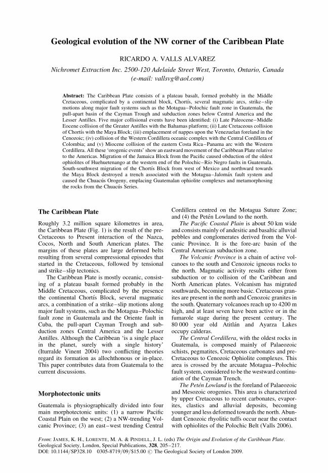
Armas Formation (age?)
The Armas Formation, composed of red bed anddeltaic claystone, siltstone and sandstones, occursin Motagua River valley in Izabal. The formationis a thick series of young or fresh-appearingstrata lying on metamorphic basement and
Cretaceous limestones. The unit is divided intotwo subunits that consist sedimentary rocks deri-ved from the volcanic, metamorphic and sedi-mentary rocks. Total estimated thickness is2500–3000 m.
Figure 3 shows a stratigraphic column based onwork by Millan (1985) and the author.
Fig. 3. Stratigraphic column for the studied area.
R. A. VALLS ALVAREZ210
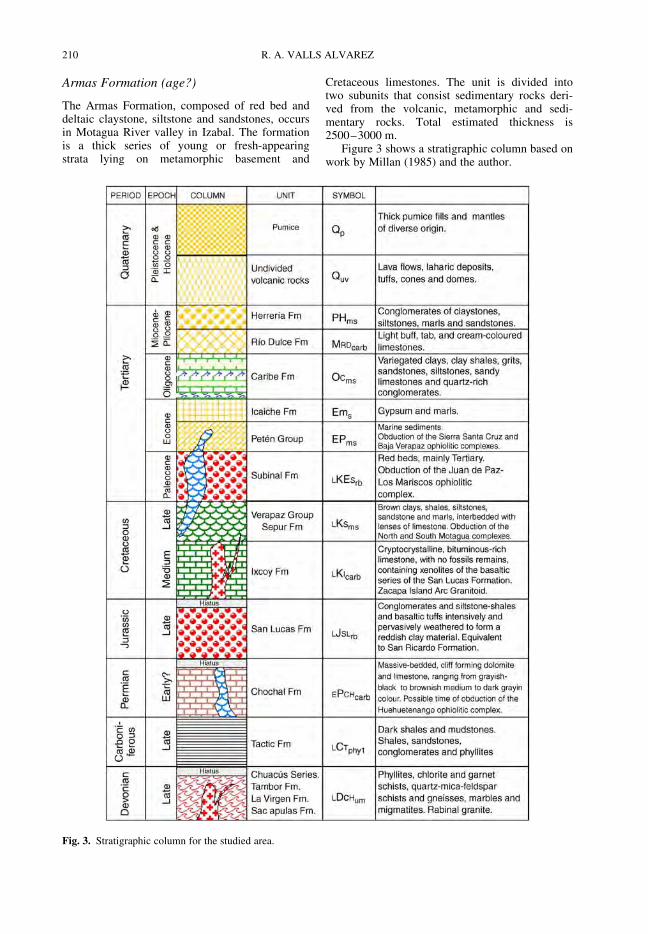
The geological evolution of Central
Guatemala
The stratigraphy of Central Guatemala describedabove suggests the geological evolution shownin Figure 4. The oldest rocks are Palaeozoicschists and other metamorphic rocks of the pre-Permian Chuacus Series, accompanied by graniticand dioritic batholiths (Fig. 4a). Around 300 Ma,during the Carboniferous, shallow marine sedimentsand conglomerates were followed by deeper sand-stones and shales at greater depths (Santa RosaGroup) (Fig. 4b). During the Early Permian(Fig. 4c), limestones and other carbonate rocksaccumulated (Chochal Formation).
A hiatus of nearly 51 million years marksthe Triassic Period, when the sea retreated and
no significant deposition occurred. In this paper, Iam suggesting that the pre-Cretaceous passing byof the Jamaica Block from somewhere in thePacific Ocean on its way to its present locationsouth of Cuba was the responsible for the obductionof the oldest ophiolites of Huehuetenango in thewestern end of the Polochic–Rıo Negro faults inGuatemala.
Late Jurassic red beds of the Todos Santos Fmpossibly record tropical oxidizing conditions. Vol-canic rocks from the San Lucas Fm formed at thistime. The Late Cretaceous to Early Cenozoicperiods (Fig. 4d) were recorded by carbonate sedi-ments (Coban Fm, Ixcoy Fm, Peten Fm, CampurFm and others) and the intrusion of granitic anddioritic bodies of the Zacapa Island Arc. Theywere followed by marine clastic sediments of the
Fig. 4. Model of the geological evolution of Central Guatemala.
GEOLOGICAL EVOLUTION OF NW CARIBBEAN PLATE 211

Verapaz Group and obduction of the North andSouth Motagua ophiolite complexes and the Juande Paz–Los Mariscos ophiolite complex. Thesewere later covered by the red beds of the SubinalFm, which suggest another period of regression.
The Paleocene witnessed deposition of moremarine sediments, mainly shallow marine conglom-erates, with deeper sandstones and shales. Obduc-tion of the Sierra de Santa Cruz and the BajaVerapaz ophiolite complexes occurred at this time(Fig. 4e).
Marls and gypsum of the Icaiche Fm formedduring the Eocene, while the end of the CenozoicPeriod was marked by the deposition of tuffs,lavas and other volcanic rocks accompanied by theintrusion of smaller granitoid bodies.
Finally, Quaternary formations are representedby alluvial and deluvial material as well as bylavas and tuffs from active volcanoes (GuastatoyaFm, Toledo Fm, Desempeno Fm, Rıo Dulce Fm,and others). Some of the ultramafic intrusives thathad undergone serpentinization before were oxi-dized, resulting in the formation of Ni lateriticzones (Fig. 4f).
Current models for the Caribbean Plate
There are basically two groups of ideas with respectto the formation of the Caribbean Plate. One groupdefends the idea of the in situ formation of the Car-ibbean Plate (Fig. 5) in contrast to complex Pacific
Fig. 5. (a) Triassic–Early Jurassic rifting of Pangaea; (b) Late Jurassic–Early Cretaceous opening of the area betweenNorth and South America during drift. Analogy with the Scotia Plate suggests that the Beata Ridge was a spreadingcentre and that continental fragments lie on the plate margins and interior. From James (2005).
R. A. VALLS ALVAREZ212

models that require major block rotations, platemigrations, hotspots or plumes (James 2005).
The other group (Pindell 1993; Pindell et al. 2000)defends the idea that at least parts of the CaribbeanPlate have migrated several thousands of kilometresinto its inter-American location from the Pacific(Fig. 6). Let us see now some of the geological fea-tures that our current knowledge of the stratigraphyof Guatemala indicates that existed in the area.
The model
Interoceanic channel
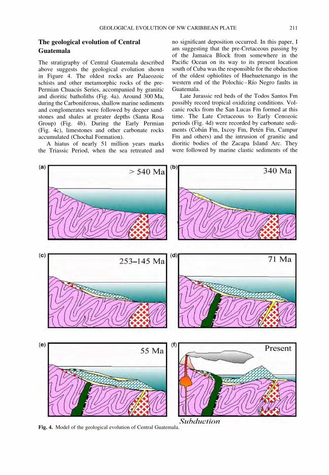
The stratigraphy of Central Guatemala calls forthe existence of an interoceanic channel since theEarly Proterozoic. This is suggested by the presenceof sedimentary units along the central part ofGuatemala, now constituting the metamorphic
Fig. 6. (a) Migration of the Caribbean Plate from the Pacific (red arrows), preceded by a leading edge volcanic arc (coloursindicate progress); (b) genesis of the Caribbean Plate oceanic crust in place along with the Gulf of Mexico, Yucatan Basinand Cayman Trough during extension as North America drifted NW from South America. From James (2005).
GEOLOGICAL EVOLUTION OF NW CARIBBEAN PLATE 213
Chuacus Series (Fig. 7). It is generally accepted thatboth Jamaica and Chortıs were located at this timesomewhere west of Mexico.
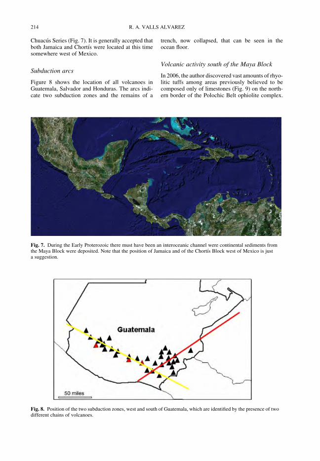
Subduction arcs
Figure 8 shows the location of all volcanoes inGuatemala, Salvador and Honduras. The arcs indi-cate two subduction zones and the remains of a
trench, now collapsed, that can be seen in theocean floor.
Volcanic activity south of the Maya Block
In 2006, the author discovered vast amounts of rhyo-litic tuffs among areas previously believed to becomposed only of limestones (Fig. 9) on the north-ern border of the Polochic Belt ophiolite complex.
Fig. 7. During the Early Proterozoic there must have been an interoceanic channel were continental sediments fromthe Maya Block were deposited. Note that the position of Jamaica and of the Chortıs Block west of Mexico is justa suggestion.
Fig. 8. Position of the two subduction zones, west and south of Guatemala, which are identified by the presence of twodifferent chains of volcanoes.
R. A. VALLS ALVAREZ214
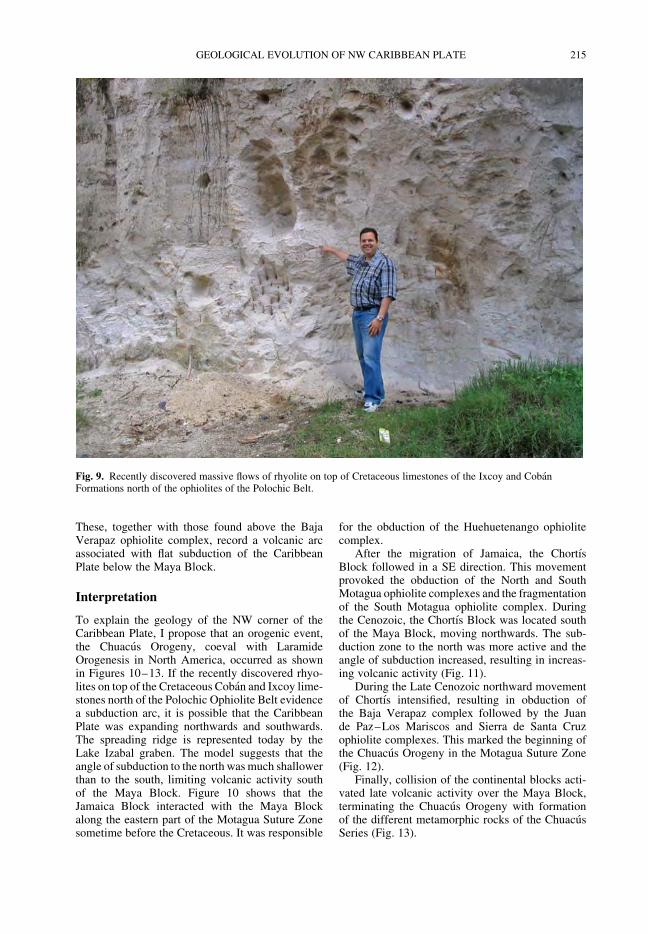
These, together with those found above the BajaVerapaz ophiolite complex, record a volcanic arcassociated with flat subduction of the CaribbeanPlate below the Maya Block.
Interpretation
To explain the geology of the NW corner of theCaribbean Plate, I propose that an orogenic event,the Chuacus Orogeny, coeval with LaramideOrogenesis in North America, occurred as shownin Figures 10–13. If the recently discovered rhyo-lites on top of the Cretaceous Coban and Ixcoy lime-stones north of the Polochic Ophiolite Belt evidencea subduction arc, it is possible that the CaribbeanPlate was expanding northwards and southwards.The spreading ridge is represented today by theLake Izabal graben. The model suggests that theangle of subduction to the north was much shallowerthan to the south, limiting volcanic activity southof the Maya Block. Figure 10 shows that theJamaica Block interacted with the Maya Blockalong the eastern part of the Motagua Suture Zonesometime before the Cretaceous. It was responsible
for the obduction of the Huehuetenango ophiolitecomplex.
After the migration of Jamaica, the ChortısBlock followed in a SE direction. This movementprovoked the obduction of the North and SouthMotagua ophiolite complexes and the fragmentationof the South Motagua ophiolite complex. Duringthe Cenozoic, the Chortıs Block was located southof the Maya Block, moving northwards. The sub-duction zone to the north was more active and theangle of subduction increased, resulting in increas-ing volcanic activity (Fig. 11).
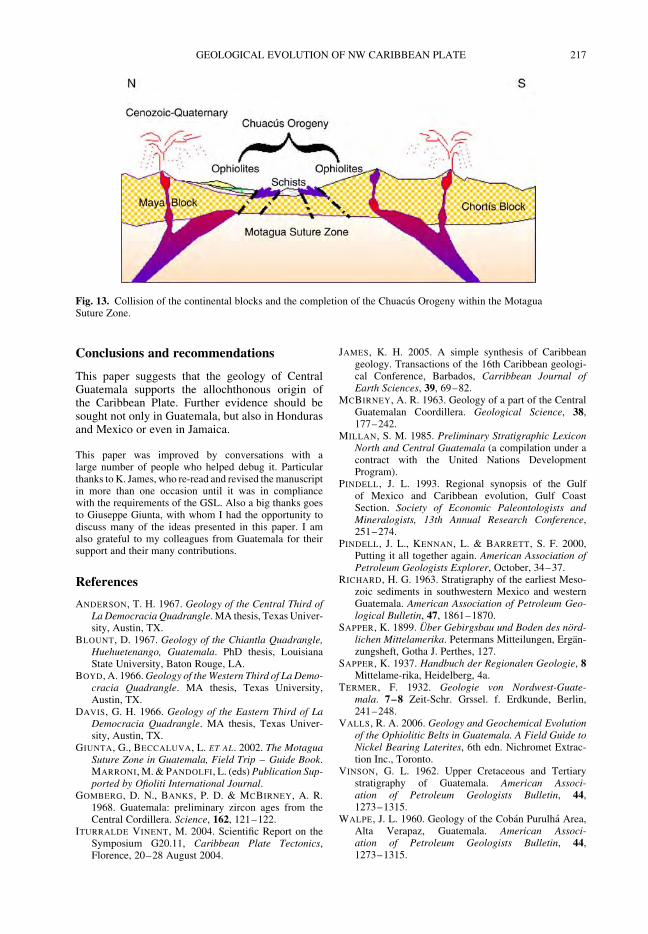
During the Late Cenozoic northward movementof Chortıs intensified, resulting in obduction ofthe Baja Verapaz complex followed by the Juande Paz–Los Mariscos and Sierra de Santa Cruzophiolite complexes. This marked the beginning ofthe Chuacus Orogeny in the Motagua Suture Zone(Fig. 12).
Finally, collision of the continental blocks acti-vated late volcanic activity over the Maya Block,terminating the Chuacus Orogeny with formationof the different metamorphic rocks of the ChuacusSeries (Fig. 13).
Fig. 9. Recently discovered massive flows of rhyolite on top of Cretaceous limestones of the Ixcoy and CobanFormations north of the ophiolites of the Polochic Belt.
GEOLOGICAL EVOLUTION OF NW CARIBBEAN PLATE 215
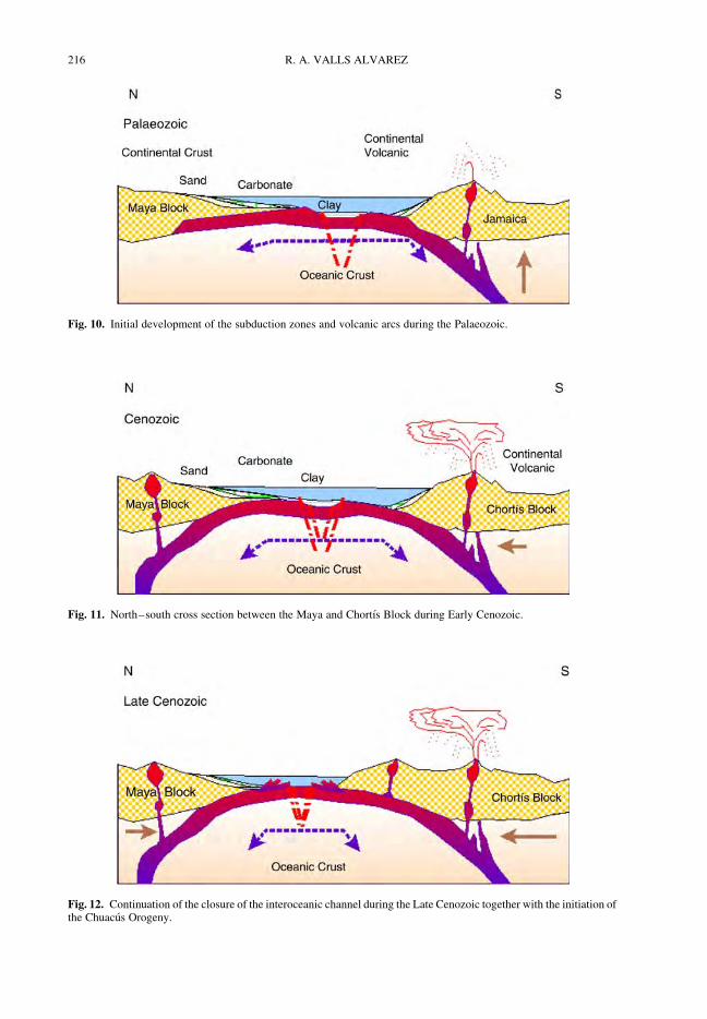
Fig. 11. North–south cross section between the Maya and Chortıs Block during Early Cenozoic.
Fig. 12. Continuation of the closure of the interoceanic channel during the Late Cenozoic together with the initiation ofthe Chuacus Orogeny.
Fig. 10. Initial development of the subduction zones and volcanic arcs during the Palaeozoic.
R. A. VALLS ALVAREZ216
Conclusions and recommendations
This paper suggests that the geology of CentralGuatemala supports the allochthonous origin ofthe Caribbean Plate. Further evidence should besought not only in Guatemala, but also in Hondurasand Mexico or even in Jamaica.
This paper was improved by conversations with alarge number of people who helped debug it. Particularthanks to K. James, who re-read and revised the manuscriptin more than one occasion until it was in compliancewith the requirements of the GSL. Also a big thanks goesto Giuseppe Giunta, with whom I had the opportunity todiscuss many of the ideas presented in this paper. I amalso grateful to my colleagues from Guatemala for theirsupport and their many contributions.
References
ANDERSON, T. H. 1967. Geology of the Central Third ofLa Democracia Quadrangle. MA thesis, Texas Univer-sity, Austin, TX.
BLOUNT, D. 1967. Geology of the Chiantla Quadrangle,Huehuetenango, Guatemala. PhD thesis, LouisianaState University, Baton Rouge, LA.
BOYD, A. 1966. Geology of the Western Third of La Demo-cracia Quadrangle. MA thesis, Texas University,Austin, TX.
DAVIS, G. H. 1966. Geology of the Eastern Third of LaDemocracia Quadrangle. MA thesis, Texas Univer-sity, Austin, TX.
GIUNTA, G., BECCALUVA, L. ET AL. 2002. The MotaguaSuture Zone in Guatemala, Field Trip – Guide Book.MARRONI, M. & PANDOLFI, L. (eds) Publication Sup-ported by Ofioliti International Journal.
GOMBERG, D. N., BANKS, P. D. & MCBIRNEY, A. R.1968. Guatemala: preliminary zircon ages from theCentral Cordillera. Science, 162, 121–122.
ITURRALDE VINENT, M. 2004. Scientific Report on theSymposium G20.11, Caribbean Plate Tectonics,Florence, 20–28 August 2004.
JAMES, K. H. 2005. A simple synthesis of Caribbeangeology. Transactions of the 16th Caribbean geologi-cal Conference, Barbados, Carribbean Journal ofEarth Sciences, 39, 69–82.
MCBIRNEY, A. R. 1963. Geology of a part of the CentralGuatemalan Coordillera. Geological Science, 38,177–242.
MILLAN, S. M. 1985. Preliminary Stratigraphic LexiconNorth and Central Guatemala (a compilation under acontract with the United Nations DevelopmentProgram).
PINDELL, J. L. 1993. Regional synopsis of the Gulfof Mexico and Caribbean evolution, Gulf CoastSection. Society of Economic Paleontologists andMineralogists, 13th Annual Research Conference,251–274.
PINDELL, J. L., KENNAN, L. & BARRETT, S. F. 2000,Putting it all together again. American Association ofPetroleum Geologists Explorer, October, 34–37.
RICHARD, H. G. 1963. Stratigraphy of the earliest Meso-zoic sediments in southwestern Mexico and westernGuatemala. American Association of Petroleum Geo-logical Bulletin, 47, 1861–1870.
SAPPER, K. 1899. Uber Gebirgsbau und Boden des nord-lichen Mittelamerika. Petermans Mitteilungen, Ergan-zungsheft, Gotha J. Perthes, 127.
SAPPER, K. 1937. Handbuch der Regionalen Geologie, 8Mittelame-rika, Heidelberg, 4a.
TERMER, F. 1932. Geologie von Nordwest-Guate-mala. 7–8 Zeit-Schr. Grssel. f. Erdkunde, Berlin,241–248.
VALLS, R. A. 2006. Geology and Geochemical Evolutionof the Ophiolitic Belts in Guatemala. A Field Guide toNickel Bearing Laterites, 6th edn. Nichromet Extrac-tion Inc., Toronto.
VINSON, G. L. 1962. Upper Cretaceous and Tertiarystratigraphy of Guatemala. American Associ-ation of Petroleum Geologists Bulletin, 44,1273–1315.
WALPE, J. L. 1960. Geology of the Coban Purulha Area,Alta Verapaz, Guatemala. American Associ-ation of Petroleum Geologists Bulletin, 44,1273–1315.
Fig. 13. Collision of the continental blocks and the completion of the Chuacus Orogeny within the MotaguaSuture Zone.
GEOLOGICAL EVOLUTION OF NW CARIBBEAN PLATE 217

![Badush Dam, NW Iraq: A Geological Study 8_2_1.pdf · Badush Dam, NW Iraq: A Geological Study 5 Figure 2: Geological map of Badush Dam site and near surroundings (After [16]) 5 Badush](https://static.fdocuments.us/doc/165x107/5e9b63ded6a9ee1aa9518dbb/badush-dam-nw-iraq-a-geological-821pdf-badush-dam-nw-iraq-a-geological.jpg)


