Beauty and the Beast: Plate Tectonics and Geological Hazards...
154
Cascadia EarthScope Earthquake and Tsunami Education Program (CEETEP) Beauty and the Beast : Plate Tectonics and Geological Hazards of the Pacific Northwest Otter Crest State Scenic Viewpoint, Oregon Robert J. Lillie
Transcript of Beauty and the Beast: Plate Tectonics and Geological Hazards...
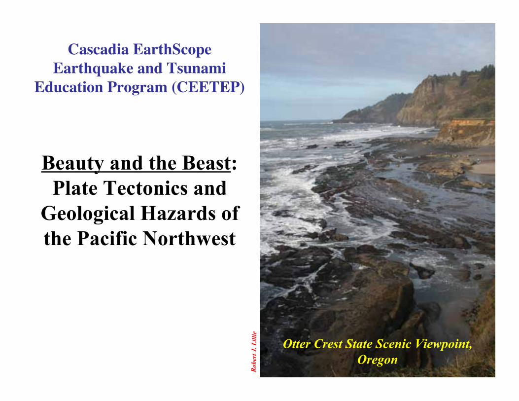
Cascadia EarthScopeEarthquake and Tsunami
Education Program (CEETEP)
Beauty and the Beast:Plate Tectonics and
Geological Hazards ofthe Pacific Northwest
Otter Crest State Scenic Viewpoint,Oregon
Robe
rt J.
Lill
ie
Robe
rt J.
Lill
ie
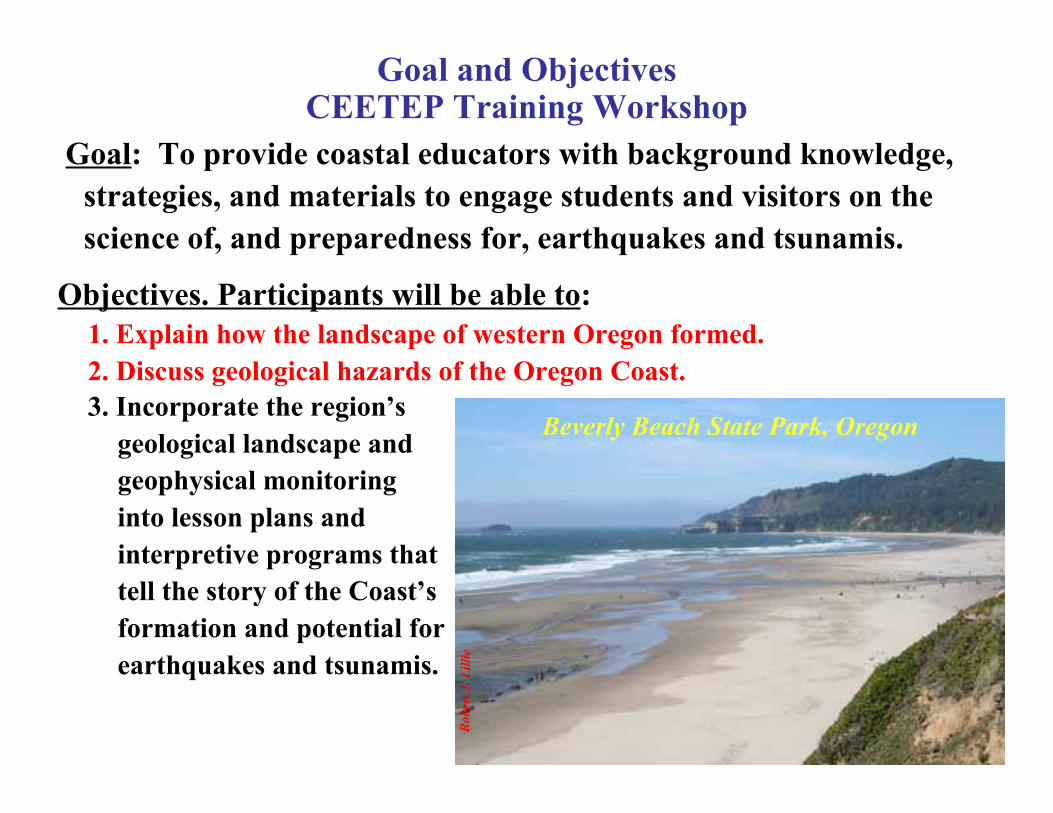
Beverly Beach State Park, Oregon
Goal and ObjectivesCEETEP Training Workshop
Objectives. Participants will be able to:1. Explain how the landscape of western Oregon formed.2. Discuss geological hazards of the Oregon Coast.
Goal: To provide coastal educators with background knowledge,strategies, and materials to engage students and visitors on thescience of, and preparedness for, earthquakes and tsunamis.
3. Incorporate the region’sgeological landscape andgeophysical monitoringinto lesson plans andinterpretive programs thattell the story of the Coast’sformation and potential forearthquakes and tsunamis.
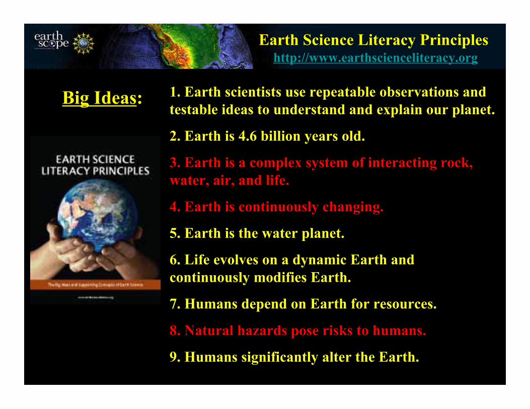
Earth Science Literacy Principles
1. Earth scientists use repeatable observations andtestable ideas to understand and explain our planet.
2. Earth is 4.6 billion years old.
3. Earth is a complex system of interacting rock,water, air, and life.
4. Earth is continuously changing.
5. Earth is the water planet.
6. Life evolves on a dynamic Earth andcontinuously modifies Earth.
7. Humans depend on Earth for resources.
8. Natural hazards pose risks to humans.
9. Humans significantly alter the Earth.
Big Ideas:
http://www.earthscienceliteracy.org
Robe
rt J.
Lill
ie
U. S
. Geo
logi
cal S
urve
y
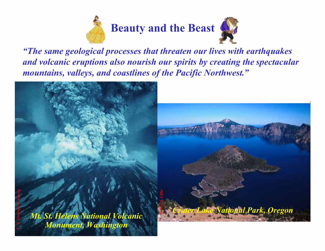
Mt. St. Helens National VolcanicMonument, Washington
Crater Lake National Park, Oregon
“The same geological processes that threaten our lives with earthquakesand volcanic eruptions also nourish our spirits by creating the spectacularmountains, valleys, and coastlines of the Pacific Northwest.”
Beauty and the Beast
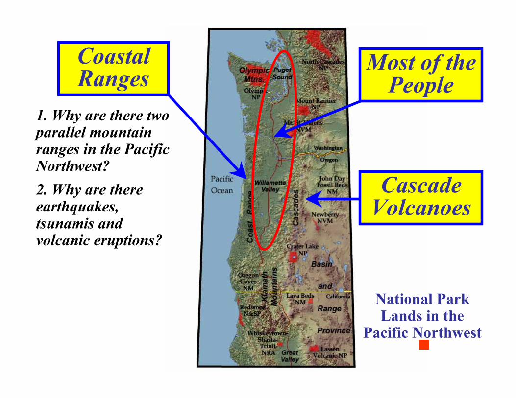
CascadeVolcanoes
1. Why are there twoparallel mountainranges in the PacificNorthwest?
National ParkLands in the
Pacific Northwest
CoastalRanges
Most of thePeople
2. Why are thereearthquakes,tsunamis andvolcanic eruptions?

E. L. Orr and W. N. Orr, “Geology of Oregon,”Kendall/Hunt Pub. Co., 5th Edition, 1992.
Geologic Provinces of Oregon
Making Connections:
Ecoregions of Oregon
Oregon’s ecology is closely tied to Oregon’s geology.
Parks and Plates©2005 Robert J. Lillie
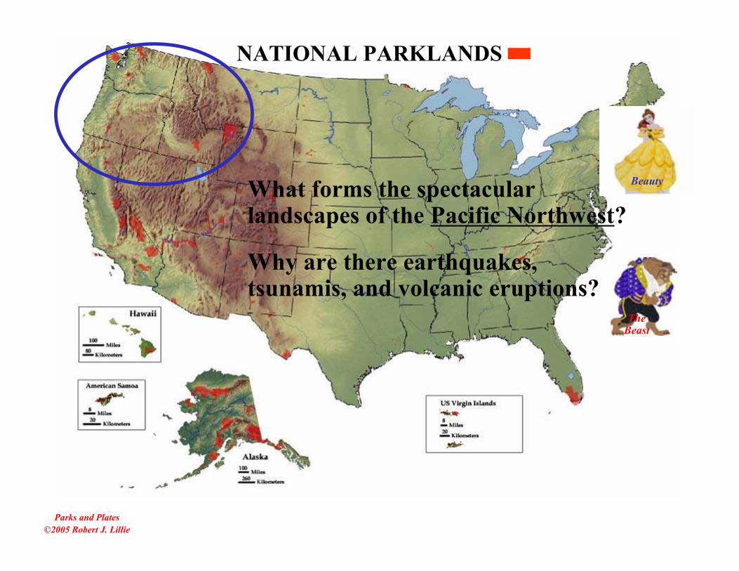
What forms the spectacularlandscapes of the Pacific Northwest?
NATIONAL PARKLANDS
Why are there earthquakes,tsunamis, and volcanic eruptions?
TheBeast
Beauty
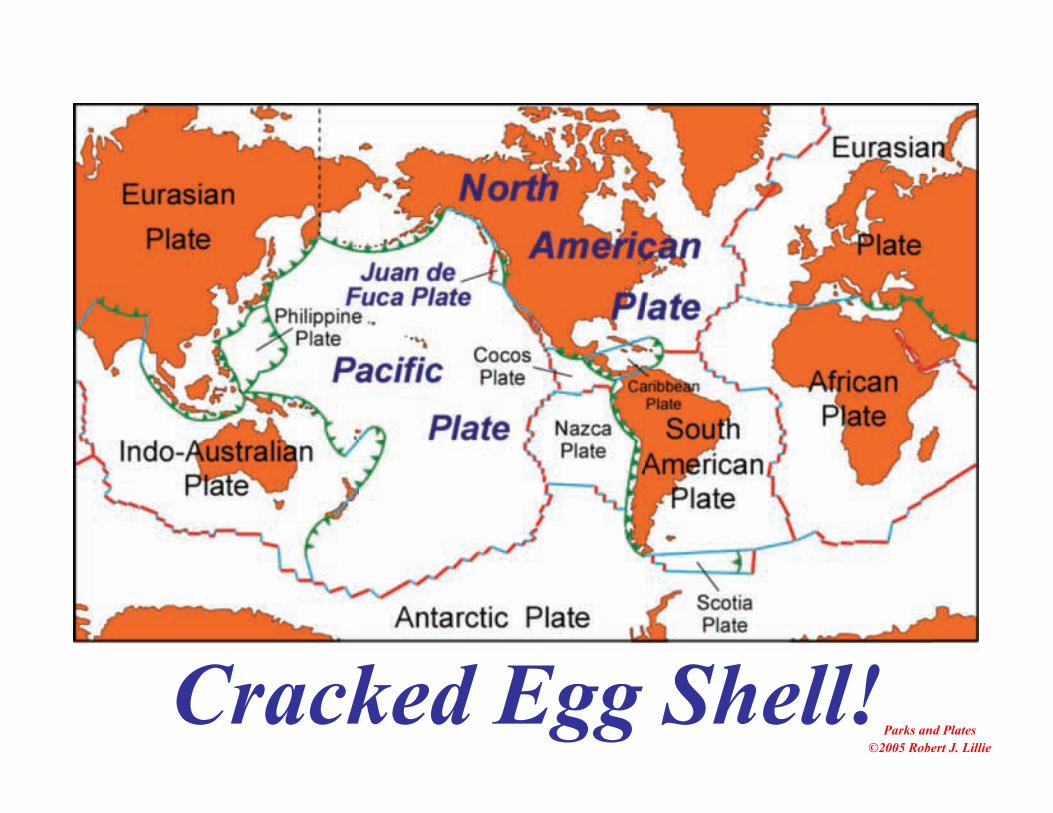
Cracked Egg Shell!Parks and Plates
©2005 Robert J. Lillie
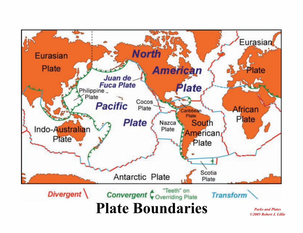
Parks and Plates©2005 Robert J. LilliePlate Boundaries

©19
77, M
arie
Tho
rpe
Beauty
Plate Tectonics: Mountain Ranges• Most mountain ranges occur along the boundaries of movingplates.
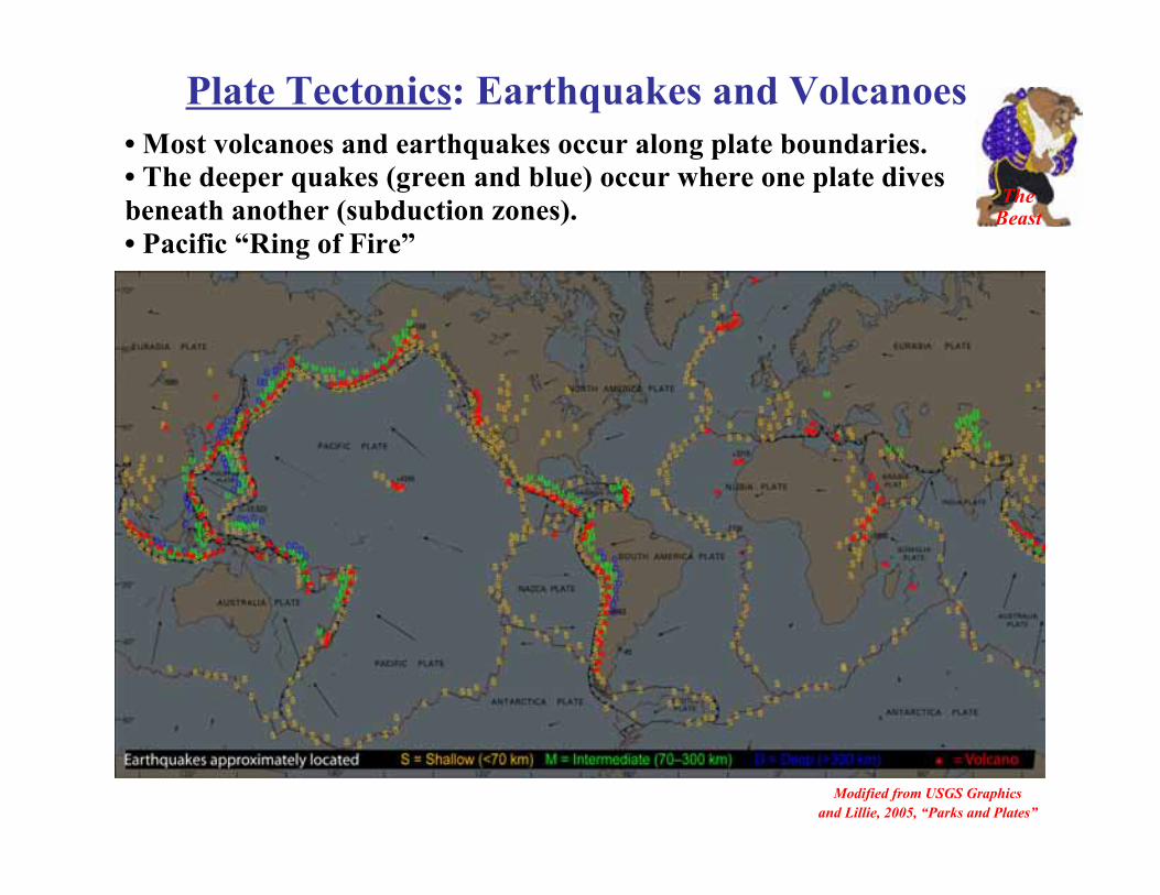
Plate Tectonics: Earthquakes and Volcanoes
Modified from USGS Graphicsand Lillie, 2005, “Parks and Plates”
• Most volcanoes and earthquakes occur along plate boundaries.• The deeper quakes (green and blue) occur where one plate divesbeneath another (subduction zones).• Pacific “Ring of Fire”
TheBeast

PLATE BOUNDARIES• Divergent:
– Plates move awayfrom one another.
– Volcanoes andShallow Earthquakes
• Convergent:– Plates move toward
one another.– Volcanoes and very
large earthquakes• Transform:
– Plates slide past oneanother.
– Earthquakes but novolcanoes
• (Hotspot):– Plate rides over
plume of hot mantle.– Lots of volcanism.
Parks and Plates ©2005 Robert J. Lillie

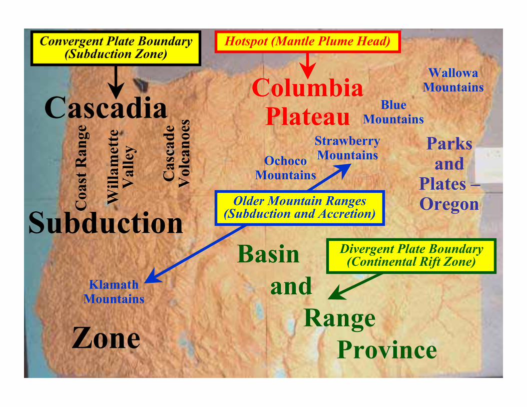
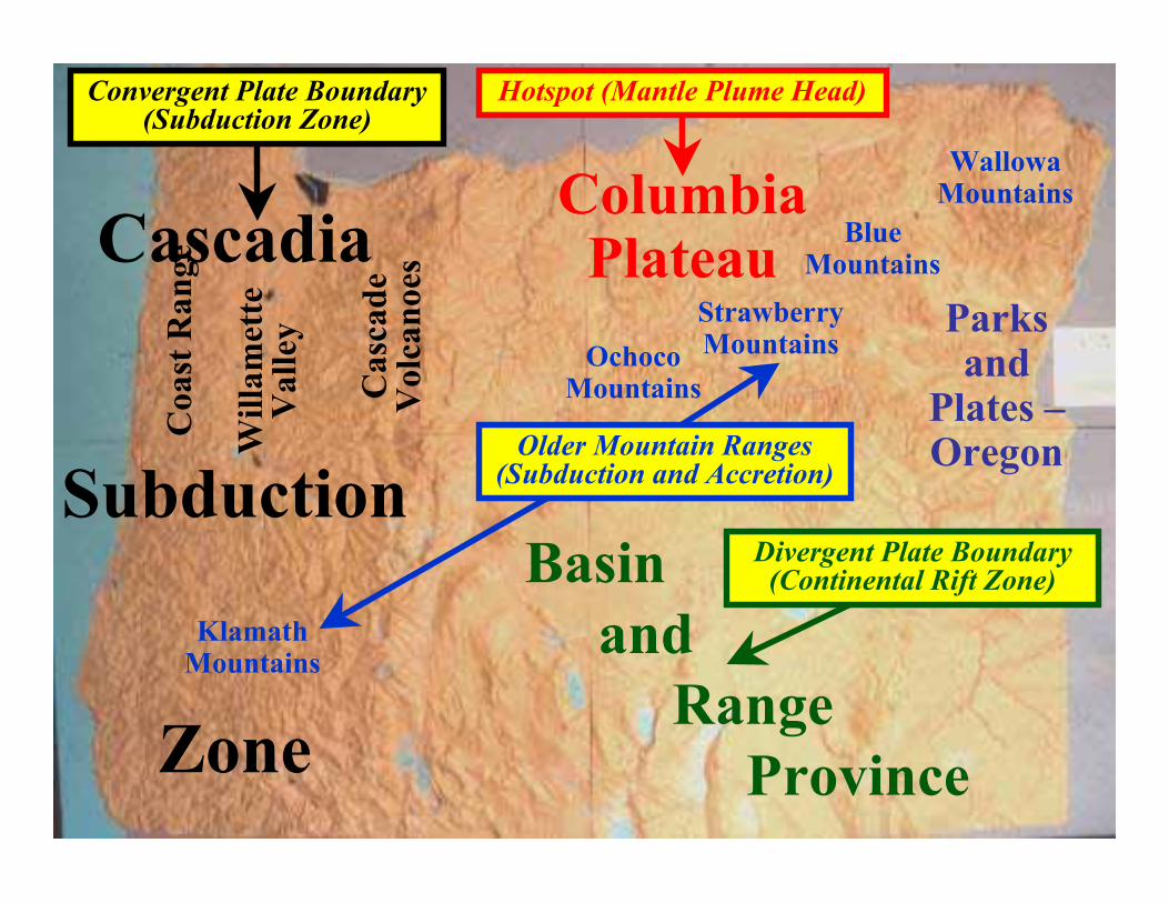
Cascadia
Subduction
Zone
Coa
st R
ange
Will
amet
teV
alle
y
Cas
cade
Vol
cano
es
Basin and Range Province
ColumbiaPlateau
Convergent Plate Boundary(Subduction Zone)
Divergent Plate Boundary(Continental Rift Zone)
Hotspot (Mantle Plume Head)
Nat
iona
l Aer
onau
tics a
nd S
pace
Adm
inist
ratio
n
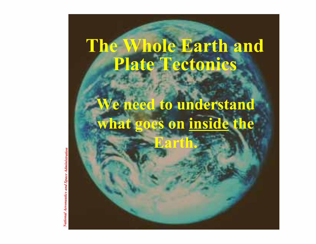
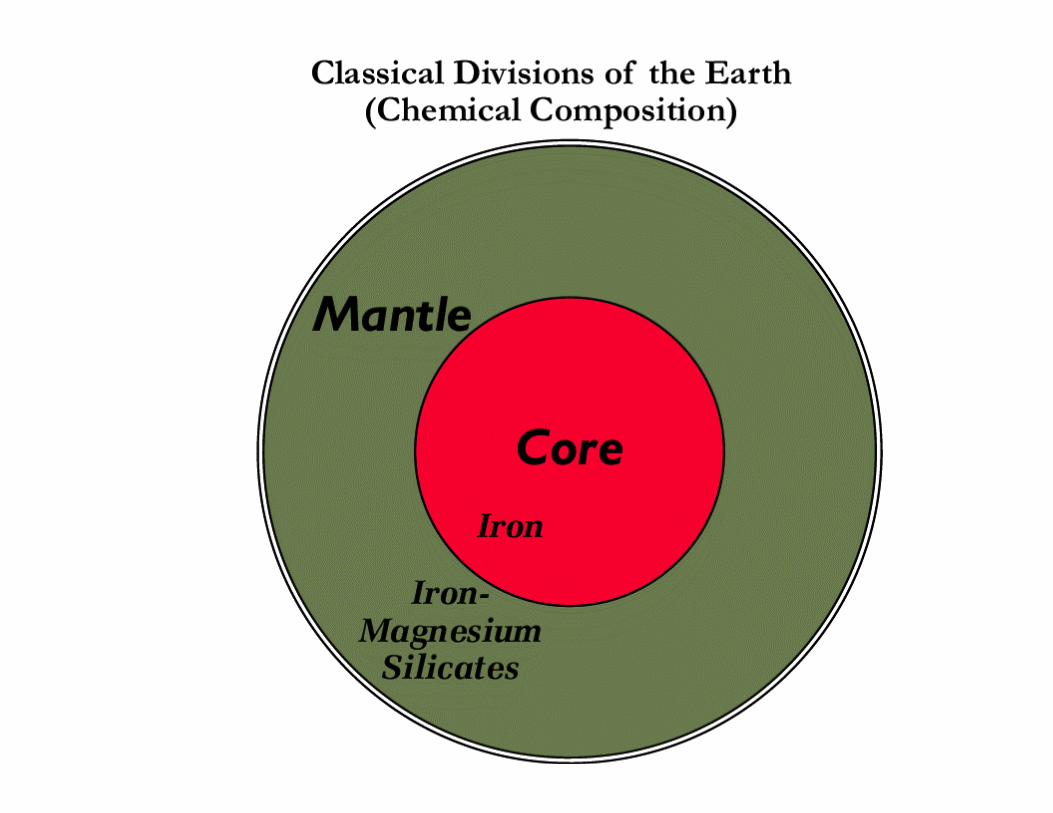
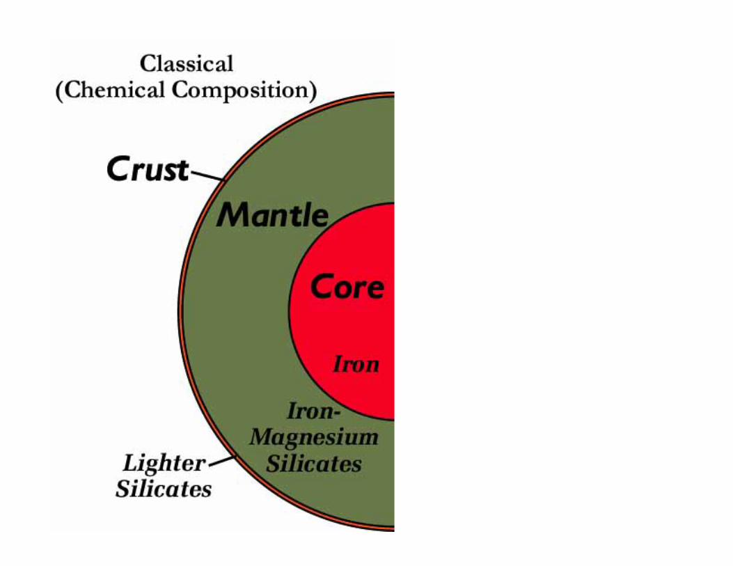
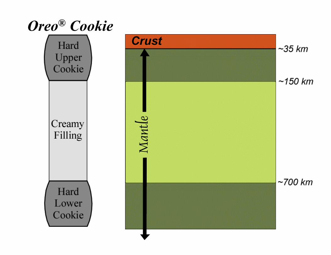
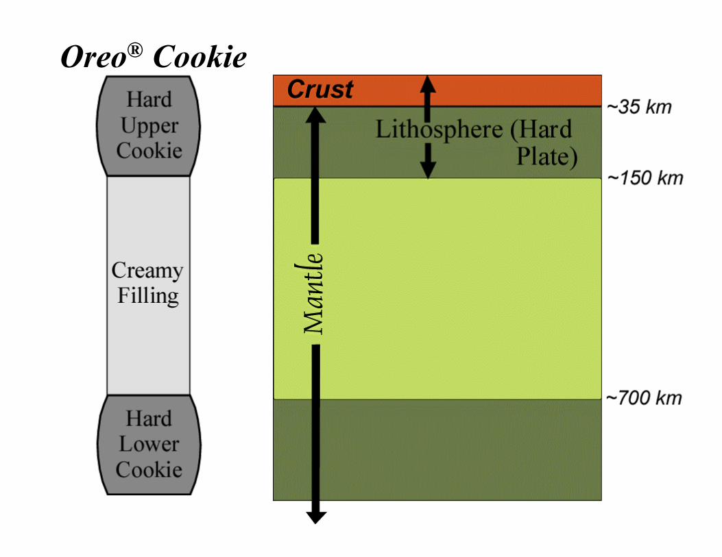
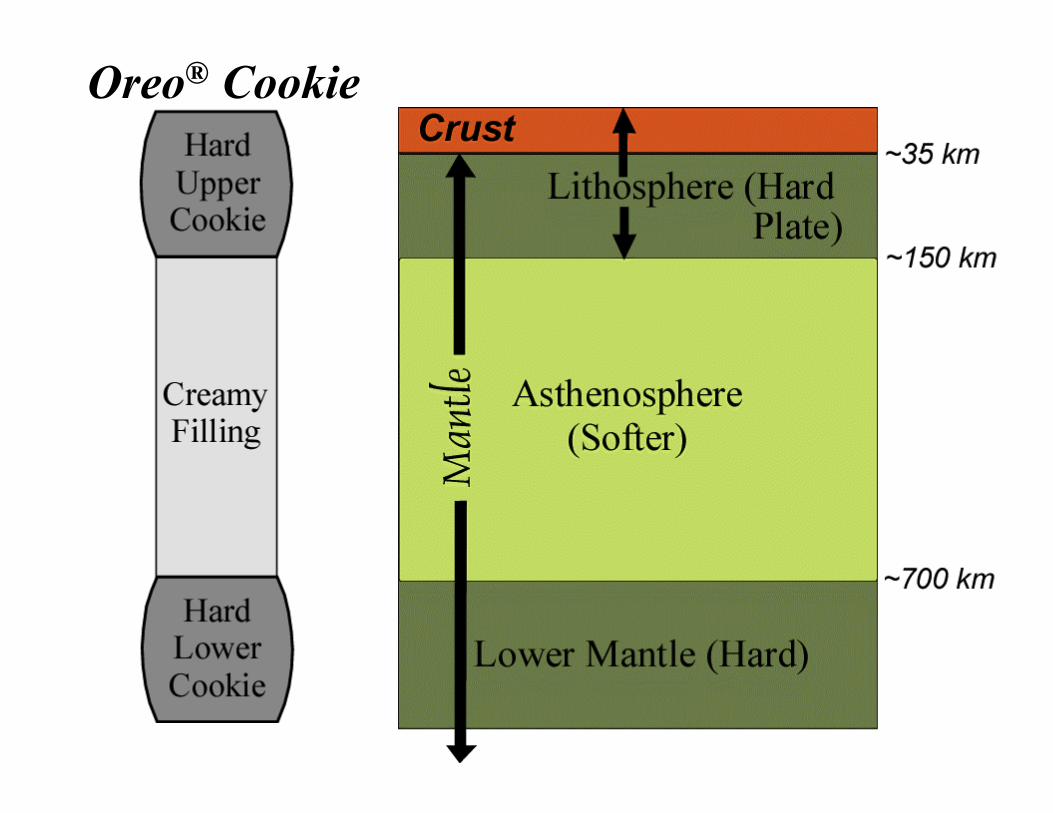
The Whole Earth andPlate Tectonics
We need to understandwhat goes on inside the
Earth.

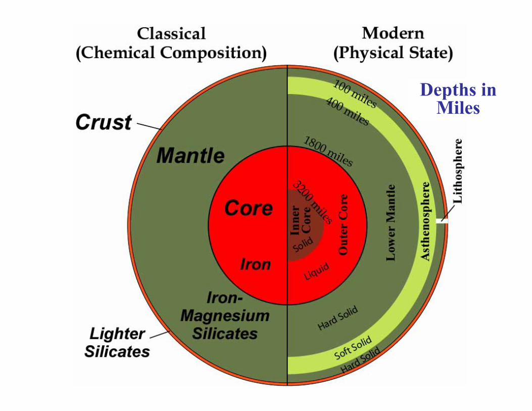
Depths inMiles
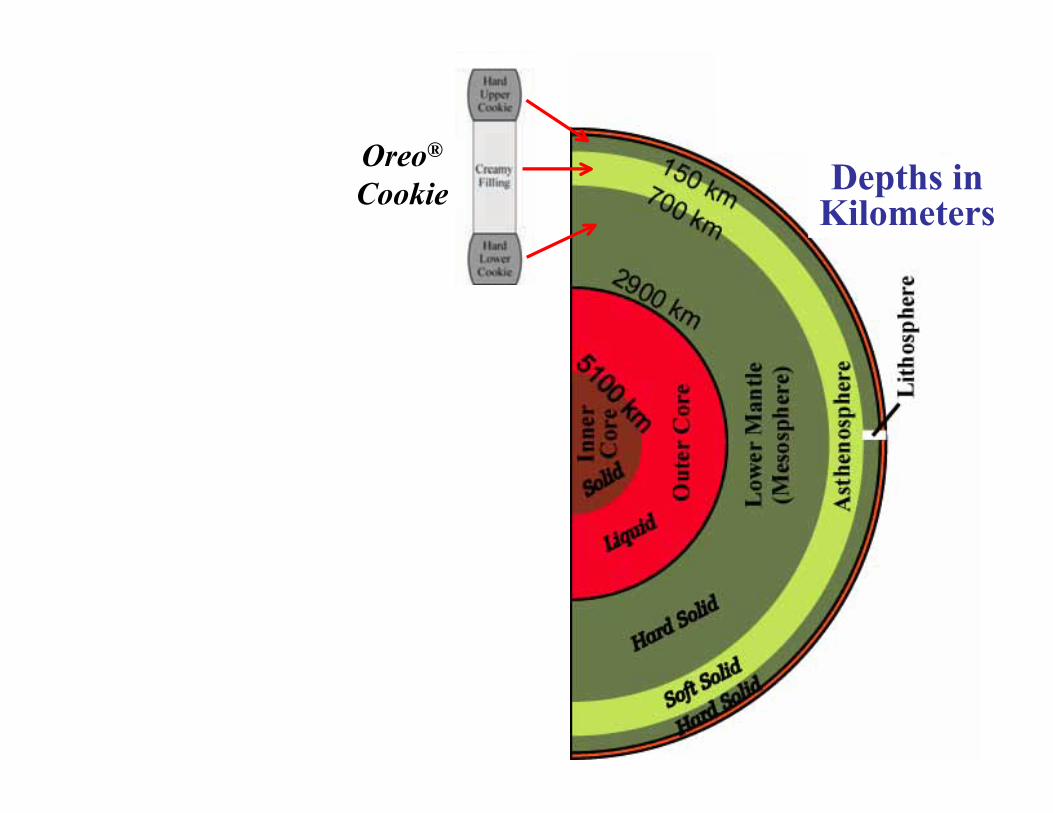
Oreo®
Cookie Depths inKilometers

Oreo® Cookie

Oreo® Cookie
Oreo® Cookie
Oreo® Cookie

Oreo® Cookie
Oreo® Cookie

Robe
rt J.
Lill
ie

Oreo® Psycho-Personality Test www.superkids.com/aweb/pages/humor/050199.sht
• Psychologists have discovered that the manner in which peopleeat Oreo® cookies provides great insight into their personalities.Choose which method best describes your favorite method ofeating Oreos:
• 1. The whole thing at once.2. One bite at a time.3. Slow and methodical nibbles examining the results of each bite
afterwards.4. In little feverous nibbles.5. Dunked in some liquid (milk, coffee …..)6. Twisted apart, the inside, then the cookie.7. Twisted apart, the inside, and toss the cookie.8. Just the cookie, not the inside.9. I just like to lick them, not eat them.10. I don’t have a favorite way because I don’t like Oreos.

Robe
rt J.
Lill
ie
6. Twisted apart, theinside, then the cookie.
• You have a highly curious nature.• You take pleasure in breaking things apart
to find out how they work, though you’renot always able to put them back together,so you destroy all the evidence of youractivities.
• You deny your involvement when things gowrong.
• You are a compulsive liar and exhibitdeviant, if not criminal, behavior.
Robe
rt J.
Lill
ie
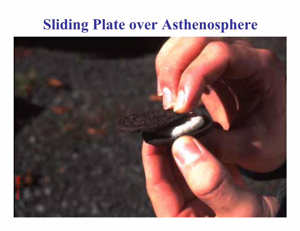
Sliding Plate over Asthenosphere

Transform Plate Boundary
Robe
rt J.
Lill
ie
PacificPlate
NorthAmerican
Plate
SanAndreasFault
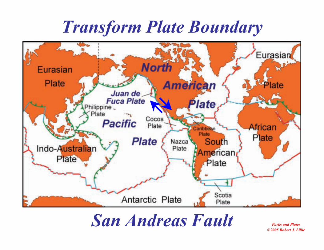
San Andreas Fault Parks and Plates©2005 Robert J. Lillie
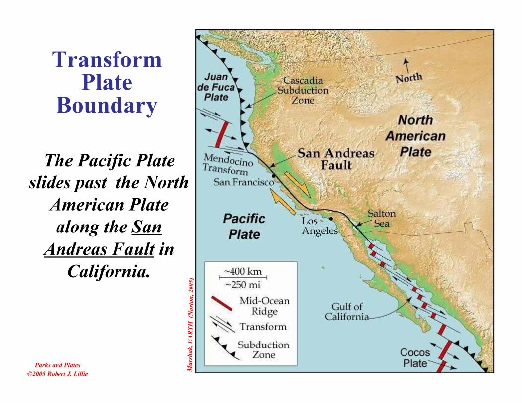
Transform Plate Boundary
Mar
shak
, EAR
TH (
Nor
ton,
200
5)
Parks and Plates©2005 Robert J. Lillie
The Pacific Plateslides past the North
American Platealong the San
Andreas Fault inCalifornia.
TransformPlate
Boundary
Parks and Plates©2005 Robert J. Lillie
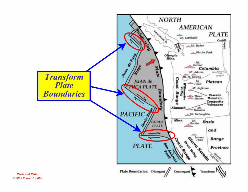
TransformPlate
Boundaries

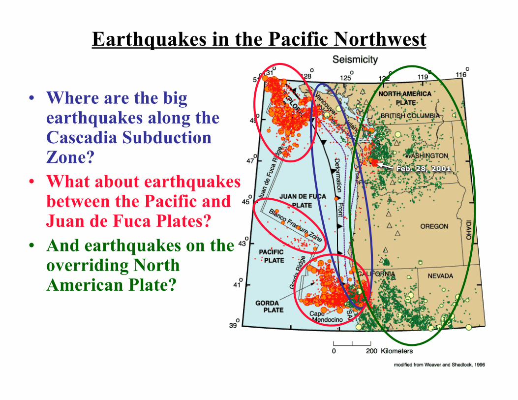
Earthquakes in the Pacific Northwest
• Where are the bigearthquakes along theCascadia SubductionZone?
• What about earthquakesbetween the Pacific andJuan de Fuca Plates?
• And earthquakes on theoverriding NorthAmerican Plate?
Robe
rt J.
Lill
ie
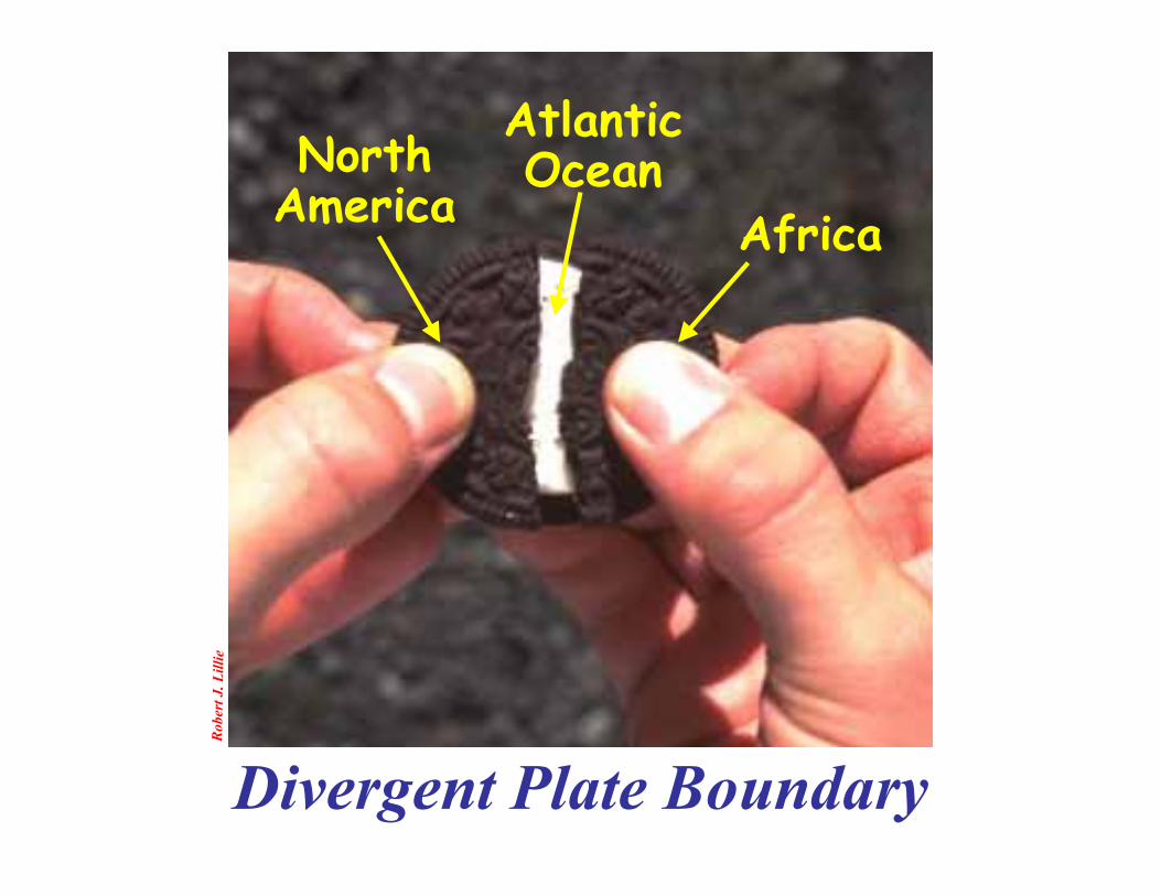
Divergent Plate Boundary
NorthAmerica Africa
AtlanticOcean

Nat
iona
l Geo
grap
hic M
id-A
tlant
ic Ri
dge
(Dive
rgen
t Pla
te Bo
unda
ry)
NorthAmerica
Africa
Iceland

Iceland
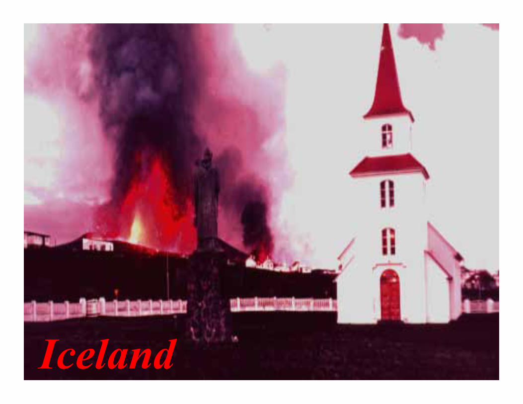
Iceland
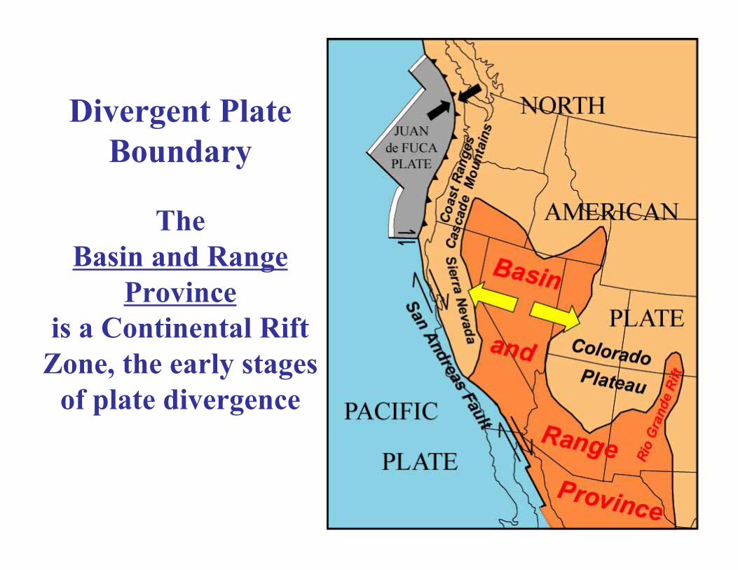
TheBasin and Range
Provinceis a Continental Rift
Zone, the early stagesof plate divergence
Divergent PlateBoundary
Robe
rt J.
Lill
ie
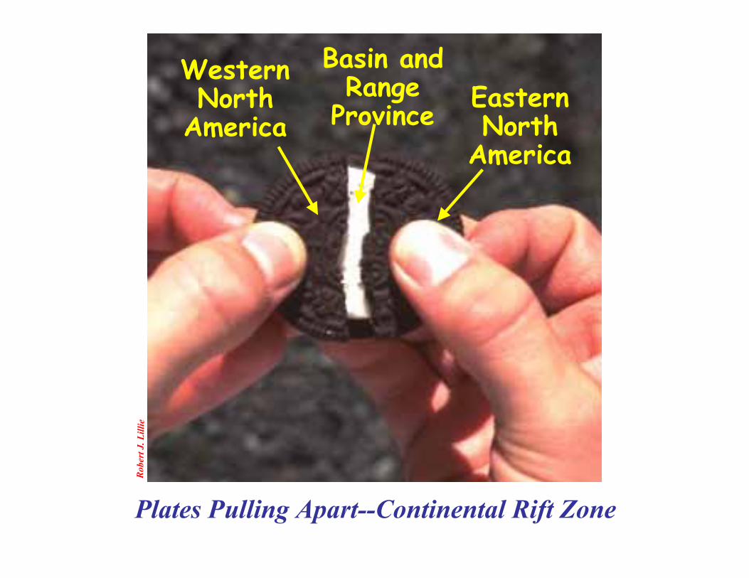
Plates Pulling Apart--Continental Rift Zone
WesternNorth
America
Basin andRange
Province EasternNorth
America
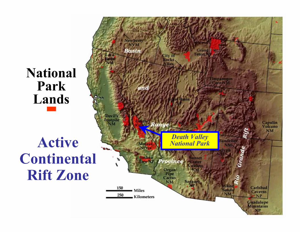
ActiveContinentalRift Zone
NationalPark
Lands
Death ValleyNational Park
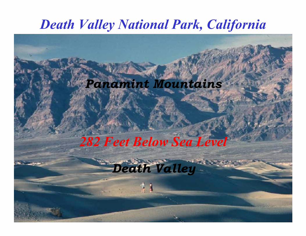
282 Feet Below Sea Level
Death Valley
Panamint Mountains
Death Valley National Park, California

Basin and Range Province
Steens Mountain(Range)
Alvord Dessert(Basin)
Abert Rim(Range)
Lake Abert(Basin)
Winter Ridge(Range)
Summer Lake(Basin)
(Range)
Klamath Lakes(Basin)

www.iris.edu (Animation by Jenda Johnson - Time 0:31)
Robe
rt J.
Lill
ie
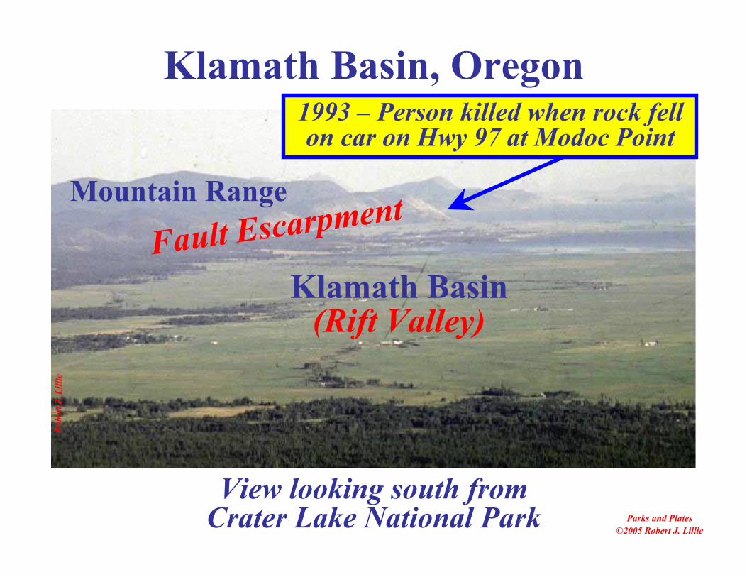
Klamath Basin, Oregon
Parks and Plates©2005 Robert J. Lillie
View looking south fromCrater Lake National Park
Fault Escarpment
(Rift Valley)Klamath Basin
1993 – Person killed when rock fellon car on Hwy 97 at Modoc Point
Mountain Range
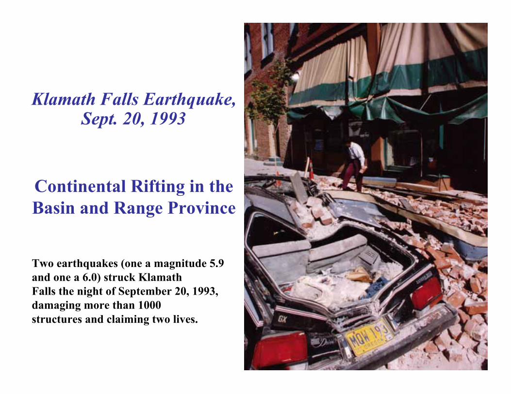
Klamath Falls Earthquake,Sept. 20, 1993
Continental Rifting in theBasin and Range Province
Two earthquakes (one a magnitude 5.9and one a 6.0) struck KlamathFalls the night of September 20, 1993,damaging more than 1000structures and claiming two lives.

www.iris.edu (Animation by Jenda Johnson - Time 0:18)
Parks and Plates©2005 Robert J. Lillie
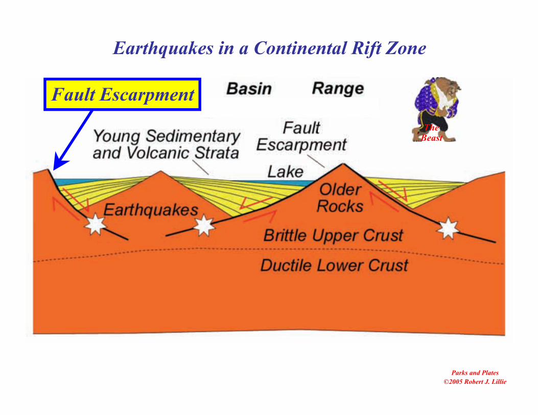
Earthquakes in a Continental Rift Zone
TheBeast
Fault Escarpment
Earthquakes in the Pacific Northwest
• Where are the bigearthquakes along theCascadia SubductionZone?
• What about earthquakesbetween the Pacific andJuan de Fuca Plates?
• And earthquakes on theoverriding NorthAmerican Plate?
Africa
SouthAmerica
Core
LowerMantle
AtlanticOcean
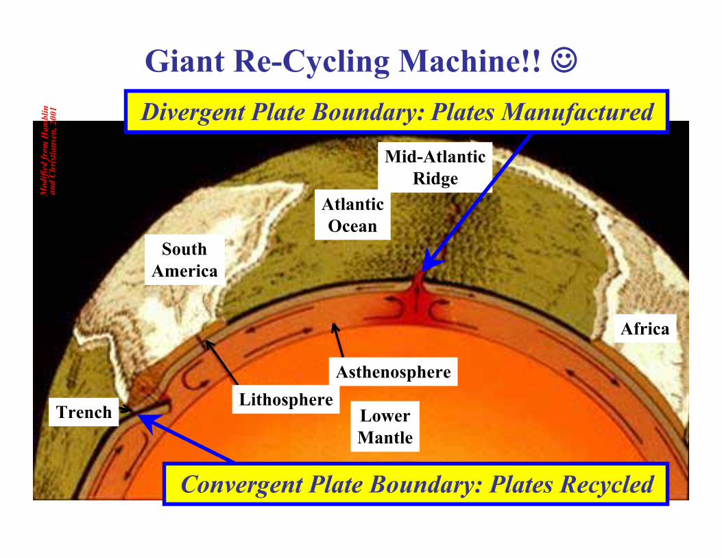
AsthenosphereLithosphere
Trench
Mid-AtlanticRidge
Mod
ified
from
Ham
blin
and
Chris
tians
en, 2
001 Divergent Plate Boundary: Plates Manufactured
Convergent Plate Boundary: Plates Recycled
Giant Re-Cycling Machine!!
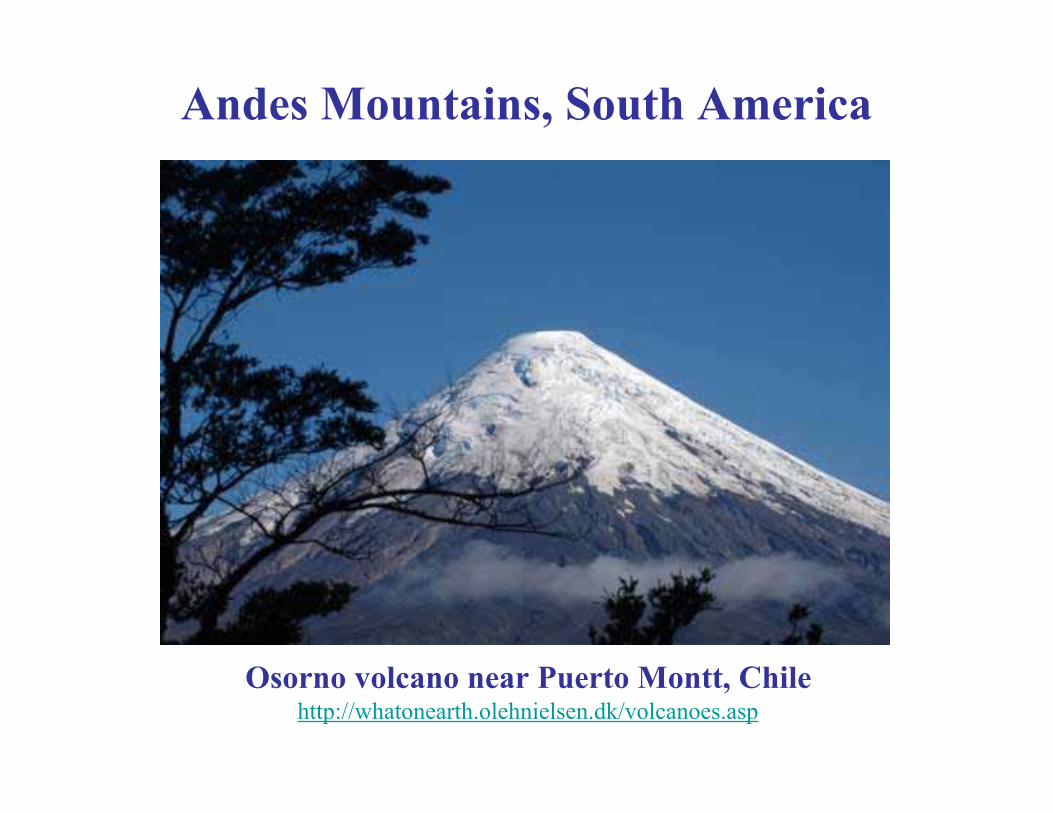
Osorno volcano near Puerto Montt, Chilehttp://whatonearth.olehnielsen.dk/volcanoes.asp
Andes Mountains, South America
Parks and Plates©2005 Robert J. Lillie
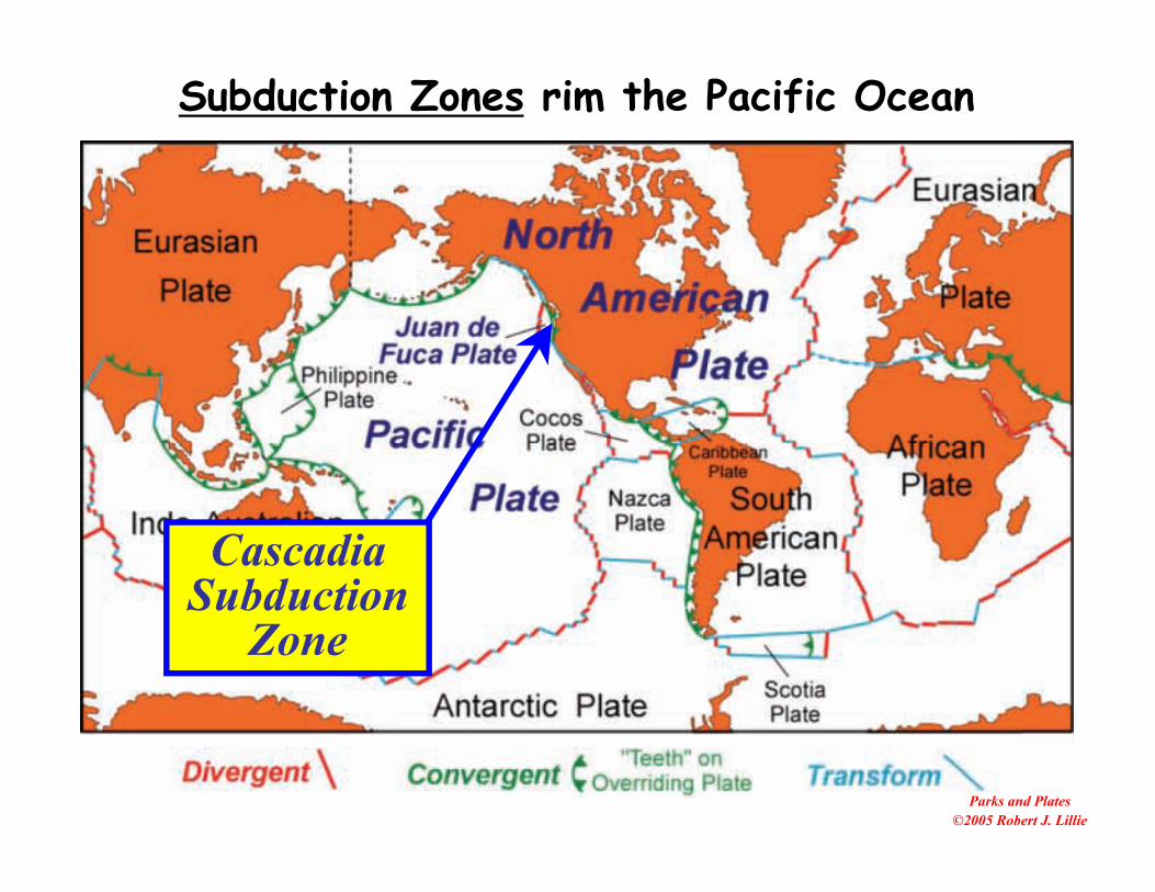
CascadiaSubduction
Zone
Subduction Zones rim the Pacific Ocean
Robe
rt J.
Lill
ie
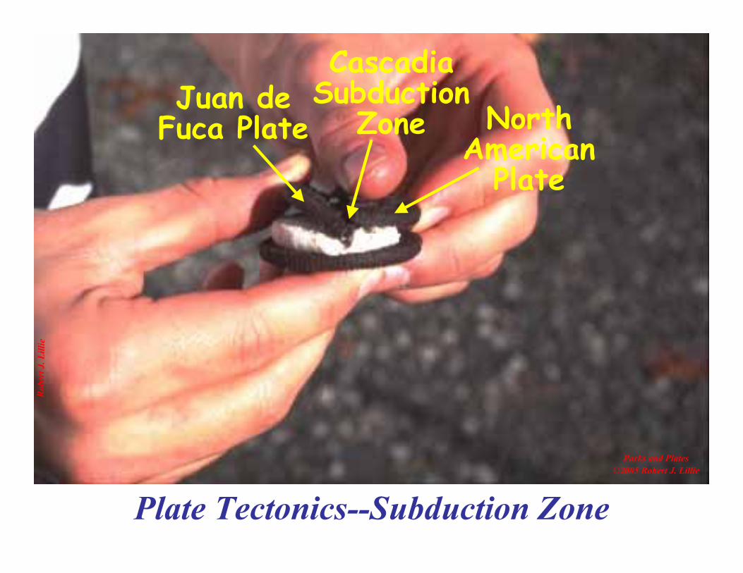
Plate Tectonics--Subduction Zone
Parks and Plates©2005 Robert J. Lillie
Juan deFuca Plate North
AmericanPlate
CascadiaSubduction
Zone

Oregon
Cascadia
Subduction
Zone
Coa
st R
ange
Will
amet
teV
alle
y
Cas
cade
Vol
cano
es

CascadeVolcanoes
1. Why are there twoparallel mountainranges in the PacificNorthwest?
National ParkLands in the
Pacific Northwest
CoastalRanges
2. Why are thereearthquakes,tsunamis andvolcanic eruptions?
Robe
rt J.
Lill
ie
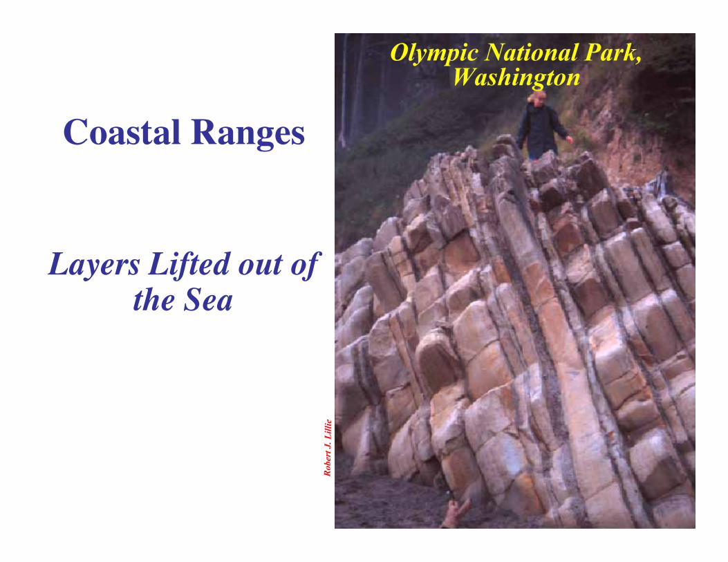
Olympic National Park,Washington
Coastal Ranges
Layers Lifted out ofthe Sea

Robe
rt J.
Lill
ie
Mt. Rainier National Park,Washington
Cascade Mountains
Steep, ExplosiveVolcanoes
Beauty
TheBeast
Parks and Plates©2005 Robert J. Lillie
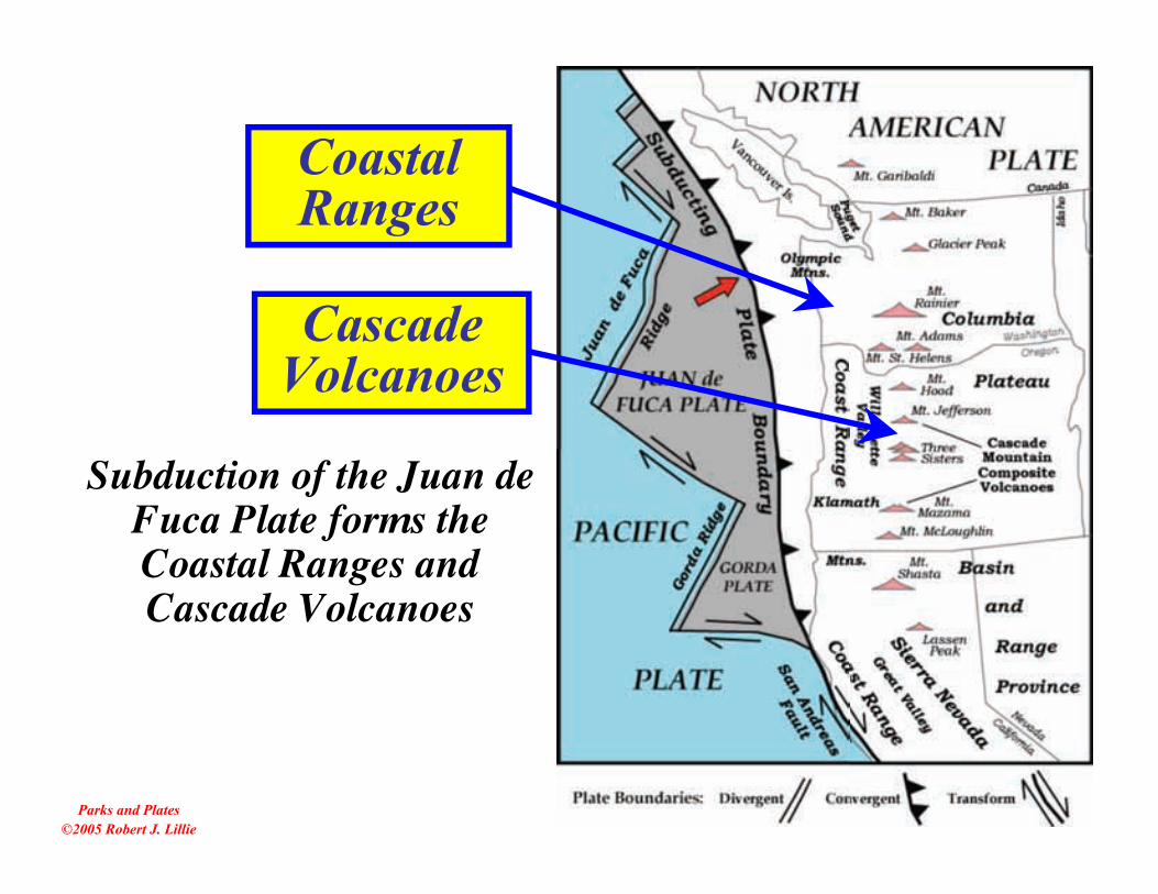
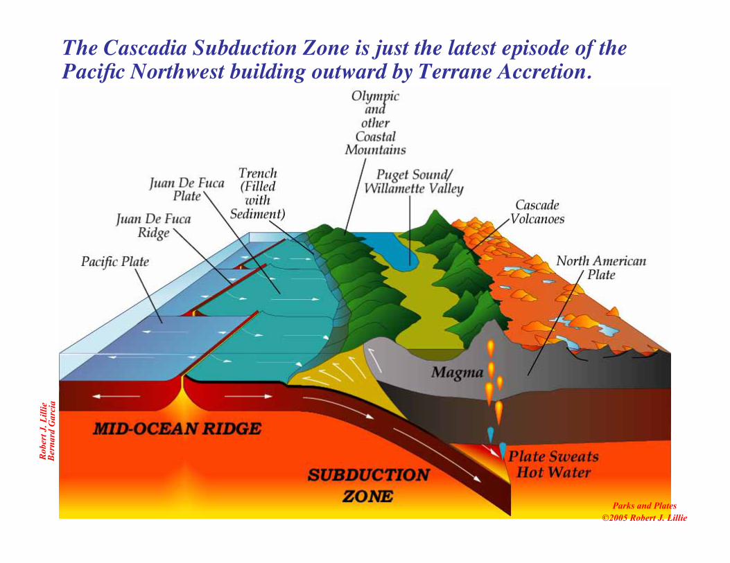
Subduction of the Juan deFuca Plate forms theCoastal Ranges andCascade Volcanoes
CoastalRanges
CascadeVolcanoes

Robe
rt J.
Lill
ieBe
rnar
d G
arci
a
Parks and Plates©2005 Robert J. Lillie
Subducting Juan de Fuca Plate forms two parallelmountain ranges in the Pacific Northwest.

Robe
rt J.
Lill
ieBe
rnar
d G
arci
a
Parks and Plates©2005 Robert J. Lillie
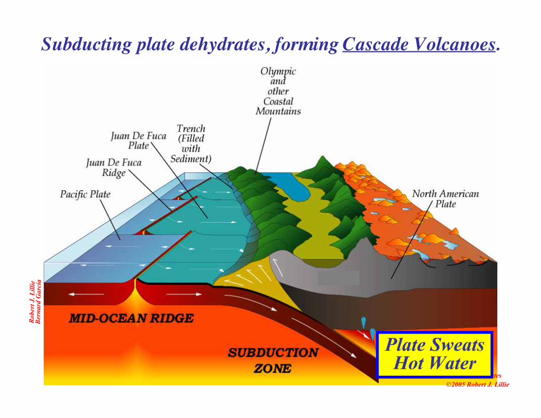
Oceanic sediment and basalt scraped off subducting plate,forming Coastal Mountains.
Sediment andBasalt Scraped offSubducting Plate
Olympic and otherCoastal Mountain
Ranges
Robe
rt J.
Lill
ieBe
rnar
d G
arci
a
Parks and Plates©2005 Robert J. Lillie
Subducting plate dehydrates, forming Cascade Volcanoes.
Plate SweatsHot Water

Robe
rt J.
Lill
ieBe
rnar
d G
arci
a
Parks and Plates©2005 Robert J. Lillie
Subducting plate dehydrates, forming Cascade Volcanoes.
VolcanicMountain
Range
Plate SweatsHot Water

Robe
rt J.
Lill
ieBe
rnar
d G
arci
a
Parks and Plates©2005 Robert J. Lillie
Puget Sound and the Willamette Valley are low-lying regionsbetween the rising mountains.
Puget Sound/Willamette Valley

Robe
rt J.
Lill
ieBe
rnar
d G
arci
a
Parks and Plates©2005 Robert J. Lillie
NationalParks
represent thetwo different
mountainranges.
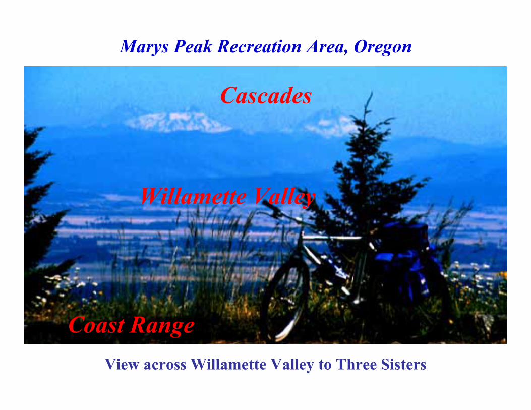
View across Willamette Valley to Three Sisters
Marys Peak Recreation Area, Oregon
Coast Range
Willamette Valley
Cascades
Robe
rt J.
Lill
ie
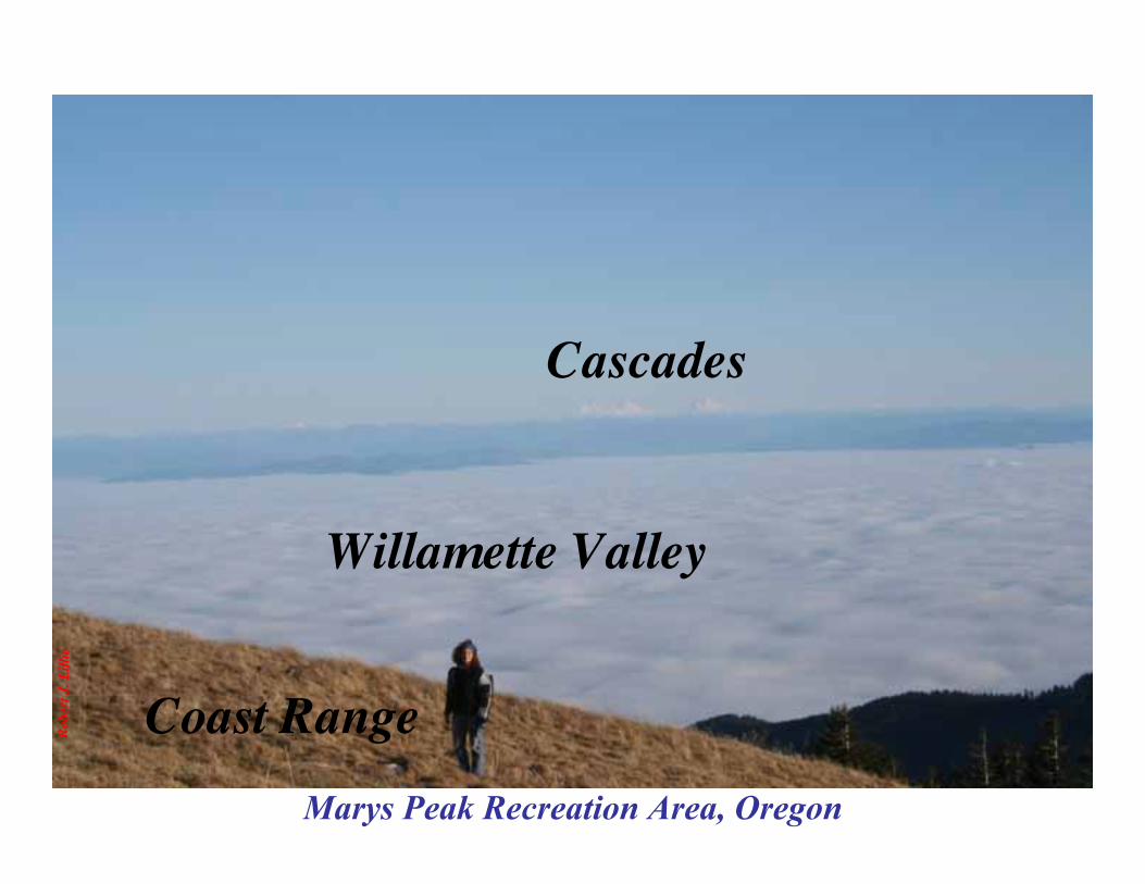
Marys Peak Recreation Area, Oregon
Coast Range
Willamette Valley
Cascades

Mt. St.HelensNVM
CascadeVolcanoes
National Park Lands inActive Volcanic Arc
Parks in the Cascadesshowcase volcanoesformed above thesubducting plate.
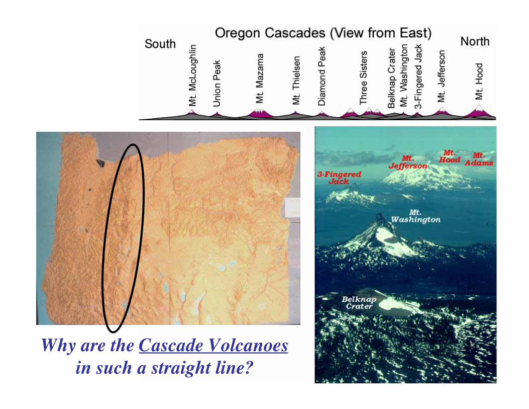
Why are the Cascade Volcanoesin such a straight line?
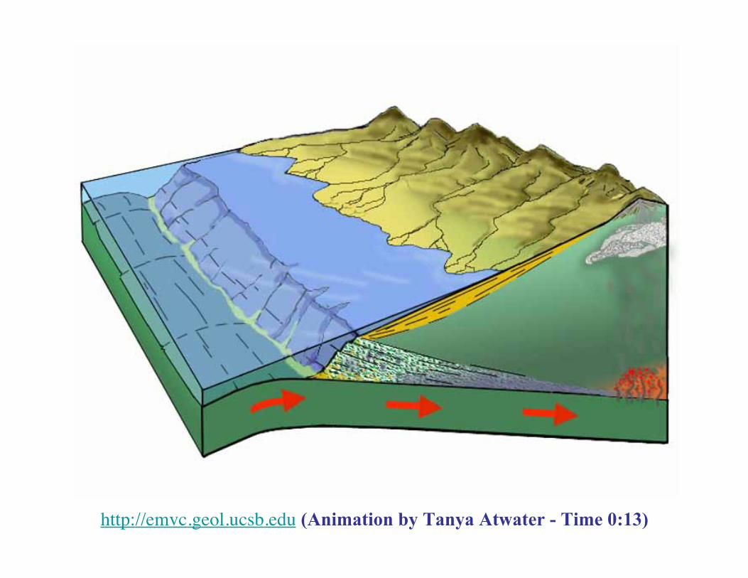
Subduction leads to Volcanism
http://emvc.geol.ucsb.edu (Animation by Tanya Atwater - Time 0:13)
Robe
rt J.
Lill
ieBe
rnar
d G
arci
a
Parks and Plates©2005 Robert J. Lillie
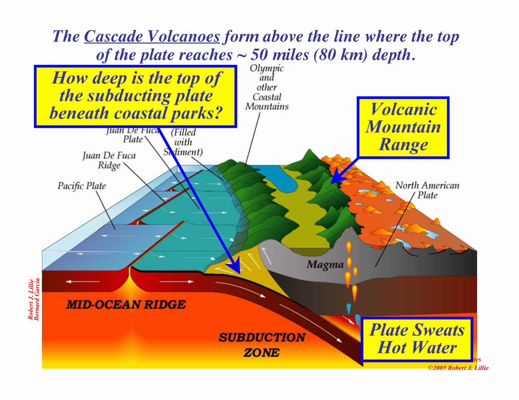
The Cascade Volcanoes form above the line where the topof the plate reaches ~ 50 miles (80 km) depth.
VolcanicMountain
Range
Plate SweatsHot Water
How deep is the top ofthe subducting plate
beneath coastal parks?
Parks and Plates©2005 Robert J. Lillie
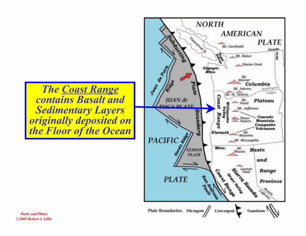
The Coast Rangecontains Basalt andSedimentary Layers
originally deposited onthe Floor of the Ocean
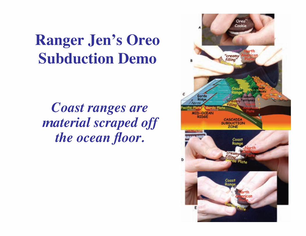
Ranger Jen’s OreoSubduction Demo
Coast ranges arematerial scraped off
the ocean floor.

Robe
rt J.
Lill
ie
Olympic National Park,Washington
Coastal Ranges
Layers Lifted out ofthe Sea
Robe
rt J.
Lill
ie
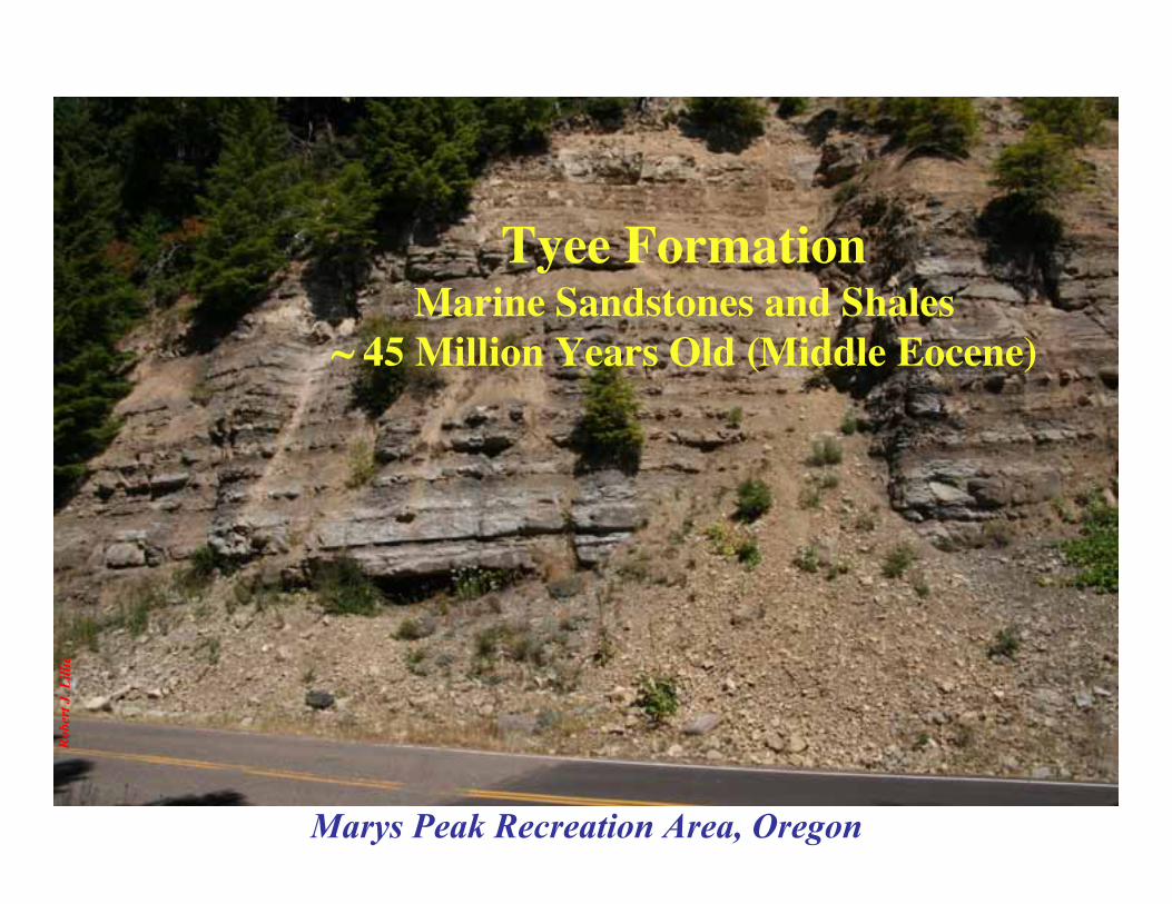
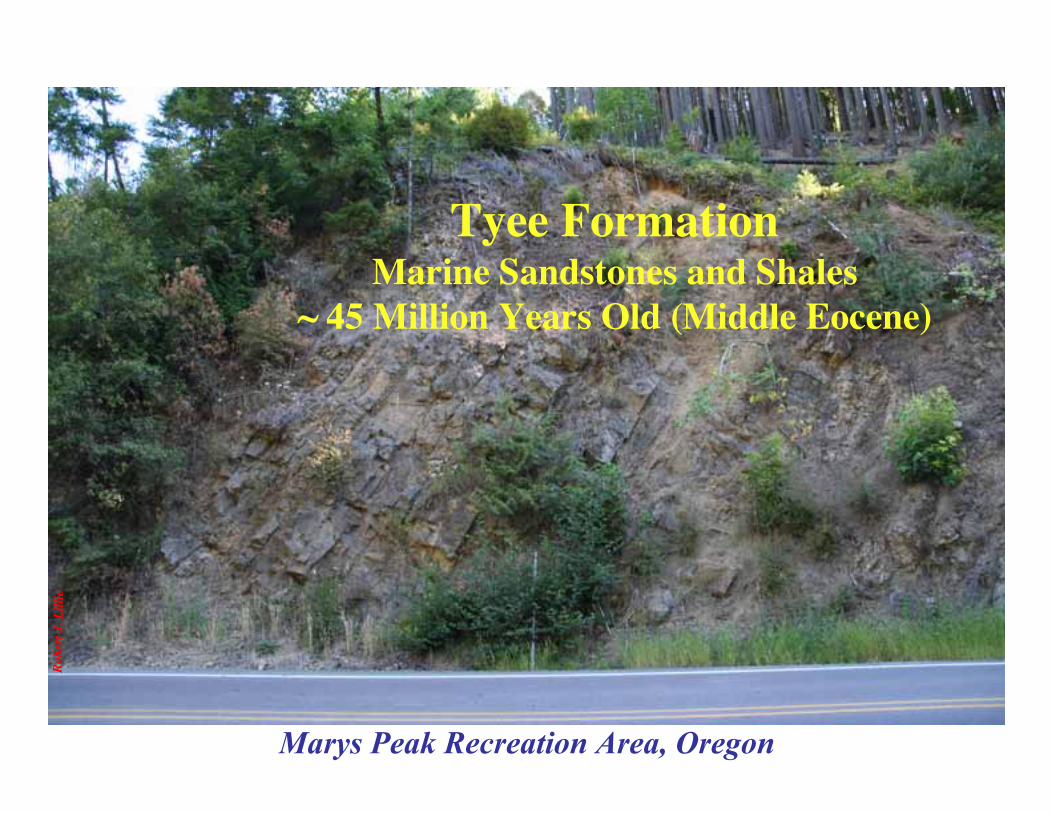
Marys Peak Recreation Area, Oregon
Tyee FormationMarine Sandstones and Shales
~ 45 Million Years Old (Middle Eocene)
Robe
rt J.
Lill
ie
Marys Peak Recreation Area, Oregon
Tyee FormationMarine Sandstones and Shales
~ 45 Million Years Old (Middle Eocene)

Robe
rt J.
Lill
ie
Devils Punch Bowl State Natural Area, Oregon
Astoria FormationMarine Sandstones and Shales
~ 18 Million Years Old (Early to Middle Miocene)

Devils Punch Bowl State Natural Area, Oregon
Robe
rt J.
Lill
ie
Astoria FormationMarine Sandstones and Shales
~ 18 Million Years Old (Early to Middle Miocene)

Robe
rt J.
Lill
ie
Beverly Beach State Park, Oregon
Yaquina FormationMarine Sandstones and Shales
~ 22 Million Years Old (Early Miocene)
Beauty

Robe
rt J.
Lill
ie
Beverly Beach State Park,Oregon
Yaquina FormationMarine Sandstones and Shales
~ 22 Million Years Old(Early Miocene)
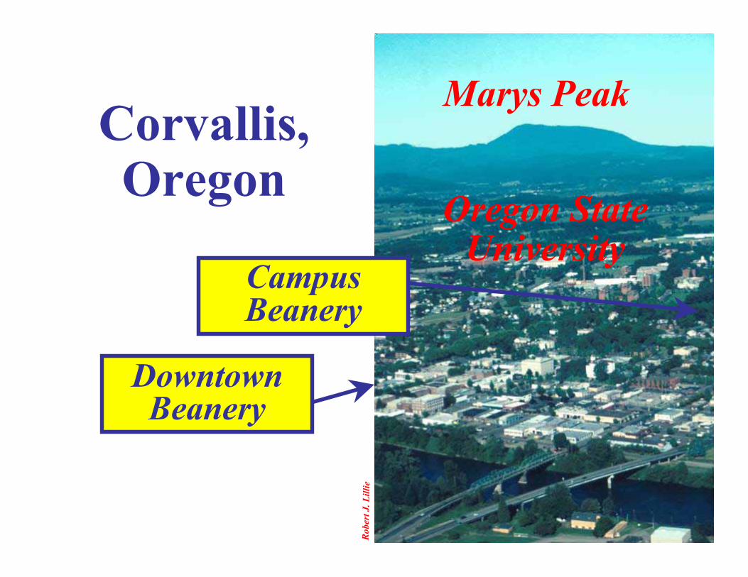
Marys PeakCorvallis,Oregon
Oregon StateUniversity
DowntownBeanery
CampusBeanery
Robe
rt J.
Lill
ie
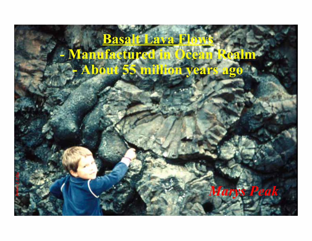
Marys Peak
Basalt Lava Flows- Manufactured in Ocean Realm
- About 55 million years ago
Robe
rt J.
Lill
ie
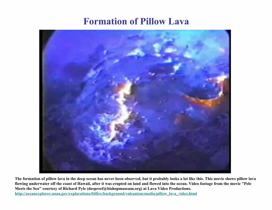
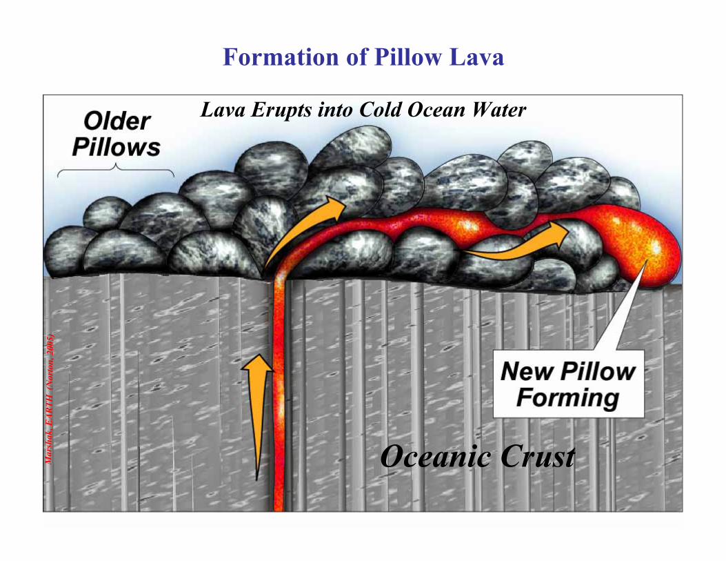
Formation of Pillow Lava
The formation of pillow lava in the deep ocean has never been observed, but it probably looks a lot like this. This movie shows pillow lavaflowing underwater off the coast of Hawaii, after it was erupted on land and flowed into the ocean. Video footage from the movie "PeleMeets the Sea" courtesy of Richard Pyle ([email protected]) at Lava Video Productions.http://oceanexplorer.noaa.gov/explorations/04fire/background/volcanism/media/pillow_lava_video.html
Mar
shak
, EAR
TH (
Nor
ton,
200
5)
Oceanic Crust
Lava Erupts into Cold Ocean Water
Formation of Pillow Lava
Robe
rt J.
Lill
ie
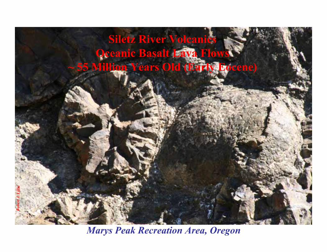
Marys Peak Recreation Area, Oregon
Siletz River VolcanicsOceanic Basalt Lava Flows
~ 55 Million Years Old (Early Eocene)
www.iris.edu (Animation by Jenda Johnson - Time 1:15)

CascadeVolcanoes
1. Why are there twoparallel mountainranges in the PacificNorthwest?
National ParkLands in the
Pacific Northwest
CoastalRanges
2. Why are thereearthquakes,tsunamis andvolcanic eruptions?

We can see what’son the surface.
Active Tectonics of the Pacific Northwest
How does the surfacechange as a responseto subduction?
How do we know what’sbeneath the surface?
- Where are the earthquakes?- Why are they there?- How often does each type occur?
- How big is each type?- How destructive is each type?

Oregon Earthquakes“The Big One” occurs when
plates lock for centuries,then suddenly let go!
Big Ones happen every 200to 600 years. The last onewas in the year 1700 …….
Four Types of Earthquakes inCascadia Subduction Zone
1) Slab Earthquakes:– Within Juan de Fuca Plate– Up to 40 miles (60 km) depth– Up to Magnitude 7
2) Locked Zone (Mega-Thrust)Earthquakes:
– Between Juan de Fuca and NorthAmerican Plates
– 5 - 10 miles (8 - 15 km) depth– Up to Magnitude 9
3) Upper Plate Earthquakes:– Within North American Plate– 1 - 10 miles (2 - 15 km) depth– Up to Magnitude 7
4) Volcanic Earthquakes:– From magma shallowing beneath
Cascade volcanoes– 1 - 5 miles (2 - 10 km) depth– Up to Magnitude 5.5
12
3 4
TheBeast
1. Nisqually, Washington,2001 (M=6.9)
2. Cascadia, 1700 (M=9?)3. Scotts Mills, Oregon,
1993 (M=5.6)
4. Mt. St. Helens, Washington,1980 (M=5.5)
5
6
Rifting: KlamathFalls, 1993, M = 6.0
Offshore:M up to 7
Joe
Gre
en
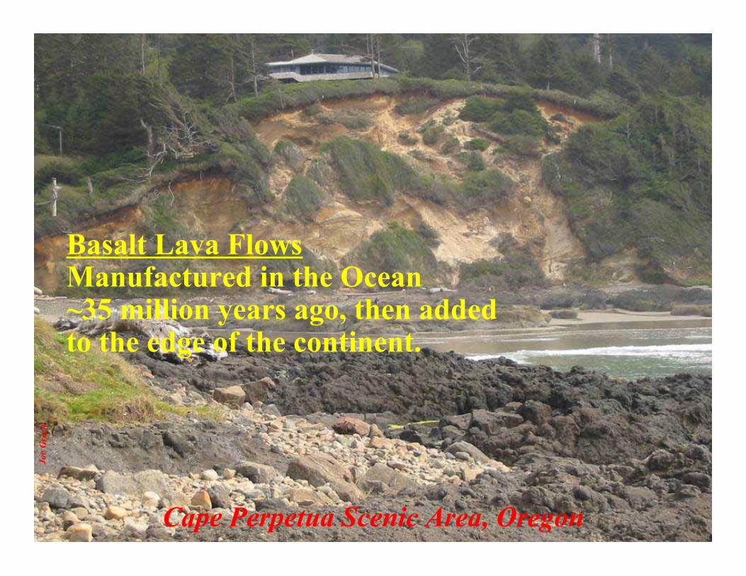
Cape Perpetua Scenic Area, Oregon
Basalt Lava FlowsManufactured in the Ocean~35 million years ago, then addedto the edge of the continent.

Robe
rt J.
Lill
ie
Heceta Head Lighthouse State Scenic Viewpoint, Oregon
Yachats FormationOceanic Basalt Lava Flows
~ 35 Million Years Old (Late Eocene - Oligocene)

Can we design an effective interpretativetalk on geology for the Oregon Coast?
Robe
rt J.
Lill
ie
Seal Rock State Park, Oregon
What about these younger lava flows?Only 9 – 15 million years old
Can we design an effective interpretativetalk on geology for the Oregon Coast?
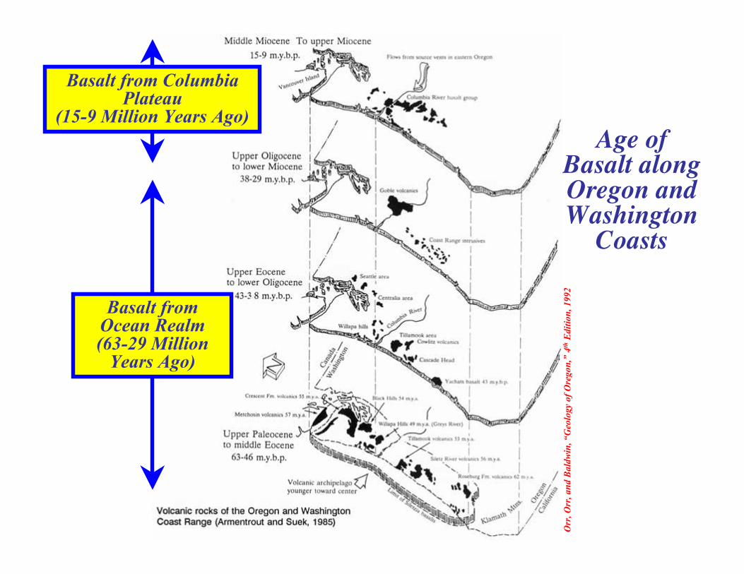
Orr
, Orr
, and
Bal
dwin
, “G
eolo
gy o
f Ore
gon,
” 4th
Edi
tion,
199
2
Basalt fromOcean Realm(63-29 Million
Years Ago)
Basalt from ColumbiaPlateau
(15-9 Million Years Ago)Age of
Basalt alongOregon andWashington
Coasts

http://www.geo.utep.edu/kidd/Vol_eq_plates.html
Plate BoundariesEarthquakes (yellow dots)Active Volcanoes (orange triangles) The
Beast
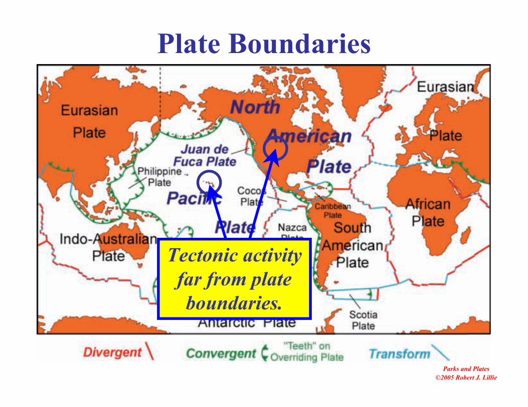
Parks and Plates©2005 Robert J. Lillie
Plate Boundaries
Tectonic activityfar from plateboundaries.

Nat
iona
l Geo
grap
hic
Soci
ety
FormingToday
45 MillionYears Old
21 MillionYears Old
NorthwestwardPlate Motion
Hawai`i – Emperor Hotspot Track
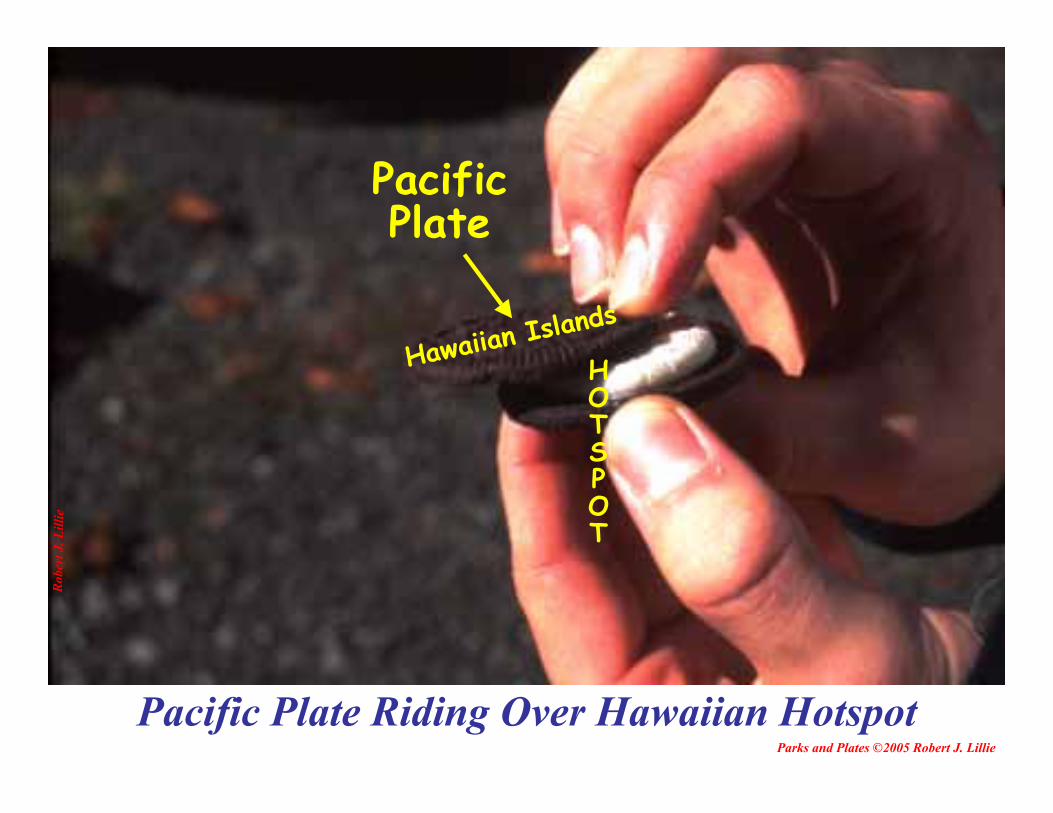
Pacific Plate Riding Over Hawaiian HotspotParks and Plates ©2005 Robert J. Lillie
Robe
rt J.
Lill
ie
PacificPlate
Hawaiian Islands
HOTSPOT
U. S
. Geo
logi
cal S
urve
y ,
Haw
aiia
n Vo
lcan
o O
bser
vato
ry
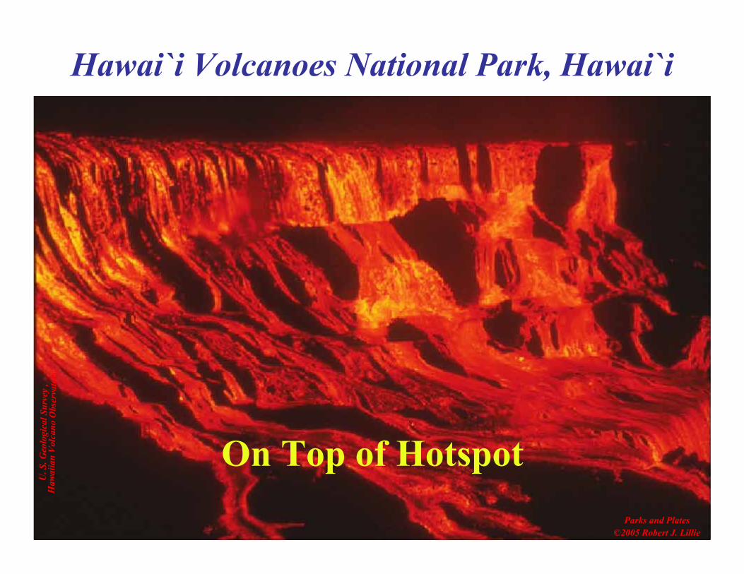
On Top of HotspotParks and Plates
©2005 Robert J. Lillie
Hawai`i Volcanoes National Park, Hawai`i
Parks and Plates©2005 Robert J. Lillie
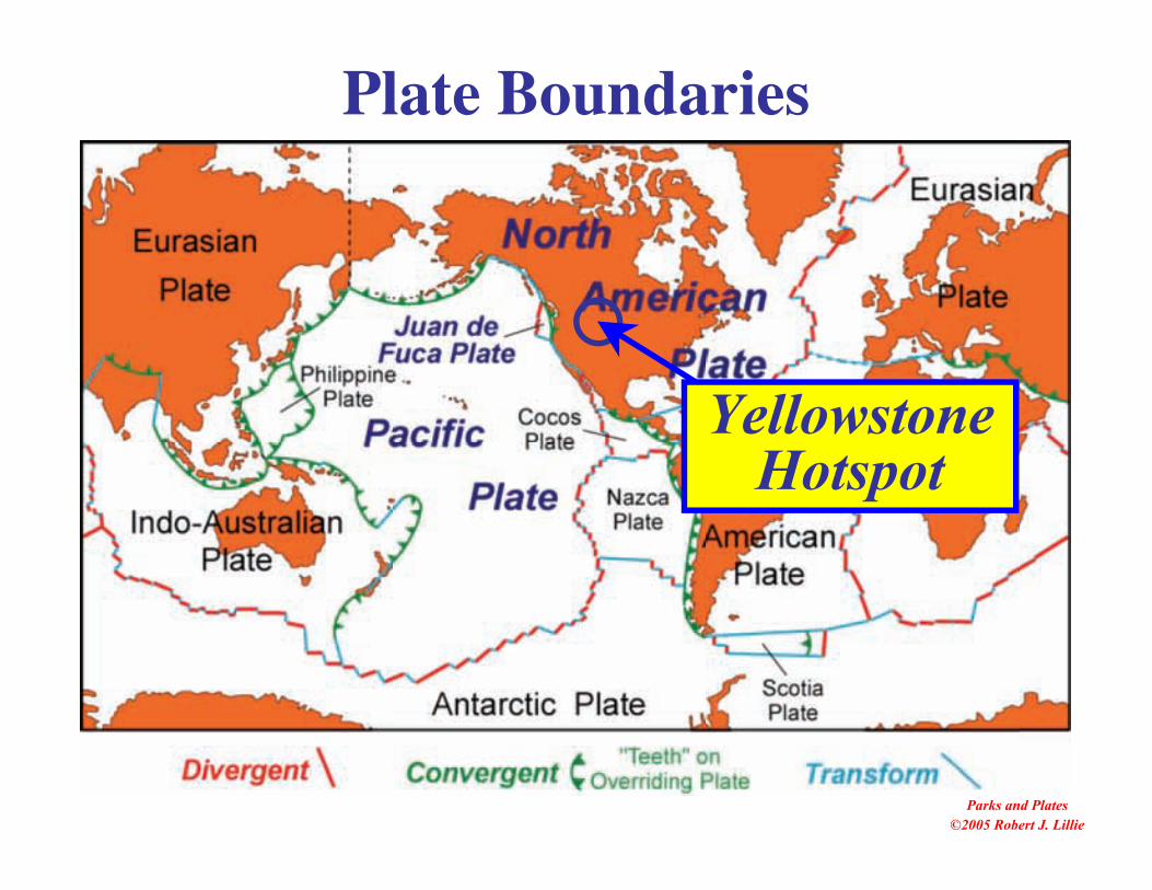
Plate Boundaries
YellowstoneHotspot

Columbia Plateau –Yellowstone
Selected Parklands
Oregon StateParks
NationalPark Service
U. S. ForestService
John DayFossil Beds NM
Yellowstone NP
Bureau LandManagement

Robe
rt J.
Lill
ie
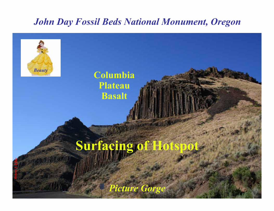
John Day Fossil Beds National Monument, Oregon
Friendly park rangers engage visitors on thegeology, paleontology, and cultural history of the
John Day Country.
SheepRock
Fossil-BearingLayers
ColumbiaPlateau Basalt
Robe
rt J.
Lill
ie
John Day Fossil Beds National Monument, Oregon
ColumbiaPlateauBasalt
Surfacing of Hotspot
Beauty
Picture Gorge
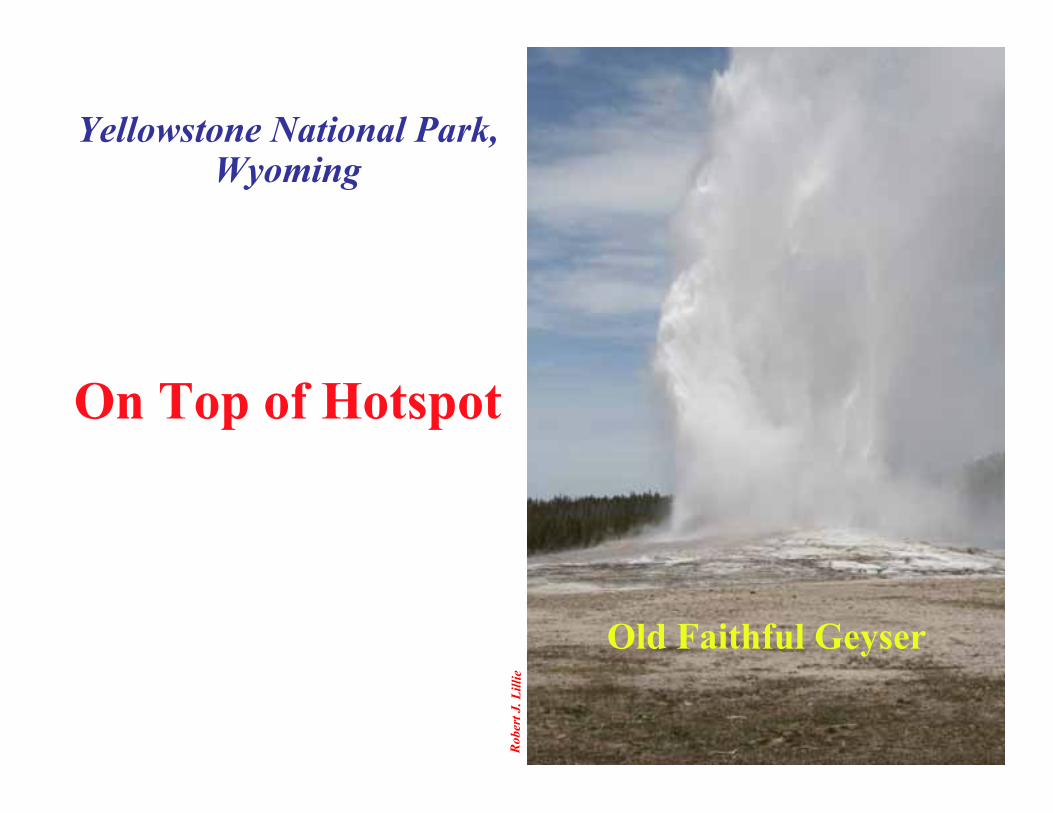
Yellowstone National Park,Wyoming
Robe
rt J.
Lill
ie
Old Faithful Geyser
On Top of Hotspot

TheBeast
This BBC production brought great globalawareness of Yellowstone as an active volcano

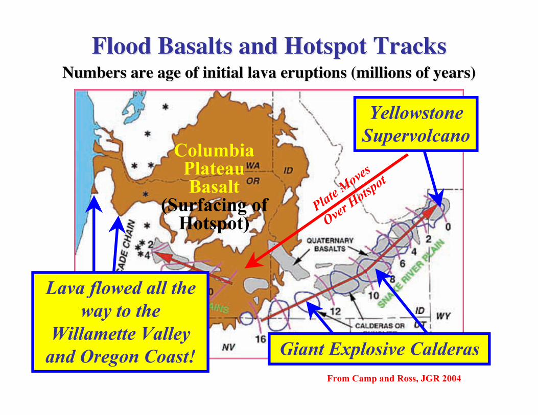
Flood Basalts and Hotspot TracksFlood Basalts and Hotspot Tracks
From Camp and Ross, JGR 2004
Plate Moves
Over Hotsp
ot
Giant Explosive Calderas
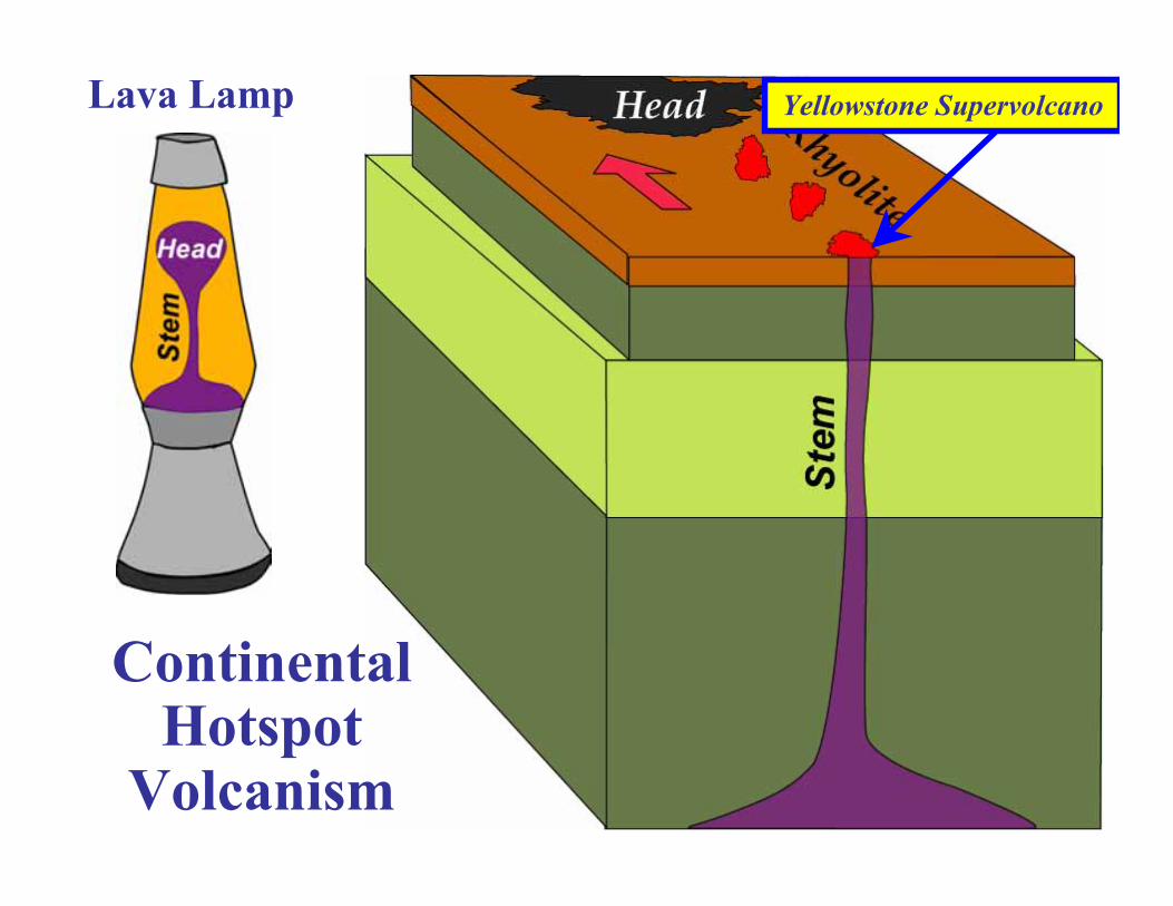
YellowstoneSupervolcano
Numbers are age of initial lava eruptionsNumbers are age of initial lava eruptions (millions of years)(millions of years)
ColumbiaPlateauBasalt
(Surfacing ofHotspot)

Parks and Plates ©2005 Robert J. Lillie
Robe
rt J.
Lill
ie
NorthAmerican
Plate
Volcanoes
HOTSPOT
Hotspot
ContinentalHotspot
Volcanism
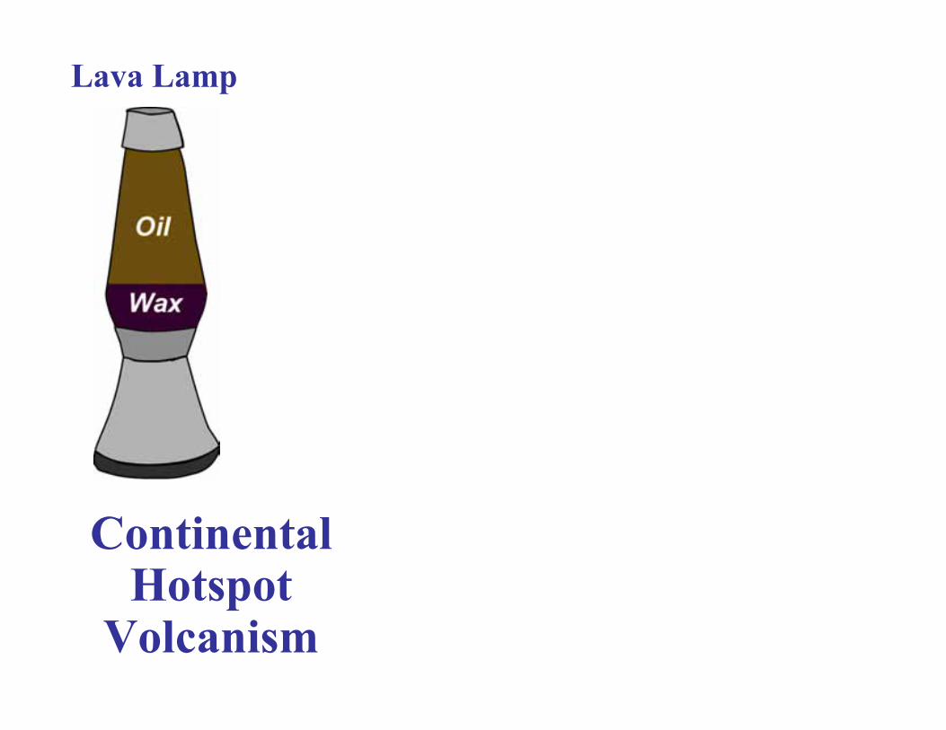
Lava Lamp
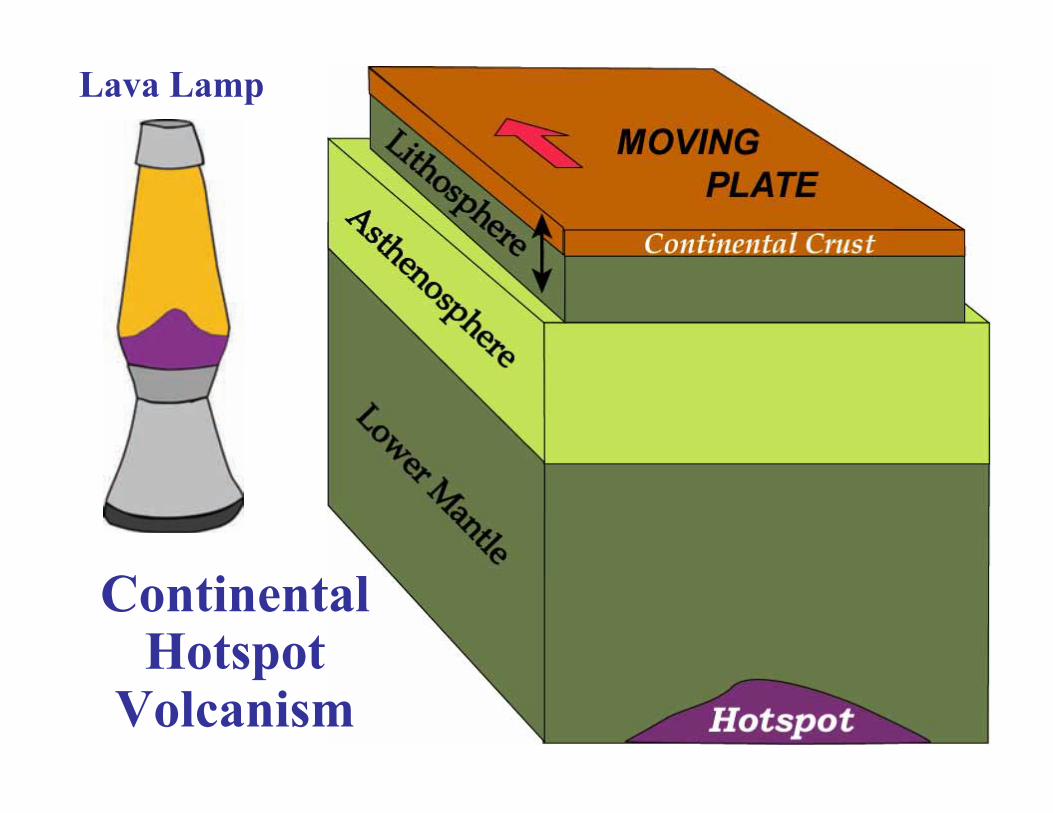
ContinentalHotspot
Volcanism
Lava Lamp
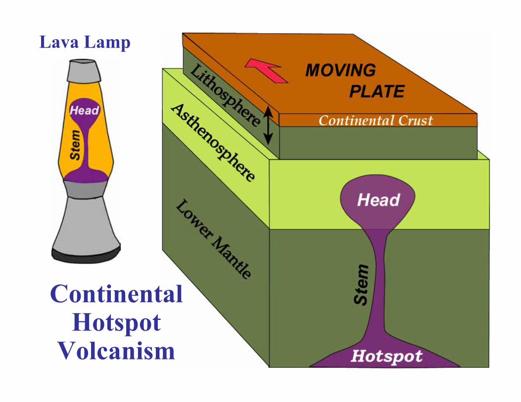
ContinentalHotspot
Volcanism
Lava Lamp

ContinentalHotspot
Volcanism
Lava Lamp Columbia Plateau
ContinentalHotspot
Volcanism
Lava Lamp Yellowstone Supervolcano
Flood Basalts and Hotspot TracksFlood Basalts and Hotspot Tracks
From Camp and Ross, JGR 2004
Plate Moves
Over Hotsp
ot
Giant Explosive Calderas
YellowstoneSupervolcano
Numbers are age of initial lava eruptionsNumbers are age of initial lava eruptions (millions of years)(millions of years)
ColumbiaPlateauBasalt
(Surfacing ofHotspot)
Lava flowed all theway to the
Willamette Valleyand Oregon Coast!
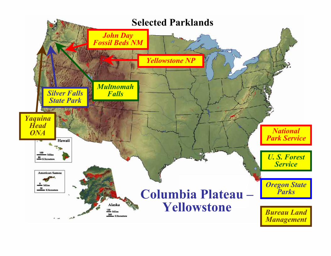
Columbia Plateau –Yellowstone
Selected Parklands
Oregon StateParks
NationalPark Service
U. S. ForestService
John DayFossil Beds NM
Yellowstone NP
Silver FallsState Park
YaquinaHeadONA
Bureau LandManagement
MultnomahFalls
U. S
. For
est S
ervi
ce
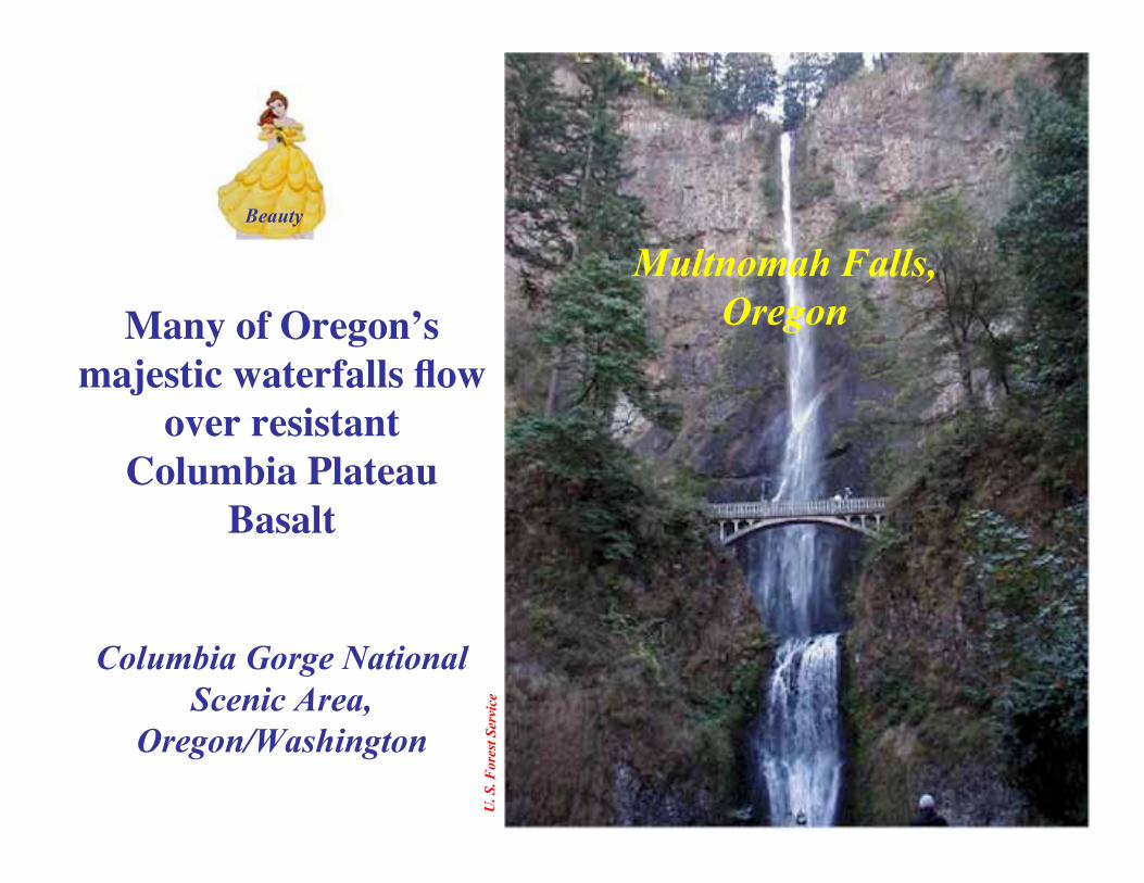
Beauty
Multnomah Falls,OregonMany of Oregon’s
majestic waterfalls flowover resistant
Columbia PlateauBasalt
Columbia Gorge NationalScenic Area,
Oregon/Washington
Robe
rt J.
Lill
ie
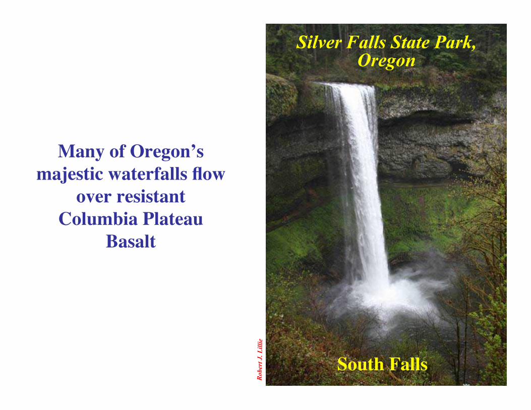
Silver Falls State Park,Oregon
South Falls
Many of Oregon’smajestic waterfalls flow
over resistantColumbia Plateau
Basalt
Yaquina Head Outstanding Natural Area, OregonBu
reau
of L
and
Man
agem
ent
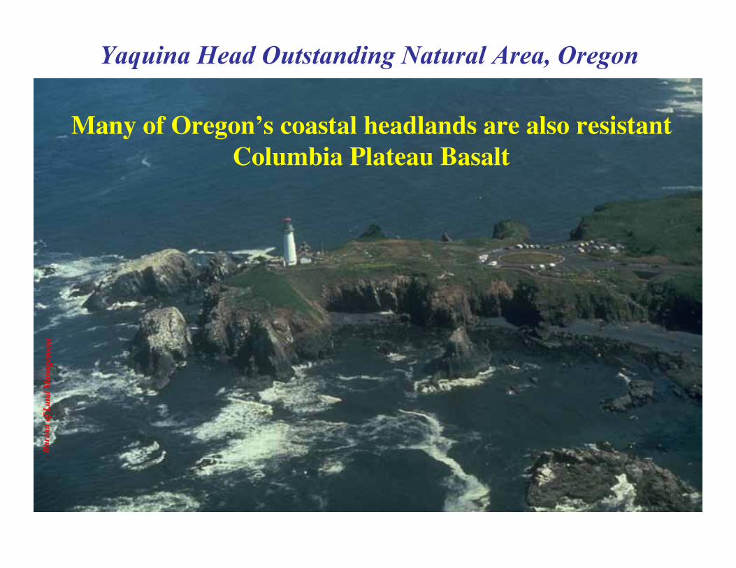
Many of Oregon’s coastal headlands are also resistantColumbia Plateau Basalt
Cape Meares Scenic Viewpoint, Oregon
Robe
rt J.
Lill
ie
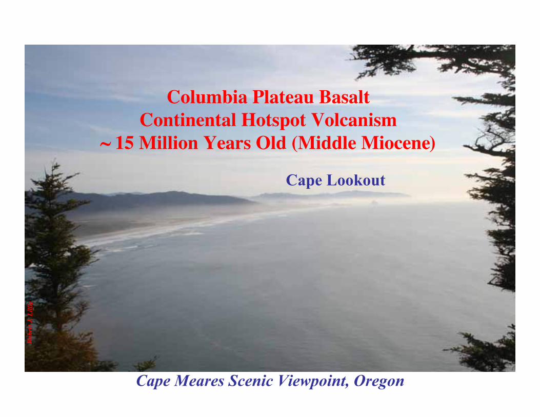
Cape Lookout
Columbia Plateau BasaltContinental Hotspot Volcanism
~ 15 Million Years Old (Middle Miocene)
Cape Lookout State Park, Oregon
Robe
rt J.
Lill
ie
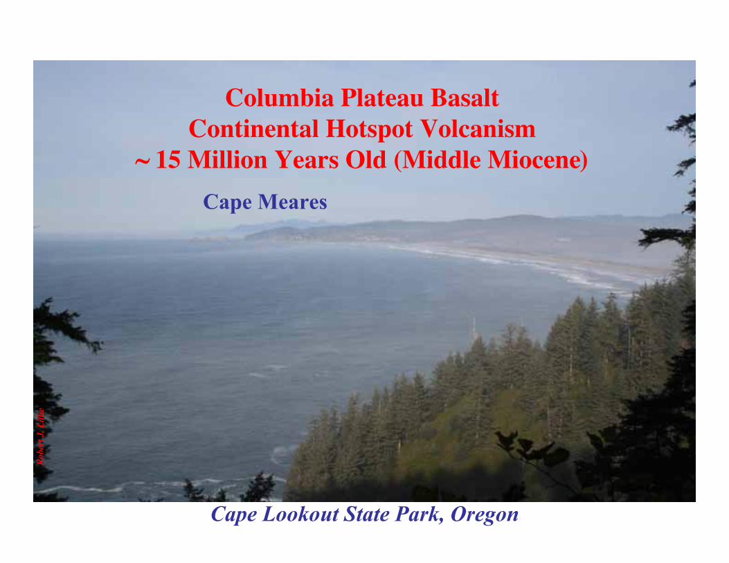
Cape Meares
Columbia Plateau BasaltContinental Hotspot Volcanism
~ 15 Million Years Old (Middle Miocene)

Devils Punch Bowl State Natural Area, Oregon
Robe
rt J.
Lill
ie
OtterCrest
CapeFoulweather

Cottonwood Canyon State Park, Oregon
Ore
gon
Park
s and
Rec
reat
ion
Dep
artm
ent
Columbia Plateau Basalt
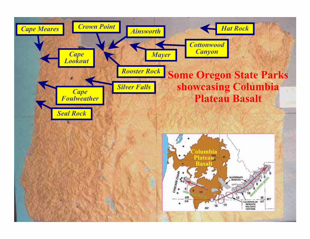
Seal Rock
CapeLookout
Cape Meares
CapeFoulweather
ColumbiaPlateauBasalt
Hat Rock
Rooster Rock
AinsworthCrown Point
Silver FallsSome Oregon State Parks
showcasing ColumbiaPlateau Basalt
CottonwoodCanyonMayer
Cascadia
Subduction
Zone
Coa
st R
ange
Will
amet
teV
alle
y
Cas
cade
Vol
cano
es
Basin and Range Province
ColumbiaPlateau
KlamathMountains
WallowaMountains
BlueMountains
OchocoMountains
StrawberryMountains
Convergent Plate Boundary(Subduction Zone)
Divergent Plate Boundary(Continental Rift Zone)
Hotspot (Mantle Plume Head)
Older Mountain Ranges(Subduction and Accretion)
Parksand
Plates –Oregon

Ore
gon
Park
s and
Rec
reat
ion
Dep
artm
ent
Iwetemlaykin State Heritage Site, Oregon
Wallowa Mountains

Mar
shak
, EAR
TH(N
orto
n, 2
005)
Parks and Plates©2005 Robert J. Lillie
AGE OF NORTHAMERICANBASEMENT
ROCKS(Billions Years)
Rocks are oldestnear the center of
the continent(continental shield)
and tend to getyounger outward.
What’s thePattern?

Marshak, EARTH (Norton, 2005)
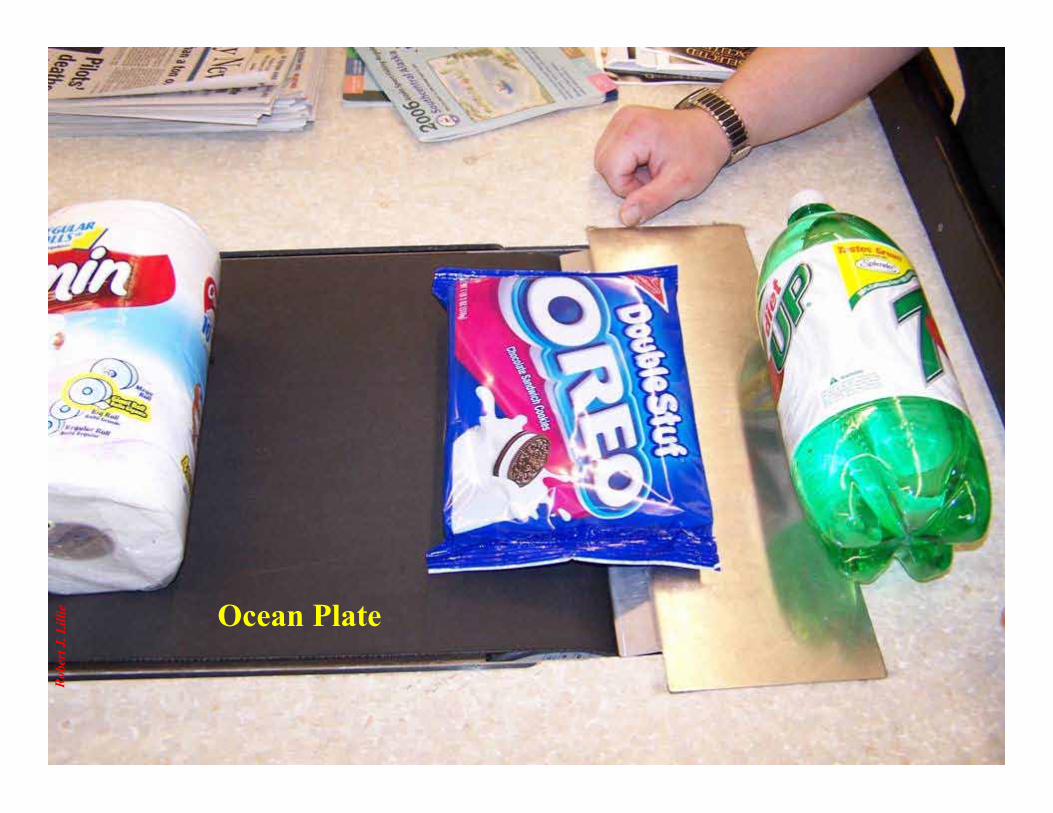
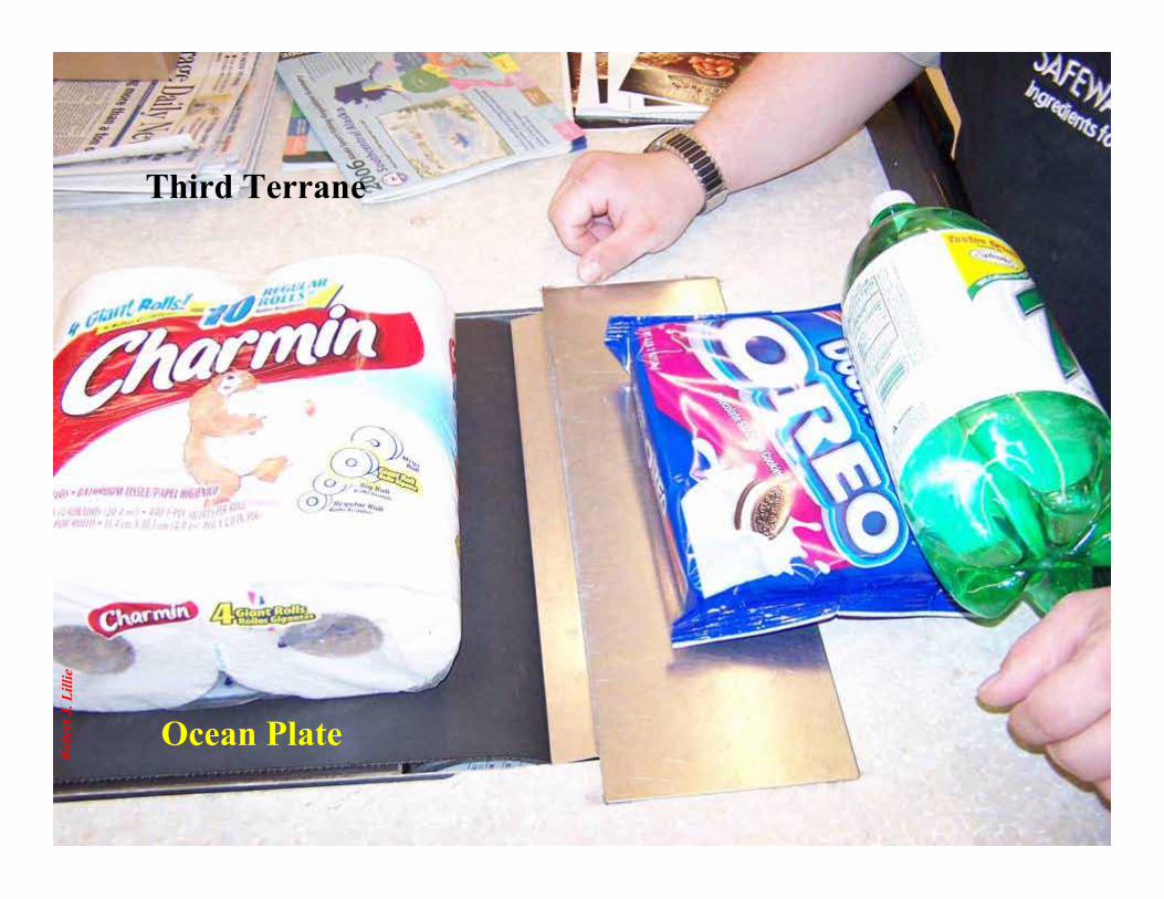
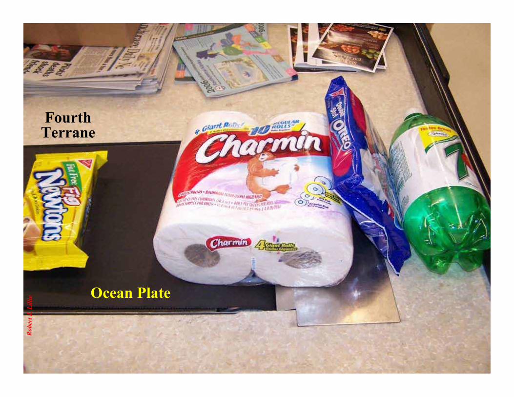
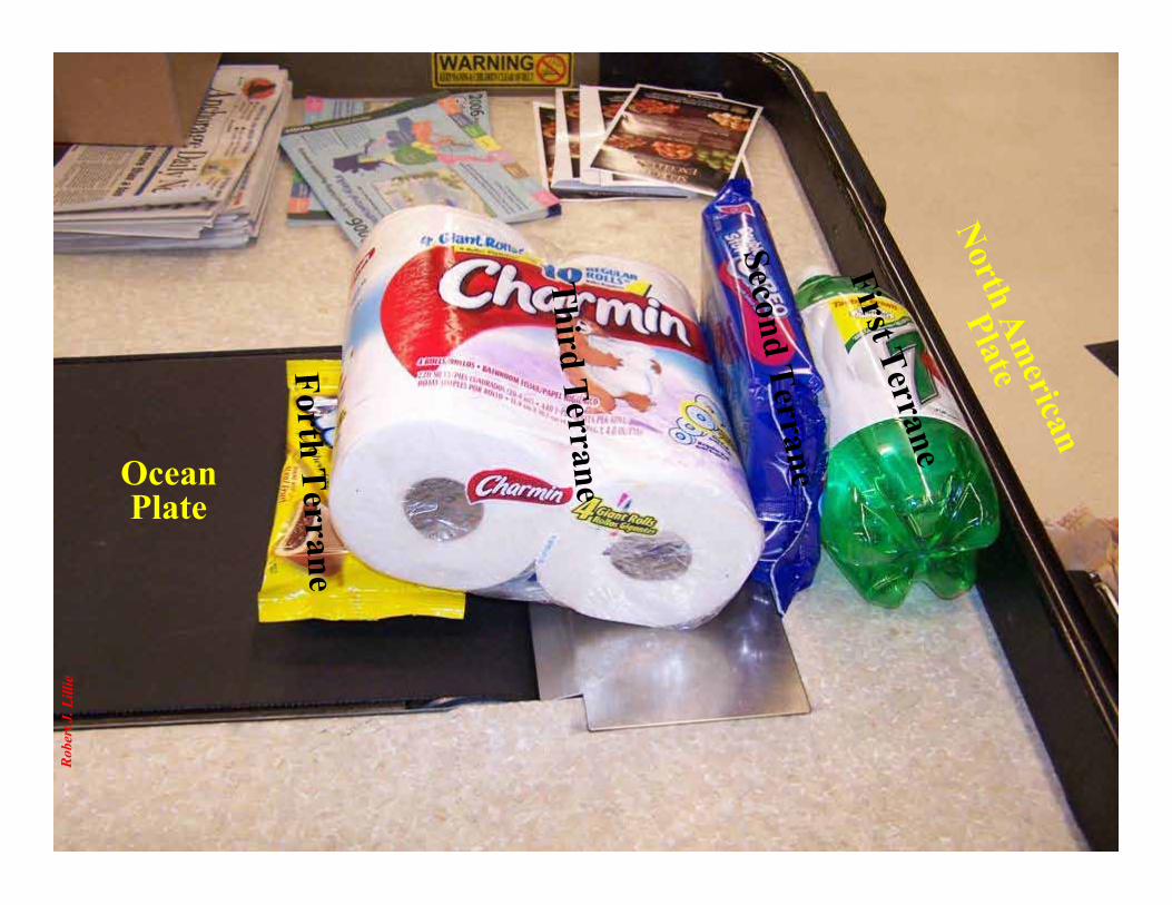
Terrane AccretionA TERRANE consists of crust that is too thick and
buoyant to subduct. The continent grows outward asterranes come crashing in.

Robe
rt J.
Lill
ie
North AmericanPlate
First Terrane
SecondTerrane
Third Terrane
ForthTerrane
Ocean Plate
Safeway Terrane Accretion

Robe
rt J.
Lill
ie
Ocean Plate
First TerraneSecondTerrane
Robe
rt J.
Lill
ie Ocean Plate
Robe
rt J.
Lill
ie
Ocean Plate
Third Terrane
Robe
rt J.
Lill
ie Ocean Plate
FourthTerrane
Robe
rt J.
Lill
ie
North American
Plate
First Terrane
Second Terrane
Third Terrane
Forth Terrane
OceanPlate
Robe
rt J.
Lill
ieBe
rnar
d G
arci
a
Parks and Plates©2005 Robert J. Lillie
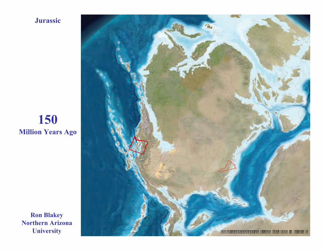
The Cascadia Subduction Zone is just the latest episode of thePacific Northwest building outward by Terrane Accretion.
Parks and Plates©2005 Robert J. Lillie
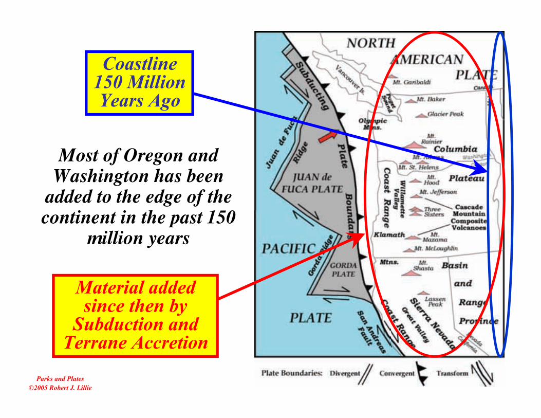
Most of Oregon andWashington has been
added to the edge of thecontinent in the past 150
million years
Material addedsince then by
Subduction andTerrane Accretion
Coastline150 MillionYears Ago

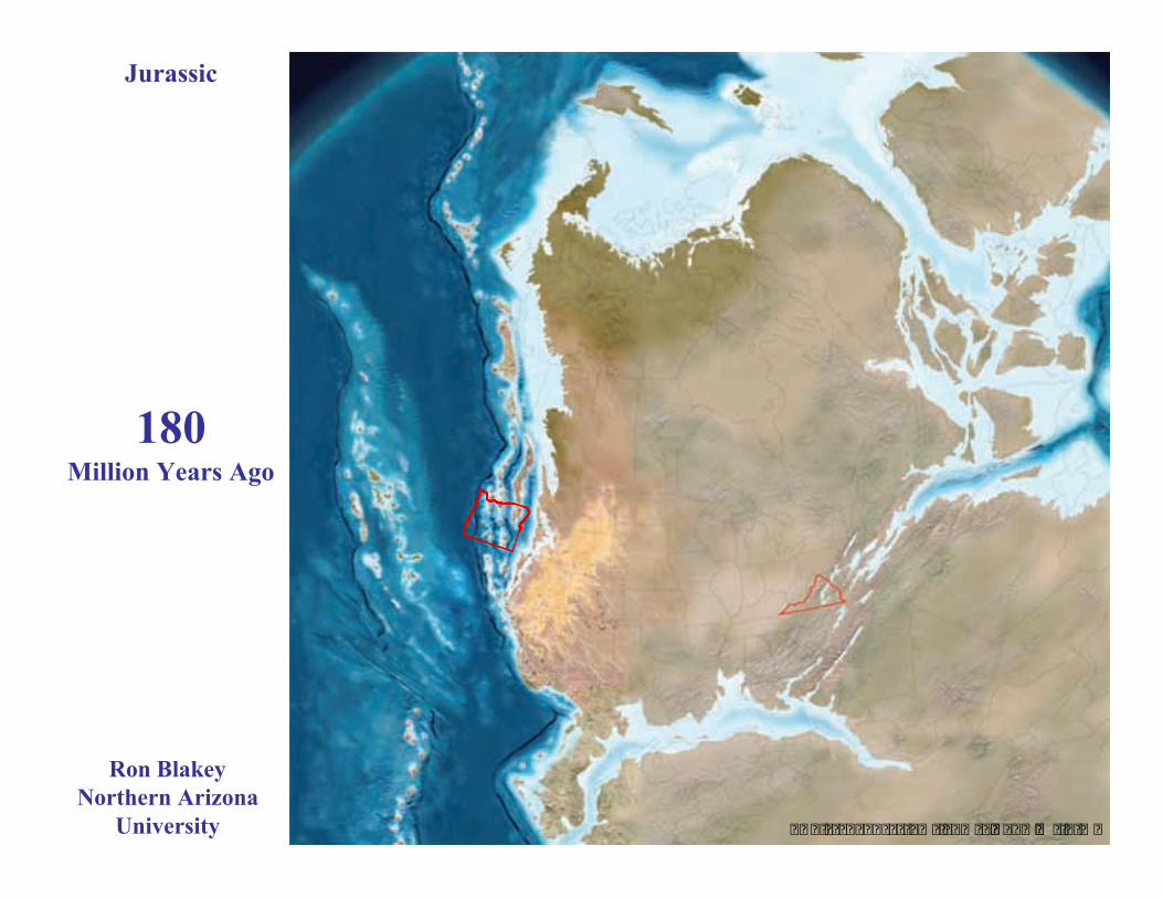
Jurassic
� � � � � � � � � � � � � � � � � �� � � � � � � � � �
195Million Years Ago
Ron BlakeyNorthern Arizona
University
� � � � � � � � � � � � � � � � � �� � � � � � � � � �
Rifting of Pangaea;
Opening of the Atlantic ocean
180Million Years Ago
Jurassic
Ron BlakeyNorthern Arizona
University
� � � � � � � � � � � � � � � � � �� � � � � � � � � �
Rifting of Pangaea;
Opening of the Atlantic ocean
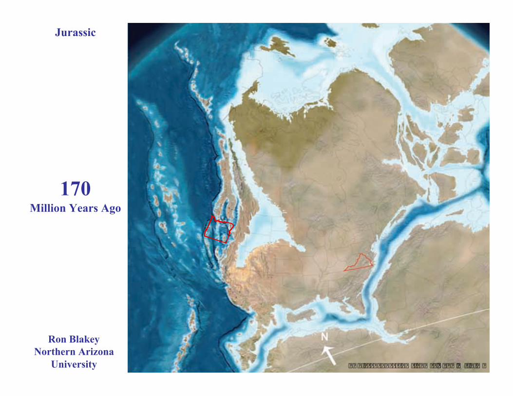
170Million Years Ago
Jurassic
Ron BlakeyNorthern Arizona
University
� � � � � � � � � � � � � � � � � �� � � � � � � � � �
Opening of the Atlantic ocean
150Million Years Ago
Jurassic
Ron BlakeyNorthern Arizona
University
� � � � � � � � � � � � � � � � � �� � � � � � � � � �
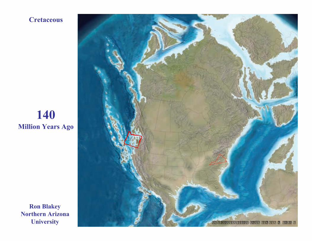
140Million Years Ago
Cretaceous
Ron BlakeyNorthern Arizona
University
� � � � � � � � � � � � � � � � � �� � � � � � � � � �
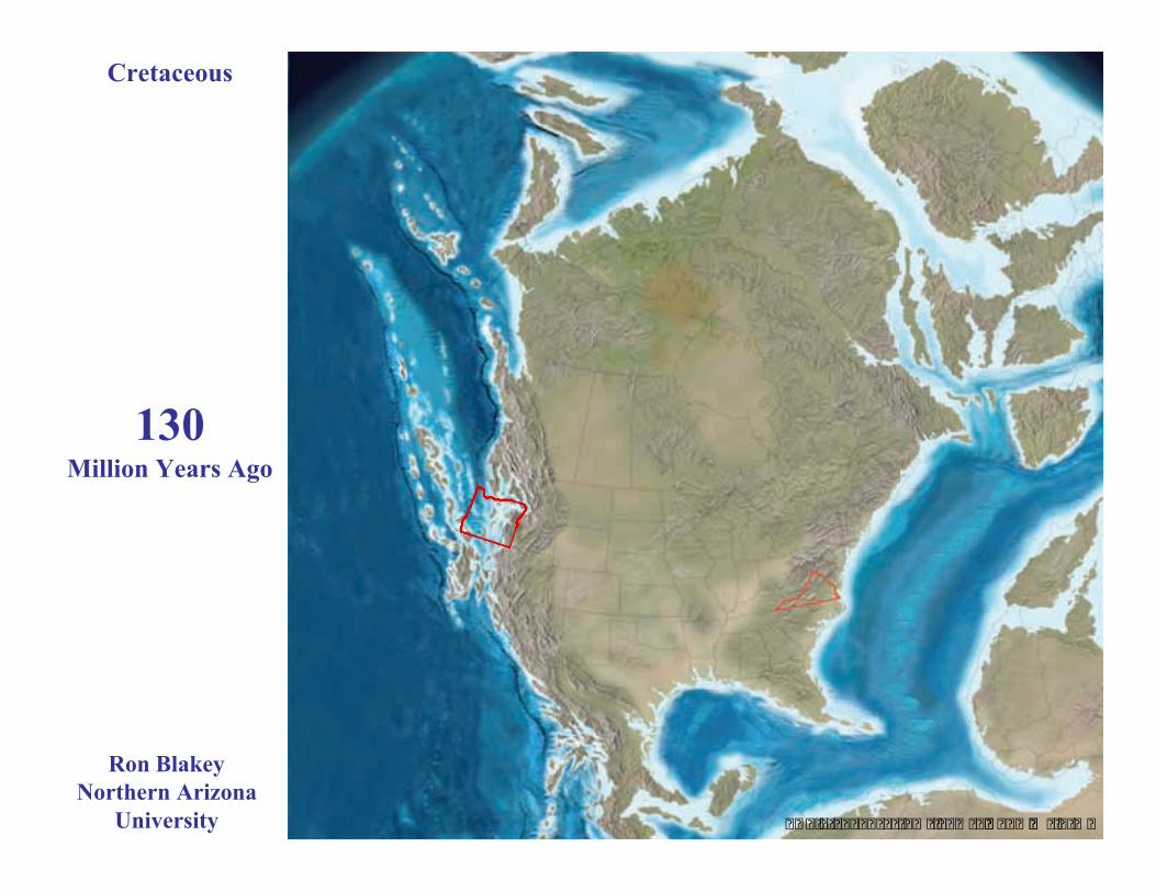
130Million Years Ago
Cretaceous
Ron BlakeyNorthern Arizona
University
� � � � � � � � � � � � � � � � � �� � � � � � � � � �
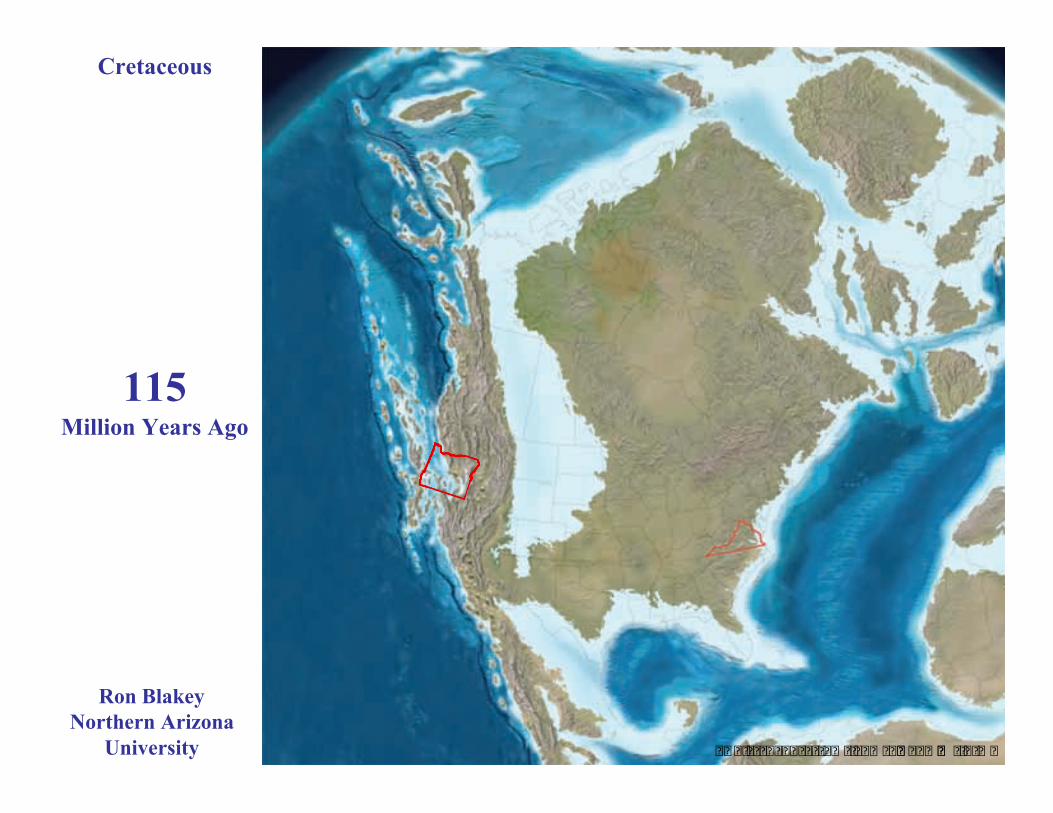
115Million Years Ago
Cretaceous
Ron BlakeyNorthern Arizona
University
� � � � � � � � � � � � � � � � � �� � � � � � � � � �
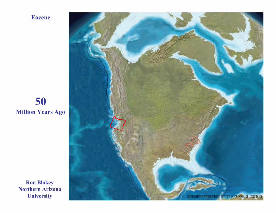
50Million Years Ago
Eocene
Ron BlakeyNorthern Arizona
University
� � � � � � � � � � � � � � � � � �� � � � � � � � � �
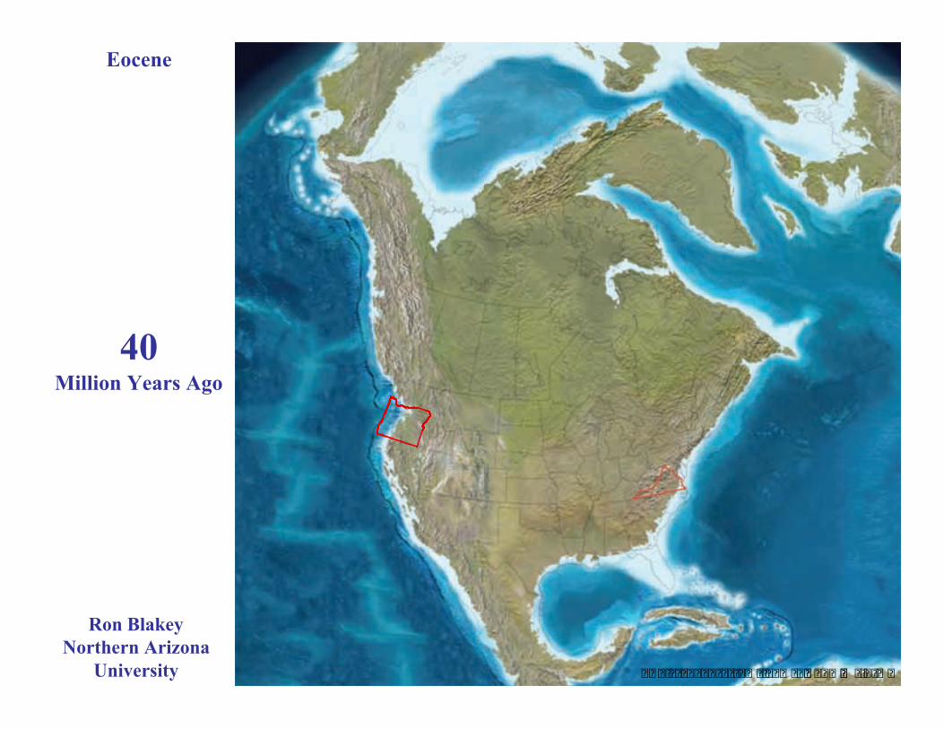
40Million Years Ago
Eocene
Ron BlakeyNorthern Arizona
University
� � � � � � � � � � � � � � � � � �� � � � � � � � � �
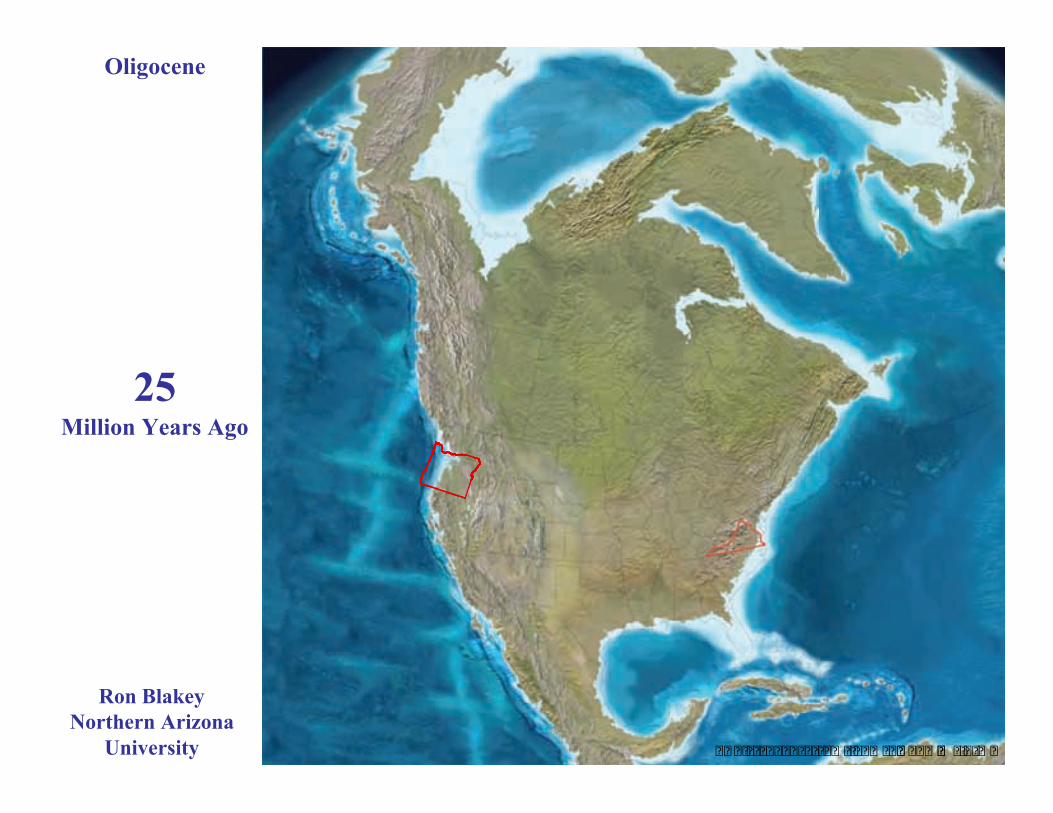
25Million Years Ago
Oligocene
Ron BlakeyNorthern Arizona
University
� � � � � � � � � � � � � � � � � �� � � � � � � � � �
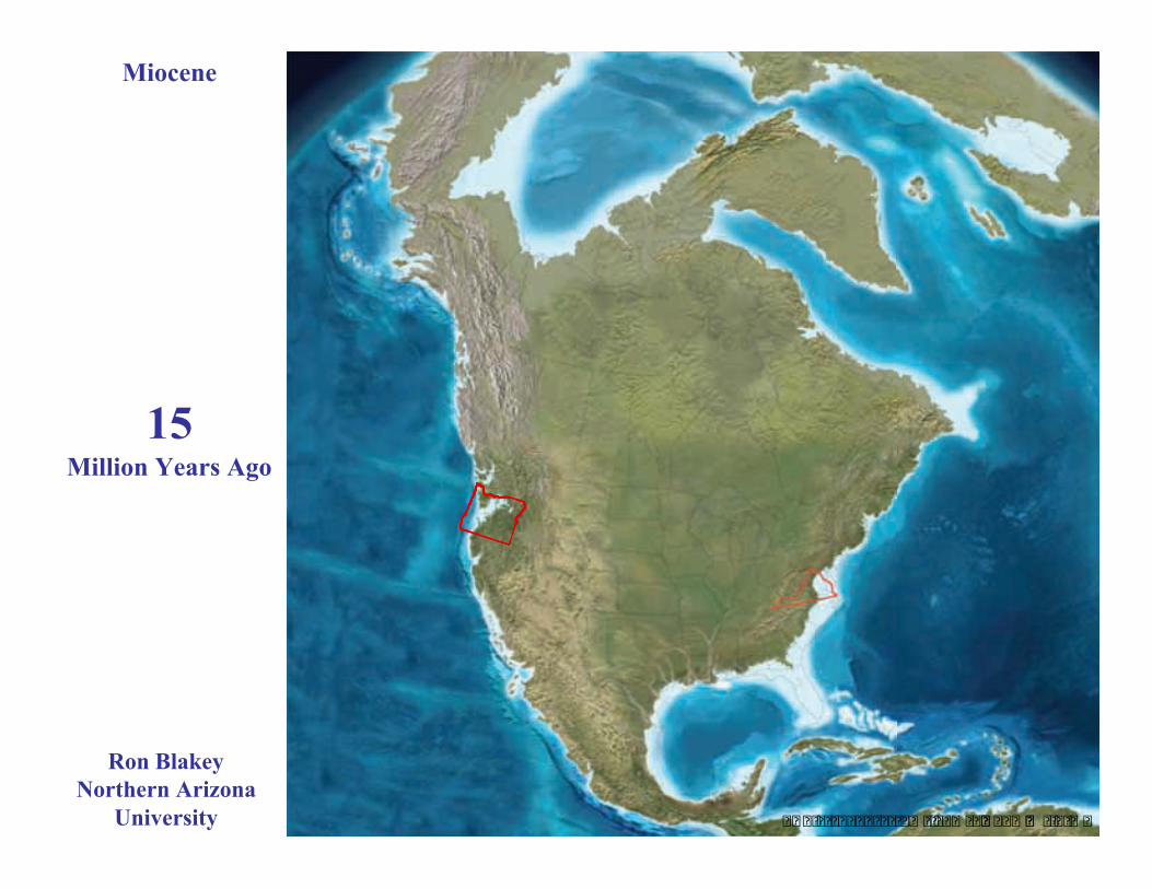
15Million Years Ago
Miocene
Ron BlakeyNorthern Arizona
University

� � � � � � � � � � � � � � � � � �� � � � � � � � � �
8Million Years Ago
Miocene
Ron BlakeyNorthern Arizona
University
� � � � � � � � � � � � � � � � � �� � � � � � � � � �
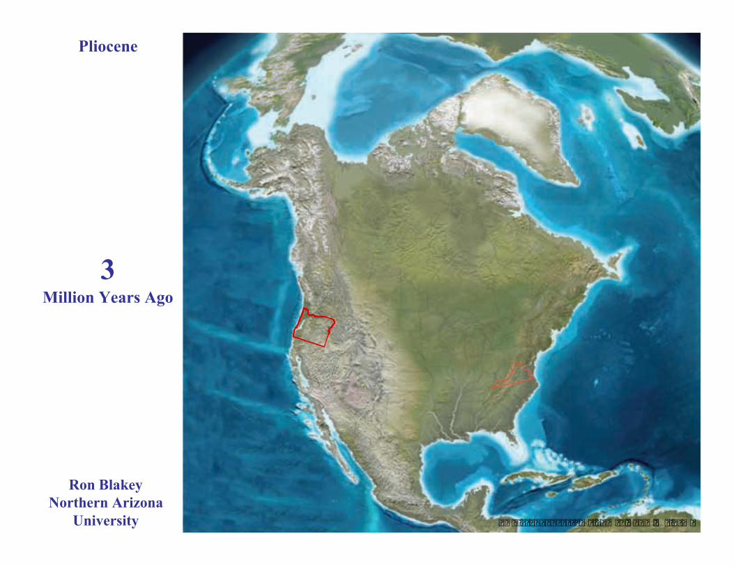
3Million Years Ago
Pliocene
Ron BlakeyNorthern Arizona
University

� � � � � � � � � � � � � � � � � �� � � � � � � � � �
Laurentide glaciation
12,500Years Ago
Holocene
Ron BlakeyNorthern Arizona
University
� � � � � � � � � � � � � � � � � �� � � � � � � � � �
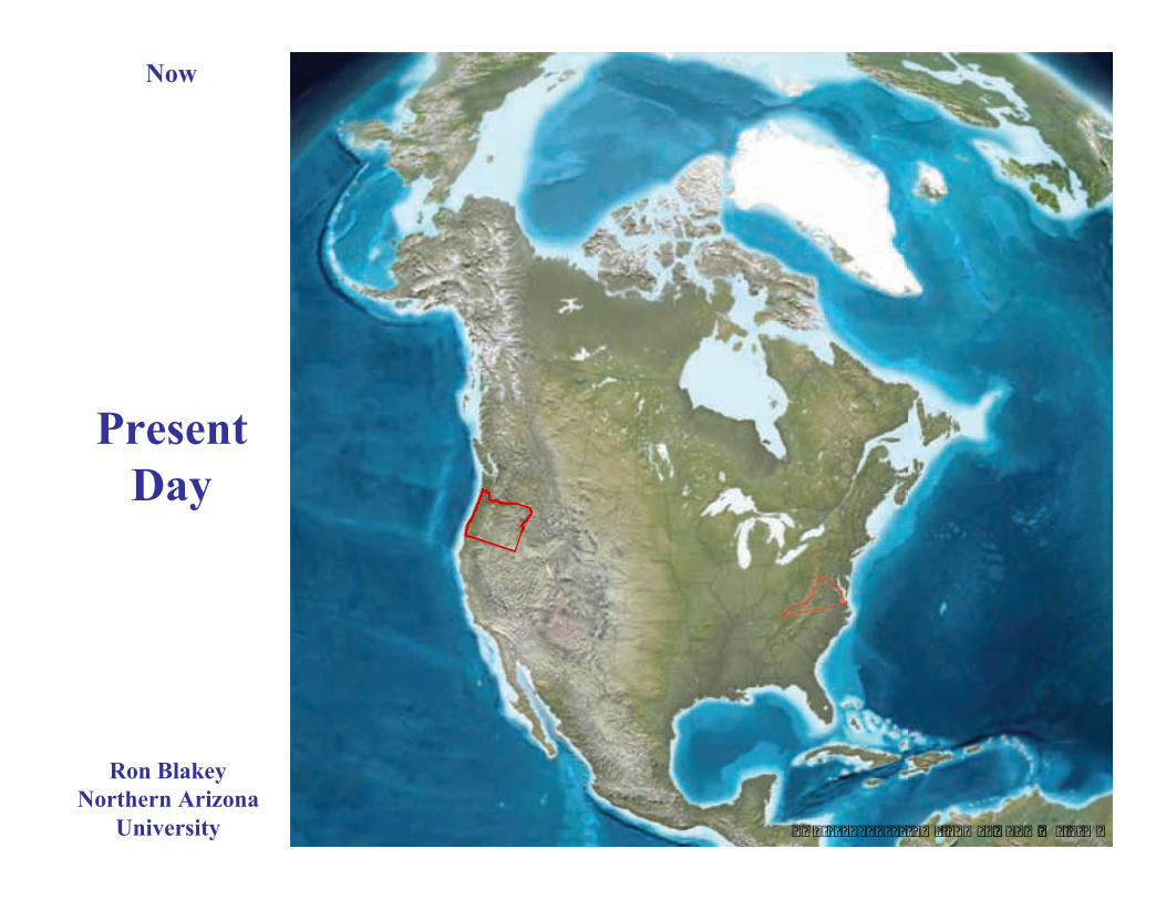
PresentDay
Now
Ron BlakeyNorthern Arizona
University

Tectonic Development ofWestern North America
85 Million Years Ago tothe Present
http://emvc.geol.ucsb.eduFrom: Tanya AtwaterEducational Multimedia Visualization CenterDepartment of Earth ScienceUniversity of California at Santa Barbara
http://emvc.geol.ucsb.eduFrom: Tanya Atwater
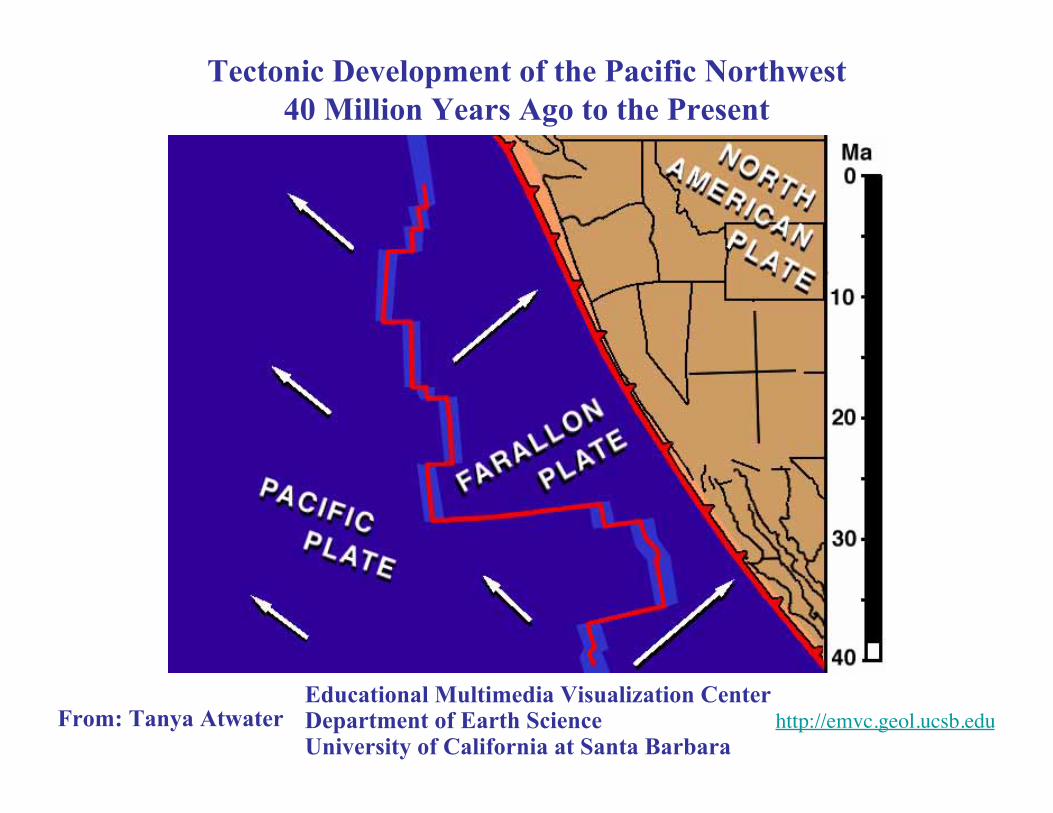
Tectonic Development of the Pacific Northwest40 Million Years Ago to the Present
Educational Multimedia Visualization CenterDepartment of Earth ScienceUniversity of California at Santa Barbara
Cascadia
Subduction
Zone
Coa
st R
ange
Will
amet
teV
alle
y
Cas
cade
Vol
cano
es
Basin and Range Province
ColumbiaPlateau
KlamathMountains
WallowaMountains
BlueMountains
OchocoMountains
StrawberryMountains
Convergent Plate Boundary(Subduction Zone)
Divergent Plate Boundary(Continental Rift Zone)
Hotspot (Mantle Plume Head)
Older Mountain Ranges(Subduction and Accretion)
Parksand
Plates –Oregon
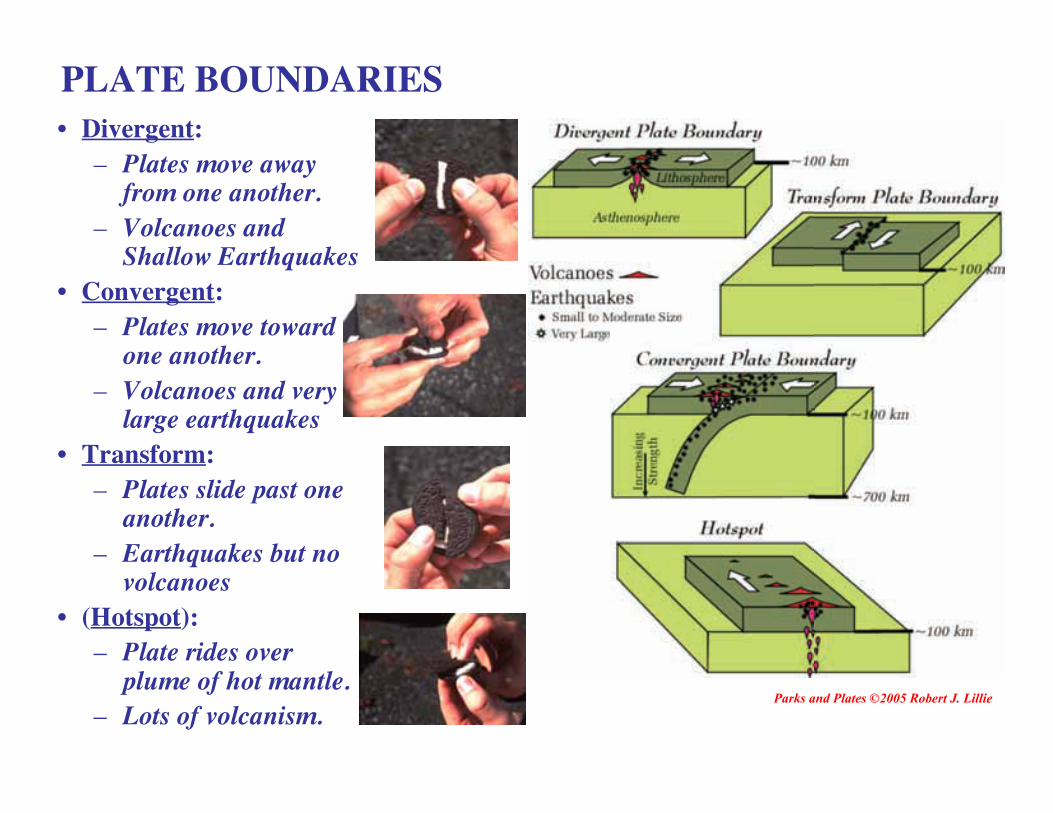
PLATE BOUNDARIES• Divergent:
– Plates move awayfrom one another.
– Volcanoes andShallow Earthquakes
• Convergent:– Plates move toward
one another.– Volcanoes and very
large earthquakes• Transform:
– Plates slide past oneanother.
– Earthquakes but novolcanoes
• (Hotspot):– Plate rides over
plume of hot mantle.– Lots of volcanism.
Parks and Plates ©2005 Robert J. Lillie