
Geography ratta list - Mega Lecture
68
Geography ratta list www.megalecture.com whatsapp: +92 323 509 4443, email: [email protected] www.youtube.com/megalecture Page 1 of 68
Transcript of Geography ratta list - Mega Lecture

Geography ratta list
www.megalecture.com
whatsapp: +92 323 509 4443, email: [email protected]
www.youtube.com/megalecture Page 1 of 68
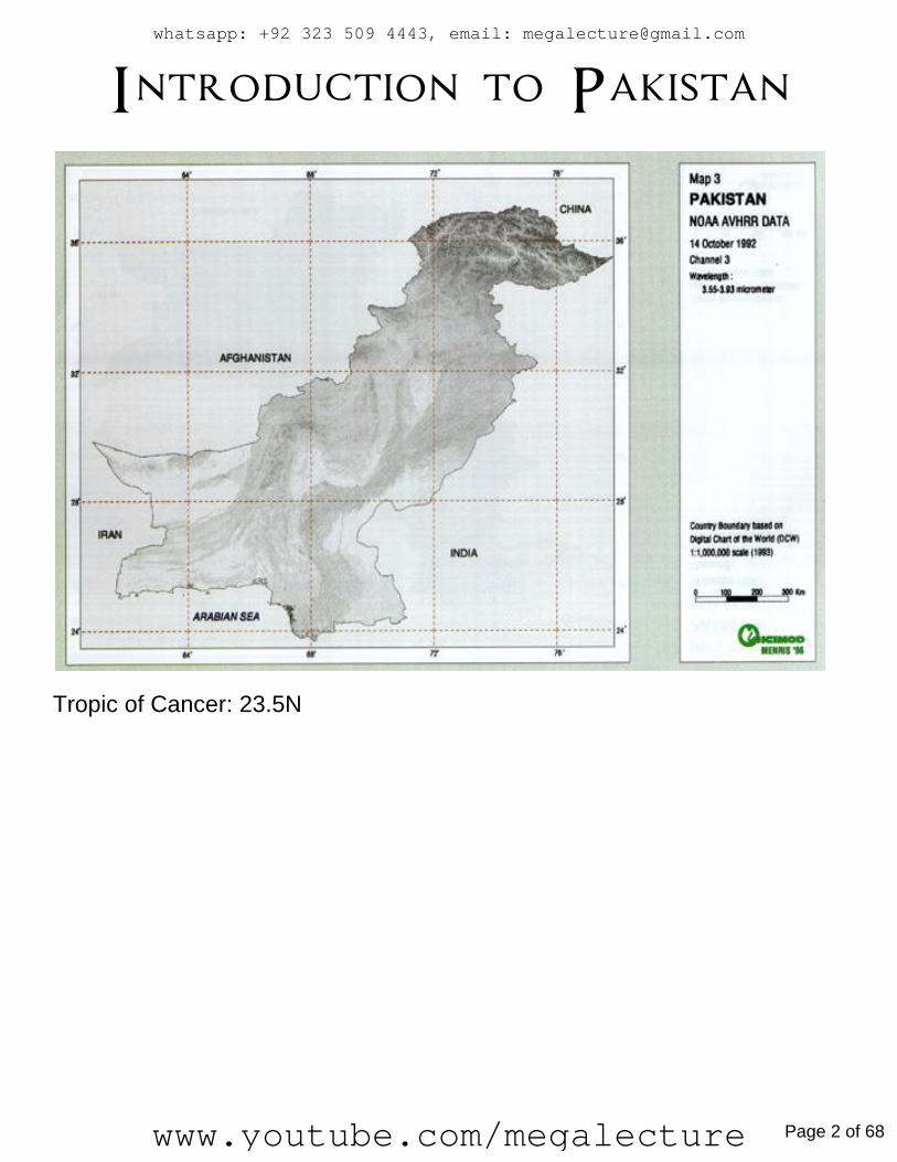
Introduction to Pakistan
Tropic of Cancer: 23.5N
whatsapp: +92 323 509 4443, email: [email protected]
www.youtube.com/megalecture Page 2 of 68

All Cities, except Srinigar are rattafyable.
www.megalecture.com
whatsapp: +92 323 509 4443, email: [email protected]
www.youtube.com/megalecture Page 3 of 68

Important Rivers:
>Indus
>Jhelum
>Chenab
>Ravi
>Sutlej
>Kabul
>Hab
>Dasht
whatsapp: +92 323 509 4443, email: [email protected]
www.youtube.com/megalecture Page 4 of 68

Passes: Bolan
^Toba Kakar Range (Balochistan)
…Connects Sibi with Quetta
Kojak
^Qila Abdullah, Chaman (Balochistan)
…Quetta with Khandar Afghanistan
Khyber
^Sofad Koh
…Peshawar with Kabul
Khunjerab
^Gilgit – Baltistan, Karakoram Mountains
…Connects Gilgit Baltistan with China
Lowari
^KPK
….Chitral with Dir
www.megalecture.com
whatsapp: +92 323 509 4443, email: [email protected]
www.youtube.com/megalecture Page 5 of 68

Topography and Drainage
NORTHERN MOUNTAINS
Northern Mountains:- i) Karakoram mountains (6000m)
ii) Himalayan mountain range (4000m)
Western Mountains:- i) Hindu Kush mountain range (5000m)
whatsapp: +92 323 509 4443, email: [email protected]
www.youtube.com/megalecture Page 6 of 68

Glaciers
Glacier Length
Siachen 75km
Baltoro 58km
Biafo 50km
Mountain Valleys
-Karakoram
- Gilgit, Hunza, Baltistan
-Hindu Kush
- Swat, Dir, Chitral
-Himalaya
- Kaghan, Gullies of murree
www.megalecture.com
whatsapp: +92 323 509 4443, email: [email protected]
www.youtube.com/megalecture Page 7 of 68

Largest Mountain peaks
-Karakoram (K-2/Godwin Austin)
-Hindu Kush (Tirich Mir)
-Himalaya (Nanga parbet)
Topography of N.Mountains
-Sharp edges ridges
-pyramidal peaks
-steep slopes
-flat land
-thin soil (slopes) thick soil(valleys)
-Bare rocks
-scree/talus
Scree
a mass of small loose stones that form or cover a slope on a mountain
Glacier
a Compact mass of ice which moves very slowly down to valley by the force of gravity
Bare rocks
mountains with no vegetation’s
snowfield
land covered with permanent snow
snowline
Imaginary line on high mountains dividing permanent snow cover
abrasion
erosional process done by glaciers on high mountains, wears down or rubs away
surface rocks
Plucking
erosional process, glaciers on high mountains, plucks and pull surface rocks.
Natural drainage of northern mountains
-Fast flowing rivers
-main river indus ( starts from Mansrowar lake in Nepal)
-Indus river tributaries, shyok, gilgi and shigar rivers
-Drainage features. Gorges, waterfalls, rapids, streams and springs
whatsapp: +92 323 509 4443, email: [email protected]
www.youtube.com/megalecture Page 8 of 68

Gorge
A deep narrow river channel formed by the erosion of river
waterfall
stream / river that falls from height e.g over a rock / a cliff
rapids
When a river/streams makes series of short waterfalls
Western Mountains 1- Koh-e-sofad / Dofad koh
2- Waziristan hills
3- Suleiman range
4- Kirthar range
www.megalecture.com
whatsapp: +92 323 509 4443, email: [email protected]
www.youtube.com/megalecture Page 9 of 68
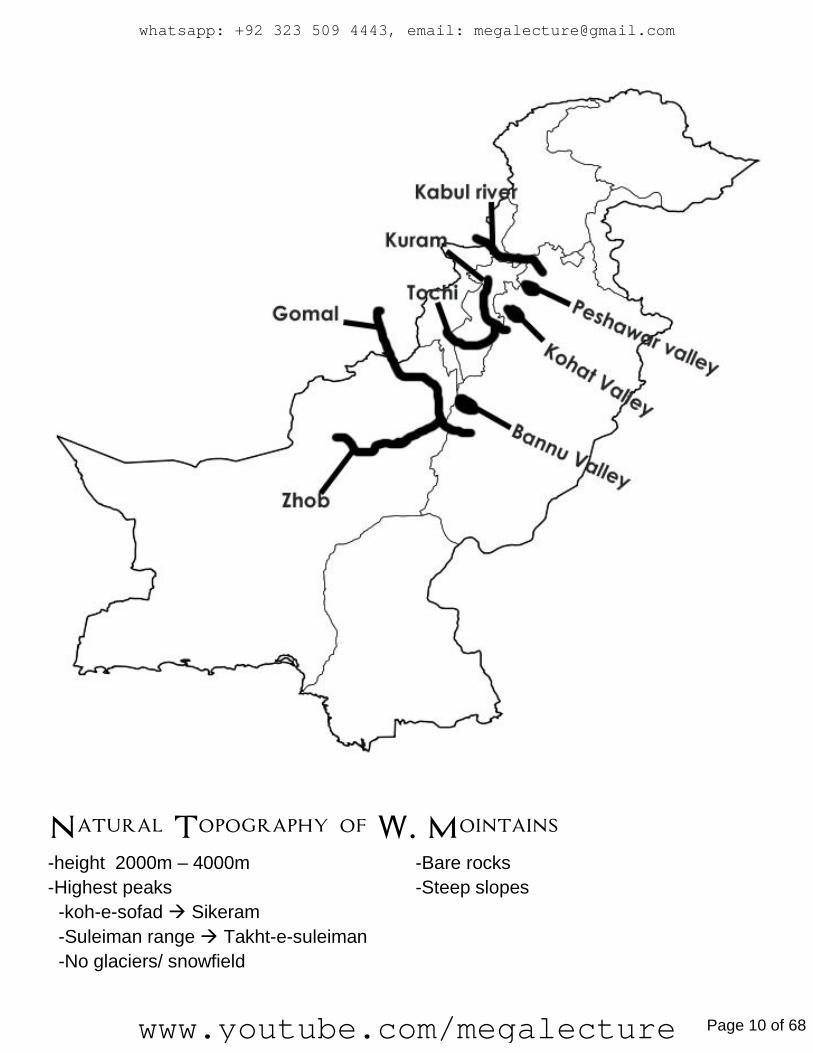
Natural Topography of W. Mointains -height 2000m – 4000m -Bare rocks
-Highest peaks -Steep slopes
-koh-e-sofad Sikeram
-Suleiman range Takht-e-suleiman
-No glaciers/ snowfield
whatsapp: +92 323 509 4443, email: [email protected]
www.youtube.com/megalecture Page 10 of 68

Balochistan Plateau -intermountain plateau – surrounded by all side of mountains
-600m – 3010m
-rugged landscape
plateau
is a large, flat area of land that is
highest than the surrounding land
Basins/Lobes/Valley
i) Nothern Basin
-Zhob Basin/valley
-Loralai Basin/valley
-Quetta Valley
ii) Western Basin
-Dry basin of chagai hills
-Kharan Desert
Mountains
-Chagai Hills
-Centeral Brahui range
-Central Makran range
-Makran Coast Range
Coastal Areas
-Jiwani
-Gawadar
-pasni
-Ormara
-Sonmiani
Basin
Aka valley / lobes. Area wholly or
partially surrounded by mountains.
Drained by rivers or has its out
drainage system.
www.megalecture.com
whatsapp: +92 323 509 4443, email: [email protected]
www.youtube.com/megalecture Page 11 of 68

Natural Topography of Balochistan Plareau -Intermountain plateau surrounded by mountains
-600 – 310m
-uneven surface and dry land
-steep slopes and bare rocks
-Basins / sub-basins e.g western and northern basin
-mountains
-passes
-kharan dasert
-coastline ( makran coast )
Natural Drainage of Balochistan Plateau -Permanent rivers
i) Zhobb river – northern part
ii) Bolan river – Central part
iii) Hab, Dasht – Southern part
-Seasonal rivers (rainy seasons)
-Seasonal rivers drain into temporary lakes Aka Hammuns
-largest Hammun is Hammun-e-Mashkhel
^these are saline/salt water lakes
whatsapp: +92 323 509 4443, email: [email protected]
www.youtube.com/megalecture Page 12 of 68

Portwar Plateau -Aka Rawalpindi Plateau
-18000sq miles
-Rain Fed/Barani. Depends on seasonal rainfall
-Main river, Swan
-Major cities e.g Islamabad, Rawalpindi, Jhelum, Attock.
-Dry and arid
Natural Topography of Portwar Plateau - 300-600m
-Low mountains, Ridges, residual hills, flat land, Undulating land, gentle slopes, steep
slopes.
-Badland topography aka Khadera (local)
Badland topography: extremely eroded and dissected region consisting of deep
valleys, gullies, ravines, troughs and depressions.
-Loess soil (deposited by wind)
-residual soil
-residual hills e.g Kallachita range
-salt range
-has smaller piedmont plains
-Sakesar is highest peak
www.megalecture.com
whatsapp: +92 323 509 4443, email: [email protected]
www.youtube.com/megalecture Page 13 of 68
Ravine
A narrow depression. Smaller then valley but larger than gully
Gully
A long, narrow channel worn out by water, smaller than ravine and valley
Trough
A long deep narrow depression
Depression
A basin or hollow. May be surrounded by Hills or mountains
Ridge
A long/elongated upland area with narrow width and steep sides
Residual hills
The hard rocks which withstand erosion and stay prominent on the ground
Natural Drainage of Portwar Plateau -Major river, swan (originates from Murree and meets with Indus on west at kalabagh)
-Tributaries of swan – Ling, leh and karrang
-Karrang river fed by monsoon rain and melting of snow
-Haro river meats with swan river
-quite a number of seasonal rivers during monsoon season
-Kallar kahar, khabeki, uchali are the salt water lakes of that area
-Large Jhils found in Attock ( Hatti Jhil ) and Rawalpindi ( Khanna Jhil )
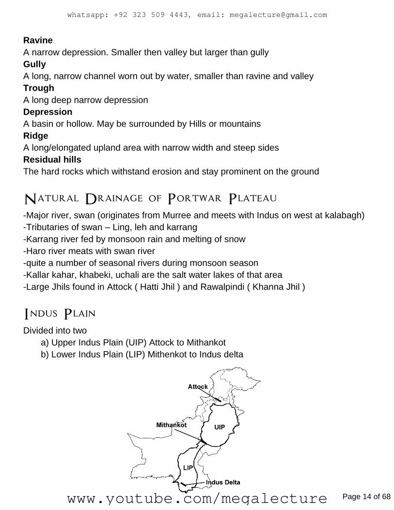
Indus Plain Divided into two
a) Upper Indus Plain (UIP) Attock to Mithankot
b) Lower Indus Plain (LIP) Mithenkot to Indus delta
whatsapp: +92 323 509 4443, email: [email protected]
www.youtube.com/megalecture Page 14 of 68

Natural topography of Upper Indus Plain -flat land
-few low hills
-Quartzite/slate hills
-thick soil (alluvium)
-Doabs. Sub features e.g Bluff/scarp, alluvial terrance/bar upland or bars
-Piedmont plains on foothills of Siwaliks between Jhelum and Chenab
-Active flood plains. Sub features
i) Levees
ii) Braided channels
iii) Dry channels
iv) Ox-bow lakes
v) Meanders
-Old flood plain. Sub features
i) Abandoned channels
ii) remains of ox-bow lakes
iii)Scars of meanders
Doab
Area between two rivers. Also termed as Scallop interfluves
Characteristics of bar
-Aka bar upland or alluvial terrace
-Highest part of doab
-nearly flat land
-has old alluvium Aka Banghar (local)
-height 10-12m from river level
-width 25-35km
Characteristics of bluff
-Scarp/cliff
-steep slope / steep wall separating OFP from bar
-Height 5-11m
-width 5-8m
www.megalecture.com
whatsapp: +92 323 509 4443, email: [email protected]
www.youtube.com/megalecture Page 15 of 68

A – Between Indus and Jhelum –Sind sagar doab / Thal desert – no bar
B – Between Jhelum and Chenab – Chaj doab – Kirana bar
C – Between Chenab and Ravi – Rachna doab – Sandal bar
D – Between Ravi and Sutlej – Bari Doab – Ganji and Nili Bars
Active flood plain
Narrow strip of land adjacent to rivers. Low lying area thus floods every year. Locally
known as Bet/khaddar.
Characteristics of Active flood plain
-Flat area
-Adjacent to rivers
-low lying area
-fresh alluvium
-2-3m above river level
-10-18km wide
-sub features
Old Flood plain
Aka meander of cover flood plain. Little Higher ground then AFP. Adjacent to AFP.
whatsapp: +92 323 509 4443, email: [email protected]
www.youtube.com/megalecture Page 16 of 68
Characteristics of Old Flood Plain
-10-15m height
-3-5miles width
-flooded every 7/8 years
-old alluvium Aka Bhangar (local)
-sub features
Natural Levees
French word meaning “Raised”. Found near river banks. Made up of river material
deposited during flood season.
Meanders
twisting and turning course of rivers. Usually found in middle and lower course of river.
Oxbow lake
crescent shaped lake. Formed by separation of loop from the main meandering course
of river.
Braided channels
Deposition of river material within the river channel shapes Bars/mounds.
Dry channels
come out from main river. Have water during flood season.
Abandoned channel
Aka “Dhoros” (local). Remains of river channels/ dried out river channels( used for
inland fishing).
remains of ox-bow lakes
dried out ox-bow lakes
Meander scars
Dried out meandering course of river.
Piedmont Plain
-Located on the foothills of mountains. Sub-feature is alluvial cone/fan
Alluvial fan
fan shaped/cone shaped deposit of gravel, sand and other small material on the
foothills of mountains.
www.megalecture.com
whatsapp: +92 323 509 4443, email: [email protected]
www.youtube.com/megalecture Page 17 of 68

Natural Topography of Lower Indus -Flat land
-gentle slope
-alluvium soil
-few low hills
-Limestone hills / custas
-rolling and dunes in arid part
-Delta
-AFP and OFP
-piedmont plains
-River indus on foothills of Suleiman and Kirthar ranges
Cuesta
-Aka escarpment
-Hard limestone ridges/rocks
-prominent on the ground
-one side steep slope (scarp) other side gentle slope (dip)
Location of cuestas in LIP
-Ganjo takkar, southwards from Hyderabad
-Rahri nears Rohri in Sukkur District
Delta
Depositional feature formed by river at the mouth of its course while draining into the
ocean/sea. Triangular shaped like birds feet Aka Lobate Shape Delta (indus delta)
Drainage of Upper Indus Plain -River Indus enters UIP at Attock
-River Indus flows with its eastern tributaries.
-Jhelum, Chenab, ravi, Sutlej meet at Panjnad. Panjnad to Indus
-Drains into Mithankot
-river Indus Width 1.4km
Drainage of Lower Indus Plain -Indus river flows alone – No tributaries -Width 1.6km
-Branches out into Distributaries -Mainly does work of Deposition
-Flows very slowly
whatsapp: +92 323 509 4443, email: [email protected]
www.youtube.com/megalecture Page 18 of 68

Deserts of Pakistan -Three Main deserts
a) Thal
b) Thar – Cholistan, Nara and Tharparkar
c) Kharan
-Types
i) Reg:- Stony deserts whose surface is hard and stones of different sizes are littered
ii) Erg:- Sandy desert. Features e.g sand and sand dunes e.g mainly Kharan
-Shapes of Sand dunes
i) Crescent
ii) Latitudinal and longitudinal
iii) transverse
www.megalecture.com
whatsapp: +92 323 509 4443, email: [email protected]
www.youtube.com/megalecture Page 19 of 68

Climate
Climatic zones of Pakistan
-Highland Climate zone
-Humid Climate zone
-Sub-humid Climate zone
-Arid climate zone
-Semi-arid climate zones
whatsapp: +92 323 509 4443, email: [email protected]
www.youtube.com/megalecture Page 20 of 68

Distribution
Highland Climate zone
-North and North western mountains e.g Himalaya, Karakoram and Hindu kush
-Western Mountains e.g koh-i-sofad, Waziristan, Suleiman and Kirthar.
-Highland areas of Baluchistan e.g Kalat, Quetta, Ziarat etc.
Characteristics of Climate
-Average low temp
-extremely low temp
-long winters
-precipitation mainly in shape of snow on high mountains
-Permanent snow on high mountain ranges
-cool weather in valleys
Northern mountains:- Winters- long, v cold (2oC to below -5oC)
Summers- short and mild (10oC to 20oC)
Western mountains:- Winters-cool to cold (9oC to -5oC)
Summers-mild to warm (10oC to 30oC)
www.megalecture.com
whatsapp: +92 323 509 4443, email: [email protected]
www.youtube.com/megalecture Page 21 of 68
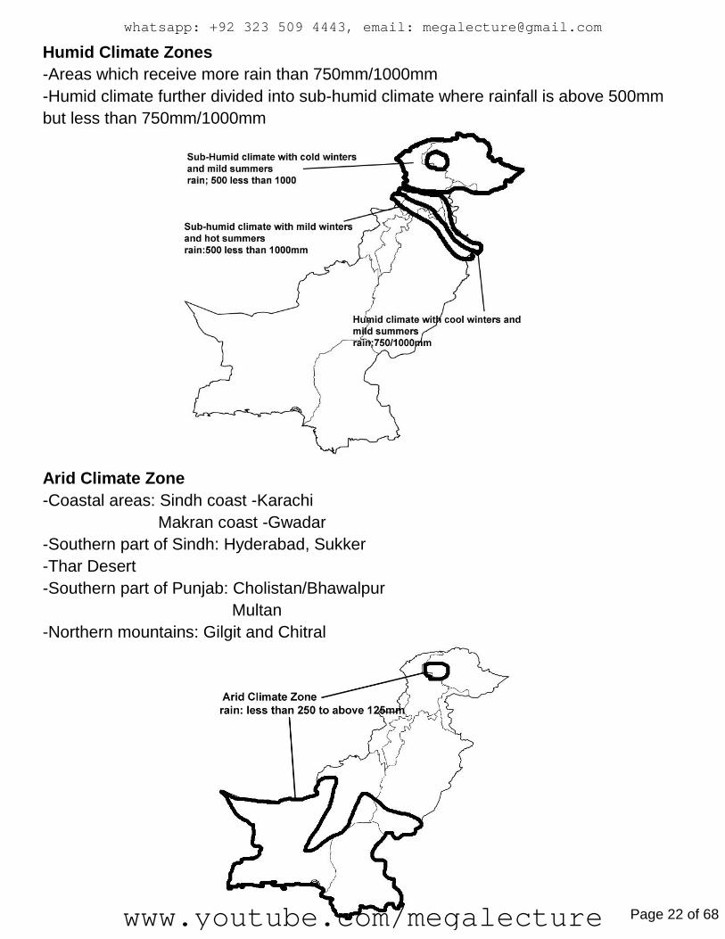
Humid Climate Zones
-Areas which receive more rain than 750mm/1000mm
-Humid climate further divided into sub-humid climate where rainfall is above 500mm
but less than 750mm/1000mm
Arid Climate Zone
-Coastal areas: Sindh coast -Karachi
Makran coast -Gwadar
-Southern part of Sindh: Hyderabad, Sukker
-Thar Desert
-Southern part of Punjab: Cholistan/Bhawalpur
Multan
-Northern mountains: Gilgit and Chitral
whatsapp: +92 323 509 4443, email: [email protected]
www.youtube.com/megalecture Page 22 of 68

Semi-Arid Climate zones
Rainfall in Pakistan Source of rain
-Monsoon rain (summer July to September)
-western Depression/winter rain (Winter December to March)
-Convectional rain/Thunderstorms (pre-monsoon (may-June) and post monsoon
(oct-nov) )
-Tropical Cyclone (Summer when sea/ocean water is warm)
www.megalecture.com
whatsapp: +92 323 509 4443, email: [email protected]
www.youtube.com/megalecture Page 23 of 68
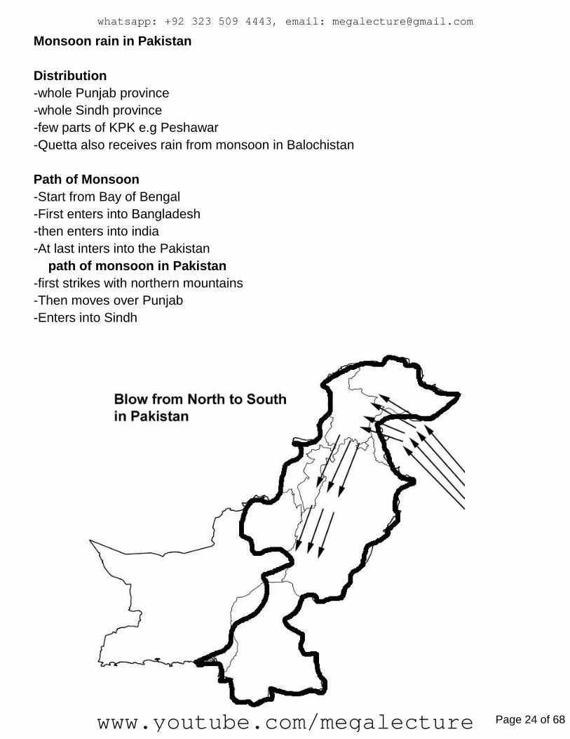
Monsoon rain in Pakistan
Distribution
-whole Punjab province
-whole Sindh province
-few parts of KPK e.g Peshawar
-Quetta also receives rain from monsoon in Balochistan
Path of Monsoon
-Start from Bay of Bengal
-First enters into Bangladesh
-then enters into india
-At last inters into the Pakistan
path of monsoon in Pakistan
-first strikes with northern mountains
-Then moves over Punjab
-Enters into Sindh
whatsapp: +92 323 509 4443, email: [email protected]
www.youtube.com/megalecture Page 24 of 68
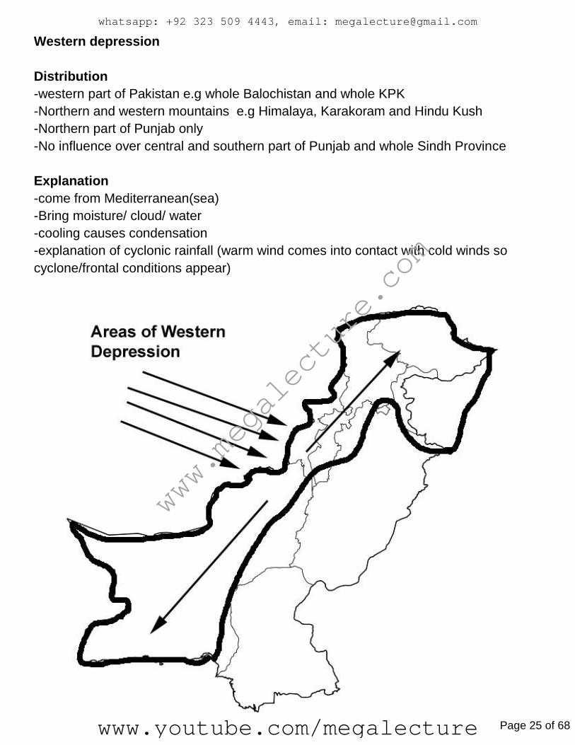
Western depression
Distribution
-western part of Pakistan e.g whole Balochistan and whole KPK
-Northern and western mountains e.g Himalaya, Karakoram and Hindu Kush
-Northern part of Punjab only
-No influence over central and southern part of Punjab and whole Sindh Province
Explanation
-come from Mediterranean(sea)
-Bring moisture/ cloud/ water
-cooling causes condensation
-explanation of cyclonic rainfall (warm wind comes into contact with cold winds so
cyclone/frontal conditions appear)
www.megalecture.com
whatsapp: +92 323 509 4443, email: [email protected]
www.youtube.com/megalecture Page 25 of 68

Convectional rain
Distribution
-Northern Mountains
-Northern part of Punjab
-some parts of KPK e.g Peshawar
-No thunderstorms/convectional rain in the southern part og Pakistan b/c of temp
inversion layer
Formation
-In summer, air/wind rise due to high temp
-rising of winds causes drop in temp wit height
-Drop in temp causes condensation process so rain takes place
tropical Cyclone
Distribution
-Develop in ocean or sea
-Coastal areas of Pakistan
-Makran Coast in Balochistan Province
-Sindh Coast in Sindh province
-Occasionally hit the coastal areas of Pakistan e.g Makran and Sindh coast
Relief rain explanation
-Moisture laden winds rise on the windward side
-rising causes drop in temp and causes condensation
-rain on windward side
-No/limited rain on other sad side Aka Leeward side
Timing of Floods in Pakistan:-In summer during July when Monsoon consides with
melting of snow
whatsapp: +92 323 509 4443, email: [email protected]
www.youtube.com/megalecture Page 26 of 68
Droughts
types and definitions
-Permanent Drought:- Occurs in desert e.g Thar, Thal, Kharan. Very low rainfall
throughout the year.
-Seasonal Drought:- Occurs in certain seasons where rain is not produced from source
-Invisible Drought:- Shortage of water surface and underground in an area. Not severe.
-Unpredictable Drought:- Occurs in Humid areas (good rainfall). Not severe.
-Meteorological Drought:- Occurs as a result of very long dry period of low rainfall.
-Agricultural Drought:- Insufficient water supply to grow crops. Shortage of rainfall,
Underground and surface water.
-Hydrological Drought:- Shortage of water supply in reservoirs, rivers, lake and
underground water on account of increased consumption rate/demand.
www.megalecture.com
whatsapp: +92 323 509 4443, email: [email protected]
www.youtube.com/megalecture Page 27 of 68
Development of
Water Resources River Indus
>starts from lake Mansarwar
>Two Tributaries:
Eastern: Jhelum, Chenab, Rabi and Sutlej
Western: Kabul, Kurram, Gomal
Imp:
>Gives water to dry areas (Southern Sindh, Southern Punjab)
>Generates HEP
>Regerates Soil Fertility
>Supports Fresh Water Fishing
>Provision of water for domestic and industrial purposes
Indus has a greater discharge rate than other rivers:
>Greater Length and Width
>Tributaries
>Glaciers of N.M Feed it
>Large catchment area
Why River Ravi has less discharge
>Less Length and Width
>Tributary of Indus
>Less Glaciers
>Small catchment are
>Indus Water Treaty
Reasons for less discharge in winter:
>Most precipitation is in snow
whatsapp: +92 323 509 4443, email: [email protected]
www.youtube.com/megalecture Page 28 of 68

^Extremely cold/low temperature so it doesn’t melt
>Pakistan is on the tail end of the Western Depression course
^…So only West and North receive Western Depression
How underground water is tapped:
Traditionally: Karez, Persian Wheel, Charsa, Shaduf, Open Wells
Modern Methods: Tube Wells
Importance of underground water:
>Household uses
>Industrial Uses (making soft drinks)
>Water for agriculture
>Supports fruit, crop, livestock farming in dry areas
>Supports commercial farming in Indus Plain
How it’s polluted:
>Toxic Industrial Waste
>Sewage + Industrial Waste from stagnant pools/ponds
>Excessive Fertilizer/Pesticide use can seep into the ground
>Mineral Waste can seep into the ground (if minerals aren’t properly dumped)
Uses of Water in Industries:
In Cotton Textileups
>Washing, Bluing, Cleaning, Bleaching, Dying, Printing
In Tanning Industry:
>Washing, Dying
In Food Processing Industry:
>Juices, Squashes, Syrups, Beverages
In Pharmaceutical Industry:
>Making Injections, Syrups, I.V Infusions
In Thermal Power Plants
>Heated to make steam to turn turbines
www.megalecture.com
whatsapp: +92 323 509 4443, email: [email protected]
www.youtube.com/megalecture Page 29 of 68

Irrigation Methods:
Why Pakistan Needs one:
>Low annual rainfall (less than 250mm)
>High evo-transpiration rate due to high temperatre
>High variability in the distribution of rain e.g: Monsoon is only in Eastern Pakistan,
Western Depression is in the West.
>High Variability in the amount of rain (North receives more than the South)
>Timing of the rain is invariable
Canal irrigation is easy when there is a presence of:
Natural:
>Flat open land, Soft thick soil,
>Presence of Indus and Tributaries makes building barrages (to divert and >control
water supply) easy,
>High amount of Monsoon rain fills reservoirs and rivers in summer, >Natural slope
makes movement in canals easy.Human:
>High demand of water for agriculture in Punjab, Sindh
>Many workers available at cheap rates in Punjab and Sindh
N.Mountains have a limited canal irrigation system:
>Steep slopes
>Low water supply due to cold
>Mostly small scale barani farmers
>Less Water Demand
>Terraced Fields present
Traditional Methods:
>Persian Wheel (cow plus wheels)
>Charsa (Donkey plus bucket on pole)
>Shaduf/Dhenkli (Human plus see saw with bucket on pole)
>Karez (Bigass underground structure)
Advantages/Disadvantages of Traditional Irrigation Method
+Easy, Cheap construction
+Zero running cost (No Fuel + Electricity)
+Local Raw Materials used
-Slow bec animal power
-Interrupted Water Supply
-Limited Water Supply
-Small area irrigated
whatsapp: +92 323 509 4443, email: [email protected]
www.youtube.com/megalecture Page 30 of 68

Separate Adv/Disadv of Karez:
+Suitable in dry areas where evaporation is high
+Supplies to farms/fields/orchards thus good in dry area
+Constant supply of water
+Cheap to construct (No machinery or raw material required)
+Can be shared by 500ish people
-Digging of Long Tunnels is hard
-Useless if underground sources are depleted (thus, limited supply)
-Needs constant cleaning from sand + dust
-Slow
Tubewell (Modern Underground irrigation method)
+Faster, saves time
+Gives constant supply of water
+Water is taken from a depth
+No animal/human power needed
+Supplies to a large area
+Less water logging and salinity (lowers water table)
+Supplies clean water
-Expensive
-Run by electricity or fuel
-Needs repair/maintenance
-Not suitable is areas where water table is already low
Modern Surface Irrigation Methods:
>Perennial Canals (Permanent, come from a dam/barrage, travel far)
^Supply controlled by storing in reservoirs, released by gates, penstocks generate HEP
and control flow, as do head works.
+Have water throughout the year
+Provide water during the dry season
+Support agriculture in all seasons (Rabi and Kharif)
+Have pressure
+Water can travel higher and further
+Supply can be controlled
-Unlined canals can cause water logging and salinity
-Expensive to build (long distance, dam and barrage joining)
-Siltation problem
-Desiltation is difficult
www.megalecture.com
whatsapp: +92 323 509 4443, email: [email protected]
www.youtube.com/megalecture Page 31 of 68

Traditional Surface Irrigation methods:
+Oldest Method still used
+Surplus Water is utilized during flood
-Only have water in flood/rainy season
-Can’t support commercial/large scale agriculture
-Rather short
-Can’t take water to high areas
Sprinklers:
+No leveling/shaping of land needed
+Can be applied to variable topography
+Suitable for most crops
+Flexible (heads available in many discharge capacities)
+Chemicals are easily applied
+Good in areas where soil erosion is high
+Water isn’t wasted
-Affected by wind
-High maintenance is needed
-System Failure is possible
-Installation is expensive
-Rice requires more supply of water than it provides
Drip Irrigation
Water is dripped slowly on the root zone of plants through tubes, pipes, emitters.
+Good for areas with less water
+Plants grow effectively
+Fertilizers can be used
+Easy to separate unwanted plants from growing
+Best for areas where soil erosion, water logging, evaporation problems
-Can get clogged
-Addition of salt in root zone can only be washed away by supportive irrigation
system/surface irrigation system,
-Initial cost is high
-Rice requires much more water than this provides
whatsapp: +92 323 509 4443, email: [email protected]
www.youtube.com/megalecture Page 32 of 68

WATER LOGGING:
Reaching of underground water close to sub surface soil or sometimes on a surface,
resulting in pools in the surface where crops can’t grow
>Stops availability of oxygen, making plant growth/production difficult
>Stops plants absorbing
SALINITY:
Thick layer of salt is left behind by evaporation of water which is reached on surface
due to high water table
>Clogs/Plugs roots. Making water extraction difficult
>Excessive amount of chloride and sodium accumulate in leaves
Causes:
>Unlined Canals
>Excessive seepage
>Poor farming techniques (Excessive irrigation where water table is high, poor leveling,
poor drainage, surplus of water, salt in water)
Effects on farmers:
>Land becomes waste land
>Livelihood of farmers is affected
>Poverty, Unemployment increased
>Rural Urban Migration
>Reclamation is costly
Controlling of this:
Waterlogging: >Canal Lining
> Proper farming techniques (leveling, drainage)
>Sinking Tubewells to lower water table
>Biological Drainage: (Plants that lower water table: Astonia)
>Canal Closure in areas of high water table
>Left Fallow system (Particular portion of land under
cultivation should be purposefully unutilized so seepage
may reduce)
SCARP = Salinity control and reclamation project
www.megalecture.com
whatsapp: +92 323 509 4443, email: [email protected]
www.youtube.com/megalecture Page 33 of 68
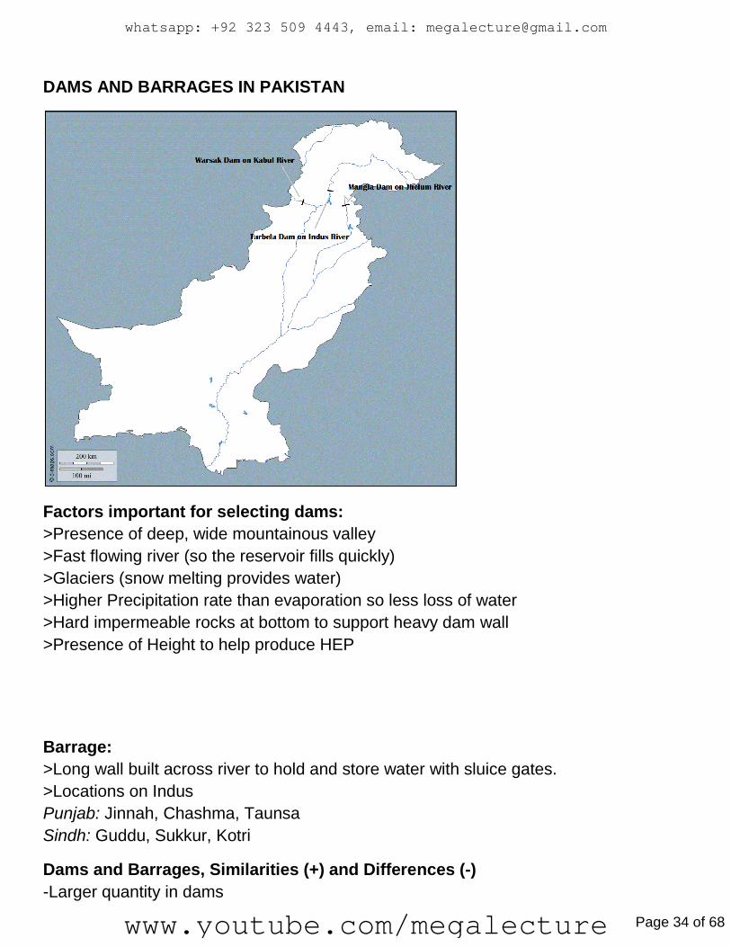
DAMS AND BARRAGES IN PAKISTAN
Factors important for selecting dams:
>Presence of deep, wide mountainous valley
>Fast flowing river (so the reservoir fills quickly)
>Glaciers (snow melting provides water)
>Higher Precipitation rate than evaporation so less loss of water
>Hard impermeable rocks at bottom to support heavy dam wall
>Presence of Height to help produce HEP
Barrage:
>Long wall built across river to hold and store water with sluice gates.
>Locations on Indus
Punjab: Jinnah, Chashma, Taunsa
Sindh: Guddu, Sukkur, Kotri
Dams and Barrages, Similarities (+) and Differences (-)
-Larger quantity in dams
whatsapp: +92 323 509 4443, email: [email protected]
www.youtube.com/megalecture Page 34 of 68
-Dams present on high mountains but barrages are present on plain areas
-Barrages provide crossing of river
-Dams produce HEP
+Both store water
+Both control floods
+Both provide water for irrigation, industries and domestic use
Comparison between large/small dams
-Large vs Small quantity
-Small dams rarely produce HEP
-Large dams irrigate vast areas
-Silting is a large problems in Large dams
-High maintenance cost in Large dams
-Long Construction time in Large dams
-More people displaced in Large dams
-Bigger impact on ecology of delta by Large dam
+Both store water
+Both control floods
+Both provide water for irrigation, industries and domestic use
Comparison between Barrages and Headworks
-Barrages built higher than river to serve as a reservoir and to control flood, but no
flood control in head works
-Headworks are built across river at same level just to divert and distribute water into
canals
-Barrages are wider and higher
+Both are constructed across river and have parallel gates
+Both divert and distribute water into perennial or link canals
Siltation:
Desposition of eroded material taken by rivers from mountainous course into river
channels, canals, barrages and dams.
Causes:
>High Erosion rate due to naturally steep slopes
>Deforestation means loose soil
>Absence of Silt Control policies, programs.
www.megalecture.com
whatsapp: +92 323 509 4443, email: [email protected]
www.youtube.com/megalecture Page 35 of 68

Effects:
>Reduction in water holding capacity
^Causes floods
^Affects HEP and Agriculture
^Weakening of foundation of dams
^Aquatic Weed and Algae Growth is stimulated
^Less recreational use (e.g: Boating)
^Degrades habitats for fish population
Controlling:
>Plantation on mountains to strengthen soil
>Installing silt traps before reservoirs
>Raising the height of the dam
>Lining of Canals (makes cleaning easier)
INDUS WATER TREATY
1960, Between Pakistan and India, with the World Bank as a mediator, Financial
assistance by Australia, Canada, USA, UK, W.Germany, New Zealand.
Pakistan got Indus, Jhelum, Chenab. India got Ravi, Sutlej, Beas.
Numerous dams, barrages, canals built with supervision from WAPDA
Reasons:
>Water Dispute began after demarcation of boundaries
>Head works of Pakistani canals went to India
>India threatened and stopped Pakistani water during border tension
>Thus necessary to:
^Save Pakistan’s agrarian economoy
^Avoid food crisis
^Prevent Large area of Punjab an Sindh converting to Desert (that area is Arid, Semi
Arid)
^To avoid conflict
It has lost importance:
>India has been ignoring clauses of it by initiating HEP projects in occupied Kashmir
on Indus River + tributaries
>India has a large population and growing energy need
whatsapp: +92 323 509 4443, email: [email protected]
www.youtube.com/megalecture Page 36 of 68
>Mega Projects like dams/barrages pays the way for India to claim Kashmir and Indus
System
>Pakistan hasn’t raised a violation at the right time on an international platform
>No discussion to make it acceptable to both with the passage of time and need
>Uncompromising attitude of both countries
Water Pollution
Causes: Dumping of Industrial, Solid, Sewage Waste. Usage of Chemicals
Effects:
>Underground water is contaminated, unfit for consumption (can cause intestinal
diseases).
>Unfit for agriculture (Chemical is transferred into human food).
>Affects Marine life (Thus human life).
>Extensive use of chemicals in agriculture stalemates the growth of algae, which
absorbs oxygen and marine life is affected (Eutrophication)
Control: >Strict rules on industries for disposal
>Awareness by education and realization of the importance of environment
>Installation of Treatment Plants in Industries
>Proper Dumping of Solid Waste
>Treatment of sewage waste
>Discouragement of excessive chemical use
Sustainable development of water:
>Awareness of water usage
>Lining of Canals
>Making of new reservoirs to store surplus flood water
>Minimizing Pollution of water
>Implementation of Strict Rules
>Sea Water use by desalination
www.megalecture.com
whatsapp: +92 323 509 4443, email: [email protected]
www.youtube.com/megalecture Page 37 of 68

Problems of water shortages:
>Less Crop production:
>Affects livestock aimals
>Industrial functions get affected
>Construction Industry affected bec making of plaster needs water
>Thermal power plants are the largest water consumers, so less electricity
>High temp companies need water to make silicon chips
>Decreased food intake, Nutrient absorption weaken Immune system
>Family members in rural areas may be forced to carry water over long distances,
causing deformities and problems
>Lack of cleanliness
>Personal Hygiene is neglected
Increasing Water supply in Pakistan/Fixing shortage of water
>New dams
>Collecting rainwater (underground tanks or large ponds)
>New canals to dry areas
>Treatment of polluted water
>Awareness for conserving water
>Education to farmers
>Lining of canals
>Plantation on floothills
Problems/Why Pakistan is facing a shortage of water.
>Low rain in Pakistan
>….Thus insufficient rainfall
>Rise in temperature means more evaporation
>Limited water supply in River Indus due to Indus water treaty 1960
>Limited number of dams, barrages
>Unlined Canals lead to more seepage or wastage
>Govt does not capital funds to upgrade existing system
>Growth of industries pollutes water, increases demand
>Siltation reduces water
>Some parts of Balochistan are too remote to irrigate
whatsapp: +92 323 509 4443, email: [email protected]
www.youtube.com/megalecture Page 38 of 68
Forests >4.8% of Pakistan is covered in Forests
>Productive: Natural Forests, of High density, Good commercial value bec timber
>Protection: Planted by man, Linear Plantation (Lines)> Found laong roads, parks
railways, low commercial value. Stop soul erosion, help control the environment
Mixed Forests: Many Trees species. 10% or more belong to one specie
Pure: One tree specie is dominant. 90% cover of one specie.
Importance:
>Raw Material
>Soil Erosion
>Lower temperature
>Shade
>Helps in rain (Transpiration)
>Clean the atmosphere (Oxygen)
>Increase Soil Fertility (Decomposition of leaves)
>Natural Habitat for animals
>Increases scenic beauty (hence tourism)
>Prevents desert forming (by preventing erosion)
>Provides employment (Forest Guards etc)
>Prevents floods
>Recharges underground water (absorption of water through roots)
Products of Forests in Pakistan:
Main:
Firewood.
Timber: Construction, Furniture, Pulp, Sports Goods
Minor:
Resin: Varnishes
Mazri: Baskets, Mats, Packing purposes
Ephedra: Medication
www.megalecture.com
whatsapp: +92 323 509 4443, email: [email protected]
www.youtube.com/megalecture Page 39 of 68

Deforestation:
>To grow crops
>Exploitation of minerals
>Making Infrastructure
>For building dams, bridges
>Urbanization
>Overgrazing
>Firewood
Effects:
>No roots to hold soil = Soil Erosion
>No leaves to intercept rain = Less nutrients for agriculture
>Siltation (Less water in resoirvers and dams) (Less production of HEP, Irrigation)
>More floods (=Destruction. Life loss, Crop loss, Livestock lost, infrastructure
damaged)
>Silt is deposited on farmland, more silt hence nutrients (Positive)
>Less transpiration = Less rainfall = Less barani yield
>Loss of natural habitat
>Shortage of Feul Wood, Timber or wood industry (More timber import)
>People may have to move
>Air Pollution (Less O2)
>More landslide
Solutions:
>Selective Cutting
>Heavy machinery only in forests (saves small plants)
>More Reforestation
>Land should be reserve for feul wood (So timber wood isn’t use for feul)
>Forestation on hill slopes (Terracing, Contour Ploughing, Strip Farming)
…which will reduce Soil Erision, Silting, Flooding
>Increasing Forest awareness (NGO’s, etc)
>Supply of N.Gas in N. Mountains
>Nurseries for more plants
>Forest Laws strictly implemented
whatsapp: +92 323 509 4443, email: [email protected]
www.youtube.com/megalecture Page 40 of 68

Forest Types:
1) Coniferous Forests:
>Evergreen, Conical (Sloping branches to shed snow)
..Needle shaped leaves, Thick Leathery Leaves (Less transpiration)
..Thick Bark (Tolerates Cold)
..Shallow roots (Absorbs water from melting snow)
.>Found between 1000 and 4000m of height from sea level.
Main Areas: The North (Gilgit Baltistan), Abbotabad, Murree, Mansera, Quetta
Importance: Timber (wood industries, construction, furniture)
Floods reduced (water supply regulated)
Roots hold soil (Less erosion)
Scenic Beauty (Promotes Tourism)
Reduce Air Pollution (Oxygen)
2) Alpine
>Stunted Growth
>Roots spread sideways (More Nutrients)
>Upward Branches (More sunlight)
>Above 4000m sea land
Main Areas: N.Areas. Mountains
Importance: Fuel Wood
3) Bela
>Planted by men (Protective Forests)
>Linear, Equally spaced
>Same specie/size/height
Main Areas: N.Areas+Mountains
Importance: Reduce Temperature (through transpiration)
Reduce Erosion of Banks
Give Shade
Reduces Air Pollution (Oxygen)
Reduces Erosion of Banks
Reduces Flooding
4) Mangroves
>Broad Leaves, More Sunlight
>Leathery Leaves (Reduce Transpiration)
>Survives in salty waters (Roots, Filter Salts, Leaves excrete extra soil)
www.megalecture.com
whatsapp: +92 323 509 4443, email: [email protected]
www.youtube.com/megalecture Page 41 of 68
>Found at sea level
Main Areas: Deltas, Indus and Hab.
Importance: >Timber for boat making, and house making
> Leaves (Food for livestock)
> Holds soil (Prevents coastal soil erosion)
> Protection (No tsunamis as they absorb shock waves)
(Prevents Cyclones)
>Habitat for wild life (Importance for Fish Industry)
(Breeding Ground, Predator Protection for Fish, plankton as food)
5) Tropical/Sub Tropical Dry Forests
>Small/Medium Height
>Rounded Bushes
>Hardwood
>Deciduous (sheds in Autumn)
Main Areas: UIP, LIP, Sindh Plain, Thar+Kharan deserts, Potwar Plateur
Importance: Protection from flooding (regulates water supply)
Fire/Fuel wood for cooking + heating
Leaves eaten by livestock
Shades
Reduces Air Pollution (Provides O2)
6) Irrigated Forests (Same as Bela)
>Man Planted
>Linear
>Equally spaced
>Same Specie
>Same Height
>Regular Water Supply
Main Areas: Thal, Bhawalpur, Changa Manga, Chicha Watni (Sahiwl),
Guddu, Taunsa barrage
Importance: Tourism
Wood for railway
Firewood for domestic uses
>Pakistan needs more of this (Growing Population)
>In wood based Industry (Helps reduce import of Timber)
^e.g: Furniture, Sports good, Paper
>Compensation for deforestation
whatsapp: +92 323 509 4443, email: [email protected]
www.youtube.com/megalecture Page 42 of 68

>Refuces Water logging
>Prevents Soil Erosion in Banks
Why irrigation is necessary for new plantation of trees:
>Low rainfall (Seasonal, High evo transpiration, Irregular thus undependable)
>Roots need water
www.megalecture.com
whatsapp: +92 323 509 4443, email: [email protected]
www.youtube.com/megalecture Page 43 of 68
Mineral Resources
Non-metallic minerals in Pakistan
-rock salt
-Limestone
-Gypsum
-coal
Main metallic materials in Pakistan
-Copper
-Chromite
Mining methods
-Open cast/pit mining:- Applied when seam/layer is close to surface. Upper layer of
earth removed. Minerals extracted by power shovels, excavation or blasts.
-Adit/dift mineral:- Applied when mineral seam/layer is found along the slop or hill of
mountain. The main opening or the tunnel is made at horizontal direction to access
minerals.
-Shaft Mining:- Applied when layer/seam is found deep underground. The tunnel is
made at vertical direction to access mineral. Elevators used.
-Quarrying:- same as open-cast. Adopted to extract limestone or building materials.
Distribution
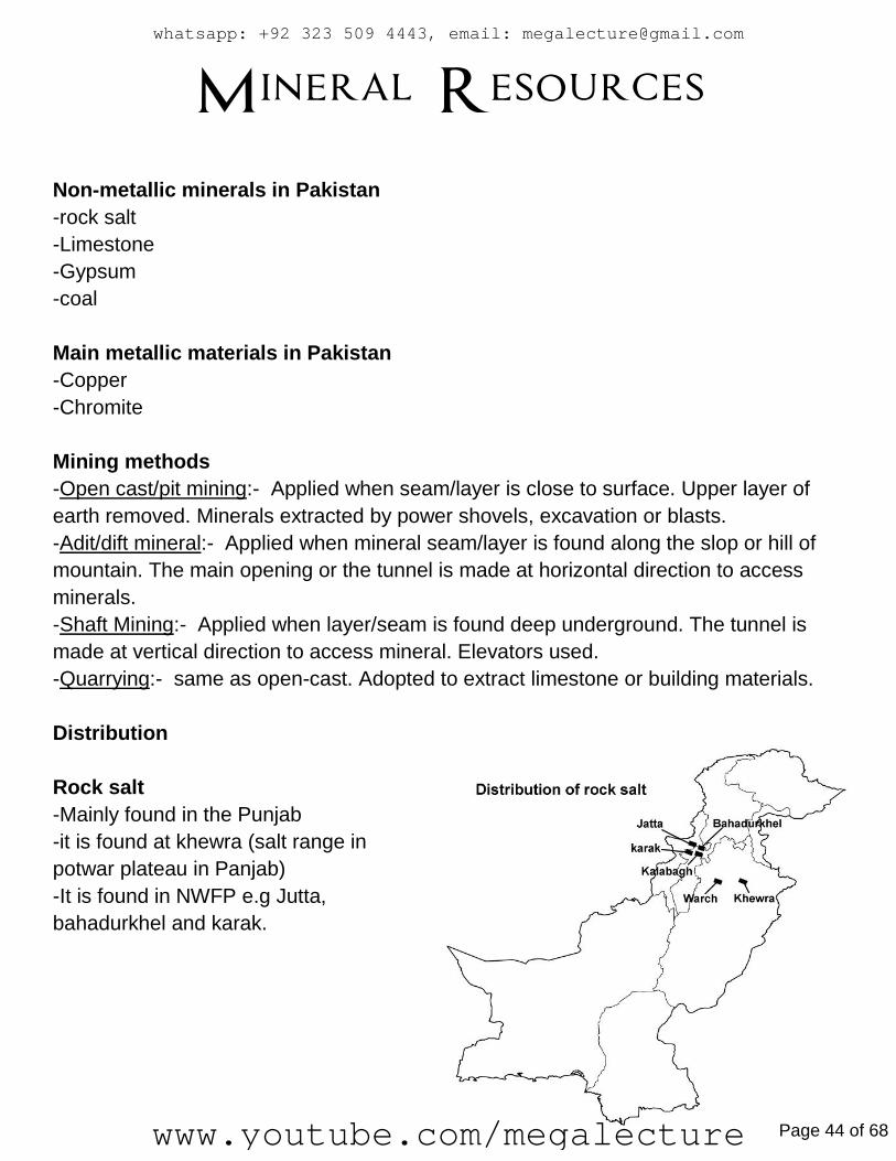
Rock salt
-Mainly found in the Punjab
-it is found at khewra (salt range in
potwar plateau in Panjab)
-It is found in NWFP e.g Jutta,
bahadurkhel and karak.
whatsapp: +92 323 509 4443, email: [email protected]
www.youtube.com/megalecture Page 44 of 68
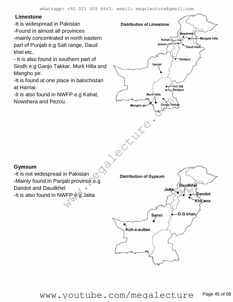
Limestone
-It is widespread in Pakistan
-Found in almost all provinces
-mainly concentrated in north eastern
part of Punjab e.g Satl range, Daud
khel etc.
- It is also found in southern part of
Sindh e.g Ganjo Takkar, Murli Hilla and
Mangho pir.
-It is found at one place in balochistan
at Harnai.
-It is also found in NWFP e.g Kahat,
Nowshera and Pezou.
Gymsum
-It is not widespread in Pakistan
-Mainly found In Panjab province e.g
Dandot and Daudkhel
-It is also found in NWFP e.g Jatta
www.megalecture.com
whatsapp: +92 323 509 4443, email: [email protected]
www.youtube.com/megalecture Page 45 of 68

Uses
Rock salt
-cooking
-preservation
-Use in chemical industry eng Soda Ash, Bicarbonate of soda
-Textile industry e.g dying, bleaching
-making artificial rubber
-for melting of snow
-in Fire extinguishers
Limestone
-Making cement
-paper, glass soap
-removing dirt from sugar mills
-Used in steel mills for smelting process
-Used in rubber industry to give shape to rubbers in molds
-For treatment of waste and drinking water
-Painted on tree trunk to save from pests
-Lining of canals
-Poultry feed
-for reducing soil acidity and increase soil alkalinity
Gypsum
-cement
-paints
-fertilizers
-reduce soil acidity
-prevents water logging
-prime ingredient for toothpaste
whatsapp: +92 323 509 4443, email: [email protected]
www.youtube.com/megalecture Page 46 of 68

Fishing >Oldest Occupation in the world
>Important for people living near coast lines
>1000km coast line. 750 of Baluchistan, 250 for Sindh
Uses:
>Healthy
>Waste makes fertilizer and poultry feed
>Extracted oil is a medicine
>Income for fishermen
Marine Fishing:
>Fishing done in the oceans/seas.
>Karachi and Gwadar are the only developed ports
Commercial fishing is only done in Karachi and Gwadar.
Landing Site: Site on coastal area where fish is dumped/landed/placed
In Balochistan: Damb, Gaddani, Jiwani, Ormara, Pishukan, Surbandar
www.megalecture.com
whatsapp: +92 323 509 4443, email: [email protected]
www.youtube.com/megalecture Page 47 of 68

Fishing methods in commercial marine fishing:
Boats: Big Trawlers, large ships, proper cold storage, Radio, GPS
Powerful engines (can go off coast), Lots of Fuel,
Nets: Gillnets (nets that set like a fence that fish swim into like Spongebob)
Nylon Nets, Strong nets, Good mesh size (young fish can escape)
Storage: Cold storage on ports and boats, Salted fish to preserve, Plastic
Baskets that can be cleaned
Fishing Methods in subsistence Fishing
Boats: Small wooden, can’t go farther than 5km, cant stay long/go deep
No cold storage, no high fuel capacity, no GPS,
Nets: Tradition nets, small mesh size so very young fish can escape
(Known as Guju, Katra)
Storage: Straw Baskets that make storage unhygienic (cant be cleaned
properly), Salted, Sun dried. Ice is put into baskets for storage.
Sindh Coast has a 70% Catch (30% in Makran)
>Sindh has larger continental shelf
(A continental shelf is a shallow water area which allws oxygen and sun rays to
circulate freely in the water helping growth of plankton/fish food)
Types of Fish in the Sindh Coast:
>Crab, Lobster, Prawns, Sardines, Sharks
Types of Fish in Makran:
>Herring, Indian Mackerel, Sardine, Shark, Seacat, Hairtail, Small craoker,
Tuna (Most sought after)
Inland Fish species:
>Manaseer, Palla, Thala, Rahu, Trout, Crap
Inland Fish Farms species:
>Moore, Rahu, tallah, Manaseer, Palla, Trout, Carp
More workforce in inland fishing:
>Large Population in Punjab and Sindh (Abundant and cheap labour)
whatsapp: +92 323 509 4443, email: [email protected]
www.youtube.com/megalecture Page 48 of 68

>Govt Encouragement/Loans
>Hatcheries are necessary
Fish Processing processes:
>Gutting, Canning, Drying, Salted, Oil extracted….
Value Added/Processed/Packed products:
>Fish Finger, Cod Liver Oil, Gutted Fish, Frozen Fish, Tin/canned fish
Fish breeding months: June and July.
Inland Fishing Areas:
>Punjab: Man made ponds near rivers, canals
>Sindh: River Indus (Sukkur, Kotri and Thatta) lakes (Kairi, Halegi, Manchur)
>NWFP: Near Rivers and Canals (Kabul) Dams (warsak)
Inland Fish Farms:
>Man Made, Ponds dug to keep and breed fishies
>Natural Lakes (aka Tobas) used as farms in Sindh
>Long thin rectangles, present in grid patterns (to separate species)
>Raised embankments made by mud to separate ponds
>Lined with bricks or cement, (Less seepage)
>Lined with Trees (Less evaporation)
Methods:
>Ponds half filled with insects
>Eggs hatched or small fishes brought in (Different specie in each pond)
>Food given regularly (e.g poultry waste)
>Health checked
>Water level checked
>Fish transferred b/w ponds by size for providing space, oxygen, food.
>Fully matured Fish caught by nets and delivered to markets
Favorable factors
Impervious soft soil, underground rivers for clean water, low evaporation
Flat land, large open lands
Dense population or labour, road network, capital, demand, canals, hatcheries.
www.megalecture.com
whatsapp: +92 323 509 4443, email: [email protected]
www.youtube.com/megalecture Page 49 of 68

ADV of Fish Industry:
>Earning of foreign exchange by exporting fish
>Employment generated (Fishermen, Fish dealers, Packing, Processing)
>Healthy food is available
>Infrastructure developed
>Acquiring of new technology/methods (engines, machines, radar, GPS)
>Growth of other industries (Boat making, net making, processing,
Packing)
>Fish farms give quick profit in 3-4 months
>No pest, disease danger
>Cheap Inputs in fish farming
disADV of Fish Industry:
>Not enough skilled workers
>Expensive to lay down roads, Railway, Electricity, Technology
>New technology is expensive (radar System, Satellites, GPS, Sonar)
>Higher chances of overfishing
>More Rural to Urban Migration
>Water Pollution (e.g: Dumping of unwanted dead fish species)
>New Infrastructure needs capital
>Loadshedding
>No Fishing in breeding season
>Sustainability is hard
whatsapp: +92 323 509 4443, email: [email protected]
www.youtube.com/megalecture Page 50 of 68

Agriculture
Types:
>Arable >Pastoral >Mixed
Barani Crops:
>Wheat, Millet, Pulses, Oil Seeds, Maizes
Areas: Potwar Plateau, Pindi, Attock
Irrigated Farmland:
>Wheat, Sugarcane, Rice, Cotton
Areas: Upper and Lower Indus Plain
Cropping Season:
Rabi/Winter: Wheat, Barley, Grams.
Kharif: Rice, Cotton, Sugarcane, Maize, Millet.
Wheat:
….Indus Plain, Punjab and Nawabshah
….Important as a staple food of Pakistan
Requires:
>Warm Temperatures (10-20 while sowing) (25-30 harvesting)
>325m – 625m Rainfall
>Loamy Soil (Flat/well drained)
>Oct-Nov rain is helpful
>Dry Harvesting Season
Method:
>Fields Ploughed
>Seeded in Oct/Nov
>Irrigation:
…One month after sowing
…One month before harvest
www.megalecture.com
whatsapp: +92 323 509 4443, email: [email protected]
www.youtube.com/megalecture Page 51 of 68

>Fertilizer and Nutrients added
>Early Summer Harvest
>Threshing, then transportation.
Byproduct: Chaff (Used in Animal Feed, Mudhouses)
Rice:
….Larkhana, Gujranwala, Sheikhupura, Sialkot
Requirements:
>Hot Temperature 25-35.
>Warm/Dry period for harvesting
>Loamy/Clay/Alluvium/Flatland
>11270 – 2000m rainfall.
Method:
>Seed Nursery/Repairing Bunds
>Fields prepared. Weeding/Flooding/Irrigating
>Seedlings are transported
>Fertilizers, Pesticides
>Water Drained before harvesting
>Harvested in Dry and Warm Conditions
Byproduct: Husk (Used or Animal Feed, Chipboards)
Cotton:
….Nawabshah, Bhawalpur, Bhawalnayar, Rahimyar Khan.
Requires:
>Hot Temperatures 25-35
>Dry Summer for Harvesting
>Alluvia + Deep Spoil
>Flatland
>1000m Baarish
whatsapp: +92 323 509 4443, email: [email protected]
www.youtube.com/megalecture Page 52 of 68
Method:
>Sowing of Seeds in April – May
>Irrigation:
…One month after sowing
…Two months after first irrigation
>Fertilizers and Pesticides applied
>Weeding, Picking.
>Transportation, then separating seeds from lint.
Byproduct: Seeds (Used as Animal Feed, Oil extracted)
Sugarcane:
…Nawabshah, Peshawar, Badeen, Faisalabad
Requires:
>High Temperatures (25-30)
>Dry Harvesting Time
>Alluvial Soill + Flatland + Deep
>1520mm rain
>Lotsa sunshine
>Well Drained Land
Method:
>Fieleds prepared by ploughing and irrigating
>Stalks buried underground
>Fertilizer/Pesticides
>Regular Irrigation + Weeding
>Top Parts harvested
…
>Quickly taken to factories, washed, scrubbed
>Crushed (for juice) Refined, Crystallized into Sugar.
Byproducts: Mollasses (Chemical Industry, Ethelyne)
Bogasses ka Chilka. (Feul for mills and clipboards)
www.megalecture.com
whatsapp: +92 323 509 4443, email: [email protected]
www.youtube.com/megalecture Page 53 of 68

Minor Crops:
Maize:
….Mardan, Swat.
Requires: Alluvial Soil + Flatland
Uses: Edible Oil, Animal Feed.
Pulses:
….Thar, Pindi
Requires: Alluvial Soil, Flatland, Irrigation
Oil Seeds:
…Sialkot, Nawabshah
Requires: Alluvial Soil + Flatland + Irrigation + Rainfall+ 15< Temps always
Millets:
…Thar, Pindi.
Requires: Grows on poorer soils, flat land, is drought resistant.
Uses: Animal Feed
Tobacco
…Mardan,Peshawar
Uses: Exported. Chemical Fertilizers.
Fruit Farms
Temperate Fruits.
>Apples, Apricots, Almonds.
…>N. Balochistan , Swat, Hunza
…..^(Masbung, Pishin, Baltistan)
Because: Sunshine, Warmth, Flatland at the valley floors, rain.
whatsapp: +92 323 509 4443, email: [email protected]
www.youtube.com/megalecture Page 54 of 68

Tropical Fruits.
>Bananas, Mangoes, Citrus Fruits.
…>N. Sindh and N. Punjab.
….Bec: Irrigation from River Indus, LIP flat land, Alluvial Soil,
Temps above even In winter, Monsoon Summer rain.
Date
…Khawar, Thar, Turban.
Because: Sunshine, Soil, Flatland, Irrigation through Karez.
Imp: Food, Shelter from strong wind, shade from intense desert heat.
Animals:
>BUFFALO:
Imp: Milk, Meat, Darft Animal, Hides, Leather Industry, Dung as Manure,
Fertilizer and Fuel,
Locations: Bhawalpur, Multan and Thang.
Cows -> Cows -> Milk
-> Buffalo -> Prestige/Pride
Goats & Sheeps:
Imp: Wool, Meat (preferred), Hides Tanning, Dung, Fertilizer, Sure
Footed.
Poultry:
Imp: Eggs, Meat.
Farming: Hens kept in sheds.
…Eggs hatched in Hatcheries.
…Small Chickens transferred to sheds, fed, vaccinated
…when old, of certain weight, transported to market for sale.
www.megalecture.com
whatsapp: +92 323 509 4443, email: [email protected]
www.youtube.com/megalecture Page 55 of 68

Power Resources Different Power resources/Extraction methods.
-Coal:- Open cast/pit mining
Shaft mining
Adit/drift mining
-Mineral oil/crude oil/ petroleum:- Derrick/Oil rig
Christmas tree
Nodding Donkey
-Natural gas:-same extraction methods as Oil.
Power Generating plants.
-Thermal power plants
-Nuclear power plants
Renewable energy/ Power resources and Collecting methods
-Hydro-Electric Power(HEP):- Dams (most common)
-Solar energy:- Solar panels
-Wind power:- windmills (not common in Pakistan)
-Geothermal power:- (not present)
-Wave Power/Energy:- (totally absent)
-Tidal energy/power:- (not present)
-Biomass energy
-Biogas
-Biofuel
whatsapp: +92 323 509 4443, email: [email protected]
www.youtube.com/megalecture Page 56 of 68

Coal
Types (starting from best quality/highest carbon content/lowest water and sulfur mixed)
-Anthracite
-Bituminous (Bituminous+highly intence heat=coking coal)
-Lignite
-Peat
www.megalecture.com
whatsapp: +92 323 509 4443, email: [email protected]
www.youtube.com/megalecture Page 57 of 68

Natural Gas
www.megalecture.com
whatsapp: +92 323 509 4443, email: [email protected]
www.youtube.com/megalecture Page 59 of 68

HEP DAMS
Major/multipurpose dams in Pakistan
- Mangla Dam on River Jhelum
- Tarbela Dam on river Indus
- Warsak Dam on River Kabul
Small dams in Pakistan
- Gomal zam Dam on Gomal river in KPK
- Hub Dam on Hub river in Balochistan
- Khanpur dam on the Haro River in KPK
- Mirani Dam on the Dasht river in Balochistan
Nuclear power plants
Distribution/Location
- Karachi Nuclear power plant/ KANPP
- Chasma Nuclear power plant 1 near Mianwali in Punjab
- Chasma Nuclear power plant 2 near Khushab in punjab
whatsapp: +92 323 509 4443, email: [email protected]
www.youtube.com/megalecture Page 60 of 68
Trade Gross Domestic Product:
Total Value of goods produced and services provided in a country during one year.
Gross National Product:
Total Value of goods and services provided by the citizens either living in a country or
outside of a country.
Differences:
>Inside/Outside difference
>GDP is best for seeing country’s local economy’s strength, GNP is best for seeing
how well nationals are doing economically
>GDP is preferred
>GDP can highlight role and contribution of an enonomic sector in economy (e.g:
Agriculture)
Similarities:
>Both get total market/monetary value of goods and services in a country
Visible Trade: Tangible. Import/Export of Goods
Invisible Trade: Untangibe. Import/Export of a service
Pakistan Export Trend:
…Gradually shifting from raw materials to manufactured goods (Thanks to Green
Revolution, Industry growth)
Pakistan Import Trend:
…Gradually shifting from manufactured goods to raw materials
Trading Partners of Pakistan:
(imports/exports of Pakistan)
USA:
Imports: Machinery (Agricultural, Mining etc), Wheat, Vegetable Oil
Exports: Carpets, Rugs, Surgical Instruments, Sports Goods
www.megalecture.com
whatsapp: +92 323 509 4443, email: [email protected]
www.youtube.com/megalecture Page 61 of 68
GERMANY:
Imports: Machinery, Electrical Appliances
Exports: Carpets, Rugs, Surgical Instruments, Sports Goods, Cotton Cloth
UK:
Imports: Machinery, Electrical Appliances, Fertilizer
Exports: Carpets, Rugs, Surgical Instruments, Sports Goods, Raw Cotton,
Fruits
SAUDIA, UAE:
Imports: Mineral Oil, Petroleum
Exports: Spices, Rices, Readymade Garmets
JAPAN:
Imports: Machinery, Electrical Appliances:
Exports: Fish + Fish products
SRI LANKA:
Imports: Tea
Exports: Fish +Fish Products, Military Hardware
Only positive balance of trade of Pakistan is with Sri Lanka.
WHY DO FOREIGN TRADE EVEN ??
>Stimulates Economic Activity
>Economy of scale is achieved
>Employment (Industries grow, ports)
>Allows specialization of goods (Like Pakistan’s sports goods industry)
>Domestic Resources are utilized (e.g: Our Agricultural Resources)
>Exports earn F.E
>Flow of IT (Development of IT resources. Encouraged by trade)
>GDP improved
>Value added products are exported
>Foreign Exchange can be used to buy imports
>Less loans
whatsapp: +92 323 509 4443, email: [email protected]
www.youtube.com/megalecture Page 62 of 68
Trade Routes of Pakistan:
Land: With India on the East.
Afghanistan on the N.W (Bolan, Khyber Pass)
China, on the North (Khunjerab Pass KKH)
Iran, on the S.W (RCD highway – isn’t well maintained)
SEA PORTS OF PAKISTAN
>Port of Karachi
>Port bin Qasim
>Port Gwadar
Balance of trade is the difference between visible imports and visible exports. A negative balance of trade means more goods are imported than exported Balance of payments is the difference between (visible and invisible imports) and (visible and invisible exports).
WAYS OF EARNING FOREIGN EXCHANGE Hidden earnings
Remittances
Export of goods SEA PORT FACILITIES:
Fire extinguishers Coast Guard Docks for maintenance of ships
Passenger lounges
Re-fuelling of ships
Warehouses
Offices
Water, Communication and Transport facilities
Quarantine and Storm-Shelter Area
www.megalecture.com
whatsapp: +92 323 509 4443, email: [email protected]
www.youtube.com/megalecture Page 63 of 68
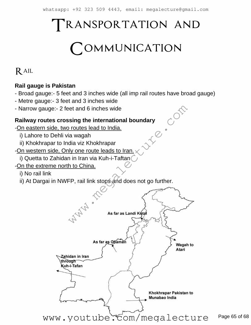
Transportation and
Communication
Rail
Rail gauge is Pakistan
- Broad gauge:- 5 feet and 3 inches wide (all imp rail routes have broad gauge)
- Metre gauge:- 3 feet and 3 inches wide
- Narrow gauge:- 2 feet and 6 inches wide
Railway routes crossing the international boundary
-On eastern side, two routes lead to India.
i) Lahore to Dehli via wagah
ii) Khokhrapar to India viz Khokhrapar
-On western side, Only one route leads to Iran.
i) Quetta to Zahidan in Iran via Kuh-i-Taftan
-On the extreme north to China.
i) No rail link
ii) At Dargai in NWFP, rail link stops and does not go further.
www.megalecture.com
whatsapp: +92 323 509 4443, email: [email protected]
www.youtube.com/megalecture Page 65 of 68

Road
Motorways/highways
-Makran Coastal highway:- Karachi - Gwadar
-N5 (national Highway):- Karachi-Hyderabad-Multan-Faislabad-Lahore-Islamabad-
Peshawar
-GTR (grand trunk road):- Lahore-Islamabad-Peshawar
-Karakoram Highway (through Khunjerab pass):- Tibet(china) to Pakistan
-Indus Highway (N-55):- Karachi – Peshawar
whatsapp: +92 323 509 4443, email: [email protected]
www.youtube.com/megalecture Page 66 of 68

Sea Ports
Telecommunication
Sources
-Phones e.g Land line, mobile, wireless, satellite etc.
-fax
-radio nd TV
-Internet e.g e-mail, video conferencing, websites etc.
www.megalecture.com
whatsapp: +92 323 509 4443, email: [email protected]
www.youtube.com/megalecture Page 67 of 68

Population Population Population is the number of people living in a specified area
Terms: >Birth rate : The average number of births per thousand people
>Death rate : The average number of deaths per thousand people
>Rate of natural increase = Birth rate (minus) Death rate
>Overpopulation : When an area’s population is too large to be supported by its available resources like
wealth, food, fresh water and land
>Demographic transitional model : Graphs suggesting sequence of change in relationships between birth and
death rates over a period of time
>Population structures: It is the percentage of males and females in different age groups. Depends on the
population’s birth and death rates and life expectancy of a particular area. It is divided into age groups for both
males and females
>Population pyramids: It is the graphical representation of population structures
whatsapp: +92 323 509 4443, email: [email protected]
www.youtube.com/megalecture Page 68 of 68