General Wetlands Information - LSU AgCenter89611EF1-C5E8-431E-9D3… · General Wetlands...
22
General Wetlands Information 14
-
Upload
phungthien -
Category
Documents
-
view
215 -
download
0
Transcript of General Wetlands Information - LSU AgCenter89611EF1-C5E8-431E-9D3… · General Wetlands...
GeneralWetlands
Information
14
LSU AgCenter • 4-H Youth Wetlands Program • 2013
General Wetlands Information
What is a Wetland? Official Definition
Wetlands are "those areas that are inundated or saturated by surface or ground water at
a frequency and duration sufficient to support and (that) under normal circumstances do
support a prevalence of vegetation typically adapted for life in saturated soil
conditions." (Official Army Corp of Engineers definition of a wetland, according to the
Clean Water Act)
Transitional lands between dry land and deep water where the water table is at or near the
surface of the land, periodically covered by shallow water.
Has three specific attributes:
Hydrophytic vegetation – water-loving plants
Hydric soils – waterlogged soils
Soils having little to no oxygen because they are saturated with water
Soils are periodically or continually saturated.
Temporarily wet = one to four months a year
Seasonally wet = four to 11 months a year
Continually Wet > 11 months
Hydrology – high water table
In essence – a “wet land”
Water is the dominant factor controlling the nature of the soil, and thus the types of
plants and animals living in and on the soil.
Why Are Wetlands Important? 1. Shoreline and Flood Protection
Shoreline Protection
o Protect shoreline from erosion by acting as a buffer against wave actions.
o Coastal wetlands are the frontline defense against incoming storms. They help
minimize the impact of storms by reducing wind action, wave action and currents,
while the roots of the plants help to hold the sediment in place.
Slow surging floodwater
o Reduce flood damage by slowing down floodwaters and act as a buffer against
storm surge.
o Wetlands act as sponges by absorbing floodwater and then allowing that excess
water to move gradually downstream (thus reducing damage to homes and
property).
o Store snow melt, rainfall and excess runoff.
15

LSU AgCenter • 4-H Youth Wetlands Program • 2013
2. Water Purification
As water flow slows through a marsh, sediment and nutrients (nitrogen, phosphorus, etc.)
settle to the wetland floor. Marsh plants can use excess nutrients for growth; otherwise,
these nutrients would pollute surface waters.
The ability of wetlands to recycle nutrients and pollutants makes them critical in improving
water quality. No other ecosystem is as productive or as unique in this conversion process.
Act as kidneys of the ecosystem because they are capable of filtering pollutants such as
fecal coliforms from raw sewage, excess nutrients from fertilizer runoff (nitrogen and
phosphorus) and heavy metals from industrial waste.
3. Groundwater Recharge
Serve as a link between surface water and underground drinking water.
Recharge groundwater aquifers – which supply half of the U.S. drinking water.
4. Wildlife Habitat and Nursery Area
More than 400 species of fish and birds are dependent on wetlands for their survival.
Up to 43 percent of endangered species use wetlands for habitat for part or all of their lives.
Provide habitat for 75 to 90 percent of the nation’s commercial fish and shellfish.
5. Recreation
Recreational fishing involves more than 45 million people in the United States, and they
spend $24 billion annually on this hobby.
Wetlands also have great potential for tourism, since people enjoy hiking, boating, water
sports, swimming, photography and bird watching in wetland landscapes and spend up to
$98 million on their hobbies annually.
In Canada, Mexico and the United States, more than 60 million people watch migratory
birds as a hobby, and 3.2 million people hunt ducks, geese and other game birds.
Collectively they generate more than $20 billion annually in economic activity.
Types of Wetlands: There are many different types of wetlands and ways to classify them; these are some of the major
classifications as defined by the U.S. Environmental Protection Agency.
Marshes 1. Tidal Marshes
Fresh
Salt
2. Nontidal
Swamps 1. Bottomland Hardwood Swamps
2. Shrub Swamps
3. Mangrove Swamps
Northern Peat lands
1. Bogs
2. Fens
16

LSU AgCenter • 4-H Youth Wetlands Program • 2013
Marshes Marshes are defined as wetlands frequently or continually inundated with water and are characterized
by emergent soft-stemmed vegetation (grasses) that are adapted to saturated soil conditions. There are
many different kinds of marshes, ranging from the prairie potholes of the Northern Great Plains to the
Atchafalaya Swamp of southern Louisiana, coastal to inland, freshwater to saltwater. All types receive
most of their water from surface water, and many marshes also are fed by groundwater. Nutrients are
plentiful, and the pH usually is neutral, which leads to an abundance of plant and animal life. Marshes
can be divided into two primary categories: tidal and nontidal.
Tidal Marshes – Salt
Characterized, in part, by Salinity (or the amount of salt dissolved in the water).
Salinity is measured in parts per thousand (ppt)
o For example: 12 ppt means for every thousand parts of water, there are 12 parts of salt.
o The salinity of the ocean is approximately 32 ppt.
o Salinity breaks salt marsh types into four distinct categories: fresh marsh, intermediate
marsh, brackish marsh and salt marsh. The salinity chart below shows the distinctions:
Tidal marshes are among the most productive ecosystems in the world because in most tidal
salt marshes plants receive full sun, limitless water supplies and generally have very nutrient-
rich sediments.
Tidal marshes have salinities that range from 2 to 32 ppt. These marshes can withstand periods
of freshwater inundation, which is dependent upon rainfall events and tidal movement into
marsh.
Plants have adapted to the stresses of salinity (often by excreting salt through their leaves),
periodic flooding and extremes in temperature.
Found in mid and high latitudes along coastlines throughout the world.
o In the United States, they are found primarily on the East Coast and Gulf of Mexico.
Salt Marsh Ecology
o The grasses and rushes that grow in salt marshes often aren’t direct food but become a
vital part of the food chain once they die and begin to decompose and the detritus (dead
plant material) becomes food for bottom-dwelling scavengers like fish, worms, shrimp
and crabs, who, in turn, become food for bigger predators.
17

LSU AgCenter • 4-H Youth Wetlands Program • 2013
o Bacteria, fungi and algae also colonize the detritus and can break down portions of the
detritus that are not digestible by animals. This process puts nutrients back into the
system and allows for more plant growth.
o These regularly flooded marshes serve as critical habitat for most juvenile fish and a
variety of invertebrates, including shrimp, fiddler crabs, marsh crabs, the marsh
periwinkle and the Atlantic ribbed mussel.
o Many species use the salt marsh as a nursery. Approximately 50 percent of offshore
game fish begin life in the salt marsh.
Tidal Marshes – Fresh
Inland from tidal salt marshes but still close enough to be affected by tides.
Have salinities that range between 0 and 2 ppt.
Vary in form and size from narrow fringing marshes of only a few square feet to vast point
marshes that cover hundreds of acres.
o Often develop along the interface between forests and rivers.
Freshwater Marsh Ecology
o Rely on sediment brought from upstream runoff, natural bank erosion and storm tides
to restore the marsh elevation and keep up with winter erosion within the marsh.
o The diverse structure formed by the high number of plant species provides a good
habitat for birds. At least 280 species of birds use these marshes as both migrating and
nesting grounds.
o More than 100 species of reptiles are found to inhabit these marshes.
Nontidal Marshes
Nontidal marshes are nonforested, nontidal wetlands dominated by grasses, sedges and other
freshwater emergent plants. These marshes are far enough inland to not be affected by tidal
fluctuations.
Nontidal marshes are mostly freshwater, but some can be brackish.
There are many different kinds of freshwater marshes, and they tend to be classified by depth
and duration of flooding. They typically are found near streams in poorly drained depressions
or near rivers, lakes and ponds.
Examples of nontidal freshwater marshes:
o Prairie Potholes and Nebraska Sandhills – usually small marshes that originated in
millions of depressions formed by glacial action.
o The Everglades – largest single marsh system in the United States located in southern
Florida.
o Vernal Pools – found in the western United States (especially western California).
Shallow, intermittently flooded, wet meadows.
o Riverine Marshes – such as those found alongside the Atchafalaya River.
o Playas – Found in the high plains of northern Texas and eastern New Mexico. Small
basins that contain clay or fine, sandy-loam soils.
Have many of the same characteristics of tidal freshwater marshes but without the daily water
fluctuations due to tidal changes.
Can be isolated basins, fringes around lakes or sluggish streams and rivers.
18
LSU AgCenter • 4-H Youth Wetlands Program • 2013
Swamps A swamp in the United States is a wetland dominated by woody plants. There are many kinds of
swamps, ranging from the forested red maple (Acer rubrum) swamps of the Northeast to the extensive
cypress and tupelo swamps found along rivers of southeastern United States. Swamps are
characterized by periodic inundation of water and saturated soils during the growing season. The
highly organic soils of swamps form a thick, black, nutrient-rich environment for the growth of water-
tolerant trees such as cypress (Taxodium spp.), Atlantic white cedar (Chamaecyparis thyoides) and
tupelo (Nyssa spp.). Some swamps are dominated by shrubs such as buttonbush or smooth alder.
Plants, birds, fish and invertebrates, such as freshwater shrimp, crayfish, and clams, require the
habitats provided by swamps. Many rare species, such as the endangered American crocodile, depend
on these ecosystems as well. Swamps may be divided into two major classes, depending on the type of
vegetation present: “true” or forested swamps and “transitional” or shrub swamps. A third type of
forested wetland found in North America is a mangrove forest or mangrove swamp.
Bottomland Hardwood Swamps (“True” or Forested Swamps)
The Atchafalaya Swamp located in southern Louisiana is the largest swamp in the United
States!
Have standing water for most, if not all, of the growing season. The depth of flooding, and its
duration, influences the types and density of trees in the swamp. The primary tree species in
southern swamp forests are bald cypress and water tupelo.
Primary wildlife inhabitants of swamp forests are reptiles, amphibians, fish, birds, raccoons,
opossums, wild pigs and invertebrates.
Found primarily in the coastal plain of the southeastern United States.
Cypress trees, a common swamp species, have "knees" that extend from the root system to
well above the average water level. The functions of the knees have been an issue of
speculation for the past century. Some scientists believe they anchor the tree, while others
think they are a means of respiration for the tree.
Occur along rivers and streams.
o Characterized by periodic overbank flooding from adjacent rivers or major streams.
Occasionally flooded but are often dry during various times of the growing season.
Also referred to as “riparian forested swamps.”
Bottomland hardwood forests have a diverse collection of tree species because of the complex
topography and the occurrence of flooding during the growing season.
Shrub Swamps (“Transitional”)
Shrub swamps occur in areas that are too wet to support the woody vegetation of forested swamps.
They are similar to forested swamps in that they are freshwater and periodically inundated but differ in
that shrubby vegetation such as buttonbush, willow, dogwood (Cornus sp.) and swamp rose (Rosa
palustris) is predominant. Forested and shrub swamps often are found adjacent to one another. The
soil often is waterlogged for much of the year and covered at times by as much as a few feet of water
because this type of swamp is found along slow-moving streams and in floodplains.
Mangrove Swamps (Mangrove Forests)
Found in tropical and subtropical climates (between the latitudes of 25 degrees north and 25
degrees south)
o In the United States, they are found primarily in the Gulf States but are moving north as
the Earth’s temperatures increase.
19
LSU AgCenter • 4-H Youth Wetlands Program • 2013
o In Louisiana, black mangrove swamps reach their northern limits and are found on the
Chandeleur Island chain and along other areas of the coastline.
Name refers to both the wetland and the salt-tolerant trees that inhabit the area. These wetlands
also have been called the “rainforests by the sea.”
Made up of diverse, salt-tolerant trees and other plant species, which thrive in intertidal zones
of sheltered tropical shores, barrier islands and estuaries.
The forest detritus, consisting mainly of fallen leaves and branches from the mangroves,
provides nutrients for the marine environment and supports immense varieties of sea life in
intricate food webs associated directly through detritus or indirectly through the algae food
chains.
The shallow, intertidal areas offer refuge and nursery grounds for juvenile fish, crabs, shrimp
and mollusks. Mangroves also are prime nesting and migratory sites for hundreds of bird
species.
Mangrove Trees
o Dominate the ecosystem because they can survive in fresh and salt water
o Adaptations
ii. Lenticles – small pores on the roots of red mangroves. Roots grow above the
waterline and pull in oxygen through the lenticles.
iii. Pneumatophores – “air roots” found in black mangroves. Roots that protrude
out of the mud and water around the main root of a mangrove tree and are
exposed at low tide. Studded with lenticles that allow oxygen to enter the
roots.
o Mangrove trees have specially adapted aerial and salt-filtering roots and salt-excreting
leaves that enable them to occupy the saline wetlands where other plant life cannot
survive.
Northern Peatlands Two major types: bogs and fens.
Found primarily in Wisconsin, Michigan, Minnesota and the glaciated Northeast.
Many were formed by the last glaciations.
They are characterized by spongy peat deposits, acidic waters and a floor covered by a thick
carpet of sphagnum moss.
Receive all or most of their water from precipitation rather than from runoff, groundwater or
streams.
o As a result, they are low in the nutrients needed for plant growth, a condition that is
enhanced by acid-forming peat mosses.
Bogs
Bogs are a wetland characterized by acidic peat deposits from decaying plant material. Bogs
receive all or most of their water from precipitation rather than from runoff, groundwater or streams.
As a result, bogs are low in the nutrients needed for plant growth, a condition that is enhanced by acid-
forming peat mosses. Bogs are sensitive environments with a high degree biodiversity, making this
wetland habitat of great importance.
Bogs generally develop when peat and sphagnum moss grow over a depression – such as a
lake, pond or area where a glacier once receded – and slowly fill it (terrestrialization). Over time,
many feet of acidic peat deposits build up in bogs of either origin. The unique and demanding physical
and chemical characteristics of bogs result in the presence of plant and animal communities that
20
LSU AgCenter • 4-H Youth Wetlands Program • 2013
demonstrate many special adaptations to low nutrient levels, waterlogged conditions and acidic waters.
Among them are carnivorous plants.
In Louisiana, hillside seepage bogs persist mostly in the Kisatchie National Forest and the Fort
Polk Military Reservation. Relics also have been found in these parishes: Beauregard, Bienville,
Calcasieu, Natchitoches, Sabine, St. Tammany, Vernon and Washington. Hillside seepage bogs
usually are continually wet and support a unique group of plants, including orchids, pitcher plants and
other rare plant species.
Fens
Fens are peat-forming wetlands that receive nutrients from sources other than precipitation –
usually from upslope sources through drainage from surrounding mineral soils and from groundwater
movement. Fens differ from bogs because they are less acidic and have higher nutrient levels. They
are therefore able to support a much more diverse plant and animal community. These systems often
are dominated by grasses, sedges, rushes and wildflowers.
Some fens are characterized by parallel ridges of vegetation separated by less productive
hollows. The ridges of these patterned fens form perpendicular to the downslope direction of water
movement.
Over time, peat may build up and separate the fen from its groundwater supply. When this
happens, the fen receives fewer nutrients and may become a bog.
Like bogs, fens are mostly a northern hemisphere phenomenon – occurring in the northeastern
United States, the Great Lakes region, the Rocky Mountains and much of Canada – and generally are
associated with low temperatures and short growing seasons, where ample precipitation and high
humidity cause excessive moisture to accumulate.
21

LSU AgCenter • 4-H Youth Wetlands Program • 2013
Identifying Wetlands The table below summarizes the major wetland types that were outlined in the previous section.
Wetland Type Location Water Source Common Plants
Bogs
Where glaciers have left a
depression in the earth. Mostly
found in northern latitudes
Precipitation
Pitcher plants, sphagnum moss,
larch, black spruce, cotton grass,
sedge, horsetails, peat, Labrador
tea and bog rosemary
Fens Northern latitudes. Similar to bogs
Groundwater
(Less acidic than
bog water)
Similar to bogs but also have
sedges, grasses, shrubs and
mosses which are different from
those found in bogs
Freshwater
Marsh
Depressions in the landscape which
fill with open water. Central and
southern Alberta
Ground or
surface water
Emergent plants such as reeds,
rushes and sedges. These vary
depending upon location.
Shallow Waters
(Potholes)
Small wetlands in the rolling hills
of the prairies in depressions left
behind by glaciers. Usually a
transition between marshes and
nearby lakes but isolated from
other marshes.
Surface water
such as rain,
snow, streams,
etc.
Grasses and emergent plants
Swamp Forested areas that are flooded
seasonally
Flooded by
surface water
runoff
Variety of trees and shrubs. In
Florida, cypress and mangrove
swamps are examples. Alberta
trees do not do well in standing
water.
Tidal Saltwater
Marsh
Near ocean shores and other
saltwater tides Flooded by tides
Cordgrass, black grass, sea
lavender and glasswort
Tidal Freshwater
Marsh
Near tidal saltwater marshes but
further inland so there is little or no
salt content in the water. Those
with salt content are called
"brackish."
Flooded by tides
More varied plant life than
saltwater marshes; may include
brightly colored flowering plants
22

LSU AgCenter • 4-H Youth Wetlands Program • 2013
Wetland Changes/Loss:
Figure source: Mitsch and Gosselink. Wetlands. 2
nd Edition, Van Nostrand Reinhold, 1993
53 percent of the wetlands in the United States have been lost since the 1700s.
The United States loses about 60,000 acres of wetlands each year.
Major causes of wetland loss and degradation:
Human Actions Natural Threats - Drainage - Erosion
- Dredging and stream channelization - Subsidence
- Deposition of fill material - Sea level rise
- Dike and damming - Droughts
- Tilling for crop production - Hurricanes and other storms
- Levees - Geologic disturbances (fault lines)
- Logging
- Mining
- Construction
- Runoff
- Air and water pollutants
- Changing nutrient levels
- Releasing toxic chemicals
- Introducing non-native species
- Grazing by domestic animals
http://www.epa.gov/owow/wetlands/vital/epa_media/mining.jpg
23

LSU AgCenter • 4-H Youth Wetlands Program • 2013
Ecology of Louisiana’s Wetlands
The wetlands of Louisiana span almost all the wetland types listed earlier in the General
Wetlands Information section. There are tidal salt marshes along the coast that move inland to
freshwater marshes and cypress swamps that extend all the way to the northern border of the state. All
the wetlands found in Louisiana provide a unique and important habitat. But the wetlands of coastal
Louisiana are disappearing at a rapid rate. Current estimates hold that Louisiana loses wetlands the
size of a football field every hour.
The following section will discuss how Louisiana’s coastal wetlands were formed and why
they are disappearing at such a rapid rate.
Wetlands Loss Over Time:
Historically the average wetland loss was about 350 acres per year.
From 1930 to 1990, average wetland loss increased to about 11,500 acres per year.
Current wetland loss is estimated at about 16,000 to 22,000 acres each year.
In 2005, Hurricane Katrina transformed 198 square miles of marshland into open water.
Mississippi River Drainage
(http://www.lpb.org/education/tah/Workshop111905_files/slide0034_image009.jpg)
The Mississippi River drains 41 percent of the continental United States.
Includes 21 U.S. states and two Canadian provinces.
Drains 2.4 million square miles.
55 percent of the total freshwater entering the Gulf of Mexico comes from the Mississippi
River.
24

LSU AgCenter • 4-H Youth Wetlands Program • 2013
Formation of Coastal Louisiana Historically, coastal Louisiana was formed as the Mississippi River flooded the land and
deposited sediment as the floodwaters receded. Where the sediment flows out at the mouth of the
Mississippi River, a delta is formed. The Mississippi River historically changed its course every 1,000
to 2,000 years, balancing land loss with land formation.
Mississippi River Delta A delta is a lobe of land created by sediment deposits from a river.
The Louisiana coast began to take shape 5,000 years ago as this process caused the Mississippi
River to change its course to follow the path of least resistance to the Gulf of Mexico. As the
river shifted, it left a lobe of land behind, creating lakes, bays and other coastal wetlands. As
this happened, the older delta lobe would lose its primary supply of fresh water and sediment
and undergo compaction, subsidence and erosion. Seasonal flooding from the river replenished
these coastal areas with fresh water and sediment.
The current Mississippi River Delta began to form 1,200 years ago and is made up of 521,000
acres of land and shallow estuaries. Unfortunately, the land-building process of delta formation
has been altered by natural and human influences.
(http://www.nationmaster.com/encyclopedia/Mississippi-River-Delta)
Until the industrial revolution (around the turn of the 20th
century), land along the coast of Louisiana
had consistently risen. Since the early 1900s, however, Louisiana has continually lost land.
Primary Causes of Land Loss in Coastal Louisiana A number of natural and human-induced effects have resulted in land loss for Louisiana. For
example, natural disturbances such as tropical storms periodically degrade coastal wetlands and
introduce salt water into otherwise freshwater habitats. In addition, subsidence, a natural process of
land compaction, results in natural land loss for Louisiana. Subsidence was historically offset with
sediment deposition from the flooding of major rivers.
25
LSU AgCenter • 4-H Youth Wetlands Program • 2013
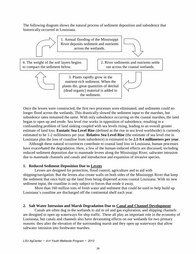
The following diagram shows the natural process of sediment deposition and subsidence that
historically occurred in Louisiana.
Once the levees were constructed, the first two processes were eliminated, and sediments could no
longer flood across the wetlands. This drastically slowed the sediment input to the marshes, but
subsidence rates remained the same. With only subsidence occurring on the coastal marshes, the land
began to open up and erode. Sea level rise works in opposition of subsidence, resulting in a
confounding problem of land sinking coupled with sea levels rising, leading to an overall greater
estimate of land loss. Eustatic Sea Level Rise (defined as the rise in sea level worldwide) is currently
estimated to be 1-2 millimeters per year. Relative Sea Level Rise (the estimate of sea level rise in
Louisiana plus the loss of coastline from subsidence) is estimated to be 2.1-9.4 millimeters per year.
Although these natural occurrences contribute to coastal land loss in Louisiana, human processes
have exacerbated the degradation. Here, a few of the human-induced effects are discussed, including
reduced sediment deposition due to manmade levees along the Mississippi River, saltwater intrusion
due to manmade channels and canals and introduction and expansion of invasive species.
1. Reduced Sediment Deposition Due to Levees
Levees are designed for protection, flood control, agriculture and to aid with
shipping/navigation. But the levees also create walls on both sides of the Mississippi River that keep
the sediment that once built up the land from being dispersed across coastal Louisiana. With no new
sediment input, the coastline is only subject to forces that erode it away.
More than 160 million tons of fresh water and sediment that could be used to help build up
Louisiana’s coastline are discharged off the continental shelf each year.
2. Salt Water Intrusion and Marsh Degradation Due to Canal and Channel Development
Canals are often dug in the wetlands to aid in oil and gas exploration, and shipping channels
are designed to open up waterways for ship traffic. These all play an important role in the economy of
Louisiana, but canals and channels also have devastating effects on our wetlands for two primary
reasons: they alter the elevation of the surrounding marsh and they open up waterways that allow
saltwater intrusion into freshwater marshes.
1. Annual flooding of the Mississippi
River deposits sediment and nutrients
across the wetlands.
2. River sediments and nutrients settle
out across the coastal wetlands.
3. Plants rapidly grow in the
nutrient-rich sediment. When the
plants die, great quantities of detrital
(dead organic) material is added to
the sediment.
4. The weight of the soil layers begins
to compact the sediment below.
26

LSU AgCenter • 4-H Youth Wetlands Program • 2013
Canals and channels bisect large areas of Louisiana and convert it to open water. In addition to
the direct problem caused by the canals, the extra sediment that is extracted to form a canal is
deposited on the sides of the canal (this is called a spoil bank). A spoil bank adjusts the elevation of
the marsh, inhibiting the overland flow of water following rain or flooding events. If the water can’t
flow from one area to another because of the spoil bank, it becomes trapped and converts the
marshland to open water.
Another negative aspect to the canals is that they cut direct lines between the Gulf of Mexico
and the inland freshwater marshes. This allows salt water to flow freely into the marshes and leads to a
problem known as saltwater intrusion. Saltwater intrusion is the movement of salt water into a non-
saltwater habitat, such as a freshwater marsh. This intrusion may occur as the result of a natural
process like a storm surge from a hurricane, but more often, it results from human activities such as
construction of shipping channels or dredging oil field canals. These channels and canals provide
conduits for salt water from the Gulf of Mexico to reach deep into interior marshes.
Saltwater intrusion often results in plant death in freshwater marshes and other freshwater or
upland habitats. Plants that are not adapted to live in salt water cannot survive. The root systems of
wetland plants hold the sediment in place. Thus, with saltwater intrusion, the wetlands will then begin
to erode away as the underground net system of plant roots disappears. When that happens, a once
freshwater marsh has been converted into open water, losing its functions as fish nursery and habitat,
food source for wetland animals, storm surge protection for residents and more.
3. Introduction and Expansion of Invasive Species
Invasive species are plants and animals that have been introduced into an environment in
which they are not native and can often have detrimental effects on the ecosystem. Invasive species
often lack natural predators, which leads to rapid expansion that results in the invasive species out-
competing the native species. Invasive species can be both plants and animals, and often have
detrimental effects on wetland landscapes. Below are a few examples of invasive species that are
doing damage to Louisiana’s wetlands:
1. Asian Carp (Cyprinus ssp., Ctenopharyngodon ssp., and Hypophthalmichthys)
There are four Asian carp fish species that have been introduced into the United States and
have established in Louisiana wetlands. Their introduction has resulted in reduced native fish
health due to habitat destruction and consumption of food. Many landowners use sterile carp to
help control vegetation in ponds and lakes, but these invasive fish still result in habitat
degradation for the native fish.
2. Chinese Tallow Tree (Triadeca sebifera)
This is a non-native tree that originated in China and was reportedly brought to the United
States in 1772 by Benjamin Franklin. It was brought to the Gulf region during the early 1900s
to help establish local sap industries. Chinese tallow trees grow aggressively, out-competing
native wetland plants and degrading wetland habitats.
3. Nutria (Myocastor coypus)
Nutria were first brought to Louisiana during the 1930s for fur farming and were later
introduced (intentionally or accidentally) to the coastal marshes. Nutria are herbivores that feed
on marsh grass. They not only eat the aboveground stem of the grass, but they dig into the
sediment and eat the root system. When the roots of the plants are killed, there is nothing left to
hold the land in place, and the wetlands erode away. A single nutria can eat up to 2.5 pounds of
marsh grass in a day. Currently, nearly 50,000 acres of Louisiana marshes are affected by
nutria.
27

LSU AgCenter • 4-H Youth Wetlands Program • 2013
Hurricane Impacts on Wetlands A hurricane is a powerful storm that forms over the ocean and generates winds that blow more
than 75 miles per hour. When hurricanes come ashore, they can do considerable damage to homes,
cities, livestock and the environment. Wetlands are an important factor in helping reduce the impact
hurricanes may have once they make landfall because wetlands act as a buffer against hurricane winds
and storm surge. When a hurricane comes across a wetland, the vegetation will help slow down the
storm surge and thus reduce the damage the hurricane can do when it reaches a populated area. Many
researchers believe that for every 1 to 2.7 miles of vegetated wetland that a hurricane crosses, the
wetlands reduce the storm surge of the hurricane by 1 foot.
Nearly 50 percent of Louisiana’s population lives in coastal parishes and is subject to direct
hits when hurricanes come ashore. As the wetlands continue to erode, the protection they offer to these
residents when hurricanes hit the coast is continuously decreasing. It has been said that if Hurricane
Katrina had struck in 1945, when there was a larger acreage of coastal wetlands, the storm surge that
reached New Orleans would have been as much as 5-10 feet lower.
In 2005, a record-breaking hurricane season resulted in two hurricanes that devastated the coast
of Louisiana: hurricanes Katrina and Rita. Hurricane Katrina brought strong wind speeds, while
hurricane Rita followed with great water surges and saltwater introduction into freshwater habitats.
Impact of Hurricanes Katrina and Rita in 2005
Temporarily devastated habitat for brown pelicans, turtles, reptiles, fish and migratory bird
species.
Caused closure of 16 National Wildlife Refuges.
Caused substantial beach erosion.
About 20 percent of the Louisiana marshes were overrun by water and have developed into
open water habitats.
90 percent of crude oil production in the continental United States was shut down for a time.
This temporarily increased gas prices nationwide.
The chart below shows the hurricanes’ effects on Louisiana’s economy:
Hurricanes Katrina and Rita:
Effects on Louisiana’s Economy
Industry Estimated Loss of
Revenue
Forestry $839,933,224
Agronomic Crops $357,854,629
Fruits/Nuts/Vegetables $41,951,686
Livestock $75,580,644
Aquaculture $58,330,115
Fisheries $176,280,625
Wildlife/Recreational $40,803,977
TOTAL $1,590,734,900
28

LSU AgCenter • 4-H Youth Wetlands Program • 2013
References:
Alberta Environmental Education: Wetlands – Webbed Feet Not Required:
http://environment.gov.ab.ca/edu/posting.asp?assetid=6278&audience=Teachers&searchtype=asset&t
xtsearch=wetland&head=ED
America’s WETLAND Foundation:
www.americaswetland.com
Barataria-Terrebonne National Estuary Program (BTNEP):
www.btnep.org
The Biodiversity Partnership (for info on LA invasive species):
http://www.biodiversitypartners.org/state/la/invasive.shtml
Coastal Wetlands Planning, Protection and Restoration Act (CWPPRA) website – LA Coast:
www.lacoast.gov
Entergy-Louisiana – Research Center:
http://www.entergy-louisiana.com/economic_development/rc_market_access.aspx
Environmental Protection Agency:
http://www.epa.gov/owow/wetlands/
Louisiana Department of Natural Resources:
http://dnr.louisiana.gov/
Louisiana Department of Wildlife and Fisheries- Nutria website:
http://www.nutria.com/site.php
Mitsch, W.J. and J.G. Gosselink. Wetlands. John Wiley & Sons, New York, 2000.
Newton, G. (editor). “Water Marks. Louisiana Coastal Wetlands Planning, Protection, and
Restoration News.” Various Volumes.
www.lacoast.gov/watermarks
The Ramsar Convention on Wetlands. “Wetlands Values and Functions.”
http://www.ramsar.org/info/values_intro_e.htm
The Ramsar Convention on Wetlands:
http://195.143.117.139/info/values_recreation_e.htm
United State Geological Survey (USGS) – “Chinese Tallow: Invading the Coastal Plain.” USGS FS-
154-00. October, 2000.
http://www.nwrc.usgs.gov/factshts/154-00.pdf
29

LSU AgCenter • 4-H Youth Wetlands Program • 2013
Additional Internet Resources
Additional Information About Louisiana’s Wetlands:
America’s WETLAND: A Campaign to Save Coastal Louisiana
o http://www.americaswetlandresources.com
LSU Agricultural Center and Louisiana Sea Grant
o www.lsuagcenter.com/en/environment/conservation/wetlands
o www.seagrantfish.lsu.edu/habitat/index.html
U.S. Environmental Protection Agency
o http://water.epa.gov/type/wetlands/index.cfm
U.S. Geological Survey – Marine and Coastal Geology Program
o marine.usgs.gov/fact-sheets/LAwetlands/lawetlands.html
U.S. Geological Survey – National Wetlands Research Center
o http://www.nwrc.usgs.gov/wetlands/wetlandsInfo.htm
Large Scale Restoration and Conservation Projects:
Coalition to Restore Coastal Louisiana
o www.crcl.org
Coastal Protection and Restoration Authority of Louisiana
o www.coastal.louisiana.gov
Coastal Wetlands Planning, Protection and Restoration Act
o www.lacoast.gov
Outdoor Environmental Education Programs:
Barataria-Terrebonne National Estuary Program – BTNEP has developed a wonderful
field trip guide to some of the most interesting places in the estuary. You can download
the guide and print each tour so you can take the information with you.
o http://educators.btnep.org/btnep/resources/educators/lessons/11-01-
04/Field_Trip_Guide_Barataria-Terrebonne_Estuary.aspx
Coastal Roots – The Coastal Roots program is a Louisiana State University effort that
provides schools with access to wetland plant nurseries to help students develop an
attitude of stewardship toward our natural resources.
o http://coastalroots.lsu.edu/
30
LSU AgCenter • 4-H Youth Wetlands Program • 2013
Coastal Education Program – The Coastal Education Program is organized by the
Pontchartrain Institute for Environmental Sciences to provide teachers and students
opportunities to learn about coastal wetlands.
o http://pies.uno.edu/education/index.htm
Louisiana Outdoors Outreach Program – The Louisiana Outdoors Outreach program
seeks to bring outdoor education and skill building to Louisiana students.
o http://www.crt.state.la.us/parks/iloop.aspx
Native Fish in the Classroom – Native Fish in the Classroom is a Louisiana Sea Grant
and Louisiana Department of Wildlife and Fisheries partnership program providing
schools with native fish nurseries and background information on fisheries management,
fish biology, protected species and aquatic natural resources.
o http://www.lamer.lsu.edu/nativefish/index.html
Other Wetland Lesson Plans and Resources:
America’s WETLAND Foundation
o http://www.americaswetland.com/custompage.cfm?pageid=28
Audubon Nature Institute
o http://www.auduboninstitute.org/louisiana-wetlands
Barataria-Terrebonne National Estuary Program – Wetlands Webliography
o http://educators.btnep.org/BTNEP/resources/educators/lessons/11-01-
03/Wetlands_Webliography.aspx
Coastal Wetlands Planning, Protection and Restoration Act
o http://lacoast.gov/new/Ed/Default.aspx
National Park Service – Traveling Trunk
o http://www.nps.gov/jela/forteachers/travellingtrunks.htm
Project WET
o http://www.projectwet.org
Project WILD
o http://www.projectwild.org
U.S. Environmental Protection Agency
o http://water.epa.gov/type/wetlands/outreach/education_index.cfm#activities
Wonders of the Wetlands
o http://www.wetland.org/education_wow.htm
31

LSU AgCenter • 4-H Youth Wetlands Program • 2013
Louisiana Coastal Facts
Provided by Coastal Protection and Restoration
Authority of Louisiana
Louisiana
Length of Coastline:
397 miles
Tidal Shoreline:
7,721 miles
Coastal Zone Population:
More than 2 million
people (47 percent of the
state’s population)
Coastal Area:
14,587 square miles
Coastal Land Area:
5,663 square miles
Length of Oil and Gas
Pipelines:
125,000 miles
Coastal Land Loss
Coastal Louisiana has experienced a net decrease of 1,883 square miles of land between
1932 and 2010.
Currently, Louisiana has 37 percent of the estuarine herbaceous marshes in the 48
contiguous United States but accounts for 90 percent of coastal wetland loss in the lower
48 states.
Over a four year period between 2004 and 2008, hurricanes Katrina, Rita, Gustav and Ike
transformed approximately 328 square miles of marsh to open water – an amount that
exceeded total land loss for the approximately 25-year period between 1978 and 2004.
The land loss rates on the Louisiana coast have slowed from an average of more than 30
square miles per year between 1956 and 1978 to an estimated 17 square miles per year
from 1985 to 2010. If these recent losses were to occur at a constant rate, it would equate
to losing an area the size of a football field every hour
Energy
According to 2010 energy estimates of Louisiana’s primary energy production, including outer
continental shelf production, Louisiana ranks first in crude oil production and second in natural
gas production. Excluding outer continental shelf production, Louisiana still ranks fourth in
natural gas and fifth in crude oil production among the 50 states.
32

LSU AgCenter • 4-H Youth Wetlands Program • 2013
Waterborne Commerce
Louisiana’s coastal wetlands provide storm protection for ports that, according to 2009
data, carried 449 million tons of waterborne commerce. Louisiana ports account for 20
percent of all waterborne commerce in the United States.
Five of the 15 largest ports in the United States are located in Louisiana.
Fisheries
Commercial Fishing – According to 2008 data, Louisiana commercial landings
exceeded 916 million pounds, with a dockside value of $272.9 million. That means
Louisiana accounts for approximately 26 percent of the total catch by weight in the lower
48 states.
Recreational Fishing – According to 2009 data, noncommercial fishing in Louisiana
employs almost 20,000 people, and related annual expenditures amount to more than
$1.7 billion.
Wildlife
Hunting – Annual hunting-related expenditures in Louisiana amounted to $975 million in
2006.
Wildlife-Watching – Expenditures related to wildlife-watching in Louisiana during
2006 amounted to $517 million.
Fur Harvest – According to 2007-2008 data, fur harvest in Louisiana’s coastal
wetlands generated approximately $1.75 million.
Alligator Harvest – Louisiana’s alligator harvest was valued at approximately $109.2
million a year, according to 2006 data.
Waterfowl – Louisiana’s coastal wetlands annually provide habitat for more than 5
million migratory waterfowl.
Tourism
Tourism provides $9.3 billion a year in revenue for Louisiana.
If current coastal losses were to occur at a constant rate, it would equate to
losing an area the size of a football field every hour
References
Barras, J.A. 2009. Land Area Change and Overview of Hurricane Impacts in Coastal Louisiana,
2004-08: U.S. Geological Survey Scientific Investigations Map 3080, Scale 1:250,000, 6 p.
Pamphlet, http://pubs.usgs.gov/sim/3080/.
33

LSU AgCenter • 4-H Youth Wetlands Program • 2013
Barras, J.A., J.C. Bernier, and R.A. Morton. 2008. Land Area Change in Coastal Louisiana- A
Multidecadal Perspective (from 1956 to 2006): U.S. Geological Survey Scientific Investigations
Map 3019, scale 1:250,000, 14p. Pamphlet, http://pubs.usgs.gov/sim/3019/.
Coastal Protection and Restoration Authority. 2011. Fiscal Year 2012 Annual Plan: Integrated
Ecosystem Restoration and Hurricane Protection in Coastal Louisiana. Coastal Protection and
Restoration Authority of Louisiana. Baton Rouge, LA.
http://www.lacpra.org/assets/docs/2012%20ANNUAL%20PLAN/CPRA_Annual_Plan_4-28-
11_Web_Format.pdf
Couvillion, B.R., J. A. Barras, G. D. Steyer, W. Sleavin William, M. Fisher, H. Beck, N. Trahan,
B. Griffin, and D. Heckman. 2011. Land Area Change in Coastal Louisiana from 1932 to 2010:
U.S. Geological Survey Scientific Investigations Map 3164, scale 1:265,000, 12 p. Pamphlet.
http://pubs.usgs.gov/sim/3164/ downloads/SIM3164_Pamphlet.pdf.
Louisiana Department of Culture, Recreation and Tourism. n.d. Louisiana tourism by the
numbers. http://www.crt.state.la.us/tourism/research/Documents/2010-
11/LouisianaTourismFactsUpdatedfullsheet.pdf.
Louisiana Department of Natural Resources, Technology Assessment Division. 2011. Selected
Louisiana Energy Statistics. Louisiana Energy Topic. Baton Rouge, LA. Internet URL:
http://dnr.louisiana.gov/assets/TAD/newsletters/energy_facts_annual/LEF_2010.pdf.
Louisiana Department of Wildlife and Fisheries. 2008. The Economic Benefits of Fisheries,
Wildlife and Boating Resources in the State of Louisiana. Baton Rouge, LA.
http://www.wlf.louisiana.gov/sites/default/files/pdf/publication/32728-economic-benefits-
fisheries-wildlife-and-boating-resources-state-louisiana-
2006/southwick_2006_final_final_report_5-27-08_0.pdf
Louisiana Department of Wildlife and Fisheries. 2008. 2007-2008 Annual Report. Baton Rouge,
LA. http://www.wlf.louisiana.gov/sites/default/files/pdf/page_wildlife/32693-
Alligator%20Program%20Annual%20Reports/2007-2008_annual_report.pdf
Louisiana Department of Wildlife and Fisheries. 2011. Waterfowl Population Estimates in
Louisiana’s Coastal Zone Below U.S. Highway 90 and on Catahoula Lake. Baton Rouge, LA.
Internet URL: http://www.wlf.louisiana.gov/sites/default/files/pdf/waterfowl_survey/33575-
January%202011%20Survey/waterjan2011.pdf.
National Oceanic and Atmospheric Administration, National Marine Fisheries Service. 2009.
Fisheries of the United States, 2008. Silver Spring, MD. Internet URL:
http://www.st.nmfs.noaa.gov.
National Oceanic and Atmospheric Administration, National Marine Fisheries Service. 2010.
Annual commercial landing statistics.
http://www.st.nmfs.noaa.gov/st1/commercial/landings/annual_landings.html.
34

LSU AgCenter • 4-H Youth Wetlands Program • 2013
National Oceanic and Atmospheric Administration. 2011. Recreational Fishing Impacts.
https://www.st.nmfs.noaa.gov/st1/recreational/index.html, July 20, 2011.
National Oceanic and Atmospheric Administration. 1975. The Coastline of the United States.
http://shoreline.noaa.gov/_pdf/Coastline_of_the_US_1975.pdf.
Scott, Loren. 2011. The Energy Sector: Still a Giant Economic Engine for the Louisiana
Economy. Mid-Continent Oil and Gas Association. August 2011. http://thehayride.com/wp-
content/uploads/2011/10/Executive-Summary-1.pdf.
U.S. Army Corps of Engineers. 2010. Waterborne Commerce of the United States, Calendar
Year 2009. Alexandria, VA: Institute for Water Resources, U. S. Army Corps of Engineers.
Internet URL: http://www.ndc.iwr.usace.army.mil/wcsc/statenm09.htm.
http://www.ndc.iwr.usace.army.mil/wcsc/portton09.htm.
U.S. Census Bureau. 2011. Census 2010.
http://factfinder2.census.gov/faces/nav/jsf/pages/index.xhtml. Includes watersheds that NOAA
indicates have either 1) at least 15 percent of their land area within a coastal watershed, or 2) a
portion of or an entire county accounts for at least 15 percent of a U.S. Geological Survey coastal
cataloging unit.
For further information on Coastal Protection and Restoration Projects in Louisiana, please visit
the CPRA home page www.coastal.la.gov, CRMS home page
www.lacoast.gov/crms2/Home.aspx, CWPPRA home page www.lacoast.gov, the Coast 2050
home page www.coast2050.gov, the LCA home page www.lca.gov or the following
governmental agencies:
U.S. Army Corps of Engineers
Planning Division (504) 865-1121
www.cecer.army.mil
U.S. Department of Interior
U.S. Geological Survey National Wetlands Research Center
(337) 266-8556 www.nwrc.usgs.gov
Louisiana Department of Natural
Resources
Office of the Secretary Technology Assessment Division
(225) 342-1399
www.dnr.louisiana.gov
U.S. Department of Interior U.S.
Fish and Wildlife Service (337) 291-
3100
www.fws.gov
U.S. Department of Agriculture
Natural Resources Conservation
Service
(318) 437-7756
www.la.nrcs.usda.gov
State of Louisiana
Governor's Office of Coastal
Activities
(225) 342-3968
www.coastal.la.gov
U.S. Department of Commerce
National Marine Fisheries Service
(225) 389-0508
www.nmfs.gov
U.S. Department of Commerce
Region 6
(225) 389-0735
www.epa.gov
State of Louisiana
Coastal Protection and Restoration
Authority
(225) 342-7308 or 1-888-459-6107
www.coastal.la.gov
Note: Although this document is updated regularly, please contact the CPRA for the most current
statistics. Last updated 12/07/2011.
35