
General info leaflet 1st draft - Forestry Commission homepageFILE/... · NORTH YORK MOORS managing...
9
General Information About the woods and forests managed by the Forestry Commission from the Tees to the Humber NORTH YORK MOORS managing woods between Tees and Humber 2007 Forestry Commission North York Moors cares for 21471.9 hectares of land (equivalent to more than 42,000 football pitches) between the Tees and the Humber. Woods and forests are managed to meet the demands placed on them bytheGovernmentsForest Policy‘A strategyfor England’s Woods, Trees and Forests’ published in 2007. A BRIEF HISTORY. Many areas in North Yorkshire were deforested during the early BronzeAge. Thesepeopleleft signsscatteredthroughtheregion’s woodlands but particularly the large forests of Dalby, Langdale, Harwood Dale, Broxa and Wykeham. Later Iron Age settlements were in Wykeham and Broxa Forests. The term forest actually relates to hunting areas not just woodland. Around 1106 King Henry I declared much of land between Pickering, Scarborough and Whitby to be a Royal Hunting Forest this included the present day Dalby Forest and other woodland in the area. The church was also a powerful landowner and Bishop Wood near Selby although managed by the Forestry Commission still belongs to the Church Commissioners. Only 10% of the present forest area is old woodland or on the site of old woodland, everything else was either moorland or farmland. Some places, particularly around Dalby Forest were used to rear tens of thousands of rabbits in specially constructed warrens. After the 1 st World War hardly a tree was left standing that could be used in manufacturing and mining. The Government set uptheForestryCommissiontocarefor Britain’s remaining woods and create lots of new ones as a strategic timber reserve. The first trees in Dalby Forest were planted in the early 1920s. The Forestry commission has more than 230 protected monuments in its care in the region as well as many other features. INFORMATION NOTE NO. 14
Transcript of General info leaflet 1st draft - Forestry Commission homepageFILE/... · NORTH YORK MOORS managing...

General InformationAbout the woods and forests managed by the ForestryCommission from the Tees to the Humber
NORTH YORK MOORSmanaging woods between Tees and Humber 2007
Forestry Commission North York Moors cares for 21471.9hectares of land (equivalent to more than 42,000 football pitches)between the Tees and the Humber.
Woods and forests are managed to meet the demands placed onthem by the Governments Forest Policy ‘A strategy for England’sWoods, Trees and Forests’ published in 2007.
A BRIEF HISTORY.Many areas in North Yorkshire were deforested during the earlyBronze Age. These people left signs scattered through the region’swoodlands but particularly the large forests of Dalby, Langdale,Harwood Dale, Broxa and Wykeham. Later Iron Age settlementswere in Wykeham and Broxa Forests. The term forest actuallyrelates to hunting areas not just woodland. Around 1106 King HenryI declared much of land between Pickering, Scarborough and Whitbyto be a Royal Hunting Forest this included the present day DalbyForest and other woodland in the area. The church was also apowerful landowner and Bishop Wood near Selby although managedby the Forestry Commission still belongs to the ChurchCommissioners. Only 10% of the present forest area is oldwoodland or on the site of old woodland, everything else was eithermoorland or farmland. Some places, particularly around DalbyForest were used to rear tens of thousands of rabbits in speciallyconstructed warrens. After the 1st World War hardly a tree was leftstanding that could be used in manufacturing and mining. TheGovernment set up the Forestry Commission to care for Britain’sremaining woods and create lots of new ones as a strategic timberreserve. The first trees in Dalby Forest were planted in the early1920s. The Forestry commission has more than 230 protectedmonuments in its care in the region as well as many other features.
INFORMATION NOTE NO. 14
NORTH YORK MOORSmanaging woods between Tees and Humber 2007
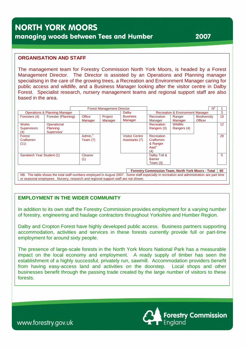
ORGANISATION AND STAFF
The management team for Forestry Commission North York Moors, is headed by a ForestManagement Director. The Director is assisted by an Operations and Planning managerspecialising in the care of the growing trees, a Recreation and Environment Manager caring forpublic access and wildlife, and a Business Manager looking after the visitor centre in DalbyForest. Specialist research, nursery management teams and regional support staff are alsobased in the area.
Forest Management Director No 1Operations & Planning Manager Recreation & Environment Manager 3
Foresters (4) Forester (Planning) OfficeManager
ProjectManager
DalbyBusinessManager
RecreationManager
RangerManager
BiodiversityOfficer
10
WorksSupervisors(4)
OperationalPlanningSupervisor
RecreationRangers (3)
WildlifeRangers (4)
12
ForestCraftsmen(11)
Admin,n
Team (7)Visitor CentreAssistants (7)
RecreationCraftsmen& RangerAsst’t
(4)
29
Sandwich Year Student (1) Cleaner(1)
Dalby Toll &BarrierTeam (3)
5
Forestry Commission Team, North York Moors - Total 60NB. The table shows the total staff numbers employed in August 2007. Some staff especially in recreation and administration are part timeor seasonal employees. Nursery, research and regional support staff are not shown.
EMPLOYMENT IN THE WIDER COMMUNITY
In addition to its own staff the Forestry Commission provides employment for a varying numberof forestry, engineering and haulage contractors throughout Yorkshire and Humber Region.
Dalby and Cropton Forest have highly developed public access. Business partners supportingaccommodation, activities and services in these forests currently provide full or part-timeemployment for around sixty people.
The presence of large-scale forests in the North York Moors National Park has a measurableimpact on the local economy and employment. A ready supply of timber has seen theestablishment of a highly successful, privately run, sawmill. Accommodation providers benefitfrom having easy-access land and activities on the doorstep. Local shops and otherbusinesses benefit through the passing trade created by the large number of visitors to theseforests.

NORTH YORK MOORSmanaging woods between Tees and Humber 2007
TREES AND FORESTS
Tree Species (Conifers) Area (ha*) Tree Species(Broadleaves)
Area (ha)
Corsican Pine 473 Alder 22Douglas Fir 526 Ash 35European Larch 348 Beech 303Grand Fir 24 Birch 231Hybrid Larch 834 Mixed Broadleaves 1226Japanese Larch 2090 Oak 263Lawson Cypress 9 Poplar 50Lodgepole Pine 1386 Sycamore 222Mixed Conifer 337Noble Fir 9Norway Spruce 440Scots Pine 3727Sitka Spruce 4565Western Hemlock 157Western Red Cedar 57
Open space forms anincreasingly important partof forest management. Thistotal includes, heath andgrass, agricultural andrecreational land but notroads and rides.
4214
There is public access to alarge part of these woodsand forests
Area (ha) These forests have limitedor no public access**.
Area (ha)
Allerthorpe 148.3 Arncliffe 173.4Bishop Wood 340.7 Bransdale 203.4Boltby 632.1 Coate Moor 155.0Broxa 730.0 Deer Park 312.1Coatham Wood 198.6 Eastmoor/Riccaldale 1100.9Cropton 3662.2 Faceby 61.4Dalby 3597.6 Gilling 589.1Guisborough 478.2 Goathland 69.7Hagg Wood 81.0 Sand Hutton 178.2Harwood Dale 747.6 Wass Moor/Pry Rigg 663.4Ingleby Greenhow 552.6 Bumble Wood 264.4Kilburn/Oldstead 546.8 Wykeham 1117.0Langdale 3008.7Silton 461.9 other woods 80.5Sneaton 904.7South Burdon 81.3Stainburn 215.5Wheldrake 115.6 Total area (ha). 21471.9* ha A hectare. 1 hectare equals just under 2.5 acres.** This is usually because the Forestry Commission is a tenant and the landowner has reserved the accessrights. Bumble Wood & Goathland are freehold but the previous owner has reserved rights until 2020.

CLIMATE
Across the region the altitude of Forestry Commissionwoodlands varies between 5m at Bishop Wood, nearSelby to 244m at the head of Bransdale. In general thehigher the altitude the more extreme the climate. Highwinds and exposure to salt laden air from the North Seacan cause particular problems to foresters trying tomanage the growing trees. The average rainfall isbetween 66cm and 91cm a year.
GEOLOGY & SOILS
Whilst the low-lying woods in the Vale of York and thelower Tees Valley are situated on riverine, lake-bed andglacial deposits most woods are located on sedimentaryrocks of the Jurassic period. These give rise to a widerange of soil types from lime-rich rendzina and brownearth to acid peats, gleys (waterlogged clays) and ironpans.
Of particular interest to geologists are the glacialmeltwater channels that give the forests of Broxa,Wykeham and Dalby their distinctive valleys. Thelargest meltwater channel of all is Newtondale on theedge of Cropton Forest, possibly the most important(and impressive) feature of its type in England.
Dalby Forest is also noted for the lime rich springs inDeepdale. Lime-laden water comes to the surface andrapidly evaporates causing lime to be deposited in layerson anything in its path, eventually building up into bedsof tufa or travertines.
The North East Yorkshire Geology Trust is a very activegroup in the area and can offer help and advice. Formore details see their website,
http://www.neyorksgeologytrust.com
or telephone: 01947 881 000
NORTH YORK MOORSmanaging woods between Tees and Humber 2007

NORTH YORK MOORSmanaging woods between Tees and Humber 2007
PLANTING & SILVICULTURE
In NYM, the total restock1 area is 160 hectares (ha) and is made up as follows :-
141 ha restocked with nursery grown plants (138ha conifer, 3 ha broadleaves)19 ha natural regeneration broadleaves (for native broadleaved restoration sites)
Approximately 400 000 trees are required annually from Forestry Commission nurseries atWykeham and Delamere. Most of the trees planted are 2 years old, grown on from seedlings.
Sitka spruce is the main species planted (approx 40%) with larch (25-30%) and Scots pine(approx 20%). Douglas fir and Norway spruce are also planted in smaller quantities. SomeNorway spruce are specially grown and managed as Christmas trees for sale through FCvisitor centres across the UK.
Approximately 90% of the restocked area receives ground preparation. On the drier sites, ascarifier is used behind a large tractor to create a weed free trace in the soil where the tree canbe planted. For wetter sites, excavators are used to create raised mounds of soil for the treesto be planted on. These warm up quicker in the spring and create good conditions for treegrowth and survival. All trees are hand planted by staff and contractors who transport thetrees in specially designed planting bags.
Newly planted trees are subject to attack from browsing mammals (deer, rabbits, hares, voles)and insect (pine weevil). Weeds need to be controlled (either chemically or mechanically) toprevent trees dying through lack of light, water or nutrients. Drought, frost and drying easterlywinds in the winter are other threats to newly planted trees before the roots become wellestablished.
In the early years, trees that die are replaced. Approximately 50 000 replacement trees arerequired each year. The aim is to achieve a minimum of 2500 trees per hectare at the age ofestablishment, 5 years after planting2.
Where site conditions allow (not too windy or exposed, good soils) the forest is managed bycontinuous cover rather than clearfelling. Here, natural regeneration of conifers is encouragedutilising seed from the mature trees, gradually opened up to the light by regular thinning.
Not all areas where trees are clearfelled are replanted. Forest Design Plans, the main tool formanaging forests incorporate open space associated with the creation of naturalised habitats,habitat networks and the delivery of biodiversity action plan targets.
1 Restock/restocking Replacing trees on sites where tree removal has taken place.2 On areas where a timber harvest is the main objective.

NORTH YORK MOORSmanaging woods between Tees and Humber 2007
THE TREE HARVEST
Forestry Commission North York moors has 18504 hectares of tree–covered land. About 90%of this area is used to produce a crop of trees for timber production. Timber is harvested by acombination of clearfelling (complete tree removal from a site) and thinning (removing aproportion of the trees to give more growing space to the remaining crop).
The following table shows the forecast of production from thinning and felling until the year2016.
Period Thinning (m3) Felling (m3) Total (m3)2007 – 2011 27000 95000 1220002012 – 2016 29000 108000 137000
NB. A cubic metre of freshly felled softwood is the equivalent of 0.93 tonne.
All timber managed by Forestry Commission North York Moors is harvested by contractors.Most timber is sold standing to the merchant and contractors, however some is sold at theroadside i.e. already cut by contractors hired by the Forestry Commission.
MARKETING THE TIMBER
Sawlogs (i.e. construction timber, planks and boards) 65%Small roundwood (i.e. chipwood* and fencing material) 30%Miscellaneous (i.e. firewood) 5%
Over 90% of the trees are felled by mechanical harvesters. The rest are felled manually bychainsaw. Timber is extracted using forwarders except on the steeper slopes where skidderextraction is preferred. (Skidders drag whole tree lengths along the ground)*Chipwood includes ‘bio-fuel’ for electricity generation at power stations and local heat schemes.
RECREATION
All the woodlands owned by the Forestry Commission (please refer to the Trees andForests section) are dedicated under the Countryside and Rights of Way Act (CROW) andthe public are welcome to walk in these woodlands. In the more popular woodlands, suchas Dalby Forest, Guisborough Forest, Kilburn Wood and Cropton Forest, you will findwaymarked trails to follow. The Forestry Commission grants horse riders and pedal cyclistspermissive access in these woodlands. Under CROW we can close the forests if we needto restrict public access and this is used for events such as car rallies where there is a highrisk to the public. You will also see CROW closures for harvesting operations. We aim tokeep these closures to a minimum period.
The Rangers deliver an Education Service, offering activities such as shelter building,orienteering and stream studies to school and other groups of varying ages. All theactivities are linked into the National Curriculum and cover several key stages. Activitiescan be tailor- made to suit a group’s requirements.
The Rangers also deliver the ‘What’s On’ programme, which includes varied events fromArty Parties to Bushcraft, Tai Chi to badger watching. We aim to cover many topics ofinterest from wildlife and nature to the working forest, and popular events include Halloweenand Father Christmas. There is hopefully something for everyone throughout the year.
The forests play host to many varied events including car rallies, motorbike enduro’s, huskyraces and the Forest Tour when the Forestry Commission hosts up to three open-airconcerts at Adderstone Field in Dalby Forest.
We work closely with the ‘Friends of’ groups to improve the forests for visitors and thesegroups help to fund improvements in the forest.
Our aim is for people to enjoy the outdoors and benefit from the forest environment.Activities include walking and cycling from the easy to the extreme, picnicking, adventureand play. More than 350 thousand people visit Dalby Forest each year and there arethought to be between 1.5 and 2 million visits to all Forestry Commission woodland betweenthe Rivers Tees and Humber.
NORTH YORK MOORSmanaging woods between Tees and Humber 2007

CONSERVATION
NORTH YORK MOORSmanaging woods between Tees and Humber 2007
As the nation’s largest landowner theForestry Commission’s management ofthe historical and natural heritage in itscare is extremely important. The forestsof North Yorkshire have the mostimportant assemblage of Bronze Agestructures on the Commission’s estate inEngland. The wildlife of the forests varyas the estate covers habitats from uplandheath, lime rich grasslands, and ancientsemi-natural woodland. Many featuresand species have statutory protection.
Thieves Dikes, a Scheduled Monument in Broxa Forest
Between the Rivers Tees and Humber the Forestry Commission manages more than2000 sites of historical interest from 4,500 year old Neolithic burial sites to 2nd World Warmilitary structures. Many sites are regarded as being of national importance and of thesearound two hundred and thirty have been designated as Scheduled Monuments givingthem statutory protection.
Duke of BurgundyPhoto. Jax Westmoreland
Environmental protection begins at a landscape scale and manyof the region’s forests are within protected landscapes especiallythe North York Moors National Park. Landscape scale change toprovide environmental benefits in forests is being achievedthrough the establishment of habitat networks that allow speciesto spread through the landscape. The Forestry Commissioncares for 17 Sites of Special Scientific Interest (SSSI), two ofwhich are also European Special Areas of Conservation (SAC)and one of which is a European Special Protection Area. Thereare also around a thousand areas of conservation interest, a totalthat rises annually. Amongst wildlife that receives increasedstatutory protection in the area are badgers, otters, water vole,great crested newt, honey buzzard, goshawk and several speciesof bats. The Commission works closely with many organisationsand local naturalists to ensure responsible management of allnatural assets. Many United Kingdom and Local BiodiversityAction Plan (UKBAP and LBAP) species are represented in theregion’s forests. A rigorous consultation process before anyforest operations protects landscape, habitats and species.

NORTH YORK MOORSmanaging woods between Tees and Humber 2007
GREENING OUR BUSINESS
Sustainable Development in the Forestry Commission North YorkMoors
Sustainable development can be seen as 'development, which meets the needs of the presentwithout compromising the ability of future generations to meet their own needs.'
‘Securing the Future’ - the UK Government Sustainable Development Strategy- asksDepartments to prepare an action plan for the sustainable management of the Governmentestate.
The Forestry Commission North York Moors aims to meet the Government’s intentions in thefollowing ways: 1) The sustainable management of forests
Our forests are independently certified under the UKWoodland Assurance Standard Scheme. This means that thetimber from the North York Moors woodlands can carry theinternational FSC logo.
2) The construction of the new sustainable visitor centre inDalby Forest
This building is constructed from FSC certified timber andincorporates renewable energy features, e.g. solar photo-voltaic cells and a solar hot water system, a wind turbine,rainwater harvester to flush the toilets and a wood burner toheat the centre. It is partly made of recycled materials and hasan exhibition on sustainability to inform visitors of thedifference they can make at home.
3) Various wood fuel initiativesFor example supplying timber to Sempcorp at Wilton in theTees Estuary to fuel the power station and working with thecommunity of Bransdale to supply and ultimately let thecommunity manage their local woodland for wood fuel.
4) The Greenerways projectThis project is about how we, as FC employees, incorporatesustainability issues into our everyday working lives. Thisincludes corporate management activities e.g. wastemanagement, water and energy use, transport and humanresources.
24 Aug 2007


![Morocco and the Moors[1]](https://static.fdocuments.us/doc/165x107/577ce0291a28ab9e78b2c3ee/morocco-and-the-moors1.jpg)
