GDOT Electronic Data Guidelines v4...Jul 01, 2010 · June 2011 Added Section 2-2 Plan Sheet DGN...
582
GEORGIA DEPARTMENT OF TRANSPORTATION ELECTRONIC DATA GUIDELINES Version 4.1 Current Revision Date: June 2011
Transcript of GDOT Electronic Data Guidelines v4...Jul 01, 2010 · June 2011 Added Section 2-2 Plan Sheet DGN...
GEORGIA DEPARTMENT OF TRANSPORTATION
ELECTRONIC DATA GUIDELINES
Version 4.1
Current Revision Date: June 2011

Georgia Department of Transportation ELECTRONIC DATA GUIDELINES Version 4.1
June 2011
1-2 TABLE OF CONTENTS
Electronic Data Guidelines (Section 1)
1-1 Electronic Data Guidelines Cover 1-2 Table of Contents 1-3 Disclaimer 1-4 EDG Revision Summary 1-5 General Information 1-6 Current DOT Software Versions 1-7 Guidelines for Submitting Electronic Data 1-8 Graphic Standards 1-9 Working Units 1-10 Minimum Text Sizes 1-11 Saving Plotted Views 1-12 File Locations 1-13 Miscellaneous Items Design File Names and Level Schemes (Section 2)
2-1 Design File Names and Level Schemes Cover 2-2 Plan Sheet DGN File Names 2-3 Construction Plan Assembly 2-4 Plan Sheet Levels 2-5 Construction Plan Assembly Sheets Sections
(01) Cover Sheet (02) Index Sheet (03) Revision Summary Sheet (04) General Notes (05) Typical Sections (06) Summary of Quantities (07) Quantities by Amendment (08) Quantities on Construction (10) Traffic Diagram Sheets (11) Construction Layout (12) Misc. Maps (13) Mainline Roadway Plan (14) Crossroad Plan
2 of 582

Georgia Department of Transportation ELECTRONIC DATA GUIDELINES Version 4.1
June 2011
2-5 Construction Plan Assembly Sheets Sections (continued)
(15) Mainline Roadway Profile (16) Crossroad Profile (17) Driveway Profiles (18) Special Grading Sheets (19) Staging Plan Sheets (19) Staging Profiles (19) Staging Cross Sections (20) Staging Details (21) Drainage Area Map (22) Drainage Profiles (23) Cross-Sections (24) Utility Plans (25) Lighting Plans and Details (26) Signing and Marking Plans (27) Signal Plans (28) ITS Plans (29) Landscaping Plans (30) Mitigation Plans (31) Retaining Wall Envelopes (32) Retaining Wall Plans (33) Sound Barrier Envelopes (34) Sound Barrier Plans (35) Bridge Plans (36) Bridge Culvert Plans (37) Miscellaneous Structural (38) Special Construction Detail (39) Special Design Box Culverts (40) Construction Details (41) Georgia Standards (44) Utility Relocation Plans (50) Erosion Cover Sheet (51) ESPC General Notes Sheet (52) Erosion Cont. Legend (53) ESPCP Drainage Area Map (54) BMP Location Details (55) EC Watershed Map-Site Mon. (56) Const Stds&Dtls for EC ONLY (60) Right of Way Plans-Cover (60) Right of Way Plans-Sheets Sheet Layout
2-6 Reference: File Names (List)
3 of 582
Georgia Department of Transportation ELECTRONIC DATA GUIDELINES Version 4.1
June 2011
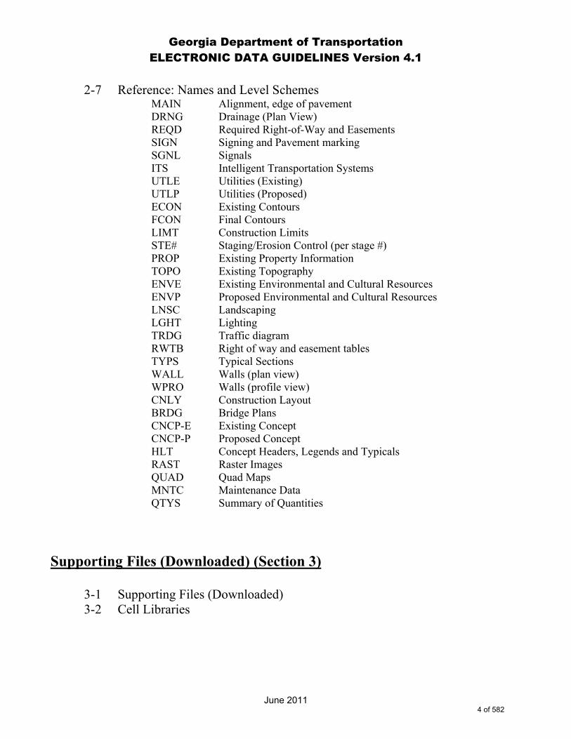
2-7 Reference: Names and Level Schemes
MAIN Alignment, edge of pavement DRNG Drainage (Plan View) REQD Required Right-of-Way and Easements SIGN Signing and Pavement marking SGNL Signals ITS Intelligent Transportation Systems UTLE Utilities (Existing) UTLP Utilities (Proposed) ECON Existing Contours FCON Final Contours LIMT Construction Limits STE# Staging/Erosion Control (per stage #) PROP Existing Property Information TOPO Existing Topography ENVE Existing Environmental and Cultural Resources ENVP Proposed Environmental and Cultural Resources LNSC Landscaping LGHT Lighting TRDG Traffic diagram RWTB Right of way and easement tables TYPS Typical Sections WALL Walls (plan view) WPRO Walls (profile view) CNLY Construction Layout BRDG Bridge Plans CNCP-E Existing Concept CNCP-P Proposed Concept HLT Concept Headers, Legends and Typicals RAST Raster Images QUAD Quad Maps MNTC Maintenance Data QTYS Summary of Quantities
Supporting Files (Downloaded) (Section 3)
3-1 Supporting Files (Downloaded) 3-2 Cell Libraries
4 of 582

Georgia Department of Transportation ELECTRONIC DATA GUIDELINES Version 4.1
June 2011
Master Level and ByLevel Symbology Index (Section 4)
4-1 Master Level Name and ByLevel Symbology Index Cover 4-2 Level Name – Reference File Name Designations 4-3 Master Level Name and ByLevel Symbology Index
5 of 582

Georgia Department of Transportation ELECTRONIC DATA GUIDELINES Version 4.1
June 2011
1-3 DISCLAIMER
The guidelines contained in this document are for reference only. The material is provided without warranty or liability of any kind to the Department. Every effort has been made to make the documentation as complete and accurate as possible without errors. This information is provided on an "as is" basis. Updates to these guidelines will be made as needed due to any errors found in the documentation, new programs, changes in software, software enhancements, or as policy and management dictate. As with any documentation or guidelines, improvements can and should be made. Any additions, suggestions or comments for improvement are encouraged. This documentation is not meant to be a complete instructional document. The intent is to provide guidelines that, if followed, will result in better quality and consistency for electronic plans and documents. Any recommendation for improvement to this documentation is welcomed. Any errors found should be brought to the attention of the DOT so corrections can be made. Any additional information or detailed explanation needed to this documentation should be documented and mailed to: Director of Engineering
Georgia Department of Transportation One Georgia Center 600 W. Peachtree St. N.W. Atlanta, GA 30308, US Attn: Plan Presentation Committee
Or email to: [email protected] (When submitting issues through the Solutions Center/Remedy, please specify a subject line of “Plan Presentation Committee” so the issue will be assigned correctly.)
6 of 582

Georgia Department of Transportation ELECTRONIC DATA GUIDELINES Version 4.1
June 2011
1-4 EDG REVISION SUMMARY
Version History: Version 4.0 - Release Date: July 1, 2010 Version 4.1 - Revision Date: June 2011
Any subsequent revisions to this document shall be documented below.
Revisions
Date Description 7-1-2010
Released EDG Version 4.0 (Initial MicroStation V8i compliant edition.)
June 2011
Revised reference to “Director of Preconstruction” to read “Director of Engineering”.
June 2011
General revision to included references to ByLevel element symbology.
June 2011
General revision to all references of “ATMS Plans” to read “ITS Plans”.
June 2011
General revision to sheet DGN file naming convention to define a two (2) digit Plan Section number followed by a three (3) digit drawing number.
June 2011
General revision to remove all cross references between MicroStation V8i Level numbers and legacy MicroStation J Level numbers.
June 2011
Revised Section 1-4 EDG Revision Summary to delete all references to: Menu and Source Files Revised/Added, Cell Library Files Revised/Added, Macro Files Revised/Added, DGN Files Revised/Added, Video Files Revised/Added, and Plotting Resource Files Revised/Added.
June 2011
Revised Section 1-5 General Information to include guidance on the use of MicroStation DGN file Models.
7 of 582

Georgia Department of Transportation ELECTRONIC DATA GUIDELINES Version 4.1
June 2011
June 2011
Revised Section 1-5 General Information to include guidance on the use of 3D MicroStation DGN files.
June 2011
Revised Section 1-6 Current Software.
June 2011
Revised Section 1-8 Graphic Standards to expound upon “ByLevel” element symbology requirements.
June 2011
Revised Section 1-9 Working Units to include “US Survey Feet”.
June 2011
Renamed Section 1-10 Minimum Text Size for Right of Way Plans to 1-10 Minimum Text Sizes.
June 2011
Revised Section 1-10 Minimum Text Sizes to include guidelines for Construction Plans.
June 2011
Renamed Section 2-2 Construction Plan Assembly to 2-3 Construction Plan Assembly.
June 2011
Added Section 2-2 Plan Sheet DGN File Names.
June 2011
Renamed Section 2-3 Plan Sheet Levels to 2-4 Plan Sheet Levels.
June 2011
Revised Section 2-3 Construction Plan Assembly to remove reference to (09)Detailed Estimate.
June 2011
Revised Section 2-3 Construction Plan Assembly to define Plan Section number “60” for Right-of-Way Cover and Right-of-Way Plans.
June 2011
Revised Section 2-3 Construction Plan Assembly to add Sheet Layout.
June 2011
Renamed Section 2-4 Construction Plan Assembly Sheet Sections to 2-5 Construction Plan Assembly Sheet Sections.
8 of 582

Georgia Department of Transportation ELECTRONIC DATA GUIDELINES Version 4.1
June 2011
June 2011
Renamed Sections 2-4 (01) Cover Sheet through 2-4 Sheet Layout to 2-5 (01) Cover Sheet through 2-5 Sheet Layout.
June 2011
Revised Section 2-4 Plan Sheet Levels for the creation of addition sheet levels:
SHT_B_Clip-Border-Cell (28082) SHT_B_Clip-Border-Line (28083) SHT_B_Clip-Border-Text (28084) SHT_B_Plot-Border-Inner-Line (28085) SHT_B_Plot-Border-Outer-Line (28086) SHT_B_Summary-Quantities-Cell (28087) SHT_B_Summary-Quantities-Line (28088) SHT_B_Summary-Quantities-Text (28089)
June 2011
Revised Section 2-4 Plan Sheet Levels to include “Location Sketch” data on level SHT_B_Legend-Logo-Scale (28056).
June 2011
Revised Section 2-4 Plan Sheet Levels to delete all references to level SHT_B_09-Detailed-Estimate (28008).
June 2011
Renamed Section 2-5 Reference File Names (List) to 2-6 Reference File Names (List).
June 2011
General revision to Sections 2-5 (01) Cover Sheet through 2-5 (60) Right of Way Plan-Sheets revising section names to match GDOT Plan Presentation Guide.
June 2011
Revised all plan sheet Sections 2-5 (01) Cover Sheet through 2-5 (60) Right of Way Plan-Sheets to indicate additional sheet DGN file levels.
June 2011
Revised Sections 2-5 (02) Index Sheet through 2-5 (08) Quantities on Construction to remove sheet levels SHT_B_North-Arrow (28068), SHT_B_Match-Lines-Line (28061) and SHT_B_Match-Lines-Text (28062).
June 2011
Deleted Section 2-5 (09) Detailed Estimate.
June 2011
Revised Section 2-5 (10) Traffic Diagram Sheets to remove sheet level SHT_B_North-Arrow (28068).
9 of 582
Georgia Department of Transportation ELECTRONIC DATA GUIDELINES Version 4.1
June 2011
June 2011
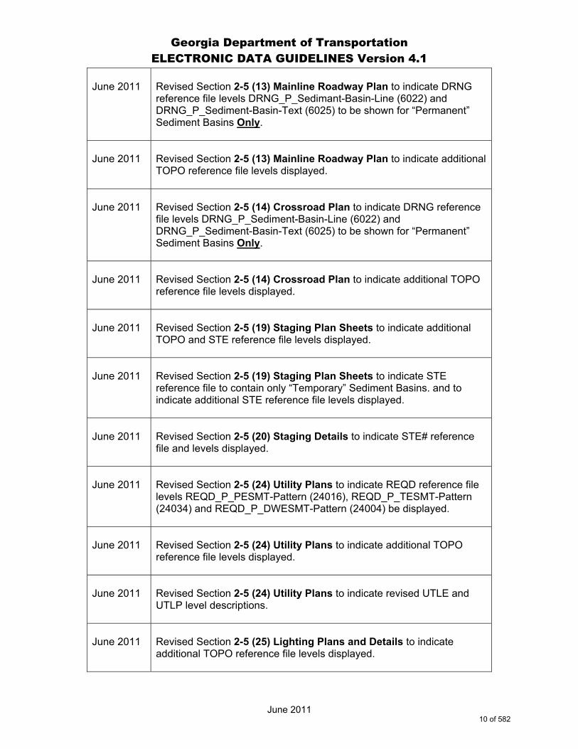
Revised Section 2-5 (13) Mainline Roadway Plan to indicate DRNG reference file levels DRNG_P_Sedimant-Basin-Line (6022) and DRNG_P_Sediment-Basin-Text (6025) to be shown for “Permanent” Sediment Basins Only.
June 2011
Revised Section 2-5 (13) Mainline Roadway Plan to indicate additional TOPO reference file levels displayed.
June 2011
Revised Section 2-5 (14) Crossroad Plan to indicate DRNG reference file levels DRNG_P_Sediment-Basin-Line (6022) and DRNG_P_Sediment-Basin-Text (6025) to be shown for “Permanent” Sediment Basins Only.
June 2011
Revised Section 2-5 (14) Crossroad Plan to indicate additional TOPO reference file levels displayed.
June 2011
Revised Section 2-5 (19) Staging Plan Sheets to indicate additional TOPO and STE reference file levels displayed.
June 2011
Revised Section 2-5 (19) Staging Plan Sheets to indicate STE reference file to contain only “Temporary” Sediment Basins. and to indicate additional STE reference file levels displayed.
June 2011
Revised Section 2-5 (20) Staging Details to indicate STE# reference file and levels displayed.
June 2011
Revised Section 2-5 (24) Utility Plans to indicate REQD reference file levels REQD_P_PESMT-Pattern (24016), REQD_P_TESMT-Pattern (24034) and REQD_P_DWESMT-Pattern (24004) be displayed.
June 2011
Revised Section 2-5 (24) Utility Plans to indicate additional TOPO reference file levels displayed.
June 2011
Revised Section 2-5 (24) Utility Plans to indicate revised UTLE and UTLP level descriptions.
June 2011
Revised Section 2-5 (25) Lighting Plans and Details to indicate additional TOPO reference file levels displayed.
10 of 582

Georgia Department of Transportation ELECTRONIC DATA GUIDELINES Version 4.1
June 2011
June 2011
Revised Section 2-5 (25) Lighting Plans and Details to indicate revised UTLE and UTLP level descriptions.
June 2011
Revised Section 2-5 (27) Signal Plans to indicate revised UTLE and UTLP level descriptions.
June 2011
Revised Section 2-5 (28) ITS Plans to indicate revised UTLE and UTLP level descriptions.
June 2011
Revised Section 2-5 (29) Landscaping Plans to indicate additional TOPO reference file levels displayed.
June 2011
Revised Section 2-5 (30 Mitigation Plans to indicate additional TOPO reference file levels displayed.
June 2011
Revised Section 2-5 (30) Mitigation Plans to indicate revised UTLP level descriptions.
June 2011
Revised Section 2-5 (32) Retaining Wall Plans to indicate additional TOPO reference file levels displayed.
June 2011
Revised Section 2-5 (32) Retaining Wall Plans to indicate revised UTLE and UTLP level descriptions.
June 2011
Revised Section 2-5 (34) Sound Barrier Plans to indicate additional TOPO reference file levels displayed.
June 2011
Revised Section 2-5 (34) Sound Barrier Plans to indicate revised UTLE and UTLP level descriptions.
June 2011
Revised Section 2-5 (35) Bridge Plans to include the addition of the BRDG reference file and associated BRDG levels.
June 2011
Revised Section 2-5 (36) Bridge Culvert Plans to include the addition of the BRDG reference file and associated BRDG levels.
11 of 582
Georgia Department of Transportation ELECTRONIC DATA GUIDELINES Version 4.1
June 2011
June 2011
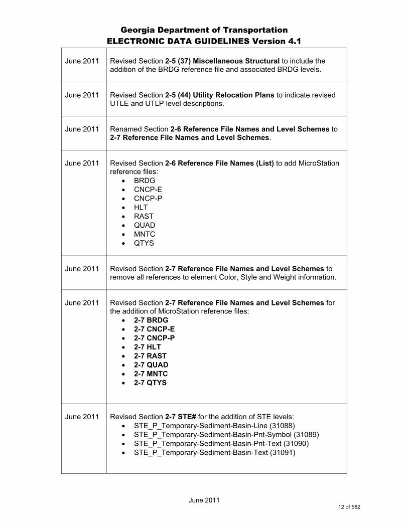
Revised Section 2-5 (37) Miscellaneous Structural to include the addition of the BRDG reference file and associated BRDG levels.
June 2011
Revised Section 2-5 (44) Utility Relocation Plans to indicate revised UTLE and UTLP level descriptions.
June 2011
Renamed Section 2-6 Reference File Names and Level Schemes to 2-7 Reference File Names and Level Schemes.
June 2011
Revised Section 2-6 Reference File Names (List) to add MicroStation reference files:
BRDG CNCP-E CNCP-P HLT RAST QUAD MNTC QTYS
June 2011
Revised Section 2-7 Reference File Names and Level Schemes to remove all references to element Color, Style and Weight information.
June 2011
Revised Section 2-7 Reference File Names and Level Schemes for the addition of MicroStation reference files:
2-7 BRDG 2-7 CNCP-E 2-7 CNCP-P 2-7 HLT 2-7 RAST 2-7 QUAD 2-7 MNTC 2-7 QTYS
June 2011
Revised Section 2-7 STE# for the addition of STE levels:
STE_P_Temporary-Sediment-Basin-Line (31088) STE_P_Temporary-Sediment-Basin-Pnt-Symbol (31089) STE_P_Temporary-Sediment-Basin-Pnt-Text (31090) STE_P_Temporary-Sediment-Basin-Text (31091)
12 of 582
Georgia Department of Transportation ELECTRONIC DATA GUIDELINES Version 4.1
June 2011
June 2011
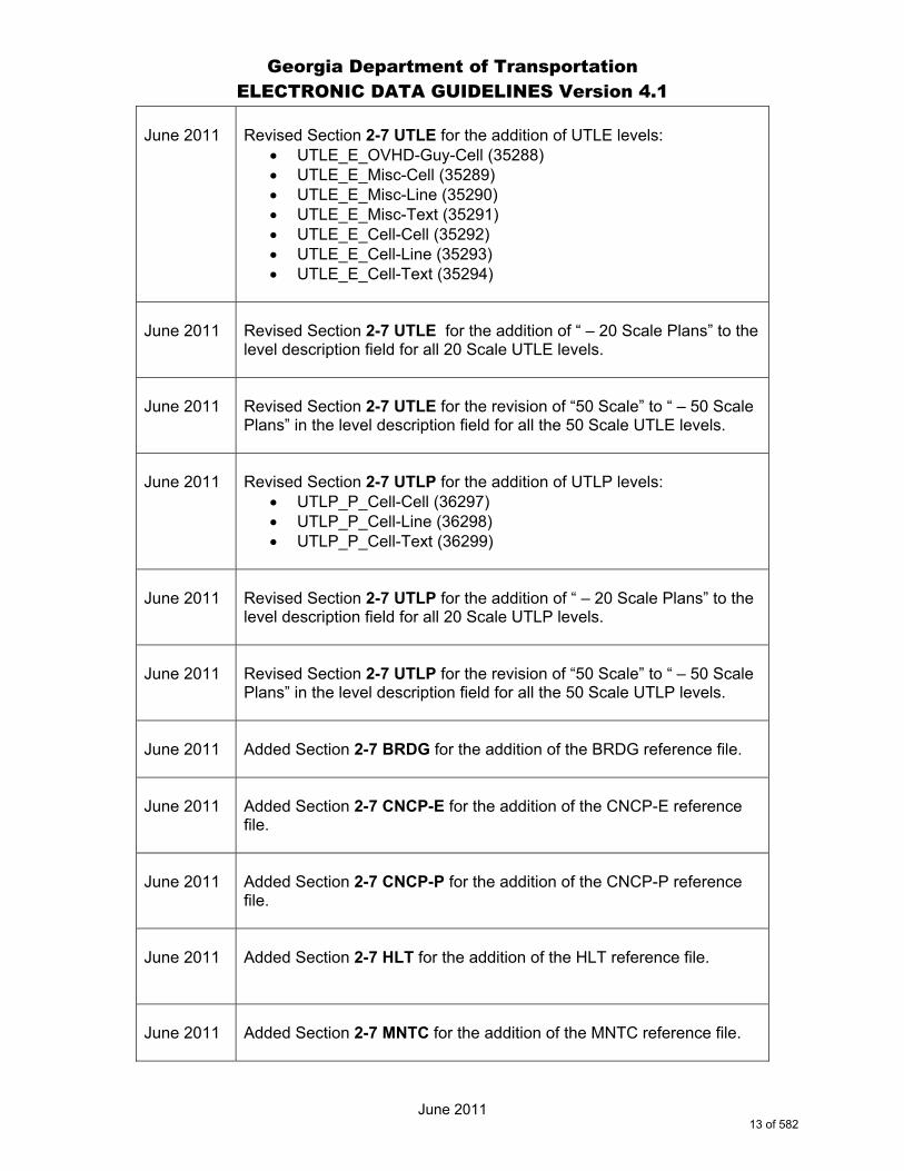
Revised Section 2-7 UTLE for the addition of UTLE levels:
UTLE_E_OVHD-Guy-Cell (35288) UTLE_E_Misc-Cell (35289) UTLE_E_Misc-Line (35290) UTLE_E_Misc-Text (35291) UTLE_E_Cell-Cell (35292) UTLE_E_Cell-Line (35293) UTLE_E_Cell-Text (35294)
June 2011
Revised Section 2-7 UTLE for the addition of “ – 20 Scale Plans” to the level description field for all 20 Scale UTLE levels.
June 2011
Revised Section 2-7 UTLE for the revision of “50 Scale” to “ – 50 Scale Plans” in the level description field for all the 50 Scale UTLE levels.
June 2011
Revised Section 2-7 UTLP for the addition of UTLP levels:
UTLP_P_Cell-Cell (36297) UTLP_P_Cell-Line (36298) UTLP_P_Cell-Text (36299)
June 2011
Revised Section 2-7 UTLP for the addition of “ – 20 Scale Plans” to the level description field for all 20 Scale UTLP levels.
June 2011
Revised Section 2-7 UTLP for the revision of “50 Scale” to “ – 50 Scale Plans” in the level description field for all the 50 Scale UTLP levels.
June 2011
Added Section 2-7 BRDG for the addition of the BRDG reference file.
June 2011
Added Section 2-7 CNCP-E for the addition of the CNCP-E reference file.
June 2011
Added Section 2-7 CNCP-P for the addition of the CNCP-P reference file.
June 2011
Added Section 2-7 HLT for the addition of the HLT reference file.
June 2011
Added Section 2-7 MNTC for the addition of the MNTC reference file.
13 of 582

Georgia Department of Transportation ELECTRONIC DATA GUIDELINES Version 4.1
June 2011
June 2011
Added Section 2-7 QTYS for the addition of the QTYS reference file.
June 2011
Added Section 2-7 RAST for the addition of the RAST reference file and associated levels:
RAST_Clip-Element (18000) RAST_Dsgn_LVL1 (18001) RAST_Dsgn_LVL2 (18002) RAST_Dsgn_LVL3 (18003) RAST_Dsgn_LVL4 (18004) RAST_Raster (18005) RAST_Text (18006) RAST_Trans_20 (18007) RAST_Trans_40 (18008) RAST_Trans_60 (18009) RAST_Trans_80 (18010)
June 2011
Added Section 2-7 QUAD for the addition of the QUAD reference file and associated levels:
QUAD_County-Shape-Line (41000) QUAD_County-Text (41001) QUAD_DOQQ-Point (41002) QUAD_DOQQ-Shape-Point (41003) QUAD_DOQQ-Text (41004) QUAD_EW-Zone-Boundary-Line (41005) QUAD_Lat-Long-Text (41006) QUAD_Quadmap-Point (41007) QUAD_Quadmap-Shape-Line (41008) QUAD_Quadmap-Text (41009) QUAD_State-Boundary-Line (41010)
June 2011
Revised Section 2-7 TOPO for the addition of TOPO levels:
TOPO_E_GOLF-Cell (32498) TOPO_E_GOLF-Line (32499) TOPO_E_GOLF-Text (32500) TOPO_E_Basketball-Court-Cell (32501) TOPO_E_Basketball-Court-Line (32532) TOPO_E_Basketball-Court-Text (32533) TOPO_E_Flow-Arrow-Cell (32502) TOPO_E_Iron-Pin-Placed-Cell (32503) TOPO_E_RIVER-TIC-MARK-Cell (32504) TOPO_E_WATER-SURFACE-Cell (32505) TOPO_E_Tic2-Cell (32496)
Continued next page-
14 of 582

Georgia Department of Transportation ELECTRONIC DATA GUIDELINES Version 4.1
June 2011
TOPO_E_Tic2-Text (32506) TOPO_E_DEW-Hatch-Line (32507) TOPO_E_BUILD-Cell (32508) TOPO_E_BUILD-Line (32509) TOPO_E_BUILD-Text (32510) TOPO_E_USIGNAL-Cell (32511) TOPO_E_USIGNAL-Line (32512) TOPO_E_USIGNAL-Text (32513) TOPO_E_RIDGE-Cell (32514) TOPO_E_RIDGE-Line (32515) TOPO_E_RIDGE-Text (32516) TOPO_E_DITCH-Taper-Cell (32517) TOPO_E_UTIL-Cell (32518) TOPO_E_UTIL-Line (32519) TOPO_E_UTIL-Text (32520) TOPO_E_PHOTO-CTRL-Cell (32521) TOPO_E_PHOTO-CTRL-Line (32522) TOPO_E_PHOTO-CTRL-Text (32523) TOPO_E_TRAIL-Cell (32524) TOPO_E_TRAIL-Line (32525) TOPO_E_TRAIL-Text (32526) TOPO_E_TEL-Cell (32527) TOPO_E_TEL-Line (32528) TOPO_E_TEL-Text (32529) TOPO_E_TSCALE-Cell (32530) TOPO_E_MSHEET-Cell (32531)
June 2011
Revised Section 3-2 Cell Libraries to update the library list, library revision dates and the library cell counts.
June 2011
Renamed Section 4-1 Master MicroStation Level Cover to 4-1 Master Level Name and ByLevel Symbology Index Cover.
June 2011
Renamed Section 4-2 GDOT Level Library to 4-3 Master Level Name and ByLevel Symbology Index.
June 2011
Added new Section 4-2 Level Name - Reference File Name Designations.
June 2011
Revised Section 4-3 Master Level Name and ByLevel Symbology Index to include Department photogrammetric mapping codes in TOPO level descriptions.
15 of 582

Georgia Department of Transportation ELECTRONIC DATA GUIDELINES Version 4.1
June 2011
June 2011
General revision to Section 4-3 Master Level Name and ByLevel Symbology Index to ByLevel element symbology.
June 2011
Revised Section 4-3 Master Level Name and ByLevel Symbology Index for the addition of CNCP-P level:
CNCP_P_Vert-Reconstruction-Hatching (4018)
June 2011
Revised Section 4-3 Master Level Name and ByLevel Symbology Index to delete MISC levels:
MISC_Clip-Element (18000) MISC_Dsgn_LVL1 (18001) MISC_Dsgn_LVL2 (18002) MISC_Dsgn_LVL3 (18003) MISC_Dsgn_LVL4 (18004) MISC_Raster (18005) MISC_Text (18006) MISC_Trans_20 (18007) MISC_Trans_40 (18008) MISC_Trans_60 (18009) MISC_Trans_80 (18010)
June 2011
Revised Section 4-3 Master Level Name and ByLevel Symbology Index to delete SHT level:
SHT_B_09-Detailed-Estimate (28008)
June 2011
Revised Sections 4-3 Master Level Name and ByLevel Symbology Index for the addition of UTLE levels:
UTLE_E_OVHD-Guy-Cell (35288) UTLE_E_Misc-Cell (35289) UTLE_E_Misc-Line (35290) UTLE_E_Misc-Text (35291) UTLE_E_Cell-Cell (35292) UTLE_E_Cell-Line (35293) UTLE_E_Cell-Text (35294)
June 2011
Revised Section 4-3 Master Level Name and ByLevel Symbology Index for the addition of RAST levels:
RAST_Clip-Element (18000) RAST_Dsgn_LVL1 (18001) RAST_Dsgn_LVL2 (18002)
Continued next page-
16 of 582

Georgia Department of Transportation ELECTRONIC DATA GUIDELINES Version 4.1
June 2011
RAST_Dsgn_LVL3 (18003) RAST_Dsgn_LVL4 (18004) RAST_Raster (18005) RAST_Text (18006) RAST_Trans_20 (18007) RAST_Trans_40 (18008) RAST_Trans_60 (18009) RAST_Trans_80 (18010)
June 2011
Revised Section 4-3 Master Level Name and Bylevel Symbology Index adding “Location Sketch” to the description field for Level SHT_B_Legend-Logo-Scale (28056)
June 2011
Revised Section 4-3 Master Level Name and ByLevel Symbology Index for the addition of sheet levels:
SHT_B_Clip-Border-Cell (28082) SHT_B_Clip-Border-Line (28083) SHT_B_Clip-Border-Text (28084) SHT_B_Plot-Border-Inner-Line (28085) SHT_B_Plot-Border-Outer-Line (28086) SHT_B_Summary-Quantities-Cell (28087) SHT_B_Summary-Quantities-Line (28088) SHT_B_Summary-Quantities-Text (28089)
June 2011
Revised Section 4-3 Master Level Name and ByLevel Symbology Index for the addition of QUAD levels:
QUAD_County-Shape-Line (41000) QUAD_County-Text (41001) QUAD_DOQQ-Point (41002) QUAD_DOQQ-Shape-Point (41003) QUAD_DOQQ-Text (41004) QUAD_EW-Zone-Boundary-Line (41005) QUAD_Lat-Long-Text (41006) QUAD_Quadmap-Point (41007) QUAD_Quadmap-Shape-Line (41008) QUAD_Quadmap-Text (41009) QUAD_State-Boundary-Line (41010)
June 2011
Revised Section 4-3 Master Level Name and ByLevel Symbology Index for the addition of STE levels:
STE_P_Temporary-Sediment-Basin-Line (31088) STE_P_Temporary-Sediment-Basin-Pnt-Symbol (31089) STE_P_Temporary-Sediment-Basin-Pnt-Text (31090) STE_P_Temporary-Sediment-Basin-Text (31091)
17 of 582

Georgia Department of Transportation ELECTRONIC DATA GUIDELINES Version 4.1
June 2011
June 2011
Revised Section 4-3 Master Level Name and ByLevel Symbology Index for the addition of TOPO levels:
TOPO_E_GOLF-Cell (32498) TOPO_E_GOLF-Line (32499) TOPO_E_GOLF-Text (32500) TOPO_E_Basketball-Court-Cell (32501) TOPO_E_Basketball-Court-Line (32532) TOPO_E_Basketball-Court-Text (32533) TOPO_E_Flow-Arrow-Cell (32502) TOPO_E_Iron-Pin-Placed-Cell (32503) TOPO_E_RIVER-TIC-MARK-Cell (32504) TOPO_E_WATER-SURFACE-Cell (32505) TOPO_E_Tic2-Cell (32496) TOPO_E_Tic2-Text (32506) TOPO_E_DEW-Hatch-Line (32507) TOPO_E_BUILD-Cell (32508) TOPO_E_BUILD-Line (32509) TOPO_E_BUILD-Text (32510) TOPO_E_USIGNAL-Cell (32511) TOPO_E_USIGNAL-Line (32512) TOPO_E_USIGNAL-Text (32513) TOPO_E_RIDGE-Cell (32514) TOPO_E_RIDGE-Line (32515) TOPO_E_RIDGE-Text (32516) TOPO_E_DITCH-Taper-Cell (32517) TOPO_E_UTIL-Cell (32518) TOPO_E_UTIL-Line (32519) TOPO_E_UTIL-Text (32520) TOPO_E_PHOTO-CTRL-Cell (32521) TOPO_E_PHOTO-CTRL-Line (32522) TOPO_E_PHOTO-CTRL-Text (32523) TOPO_E_TRAIL-Cell (32524) TOPO_E_TRAIL-Line (32525) TOPO_E_TRAIL-Text (32526) TOPO_E_TEL-Cell (32527) TOPO_E_TEL-Line (32528) TOPO_E_TEL-Text (32529) TOPO_E_TSCALE-Cell (32530) TOPO_E_MSHEET-Cell (32531)
June 2011
Revised Section 4-3 Master Level Name and ByLevel Symbology Index to indicate revised UTLE and UTLP level descriptions.
18 of 582

Georgia Department of Transportation ELECTRONIC DATA GUIDELINES Version 4.1
June 2011
1-5 GENERAL INFORMATION
Term EDG In places where EDG is mentioned in this document, unless otherwise stated, it represents an acronym for Electronic Data Guidelines and not the MicroStation “EDG” utility which is a non graphical design file editor. English Units This document and the supporting CADD Standard files were written based upon Projects with English Units. Metric (System International) versions of these items will only be produced if the Department elects to initiate new projects in the Metric format. Reference Files The use of MicroStation reference files is required to prevent duplicate design information. Therefore, project design elements should exist in only one design file in most cases. Models The only model used in MicroStation for all Department DGN files shall be the “Default” model. No other model names or types are permitted. DGN Files All DGN files shall be in “3D” by utilizing the Department supplied MicroStation seed file. All data which does not contain an elevation shall be placed at a default elevation of 0.0000 within the appropriate DGN file. Topography Only one topography file shall exist for a project. Topography updates shall be coordinated between the project manager and the SDE. As a general rule, topography files will remain independent files and should not be modified. However, special situations may require manipulation of these files at the discretion of the project manager and may require coordination with the project SDE. Only topographic information should be included in topography files. No centerline information should be created or shown in the topography files.
19 of 582

Georgia Department of Transportation ELECTRONIC DATA GUIDELINES Version 4.1
June 2011
This page left intentionally blank
20 of 582

Georgia Department of Transportation ELECTRONIC DATA GUIDELINES Version 4.1
June 2011
1-6 CURRENT DOT SOFTWARE VERSIONS
The current versions of major software used and accepted by the Department are identified on the R.O.A.D.S. website: http://www.dot.ga.gov/doingbusiness/PoliciesManuals/roads/software/Pages/default.aspx
All project deliverables shall be submitted to the Department in MicroStation and InRoads Suite software format. Technical support and documentation for MicroStation and InRoads Suite versions other than the version identified on the R.O.A.D.S. website shall not be provided by the Department. The INI files, DGNLIB files, XIN files, sheet commands, grid files, menus, workspaces, etc., provided by the Department may not work for other versions. MicroStation provides methods for exchanging select file types with other CADD and graphics software formats, but data is often modified during the conversion process. If CADD or graphics software other than MicroStation V8i is used, those files shall be converted to MicroStation V8i file format and thoroughly reviewed prior to transmitting to the Department. The Department shall not provide any assistance in the conversion of non MicroStation V8i CADD or graphics software files to MicroStation V8i format. All files converted to MicroStation V8i file format shall be required to meet all Department standards as defined in this document.
21 of 582

Georgia Department of Transportation ELECTRONIC DATA GUIDELINES Version 4.1
June 2011
1-7 GUIDELINES FOR SUBMITTING ELECTRONIC DATA TO THE DEPARTMENT
All electronic data furnished to the Department shall use the appropriate naming scheme and format for the type of data to be transmitted. It is very important to clearly communicate what is being transmitted and to describe the format of the transmitted files. A letter shall be attached to all submissions stating briefly: 1. File content 2. File Format (zipped, Windows 7, Windows Vista, Windows XP,
MicroStation, InRoads Suite etc. and the utility used) 3. MicroStation and InRoads Suite version (as identified on R.O.A.D.S.
website) 4. Number of CD/DVDs . 5. Files shall be in the proper format before transmitting to the Department.
No translating of information by Department personnel shall be required. 6. If files are zipped or backed up, a brief explanation of the recommended
procedure to extract the files shall be included. 7. Versions of software must be current to or fully compatible with that of the
Department. 8. Each disk submitted shall be labeled and dated with a minimum of the PI#
and date. If a series of disks are transmitted, the disk label shall also include the disk number and the total disks of that set, (ex: 1 of 10). Other subsequent disks shall be labeled so as to uniquely identify each group or set and shall include the sequence number followed by the total number in the group (ex: 2 of 10, 3 of 10, etc.)
9. The Department reserves the right to reject any file transmitted that does not conform to these guidelines.
Deviation from Format Any file to be submitted that deviates from the above mentioned format must have prior Department approval. The approval must be in writing with the name of the individual from the Department who permitted the varying format.
22 of 582

Georgia Department of Transportation ELECTRONIC DATA GUIDELINES Version 4.1
June 2011
Using Backup, Disks, and Compression
In general, all files are to be furnished on one of the following in order of preference:
1) CD 2) DVD 3) FTP
Winzip If data compression is necessary, WINZIP shall be the standard format used. In addition the WINZIP executable used shall be included with the transmitted files.
23 of 582

Georgia Department of Transportation ELECTRONIC DATA GUIDELINES Version 4.1
June 2011
1-8 GRAPHIC STANDARDS MicroStation
Color Tables: The Department has two acceptable MicroStation color tables: GDOTcolor.tbl for use in plan file production. GDOTDcolor.tbl for use in concept layouts (public displays).
GDOTcolor.TBL GDOTDcolor.tbl
MicroStation Line Code:
LC = # RESULTING LINE STYLE 0 = SOLID 1 = DOTTED 2 = MEDIUM DASH 3 = LONG DASH 4 = DOT DASH 5 = SHORT DASH 6 = DASH DOT DOT 7 = LONG DASH SHORT DASH
24 of 582

Georgia Department of Transportation ELECTRONIC DATA GUIDELINES Version 4.1
June 2011
MicroStation
Weight Number:
WT = # RESULTING WEIGHT / THICKNESS 0 = 0.005" 1 = 0.010" 2 = 0.015" 3 = 0.020" 4 = 0.025" 5 = 0.030" 6 = 0.035" 7 = 0.040" 8 = 0.045" 9 = 0.050" 10 = 0.055" 11 = 0.060" 12 = 0.065" 13 = 0.070" 14 = 0.075" 15 = 0.080" 16 = 0.085" WEIGHT VS. THICKNESS
* NOTE: MicroStation weights range from 0 to 31. The resulting weight as shown above is not a MicroStation design file thickness value as viewed on the monitor screen, but is the measured width or thickness on a hardcopy plot from an output device such as a printer or a plotter. The resulting value may vary slightly in appearance or measured width due to plotter specific controls. A measured value of width or thickness as shown above is desired and must be obtained within a reasonable tolerance. Experience indicates there are no problems meeting the above guideline for thickness and appearance. For that reason, a tolerance value is not specified. If upon review of plans submitted to the Department or submitted by another office of the Department, it is found that the line thickness, weight, or style does not meet the Departments guidelines, the Department shall reserve the right to reject those plans.
25 of 582

Georgia Department of Transportation ELECTRONIC DATA GUIDELINES Version 4.1
June 2011
MicroStation Element Symbology with ByLevel ALL graphic elements placed in ALL MicroStation DGN files shall utilize “ByLevel” symbology for Color, Style and Weight. The definitions for all level symbologies are controlled by the level DGNLIB that is included in GDOT MicroStation Workspace. All graphic elements placed in DGN files must utilize ByLevel symbology to maintain the proper display characteristics to meet the Department’s EDG standards. The ByLevel element display settings for color, style and weight are automatically set each time that a user selects a new active level within MicroStation when utilizing the GDOT MicroStation Workspace. This feature eliminates the user having to set the element display characteristics manually for each graphic element placed. The user only needs to select the proper level for a particular element and begin drawing, the newly placed elements will automatically pickup the correct ByLevel display symbology for each level.
26 of 582

Georgia Department of Transportation ELECTRONIC DATA GUIDELINES Version 4.1
June 2011
MicroStation
User Defined Line Styles: The Department has created over 450 user defined line styles for use in displaying Utilities, Erosion Control Items, Guardrail, Fencing and many other linear displayed features. The only acceptable line styles that the Department will accept are those that the Department has provided. Any suggestions for future line styles should be submitted to the Plan Presentation Committee. Email to: [email protected] (When submitting issues through the Solutions Center/Remedy, please specify a subject line of “Plan Presentation Committee” so the issue will be assigned correctly.) Microstation - File Format The English Seed file is noted as GDOT_V8_3D.DGN and is different than the SEED3D.DGN provided with the MicroStation software. The original SEED3D.DGN file provided with MicroStation shall not be used for creating files for the Department. English Units FOR ALL ENGLISH MICROSTATION FILES MicroStation V8i file format shall be used for all CADD files submitted to the Department using the Department supplied seed file “GDOT_V8_3D.dgn”.
27 of 582

Georgia Department of Transportation ELECTRONIC DATA GUIDELINES Version 4.1
June 2011
1-9 Working Units MicroStation allows the user to draw in real world units such as feet and inches. These real world units are called working units. Working units are expressed as Master Units (the largest units in a design file, such as feet) and fractional Sub Units (such as tenths or inches). The default definition for the foot in MicroStation is the International Foot. The Georgia State Plane Coordinate System upon which GDOT roadway design jobs are based is measured in U.S. Survey Feet. GDOT uses the U.S. Survey Foot definition, not the International Foot, as the standard Master Unit. U.S. Survey Feet (Georgia DOT plans) U.S. Survey Feet 1 foot = 1200/3937 meters ≈ 0.3048006096012 meters (0.3048006 rounded) International Feet (not for use in Georgia DOT plan submissions) International Feet 1 foot = 0.3048 meters GDOT has developed a standard unit definition file, GDOT_Units.def, to define the U.S. Survey Foot as the standard Master Unit. This file can be obtained from the Georgia Department of Transportation website. MicroStation design files used in plan preparation shall use the following standard working units as defined in the GDOT seed files and in GDOT_Units.def:
Unit Names Label Master Unit: US Survey Feet ‘ Sub Unit: US Survey Inches “
The GDOT seed files have been created with the standard working units described above and with a standard resolution of 12,000 per U.S. Survey Foot. These settings shall not be changed by the user.
28 of 582
Georgia Department of Transportation ELECTRONIC DATA GUIDELINES Version 4.1
June 2011
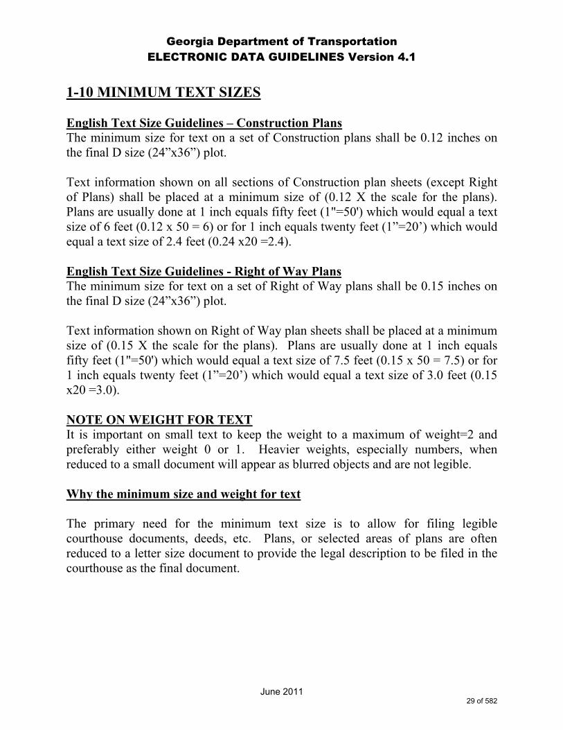
1-10 MINIMUM TEXT SIZES English Text Size Guidelines – Construction Plans The minimum size for text on a set of Construction plans shall be 0.12 inches on the final D size (24”x36”) plot. Text information shown on all sections of Construction plan sheets (except Right of Plans) shall be placed at a minimum size of (0.12 X the scale for the plans). Plans are usually done at 1 inch equals fifty feet (1"=50') which would equal a text size of 6 feet (0.12 x 50 = 6) or for 1 inch equals twenty feet (1”=20’) which would equal a text size of 2.4 feet (0.24 x20 =2.4). English Text Size Guidelines - Right of Way Plans The minimum size for text on a set of Right of Way plans shall be 0.15 inches on the final D size (24”x36”) plot. Text information shown on Right of Way plan sheets shall be placed at a minimum size of (0.15 X the scale for the plans). Plans are usually done at 1 inch equals fifty feet (1"=50') which would equal a text size of 7.5 feet (0.15 x 50 = 7.5) or for 1 inch equals twenty feet (1”=20’) which would equal a text size of 3.0 feet (0.15 x20 =3.0). NOTE ON WEIGHT FOR TEXT It is important on small text to keep the weight to a maximum of weight=2 and preferably either weight 0 or 1. Heavier weights, especially numbers, when reduced to a small document will appear as blurred objects and are not legible. Why the minimum size and weight for text The primary need for the minimum text size is to allow for filing legible courthouse documents, deeds, etc. Plans, or selected areas of plans are often reduced to a letter size document to provide the legal description to be filed in the courthouse as the final document.
29 of 582

Georgia Department of Transportation ELECTRONIC DATA GUIDELINES Version 4.1
June 2011
1-11 SAVING VIEWS IN MICROSTATION FOR PLOTTING Problem: Recalling information to plot When design files are provided for review, modification, revision, etc., the personnel viewing or modifying the design files cannot easily determine which reference files were attached or what levels were displayed in producing the final hardcopy plot. Solution: Saved Views For each sheet file and all major files for which a plot is created from, a Saved View called “GPLOT” shall be created that contains the exact levels displayed for the active file and all reference files attached which produce the final plot. Once the file is rotated on the screen correctly; the view attributes are set correctly; all reference files attached with appropriate levels displayed; all reference files clipped; the user can key-in: “SV=GPLOT” to save the view. This will create a saved view named “GPLOT” with all the level and clipping settings for plotting.
30 of 582
Georgia Department of Transportation ELECTRONIC DATA GUIDELINES Version 4.1
June 2011
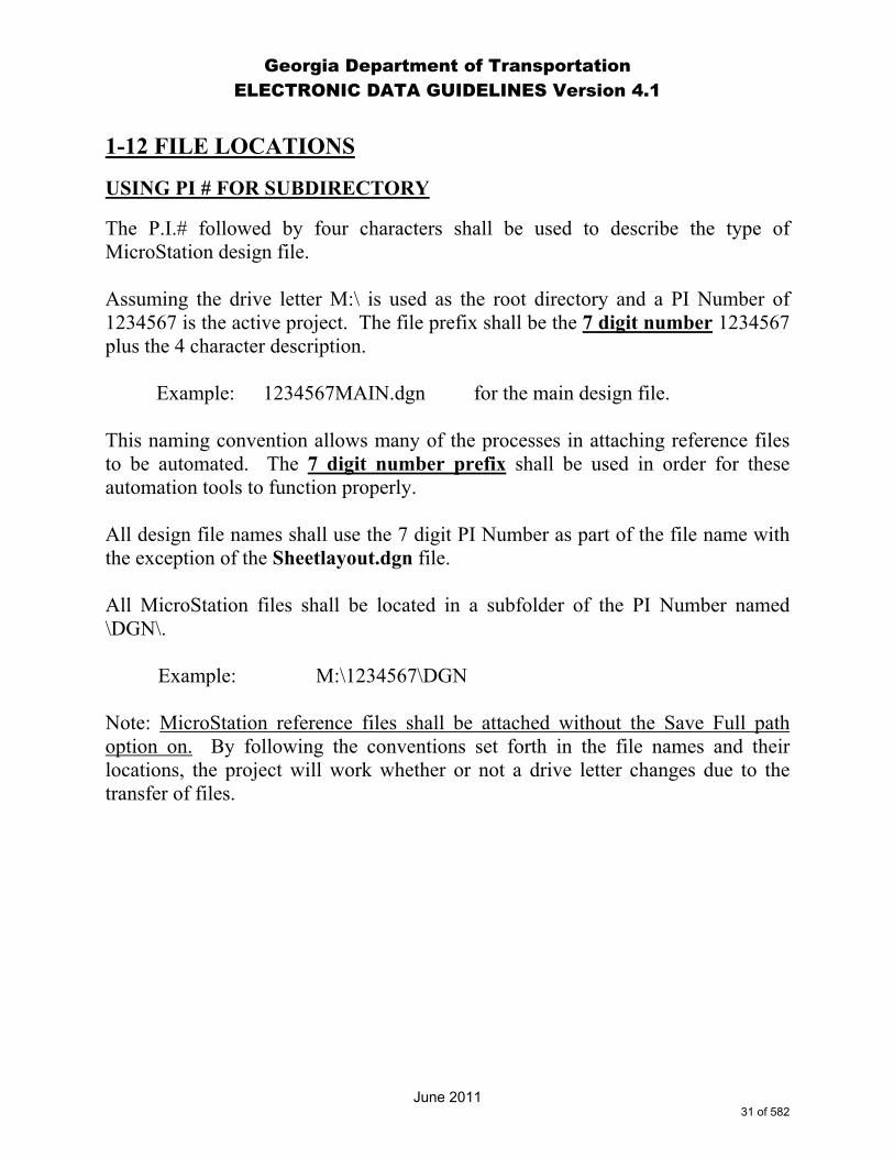
1-12 FILE LOCATIONS
USING PI # FOR SUBDIRECTORY
The P.I.# followed by four characters shall be used to describe the type of MicroStation design file. Assuming the drive letter M:\ is used as the root directory and a PI Number of 1234567 is the active project. The file prefix shall be the 7 digit number 1234567 plus the 4 character description. Example: 1234567MAIN.dgn for the main design file. This naming convention allows many of the processes in attaching reference files to be automated. The 7 digit number prefix shall be used in order for these automation tools to function properly. All design file names shall use the 7 digit PI Number as part of the file name with the exception of the Sheetlayout.dgn file. All MicroStation files shall be located in a subfolder of the PI Number named \DGN\.
Example: M:\1234567\DGN
Note: MicroStation reference files shall be attached without the Save Full path option on. By following the conventions set forth in the file names and their locations, the project will work whether or not a drive letter changes due to the transfer of files.
31 of 582

Georgia Department of Transportation ELECTRONIC DATA GUIDELINES Version 4.1
June 2011
1-13 MISCELLANEOUS ITEMS A clipped boundary shall be placed so that a match line is created for the adjacent sheets to be plotted. This minimizes the possibility for duplication of data between plan sheets. It is recommended to display levels on a final plot as illustrated later in these guidelines. This will help ensure consistency as well as assist in the automation of procedures. As with any document there may be items that have not been addressed and the project designer will need to make the final determination of level display for each sheet. Documentation shall be provided for information placed in MicroStation files that are not listed in Sections 2-4, 2-5, 2-6, 2-7 and 4-2. Documentation of procedures and project history shall be maintained in a project log file.
32 of 582
Georgia Department of Transportation ELECTRONIC DATA GUIDELINES Version 4.1
2-1 Design File Names and Level Schemes
The following sections describe in a spreadsheet format the Design File Name and Level Conventions that shall be used on all Georgia Department of Transportation plans.
33 of 582
Georgia Department of Transportation ELECTRONIC DATA GUIDELINES Version 4.1
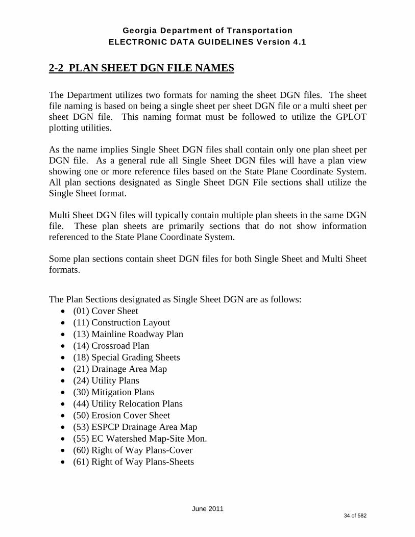
June 2011
2-2 PLAN SHEET DGN FILE NAMES The Department utilizes two formats for naming the sheet DGN files. The sheet file naming is based on being a single sheet per sheet DGN file or a multi sheet per sheet DGN file. This naming format must be followed to utilize the GPLOT plotting utilities. As the name implies Single Sheet DGN files shall contain only one plan sheet per DGN file. As a general rule all Single Sheet DGN files will have a plan view showing one or more reference files based on the State Plane Coordinate System. All plan sections designated as Single Sheet DGN File sections shall utilize the Single Sheet format. Multi Sheet DGN files will typically contain multiple plan sheets in the same DGN file. These plan sheets are primarily sections that do not show information referenced to the State Plane Coordinate System. Some plan sections contain sheet DGN files for both Single Sheet and Multi Sheet formats. The Plan Sections designated as Single Sheet DGN are as follows:
(01) Cover Sheet (11) Construction Layout (13) Mainline Roadway Plan (14) Crossroad Plan (18) Special Grading Sheets (21) Drainage Area Map (24) Utility Plans (30) Mitigation Plans (44) Utility Relocation Plans (50) Erosion Cover Sheet (53) ESPCP Drainage Area Map (55) EC Watershed Map-Site Mon. (60) Right of Way Plans-Cover (61) Right of Way Plans-Sheets
34 of 582
Georgia Department of Transportation ELECTRONIC DATA GUIDELINES Version 4.1
June 2011
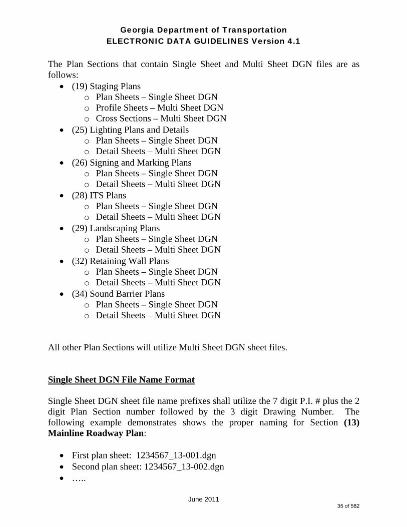
The Plan Sections that contain Single Sheet and Multi Sheet DGN files are as follows:
(19) Staging Plans o Plan Sheets – Single Sheet DGN o Profile Sheets – Multi Sheet DGN o Cross Sections – Multi Sheet DGN
(25) Lighting Plans and Details o Plan Sheets – Single Sheet DGN o Detail Sheets – Multi Sheet DGN
(26) Signing and Marking Plans o Plan Sheets – Single Sheet DGN o Detail Sheets – Multi Sheet DGN
(28) ITS Plans o Plan Sheets – Single Sheet DGN o Detail Sheets – Multi Sheet DGN
(29) Landscaping Plans o Plan Sheets – Single Sheet DGN o Detail Sheets – Multi Sheet DGN
(32) Retaining Wall Plans o Plan Sheets – Single Sheet DGN o Detail Sheets – Multi Sheet DGN
(34) Sound Barrier Plans o Plan Sheets – Single Sheet DGN o Detail Sheets – Multi Sheet DGN
All other Plan Sections will utilize Multi Sheet DGN sheet files. Single Sheet DGN File Name Format Single Sheet DGN sheet file name prefixes shall utilize the 7 digit P.I. # plus the 2 digit Plan Section number followed by the 3 digit Drawing Number. The following example demonstrates shows the proper naming for Section (13) Mainline Roadway Plan:
First plan sheet: 1234567_13-001.dgn Second plan sheet: 1234567_13-002.dgn …..
35 of 582

Georgia Department of Transportation ELECTRONIC DATA GUIDELINES Version 4.1
June 2011
Multi Sheet DGN File Name Format Multi Sheet DGN sheet file name prefixes shall utilize the 7 digit P.I. # plus the 2 digit Plan Section number. The following example demonstrates the proper naming for Section (15) Mainline Roadway Profile:
1234567_15.dgn Note: It is possible to have a Multi Sheet DGN sheet file containing only one plan sheet. Single Sheet DGN sheet files shall contain one plan sheet only.
36 of 582
Georgia Department of TransportationELECTRONIC DATA GUIDELINES Version 4.1
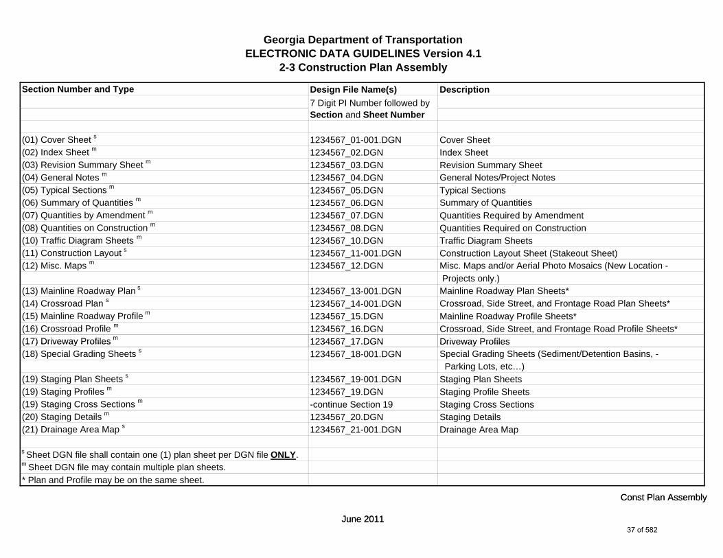
2-3 Construction Plan Assembly
Section Number and Type Design File Name(s) Description
(01) Cover Sheet s 1234567_01-001.DGN Cover Sheet(02) Index Sheet m 1234567_02.DGN Index Sheet(03) Revision Summary Sheet m 1234567_03.DGN Revision Summary Sheet(04) General Notes m 1234567_04.DGN General Notes/Project Notes(05) Typical Sections m 1234567_05.DGN Typical Sections(06) Summary of Quantities m 1234567_06.DGN Summary of Quantities(07) Quantities by Amendment m 1234567_07.DGN Quantities Required by Amendment(08) Quantities on Construction m 1234567_08.DGN Quantities Required on Construction(10) Traffic Diagram Sheets m 1234567_10.DGN Traffic Diagram Sheets(11) Construction Layout s 1234567_11-001.DGN Construction Layout Sheet (Stakeout Sheet)(12) Misc. Maps m 1234567_12.DGN Misc. Maps and/or Aerial Photo Mosaics (New Location -
Projects only.)(13) Mainline Roadway Plan s 1234567_13-001.DGN Mainline Roadway Plan Sheets*(14) Crossroad Plan s 1234567_14-001.DGN Crossroad, Side Street, and Frontage Road Plan Sheets*(15) Mainline Roadway Profile m 1234567_15.DGN Mainline Roadway Profile Sheets*(16) Crossroad Profile m 1234567_16.DGN Crossroad, Side Street, and Frontage Road Profile Sheets*(17) Driveway Profiles m 1234567 17.DGN Driveway Profiles
7 Digit PI Number followed by Section and Sheet Number
June 2011
Const Plan Assembly
(17) Driveway Profiles 1234567_17.DGN Driveway Profiles(18) Special Grading Sheets s 1234567_18-001.DGN Special Grading Sheets (Sediment/Detention Basins, -
Parking Lots, etc…)(19) Staging Plan Sheets s 1234567_19-001.DGN Staging Plan Sheets (19) Staging Profiles m 1234567_19.DGN Staging Profile Sheets (19) Staging Cross Sections m -continue Section 19 Staging Cross Sections(20) Staging Details m 1234567_20.DGN Staging Details(21) Drainage Area Map s 1234567_21-001.DGN Drainage Area Map
s Sheet DGN file shall contain one (1) plan sheet per DGN file ONLY.m Sheet DGN file may contain multiple plan sheets.* Plan and Profile may be on the same sheet.
June 2011
Const Plan Assembly
37 of 582

Georgia Department of TransportationELECTRONIC DATA GUIDELINES Version 4.1
2-3 Construction Plan Assembly
Section Number and Type Design File Name(s) Description
(22) Drainage Profiles m 1234567_22.DGN Drainage Profiles(23) Cross-Sections m 1234567_23.DGN Cross Sections(24) Utility Plans s 1234567_24-001.DGN Utility Plans(25) Lighting Plans and Details s m 1234567_25-001.DGN Lighting Plans and Details - Plan Sheets
1234567_25.DGN Lighting Plans and Details - Detail Sheets(26) Signing and Marking Plans s m 1234567_26-001.DGN Signing and Marking Plans and Details - Plan Sheets
1234567_26.DGN Signing and Marking Plans and Details - Detail Sheets(27) Signal Plans s m 1234567_27-001.DGN Signal Plans - Plan Sheets
1234567_27.DGN Signal Plans - Detail Sheets(28) ITS Plans s m 1234567_28-001.DGN ITS Plans - Plan Sheets
1234567_28.DGN ITS Plans - Detail Sheets(29) Landscaping Plans s m 1234567_29-001.DGN Landscaping Plans and Details - Plan Sheets
1234567_29.DGN Landscaping Plans and Details - Detail Sheets(30) Mitigation Plans s 1234567_30-001.DGN Mitigation Plans (Wetland, etc…)(31) Retaining Wall Envelopes m 1234567_31.DGN Retaining Wall Envelopes(32) Retaining Wall Plans s m 1234567_32-001.DGN Retaining Wall Plans - Plan Sheets*
1234567 32.DGN Retaining Wall Plans - Detail Sheets*
7 Digit PI Number followed by Section and Sheet Number
June 2011
Const Plan Assembly
1234567_32.DGN Retaining Wall Plans - Detail Sheets(33) Sound Barrier Envelopes m 1234567_33.DGN Sound Barrier Envelopes(34) Sound Barrier Plans s m 1234567_34-001.DGN Sound Barrier Plans - Plan Sheets
1234567_34.DGN Sound Barrier Plans - Detail Sheets(35) Bridge Plans m 1234567_35.DGN Bridge Plans and Bridge Standards*(36) Bridge Culvert Plans m 1234567_36.DGN Bridge Culvert Plans*
s Sheet DGN file shall contain one (1) plan sheet per DGN file ONLY.m Sheet DGN file may contain multiple plan sheets.
* Structural Plans designed by the Office of Bridge and Structural - Design or Structural Consultants.
June 2011
Const Plan Assembly
38 of 582
Georgia Department of TransportationELECTRONIC DATA GUIDELINES Version 4.1
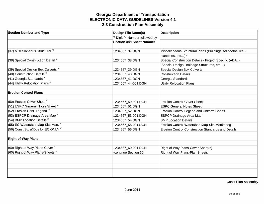
2-3 Construction Plan Assembly
Section Number and Type Design File Name(s) Description
(37) Miscellaneous Structural m 1234567_37.DGN Miscellaneous Structural Plans (Buildings, tollbooths, ice - canopies, etc…)*
(38) Special Construction Detail m 1234567_38.DGN Special Construction Details - Project Specific (ADA, - Special Design Drainage Structures, etc…)
(39) Special Design Box Culverts m 1234567_39.DGN Special Design Box Culverts(40) Construction Details m 1234567_40.DGN Construction Details(41) Georgia Standards m 1234567_41.DGN Georgia Standards (44) Utility Relocation Plans s 1234567_44-001.DGN Utility Relocation Plans
Erosion Control Plans
(50) Erosion Cover Sheet s 1234567_50-001.DGN Erosion Control Cover Sheet(51) ESPC General Notes Sheet m 1234567_51.DGN ESPC General Notes Sheet(52) Erosion Cont. Legend m 1234567_52.DGN Erosion Control Legend and Uniform Codes(53) ESPCP Drainage Area Map s 1234567_53-001.DGN ESPCP Drainage Area Map(54) BMP Location Details m 1234567_54.DGN BMP Location Details(55) EC Watershed Map-Site Mon. s 1234567 55-001.DGN Erosion Control Watershed Map-Site Monitoring
7 Digit PI Number followed by Section and Sheet Number
June 2011
Const Plan Assembly
(55) EC Watershed Map-Site Mon. 1234567_55-001.DGN Erosion Control Watershed Map-Site Monitoring(56) Const Stds&Dtls for EC ONLY m 1234567_56.DGN Erosion Control Construction Standards and Details
Right-of-Way Plans
(60) Right of Way Plans-Cover s 1234567_60-001.DGN Right of Way Plans-Cover Sheet(s)(60) Right of Way Plans-Sheets s -continue Section 60 Right of Way Plans-Plan Sheets
June 2011
Const Plan Assembly
39 of 582

Georgia Department of TransportationELECTRONIC DATA GUIDELINES Version 4.1
2-4 Plan Sheet Levels
MicroStation Level Name
Leve
l Ref
eren
ce
Num
ber
Description
Section Specific Levels
Section Specific Information Number Corresponds to Section (Number 13 = Mainline Plan, Number 24 = Utility Plan etc…)
SHT_B_01-Cover 28000 Cover (sheet specific)SHT_B_02-Index 28001 Index (sheet specific)SHT_B_03-Revision-Summary 28002 Revision Summary (sheet specific)SHT_B_04-General-Notes 28003 General Notes (sheet specific)SHT_B_05-Typical-Sections 28004 Typical Sections (sheet specific)SHT_B_06-Summary-Quantities 28005 Summary Quantities (sheet specific)SHT_B_07-Quantities-Amendment 28006 Quantities Amendment (sheet specific)SHT_B_08-Quantities-Construction 28007 Quantities Construction (sheet specific)SHT_B_10-Traffic-Diagram 28009 Traffic Diagram (sheet specific)SHT_B_11-Construction-Layout 28010 Construction Layout (sheet specific)SHT_B_12-Misc-Maps 28011 Miscellaneous Maps (sheet specific)SHT_B_13-Mainline-Plan 28012 Mainline Plan (sheet specific)SHT_B_14-Crossroad-Plan 28013 Crossroad Plan (sheet specific)SHT_B_15-Mainline-Profile 28014 Mainline Profile (sheet specific)SHT_B_16-Crossroad-Profile 28015 Crossroad Profile (sheet specific)SHT_B_17-Driveway-Profiles 28016 Driveway Profiles (sheet specific)SHT_B_18-Special-Grading 28017 Special Grading (sheet specific)SHT_B_19-Staging-Cross-Sections 28018 Staging Cross Sections (sheet specific)SHT_B_19-Staging-Plan 28019 Staging Plan (sheet specific)SHT_B_19-Staging-Profile 28079 Staging Profile (sheet specific)SHT_B_20-Staging-Details 28020 Staging Details (sheet specific)
June 2011
Plan Sheet Levels
40 of 582

Georgia Department of TransportationELECTRONIC DATA GUIDELINES Version 4.1
2-4 Plan Sheet Levels
MicroStation Level Name
Leve
l Ref
eren
ce
Num
ber
Description
SHT_B_21-Drainage-Area-Map 28021 Drainage Area Map (sheet specific)SHT_B_22-Drainage-Profiles 28022 Drainage Profiles (sheet specific)SHT_B_23-Cross-Sections 28023 Cross Sections (sheet specific)SHT_B_24-Utility-Plans 28024 Utility Plans (sheet specific)SHT_B_25-Lighting-Plans 28025 Lighting Plans (sheet specific)SHT_B_26-Signing-and-Marking-Plans 28026 Signing and Marking Plans (sheet specific)SHT_B_27-Signal-Plans 28027 Signal Plans (sheet specific)SHT_B_28-ATMS-Plans 28028 ITS Plans (sheet specific)SHT_B_29-Landscaping-Plans 28029 Landscaping Plans (sheet specific)SHT_B_30-Mitigation-Plans 28030 Mitigation Plans (sheet specific)SHT_B_31-Retaining-Wall-Envelope 28031 Retaining Wall Envelope (sheet specific)SHT_B_32-Retaining-Wall-Plans 28032 Retaining Wall Plans (sheet specific)SHT_B_33-Noise-Barrier-Envelopes 28033 Noise Barrier Envelopes (sheet specific)SHT_B_34-Noise-Barrier-Plans 28034 Noise Barrier Plans (sheet specific)SHT_B_35-Bridge-Plans 28035 Bridge Plans (sheet specific)SHT_B_36-Bridge-Culvert-Plans 28036 Bridge Culvert Plans (sheet specific)SHT_B_37-Miscellaneous-Structures 28037 Miscellaneous Structures (sheet specific)SHT_B_38-Special-Construction-Detail 28038 Special Construction Detail (sheet specific)SHT_B_39-Special-Culverts 28039 Special Culverts (sheet specific)SHT_B_40-Construction-Details 28040 Construction Details (sheet specific)SHT_B_41-Georgia-Standards 28041 Georgia Standards (sheet specific)SHT_B_44-Utility-Relocation-Plans 28081 Utility Relocation Plans (sheet specific)SHT_B_50-Erosion-Cover 28042 Erosion Cover (sheet specific)SHT_B_51-ESPC-General-Notes 28043 ESPC General Notes (sheet specific)SHT_B_52-Erosion-Cont-Legend 28044 Erosion Cont. Legend (sheet specific)SHT_B_53-ERC-Drainage-Area-Map 28045 ERC Drainage Area Map (sheet specific)SHT_B_54-BMP-Location-Details 28046 BMP Location Details (sheet specific)
June 2011
Plan Sheet Levels
41 of 582

Georgia Department of TransportationELECTRONIC DATA GUIDELINES Version 4.1
2-4 Plan Sheet Levels
MicroStation Level Name
Leve
l Ref
eren
ce
Num
ber
Description
SHT_B_55-Watershed-Map-Site-Mon 28047 Watershed Map-Site Mon. (sheet specific)SHT_B_56-Erosion-Construction-Detail 28048 Erosion Construction Detail (sheet specific)SHT_B_60-Right-of-Way 28080 Right of Way (sheet specific)
SHT_B_CrossRoad-Text 28049 Sheet border crossroad profile title textSHT_B_Drain-Text 28050 Sheet border drainage X-section title textSHT_B_Grid-Elevation-Text 28051 Grid elevtion textSHT_B_Grid-Major-Line 28052 Sheet border major grid lineSHT_B_Grid-Minor-Line 28053 Sheet border minor grid lineSHT_B_Grid-Offset-Text 28054 Grid offset textSHT_B_Grid-Station-Text 28055 Profile Station Grid Text
SHT_B_MainLine-Text 28057 Sheet border mainline profile title textSHT_B_Major-Elevation-Tic-Line 28058 Elevation tick marks majorSHT_B_Major-Offset-Tic-Line 28059 X-Section Offset Tick Marks majorSHT_B_Major-Station-Tic-Line 28060 Profile Station Tick Marks major
SHT_B_Minor-Elevation-Tic-Line 28063 Elevation tick marks minorSHT_B_Minor-Offset-Tic-Line 28064 X-Section Offset Tick Marks minorSHT_B_Minor-Station-Tic-Line 28065 Profile Station Tick Marks minor
SHT_B_Plotting-Info-Tags 28070 Sheet border plotting information tagsSHT_B_Right-of-Way 28071 Right-of-Way (sheet specific)
SHT_B_Stage-Text 28074 Sheet border staging X-section title textSHT_B_Title-Block 28075 Sheet border Title block SHT_B_Xsec-Text 28076 Sheet border earthwork X-section title text
June 2011
Plan Sheet Levels
42 of 582

Georgia Department of TransportationELECTRONIC DATA GUIDELINES Version 4.1
2-4 Plan Sheet Levels
MicroStation Level Name
Leve
l Ref
eren
ce
Num
ber
Description
Following Levels Apply to all Planimetric Sheets (examples include (13) Mainline Plan, (24) Utility Plan etc…)
SHT_P_Major-Station-Tic-Line 28077 Profile Station Tick MarksSHT_P_Minor-Station-Tic-Line 28078 Profile Station Tick MarksSHT_B_Misc-P 28067 Sheet border miscellaneous items, notes, etc. (plotted)SHT_B_North-Arrow 28068 Sheet border north arrowSHT_B_Match-Lines-Text 28062 Sheet border match line textSHT_B_Match-Lines-Line 28061 Sheet border match line linesSHT_B_Legend-Logo-Scale 28056 Sheet border legend, logo, scale bars, location sketchSHT_B_Plot-Sub-Text 28069 Sheet border plot substitution textSHT_B_Sheet-Outline-Line 28072 Sheet border sheet outline linesSHT_B_Sheet-Outline-Text 28073 Sheet border sheet outline textSHT_B_Misc-NP 28066 Sheet border miscellaneous items, notes, etc. (not plotted)SHT_B_Clip-Border-Cell 28082 Clip border - cellSHT_B_Clip-Border-Line 28083 Clip border - lineSHT_B_Clip-Border-Text 28084 Clip border - textSHT_B_Plot-Border-Inner-Line 28085 Plot border inner lineSHT_B_Plot-Border-Outer-Line 28086 Plot border outer lineSHT_B_Summary-Quantities-Cell 28087 Summary Quantities - cellSHT_B_Summary-Quantities-Line 28088 Summary Quantities - lineSHT_B_Summary-Quantities-Text 28089 Summary Quantities - text
June 2011
Plan Sheet Levels
43 of 582

Georgia Department of Transportation ELECTRONIC DATA GUIDELINES Version 4.1
2-5 Construction Plan Assembly Sheet Sections
The following sections describe in a spreadsheet format the Design File Name and Level Schemes that shall be used on Georgia Department of Transportation plan sheets.
44 of 582

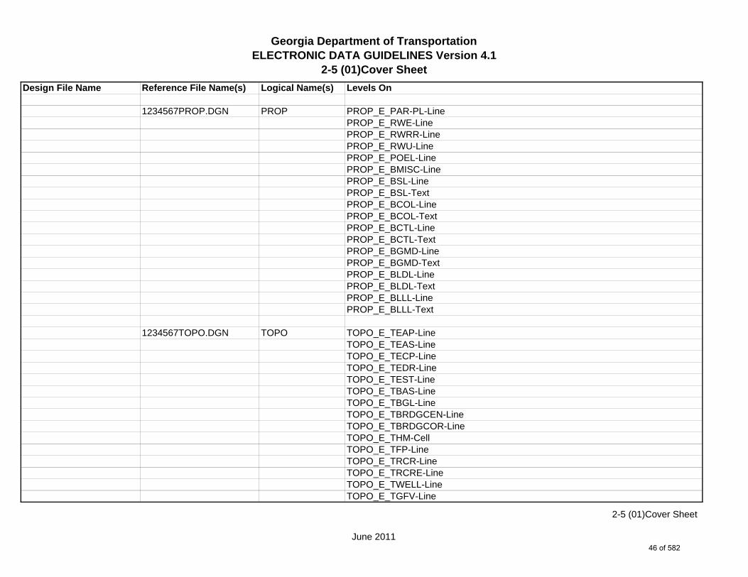
Georgia Department of TransportationELECTRONIC DATA GUIDELINES Version 4.1
2-5 (01)Cover Sheet
Design File Name Reference File Name(s) Logical Name(s) Levels On (See Plan Sheet Levels Section for Level Usage)
1234567_01-001.DGN s NA NA SHT_B_01-CoverSHT_B_Misc-PSHT_B_North-ArrowSHT_B_Match-Lines-TextSHT_B_Match-Lines-LineSHT_B_Legend-Logo-ScaleSHT_B_Plot-Sub-TextSHT_B_Sheet-Outline-LineSHT_B_Sheet-Outline-TextSHT_B_Title-BlockSHT_B_Plot-Border-Inner-LineSHT_B_Plot-Border-Outer-Line
1234567MAIN.DGN MAIN MAIN_P_CONSTCL-LineMAIN_P_CONSTCL-Tic-Sta-TextMAIN_P_CONSTCL-PC-PT-Sta-Ldr-TextMAIN_P_CONSTCL-Brng-TextMAIN_P_CONSTCL-CellMAIN_P_SIDECL-LineMAIN_P_EOP-LineMAIN_P_Bridge-LineMAIN_P_Sidewalk-LineMAIN_P_Median-Side-Barrier-Line
1234567DRNG.DGN DRNG DRNG_P_Ditch-and-Channel-Text
1234567REQD.DGN REQD REQD_P_Parcel-Owner-#-TextREQD_P_REQD-RW-LineREQD_P_REQD-RW-Ltd-Access
s Single Sheet DGN Sheet File.
June 2011
2-5 (01)Cover Sheet
45 of 582
Georgia Department of TransportationELECTRONIC DATA GUIDELINES Version 4.1
2-5 (01)Cover Sheet
Design File Name Reference File Name(s) Logical Name(s) Levels On
1234567PROP.DGN PROP PROP_E_PAR-PL-LinePROP_E_RWE-Line PROP_E_RWRR-LinePROP_E_RWU-LinePROP_E_POEL-LinePROP_E_BMISC-LinePROP_E_BSL-LinePROP_E_BSL-TextPROP_E_BCOL-LinePROP_E_BCOL-TextPROP_E_BCTL-LinePROP_E_BCTL-TextPROP_E_BGMD-LinePROP_E_BGMD-TextPROP_E_BLDL-LinePROP_E_BLDL-TextPROP_E_BLLL-LinePROP_E_BLLL-Text
1234567TOPO.DGN TOPO TOPO_E_TEAP-LineTOPO_E_TEAS-LineTOPO_E_TECP-LineTOPO_E_TEDR-LineTOPO_E_TEST-LineTOPO_E_TBAS-LineTOPO_E_TBGL-LineTOPO_E_TBRDGCEN-LineTOPO_E_TBRDGCOR-LineTOPO_E_THM-CellTOPO_E_TFP-LineTOPO_E_TRCR-LineTOPO_E_TRCRE-LineTOPO_E_TWELL-LineTOPO_E_TGFV-Line
June 2011
2-5 (01)Cover Sheet
46 of 582

Georgia Department of TransportationELECTRONIC DATA GUIDELINES Version 4.1
2-5 (01)Cover Sheet
Design File Name Reference File Name(s) Logical Name(s) Levels On
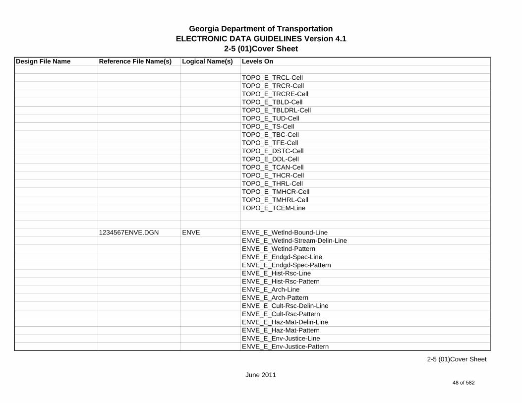
TOPO_E_TGMW-LineTOPO_E_TGP-LineTOPO_E_TGPI-LineTOPO_E_TFT-LineTOPO_E_TGST-LineTOPO_E_TGVP-LineTOPO_E_DCEF-LineTOPO_E_DCB-LineTOPO_E_DCWE-LineTOPO_E_DDCB-LineTOPO_E_DDI-LineTOPO_E_DHWE-LineTOPO_E_DJB-LineTOPO_E_DPC-LineTOPO_E_DPM-LineTOPO_E_DPP-LineTOPO_E_MDITCHFL-LineTOPO_E_DPD-LineTOPO_E_DSB-LineTOPO_E_DSC-LineTOPO_E_DSE-LineTOPO_E_DWE-LineTOPO_E_DEW-LineTOPO_E_DHWM-LineTOPO_E_DSWE-LineTOPO_E_DMISC-LineTOPO_E_TGR-CellTOPO_E_TBAS-CellTOPO_E_TBGL-CellTOPO_E_TBRDGCEN-CellTOPO_E_TBRDGCOR-CellTOPO_E_TFP-CellTOPO_E_TRCL-LineTOPO_E_TRCL-Text
June 2011
2-5 (01)Cover Sheet
47 of 582
Georgia Department of TransportationELECTRONIC DATA GUIDELINES Version 4.1
2-5 (01)Cover Sheet
Design File Name Reference File Name(s) Logical Name(s) Levels On
TOPO_E_TRCL-CellTOPO_E_TRCR-CellTOPO_E_TRCRE-CellTOPO_E_TBLD-CellTOPO_E_TBLDRL-CellTOPO_E_TUD-CellTOPO_E_TS-CellTOPO_E_TBC-CellTOPO_E_TFE-CellTOPO_E_DSTC-CellTOPO_E_DDL-CellTOPO_E_TCAN-CellTOPO_E_THCR-CellTOPO_E_THRL-CellTOPO_E_TMHCR-CellTOPO_E_TMHRL-CellTOPO_E_TCEM-Line
1234567ENVE.DGN ENVE ENVE_E_Wetlnd-Bound-LineENVE_E_Wetlnd-Stream-Delin-LineENVE_E_Wetlnd-PatternENVE_E_Endgd-Spec-LineENVE_E_Endgd-Spec-PatternENVE_E_Hist-Rsc-LineENVE_E_Hist-Rsc-PatternENVE_E_Arch-LineENVE_E_Arch-PatternENVE_E_Cult-Rsc-Delin-LineENVE_E_Cult-Rsc-PatternENVE_E_Haz-Mat-Delin-LineENVE_E_Haz-Mat-PatternENVE_E_Env-Justice-LineENVE_E_Env-Justice-Pattern
June 2011
2-5 (01)Cover Sheet
48 of 582

Georgia Department of TransportationELECTRONIC DATA GUIDELINES Version 4.1
2-5 (01)Cover Sheet
Design File Name Reference File Name(s) Logical Name(s) Levels On
ENVE_E_ESA-LineENVE_E_ESA-Pattern
The following information (but not limited to) is copied into the sheet file, placed on Level 28000, and scaled up for clarity: Road names and Route numbers, Project midpoint and coordinates, Equalities,Begin and End bridge stations,River and stream names, State, County, City, GMD, and Land Lot lines, Crossroad stations, Railroad and major utility names, parcel numbers, Existing and Required R/W lines, Mainline alignment data.
June 2011
2-5 (01)Cover Sheet
49 of 582
Georgia Department of TransportationELECTRONIC DATA GUIDELINES Version 4.1
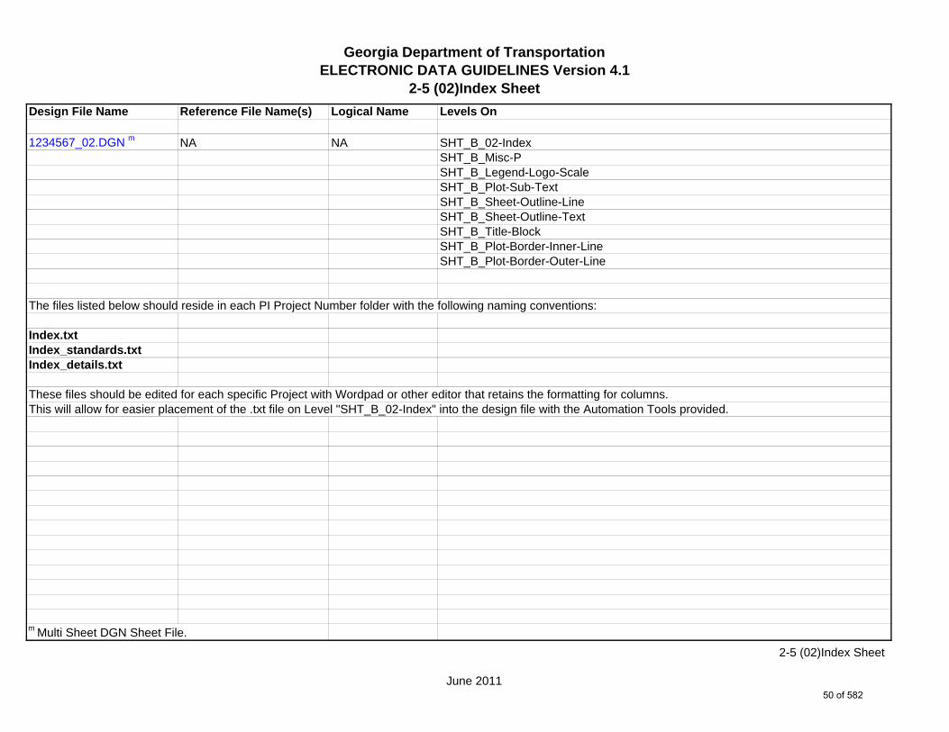
2-5 (02)Index Sheet
Design File Name Reference File Name(s) Logical Name Levels On
1234567_02.DGN m NA NA SHT_B_02-IndexSHT_B_Misc-PSHT_B_Legend-Logo-ScaleSHT_B_Plot-Sub-TextSHT_B_Sheet-Outline-LineSHT_B_Sheet-Outline-TextSHT_B_Title-BlockSHT_B_Plot-Border-Inner-LineSHT_B_Plot-Border-Outer-Line
The files listed below should reside in each PI Project Number folder with the following naming conventions:
Index.txtIndex_standards.txtIndex_details.txt
These files should be edited for each specific Project with Wordpad or other editor that retains the formatting for columns.This will allow for easier placement of the .txt file on Level "SHT_B_02-Index" into the design file with the Automation Tools provided.
m Multi Sheet DGN Sheet File.
June 2011
2-5 (02)Index Sheet
50 of 582
Georgia Department of TransportationELECTRONIC DATA GUIDELINES Version 4.1
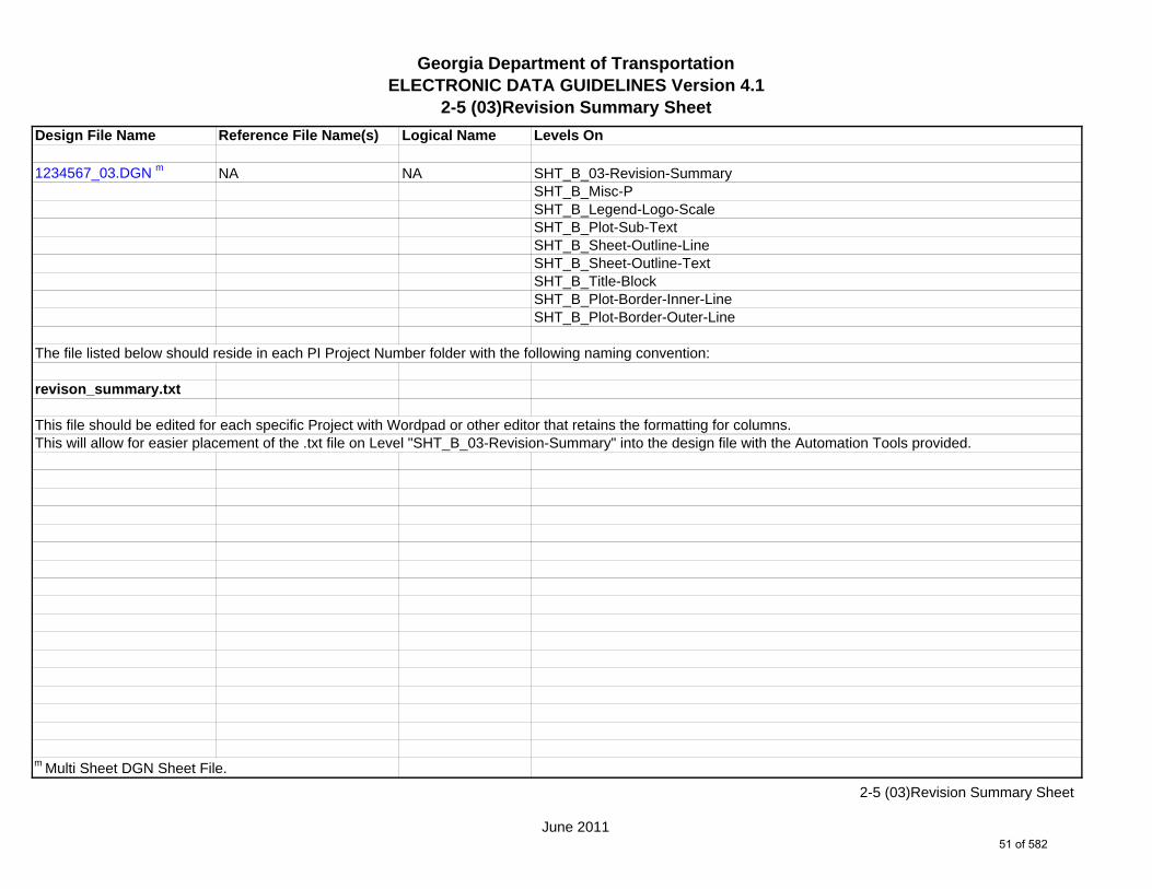
2-5 (03)Revision Summary Sheet
Design File Name Reference File Name(s) Logical Name Levels On
1234567_03.DGN m NA NA SHT_B_03-Revision-SummarySHT_B_Misc-PSHT_B_Legend-Logo-ScaleSHT_B_Plot-Sub-TextSHT_B_Sheet-Outline-LineSHT_B_Sheet-Outline-TextSHT_B_Title-BlockSHT_B_Plot-Border-Inner-LineSHT_B_Plot-Border-Outer-Line
The file listed below should reside in each PI Project Number folder with the following naming convention:
revison_summary.txt
This file should be edited for each specific Project with Wordpad or other editor that retains the formatting for columns.This will allow for easier placement of the .txt file on Level "SHT_B_03-Revision-Summary" into the design file with the Automation Tools provided.
m Multi Sheet DGN Sheet File.
June 2011
2-5 (03)Revision Summary Sheet
51 of 582

Georgia Department of TransportationELECTRONIC DATA GUIDELINES Version 4.1
2-5 (04)General Notes
Design File Name Reference File Name(s) Logical Name Levels On
1234567_04.DGN m NA NA SHT_B_04-General-NotesSHT_B_Misc-PSHT_B_Legend-Logo-ScaleSHT_B_Plot-Sub-TextSHT_B_Sheet-Outline-LineSHT_B_Sheet-Outline-TextSHT_B_Title-BlockSHT_B_Plot-Border-Inner-LineSHT_B_Plot-Border-Outer-Line
See GDOT-GN-General-Notes.cel library for general notes.General Notes should be placed on Level "SHT_B_04-General-Notes".
m Multi Sheet DGN Sheet File.
June 2011
2-5 (04)General Notes
52 of 582
Georgia Department of TransportationELECTRONIC DATA GUIDELINES Version 4.1
2-5 (05)Typical Sections
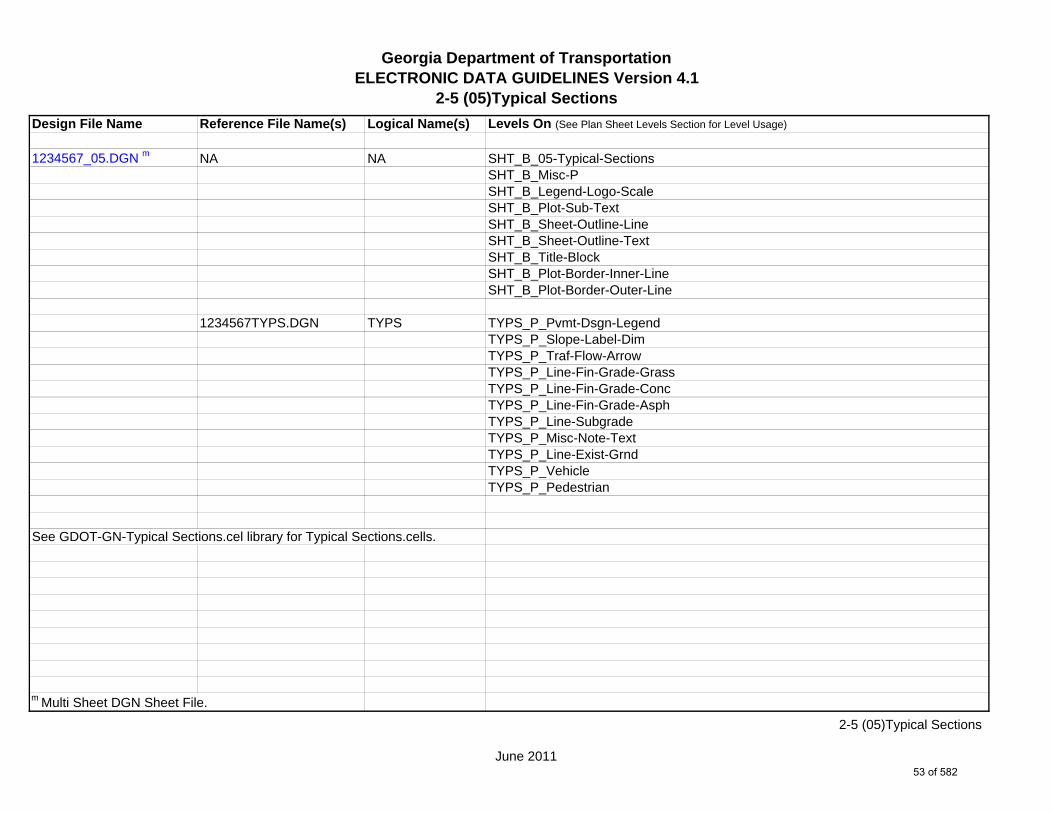
Design File Name Reference File Name(s) Logical Name(s) Levels On (See Plan Sheet Levels Section for Level Usage)
1234567_05.DGN m NA NA SHT_B_05-Typical-SectionsSHT_B_Misc-PSHT_B_Legend-Logo-ScaleSHT_B_Plot-Sub-TextSHT_B_Sheet-Outline-LineSHT_B_Sheet-Outline-TextSHT_B_Title-BlockSHT_B_Plot-Border-Inner-LineSHT_B_Plot-Border-Outer-Line
1234567TYPS.DGN TYPS TYPS_P_Pvmt-Dsgn-LegendTYPS_P_Slope-Label-DimTYPS_P_Traf-Flow-ArrowTYPS_P_Line-Fin-Grade-GrassTYPS_P_Line-Fin-Grade-ConcTYPS_P_Line-Fin-Grade-AsphTYPS_P_Line-SubgradeTYPS_P_Misc-Note-TextTYPS_P_Line-Exist-GrndTYPS_P_VehicleTYPS_P_Pedestrian
See GDOT-GN-Typical Sections.cel library for Typical Sections.cells.
m Multi Sheet DGN Sheet File.
June 2011
2-5 (05)Typical Sections
53 of 582

Georgia Department of TransportationELECTRONIC DATA GUIDELINES Version 4.1
2-5 (06)Summary of Quantities
Design File Name Reference File Name Logical Name Levels On
1234567_06.DGN m NA NA SHT_B_06-Summary-QuantitiesSHT_B_Misc-PSHT_B_Legend-Logo-ScaleSHT_B_Plot-Sub-TextSHT_B_Sheet-Outline-LineSHT_B_Sheet-Outline-TextSHT_B_Title-BlockSHT_B_Plot-Border-Inner-LineSHT_B_Plot-Border-Outer-LineSHT_B_Summary-Quantities-Cell
m Multi Sheet DGN Sheet File.
June 2011
2-5 (06)Summary of Quantities
54 of 582

Georgia Department of TransportationELECTRONIC DATA GUIDELINES Version 4.1
2-5 (07)Quantities by Amendment
Design File Name Reference File Name Logical Name Levels On
1234567_07.DGN m NA NA SHT_B_07-Quantities-AmendmentSHT_B_Misc-PSHT_B_Legend-Logo-ScaleSHT_B_Plot-Sub-TextSHT_B_Sheet-Outline-LineSHT_B_Sheet-Outline-TextSHT_B_Title-BlockSHT_B_Plot-Border-Inner-LineSHT_B_Plot-Border-Outer-LineSHT_B_Summary-Quantities-Cell
m Multi Sheet DGN Sheet File.
June 2011
2-5 (07)Quantities by Amendment
55 of 582
Georgia Department of TransportationELECTRONIC DATA GUIDELINES Version 4.1
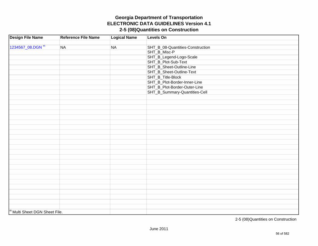
2-5 (08)Quantities on Construction
Design File Name Reference File Name Logical Name Levels On
1234567_08.DGN m NA NA SHT_B_08-Quantities-ConstructionSHT_B_Misc-PSHT_B_Legend-Logo-ScaleSHT_B_Plot-Sub-TextSHT_B_Sheet-Outline-LineSHT_B_Sheet-Outline-TextSHT_B_Title-BlockSHT_B_Plot-Border-Inner-LineSHT_B_Plot-Border-Outer-LineSHT_B_Summary-Quantities-Cell
m Multi Sheet DGN Sheet File.
June 2011
2-5 (08)Quantities on Construction
56 of 582

Georgia Department of TransportationELECTRONIC DATA GUIDELINES Version 4.1
2-5 (10)Traffic Diagram Sheets
Design File Name Reference File Name(s) Logical Name(s) Levels On (See Plan Sheet Levels Section for Level Usage)
1234567_10.DGN m NA NA SHT_B_10-Traffic-DiagramSHT_B_Misc-PSHT_B_Match-Lines-TextSHT_B_Match-Lines-LineSHT_B_Legend-Logo-ScaleSHT_B_Plot-Sub-TextSHT_B_Sheet-Outline-LineSHT_B_Sheet-Outline-TextSHT_B_Title-BlockSHT_B_Plot-Border-Inner-LineSHT_B_Plot-Border-Outer-Line
1234567TRDG.DGN TRDG TRDG_P_LineTRDG_P_TextTRDG_P_Text-DHVTRDG_P_Text-ADTTRDG_P_Text-Percent-TrucksTRDG_P_CellTRDG_P_Divider-Line
m Multi Sheet DGN Sheet File.
June 2011
2-5 (10)Traffic Diagram Sheets
57 of 582
Georgia Department of TransportationELECTRONIC DATA GUIDELINES Version 4.1
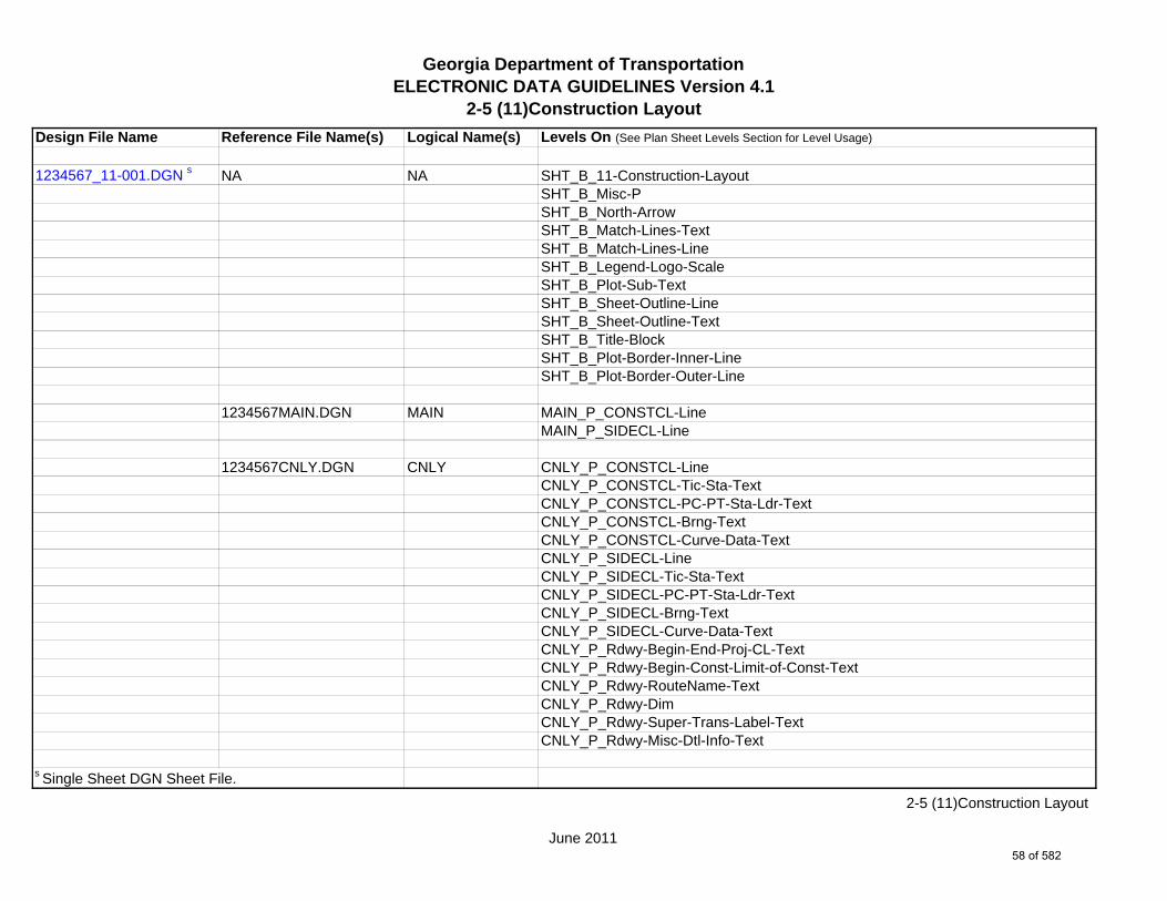
2-5 (11)Construction Layout
Design File Name Reference File Name(s) Logical Name(s) Levels On (See Plan Sheet Levels Section for Level Usage)
1234567_11-001.DGN s NA NA SHT_B_11-Construction-LayoutSHT_B_Misc-PSHT_B_North-ArrowSHT_B_Match-Lines-TextSHT_B_Match-Lines-LineSHT_B_Legend-Logo-ScaleSHT_B_Plot-Sub-TextSHT_B_Sheet-Outline-LineSHT_B_Sheet-Outline-TextSHT_B_Title-BlockSHT_B_Plot-Border-Inner-LineSHT_B_Plot-Border-Outer-Line
1234567MAIN.DGN MAIN MAIN_P_CONSTCL-LineMAIN_P_SIDECL-Line
1234567CNLY.DGN CNLY CNLY_P_CONSTCL-LineCNLY_P_CONSTCL-Tic-Sta-TextCNLY_P_CONSTCL-PC-PT-Sta-Ldr-TextCNLY_P_CONSTCL-Brng-TextCNLY_P_CONSTCL-Curve-Data-TextCNLY_P_SIDECL-LineCNLY_P_SIDECL-Tic-Sta-TextCNLY_P_SIDECL-PC-PT-Sta-Ldr-TextCNLY_P_SIDECL-Brng-TextCNLY_P_SIDECL-Curve-Data-TextCNLY_P_Rdwy-Begin-End-Proj-CL-TextCNLY_P_Rdwy-Begin-Const-Limit-of-Const-TextCNLY_P_Rdwy-RouteName-TextCNLY_P_Rdwy-DimCNLY_P_Rdwy-Super-Trans-Label-TextCNLY_P_Rdwy-Misc-Dtl-Info-Text
s Single Sheet DGN Sheet File.
June 2011
2-5 (11)Construction Layout
58 of 582
Georgia Department of TransportationELECTRONIC DATA GUIDELINES Version 4.1
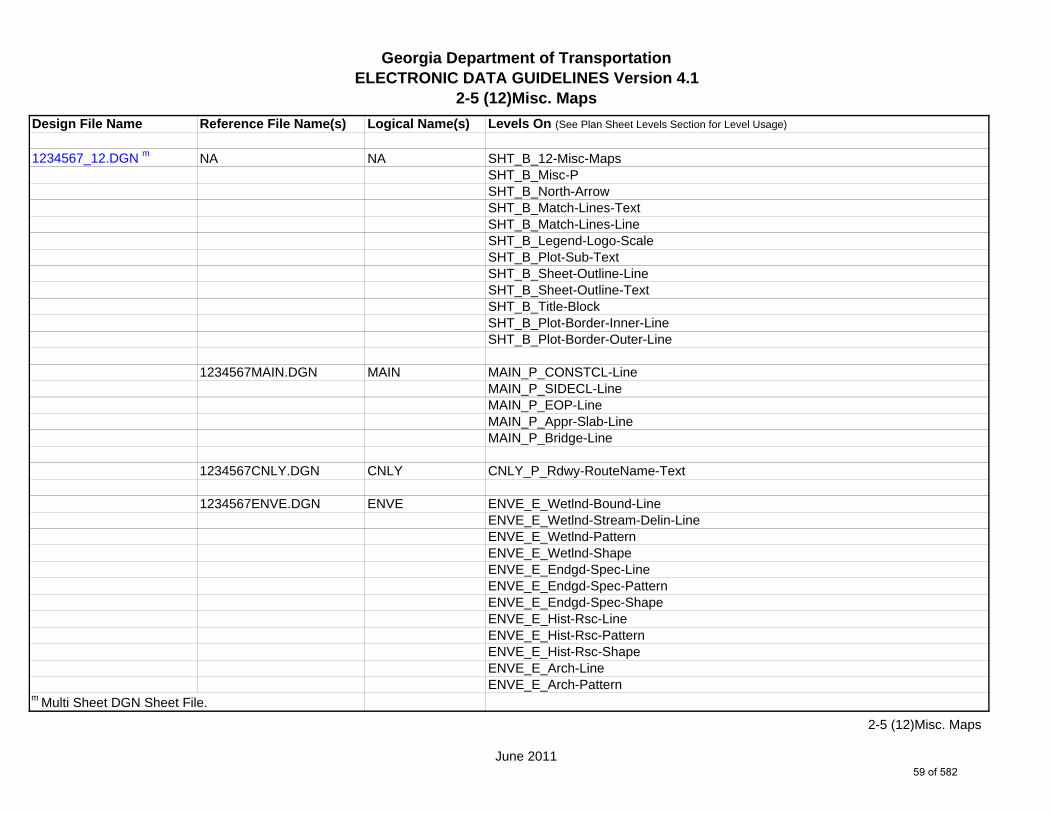
2-5 (12)Misc. Maps
Design File Name Reference File Name(s) Logical Name(s) Levels On (See Plan Sheet Levels Section for Level Usage)
1234567_12.DGN m NA NA SHT_B_12-Misc-MapsSHT_B_Misc-PSHT_B_North-ArrowSHT_B_Match-Lines-TextSHT_B_Match-Lines-LineSHT_B_Legend-Logo-ScaleSHT_B_Plot-Sub-TextSHT_B_Sheet-Outline-LineSHT_B_Sheet-Outline-TextSHT_B_Title-BlockSHT_B_Plot-Border-Inner-LineSHT_B_Plot-Border-Outer-Line
1234567MAIN.DGN MAIN MAIN_P_CONSTCL-LineMAIN_P_SIDECL-LineMAIN_P_EOP-LineMAIN_P_Appr-Slab-LineMAIN_P_Bridge-Line
1234567CNLY.DGN CNLY CNLY_P_Rdwy-RouteName-Text
1234567ENVE.DGN ENVE ENVE_E_Wetlnd-Bound-LineENVE_E_Wetlnd-Stream-Delin-LineENVE_E_Wetlnd-PatternENVE_E_Wetlnd-ShapeENVE_E_Endgd-Spec-LineENVE_E_Endgd-Spec-PatternENVE_E_Endgd-Spec-ShapeENVE_E_Hist-Rsc-LineENVE_E_Hist-Rsc-PatternENVE_E_Hist-Rsc-ShapeENVE_E_Arch-LineENVE_E_Arch-Pattern
m Multi Sheet DGN Sheet File.
June 2011
2-5 (12)Misc. Maps
59 of 582

Georgia Department of TransportationELECTRONIC DATA GUIDELINES Version 4.1
2-5 (12)Misc. Maps
Design File Name Reference File Name(s) Logical Name(s) Levels On (See Plan Sheet Levels Section for Level Usage)
ENVE_E_Arch-ShapeENVE_E_Cult-Rsc-Delin-LineENVE_E_Cult-Rsc-PatternENVE_E_Cult-Rsc-ShapeENVE_E_Haz-Mat-Delin-LineENVE_E_Haz-Mat-PatternENVE_E_Haz-Mat-ShapeENVE_E_Env-Justice-LineENVE_E_Env-Justice-PatternENVE_E_Env-Justice-ShapeENVE_E_ESA-LineENVE_E_ESA-PatternENVE_E_ESA-Shape
1234567ENVP.DGN ENVP ENVP_P_Relocations-LineENVP_P_Socl-Resc-Impact-Area-LineENVP_P_Socl-Resc-Impact-Area-PatternENVP_P_Hist-APE-LineENVP_P_Hist-APE-PatternENVP_P_Cultrl-Resc-Impact-Area-LineENVP_P_Cultrl-Resc-Impact-Area-PatternENVP_P_Wetlnd-Impact-Area-LineENVP_P_Wetlnd-Impact-Area-PatternENVP_P_Wetlnd-Impact-Area-TextENVP_P_Wetlnd-Mitigat-Site-LineENVP_P_Wetlnd-Mitigat-Site-PatternENVP_P_Wetlnd-Mitigat-Site-TextENVP_P_Fldplain-Impact-Area-LineENVP_P_Fldplain-Impact-Area-PatternENVP_P_Fldplain-Impact-Area-TextENVP_P_Impacted-USTENVP_P_Noise-Study-ReceptENVP_P_Noise-Study-ReadingsENVP_P_Noise-Study-Proj-Noise-Lvls
June 2011
2-5 (12)Misc. Maps
60 of 582

Georgia Department of TransportationELECTRONIC DATA GUIDELINES Version 4.1
2-5 (12)Misc. Maps
Design File Name Reference File Name(s) Logical Name(s) Levels On (See Plan Sheet Levels Section for Level Usage)
ENVP_P_Noise-Study-Noise-ContENVP_P_Noise-Study-Impacted-PropENVP_P_Viewshed-Vis-ImpactENVP_P_Fldplain-Impact-Area-LineENVP_P_Fldplain-Impact-Area-PatternENVP_P_Fldplain-Impact-Area-Text
June 2011
2-5 (12)Misc. Maps
61 of 582

Georgia Department of TransportationELECTRONIC DATA GUIDELINES Version 4.1
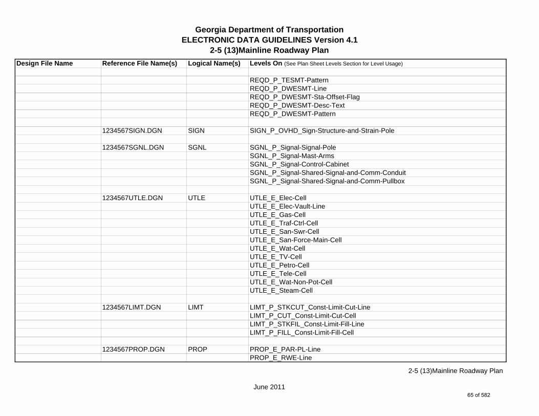
2-5 (13)Mainline Roadway Plan
Design File Name Reference File Name(s) Logical Name(s) Levels On (See Plan Sheet Levels Section for Level Usage)
1234567_13-001.DGN s NA NA SHT_B_13-Mainline-PlanSHT_B_Misc-PSHT_B_North-ArrowSHT_B_Match-Lines-TextSHT_B_Match-Lines-LineSHT_B_Legend-Logo-ScaleSHT_B_Plot-Sub-TextSHT_B_Sheet-Outline-LineSHT_B_Sheet-Outline-TextSHT_B_Title-BlockSHT_B_Plot-Border-Inner-LineSHT_B_Plot-Border-Outer-Line
1234567MAIN.DGN MAIN MAIN_P_CONSTCL-LineMAIN_P_CONSTCL-Tic-Sta-TextMAIN_P_CONSTCL-PC-PT-Sta-Ldr-TextMAIN_P_CONSTCL-Brng-TextMAIN_P_CONSTCL-CellMAIN_P_CONSTCL-Curve-Data-TextMAIN_P_SIDECL-LineMAIN_P_SIDECL-Tic-Sta-TextMAIN_P_SIDECL-PC-PT-Sta-Ldr-TextMAIN_P_SIDECL-Brng-TextMAIN_P_SIDECL-CellMAIN_P_SIDECL-Curve-Data-TextMAIN_P_EOP-LineMAIN_P_EOP-TextMAIN_P_EOP-CellMAIN_P_EPSHLDR-LineMAIN_P_EPSHLDR-TextMAIN_P_Appr-Slab-LineMAIN_P_Appr-Slab-TextMAIN_P_Bridge-Line
s Single Sheet DGN Sheet File.
June 2011
2-5 (13)Mainline Roadway Plan
62 of 582
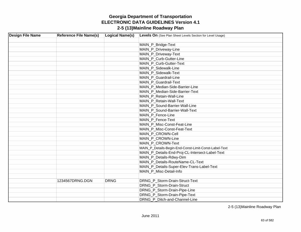
Georgia Department of TransportationELECTRONIC DATA GUIDELINES Version 4.1
2-5 (13)Mainline Roadway Plan
Design File Name Reference File Name(s) Logical Name(s) Levels On (See Plan Sheet Levels Section for Level Usage)
MAIN_P_Bridge-TextMAIN_P_Driveway-LineMAIN_P_Driveway-TextMAIN_P_Curb-Gutter-LineMAIN_P_Curb-Gutter-TextMAIN_P_Sidewalk-LineMAIN_P_Sidewalk-TextMAIN_P_Guardrail-LineMAIN_P_Guardrail-TextMAIN_P_Median-Side-Barrier-LineMAIN_P_Median-Side-Barrier-TextMAIN_P_Retain-Wall-LineMAIN_P_Retain-Wall-TextMAIN_P_Sound-Barrier-Wall-LineMAIN_P_Sound-Barrier-Wall-TextMAIN_P_Fence-LineMAIN_P_Fence-TextMAIN_P_Misc-Const-Feat-LineMAIN_P_Misc-Const-Feat-TextMAIN_P_CROWN-CellMAIN_P_CROWN-LineMAIN_P_CROWN-TextMAIN_P_Details-Begin-End-Const-Limit-Const-Label-TextMAIN_P_Details-End-Proj-CL-Intersect-Label-TextMAIN_P_Details-Rdwy-DimMAIN_P_Details-RouteName-CL-TextMAIN_P_Details-Super-Elev-Trans-Label-TextMAIN_P_Misc-Detail-Info
1234567DRNG.DGN DRNG DRNG_P_Storm-Drain-Struct-TextDRNG_P_Storm-Drain-StructDRNG_P_Storm-Drain-Pipe-LineDRNG_P_Storm-Drain-Pipe-TextDRNG_P_Ditch-and-Channel-Line
June 2011
2-5 (13)Mainline Roadway Plan
63 of 582

Georgia Department of TransportationELECTRONIC DATA GUIDELINES Version 4.1
2-5 (13)Mainline Roadway Plan
Design File Name Reference File Name(s) Logical Name(s) Levels On (See Plan Sheet Levels Section for Level Usage)
DRNG_P_Ditch-and-Channel-TextDRNG_P_Cross-Drain-and-Culv-LineDRNG_P_Cross-Drain-and-Culv-TextDRNG_P_Bridge-Culv-LineDRNG_P_Bridge-Culv-TextDRNG_P_Sediment-Basin-Line (*Shown for Permanent Sediment Basins Only)DRNG_P_Sediment-Basin-Text (*Shown for Permanent Sediment Basins Only)DRNG_P_Detention-Pond-LineDRNG_P_Detention-Pond-TextDRNG_P_Perm-Riprap-PatternDRNG_P_Perm-Ditch-Protect-TextDRNG_P_Perm-Ditch-Protect-LineDRNG_P_Misc-Text
1234567REQD.DGN REQD REQD_P_Parcel-Owner-#-TextREQD_P_Parcel-Owner-TextREQD_P_RWRM-RW-CellREQD_P_RWRM-RW-LineREQD_P_RWRM-RW-MarkerREQD_P_RWRM-RW-TextREQD_P_REQD-RW-CellREQD_P_REQD-RW-LineREQD_P_REQD-RW-Ltd-AccessREQD_P_REQD-RW-Sta-Offset-FlagREQD_P_REQD-RW-Desc-TextREQD_P_PESMT-Pnt#-TextREQD_P_PESMT-LineREQD_P_PESMT-Sta-Offset-FlagREQD_P_PESMT-Desc-TextREQD_P_PESMT-PatternREQD_P_TESMT-Pnt#-TextREQD_P_TESMT-LineREQD_P_TESMT-Sta-Offset-FlagREQD_P_TESMT-Desc-Text
June 2011
2-5 (13)Mainline Roadway Plan
64 of 582
Georgia Department of TransportationELECTRONIC DATA GUIDELINES Version 4.1
2-5 (13)Mainline Roadway Plan
Design File Name Reference File Name(s) Logical Name(s) Levels On (See Plan Sheet Levels Section for Level Usage)
REQD_P_TESMT-PatternREQD_P_DWESMT-LineREQD_P_DWESMT-Sta-Offset-FlagREQD_P_DWESMT-Desc-TextREQD_P_DWESMT-Pattern
1234567SIGN.DGN SIGN SIGN_P_OVHD_Sign-Structure-and-Strain-Pole
1234567SGNL.DGN SGNL SGNL_P_Signal-Signal-PoleSGNL_P_Signal-Mast-ArmsSGNL_P_Signal-Control-CabinetSGNL_P_Signal-Shared-Signal-and-Comm-ConduitSGNL_P_Signal-Shared-Signal-and-Comm-Pullbox
1234567UTLE.DGN UTLE UTLE_E_Elec-CellUTLE_E_Elec-Vault-LineUTLE_E_Gas-CellUTLE_E_Traf-Ctrl-CellUTLE_E_San-Swr-CellUTLE_E_San-Force-Main-CellUTLE_E_Wat-CellUTLE_E_TV-CellUTLE_E_Petro-CellUTLE_E_Tele-CellUTLE_E_Wat-Non-Pot-CellUTLE_E_Steam-Cell
1234567LIMT.DGN LIMT LIMT_P_STKCUT_Const-Limit-Cut-LineLIMT_P_CUT_Const-Limit-Cut-CellLIMT_P_STKFIL_Const-Limit-Fill-LineLIMT_P_FILL_Const-Limit-Fill-Cell
1234567PROP.DGN PROP PROP_E_PAR-PL-LinePROP_E_RWE-Line
June 2011
2-5 (13)Mainline Roadway Plan
65 of 582
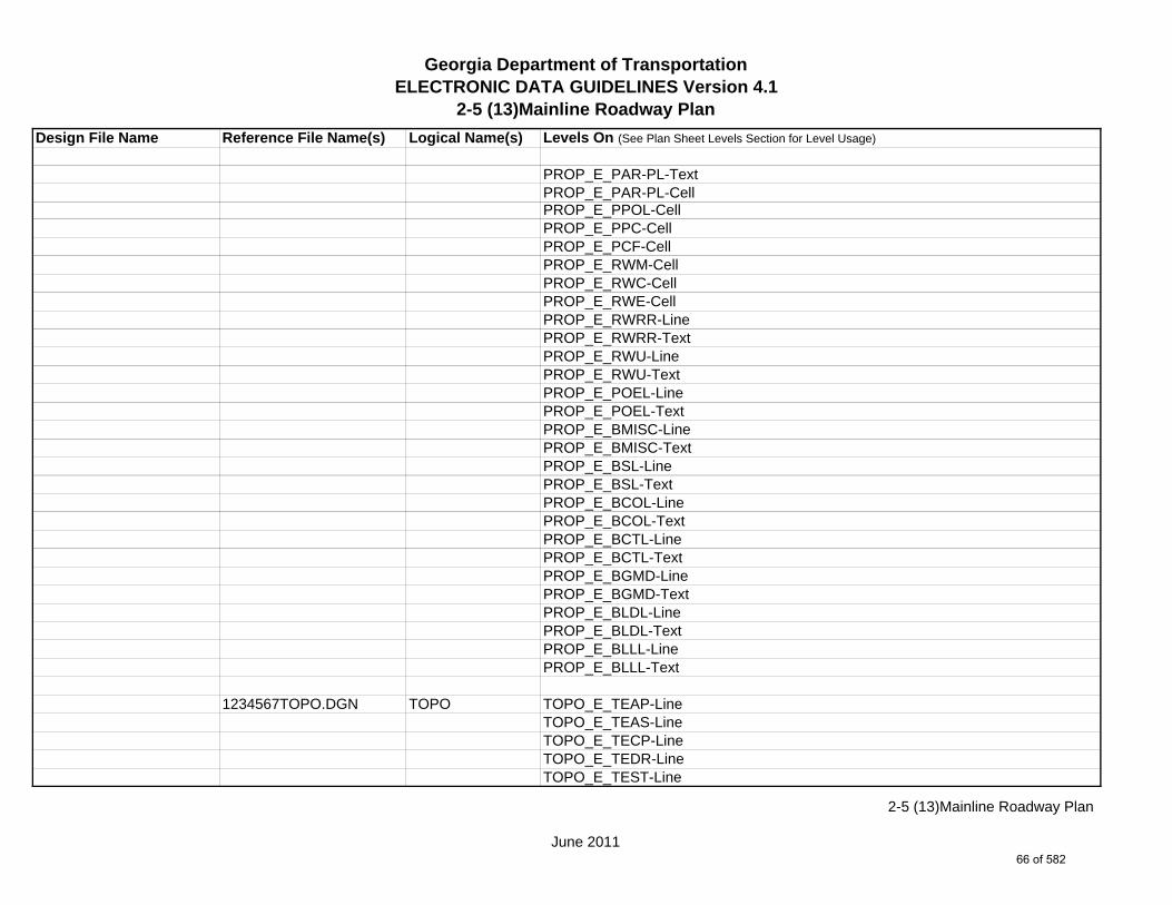
Georgia Department of TransportationELECTRONIC DATA GUIDELINES Version 4.1
2-5 (13)Mainline Roadway Plan
Design File Name Reference File Name(s) Logical Name(s) Levels On (See Plan Sheet Levels Section for Level Usage)
PROP_E_PAR-PL-TextPROP_E_PAR-PL-CellPROP_E_PPOL-CellPROP_E_PPC-CellPROP_E_PCF-CellPROP_E_RWM-CellPROP_E_RWC-CellPROP_E_RWE-CellPROP_E_RWRR-LinePROP_E_RWRR-TextPROP_E_RWU-LinePROP_E_RWU-TextPROP_E_POEL-LinePROP_E_POEL-TextPROP_E_BMISC-LinePROP_E_BMISC-TextPROP_E_BSL-LinePROP_E_BSL-TextPROP_E_BCOL-LinePROP_E_BCOL-TextPROP_E_BCTL-LinePROP_E_BCTL-TextPROP_E_BGMD-LinePROP_E_BGMD-TextPROP_E_BLDL-LinePROP_E_BLDL-TextPROP_E_BLLL-LinePROP_E_BLLL-Text
1234567TOPO.DGN TOPO TOPO_E_TEAP-LineTOPO_E_TEAS-LineTOPO_E_TECP-LineTOPO_E_TEDR-LineTOPO_E_TEST-Line
June 2011
2-5 (13)Mainline Roadway Plan
66 of 582

Georgia Department of TransportationELECTRONIC DATA GUIDELINES Version 4.1
2-5 (13)Mainline Roadway Plan
Design File Name Reference File Name(s) Logical Name(s) Levels On (See Plan Sheet Levels Section for Level Usage)
TOPO_E_UOEL-CellTOPO_E_UOTL-CellTOPO_E_UELBOX-CellTOPO_E_UPP-CellTOPO_E_ULP-CellTOPO_E_UTP-CellTOPO_E_UTPD-CellTOPO_E_UGP-CellTOPO_E_UPGA-CellTOPO_E_UYLE-CellTOPO_E_UYLG-CellTOPO_E_UWM-CellTOPO_E_UWV-CellTOPO_E_UFH-CellTOPO_E_UMHST-CellTOPO_E_UMHSTF-CellTOPO_E_UMHT-CellTOPO_E_UMHE-CellTOPO_E_UMHSS-CellTOPO_E_UMHSSF-CellTOPO_E_USSL-CellTOPO_E_UGM-CellTOPO_E_UNGV-CellTOPO_E_UNGVP-CellTOPO_E_UNGLM-CellTOPO_E_TEDD-LineTOPO_E_TEDD-TextTOPO_E_TEAD-LineTOPO_E_TEAD-TextTOPO_E_TECD-LineTOPO_E_TECD-TextTOPO_E_TAC-LineTOPO_E_TCGF-LineTOPO_E_TCGT-Line
June 2011
2-5 (13)Mainline Roadway Plan
67 of 582

Georgia Department of TransportationELECTRONIC DATA GUIDELINES Version 4.1
2-5 (13)Mainline Roadway Plan
Design File Name Reference File Name(s) Logical Name(s) Levels On (See Plan Sheet Levels Section for Level Usage)
TOPO_E_THC-LineTOPO_E_TVG-LineTOPO_E_TGR-LineTOPO_E_TBAS-LineTOPO_E_TBGL-LineTOPO_E_TBRDGCEN-LineTOPO_E_TBRDGCOR-LineTOPO_E_THM-CellTOPO_E_TFP-LineTOPO_E_TRCR-LineTOPO_E_TRCR-TextTOPO_E_TRCRE-LineTOPO_E_TRCRE-TextTOPO_E_TBLD-LineTOPO_E_TBLDRL-LineTOPO_E_TUD-LineTOPO_E_TS-LineTOPO_E_TBC-LineTOPO_E_TFE-LineTOPO_E_DSTC-LineTOPO_E_DDL-LineTOPO_E_TCAN-LineTOPO_E_THCR-LineTOPO_E_THRL-LineTOPO_E_TMHCR-LineTOPO_E_TMHRL-LineTOPO_E_TFCL-LineTOPO_E_TFW-LineTOPO_E_TFBW-LineTOPO_E_TFFW-LineTOPO_E_TVF-LineTOPO_E_TG-LineTOPO_E_TWELL-LineTOPO_E_TGFV-Line
June 2011
2-5 (13)Mainline Roadway Plan
68 of 582

Georgia Department of TransportationELECTRONIC DATA GUIDELINES Version 4.1
2-5 (13)Mainline Roadway Plan
Design File Name Reference File Name(s) Logical Name(s) Levels On (See Plan Sheet Levels Section for Level Usage)
TOPO_E_TGMW-LineTOPO_E_TGP-LineTOPO_E_TGPI-LineTOPO_E_TFT-LineTOPO_E_TGST-LineTOPO_E_TGVP-LineTOPO_E_DCEF-LineTOPO_E_DCB-LineTOPO_E_DCWE-LineTOPO_E_DDCB-LineTOPO_E_DDI-LineTOPO_E_DHWE-LineTOPO_E_DJB-LineTOPO_E_DPC-LineTOPO_E_DPM-LineTOPO_E_DPP-LineTOPO_E_MDITCHFL-LineTOPO_E_MDITCHFL-TextTOPO_E_DPD-LineTOPO_E_DPD-TextTOPO_E_DSB-LineTOPO_E_DSB-TextTOPO_E_DSC-LineTOPO_E_DSC-TextTOPO_E_DSE-LineTOPO_E_DSE-TextTOPO_E_DWE-LineTOPO_E_DWE-TextTOPO_E_DEW-LineTOPO_E_DEW-TextTOPO_E_DHWM-LineTOPO_E_DHWM-TextTOPO_E_DSWE-LineTOPO_E_DSWE-Text
June 2011
2-5 (13)Mainline Roadway Plan
69 of 582

Georgia Department of TransportationELECTRONIC DATA GUIDELINES Version 4.1
2-5 (13)Mainline Roadway Plan
Design File Name Reference File Name(s) Logical Name(s) Levels On (See Plan Sheet Levels Section for Level Usage)
TOPO_E_DMISC-LineTOPO_E_DMISC-TextTOPO_E_TWF-LineTOPO_E_TWFT-LineTOPO_E_TWFB-LineTOPO_E_TSATDSH-LineTOPO_E_TWL-LineTOPO_E_TTRE-LineTOPO_E_TGRV-LineTOPO_E_DADB-LineTOPO_E_DDT-LineTOPO_E_DSPURDK-LineTOPO_E_TMAR-LineTOPO_E_TMPH-LineTOPO_E_TKMP-LineTOPO_E_TMPR-LineTOPO_E_TSC-LineTOPO_E_TSE-LineTOPO_E_TIRRLMT-LineTOPO_E_TIRRPVTP-LineTOPO_E_TCUL-LineTOPO_E_TMISC-Pnt-CellTOPO_E_SLCD-CellTOPO_E_SLCD-LineTOPO_E_SLCD-Line-TextTOPO_E_SDCD-CellTOPO_E_SDCD-LineTOPO_E_SDCD-Line-TextTOPO_E_SCCHK-LineTOPO_E_SCCHK-TextTOPO_E_SBNCHMK-CellTOPO_E_SBNCHMK-TextTOPO_E_SNGSCM-CellTOPO_E_SNGSCM-Text
June 2011
2-5 (13)Mainline Roadway Plan
70 of 582

Georgia Department of TransportationELECTRONIC DATA GUIDELINES Version 4.1
2-5 (13)Mainline Roadway Plan
Design File Name Reference File Name(s) Logical Name(s) Levels On (See Plan Sheet Levels Section for Level Usage)
TOPO_E_SLCM-CellTOPO_E_SLCM-TextTOPO_E_POOL-LineTOPO_E_POOL-TextTOPO_E_FNDN-LineTOPO_E_RUIN-LineTOPO_E_TANK-LineTOPO_E_DTCH-LineTOPO_E_DTCH-TextTOPO_E_DTCH-Hidden-LineTOPO_E_DTCH-Hidden-TextTOPO_E_TWFE-LineTOPO_E_TWFE-TextTOPO_E_GOLF-LineTOPO_E_GOLF-TextTOPO_E_Basketball-Court-CellTOPO_E_Basketball-Court-LineTOPO_E_Basketball-Court-TextTOPO_E_Flow-Arrow-CellTOPO_E_DEW-Hatch-LineTOPO_E_DITCH-Taper-CellTOPO_E_TRAIL-LineTOPO_E_TRAIL-Text
1234567ENVE.DGN ENVE ENVE_E_Wetlnd-Bound-LineENVE_E_Wetlnd-Stream-Delin-LineENVE_E_Wetlnd-Stream-TextENVE_E_Wetlnd-PatternENVE_E_Wetlnd-ShapeENVE_E_Endgd-Spec-LineENVE_E_Endgd-Spec-TextENVE_E_Endgd-Spec-PatternENVE_E_Endgd-Spec-ShapeENVE_E_Hist-Rsc-Line
June 2011
2-5 (13)Mainline Roadway Plan
71 of 582

Georgia Department of TransportationELECTRONIC DATA GUIDELINES Version 4.1
2-5 (13)Mainline Roadway Plan
Design File Name Reference File Name(s) Logical Name(s) Levels On (See Plan Sheet Levels Section for Level Usage)
ENVE_E_Hist-Rsc-TextENVE_E_Hist-Rsc-PatternENVE_E_Hist-Rsc-ShapeENVE_E_Arch-LineENVE_E_Arch-TextENVE_E_Arch-PatternENVE_E_Arch-ShapeENVE_E_Cult-Rsc-Delin-LineENVE_E_Cult-Rsc-TextENVE_E_Cult-Rsc-PatternENVE_E_Cult-Rsc-ShapeENVE_E_Haz-Mat-Delin-LineENVE_E_Haz-Mat-TextENVE_E_Haz-Mat-PatternENVE_E_Haz-Mat-ShapeENVE_E_Env-Justice-LineENVE_E_Env-Justice-TextENVE_E_Env-Justice-PatternENVE_E_Env-Justice-ShapeENVE_E_ESA-LineENVE_E_ESA-TextENVE_E_ESA-PatternENVE_E_ESA-Shape
1234567ENVP.DGN ENVP ENVP_P_Relocations-LineENVP_P_Relocations-TextENVP_P_Socl-Resc-Impact-Area-LineENVP_P_Socl-Resc-Impact-Area-PatternENVP_P_Socl-Resc-Impact-Area-TextENVP_P_Hist-APE-LineENVP_P_Hist-APE-PatternENVP_P_Hist-APE-TextENVP_P_Cultrl-Resc-Impact-Area-LineENVP_P_Cultrl-Resc-Impact-Area-Pattern
June 2011
2-5 (13)Mainline Roadway Plan
72 of 582

Georgia Department of TransportationELECTRONIC DATA GUIDELINES Version 4.1
2-5 (13)Mainline Roadway Plan
Design File Name Reference File Name(s) Logical Name(s) Levels On (See Plan Sheet Levels Section for Level Usage)
ENVP_P_Cultrl-Resc-Impact-Area-TextENVP_P_Wetlnd-Impact-Area-LineENVP_P_Wetlnd-Impact-Area-PatternENVP_P_Wetlnd-Impact-Area-TextENVP_P_Wetlnd-Mitigat-Site-LineENVP_P_Wetlnd-Mitigat-Site-PatternENVP_P_Wetlnd-Mitigat-Site-TextENVP_P_Fldplain-Impact-Area-LineENVP_P_Fldplain-Impact-Area-PatternENVP_P_Fldplain-Impact-Area-TextENVP_P_Impacted-USTENVP_P_Noise-Study-ReceptENVP_P_Noise-Study-ReadingsENVP_P_Noise-Study-Proj-Noise-LvlsENVP_P_Noise-Study-Noise-ContENVP_P_Noise-Study-Impacted-PropENVP_P_Viewshed-Vis-Impact
June 2011
2-5 (13)Mainline Roadway Plan
73 of 582
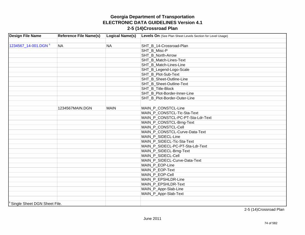
Georgia Department of TransportationELECTRONIC DATA GUIDELINES Version 4.1
2-5 (14)Crossroad Plan
Design File Name Reference File Name(s) Logical Name(s) Levels On (See Plan Sheet Levels Section for Level Usage)
1234567_14-001.DGN s NA NA SHT_B_14-Crossroad-PlanSHT_B_Misc-PSHT_B_North-ArrowSHT_B_Match-Lines-TextSHT_B_Match-Lines-LineSHT_B_Legend-Logo-ScaleSHT_B_Plot-Sub-TextSHT_B_Sheet-Outline-LineSHT_B_Sheet-Outline-TextSHT_B_Title-BlockSHT_B_Plot-Border-Inner-LineSHT_B_Plot-Border-Outer-Line
1234567MAIN.DGN MAIN MAIN_P_CONSTCL-LineMAIN_P_CONSTCL-Tic-Sta-TextMAIN_P_CONSTCL-PC-PT-Sta-Ldr-TextMAIN_P_CONSTCL-Brng-TextMAIN_P_CONSTCL-CellMAIN_P_CONSTCL-Curve-Data-TextMAIN_P_SIDECL-LineMAIN_P_SIDECL-Tic-Sta-TextMAIN_P_SIDECL-PC-PT-Sta-Ldr-TextMAIN_P_SIDECL-Brng-TextMAIN_P_SIDECL-CellMAIN_P_SIDECL-Curve-Data-TextMAIN_P_EOP-LineMAIN_P_EOP-TextMAIN_P_EOP-CellMAIN_P_EPSHLDR-LineMAIN_P_EPSHLDR-TextMAIN_P_Appr-Slab-LineMAIN_P_Appr-Slab-Text
s Single Sheet DGN Sheet File.
June 2011
2-5 (14)Crossroad Plan
74 of 582

Georgia Department of TransportationELECTRONIC DATA GUIDELINES Version 4.1
2-5 (14)Crossroad Plan
Design File Name Reference File Name(s) Logical Name(s) Levels On (See Plan Sheet Levels Section for Level Usage)
MAIN_P_Bridge-LineMAIN_P_Bridge-TextMAIN_P_Driveway-LineMAIN_P_Driveway-TextMAIN_P_Curb-Gutter-LineMAIN_P_Curb-Gutter-TextMAIN_P_Sidewalk-LineMAIN_P_Sidewalk-TextMAIN_P_Guardrail-LineMAIN_P_Guardrail-TextMAIN_P_Median-Side-Barrier-LineMAIN_P_Median-Side-Barrier-TextMAIN_P_Retain-Wall-LineMAIN_P_Retain-Wall-TextMAIN_P_Sound-Barrier-Wall-LineMAIN_P_Sound-Barrier-Wall-TextMAIN_P_Fence-LineMAIN_P_Fence-TextMAIN_P_Misc-Const-Feat-LineMAIN_P_Misc-Const-Feat-TextMAIN_P_CROWN-CellMAIN_P_CROWN-LineMAIN_P_CROWN-TextMAIN_P_Details-Begin-End-Const-Limit-Const-Label-TextMAIN_P_Details-End-Proj-CL-Intersect-Label-TextMAIN_P_Details-Rdwy-DimMAIN_P_Details-RouteName-CL-TextMAIN_P_Details-Super-Elev-Trans-Label-TextMAIN_P_Misc-Detail-Info
1234567DRNG.DGN DRNG DRNG_P_Storm-Drain-Struct-TextDRNG_P_Storm-Drain-StructDRNG_P_Storm-Drain-Pipe-LineDRNG_P_Storm-Drain-Pipe-Text
June 2011
2-5 (14)Crossroad Plan
75 of 582
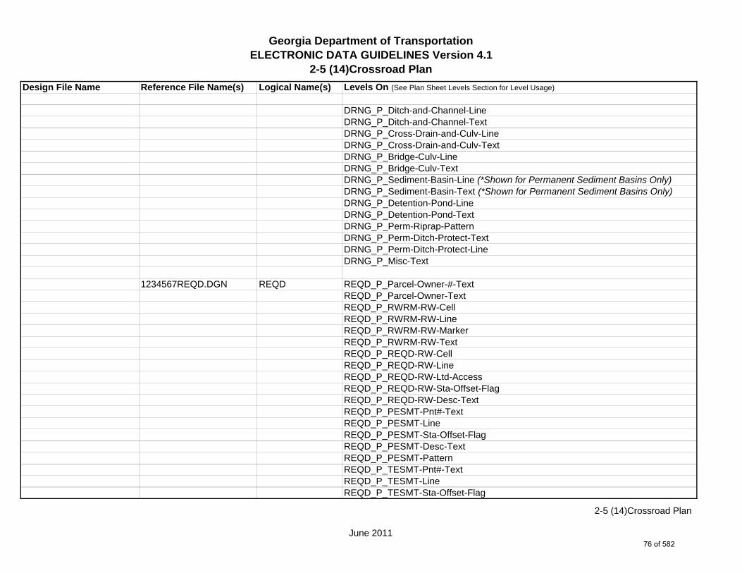
Georgia Department of TransportationELECTRONIC DATA GUIDELINES Version 4.1
2-5 (14)Crossroad Plan
Design File Name Reference File Name(s) Logical Name(s) Levels On (See Plan Sheet Levels Section for Level Usage)
DRNG_P_Ditch-and-Channel-LineDRNG_P_Ditch-and-Channel-TextDRNG_P_Cross-Drain-and-Culv-LineDRNG_P_Cross-Drain-and-Culv-TextDRNG_P_Bridge-Culv-LineDRNG_P_Bridge-Culv-TextDRNG_P_Sediment-Basin-Line (*Shown for Permanent Sediment Basins Only)DRNG_P_Sediment-Basin-Text (*Shown for Permanent Sediment Basins Only)DRNG_P_Detention-Pond-LineDRNG_P_Detention-Pond-TextDRNG_P_Perm-Riprap-PatternDRNG_P_Perm-Ditch-Protect-TextDRNG_P_Perm-Ditch-Protect-LineDRNG_P_Misc-Text
1234567REQD.DGN REQD REQD_P_Parcel-Owner-#-TextREQD_P_Parcel-Owner-TextREQD_P_RWRM-RW-CellREQD_P_RWRM-RW-LineREQD_P_RWRM-RW-MarkerREQD_P_RWRM-RW-TextREQD_P_REQD-RW-CellREQD_P_REQD-RW-LineREQD_P_REQD-RW-Ltd-AccessREQD_P_REQD-RW-Sta-Offset-FlagREQD_P_REQD-RW-Desc-TextREQD_P_PESMT-Pnt#-TextREQD_P_PESMT-LineREQD_P_PESMT-Sta-Offset-FlagREQD_P_PESMT-Desc-TextREQD_P_PESMT-PatternREQD_P_TESMT-Pnt#-TextREQD_P_TESMT-LineREQD_P_TESMT-Sta-Offset-Flag
June 2011
2-5 (14)Crossroad Plan
76 of 582

Georgia Department of TransportationELECTRONIC DATA GUIDELINES Version 4.1
2-5 (14)Crossroad Plan
Design File Name Reference File Name(s) Logical Name(s) Levels On (See Plan Sheet Levels Section for Level Usage)
REQD_P_TESMT-Desc-TextREQD_P_TESMT-PatternREQD_P_DWESMT-LineREQD_P_DWESMT-Sta-Offset-FlagREQD_P_DWESMT-Desc-TextREQD_P_DWESMT-Pattern
1234567SIGN.DGN SIGN SIGN_P_OVHD_Sign-Structure-and-Strain-Pole
1234567SGNL.DGN SGNL SGNL_P_Signal-Signal-PoleSGNL_P_Signal-Mast-ArmsSGNL_P_Signal-Control-CabinetSGNL_P_Signal-Shared-Signal-and-Comm-ConduitSGNL_P_Signal-Shared-Signal-and-Comm-Pullbox
1234567UTLE.DGN UTLE UTLE_E_Elec-CellUTLE_E_Elec-Vault-LineUTLE_E_Gas-CellUTLE_E_Traf-Ctrl-CellUTLE_E_San-Swr-CellUTLE_E_San-Force-Main-CellUTLE_E_Wat-CellUTLE_E_TV-CellUTLE_E_Petro-CellUTLE_E_Tele-CellUTLE_E_Wat-Non-Pot-CellUTLE_E_Steam-Cell
1234567LIMT.DGN LIMT LIMT_P_STKCUT_Const-Limit-Cut-LineLIMT_P_CUT_Const-Limit-Cut-CellLIMT_P_STKFIL_Const-Limit-Fill-LineLIMT_P_FILL_Const-Limit-Fill-Cell
June 2011
2-5 (14)Crossroad Plan
77 of 582

Georgia Department of TransportationELECTRONIC DATA GUIDELINES Version 4.1
2-5 (14)Crossroad Plan
Design File Name Reference File Name(s) Logical Name(s) Levels On (See Plan Sheet Levels Section for Level Usage)
1234567PROP.DGN PROP PROP_E_PAR-PL-LinePROP_E_RWE-Line PROP_E_PAR-PL-TextPROP_E_PAR-PL-CellPROP_E_PPOL-CellPROP_E_PPC-CellPROP_E_PCF-CellPROP_E_RWM-CellPROP_E_RWC-CellPROP_E_RWE-CellPROP_E_RWRR-LinePROP_E_RWRR-TextPROP_E_RWU-LinePROP_E_RWU-TextPROP_E_POEL-LinePROP_E_POEL-TextPROP_E_BMISC-LinePROP_E_BMISC-TextPROP_E_BSL-LinePROP_E_BSL-TextPROP_E_BCOL-LinePROP_E_BCOL-TextPROP_E_BCTL-LinePROP_E_BCTL-TextPROP_E_BGMD-LinePROP_E_BGMD-TextPROP_E_BLDL-LinePROP_E_BLDL-TextPROP_E_BLLL-LinePROP_E_BLLL-Text
1234567TOPO.DGN TOPO TOPO_E_TEAP-LineTOPO_E_TEAS-LineTOPO_E_TECP-Line
June 2011
2-5 (14)Crossroad Plan
78 of 582

Georgia Department of TransportationELECTRONIC DATA GUIDELINES Version 4.1
2-5 (14)Crossroad Plan
Design File Name Reference File Name(s) Logical Name(s) Levels On (See Plan Sheet Levels Section for Level Usage)
TOPO_E_TEDR-LineTOPO_E_TEST-LineTOPO_E_UOEL-CellTOPO_E_UOTL-CellTOPO_E_UELBOX-CellTOPO_E_UPP-CellTOPO_E_ULP-CellTOPO_E_UTP-CellTOPO_E_UTPD-CellTOPO_E_UGP-CellTOPO_E_UPGA-CellTOPO_E_UYLE-CellTOPO_E_UYLG-CellTOPO_E_UWM-CellTOPO_E_UWV-CellTOPO_E_UFH-CellTOPO_E_UMHST-CellTOPO_E_UMHSTF-CellTOPO_E_UMHT-CellTOPO_E_UMHE-CellTOPO_E_UMHSS-CellTOPO_E_UMHSSF-CellTOPO_E_USSL-CellTOPO_E_UGM-CellTOPO_E_UNGV-CellTOPO_E_UNGVP-CellTOPO_E_UNGLM-CellTOPO_E_TEDD-LineTOPO_E_TEDD-TextTOPO_E_TEAD-LineTOPO_E_TEAD-TextTOPO_E_TECD-LineTOPO_E_TECD-TextTOPO_E_TAC-Line
June 2011
2-5 (14)Crossroad Plan
79 of 582

Georgia Department of TransportationELECTRONIC DATA GUIDELINES Version 4.1
2-5 (14)Crossroad Plan
Design File Name Reference File Name(s) Logical Name(s) Levels On (See Plan Sheet Levels Section for Level Usage)
TOPO_E_TCGF-LineTOPO_E_TCGT-LineTOPO_E_THC-LineTOPO_E_TVG-LineTOPO_E_TGR-LineTOPO_E_TBAS-LineTOPO_E_TBGL-LineTOPO_E_TBRDGCEN-LineTOPO_E_TBRDGCOR-LineTOPO_E_THM-CellTOPO_E_TFP-LineTOPO_E_TRCR-LineTOPO_E_TRCR-TextTOPO_E_TRCRE-LineTOPO_E_TRCRE-TextTOPO_E_TBLD-LineTOPO_E_TBLDRL-LineTOPO_E_TUD-LineTOPO_E_TS-LineTOPO_E_TBC-LineTOPO_E_TFE-LineTOPO_E_DSTC-LineTOPO_E_DDL-LineTOPO_E_TCAN-LineTOPO_E_THCR-LineTOPO_E_THRL-LineTOPO_E_TMHCR-LineTOPO_E_TMHRL-LineTOPO_E_TFCL-LineTOPO_E_TFW-LineTOPO_E_TFBW-LineTOPO_E_TFFW-LineTOPO_E_TVF-LineTOPO_E_TG-Line
June 2011
2-5 (14)Crossroad Plan
80 of 582

Georgia Department of TransportationELECTRONIC DATA GUIDELINES Version 4.1
2-5 (14)Crossroad Plan
Design File Name Reference File Name(s) Logical Name(s) Levels On (See Plan Sheet Levels Section for Level Usage)
TOPO_E_TWELL-LineTOPO_E_TGFV-LineTOPO_E_TGMW-LineTOPO_E_TGP-LineTOPO_E_TGPI-LineTOPO_E_TFT-LineTOPO_E_TGST-LineTOPO_E_TGVP-LineTOPO_E_DCEF-LineTOPO_E_DCB-LineTOPO_E_DCWE-LineTOPO_E_DDCB-LineTOPO_E_DDI-LineTOPO_E_DHWE-LineTOPO_E_DJB-LineTOPO_E_DPC-LineTOPO_E_DPM-LineTOPO_E_DPP-LineTOPO_E_MDITCHFL-LineTOPO_E_MDITCHFL-TextTOPO_E_DPD-LineTOPO_E_DPD-TextTOPO_E_DSB-LineTOPO_E_DSB-TextTOPO_E_DSC-LineTOPO_E_DSC-TextTOPO_E_DSE-LineTOPO_E_DSE-TextTOPO_E_DWE-LineTOPO_E_DWE-TextTOPO_E_DEW-LineTOPO_E_DEW-TextTOPO_E_DHWM-LineTOPO_E_DHWM-Text
June 2011
2-5 (14)Crossroad Plan
81 of 582
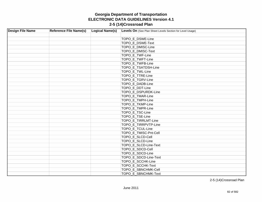
Georgia Department of TransportationELECTRONIC DATA GUIDELINES Version 4.1
2-5 (14)Crossroad Plan
Design File Name Reference File Name(s) Logical Name(s) Levels On (See Plan Sheet Levels Section for Level Usage)
TOPO_E_DSWE-LineTOPO_E_DSWE-TextTOPO_E_DMISC-LineTOPO_E_DMISC-TextTOPO_E_TWF-LineTOPO_E_TWFT-LineTOPO_E_TWFB-LineTOPO_E_TSATDSH-LineTOPO_E_TWL-LineTOPO_E_TTRE-LineTOPO_E_TGRV-LineTOPO_E_DADB-LineTOPO_E_DDT-LineTOPO_E_DSPURDK-LineTOPO_E_TMAR-LineTOPO_E_TMPH-LineTOPO_E_TKMP-LineTOPO_E_TMPR-LineTOPO_E_TSC-LineTOPO_E_TSE-LineTOPO_E_TIRRLMT-LineTOPO_E_TIRRPVTP-LineTOPO_E_TCUL-LineTOPO_E_TMISC-Pnt-CellTOPO_E_SLCD-CellTOPO_E_SLCD-LineTOPO_E_SLCD-Line-TextTOPO_E_SDCD-CellTOPO_E_SDCD-LineTOPO_E_SDCD-Line-TextTOPO_E_SCCHK-LineTOPO_E_SCCHK-TextTOPO_E_SBNCHMK-CellTOPO_E_SBNCHMK-Text
June 2011
2-5 (14)Crossroad Plan
82 of 582
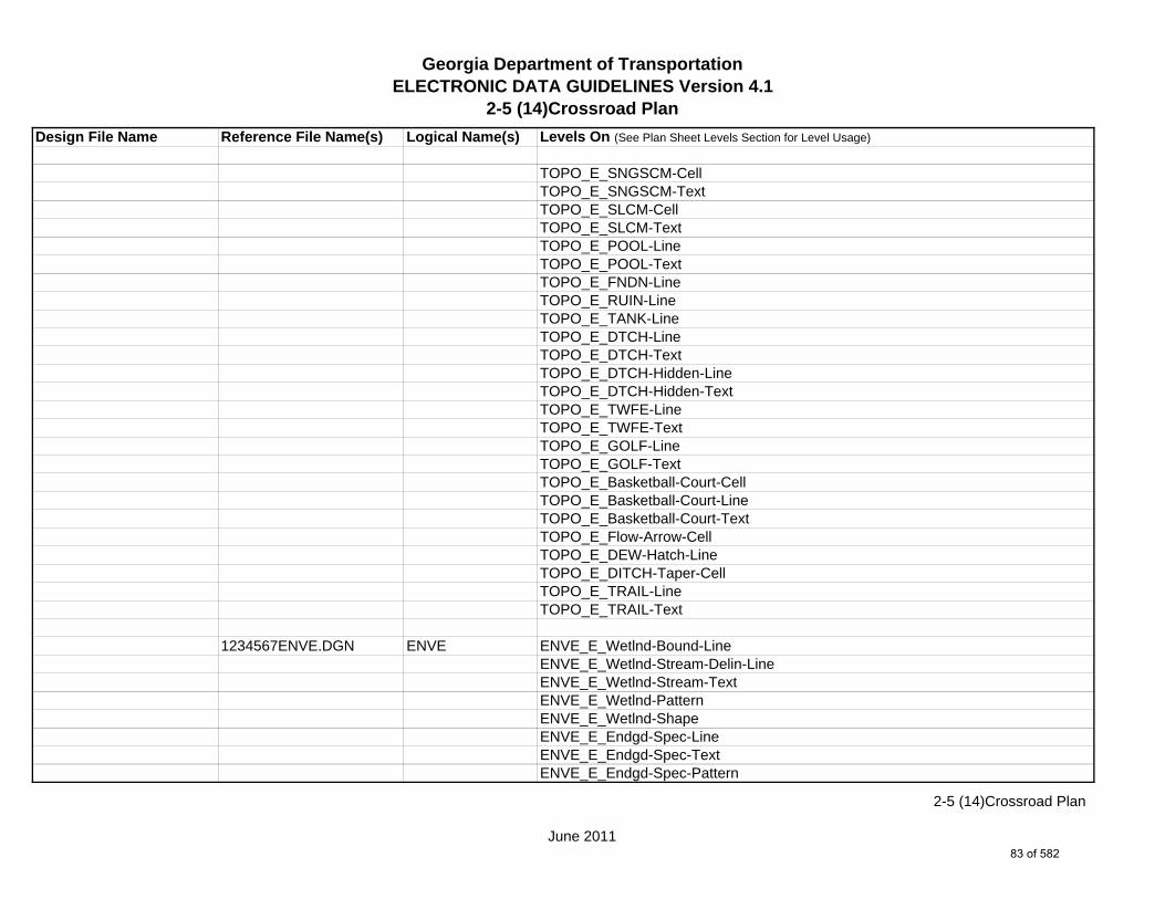
Georgia Department of TransportationELECTRONIC DATA GUIDELINES Version 4.1
2-5 (14)Crossroad Plan
Design File Name Reference File Name(s) Logical Name(s) Levels On (See Plan Sheet Levels Section for Level Usage)
TOPO_E_SNGSCM-CellTOPO_E_SNGSCM-TextTOPO_E_SLCM-CellTOPO_E_SLCM-TextTOPO_E_POOL-LineTOPO_E_POOL-TextTOPO_E_FNDN-LineTOPO_E_RUIN-LineTOPO_E_TANK-LineTOPO_E_DTCH-LineTOPO_E_DTCH-TextTOPO_E_DTCH-Hidden-LineTOPO_E_DTCH-Hidden-TextTOPO_E_TWFE-LineTOPO_E_TWFE-TextTOPO_E_GOLF-LineTOPO_E_GOLF-TextTOPO_E_Basketball-Court-CellTOPO_E_Basketball-Court-LineTOPO_E_Basketball-Court-TextTOPO_E_Flow-Arrow-CellTOPO_E_DEW-Hatch-LineTOPO_E_DITCH-Taper-CellTOPO_E_TRAIL-LineTOPO_E_TRAIL-Text
1234567ENVE.DGN ENVE ENVE_E_Wetlnd-Bound-LineENVE_E_Wetlnd-Stream-Delin-LineENVE_E_Wetlnd-Stream-TextENVE_E_Wetlnd-PatternENVE_E_Wetlnd-ShapeENVE_E_Endgd-Spec-LineENVE_E_Endgd-Spec-TextENVE_E_Endgd-Spec-Pattern
June 2011
2-5 (14)Crossroad Plan
83 of 582

Georgia Department of TransportationELECTRONIC DATA GUIDELINES Version 4.1
2-5 (14)Crossroad Plan
Design File Name Reference File Name(s) Logical Name(s) Levels On (See Plan Sheet Levels Section for Level Usage)
ENVE_E_Endgd-Spec-ShapeENVE_E_Hist-Rsc-LineENVE_E_Hist-Rsc-TextENVE_E_Hist-Rsc-PatternENVE_E_Hist-Rsc-ShapeENVE_E_Arch-LineENVE_E_Arch-TextENVE_E_Arch-PatternENVE_E_Arch-ShapeENVE_E_Cult-Rsc-Delin-LineENVE_E_Cult-Rsc-TextENVE_E_Cult-Rsc-PatternENVE_E_Cult-Rsc-ShapeENVE_E_Haz-Mat-Delin-LineENVE_E_Haz-Mat-TextENVE_E_Haz-Mat-PatternENVE_E_Haz-Mat-ShapeENVE_E_Env-Justice-LineENVE_E_Env-Justice-TextENVE_E_Env-Justice-PatternENVE_E_Env-Justice-ShapeENVE_E_ESA-LineENVE_E_ESA-TextENVE_E_ESA-PatternENVE_E_ESA-Shape
1234567ENVP.DGN ENVP ENVP_P_Relocations-LineENVP_P_Relocations-TextENVP_P_Socl-Resc-Impact-Area-LineENVP_P_Socl-Resc-Impact-Area-PatternENVP_P_Socl-Resc-Impact-Area-TextENVP_P_Hist-APE-LineENVP_P_Hist-APE-PatternENVP_P_Hist-APE-Text
June 2011
2-5 (14)Crossroad Plan
84 of 582
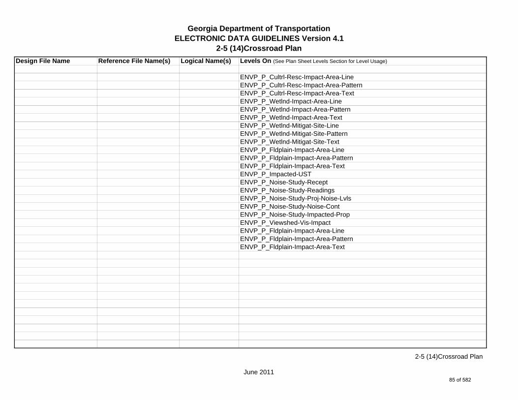
Georgia Department of TransportationELECTRONIC DATA GUIDELINES Version 4.1
2-5 (14)Crossroad Plan
Design File Name Reference File Name(s) Logical Name(s) Levels On (See Plan Sheet Levels Section for Level Usage)
ENVP_P_Cultrl-Resc-Impact-Area-LineENVP_P_Cultrl-Resc-Impact-Area-PatternENVP_P_Cultrl-Resc-Impact-Area-TextENVP_P_Wetlnd-Impact-Area-LineENVP_P_Wetlnd-Impact-Area-PatternENVP_P_Wetlnd-Impact-Area-TextENVP_P_Wetlnd-Mitigat-Site-LineENVP_P_Wetlnd-Mitigat-Site-PatternENVP_P_Wetlnd-Mitigat-Site-TextENVP_P_Fldplain-Impact-Area-LineENVP_P_Fldplain-Impact-Area-PatternENVP_P_Fldplain-Impact-Area-TextENVP_P_Impacted-USTENVP_P_Noise-Study-ReceptENVP_P_Noise-Study-ReadingsENVP_P_Noise-Study-Proj-Noise-LvlsENVP_P_Noise-Study-Noise-ContENVP_P_Noise-Study-Impacted-PropENVP_P_Viewshed-Vis-ImpactENVP_P_Fldplain-Impact-Area-LineENVP_P_Fldplain-Impact-Area-PatternENVP_P_Fldplain-Impact-Area-Text
June 2011
2-5 (14)Crossroad Plan
85 of 582

Georgia Department of TransportationELECTRONIC DATA GUIDELINES Version 4.1
2-5 (15)Mainline Roadway Profile
Design File Name Reference File Name(s) Logical Name(s) Levels On (See Plan Sheet Levels Section for Level Usage)
1234567_15.DGN m NA NA SHT_B_15-Mainline-ProfileSHT_B_CrossRoad-TextSHT_B_Grid-Elevation-TextSHT_B_Grid-Major-LineSHT_B_Grid-Minor-LineSHT_B_Grid-Offset-TextSHT_B_Grid-Station-TextSHT_B_Legend-Logo-ScaleSHT_B_MainLine-TextSHT_B_Major-Elevation-Tic-LineSHT_B_Major-Offset-Tic-LineSHT_B_Major-Station-Tic-LineSHT_B_Match-Lines-LineSHT_B_Match-Lines-TextSHT_B_Minor-Elevation-Tic-LineSHT_B_Minor-Offset-Tic-LineSHT_B_Minor-Station-Tic-LineSHT_B_Plot-Sub-TextSHT_B_Plotting-Info-TagsSHT_B_Sheet-Outline-LineSHT_B_Sheet-Outline-TextSHT_B_Title-BlockSHT_P_Major-Station-Tic-LineSHT_P_Minor-Station-Tic-LineSHT_B_Plot-Border-Inner-LineSHT_B_Plot-Border-Outer-Line
PROF_E_Drainage-CellPROF_E_Drainage-LinePROF_E_Drainage-TextPROF_E_Ground-LinePROF_E_Ground-Text
m Multi Sheet DGN Sheet File.
June 2011
2-5 (15)Mainline Roadway Profile
86 of 582

Georgia Department of TransportationELECTRONIC DATA GUIDELINES Version 4.1
2-5 (15)Mainline Roadway Profile
Design File Name Reference File Name(s) Logical Name(s) Levels On (See Plan Sheet Levels Section for Level Usage)
PROF_E_Substratum1-LinePROF_E_Substratum2-LinePROF_E_Substratum3-Line
PROF_P_Drainage-CellPROF_P_Drainage-LinePROF_P_Drainage-TextPROF_P_Finish-Elev-TextPROF_P_Finish-LinePROF_P_Finish-Pt-CellPROF_P_Finish-TextPROF_P_Grid-Elev-TextPROF_P_Label-TextPROF_P_Scale-TextPROF_P_Stage1-LinePROF_P_Stage2-LinePROF_P_Stage3-LinePROF_P_Stage4-LinePROF_P_Stage5-LinePROF_P_Station-TextPROF_P_Subgrade-Line
June 2011
2-5 (15)Mainline Roadway Profile
87 of 582

Georgia Department of TransportationELECTRONIC DATA GUIDELINES Version 4.1
2-5 (16)Crossroad Profile
Design File Name Reference File Name(s) Logical Name(s) Levels On (See Plan Sheet Levels Section for Level Usage)
1234567_16.DGN m NA NA SHT_B_16-Crossroad-ProfileSHT_B_CrossRoad-TextSHT_B_Grid-Elevation-TextSHT_B_Grid-Major-LineSHT_B_Grid-Minor-LineSHT_B_Grid-Offset-TextSHT_B_Grid-Station-TextSHT_B_Legend-Logo-ScaleSHT_B_MainLine-TextSHT_B_Major-Elevation-Tic-LineSHT_B_Major-Offset-Tic-LineSHT_B_Major-Station-Tic-LineSHT_B_Match-Lines-LineSHT_B_Match-Lines-TextSHT_B_Minor-Elevation-Tic-LineSHT_B_Minor-Offset-Tic-LineSHT_B_Minor-Station-Tic-LineSHT_B_Plot-Sub-TextSHT_B_Plotting-Info-TagsSHT_B_Sheet-Outline-LineSHT_B_Sheet-Outline-TextSHT_B_Title-BlockSHT_P_Major-Station-Tic-LineSHT_P_Minor-Station-Tic-LineSHT_B_Plot-Border-Inner-LineSHT_B_Plot-Border-Outer-Line
PROF_E_Drainage-CellPROF_E_Drainage-LinePROF_E_Drainage-TextPROF_E_Ground-LinePROF_E_Ground-Text
m Multi Sheet DGN Sheet File.
June 2011
2-5 (16)Crossroad Profile
88 of 582

Georgia Department of TransportationELECTRONIC DATA GUIDELINES Version 4.1
2-5 (16)Crossroad Profile
Design File Name Reference File Name(s) Logical Name(s) Levels On (See Plan Sheet Levels Section for Level Usage)
PROF_E_Substratum1-LinePROF_E_Substratum2-LinePROF_E_Substratum3-Line
PROF_P_Drainage-CellPROF_P_Drainage-LinePROF_P_Drainage-TextPROF_P_Finish-Elev-TextPROF_P_Finish-LinePROF_P_Finish-Pt-CellPROF_P_Finish-TextPROF_P_Grid-Elev-TextPROF_P_Label-TextPROF_P_Scale-TextPROF_P_Stage1-LinePROF_P_Stage2-LinePROF_P_Stage3-LinePROF_P_Stage4-LinePROF_P_Stage5-LinePROF_P_Station-TextPROF_P_Subgrade-Line
June 2011
2-5 (16)Crossroad Profile
89 of 582

Georgia Department of TransportationELECTRONIC DATA GUIDELINES Version 4.1
2-5 (17)Driveway Profiles
Design File Name Reference File Name(s) Logical Name(s) Levels On (See Plan Sheet Levels Section for Level Usage) 1234567_17.DGN m NA NA SHT_B_17-Driveway-Profiles
SHT_B_CrossRoad-TextSHT_B_Grid-Elevation-TextSHT_B_Grid-Major-LineSHT_B_Grid-Minor-LineSHT_B_Grid-Offset-TextSHT_B_Grid-Station-TextSHT_B_Legend-Logo-ScaleSHT_B_MainLine-TextSHT_B_Major-Elevation-Tic-LineSHT_B_Major-Offset-Tic-LineSHT_B_Major-Station-Tic-LineSHT_B_Match-Lines-LineSHT_B_Match-Lines-TextSHT_B_Minor-Elevation-Tic-LineSHT_B_Minor-Offset-Tic-LineSHT_B_Minor-Station-Tic-LineSHT_B_Plot-Sub-TextSHT_B_Plotting-Info-TagsSHT_B_Sheet-Outline-LineSHT_B_Sheet-Outline-TextSHT_B_Title-BlockSHT_P_Major-Station-Tic-LineSHT_P_Minor-Station-Tic-LineSHT_B_Plot-Border-Inner-LineSHT_B_Plot-Border-Outer-Line
PROF_E_Drainage-CellPROF_E_Drainage-LinePROF_E_Drainage-TextPROF_E_Ground-LinePROF_E_Ground-Text
m Multi Sheet DGN Sheet File.
June 2011
2-5 (17)Driveway Profiles
90 of 582

Georgia Department of TransportationELECTRONIC DATA GUIDELINES Version 4.1
2-5 (17)Driveway Profiles
Design File Name Reference File Name(s) Logical Name(s) Levels On (See Plan Sheet Levels Section for Level Usage)
PROF_E_Substratum1-LinePROF_E_Substratum2-LinePROF_E_Substratum3-Line
PROF_P_Drainage-CellPROF_P_Drainage-LinePROF_P_Drainage-TextPROF_P_Finish-Elev-TextPROF_P_Finish-LinePROF_P_Finish-Pt-CellPROF_P_Finish-TextPROF_P_Grid-Elev-TextPROF_P_Label-TextPROF_P_Scale-TextPROF_P_Stage1-LinePROF_P_Stage2-LinePROF_P_Stage3-LinePROF_P_Stage4-LinePROF_P_Stage5-LinePROF_P_Station-TextPROF_P_Subgrade-Line
June 2011
2-5 (17)Driveway Profiles
91 of 582

Georgia Department of TransportationELECTRONIC DATA GUIDELINES Version 4.1
2-5 (18)Special Grading Sheets
Design File Name Reference File Name(s) Logical Name(s) Levels On (See Plan Sheet Levels Section for Level Usage) 1234567_18-001.DGN s NA NA SHT_B_18-Special-Grading
SHT_B_Misc-PSHT_B_North-ArrowSHT_B_Match-Lines-TextSHT_B_Match-Lines-LineSHT_B_Legend-Logo-ScaleSHT_B_Plot-Sub-TextSHT_B_Sheet-Outline-LineSHT_B_Sheet-Outline-TextSHT_B_Title-BlockSHT_B_Plot-Border-Inner-LineSHT_B_Plot-Border-Outer-Line
1234567MAIN.DGN MAIN MAIN_P_CONSTCL-LineMAIN_P_CONSTCL-Tic-Sta-TextMAIN_P_CONSTCL-PC-PT-Sta-Ldr-TextMAIN_P_CONSTCL-Brng-TextMAIN_P_CONSTCL-CellMAIN_P_CONSTCL-Curve-Data-TextMAIN_P_SIDECL-LineMAIN_P_SIDECL-Tic-Sta-TextMAIN_P_SIDECL-PC-PT-Sta-Ldr-TextMAIN_P_SIDECL-Brng-TextMAIN_P_SIDECL-CellMAIN_P_SIDECL-Curve-Data-TextMAIN_P_EOP-LineMAIN_P_EOP-TextMAIN_P_EOP-CellMAIN_P_EPSHLDR-LineMAIN_P_EPSHLDR-TextMAIN_P_Appr-Slab-LineMAIN_P_Appr-Slab-Text
s Single Sheet DGN Sheet File.
June 2011
2-5 (18)Special Grading Sheets
92 of 582

Georgia Department of TransportationELECTRONIC DATA GUIDELINES Version 4.1
2-5 (18)Special Grading Sheets
Design File Name Reference File Name(s) Logical Name(s) Levels On (See Plan Sheet Levels Section for Level Usage)
MAIN_P_Bridge-LineMAIN_P_Bridge-TextMAIN_P_Driveway-LineMAIN_P_Driveway-TextMAIN_P_Curb-Gutter-LineMAIN_P_Curb-Gutter-TextMAIN_P_Sidewalk-LineMAIN_P_Sidewalk-TextMAIN_P_Guardrail-LineMAIN_P_Guardrail-TextMAIN_P_Median-Side-Barrier-LineMAIN_P_Median-Side-Barrier-TextMAIN_P_Retain-Wall-LineMAIN_P_Retain-Wall-TextMAIN_P_Sound-Barrier-Wall-LineMAIN_P_Sound-Barrier-Wall-TextMAIN_P_Fence-LineMAIN_P_Fence-TextMAIN_P_Misc-Const-Feat-LineMAIN_P_Misc-Const-Feat-TextMAIN_P_CROWN-CellMAIN_P_CROWN-LineMAIN_P_CROWN-TextMAIN_P_Details-Begin-End-Const-Limit-Const-Label-TextMAIN_P_Details-End-Proj-CL-Intersect-Label-TextMAIN_P_Details-Rdwy-DimMAIN_P_Details-RouteName-CL-TextMAIN_P_Details-Super-Elev-Trans-Label-TextMAIN_P_Misc-Detail-Info
1234567REQD.DGN REQD REQD_P_RWRM-RW-CellREQD_P_RWRM-RW-LineREQD_P_RWRM-RW-MarkerREQD_P_RWRM-RW-Text
June 2011
2-5 (18)Special Grading Sheets
93 of 582
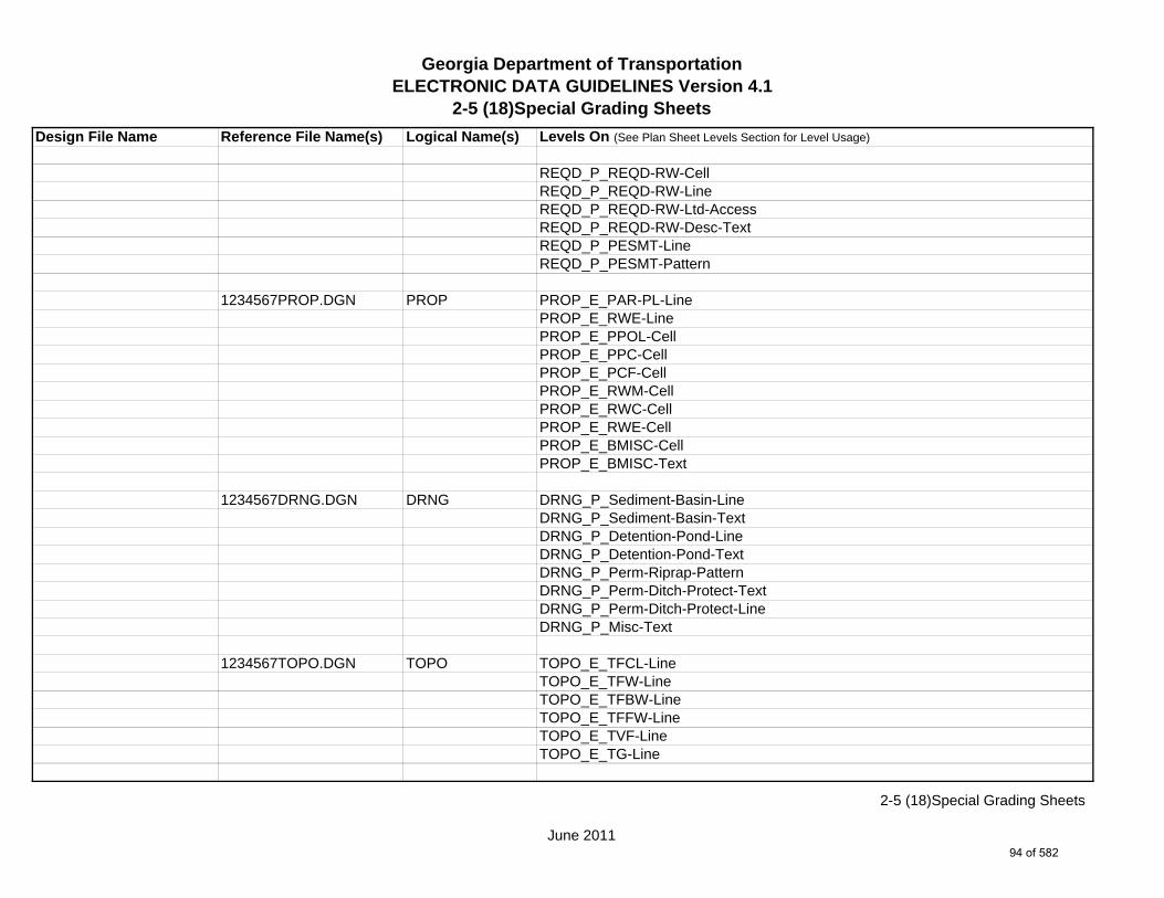
Georgia Department of TransportationELECTRONIC DATA GUIDELINES Version 4.1
2-5 (18)Special Grading Sheets
Design File Name Reference File Name(s) Logical Name(s) Levels On (See Plan Sheet Levels Section for Level Usage)
REQD_P_REQD-RW-CellREQD_P_REQD-RW-LineREQD_P_REQD-RW-Ltd-AccessREQD_P_REQD-RW-Desc-TextREQD_P_PESMT-LineREQD_P_PESMT-Pattern
1234567PROP.DGN PROP PROP_E_PAR-PL-LinePROP_E_RWE-Line PROP_E_PPOL-CellPROP_E_PPC-CellPROP_E_PCF-CellPROP_E_RWM-CellPROP_E_RWC-CellPROP_E_RWE-CellPROP_E_BMISC-CellPROP_E_BMISC-Text
1234567DRNG.DGN DRNG DRNG_P_Sediment-Basin-LineDRNG_P_Sediment-Basin-TextDRNG_P_Detention-Pond-LineDRNG_P_Detention-Pond-TextDRNG_P_Perm-Riprap-PatternDRNG_P_Perm-Ditch-Protect-TextDRNG_P_Perm-Ditch-Protect-LineDRNG_P_Misc-Text
1234567TOPO.DGN TOPO TOPO_E_TFCL-LineTOPO_E_TFW-LineTOPO_E_TFBW-LineTOPO_E_TFFW-LineTOPO_E_TVF-LineTOPO_E_TG-Line
June 2011
2-5 (18)Special Grading Sheets
94 of 582

Georgia Department of TransportationELECTRONIC DATA GUIDELINES Version 4.1
2-5 (18)Special Grading Sheets
Design File Name Reference File Name(s) Logical Name(s) Levels On (See Plan Sheet Levels Section for Level Usage)
1234567FCON.DGN FCON FCON_P_Major-Contour-LineFCON_P_Major-Contour-TextFCON_P_Minor-Contour-LineFCON_P_Minor-Contour-Text
1234567ENVE.DGN ENVE ENVE_E_Wetlnd-Bound-Line
ENVE_E_Wetlnd-Stream-Delin-LineENVE_E_Wetlnd-Stream-TextENVE_E_Wetlnd-PatternENVE_E_Wetlnd-ShapeENVE_E_Endgd-Spec-LineENVE_E_Endgd-Spec-TextENVE_E_Endgd-Spec-PatternENVE_E_Endgd-Spec-ShapeENVE_E_Hist-Rsc-LineENVE_E_Hist-Rsc-TextENVE_E_Hist-Rsc-PatternENVE_E_Hist-Rsc-ShapeENVE_E_Arch-LineENVE_E_Arch-TextENVE_E_Arch-PatternENVE_E_Arch-ShapeENVE_E_Cult-Rsc-Delin-LineENVE_E_Cult-Rsc-TextENVE_E_Cult-Rsc-PatternENVE_E_Cult-Rsc-ShapeENVE_E_Haz-Mat-Delin-LineENVE_E_Haz-Mat-TextENVE_E_Haz-Mat-PatternENVE_E_Haz-Mat-ShapeENVE_E_Env-Justice-LineENVE_E_Env-Justice-TextENVE_E_Env-Justice-PatternENVE_E_Env-Justice-Shape
June 2011
2-5 (18)Special Grading Sheets
95 of 582

Georgia Department of TransportationELECTRONIC DATA GUIDELINES Version 4.1
2-5 (18)Special Grading Sheets
Design File Name Reference File Name(s) Logical Name(s) Levels On (See Plan Sheet Levels Section for Level Usage)
ENVE_E_ESA-LineENVE_E_ESA-TextENVE_E_ESA-PatternENVE_E_ESA-Shape
1234567ENVP.DGN ENVP ENVP_P_Relocations-LineENVP_P_Relocations-TextENVP_P_Socl-Resc-Impact-Area-LineENVP_P_Socl-Resc-Impact-Area-PatternENVP_P_Socl-Resc-Impact-Area-TextENVP_P_Hist-APE-LineENVP_P_Hist-APE-PatternENVP_P_Hist-APE-TextENVP_P_Cultrl-Resc-Impact-Area-LineENVP_P_Cultrl-Resc-Impact-Area-PatternENVP_P_Cultrl-Resc-Impact-Area-TextENVP_P_Wetlnd-Impact-Area-LineENVP_P_Wetlnd-Impact-Area-PatternENVP_P_Wetlnd-Impact-Area-TextENVP_P_Wetlnd-Mitigat-Site-LineENVP_P_Wetlnd-Mitigat-Site-PatternENVP_P_Wetlnd-Mitigat-Site-TextENVP_P_Fldplain-Impact-Area-LineENVP_P_Fldplain-Impact-Area-PatternENVP_P_Fldplain-Impact-Area-TextENVP_P_Impacted-USTENVP_P_Noise-Study-ReceptENVP_P_Noise-Study-ReadingsENVP_P_Noise-Study-Proj-Noise-LvlsENVP_P_Noise-Study-Noise-ContENVP_P_Noise-Study-Impacted-PropENVP_P_Viewshed-Vis-Impact
June 2011
2-5 (18)Special Grading Sheets
96 of 582

Georgia Department of TransportationELECTRONIC DATA GUIDELINES Version 4.1
2-5 (18)Special Grading Sheets
Design File Name Reference File Name(s) Logical Name(s) Levels On (See Plan Sheet Levels Section for Level Usage)
ENVP_P_Fldplain-Impact-Area-LineENVP_P_Fldplain-Impact-Area-PatternENVP_P_Fldplain-Impact-Area-Text
June 2011
2-5 (18)Special Grading Sheets
97 of 582
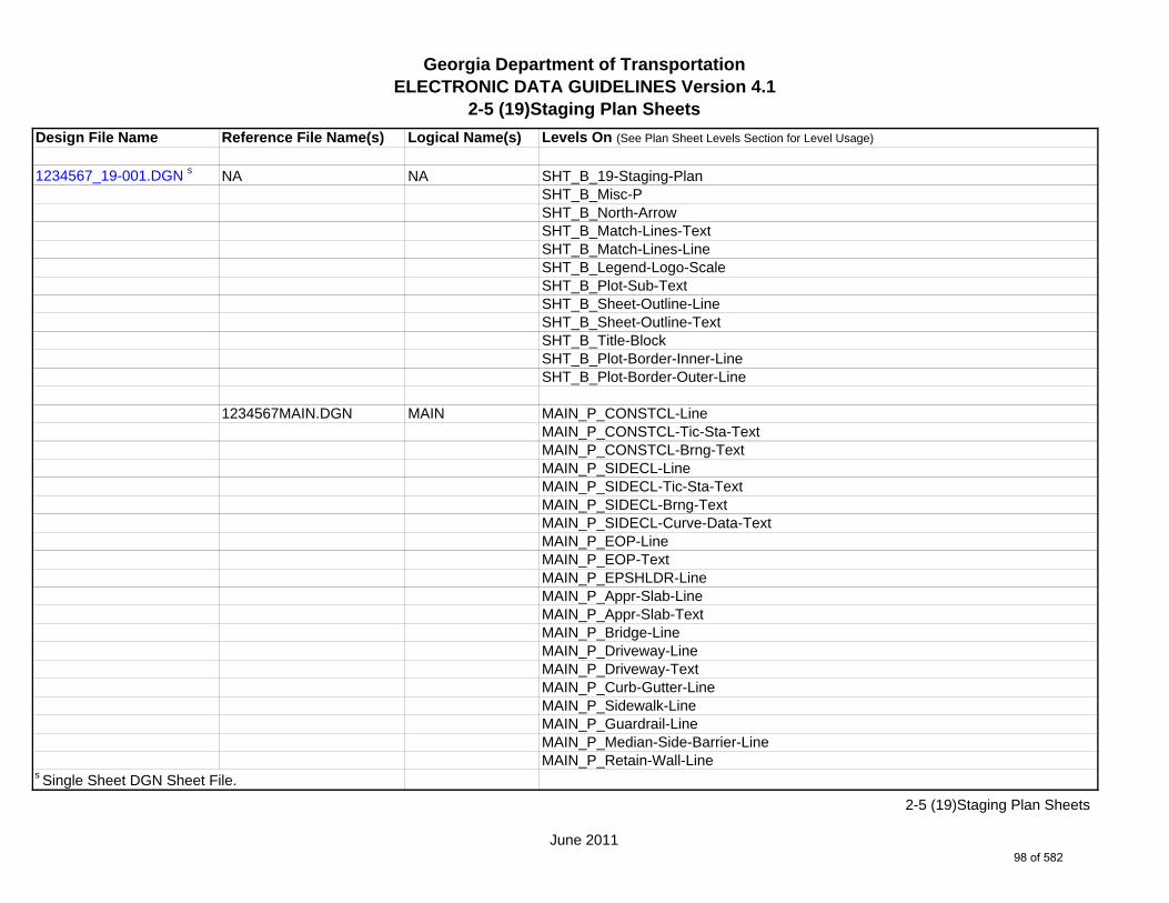
Georgia Department of TransportationELECTRONIC DATA GUIDELINES Version 4.1
2-5 (19)Staging Plan Sheets
Design File Name Reference File Name(s) Logical Name(s) Levels On (See Plan Sheet Levels Section for Level Usage)
1234567_19-001.DGN s NA NA SHT_B_19-Staging-PlanSHT_B_Misc-PSHT_B_North-ArrowSHT_B_Match-Lines-TextSHT_B_Match-Lines-LineSHT_B_Legend-Logo-ScaleSHT_B_Plot-Sub-TextSHT_B_Sheet-Outline-LineSHT_B_Sheet-Outline-TextSHT_B_Title-BlockSHT_B_Plot-Border-Inner-LineSHT_B_Plot-Border-Outer-Line
1234567MAIN.DGN MAIN MAIN_P_CONSTCL-LineMAIN_P_CONSTCL-Tic-Sta-TextMAIN_P_CONSTCL-Brng-TextMAIN_P_SIDECL-LineMAIN_P_SIDECL-Tic-Sta-TextMAIN_P_SIDECL-Brng-TextMAIN_P_SIDECL-Curve-Data-TextMAIN_P_EOP-LineMAIN_P_EOP-TextMAIN_P_EPSHLDR-LineMAIN_P_Appr-Slab-LineMAIN_P_Appr-Slab-TextMAIN_P_Bridge-LineMAIN_P_Driveway-LineMAIN_P_Driveway-TextMAIN_P_Curb-Gutter-LineMAIN_P_Sidewalk-LineMAIN_P_Guardrail-LineMAIN_P_Median-Side-Barrier-LineMAIN_P_Retain-Wall-Line
s Single Sheet DGN Sheet File.
June 2011
2-5 (19)Staging Plan Sheets
98 of 582

Georgia Department of TransportationELECTRONIC DATA GUIDELINES Version 4.1
2-5 (19)Staging Plan Sheets
Design File Name Reference File Name(s) Logical Name(s) Levels On (See Plan Sheet Levels Section for Level Usage)
MAIN_P_Details-End-Proj-CL-Intersect-Label-TextMAIN_P_Details-Begin-End-Const-Limit-Const-Label-TextMAIN_P_Details-RouteName-CL-Text
1234567DRNG.DGN DRNG DRNG_P_Storm-Drain-StructDRNG_P_Storm-Drain-Pipe-LineDRNG_P_Ditch-and-Channel-LineDRNG_P_Cross-Drain-and-Culv-LineDRNG_P_Bridge-Culv-LineDRNG_P_Sediment-Basin-LineDRNG_P_Detention-Pond-Line
1234567REQD.DGN REQD REQD_P_REQD-RW-LineREQD_P_REQD-RW-Ltd-AccessREQD_P_REQD-RW-Sta-Offset-FlagREQD_P_REQD-RW-Desc-TextREQD_P_PESMT-Pnt#-TextREQD_P_PESMT-LineREQD_P_TESMT-LineREQD_P_TESMT-Desc-TextREQD_P_DWESMT-LineREQD_P_DWESMT-Desc-Text
1234567SIGN.DGN SIGN SIGN_P_OVHD_Sign-Structure-and-Strain-Pole
1234567SGNL.DGN SGNL
1234567UTLE.DGN UTLE UTLE_E_Elec-CellUTLE_E_Elec-Vault-LineUTLE_E_Gas-CellUTLE_E_Traf-Ctrl-CellUTLE_E_San-Swr-CellUTLE_E_San-Force-Main-CellUTLE_E_Wat-Cell
June 2011
2-5 (19)Staging Plan Sheets
99 of 582

Georgia Department of TransportationELECTRONIC DATA GUIDELINES Version 4.1
2-5 (19)Staging Plan Sheets
Design File Name Reference File Name(s) Logical Name(s) Levels On (See Plan Sheet Levels Section for Level Usage)
UTLE_E_TV-CellUTLE_E_Petro-CellUTLE_E_Tele-CellUTLE_E_Wat-Non-Pot-CellUTLE_E_Steam-Cell
1234567LIMT.DGN LIMT LIMT_P_STKCUT_Const-Limit-Cut-LineLIMT_P_CUT_Const-Limit-Cut-CellLIMT_P_STKFIL_Const-Limit-Fill-LineLIMT_P_FILL_Const-Limit-Fill-Cell
*1234567STE#.DGN STE# STE_P_DETCL-LineSTE_P_DETCL-Tic-Sta-TextSTE_P_DETCL-PC-PT-Sta-Ldr-TextSTE_P_DETCL-Brng-TextSTE_P_DETCL-Curve-Data-TextSTE_P_DETCL-CellSTE_P_STGD-Narrative-TextSTE_P_STGD-Traf-Flow-ArrowSTE_P_STGD-Current-Stage-HatchSTE_P_STGD-Current-Stage-TextSTE_P_STGD-Temp-Drain-StructSTE_P_STGD-Temp-Drain-Struct-TextSTE_P_STGD-Temp-Pvmt-WidenSTE_P_STGD-Temp-BarrierSTE_P_STGD-Const-LimitSTE_P_STGD-MiscSTE_P_DETOUR-TextSTE_P_DETOUR-DimSTE_P_DETOUR-Super-Label-TextSTE_P_DETOUR-Misc-TextSTE_P_Temporary-Sediment-Basin-LineSTE_P_Temporary-Sediment-Basin-Text
June 2011
2-5 (19)Staging Plan Sheets
100 of 582

Georgia Department of TransportationELECTRONIC DATA GUIDELINES Version 4.1
2-5 (19)Staging Plan Sheets
Design File Name Reference File Name(s) Logical Name(s) Levels On (See Plan Sheet Levels Section for Level Usage)
1234567PROP.DGN PROP PROP_E_PAR-PL-LinePROP_E_RWE-Line PROP_E_PAR-PL-TextPROP_E_PAR-PL-CellPROP_E_RWM-TextPROP_E_RWC-TextPROP_E_RWE-TextPROP_E_RWRR-LinePROP_E_RWRR-TextPROP_E_RWU-LinePROP_E_RWU-TextPROP_E_POEL-LinePROP_E_POEL-TextPROP_E_BSL-LinePROP_E_BSL-TextPROP_E_BCOL-LinePROP_E_BCOL-TextPROP_E_BCTL-LinePROP_E_BCTL-TextPROP_E_BGMD-LinePROP_E_BGMD-TextPROP_E_BLDL-LinePROP_E_BLDL-TextPROP_E_BLLL-LinePROP_E_BLLL-Text
1234567TOPO.DGN TOPO TOPO_E_TEAP-LineTOPO_E_TEAS-LineTOPO_E_TECP-LineTOPO_E_TEDR-LineTOPO_E_TEST-LineTOPO_E_TEDD-LineTOPO_E_TEDD-TextTOPO_E_TEAD-Line
June 2011
2-5 (19)Staging Plan Sheets
101 of 582

Georgia Department of TransportationELECTRONIC DATA GUIDELINES Version 4.1
2-5 (19)Staging Plan Sheets
Design File Name Reference File Name(s) Logical Name(s) Levels On (See Plan Sheet Levels Section for Level Usage)
TOPO_E_TEAD-TextTOPO_E_TECD-LineTOPO_E_TECD-TextTOPO_E_TAC-LineTOPO_E_TAC-TextTOPO_E_TCGF-LineTOPO_E_TCGF-TextTOPO_E_TCGT-LineTOPO_E_TCGT-TextTOPO_E_THC-LineTOPO_E_THC-TextTOPO_E_TVG-LineTOPO_E_TVG-TextTOPO_E_TSW-LineTOPO_E_TGR-LineTOPO_E_TBAS-LineTOPO_E_TBGL-LineTOPO_E_TBRDGCEN-LineTOPO_E_TBRDGCOR-LineTOPO_E_THM-CellTOPO_E_TFP-LineTOPO_E_TRCR-LineTOPO_E_TRCRE-LineTOPO_E_TBLD-LineTOPO_E_TBLDRL-LineTOPO_E_TUD-LineTOPO_E_TS-LineTOPO_E_TBC-LineTOPO_E_TFE-LineTOPO_E_DSTC-LineTOPO_E_DDL-LineTOPO_E_TCAN-LineTOPO_E_THCR-LineTOPO_E_THRL-Line
June 2011
2-5 (19)Staging Plan Sheets
102 of 582

Georgia Department of TransportationELECTRONIC DATA GUIDELINES Version 4.1
2-5 (19)Staging Plan Sheets
Design File Name Reference File Name(s) Logical Name(s) Levels On (See Plan Sheet Levels Section for Level Usage)
TOPO_E_TMHCR-LineTOPO_E_TMHRL-LineTOPO_E_DCEF-LineTOPO_E_DCB-LineTOPO_E_DCWE-LineTOPO_E_DDCB-LineTOPO_E_DDI-LineTOPO_E_DHWE-LineTOPO_E_DJB-LineTOPO_E_DPC-LineTOPO_E_DPM-LineTOPO_E_DPP-LineTOPO_E_MDITCHFL-LineTOPO_E_DPD-LineTOPO_E_DSB-LineTOPO_E_DSC-LineTOPO_E_DSE-LineTOPO_E_DWE-LineTOPO_E_DEW-LineTOPO_E_DHWM-LineTOPO_E_DSWE-LineTOPO_E_DMISC-LineTOPO_E_TWF-LineTOPO_E_TWFT-LineTOPO_E_TWFB-LineTOPO_E_TGRV-LineTOPO_E_DADB-LineTOPO_E_DDT-LineTOPO_E_DSPURDK-LineTOPO_E_POOL-LineTOPO_E_FNDN-LineTOPO_E_RUIN-LineTOPO_E_TANK-LineTOPO_E_DTCH-Line
June 2011
2-5 (19)Staging Plan Sheets
103 of 582
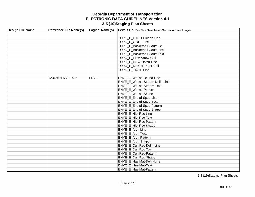
Georgia Department of TransportationELECTRONIC DATA GUIDELINES Version 4.1
2-5 (19)Staging Plan Sheets
Design File Name Reference File Name(s) Logical Name(s) Levels On (See Plan Sheet Levels Section for Level Usage)
TOPO_E_DTCH-Hidden-LineTOPO_E_GOLF-LineTOPO_E_Basketball-Court-CellTOPO_E_Basketball-Court-LineTOPO_E_Basketball-Court-TextTOPO_E_Flow-Arrow-CellTOPO_E_DEW-Hatch-LineTOPO_E_DITCH-Taper-CellTOPO_E_TRAIL-Line
1234567ENVE.DGN ENVE ENVE_E_Wetlnd-Bound-LineENVE_E_Wetlnd-Stream-Delin-LineENVE_E_Wetlnd-Stream-TextENVE_E_Wetlnd-PatternENVE_E_Wetlnd-ShapeENVE_E_Endgd-Spec-LineENVE_E_Endgd-Spec-TextENVE_E_Endgd-Spec-PatternENVE_E_Endgd-Spec-ShapeENVE_E_Hist-Rsc-LineENVE_E_Hist-Rsc-TextENVE_E_Hist-Rsc-PatternENVE_E_Hist-Rsc-ShapeENVE_E_Arch-LineENVE_E_Arch-TextENVE_E_Arch-PatternENVE_E_Arch-ShapeENVE_E_Cult-Rsc-Delin-LineENVE_E_Cult-Rsc-TextENVE_E_Cult-Rsc-PatternENVE_E_Cult-Rsc-ShapeENVE_E_Haz-Mat-Delin-LineENVE_E_Haz-Mat-TextENVE_E_Haz-Mat-Pattern
June 2011
2-5 (19)Staging Plan Sheets
104 of 582
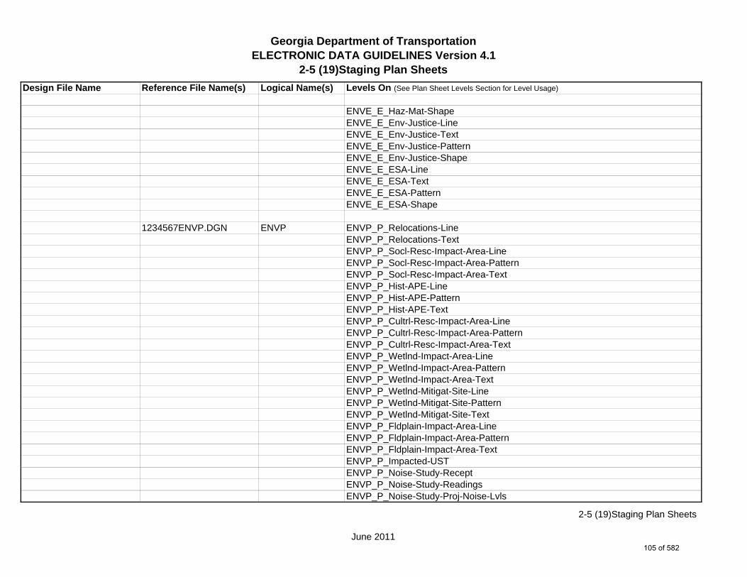
Georgia Department of TransportationELECTRONIC DATA GUIDELINES Version 4.1
2-5 (19)Staging Plan Sheets
Design File Name Reference File Name(s) Logical Name(s) Levels On (See Plan Sheet Levels Section for Level Usage)
ENVE_E_Haz-Mat-ShapeENVE_E_Env-Justice-LineENVE_E_Env-Justice-TextENVE_E_Env-Justice-PatternENVE_E_Env-Justice-ShapeENVE_E_ESA-LineENVE_E_ESA-TextENVE_E_ESA-PatternENVE_E_ESA-Shape
1234567ENVP.DGN ENVP ENVP_P_Relocations-LineENVP_P_Relocations-TextENVP_P_Socl-Resc-Impact-Area-LineENVP_P_Socl-Resc-Impact-Area-PatternENVP_P_Socl-Resc-Impact-Area-TextENVP_P_Hist-APE-LineENVP_P_Hist-APE-PatternENVP_P_Hist-APE-TextENVP_P_Cultrl-Resc-Impact-Area-LineENVP_P_Cultrl-Resc-Impact-Area-PatternENVP_P_Cultrl-Resc-Impact-Area-TextENVP_P_Wetlnd-Impact-Area-LineENVP_P_Wetlnd-Impact-Area-PatternENVP_P_Wetlnd-Impact-Area-TextENVP_P_Wetlnd-Mitigat-Site-LineENVP_P_Wetlnd-Mitigat-Site-PatternENVP_P_Wetlnd-Mitigat-Site-TextENVP_P_Fldplain-Impact-Area-LineENVP_P_Fldplain-Impact-Area-PatternENVP_P_Fldplain-Impact-Area-TextENVP_P_Impacted-USTENVP_P_Noise-Study-ReceptENVP_P_Noise-Study-ReadingsENVP_P_Noise-Study-Proj-Noise-Lvls
June 2011
2-5 (19)Staging Plan Sheets
105 of 582

Georgia Department of TransportationELECTRONIC DATA GUIDELINES Version 4.1
2-5 (19)Staging Plan Sheets
Design File Name Reference File Name(s) Logical Name(s) Levels On (See Plan Sheet Levels Section for Level Usage)
ENVP_P_Noise-Study-Noise-ContENVP_P_Noise-Study-Impacted-PropENVP_P_Viewshed-Vis-ImpactENVP_P_Fldplain-Impact-Area-LineENVP_P_Fldplain-Impact-Area-PatternENVP_P_Fldplain-Impact-Area-Text
*Reference File Name Corresponds to Stage # (example for Stage 1 - 1234567STE1.DGN Logical Name STE1)
June 2011
2-5 (19)Staging Plan Sheets
106 of 582
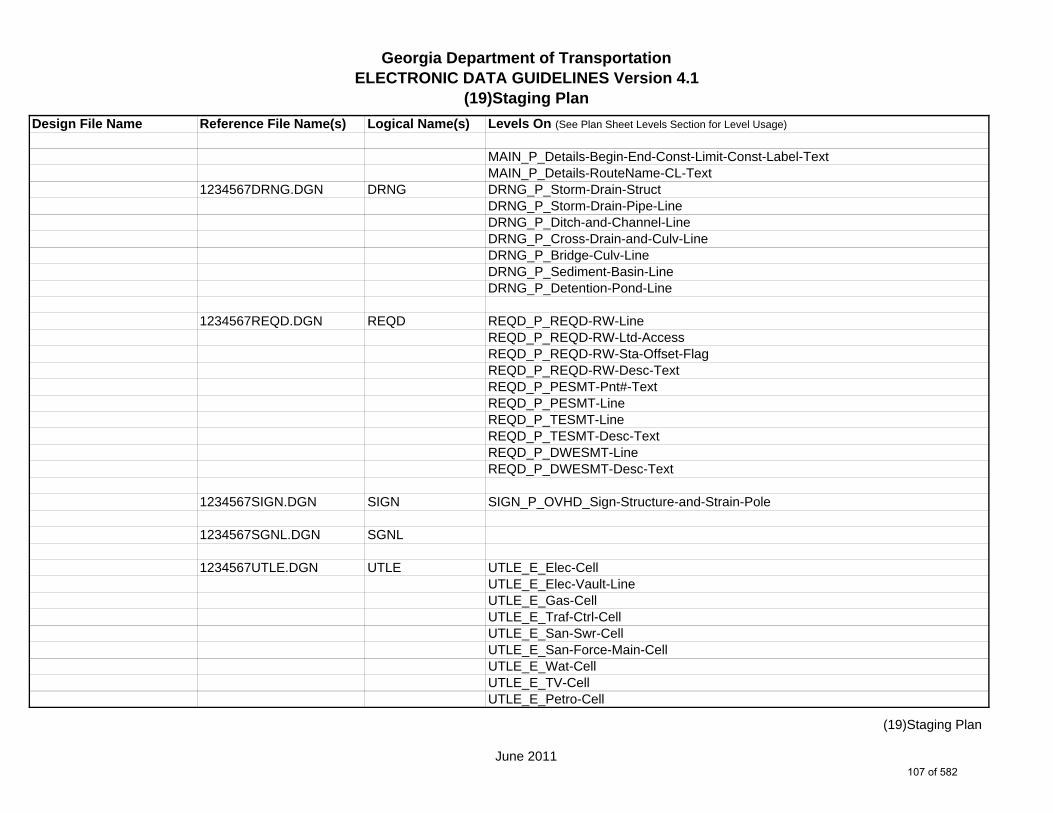
Georgia Department of TransportationELECTRONIC DATA GUIDELINES Version 4.1
(19)Staging Plan
Design File Name Reference File Name(s) Logical Name(s) Levels On (See Plan Sheet Levels Section for Level Usage)
MAIN_P_Details-Begin-End-Const-Limit-Const-Label-TextMAIN_P_Details-RouteName-CL-Text
1234567DRNG.DGN DRNG DRNG_P_Storm-Drain-StructDRNG_P_Storm-Drain-Pipe-LineDRNG_P_Ditch-and-Channel-LineDRNG_P_Cross-Drain-and-Culv-LineDRNG_P_Bridge-Culv-LineDRNG_P_Sediment-Basin-LineDRNG_P_Detention-Pond-Line
1234567REQD.DGN REQD REQD_P_REQD-RW-LineREQD_P_REQD-RW-Ltd-AccessREQD_P_REQD-RW-Sta-Offset-FlagREQD_P_REQD-RW-Desc-TextREQD_P_PESMT-Pnt#-TextREQD_P_PESMT-LineREQD_P_TESMT-LineREQD_P_TESMT-Desc-TextREQD_P_DWESMT-LineREQD_P_DWESMT-Desc-Text
1234567SIGN.DGN SIGN SIGN_P_OVHD_Sign-Structure-and-Strain-Pole
1234567SGNL.DGN SGNL
1234567UTLE.DGN UTLE UTLE_E_Elec-CellUTLE_E_Elec-Vault-LineUTLE_E_Gas-CellUTLE_E_Traf-Ctrl-CellUTLE_E_San-Swr-CellUTLE_E_San-Force-Main-CellUTLE_E_Wat-CellUTLE_E_TV-CellUTLE_E_Petro-Cell
June 2011
(19)Staging Plan
107 of 582

Georgia Department of TransportationELECTRONIC DATA GUIDELINES Version 4.1
(19)Staging Plan
Design File Name Reference File Name(s) Logical Name(s) Levels On (See Plan Sheet Levels Section for Level Usage)
UTLE_E_Tele-CellUTLE_E_Wat-Non-Pot-CellUTLE_E_Steam-Cell
1234567LIMT.DGN LIMT LIMT_P_STKCUT_Const-Limit-Cut-LineLIMT_P_CUT_Const-Limit-Cut-CellLIMT_P_STKFIL_Const-Limit-Fill-LineLIMT_P_FILL_Const-Limit-Fill-Cell
*1234567STE#.DGN STE# STE_P_DETCL-LineSTE_P_DETCL-Tic-Sta-TextSTE_P_DETCL-PC-PT-Sta-Ldr-TextSTE_P_DETCL-Brng-TextSTE_P_DETCL-Curve-Data-TextSTE_P_DETCL-CellSTE_P_STGD-Narrative-TextSTE_P_STGD-Traf-Flow-ArrowSTE_P_STGD-Current-Stage-HatchSTE_P_STGD-Current-Stage-TextSTE_P_STGD-Temp-Drain-StructSTE_P_STGD-Temp-Drain-Struct-TextSTE_P_STGD-Temp-Pvmt-WidenSTE_P_STGD-Temp-BarrierSTE_P_STGD-Const-LimitSTE_P_STGD-MiscSTE_P_DETOUR-TextSTE_P_DETOUR-DimSTE_P_DETOUR-Super-Label-TextSTE_P_DETOUR-Misc-TextSTE_P_Temporary-Sediment-Basin-LineSTE_P_Temporary-Sediment-Basin-Text
1234567PROP.DGN PROP PROP_E_PAR-PL-LinePROP_E_RWE-Line
June 2011
(19)Staging Plan
108 of 582

Georgia Department of TransportationELECTRONIC DATA GUIDELINES Version 4.1
(19)Staging Plan
Design File Name Reference File Name(s) Logical Name(s) Levels On (See Plan Sheet Levels Section for Level Usage)
PROP_E_PAR-PL-TextPROP_E_PAR-PL-CellPROP_E_RWM-TextPROP_E_RWC-TextPROP_E_RWE-TextPROP_E_RWRR-LinePROP_E_RWRR-TextPROP_E_RWU-LinePROP_E_RWU-TextPROP_E_POEL-LinePROP_E_POEL-TextPROP_E_BSL-LinePROP_E_BSL-TextPROP_E_BCOL-LinePROP_E_BCOL-TextPROP_E_BCTL-LinePROP_E_BCTL-TextPROP_E_BGMD-LinePROP_E_BGMD-TextPROP_E_BLDL-LinePROP_E_BLDL-TextPROP_E_BLLL-LinePROP_E_BLLL-Text
1234567TOPO.DGN TOPO TOPO_E_TEAP-LineTOPO_E_TEAS-LineTOPO_E_TECP-LineTOPO_E_TEDR-LineTOPO_E_TEST-LineTOPO_E_TEDD-LineTOPO_E_TEDD-TextTOPO_E_TEAD-LineTOPO_E_TEAD-TextTOPO_E_TECD-Line
June 2011
(19)Staging Plan
109 of 582
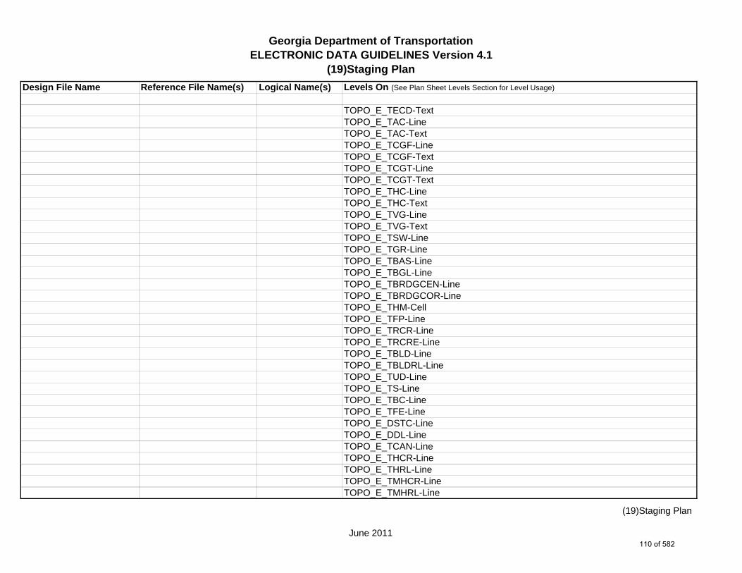
Georgia Department of TransportationELECTRONIC DATA GUIDELINES Version 4.1
(19)Staging Plan
Design File Name Reference File Name(s) Logical Name(s) Levels On (See Plan Sheet Levels Section for Level Usage)
TOPO_E_TECD-TextTOPO_E_TAC-LineTOPO_E_TAC-TextTOPO_E_TCGF-LineTOPO_E_TCGF-TextTOPO_E_TCGT-LineTOPO_E_TCGT-TextTOPO_E_THC-LineTOPO_E_THC-TextTOPO_E_TVG-LineTOPO_E_TVG-TextTOPO_E_TSW-LineTOPO_E_TGR-LineTOPO_E_TBAS-LineTOPO_E_TBGL-LineTOPO_E_TBRDGCEN-LineTOPO_E_TBRDGCOR-LineTOPO_E_THM-CellTOPO_E_TFP-LineTOPO_E_TRCR-LineTOPO_E_TRCRE-LineTOPO_E_TBLD-LineTOPO_E_TBLDRL-LineTOPO_E_TUD-LineTOPO_E_TS-LineTOPO_E_TBC-LineTOPO_E_TFE-LineTOPO_E_DSTC-LineTOPO_E_DDL-LineTOPO_E_TCAN-LineTOPO_E_THCR-LineTOPO_E_THRL-LineTOPO_E_TMHCR-LineTOPO_E_TMHRL-Line
June 2011
(19)Staging Plan
110 of 582

Georgia Department of TransportationELECTRONIC DATA GUIDELINES Version 4.1
(19)Staging Plan
Design File Name Reference File Name(s) Logical Name(s) Levels On (See Plan Sheet Levels Section for Level Usage)
TOPO_E_DCEF-LineTOPO_E_DCB-LineTOPO_E_DCWE-LineTOPO_E_DDCB-LineTOPO_E_DDI-LineTOPO_E_DHWE-LineTOPO_E_DJB-LineTOPO_E_DPC-LineTOPO_E_DPM-LineTOPO_E_DPP-LineTOPO_E_MDITCHFL-LineTOPO_E_DPD-LineTOPO_E_DSB-LineTOPO_E_DSC-LineTOPO_E_DSE-LineTOPO_E_DWE-LineTOPO_E_DEW-LineTOPO_E_DHWM-LineTOPO_E_DSWE-LineTOPO_E_DMISC-LineTOPO_E_TWF-LineTOPO_E_TWFT-LineTOPO_E_TWFB-LineTOPO_E_TGRV-LineTOPO_E_DADB-LineTOPO_E_DDT-LineTOPO_E_DSPURDK-LineTOPO_E_POOL-LineTOPO_E_FNDN-LineTOPO_E_RUIN-LineTOPO_E_TANK-LineTOPO_E_DTCH-LineTOPO_E_DTCH-Hidden-LineTOPO_E_GOLF-Line
June 2011
(19)Staging Plan
111 of 582

Georgia Department of TransportationELECTRONIC DATA GUIDELINES Version 4.1
(19)Staging Plan
Design File Name Reference File Name(s) Logical Name(s) Levels On (See Plan Sheet Levels Section for Level Usage)
TOPO_E_Basketball-Court-CellTOPO_E_Basketball-Court-LineTOPO_E_Basketball-Court-TextTOPO_E_Flow-Arrow-CellTOPO_E_DEW-Hatch-LineTOPO_E_DITCH-Taper-CellTOPO_E_TRAIL-Line
1234567ENVE.DGN ENVE ENVE_E_Wetlnd-Bound-LineENVE_E_Wetlnd-Stream-Delin-LineENVE_E_Wetlnd-Stream-TextENVE_E_Wetlnd-PatternENVE_E_Wetlnd-ShapeENVE_E_Endgd-Spec-LineENVE_E_Endgd-Spec-TextENVE_E_Endgd-Spec-PatternENVE_E_Endgd-Spec-ShapeENVE_E_Hist-Rsc-LineENVE_E_Hist-Rsc-TextENVE_E_Hist-Rsc-PatternENVE_E_Hist-Rsc-ShapeENVE_E_Arch-LineENVE_E_Arch-TextENVE_E_Arch-PatternENVE_E_Arch-ShapeENVE_E_Cult-Rsc-Delin-LineENVE_E_Cult-Rsc-TextENVE_E_Cult-Rsc-PatternENVE_E_Cult-Rsc-ShapeENVE_E_Haz-Mat-Delin-LineENVE_E_Haz-Mat-TextENVE_E_Haz-Mat-PatternENVE_E_Haz-Mat-ShapeENVE_E_Env-Justice-Line
June 2011
(19)Staging Plan
112 of 582

Georgia Department of TransportationELECTRONIC DATA GUIDELINES Version 4.1
(19)Staging Plan
Design File Name Reference File Name(s) Logical Name(s) Levels On (See Plan Sheet Levels Section for Level Usage)
ENVE_E_Env-Justice-TextENVE_E_Env-Justice-PatternENVE_E_Env-Justice-ShapeENVE_E_ESA-LineENVE_E_ESA-TextENVE_E_ESA-PatternENVE_E_ESA-Shape
1234567ENVP.DGN ENVP ENVP_P_Relocations-LineENVP_P_Relocations-TextENVP_P_Socl-Resc-Impact-Area-LineENVP_P_Socl-Resc-Impact-Area-PatternENVP_P_Socl-Resc-Impact-Area-TextENVP_P_Hist-APE-LineENVP_P_Hist-APE-PatternENVP_P_Hist-APE-TextENVP_P_Cultrl-Resc-Impact-Area-LineENVP_P_Cultrl-Resc-Impact-Area-PatternENVP_P_Cultrl-Resc-Impact-Area-TextENVP_P_Wetlnd-Impact-Area-LineENVP_P_Wetlnd-Impact-Area-PatternENVP_P_Wetlnd-Impact-Area-TextENVP_P_Wetlnd-Mitigat-Site-LineENVP_P_Wetlnd-Mitigat-Site-PatternENVP_P_Wetlnd-Mitigat-Site-TextENVP_P_Fldplain-Impact-Area-LineENVP_P_Fldplain-Impact-Area-PatternENVP_P_Fldplain-Impact-Area-TextENVP_P_Impacted-USTENVP_P_Noise-Study-ReceptENVP_P_Noise-Study-ReadingsENVP_P_Noise-Study-Proj-Noise-LvlsENVP_P_Noise-Study-Noise-ContENVP_P_Noise-Study-Impacted-Prop
June 2011
(19)Staging Plan
113 of 582

Georgia Department of TransportationELECTRONIC DATA GUIDELINES Version 4.1
(19)Staging Plan
Design File Name Reference File Name(s) Logical Name(s) Levels On (See Plan Sheet Levels Section for Level Usage)
ENVP_P_Viewshed-Vis-ImpactENVP_P_Fldplain-Impact-Area-LineENVP_P_Fldplain-Impact-Area-PatternENVP_P_Fldplain-Impact-Area-Text
*Reference File Name Corresponds to Stage # (example for Stage 1 - 1234567STE1.DGN Logical Name STE1)
June 2011
(19)Staging Plan
114 of 582

Georgia Department of TransportationELECTRONIC DATA GUIDELINES Version 4.1
2-5 (19)Staging Profiles
Design File Name Reference File Name(s) Logical Name(s) Levels On
1234567_19.DGN m NA NA SHT_B_19-Staging-ProfileSHT_B_CrossRoad-TextSHT_B_Grid-Elevation-TextSHT_B_Grid-Major-LineSHT_B_Grid-Minor-LineSHT_B_Grid-Offset-TextSHT_B_Grid-Station-TextSHT_B_Legend-Logo-ScaleSHT_B_MainLine-TextSHT_B_Major-Elevation-Tic-LineSHT_B_Major-Offset-Tic-LineSHT_B_Major-Station-Tic-LineSHT_B_Match-Lines-LineSHT_B_Match-Lines-TextSHT_B_Minor-Elevation-Tic-LineSHT_B_Minor-Offset-Tic-LineSHT_B_Minor-Station-Tic-LineSHT_B_Plot-Sub-TextSHT_B_Plotting-Info-TagsSHT_B_Sheet-Outline-LineSHT_B_Sheet-Outline-TextSHT_B_Title-BlockSHT_P_Major-Station-Tic-LineSHT_P_Minor-Station-Tic-LineSHT_B_Plot-Border-Inner-LineSHT_B_Plot-Border-Outer-Line
PROF_E_Drainage-CellPROF_E_Drainage-LinePROF_E_Drainage-TextPROF_E_Ground-LinePROF_E_Ground-Text
m Multi Sheet DGN Sheet File.
June 2011
2-5 (19)Staging Profiles
115 of 582

Georgia Department of TransportationELECTRONIC DATA GUIDELINES Version 4.1
2-5 (19)Staging Profiles
Design File Name Reference File Name(s) Logical Name(s) Levels On
PROF_E_Substratum1-LinePROF_E_Substratum2-LinePROF_E_Substratum3-Line
PROF_P_Drainage-CellPROF_P_Drainage-LinePROF_P_Drainage-TextPROF_P_Finish-Elev-TextPROF_P_Finish-LinePROF_P_Finish-Pt-CellPROF_P_Finish-TextPROF_P_Grid-Elev-TextPROF_P_Label-TextPROF_P_Scale-TextPROF_P_Stage1-LinePROF_P_Stage2-LinePROF_P_Stage3-LinePROF_P_Stage4-LinePROF_P_Stage5-LinePROF_P_Station-TextPROF_P_Subgrade-Line
June 2011
2-5 (19)Staging Profiles
116 of 582

Georgia Department of TransportationELECTRONIC DATA GUIDELINES Version 4.1
2-5 (19)Staging Cross Sections
Design File Name Reference File Name(s) Logical Name(s) Levels On
1234567_19.DGN m NA NA SHT_B_19-Staging-Cross-SectionsSHT_B_CrossRoad-TextSHT_B_Grid-Elevation-TextSHT_B_Grid-Major-LineSHT_B_Grid-Minor-LineSHT_B_Grid-Offset-TextSHT_B_Grid-Station-TextSHT_B_Legend-Logo-ScaleSHT_B_MainLine-TextSHT_B_Major-Elevation-Tic-LineSHT_B_Major-Offset-Tic-LineSHT_B_Match-Lines-LineSHT_B_Match-Lines-TextSHT_B_Minor-Elevation-Tic-LineSHT_B_Minor-Offset-Tic-LineSHT_B_Plot-Sub-TextSHT_B_Plotting-Info-TagsSHT_B_Sheet-Outline-LineSHT_B_Sheet-Outline-TextSHT_B_Title-BlockSHT_P_Major-Station-Tic-LineSHT_P_Minor-Station-Tic-LineSHT_B_Plot-Border-Inner-LineSHT_B_Plot-Border-Outer-Line
XSEC_E_Drainage-CellXSEC_E_Drainage-LineXSEC_E_Drainage-TextXSEC_E_Ground-LineXSEC_E_Ground-TextXSEC_E_Substratum1-LineXSEC_E_Substratum2-LineXSEC_E_Substratum3-Line
m Multi Sheet DGN Sheet File.
June 2011
2-5 (19)Staging Cross Sections
117 of 582

Georgia Department of TransportationELECTRONIC DATA GUIDELINES Version 4.1
2-5 (19)Staging Cross Sections
Design File Name Reference File Name(s) Logical Name(s) Levels On
XSEC_E_Ground_Enhancement-LineXSEC_E_Ground_Enhancement-Text
XSEC_P_Subgrade-LineXSEC_P_Xslope-TextXSEC_P_Finish-LineXSEC_P_Grid-Elev-TextXSEC_P_Grid-Offset-TextXSEC_P_Station-TextXSEC_P_Drainage-CellXSEC_P_Drainage-LineXSEC_P_Drainage-TextXSEC_P_Label-TextXSEC_P_Scale-TextXSEC_P_Stage1-LineXSEC_P_Stage2-LineXSEC_P_Stage3-LineXSEC_P_Stage4-LineXSEC_P_Stage5-LineXSEC_P_Component-Blue-LineXSEC_P_Component-Cyan-LineXSEC_P_Component-Green-LineXSEC_P_Component-Orange-LineXSEC_P_Component-Purple-LineXSEC_P_Component-Red-LineXSEC_P_Component-White-LineXSEC_P_Component-Yellow-LineXSEC_P_Label-Point
June 2011
2-5 (19)Staging Cross Sections
118 of 582

Georgia Department of TransportationELECTRONIC DATA GUIDELINES Version 4.1
2-5 (20)Staging Details
Design File Name Reference File Name(s) Logical Name(s) Levels On
1234567_20.DGN m NA NA SHT_B_20-Staging-DetailsSHT_B_Legend-Logo-ScaleSHT_B_Plot-Sub-TextSHT_B_Plotting-Info-TagsSHT_B_Sheet-Outline-LineSHT_B_Sheet-Outline-TextSHT_B_Title-BlockSHT_B_Plot-Border-Inner-LineSHT_B_Plot-Border-Outer-Line
1234567STE#.DGN STE# STE_P_STGD-MiscSTE_P_DETOUR-Misc-Text
m Multi Sheet DGN Sheet File.
June 2011
2-5 (20)Staging Details
119 of 582

Georgia Department of TransportationELECTRONIC DATA GUIDELINES Version 4.1
2-5 (21)Drainage Area Map
Design File Name Reference File Name(s) Logical Name(s) Levels On (See Plan Sheet Levels Section for Level Usage)
1234567_21-001.DGN s NA NA SHT_B_21-Drainage-Area-MapSHT_B_Legend-Logo-ScaleSHT_B_Misc-PSHT_B_Plot-Sub-TextSHT_B_Plotting-Info-TagsSHT_B_Sheet-Outline-LineSHT_B_Sheet-Outline-TextSHT_B_Stage-TextSHT_B_Title-BlockSHT_B_Plot-Border-Inner-LineSHT_B_Plot-Border-Outer-Line
1234567MAIN.DGN MAIN MAIN_P_CONSTCL-LineMAIN_P_SIDECL-LineMAIN_P_EOP-LineMAIN_P_Appr-Slab-LineMAIN_P_Bridge-LineMAIN_P_Retain-Wall-Line
1234567DRNG.DGN DRNG DRNG_P_BASIN-Boundary-Major-LineDRNG_P_Cross-Drain-and-Culv-LineDRNG_P_Bridge-Culv-Line
1234567ENVE.DGN ENVE ENVE_E_Wetlnd-Bound-LineENVE_E_Wetlnd-Stream-Delin-LineENVE_E_Wetlnd-Stream-TextENVE_E_Wetlnd-PatternENVE_E_Wetlnd-ShapeENVE_E_Endgd-Spec-LineENVE_E_Endgd-Spec-TextENVE_E_Endgd-Spec-PatternENVE_E_Endgd-Spec-Shape
s Single Sheet DGN Sheet File.
June 2011
2-5 (21)Drainage Area Map
120 of 582

Georgia Department of TransportationELECTRONIC DATA GUIDELINES Version 4.1
2-5 (21)Drainage Area Map
Design File Name Reference File Name(s) Logical Name(s) Levels On (See Plan Sheet Levels Section for Level Usage)
ENVE_E_Hist-Rsc-LineENVE_E_Hist-Rsc-TextENVE_E_Hist-Rsc-PatternENVE_E_Hist-Rsc-ShapeENVE_E_Arch-LineENVE_E_Arch-TextENVE_E_Arch-PatternENVE_E_Arch-ShapeENVE_E_Cult-Rsc-Delin-LineENVE_E_Cult-Rsc-TextENVE_E_Cult-Rsc-PatternENVE_E_Cult-Rsc-ShapeENVE_E_Haz-Mat-Delin-LineENVE_E_Haz-Mat-TextENVE_E_Haz-Mat-PatternENVE_E_Haz-Mat-ShapeENVE_E_Env-Justice-LineENVE_E_Env-Justice-TextENVE_E_Env-Justice-PatternENVE_E_Env-Justice-ShapeENVE_E_ESA-LineENVE_E_ESA-TextENVE_E_ESA-PatternENVE_E_ESA-Shape
1234567ENVP.DGN ENVP ENVP_P_Relocations-LineENVP_P_Relocations-TextENVP_P_Socl-Resc-Impact-Area-LineENVP_P_Socl-Resc-Impact-Area-PatternENVP_P_Socl-Resc-Impact-Area-TextENVP_P_Hist-APE-LineENVP_P_Hist-APE-PatternENVP_P_Hist-APE-Text
June 2011
2-5 (21)Drainage Area Map
121 of 582

Georgia Department of TransportationELECTRONIC DATA GUIDELINES Version 4.1
2-5 (21)Drainage Area Map
Design File Name Reference File Name(s) Logical Name(s) Levels On (See Plan Sheet Levels Section for Level Usage)
ENVP_P_Cultrl-Resc-Impact-Area-LineENVP_P_Cultrl-Resc-Impact-Area-PatternENVP_P_Cultrl-Resc-Impact-Area-TextENVP_P_Wetlnd-Impact-Area-LineENVP_P_Wetlnd-Impact-Area-PatternENVP_P_Wetlnd-Impact-Area-TextENVP_P_Wetlnd-Mitigat-Site-LineENVP_P_Wetlnd-Mitigat-Site-PatternENVP_P_Wetlnd-Mitigat-Site-TextENVP_P_Fldplain-Impact-Area-LineENVP_P_Fldplain-Impact-Area-PatternENVP_P_Fldplain-Impact-Area-TextENVP_P_Impacted-USTENVP_P_Noise-Study-ReceptENVP_P_Noise-Study-ReadingsENVP_P_Noise-Study-Proj-Noise-LvlsENVP_P_Noise-Study-Noise-ContENVP_P_Noise-Study-Impacted-PropENVP_P_Viewshed-Vis-ImpactENVP_P_Fldplain-Impact-Area-LineENVP_P_Fldplain-Impact-Area-PatternENVP_P_Fldplain-Impact-Area-Text
June 2011
2-5 (21)Drainage Area Map
122 of 582
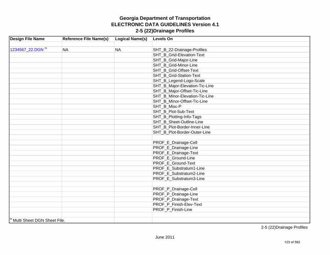
Georgia Department of TransportationELECTRONIC DATA GUIDELINES Version 4.1
2-5 (22)Drainage Profiles
Design File Name Reference File Name(s) Logical Name(s) Levels On
1234567_22.DGN m NA NA SHT_B_22-Drainage-ProfilesSHT_B_Grid-Elevation-TextSHT_B_Grid-Major-LineSHT_B_Grid-Minor-LineSHT_B_Grid-Offset-TextSHT_B_Grid-Station-TextSHT_B_Legend-Logo-ScaleSHT_B_Major-Elevation-Tic-LineSHT_B_Major-Offset-Tic-LineSHT_B_Minor-Elevation-Tic-LineSHT_B_Minor-Offset-Tic-LineSHT_B_Misc-PSHT_B_Plot-Sub-TextSHT_B_Plotting-Info-TagsSHT_B_Sheet-Outline-LineSHT_B_Plot-Border-Inner-LineSHT_B_Plot-Border-Outer-Line
PROF_E_Drainage-CellPROF_E_Drainage-LinePROF_E_Drainage-TextPROF_E_Ground-LinePROF_E_Ground-TextPROF_E_Substratum1-LinePROF_E_Substratum2-LinePROF_E_Substratum3-Line
PROF_P_Drainage-CellPROF_P_Drainage-LinePROF_P_Drainage-TextPROF_P_Finish-Elev-TextPROF_P_Finish-Line
m Multi Sheet DGN Sheet File.
June 2011
2-5 (22)Drainage Profiles
123 of 582

Georgia Department of TransportationELECTRONIC DATA GUIDELINES Version 4.1
2-5 (22)Drainage Profiles
Design File Name Reference File Name(s) Logical Name(s) Levels On
PROF_P_Finish-Pt-CellPROF_P_Finish-TextPROF_P_Grid-Elev-TextPROF_P_Label-TextPROF_P_Scale-TextPROF_P_Stage1-LinePROF_P_Stage2-LinePROF_P_Stage3-LinePROF_P_Stage4-LinePROF_P_Stage5-LinePROF_P_Station-TextPROF_P_Subgrade-Line
DRNG_P_Cross-Drain-and-Culv-LineDRNG_P_Cross-Drain-and-Culv-TextDRNG_P_Storm-Drain-Pipe-LineDRNG_P_Storm-Drain-Pipe-TextDRNG_P_Storm-Drain-StructDRNG_P_Storm-Drain-Struct-TextDRNG_P_Struct-Text
June 2011
2-5 (22)Drainage Profiles
124 of 582

Georgia Department of TransportationELECTRONIC DATA GUIDELINES Version 4.1
2-5 (23) Cross-SectionsDesign File Name Reference File Name(s) Logical Name(s) Levels On
1234567_23.DGN m NA NA SHT_B_23-Cross-SectionsSHT_B_Grid-Elevation-TextSHT_B_Grid-Major-LineSHT_B_Grid-Minor-LineSHT_B_Grid-Offset-TextSHT_B_Grid-Station-TextSHT_B_Legend-Logo-ScaleSHT_B_Major-Elevation-Tic-LineSHT_B_Major-Offset-Tic-LineSHT_B_Minor-Elevation-Tic-LineSHT_B_Minor-Offset-Tic-LineSHT_B_Misc-PSHT_B_Plot-Sub-TextSHT_B_Plotting-Info-TagsSHT_B_Sheet-Outline-LineSHT_B_Plot-Border-Inner-LineSHT_B_Plot-Border-Outer-Line
XSEC_E_Drainage-CellXSEC_E_Drainage-LineXSEC_E_Drainage-TextXSEC_E_Ground-LineXSEC_E_Ground-TextXSEC_E_Substratum1-LineXSEC_E_Substratum2-LineXSEC_E_Substratum3-LineXSEC_E_Ground_Enhancement-LineXSEC_E_Ground_Enhancement-Text
XSEC_P_Subgrade-LineXSEC_P_Xslope-TextXSEC_P_Finish-Line
m Multi Sheet DGN Sheet File.
June 2011
2-5 (23) Cross-Sections
125 of 582

Georgia Department of TransportationELECTRONIC DATA GUIDELINES Version 4.1
2-5 (23) Cross-SectionsDesign File Name Reference File Name(s) Logical Name(s) Levels On
XSEC_P_Grid-Elev-TextXSEC_P_Grid-Offset-TextXSEC_P_Station-TextXSEC_P_Drainage-CellXSEC_P_Drainage-LineXSEC_P_Drainage-TextXSEC_P_Label-TextXSEC_P_Scale-TextXSEC_P_Stage1-LineXSEC_P_Stage2-LineXSEC_P_Stage3-LineXSEC_P_Stage4-LineXSEC_P_Stage5-LineXSEC_P_Component-Blue-LineXSEC_P_Component-Cyan-LineXSEC_P_Component-Green-LineXSEC_P_Component-Orange-LineXSEC_P_Component-Purple-LineXSEC_P_Component-Red-LineXSEC_P_Component-White-LineXSEC_P_Component-Yellow-LineXSEC_P_Label-Point
June 2011
2-5 (23) Cross-Sections
126 of 582

Georgia Department of TransportationELECTRONIC DATA GUIDELINES Version 4.1
2-5 (24)Utility Plans
Design File Name Reference File Name(s) Logical Name(s) Levels On (See Plan Sheet Levels Section for Level Usage)
1234567_24-001.DGN s NA NA SHT_B_24-Utility-PlansSHT_B_Legend-Logo-ScaleSHT_B_Misc-PSHT_B_North-ArrowSHT_B_Plot-Sub-TextSHT_B_Plotting-Info-TagsSHT_B_Sheet-Outline-LineSHT_B_Sheet-Outline-TextSHT_B_Title-BlockSHT_B_Plot-Border-Inner-LineSHT_B_Plot-Border-Outer-Line
1234567MAIN.DGN MAIN MAIN_P_CONSTCL-LineMAIN_P_CONSTCL-Tic-Sta-TextMAIN_P_CONSTCL-Brng-TextMAIN_P_SIDECL-LineMAIN_P_SIDECL-Tic-Sta-TextMAIN_P_EOP-LineMAIN_P_Appr-Slab-LineMAIN_P_EPSHLDR-LineMAIN_P_Bridge-LineMAIN_P_Driveway-LineMAIN_P_Curb-Gutter-LineMAIN_P_Sidewalk-LineMAIN_P_Guardrail-LineMAIN_P_Median-Side-Barrier-LineMAIN_P_Retain-Wall-LineMAIN_P_Sound-Barrier-Wall-LineMAIN_P_Fence-LineMAIN_P_Misc-Const-Feat-LineMAIN_P_Details-End-Proj-CL-Intersect-Label-TextMAIN_P_Details-Begin-End-Const-Limit-Const-Label-TextMAIN_P_Details-RouteName-CL-Text
s Single Sheet DGN Sheet File.
June 2011
2-5 (24)Utility Plans
127 of 582

Georgia Department of TransportationELECTRONIC DATA GUIDELINES Version 4.1
2-5 (24)Utility Plans
Design File Name Reference File Name(s) Logical Name(s) Levels On (See Plan Sheet Levels Section for Level Usage)
1234567DRNG.DGN DRNG DRNG_P_Storm-Drain-Struct-TextDRNG_P_Storm-Drain-StructDRNG_P_Storm-Drain-Pipe-LineDRNG_P_Storm-Drain-Pipe-TextDRNG_P_Ditch-and-Channel-LineDRNG_P_Cross-Drain-and-Culv-LineDRNG_P_Cross-Drain-and-Culv-TextDRNG_P_Bridge-Culv-LineDRNG_P_Bridge-Culv-TextDRNG_P_Sediment-Basin-LineDRNG_P_Detention-Pond-LineDRNG_P_Perm-Riprap-PatternDRNG_P_Perm-Ditch-Protect-Line
1234567REQD.DGN REQD REQD_P_Parcel-Owner-TextREQD_P_Parcel-Owner-#-TextREQD_P_Parcel-Reqd-RW-Tract#-TextREQD_P_RWRM-RW-CellREQD_P_RWRM-RW-LineREQD_P_RWRM-RW-MarkerREQD_P_RWRM-RW-TextREQD_P_REQD-RW-CellREQD_P_REQD-RW-LineREQD_P_REQD-RW-Ltd-AccessREQD_P_REQD-RW-Desc-TextREQD_P_PESMT-LineREQD_P_PESMT-PatternREQD_P_TESMT-LineREQD_P_TESMT-PatternREQD_P_DWESMT-LineREQD_P_DWESMT-Pattern
1234567SIGN.DGN SIGN SIGN_E_SM-CellSIGN_P_OVHD_Sign-Structure-and-Strain-Pole
June 2011
2-5 (24)Utility Plans
128 of 582

Georgia Department of TransportationELECTRONIC DATA GUIDELINES Version 4.1
2-5 (24)Utility Plans
Design File Name Reference File Name(s) Logical Name(s) Levels On (See Plan Sheet Levels Section for Level Usage)
1234567SGNL.DGN SGNL SGNL_P_Signal-SignSGNL_P_Signal-Signal-PoleSGNL_P_Signal-Mast-ArmsSGNL_P_Signal-Span-WireSGNL_P_Signal-Control-CabinetSGNL_P_Signal-Shared-Signal-and-Comm-ConduitSGNL_P_Signal-Shared-Signal-and-Comm-PullboxSGNL_P_Signal-Pedestrian-Pedestal-PoleSGNL_P_Signal-Comm-Only-ConduitSGNL_P_Signal-Comm-Only-PullboxSGNL_P_Signal-LoopSGNL_P_Signal-Signal-Only-PullboxSGNL_P_Signal-Signal-Only-Pullbox-TP2SGNL_P_Signal-Signal-Only-ConduitSGNL_P_Signal-Loop-lead-InSGNL_P_Signal-Text
1234567UTLE.DGN UTLE UTLE_E_Elec-CellUTLE_E_UG-Elec-TextUTLE_E_UG-Elec-LineUTLE_E_UG-Elec-Line-Qual-BUTLE_E_UG-Elec-Line-Qual-CUTLE_E_Elec-Vault-LineUTLE_E_Gas-CellUTLE_E_UG-Gas-TextUTLE_E_UG-Gas-LineUTLE_E_UG-Gas-Line-Qual-BUTLE_E_UG-Gas-Line-Qual-C*UTLE_E_UG-Gas-Line-24^UTLE_E_UG-Gas-Line-24-50*UTLE_E_UG-Gas-Line-24-Qual-B
*Denotes level for 20 Scale Plans.^Denotes level for 50 Scale Plans.
June 2011
2-5 (24)Utility Plans
129 of 582

Georgia Department of TransportationELECTRONIC DATA GUIDELINES Version 4.1
2-5 (24)Utility Plans
Design File Name Reference File Name(s) Logical Name(s) Levels On (See Plan Sheet Levels Section for Level Usage)
^UTLE_E_UG-Gas-Line-24-Qual-B-50*UTLE_E_UG-Gas-Line-24-Qual-C^UTLE_E_UG-Gas-Line-24-Qual-C-50*UTLE_E_UG-Gas-Line-30^UTLE_E_UG-Gas-Line-30-50*UTLE_E_UG-Gas-Line-30-Qual-B^UTLE_E_UG-Gas-Line-30-Qual-B-50*UTLE_E_UG-Gas-Line-30-Qual-C^UTLE_E_UG-Gas-Line-30-Qual-C-50*UTLE_E_UG-Gas-Line-36^UTLE_E_UG-Gas-Line-36-50*UTLE_E_UG-Gas-Line-36-Qual-B^UTLE_E_UG-Gas-Line-36-Qual-B-50*UTLE_E_UG-Gas-Line-36-Qual-C^UTLE_E_UG-Gas-Line-36-Qual-C-50*UTLE_E_UG-Gas-Line-42^UTLE_E_UG-Gas-Line-42-50*UTLE_E_UG-Gas-Line-42-Qual-B^UTLE_E_UG-Gas-Line-42-Qual-B-50*UTLE_E_UG-Gas-Line-42-Qual-C^UTLE_E_UG-Gas-Line-42-Qual-C-50*UTLE_E_UG-Gas-Line-48^UTLE_E_UG-Gas-Line-48-50*UTLE_E_UG-Gas-Line-48-Qual-B^UTLE_E_UG-Gas-Line-48-Qual-B-50*UTLE_E_UG-Gas-Line-48-Qual-C^UTLE_E_UG-Gas-Line-48-Qual-C-50UTLE_E_Traf-Ctrl-CellUTLE_E_UG-Traf-Ctrl-TextUTLE_E_UG-Traf-Ctrl-LineUTLE_E_UG-Traf-Ctrl-Line-Qual-B
*Denotes level for 20 Scale Plans.^Denotes level for 50 Scale Plans.
June 2011
2-5 (24)Utility Plans
130 of 582

Georgia Department of TransportationELECTRONIC DATA GUIDELINES Version 4.1
2-5 (24)Utility Plans
Design File Name Reference File Name(s) Logical Name(s) Levels On (See Plan Sheet Levels Section for Level Usage)
UTLE_E_UG-Traf-Ctrl-Line-Qual-CUTLE_E_San-Swr-CellUTLE_E_UG-San-Swr-TextUTLE_E_UG-San-Swr-LineUTLE_E_UG-San-Swr-Line-Qual-BUTLE_E_UG-San-Swr-Line-Qual-C*UTLE_E_UG-San-Swr-Line-24^UTLE_E_UG-San-Swr-Line-24-50*UTLE_E_UG-San-Swr-Line-24-Qual-B^UTLE_E_UG-San-Swr-Line-24-Qual-B-50*UTLE_E_UG-San-Swr-Line-24-Qual-C^UTLE_E_UG-San-Swr-Line-24-Qual-C-50*UTLE_E_UG-San-Swr-Line-30^UTLE_E_UG-San-Swr-Line-30-50*UTLE_E_UG-San-Swr-Line-30-Qual-B^UTLE_E_UG-San-Swr-Line-30-Qual-B-50*UTLE_E_UG-San-Swr-Line-30-Qual-C^UTLE_E_UG-San-Swr-Line-30-Qual-C-50*UTLE_E_UG-San-Swr-Line-36^UTLE_E_UG-San-Swr-Line-36-50*UTLE_E_UG-San-Swr-Line-36-Qual-B^UTLE_E_UG-San-Swr-Line-36-Qual-B-50*UTLE_E_UG-San-Swr-Line-36-Qual-C^UTLE_E_UG-San-Swr-Line-36-Qual-C-50*UTLE_E_UG-San-Swr-Line-42^UTLE_E_UG-San-Swr-Line-42-50*UTLE_E_UG-San-Swr-Line-42-Qual-B^UTLE_E_UG-San-Swr-Line-42-Qual-B-50*UTLE_E_UG-San-Swr-Line-42-Qual-C^UTLE_E_UG-San-Swr-Line-42-Qual-C-50*UTLE_E_UG-San-Swr-Line-48
*Denotes level for 20 Scale Plans.^Denotes level for 50 Scale Plans.
June 2011
2-5 (24)Utility Plans
131 of 582

Georgia Department of TransportationELECTRONIC DATA GUIDELINES Version 4.1
2-5 (24)Utility Plans
Design File Name Reference File Name(s) Logical Name(s) Levels On (See Plan Sheet Levels Section for Level Usage)
^UTLE_E_UG-San-Swr-Line-48-50*UTLE_E_UG-San-Swr-Line-48-Qual-B^UTLE_E_UG-San-Swr-Line-48-Qual-B-50*UTLE_E_UG-San-Swr-Line-48-Qual-C^UTLE_E_UG-San-Swr-Line-48-Qual-C-50UTLE_E_San-Force-Main-CellUTLE_E_UG-San-Force-Main-TextUTLE_E_UG-San-Force-Main-LineUTLE_E_UG-San-Force-Main-Line-Qual-BUTLE_E_UG-San-Force-Main-Line-Qual-CUTLE_E_Wat-CellUTLE_E_UG-Wat-TextUTLE_E_UG-Wat-LineUTLE_E_UG-Wat-Line-Qual-BUTLE_E_UG-Wat-Line-Qual-C*UTLE_E_UG-Wat-Line-24^UTLE_E_UG-Wat-Line-24-50*UTLE_E_UG-Wat-Line-24-Qual-B^UTLE_E_UG-Wat-Line-24-Qual-B-50*UTLE_E_UG-Wat-Line-24-Qual-C^UTLE_E_UG-Wat-Line-24-Qual-C-50*UTLE_E_UG-Wat-Line-30^UTLE_E_UG-Wat-Line-30-50*UTLE_E_UG-Wat-Line-30-Qual-B^UTLE_E_UG-Wat-Line-30-Qual-B-50*UTLE_E_UG-Wat-Line-30-Qual-C^UTLE_E_UG-Wat-Line-30-Qual-C-50*UTLE_E_UG-Wat-Line-36^UTLE_E_UG-Wat-Line-36-50*UTLE_E_UG-Wat-Line-36-Qual-B^UTLE_E_UG-Wat-Line-36-Qual-B-50
*Denotes level for 20 Scale Plans.^Denotes level for 50 Scale Plans.
June 2011
2-5 (24)Utility Plans
132 of 582

Georgia Department of TransportationELECTRONIC DATA GUIDELINES Version 4.1
2-5 (24)Utility Plans
Design File Name Reference File Name(s) Logical Name(s) Levels On (See Plan Sheet Levels Section for Level Usage)
*UTLE_E_UG-Wat-Line-36-Qual-C^UTLE_E_UG-Wat-Line-36-Qual-C-50*UTLE_E_UG-Wat-Line-42^UTLE_E_UG-Wat-Line-42-50*UTLE_E_UG-Wat-Line-42-Qual-B^UTLE_E_UG-Wat-Line-42-Qual-B-50*UTLE_E_UG-Wat-Line-42-Qual-C^UTLE_E_UG-Wat-Line-42-Qual-C-50*UTLE_E_UG-Wat-Line-48^UTLE_E_UG-Wat-Line-48-50*UTLE_E_UG-Wat-Line-48-Qual-B^UTLE_E_UG-Wat-Line-48-Qual-B-50*UTLE_E_UG-Wat-Line-48-Qual-C^UTLE_E_UG-Wat-Line-48-Qual-C-50UTLE_E_TV-CellUTLE_E_UG-TV-TextUTLE_E_UG-TV-LineUTLE_E_UG-TV-Line-Qual-BUTLE_E_UG-TV-Line-Qual-CUTLE_E_Petro-CellUTLE_E_UG-Petro-TextUTLE_E_UG-Petro-LineUTLE_E_UG-Petro-Line-Qual-BUTLE_E_UG-Petro-Line-Qual-C*UTLE_E_UG-Petro-Line-24^UTLE_E_UG-Petro-Line-24-50*UTLE_E_UG-Petro-Line-24-Qual-B^UTLE_E_UG-Petro-Line-24-Qual-B-50*UTLE_E_UG-Petro-Line-24-Qual-C^UTLE_E_UG-Petro-Line-24-Qual-C-50*UTLE_E_UG-Petro-Line-30
*Denotes level for 20 Scale Plans.^Denotes level for 50 Scale Plans.
June 2011
2-5 (24)Utility Plans
133 of 582
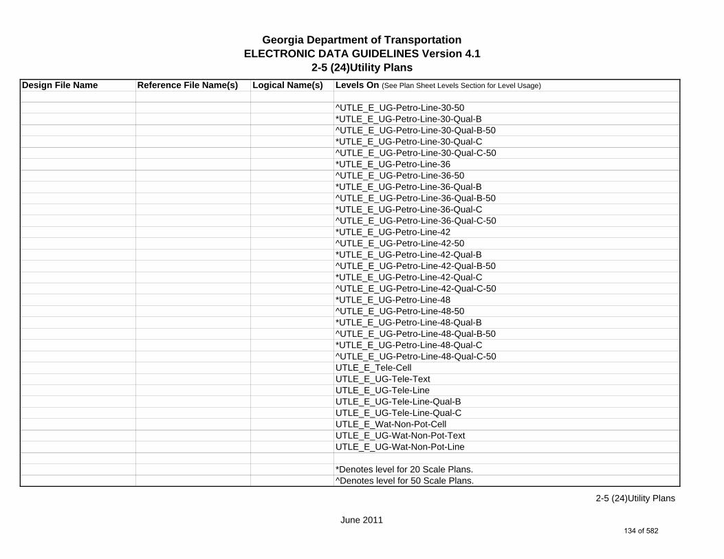
Georgia Department of TransportationELECTRONIC DATA GUIDELINES Version 4.1
2-5 (24)Utility Plans
Design File Name Reference File Name(s) Logical Name(s) Levels On (See Plan Sheet Levels Section for Level Usage)
^UTLE_E_UG-Petro-Line-30-50*UTLE_E_UG-Petro-Line-30-Qual-B^UTLE_E_UG-Petro-Line-30-Qual-B-50*UTLE_E_UG-Petro-Line-30-Qual-C^UTLE_E_UG-Petro-Line-30-Qual-C-50*UTLE_E_UG-Petro-Line-36^UTLE_E_UG-Petro-Line-36-50*UTLE_E_UG-Petro-Line-36-Qual-B^UTLE_E_UG-Petro-Line-36-Qual-B-50*UTLE_E_UG-Petro-Line-36-Qual-C^UTLE_E_UG-Petro-Line-36-Qual-C-50*UTLE_E_UG-Petro-Line-42^UTLE_E_UG-Petro-Line-42-50*UTLE_E_UG-Petro-Line-42-Qual-B^UTLE_E_UG-Petro-Line-42-Qual-B-50*UTLE_E_UG-Petro-Line-42-Qual-C^UTLE_E_UG-Petro-Line-42-Qual-C-50*UTLE_E_UG-Petro-Line-48^UTLE_E_UG-Petro-Line-48-50*UTLE_E_UG-Petro-Line-48-Qual-B^UTLE_E_UG-Petro-Line-48-Qual-B-50*UTLE_E_UG-Petro-Line-48-Qual-C^UTLE_E_UG-Petro-Line-48-Qual-C-50UTLE_E_Tele-CellUTLE_E_UG-Tele-TextUTLE_E_UG-Tele-LineUTLE_E_UG-Tele-Line-Qual-BUTLE_E_UG-Tele-Line-Qual-CUTLE_E_Wat-Non-Pot-CellUTLE_E_UG-Wat-Non-Pot-TextUTLE_E_UG-Wat-Non-Pot-Line
*Denotes level for 20 Scale Plans.^Denotes level for 50 Scale Plans.
June 2011
2-5 (24)Utility Plans
134 of 582

Georgia Department of TransportationELECTRONIC DATA GUIDELINES Version 4.1
2-5 (24)Utility Plans
Design File Name Reference File Name(s) Logical Name(s) Levels On (See Plan Sheet Levels Section for Level Usage)
UTLE_E_UG-Wat-Non-Pot-Line-Qual-BUTLE_E_UG-Wat-Non-Pot-Line-Qual-C*UTLE_E_UG-Wat-Non-Pot-Line-24^UTLE_E_UG-Wat-Non-Pot-Line-24-50*UTLE_E_UG-Wat-Non-Pot-Line-24-Qual-B^UTLE_E_UG-Wat-Non-Pot-Line-24-Qual-B-50*UTLE_E_UG-Wat-Non-Pot-Line-24-Qual-C^UTLE_E_UG-Wat-Non-Pot-Line-24-Qual-C-50*UTLE_E_UG-Wat-Non-Pot-Line-30^UTLE_E_UG-Wat-Non-Pot-Line-30-50*UTLE_E_UG-Wat-Non-Pot-Line-30-Qual-B^UTLE_E_UG-Wat-Non-Pot-Line-30-Qual-B-50*UTLE_E_UG-Wat-Non-Pot-Line-30-Qual-C^UTLE_E_UG-Wat-Non-Pot-Line-30-Qual-C-50*UTLE_E_UG-Wat-Non-Pot-Line-36^UTLE_E_UG-Wat-Non-Pot-Line-36-50*UTLE_E_UG-Wat-Non-Pot-Line-36-Qual-B^UTLE_E_UG-Wat-Non-Pot-Line-36-Qual-B-50*UTLE_E_UG-Wat-Non-Pot-Line-36-Qual-C^UTLE_E_UG-Wat-Non-Pot-Line-36-Qual-C-50*UTLE_E_UG-Wat-Non-Pot-Line-42^UTLE_E_UG-Wat-Non-Pot-Line-42-50*UTLE_E_UG-Wat-Non-Pot-Line-42-Qual-B^UTLE_E_UG-Wat-Non-Pot-Line-42-Qual-B-50*UTLE_E_UG-Wat-Non-Pot-Line-42-Qual-C^UTLE_E_UG-Wat-Non-Pot-Line-42-Qual-C-50*UTLE_E_UG-Wat-Non-Pot-Line-48^UTLE_E_UG-Wat-Non-Pot-Line-48-50*UTLE_E_UG-Wat-Non-Pot-Line-48-Qual-B^UTLE_E_UG-Wat-Non-Pot-Line-48-Qual-B-50*UTLE_E_UG-Wat-Non-Pot-Line-48-Qual-C
*Denotes level for 20 Scale Plans.^Denotes level for 50 Scale Plans.
June 2011
2-5 (24)Utility Plans
135 of 582

Georgia Department of TransportationELECTRONIC DATA GUIDELINES Version 4.1
2-5 (24)Utility Plans
Design File Name Reference File Name(s) Logical Name(s) Levels On (See Plan Sheet Levels Section for Level Usage)
^UTLE_E_UG-Wat-Non-Pot-Line-48-Qual-C-50UTLE_E_Steam-CellUTLE_E_UG-Steam-TextUTLE_E_UG-Steam-LineUTLE_E_UG-Steam-Line-Qual-BUTLE_E_UG-Steam-Line-Qual-C*UTLE_E_UG-Steam-Line-24^UTLE_E_UG-Steam-Line-24-50*UTLE_E_UG-Steam-Line-24-Qual-B^UTLE_E_UG-Steam-Line-24-Qual-B-50*UTLE_E_UG-Steam-Line-24-Qual-C^UTLE_E_UG-Steam-Line-24-Qual-C-50*UTLE_E_UG-Steam-Line-30^UTLE_E_UG-Steam-Line-30-50*UTLE_E_UG-Steam-Line-30-Qual-B^UTLE_E_UG-Steam-Line-30-Qual-B-50*UTLE_E_UG-Steam-Line-30-Qual-C^UTLE_E_UG-Steam-Line-30-Qual-C-50*UTLE_E_UG-Steam-Line-36^UTLE_E_UG-Steam-Line-36-50*UTLE_E_UG-Steam-Line-36-Qual-B^UTLE_E_UG-Steam-Line-36-Qual-B-50*UTLE_E_UG-Steam-Line-36-Qual-C^UTLE_E_UG-Steam-Line-36-Qual-C-50*UTLE_E_UG-Steam-Line-42^UTLE_E_UG-Steam-Line-42-50*UTLE_E_UG-Steam-Line-42-Qual-B^UTLE_E_UG-Steam-Line-42-Qual-B-50*UTLE_E_UG-Steam-Line-42-Qual-C^UTLE_E_UG-Steam-Line-42-Qual-C-50*UTLE_E_UG-Steam-Line-48
*Denotes level for 20 Scale Plans.^Denotes level for 50 Scale Plans.
June 2011
2-5 (24)Utility Plans
136 of 582

Georgia Department of TransportationELECTRONIC DATA GUIDELINES Version 4.1
2-5 (24)Utility Plans
Design File Name Reference File Name(s) Logical Name(s) Levels On (See Plan Sheet Levels Section for Level Usage)
^UTLE_E_UG-Steam-Line-48-50*UTLE_E_UG-Steam-Line-48-Qual-B^UTLE_E_UG-Steam-Line-48-Qual-B-50*UTLE_E_UG-Steam-Line-48-Qual-C^UTLE_E_UG-Steam-Line-48-Qual-C-50UTLE_E_UG-Utl-Unknown-Line-Qual-BUTLE_E_UG-Utl-Unknown-TextUTLE_E_OVHD-Tele-TextUTLE_E_OVHD-Tele-LineUTLE_E_OVHD-TV-TextUTLE_E_OVHD-TV-LineUTLE_E_OVHD-Elec-TextUTLE_E_OVHD-Elec-LineUTLE_E_OVHD-Traf-Ctrl-TextUTLE_E_OVHD-Traf-Ctrl-LineUTLE_E_OVHD-Combo-Util-TextUTLE_E_OVHD-Combo-Util-Line-Elec-TeleUTLE_E_OVHD-Combo-Util-Line-Elec-Tele-Traf-CtrlUTLE_E_OVHD-Combo-Util-Line-Elec-Tele-TVUTLE_E_OVHD-Combo-Util-Line-Elec-Tele-TV-Traf-CtrlUTLE_E_OVHD-Combo-Util-Line-Elec-Traf-CtrlUTLE_E_OVHD-Combo-Util-Line-Elec-TVUTLE_E_OVHD-Combo-Util-Line-Elec-TV-Traf-CtrlUTLE_E_OVHD-Combo-Util-Line-Guy-WireUTLE_E_OVHD-Combo-Util-Line-Tele-Traf-CtrlUTLE_E_OVHD-Combo-Util-Line-Tele-TVUTLE_E_OVHD-Combo-Util-Line-Tele-TV-Traf-CtrlUTLE_E_OVHD-Combo-Util-Line-TV-Traf-CtrlUTLE_E_Test-Hole-CellUTLE_E_Test-Hole-TextUTLE_E_Limits-of-Study
*Denotes level for 20 Scale Plans.^Denotes level for 50 Scale Plans.
June 2011
2-5 (24)Utility Plans
137 of 582

Georgia Department of TransportationELECTRONIC DATA GUIDELINES Version 4.1
2-5 (24)Utility Plans
Design File Name Reference File Name(s) Logical Name(s) Levels On (See Plan Sheet Levels Section for Level Usage)
UTLE_E_UG-Gas-Line-User-DefUTLE_E_UG-Gas-Line-User-Def-Qual-BUTLE_E_UG-Gas-Line-User-Def-Qual-CUTLE_E_UG-Petro-Line-User-DefUTLE_E_UG-Petro-Line-User-Def-Qual-BUTLE_E_UG-Petro-Line-User-Def-Qual-CUTLE_E_UG-San-Swr-User-Def-LineUTLE_E_UG-San-Swr-User-Def-Line-Qual-BUTLE_E_UG-San-Swr-User-Def-Line-Qual-CUTLE_E_UG-Steam-User-Def-LineUTLE_E_UG-Steam-User-Def-Line-Qual-BUTLE_E_UG-Steam-User-Def-Line-Qual-CUTLE_E_UG-Wat-User-Def-LineUTLE_E_UG-Wat-User-Def-Line-Qual-BUTLE_E_UG-Wat-User-Def-Line-Qual-CUTLE_E_UG-Wat-Non-Pot-User-Def-LineUTLE_E_UG-Wat-Non-Pot-User-Def-Line-Qual-BUTLE_E_UG-Wat-Non-Pot-User-Def-Line-Qual-C
1234567UTLP.DGN UTLP UTLP_P_Elec-CellUTLP_P_UG-Elec-TextUTLP_P_UG-Elec-LineUTLP_P_UG-Elec-Line-REMUTLP_P_Elec-Vault-LineUTLP_P_Gas-CellUTLP_P_UG-Gas-TextUTLP_P_UG-Gas-Line*UTLP_P_UG-Gas-Line-24^UTLP_P_UG-Gas-Line-24-50*UTLP_P_UG-Gas-Line-30^UTLP_P_UG-Gas-Line-30-50
*Denotes level for 20 Scale Plans.^Denotes level for 50 Scale Plans.
June 2011
2-5 (24)Utility Plans
138 of 582
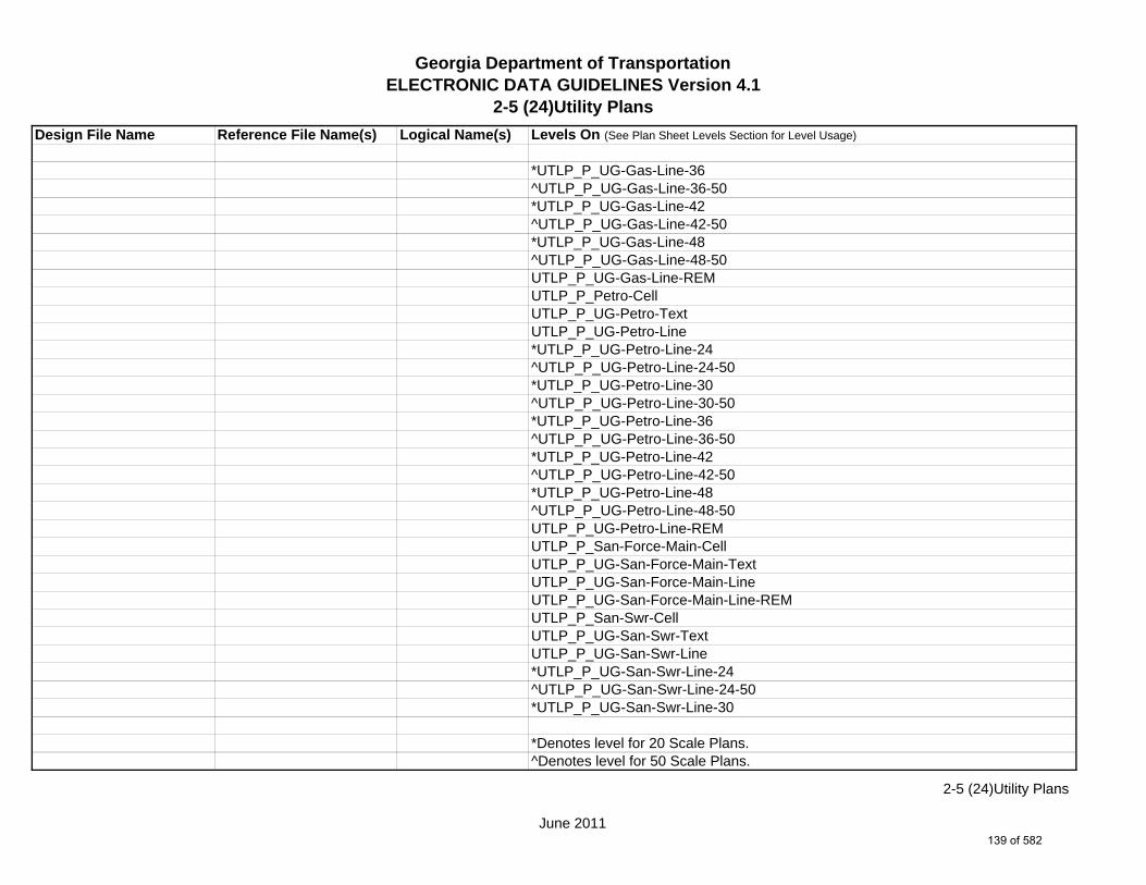
Georgia Department of TransportationELECTRONIC DATA GUIDELINES Version 4.1
2-5 (24)Utility Plans
Design File Name Reference File Name(s) Logical Name(s) Levels On (See Plan Sheet Levels Section for Level Usage)
*UTLP_P_UG-Gas-Line-36^UTLP_P_UG-Gas-Line-36-50*UTLP_P_UG-Gas-Line-42^UTLP_P_UG-Gas-Line-42-50*UTLP_P_UG-Gas-Line-48^UTLP_P_UG-Gas-Line-48-50UTLP_P_UG-Gas-Line-REMUTLP_P_Petro-CellUTLP_P_UG-Petro-TextUTLP_P_UG-Petro-Line*UTLP_P_UG-Petro-Line-24^UTLP_P_UG-Petro-Line-24-50*UTLP_P_UG-Petro-Line-30^UTLP_P_UG-Petro-Line-30-50*UTLP_P_UG-Petro-Line-36^UTLP_P_UG-Petro-Line-36-50*UTLP_P_UG-Petro-Line-42^UTLP_P_UG-Petro-Line-42-50*UTLP_P_UG-Petro-Line-48^UTLP_P_UG-Petro-Line-48-50UTLP_P_UG-Petro-Line-REMUTLP_P_San-Force-Main-CellUTLP_P_UG-San-Force-Main-TextUTLP_P_UG-San-Force-Main-LineUTLP_P_UG-San-Force-Main-Line-REMUTLP_P_San-Swr-CellUTLP_P_UG-San-Swr-TextUTLP_P_UG-San-Swr-Line*UTLP_P_UG-San-Swr-Line-24^UTLP_P_UG-San-Swr-Line-24-50*UTLP_P_UG-San-Swr-Line-30
*Denotes level for 20 Scale Plans.^Denotes level for 50 Scale Plans.
June 2011
2-5 (24)Utility Plans
139 of 582

Georgia Department of TransportationELECTRONIC DATA GUIDELINES Version 4.1
2-5 (24)Utility Plans
Design File Name Reference File Name(s) Logical Name(s) Levels On (See Plan Sheet Levels Section for Level Usage)
^UTLP_P_UG-San-Swr-Line-30-50*UTLP_P_UG-San-Swr-Line-36^UTLP_P_UG-San-Swr-Line-36-50*UTLP_P_UG-San-Swr-Line-42^UTLP_P_UG-San-Swr-Line-42-50*UTLP_P_UG-San-Swr-Line-48^UTLP_P_UG-San-Swr-Line-48-50UTLP_P_UG-San-Swr-Line-REMUTLP_P_Steam-CellUTLP_P_UG-Steam-TextUTLP_P_UG-Steam-Line*UTLP_P_UG-Steam-Line-24^UTLP_P_UG-Steam-Line-24-50*UTLP_P_UG-Steam-Line-30^UTLP_P_UG-Steam-Line-30-50*UTLP_P_UG-Steam-Line-36^UTLP_P_UG-Steam-Line-36-50*UTLP_P_UG-Steam-Line-42^UTLP_P_UG-Steam-Line-42-50*UTLP_P_UG-Steam-Line-48^UTLP_P_UG-Steam-Line-48-50UTLP_P_UG-Steam-Line-REMUTLP_P_Tele-CellUTLP_P_UG-Tele-TextUTLP_P_UG-Tele-LineUTLP_P_UG-Tele-Line-REMUTLP_P_Traf-Ctrl-CellUTLP_P_UG-Traf-Ctrl-TextUTLP_P_UG-Traf-Ctrl-LineUTLP_P_UG-Traf-Ctrl-Line-REMUTLP_P_TV-Cell
*Denotes level for 20 Scale Plans.^Denotes level for 50 Scale Plans.
June 2011
2-5 (24)Utility Plans
140 of 582

Georgia Department of TransportationELECTRONIC DATA GUIDELINES Version 4.1
2-5 (24)Utility Plans
Design File Name Reference File Name(s) Logical Name(s) Levels On (See Plan Sheet Levels Section for Level Usage)
UTLP_P_UG-TV-TextUTLP_P_UG-TV-LineUTLP_P_UG-TV-Line-REMUTLP_P_Wat-CellUTLP_P_UG-Wat-TextUTLP_P_UG-Wat-Line*UTLP_P_UG-Wat-Line-24^UTLP_P_UG-Wat-Line-24-50*UTLP_P_UG-Wat-Line-30^UTLP_P_UG-Wat-Line-30-50*UTLP_P_UG-Wat-Line-36^UTLP_P_UG-Wat-Line-36-50*UTLP_P_UG-Wat-Line-42^UTLP_P_UG-Wat-Line-42-50*UTLP_P_UG-Wat-Line-48^UTLP_P_UG-Wat-Line-48-50UTLP_P_UG-Wat-Line-REMUTLP_P_Wat-Non-Pot-CellUTLP_P_UG-Wat-Non-Pot-TextUTLP_P_UG-Wat-Non-Pot-Line*UTLP_P_UG-Wat-Non-Pot-Line-24^UTLP_P_UG-Wat-Non-Pot-Line-24-50*UTLP_P_UG-Wat-Non-Pot-Line-30^UTLP_P_UG-Wat-Non-Pot-Line-30-50*UTLP_P_UG-Wat-Non-Pot-Line-36^UTLP_P_UG-Wat-Non-Pot-Line-36-50*UTLP_P_UG-Wat-Non-Pot-Line-42^UTLP_P_UG-Wat-Non-Pot-Line-42-50*UTLP_P_UG-Wat-Non-Pot-Line-48^UTLP_P_UG-Wat-Non-Pot-Line-48-50UTLP_P_UG-Wat-Non-Pot-Line-REM
*Denotes level for 20 Scale Plans.^Denotes level for 50 Scale Plans.
June 2011
2-5 (24)Utility Plans
141 of 582

Georgia Department of TransportationELECTRONIC DATA GUIDELINES Version 4.1
2-5 (24)Utility Plans
Design File Name Reference File Name(s) Logical Name(s) Levels On (See Plan Sheet Levels Section for Level Usage)
UTLP_P_OVHD-Tele-TextUTLP_P_OVHD-Tele-LineUTLP_P_OVHD-Tele-Line-REMUTLP_P_OVHD-TV-TextUTLP_P_OVHD-TV-LineUTLP_P_OVHD-TV-Line-REMUTLP_P_OVHD-Elec-TextUTLP_P_OVHD-Elec-LineUTLP_P_OVHD-Elec-Line-REMUTLP_P_OVHD-Traf-Ctrl-TextUTLP_P_OVHD-Traf-Ctrl-LineUTLP_P_OVHD-Traf-Ctrl-Line-REMUTLP_P_OVHD-Combo-Util-TextUTLP_P_OVHD-Combo-Util-LineUTLP_P_OVHD-Combo-Util-Line-Elec-TeleUTLP_P_OVHD-Combo-Util-Lines-Elec-Tele-REMUTLP_P_OVHD-Combo-Util-Line-Elec-Tele-Traf-CtrlUTLP_P_OVHD-Combo-Util-Line-Elec-Tele-Traf-Ctrl-REMUTLP_P_OVHD-Combo-Util-Line-Elec-Tele-TVUTLP_P_OVHD-Combo-Util-Line-Elec-Tele-TV-REMUTLP_P_OVHD-Combo-Util-Line-Elec-Tele-TV-Traf-CtrlUTLP_P_OVHD-Combo-Util-Line-Elec-Tele-TV-Traf-Ctrl-REMUTLP_P_OVHD-Combo-Util-Line-Elec-Traf-CtrlUTLP_P_OVHD-Combo-Util-Line-Elec-Traf-Ctrl-REMUTLP_P_OVHD-Combo-Util-Line-Elec-TVUTLP_P_OVHD-Combo-Util-Line-Elec-TV-REMUTLP_P_OVHD-Combo-Util-Line-Elec-TV-Traf-CtrlUTLP_P_OVHD-Combo-Util-Line-Elec-TV-Traf-Ctrl-REMUTLP_P_OVHD-Combo-Util-Line-Tele-TVUTLP_P_OVHD-Combo-Util-Line-Tele-TV-REMUTLP_P_OVHD-Combo-Util-Line-Tele-Traf-CtrlUTLP_P_OVHD-Combo-Util-Line-Tele-Traf-Ctrl-REMUTLP_P_OVHD-Combo-Util-Line-Tele-TV-Traf-CtrlUTLP_P_OVHD-Combo-Util-Line-Tele-TV-Traf-Ctrl-REM
June 2011
2-5 (24)Utility Plans
142 of 582
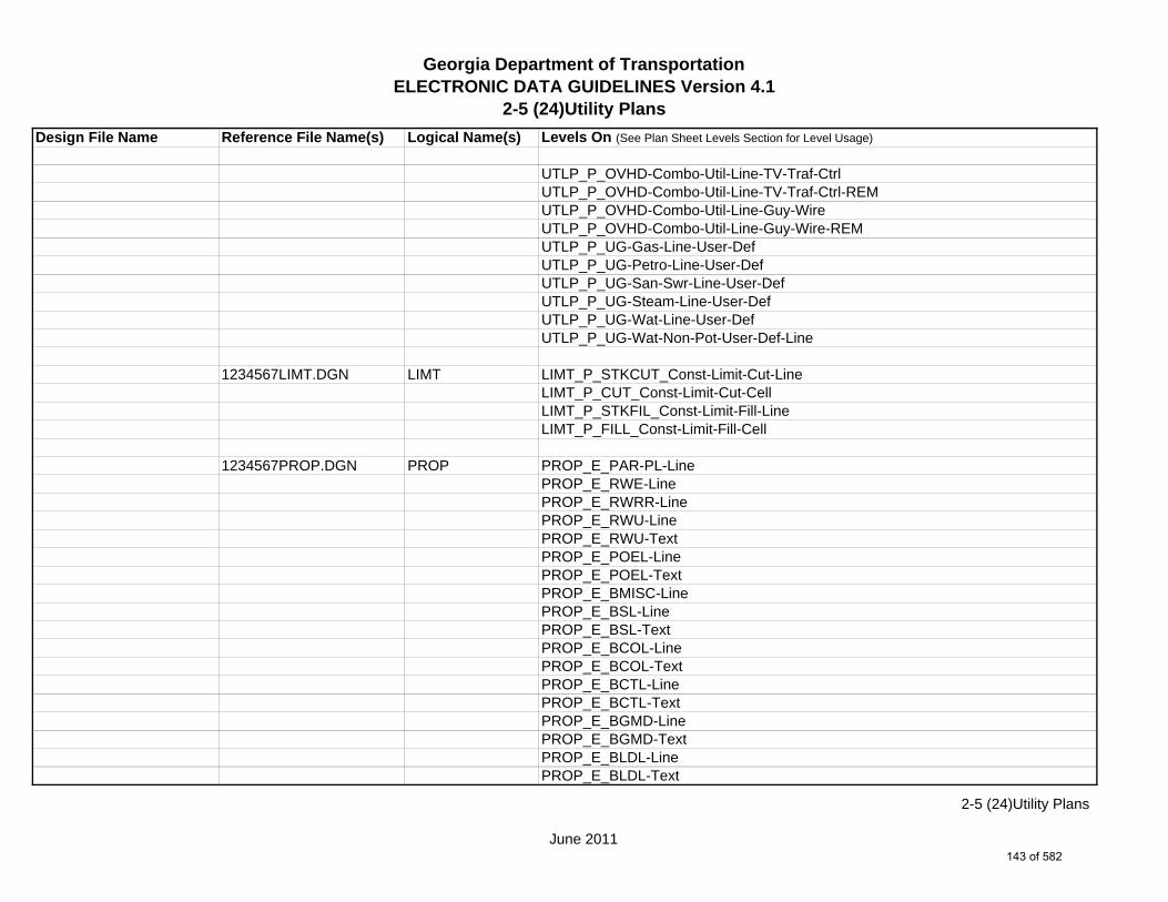
Georgia Department of TransportationELECTRONIC DATA GUIDELINES Version 4.1
2-5 (24)Utility Plans
Design File Name Reference File Name(s) Logical Name(s) Levels On (See Plan Sheet Levels Section for Level Usage)
UTLP_P_OVHD-Combo-Util-Line-TV-Traf-CtrlUTLP_P_OVHD-Combo-Util-Line-TV-Traf-Ctrl-REMUTLP_P_OVHD-Combo-Util-Line-Guy-WireUTLP_P_OVHD-Combo-Util-Line-Guy-Wire-REMUTLP_P_UG-Gas-Line-User-DefUTLP_P_UG-Petro-Line-User-DefUTLP_P_UG-San-Swr-Line-User-DefUTLP_P_UG-Steam-Line-User-DefUTLP_P_UG-Wat-Line-User-DefUTLP_P_UG-Wat-Non-Pot-User-Def-Line
1234567LIMT.DGN LIMT LIMT_P_STKCUT_Const-Limit-Cut-LineLIMT_P_CUT_Const-Limit-Cut-CellLIMT_P_STKFIL_Const-Limit-Fill-LineLIMT_P_FILL_Const-Limit-Fill-Cell
1234567PROP.DGN PROP PROP_E_PAR-PL-LinePROP_E_RWE-Line PROP_E_RWRR-LinePROP_E_RWU-LinePROP_E_RWU-TextPROP_E_POEL-LinePROP_E_POEL-TextPROP_E_BMISC-LinePROP_E_BSL-LinePROP_E_BSL-TextPROP_E_BCOL-LinePROP_E_BCOL-TextPROP_E_BCTL-LinePROP_E_BCTL-TextPROP_E_BGMD-LinePROP_E_BGMD-TextPROP_E_BLDL-LinePROP_E_BLDL-Text
June 2011
2-5 (24)Utility Plans
143 of 582

Georgia Department of TransportationELECTRONIC DATA GUIDELINES Version 4.1
2-5 (24)Utility Plans
Design File Name Reference File Name(s) Logical Name(s) Levels On (See Plan Sheet Levels Section for Level Usage)
PROP_E_BLLL-LinePROP_E_BLLL-Text
1234567TOPO.DGN TOPO TOPO_E_TEAP-LineTOPO_E_TEAS-LineTOPO_E_TECP-LineTOPO_E_TEDR-LineTOPO_E_TEST-LineTOPO_E_TEDD-LineTOPO_E_TEAD-LineTOPO_E_TECD-LineTOPO_E_TAC-LineTOPO_E_TCGF-LineTOPO_E_TCGT-LineTOPO_E_THC-LineTOPO_E_TVG-LineTOPO_E_TSW-LineTOPO_E_TGR-LineTOPO_E_TBAS-LineTOPO_E_TBGL-LineTOPO_E_TBRDGCEN-LineTOPO_E_TBRDGCOR-LineTOPO_E_THM-CellTOPO_E_TFP-LineTOPO_E_TRCR-LineTOPO_E_TRCRE-LineTOPO_E_TBLD-LineTOPO_E_TBLDRL-LineTOPO_E_TUD-LineTOPO_E_TS-LineTOPO_E_TBC-LineTOPO_E_TFE-LineTOPO_E_DSTC-LineTOPO_E_DDL-Line
June 2011
2-5 (24)Utility Plans
144 of 582

Georgia Department of TransportationELECTRONIC DATA GUIDELINES Version 4.1
2-5 (24)Utility Plans
Design File Name Reference File Name(s) Logical Name(s) Levels On (See Plan Sheet Levels Section for Level Usage)
TOPO_E_TCAN-LineTOPO_E_THCR-LineTOPO_E_THRL-LineTOPO_E_TMHCR-LineTOPO_E_TMHRL-LineTOPO_E_TFCL-LineTOPO_E_TFCL-TextTOPO_E_TFW-LineTOPO_E_TFW-TextTOPO_E_TFBW-LineTOPO_E_TFBW-TextTOPO_E_TFFW-LineTOPO_E_TFFW-TextTOPO_E_TVF-LineTOPO_E_TVF-TextTOPO_E_TG-LineTOPO_E_TG-TextTOPO_E_TWELL-LineTOPO_E_TGFV-LineTOPO_E_TGMW-LineTOPO_E_TGP-LineTOPO_E_TGPI-LineTOPO_E_TFT-LineTOPO_E_TGST-LineTOPO_E_TGVP-LineTOPO_E_DCEF-LineTOPO_E_DCEF-TextTOPO_E_DCB-LineTOPO_E_DCB-TextTOPO_E_DCWE-LineTOPO_E_DCWE-TextTOPO_E_DDCB-LineTOPO_E_DDCB-TextTOPO_E_DDI-Line
June 2011
2-5 (24)Utility Plans
145 of 582

Georgia Department of TransportationELECTRONIC DATA GUIDELINES Version 4.1
2-5 (24)Utility Plans
Design File Name Reference File Name(s) Logical Name(s) Levels On (See Plan Sheet Levels Section for Level Usage)
TOPO_E_DDI-TextTOPO_E_DHWE-LineTOPO_E_DHWE-TextTOPO_E_DJB-LineTOPO_E_DJB-TextTOPO_E_DPC-LineTOPO_E_DPC-TextTOPO_E_DPM-LineTOPO_E_DPM-TextTOPO_E_DPP-LineTOPO_E_DPP-TextTOPO_E_MDITCHFL-LineTOPO_E_MDITCHFL-TextTOPO_E_DPD-LineTOPO_E_DPD-TextTOPO_E_DSB-LineTOPO_E_DSB-TextTOPO_E_DSC-LineTOPO_E_DSC-TextTOPO_E_DSE-LineTOPO_E_DSE-TextTOPO_E_DWE-LineTOPO_E_DWE-TextTOPO_E_DEW-LineTOPO_E_DEW-TextTOPO_E_DHWM-LineTOPO_E_DHWM-TextTOPO_E_DSWE-LineTOPO_E_DSWE-TextTOPO_E_DMISC-LineTOPO_E_DMISC-TextTOPO_E_TWF-LineTOPO_E_TWFT-LineTOPO_E_TWFB-Line
June 2011
2-5 (24)Utility Plans
146 of 582
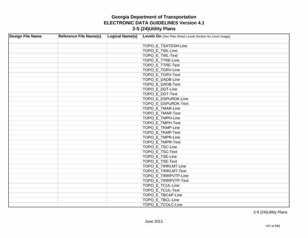
Georgia Department of TransportationELECTRONIC DATA GUIDELINES Version 4.1
2-5 (24)Utility Plans
Design File Name Reference File Name(s) Logical Name(s) Levels On (See Plan Sheet Levels Section for Level Usage)
TOPO_E_TSATDSH-LineTOPO_E_TWL-LineTOPO_E_TWL-TextTOPO_E_TTRE-LineTOPO_E_TTRE-TextTOPO_E_TGRV-LineTOPO_E_TGRV-TextTOPO_E_DADB-LineTOPO_E_DADB-TextTOPO_E_DDT-LineTOPO_E_DDT-TextTOPO_E_DSPURDK-LineTOPO_E_DSPURDK-TextTOPO_E_TMAR-LineTOPO_E_TMAR-TextTOPO_E_TMPH-LineTOPO_E_TMPH-TextTOPO_E_TKMP-LineTOPO_E_TKMP-TextTOPO_E_TMPR-LineTOPO_E_TMPR-TextTOPO_E_TSC-LineTOPO_E_TSC-TextTOPO_E_TSE-LineTOPO_E_TSE-TextTOPO_E_TIRRLMT-LineTOPO_E_TIRRLMT-TextTOPO_E_TIRRPVTP-LineTOPO_E_TIRRPVTP-TextTOPO_E_TCUL-LineTOPO_E_TCUL-TextTOPO_E_TBCAP-LineTOPO_E_TBCL-LineTOPO_E_TCOLC-Line
June 2011
2-5 (24)Utility Plans
147 of 582

Georgia Department of TransportationELECTRONIC DATA GUIDELINES Version 4.1
2-5 (24)Utility Plans
Design File Name Reference File Name(s) Logical Name(s) Levels On (See Plan Sheet Levels Section for Level Usage)
TOPO_E_TCOLE-LineTOPO_E_TENDROLL-LineTOPO_E_UOEL-CellTOPO_E_UOEL-TextTOPO_E_UOTL-CellTOPO_E_UOTL-TextTOPO_E_UELBOX-CellTOPO_E_UELBOX-TextTOPO_E_UPP-CellTOPO_E_UPP-TextTOPO_E_ULP-CellTOPO_E_ULP-TextTOPO_E_UTP-CellTOPO_E_UTP-TextTOPO_E_UTPD-CellTOPO_E_UTPD-TextTOPO_E_UGP-CellTOPO_E_UGP-TextTOPO_E_UPGA-CellTOPO_E_UPGA-TextTOPO_E_UYLE-CellTOPO_E_UYLE-TextTOPO_E_UYLG-CellTOPO_E_UYLG-TextTOPO_E_UWM-CellTOPO_E_UWM-TextTOPO_E_UWV-CellTOPO_E_UWV-TextTOPO_E_UFH-CellTOPO_E_UFH-TextTOPO_E_UMHST-CellTOPO_E_UMHST-TextTOPO_E_UMHSTF-CellTOPO_E_UMHSTF-Text
June 2011
2-5 (24)Utility Plans
148 of 582
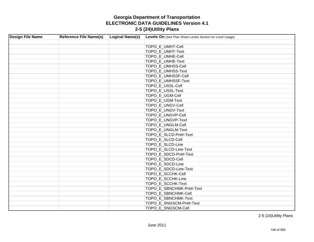
Georgia Department of TransportationELECTRONIC DATA GUIDELINES Version 4.1
2-5 (24)Utility Plans
Design File Name Reference File Name(s) Logical Name(s) Levels On (See Plan Sheet Levels Section for Level Usage)
TOPO_E_UMHT-CellTOPO_E_UMHT-TextTOPO_E_UMHE-CellTOPO_E_UMHE-TextTOPO_E_UMHSS-CellTOPO_E_UMHSS-TextTOPO_E_UMHSSF-CellTOPO_E_UMHSSF-TextTOPO_E_USSL-CellTOPO_E_USSL-TextTOPO_E_UGM-CellTOPO_E_UGM-TextTOPO_E_UNGV-CellTOPO_E_UNGV-TextTOPO_E_UNGVP-CellTOPO_E_UNGVP-TextTOPO_E_UNGLM-CellTOPO_E_UNGLM-TextTOPO_E_SLCD-Pnt#-TextTOPO_E_SLCD-CellTOPO_E_SLCD-LineTOPO_E_SLCD-Line-TextTOPO_E_SDCD-Pnt#-TextTOPO_E_SDCD-CellTOPO_E_SDCD-LineTOPO_E_SDCD-Line-TextTOPO_E_SCCHK-CellTOPO_E_SCCHK-LineTOPO_E_SCCHK-TextTOPO_E_SBNCHMK-Pnt#-TextTOPO_E_SBNCHMK-CellTOPO_E_SBNCHMK-TextTOPO_E_SNGSCM-Pnt#-TextTOPO_E_SNGSCM-Cell
June 2011
2-5 (24)Utility Plans
149 of 582

Georgia Department of TransportationELECTRONIC DATA GUIDELINES Version 4.1
2-5 (24)Utility Plans
Design File Name Reference File Name(s) Logical Name(s) Levels On (See Plan Sheet Levels Section for Level Usage)
TOPO_E_SNGSCM-TextTOPO_E_SLCM-Pnt#-TextTOPO_E_SLCM-CellTOPO_E_SLCM-TextTOPO_E_POOL-LineTOPO_E_POOL-TextTOPO_E_FNDN-LineTOPO_E_RUIN-LineTOPO_E_TANK-LineTOPO_E_DTCH-LineTOPO_E_DTCH-TextTOPO_E_DTCH-Hidden-LineTOPO_E_DTCH-Hidden-TextTOPO_E_TWFE-LineTOPO_E_TWFE-TextTOPO_E_GOLF-LineTOPO_E_GOLF-TextTOPO_E_Basketball-Court-CellTOPO_E_Basketball-Court-CellTOPO_E_Basketball-Court-CellTOPO_E_Flow-Arrow-CellTOPO_E_DEW-Hatch-LineTOPO_E_DITCH-Taper-CellTOPO_E_TRAIL-LineTOPO_E_TRAIL-Text
1234567LGHT.DGN LGHT LGHT_P_Std-CellLGHT_P_High-Mast-CellLGHT_P_Underpass-Luminaire-CellLGHT_P_Servc-Pt-CellLGHT_P_Elec-JBox-Conc-CellLGHT_P_Elec-JBox-Galv-CellLGHT_P_Grnd-Rod-Cell
June 2011
2-5 (24)Utility Plans
150 of 582

Georgia Department of TransportationELECTRONIC DATA GUIDELINES Version 4.1
2-5 (24)Utility Plans
Design File Name Reference File Name(s) Logical Name(s) Levels On (See Plan Sheet Levels Section for Level Usage)
1234567ENVE.DGN ENVE ENVE_E_Wetlnd-Bound-LineENVE_E_Wetlnd-Stream-Delin-LineENVE_E_Wetlnd-Stream-TextENVE_E_Wetlnd-PatternENVE_E_Wetlnd-ShapeENVE_E_Endgd-Spec-LineENVE_E_Endgd-Spec-TextENVE_E_Endgd-Spec-PatternENVE_E_Endgd-Spec-ShapeENVE_E_Hist-Rsc-LineENVE_E_Hist-Rsc-TextENVE_E_Hist-Rsc-PatternENVE_E_Hist-Rsc-ShapeENVE_E_Arch-LineENVE_E_Arch-TextENVE_E_Arch-PatternENVE_E_Arch-ShapeENVE_E_Cult-Rsc-Delin-LineENVE_E_Cult-Rsc-TextENVE_E_Cult-Rsc-PatternENVE_E_Cult-Rsc-ShapeENVE_E_Haz-Mat-Delin-LineENVE_E_Haz-Mat-TextENVE_E_Haz-Mat-PatternENVE_E_Haz-Mat-ShapeENVE_E_Env-Justice-LineENVE_E_Env-Justice-TextENVE_E_Env-Justice-PatternENVE_E_Env-Justice-ShapeENVE_E_ESA-LineENVE_E_ESA-TextENVE_E_ESA-PatternENVE_E_ESA-Shape
June 2011
2-5 (24)Utility Plans
151 of 582

Georgia Department of TransportationELECTRONIC DATA GUIDELINES Version 4.1
2-5 (24)Utility Plans
Design File Name Reference File Name(s) Logical Name(s) Levels On (See Plan Sheet Levels Section for Level Usage)
1234567ENVP.DGN ENVP ENVP_P_Relocations-LineENVP_P_Relocations-TextENVP_P_Socl-Resc-Impact-Area-LineENVP_P_Socl-Resc-Impact-Area-PatternENVP_P_Socl-Resc-Impact-Area-TextENVP_P_Hist-APE-LineENVP_P_Hist-APE-PatternENVP_P_Hist-APE-TextENVP_P_Cultrl-Resc-Impact-Area-LineENVP_P_Cultrl-Resc-Impact-Area-PatternENVP_P_Cultrl-Resc-Impact-Area-TextENVP_P_Wetlnd-Impact-Area-LineENVP_P_Wetlnd-Impact-Area-PatternENVP_P_Wetlnd-Impact-Area-TextENVP_P_Wetlnd-Mitigat-Site-LineENVP_P_Wetlnd-Mitigat-Site-PatternENVP_P_Wetlnd-Mitigat-Site-TextENVP_P_Fldplain-Impact-Area-LineENVP_P_Fldplain-Impact-Area-PatternENVP_P_Fldplain-Impact-Area-TextENVP_P_Impacted-USTENVP_P_Noise-Study-ReceptENVP_P_Noise-Study-ReadingsENVP_P_Noise-Study-Proj-Noise-LvlsENVP_P_Noise-Study-Noise-ContENVP_P_Noise-Study-Impacted-PropENVP_P_Viewshed-Vis-ImpactENVP_P_Fldplain-Impact-Area-LineENVP_P_Fldplain-Impact-Area-PatternENVP_P_Fldplain-Impact-Area-Text
June 2011
2-5 (24)Utility Plans
152 of 582

Georgia Department of TransportationELECTRONIC DATA GUIDELINES Version 4.1
2-5 (25)Lighting Plans and Details
Design File Name Reference File Name(s) Logical Name(s) Levels On (See Plan Sheet Levels Section for Level Usage)
1234567_25-001.DGN s / NA NA SHT_B_25-Lighting-Plans1234567_25.DGN m SHT_B_Legend-Logo-Scale
SHT_B_Misc-PSHT_B_North-ArrowSHT_B_Plot-Sub-TextSHT_B_Plotting-Info-TagsSHT_B_Sheet-Outline-LineSHT_B_Sheet-Outline-TextSHT_B_Title-BlockSHT_B_Plot-Border-Inner-LineSHT_B_Plot-Border-Outer-Line
1234567MAIN.DGN MAIN MAIN_P_CONSTCL-LineMAIN_P_CONSTCL-Tic-Sta-TextMAIN_P_CONSTCL-PC-PT-Sta-Ldr-TextMAIN_P_CONSTCL-Brng-TextMAIN_P_SIDECL-LineMAIN_P_SIDECL-Tic-Sta-TextMAIN_P_SIDECL-PC-PT-Sta-Ldr-TextMAIN_P_SIDECL-Brng-TextMAIN_P_EOP-LineMAIN_P_Appr-Slab-LineMAIN_P_EPSHLDR-LineMAIN_P_Bridge-LineMAIN_P_Driveway-LineMAIN_P_Curb-Gutter-LineMAIN_P_Sidewalk-LineMAIN_P_Guardrail-LineMAIN_P_Median-Side-Barrier-LineMAIN_P_Retain-Wall-LineMAIN_P_Sound-Barrier-Wall-LineMAIN_P_Fence-Line
s Single Sheet DGN Sheet File - Plan Sheetsm Multi Sheet DGN Sheet File - Detail Sheets
June 2011
2-5 (25)Lighting Plans and Details
153 of 582

Georgia Department of TransportationELECTRONIC DATA GUIDELINES Version 4.1
2-5 (25)Lighting Plans and Details
Design File Name Reference File Name(s) Logical Name(s) Levels On (See Plan Sheet Levels Section for Level Usage)
MAIN_P_Misc-Const-Feat-LineMAIN_P_CROWN-CellMAIN_P_Details-End-Proj-CL-Intersect-Label-TextMAIN_P_Details-Begin-End-Const-Limit-Const-Label-TextMAIN_P_Details-RouteName-CL-TextMAIN_P_Details-Rdwy-DimMAIN_P_Details-Super-Elev-Trans-Label-TextMAIN_P_Misc-Detail-Info
1234567DRNG.DGN DRNG DRNG_P_Storm-Drain-StructDRNG_P_Storm-Drain-Pipe-LineDRNG_P_Ditch-and-Channel-LineDRNG_P_Cross-Drain-and-Culv-LineDRNG_P_Bridge-Culv-LineDRNG_P_Detention-Pond-LineDRNG_P_Perm-Riprap-PatternDRNG_P_Perm-Ditch-Protect-Line
1234567REQD.DGN REQD REQD_P_RWRM-RW-CellREQD_P_RWRM-RW-LineREQD_P_RWRM-RW-MarkerREQD_P_RWRM-RW-TextREQD_P_REQD-RW-CellREQD_P_REQD-RW-LineREQD_P_REQD-RW-Ltd-AccessREQD_P_REQD-RW-Desc-TextREQD_P_PESMT-LineREQD_P_PESMT-Pattern
1234567SIGN.DGN SIGN SIGN_P_OVHD_Sign-Structure-and-Strain-Pole
1234567SGNL.DGN SGNL SGNL_E_Signal-SignalSGNL_E_Signal-ControllerSGNL_E_Signal-Conduit-and-Pullbox
June 2011
2-5 (25)Lighting Plans and Details
154 of 582

Georgia Department of TransportationELECTRONIC DATA GUIDELINES Version 4.1
2-5 (25)Lighting Plans and Details
Design File Name Reference File Name(s) Logical Name(s) Levels On (See Plan Sheet Levels Section for Level Usage)
SGNL_P_Signal-Comm-Only-ConduitSGNL_P_Signal-Comm-Only-PullboxSGNL_P_Signal-LoopSGNL_P_Signal-Signal-Only-PullboxSGNL_P_Signal-Signal-Only-Pullbox-TP2SGNL_P_Signal-Signal-Only-ConduitSGNL_P_Signal-Loop-lead-InSGNL_P_Signal-Text
1234567UTLE.DGN UTLE UTLE_E_Elec-CellUTLE_E_Elec-Vault-LineUTLE_E_Gas-CellUTLE_E_Traf-Ctrl-CellUTLE_E_San-Swr-CellUTLE_E_Wat-CellUTLE_E_TV-CellUTLE_E_Petro-CellUTLE_E_Tele-CellUTLE_E_Wat-Non-Pot-CellUTLE_E_Steam-Cell
1234567UTLP.DGN UTLP UTLP_P_Elec-CellUTLP_P_Elec-Vault-LineUTLP_P_UG-Elec-TextUTLP_P_UG-Elec-LineUTLP_P_UG-Elec-Line-REMUTLP_P_Gas-CellUTLP_P_UG-Gas-TextUTLP_P_UG-Gas-Line*UTLP_P_UG-Gas-Line-24
*Denotes level for 20 Scale Plans.^Denotes level for 50 Scale Plans.
June 2011
2-5 (25)Lighting Plans and Details
155 of 582

Georgia Department of TransportationELECTRONIC DATA GUIDELINES Version 4.1
2-5 (25)Lighting Plans and Details
Design File Name Reference File Name(s) Logical Name(s) Levels On (See Plan Sheet Levels Section for Level Usage)
^UTLP_P_UG-Gas-Line-24-50*UTLP_P_UG-Gas-Line-30^UTLP_P_UG-Gas-Line-30-50*UTLP_P_UG-Gas-Line-36^UTLP_P_UG-Gas-Line-36-50*UTLP_P_UG-Gas-Line-42^UTLP_P_UG-Gas-Line-42-50*UTLP_P_UG-Gas-Line-48^UTLP_P_UG-Gas-Line-48-50UTLP_P_UG-Gas-Line-REMUTLP_P_Petro-CellUTLP_P_UG-Petro-TextUTLP_P_UG-Petro-Line*UTLP_P_UG-Petro-Line-24^UTLP_P_UG-Petro-Line-24-50*UTLP_P_UG-Petro-Line-30^UTLP_P_UG-Petro-Line-30-50*UTLP_P_UG-Petro-Line-36^UTLP_P_UG-Petro-Line-36-50*UTLP_P_UG-Petro-Line-42^UTLP_P_UG-Petro-Line-42-50*UTLP_P_UG-Petro-Line-48^UTLP_P_UG-Petro-Line-48-50UTLP_P_UG-Petro-Line-REMUTLP_P_San-Force-Main-CellUTLP_P_UG-San-Force-Main-TextUTLP_P_UG-San-Force-Main-LineUTLP_P_UG-San-Force-Main-Line-REMUTLP_P_San-Swr-CellUTLP_P_UG-San-Swr-TextUTLP_P_UG-San-Swr-Line
*Denotes level for 20 Scale Plans.^Denotes level for 50 Scale Plans.
June 2011
2-5 (25)Lighting Plans and Details
156 of 582

Georgia Department of TransportationELECTRONIC DATA GUIDELINES Version 4.1
2-5 (25)Lighting Plans and Details
Design File Name Reference File Name(s) Logical Name(s) Levels On (See Plan Sheet Levels Section for Level Usage)
*UTLP_P_UG-San-Swr-Line-24^UTLP_P_UG-San-Swr-Line-24-50*UTLP_P_UG-San-Swr-Line-30^UTLP_P_UG-San-Swr-Line-30-50*UTLP_P_UG-San-Swr-Line-36^UTLP_P_UG-San-Swr-Line-36-50*UTLP_P_UG-San-Swr-Line-42^UTLP_P_UG-San-Swr-Line-42-50*UTLP_P_UG-San-Swr-Line-48^UTLP_P_UG-San-Swr-Line-48-50UTLP_P_UG-San-Swr-Line-REMUTLP_P_Steam-CellUTLP_P_UG-Steam-TextUTLP_P_UG-Steam-Line*UTLP_P_UG-Steam-Line-24^UTLP_P_UG-Steam-Line-24-50*UTLP_P_UG-Steam-Line-30^UTLP_P_UG-Steam-Line-30-50*UTLP_P_UG-Steam-Line-36^UTLP_P_UG-Steam-Line-36-50*UTLP_P_UG-Steam-Line-42^UTLP_P_UG-Steam-Line-42-50*UTLP_P_UG-Steam-Line-48^UTLP_P_UG-Steam-Line-48-50UTLP_P_UG-Steam-Line-REMUTLP_P_Tele-CellUTLP_P_UG-Tele-TextUTLP_P_UG-Tele-LineUTLP_P_UG-Tele-Line-REMUTLP_P_Traf-Ctrl-CellUTLP_P_UG-Traf-Ctrl-Text
*Denotes level for 20 Scale Plans.^Denotes level for 50 Scale Plans.
June 2011
2-5 (25)Lighting Plans and Details
157 of 582

Georgia Department of TransportationELECTRONIC DATA GUIDELINES Version 4.1
2-5 (25)Lighting Plans and Details
Design File Name Reference File Name(s) Logical Name(s) Levels On (See Plan Sheet Levels Section for Level Usage)
UTLP_P_UG-Traf-Ctrl-LineUTLP_P_UG-Traf-Ctrl-Line-REMUTLP_P_TV-CellUTLP_P_UG-TV-TextUTLP_P_UG-TV-LineUTLP_P_UG-TV-Line-REMUTLP_P_Wat-CellUTLP_P_UG-Wat-TextUTLP_P_UG-Wat-Line*UTLP_P_UG-Wat-Line-24^UTLP_P_UG-Wat-Line-24-50*UTLP_P_UG-Wat-Line-30^UTLP_P_UG-Wat-Line-30-50*UTLP_P_UG-Wat-Line-36^UTLP_P_UG-Wat-Line-36-50*UTLP_P_UG-Wat-Line-42^UTLP_P_UG-Wat-Line-42-50*UTLP_P_UG-Wat-Line-48^UTLP_P_UG-Wat-Line-48-50UTLP_P_UG-Wat-Line-REMUTLP_P_Wat-Non-Pot-CellUTLP_P_UG-Wat-Non-Pot-TextUTLP_P_UG-Wat-Non-Pot-Line*UTLP_P_UG-Wat-Non-Pot-Line-24^UTLP_P_UG-Wat-Non-Pot-Line-24-50*UTLP_P_UG-Wat-Non-Pot-Line-30^UTLP_P_UG-Wat-Non-Pot-Line-30-50*UTLP_P_UG-Wat-Non-Pot-Line-36^UTLP_P_UG-Wat-Non-Pot-Line-36-50*UTLP_P_UG-Wat-Non-Pot-Line-42^UTLP_P_UG-Wat-Non-Pot-Line-42-50
*Denotes level for 20 Scale Plans.^Denotes level for 50 Scale Plans.
June 2011
2-5 (25)Lighting Plans and Details
158 of 582

Georgia Department of TransportationELECTRONIC DATA GUIDELINES Version 4.1
2-5 (25)Lighting Plans and Details
Design File Name Reference File Name(s) Logical Name(s) Levels On (See Plan Sheet Levels Section for Level Usage)
*UTLP_P_UG-Wat-Non-Pot-Line-48^UTLP_P_UG-Wat-Non-Pot-Line-48-50UTLP_P_UG-Wat-Non-Pot-Line-REMUTLP_P_OVHD-Tele-TextUTLP_P_OVHD-Tele-LineUTLP_P_OVHD-Tele-Line-REMUTLP_P_OVHD-TV-TextUTLP_P_OVHD-TV-LineUTLP_P_OVHD-TV-Line-REMUTLP_P_OVHD-Elec-TextUTLP_P_OVHD-Elec-LineUTLP_P_OVHD-Elec-Line-REMUTLP_P_OVHD-Traf-Ctrl-TextUTLP_P_OVHD-Traf-Ctrl-LineUTLP_P_OVHD-Traf-Ctrl-Line-REMUTLP_P_OVHD-Microwave-REMUTLP_P_OVHD-Combo-Util-TextUTLP_P_OVHD-Combo-Util-Line-Elec-TeleUTLP_P_OVHD-Combo-Util-Lines-Elec-Tele-REMUTLP_P_OVHD-Combo-Util-Line-Elec-Tele-Traf-CtrlUTLP_P_OVHD-Combo-Util-Line-Elec-Tele-Traf-Ctrl-REMUTLP_P_OVHD-Combo-Util-Line-Elec-Tele-TVUTLP_P_OVHD-Combo-Util-Line-Elec-Tele-TV-REMUTLP_P_OVHD-Combo-Util-Line-Elec-Tele-TV-Traf-CtrlUTLP_P_OVHD-Combo-Util-Line-Elec-Tele-TV-Traf-Ctrl-REMUTLP_P_OVHD-Combo-Util-Line-Elec-Traf-CtrlUTLP_P_OVHD-Combo-Util-Line-Elec-Traf-Ctrl-REMUTLP_P_OVHD-Combo-Util-Line-Elec-TVUTLP_P_OVHD-Combo-Util-Line-Elec-TV-REMUTLP_P_OVHD-Combo-Util-Line-Elec-TV-Traf-CtrlUTLP_P_OVHD-Combo-Util-Line-Elec-TV-Traf-Ctrl-REM
*Denotes level for 20 Scale Plans.^Denotes level for 50 Scale Plans.
June 2011
2-5 (25)Lighting Plans and Details
159 of 582

Georgia Department of TransportationELECTRONIC DATA GUIDELINES Version 4.1
2-5 (25)Lighting Plans and Details
Design File Name Reference File Name(s) Logical Name(s) Levels On (See Plan Sheet Levels Section for Level Usage)
UTLP_P_OVHD-Combo-Util-Line-Tele-TVUTLP_P_OVHD-Combo-Util-Line-Tele-TV-REMUTLP_P_OVHD-Combo-Util-Line-Tele-Traf-CtrlUTLP_P_OVHD-Combo-Util-Line-Tele-Traf-Ctrl-REMUTLP_P_OVHD-Combo-Util-Line-Tele-TV-Traf-CtrlUTLP_P_OVHD-Combo-Util-Line-Tele-TV-Traf-Ctrl-REMUTLP_P_OVHD-Combo-Util-Line-TV-Traf-CtrlUTLP_P_OVHD-Combo-Util-Line-TV-Traf-Ctrl-REMUTLP_P_OVHD-Combo-Util-Line-Guy-WireUTLP_P_OVHD-Combo-Util-Line-Guy-Wire-REMUTLP_P_UG-Gas-Line-User-DefUTLP_P_UG-Petro-Line-User-DefUTLP_P_UG-San-Swr-Line-User-DefUTLP_P_UG-Steam-Line-User-DefUTLP_P_UG-Wat-Line-User-DefUTLP_P_UG-Wat-Non-Pot-User-Def-Line
1234567LIMT.DGN LIMT LIMT_P_STKCUT_Const-Limit-Cut-LineLIMT_P_CUT_Const-Limit-Cut-CellLIMT_P_STKFIL_Const-Limit-Fill-LineLIMT_P_FILL_Const-Limit-Fill-Cell
1234567PROP.DGN PROP PROP_E_PAR-PL-LinePROP_E_RWE-Line PROP_E_RWRR-LinePROP_E_RWU-LinePROP_E_POEL-LinePROP_E_BMISC-Line
1234567TOPO.DGN TOPO TOPO_E_TEAP-LineTOPO_E_TEAP-TextTOPO_E_TEAS-LineTOPO_E_TEAS-TextTOPO_E_TECP-Line
June 2011
2-5 (25)Lighting Plans and Details
160 of 582
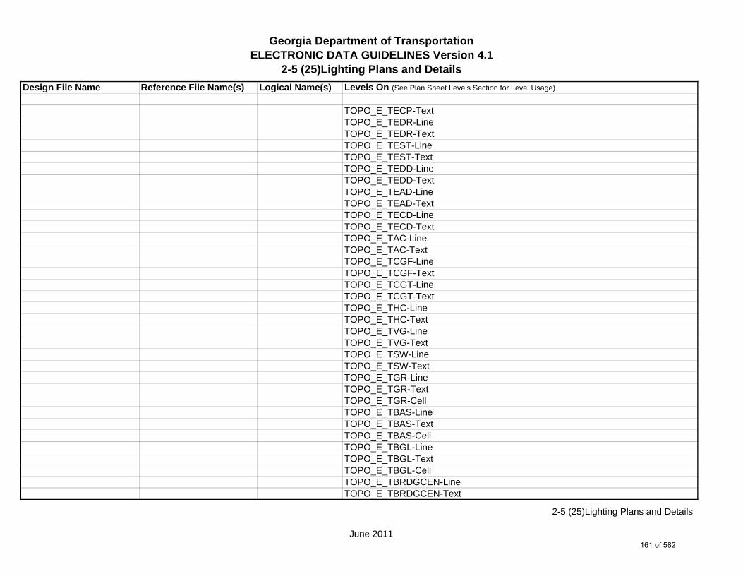
Georgia Department of TransportationELECTRONIC DATA GUIDELINES Version 4.1
2-5 (25)Lighting Plans and Details
Design File Name Reference File Name(s) Logical Name(s) Levels On (See Plan Sheet Levels Section for Level Usage)
TOPO_E_TECP-TextTOPO_E_TEDR-LineTOPO_E_TEDR-TextTOPO_E_TEST-LineTOPO_E_TEST-TextTOPO_E_TEDD-LineTOPO_E_TEDD-TextTOPO_E_TEAD-LineTOPO_E_TEAD-TextTOPO_E_TECD-LineTOPO_E_TECD-TextTOPO_E_TAC-LineTOPO_E_TAC-TextTOPO_E_TCGF-LineTOPO_E_TCGF-TextTOPO_E_TCGT-LineTOPO_E_TCGT-TextTOPO_E_THC-LineTOPO_E_THC-TextTOPO_E_TVG-LineTOPO_E_TVG-TextTOPO_E_TSW-LineTOPO_E_TSW-TextTOPO_E_TGR-LineTOPO_E_TGR-TextTOPO_E_TGR-CellTOPO_E_TBAS-LineTOPO_E_TBAS-TextTOPO_E_TBAS-CellTOPO_E_TBGL-LineTOPO_E_TBGL-TextTOPO_E_TBGL-CellTOPO_E_TBRDGCEN-LineTOPO_E_TBRDGCEN-Text
June 2011
2-5 (25)Lighting Plans and Details
161 of 582
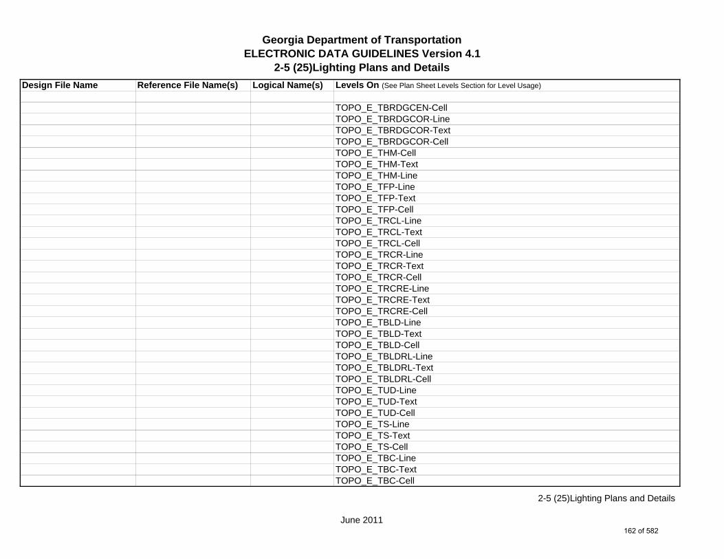
Georgia Department of TransportationELECTRONIC DATA GUIDELINES Version 4.1
2-5 (25)Lighting Plans and Details
Design File Name Reference File Name(s) Logical Name(s) Levels On (See Plan Sheet Levels Section for Level Usage)
TOPO_E_TBRDGCEN-CellTOPO_E_TBRDGCOR-LineTOPO_E_TBRDGCOR-TextTOPO_E_TBRDGCOR-CellTOPO_E_THM-CellTOPO_E_THM-TextTOPO_E_THM-LineTOPO_E_TFP-LineTOPO_E_TFP-TextTOPO_E_TFP-CellTOPO_E_TRCL-LineTOPO_E_TRCL-TextTOPO_E_TRCL-CellTOPO_E_TRCR-LineTOPO_E_TRCR-TextTOPO_E_TRCR-CellTOPO_E_TRCRE-LineTOPO_E_TRCRE-TextTOPO_E_TRCRE-CellTOPO_E_TBLD-LineTOPO_E_TBLD-TextTOPO_E_TBLD-CellTOPO_E_TBLDRL-LineTOPO_E_TBLDRL-TextTOPO_E_TBLDRL-CellTOPO_E_TUD-LineTOPO_E_TUD-TextTOPO_E_TUD-CellTOPO_E_TS-LineTOPO_E_TS-TextTOPO_E_TS-CellTOPO_E_TBC-LineTOPO_E_TBC-TextTOPO_E_TBC-Cell
June 2011
2-5 (25)Lighting Plans and Details
162 of 582

Georgia Department of TransportationELECTRONIC DATA GUIDELINES Version 4.1
2-5 (25)Lighting Plans and Details
Design File Name Reference File Name(s) Logical Name(s) Levels On (See Plan Sheet Levels Section for Level Usage)
TOPO_E_TFE-LineTOPO_E_TFE-TextTOPO_E_TFE-CellTOPO_E_DSTC-LineTOPO_E_DSTC-TextTOPO_E_DSTC-CellTOPO_E_DDL-LineTOPO_E_DDL-TextTOPO_E_DDL-CellTOPO_E_TCAN-LineTOPO_E_TCAN-TextTOPO_E_TCAN-CellTOPO_E_THCR-LineTOPO_E_THCR-TextTOPO_E_THCR-CellTOPO_E_THRL-LineTOPO_E_THRL-TextTOPO_E_THRL-CellTOPO_E_TMHCR-LineTOPO_E_TMHCR-TextTOPO_E_TMHCR-CellTOPO_E_TMHRL-LineTOPO_E_TMHRL-TextTOPO_E_TMHRL-CellTOPO_E_TFCL-LineTOPO_E_TFCL-TextTOPO_E_TFW-LineTOPO_E_TFW-TextTOPO_E_TFBW-LineTOPO_E_TFBW-TextTOPO_E_TFFW-LineTOPO_E_TFFW-TextTOPO_E_TVF-LineTOPO_E_TVF-Text
June 2011
2-5 (25)Lighting Plans and Details
163 of 582

Georgia Department of TransportationELECTRONIC DATA GUIDELINES Version 4.1
2-5 (25)Lighting Plans and Details
Design File Name Reference File Name(s) Logical Name(s) Levels On (See Plan Sheet Levels Section for Level Usage)
TOPO_E_TG-LineTOPO_E_TG-TextTOPO_E_TWELL-LineTOPO_E_TWELL-TextTOPO_E_TGFV-LineTOPO_E_TGFV-TextTOPO_E_TGMW-LineTOPO_E_TGMW-TextTOPO_E_TGP-LineTOPO_E_TGP-TextTOPO_E_TGPI-LineTOPO_E_TGPI-TextTOPO_E_TFT-LineTOPO_E_TFT-TextTOPO_E_TGST-LineTOPO_E_TGST-TextTOPO_E_TGVP-LineTOPO_E_TGVP-TextTOPO_E_DCEF-LineTOPO_E_DCEF-TextTOPO_E_DCB-LineTOPO_E_DCB-TextTOPO_E_DCWE-LineTOPO_E_DCWE-TextTOPO_E_DDCB-LineTOPO_E_DDCB-TextTOPO_E_DDI-LineTOPO_E_DDI-TextTOPO_E_DHWE-LineTOPO_E_DHWE-TextTOPO_E_DJB-LineTOPO_E_DJB-TextTOPO_E_DPC-LineTOPO_E_DPC-Text
June 2011
2-5 (25)Lighting Plans and Details
164 of 582

Georgia Department of TransportationELECTRONIC DATA GUIDELINES Version 4.1
2-5 (25)Lighting Plans and Details
Design File Name Reference File Name(s) Logical Name(s) Levels On (See Plan Sheet Levels Section for Level Usage)
TOPO_E_DPM-LineTOPO_E_DPM-TextTOPO_E_DPP-LineTOPO_E_DPP-TextTOPO_E_MDITCHFL-LineTOPO_E_MDITCHFL-TextTOPO_E_DPD-LineTOPO_E_DPD-TextTOPO_E_DSB-LineTOPO_E_DSB-TextTOPO_E_DSC-LineTOPO_E_DSC-TextTOPO_E_DSE-LineTOPO_E_DSE-TextTOPO_E_DWE-LineTOPO_E_DWE-TextTOPO_E_DEW-LineTOPO_E_DEW-TextTOPO_E_DHWM-LineTOPO_E_DHWM-TextTOPO_E_DSWE-LineTOPO_E_DSWE-TextTOPO_E_DMISC-LineTOPO_E_DMISC-TextTOPO_E_TWF-LineTOPO_E_TWF-TextTOPO_E_TWFT-LineTOPO_E_TWFT-TextTOPO_E_TWFB-LineTOPO_E_TWFB-TextTOPO_E_TSATDSH-LineTOPO_E_TSATDSH-TextTOPO_E_TWL-LineTOPO_E_TWL-Text
June 2011
2-5 (25)Lighting Plans and Details
165 of 582

Georgia Department of TransportationELECTRONIC DATA GUIDELINES Version 4.1
2-5 (25)Lighting Plans and Details
Design File Name Reference File Name(s) Logical Name(s) Levels On (See Plan Sheet Levels Section for Level Usage)
TOPO_E_TTRE-LineTOPO_E_TTRE-TextTOPO_E_TGRV-LineTOPO_E_TGRV-TextTOPO_E_DADB-LineTOPO_E_DADB-TextTOPO_E_DADB-LineTOPO_E_DADB-TextTOPO_E_DADB-LineTOPO_E_DADB-TextTOPO_E_DSPURDK-LineTOPO_E_DSPURDK-TextTOPO_E_TMAR-LineTOPO_E_TMAR-TextTOPO_E_TMPH-LineTOPO_E_TMPH-TextTOPO_E_TKMP-LineTOPO_E_TKMP-TextTOPO_E_TMPR-LineTOPO_E_TMPR-TextTOPO_E_TSC-LineTOPO_E_TSC-TextTOPO_E_TSE-LineTOPO_E_TSE-TextTOPO_E_TIRRLMT-LineTOPO_E_TIRRLMT-TextTOPO_E_TIRRPVTP-LineTOPO_E_TIRRPVTP-TextTOPO_E_TCUL-LineTOPO_E_TCUL-TextTOPO_E_TBCAP-LineTOPO_E_TBCAP-TextTOPO_E_TBCL-LineTOPO_E_TBCL-Text
June 2011
2-5 (25)Lighting Plans and Details
166 of 582

Georgia Department of TransportationELECTRONIC DATA GUIDELINES Version 4.1
2-5 (25)Lighting Plans and Details
Design File Name Reference File Name(s) Logical Name(s) Levels On (See Plan Sheet Levels Section for Level Usage)
TOPO_E_TCOLC-LineTOPO_E_TCOLC-TextTOPO_E_TCOLE-LineTOPO_E_TCOLE-TextTOPO_E_TENDROLL-LineTOPO_E_TENDROLL-TextTOPO_E_TMISC-Pnt-CellTOPO_E_TMISC-LineTOPO_E_TMISC-TextTOPO_E_USTRPOL-LineTOPO_E_USTRPOL-TextTOPO_E_UOEL-CellTOPO_E_UOEL-TextTOPO_E_UOEL-LineTOPO_E_UOTL-CellTOPO_E_UOTL-TextTOPO_E_UOTL-LineTOPO_E_UELBOX-CellTOPO_E_UELBOX-TextTOPO_E_UELBOX-LineTOPO_E_UPP-CellTOPO_E_UPP-TextTOPO_E_UPP-LineTOPO_E_ULP-CellTOPO_E_ULP-TextTOPO_E_ULP-LineTOPO_E_UTP-CellTOPO_E_UTP-TextTOPO_E_UTP-LineTOPO_E_UTPD-CellTOPO_E_UTPD-TextTOPO_E_UTPD-LineTOPO_E_UGP-CellTOPO_E_UGP-Text
June 2011
2-5 (25)Lighting Plans and Details
167 of 582

Georgia Department of TransportationELECTRONIC DATA GUIDELINES Version 4.1
2-5 (25)Lighting Plans and Details
Design File Name Reference File Name(s) Logical Name(s) Levels On (See Plan Sheet Levels Section for Level Usage)
TOPO_E_UGP-LineTOPO_E_UPGA-CellTOPO_E_UPGA-TextTOPO_E_UPGA-LineTOPO_E_UYLE-CellTOPO_E_UYLE-TextTOPO_E_UYLE-LineTOPO_E_UYLG-CellTOPO_E_UYLG-TextTOPO_E_UYLG-LineTOPO_E_UWM-CellTOPO_E_UWM-TextTOPO_E_UWM-LineTOPO_E_UWV-CellTOPO_E_UWV-TextTOPO_E_UWV-LineTOPO_E_UFH-CellTOPO_E_UFH-TextTOPO_E_UFH-LineTOPO_E_UMHST-CellTOPO_E_UMHST-TextTOPO_E_UMHST-LineTOPO_E_UMHSTF-CellTOPO_E_UMHSTF-TextTOPO_E_UMHSTF-LineTOPO_E_UMHT-CellTOPO_E_UMHT-TextTOPO_E_UMHT-LineTOPO_E_UMHE-CellTOPO_E_UMHE-TextTOPO_E_UMHE-LineTOPO_E_UMHSS-CellTOPO_E_UMHSS-TextTOPO_E_UMHSS-Line
June 2011
2-5 (25)Lighting Plans and Details
168 of 582
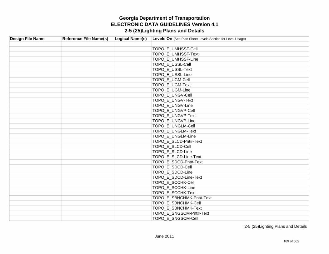
Georgia Department of TransportationELECTRONIC DATA GUIDELINES Version 4.1
2-5 (25)Lighting Plans and Details
Design File Name Reference File Name(s) Logical Name(s) Levels On (See Plan Sheet Levels Section for Level Usage)
TOPO_E_UMHSSF-CellTOPO_E_UMHSSF-TextTOPO_E_UMHSSF-LineTOPO_E_USSL-CellTOPO_E_USSL-TextTOPO_E_USSL-LineTOPO_E_UGM-CellTOPO_E_UGM-TextTOPO_E_UGM-LineTOPO_E_UNGV-CellTOPO_E_UNGV-TextTOPO_E_UNGV-LineTOPO_E_UNGVP-CellTOPO_E_UNGVP-TextTOPO_E_UNGVP-LineTOPO_E_UNGLM-CellTOPO_E_UNGLM-TextTOPO_E_UNGLM-LineTOPO_E_SLCD-Pnt#-TextTOPO_E_SLCD-CellTOPO_E_SLCD-LineTOPO_E_SLCD-Line-TextTOPO_E_SDCD-Pnt#-TextTOPO_E_SDCD-CellTOPO_E_SDCD-LineTOPO_E_SDCD-Line-TextTOPO_E_SCCHK-CellTOPO_E_SCCHK-LineTOPO_E_SCCHK-TextTOPO_E_SBNCHMK-Pnt#-TextTOPO_E_SBNCHMK-CellTOPO_E_SBNCHMK-TextTOPO_E_SNGSCM-Pnt#-TextTOPO_E_SNGSCM-Cell
June 2011
2-5 (25)Lighting Plans and Details
169 of 582

Georgia Department of TransportationELECTRONIC DATA GUIDELINES Version 4.1
2-5 (25)Lighting Plans and Details
Design File Name Reference File Name(s) Logical Name(s) Levels On (See Plan Sheet Levels Section for Level Usage)
TOPO_E_SNGSCM-TextTOPO_E_SLCM-Pnt#-TextTOPO_E_SLCM-CellTOPO_E_SLCM-TextTOPO_E_SLCM-LineTOPO_E_TCBA-CellTOPO_E_TCBA-LineTOPO_E_TCBA-TextTOPO_E_TCBF-CellTOPO_E_TCBF-LineTOPO_E_TCBF-TextTOPO_E_TLIML-CellTOPO_E_TLIML-LineTOPO_E_TLIML-TextTOPO_E_MJLL-CellTOPO_E_MJLL-LineTOPO_E_MJLL-TextTOPO_E_MSEWLINE-CellTOPO_E_MSEWLINE-LineTOPO_E_MSEWLINE-TextTOPO_E_TPBL-CellTOPO_E_TPBL-LineTOPO_E_TPBL-TextTOPO_E_TRP-CellTOPO_E_TRP-LineTOPO_E_TRP-TextTOPO_E_DOBSC-CellTOPO_E_DOBSC-LineTOPO_E_DOBSC-TextTOPO_E_MOBSC-CellTOPO_E_MOBSC-LineTOPO_E_MOBSC-TextTOPO_E_MPCKGRD-CellTOPO_E_MPCKGRD-Line
June 2011
2-5 (25)Lighting Plans and Details
170 of 582

Georgia Department of TransportationELECTRONIC DATA GUIDELINES Version 4.1
2-5 (25)Lighting Plans and Details
Design File Name Reference File Name(s) Logical Name(s) Levels On (See Plan Sheet Levels Section for Level Usage)
TOPO_E_MPCKGRD-TextTOPO_E_MPCKPAV-CellTOPO_E_MPCKPAV-LineTOPO_E_MPCKPAV-TextTOPO_E_X_SurveyorDefined-CellTOPO_E_X_SurveyorDefined-LineTOPO_E_X_SurveyorDefined-TextTOPO_E_XX-CellTOPO_E_XX-LineTOPO_E_XX-TextTOPO_E_TECS-CellTOPO_E_TECS-LineTOPO_E_TECS-TextTOPO_E_POOL-CellTOPO_E_POOL-LineTOPO_E_POOL-TextTOPO_E_ORCH-CellTOPO_E_ORCH-LineTOPO_E_ORCH-TextTOPO_E_TRLN-CellTOPO_E_TRLN-LineTOPO_E_TRLN-TextTOPO_E_QUAR-CellTOPO_E_QUAR-LineTOPO_E_QUAR-TextTOPO_E_DOCW-CellTOPO_E_DOCW-LineTOPO_E_DOCW-TextTOPO_E_TWBR-CellTOPO_E_TWBR-LineTOPO_E_TWBR-TextTOPO_E_CRBR-CellTOPO_E_CRBR-LineTOPO_E_CRBR-Text
June 2011
2-5 (25)Lighting Plans and Details
171 of 582

Georgia Department of TransportationELECTRONIC DATA GUIDELINES Version 4.1
2-5 (25)Lighting Plans and Details
Design File Name Reference File Name(s) Logical Name(s) Levels On (See Plan Sheet Levels Section for Level Usage)
TOPO_E_FNDN-CellTOPO_E_FNDN-LineTOPO_E_FNDN-TextTOPO_E_RUIN-CellTOPO_E_RUIN-LineTOPO_E_RUIN-TextTOPO_E_CONT-CellTOPO_E_CONT-Index-LineTOPO_E_CONT-Intermed-LineTOPO_E_CONT-Depress-LineTOPO_E_CONT-Hidden-LineTOPO_E_CONT-TextTOPO_E_ELEV-CellTOPO_E_ELEV-LineTOPO_E_ELEV-TextTOPO_E_TANK-CellTOPO_E_TANK-LineTOPO_E_TANK-TextTOPO_E_DTCH-CellTOPO_E_DTCH-LineTOPO_E_DTCH-TextTOPO_E_DTCH-Hidden-CellTOPO_E_DTCH-Hidden-LineTOPO_E_DTCH-Hidden-TextTOPO_E_TWF-CellTOPO_E_TWF-LineTOPO_E_TWF-TextTOPO_E_UTCM-CellTOPO_E_UTCM-LineTOPO_E_UTCM-TextTOPO_E_TCEM-CellTOPO_E_TCEM-LineTOPO_E_TCEM-TextTOPO_E_DWB-Cell
June 2011
2-5 (25)Lighting Plans and Details
172 of 582
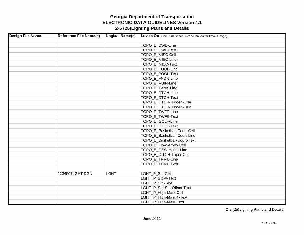
Georgia Department of TransportationELECTRONIC DATA GUIDELINES Version 4.1
2-5 (25)Lighting Plans and Details
Design File Name Reference File Name(s) Logical Name(s) Levels On (See Plan Sheet Levels Section for Level Usage)
TOPO_E_DWB-LineTOPO_E_DWB-TextTOPO_E_MISC-CellTOPO_E_MISC-LineTOPO_E_MISC-TextTOPO_E_POOL-LineTOPO_E_POOL-TextTOPO_E_FNDN-LineTOPO_E_RUIN-LineTOPO_E_TANK-LineTOPO_E_DTCH-LineTOPO_E_DTCH-TextTOPO_E_DTCH-Hidden-LineTOPO_E_DTCH-Hidden-TextTOPO_E_TWFE-LineTOPO_E_TWFE-TextTOPO_E_GOLF-LineTOPO_E_GOLF-TextTOPO_E_Basketball-Court-CellTOPO_E_Basketball-Court-LineTOPO_E_Basketball-Court-TextTOPO_E_Flow-Arrow-CellTOPO_E_DEW-Hatch-LineTOPO_E_DITCH-Taper-CellTOPO_E_TRAIL-LineTOPO_E_TRAIL-Text
1234567LGHT.DGN LGHT LGHT_P_Std-CellLGHT_P_Std-#-TextLGHT_P_Std-TextLGHT_P_Std-Sta-Offset-TextLGHT_P_High-Mast-CellLGHT_P_High-Mast-#-TextLGHT_P_High-Mast-Text
June 2011
2-5 (25)Lighting Plans and Details
173 of 582
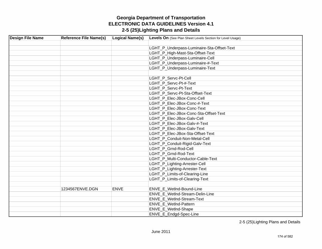
Georgia Department of TransportationELECTRONIC DATA GUIDELINES Version 4.1
2-5 (25)Lighting Plans and Details
Design File Name Reference File Name(s) Logical Name(s) Levels On (See Plan Sheet Levels Section for Level Usage)
LGHT_P_Underpass-Luminaire-Sta-Offset-TextLGHT_P_High-Mast-Sta-Offset-TextLGHT_P_Underpass-Luminaire-CellLGHT_P_Underpass-Luminaire-#-TextLGHT_P_Underpass-Luminaire-Text
LGHT_P_Servc-Pt-CellLGHT_P_Servc-Pt-#-TextLGHT_P_Servc-Pt-TextLGHT_P_Servc-Pt-Sta-Offset-TextLGHT_P_Elec-JBox-Conc-CellLGHT_P_Elec-JBox-Conc-#-TextLGHT_P_Elec-JBox-Conc-TextLGHT_P_Elec-JBox-Conc-Sta-Offset-TextLGHT_P_Elec-JBox-Galv-CellLGHT_P_Elec-JBox-Galv-#-TextLGHT_P_Elec-JBox-Galv-TextLGHT_P_Elec-JBox-Sta-Offset-TextLGHT_P_Conduit-Non-Metal-CellLGHT_P_Conduit-Rigid-Galv-TextLGHT_P_Grnd-Rod-CellLGHT_P_Grnd-Rod-TextLGHT_P_Multi-Conductor-Cable-TextLGHT_P_Lighting-Arrester-CellLGHT_P_Lighting-Arrester-TextLGHT_P_Limits-of-Clearing-LineLGHT_P_Limits-of-Clearing-Text
1234567ENVE.DGN ENVE ENVE_E_Wetlnd-Bound-LineENVE_E_Wetlnd-Stream-Delin-LineENVE_E_Wetlnd-Stream-TextENVE_E_Wetlnd-PatternENVE_E_Wetlnd-ShapeENVE_E_Endgd-Spec-Line
June 2011
2-5 (25)Lighting Plans and Details
174 of 582

Georgia Department of TransportationELECTRONIC DATA GUIDELINES Version 4.1
2-5 (25)Lighting Plans and Details
Design File Name Reference File Name(s) Logical Name(s) Levels On (See Plan Sheet Levels Section for Level Usage)
ENVE_E_Endgd-Spec-TextENVE_E_Endgd-Spec-PatternENVE_E_Endgd-Spec-ShapeENVE_E_Hist-Rsc-LineENVE_E_Hist-Rsc-TextENVE_E_Hist-Rsc-PatternENVE_E_Hist-Rsc-ShapeENVE_E_Arch-LineENVE_E_Arch-TextENVE_E_Arch-PatternENVE_E_Arch-ShapeENVE_E_Cult-Rsc-Delin-LineENVE_E_Cult-Rsc-TextENVE_E_Cult-Rsc-PatternENVE_E_Cult-Rsc-ShapeENVE_E_Haz-Mat-Delin-LineENVE_E_Haz-Mat-TextENVE_E_Haz-Mat-PatternENVE_E_Haz-Mat-ShapeENVE_E_Env-Justice-LineENVE_E_Env-Justice-TextENVE_E_Env-Justice-PatternENVE_E_Env-Justice-ShapeENVE_E_ESA-LineENVE_E_ESA-TextENVE_E_ESA-PatternENVE_E_ESA-Shape
1234567ENVP.DGN ENVP ENVP_P_Relocations-LineENVP_P_Relocations-TextENVP_P_Socl-Resc-Impact-Area-LineENVP_P_Socl-Resc-Impact-Area-PatternENVP_P_Socl-Resc-Impact-Area-TextENVP_P_Hist-APE-Line
June 2011
2-5 (25)Lighting Plans and Details
175 of 582

Georgia Department of TransportationELECTRONIC DATA GUIDELINES Version 4.1
2-5 (25)Lighting Plans and Details
Design File Name Reference File Name(s) Logical Name(s) Levels On (See Plan Sheet Levels Section for Level Usage)
ENVP_P_Hist-APE-PatternENVP_P_Hist-APE-TextENVP_P_Cultrl-Resc-Impact-Area-LineENVP_P_Cultrl-Resc-Impact-Area-PatternENVP_P_Cultrl-Resc-Impact-Area-TextENVP_P_Wetlnd-Impact-Area-LineENVP_P_Wetlnd-Impact-Area-PatternENVP_P_Wetlnd-Impact-Area-TextENVP_P_Wetlnd-Mitigat-Site-LineENVP_P_Wetlnd-Mitigat-Site-PatternENVP_P_Wetlnd-Mitigat-Site-TextENVP_P_Fldplain-Impact-Area-LineENVP_P_Fldplain-Impact-Area-PatternENVP_P_Fldplain-Impact-Area-TextENVP_P_Impacted-USTENVP_P_Noise-Study-ReceptENVP_P_Noise-Study-ReadingsENVP_P_Noise-Study-Proj-Noise-LvlsENVP_P_Noise-Study-Noise-ContENVP_P_Noise-Study-Impacted-PropENVP_P_Viewshed-Vis-ImpactENVP_P_Fldplain-Impact-Area-LineENVP_P_Fldplain-Impact-Area-PatternENVP_P_Fldplain-Impact-Area-Text
June 2011
2-5 (25)Lighting Plans and Details
176 of 582
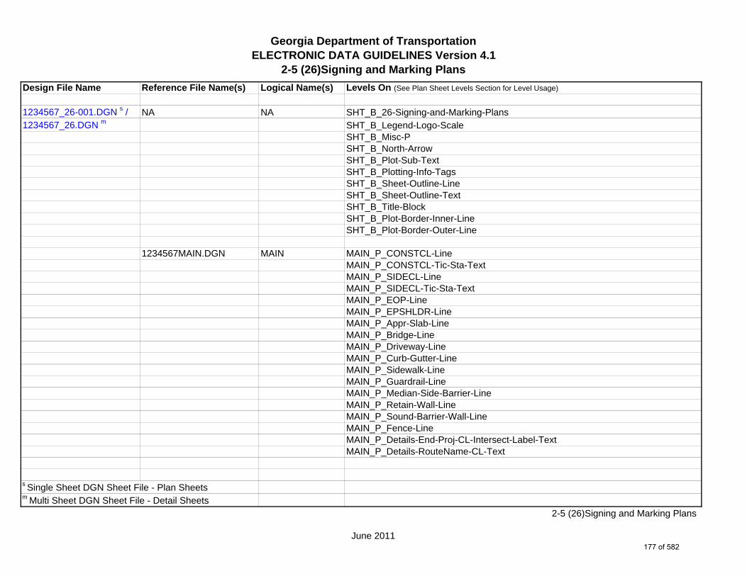
Georgia Department of TransportationELECTRONIC DATA GUIDELINES Version 4.1
2-5 (26)Signing and Marking Plans Design File Name Reference File Name(s) Logical Name(s) Levels On (See Plan Sheet Levels Section for Level Usage)
1234567_26-001.DGN s / NA NA SHT_B_26-Signing-and-Marking-Plans1234567_26.DGN m SHT_B_Legend-Logo-Scale
SHT_B_Misc-PSHT_B_North-ArrowSHT_B_Plot-Sub-TextSHT_B_Plotting-Info-TagsSHT_B_Sheet-Outline-LineSHT_B_Sheet-Outline-TextSHT_B_Title-BlockSHT_B_Plot-Border-Inner-LineSHT_B_Plot-Border-Outer-Line
1234567MAIN.DGN MAIN MAIN_P_CONSTCL-LineMAIN_P_CONSTCL-Tic-Sta-TextMAIN_P_SIDECL-LineMAIN_P_SIDECL-Tic-Sta-TextMAIN_P_EOP-LineMAIN_P_EPSHLDR-LineMAIN_P_Appr-Slab-LineMAIN_P_Bridge-LineMAIN_P_Driveway-LineMAIN_P_Curb-Gutter-LineMAIN_P_Sidewalk-LineMAIN_P_Guardrail-LineMAIN_P_Median-Side-Barrier-LineMAIN_P_Retain-Wall-LineMAIN_P_Sound-Barrier-Wall-LineMAIN_P_Fence-LineMAIN_P_Details-End-Proj-CL-Intersect-Label-TextMAIN_P_Details-RouteName-CL-Text
s Single Sheet DGN Sheet File - Plan Sheetsm Multi Sheet DGN Sheet File - Detail Sheets
June 2011
2-5 (26)Signing and Marking Plans
177 of 582
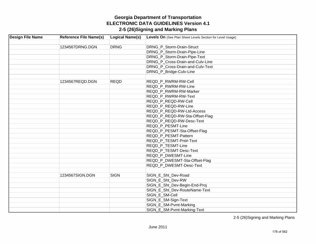
Georgia Department of TransportationELECTRONIC DATA GUIDELINES Version 4.1
2-5 (26)Signing and Marking Plans Design File Name Reference File Name(s) Logical Name(s) Levels On (See Plan Sheet Levels Section for Level Usage)
1234567DRNG.DGN DRNG DRNG_P_Storm-Drain-StructDRNG_P_Storm-Drain-Pipe-LineDRNG_P_Storm-Drain-Pipe-TextDRNG_P_Cross-Drain-and-Culv-LineDRNG_P_Cross-Drain-and-Culv-TextDRNG_P_Bridge-Culv-Line
1234567REQD.DGN REQD REQD_P_RWRM-RW-CellREQD_P_RWRM-RW-LineREQD_P_RWRM-RW-MarkerREQD_P_RWRM-RW-TextREQD_P_REQD-RW-CellREQD_P_REQD-RW-LineREQD_P_REQD-RW-Ltd-AccessREQD_P_REQD-RW-Sta-Offset-FlagREQD_P_REQD-RW-Desc-TextREQD_P_PESMT-LineREQD_P_PESMT-Sta-Offset-FlagREQD_P_PESMT-PatternREQD_P_TESMT-Pnt#-TextREQD_P_TESMT-LineREQD_P_TESMT-Desc-TextREQD_P_DWESMT-LineREQD_P_DWESMT-Sta-Offset-FlagREQD_P_DWESMT-Desc-Text
1234567SIGN.DGN SIGN SIGN_E_Sht_Dev-RoadSIGN_E_Sht_Dev-RWSIGN_E_Sht_Dev-Begin-End-ProjSIGN_E_Sht_Dev-RouteName-TextSIGN_E_SM-CellSIGN_E_SM-Sign-TextSIGN_E_SM-Pvmt-MarkingSIGN_E_SM-Pvmt-Marking-Text
June 2011
2-5 (26)Signing and Marking Plans
178 of 582

Georgia Department of TransportationELECTRONIC DATA GUIDELINES Version 4.1
2-5 (26)Signing and Marking Plans Design File Name Reference File Name(s) Logical Name(s) Levels On (See Plan Sheet Levels Section for Level Usage)
SIGN_P_OVHD_Sign-Structure-and-Strain-PoleSIGN_P_SM-Markings-TextSIGN_P_SM-MarkingsSIGN_P_SM-CellSIGN_P_SM-Text
1234567PROP.DGN PROP PROP_E_PAR-PL-LinePROP_E_RWE-Line PROP_E_RWRR-LinePROP_E_RWRR-TextPROP_E_RWU-LinePROP_E_RWU-TextPROP_E_POEL-LinePROP_E_POEL-TextPROP_E_BMISC-LinePROP_E_BMISC-TextPROP_E_BSL-CellPROP_E_BSL-LinePROP_E_BSL-TextPROP_E_BCOL-CellPROP_E_BCOL-LinePROP_E_BCOL-TextPROP_E_BCTL-CellPROP_E_BCTL-LinePROP_E_BCTL-TextPROP_E_BGMD-CellPROP_E_BGMD-LinePROP_E_BGMD-TextPROP_E_BLDL-CellPROP_E_BLDL-LinePROP_E_BLDL-TextPROP_E_BLLL-CellPROP_E_BLLL-Pnt#-Alg-Name-Text
June 2011
2-5 (26)Signing and Marking Plans
179 of 582

Georgia Department of TransportationELECTRONIC DATA GUIDELINES Version 4.1
2-5 (26)Signing and Marking Plans Design File Name Reference File Name(s) Logical Name(s) Levels On (See Plan Sheet Levels Section for Level Usage)
PROP_E_BLLL-LinePROP_E_BLLL-Text
1234567TOPO.DGN TOPO TOPO_E_TEAP-LineTOPO_E_TEAS-LineTOPO_E_TECP-LineTOPO_E_TEDR-LineTOPO_E_TEST-LineTOPO_E_TEDD-LineTOPO_E_TEAD-LineTOPO_E_TECD-LineTOPO_E_TAC-LineTOPO_E_TCGF-LineTOPO_E_TCGT-LineTOPO_E_THC-LineTOPO_E_TVG-LineTOPO_E_TBAS-LineTOPO_E_TBGL-LineTOPO_E_TBRDGCEN-LineTOPO_E_TBRDGCOR-LineTOPO_E_THM-CellTOPO_E_TFP-LineTOPO_E_TRCR-LineTOPO_E_TRCRE-LineTOPO_E_DCEF-LineTOPO_E_DCEF-TextTOPO_E_DCB-LineTOPO_E_DCB-TextTOPO_E_DCWE-LineTOPO_E_DCWE-TextTOPO_E_DDCB-LineTOPO_E_DDCB-TextTOPO_E_DDI-LineTOPO_E_DDI-Text
June 2011
2-5 (26)Signing and Marking Plans
180 of 582
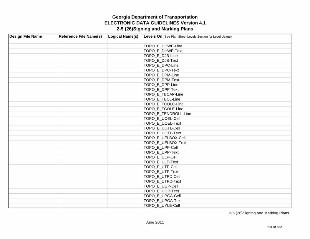
Georgia Department of TransportationELECTRONIC DATA GUIDELINES Version 4.1
2-5 (26)Signing and Marking Plans Design File Name Reference File Name(s) Logical Name(s) Levels On (See Plan Sheet Levels Section for Level Usage)
TOPO_E_DHWE-LineTOPO_E_DHWE-TextTOPO_E_DJB-LineTOPO_E_DJB-TextTOPO_E_DPC-LineTOPO_E_DPC-TextTOPO_E_DPM-LineTOPO_E_DPM-TextTOPO_E_DPP-LineTOPO_E_DPP-TextTOPO_E_TBCAP-LineTOPO_E_TBCL-LineTOPO_E_TCOLC-LineTOPO_E_TCOLE-LineTOPO_E_TENDROLL-LineTOPO_E_UOEL-CellTOPO_E_UOEL-TextTOPO_E_UOTL-CellTOPO_E_UOTL-TextTOPO_E_UELBOX-CellTOPO_E_UELBOX-TextTOPO_E_UPP-CellTOPO_E_UPP-TextTOPO_E_ULP-CellTOPO_E_ULP-TextTOPO_E_UTP-CellTOPO_E_UTP-TextTOPO_E_UTPD-CellTOPO_E_UTPD-TextTOPO_E_UGP-CellTOPO_E_UGP-TextTOPO_E_UPGA-CellTOPO_E_UPGA-TextTOPO_E_UYLE-Cell
June 2011
2-5 (26)Signing and Marking Plans
181 of 582
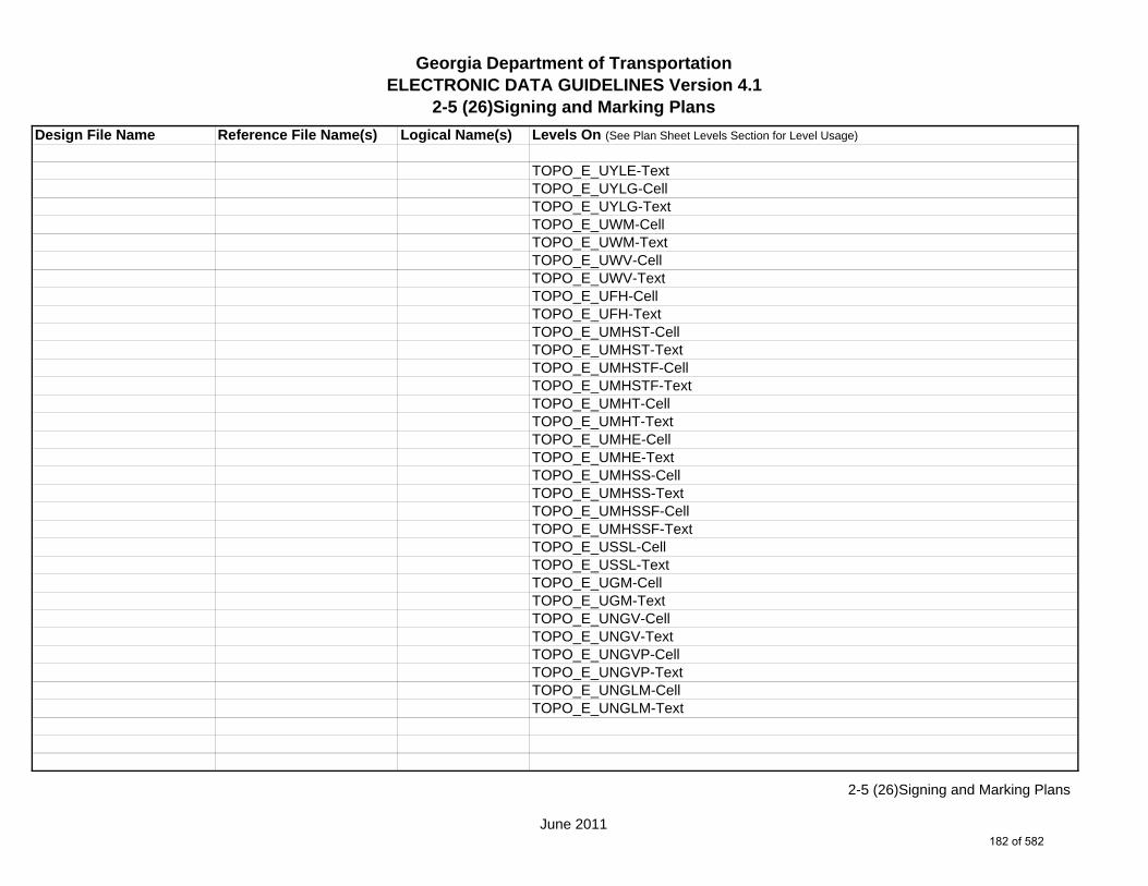
Georgia Department of TransportationELECTRONIC DATA GUIDELINES Version 4.1
2-5 (26)Signing and Marking Plans Design File Name Reference File Name(s) Logical Name(s) Levels On (See Plan Sheet Levels Section for Level Usage)
TOPO_E_UYLE-TextTOPO_E_UYLG-CellTOPO_E_UYLG-TextTOPO_E_UWM-CellTOPO_E_UWM-TextTOPO_E_UWV-CellTOPO_E_UWV-TextTOPO_E_UFH-CellTOPO_E_UFH-TextTOPO_E_UMHST-CellTOPO_E_UMHST-TextTOPO_E_UMHSTF-CellTOPO_E_UMHSTF-TextTOPO_E_UMHT-CellTOPO_E_UMHT-TextTOPO_E_UMHE-CellTOPO_E_UMHE-TextTOPO_E_UMHSS-CellTOPO_E_UMHSS-TextTOPO_E_UMHSSF-CellTOPO_E_UMHSSF-TextTOPO_E_USSL-CellTOPO_E_USSL-TextTOPO_E_UGM-CellTOPO_E_UGM-TextTOPO_E_UNGV-CellTOPO_E_UNGV-TextTOPO_E_UNGVP-CellTOPO_E_UNGVP-TextTOPO_E_UNGLM-CellTOPO_E_UNGLM-Text
June 2011
2-5 (26)Signing and Marking Plans
182 of 582

Georgia Department of TransportationELECTRONIC DATA GUIDELINES Version 4.1
2-5 (26)Signing and Marking Plans Design File Name Reference File Name(s) Logical Name(s) Levels On (See Plan Sheet Levels Section for Level Usage)
1234567UTLE.DGN UTLE UTLE_E_OVHD-Tele-TextUTLE_E_OVHD-Elec-TextUTLE_E_OVHD-Traf-Ctrl-TextUTLE_E_OVHD-Traf-Ctrl-LineUTLE_E_OVHD-Combo-Util-Text
1234567UTLP.DGN UTLP UTLP_P_OVHD-Tele-TextUTLP_P_OVHD-TV-TextUTLP_P_OVHD-Elec-TextUTLP_P_OVHD-Traf-Ctrl-TextUTLP_P_OVHD-Traf-Ctrl-LineUTLP_P_OVHD-Traf-Ctrl-Line-REMUTLP_P_OVHD-Combo-Util-Text
1234567ENVE.DGN ENVE ENVE_E_Wetlnd-Bound-LineENVE_E_Wetlnd-Stream-Delin-LineENVE_E_Wetlnd-Stream-TextENVE_E_Wetlnd-PatternENVE_E_Wetlnd-ShapeENVE_E_Endgd-Spec-LineENVE_E_Endgd-Spec-TextENVE_E_Endgd-Spec-PatternENVE_E_Endgd-Spec-ShapeENVE_E_Hist-Rsc-LineENVE_E_Hist-Rsc-TextENVE_E_Hist-Rsc-PatternENVE_E_Hist-Rsc-ShapeENVE_E_Arch-LineENVE_E_Arch-TextENVE_E_Arch-PatternENVE_E_Arch-ShapeENVE_E_Cult-Rsc-Delin-LineENVE_E_Cult-Rsc-TextENVE_E_Cult-Rsc-Pattern
June 2011
2-5 (26)Signing and Marking Plans
183 of 582

Georgia Department of TransportationELECTRONIC DATA GUIDELINES Version 4.1
2-5 (26)Signing and Marking Plans Design File Name Reference File Name(s) Logical Name(s) Levels On (See Plan Sheet Levels Section for Level Usage)
ENVE_E_Cult-Rsc-ShapeENVE_E_Haz-Mat-Delin-LineENVE_E_Haz-Mat-TextENVE_E_Haz-Mat-PatternENVE_E_Haz-Mat-ShapeENVE_E_Env-Justice-LineENVE_E_Env-Justice-TextENVE_E_Env-Justice-PatternENVE_E_Env-Justice-ShapeENVE_E_ESA-LineENVE_E_ESA-TextENVE_E_ESA-PatternENVE_E_ESA-Shape
1234567ENVP.DGN ENVP ENVP_P_Relocations-LineENVP_P_Relocations-TextENVP_P_Socl-Resc-Impact-Area-LineENVP_P_Socl-Resc-Impact-Area-PatternENVP_P_Socl-Resc-Impact-Area-TextENVP_P_Hist-APE-LineENVP_P_Hist-APE-PatternENVP_P_Hist-APE-TextENVP_P_Cultrl-Resc-Impact-Area-LineENVP_P_Cultrl-Resc-Impact-Area-PatternENVP_P_Cultrl-Resc-Impact-Area-TextENVP_P_Wetlnd-Impact-Area-LineENVP_P_Wetlnd-Impact-Area-PatternENVP_P_Wetlnd-Impact-Area-TextENVP_P_Wetlnd-Mitigat-Site-LineENVP_P_Wetlnd-Mitigat-Site-PatternENVP_P_Wetlnd-Mitigat-Site-TextENVP_P_Fldplain-Impact-Area-LineENVP_P_Fldplain-Impact-Area-PatternENVP_P_Fldplain-Impact-Area-Text
June 2011
2-5 (26)Signing and Marking Plans
184 of 582

Georgia Department of TransportationELECTRONIC DATA GUIDELINES Version 4.1
2-5 (26)Signing and Marking Plans Design File Name Reference File Name(s) Logical Name(s) Levels On (See Plan Sheet Levels Section for Level Usage)
ENVP_P_Impacted-USTENVP_P_Noise-Study-ReceptENVP_P_Noise-Study-ReadingsENVP_P_Noise-Study-Proj-Noise-LvlsENVP_P_Noise-Study-Noise-ContENVP_P_Noise-Study-Impacted-PropENVP_P_Viewshed-Vis-ImpactENVP_P_Fldplain-Impact-Area-LineENVP_P_Fldplain-Impact-Area-PatternENVP_P_Fldplain-Impact-Area-Text
June 2011
2-5 (26)Signing and Marking Plans
185 of 582

Georgia Department of TransportationELECTRONIC DATA GUIDELINES Version 4.1
2-5 (27)Signal PlansDesign File Name Reference File Name(s) Logical Name(s) Levels On (See Plan Sheet Levels Section for Level Usage)
1234567_27-001.DGN s / NA NA SHT_B_27-Signal-Plans1234567_27.DGN m SHT_B_Legend-Logo-Scale
SHT_B_Misc-PSHT_B_North-ArrowSHT_B_Plot-Sub-TextSHT_B_Plotting-Info-TagsSHT_B_Sheet-Outline-LineSHT_B_Sheet-Outline-TextSHT_B_Title-BlockSHT_B_Plot-Border-Inner-LineSHT_B_Plot-Border-Outer-Line
1234567MAIN.DGN MAIN MAIN_P_CONSTCL-LineMAIN_P_CONSTCL-Tic-Sta-TextMAIN_P_SIDECL-LineMAIN_P_SIDECL-Tic-Sta-TextMAIN_P_EOP-LineMAIN_P_EPSHLDR-LineMAIN_P_Appr-Slab-LineMAIN_P_Bridge-LineMAIN_P_Driveway-LineMAIN_P_Curb-Gutter-LineMAIN_P_Sidewalk-LineMAIN_P_Guardrail-LineMAIN_P_Median-Side-Barrier-LineMAIN_P_Retain-Wall-LineMAIN_P_Sound-Barrier-Wall-LineMAIN_P_Fence-LineMAIN_P_Details-End-Proj-CL-Intersect-Label-TextMAIN_P_Details-RouteName-CL-Text
s Single Sheet DGN Sheet File - Plan Sheetsm Multi Sheet DGN Sheet File - Detail Sheets
June 2011
2-5 (27)Signal Plans
186 of 582

Georgia Department of TransportationELECTRONIC DATA GUIDELINES Version 4.1
2-5 (27)Signal PlansDesign File Name Reference File Name(s) Logical Name(s) Levels On (See Plan Sheet Levels Section for Level Usage)
1234567DRNG.DGN DRNG DRNG_P_Storm-Drain-Pipe-LineDRNG_P_Bridge-Culv-Line
1234567REQD.DGN REQD REQD_P_REQD-RW-Desc-TextREQD_P_TESMT-Pnt#-Text
1234567SIGN.DGN SIGN SIGN_E_SM-Pvmt-MarkingSIGN_P_SM-Markings
1234567SGNL.DGN SGNL SGNL_E_Sht_Dev-RoadSGNL_E_Sht_Dev-RWSGNL_E_Sht_Dev-SidewalkSGNL_E_Sht_Dev-Begin-End-ProjSGNL_E_Sht_Dev-RouteNameSGNL_E_Signal-ControllerSGNL_E_Signal-Conduit-and-PullboxSGNL_E_Signal-SignalSGNL_E_Signal-TextSGNL_P_Signal-SignSGNL_P_Signal-Signal-PoleSGNL_P_Signal-Mast-ArmsSGNL_P_Signal-Span-WireSGNL_P_Signal-Control-CabinetSGNL_P_Signal-Shared-Signal-and-Comm-ConduitSGNL_P_Signal-Shared-Signal-and-Comm-PullboxSGNL_P_Signal-Head-and-Street-Name-TextSGNL_P_Signal-Pedestrian-Pedestal-PoleSGNL_P_Signal-Comm-Only-ConduitSGNL_P_Signal-Comm-Only-PullboxSGNL_P_Signal-LoopSGNL_P_Signal-Signal-Only-PullboxSGNL_P_Signal-Signal-Only-Pullbox-TP2
June 2011
2-5 (27)Signal Plans
187 of 582

Georgia Department of TransportationELECTRONIC DATA GUIDELINES Version 4.1
2-5 (27)Signal PlansDesign File Name Reference File Name(s) Logical Name(s) Levels On (See Plan Sheet Levels Section for Level Usage)
SGNL_P_Signal-Signal-Only-ConduitSGNL_P_Signal-Loop-lead-InSGNL_P_Signal-Text
1234567UTLE.DGN UTLE UTLE_E_Elec-CellUTLE_E_UG-Elec-TextUTLE_E_UG-Elec-LineUTLE_E_UG-Elec-Line-Qual-BUTLE_E_UG-Elec-Line-Qual-CUTLE_E_Gas-CellUTLE_E_UG-Gas-LineUTLE_E_UG-Gas-Line-Qual-BUTLE_E_UG-Gas-Line-Qual-C*UTLE_E_UG-Gas-Line-24^UTLE_E_UG-Gas-Line-24-50*UTLE_E_UG-Gas-Line-24-Qual-B^UTLE_E_UG-Gas-Line-24-Qual-B-50*UTLE_E_UG-Gas-Line-24-Qual-C^UTLE_E_UG-Gas-Line-24-Qual-C-50*UTLE_E_UG-Gas-Line-30^UTLE_E_UG-Gas-Line-30-50*UTLE_E_UG-Gas-Line-30-Qual-B^UTLE_E_UG-Gas-Line-30-Qual-B-50*UTLE_E_UG-Gas-Line-30-Qual-C^UTLE_E_UG-Gas-Line-30-Qual-C-50*UTLE_E_UG-Gas-Line-36^UTLE_E_UG-Gas-Line-36-50*UTLE_E_UG-Gas-Line-36-Qual-B^UTLE_E_UG-Gas-Line-36-Qual-B-50*UTLE_E_UG-Gas-Line-36-Qual-C^UTLE_E_UG-Gas-Line-36-Qual-C-50
*Denotes level for 20 Scale Plans.^Denotes level for 50 Scale Plans.
June 2011
2-5 (27)Signal Plans
188 of 582

Georgia Department of TransportationELECTRONIC DATA GUIDELINES Version 4.1
2-5 (27)Signal PlansDesign File Name Reference File Name(s) Logical Name(s) Levels On (See Plan Sheet Levels Section for Level Usage)
*UTLE_E_UG-Gas-Line-42^UTLE_E_UG-Gas-Line-42-50*UTLE_E_UG-Gas-Line-42-Qual-B^UTLE_E_UG-Gas-Line-42-Qual-B-50*UTLE_E_UG-Gas-Line-42-Qual-C^UTLE_E_UG-Gas-Line-42-Qual-C-50*UTLE_E_UG-Gas-Line-48^UTLE_E_UG-Gas-Line-48-50*UTLE_E_UG-Gas-Line-48-Qual-B^UTLE_E_UG-Gas-Line-48-Qual-B-50*UTLE_E_UG-Gas-Line-48-Qual-C^UTLE_E_UG-Gas-Line-48-Qual-C-50UTLE_E_Traf-Ctrl-CellUTLE_E_UG-Traf-Ctrl-LineUTLE_E_UG-Traf-Ctrl-Line-Qual-BUTLE_E_UG-Traf-Ctrl-Line-Qual-CUTLE_E_San-Swr-CellUTLE_E_UG-San-Swr-LineUTLE_E_UG-San-Swr-Line-Qual-BUTLE_E_UG-San-Swr-Line-Qual-C*UTLE_E_UG-San-Swr-Line-24^UTLE_E_UG-San-Swr-Line-24-50*UTLE_E_UG-San-Swr-Line-24-Qual-B^UTLE_E_UG-San-Swr-Line-24-Qual-B-50*UTLE_E_UG-San-Swr-Line-24-Qual-C^UTLE_E_UG-San-Swr-Line-24-Qual-C-50*UTLE_E_UG-San-Swr-Line-30^UTLE_E_UG-San-Swr-Line-30-50*UTLE_E_UG-San-Swr-Line-30-Qual-B^UTLE_E_UG-San-Swr-Line-30-Qual-B-50*UTLE_E_UG-San-Swr-Line-30-Qual-C
*Denotes level for 20 Scale Plans.^Denotes level for 50 Scale Plans.
June 2011
2-5 (27)Signal Plans
189 of 582

Georgia Department of TransportationELECTRONIC DATA GUIDELINES Version 4.1
2-5 (27)Signal PlansDesign File Name Reference File Name(s) Logical Name(s) Levels On (See Plan Sheet Levels Section for Level Usage)
^UTLE_E_UG-San-Swr-Line-30-Qual-C-50*UTLE_E_UG-San-Swr-Line-36^UTLE_E_UG-San-Swr-Line-36-50*UTLE_E_UG-San-Swr-Line-36-Qual-B^UTLE_E_UG-San-Swr-Line-36-Qual-B-50*UTLE_E_UG-San-Swr-Line-36-Qual-C^UTLE_E_UG-San-Swr-Line-36-Qual-C-50*UTLE_E_UG-San-Swr-Line-42^UTLE_E_UG-San-Swr-Line-42-50*UTLE_E_UG-San-Swr-Line-42-Qual-B^UTLE_E_UG-San-Swr-Line-42-Qual-B-50*UTLE_E_UG-San-Swr-Line-42-Qual-C^UTLE_E_UG-San-Swr-Line-42-Qual-C-50*UTLE_E_UG-San-Swr-Line-48^UTLE_E_UG-San-Swr-Line-48-50*UTLE_E_UG-San-Swr-Line-48-Qual-B^UTLE_E_UG-San-Swr-Line-48-Qual-B-50*UTLE_E_UG-San-Swr-Line-48-Qual-C^UTLE_E_UG-San-Swr-Line-48-Qual-C-50UTLE_E_UG-San-Force-Main-CellUTLE_E_UG-San-Force-Main-LineUTLE_E_UG-San-Force-Main-Line-Qual-BUTLE_E_UG-San-Force-Main-Line-Qual-CUTLE_E_Wat-CellUTLE_E_UG-Wat-LineUTLE_E_UG-Wat-Line-Qual-BUTLE_E_UG-Wat-Line-Qual-C*UTLE_E_UG-Wat-Line-24^UTLE_E_UG-Wat-Line-24-50*UTLE_E_UG-Wat-Line-24-Qual-B^UTLE_E_UG-Wat-Line-24-Qual-B-50
*Denotes level for 20 Scale Plans.^Denotes level for 50 Scale Plans.
June 2011
2-5 (27)Signal Plans
190 of 582

Georgia Department of TransportationELECTRONIC DATA GUIDELINES Version 4.1
2-5 (27)Signal PlansDesign File Name Reference File Name(s) Logical Name(s) Levels On (See Plan Sheet Levels Section for Level Usage)
*UTLE_E_UG-Wat-Line-24-Qual-C^UTLE_E_UG-Wat-Line-24-Qual-C-50*UTLE_E_UG-Wat-Line-30^UTLE_E_UG-Wat-Line-30-50*UTLE_E_UG-Wat-Line-30-Qual-B^UTLE_E_UG-Wat-Line-30-Qual-B-50*UTLE_E_UG-Wat-Line-30-Qual-C^UTLE_E_UG-Wat-Line-30-Qual-C-50*UTLE_E_UG-Wat-Line-36^UTLE_E_UG-Wat-Line-36-50*UTLE_E_UG-Wat-Line-36-Qual-B^UTLE_E_UG-Wat-Line-36-Qual-B-50*UTLE_E_UG-Wat-Line-36-Qual-C^UTLE_E_UG-Wat-Line-36-Qual-C-50*UTLE_E_UG-Wat-Line-42^UTLE_E_UG-Wat-Line-42-50*UTLE_E_UG-Wat-Line-42-Qual-B^UTLE_E_UG-Wat-Line-42-Qual-B-50*UTLE_E_UG-Wat-Line-42-Qual-C^UTLE_E_UG-Wat-Line-42-Qual-C-50*UTLE_E_UG-Wat-Line-48^UTLE_E_UG-Wat-Line-48-50*UTLE_E_UG-Wat-Line-48-Qual-B^UTLE_E_UG-Wat-Line-48-Qual-B-50*UTLE_E_UG-Wat-Line-48-Qual-C^UTLE_E_UG-Wat-Line-48-Qual-C-50UTLE_E_TV-CellUTLE_E_UG-TV-LineUTLE_E_UG-TV-Line-Qual-BUTLE_E_UG-TV-Line-Qual-CUTLE_E_Petro-Cell
*Denotes level for 20 Scale Plans.^Denotes level for 50 Scale Plans.
June 2011
2-5 (27)Signal Plans
191 of 582

Georgia Department of TransportationELECTRONIC DATA GUIDELINES Version 4.1
2-5 (27)Signal PlansDesign File Name Reference File Name(s) Logical Name(s) Levels On (See Plan Sheet Levels Section for Level Usage)
UTLE_E_UG-Petro-LineUTLE_E_UG-Petro-Line-Qual-BUTLE_E_UG-Petro-Line-Qual-C*UTLE_E_UG-Petro-Line-24^UTLE_E_UG-Petro-Line-24-50*UTLE_E_UG-Petro-Line-24-Qual-B^UTLE_E_UG-Petro-Line-24-Qual-B-50*UTLE_E_UG-Petro-Line-24-Qual-C^UTLE_E_UG-Petro-Line-24-Qual-C-50*UTLE_E_UG-Petro-Line-30^UTLE_E_UG-Petro-Line-30-50*UTLE_E_UG-Petro-Line-30-Qual-B^UTLE_E_UG-Petro-Line-30-Qual-B-50*UTLE_E_UG-Petro-Line-30-Qual-C^UTLE_E_UG-Petro-Line-30-Qual-C-50*UTLE_E_UG-Petro-Line-36^UTLE_E_UG-Petro-Line-36-50*UTLE_E_UG-Petro-Line-36-Qual-B^UTLE_E_UG-Petro-Line-36-Qual-B-50*UTLE_E_UG-Petro-Line-36-Qual-C^UTLE_E_UG-Petro-Line-36-Qual-C-50*UTLE_E_UG-Petro-Line-42^UTLE_E_UG-Petro-Line-42-50*UTLE_E_UG-Petro-Line-42-Qual-B^UTLE_E_UG-Petro-Line-42-Qual-B-50*UTLE_E_UG-Petro-Line-42-Qual-C^UTLE_E_UG-Petro-Line-42-Qual-C-50*UTLE_E_UG-Petro-Line-48^UTLE_E_UG-Petro-Line-48-50*UTLE_E_UG-Petro-Line-48-Qual-B^UTLE_E_UG-Petro-Line-48-Qual-B-50
*Denotes level for 20 Scale Plans.^Denotes level for 50 Scale Plans.
June 2011
2-5 (27)Signal Plans
192 of 582

Georgia Department of TransportationELECTRONIC DATA GUIDELINES Version 4.1
2-5 (27)Signal PlansDesign File Name Reference File Name(s) Logical Name(s) Levels On (See Plan Sheet Levels Section for Level Usage)
*UTLE_E_UG-Petro-Line-48-Qual-C^UTLE_E_UG-Petro-Line-48-Qual-C-50UTLE_E_Tele-CellUTLE_E_UG-Tele-LineUTLE_E_UG-Tele-Line-Qual-BUTLE_E_UG-Tele-Line-Qual-CUTLE_E_Wat-Non-Pot-CellUTLE_E_UG-Wat-Non-Pot-LineUTLE_E_UG-Wat-Non-Pot-Line-Qual-BUTLE_E_UG-Wat-Non-Pot-Line-Qual-C*UTLE_E_UG-Wat-Non-Pot-Line-24^UTLE_E_UG-Wat-Non-Pot-Line-24-50*UTLE_E_UG-Wat-Non-Pot-Line-24-Qual-B^UTLE_E_UG-Wat-Non-Pot-Line-24-Qual-B-50*UTLE_E_UG-Wat-Non-Pot-Line-24-Qual-C^UTLE_E_UG-Wat-Non-Pot-Line-24-Qual-C-50*UTLE_E_UG-Wat-Non-Pot-Line-30^UTLE_E_UG-Wat-Non-Pot-Line-30-50*UTLE_E_UG-Wat-Non-Pot-Line-30-Qual-B^UTLE_E_UG-Wat-Non-Pot-Line-30-Qual-B-50*UTLE_E_UG-Wat-Non-Pot-Line-30-Qual-C^UTLE_E_UG-Wat-Non-Pot-Line-30-Qual-C-50*UTLE_E_UG-Wat-Non-Pot-Line-36^UTLE_E_UG-Wat-Non-Pot-Line-36-50*UTLE_E_UG-Wat-Non-Pot-Line-36-Qual-B^UTLE_E_UG-Wat-Non-Pot-Line-36-Qual-B-50*UTLE_E_UG-Wat-Non-Pot-Line-36-Qual-C^UTLE_E_UG-Wat-Non-Pot-Line-36-Qual-C-50*UTLE_E_UG-Wat-Non-Pot-Line-42^UTLE_E_UG-Wat-Non-Pot-Line-42-50*UTLE_E_UG-Wat-Non-Pot-Line-42-Qual-B
*Denotes level for 20 Scale Plans.^Denotes level for 50 Scale Plans.
June 2011
2-5 (27)Signal Plans
193 of 582

Georgia Department of TransportationELECTRONIC DATA GUIDELINES Version 4.1
2-5 (27)Signal PlansDesign File Name Reference File Name(s) Logical Name(s) Levels On (See Plan Sheet Levels Section for Level Usage)
^UTLE_E_UG-Wat-Non-Pot-Line-42-Qual-B-50*UTLE_E_UG-Wat-Non-Pot-Line-42-Qual-C^UTLE_E_UG-Wat-Non-Pot-Line-42-Qual-C-50*UTLE_E_UG-Wat-Non-Pot-Line-48^UTLE_E_UG-Wat-Non-Pot-Line-48-50*UTLE_E_UG-Wat-Non-Pot-Line-48-Qual-B^UTLE_E_UG-Wat-Non-Pot-Line-48-Qual-B-50*UTLE_E_UG-Wat-Non-Pot-Line-48-Qual-C^UTLE_E_UG-Wat-Non-Pot-Line-48-Qual-C-50UTLE_E_Steam-CellUTLE_E_UG-Steam-LineUTLE_E_UG-Steam-Line-Qual-BUTLE_E_UG-Steam-Line-Qual-C*UTLE_E_UG-Steam-Line-24^UTLE_E_UG-Steam-Line-24-50*UTLE_E_UG-Steam-Line-24-Qual-B^UTLE_E_UG-Steam-Line-24-Qual-B-50*UTLE_E_UG-Steam-Line-24-Qual-C^UTLE_E_UG-Steam-Line-24-Qual-C-50*UTLE_E_UG-Steam-Line-30^UTLE_E_UG-Steam-Line-30-50*UTLE_E_UG-Steam-Line-30-Qual-B^UTLE_E_UG-Steam-Line-30-Qual-B-50*UTLE_E_UG-Steam-Line-30-Qual-C^UTLE_E_UG-Steam-Line-30-Qual-C-50*UTLE_E_UG-Steam-Line-36^UTLE_E_UG-Steam-Line-36-50*UTLE_E_UG-Steam-Line-36-Qual-B^UTLE_E_UG-Steam-Line-36-Qual-B-50*UTLE_E_UG-Steam-Line-36-Qual-C^UTLE_E_UG-Steam-Line-36-Qual-C-50
*Denotes level for 20 Scale Plans.^Denotes level for 50 Scale Plans.
June 2011
2-5 (27)Signal Plans
194 of 582

Georgia Department of TransportationELECTRONIC DATA GUIDELINES Version 4.1
2-5 (27)Signal PlansDesign File Name Reference File Name(s) Logical Name(s) Levels On (See Plan Sheet Levels Section for Level Usage)
*UTLE_E_UG-Steam-Line-42^UTLE_E_UG-Steam-Line-42-50*UTLE_E_UG-Steam-Line-42-Qual-B^UTLE_E_UG-Steam-Line-42-Qual-B-50*UTLE_E_UG-Steam-Line-42-Qual-C^UTLE_E_UG-Steam-Line-42-Qual-C-50*UTLE_E_UG-Steam-Line-48^UTLE_E_UG-Steam-Line-48-50*UTLE_E_UG-Steam-Line-48-Qual-B^UTLE_E_UG-Steam-Line-48-Qual-B-50*UTLE_E_UG-Steam-Line-48-Qual-C^UTLE_E_UG-Steam-Line-48-Qual-C-50UTLE_E_UG-Utl-Unknown-CellUTLE_E_UG-Utl-Unknown-Line-Qual-BUTLE_E_OVHD-Tele-LineUTLE_E_OVHD-TV-LineUTLE_E_OVHD-Elec-LineUTLE_E_OVHD-Traf-Ctrl-LineUTLE_E_OVHD-Combo-Util-Line-Elec-TeleUTLE_E_OVHD-Combo-Util-Line-Elec-Tele-Traf-CtrlUTLE_E_OVHD-Combo-Util-Line-Elec-Tele-TVUTLE_E_OVHD-Combo-Util-Line-Elec-Tele-TV-Traf-CtrlUTLE_E_OVHD-Combo-Util-Line-Elec-Traf-CtrlUTLE_E_OVHD-Combo-Util-Line-Elec-TVUTLE_E_OVHD-Combo-Util-Line-Elec-TV-Traf-CtrlUTLE_E_OVHD-Combo-Util-Line-Guy-WireUTLE_E_OVHD-Combo-Util-Line-Tele-Traf-CtrlUTLE_E_OVHD-Combo-Util-Line-Tele-TVUTLE_E_OVHD-Combo-Util-Line-Tele-TV-Traf-CtrlUTLE_E_OVHD-Combo-Util-Line-TV-Traf-CtrlUTLE_E_UG-Gas-Line-User-Def
*Denotes level for 20 Scale Plans.^Denotes level for 50 Scale Plans.
June 2011
2-5 (27)Signal Plans
195 of 582

Georgia Department of TransportationELECTRONIC DATA GUIDELINES Version 4.1
2-5 (27)Signal PlansDesign File Name Reference File Name(s) Logical Name(s) Levels On (See Plan Sheet Levels Section for Level Usage)
UTLE_E_UG-Gas-Line-User-Def-Qual-BUTLE_E_UG-Gas-Line-User-Def-Qual-CUTLE_E_UG-Petro-Line-User-DefUTLE_E_UG-Petro-Line-User-Def-Qual-BUTLE_E_UG-Petro-Line-User-Def-Qual-CUTLE_E_UG-San-Swr-User-Def-LineUTLE_E_UG-San-Swr-User-Def-Line-Qual-BUTLE_E_UG-San-Swr-User-Def-Line-Qual-CUTLE_E_UG-Steam-User-Def-LineUTLE_E_UG-Steam-User-Def-Line-Qual-BUTLE_E_UG-Steam-User-Def-Line-Qual-CUTLE_E_UG-Wat-User-Def-LineUTLE_E_UG-Wat-User-Def-Line-Qual-BUTLE_E_UG-Wat-User-Def-Line-Qual-CUTLE_E_UG-Wat-Non-Pot-User-Def-LineUTLE_E_UG-Wat-Non-Pot-User-Def-Line-Qual-BUTLE_E_UG-Wat-Non-Pot-User-Def-Line-Qual-C
1234567UTLP.DGN UTLP UTLP_P_Elec-CellUTLP_P_Elec-Vault-LineUTLP_P_UG-Elec-LineUTLP_P_UG-Elec-Line-REMUTLP_P_Gas-CellUTLP_P_UG-Gas-Line*UTLP_P_UG-Gas-Line-24^UTLP_P_UG-Gas-Line-24-50*UTLP_P_UG-Gas-Line-30^UTLP_P_UG-Gas-Line-30-50*UTLP_P_UG-Gas-Line-36^UTLP_P_UG-Gas-Line-36-50*UTLP_P_UG-Gas-Line-42
*Denotes level for 20 Scale Plans.^Denotes level for 50 Scale Plans.
June 2011
2-5 (27)Signal Plans
196 of 582

Georgia Department of TransportationELECTRONIC DATA GUIDELINES Version 4.1
2-5 (27)Signal PlansDesign File Name Reference File Name(s) Logical Name(s) Levels On (See Plan Sheet Levels Section for Level Usage)
^UTLP_P_UG-Gas-Line-42-50*UTLP_P_UG-Gas-Line-48^UTLP_P_UG-Gas-Line-48-50UTLP_P_UG-Gas-Line-REMUTLP_P_Petro-CellUTLP_P_UG-Petro-Line*UTLP_P_UG-Petro-Line-24^UTLP_P_UG-Petro-Line-24-50*UTLP_P_UG-Petro-Line-30^UTLP_P_UG-Petro-Line-30-50*UTLP_P_UG-Petro-Line-36^UTLP_P_UG-Petro-Line-36-50*UTLP_P_UG-Petro-Line-42^UTLP_P_UG-Petro-Line-42-50*UTLP_P_UG-Petro-Line-48^UTLP_P_UG-Petro-Line-48-50UTLP_P_UG-Petro-Line-REMUTLP_P_UG-San-Force-Main-CellUTLP_P_UG-San-Force-Main-LineUTLP_P_San-Swr-CellUTLP_P_UG-San-Swr-Line*UTLP_P_UG-San-Swr-Line-24^UTLP_P_UG-San-Swr-Line-24-50*UTLP_P_UG-San-Swr-Line-30^UTLP_P_UG-San-Swr-Line-30-50*UTLP_P_UG-San-Swr-Line-36^UTLP_P_UG-San-Swr-Line-36-50*UTLP_P_UG-San-Swr-Line-42^UTLP_P_UG-San-Swr-Line-42-50*UTLP_P_UG-San-Swr-Line-48^UTLP_P_UG-San-Swr-Line-48-50
*Denotes level for 20 Scale Plans.^Denotes level for 50 Scale Plans.
June 2011
2-5 (27)Signal Plans
197 of 582

Georgia Department of TransportationELECTRONIC DATA GUIDELINES Version 4.1
2-5 (27)Signal PlansDesign File Name Reference File Name(s) Logical Name(s) Levels On (See Plan Sheet Levels Section for Level Usage)
UTLP_P_UG-San-Swr-Line-REMUTLP_P_Steam-CellUTLP_P_UG-Steam-Line*UTLP_P_UG-Steam-Line-24^UTLP_P_UG-Steam-Line-24-50*UTLP_P_UG-Steam-Line-30^UTLP_P_UG-Steam-Line-30-50*UTLP_P_UG-Steam-Line-36^UTLP_P_UG-Steam-Line-36-50*UTLP_P_UG-Steam-Line-42^UTLP_P_UG-Steam-Line-42-50*UTLP_P_UG-Steam-Line-48^UTLP_P_UG-Steam-Line-48-50UTLP_P_UG-Steam-Line-REMUTLP_P_Tele-CellUTLP_P_UG-Tele-LineUTLP_P_UG-Tele-Line-REMUTLP_P_Traf-Ctrl-CellUTLP_P_UG-Traf-Ctrl-LineUTLP_P_UG-Traf-Ctrl-Line-REMUTLP_P_TV-CellUTLP_P_UG-TV-LineUTLP_P_UG-TV-Line-REMUTLP_P_Wat-CellUTLP_P_UG-Wat-Line*UTLP_P_UG-Wat-Line-24^UTLP_P_UG-Wat-Line-24-50*UTLP_P_UG-Wat-Line-30^UTLP_P_UG-Wat-Line-30-50*UTLP_P_UG-Wat-Line-36^UTLP_P_UG-Wat-Line-36-50
*Denotes level for 20 Scale Plans.^Denotes level for 50 Scale Plans.
June 2011
2-5 (27)Signal Plans
198 of 582
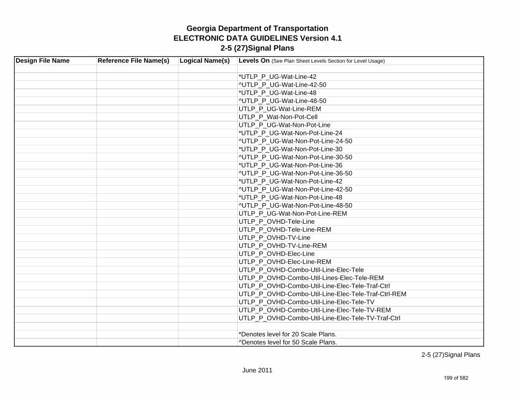
Georgia Department of TransportationELECTRONIC DATA GUIDELINES Version 4.1
2-5 (27)Signal PlansDesign File Name Reference File Name(s) Logical Name(s) Levels On (See Plan Sheet Levels Section for Level Usage)
*UTLP_P_UG-Wat-Line-42^UTLP_P_UG-Wat-Line-42-50*UTLP_P_UG-Wat-Line-48^UTLP_P_UG-Wat-Line-48-50UTLP_P_UG-Wat-Line-REMUTLP_P_Wat-Non-Pot-CellUTLP_P_UG-Wat-Non-Pot-Line*UTLP_P_UG-Wat-Non-Pot-Line-24^UTLP_P_UG-Wat-Non-Pot-Line-24-50*UTLP_P_UG-Wat-Non-Pot-Line-30^UTLP_P_UG-Wat-Non-Pot-Line-30-50*UTLP_P_UG-Wat-Non-Pot-Line-36^UTLP_P_UG-Wat-Non-Pot-Line-36-50*UTLP_P_UG-Wat-Non-Pot-Line-42^UTLP_P_UG-Wat-Non-Pot-Line-42-50*UTLP_P_UG-Wat-Non-Pot-Line-48^UTLP_P_UG-Wat-Non-Pot-Line-48-50UTLP_P_UG-Wat-Non-Pot-Line-REMUTLP_P_OVHD-Tele-LineUTLP_P_OVHD-Tele-Line-REMUTLP_P_OVHD-TV-LineUTLP_P_OVHD-TV-Line-REMUTLP_P_OVHD-Elec-LineUTLP_P_OVHD-Elec-Line-REMUTLP_P_OVHD-Combo-Util-Line-Elec-TeleUTLP_P_OVHD-Combo-Util-Lines-Elec-Tele-REMUTLP_P_OVHD-Combo-Util-Line-Elec-Tele-Traf-CtrlUTLP_P_OVHD-Combo-Util-Line-Elec-Tele-Traf-Ctrl-REMUTLP_P_OVHD-Combo-Util-Line-Elec-Tele-TVUTLP_P_OVHD-Combo-Util-Line-Elec-Tele-TV-REMUTLP_P_OVHD-Combo-Util-Line-Elec-Tele-TV-Traf-Ctrl
*Denotes level for 20 Scale Plans.^Denotes level for 50 Scale Plans.
June 2011
2-5 (27)Signal Plans
199 of 582

Georgia Department of TransportationELECTRONIC DATA GUIDELINES Version 4.1
2-5 (27)Signal PlansDesign File Name Reference File Name(s) Logical Name(s) Levels On (See Plan Sheet Levels Section for Level Usage)
UTLP_P_OVHD-Combo-Util-Line-Elec-Tele-TV-Traf-Ctrl-REMUTLP_P_OVHD-Combo-Util-Line-Elec-Traf-CtrlUTLP_P_OVHD-Combo-Util-Line-Elec-Traf-Ctrl-REMUTLP_P_OVHD-Combo-Util-Line-Elec-TVUTLP_P_OVHD-Combo-Util-Line-Elec-TV-REMUTLP_P_OVHD-Combo-Util-Line-Elec-TV-Traf-CtrlUTLP_P_OVHD-Combo-Util-Line-Elec-TV-Traf-Ctrl-REMUTLP_P_OVHD-Combo-Util-Line-Tele-TVUTLP_P_OVHD-Combo-Util-Line-Tele-TV-REMUTLP_P_OVHD-Combo-Util-Line-Tele-Traf-CtrlUTLP_P_OVHD-Combo-Util-Line-Tele-Traf-Ctrl-REMUTLP_P_OVHD-Combo-Util-Line-Tele-TV-Traf-CtrlUTLP_P_OVHD-Combo-Util-Line-Tele-TV-Traf-Ctrl-REMUTLP_P_OVHD-Combo-Util-Line-TV-Traf-CtrlUTLP_P_OVHD-Combo-Util-Line-TV-Traf-Ctrl-REMUTLP_P_OVHD-Combo-Util-Line-Guy-WireUTLP_P_OVHD-Combo-Util-Line-Guy-Wire-REMUTLP_P_UG-Gas-Line-User-DefUTLP_P_UG-Petro-Line-User-DefUTLP_P_UG-San-Swr-Line-User-DefUTLP_P_UG-Steam-Line-User-DefUTLP_P_UG-Wat-Line-User-DefUTLP_P_UG-Wat-Non-Pot-User-Def-Line
1234567PROP.DGN PROP PROP_E_PAR-PL-LinePROP_E_RWE-Line PROP_E_PAR-PL-TextPROP_E_RWRR-LinePROP_E_RWRR-TextPROP_E_RWU-LinePROP_E_RWU-TextPROP_E_POEL-LinePROP_E_POEL-Text
June 2011
2-5 (27)Signal Plans
200 of 582
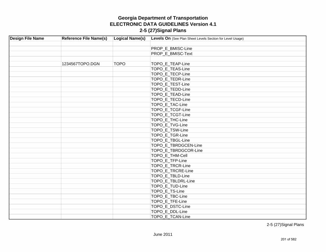
Georgia Department of TransportationELECTRONIC DATA GUIDELINES Version 4.1
2-5 (27)Signal PlansDesign File Name Reference File Name(s) Logical Name(s) Levels On (See Plan Sheet Levels Section for Level Usage)
PROP_E_BMISC-LinePROP_E_BMISC-Text
1234567TOPO.DGN TOPO TOPO_E_TEAP-LineTOPO_E_TEAS-LineTOPO_E_TECP-LineTOPO_E_TEDR-LineTOPO_E_TEST-LineTOPO_E_TEDD-LineTOPO_E_TEAD-LineTOPO_E_TECD-LineTOPO_E_TAC-LineTOPO_E_TCGF-LineTOPO_E_TCGT-LineTOPO_E_THC-LineTOPO_E_TVG-LineTOPO_E_TSW-LineTOPO_E_TGR-LineTOPO_E_TBGL-LineTOPO_E_TBRDGCEN-LineTOPO_E_TBRDGCOR-LineTOPO_E_THM-CellTOPO_E_TFP-LineTOPO_E_TRCR-LineTOPO_E_TRCRE-LineTOPO_E_TBLD-LineTOPO_E_TBLDRL-LineTOPO_E_TUD-LineTOPO_E_TS-LineTOPO_E_TBC-LineTOPO_E_TFE-LineTOPO_E_DSTC-LineTOPO_E_DDL-LineTOPO_E_TCAN-Line
June 2011
2-5 (27)Signal Plans
201 of 582

Georgia Department of TransportationELECTRONIC DATA GUIDELINES Version 4.1
2-5 (27)Signal PlansDesign File Name Reference File Name(s) Logical Name(s) Levels On (See Plan Sheet Levels Section for Level Usage)
TOPO_E_THCR-LineTOPO_E_THRL-LineTOPO_E_TMHCR-LineTOPO_E_TMHRL-LineTOPO_E_TFCL-LineTOPO_E_TFW-LineTOPO_E_TFBW-LineTOPO_E_TFFW-LineTOPO_E_TVF-LineTOPO_E_TG-LineTOPO_E_TWELL-LineTOPO_E_TGFV-LineTOPO_E_TGMW-LineTOPO_E_TGP-LineTOPO_E_TGPI-LineTOPO_E_TFT-LineTOPO_E_TGST-LineTOPO_E_TGVP-LineTOPO_E_DCEF-LineTOPO_E_DCB-LineTOPO_E_DCWE-LineTOPO_E_DDCB-LineTOPO_E_DDI-LineTOPO_E_DHWE-LineTOPO_E_DJB-LineTOPO_E_DPC-LineTOPO_E_DPM-LineTOPO_E_DPP-LineTOPO_E_TWF-LineTOPO_E_TWFT-LineTOPO_E_TWFB-LineTOPO_E_TSATDSH-LineTOPO_E_TWL-LineTOPO_E_TTRE-Line
June 2011
2-5 (27)Signal Plans
202 of 582
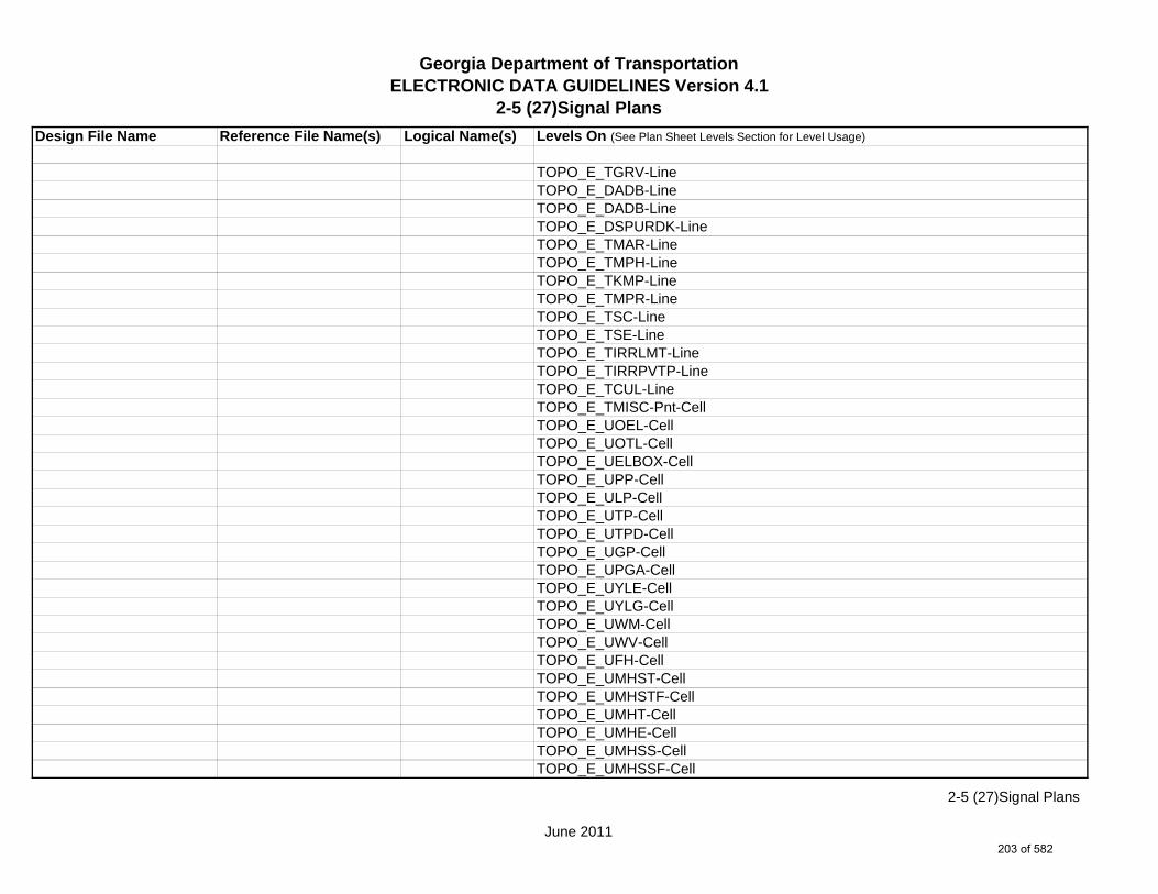
Georgia Department of TransportationELECTRONIC DATA GUIDELINES Version 4.1
2-5 (27)Signal PlansDesign File Name Reference File Name(s) Logical Name(s) Levels On (See Plan Sheet Levels Section for Level Usage)
TOPO_E_TGRV-LineTOPO_E_DADB-LineTOPO_E_DADB-LineTOPO_E_DSPURDK-LineTOPO_E_TMAR-LineTOPO_E_TMPH-LineTOPO_E_TKMP-LineTOPO_E_TMPR-LineTOPO_E_TSC-LineTOPO_E_TSE-LineTOPO_E_TIRRLMT-LineTOPO_E_TIRRPVTP-LineTOPO_E_TCUL-LineTOPO_E_TMISC-Pnt-CellTOPO_E_UOEL-CellTOPO_E_UOTL-CellTOPO_E_UELBOX-CellTOPO_E_UPP-CellTOPO_E_ULP-CellTOPO_E_UTP-CellTOPO_E_UTPD-CellTOPO_E_UGP-CellTOPO_E_UPGA-CellTOPO_E_UYLE-CellTOPO_E_UYLG-CellTOPO_E_UWM-CellTOPO_E_UWV-CellTOPO_E_UFH-CellTOPO_E_UMHST-CellTOPO_E_UMHSTF-CellTOPO_E_UMHT-CellTOPO_E_UMHE-CellTOPO_E_UMHSS-CellTOPO_E_UMHSSF-Cell
June 2011
2-5 (27)Signal Plans
203 of 582
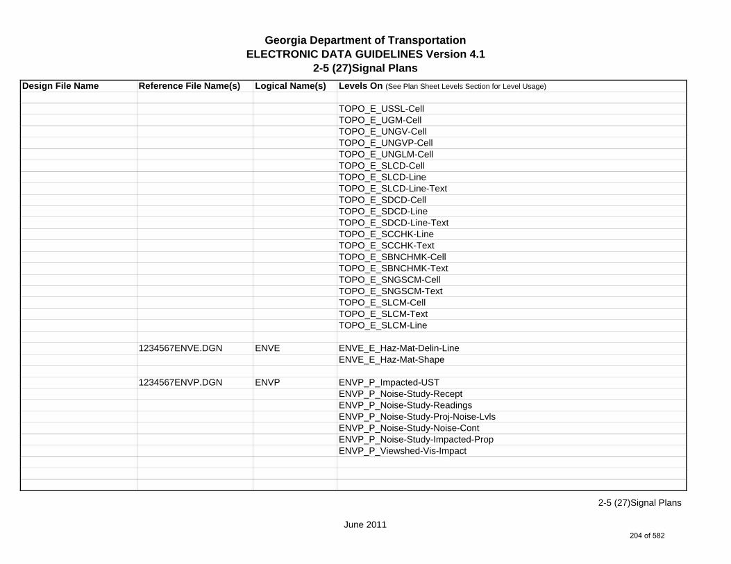
Georgia Department of TransportationELECTRONIC DATA GUIDELINES Version 4.1
2-5 (27)Signal PlansDesign File Name Reference File Name(s) Logical Name(s) Levels On (See Plan Sheet Levels Section for Level Usage)
TOPO_E_USSL-CellTOPO_E_UGM-CellTOPO_E_UNGV-CellTOPO_E_UNGVP-CellTOPO_E_UNGLM-CellTOPO_E_SLCD-CellTOPO_E_SLCD-LineTOPO_E_SLCD-Line-TextTOPO_E_SDCD-CellTOPO_E_SDCD-LineTOPO_E_SDCD-Line-TextTOPO_E_SCCHK-LineTOPO_E_SCCHK-TextTOPO_E_SBNCHMK-CellTOPO_E_SBNCHMK-TextTOPO_E_SNGSCM-CellTOPO_E_SNGSCM-TextTOPO_E_SLCM-CellTOPO_E_SLCM-TextTOPO_E_SLCM-Line
1234567ENVE.DGN ENVE ENVE_E_Haz-Mat-Delin-LineENVE_E_Haz-Mat-Shape
1234567ENVP.DGN ENVP ENVP_P_Impacted-USTENVP_P_Noise-Study-ReceptENVP_P_Noise-Study-ReadingsENVP_P_Noise-Study-Proj-Noise-LvlsENVP_P_Noise-Study-Noise-ContENVP_P_Noise-Study-Impacted-PropENVP_P_Viewshed-Vis-Impact
June 2011
2-5 (27)Signal Plans
204 of 582
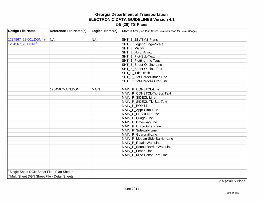
Georgia Department of TransportationELECTRONIC DATA GUIDELINES Version 4.1
2-5 (28)ITS PlansDesign File Name Reference File Name(s) Logical Name(s) Levels On (See Plan Sheet Levels Section for Level Usage)
1234567_28-001.DGN s / NA NA SHT_B_28-ATMS-Plans1234567_28.DGN m SHT_B_Legend-Logo-Scale
SHT_B_Misc-PSHT_B_North-ArrowSHT_B_Plot-Sub-TextSHT_B_Plotting-Info-TagsSHT_B_Sheet-Outline-LineSHT_B_Sheet-Outline-TextSHT_B_Title-BlockSHT_B_Plot-Border-Inner-LineSHT_B_Plot-Border-Outer-Line
1234567MAIN.DGN MAIN MAIN_P_CONSTCL-LineMAIN_P_CONSTCL-Tic-Sta-TextMAIN_P_SIDECL-LineMAIN_P_SIDECL-Tic-Sta-TextMAIN_P_EOP-LineMAIN_P_Appr-Slab-LineMAIN_P_EPSHLDR-LineMAIN_P_Bridge-LineMAIN_P_Driveway-LineMAIN_P_Curb-Gutter-LineMAIN_P_Sidewalk-LineMAIN_P_Guardrail-LineMAIN_P_Median-Side-Barrier-LineMAIN_P_Retain-Wall-LineMAIN_P_Sound-Barrier-Wall-LineMAIN_P_Fence-LineMAIN_P_Misc-Const-Feat-Line
s Single Sheet DGN Sheet File - Plan Sheetsm Multi Sheet DGN Sheet File - Detail Sheets
June 2011
2-5 (28)ITS Plans
205 of 582

Georgia Department of TransportationELECTRONIC DATA GUIDELINES Version 4.1
2-5 (28)ITS PlansDesign File Name Reference File Name(s) Logical Name(s) Levels On (See Plan Sheet Levels Section for Level Usage)
1234567DRNG.DGN DRNG DRNG_P_Storm-Drain-Pipe-LineDRNG_P_Cross-Drain-and-Culv-LineDRNG_P_Bridge-Culv-LineDRNG_P_Sediment-Basin-LineDRNG_P_Detention-Pond-LineDRNG_P_Perm-Riprap-PatternDRNG_P_Perm-Ditch-Protect-TextDRNG_P_Perm-Ditch-Protect-Line
1234567ITS.DGN ITS ATMS_P_ITS-Device-and-ConduitATMS_P_ITS-TextATMS_P_Utility-PoleATMS_P_Utility-TextATMS_P_6in-Fiber-LineATMS_P_12in-Fiber-LineATMS_P_24in-Fiber-LineATMS_P_36in-Fiber-LineATMS_P_48in-Fiber-LineATMS_P_72in-Fiber-LineATMS_P_96in-Fiber-Line
1234567REQD.DGN REQD REQD_P_REQD-RW-LineREQD_P_REQD-RW-Ltd-AccessREQD_P_REQD-RW-Desc-TextREQD_P_PESMT-LineREQD_P_PESMT-Desc-TextREQD_P_TESMT-Pnt#-TextREQD_P_TESMT-LineREQD_P_TESMT-Desc-TextREQD_P_DWESMT-LineREQD_P_DWESMT-Desc-Text
June 2011
2-5 (28)ITS Plans
206 of 582

Georgia Department of TransportationELECTRONIC DATA GUIDELINES Version 4.1
2-5 (28)ITS PlansDesign File Name Reference File Name(s) Logical Name(s) Levels On (See Plan Sheet Levels Section for Level Usage)
1234567SIGN.DGN SIGN SIGN_E_SM-CellSIGN_E_SM-Sign-TextSIGN_E_SM-Pvmt-MarkingSIGN_E_SM-Pvmt-Marking-TextSIGN_P_SM-MarkingsSIGN_P_SM-Cell
1234567SGNL.DGN SNGL SGNL_E_Signal-SignalSGNL_E_Signal-ControllerSGNL_E_Signal-Conduit-and-PullboxSGNL_E_Signal-TextSGNL_P_Signal-SignSGNL_P_Signal-Signal-PoleSGNL_P_Signal-Mast-ArmsSGNL_P_Signal-Span-WireSGNL_P_Signal-Control-CabinetSGNL_P_Signal-Shared-Signal-and-Comm-ConduitSGNL_P_Signal-Shared-Signal-and-Comm-PullboxSGNL_P_Signal-Head-and-Street-Name-TextSGNL_P_Signal-Pedestrian-Pedestal-PoleSGNL_P_Signal-Comm-Only-ConduitSGNL_P_Signal-Comm-Only-PullboxSGNL_P_Signal-LoopSGNL_P_Signal-Signal-Only-PullboxSGNL_P_Signal-Signal-Only-Pullbox-TP2SGNL_P_Signal-Signal-Only-ConduitSGNL_P_Signal-Loop-lead-InSGNL_P_Signal-TextSGNL_E_Sht_Dev-RoadSGNL_E_Sht_Dev-RWSGNL_E_Sht_Dev-SidewalkSGNL_E_Sht_Dev-Begin-End-ProjSGNL_E_Sht_Dev-RouteName
June 2011
2-5 (28)ITS Plans
207 of 582
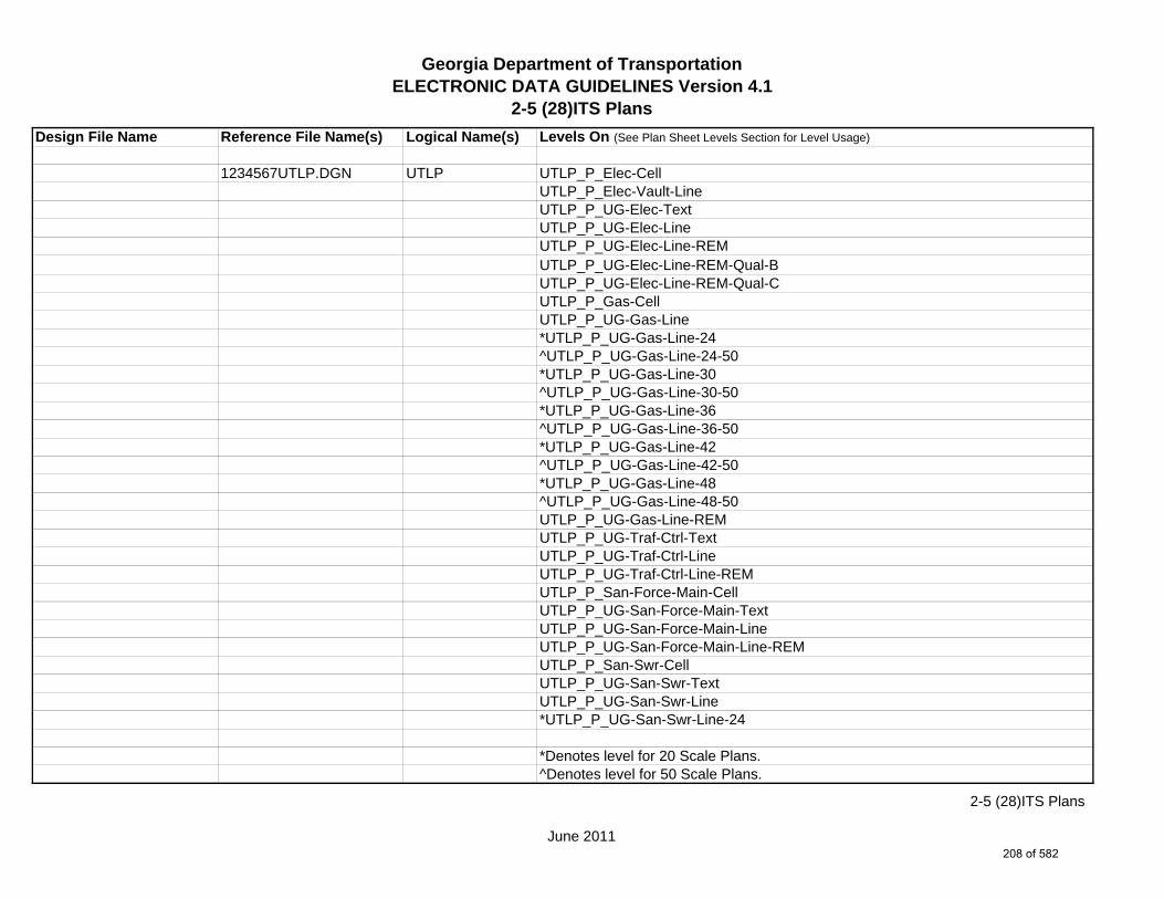
Georgia Department of TransportationELECTRONIC DATA GUIDELINES Version 4.1
2-5 (28)ITS PlansDesign File Name Reference File Name(s) Logical Name(s) Levels On (See Plan Sheet Levels Section for Level Usage)
1234567UTLP.DGN UTLP UTLP_P_Elec-CellUTLP_P_Elec-Vault-LineUTLP_P_UG-Elec-TextUTLP_P_UG-Elec-LineUTLP_P_UG-Elec-Line-REMUTLP_P_UG-Elec-Line-REM-Qual-BUTLP_P_UG-Elec-Line-REM-Qual-CUTLP_P_Gas-CellUTLP_P_UG-Gas-Line*UTLP_P_UG-Gas-Line-24^UTLP_P_UG-Gas-Line-24-50*UTLP_P_UG-Gas-Line-30^UTLP_P_UG-Gas-Line-30-50*UTLP_P_UG-Gas-Line-36^UTLP_P_UG-Gas-Line-36-50*UTLP_P_UG-Gas-Line-42^UTLP_P_UG-Gas-Line-42-50*UTLP_P_UG-Gas-Line-48^UTLP_P_UG-Gas-Line-48-50UTLP_P_UG-Gas-Line-REMUTLP_P_UG-Traf-Ctrl-TextUTLP_P_UG-Traf-Ctrl-LineUTLP_P_UG-Traf-Ctrl-Line-REMUTLP_P_San-Force-Main-CellUTLP_P_UG-San-Force-Main-TextUTLP_P_UG-San-Force-Main-LineUTLP_P_UG-San-Force-Main-Line-REMUTLP_P_San-Swr-CellUTLP_P_UG-San-Swr-TextUTLP_P_UG-San-Swr-Line*UTLP_P_UG-San-Swr-Line-24
*Denotes level for 20 Scale Plans.^Denotes level for 50 Scale Plans.
June 2011
2-5 (28)ITS Plans
208 of 582

Georgia Department of TransportationELECTRONIC DATA GUIDELINES Version 4.1
2-5 (28)ITS PlansDesign File Name Reference File Name(s) Logical Name(s) Levels On (See Plan Sheet Levels Section for Level Usage)
^UTLP_P_UG-San-Swr-Line-24-50*UTLP_P_UG-San-Swr-Line-30^UTLP_P_UG-San-Swr-Line-30-50*UTLP_P_UG-San-Swr-Line-36^UTLP_P_UG-San-Swr-Line-36-50*UTLP_P_UG-San-Swr-Line-42^UTLP_P_UG-San-Swr-Line-42-50*UTLP_P_UG-San-Swr-Line-48^UTLP_P_UG-San-Swr-Line-48-50UTLP_P_UG-San-Swr-Line-REMUTLP_P_Wat-CellUTLP_P_UG-Wat-Line*UTLP_P_UG-Wat-Line-24^UTLP_P_UG-Wat-Line-24-50*UTLP_P_UG-Wat-Line-30^UTLP_P_UG-Wat-Line-30-50*UTLP_P_UG-Wat-Line-36^UTLP_P_UG-Wat-Line-36-50*UTLP_P_UG-Wat-Line-42^UTLP_P_UG-Wat-Line-42-50*UTLP_P_UG-Wat-Line-48^UTLP_P_UG-Wat-Line-48-50UTLP_P_UG-Wat-Line-REMUTLP_P_TV-CellUTLP_P_UG-TV-LineUTLP_P_UG-TV-Line-REMUTLP_P_Petro-CellUTLP_P_UG-Petro-Line*UTLP_P_UG-Petro-Line-24^UTLP_P_UG-Petro-Line-24-50*UTLP_P_UG-Petro-Line-30
*Denotes level for 20 Scale Plans.^Denotes level for 50 Scale Plans.
June 2011
2-5 (28)ITS Plans
209 of 582

Georgia Department of TransportationELECTRONIC DATA GUIDELINES Version 4.1
2-5 (28)ITS PlansDesign File Name Reference File Name(s) Logical Name(s) Levels On (See Plan Sheet Levels Section for Level Usage)
^UTLP_P_UG-Petro-Line-30-50*UTLP_P_UG-Petro-Line-36^UTLP_P_UG-Petro-Line-36-50*UTLP_P_UG-Petro-Line-42^UTLP_P_UG-Petro-Line-42-50*UTLP_P_UG-Petro-Line-48^UTLP_P_UG-Petro-Line-48-50UTLP_P_UG-Petro-Line-REMUTLP_P_Tele-CellUTLP_P_UG-Tele-LineUTLP_P_UG-Tele-Line-REMUTLP_P_Wat-Non-Pot-CellUTLP_P_UG-Wat-Non-Pot-Line*UTLP_P_UG-Wat-Non-Pot-Line-24^UTLP_P_UG-Wat-Non-Pot-Line-24-50*UTLP_P_UG-Wat-Non-Pot-Line-30^UTLP_P_UG-Wat-Non-Pot-Line-30-50*UTLP_P_UG-Wat-Non-Pot-Line-36^UTLP_P_UG-Wat-Non-Pot-Line-36-50*UTLP_P_UG-Wat-Non-Pot-Line-42^UTLP_P_UG-Wat-Non-Pot-Line-42-50*UTLP_P_UG-Wat-Non-Pot-Line-48^UTLP_P_UG-Wat-Non-Pot-Line-48-50UTLP_P_UG-Wat-Non-Pot-Line-REMUTLP_P_Steam-CellUTLP_P_UG-Steam-Line*UTLP_P_UG-Steam-Line-24^UTLP_P_UG-Steam-Line-24-50*UTLP_P_UG-Steam-Line-30^UTLP_P_UG-Steam-Line-30-50*UTLP_P_UG-Steam-Line-36
*Denotes level for 20 Scale Plans.^Denotes level for 50 Scale Plans.
June 2011
2-5 (28)ITS Plans
210 of 582
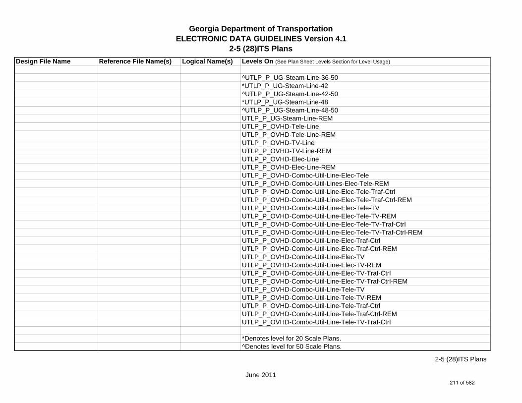
Georgia Department of TransportationELECTRONIC DATA GUIDELINES Version 4.1
2-5 (28)ITS PlansDesign File Name Reference File Name(s) Logical Name(s) Levels On (See Plan Sheet Levels Section for Level Usage)
^UTLP_P_UG-Steam-Line-36-50*UTLP_P_UG-Steam-Line-42^UTLP_P_UG-Steam-Line-42-50*UTLP_P_UG-Steam-Line-48^UTLP_P_UG-Steam-Line-48-50UTLP_P_UG-Steam-Line-REMUTLP_P_OVHD-Tele-LineUTLP_P_OVHD-Tele-Line-REMUTLP_P_OVHD-TV-LineUTLP_P_OVHD-TV-Line-REMUTLP_P_OVHD-Elec-LineUTLP_P_OVHD-Elec-Line-REMUTLP_P_OVHD-Combo-Util-Line-Elec-TeleUTLP_P_OVHD-Combo-Util-Lines-Elec-Tele-REMUTLP_P_OVHD-Combo-Util-Line-Elec-Tele-Traf-CtrlUTLP_P_OVHD-Combo-Util-Line-Elec-Tele-Traf-Ctrl-REMUTLP_P_OVHD-Combo-Util-Line-Elec-Tele-TVUTLP_P_OVHD-Combo-Util-Line-Elec-Tele-TV-REMUTLP_P_OVHD-Combo-Util-Line-Elec-Tele-TV-Traf-CtrlUTLP_P_OVHD-Combo-Util-Line-Elec-Tele-TV-Traf-Ctrl-REMUTLP_P_OVHD-Combo-Util-Line-Elec-Traf-CtrlUTLP_P_OVHD-Combo-Util-Line-Elec-Traf-Ctrl-REMUTLP_P_OVHD-Combo-Util-Line-Elec-TVUTLP_P_OVHD-Combo-Util-Line-Elec-TV-REMUTLP_P_OVHD-Combo-Util-Line-Elec-TV-Traf-CtrlUTLP_P_OVHD-Combo-Util-Line-Elec-TV-Traf-Ctrl-REMUTLP_P_OVHD-Combo-Util-Line-Tele-TVUTLP_P_OVHD-Combo-Util-Line-Tele-TV-REMUTLP_P_OVHD-Combo-Util-Line-Tele-Traf-CtrlUTLP_P_OVHD-Combo-Util-Line-Tele-Traf-Ctrl-REMUTLP_P_OVHD-Combo-Util-Line-Tele-TV-Traf-Ctrl
*Denotes level for 20 Scale Plans.^Denotes level for 50 Scale Plans.
June 2011
2-5 (28)ITS Plans
211 of 582

Georgia Department of TransportationELECTRONIC DATA GUIDELINES Version 4.1
2-5 (28)ITS PlansDesign File Name Reference File Name(s) Logical Name(s) Levels On (See Plan Sheet Levels Section for Level Usage)
UTLP_P_OVHD-Combo-Util-Line-Tele-TV-Traf-Ctrl-REMUTLP_P_OVHD-Combo-Util-Line-TV-Traf-CtrlUTLP_P_OVHD-Combo-Util-Line-TV-Traf-Ctrl-REMUTLP_P_OVHD-Combo-Util-Line-Guy-WireUTLP_P_OVHD-Combo-Util-Line-Guy-Wire-REMUTLP_P_UG-Gas-Line-User-DefUTLP_P_UG-Petro-Line-User-DefUTLP_P_UG-San-Swr-Line-User-DefUTLP_P_UG-Steam-Line-User-DefUTLP_P_UG-Wat-Line-User-DefUTLP_P_UG-Wat-Non-Pot-User-Def-Line
1234567PROP.DGN PROP PROP_E_RWRR-Line
1234567TOPO.DGN TOPO TOPO_E_TBAS-LineTOPO_E_TBGL-LineTOPO_E_TBRDGCEN-LineTOPO_E_TBRDGCOR-LineTOPO_E_THM-CellTOPO_E_TFP-Line
June 2011
2-5 (28)ITS Plans
212 of 582

Georgia Department of TransportationELECTRONIC DATA GUIDELINES Version 4.1
2-5 (29)Landscaping PlansDesign File Name Reference File Name(s) Logical Name(s) Levels On (See Plan Sheet Levels Section for Level Usage)
1234567_29-001.DGN s / NA NA SHT_B_29-Landscaping-Plans1234567_29.DGN m SHT_B_Legend-Logo-Scale
SHT_B_Misc-PSHT_B_North-ArrowSHT_B_Plot-Sub-TextSHT_B_Plotting-Info-TagsSHT_B_Sheet-Outline-LineSHT_B_Sheet-Outline-TextSHT_B_Title-BlockSHT_B_Plot-Border-Inner-LineSHT_B_Plot-Border-Outer-Line
1234567MAIN.DGN MAIN MAIN_P_CONSTCL-LineMAIN_P_SIDECL-LineMAIN_P_EOP-LineMAIN_P_Appr-Slab-LineMAIN_P_EPSHLDR-LineMAIN_P_Bridge-LineMAIN_P_Driveway-LineMAIN_P_Curb-Gutter-LineMAIN_P_Sidewalk-LineMAIN_P_Guardrail-LineMAIN_P_Median-Side-Barrier-LineMAIN_P_Retain-Wall-LineMAIN_P_Sound-Barrier-Wall-LineMAIN_P_Fence-LineMAIN_P_Misc-Const-Feat-Line
1234567LNSC.DGN LNSC LNSC_E_Tree-ConifLNSC_E_Tree-DecidLNSC_E_TreeLNSC_E_Tree-Everg
s Single Sheet DGN Sheet File - Plan Sheetsm Multi Sheet DGN Sheet File - Detail Sheets
June 2011
2-5 (29)Landscaping Plans
213 of 582

Georgia Department of TransportationELECTRONIC DATA GUIDELINES Version 4.1
2-5 (29)Landscaping PlansDesign File Name Reference File Name(s) Logical Name(s) Levels On (See Plan Sheet Levels Section for Level Usage)
LNSC_E_Tree-PineLNSC_E_Shrub-ConifLNSC_E_Shrub_DecidLNSC_E_Tree-LineLNSC_E_Revision-BubbleLNSC_E_SwampLNSC_E_Annotation-TextLNSC_R_TreeLNSC_R_Annotation-TextLNSC_P_Tree-ConifLNSC_P_Tree-DecidLNSC_P_TreeLNSC_P_Tree-EvergLNSC_P_Tree-StumpLNSC_P_Annotation-Text
1234567REQD.DGN REQD REQD_P_REQD-RW-Desc-Text
1234567PROP.DGN PROP PROP_E_PAR-PL-LinePROP_E_RWE-Line
1234567DRNG.DGN DRNG DRNG_P_Storm-Drain-Pipe-LineDRNG_P_Sediment-Basin-TextDRNG_P_Perm-Ditch-Protect-TextDRNG_P_Struct-TextDRNG_P_BASIN-Boundary-Major-PatternDRNG_P_BASIN-Boundary-Major-Pnt
1234567TOPO.DGN TOPO TOPO_E_TEAP-LineTOPO_E_TEAS-LineTOPO_E_TECP-LineTOPO_E_TEDR-LineTOPO_E_TEST-LineTOPO_E_TEDD-Line
June 2011
2-5 (29)Landscaping Plans
214 of 582

Georgia Department of TransportationELECTRONIC DATA GUIDELINES Version 4.1
2-5 (29)Landscaping PlansDesign File Name Reference File Name(s) Logical Name(s) Levels On (See Plan Sheet Levels Section for Level Usage)
TOPO_E_TEAD-LineTOPO_E_TECD-LineTOPO_E_UOEL-CellTOPO_E_UOTL-CellTOPO_E_UELBOX-CellTOPO_E_UPP-CellTOPO_E_ULP-CellTOPO_E_UTP-CellTOPO_E_UTPD-CellTOPO_E_UGP-CellTOPO_E_UPGA-CellTOPO_E_UYLE-CellTOPO_E_UYLG-CellTOPO_E_UWM-CellTOPO_E_UWV-CellTOPO_E_UFH-CellTOPO_E_UMHST-CellTOPO_E_UMHSTF-CellTOPO_E_UMHT-CellTOPO_E_UMHE-CellTOPO_E_UMHSS-CellTOPO_E_UMHSSF-CellTOPO_E_USSL-CellTOPO_E_UGM-CellTOPO_E_UNGV-CellTOPO_E_UNGVP-CellTOPO_E_UNGLM-CellTOPO_E_TAC-LineTOPO_E_TCGF-LineTOPO_E_TCGT-LineTOPO_E_THC-LineTOPO_E_TVG-LineTOPO_E_TSW-LineTOPO_E_TGR-Line
June 2011
2-5 (29)Landscaping Plans
215 of 582

Georgia Department of TransportationELECTRONIC DATA GUIDELINES Version 4.1
2-5 (29)Landscaping PlansDesign File Name Reference File Name(s) Logical Name(s) Levels On (See Plan Sheet Levels Section for Level Usage)
TOPO_E_TBAS-LineTOPO_E_TBGL-LineTOPO_E_TBRDGCEN-LineTOPO_E_TBRDGCOR-LineTOPO_E_THM-CellTOPO_E_TFP-LineTOPO_E_TRCR-LineTOPO_E_TRCRE-LineTOPO_E_DCEF-LineTOPO_E_DCB-LineTOPO_E_DCWE-LineTOPO_E_DDCB-LineTOPO_E_DDI-LineTOPO_E_DHWE-LineTOPO_E_DJB-LineTOPO_E_DPC-LineTOPO_E_DPM-LineTOPO_E_DPP-LineTOPO_E_MDITCHFL-LineTOPO_E_DPD-LineTOPO_E_DSB-LineTOPO_E_DSC-LineTOPO_E_DSE-LineTOPO_E_DWE-LineTOPO_E_DEW-LineTOPO_E_DHWM-LineTOPO_E_DSWE-LineTOPO_E_DMISC-LineTOPO_E_TWF-LineTOPO_E_TWFT-LineTOPO_E_TWFB-LineTOPO_E_TSATDSH-LineTOPO_E_TWL-LineTOPO_E_TTRE-Line
June 2011
2-5 (29)Landscaping Plans
216 of 582
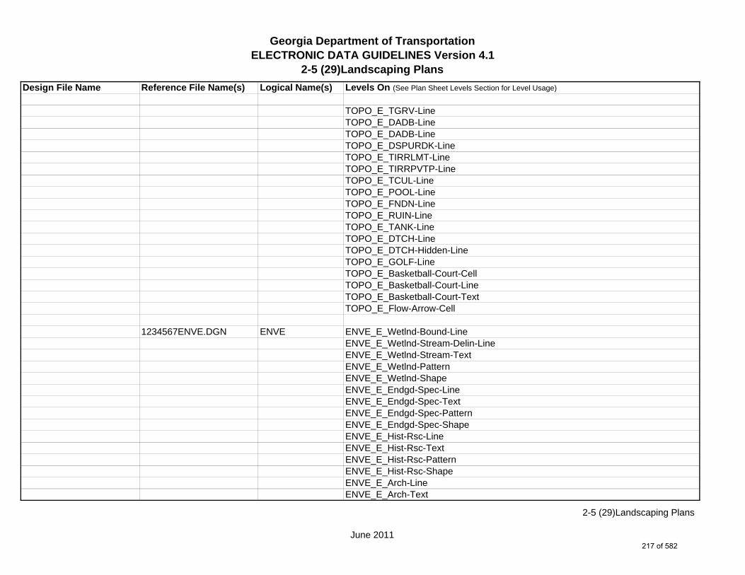
Georgia Department of TransportationELECTRONIC DATA GUIDELINES Version 4.1
2-5 (29)Landscaping PlansDesign File Name Reference File Name(s) Logical Name(s) Levels On (See Plan Sheet Levels Section for Level Usage)
TOPO_E_TGRV-LineTOPO_E_DADB-LineTOPO_E_DADB-LineTOPO_E_DSPURDK-LineTOPO_E_TIRRLMT-LineTOPO_E_TIRRPVTP-LineTOPO_E_TCUL-LineTOPO_E_POOL-LineTOPO_E_FNDN-LineTOPO_E_RUIN-LineTOPO_E_TANK-LineTOPO_E_DTCH-LineTOPO_E_DTCH-Hidden-LineTOPO_E_GOLF-LineTOPO_E_Basketball-Court-CellTOPO_E_Basketball-Court-LineTOPO_E_Basketball-Court-TextTOPO_E_Flow-Arrow-Cell
1234567ENVE.DGN ENVE ENVE_E_Wetlnd-Bound-LineENVE_E_Wetlnd-Stream-Delin-LineENVE_E_Wetlnd-Stream-TextENVE_E_Wetlnd-PatternENVE_E_Wetlnd-ShapeENVE_E_Endgd-Spec-LineENVE_E_Endgd-Spec-TextENVE_E_Endgd-Spec-PatternENVE_E_Endgd-Spec-ShapeENVE_E_Hist-Rsc-LineENVE_E_Hist-Rsc-TextENVE_E_Hist-Rsc-PatternENVE_E_Hist-Rsc-ShapeENVE_E_Arch-LineENVE_E_Arch-Text
June 2011
2-5 (29)Landscaping Plans
217 of 582

Georgia Department of TransportationELECTRONIC DATA GUIDELINES Version 4.1
2-5 (29)Landscaping PlansDesign File Name Reference File Name(s) Logical Name(s) Levels On (See Plan Sheet Levels Section for Level Usage)
ENVE_E_Arch-PatternENVE_E_Arch-ShapeENVE_E_Cult-Rsc-Delin-LineENVE_E_Cult-Rsc-TextENVE_E_Cult-Rsc-PatternENVE_E_Cult-Rsc-ShapeENVE_E_Haz-Mat-Delin-LineENVE_E_Haz-Mat-TextENVE_E_Haz-Mat-PatternENVE_E_Haz-Mat-ShapeENVE_E_Env-Justice-LineENVE_E_Env-Justice-TextENVE_E_Env-Justice-PatternENVE_E_Env-Justice-ShapeENVE_E_ESA-LineENVE_E_ESA-TextENVE_E_ESA-PatternENVE_E_ESA-Shape
1234567ENVP.DGN ENVP ENVP_P_Relocations-LineENVP_P_Relocations-TextENVP_P_Socl-Resc-Impact-Area-LineENVP_P_Socl-Resc-Impact-Area-PatternENVP_P_Socl-Resc-Impact-Area-TextENVP_P_Hist-APE-LineENVP_P_Hist-APE-PatternENVP_P_Hist-APE-TextENVP_P_Cultrl-Resc-Impact-Area-LineENVP_P_Cultrl-Resc-Impact-Area-PatternENVP_P_Cultrl-Resc-Impact-Area-TextENVP_P_Wetlnd-Impact-Area-LineENVP_P_Wetlnd-Impact-Area-PatternENVP_P_Wetlnd-Impact-Area-TextENVP_P_Wetlnd-Mitigat-Site-Line
June 2011
2-5 (29)Landscaping Plans
218 of 582

Georgia Department of TransportationELECTRONIC DATA GUIDELINES Version 4.1
2-5 (29)Landscaping PlansDesign File Name Reference File Name(s) Logical Name(s) Levels On (See Plan Sheet Levels Section for Level Usage)
ENVP_P_Wetlnd-Mitigat-Site-PatternENVP_P_Wetlnd-Mitigat-Site-TextENVP_P_Fldplain-Impact-Area-LineENVP_P_Fldplain-Impact-Area-PatternENVP_P_Fldplain-Impact-Area-TextENVP_P_Impacted-USTENVP_P_Noise-Study-ReceptENVP_P_Noise-Study-ReadingsENVP_P_Noise-Study-Proj-Noise-LvlsENVP_P_Noise-Study-Noise-ContENVP_P_Noise-Study-Impacted-PropENVP_P_Viewshed-Vis-ImpactENVP_P_Fldplain-Impact-Area-LineENVP_P_Fldplain-Impact-Area-PatternENVP_P_Fldplain-Impact-Area-Text
1234567UTLE.DGN UTLE UTLE_E_OVHD-Tele-LineUTLE_E_OVHD-TV-LineUTLE_E_OVHD-Elec-LineUTLE_E_OVHD-Traf-Ctrl-LineUTLE_E_OVHD-Combo-Util-Line-Elec-TeleUTLE_E_OVHD-Combo-Util-Line-Elec-Tele-Traf-CtrlUTLE_E_OVHD-Combo-Util-Line-Elec-Tele-TVUTLE_E_OVHD-Combo-Util-Line-Elec-Tele-TV-Traf-CtrlUTLE_E_OVHD-Combo-Util-Line-Elec-Traf-CtrlUTLE_E_OVHD-Combo-Util-Line-Elec-TVUTLE_E_OVHD-Combo-Util-Line-Elec-TV-Traf-CtrlUTLE_E_OVHD-Combo-Util-Line-Guy-WireUTLE_E_OVHD-Combo-Util-Line-Tele-Traf-CtrlUTLE_E_OVHD-Combo-Util-Line-Tele-TVUTLE_E_OVHD-Combo-Util-Line-Tele-TV-Traf-CtrlUTLE_E_OVHD-Combo-Util-Line-TV-Traf-Ctrl
June 2011
2-5 (29)Landscaping Plans
219 of 582

Georgia Department of TransportationELECTRONIC DATA GUIDELINES Version 4.1
2-5 (29)Landscaping PlansDesign File Name Reference File Name(s) Logical Name(s) Levels On (See Plan Sheet Levels Section for Level Usage)
1234567UTLP.DGN UTLP UTLP_P_OVHD-Tele-LineUTLP_P_OVHD-Tele-Line-REMUTLP_P_OVHD-TV-LineUTLP_P_OVHD-TV-Line-REMUTLP_P_OVHD-Elec-LineUTLP_P_OVHD-Elec-Line-REMUTLP_P_OVHD-Traf-Ctrl-LineUTLP_P_OVHD-Traf-Ctrl-Line-REMUTLP_P_OVHD-Combo-Util-Line-Elec-TeleUTLP_P_OVHD-Combo-Util-Lines-Elec-Tele-REMUTLP_P_OVHD-Combo-Util-Line-Elec-Tele-Traf-CtrlUTLP_P_OVHD-Combo-Util-Line-Elec-Tele-Traf-Ctrl-REMUTLP_P_OVHD-Combo-Util-Line-Elec-Tele-TVUTLP_P_OVHD-Combo-Util-Line-Elec-Tele-TV-REMUTLP_P_OVHD-Combo-Util-Line-Elec-Tele-TV-Traf-CtrlUTLP_P_OVHD-Combo-Util-Line-Elec-Tele-TV-Traf-Ctrl-REMUTLP_P_OVHD-Combo-Util-Line-Elec-Traf-CtrlUTLP_P_OVHD-Combo-Util-Line-Elec-Traf-Ctrl-REMUTLP_P_OVHD-Combo-Util-Line-Elec-TVUTLP_P_OVHD-Combo-Util-Line-Elec-TV-REMUTLP_P_OVHD-Combo-Util-Line-Elec-TV-Traf-CtrlUTLP_P_OVHD-Combo-Util-Line-Elec-TV-Traf-Ctrl-REMUTLP_P_OVHD-Combo-Util-Line-Tele-TVUTLP_P_OVHD-Combo-Util-Line-Tele-TV-REMUTLP_P_OVHD-Combo-Util-Line-Tele-Traf-CtrlUTLP_P_OVHD-Combo-Util-Line-Tele-Traf-Ctrl-REMUTLP_P_OVHD-Combo-Util-Line-Tele-TV-Traf-CtrlUTLP_P_OVHD-Combo-Util-Line-Tele-TV-Traf-Ctrl-REMUTLP_P_OVHD-Combo-Util-Line-TV-Traf-CtrlUTLP_P_OVHD-Combo-Util-Line-TV-Traf-Ctrl-REMUTLP_P_OVHD-Combo-Util-Line-Guy-WireUTLP_P_OVHD-Combo-Util-Line-Guy-Wire-REM
June 2011
2-5 (29)Landscaping Plans
220 of 582
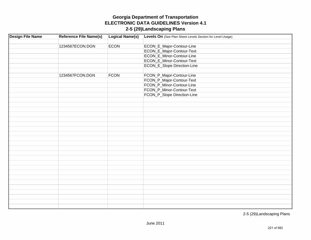
Georgia Department of TransportationELECTRONIC DATA GUIDELINES Version 4.1
2-5 (29)Landscaping PlansDesign File Name Reference File Name(s) Logical Name(s) Levels On (See Plan Sheet Levels Section for Level Usage)
1234567ECON.DGN ECON ECON_E_Major-Contour-LineECON_E_Major-Contour-TextECON_E_Minor-Contour-LineECON_E_Minor-Contour-TextECON_E_Slope Direction-Line
1234567FCON.DGN FCON FCON_P_Major-Contour-LineFCON_P_Major-Contour-TextFCON_P_Minor-Contour-LineFCON_P_Minor-Contour-TextFCON_P_Slope Direction-Line
June 2011
2-5 (29)Landscaping Plans
221 of 582

Georgia Department of TransportationELECTRONIC DATA GUIDELINES Version 4.1
2-5 (30)Mitigation Plans
Design File Name Reference File Name(s) Logical Name(s) Levels On (See Plan Sheet Levels Section for Level Usage) 1234567_30-001.DGN s / NA NA SHT_B_30-Mitigation-Plans1234567_30.DGN m SHT_B_Legend-Logo-Scale
SHT_B_Misc-PSHT_B_North-ArrowSHT_B_Plot-Sub-TextSHT_B_Plotting-Info-TagsSHT_B_Sheet-Outline-LineSHT_B_Sheet-Outline-TextSHT_B_Title-BlockSHT_B_Plot-Border-Inner-LineSHT_B_Plot-Border-Outer-Line
1234567MAIN.DGN MAIN MAIN_P_CONSTCL-LineMAIN_P_CONSTCL-Tic-Sta-TextMAIN_P_CONSTCL-PC-PT-Sta-Ldr-TextMAIN_P_CONSTCL-Brng-TextMAIN_P_CONSTCL-CellMAIN_P_CONSTCL-Curve-Data-TextMAIN_P_SIDECL-LineMAIN_P_SIDECL-Tic-Sta-TextMAIN_P_SIDECL-PC-PT-Sta-Ldr-TextMAIN_P_SIDECL-Brng-TextMAIN_P_SIDECL-CellMAIN_P_SIDECL-Curve-Data-TextMAIN_P_EOP-LineMAIN_P_EOP-TextMAIN_P_EOP-CellMAIN_P_EPSHLDR-LineMAIN_P_EPSHLDR-TextMAIN_P_Appr-Slab-LineMAIN_P_Appr-Slab-Text
s Single Sheet DGN Sheet File - Plan Sheetsm Multi Sheet DGN Sheet File - Detail Sheets
June 2011
2-5 (30)Mitigation Plans
222 of 582

Georgia Department of TransportationELECTRONIC DATA GUIDELINES Version 4.1
2-5 (30)Mitigation Plans
Design File Name Reference File Name(s) Logical Name(s) Levels On (See Plan Sheet Levels Section for Level Usage)
MAIN_P_Bridge-LineMAIN_P_Bridge-TextMAIN_P_Driveway-LineMAIN_P_Driveway-TextMAIN_P_Curb-Gutter-LineMAIN_P_Curb-Gutter-TextMAIN_P_Sidewalk-LineMAIN_P_Sidewalk-TextMAIN_P_Guardrail-LineMAIN_P_Guardrail-TextMAIN_P_Median-Side-Barrier-LineMAIN_P_Median-Side-Barrier-TextMAIN_P_Retain-Wall-LineMAIN_P_Retain-Wall-TextMAIN_P_Sound-Barrier-Wall-LineMAIN_P_Sound-Barrier-Wall-TextMAIN_P_Fence-LineMAIN_P_Fence-TextMAIN_P_Misc-Const-Feat-LineMAIN_P_Misc-Const-Feat-TextMAIN_P_CROWN-CellMAIN_P_CROWN-LineMAIN_P_CROWN-TextMAIN_P_Details-End-Proj-CL-Intersect-Label-TextMAIN_P_Details-Begin-End-Const-Limit-Const-Label-TextMAIN_P_Details-RouteName-CL-TextMAIN_P_Details-Rdwy-DimMAIN_P_Details-Super-Elev-Trans-Label-TextMAIN_P_Misc-Detail-Info
1234567REQD.DGN REQD REQD_P_Parcel-Owner-#-TextREQD_P_RWRM-RW-CellREQD_P_RWRM-RW-LineREQD_P_RWRM-RW-Marker
June 2011
2-5 (30)Mitigation Plans
223 of 582
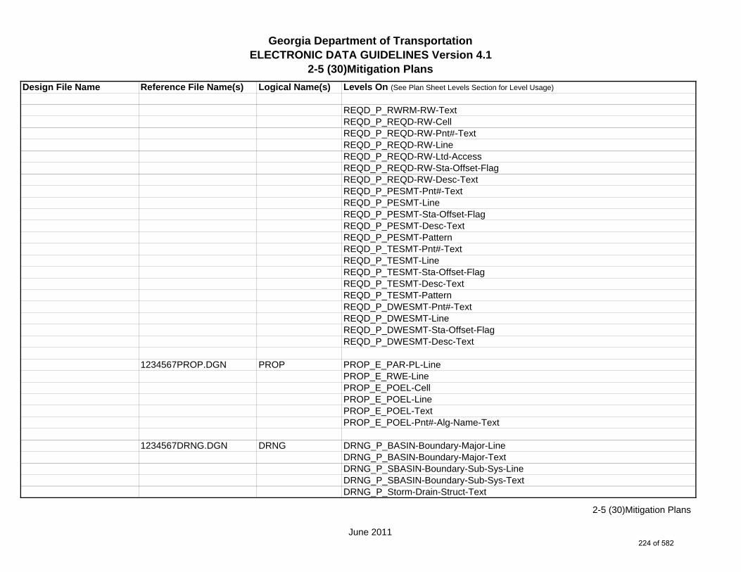
Georgia Department of TransportationELECTRONIC DATA GUIDELINES Version 4.1
2-5 (30)Mitigation Plans
Design File Name Reference File Name(s) Logical Name(s) Levels On (See Plan Sheet Levels Section for Level Usage)
REQD_P_RWRM-RW-TextREQD_P_REQD-RW-CellREQD_P_REQD-RW-Pnt#-TextREQD_P_REQD-RW-LineREQD_P_REQD-RW-Ltd-AccessREQD_P_REQD-RW-Sta-Offset-FlagREQD_P_REQD-RW-Desc-TextREQD_P_PESMT-Pnt#-TextREQD_P_PESMT-LineREQD_P_PESMT-Sta-Offset-FlagREQD_P_PESMT-Desc-TextREQD_P_PESMT-PatternREQD_P_TESMT-Pnt#-TextREQD_P_TESMT-LineREQD_P_TESMT-Sta-Offset-FlagREQD_P_TESMT-Desc-TextREQD_P_TESMT-PatternREQD_P_DWESMT-Pnt#-TextREQD_P_DWESMT-LineREQD_P_DWESMT-Sta-Offset-FlagREQD_P_DWESMT-Desc-Text
1234567PROP.DGN PROP PROP_E_PAR-PL-LinePROP_E_RWE-Line PROP_E_POEL-CellPROP_E_POEL-LinePROP_E_POEL-TextPROP_E_POEL-Pnt#-Alg-Name-Text
1234567DRNG.DGN DRNG DRNG_P_BASIN-Boundary-Major-LineDRNG_P_BASIN-Boundary-Major-TextDRNG_P_SBASIN-Boundary-Sub-Sys-LineDRNG_P_SBASIN-Boundary-Sub-Sys-TextDRNG_P_Storm-Drain-Struct-Text
June 2011
2-5 (30)Mitigation Plans
224 of 582
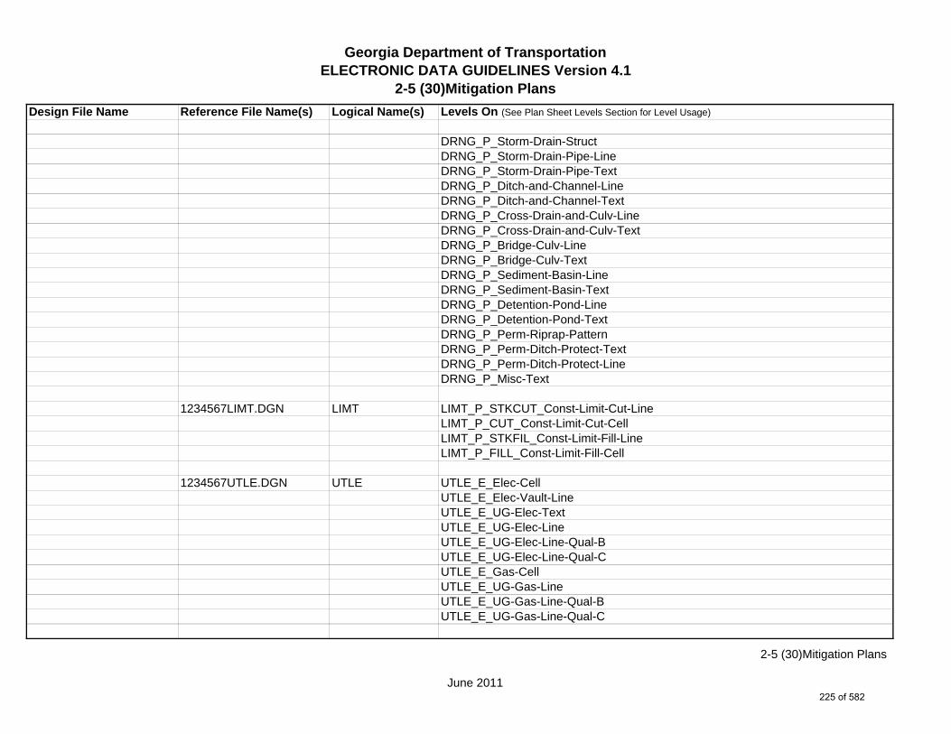
Georgia Department of TransportationELECTRONIC DATA GUIDELINES Version 4.1
2-5 (30)Mitigation Plans
Design File Name Reference File Name(s) Logical Name(s) Levels On (See Plan Sheet Levels Section for Level Usage)
DRNG_P_Storm-Drain-StructDRNG_P_Storm-Drain-Pipe-LineDRNG_P_Storm-Drain-Pipe-TextDRNG_P_Ditch-and-Channel-LineDRNG_P_Ditch-and-Channel-TextDRNG_P_Cross-Drain-and-Culv-LineDRNG_P_Cross-Drain-and-Culv-TextDRNG_P_Bridge-Culv-LineDRNG_P_Bridge-Culv-TextDRNG_P_Sediment-Basin-LineDRNG_P_Sediment-Basin-TextDRNG_P_Detention-Pond-LineDRNG_P_Detention-Pond-TextDRNG_P_Perm-Riprap-PatternDRNG_P_Perm-Ditch-Protect-TextDRNG_P_Perm-Ditch-Protect-LineDRNG_P_Misc-Text
1234567LIMT.DGN LIMT LIMT_P_STKCUT_Const-Limit-Cut-LineLIMT_P_CUT_Const-Limit-Cut-CellLIMT_P_STKFIL_Const-Limit-Fill-LineLIMT_P_FILL_Const-Limit-Fill-Cell
1234567UTLE.DGN UTLE UTLE_E_Elec-CellUTLE_E_Elec-Vault-LineUTLE_E_UG-Elec-TextUTLE_E_UG-Elec-LineUTLE_E_UG-Elec-Line-Qual-BUTLE_E_UG-Elec-Line-Qual-CUTLE_E_Gas-CellUTLE_E_UG-Gas-LineUTLE_E_UG-Gas-Line-Qual-BUTLE_E_UG-Gas-Line-Qual-C
June 2011
2-5 (30)Mitigation Plans
225 of 582

Georgia Department of TransportationELECTRONIC DATA GUIDELINES Version 4.1
2-5 (30)Mitigation Plans
Design File Name Reference File Name(s) Logical Name(s) Levels On (See Plan Sheet Levels Section for Level Usage)
*UTLE_E_UG-Gas-Line-24^UTLE_E_UG-Gas-Line-24-50*UTLE_E_UG-Gas-Line-24-Qual-B^UTLE_E_UG-Gas-Line-24-Qual-B-50*UTLE_E_UG-Gas-Line-24-Qual-C^UTLE_E_UG-Gas-Line-24-Qual-C-50*UTLE_E_UG-Gas-Line-30^UTLE_E_UG-Gas-Line-30-50*UTLE_E_UG-Gas-Line-30-Qual-B^UTLE_E_UG-Gas-Line-30-Qual-B-50*UTLE_E_UG-Gas-Line-30-Qual-C^UTLE_E_UG-Gas-Line-30-Qual-C-50*UTLE_E_UG-Gas-Line-36^UTLE_E_UG-Gas-Line-36-50*UTLE_E_UG-Gas-Line-36-Qual-B^UTLE_E_UG-Gas-Line-36-Qual-B-50*UTLE_E_UG-Gas-Line-36-Qual-C^UTLE_E_UG-Gas-Line-36-Qual-C-50*UTLE_E_UG-Gas-Line-42^UTLE_E_UG-Gas-Line-42-50*UTLE_E_UG-Gas-Line-42-Qual-B^UTLE_E_UG-Gas-Line-42-Qual-B-50*UTLE_E_UG-Gas-Line-42-Qual-C^UTLE_E_UG-Gas-Line-42-Qual-C-50*UTLE_E_UG-Gas-Line-48^UTLE_E_UG-Gas-Line-48-50*UTLE_E_UG-Gas-Line-48-Qual-B^UTLE_E_UG-Gas-Line-48-Qual-B-50*UTLE_E_UG-Gas-Line-48-Qual-C^UTLE_E_UG-Gas-Line-48-Qual-C-50UTLE_E_Traf-Ctrl-Cell
*Denotes level for 20 Scale Plans.^Denotes level for 50 Scale Plans.
June 2011
2-5 (30)Mitigation Plans
226 of 582

Georgia Department of TransportationELECTRONIC DATA GUIDELINES Version 4.1
2-5 (30)Mitigation Plans
Design File Name Reference File Name(s) Logical Name(s) Levels On (See Plan Sheet Levels Section for Level Usage)
UTLE_E_UG-Traf-Ctrl-LineUTLE_E_UG-Traf-Ctrl-Line-Qual-BUTLE_E_UG-Traf-Ctrl-Line-Qual-CUTLE_E_San-Swr-CellUTLE_E_UG-San-Swr-LineUTLE_E_UG-San-Swr-Line-Qual-BUTLE_E_UG-San-Swr-Line-Qual-C*UTLE_E_UG-San-Swr-Line-24^UTLE_E_UG-San-Swr-Line-24-50*UTLE_E_UG-San-Swr-Line-24-Qual-B^UTLE_E_UG-San-Swr-Line-24-Qual-B-50*UTLE_E_UG-San-Swr-Line-24-Qual-C^UTLE_E_UG-San-Swr-Line-24-Qual-C-50*UTLE_E_UG-San-Swr-Line-30^UTLE_E_UG-San-Swr-Line-30-50*UTLE_E_UG-San-Swr-Line-30-Qual-B^UTLE_E_UG-San-Swr-Line-30-Qual-B-50*UTLE_E_UG-San-Swr-Line-30-Qual-C^UTLE_E_UG-San-Swr-Line-30-Qual-C-50*UTLE_E_UG-San-Swr-Line-36^UTLE_E_UG-San-Swr-Line-36-50*UTLE_E_UG-San-Swr-Line-36-Qual-B^UTLE_E_UG-San-Swr-Line-36-Qual-B-50*UTLE_E_UG-San-Swr-Line-36-Qual-C^UTLE_E_UG-San-Swr-Line-36-Qual-C-50*UTLE_E_UG-San-Swr-Line-42^UTLE_E_UG-San-Swr-Line-42-50*UTLE_E_UG-San-Swr-Line-42-Qual-B^UTLE_E_UG-San-Swr-Line-42-Qual-B-50*UTLE_E_UG-San-Swr-Line-42-Qual-C^UTLE_E_UG-San-Swr-Line-42-Qual-C-50
*Denotes level for 20 Scale Plans.^Denotes level for 50 Scale Plans.
June 2011
2-5 (30)Mitigation Plans
227 of 582

Georgia Department of TransportationELECTRONIC DATA GUIDELINES Version 4.1
2-5 (30)Mitigation Plans
Design File Name Reference File Name(s) Logical Name(s) Levels On (See Plan Sheet Levels Section for Level Usage)
*UTLE_E_UG-San-Swr-Line-48^UTLE_E_UG-San-Swr-Line-48-50*UTLE_E_UG-San-Swr-Line-48-Qual-B^UTLE_E_UG-San-Swr-Line-48-Qual-B-50*UTLE_E_UG-San-Swr-Line-48-Qual-C^UTLE_E_UG-San-Swr-Line-48-Qual-C-50UTLE_E_San-Force-Main-CellUTLE_E_UG-San-Force-Main-LineUTLE_E_UG-San-Force-Main-Line-Qual-BUTLE_E_UG-San-Force-Main-Line-Qual-CUTLE_E_Wat-CellUTLE_E_UG-Wat-LineUTLE_E_UG-Wat-Line-Qual-BUTLE_E_UG-Wat-Line-Qual-C*UTLE_E_UG-Wat-Line-24^UTLE_E_UG-Wat-Line-24-50*UTLE_E_UG-Wat-Line-24-Qual-B^UTLE_E_UG-Wat-Line-24-Qual-B-50*UTLE_E_UG-Wat-Line-24-Qual-C^UTLE_E_UG-Wat-Line-24-Qual-C-50*UTLE_E_UG-Wat-Line-30^UTLE_E_UG-Wat-Line-30-50*UTLE_E_UG-Wat-Line-30-Qual-B^UTLE_E_UG-Wat-Line-30-Qual-B-50*UTLE_E_UG-Wat-Line-30-Qual-C^UTLE_E_UG-Wat-Line-30-Qual-C-50*UTLE_E_UG-Wat-Line-36^UTLE_E_UG-Wat-Line-36-50*UTLE_E_UG-Wat-Line-36-Qual-B^UTLE_E_UG-Wat-Line-36-Qual-B-50*UTLE_E_UG-Wat-Line-36-Qual-C
*Denotes level for 20 Scale Plans.^Denotes level for 50 Scale Plans.
June 2011
2-5 (30)Mitigation Plans
228 of 582

Georgia Department of TransportationELECTRONIC DATA GUIDELINES Version 4.1
2-5 (30)Mitigation Plans
Design File Name Reference File Name(s) Logical Name(s) Levels On (See Plan Sheet Levels Section for Level Usage)
^UTLE_E_UG-Wat-Line-36-Qual-C-50*UTLE_E_UG-Wat-Line-42^UTLE_E_UG-Wat-Line-42-50*UTLE_E_UG-Wat-Line-42-Qual-B^UTLE_E_UG-Wat-Line-42-Qual-B-50*UTLE_E_UG-Wat-Line-42-Qual-C^UTLE_E_UG-Wat-Line-42-Qual-C-50*UTLE_E_UG-Wat-Line-48^UTLE_E_UG-Wat-Line-48-50*UTLE_E_UG-Wat-Line-48-Qual-B^UTLE_E_UG-Wat-Line-48-Qual-B-50*UTLE_E_UG-Wat-Line-48-Qual-C^UTLE_E_UG-Wat-Line-48-Qual-C-50UTLE_E_TV-CellUTLE_E_UG-TV-LineUTLE_E_UG-TV-Line-Qual-BUTLE_E_UG-TV-Line-Qual-CUTLE_E_Petro-CellUTLE_E_UG-Petro-LineUTLE_E_UG-Petro-Line-Qual-BUTLE_E_UG-Petro-Line-Qual-C*UTLE_E_UG-Petro-Line-24^UTLE_E_UG-Petro-Line-24-50*UTLE_E_UG-Petro-Line-24-Qual-B^UTLE_E_UG-Petro-Line-24-Qual-B-50*UTLE_E_UG-Petro-Line-24-Qual-C^UTLE_E_UG-Petro-Line-24-Qual-C-50*UTLE_E_UG-Petro-Line-30^UTLE_E_UG-Petro-Line-30-50*UTLE_E_UG-Petro-Line-30-Qual-B^UTLE_E_UG-Petro-Line-30-Qual-B-50
*Denotes level for 20 Scale Plans.^Denotes level for 50 Scale Plans.
June 2011
2-5 (30)Mitigation Plans
229 of 582

Georgia Department of TransportationELECTRONIC DATA GUIDELINES Version 4.1
2-5 (30)Mitigation Plans
Design File Name Reference File Name(s) Logical Name(s) Levels On (See Plan Sheet Levels Section for Level Usage)
*UTLE_E_UG-Petro-Line-30-Qual-C^UTLE_E_UG-Petro-Line-30-Qual-C-50*UTLE_E_UG-Petro-Line-36^UTLE_E_UG-Petro-Line-36-50*UTLE_E_UG-Petro-Line-36-Qual-B^UTLE_E_UG-Petro-Line-36-Qual-B-50*UTLE_E_UG-Petro-Line-36-Qual-C^UTLE_E_UG-Petro-Line-36-Qual-C-50*UTLE_E_UG-Petro-Line-42^UTLE_E_UG-Petro-Line-42-50*UTLE_E_UG-Petro-Line-42-Qual-B^UTLE_E_UG-Petro-Line-42-Qual-B-50*UTLE_E_UG-Petro-Line-42-Qual-C^UTLE_E_UG-Petro-Line-42-Qual-C-50*UTLE_E_UG-Petro-Line-48^UTLE_E_UG-Petro-Line-48-50*UTLE_E_UG-Petro-Line-48-Qual-B^UTLE_E_UG-Petro-Line-48-Qual-B-50*UTLE_E_UG-Petro-Line-48-Qual-C^UTLE_E_UG-Petro-Line-48-Qual-C-50UTLE_E_Tele-CellUTLE_E_UG-Tele-LineUTLE_E_UG-Tele-Line-Qual-BUTLE_E_UG-Tele-Line-Qual-CUTLE_E_Wat-Non-Pot-CellUTLE_E_UG-Wat-Non-Pot-LineUTLE_E_UG-Wat-Non-Pot-Line-Qual-BUTLE_E_UG-Wat-Non-Pot-Line-Qual-C*UTLE_E_UG-Wat-Non-Pot-Line-24^UTLE_E_UG-Wat-Non-Pot-Line-24-50*UTLE_E_UG-Wat-Non-Pot-Line-24-Qual-B
*Denotes level for 20 Scale Plans.^Denotes level for 50 Scale Plans.
June 2011
2-5 (30)Mitigation Plans
230 of 582

Georgia Department of TransportationELECTRONIC DATA GUIDELINES Version 4.1
2-5 (30)Mitigation Plans
Design File Name Reference File Name(s) Logical Name(s) Levels On (See Plan Sheet Levels Section for Level Usage)
^UTLE_E_UG-Wat-Non-Pot-Line-24-Qual-B-50*UTLE_E_UG-Wat-Non-Pot-Line-24-Qual-C^UTLE_E_UG-Wat-Non-Pot-Line-24-Qual-C-50*UTLE_E_UG-Wat-Non-Pot-Line-30^UTLE_E_UG-Wat-Non-Pot-Line-30-50*UTLE_E_UG-Wat-Non-Pot-Line-30-Qual-B^UTLE_E_UG-Wat-Non-Pot-Line-30-Qual-B-50*UTLE_E_UG-Wat-Non-Pot-Line-30-Qual-C^UTLE_E_UG-Wat-Non-Pot-Line-30-Qual-C-50*UTLE_E_UG-Wat-Non-Pot-Line-36^UTLE_E_UG-Wat-Non-Pot-Line-36-50*UTLE_E_UG-Wat-Non-Pot-Line-36-Qual-B^UTLE_E_UG-Wat-Non-Pot-Line-36-Qual-B-50*UTLE_E_UG-Wat-Non-Pot-Line-36-Qual-C^UTLE_E_UG-Wat-Non-Pot-Line-36-Qual-C-50*UTLE_E_UG-Wat-Non-Pot-Line-42^UTLE_E_UG-Wat-Non-Pot-Line-42-50*UTLE_E_UG-Wat-Non-Pot-Line-42-Qual-B^UTLE_E_UG-Wat-Non-Pot-Line-42-Qual-B-50*UTLE_E_UG-Wat-Non-Pot-Line-42-Qual-C^UTLE_E_UG-Wat-Non-Pot-Line-42-Qual-C-50*UTLE_E_UG-Wat-Non-Pot-Line-48^UTLE_E_UG-Wat-Non-Pot-Line-48-50*UTLE_E_UG-Wat-Non-Pot-Line-48-Qual-B^UTLE_E_UG-Wat-Non-Pot-Line-48-Qual-B-50*UTLE_E_UG-Wat-Non-Pot-Line-48-Qual-C^UTLE_E_UG-Wat-Non-Pot-Line-48-Qual-C-50UTLE_E_Steam-CellUTLE_E_UG-Steam-LineUTLE_E_UG-Steam-Line-Qual-BUTLE_E_UG-Steam-Line-Qual-C
*Denotes level for 20 Scale Plans.^Denotes level for 50 Scale Plans.
June 2011
2-5 (30)Mitigation Plans
231 of 582

Georgia Department of TransportationELECTRONIC DATA GUIDELINES Version 4.1
2-5 (30)Mitigation Plans
Design File Name Reference File Name(s) Logical Name(s) Levels On (See Plan Sheet Levels Section for Level Usage)
*UTLE_E_UG-Steam-Line-24^UTLE_E_UG-Steam-Line-24-50*UTLE_E_UG-Steam-Line-24-Qual-B^UTLE_E_UG-Steam-Line-24-Qual-B-50*UTLE_E_UG-Steam-Line-24-Qual-C^UTLE_E_UG-Steam-Line-24-Qual-C-50*UTLE_E_UG-Steam-Line-30^UTLE_E_UG-Steam-Line-30-50*UTLE_E_UG-Steam-Line-30-Qual-B^UTLE_E_UG-Steam-Line-30-Qual-B-50*UTLE_E_UG-Steam-Line-30-Qual-C^UTLE_E_UG-Steam-Line-30-Qual-C-50*UTLE_E_UG-Steam-Line-36^UTLE_E_UG-Steam-Line-36-50*UTLE_E_UG-Steam-Line-36-Qual-B^UTLE_E_UG-Steam-Line-36-Qual-B-50*UTLE_E_UG-Steam-Line-36-Qual-C^UTLE_E_UG-Steam-Line-36-Qual-C-50*UTLE_E_UG-Steam-Line-42^UTLE_E_UG-Steam-Line-42-50*UTLE_E_UG-Steam-Line-42-Qual-B^UTLE_E_UG-Steam-Line-42-Qual-B-50*UTLE_E_UG-Steam-Line-42-Qual-C^UTLE_E_UG-Steam-Line-42-Qual-C-50*UTLE_E_UG-Steam-Line-48^UTLE_E_UG-Steam-Line-48-50*UTLE_E_UG-Steam-Line-48-Qual-B^UTLE_E_UG-Steam-Line-48-Qual-B-50*UTLE_E_UG-Steam-Line-48-Qual-C^UTLE_E_UG-Steam-Line-48-Qual-C-50UTLE_E_UG-Utl-Unknown-Line-Qual-B
*Denotes level for 20 Scale Plans.^Denotes level for 50 Scale Plans.
June 2011
2-5 (30)Mitigation Plans
232 of 582

Georgia Department of TransportationELECTRONIC DATA GUIDELINES Version 4.1
2-5 (30)Mitigation Plans
Design File Name Reference File Name(s) Logical Name(s) Levels On (See Plan Sheet Levels Section for Level Usage)
UTLE_E_OVHD-Tele-LineUTLE_E_OVHD-TV-LineUTLE_E_OVHD-Elec-LineUTLE_E_OVHD-Traf-Ctrl-LineUTLE_E_OVHD-Combo-Util-Line-Elec-TeleUTLE_E_OVHD-Combo-Util-Line-Elec-Tele-Traf-CtrlUTLE_E_OVHD-Combo-Util-Line-Elec-Tele-TVUTLE_E_OVHD-Combo-Util-Line-Elec-Tele-TV-Traf-CtrlUTLE_E_OVHD-Combo-Util-Line-Elec-Traf-CtrlUTLE_E_OVHD-Combo-Util-Line-Elec-TVUTLE_E_OVHD-Combo-Util-Line-Elec-TV-Traf-CtrlUTLE_E_OVHD-Combo-Util-Line-Guy-WireUTLE_E_OVHD-Combo-Util-Line-Tele-Traf-CtrlUTLE_E_OVHD-Combo-Util-Line-Tele-TVUTLE_E_OVHD-Combo-Util-Line-Tele-TV-Traf-CtrlUTLE_E_OVHD-Combo-Util-Line-TV-Traf-CtrlUTLE_E_Test-Hole-CellUTLE_E_Limits-of-StudyUTLE_E_UG-Gas-Line-User-DefUTLE_E_UG-Gas-Line-User-Def-Qual-BUTLE_E_UG-Gas-Line-User-Def-Qual-CUTLE_E_UG-Petro-Line-User-DefUTLE_E_UG-Petro-Line-User-Def-Qual-BUTLE_E_UG-Petro-Line-User-Def-Qual-CUTLE_E_UG-San-Swr-User-Def-LineUTLE_E_UG-San-Swr-User-Def-Line-Qual-BUTLE_E_UG-San-Swr-User-Def-Line-Qual-CUTLE_E_UG-Steam-User-Def-LineUTLE_E_UG-Steam-User-Def-Line-Qual-BUTLE_E_UG-Steam-User-Def-Line-Qual-CUTLE_E_UG-Wat-User-Def-LineUTLE_E_UG-Wat-User-Def-Line-Qual-BUTLE_E_UG-Wat-User-Def-Line-Qual-C
June 2011
2-5 (30)Mitigation Plans
233 of 582

Georgia Department of TransportationELECTRONIC DATA GUIDELINES Version 4.1
2-5 (30)Mitigation Plans
Design File Name Reference File Name(s) Logical Name(s) Levels On (See Plan Sheet Levels Section for Level Usage)
UTLE_E_UG-Wat-Non-Pot-User-Def-LineUTLE_E_UG-Wat-Non-Pot-User-Def-Line-Qual-BUTLE_E_UG-Wat-Non-Pot-User-Def-Line-Qual-C
1234567UTLP.DGN UTLP UTLP_P_Elec-CellUTLP_P_Elec-Vault-LineUTLP_P_UG-Elec-LineUTLP_P_UG-Elec-Line-REMUTLP_P_Gas-CellUTLP_P_UG-Gas-Line*UTLP_P_UG-Gas-Line-24^UTLP_P_UG-Gas-Line-24-50*UTLP_P_UG-Gas-Line-30^UTLP_P_UG-Gas-Line-30-50*UTLP_P_UG-Gas-Line-36^UTLP_P_UG-Gas-Line-36-50*UTLP_P_UG-Gas-Line-42^UTLP_P_UG-Gas-Line-42-50*UTLP_P_UG-Gas-Line-48^UTLP_P_UG-Gas-Line-48-50UTLP_P_UG-Gas-Line-REMUTLP_P_San-Force-Main-CellUTLP_P_UG-San-Force-Main-LineUTLP_P_UG-San-Force-Main-Line-REMUTLP_P_San-Swr-CellUTLP_P_UG-San-Swr-Line*UTLP_P_UG-San-Swr-Line-24^UTLP_P_UG-San-Swr-Line-24-50*UTLP_P_UG-San-Swr-Line-30^UTLP_P_UG-San-Swr-Line-30-50*UTLP_P_UG-San-Swr-Line-36
*Denotes level for 20 Scale Plans.^Denotes level for 50 Scale Plans.
June 2011
2-5 (30)Mitigation Plans
234 of 582
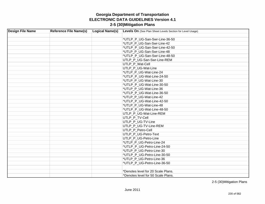
Georgia Department of TransportationELECTRONIC DATA GUIDELINES Version 4.1
2-5 (30)Mitigation Plans
Design File Name Reference File Name(s) Logical Name(s) Levels On (See Plan Sheet Levels Section for Level Usage)
^UTLP_P_UG-San-Swr-Line-36-50*UTLP_P_UG-San-Swr-Line-42^UTLP_P_UG-San-Swr-Line-42-50*UTLP_P_UG-San-Swr-Line-48^UTLP_P_UG-San-Swr-Line-48-50UTLP_P_UG-San-Swr-Line-REMUTLP_P_Wat-CellUTLP_P_UG-Wat-Line*UTLP_P_UG-Wat-Line-24^UTLP_P_UG-Wat-Line-24-50*UTLP_P_UG-Wat-Line-30^UTLP_P_UG-Wat-Line-30-50*UTLP_P_UG-Wat-Line-36^UTLP_P_UG-Wat-Line-36-50*UTLP_P_UG-Wat-Line-42^UTLP_P_UG-Wat-Line-42-50*UTLP_P_UG-Wat-Line-48^UTLP_P_UG-Wat-Line-48-50UTLP_P_UG-Wat-Line-REMUTLP_P_TV-CellUTLP_P_UG-TV-LineUTLP_P_UG-TV-Line-REMUTLP_P_Petro-CellUTLP_P_UG-Petro-TextUTLP_P_UG-Petro-Line*UTLP_P_UG-Petro-Line-24^UTLP_P_UG-Petro-Line-24-50*UTLP_P_UG-Petro-Line-30^UTLP_P_UG-Petro-Line-30-50*UTLP_P_UG-Petro-Line-36^UTLP_P_UG-Petro-Line-36-50
*Denotes level for 20 Scale Plans.^Denotes level for 50 Scale Plans.
June 2011
2-5 (30)Mitigation Plans
235 of 582

Georgia Department of TransportationELECTRONIC DATA GUIDELINES Version 4.1
2-5 (30)Mitigation Plans
Design File Name Reference File Name(s) Logical Name(s) Levels On (See Plan Sheet Levels Section for Level Usage)
*UTLP_P_UG-Petro-Line-42^UTLP_P_UG-Petro-Line-42-50*UTLP_P_UG-Petro-Line-48^UTLP_P_UG-Petro-Line-48-50UTLP_P_UG-Petro-Line-REMUTLP_P_Tele-CellUTLP_P_UG-Tele-LineUTLP_P_UG-Tele-Line-REMUTLP_P_Wat-Non-Pot-CellUTLP_P_UG-Wat-Non-Pot-Line*UTLP_P_UG-Wat-Non-Pot-Line-24^UTLP_P_UG-Wat-Non-Pot-Line-24-50*UTLP_P_UG-Wat-Non-Pot-Line-30^UTLP_P_UG-Wat-Non-Pot-Line-30-50*UTLP_P_UG-Wat-Non-Pot-Line-36^UTLP_P_UG-Wat-Non-Pot-Line-36-50*UTLP_P_UG-Wat-Non-Pot-Line-42^UTLP_P_UG-Wat-Non-Pot-Line-42-50*UTLP_P_UG-Wat-Non-Pot-Line-48^UTLP_P_UG-Wat-Non-Pot-Line-48-50UTLP_P_UG-Wat-Non-Pot-Line-REMUTLP_P_Steam-CellUTLP_P_UG-Steam-Line*UTLP_P_UG-Steam-Line-24^UTLP_P_UG-Steam-Line-24-50*UTLP_P_UG-Steam-Line-30^UTLP_P_UG-Steam-Line-30-50*UTLP_P_UG-Steam-Line-36^UTLP_P_UG-Steam-Line-36-50*UTLP_P_UG-Steam-Line-42^UTLP_P_UG-Steam-Line-42-50
*Denotes level for 20 Scale Plans.^Denotes level for 50 Scale Plans.
June 2011
2-5 (30)Mitigation Plans
236 of 582

Georgia Department of TransportationELECTRONIC DATA GUIDELINES Version 4.1
2-5 (30)Mitigation Plans
Design File Name Reference File Name(s) Logical Name(s) Levels On (See Plan Sheet Levels Section for Level Usage)
*UTLP_P_UG-Steam-Line-48^UTLP_P_UG-Steam-Line-48-50UTLP_P_UG-Steam-Line-REMUTLP_P_OVHD-Combo-Util-Line-Elec-TeleUTLP_P_OVHD-Combo-Util-Lines-Elec-Tele-REMUTLP_P_OVHD-Combo-Util-Line-Elec-Tele-Traf-CtrlUTLP_P_OVHD-Combo-Util-Line-Elec-Tele-Traf-Ctrl-REMUTLP_P_OVHD-Combo-Util-Line-Elec-Tele-TVUTLP_P_OVHD-Combo-Util-Line-Elec-Tele-TV-REMUTLP_P_OVHD-Combo-Util-Line-Elec-Tele-TV-Traf-CtrlUTLP_P_OVHD-Combo-Util-Line-Elec-Tele-TV-Traf-Ctrl-REMUTLP_P_OVHD-Combo-Util-Line-Elec-Traf-CtrlUTLP_P_OVHD-Combo-Util-Line-Elec-Traf-Ctrl-REMUTLP_P_OVHD-Combo-Util-Line-Elec-TVUTLP_P_OVHD-Combo-Util-Line-Elec-TV-REMUTLP_P_OVHD-Combo-Util-Line-Elec-TV-Traf-CtrlUTLP_P_OVHD-Combo-Util-Line-Elec-TV-Traf-Ctrl-REMUTLP_P_OVHD-Combo-Util-Line-Tele-TVUTLP_P_OVHD-Combo-Util-Line-Tele-TV-REMUTLP_P_OVHD-Combo-Util-Line-Tele-Traf-CtrlUTLP_P_OVHD-Combo-Util-Line-Tele-Traf-Ctrl-REMUTLP_P_OVHD-Combo-Util-Line-Tele-TV-Traf-CtrlUTLP_P_OVHD-Combo-Util-Line-Tele-TV-Traf-Ctrl-REMUTLP_P_OVHD-Combo-Util-Line-TV-Traf-CtrlUTLP_P_OVHD-Combo-Util-Line-TV-Traf-Ctrl-REMUTLP_P_OVHD-Combo-Util-Line-Guy-WireUTLP_P_OVHD-Combo-Util-Line-Guy-Wire-REMUTLP_P_UG-Gas-Line-User-DefUTLP_P_UG-Petro-Line-User-DefUTLP_P_UG-San-Swr-Line-User-DefUTLP_P_UG-Steam-Line-User-Def
*Denotes level for 20 Scale Plans.^Denotes level for 50 Scale Plans.
June 2011
2-5 (30)Mitigation Plans
237 of 582
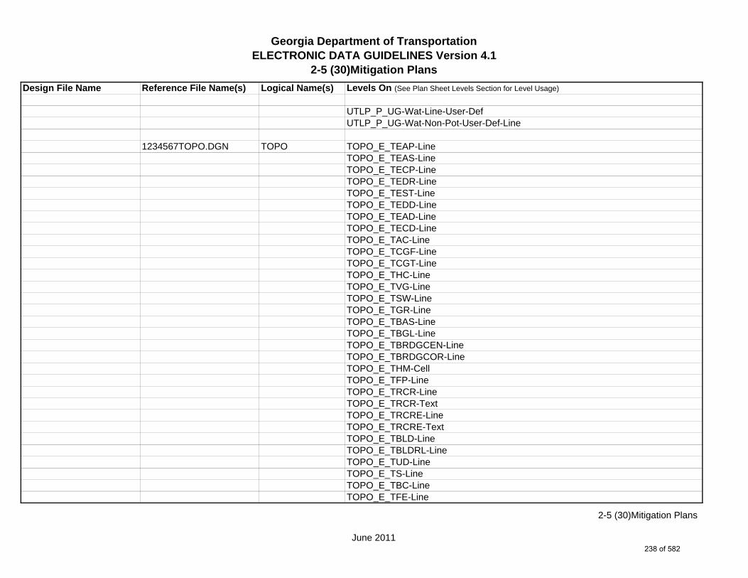
Georgia Department of TransportationELECTRONIC DATA GUIDELINES Version 4.1
2-5 (30)Mitigation Plans
Design File Name Reference File Name(s) Logical Name(s) Levels On (See Plan Sheet Levels Section for Level Usage)
UTLP_P_UG-Wat-Line-User-DefUTLP_P_UG-Wat-Non-Pot-User-Def-Line
1234567TOPO.DGN TOPO TOPO_E_TEAP-LineTOPO_E_TEAS-LineTOPO_E_TECP-LineTOPO_E_TEDR-LineTOPO_E_TEST-LineTOPO_E_TEDD-LineTOPO_E_TEAD-LineTOPO_E_TECD-LineTOPO_E_TAC-LineTOPO_E_TCGF-LineTOPO_E_TCGT-LineTOPO_E_THC-LineTOPO_E_TVG-LineTOPO_E_TSW-LineTOPO_E_TGR-LineTOPO_E_TBAS-LineTOPO_E_TBGL-LineTOPO_E_TBRDGCEN-LineTOPO_E_TBRDGCOR-LineTOPO_E_THM-CellTOPO_E_TFP-LineTOPO_E_TRCR-LineTOPO_E_TRCR-TextTOPO_E_TRCRE-LineTOPO_E_TRCRE-TextTOPO_E_TBLD-LineTOPO_E_TBLDRL-LineTOPO_E_TUD-LineTOPO_E_TS-LineTOPO_E_TBC-LineTOPO_E_TFE-Line
June 2011
2-5 (30)Mitigation Plans
238 of 582
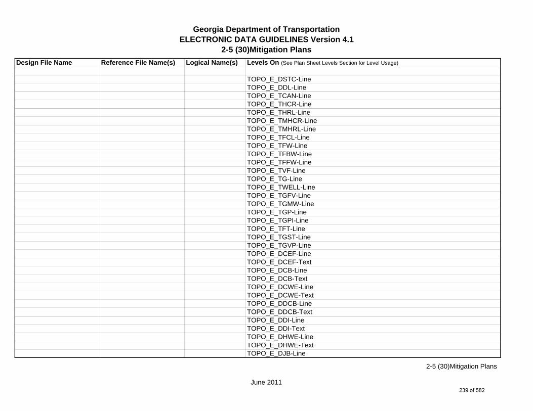
Georgia Department of TransportationELECTRONIC DATA GUIDELINES Version 4.1
2-5 (30)Mitigation Plans
Design File Name Reference File Name(s) Logical Name(s) Levels On (See Plan Sheet Levels Section for Level Usage)
TOPO_E_DSTC-LineTOPO_E_DDL-LineTOPO_E_TCAN-LineTOPO_E_THCR-LineTOPO_E_THRL-LineTOPO_E_TMHCR-LineTOPO_E_TMHRL-LineTOPO_E_TFCL-LineTOPO_E_TFW-LineTOPO_E_TFBW-LineTOPO_E_TFFW-LineTOPO_E_TVF-LineTOPO_E_TG-LineTOPO_E_TWELL-LineTOPO_E_TGFV-LineTOPO_E_TGMW-LineTOPO_E_TGP-LineTOPO_E_TGPI-LineTOPO_E_TFT-LineTOPO_E_TGST-LineTOPO_E_TGVP-LineTOPO_E_DCEF-LineTOPO_E_DCEF-TextTOPO_E_DCB-LineTOPO_E_DCB-TextTOPO_E_DCWE-LineTOPO_E_DCWE-TextTOPO_E_DDCB-LineTOPO_E_DDCB-TextTOPO_E_DDI-LineTOPO_E_DDI-TextTOPO_E_DHWE-LineTOPO_E_DHWE-TextTOPO_E_DJB-Line
June 2011
2-5 (30)Mitigation Plans
239 of 582
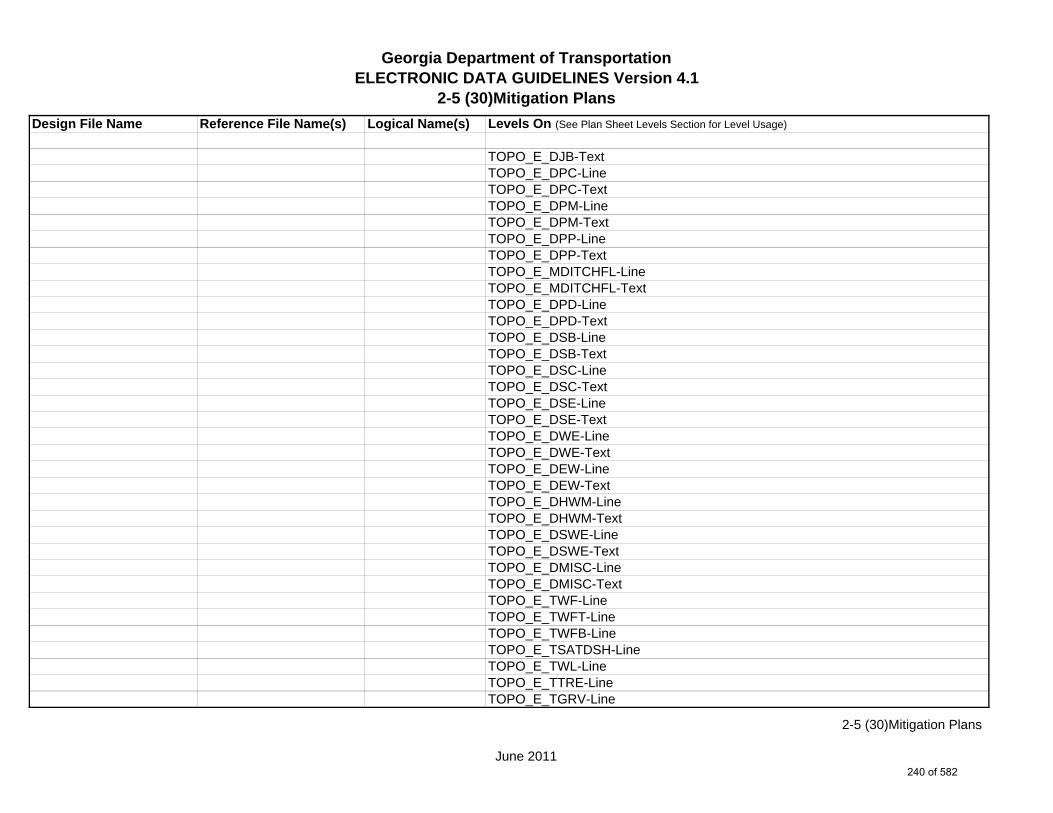
Georgia Department of TransportationELECTRONIC DATA GUIDELINES Version 4.1
2-5 (30)Mitigation Plans
Design File Name Reference File Name(s) Logical Name(s) Levels On (See Plan Sheet Levels Section for Level Usage)
TOPO_E_DJB-TextTOPO_E_DPC-LineTOPO_E_DPC-TextTOPO_E_DPM-LineTOPO_E_DPM-TextTOPO_E_DPP-LineTOPO_E_DPP-TextTOPO_E_MDITCHFL-LineTOPO_E_MDITCHFL-TextTOPO_E_DPD-LineTOPO_E_DPD-TextTOPO_E_DSB-LineTOPO_E_DSB-TextTOPO_E_DSC-LineTOPO_E_DSC-TextTOPO_E_DSE-LineTOPO_E_DSE-TextTOPO_E_DWE-LineTOPO_E_DWE-TextTOPO_E_DEW-LineTOPO_E_DEW-TextTOPO_E_DHWM-LineTOPO_E_DHWM-TextTOPO_E_DSWE-LineTOPO_E_DSWE-TextTOPO_E_DMISC-LineTOPO_E_DMISC-TextTOPO_E_TWF-LineTOPO_E_TWFT-LineTOPO_E_TWFB-LineTOPO_E_TSATDSH-LineTOPO_E_TWL-LineTOPO_E_TTRE-LineTOPO_E_TGRV-Line
June 2011
2-5 (30)Mitigation Plans
240 of 582

Georgia Department of TransportationELECTRONIC DATA GUIDELINES Version 4.1
2-5 (30)Mitigation Plans
Design File Name Reference File Name(s) Logical Name(s) Levels On (See Plan Sheet Levels Section for Level Usage)
TOPO_E_DADB-LineTOPO_E_DADB-LineTOPO_E_DSPURDK-LineTOPO_E_TMAR-LineTOPO_E_TMPH-LineTOPO_E_TKMP-LineTOPO_E_TMPR-LineTOPO_E_TSC-LineTOPO_E_TSE-LineTOPO_E_TIRRLMT-LineTOPO_E_TIRRPVTP-LineTOPO_E_TCUL-LineTOPO_E_TBCAP-LineTOPO_E_TBCL-LineTOPO_E_TCOLC-LineTOPO_E_TCOLE-LineTOPO_E_TENDROLL-LineTOPO_E_TMISC-Pnt-CellTOPO_E_UOEL-CellTOPO_E_UOEL-TextTOPO_E_UOTL-CellTOPO_E_UOTL-TextTOPO_E_UELBOX-CellTOPO_E_UELBOX-TextTOPO_E_UPP-CellTOPO_E_UPP-TextTOPO_E_ULP-CellTOPO_E_ULP-TextTOPO_E_UTP-CellTOPO_E_UTP-TextTOPO_E_UTPD-CellTOPO_E_UTPD-TextTOPO_E_UGP-CellTOPO_E_UGP-Text
June 2011
2-5 (30)Mitigation Plans
241 of 582

Georgia Department of TransportationELECTRONIC DATA GUIDELINES Version 4.1
2-5 (30)Mitigation Plans
Design File Name Reference File Name(s) Logical Name(s) Levels On (See Plan Sheet Levels Section for Level Usage)
TOPO_E_UPGA-CellTOPO_E_UPGA-TextTOPO_E_UYLE-CellTOPO_E_UYLE-TextTOPO_E_UYLG-CellTOPO_E_UYLG-TextTOPO_E_UWM-CellTOPO_E_UWM-TextTOPO_E_UWV-CellTOPO_E_UWV-TextTOPO_E_UFH-CellTOPO_E_UFH-TextTOPO_E_UMHST-CellTOPO_E_UMHST-TextTOPO_E_UMHSTF-CellTOPO_E_UMHSTF-TextTOPO_E_UMHT-CellTOPO_E_UMHT-TextTOPO_E_UMHE-CellTOPO_E_UMHE-TextTOPO_E_UMHSS-CellTOPO_E_UMHSS-TextTOPO_E_UMHSSF-CellTOPO_E_UMHSSF-TextTOPO_E_USSL-CellTOPO_E_USSL-TextTOPO_E_UGM-CellTOPO_E_UGM-TextTOPO_E_UNGV-CellTOPO_E_UNGV-TextTOPO_E_UNGVP-CellTOPO_E_UNGVP-TextTOPO_E_UNGLM-CellTOPO_E_UNGLM-Text
June 2011
2-5 (30)Mitigation Plans
242 of 582
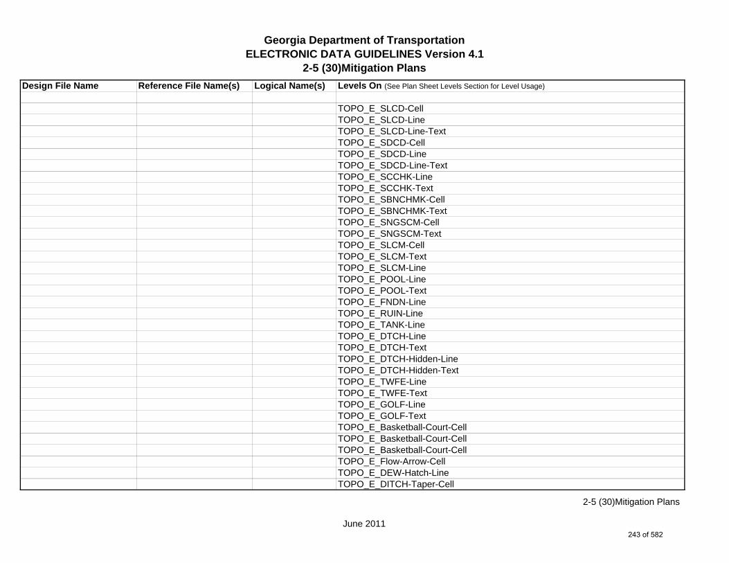
Georgia Department of TransportationELECTRONIC DATA GUIDELINES Version 4.1
2-5 (30)Mitigation Plans
Design File Name Reference File Name(s) Logical Name(s) Levels On (See Plan Sheet Levels Section for Level Usage)
TOPO_E_SLCD-CellTOPO_E_SLCD-LineTOPO_E_SLCD-Line-TextTOPO_E_SDCD-CellTOPO_E_SDCD-LineTOPO_E_SDCD-Line-TextTOPO_E_SCCHK-LineTOPO_E_SCCHK-TextTOPO_E_SBNCHMK-CellTOPO_E_SBNCHMK-TextTOPO_E_SNGSCM-CellTOPO_E_SNGSCM-TextTOPO_E_SLCM-CellTOPO_E_SLCM-TextTOPO_E_SLCM-LineTOPO_E_POOL-LineTOPO_E_POOL-TextTOPO_E_FNDN-LineTOPO_E_RUIN-LineTOPO_E_TANK-LineTOPO_E_DTCH-LineTOPO_E_DTCH-TextTOPO_E_DTCH-Hidden-LineTOPO_E_DTCH-Hidden-TextTOPO_E_TWFE-LineTOPO_E_TWFE-TextTOPO_E_GOLF-LineTOPO_E_GOLF-TextTOPO_E_Basketball-Court-CellTOPO_E_Basketball-Court-CellTOPO_E_Basketball-Court-CellTOPO_E_Flow-Arrow-CellTOPO_E_DEW-Hatch-LineTOPO_E_DITCH-Taper-Cell
June 2011
2-5 (30)Mitigation Plans
243 of 582

Georgia Department of TransportationELECTRONIC DATA GUIDELINES Version 4.1
2-5 (30)Mitigation Plans
Design File Name Reference File Name(s) Logical Name(s) Levels On (See Plan Sheet Levels Section for Level Usage)
TOPO_E_TRAIL-LineTOPO_E_TRAIL-Text
1234567FCON.DGN FCON FCON_P_Major-Contour-LineFCON_P_Major-Contour-TextFCON_P_Minor-Contour-LineFCON_P_Minor-Contour-TextFCON_P_Slope Direction-Line
1234567SIGN.DGN SIGN SIGN_P_OVHD_Sign-Structure-and-Strain-Pole
1234567SGNL.DGN SGNL SGNL_P_Signal-Signal-PoleSGNL_P_Signal-Mast-ArmsSGNL_P_Signal-Control-CabinetSGNL_P_Signal-Shared-Signal-and-Comm-ConduitSGNL_P_Signal-Shared-Signal-and-Comm-PullboxSGNL_P_Signal-Head-and-Street-Name-TextSGNL_P_Signal-Pedestrian-Pedestal-Pole
1234567ENVE.DGN ENVE ENVE_E_Wetlnd-Bound-LineENVE_E_Wetlnd-Stream-Delin-LineENVE_E_Wetlnd-Stream-TextENVE_E_Wetlnd-PatternENVE_E_Wetlnd-ShapeENVE_E_Endgd-Spec-LineENVE_E_Endgd-Spec-TextENVE_E_Endgd-Spec-PatternENVE_E_Endgd-Spec-ShapeENVE_E_Hist-Rsc-LineENVE_E_Hist-Rsc-TextENVE_E_Hist-Rsc-PatternENVE_E_Hist-Rsc-ShapeENVE_E_Arch-Line
June 2011
2-5 (30)Mitigation Plans
244 of 582

Georgia Department of TransportationELECTRONIC DATA GUIDELINES Version 4.1
2-5 (30)Mitigation Plans
Design File Name Reference File Name(s) Logical Name(s) Levels On (See Plan Sheet Levels Section for Level Usage)
ENVE_E_Arch-TextENVE_E_Arch-PatternENVE_E_Arch-ShapeENVE_E_Cult-Rsc-Delin-LineENVE_E_Cult-Rsc-TextENVE_E_Cult-Rsc-PatternENVE_E_Cult-Rsc-ShapeENVE_E_Haz-Mat-Delin-LineENVE_E_Haz-Mat-TextENVE_E_Haz-Mat-PatternENVE_E_Haz-Mat-ShapeENVE_E_Env-Justice-LineENVE_E_Env-Justice-TextENVE_E_Env-Justice-PatternENVE_E_Env-Justice-ShapeENVE_E_ESA-LineENVE_E_ESA-TextENVE_E_ESA-PatternENVE_E_ESA-Shape
1234567ENVP.DGN ENVP ENVP_P_Relocations-LineENVP_P_Relocations-TextENVP_P_Socl-Resc-Impact-Area-LineENVP_P_Socl-Resc-Impact-Area-PatternENVP_P_Socl-Resc-Impact-Area-TextENVP_P_Hist-APE-LineENVP_P_Hist-APE-PatternENVP_P_Hist-APE-TextENVP_P_Cultrl-Resc-Impact-Area-LineENVP_P_Cultrl-Resc-Impact-Area-PatternENVP_P_Cultrl-Resc-Impact-Area-TextENVP_P_Wetlnd-Impact-Area-LineENVP_P_Wetlnd-Impact-Area-PatternENVP_P_Wetlnd-Impact-Area-Text
June 2011
2-5 (30)Mitigation Plans
245 of 582
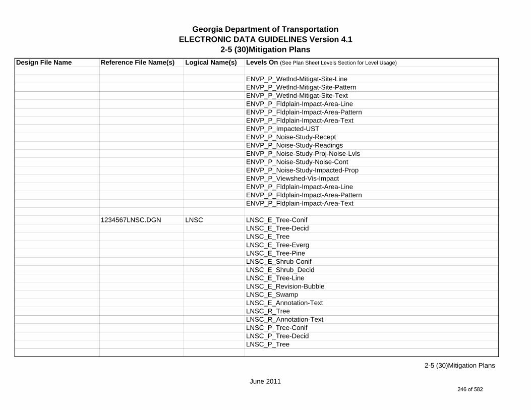
Georgia Department of TransportationELECTRONIC DATA GUIDELINES Version 4.1
2-5 (30)Mitigation Plans
Design File Name Reference File Name(s) Logical Name(s) Levels On (See Plan Sheet Levels Section for Level Usage)
ENVP_P_Wetlnd-Mitigat-Site-LineENVP_P_Wetlnd-Mitigat-Site-PatternENVP_P_Wetlnd-Mitigat-Site-TextENVP_P_Fldplain-Impact-Area-LineENVP_P_Fldplain-Impact-Area-PatternENVP_P_Fldplain-Impact-Area-TextENVP_P_Impacted-USTENVP_P_Noise-Study-ReceptENVP_P_Noise-Study-ReadingsENVP_P_Noise-Study-Proj-Noise-LvlsENVP_P_Noise-Study-Noise-ContENVP_P_Noise-Study-Impacted-PropENVP_P_Viewshed-Vis-ImpactENVP_P_Fldplain-Impact-Area-LineENVP_P_Fldplain-Impact-Area-PatternENVP_P_Fldplain-Impact-Area-Text
1234567LNSC.DGN LNSC LNSC_E_Tree-ConifLNSC_E_Tree-DecidLNSC_E_TreeLNSC_E_Tree-EvergLNSC_E_Tree-PineLNSC_E_Shrub-ConifLNSC_E_Shrub_DecidLNSC_E_Tree-LineLNSC_E_Revision-BubbleLNSC_E_SwampLNSC_E_Annotation-TextLNSC_R_TreeLNSC_R_Annotation-TextLNSC_P_Tree-ConifLNSC_P_Tree-DecidLNSC_P_Tree
June 2011
2-5 (30)Mitigation Plans
246 of 582
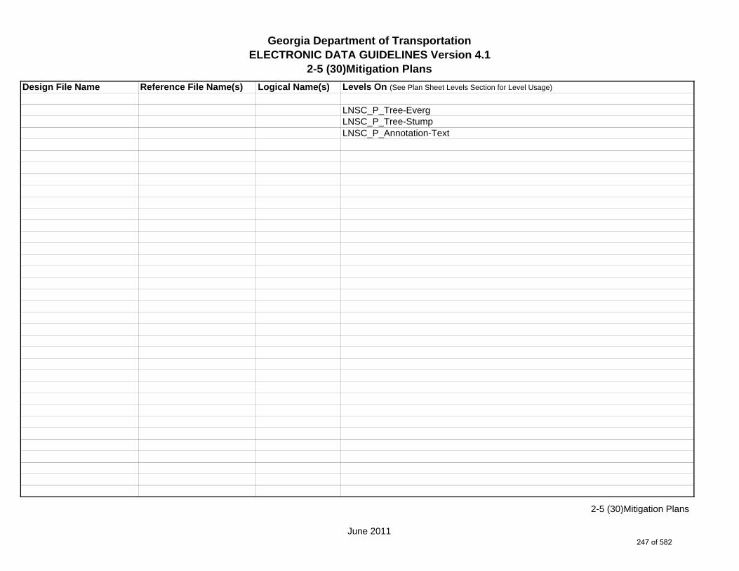
Georgia Department of TransportationELECTRONIC DATA GUIDELINES Version 4.1
2-5 (30)Mitigation Plans
Design File Name Reference File Name(s) Logical Name(s) Levels On (See Plan Sheet Levels Section for Level Usage)
LNSC_P_Tree-EvergLNSC_P_Tree-StumpLNSC_P_Annotation-Text
June 2011
2-5 (30)Mitigation Plans
247 of 582
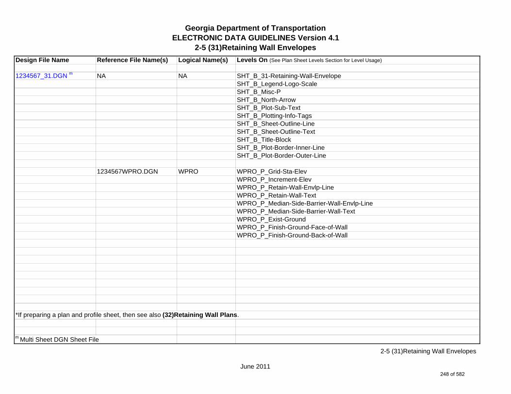
Georgia Department of TransportationELECTRONIC DATA GUIDELINES Version 4.1
2-5 (31)Retaining Wall Envelopes
Design File Name Reference File Name(s) Logical Name(s) Levels On (See Plan Sheet Levels Section for Level Usage)
1234567_31.DGN m NA NA SHT_B_31-Retaining-Wall-EnvelopeSHT_B_Legend-Logo-ScaleSHT_B_Misc-PSHT_B_North-ArrowSHT_B_Plot-Sub-TextSHT_B_Plotting-Info-TagsSHT_B_Sheet-Outline-LineSHT_B_Sheet-Outline-TextSHT_B_Title-BlockSHT_B_Plot-Border-Inner-LineSHT_B_Plot-Border-Outer-Line
1234567WPRO.DGN WPRO WPRO_P_Grid-Sta-ElevWPRO_P_Increment-ElevWPRO_P_Retain-Wall-Envlp-LineWPRO_P_Retain-Wall-TextWPRO_P_Median-Side-Barrier-Wall-Envlp-LineWPRO_P_Median-Side-Barrier-Wall-TextWPRO_P_Exist-GroundWPRO_P_Finish-Ground-Face-of-WallWPRO_P_Finish-Ground-Back-of-Wall
*If preparing a plan and profile sheet, then see also (32)Retaining Wall Plans.
m Multi Sheet DGN Sheet File
June 2011
2-5 (31)Retaining Wall Envelopes
248 of 582

Georgia Department of TransportationELECTRONIC DATA GUIDELINES Version 4.1
2-5 (32)Retaining Wall Plans
Design File Name Reference File Name(s) Logical Name(s) Levels On (See Plan Sheet Levels Section for Level Usage)
1234567_32-001.DGN s / NA NA SHT_B_32-Retaining-Wall-Plans1234567_32.DGN m SHT_B_Legend-Logo-Scale
SHT_B_Misc-PSHT_B_North-ArrowSHT_B_Plot-Sub-TextSHT_B_Plotting-Info-TagsSHT_B_Sheet-Outline-LineSHT_B_Sheet-Outline-TextSHT_B_Title-BlockSHT_B_Plot-Border-Inner-LineSHT_B_Plot-Border-Outer-Line
1234567WALL.DGN WALL WALL_P_Retain-Wall-LineWALL_P_Retain-Wall-TextWALL_P_Retain-Wall-Footing-LineWALL_P_Median-Side-Barrier-Wall-LineWALL_P_Median-Side-Barrier-Wall-TextWALL_P_Median-Side-Barrier-Wall-Foundation-Line
1234567MAIN.DGN MAIN MAIN_P_CONSTCL-LineMAIN_P_CONSTCL-Tic-Sta-TextMAIN_P_CONSTCL-PC-PT-Sta-Ldr-TextMAIN_P_CONSTCL-Brng-TextMAIN_P_CONSTCL-CellMAIN_P_SIDECL-LineMAIN_P_SIDECL-Tic-Sta-TextMAIN_P_SIDECL-PC-PT-Sta-Ldr-TextMAIN_P_SIDECL-Brng-TextMAIN_P_SIDECL-CellMAIN_P_EOP-LineMAIN_P_EPSHLDR-LineMAIN_P_Appr-Slab-Line
s Single Sheet DGN Sheet File - Plan Sheetsm Multi Sheet DGN Sheet File - Detail Sheets
June 2011
2-5 (32)Retaining Wall Plans
249 of 582
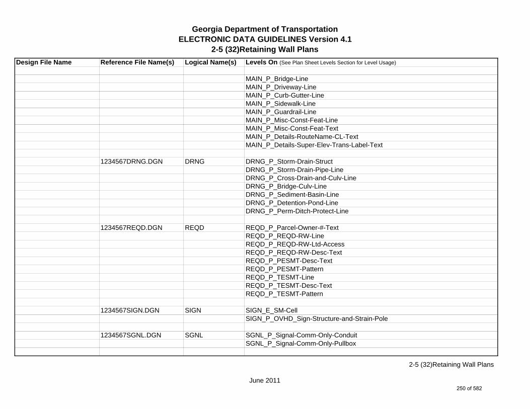
Georgia Department of TransportationELECTRONIC DATA GUIDELINES Version 4.1
2-5 (32)Retaining Wall Plans
Design File Name Reference File Name(s) Logical Name(s) Levels On (See Plan Sheet Levels Section for Level Usage)
MAIN_P_Bridge-LineMAIN_P_Driveway-LineMAIN_P_Curb-Gutter-LineMAIN_P_Sidewalk-LineMAIN_P_Guardrail-LineMAIN_P_Misc-Const-Feat-LineMAIN_P_Misc-Const-Feat-TextMAIN_P_Details-RouteName-CL-TextMAIN_P_Details-Super-Elev-Trans-Label-Text
1234567DRNG.DGN DRNG DRNG_P_Storm-Drain-StructDRNG_P_Storm-Drain-Pipe-LineDRNG_P_Cross-Drain-and-Culv-LineDRNG_P_Bridge-Culv-LineDRNG_P_Sediment-Basin-LineDRNG_P_Detention-Pond-LineDRNG_P_Perm-Ditch-Protect-Line
1234567REQD.DGN REQD REQD_P_Parcel-Owner-#-TextREQD_P_REQD-RW-LineREQD_P_REQD-RW-Ltd-AccessREQD_P_REQD-RW-Desc-TextREQD_P_PESMT-Desc-TextREQD_P_PESMT-PatternREQD_P_TESMT-LineREQD_P_TESMT-Desc-TextREQD_P_TESMT-Pattern
1234567SIGN.DGN SIGN SIGN_E_SM-CellSIGN_P_OVHD_Sign-Structure-and-Strain-Pole
1234567SGNL.DGN SGNL SGNL_P_Signal-Comm-Only-ConduitSGNL_P_Signal-Comm-Only-Pullbox
June 2011
2-5 (32)Retaining Wall Plans
250 of 582
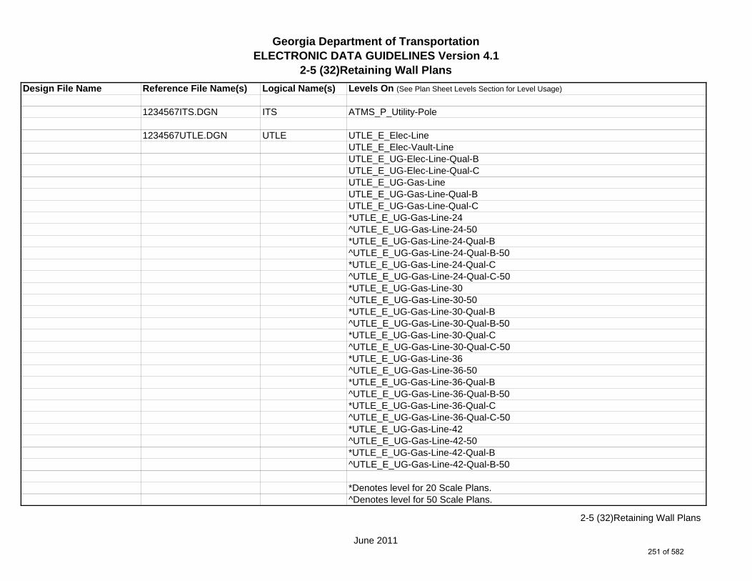
Georgia Department of TransportationELECTRONIC DATA GUIDELINES Version 4.1
2-5 (32)Retaining Wall Plans
Design File Name Reference File Name(s) Logical Name(s) Levels On (See Plan Sheet Levels Section for Level Usage)
1234567ITS.DGN ITS ATMS_P_Utility-Pole
1234567UTLE.DGN UTLE UTLE_E_Elec-LineUTLE_E_Elec-Vault-LineUTLE_E_UG-Elec-Line-Qual-BUTLE_E_UG-Elec-Line-Qual-CUTLE_E_UG-Gas-LineUTLE_E_UG-Gas-Line-Qual-BUTLE_E_UG-Gas-Line-Qual-C*UTLE_E_UG-Gas-Line-24^UTLE_E_UG-Gas-Line-24-50*UTLE_E_UG-Gas-Line-24-Qual-B^UTLE_E_UG-Gas-Line-24-Qual-B-50*UTLE_E_UG-Gas-Line-24-Qual-C^UTLE_E_UG-Gas-Line-24-Qual-C-50*UTLE_E_UG-Gas-Line-30^UTLE_E_UG-Gas-Line-30-50*UTLE_E_UG-Gas-Line-30-Qual-B^UTLE_E_UG-Gas-Line-30-Qual-B-50*UTLE_E_UG-Gas-Line-30-Qual-C^UTLE_E_UG-Gas-Line-30-Qual-C-50*UTLE_E_UG-Gas-Line-36^UTLE_E_UG-Gas-Line-36-50*UTLE_E_UG-Gas-Line-36-Qual-B^UTLE_E_UG-Gas-Line-36-Qual-B-50*UTLE_E_UG-Gas-Line-36-Qual-C^UTLE_E_UG-Gas-Line-36-Qual-C-50*UTLE_E_UG-Gas-Line-42^UTLE_E_UG-Gas-Line-42-50*UTLE_E_UG-Gas-Line-42-Qual-B^UTLE_E_UG-Gas-Line-42-Qual-B-50
*Denotes level for 20 Scale Plans.^Denotes level for 50 Scale Plans.
June 2011
2-5 (32)Retaining Wall Plans
251 of 582
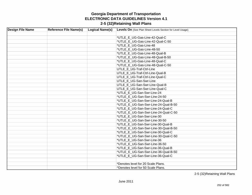
Georgia Department of TransportationELECTRONIC DATA GUIDELINES Version 4.1
2-5 (32)Retaining Wall Plans
Design File Name Reference File Name(s) Logical Name(s) Levels On (See Plan Sheet Levels Section for Level Usage)
*UTLE_E_UG-Gas-Line-42-Qual-C^UTLE_E_UG-Gas-Line-42-Qual-C-50*UTLE_E_UG-Gas-Line-48^UTLE_E_UG-Gas-Line-48-50*UTLE_E_UG-Gas-Line-48-Qual-B^UTLE_E_UG-Gas-Line-48-Qual-B-50*UTLE_E_UG-Gas-Line-48-Qual-C^UTLE_E_UG-Gas-Line-48-Qual-C-50UTLE_E_UG-Traf-Ctrl-LineUTLE_E_UG-Traf-Ctrl-Line-Qual-BUTLE_E_UG-Traf-Ctrl-Line-Qual-CUTLE_E_UG-San-Swr-LineUTLE_E_UG-San-Swr-Line-Qual-BUTLE_E_UG-San-Swr-Line-Qual-C*UTLE_E_UG-San-Swr-Line-24^UTLE_E_UG-San-Swr-Line-24-50*UTLE_E_UG-San-Swr-Line-24-Qual-B^UTLE_E_UG-San-Swr-Line-24-Qual-B-50*UTLE_E_UG-San-Swr-Line-24-Qual-C^UTLE_E_UG-San-Swr-Line-24-Qual-C-50*UTLE_E_UG-San-Swr-Line-30^UTLE_E_UG-San-Swr-Line-30-50*UTLE_E_UG-San-Swr-Line-30-Qual-B^UTLE_E_UG-San-Swr-Line-30-Qual-B-50*UTLE_E_UG-San-Swr-Line-30-Qual-C^UTLE_E_UG-San-Swr-Line-30-Qual-C-50*UTLE_E_UG-San-Swr-Line-36^UTLE_E_UG-San-Swr-Line-36-50*UTLE_E_UG-San-Swr-Line-36-Qual-B^UTLE_E_UG-San-Swr-Line-36-Qual-B-50*UTLE_E_UG-San-Swr-Line-36-Qual-C
*Denotes level for 20 Scale Plans.^Denotes level for 50 Scale Plans.
June 2011
2-5 (32)Retaining Wall Plans
252 of 582

Georgia Department of TransportationELECTRONIC DATA GUIDELINES Version 4.1
2-5 (32)Retaining Wall Plans
Design File Name Reference File Name(s) Logical Name(s) Levels On (See Plan Sheet Levels Section for Level Usage)
^UTLE_E_UG-San-Swr-Line-36-Qual-C-50*UTLE_E_UG-San-Swr-Line-42^UTLE_E_UG-San-Swr-Line-42-50*UTLE_E_UG-San-Swr-Line-42-Qual-B^UTLE_E_UG-San-Swr-Line-42-Qual-B-50*UTLE_E_UG-San-Swr-Line-42-Qual-C^UTLE_E_UG-San-Swr-Line-42-Qual-C-50*UTLE_E_UG-San-Swr-Line-48^UTLE_E_UG-San-Swr-Line-48-50*UTLE_E_UG-San-Swr-Line-48-Qual-B^UTLE_E_UG-San-Swr-Line-48-Qual-B-50*UTLE_E_UG-San-Swr-Line-48-Qual-C^UTLE_E_UG-San-Swr-Line-48-Qual-C-50UTLE_E_UG-San-Force-Main-LineUTLE_E_UG-San-Force-Main-Line-Qual-BUTLE_E_UG-San-Force-Main-Line-Qual-CUTLE_E_UG-Wat-LineUTLE_E_UG-Wat-Line-Qual-BUTLE_E_UG-Wat-Line-Qual-C*UTLE_E_UG-Wat-Line-24^UTLE_E_UG-Wat-Line-24-50*UTLE_E_UG-Wat-Line-24-Qual-B^UTLE_E_UG-Wat-Line-24-Qual-B-50*UTLE_E_UG-Wat-Line-24-Qual-C^UTLE_E_UG-Wat-Line-24-Qual-C-50*UTLE_E_UG-Wat-Line-30^UTLE_E_UG-Wat-Line-30-50*UTLE_E_UG-Wat-Line-30-Qual-B^UTLE_E_UG-Wat-Line-30-Qual-B-50*UTLE_E_UG-Wat-Line-30-Qual-C^UTLE_E_UG-Wat-Line-30-Qual-C-50
*Denotes level for 20 Scale Plans.^Denotes level for 50 Scale Plans.
June 2011
2-5 (32)Retaining Wall Plans
253 of 582
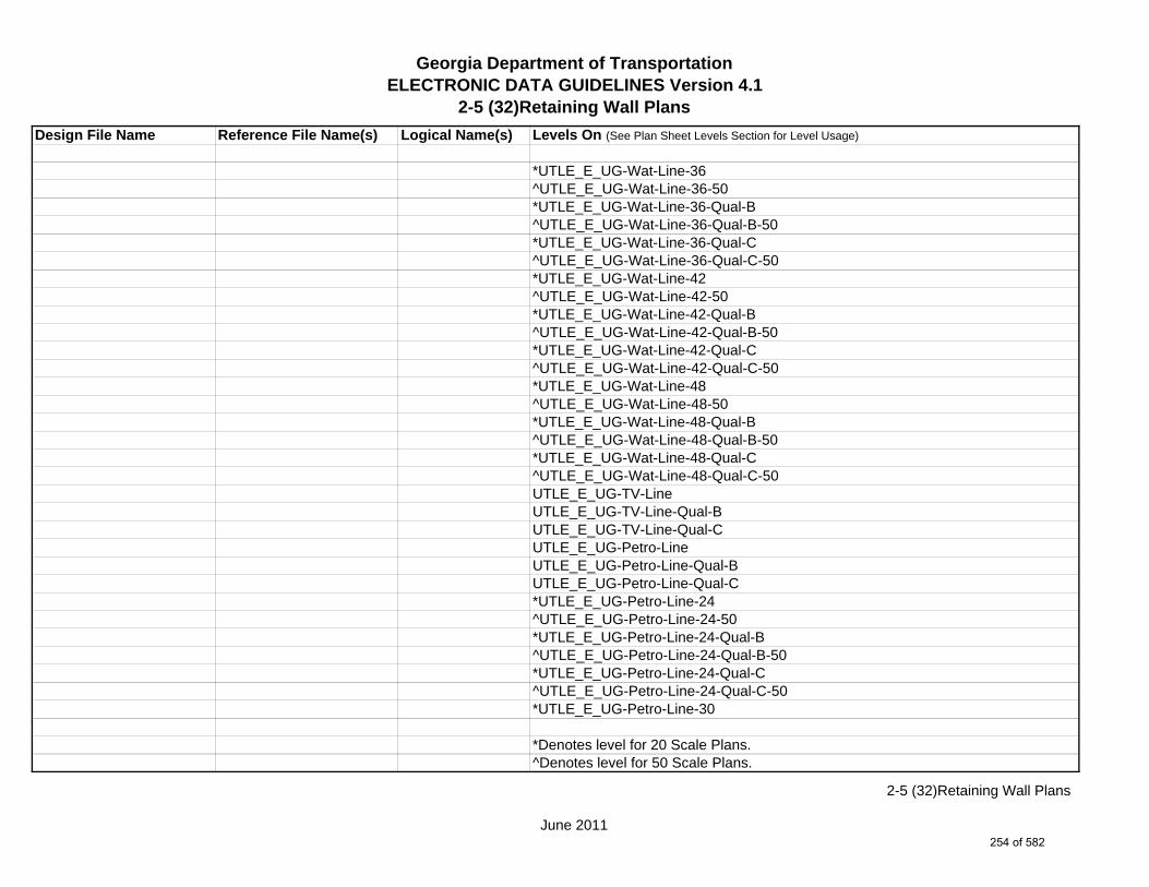
Georgia Department of TransportationELECTRONIC DATA GUIDELINES Version 4.1
2-5 (32)Retaining Wall Plans
Design File Name Reference File Name(s) Logical Name(s) Levels On (See Plan Sheet Levels Section for Level Usage)
*UTLE_E_UG-Wat-Line-36^UTLE_E_UG-Wat-Line-36-50*UTLE_E_UG-Wat-Line-36-Qual-B^UTLE_E_UG-Wat-Line-36-Qual-B-50*UTLE_E_UG-Wat-Line-36-Qual-C^UTLE_E_UG-Wat-Line-36-Qual-C-50*UTLE_E_UG-Wat-Line-42^UTLE_E_UG-Wat-Line-42-50*UTLE_E_UG-Wat-Line-42-Qual-B^UTLE_E_UG-Wat-Line-42-Qual-B-50*UTLE_E_UG-Wat-Line-42-Qual-C^UTLE_E_UG-Wat-Line-42-Qual-C-50*UTLE_E_UG-Wat-Line-48^UTLE_E_UG-Wat-Line-48-50*UTLE_E_UG-Wat-Line-48-Qual-B^UTLE_E_UG-Wat-Line-48-Qual-B-50*UTLE_E_UG-Wat-Line-48-Qual-C^UTLE_E_UG-Wat-Line-48-Qual-C-50UTLE_E_UG-TV-LineUTLE_E_UG-TV-Line-Qual-BUTLE_E_UG-TV-Line-Qual-CUTLE_E_UG-Petro-LineUTLE_E_UG-Petro-Line-Qual-BUTLE_E_UG-Petro-Line-Qual-C*UTLE_E_UG-Petro-Line-24^UTLE_E_UG-Petro-Line-24-50*UTLE_E_UG-Petro-Line-24-Qual-B^UTLE_E_UG-Petro-Line-24-Qual-B-50*UTLE_E_UG-Petro-Line-24-Qual-C^UTLE_E_UG-Petro-Line-24-Qual-C-50*UTLE_E_UG-Petro-Line-30
*Denotes level for 20 Scale Plans.^Denotes level for 50 Scale Plans.
June 2011
2-5 (32)Retaining Wall Plans
254 of 582

Georgia Department of TransportationELECTRONIC DATA GUIDELINES Version 4.1
2-5 (32)Retaining Wall Plans
Design File Name Reference File Name(s) Logical Name(s) Levels On (See Plan Sheet Levels Section for Level Usage)
^UTLE_E_UG-Petro-Line-30-50*UTLE_E_UG-Petro-Line-30-Qual-B^UTLE_E_UG-Petro-Line-30-Qual-B-50*UTLE_E_UG-Petro-Line-30-Qual-C^UTLE_E_UG-Petro-Line-30-Qual-C-50*UTLE_E_UG-Petro-Line-36^UTLE_E_UG-Petro-Line-36-50*UTLE_E_UG-Petro-Line-36-Qual-B^UTLE_E_UG-Petro-Line-36-Qual-B-50*UTLE_E_UG-Petro-Line-36-Qual-C^UTLE_E_UG-Petro-Line-36-Qual-C-50*UTLE_E_UG-Petro-Line-42^UTLE_E_UG-Petro-Line-42-50*UTLE_E_UG-Petro-Line-42-Qual-B^UTLE_E_UG-Petro-Line-42-Qual-B-50*UTLE_E_UG-Petro-Line-42-Qual-C^UTLE_E_UG-Petro-Line-42-Qual-C-50*UTLE_E_UG-Petro-Line-48^UTLE_E_UG-Petro-Line-48-50*UTLE_E_UG-Petro-Line-48-Qual-B^UTLE_E_UG-Petro-Line-48-Qual-B-50*UTLE_E_UG-Petro-Line-48-Qual-C^UTLE_E_UG-Petro-Line-48-Qual-C-50UTLE_E_UG-Tele-LineUTLE_E_UG-Tele-Line-Qual-BUTLE_E_UG-Tele-Line-Qual-CUTLE_E_UG-Wat-Non-Pot-LineUTLE_E_UG-Wat-Non-Pot-Line-Qual-BUTLE_E_UG-Wat-Non-Pot-Line-Qual-C*UTLE_E_UG-Wat-Non-Pot-Line-24^UTLE_E_UG-Wat-Non-Pot-Line-24-50
*Denotes level for 20 Scale Plans.^Denotes level for 50 Scale Plans.
June 2011
2-5 (32)Retaining Wall Plans
255 of 582
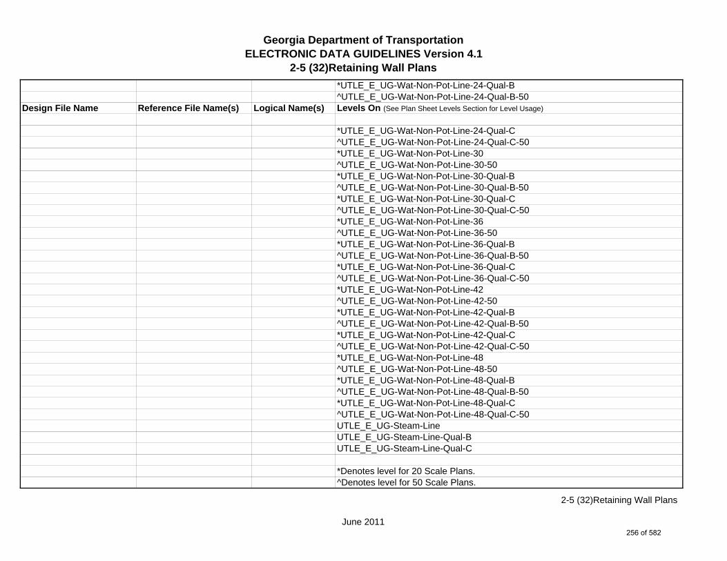
Georgia Department of TransportationELECTRONIC DATA GUIDELINES Version 4.1
2-5 (32)Retaining Wall Plans
*UTLE_E_UG-Wat-Non-Pot-Line-24-Qual-B^UTLE_E_UG-Wat-Non-Pot-Line-24-Qual-B-50
Design File Name Reference File Name(s) Logical Name(s) Levels On (See Plan Sheet Levels Section for Level Usage)
*UTLE_E_UG-Wat-Non-Pot-Line-24-Qual-C^UTLE_E_UG-Wat-Non-Pot-Line-24-Qual-C-50*UTLE_E_UG-Wat-Non-Pot-Line-30^UTLE_E_UG-Wat-Non-Pot-Line-30-50*UTLE_E_UG-Wat-Non-Pot-Line-30-Qual-B^UTLE_E_UG-Wat-Non-Pot-Line-30-Qual-B-50*UTLE_E_UG-Wat-Non-Pot-Line-30-Qual-C^UTLE_E_UG-Wat-Non-Pot-Line-30-Qual-C-50*UTLE_E_UG-Wat-Non-Pot-Line-36^UTLE_E_UG-Wat-Non-Pot-Line-36-50*UTLE_E_UG-Wat-Non-Pot-Line-36-Qual-B^UTLE_E_UG-Wat-Non-Pot-Line-36-Qual-B-50*UTLE_E_UG-Wat-Non-Pot-Line-36-Qual-C^UTLE_E_UG-Wat-Non-Pot-Line-36-Qual-C-50*UTLE_E_UG-Wat-Non-Pot-Line-42^UTLE_E_UG-Wat-Non-Pot-Line-42-50*UTLE_E_UG-Wat-Non-Pot-Line-42-Qual-B^UTLE_E_UG-Wat-Non-Pot-Line-42-Qual-B-50*UTLE_E_UG-Wat-Non-Pot-Line-42-Qual-C^UTLE_E_UG-Wat-Non-Pot-Line-42-Qual-C-50*UTLE_E_UG-Wat-Non-Pot-Line-48^UTLE_E_UG-Wat-Non-Pot-Line-48-50*UTLE_E_UG-Wat-Non-Pot-Line-48-Qual-B^UTLE_E_UG-Wat-Non-Pot-Line-48-Qual-B-50*UTLE_E_UG-Wat-Non-Pot-Line-48-Qual-C^UTLE_E_UG-Wat-Non-Pot-Line-48-Qual-C-50UTLE_E_UG-Steam-LineUTLE_E_UG-Steam-Line-Qual-BUTLE_E_UG-Steam-Line-Qual-C
*Denotes level for 20 Scale Plans.^Denotes level for 50 Scale Plans.
June 2011
2-5 (32)Retaining Wall Plans
256 of 582

Georgia Department of TransportationELECTRONIC DATA GUIDELINES Version 4.1
2-5 (32)Retaining Wall Plans
Design File Name Reference File Name(s) Logical Name(s) Levels On (See Plan Sheet Levels Section for Level Usage)
*UTLE_E_UG-Steam-Line-24^UTLE_E_UG-Steam-Line-24-50*UTLE_E_UG-Steam-Line-24-Qual-B^UTLE_E_UG-Steam-Line-24-Qual-B-50*UTLE_E_UG-Steam-Line-24-Qual-C^UTLE_E_UG-Steam-Line-24-Qual-C-50*UTLE_E_UG-Steam-Line-30^UTLE_E_UG-Steam-Line-30-50*UTLE_E_UG-Steam-Line-30-Qual-B^UTLE_E_UG-Steam-Line-30-Qual-B-50*UTLE_E_UG-Steam-Line-30-Qual-C^UTLE_E_UG-Steam-Line-30-Qual-C-50*UTLE_E_UG-Steam-Line-36^UTLE_E_UG-Steam-Line-36-50*UTLE_E_UG-Steam-Line-36-Qual-B^UTLE_E_UG-Steam-Line-36-Qual-B-50*UTLE_E_UG-Steam-Line-36-Qual-C^UTLE_E_UG-Steam-Line-36-Qual-C-50*UTLE_E_UG-Steam-Line-42^UTLE_E_UG-Steam-Line-42-50*UTLE_E_UG-Steam-Line-42-Qual-B^UTLE_E_UG-Steam-Line-42-Qual-B-50*UTLE_E_UG-Steam-Line-42-Qual-C^UTLE_E_UG-Steam-Line-42-Qual-C-50*UTLE_E_UG-Steam-Line-48^UTLE_E_UG-Steam-Line-48-50*UTLE_E_UG-Steam-Line-48-Qual-B^UTLE_E_UG-Steam-Line-48-Qual-B-50*UTLE_E_UG-Steam-Line-48-Qual-C^UTLE_E_UG-Steam-Line-48-Qual-C-50UTLE_E_UG-Utl-Unknown-Line-Qual-B
*Denotes level for 20 Scale Plans.^Denotes level for 50 Scale Plans.
June 2011
2-5 (32)Retaining Wall Plans
257 of 582
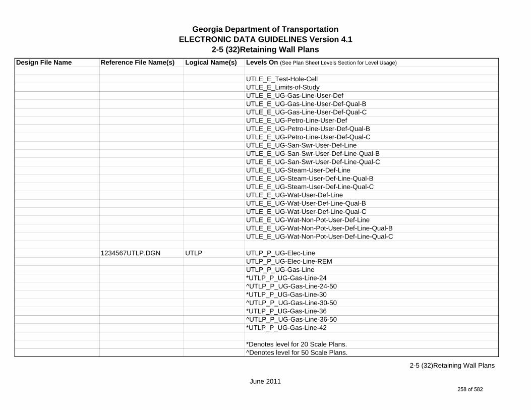
Georgia Department of TransportationELECTRONIC DATA GUIDELINES Version 4.1
2-5 (32)Retaining Wall Plans
Design File Name Reference File Name(s) Logical Name(s) Levels On (See Plan Sheet Levels Section for Level Usage)
UTLE_E_Test-Hole-CellUTLE_E_Limits-of-StudyUTLE_E_UG-Gas-Line-User-DefUTLE_E_UG-Gas-Line-User-Def-Qual-BUTLE_E_UG-Gas-Line-User-Def-Qual-CUTLE_E_UG-Petro-Line-User-DefUTLE_E_UG-Petro-Line-User-Def-Qual-BUTLE_E_UG-Petro-Line-User-Def-Qual-CUTLE_E_UG-San-Swr-User-Def-LineUTLE_E_UG-San-Swr-User-Def-Line-Qual-BUTLE_E_UG-San-Swr-User-Def-Line-Qual-CUTLE_E_UG-Steam-User-Def-LineUTLE_E_UG-Steam-User-Def-Line-Qual-BUTLE_E_UG-Steam-User-Def-Line-Qual-CUTLE_E_UG-Wat-User-Def-LineUTLE_E_UG-Wat-User-Def-Line-Qual-BUTLE_E_UG-Wat-User-Def-Line-Qual-CUTLE_E_UG-Wat-Non-Pot-User-Def-LineUTLE_E_UG-Wat-Non-Pot-User-Def-Line-Qual-BUTLE_E_UG-Wat-Non-Pot-User-Def-Line-Qual-C
1234567UTLP.DGN UTLP UTLP_P_UG-Elec-LineUTLP_P_UG-Elec-Line-REMUTLP_P_UG-Gas-Line*UTLP_P_UG-Gas-Line-24^UTLP_P_UG-Gas-Line-24-50*UTLP_P_UG-Gas-Line-30^UTLP_P_UG-Gas-Line-30-50*UTLP_P_UG-Gas-Line-36^UTLP_P_UG-Gas-Line-36-50*UTLP_P_UG-Gas-Line-42
*Denotes level for 20 Scale Plans.^Denotes level for 50 Scale Plans.
June 2011
2-5 (32)Retaining Wall Plans
258 of 582
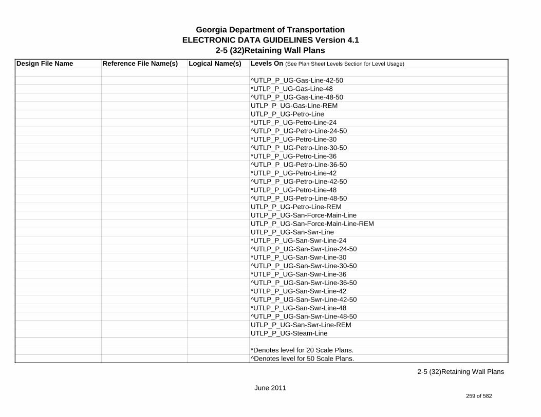
Georgia Department of TransportationELECTRONIC DATA GUIDELINES Version 4.1
2-5 (32)Retaining Wall Plans
Design File Name Reference File Name(s) Logical Name(s) Levels On (See Plan Sheet Levels Section for Level Usage)
^UTLP_P_UG-Gas-Line-42-50*UTLP_P_UG-Gas-Line-48^UTLP_P_UG-Gas-Line-48-50UTLP_P_UG-Gas-Line-REMUTLP_P_UG-Petro-Line*UTLP_P_UG-Petro-Line-24^UTLP_P_UG-Petro-Line-24-50*UTLP_P_UG-Petro-Line-30^UTLP_P_UG-Petro-Line-30-50*UTLP_P_UG-Petro-Line-36^UTLP_P_UG-Petro-Line-36-50*UTLP_P_UG-Petro-Line-42^UTLP_P_UG-Petro-Line-42-50*UTLP_P_UG-Petro-Line-48^UTLP_P_UG-Petro-Line-48-50UTLP_P_UG-Petro-Line-REMUTLP_P_UG-San-Force-Main-LineUTLP_P_UG-San-Force-Main-Line-REMUTLP_P_UG-San-Swr-Line*UTLP_P_UG-San-Swr-Line-24^UTLP_P_UG-San-Swr-Line-24-50*UTLP_P_UG-San-Swr-Line-30^UTLP_P_UG-San-Swr-Line-30-50*UTLP_P_UG-San-Swr-Line-36^UTLP_P_UG-San-Swr-Line-36-50*UTLP_P_UG-San-Swr-Line-42^UTLP_P_UG-San-Swr-Line-42-50*UTLP_P_UG-San-Swr-Line-48^UTLP_P_UG-San-Swr-Line-48-50UTLP_P_UG-San-Swr-Line-REMUTLP_P_UG-Steam-Line
*Denotes level for 20 Scale Plans.^Denotes level for 50 Scale Plans.
June 2011
2-5 (32)Retaining Wall Plans
259 of 582

Georgia Department of TransportationELECTRONIC DATA GUIDELINES Version 4.1
2-5 (32)Retaining Wall Plans
Design File Name Reference File Name(s) Logical Name(s) Levels On (See Plan Sheet Levels Section for Level Usage)
*UTLP_P_UG-Steam-Line-24^UTLP_P_UG-Steam-Line-24-50*UTLP_P_UG-Steam-Line-30^UTLP_P_UG-Steam-Line-30-50*UTLP_P_UG-Steam-Line-36^UTLP_P_UG-Steam-Line-36-50*UTLP_P_UG-Steam-Line-42^UTLP_P_UG-Steam-Line-42-50*UTLP_P_UG-Steam-Line-48^UTLP_P_UG-Steam-Line-48-50UTLP_P_UG-Steam-Line-REMUTLP_P_UG-Tele-LineUTLP_P_UG-Tele-Line-REMUTLP_P_UG-TV-LineUTLP_P_UG-TV-Line-REMUTLP_P_UG-Wat-Line*UTLP_P_UG-Wat-Line-24^UTLP_P_UG-Wat-Line-24-50*UTLP_P_UG-Wat-Line-30^UTLP_P_UG-Wat-Line-30-50*UTLP_P_UG-Wat-Line-36^UTLP_P_UG-Wat-Line-36-50*UTLP_P_UG-Wat-Line-42^UTLP_P_UG-Wat-Line-42-50*UTLP_P_UG-Wat-Line-48^UTLP_P_UG-Wat-Line-48-50UTLP_P_UG-Wat-Line-REMUTLP_P_UG-Wat-Non-Pot-Line*UTLP_P_UG-Wat-Non-Pot-Line-24^UTLP_P_UG-Wat-Non-Pot-Line-24-50*UTLP_P_UG-Wat-Non-Pot-Line-30
*Denotes level for 20 Scale Plans.^Denotes level for 50 Scale Plans.
June 2011
2-5 (32)Retaining Wall Plans
260 of 582

Georgia Department of TransportationELECTRONIC DATA GUIDELINES Version 4.1
2-5 (32)Retaining Wall Plans
Design File Name Reference File Name(s) Logical Name(s) Levels On (See Plan Sheet Levels Section for Level Usage)
^UTLP_P_UG-Wat-Non-Pot-Line-30-50*UTLP_P_UG-Wat-Non-Pot-Line-36^UTLP_P_UG-Wat-Non-Pot-Line-36-50*UTLP_P_UG-Wat-Non-Pot-Line-42^UTLP_P_UG-Wat-Non-Pot-Line-42-50*UTLP_P_UG-Wat-Non-Pot-Line-48^UTLP_P_UG-Wat-Non-Pot-Line-48-50UTLP_P_UG-Wat-Non-Pot-Line-REMUTLP_P_UG-Gas-Line-User-DefUTLP_P_UG-Petro-Line-User-DefUTLP_P_UG-San-Swr-Line-User-DefUTLP_P_UG-Steam-Line-User-DefUTLP_P_UG-Wat-Line-User-DefUTLP_P_UG-Wat-Non-Pot-User-Def-Line
1234567ECON.DGN ECON ECON_E_Major-Contour-Line (Optional)ECON_E_Major-Contour-Text (Optional)ECON_E_Minor-Contour-Line (Optional)ECON_E_Minor-Contour-Text (Optional)ECON_E_Slope Direction-Line (Optional)
1234567FCON.DGN FCON FCON_P_Major-Contour-Line (Optional)FCON_P_Major-Contour-Text (Optional)FCON_P_Minor-Contour-Line (Optional)FCON_P_Minor-Contour-Text (Optional)FCON_P_Slope Direction-Line (Optional)
1234567LIMT.DGN LIMT LIMT_P_STKCUT_Const-Limit-Cut-LineLIMT_P_CUT_Const-Limit-Cut-CellLIMT_P_STKFIL_Const-Limit-Fill-LineLIMT_P_FILL_Const-Limit-Fill-Cell
*Denotes level for 20 Scale Plans.^Denotes level for 50 Scale Plans.
June 2011
2-5 (32)Retaining Wall Plans
261 of 582

Georgia Department of TransportationELECTRONIC DATA GUIDELINES Version 4.1
2-5 (32)Retaining Wall Plans
Design File Name Reference File Name(s) Logical Name(s) Levels On (See Plan Sheet Levels Section for Level Usage)
1234567PROP.DGN PROP PROP_E_PAR-PL-LinePROP_E_RWE-Line PROP_E_RWRR-LinePROP_E_RWRR-TextPROP_E_RWU-LinePROP_E_RWU-TextPROP_E_POEL-LinePROP_E_POEL-TextPROP_E_BMISC-LinePROP_E_BMISC-Text
1234567TOPO.DGN TOPO TOPO_E_TEAP-LineTOPO_E_TEAS-LineTOPO_E_TECP-LineTOPO_E_TEDR-LineTOPO_E_TEST-LineTOPO_E_TEDD-LineTOPO_E_TEAD-LineTOPO_E_TECD-LineTOPO_E_TAC-LineTOPO_E_TCGF-LineTOPO_E_TCGT-LineTOPO_E_THC-LineTOPO_E_TVG-LineTOPO_E_TSW-LineTOPO_E_TGR-LineTOPO_E_TBAS-LineTOPO_E_TBGL-LineTOPO_E_TBRDGCEN-LineTOPO_E_TBRDGCOR-LineTOPO_E_THM-CellTOPO_E_TFP-LineTOPO_E_TRCR-LineTOPO_E_TRCR-Text
June 2011
2-5 (32)Retaining Wall Plans
262 of 582

Georgia Department of TransportationELECTRONIC DATA GUIDELINES Version 4.1
2-5 (32)Retaining Wall Plans
Design File Name Reference File Name(s) Logical Name(s) Levels On (See Plan Sheet Levels Section for Level Usage)
TOPO_E_TRCRE-LineTOPO_E_TRCRE-TextTOPO_E_TBLD-LineTOPO_E_TBLDRL-LineTOPO_E_TUD-LineTOPO_E_TS-LineTOPO_E_TBC-LineTOPO_E_TFE-LineTOPO_E_DSTC-LineTOPO_E_DDL-LineTOPO_E_TCAN-LineTOPO_E_THCR-LineTOPO_E_THRL-LineTOPO_E_TMHCR-LineTOPO_E_TMHRL-LineTOPO_E_TFCL-LineTOPO_E_TFW-LineTOPO_E_TFBW-LineTOPO_E_TFFW-LineTOPO_E_TVF-LineTOPO_E_TG-LineTOPO_E_TWELL-LineTOPO_E_TGFV-LineTOPO_E_TGMW-LineTOPO_E_TGP-LineTOPO_E_TGPI-LineTOPO_E_TFT-LineTOPO_E_TGST-LineTOPO_E_TGVP-LineTOPO_E_DCEF-LineTOPO_E_DCEF-TextTOPO_E_DCB-LineTOPO_E_DCB-TextTOPO_E_DCWE-Line
June 2011
2-5 (32)Retaining Wall Plans
263 of 582

Georgia Department of TransportationELECTRONIC DATA GUIDELINES Version 4.1
2-5 (32)Retaining Wall Plans
Design File Name Reference File Name(s) Logical Name(s) Levels On (See Plan Sheet Levels Section for Level Usage)
TOPO_E_DCWE-TextTOPO_E_DDCB-LineTOPO_E_DDCB-TextTOPO_E_DDI-LineTOPO_E_DDI-TextTOPO_E_DHWE-LineTOPO_E_DHWE-TextTOPO_E_DJB-LineTOPO_E_DJB-TextTOPO_E_DPC-LineTOPO_E_DPC-TextTOPO_E_DPM-LineTOPO_E_DPM-TextTOPO_E_DPP-LineTOPO_E_DPP-TextTOPO_E_MDITCHFL-LineTOPO_E_MDITCHFL-TextTOPO_E_DPD-LineTOPO_E_DPD-TextTOPO_E_DSB-LineTOPO_E_DSB-TextTOPO_E_DSC-LineTOPO_E_DSC-TextTOPO_E_DSE-LineTOPO_E_DSE-TextTOPO_E_DWE-LineTOPO_E_DWE-TextTOPO_E_DEW-LineTOPO_E_DEW-TextTOPO_E_DHWM-LineTOPO_E_DHWM-TextTOPO_E_DSWE-LineTOPO_E_DSWE-TextTOPO_E_DMISC-Line
June 2011
2-5 (32)Retaining Wall Plans
264 of 582
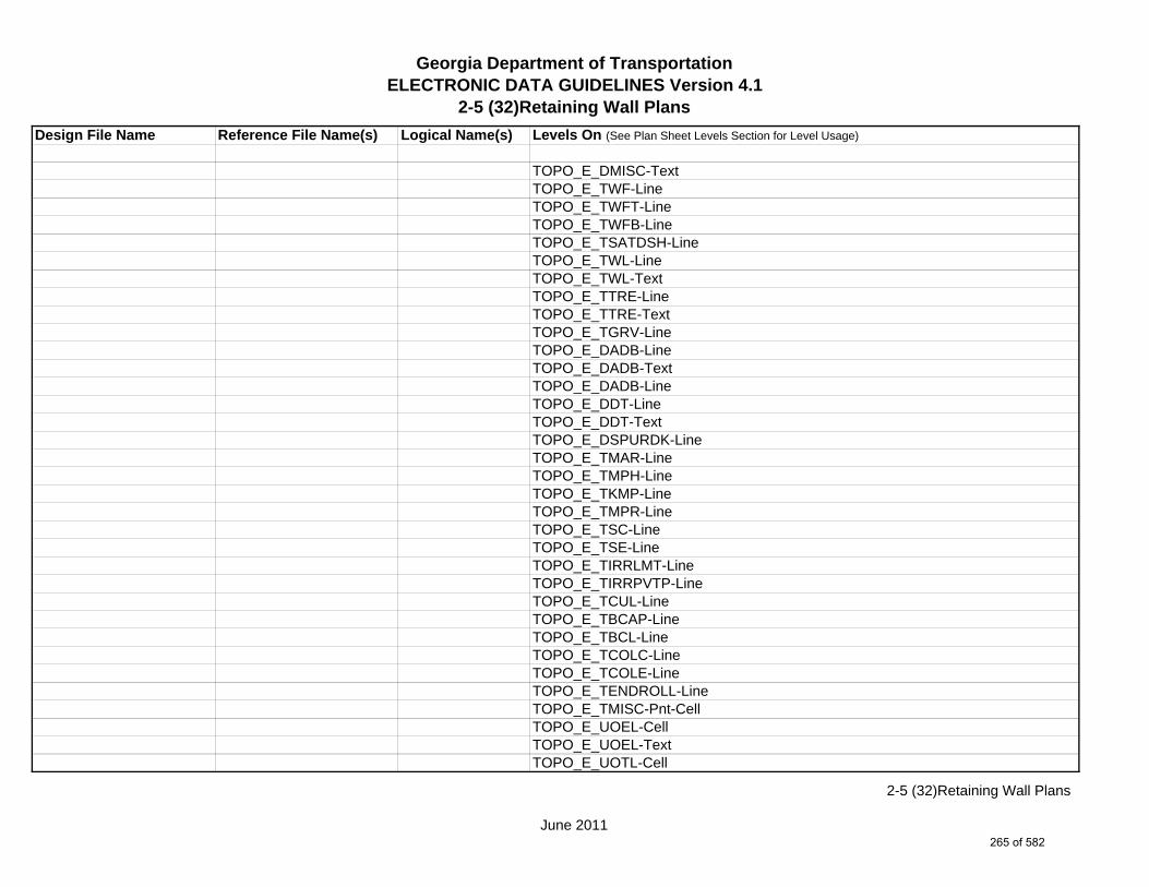
Georgia Department of TransportationELECTRONIC DATA GUIDELINES Version 4.1
2-5 (32)Retaining Wall Plans
Design File Name Reference File Name(s) Logical Name(s) Levels On (See Plan Sheet Levels Section for Level Usage)
TOPO_E_DMISC-TextTOPO_E_TWF-LineTOPO_E_TWFT-LineTOPO_E_TWFB-LineTOPO_E_TSATDSH-LineTOPO_E_TWL-LineTOPO_E_TWL-TextTOPO_E_TTRE-LineTOPO_E_TTRE-TextTOPO_E_TGRV-LineTOPO_E_DADB-LineTOPO_E_DADB-TextTOPO_E_DADB-LineTOPO_E_DDT-LineTOPO_E_DDT-TextTOPO_E_DSPURDK-LineTOPO_E_TMAR-LineTOPO_E_TMPH-LineTOPO_E_TKMP-LineTOPO_E_TMPR-LineTOPO_E_TSC-LineTOPO_E_TSE-LineTOPO_E_TIRRLMT-LineTOPO_E_TIRRPVTP-LineTOPO_E_TCUL-LineTOPO_E_TBCAP-LineTOPO_E_TBCL-LineTOPO_E_TCOLC-LineTOPO_E_TCOLE-LineTOPO_E_TENDROLL-LineTOPO_E_TMISC-Pnt-CellTOPO_E_UOEL-CellTOPO_E_UOEL-TextTOPO_E_UOTL-Cell
June 2011
2-5 (32)Retaining Wall Plans
265 of 582

Georgia Department of TransportationELECTRONIC DATA GUIDELINES Version 4.1
2-5 (32)Retaining Wall Plans
Design File Name Reference File Name(s) Logical Name(s) Levels On (See Plan Sheet Levels Section for Level Usage)
TOPO_E_UOTL-TextTOPO_E_UELBOX-CellTOPO_E_UELBOX-TextTOPO_E_UPP-CellTOPO_E_UPP-TextTOPO_E_ULP-CellTOPO_E_ULP-TextTOPO_E_UTP-CellTOPO_E_UTP-TextTOPO_E_UTPD-CellTOPO_E_UTPD-TextTOPO_E_UGP-CellTOPO_E_UGP-TextTOPO_E_UPGA-CellTOPO_E_UPGA-TextTOPO_E_UYLE-CellTOPO_E_UYLE-TextTOPO_E_UYLG-CellTOPO_E_UYLG-TextTOPO_E_UWM-CellTOPO_E_UWM-TextTOPO_E_UWV-CellTOPO_E_UWV-TextTOPO_E_UFH-CellTOPO_E_UFH-TextTOPO_E_UMHST-CellTOPO_E_UMHST-TextTOPO_E_UMHSTF-CellTOPO_E_UMHSTF-TextTOPO_E_UMHT-CellTOPO_E_UMHT-TextTOPO_E_UMHE-CellTOPO_E_UMHE-TextTOPO_E_UMHSS-Cell
June 2011
2-5 (32)Retaining Wall Plans
266 of 582

Georgia Department of TransportationELECTRONIC DATA GUIDELINES Version 4.1
2-5 (32)Retaining Wall Plans
Design File Name Reference File Name(s) Logical Name(s) Levels On (See Plan Sheet Levels Section for Level Usage)
TOPO_E_UMHSS-TextTOPO_E_UMHSSF-CellTOPO_E_UMHSSF-TextTOPO_E_USSL-CellTOPO_E_USSL-TextTOPO_E_UGM-CellTOPO_E_UGM-TextTOPO_E_UNGV-CellTOPO_E_UNGV-TextTOPO_E_UNGVP-CellTOPO_E_UNGVP-TextTOPO_E_UNGLM-CellTOPO_E_UNGLM-TextTOPO_E_SLCD-Pnt#-TextTOPO_E_SLCD-CellTOPO_E_SLCD-LineTOPO_E_SLCD-Line-TextTOPO_E_SDCD-Pnt#-TextTOPO_E_SDCD-CellTOPO_E_SDCD-LineTOPO_E_SDCD-Line-TextTOPO_E_SCCHK-CellTOPO_E_SCCHK-LineTOPO_E_SCCHK-TextTOPO_E_SBNCHMK-Pnt#-TextTOPO_E_SBNCHMK-CellTOPO_E_SBNCHMK-TextTOPO_E_SNGSCM-Pnt#-TextTOPO_E_SNGSCM-CellTOPO_E_SNGSCM-TextTOPO_E_SLCM-Pnt#-TextTOPO_E_SLCM-CellTOPO_E_SLCM-TextTOPO_E_SLCM-Line
June 2011
2-5 (32)Retaining Wall Plans
267 of 582

Georgia Department of TransportationELECTRONIC DATA GUIDELINES Version 4.1
2-5 (32)Retaining Wall Plans
Design File Name Reference File Name(s) Logical Name(s) Levels On (See Plan Sheet Levels Section for Level Usage)
TOPO_E_POOL-LineTOPO_E_POOL-TextTOPO_E_FNDN-LineTOPO_E_RUIN-LineTOPO_E_TANK-LineTOPO_E_DTCH-LineTOPO_E_DTCH-TextTOPO_E_DTCH-Hidden-LineTOPO_E_DTCH-Hidden-TextTOPO_E_TWFE-LineTOPO_E_TWFE-TextTOPO_E_GOLF-LineTOPO_E_GOLF-TextTOPO_E_Basketball-Court-CellTOPO_E_Basketball-Court-LineTOPO_E_Basketball-Court-TextTOPO_E_Flow-Arrow-CellTOPO_E_DEW-Hatch-LineTOPO_E_DITCH-Taper-CellTOPO_E_TRAIL-LineTOPO_E_TRAIL-Text
June 2011
2-5 (32)Retaining Wall Plans
268 of 582

Georgia Department of TransportationELECTRONIC DATA GUIDELINES Version 4.1
2-5 (33)Sound Barrier Envelopes
Design File Name Reference File Name(s) Logical Name(s) Levels On (See Plan Sheet Levels Section for Level Usage)
1234567_33.DGN m NA NA SHT_B_33-Noise-Barrier-EnvelopesSHT_B_Legend-Logo-ScaleSHT_B_Misc-PSHT_B_North-ArrowSHT_B_Plot-Sub-TextSHT_B_Plotting-Info-TagsSHT_B_Sheet-Outline-LineSHT_B_Sheet-Outline-TextSHT_B_Title-BlockSHT_B_Plot-Border-Inner-LineSHT_B_Plot-Border-Outer-Line
1234567WPRO.DGN WPRO WPRO_P_Grid-Sta-ElevWPRO_P_Increment-ElevWPRO_P_Sound-Barrier-Wall-Envlp-LineWPRO_P_Sound-Barrier-Wall-TextWPRO_P_Exist-GroundWPRO_P_Finish-Ground-Face-of-WallWPRO_P_Finish-Ground-Back-of-Wall
*If preparing a plan and profile sheet, then see also (34)Sound Barrier Plans.
m Multi Sheet DGN Sheet File
June 2011
2-5 (33)Sound Barrier Envelopes
269 of 582
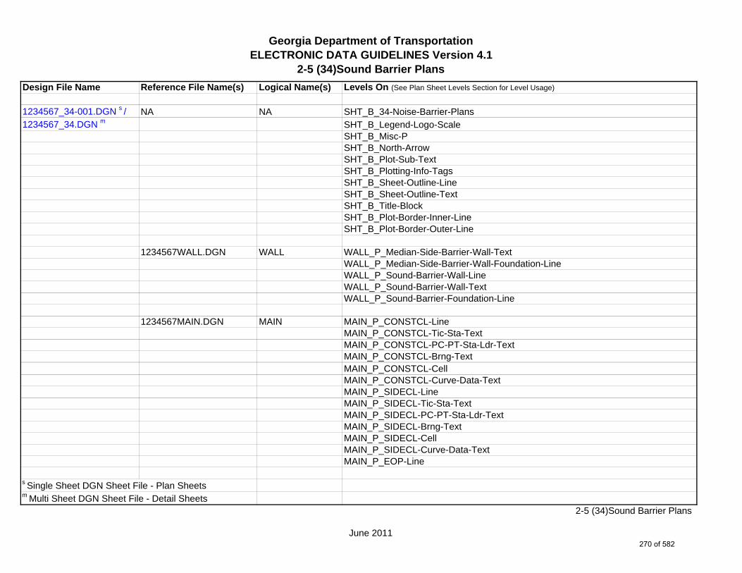
Georgia Department of TransportationELECTRONIC DATA GUIDELINES Version 4.1
2-5 (34)Sound Barrier Plans
Design File Name Reference File Name(s) Logical Name(s) Levels On (See Plan Sheet Levels Section for Level Usage)
1234567_34-001.DGN s / NA NA SHT_B_34-Noise-Barrier-Plans1234567_34.DGN m SHT_B_Legend-Logo-Scale
SHT_B_Misc-PSHT_B_North-ArrowSHT_B_Plot-Sub-TextSHT_B_Plotting-Info-TagsSHT_B_Sheet-Outline-LineSHT_B_Sheet-Outline-TextSHT_B_Title-BlockSHT_B_Plot-Border-Inner-LineSHT_B_Plot-Border-Outer-Line
1234567WALL.DGN WALL WALL_P_Median-Side-Barrier-Wall-TextWALL_P_Median-Side-Barrier-Wall-Foundation-LineWALL_P_Sound-Barrier-Wall-LineWALL_P_Sound-Barrier-Wall-TextWALL_P_Sound-Barrier-Foundation-Line
1234567MAIN.DGN MAIN MAIN_P_CONSTCL-LineMAIN_P_CONSTCL-Tic-Sta-TextMAIN_P_CONSTCL-PC-PT-Sta-Ldr-TextMAIN_P_CONSTCL-Brng-TextMAIN_P_CONSTCL-CellMAIN_P_CONSTCL-Curve-Data-TextMAIN_P_SIDECL-LineMAIN_P_SIDECL-Tic-Sta-TextMAIN_P_SIDECL-PC-PT-Sta-Ldr-TextMAIN_P_SIDECL-Brng-TextMAIN_P_SIDECL-CellMAIN_P_SIDECL-Curve-Data-TextMAIN_P_EOP-Line
s Single Sheet DGN Sheet File - Plan Sheetsm Multi Sheet DGN Sheet File - Detail Sheets
June 2011
2-5 (34)Sound Barrier Plans
270 of 582

Georgia Department of TransportationELECTRONIC DATA GUIDELINES Version 4.1
2-5 (34)Sound Barrier Plans
Design File Name Reference File Name(s) Logical Name(s) Levels On (See Plan Sheet Levels Section for Level Usage)
MAIN_P_EOP-TextMAIN_P_EOP-CellMAIN_P_EPSHLDR-LineMAIN_P_Appr-Slab-LineMAIN_P_Appr-Slab-TextMAIN_P_Bridge-LineMAIN_P_Bridge-TextMAIN_P_Driveway-LineMAIN_P_Curb-Gutter-LineMAIN_P_Sidewalk-LineMAIN_P_Guardrail-LineMAIN_P_Guardrail-TextMAIN_P_Median-Side-Barrier-LineMAIN_P_Median-Side-Barrier-TextMAIN_P_Retain-Wall-LineMAIN_P_Retain-Wall-TextMAIN_P_Sound-Barrier-Wall-LineMAIN_P_Sound-Barrier-Wall-TextMAIN_P_Misc-Const-Feat-LineMAIN_P_Misc-Const-Feat-TextMAIN_P_Details-End-Proj-CL-Intersect-Label-TextMAIN_P_Details-Begin-End-Const-Limit-Const-Label-TextMAIN_P_Details-RouteName-CL-TextMAIN_P_Details-Super-Elev-Trans-Label-Text
1234567DRNG.DGN DRNG DRNG_P_Storm-Drain-Struct-TextDRNG_P_Storm-Drain-StructDRNG_P_Storm-Drain-Pipe-LineDRNG_P_Storm-Drain-Pipe-TextDRNG_P_Ditch-and-Channel-LineDRNG_P_Ditch-and-Channel-TextDRNG_P_Cross-Drain-and-Culv-LineDRNG_P_Bridge-Culv-LineDRNG_P_Bridge-Culv-Text
June 2011
2-5 (34)Sound Barrier Plans
271 of 582

Georgia Department of TransportationELECTRONIC DATA GUIDELINES Version 4.1
2-5 (34)Sound Barrier Plans
Design File Name Reference File Name(s) Logical Name(s) Levels On (See Plan Sheet Levels Section for Level Usage)
DRNG_P_Sediment-Basin-LineDRNG_P_Detention-Pond-LineDRNG_P_Perm-Riprap-PatternDRNG_P_Perm-Ditch-Protect-TextDRNG_P_Perm-Ditch-Protect-LineDRNG_P_Sediment-Basin-Pnt-SymbolDRNG_P_Sediment-Basin-Pnt-TextDRNG_P_Detention-Pond-Pnt-SymbolDRNG_P_Detention-Pond-Pnt-Text
1234567REQD.DGN REQD REQD_P_Parcel-Owner-TextREQD_P_Parcel-Owner-#-TextREQD_P_RWRM-RW-CellREQD_P_RWRM-RW-LineREQD_P_RWRM-RW-MarkerREQD_P_RWRM-RW-TextREQD_P_REQD-RW-CellREQD_P_REQD-RW-Pnt#-TextREQD_P_REQD-RW-LineREQD_P_REQD-RW-Ltd-AccessREQD_P_REQD-RW-Sta-Offset-FlagREQD_P_REQD-RW-Desc-TextREQD_P_PESMT-Pnt#-TextREQD_P_PESMT-LineREQD_P_PESMT-Sta-Offset-FlagREQD_P_PESMT-Desc-TextREQD_P_PESMT-PatternREQD_P_PESMT-CellREQD_P_TESMT-Pnt#-TextREQD_P_TESMT-Desc-TextREQD_P_TESMT-PatternREQD_P_TESMT-Cell
June 2011
2-5 (34)Sound Barrier Plans
272 of 582

Georgia Department of TransportationELECTRONIC DATA GUIDELINES Version 4.1
2-5 (34)Sound Barrier Plans
Design File Name Reference File Name(s) Logical Name(s) Levels On (See Plan Sheet Levels Section for Level Usage)
REQD_P_DWESMT-Pnt#-TextREQD_P_DWESMT-LineREQD_P_DWESMT-Sta-Offset-Flag
1234567SIGN.DGN SIGN SIGN_E_SM-CellSIGN_P_OVHD_Sign-Structure-and-Strain-Pole
1234567SGNL.DGN SGNL SGNL_P_Signal-Comm-Only-ConduitSGNL_P_Signal-Comm-Only-Pullbox
1234567ITS.DGN ITS ATMS_P_Utility-Pole
1234567UTLE.DGN UTLE UTLE_E_UG-Elec-LineUTLE_E_UG-Elec-Line-Qual-BUTLE_E_UG-Elec-Line-Qual-CUTLE_E_UG-Gas-LineUTLE_E_UG-Gas-Line-Qual-BUTLE_E_UG-Gas-Line-Qual-C*UTLE_E_UG-Gas-Line-24^UTLE_E_UG-Gas-Line-24-50*UTLE_E_UG-Gas-Line-24-Qual-B^UTLE_E_UG-Gas-Line-24-Qual-B-50*UTLE_E_UG-Gas-Line-24-Qual-C^UTLE_E_UG-Gas-Line-24-Qual-C-50*UTLE_E_UG-Gas-Line-30^UTLE_E_UG-Gas-Line-30-50*UTLE_E_UG-Gas-Line-30-Qual-B^UTLE_E_UG-Gas-Line-30-Qual-B-50*UTLE_E_UG-Gas-Line-30-Qual-C^UTLE_E_UG-Gas-Line-30-Qual-C-50*UTLE_E_UG-Gas-Line-36
*Denotes level for 20 Scale Plans.^Denotes level for 50 Scale Plans.
June 2011
2-5 (34)Sound Barrier Plans
273 of 582

Georgia Department of TransportationELECTRONIC DATA GUIDELINES Version 4.1
2-5 (34)Sound Barrier Plans
Design File Name Reference File Name(s) Logical Name(s) Levels On (See Plan Sheet Levels Section for Level Usage)
^UTLE_E_UG-Gas-Line-36-50*UTLE_E_UG-Gas-Line-36-Qual-B^UTLE_E_UG-Gas-Line-36-Qual-B-50*UTLE_E_UG-Gas-Line-36-Qual-C^UTLE_E_UG-Gas-Line-36-Qual-C-50*UTLE_E_UG-Gas-Line-42^UTLE_E_UG-Gas-Line-42-50*UTLE_E_UG-Gas-Line-42-Qual-B^UTLE_E_UG-Gas-Line-42-Qual-B-50*UTLE_E_UG-Gas-Line-42-Qual-C^UTLE_E_UG-Gas-Line-42-Qual-C-50*UTLE_E_UG-Gas-Line-48^UTLE_E_UG-Gas-Line-48-50*UTLE_E_UG-Gas-Line-48-Qual-B^UTLE_E_UG-Gas-Line-48-Qual-B-50*UTLE_E_UG-Gas-Line-48-Qual-C^UTLE_E_UG-Gas-Line-48-Qual-C-50UTLE_E_UG-Traf-Ctrl-LineUTLE_E_UG-Traf-Ctrl-Line-Qual-BUTLE_E_UG-Traf-Ctrl-Line-Qual-CUTLE_E_UG-San-Swr-LineUTLE_E_UG-San-Swr-Line-Qual-BUTLE_E_UG-San-Swr-Line-Qual-C*UTLE_E_UG-San-Swr-Line-24^UTLE_E_UG-San-Swr-Line-24-50*UTLE_E_UG-San-Swr-Line-24-Qual-B^UTLE_E_UG-San-Swr-Line-24-Qual-B-50*UTLE_E_UG-San-Swr-Line-24-Qual-C^UTLE_E_UG-San-Swr-Line-24-Qual-C-50*UTLE_E_UG-San-Swr-Line-30^UTLE_E_UG-San-Swr-Line-30-50
*Denotes level for 20 Scale Plans.^Denotes level for 50 Scale Plans.
June 2011
2-5 (34)Sound Barrier Plans
274 of 582

Georgia Department of TransportationELECTRONIC DATA GUIDELINES Version 4.1
2-5 (34)Sound Barrier Plans
Design File Name Reference File Name(s) Logical Name(s) Levels On (See Plan Sheet Levels Section for Level Usage)
*UTLE_E_UG-San-Swr-Line-30-Qual-B^UTLE_E_UG-San-Swr-Line-30-Qual-B-50*UTLE_E_UG-San-Swr-Line-30-Qual-C^UTLE_E_UG-San-Swr-Line-30-Qual-C-50*UTLE_E_UG-San-Swr-Line-36^UTLE_E_UG-San-Swr-Line-36-50*UTLE_E_UG-San-Swr-Line-36-Qual-B^UTLE_E_UG-San-Swr-Line-36-Qual-B-50*UTLE_E_UG-San-Swr-Line-36-Qual-C^UTLE_E_UG-San-Swr-Line-36-Qual-C-50*UTLE_E_UG-San-Swr-Line-42^UTLE_E_UG-San-Swr-Line-42-50*UTLE_E_UG-San-Swr-Line-42-Qual-B^UTLE_E_UG-San-Swr-Line-42-Qual-B-50*UTLE_E_UG-San-Swr-Line-42-Qual-C^UTLE_E_UG-San-Swr-Line-42-Qual-C-50*UTLE_E_UG-San-Swr-Line-48^UTLE_E_UG-San-Swr-Line-48-50*UTLE_E_UG-San-Swr-Line-48-Qual-B^UTLE_E_UG-San-Swr-Line-48-Qual-B-50*UTLE_E_UG-San-Swr-Line-48-Qual-C^UTLE_E_UG-San-Swr-Line-48-Qual-C-50UTLE_E_UG-San-Force-Main-LineUTLE_E_UG-San-Force-Main-Line-Qual-BUTLE_E_UG-San-Force-Main-Line-Qual-CUTLE_E_UG-Wat-LineUTLE_E_UG-Wat-Line-Qual-BUTLE_E_UG-Wat-Line-Qual-C*UTLE_E_UG-Wat-Line-24^UTLE_E_UG-Wat-Line-24-50*UTLE_E_UG-Wat-Line-24-Qual-B
*Denotes level for 20 Scale Plans.^Denotes level for 50 Scale Plans.
June 2011
2-5 (34)Sound Barrier Plans
275 of 582

Georgia Department of TransportationELECTRONIC DATA GUIDELINES Version 4.1
2-5 (34)Sound Barrier Plans
Design File Name Reference File Name(s) Logical Name(s) Levels On (See Plan Sheet Levels Section for Level Usage)
^UTLE_E_UG-Wat-Line-24-Qual-B-50*UTLE_E_UG-Wat-Line-24-Qual-C^UTLE_E_UG-Wat-Line-24-Qual-C-50*UTLE_E_UG-Wat-Line-30^UTLE_E_UG-Wat-Line-30-50*UTLE_E_UG-Wat-Line-30-Qual-B^UTLE_E_UG-Wat-Line-30-Qual-B-50*UTLE_E_UG-Wat-Line-30-Qual-C^UTLE_E_UG-Wat-Line-30-Qual-C-50*UTLE_E_UG-Wat-Line-36^UTLE_E_UG-Wat-Line-36-50*UTLE_E_UG-Wat-Line-36-Qual-B^UTLE_E_UG-Wat-Line-36-Qual-B-50*UTLE_E_UG-Wat-Line-36-Qual-C^UTLE_E_UG-Wat-Line-36-Qual-C-50*UTLE_E_UG-Wat-Line-42^UTLE_E_UG-Wat-Line-42-50*UTLE_E_UG-Wat-Line-42-Qual-B^UTLE_E_UG-Wat-Line-42-Qual-B-50*UTLE_E_UG-Wat-Line-42-Qual-C^UTLE_E_UG-Wat-Line-42-Qual-C-50*UTLE_E_UG-Wat-Line-48^UTLE_E_UG-Wat-Line-48-50*UTLE_E_UG-Wat-Line-48-Qual-B^UTLE_E_UG-Wat-Line-48-Qual-B-50*UTLE_E_UG-Wat-Line-48-Qual-C^UTLE_E_UG-Wat-Line-48-Qual-C-50UTLE_E_UG-TV-LineUTLE_E_UG-TV-Line-Qual-BUTLE_E_UG-TV-Line-Qual-CUTLE_E_UG-Petro-Line
*Denotes level for 20 Scale Plans.^Denotes level for 50 Scale Plans.
June 2011
2-5 (34)Sound Barrier Plans
276 of 582

Georgia Department of TransportationELECTRONIC DATA GUIDELINES Version 4.1
2-5 (34)Sound Barrier Plans
Design File Name Reference File Name(s) Logical Name(s) Levels On (See Plan Sheet Levels Section for Level Usage)
UTLE_E_UG-Petro-Line-Qual-BUTLE_E_UG-Petro-Line-Qual-C*UTLE_E_UG-Petro-Line-24^UTLE_E_UG-Petro-Line-24-50*UTLE_E_UG-Petro-Line-24-Qual-B^UTLE_E_UG-Petro-Line-24-Qual-B-50*UTLE_E_UG-Petro-Line-24-Qual-C^UTLE_E_UG-Petro-Line-24-Qual-C-50*UTLE_E_UG-Petro-Line-30^UTLE_E_UG-Petro-Line-30-50*UTLE_E_UG-Petro-Line-30-Qual-B^UTLE_E_UG-Petro-Line-30-Qual-B-50*UTLE_E_UG-Petro-Line-30-Qual-C^UTLE_E_UG-Petro-Line-30-Qual-C-50*UTLE_E_UG-Petro-Line-36^UTLE_E_UG-Petro-Line-36-50*UTLE_E_UG-Petro-Line-36-Qual-B^UTLE_E_UG-Petro-Line-36-Qual-B-50*UTLE_E_UG-Petro-Line-36-Qual-C^UTLE_E_UG-Petro-Line-36-Qual-C-50*UTLE_E_UG-Petro-Line-42^UTLE_E_UG-Petro-Line-42-50*UTLE_E_UG-Petro-Line-42-Qual-B^UTLE_E_UG-Petro-Line-42-Qual-B-50*UTLE_E_UG-Petro-Line-42-Qual-C^UTLE_E_UG-Petro-Line-42-Qual-C-50*UTLE_E_UG-Petro-Line-48^UTLE_E_UG-Petro-Line-48-50*UTLE_E_UG-Petro-Line-48-Qual-B^UTLE_E_UG-Petro-Line-48-Qual-B-50*UTLE_E_UG-Petro-Line-48-Qual-C
*Denotes level for 20 Scale Plans.^Denotes level for 50 Scale Plans.
June 2011
2-5 (34)Sound Barrier Plans
277 of 582

Georgia Department of TransportationELECTRONIC DATA GUIDELINES Version 4.1
2-5 (34)Sound Barrier Plans
Design File Name Reference File Name(s) Logical Name(s) Levels On (See Plan Sheet Levels Section for Level Usage)
UTLE_E_UG-Petro-Line-48-Qual-C-50UTLE_E_UG-Tele-LineUTLE_E_UG-Tele-Line-Qual-BUTLE_E_UG-Tele-Line-Qual-CUTLE_E_UG-Wat-Non-Pot-LineUTLE_E_UG-Wat-Non-Pot-Line-Qual-BUTLE_E_UG-Wat-Non-Pot-Line-Qual-C*UTLE_E_UG-Wat-Non-Pot-Line-24^UTLE_E_UG-Wat-Non-Pot-Line-24-50*UTLE_E_UG-Wat-Non-Pot-Line-24-Qual-B^UTLE_E_UG-Wat-Non-Pot-Line-24-Qual-B-50*UTLE_E_UG-Wat-Non-Pot-Line-24-Qual-C^UTLE_E_UG-Wat-Non-Pot-Line-24-Qual-C-50*UTLE_E_UG-Wat-Non-Pot-Line-30^UTLE_E_UG-Wat-Non-Pot-Line-30-50*UTLE_E_UG-Wat-Non-Pot-Line-30-Qual-B^UTLE_E_UG-Wat-Non-Pot-Line-30-Qual-B-50*UTLE_E_UG-Wat-Non-Pot-Line-30-Qual-C^UTLE_E_UG-Wat-Non-Pot-Line-30-Qual-C-50*UTLE_E_UG-Wat-Non-Pot-Line-36^UTLE_E_UG-Wat-Non-Pot-Line-36-50*UTLE_E_UG-Wat-Non-Pot-Line-36-Qual-B^UTLE_E_UG-Wat-Non-Pot-Line-36-Qual-B-50*UTLE_E_UG-Wat-Non-Pot-Line-36-Qual-C^UTLE_E_UG-Wat-Non-Pot-Line-36-Qual-C-50*UTLE_E_UG-Wat-Non-Pot-Line-42^UTLE_E_UG-Wat-Non-Pot-Line-42-50*UTLE_E_UG-Wat-Non-Pot-Line-42-Qual-B^UTLE_E_UG-Wat-Non-Pot-Line-42-Qual-B-50*UTLE_E_UG-Wat-Non-Pot-Line-42-Qual-C^UTLE_E_UG-Wat-Non-Pot-Line-42-Qual-C-50
*Denotes level for 20 Scale Plans.^Denotes level for 50 Scale Plans.
June 2011
2-5 (34)Sound Barrier Plans
278 of 582

Georgia Department of TransportationELECTRONIC DATA GUIDELINES Version 4.1
2-5 (34)Sound Barrier Plans
Design File Name Reference File Name(s) Logical Name(s) Levels On (See Plan Sheet Levels Section for Level Usage)
*UTLE_E_UG-Wat-Non-Pot-Line-48^UTLE_E_UG-Wat-Non-Pot-Line-48-50*UTLE_E_UG-Wat-Non-Pot-Line-48-Qual-B^UTLE_E_UG-Wat-Non-Pot-Line-48-Qual-B-50*UTLE_E_UG-Wat-Non-Pot-Line-48-Qual-C^UTLE_E_UG-Wat-Non-Pot-Line-48-Qual-C-50UTLE_E_UG-Steam-LineUTLE_E_UG-Steam-Line-Qual-BUTLE_E_UG-Steam-Line-Qual-C*UTLE_E_UG-Steam-Line-24^UTLE_E_UG-Steam-Line-24-50*UTLE_E_UG-Steam-Line-24-Qual-B^UTLE_E_UG-Steam-Line-24-Qual-B-50*UTLE_E_UG-Steam-Line-24-Qual-C^UTLE_E_UG-Steam-Line-24-Qual-C-50*UTLE_E_UG-Steam-Line-30^UTLE_E_UG-Steam-Line-30-50*UTLE_E_UG-Steam-Line-30-Qual-B^UTLE_E_UG-Steam-Line-30-Qual-B-50*UTLE_E_UG-Steam-Line-30-Qual-C^UTLE_E_UG-Steam-Line-30-Qual-C-50*UTLE_E_UG-Steam-Line-36^UTLE_E_UG-Steam-Line-36-50*UTLE_E_UG-Steam-Line-36-Qual-B^UTLE_E_UG-Steam-Line-36-Qual-B-50*UTLE_E_UG-Steam-Line-36-Qual-C^UTLE_E_UG-Steam-Line-36-Qual-C-50*UTLE_E_UG-Steam-Line-42^UTLE_E_UG-Steam-Line-42-50*UTLE_E_UG-Steam-Line-42-Qual-B^UTLE_E_UG-Steam-Line-42-Qual-B-50
*Denotes level for 20 Scale Plans.^Denotes level for 50 Scale Plans.
June 2011
2-5 (34)Sound Barrier Plans
279 of 582

Georgia Department of TransportationELECTRONIC DATA GUIDELINES Version 4.1
2-5 (34)Sound Barrier Plans
Design File Name Reference File Name(s) Logical Name(s) Levels On (See Plan Sheet Levels Section for Level Usage)
*UTLE_E_UG-Steam-Line-42-Qual-C^UTLE_E_UG-Steam-Line-42-Qual-C-50*UTLE_E_UG-Steam-Line-48^UTLE_E_UG-Steam-Line-48-50*UTLE_E_UG-Steam-Line-48-Qual-B^UTLE_E_UG-Steam-Line-48-Qual-B-50*UTLE_E_UG-Steam-Line-48-Qual-C^UTLE_E_UG-Steam-Line-48-Qual-C-50UTLE_E_OVHD-Tele-LineUTLE_E_OVHD-TV-LineUTLE_E_OVHD-Elec-LineUTLE_E_OVHD-Traf-Ctrl-LineUTLE_E_OVHD-Combo-Util-Line-Elec-TeleUTLE_E_OVHD-Combo-Util-Line-Elec-Tele-Traf-CtrlUTLE_E_OVHD-Combo-Util-Line-Elec-Tele-TVUTLE_E_OVHD-Combo-Util-Line-Elec-Tele-TV-Traf-CtrlUTLE_E_OVHD-Combo-Util-Line-Elec-Traf-CtrlUTLE_E_OVHD-Combo-Util-Line-Elec-TVUTLE_E_OVHD-Combo-Util-Line-Elec-TV-Traf-CtrlUTLE_E_OVHD-Combo-Util-Line-Guy-WireUTLE_E_OVHD-Combo-Util-Line-Tele-Traf-CtrlUTLE_E_OVHD-Combo-Util-Line-Tele-TVUTLE_E_OVHD-Combo-Util-Line-Tele-TV-Traf-CtrlUTLE_E_OVHD-Combo-Util-Line-TV-Traf-CtrlUTLE_E_UG-Gas-Line-User-DefUTLE_E_UG-Gas-Line-User-Def-Qual-BUTLE_E_UG-Gas-Line-User-Def-Qual-CUTLE_E_UG-Petro-Line-User-DefUTLE_E_UG-Petro-Line-User-Def-Qual-BUTLE_E_UG-Petro-Line-User-Def-Qual-CUTLE_E_UG-San-Swr-User-Def-Line
*Denotes level for 20 Scale Plans.^Denotes level for 50 Scale Plans.
June 2011
2-5 (34)Sound Barrier Plans
280 of 582

Georgia Department of TransportationELECTRONIC DATA GUIDELINES Version 4.1
2-5 (34)Sound Barrier Plans
Design File Name Reference File Name(s) Logical Name(s) Levels On (See Plan Sheet Levels Section for Level Usage)
UTLE_E_UG-San-Swr-User-Def-Line-Qual-BUTLE_E_UG-San-Swr-User-Def-Line-Qual-CUTLE_E_UG-Steam-User-Def-LineUTLE_E_UG-Steam-User-Def-Line-Qual-BUTLE_E_UG-Steam-User-Def-Line-Qual-CUTLE_E_UG-Wat-User-Def-LineUTLE_E_UG-Wat-User-Def-Line-Qual-BUTLE_E_UG-Wat-User-Def-Line-Qual-CUTLE_E_UG-Wat-Non-Pot-User-Def-LineUTLE_E_UG-Wat-Non-Pot-User-Def-Line-Qual-BUTLE_E_UG-Wat-Non-Pot-User-Def-Line-Qual-C
1234567UTLP.DGN UTLP UTLP_P_UG-Elec-LineUTLP_P_UG-Elec-Line-REMUTLP_P_UG-Gas-Line*UTLP_P_UG-Gas-Line-24^UTLP_P_UG-Gas-Line-24-50*UTLP_P_UG-Gas-Line-30^UTLP_P_UG-Gas-Line-30-50*UTLP_P_UG-Gas-Line-36^UTLP_P_UG-Gas-Line-36-50*UTLP_P_UG-Gas-Line-42^UTLP_P_UG-Gas-Line-42-50*UTLP_P_UG-Gas-Line-48^UTLP_P_UG-Gas-Line-48-50UTLP_P_UG-Gas-Line-REMUTLP_P_UG-Petro-Line*UTLP_P_UG-Petro-Line-24^UTLP_P_UG-Petro-Line-24-50*UTLP_P_UG-Petro-Line-30^UTLP_P_UG-Petro-Line-30-50
*Denotes level for 20 Scale Plans.^Denotes level for 50 Scale Plans.
June 2011
2-5 (34)Sound Barrier Plans
281 of 582

Georgia Department of TransportationELECTRONIC DATA GUIDELINES Version 4.1
2-5 (34)Sound Barrier Plans
Design File Name Reference File Name(s) Logical Name(s) Levels On (See Plan Sheet Levels Section for Level Usage)
*UTLP_P_UG-Petro-Line-36^UTLP_P_UG-Petro-Line-36-50*UTLP_P_UG-Petro-Line-42^UTLP_P_UG-Petro-Line-42-50*UTLP_P_UG-Petro-Line-48^UTLP_P_UG-Petro-Line-48-50UTLP_P_UG-Petro-Line-REMUTLP_P_UG-San-Force-Main-LineUTLP_P_UG-San-Force-Main-Line-REMUTLP_P_UG-San-Swr-Line*UTLP_P_UG-San-Swr-Line-24^UTLP_P_UG-San-Swr-Line-24-50*UTLP_P_UG-San-Swr-Line-30^UTLP_P_UG-San-Swr-Line-30-50*UTLP_P_UG-San-Swr-Line-36^UTLP_P_UG-San-Swr-Line-36-50*UTLP_P_UG-San-Swr-Line-42^UTLP_P_UG-San-Swr-Line-42-50*UTLP_P_UG-San-Swr-Line-48^UTLP_P_UG-San-Swr-Line-48-50UTLP_P_UG-San-Swr-Line-REMUTLP_P_UG-Steam-Line*UTLP_P_UG-Steam-Line-24^UTLP_P_UG-Steam-Line-24-50*UTLP_P_UG-Steam-Line-30^UTLP_P_UG-Steam-Line-30-50*UTLP_P_UG-Steam-Line-36^UTLP_P_UG-Steam-Line-36-50*UTLP_P_UG-Steam-Line-42^UTLP_P_UG-Steam-Line-42-50*UTLP_P_UG-Steam-Line-48
*Denotes level for 20 Scale Plans.^Denotes level for 50 Scale Plans.
June 2011
2-5 (34)Sound Barrier Plans
282 of 582

Georgia Department of TransportationELECTRONIC DATA GUIDELINES Version 4.1
2-5 (34)Sound Barrier Plans
Design File Name Reference File Name(s) Logical Name(s) Levels On (See Plan Sheet Levels Section for Level Usage)
^UTLP_P_UG-Steam-Line-48-50UTLP_P_UG-Steam-Line-REMUTLP_P_UG-Tele-LineUTLP_P_UG-Tele-Line-REMUTLP_P_UG-TV-LineUTLP_P_UG-TV-Line-REMUTLP_P_UG-Wat-Line*UTLP_P_UG-Wat-Line-24^UTLP_P_UG-Wat-Line-24-50*UTLP_P_UG-Wat-Line-30^UTLP_P_UG-Wat-Line-30-50*UTLP_P_UG-Wat-Line-36^UTLP_P_UG-Wat-Line-36-50*UTLP_P_UG-Wat-Line-42^UTLP_P_UG-Wat-Line-42-50*UTLP_P_UG-Wat-Line-48^UTLP_P_UG-Wat-Line-48-50UTLP_P_UG-Wat-Line-REMUTLP_P_UG-Wat-Non-Pot-Line*UTLP_P_UG-Wat-Non-Pot-Line-24^UTLP_P_UG-Wat-Non-Pot-Line-24-50*UTLP_P_UG-Wat-Non-Pot-Line-30^UTLP_P_UG-Wat-Non-Pot-Line-30-50*UTLP_P_UG-Wat-Non-Pot-Line-36^UTLP_P_UG-Wat-Non-Pot-Line-36-50*UTLP_P_UG-Wat-Non-Pot-Line-42^UTLP_P_UG-Wat-Non-Pot-Line-42-50*UTLP_P_UG-Wat-Non-Pot-Line-48^UTLP_P_UG-Wat-Non-Pot-Line-48-50UTLP_P_UG-Wat-Non-Pot-Line-REMUTLP_P_UG-Gas-Line-User-Def
*Denotes level for 20 Scale Plans.^Denotes level for 50 Scale Plans.
June 2011
2-5 (34)Sound Barrier Plans
283 of 582
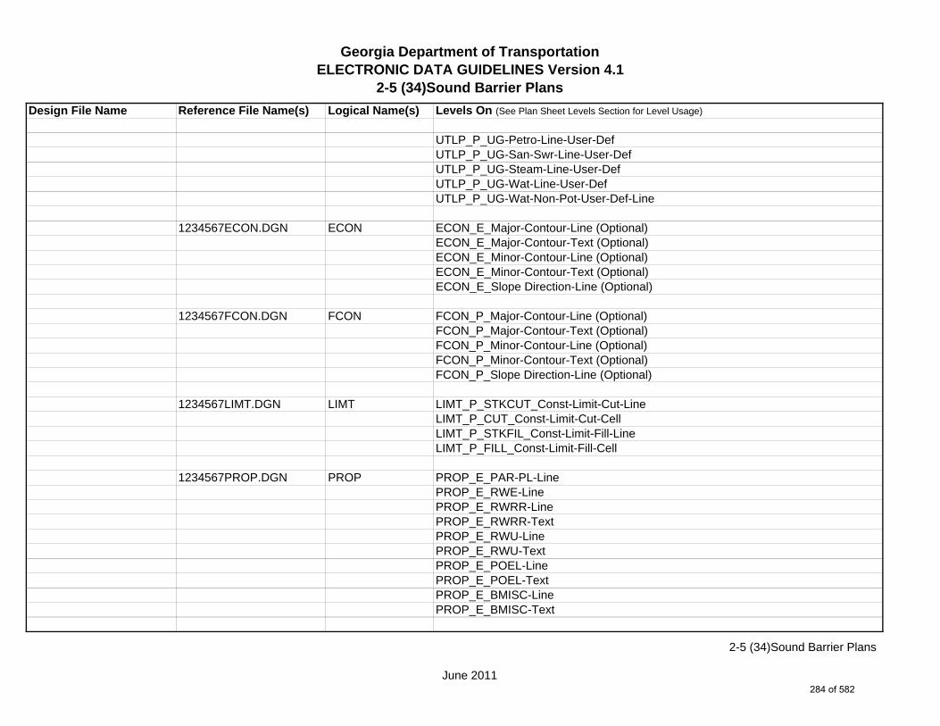
Georgia Department of TransportationELECTRONIC DATA GUIDELINES Version 4.1
2-5 (34)Sound Barrier Plans
Design File Name Reference File Name(s) Logical Name(s) Levels On (See Plan Sheet Levels Section for Level Usage)
UTLP_P_UG-Petro-Line-User-DefUTLP_P_UG-San-Swr-Line-User-DefUTLP_P_UG-Steam-Line-User-DefUTLP_P_UG-Wat-Line-User-DefUTLP_P_UG-Wat-Non-Pot-User-Def-Line
1234567ECON.DGN ECON ECON_E_Major-Contour-Line (Optional)ECON_E_Major-Contour-Text (Optional)ECON_E_Minor-Contour-Line (Optional)ECON_E_Minor-Contour-Text (Optional)ECON_E_Slope Direction-Line (Optional)
1234567FCON.DGN FCON FCON_P_Major-Contour-Line (Optional)FCON_P_Major-Contour-Text (Optional)FCON_P_Minor-Contour-Line (Optional)FCON_P_Minor-Contour-Text (Optional)FCON_P_Slope Direction-Line (Optional)
1234567LIMT.DGN LIMT LIMT_P_STKCUT_Const-Limit-Cut-LineLIMT_P_CUT_Const-Limit-Cut-CellLIMT_P_STKFIL_Const-Limit-Fill-LineLIMT_P_FILL_Const-Limit-Fill-Cell
1234567PROP.DGN PROP PROP_E_PAR-PL-LinePROP_E_RWE-Line PROP_E_RWRR-LinePROP_E_RWRR-TextPROP_E_RWU-LinePROP_E_RWU-TextPROP_E_POEL-LinePROP_E_POEL-TextPROP_E_BMISC-LinePROP_E_BMISC-Text
June 2011
2-5 (34)Sound Barrier Plans
284 of 582

Georgia Department of TransportationELECTRONIC DATA GUIDELINES Version 4.1
2-5 (34)Sound Barrier Plans
Design File Name Reference File Name(s) Logical Name(s) Levels On (See Plan Sheet Levels Section for Level Usage)
1234567TOPO.DGN TOPO TOPO_E_TEAP-LineTOPO_E_TEAS-LineTOPO_E_TECP-LineTOPO_E_TEDR-LineTOPO_E_TEST-LineTOPO_E_TEDD-LineTOPO_E_TEAD-LineTOPO_E_TECD-LineTOPO_E_TAC-LineTOPO_E_TCGF-LineTOPO_E_TCGT-LineTOPO_E_THC-LineTOPO_E_TVG-LineTOPO_E_TSW-LineTOPO_E_TGR-LineTOPO_E_TBAS-LineTOPO_E_TBGL-LineTOPO_E_TBRDGCEN-LineTOPO_E_TBRDGCOR-LineTOPO_E_THM-CellTOPO_E_TFP-LineTOPO_E_TRCR-LineTOPO_E_TRCR-TextTOPO_E_TRCRE-LineTOPO_E_TRCRE-TextTOPO_E_TBLD-LineTOPO_E_TBLDRL-LineTOPO_E_TUD-LineTOPO_E_TS-LineTOPO_E_TBC-LineTOPO_E_TFE-LineTOPO_E_DSTC-LineTOPO_E_DDL-LineTOPO_E_TCAN-Line
June 2011
2-5 (34)Sound Barrier Plans
285 of 582

Georgia Department of TransportationELECTRONIC DATA GUIDELINES Version 4.1
2-5 (34)Sound Barrier Plans
Design File Name Reference File Name(s) Logical Name(s) Levels On (See Plan Sheet Levels Section for Level Usage)
TOPO_E_THCR-LineTOPO_E_THRL-LineTOPO_E_TMHCR-LineTOPO_E_TMHRL-LineTOPO_E_TFCL-LineTOPO_E_TFW-LineTOPO_E_TFBW-LineTOPO_E_TFFW-LineTOPO_E_TVF-LineTOPO_E_TG-LineTOPO_E_TWELL-LineTOPO_E_TGFV-LineTOPO_E_TGMW-LineTOPO_E_TGP-LineTOPO_E_TGPI-LineTOPO_E_TFT-LineTOPO_E_TGST-LineTOPO_E_TGVP-LineTOPO_E_DCEF-LineTOPO_E_DCEF-TextTOPO_E_DCB-LineTOPO_E_DCB-TextTOPO_E_DCWE-LineTOPO_E_DCWE-TextTOPO_E_DDCB-LineTOPO_E_DDCB-TextTOPO_E_DDI-LineTOPO_E_DDI-TextTOPO_E_DHWE-LineTOPO_E_DHWE-TextTOPO_E_DJB-LineTOPO_E_DJB-TextTOPO_E_DPC-LineTOPO_E_DPC-Text
June 2011
2-5 (34)Sound Barrier Plans
286 of 582

Georgia Department of TransportationELECTRONIC DATA GUIDELINES Version 4.1
2-5 (34)Sound Barrier Plans
Design File Name Reference File Name(s) Logical Name(s) Levels On (See Plan Sheet Levels Section for Level Usage)
TOPO_E_DPM-LineTOPO_E_DPM-TextTOPO_E_DPP-LineTOPO_E_DPP-TextTOPO_E_MDITCHFL-LineTOPO_E_MDITCHFL-TextTOPO_E_DPD-LineTOPO_E_DPD-TextTOPO_E_DSB-LineTOPO_E_DSB-TextTOPO_E_DSC-LineTOPO_E_DSC-TextTOPO_E_DSE-LineTOPO_E_DSE-TextTOPO_E_DWE-LineTOPO_E_DWE-TextTOPO_E_DEW-LineTOPO_E_DEW-TextTOPO_E_DHWM-LineTOPO_E_DHWM-TextTOPO_E_DSWE-LineTOPO_E_DSWE-TextTOPO_E_DMISC-LineTOPO_E_DMISC-TextTOPO_E_TWF-LineTOPO_E_TWFT-LineTOPO_E_TWFB-LineTOPO_E_TSATDSH-LineTOPO_E_TWL-LineTOPO_E_TWL-TextTOPO_E_TTRE-LineTOPO_E_TTRE-TextTOPO_E_TGRV-LineTOPO_E_DADB-Line
June 2011
2-5 (34)Sound Barrier Plans
287 of 582

Georgia Department of TransportationELECTRONIC DATA GUIDELINES Version 4.1
2-5 (34)Sound Barrier Plans
Design File Name Reference File Name(s) Logical Name(s) Levels On (See Plan Sheet Levels Section for Level Usage)
TOPO_E_DADB-TextTOPO_E_DADB-LineTOPO_E_DDT-LineTOPO_E_DDT-TextTOPO_E_DSPURDK-LineTOPO_E_TMAR-LineTOPO_E_TMPH-LineTOPO_E_TKMP-LineTOPO_E_TMPR-LineTOPO_E_TSC-LineTOPO_E_TSE-LineTOPO_E_TIRRLMT-LineTOPO_E_TIRRPVTP-LineTOPO_E_TCUL-LineTOPO_E_TBCAP-LineTOPO_E_TBCL-LineTOPO_E_TCOLC-LineTOPO_E_TCOLE-LineTOPO_E_TENDROLL-LineTOPO_E_TMISC-Pnt-CellTOPO_E_UOEL-CellTOPO_E_UOEL-TextTOPO_E_UOTL-CellTOPO_E_UOTL-TextTOPO_E_UELBOX-CellTOPO_E_UELBOX-TextTOPO_E_UPP-CellTOPO_E_UPP-TextTOPO_E_ULP-CellTOPO_E_ULP-TextTOPO_E_UTP-CellTOPO_E_UTP-TextTOPO_E_UTPD-CellTOPO_E_UTPD-Text
June 2011
2-5 (34)Sound Barrier Plans
288 of 582

Georgia Department of TransportationELECTRONIC DATA GUIDELINES Version 4.1
2-5 (34)Sound Barrier Plans
Design File Name Reference File Name(s) Logical Name(s) Levels On (See Plan Sheet Levels Section for Level Usage)
TOPO_E_UGP-CellTOPO_E_UGP-TextTOPO_E_UPGA-CellTOPO_E_UPGA-TextTOPO_E_UYLE-CellTOPO_E_UYLE-TextTOPO_E_UYLG-CellTOPO_E_UYLG-TextTOPO_E_UWM-CellTOPO_E_UWM-TextTOPO_E_UWV-CellTOPO_E_UWV-TextTOPO_E_UFH-CellTOPO_E_UFH-TextTOPO_E_UMHST-CellTOPO_E_UMHST-TextTOPO_E_UMHSTF-CellTOPO_E_UMHSTF-TextTOPO_E_UMHT-CellTOPO_E_UMHT-TextTOPO_E_UMHE-CellTOPO_E_UMHE-TextTOPO_E_UMHSS-CellTOPO_E_UMHSS-TextTOPO_E_UMHSSF-CellTOPO_E_UMHSSF-TextTOPO_E_USSL-CellTOPO_E_USSL-TextTOPO_E_UGM-CellTOPO_E_UGM-TextTOPO_E_UNGV-CellTOPO_E_UNGV-TextTOPO_E_UNGVP-CellTOPO_E_UNGVP-Text
June 2011
2-5 (34)Sound Barrier Plans
289 of 582

Georgia Department of TransportationELECTRONIC DATA GUIDELINES Version 4.1
2-5 (34)Sound Barrier Plans
Design File Name Reference File Name(s) Logical Name(s) Levels On (See Plan Sheet Levels Section for Level Usage)
TOPO_E_UNGLM-CellTOPO_E_UNGLM-TextTOPO_E_SLCD-Pnt#-TextTOPO_E_SLCD-CellTOPO_E_SLCD-LineTOPO_E_SLCD-Line-TextTOPO_E_SDCD-Pnt#-TextTOPO_E_SDCD-CellTOPO_E_SDCD-LineTOPO_E_SDCD-Line-TextTOPO_E_SCCHK-CellTOPO_E_SCCHK-LineTOPO_E_SCCHK-TextTOPO_E_SBNCHMK-Pnt#-TextTOPO_E_SBNCHMK-CellTOPO_E_SBNCHMK-TextTOPO_E_SNGSCM-Pnt#-TextTOPO_E_SNGSCM-CellTOPO_E_SNGSCM-TextTOPO_E_SLCM-Pnt#-TextTOPO_E_SLCM-CellTOPO_E_SLCM-TextTOPO_E_SLCM-LineTOPO_E_POOL-LineTOPO_E_POOL-TextTOPO_E_FNDN-LineTOPO_E_RUIN-LineTOPO_E_TANK-LineTOPO_E_DTCH-LineTOPO_E_DTCH-TextTOPO_E_DTCH-Hidden-LineTOPO_E_DTCH-Hidden-TextTOPO_E_TWFE-LineTOPO_E_TWFE-Text
June 2011
2-5 (34)Sound Barrier Plans
290 of 582
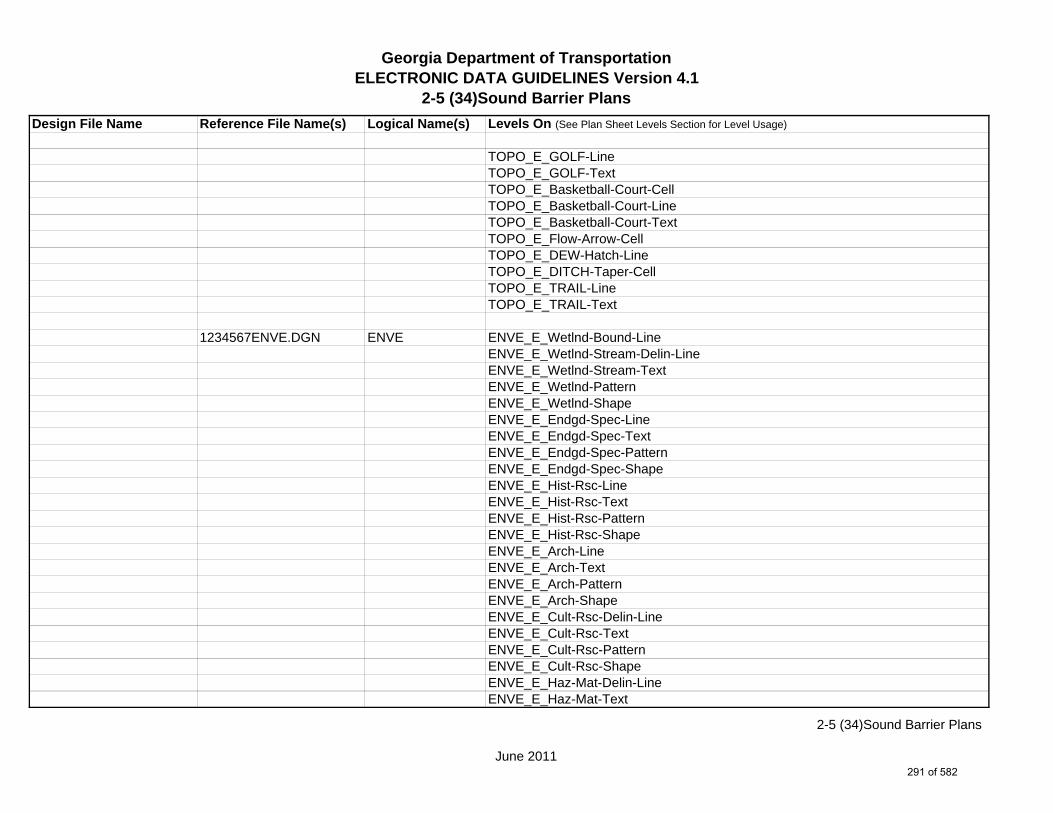
Georgia Department of TransportationELECTRONIC DATA GUIDELINES Version 4.1
2-5 (34)Sound Barrier Plans
Design File Name Reference File Name(s) Logical Name(s) Levels On (See Plan Sheet Levels Section for Level Usage)
TOPO_E_GOLF-LineTOPO_E_GOLF-TextTOPO_E_Basketball-Court-CellTOPO_E_Basketball-Court-LineTOPO_E_Basketball-Court-TextTOPO_E_Flow-Arrow-CellTOPO_E_DEW-Hatch-LineTOPO_E_DITCH-Taper-CellTOPO_E_TRAIL-LineTOPO_E_TRAIL-Text
1234567ENVE.DGN ENVE ENVE_E_Wetlnd-Bound-LineENVE_E_Wetlnd-Stream-Delin-LineENVE_E_Wetlnd-Stream-TextENVE_E_Wetlnd-PatternENVE_E_Wetlnd-ShapeENVE_E_Endgd-Spec-LineENVE_E_Endgd-Spec-TextENVE_E_Endgd-Spec-PatternENVE_E_Endgd-Spec-ShapeENVE_E_Hist-Rsc-LineENVE_E_Hist-Rsc-TextENVE_E_Hist-Rsc-PatternENVE_E_Hist-Rsc-ShapeENVE_E_Arch-LineENVE_E_Arch-TextENVE_E_Arch-PatternENVE_E_Arch-ShapeENVE_E_Cult-Rsc-Delin-LineENVE_E_Cult-Rsc-TextENVE_E_Cult-Rsc-PatternENVE_E_Cult-Rsc-ShapeENVE_E_Haz-Mat-Delin-LineENVE_E_Haz-Mat-Text
June 2011
2-5 (34)Sound Barrier Plans
291 of 582

Georgia Department of TransportationELECTRONIC DATA GUIDELINES Version 4.1
2-5 (34)Sound Barrier Plans
Design File Name Reference File Name(s) Logical Name(s) Levels On (See Plan Sheet Levels Section for Level Usage)
ENVE_E_Haz-Mat-PatternENVE_E_Haz-Mat-ShapeENVE_E_Env-Justice-LineENVE_E_Env-Justice-TextENVE_E_Env-Justice-PatternENVE_E_Env-Justice-ShapeENVE_E_ESA-LineENVE_E_ESA-TextENVE_E_ESA-PatternENVE_E_ESA-Shape
1234567ENVP.DGN ENVP ENVP_P_Relocations-LineENVP_P_Relocations-TextENVP_P_Socl-Resc-Impact-Area-LineENVP_P_Socl-Resc-Impact-Area-PatternENVP_P_Socl-Resc-Impact-Area-TextENVP_P_Hist-APE-LineENVP_P_Hist-APE-PatternENVP_P_Hist-APE-TextENVP_P_Cultrl-Resc-Impact-Area-LineENVP_P_Cultrl-Resc-Impact-Area-PatternENVP_P_Cultrl-Resc-Impact-Area-TextENVP_P_Wetlnd-Impact-Area-LineENVP_P_Wetlnd-Impact-Area-PatternENVP_P_Wetlnd-Impact-Area-TextENVP_P_Wetlnd-Mitigat-Site-LineENVP_P_Wetlnd-Mitigat-Site-PatternENVP_P_Wetlnd-Mitigat-Site-TextENVP_P_Fldplain-Impact-Area-LineENVP_P_Fldplain-Impact-Area-PatternENVP_P_Fldplain-Impact-Area-TextENVP_P_Impacted-USTENVP_P_Noise-Study-ReceptENVP_P_Noise-Study-Readings
June 2011
2-5 (34)Sound Barrier Plans
292 of 582
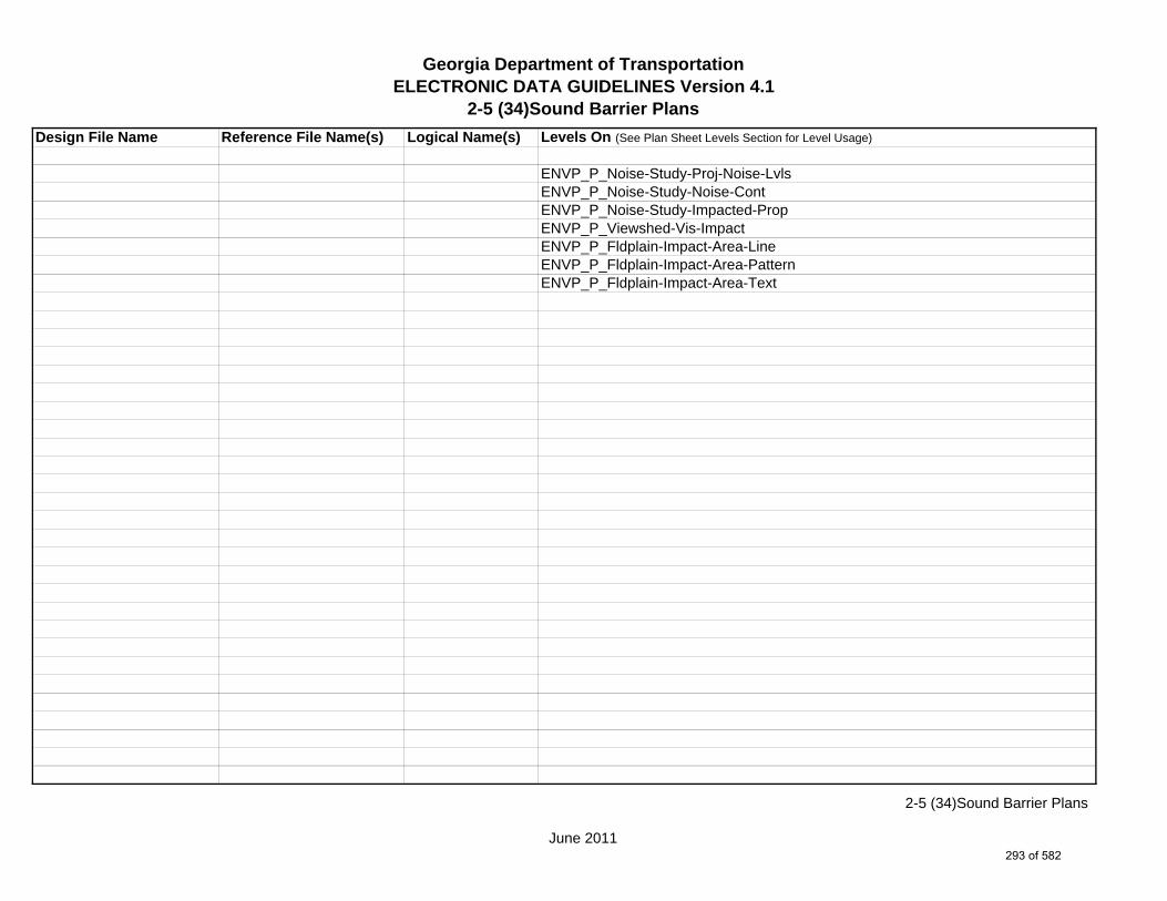
Georgia Department of TransportationELECTRONIC DATA GUIDELINES Version 4.1
2-5 (34)Sound Barrier Plans
Design File Name Reference File Name(s) Logical Name(s) Levels On (See Plan Sheet Levels Section for Level Usage)
ENVP_P_Noise-Study-Proj-Noise-LvlsENVP_P_Noise-Study-Noise-ContENVP_P_Noise-Study-Impacted-PropENVP_P_Viewshed-Vis-ImpactENVP_P_Fldplain-Impact-Area-LineENVP_P_Fldplain-Impact-Area-PatternENVP_P_Fldplain-Impact-Area-Text
June 2011
2-5 (34)Sound Barrier Plans
293 of 582
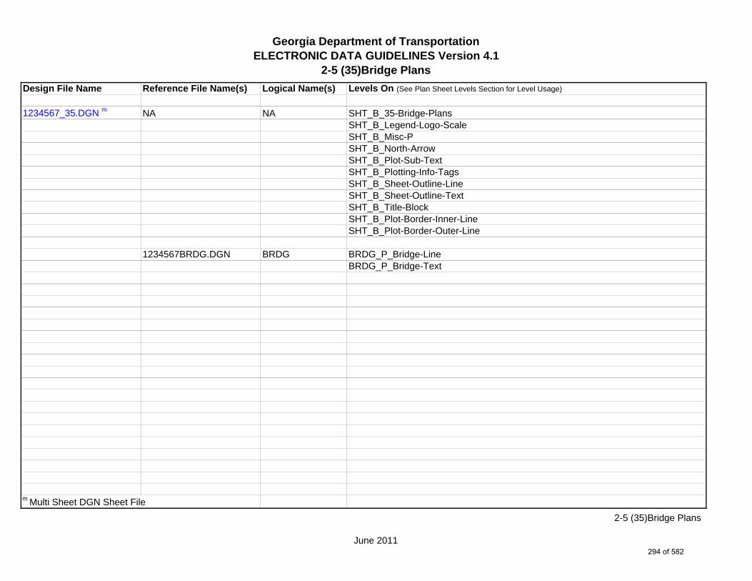
Georgia Department of TransportationELECTRONIC DATA GUIDELINES Version 4.1
2-5 (35)Bridge Plans
Design File Name Reference File Name(s) Logical Name(s) Levels On (See Plan Sheet Levels Section for Level Usage)
1234567_35.DGN m NA NA SHT_B_35-Bridge-PlansSHT_B_Legend-Logo-ScaleSHT_B_Misc-PSHT_B_North-ArrowSHT_B_Plot-Sub-TextSHT_B_Plotting-Info-TagsSHT_B_Sheet-Outline-LineSHT_B_Sheet-Outline-TextSHT_B_Title-BlockSHT_B_Plot-Border-Inner-LineSHT_B_Plot-Border-Outer-Line
1234567BRDG.DGN BRDG BRDG_P_Bridge-Line BRDG_P_Bridge-Text
m Multi Sheet DGN Sheet File
June 2011
2-5 (35)Bridge Plans
294 of 582

Georgia Department of TransportationELECTRONIC DATA GUIDELINES Version 4.1
2-5 (36)Bridge Culvert Plans
Design File Name Reference File Name(s) Logical Name(s) Levels On (See Plan Sheet Levels Section for Level Usage)
1234567_36.DGN m NA NA SHT_B_36-Bridge-Culvert-PlansSHT_B_Legend-Logo-ScaleSHT_B_Misc-PSHT_B_North-ArrowSHT_B_Plot-Sub-TextSHT_B_Plotting-Info-TagsSHT_B_Sheet-Outline-LineSHT_B_Sheet-Outline-TextSHT_B_Title-BlockSHT_B_Plot-Border-Inner-LineSHT_B_Plot-Border-Outer-Line
1234567BRDG.DGN BRDG BRDG_P_Bridge-Line BRDG_P_Bridge-Text
m Multi Sheet DGN Sheet File
June 2011
2-5 (36)Bridge Culvert Plans
295 of 582
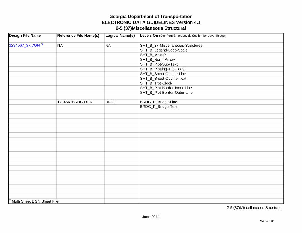
Georgia Department of TransportationELECTRONIC DATA GUIDELINES Version 4.1
2-5 (37)Miscellaneous Structural
Design File Name Reference File Name(s) Logical Name(s) Levels On (See Plan Sheet Levels Section for Level Usage)
1234567_37.DGN m NA NA SHT_B_37-Miscellaneous-StructuresSHT_B_Legend-Logo-ScaleSHT_B_Misc-PSHT_B_North-ArrowSHT_B_Plot-Sub-TextSHT_B_Plotting-Info-TagsSHT_B_Sheet-Outline-LineSHT_B_Sheet-Outline-TextSHT_B_Title-BlockSHT_B_Plot-Border-Inner-LineSHT_B_Plot-Border-Outer-Line
1234567BRDG.DGN BRDG BRDG_P_Bridge-Line BRDG_P_Bridge-Text
m Multi Sheet DGN Sheet File
June 2011
2-5 (37)Miscellaneous Structural
296 of 582

Georgia Department of TransportationELECTRONIC DATA GUIDELINES Version 4.1
2-5 (38)Special Construction Detail
Design File Name Reference File Name(s) Logical Name(s) Levels On
1234567_38-001.DGN m NA NA SHT_B_38-Special-Construction-DetailSHT_B_Legend-Logo-ScaleSHT_B_Misc-PSHT_B_North-ArrowSHT_B_Plot-Sub-TextSHT_B_Plotting-Info-TagsSHT_B_Sheet-Outline-LineSHT_B_Sheet-Outline-TextSHT_B_Title-BlockSHT_B_Plot-Border-Inner-LineSHT_B_Plot-Border-Outer-Line
m Multi Sheet DGN Sheet File
June 2011
2-5 (38)Special Construction Detail
297 of 582

Georgia Department of TransportationELECTRONIC DATA GUIDELINES Version 4.1
2-5 (39)Special Design Box Culverts
Design File Name Reference File Name(s) Logical Name(s) Levels On
1234567_39.DGN m NA NA SHT_B_39-Special-CulvertsSHT_B_Legend-Logo-ScaleSHT_B_Misc-PSHT_B_North-ArrowSHT_B_Plot-Sub-TextSHT_B_Plotting-Info-TagsSHT_B_Sheet-Outline-LineSHT_B_Sheet-Outline-TextSHT_B_Title-BlockSHT_B_Plot-Border-Inner-LineSHT_B_Plot-Border-Outer-Line
m Multi Sheet DGN Sheet File
June 2011
2-5 (39)Special Design Box Culverts
298 of 582

Georgia Department of TransportationELECTRONIC DATA GUIDELINES Version 4.1
2-5 (40)Construction Details
Design File Name Reference File Name(s) Logical Name(s) Levels On
1234567_40.DGN m NA NA SHT_B_40-Construction-DetailsSHT_B_Legend-Logo-ScaleSHT_B_Misc-PSHT_B_North-ArrowSHT_B_Plot-Sub-TextSHT_B_Plotting-Info-TagsSHT_B_Sheet-Outline-LineSHT_B_Sheet-Outline-TextSHT_B_Title-BlockSHT_B_Plot-Border-Inner-LineSHT_B_Plot-Border-Outer-Line
m Multi Sheet DGN Sheet File
June 2011
2-5 (40)Construction Details
299 of 582

Georgia Department of TransportationELECTRONIC DATA GUIDELINES Version 4.1
2-5 (41)Georgia Standards
Design File Name Reference File Name(s) Logical Name(s) Levels On
1234567_41.DGN m NA NA SHT_B_41-Georgia-StandardsSHT_B_Legend-Logo-ScaleSHT_B_Misc-PSHT_B_North-ArrowSHT_B_Plot-Sub-TextSHT_B_Plotting-Info-TagsSHT_B_Sheet-Outline-LineSHT_B_Sheet-Outline-TextSHT_B_Title-BlockSHT_B_Plot-Border-Inner-LineSHT_B_Plot-Border-Outer-Line
m Multi Sheet DGN Sheet File
June 2011
2-5 (41)Georgia Standards
300 of 582

Georgia Department of TransportationELECTRONIC DATA GUIDELINES Version 4.1
2-5 (44)Utility Relocation Plans
Design File Name Reference File Name(s) Logical Name(s) Levels On (See Plan Sheet Levels Section for Level Usage)
1234567_44-001.DGN s NA NA SHT_B_44-Utility-Relocation-PlansSHT_B_Legend-Logo-ScaleSHT_B_Misc-PSHT_B_North-ArrowSHT_B_Plot-Sub-TextSHT_B_Plotting-Info-TagsSHT_B_Sheet-Outline-LineSHT_B_Sheet-Outline-TextSHT_B_Title-BlockSHT_B_Plot-Border-Inner-LineSHT_B_Plot-Border-Outer-Line
1234567MAIN.DGN MAIN MAIN_P_CONSTCL-LineMAIN_P_CONSTCL-Tic-Sta-TextMAIN_P_CONSTCL-Brng-TextMAIN_P_SIDECL-LineMAIN_P_SIDECL-Tic-Sta-TextMAIN_P_EOP-LineMAIN_P_Appr-Slab-LineMAIN_P_EPSHLDR-LineMAIN_P_Bridge-LineMAIN_P_Driveway-LineMAIN_P_Curb-Gutter-LineMAIN_P_Sidewalk-LineMAIN_P_Guardrail-LineMAIN_P_Median-Side-Barrier-LineMAIN_P_Retain-Wall-LineMAIN_P_Sound-Barrier-Wall-LineMAIN_P_Fence-LineMAIN_P_Misc-Const-Feat-LineMAIN_P_Details-End-Proj-CL-Intersect-Label-TextMAIN_P_Details-Begin-End-Const-Limit-Const-Label-TextMAIN_P_Details-RouteName-CL-Text
s Single Sheet DGN Sheet File
June 2011
2-5 (44)Utility Relocation Plans
301 of 582

Georgia Department of TransportationELECTRONIC DATA GUIDELINES Version 4.1
2-5 (44)Utility Relocation Plans
Design File Name Reference File Name(s) Logical Name(s) Levels On (See Plan Sheet Levels Section for Level Usage)
1234567DRNG.DGN DRNG DRNG_P_Storm-Drain-Struct-TextDRNG_P_Storm-Drain-StructDRNG_P_Storm-Drain-Pipe-LineDRNG_P_Storm-Drain-Pipe-TextDRNG_P_Ditch-and-Channel-LineDRNG_P_Cross-Drain-and-Culv-LineDRNG_P_Cross-Drain-and-Culv-TextDRNG_P_Bridge-Culv-LineDRNG_P_Bridge-Culv-TextDRNG_P_Sediment-Basin-LineDRNG_P_Detention-Pond-LineDRNG_P_Perm-Riprap-PatternDRNG_P_Perm-Ditch-Protect-Line
1234567REQD.DGN REQD REQD_P_Parcel-Owner-TextREQD_P_Parcel-Owner-#-TextREQD_P_Parcel-Reqd-RW-Tract#-TextREQD_P_RWRM-RW-CellREQD_P_RWRM-RW-LineREQD_P_RWRM-RW-MarkerREQD_P_RWRM-RW-TextREQD_P_REQD-RW-CellREQD_P_REQD-RW-LineREQD_P_REQD-RW-Ltd-AccessREQD_P_REQD-RW-Desc-TextREQD_P_PESMT-LineREQD_P_TESMT-LineREQD_P_DWESMT-Line
1234567SIGN.DGN SIGN SIGN_E_SM-CellSIGN_P_OVHD_Sign-Structure-and-Strain-PoleSIGN_P_OVHD_Span-WireSIGN_P_SM-Cell
June 2011
2-5 (44)Utility Relocation Plans
302 of 582

Georgia Department of TransportationELECTRONIC DATA GUIDELINES Version 4.1
2-5 (44)Utility Relocation Plans
Design File Name Reference File Name(s) Logical Name(s) Levels On (See Plan Sheet Levels Section for Level Usage)
1234567SGNL.DGN SGNL SGNL_E_Signal-SignalSGNL_E_Signal-ControllerSGNL_E_Signal-Conduit-and-PullboxSGNL_P_Signal-SignSGNL_P_Signal-Signal-PoleSGNL_P_Signal-Mast-ArmsSGNL_P_Signal-Span-WireSGNL_P_Signal-Control-CabinetSGNL_P_Signal-Shared-Signal-and-Comm-ConduitSGNL_P_Signal-Shared-Signal-and-Comm-PullboxSGNL_P_Signal-Pedestrian-Pedestal-PoleSGNL_P_Signal-Comm-Only-ConduitSGNL_P_Signal-Comm-Only-PullboxSGNL_P_Signal-LoopSGNL_P_Signal-Signal-Only-PullboxSGNL_P_Signal-Signal-Only-Pullbox-TP2SGNL_P_Signal-Signal-Only-ConduitSGNL_P_Signal-Loop-lead-InSGNL_P_Signal-Text
1234567UTLE.DGN UTLE UTLE_E_Elec-CellUTLE_E_Elec-Vault-LineUTLE_E_UG-Elec-TextUTLE_E_UG-Elec-LineUTLE_E_UG-Elec-Line-Qual-BUTLE_E_UG-Elec-Line-Qual-CUTLE_E_Gas-CellUTLE_E_UG-Gas-TextUTLE_E_UG-Gas-LineUTLE_E_UG-Gas-Line-Qual-BUTLE_E_UG-Gas-Line-Qual-C
*Denotes level for 20 Scale Plans.^Denotes level for 50 Scale Plans.
June 2011
2-5 (44)Utility Relocation Plans
303 of 582
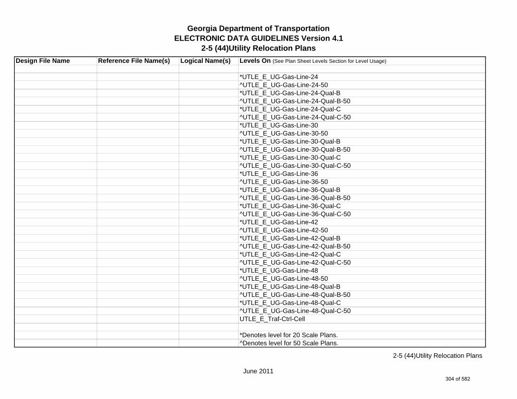
Georgia Department of TransportationELECTRONIC DATA GUIDELINES Version 4.1
2-5 (44)Utility Relocation Plans
Design File Name Reference File Name(s) Logical Name(s) Levels On (See Plan Sheet Levels Section for Level Usage)
*UTLE_E_UG-Gas-Line-24^UTLE_E_UG-Gas-Line-24-50*UTLE_E_UG-Gas-Line-24-Qual-B^UTLE_E_UG-Gas-Line-24-Qual-B-50*UTLE_E_UG-Gas-Line-24-Qual-C^UTLE_E_UG-Gas-Line-24-Qual-C-50*UTLE_E_UG-Gas-Line-30^UTLE_E_UG-Gas-Line-30-50*UTLE_E_UG-Gas-Line-30-Qual-B^UTLE_E_UG-Gas-Line-30-Qual-B-50*UTLE_E_UG-Gas-Line-30-Qual-C^UTLE_E_UG-Gas-Line-30-Qual-C-50*UTLE_E_UG-Gas-Line-36^UTLE_E_UG-Gas-Line-36-50*UTLE_E_UG-Gas-Line-36-Qual-B^UTLE_E_UG-Gas-Line-36-Qual-B-50*UTLE_E_UG-Gas-Line-36-Qual-C^UTLE_E_UG-Gas-Line-36-Qual-C-50*UTLE_E_UG-Gas-Line-42^UTLE_E_UG-Gas-Line-42-50*UTLE_E_UG-Gas-Line-42-Qual-B^UTLE_E_UG-Gas-Line-42-Qual-B-50*UTLE_E_UG-Gas-Line-42-Qual-C^UTLE_E_UG-Gas-Line-42-Qual-C-50*UTLE_E_UG-Gas-Line-48^UTLE_E_UG-Gas-Line-48-50*UTLE_E_UG-Gas-Line-48-Qual-B^UTLE_E_UG-Gas-Line-48-Qual-B-50*UTLE_E_UG-Gas-Line-48-Qual-C^UTLE_E_UG-Gas-Line-48-Qual-C-50UTLE_E_Traf-Ctrl-Cell
*Denotes level for 20 Scale Plans.^Denotes level for 50 Scale Plans.
June 2011
2-5 (44)Utility Relocation Plans
304 of 582
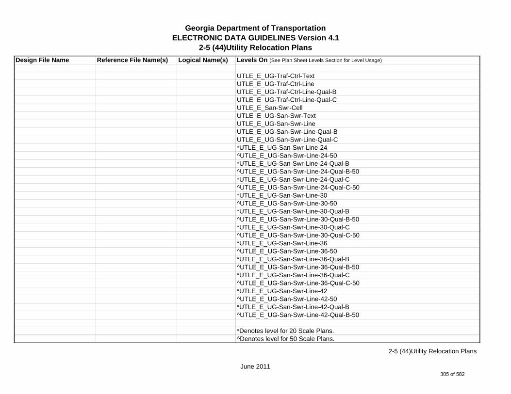
Georgia Department of TransportationELECTRONIC DATA GUIDELINES Version 4.1
2-5 (44)Utility Relocation Plans
Design File Name Reference File Name(s) Logical Name(s) Levels On (See Plan Sheet Levels Section for Level Usage)
UTLE_E_UG-Traf-Ctrl-TextUTLE_E_UG-Traf-Ctrl-LineUTLE_E_UG-Traf-Ctrl-Line-Qual-BUTLE_E_UG-Traf-Ctrl-Line-Qual-CUTLE_E_San-Swr-CellUTLE_E_UG-San-Swr-TextUTLE_E_UG-San-Swr-LineUTLE_E_UG-San-Swr-Line-Qual-BUTLE_E_UG-San-Swr-Line-Qual-C*UTLE_E_UG-San-Swr-Line-24^UTLE_E_UG-San-Swr-Line-24-50*UTLE_E_UG-San-Swr-Line-24-Qual-B^UTLE_E_UG-San-Swr-Line-24-Qual-B-50*UTLE_E_UG-San-Swr-Line-24-Qual-C^UTLE_E_UG-San-Swr-Line-24-Qual-C-50*UTLE_E_UG-San-Swr-Line-30^UTLE_E_UG-San-Swr-Line-30-50*UTLE_E_UG-San-Swr-Line-30-Qual-B^UTLE_E_UG-San-Swr-Line-30-Qual-B-50*UTLE_E_UG-San-Swr-Line-30-Qual-C^UTLE_E_UG-San-Swr-Line-30-Qual-C-50*UTLE_E_UG-San-Swr-Line-36^UTLE_E_UG-San-Swr-Line-36-50*UTLE_E_UG-San-Swr-Line-36-Qual-B^UTLE_E_UG-San-Swr-Line-36-Qual-B-50*UTLE_E_UG-San-Swr-Line-36-Qual-C^UTLE_E_UG-San-Swr-Line-36-Qual-C-50*UTLE_E_UG-San-Swr-Line-42^UTLE_E_UG-San-Swr-Line-42-50*UTLE_E_UG-San-Swr-Line-42-Qual-B^UTLE_E_UG-San-Swr-Line-42-Qual-B-50
*Denotes level for 20 Scale Plans.^Denotes level for 50 Scale Plans.
June 2011
2-5 (44)Utility Relocation Plans
305 of 582

Georgia Department of TransportationELECTRONIC DATA GUIDELINES Version 4.1
2-5 (44)Utility Relocation Plans
Design File Name Reference File Name(s) Logical Name(s) Levels On (See Plan Sheet Levels Section for Level Usage)
*UTLE_E_UG-San-Swr-Line-42-Qual-C^UTLE_E_UG-San-Swr-Line-42-Qual-C-50*UTLE_E_UG-San-Swr-Line-48^UTLE_E_UG-San-Swr-Line-48-50*UTLE_E_UG-San-Swr-Line-48-Qual-B^UTLE_E_UG-San-Swr-Line-48-Qual-B-50*UTLE_E_UG-San-Swr-Line-48-Qual-C^UTLE_E_UG-San-Swr-Line-48-Qual-C-50UTLE_E_San-Force-Main-CellUTLE_E_UG-San-Force-Main-TextUTLE_E_UG-San-Force-Main-LineUTLE_E_UG-San-Force-Main-Line-Qual-BUTLE_E_UG-San-Force-Main-Line-Qual-CUTLE_E_Wat-CellUTLE_E_UG-Wat-TextUTLE_E_UG-Wat-LineUTLE_E_UG-Wat-Line-Qual-BUTLE_E_UG-Wat-Line-Qual-C*UTLE_E_UG-Wat-Line-24^UTLE_E_UG-Wat-Line-24-50*UTLE_E_UG-Wat-Line-24-Qual-B^UTLE_E_UG-Wat-Line-24-Qual-B-50*UTLE_E_UG-Wat-Line-24-Qual-C^UTLE_E_UG-Wat-Line-24-Qual-C-50*UTLE_E_UG-Wat-Line-30^UTLE_E_UG-Wat-Line-30-50*UTLE_E_UG-Wat-Line-30-Qual-B^UTLE_E_UG-Wat-Line-30-Qual-B-50*UTLE_E_UG-Wat-Line-30-Qual-C^UTLE_E_UG-Wat-Line-30-Qual-C-50*UTLE_E_UG-Wat-Line-36
*Denotes level for 20 Scale Plans.^Denotes level for 50 Scale Plans.
June 2011
2-5 (44)Utility Relocation Plans
306 of 582

Georgia Department of TransportationELECTRONIC DATA GUIDELINES Version 4.1
2-5 (44)Utility Relocation Plans
Design File Name Reference File Name(s) Logical Name(s) Levels On (See Plan Sheet Levels Section for Level Usage)
^UTLE_E_UG-Wat-Line-36-50*UTLE_E_UG-Wat-Line-36-Qual-B^UTLE_E_UG-Wat-Line-36-Qual-B-50*UTLE_E_UG-Wat-Line-36-Qual-C^UTLE_E_UG-Wat-Line-36-Qual-C-50*UTLE_E_UG-Wat-Line-42^UTLE_E_UG-Wat-Line-42-50*UTLE_E_UG-Wat-Line-42-Qual-B^UTLE_E_UG-Wat-Line-42-Qual-B-50*UTLE_E_UG-Wat-Line-42-Qual-C^UTLE_E_UG-Wat-Line-42-Qual-C-50*UTLE_E_UG-Wat-Line-48^UTLE_E_UG-Wat-Line-48-50*UTLE_E_UG-Wat-Line-48-Qual-B^UTLE_E_UG-Wat-Line-48-Qual-B-50*UTLE_E_UG-Wat-Line-48-Qual-C^UTLE_E_UG-Wat-Line-48-Qual-C-50UTLE_E_TV-CellUTLE_E_UG-TV-TextUTLE_E_UG-TV-LineUTLE_E_UG-TV-Line-Qual-BUTLE_E_UG-TV-Line-Qual-CUTLE_E_Petro-CellUTLE_E_UG-Petro-TextUTLE_E_UG-Petro-LineUTLE_E_UG-Petro-Line-Qual-BUTLE_E_UG-Petro-Line-Qual-C*UTLE_E_UG-Petro-Line-24^UTLE_E_UG-Petro-Line-24-50*UTLE_E_UG-Petro-Line-24-Qual-B^UTLE_E_UG-Petro-Line-24-Qual-B-50
*Denotes level for 20 Scale Plans.^Denotes level for 50 Scale Plans.
June 2011
2-5 (44)Utility Relocation Plans
307 of 582

Georgia Department of TransportationELECTRONIC DATA GUIDELINES Version 4.1
2-5 (44)Utility Relocation Plans
Design File Name Reference File Name(s) Logical Name(s) Levels On (See Plan Sheet Levels Section for Level Usage)
*UTLE_E_UG-Petro-Line-24-Qual-C^UTLE_E_UG-Petro-Line-24-Qual-C-50*UTLE_E_UG-Petro-Line-30^UTLE_E_UG-Petro-Line-30-50*UTLE_E_UG-Petro-Line-30-Qual-B^UTLE_E_UG-Petro-Line-30-Qual-B-50*UTLE_E_UG-Petro-Line-30-Qual-C^UTLE_E_UG-Petro-Line-30-Qual-C-50*UTLE_E_UG-Petro-Line-36^UTLE_E_UG-Petro-Line-36-50*UTLE_E_UG-Petro-Line-36-Qual-B^UTLE_E_UG-Petro-Line-36-Qual-B-50*UTLE_E_UG-Petro-Line-36-Qual-C^UTLE_E_UG-Petro-Line-36-Qual-C-50*UTLE_E_UG-Petro-Line-42^UTLE_E_UG-Petro-Line-42-50*UTLE_E_UG-Petro-Line-42-Qual-B^UTLE_E_UG-Petro-Line-42-Qual-B-50*UTLE_E_UG-Petro-Line-42-Qual-C^UTLE_E_UG-Petro-Line-42-Qual-C-50*UTLE_E_UG-Petro-Line-48^UTLE_E_UG-Petro-Line-48-50*UTLE_E_UG-Petro-Line-48-Qual-B^UTLE_E_UG-Petro-Line-48-Qual-B-50*UTLE_E_UG-Petro-Line-48-Qual-C^UTLE_E_UG-Petro-Line-48-Qual-C-50UTLE_E_Tele-CellUTLE_E_UG-Tele-TextUTLE_E_UG-Tele-LineUTLE_E_UG-Tele-Line-Qual-BUTLE_E_UG-Tele-Line-Qual-C
*Denotes level for 20 Scale Plans.^Denotes level for 50 Scale Plans.
June 2011
2-5 (44)Utility Relocation Plans
308 of 582

Georgia Department of TransportationELECTRONIC DATA GUIDELINES Version 4.1
2-5 (44)Utility Relocation Plans
Design File Name Reference File Name(s) Logical Name(s) Levels On (See Plan Sheet Levels Section for Level Usage)
UTLE_E_Wat-Non-Pot-CellUTLE_E_UG-Wat-Non-Pot-TextUTLE_E_UG-Wat-Non-Pot-LineUTLE_E_UG-Wat-Non-Pot-Line-Qual-BUTLE_E_UG-Wat-Non-Pot-Line-Qual-C*UTLE_E_UG-Wat-Non-Pot-Line-24^UTLE_E_UG-Wat-Non-Pot-Line-24-50*UTLE_E_UG-Wat-Non-Pot-Line-24-Qual-B^UTLE_E_UG-Wat-Non-Pot-Line-24-Qual-B-50*UTLE_E_UG-Wat-Non-Pot-Line-24-Qual-C^UTLE_E_UG-Wat-Non-Pot-Line-24-Qual-C-50*UTLE_E_UG-Wat-Non-Pot-Line-30^UTLE_E_UG-Wat-Non-Pot-Line-30-50*UTLE_E_UG-Wat-Non-Pot-Line-30-Qual-B^UTLE_E_UG-Wat-Non-Pot-Line-30-Qual-B-50*UTLE_E_UG-Wat-Non-Pot-Line-30-Qual-C^UTLE_E_UG-Wat-Non-Pot-Line-30-Qual-C-50*UTLE_E_UG-Wat-Non-Pot-Line-36^UTLE_E_UG-Wat-Non-Pot-Line-36-50*UTLE_E_UG-Wat-Non-Pot-Line-36-Qual-B^UTLE_E_UG-Wat-Non-Pot-Line-36-Qual-B-50*UTLE_E_UG-Wat-Non-Pot-Line-36-Qual-C^UTLE_E_UG-Wat-Non-Pot-Line-36-Qual-C-50*UTLE_E_UG-Wat-Non-Pot-Line-42^UTLE_E_UG-Wat-Non-Pot-Line-42-50*UTLE_E_UG-Wat-Non-Pot-Line-42-Qual-B^UTLE_E_UG-Wat-Non-Pot-Line-42-Qual-B-50*UTLE_E_UG-Wat-Non-Pot-Line-42-Qual-C^UTLE_E_UG-Wat-Non-Pot-Line-42-Qual-C-50*UTLE_E_UG-Wat-Non-Pot-Line-48^UTLE_E_UG-Wat-Non-Pot-Line-48-50
*Denotes level for 20 Scale Plans.^Denotes level for 50 Scale Plans.
June 2011
2-5 (44)Utility Relocation Plans
309 of 582
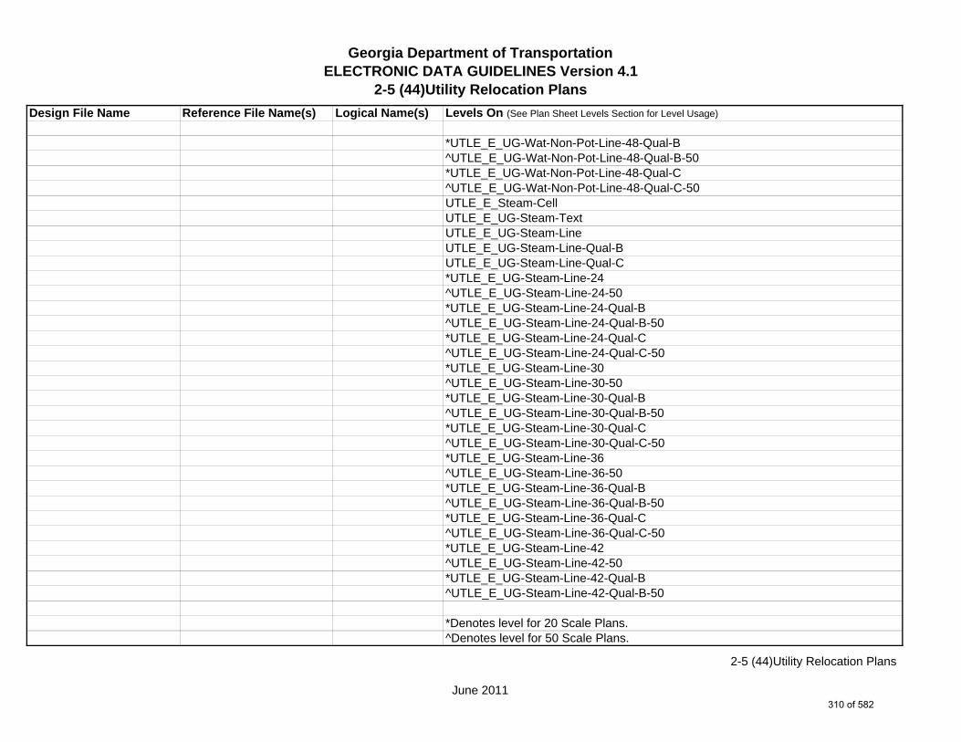
Georgia Department of TransportationELECTRONIC DATA GUIDELINES Version 4.1
2-5 (44)Utility Relocation Plans
Design File Name Reference File Name(s) Logical Name(s) Levels On (See Plan Sheet Levels Section for Level Usage)
*UTLE_E_UG-Wat-Non-Pot-Line-48-Qual-B^UTLE_E_UG-Wat-Non-Pot-Line-48-Qual-B-50*UTLE_E_UG-Wat-Non-Pot-Line-48-Qual-C^UTLE_E_UG-Wat-Non-Pot-Line-48-Qual-C-50UTLE_E_Steam-CellUTLE_E_UG-Steam-TextUTLE_E_UG-Steam-LineUTLE_E_UG-Steam-Line-Qual-BUTLE_E_UG-Steam-Line-Qual-C*UTLE_E_UG-Steam-Line-24^UTLE_E_UG-Steam-Line-24-50*UTLE_E_UG-Steam-Line-24-Qual-B^UTLE_E_UG-Steam-Line-24-Qual-B-50*UTLE_E_UG-Steam-Line-24-Qual-C^UTLE_E_UG-Steam-Line-24-Qual-C-50*UTLE_E_UG-Steam-Line-30^UTLE_E_UG-Steam-Line-30-50*UTLE_E_UG-Steam-Line-30-Qual-B^UTLE_E_UG-Steam-Line-30-Qual-B-50*UTLE_E_UG-Steam-Line-30-Qual-C^UTLE_E_UG-Steam-Line-30-Qual-C-50*UTLE_E_UG-Steam-Line-36^UTLE_E_UG-Steam-Line-36-50*UTLE_E_UG-Steam-Line-36-Qual-B^UTLE_E_UG-Steam-Line-36-Qual-B-50*UTLE_E_UG-Steam-Line-36-Qual-C^UTLE_E_UG-Steam-Line-36-Qual-C-50*UTLE_E_UG-Steam-Line-42^UTLE_E_UG-Steam-Line-42-50*UTLE_E_UG-Steam-Line-42-Qual-B^UTLE_E_UG-Steam-Line-42-Qual-B-50
*Denotes level for 20 Scale Plans.^Denotes level for 50 Scale Plans.
June 2011
2-5 (44)Utility Relocation Plans
310 of 582

Georgia Department of TransportationELECTRONIC DATA GUIDELINES Version 4.1
2-5 (44)Utility Relocation Plans
Design File Name Reference File Name(s) Logical Name(s) Levels On (See Plan Sheet Levels Section for Level Usage)
*UTLE_E_UG-Steam-Line-42-Qual-C^UTLE_E_UG-Steam-Line-42-Qual-C-50*UTLE_E_UG-Steam-Line-48^UTLE_E_UG-Steam-Line-48-50*UTLE_E_UG-Steam-Line-48-Qual-B^UTLE_E_UG-Steam-Line-48-Qual-B-50*UTLE_E_UG-Steam-Line-48-Qual-C^UTLE_E_UG-Steam-Line-48-Qual-C-50UTLE_E_UG-Utl-Unknown-Line-Qual-BUTLE_E_UG-Utl-Unknown-TextUTLE_E_OVHD-Tele-TextUTLE_E_OVHD-Tele-LineUTLE_E_OVHD-TV-CellUTLE_E_OVHD-TV-TextUTLE_E_OVHD-TV-LineUTLE_E_OVHD-Elec-TextUTLE_E_OVHD-Elec-LineUTLE_E_OVHD-Traf-Ctrl-TextUTLE_E_OVHD-Traf-Ctrl-LineUTLE_E_OVHD-Combo-Util-TextUTLE_E_OVHD-Combo-Util-Line-Elec-TeleUTLE_E_OVHD-Combo-Util-Line-Elec-Tele-Traf-CtrlUTLE_E_OVHD-Combo-Util-Line-Elec-Tele-TVUTLE_E_OVHD-Combo-Util-Line-Elec-Tele-TV-Traf-CtrlUTLE_E_OVHD-Combo-Util-Line-Elec-Traf-CtrlUTLE_E_OVHD-Combo-Util-Line-Elec-TVUTLE_E_OVHD-Combo-Util-Line-Elec-TV-Traf-CtrlUTLE_E_OVHD-Combo-Util-Line-Guy-WireUTLE_E_OVHD-Combo-Util-Line-Tele-Traf-CtrlUTLE_E_OVHD-Combo-Util-Line-Tele-TVUTLE_E_OVHD-Combo-Util-Line-Tele-TV-Traf-Ctrl
*Denotes level for 20 Scale Plans.^Denotes level for 50 Scale Plans.
June 2011
2-5 (44)Utility Relocation Plans
311 of 582
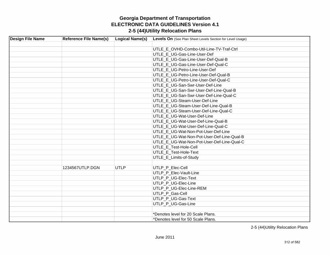
Georgia Department of TransportationELECTRONIC DATA GUIDELINES Version 4.1
2-5 (44)Utility Relocation Plans
Design File Name Reference File Name(s) Logical Name(s) Levels On (See Plan Sheet Levels Section for Level Usage)
UTLE_E_OVHD-Combo-Util-Line-TV-Traf-CtrlUTLE_E_UG-Gas-Line-User-DefUTLE_E_UG-Gas-Line-User-Def-Qual-BUTLE_E_UG-Gas-Line-User-Def-Qual-CUTLE_E_UG-Petro-Line-User-DefUTLE_E_UG-Petro-Line-User-Def-Qual-BUTLE_E_UG-Petro-Line-User-Def-Qual-CUTLE_E_UG-San-Swr-User-Def-LineUTLE_E_UG-San-Swr-User-Def-Line-Qual-BUTLE_E_UG-San-Swr-User-Def-Line-Qual-CUTLE_E_UG-Steam-User-Def-LineUTLE_E_UG-Steam-User-Def-Line-Qual-BUTLE_E_UG-Steam-User-Def-Line-Qual-CUTLE_E_UG-Wat-User-Def-LineUTLE_E_UG-Wat-User-Def-Line-Qual-BUTLE_E_UG-Wat-User-Def-Line-Qual-CUTLE_E_UG-Wat-Non-Pot-User-Def-LineUTLE_E_UG-Wat-Non-Pot-User-Def-Line-Qual-BUTLE_E_UG-Wat-Non-Pot-User-Def-Line-Qual-CUTLE_E_Test-Hole-CellUTLE_E_Test-Hole-TextUTLE_E_Limits-of-Study
1234567UTLP.DGN UTLP UTLP_P_Elec-CellUTLP_P_Elec-Vault-LineUTLP_P_UG-Elec-TextUTLP_P_UG-Elec-LineUTLP_P_UG-Elec-Line-REMUTLP_P_Gas-CellUTLP_P_UG-Gas-TextUTLP_P_UG-Gas-Line
*Denotes level for 20 Scale Plans.^Denotes level for 50 Scale Plans.
June 2011
2-5 (44)Utility Relocation Plans
312 of 582

Georgia Department of TransportationELECTRONIC DATA GUIDELINES Version 4.1
2-5 (44)Utility Relocation Plans
Design File Name Reference File Name(s) Logical Name(s) Levels On (See Plan Sheet Levels Section for Level Usage)
*UTLP_P_UG-Gas-Line-24^UTLP_P_UG-Gas-Line-24-50*UTLP_P_UG-Gas-Line-30^UTLP_P_UG-Gas-Line-30-50*UTLP_P_UG-Gas-Line-36^UTLP_P_UG-Gas-Line-36-50*UTLP_P_UG-Gas-Line-42^UTLP_P_UG-Gas-Line-42-50*UTLP_P_UG-Gas-Line-48^UTLP_P_UG-Gas-Line-48-50UTLP_P_UG-Gas-Line-REMUTLP_P_Petro-CellUTLP_P_UG-Petro-TextUTLP_P_UG-Petro-Line*UTLP_P_UG-Petro-Line-24^UTLP_P_UG-Petro-Line-24-50*UTLP_P_UG-Petro-Line-30^UTLP_P_UG-Petro-Line-30-50*UTLP_P_UG-Petro-Line-36^UTLP_P_UG-Petro-Line-36-50*UTLP_P_UG-Petro-Line-42^UTLP_P_UG-Petro-Line-42-50*UTLP_P_UG-Petro-Line-48^UTLP_P_UG-Petro-Line-48-50UTLP_P_UG-Petro-Line-REMUTLP_P_San-Force-Main-CellUTLP_P_UG-San-Force-Main-TextUTLP_P_UG-San-Force-Main-LineUTLP_P_UG-San-Force-Main-Line-REMUTLP_P_San-Swr-CellUTLP_P_UG-San-Swr-Text
*Denotes level for 20 Scale Plans.^Denotes level for 50 Scale Plans.
June 2011
2-5 (44)Utility Relocation Plans
313 of 582

Georgia Department of TransportationELECTRONIC DATA GUIDELINES Version 4.1
2-5 (44)Utility Relocation Plans
Design File Name Reference File Name(s) Logical Name(s) Levels On (See Plan Sheet Levels Section for Level Usage)
UTLP_P_UG-San-Swr-Line*UTLP_P_UG-San-Swr-Line-24^UTLP_P_UG-San-Swr-Line-24-50*UTLP_P_UG-San-Swr-Line-30^UTLP_P_UG-San-Swr-Line-30-50*UTLP_P_UG-San-Swr-Line-36^UTLP_P_UG-San-Swr-Line-36-50*UTLP_P_UG-San-Swr-Line-42^UTLP_P_UG-San-Swr-Line-42-50*UTLP_P_UG-San-Swr-Line-48^UTLP_P_UG-San-Swr-Line-48-50UTLP_P_UG-San-Swr-Line-REMUTLP_P_Steam-CellUTLP_P_UG-Steam-TextUTLP_P_UG-Steam-Line*UTLP_P_UG-Steam-Line-24^UTLP_P_UG-Steam-Line-24-50*UTLP_P_UG-Steam-Line-30^UTLP_P_UG-Steam-Line-30-50*UTLP_P_UG-Steam-Line-36^UTLP_P_UG-Steam-Line-36-50*UTLP_P_UG-Steam-Line-42^UTLP_P_UG-Steam-Line-42-50*UTLP_P_UG-Steam-Line-48^UTLP_P_UG-Steam-Line-48-50UTLP_P_UG-Steam-Line-REMUTLP_P_Tele-CellUTLP_P_UG-Tele-TextUTLP_P_UG-Tele-LineUTLP_P_UG-Tele-Line-REMUTLP_P_Traf-Ctrl-Cell
*Denotes level for 20 Scale Plans.^Denotes level for 50 Scale Plans.
June 2011
2-5 (44)Utility Relocation Plans
314 of 582
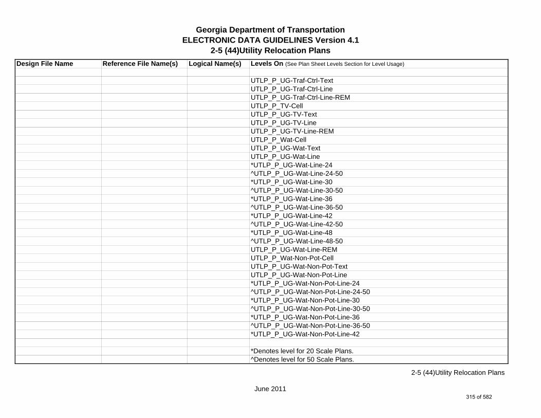
Georgia Department of TransportationELECTRONIC DATA GUIDELINES Version 4.1
2-5 (44)Utility Relocation Plans
Design File Name Reference File Name(s) Logical Name(s) Levels On (See Plan Sheet Levels Section for Level Usage)
UTLP_P_UG-Traf-Ctrl-TextUTLP_P_UG-Traf-Ctrl-LineUTLP_P_UG-Traf-Ctrl-Line-REMUTLP_P_TV-CellUTLP_P_UG-TV-TextUTLP_P_UG-TV-LineUTLP_P_UG-TV-Line-REMUTLP_P_Wat-CellUTLP_P_UG-Wat-TextUTLP_P_UG-Wat-Line*UTLP_P_UG-Wat-Line-24^UTLP_P_UG-Wat-Line-24-50*UTLP_P_UG-Wat-Line-30^UTLP_P_UG-Wat-Line-30-50*UTLP_P_UG-Wat-Line-36^UTLP_P_UG-Wat-Line-36-50*UTLP_P_UG-Wat-Line-42^UTLP_P_UG-Wat-Line-42-50*UTLP_P_UG-Wat-Line-48^UTLP_P_UG-Wat-Line-48-50UTLP_P_UG-Wat-Line-REMUTLP_P_Wat-Non-Pot-CellUTLP_P_UG-Wat-Non-Pot-TextUTLP_P_UG-Wat-Non-Pot-Line*UTLP_P_UG-Wat-Non-Pot-Line-24^UTLP_P_UG-Wat-Non-Pot-Line-24-50*UTLP_P_UG-Wat-Non-Pot-Line-30^UTLP_P_UG-Wat-Non-Pot-Line-30-50*UTLP_P_UG-Wat-Non-Pot-Line-36^UTLP_P_UG-Wat-Non-Pot-Line-36-50*UTLP_P_UG-Wat-Non-Pot-Line-42
*Denotes level for 20 Scale Plans.^Denotes level for 50 Scale Plans.
June 2011
2-5 (44)Utility Relocation Plans
315 of 582

Georgia Department of TransportationELECTRONIC DATA GUIDELINES Version 4.1
2-5 (44)Utility Relocation Plans
Design File Name Reference File Name(s) Logical Name(s) Levels On (See Plan Sheet Levels Section for Level Usage)
^UTLP_P_UG-Wat-Non-Pot-Line-42-50*UTLP_P_UG-Wat-Non-Pot-Line-48^UTLP_P_UG-Wat-Non-Pot-Line-48-50UTLP_P_UG-Wat-Non-Pot-Line-REMUTLP_P_OVHD-Tele-TextUTLP_P_OVHD-Tele-LineUTLP_P_OVHD-Tele-Line-REMUTLP_P_OVHD-TV-TextUTLP_P_OVHD-TV-LineUTLP_P_OVHD-TV-Line-REMUTLP_P_OVHD-Elec-TextUTLP_P_OVHD-Elec-LineUTLP_P_OVHD-Elec-Line-REMUTLP_P_OVHD-Traf-Ctrl-TextUTLP_P_OVHD-Traf-Ctrl-LineUTLP_P_OVHD-Traf-Ctrl-Line-REMUTLP_P_OVHD-Combo-Util-TextUTLP_P_OVHD-Combo-Util-Line-Elec-TeleUTLP_P_OVHD-Combo-Util-Lines-Elec-Tele-REMUTLP_P_OVHD-Combo-Util-Line-Elec-Tele-Traf-CtrlUTLP_P_OVHD-Combo-Util-Line-Elec-Tele-Traf-Ctrl-REMUTLP_P_OVHD-Combo-Util-Line-Elec-Tele-TVUTLP_P_OVHD-Combo-Util-Line-Elec-Tele-TV-REMUTLP_P_OVHD-Combo-Util-Line-Elec-Tele-TV-Traf-CtrlUTLP_P_OVHD-Combo-Util-Line-Elec-Tele-TV-Traf-Ctrl-REMUTLP_P_OVHD-Combo-Util-Line-Elec-Traf-CtrlUTLP_P_OVHD-Combo-Util-Line-Elec-Traf-Ctrl-REMUTLP_P_OVHD-Combo-Util-Line-Elec-TVUTLP_P_OVHD-Combo-Util-Line-Elec-TV-REMUTLP_P_OVHD-Combo-Util-Line-Elec-TV-Traf-CtrlUTLP_P_OVHD-Combo-Util-Line-Elec-TV-Traf-Ctrl-REM
*Denotes level for 20 Scale Plans.^Denotes level for 50 Scale Plans.
June 2011
2-5 (44)Utility Relocation Plans
316 of 582

Georgia Department of TransportationELECTRONIC DATA GUIDELINES Version 4.1
2-5 (44)Utility Relocation Plans
Design File Name Reference File Name(s) Logical Name(s) Levels On (See Plan Sheet Levels Section for Level Usage)
UTLP_P_OVHD-Combo-Util-Line-Tele-TVUTLP_P_OVHD-Combo-Util-Line-Tele-TV-REMUTLP_P_OVHD-Combo-Util-Line-Tele-Traf-CtrlUTLP_P_OVHD-Combo-Util-Line-Tele-Traf-Ctrl-REMUTLP_P_OVHD-Combo-Util-Line-Tele-TV-Traf-CtrlUTLP_P_OVHD-Combo-Util-Line-Tele-TV-Traf-Ctrl-REMUTLP_P_OVHD-Combo-Util-Line-TV-Traf-CtrlUTLP_P_OVHD-Combo-Util-Line-TV-Traf-Ctrl-REMUTLP_P_OVHD-Combo-Util-Line-Guy-WireUTLP_P_OVHD-Combo-Util-Line-Guy-Wire-REMUTLP_P_UG-Gas-Line-User-DefUTLP_P_UG-Petro-Line-User-DefUTLP_P_UG-San-Swr-Line-User-DefUTLP_P_UG-Steam-Line-User-DefUTLP_P_UG-Wat-Line-User-DefUTLP_P_UG-Wat-Non-Pot-User-Def-Line
1234567LIMT.DGN LIMT LIMT_P_STKCUT_Const-Limit-Cut-LineLIMT_P_CUT_Const-Limit-Cut-CellLIMT_P_STKFIL_Const-Limit-Fill-LineLIMT_P_FILL_Const-Limit-Fill-Cell
1234567PROP.DGN PROP PROP_E_PAR-PL-LinePROP_E_RWE-Line PROP_E_RWRR-LinePROP_E_RWU-LinePROP_E_RWU-TextPROP_E_POEL-LinePROP_E_POEL-TextPROP_E_BMISC-LinePROP_E_BSL-LinePROP_E_BSL-TextPROP_E_BCOL-LinePROP_E_BCOL-Text
June 2011
2-5 (44)Utility Relocation Plans
317 of 582

Georgia Department of TransportationELECTRONIC DATA GUIDELINES Version 4.1
2-5 (44)Utility Relocation Plans
Design File Name Reference File Name(s) Logical Name(s) Levels On (See Plan Sheet Levels Section for Level Usage)
PROP_E_BCTL-LinePROP_E_BCTL-TextPROP_E_BGMD-LinePROP_E_BGMD-TextPROP_E_BLDL-LinePROP_E_BLDL-TextPROP_E_BLLL-LinePROP_E_BLLL-Text
1234567TOPO.DGN TOPO TOPO_E_TEAP-LineTOPO_E_TEAS-LineTOPO_E_TECP-LineTOPO_E_TEDR-LineTOPO_E_TEST-LineTOPO_E_TEDD-LineTOPO_E_TEAD-LineTOPO_E_TECD-LineTOPO_E_TAC-LineTOPO_E_TCGF-LineTOPO_E_TCGT-LineTOPO_E_THC-LineTOPO_E_TVG-LineTOPO_E_TSW-LineTOPO_E_TGR-LineTOPO_E_TBAS-LineTOPO_E_TBGL-LineTOPO_E_TBRDGCEN-LineTOPO_E_TBRDGCOR-LineTOPO_E_THM-CellTOPO_E_TFP-LineTOPO_E_TRCR-LineTOPO_E_TRCRE-LineTOPO_E_TBLD-LineTOPO_E_TBLDRL-Line
June 2011
2-5 (44)Utility Relocation Plans
318 of 582

Georgia Department of TransportationELECTRONIC DATA GUIDELINES Version 4.1
2-5 (44)Utility Relocation Plans
Design File Name Reference File Name(s) Logical Name(s) Levels On (See Plan Sheet Levels Section for Level Usage)
TOPO_E_TUD-LineTOPO_E_TS-LineTOPO_E_TBC-LineTOPO_E_TFE-LineTOPO_E_DSTC-LineTOPO_E_DDL-LineTOPO_E_TCAN-LineTOPO_E_THCR-LineTOPO_E_THRL-LineTOPO_E_TMHCR-LineTOPO_E_TMHRL-LineTOPO_E_TFCL-LineTOPO_E_TFW-LineTOPO_E_TFBW-LineTOPO_E_TFFW-LineTOPO_E_TVF-LineTOPO_E_TG-LineTOPO_E_TFCL-TextTOPO_E_TFW-TextTOPO_E_TFBW-TextTOPO_E_TFFW-TextTOPO_E_TVF-TextTOPO_E_TG-TextTOPO_E_TWELL-LineTOPO_E_TGFV-LineTOPO_E_TGMW-LineTOPO_E_TGP-LineTOPO_E_TGPI-LineTOPO_E_TFT-LineTOPO_E_TGST-LineTOPO_E_TGVP-LineTOPO_E_DCEF-LineTOPO_E_DCEF-TextTOPO_E_DCB-Line
June 2011
2-5 (44)Utility Relocation Plans
319 of 582

Georgia Department of TransportationELECTRONIC DATA GUIDELINES Version 4.1
2-5 (44)Utility Relocation Plans
Design File Name Reference File Name(s) Logical Name(s) Levels On (See Plan Sheet Levels Section for Level Usage)
TOPO_E_DCB-TextTOPO_E_DCWE-LineTOPO_E_DCWE-TextTOPO_E_DDCB-LineTOPO_E_DDCB-TextTOPO_E_DDI-LineTOPO_E_DDI-TextTOPO_E_DHWE-LineTOPO_E_DHWE-TextTOPO_E_DJB-LineTOPO_E_DJB-TextTOPO_E_DPC-LineTOPO_E_DPC-TextTOPO_E_DPM-LineTOPO_E_DPM-TextTOPO_E_DPP-LineTOPO_E_DPP-TextTOPO_E_MDITCHFL-LineTOPO_E_MDITCHFL-TextTOPO_E_DPD-LineTOPO_E_DPD-TextTOPO_E_DSB-LineTOPO_E_DSB-TextTOPO_E_DSC-LineTOPO_E_DSC-TextTOPO_E_DSE-LineTOPO_E_DSE-TextTOPO_E_DWE-LineTOPO_E_DWE-TextTOPO_E_DEW-LineTOPO_E_DEW-TextTOPO_E_DHWM-LineTOPO_E_DHWM-TextTOPO_E_DSWE-Line
June 2011
2-5 (44)Utility Relocation Plans
320 of 582
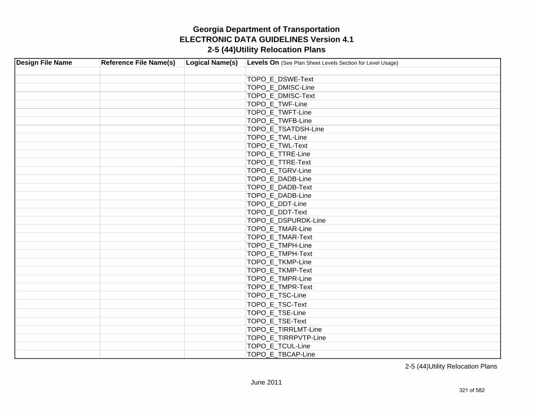
Georgia Department of TransportationELECTRONIC DATA GUIDELINES Version 4.1
2-5 (44)Utility Relocation Plans
Design File Name Reference File Name(s) Logical Name(s) Levels On (See Plan Sheet Levels Section for Level Usage)
TOPO_E_DSWE-TextTOPO_E_DMISC-LineTOPO_E_DMISC-TextTOPO_E_TWF-LineTOPO_E_TWFT-LineTOPO_E_TWFB-LineTOPO_E_TSATDSH-LineTOPO_E_TWL-LineTOPO_E_TWL-TextTOPO_E_TTRE-LineTOPO_E_TTRE-TextTOPO_E_TGRV-LineTOPO_E_DADB-LineTOPO_E_DADB-TextTOPO_E_DADB-LineTOPO_E_DDT-LineTOPO_E_DDT-TextTOPO_E_DSPURDK-LineTOPO_E_TMAR-LineTOPO_E_TMAR-TextTOPO_E_TMPH-LineTOPO_E_TMPH-TextTOPO_E_TKMP-LineTOPO_E_TKMP-TextTOPO_E_TMPR-LineTOPO_E_TMPR-TextTOPO_E_TSC-LineTOPO_E_TSC-TextTOPO_E_TSE-LineTOPO_E_TSE-TextTOPO_E_TIRRLMT-LineTOPO_E_TIRRPVTP-LineTOPO_E_TCUL-LineTOPO_E_TBCAP-Line
June 2011
2-5 (44)Utility Relocation Plans
321 of 582

Georgia Department of TransportationELECTRONIC DATA GUIDELINES Version 4.1
2-5 (44)Utility Relocation Plans
Design File Name Reference File Name(s) Logical Name(s) Levels On (See Plan Sheet Levels Section for Level Usage)
TOPO_E_TBCL-LineTOPO_E_TCOLC-LineTOPO_E_TCOLE-LineTOPO_E_TENDROLL-LineTOPO_E_UOEL-CellTOPO_E_UOEL-TextTOPO_E_UOTL-CellTOPO_E_UOTL-TextTOPO_E_UELBOX-CellTOPO_E_UELBOX-TextTOPO_E_UPP-CellTOPO_E_UPP-TextTOPO_E_ULP-CellTOPO_E_ULP-TextTOPO_E_UTP-CellTOPO_E_UTP-TextTOPO_E_UTPD-CellTOPO_E_UTPD-TextTOPO_E_UGP-CellTOPO_E_UGP-TextTOPO_E_UPGA-CellTOPO_E_UPGA-TextTOPO_E_UYLE-CellTOPO_E_UYLE-TextTOPO_E_UYLG-CellTOPO_E_UYLG-TextTOPO_E_UWM-CellTOPO_E_UWM-TextTOPO_E_UWV-CellTOPO_E_UWV-TextTOPO_E_UFH-CellTOPO_E_UFH-TextTOPO_E_UMHST-CellTOPO_E_UMHST-Text
June 2011
2-5 (44)Utility Relocation Plans
322 of 582

Georgia Department of TransportationELECTRONIC DATA GUIDELINES Version 4.1
2-5 (44)Utility Relocation Plans
Design File Name Reference File Name(s) Logical Name(s) Levels On (See Plan Sheet Levels Section for Level Usage)
TOPO_E_UMHSTF-CellTOPO_E_UMHSTF-TextTOPO_E_UMHT-CellTOPO_E_UMHT-TextTOPO_E_UMHE-CellTOPO_E_UMHE-TextTOPO_E_UMHSS-CellTOPO_E_UMHSS-TextTOPO_E_UMHSSF-CellTOPO_E_UMHSSF-TextTOPO_E_USSL-CellTOPO_E_USSL-TextTOPO_E_UGM-CellTOPO_E_UGM-TextTOPO_E_UNGV-CellTOPO_E_UNGV-TextTOPO_E_UNGVP-CellTOPO_E_UNGVP-TextTOPO_E_UNGLM-CellTOPO_E_UNGLM-TextTOPO_E_SLCD-Pnt#-TextTOPO_E_SLCD-CellTOPO_E_SLCD-LineTOPO_E_SLCD-Line-TextTOPO_E_SDCD-Pnt#-TextTOPO_E_SDCD-CellTOPO_E_SDCD-LineTOPO_E_SDCD-Line-TextTOPO_E_SCCHK-CellTOPO_E_SCCHK-LineTOPO_E_SCCHK-TextTOPO_E_SBNCHMK-Pnt#-TextTOPO_E_SBNCHMK-CellTOPO_E_SBNCHMK-Text
June 2011
2-5 (44)Utility Relocation Plans
323 of 582
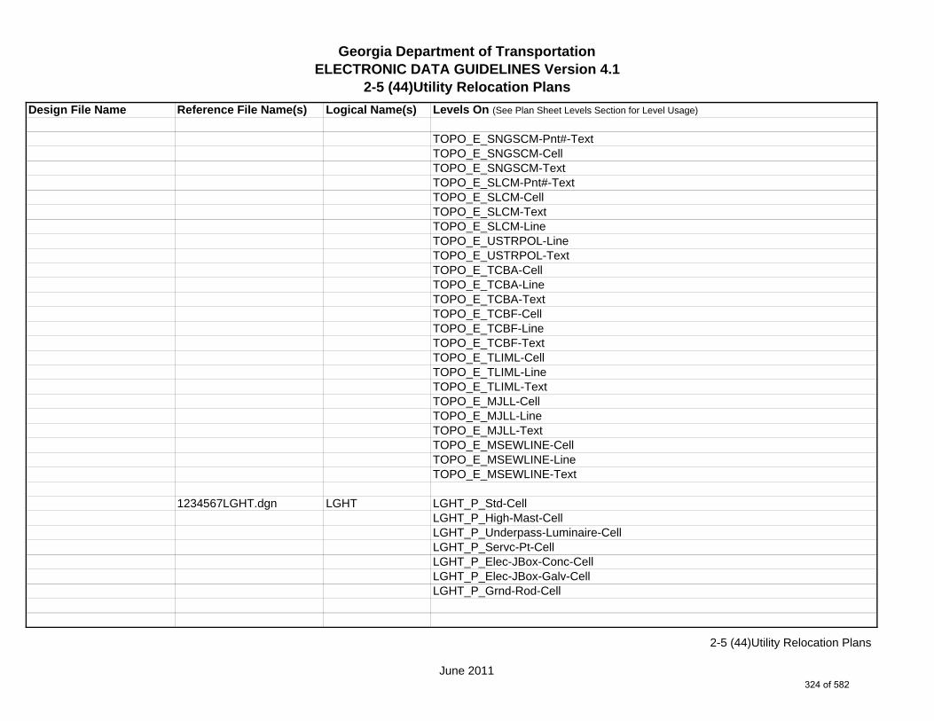
Georgia Department of TransportationELECTRONIC DATA GUIDELINES Version 4.1
2-5 (44)Utility Relocation Plans
Design File Name Reference File Name(s) Logical Name(s) Levels On (See Plan Sheet Levels Section for Level Usage)
TOPO_E_SNGSCM-Pnt#-TextTOPO_E_SNGSCM-CellTOPO_E_SNGSCM-TextTOPO_E_SLCM-Pnt#-TextTOPO_E_SLCM-CellTOPO_E_SLCM-TextTOPO_E_SLCM-LineTOPO_E_USTRPOL-LineTOPO_E_USTRPOL-TextTOPO_E_TCBA-CellTOPO_E_TCBA-LineTOPO_E_TCBA-TextTOPO_E_TCBF-CellTOPO_E_TCBF-LineTOPO_E_TCBF-TextTOPO_E_TLIML-CellTOPO_E_TLIML-LineTOPO_E_TLIML-TextTOPO_E_MJLL-CellTOPO_E_MJLL-LineTOPO_E_MJLL-TextTOPO_E_MSEWLINE-CellTOPO_E_MSEWLINE-LineTOPO_E_MSEWLINE-Text
1234567LGHT.dgn LGHT LGHT_P_Std-CellLGHT_P_High-Mast-CellLGHT_P_Underpass-Luminaire-CellLGHT_P_Servc-Pt-CellLGHT_P_Elec-JBox-Conc-CellLGHT_P_Elec-JBox-Galv-CellLGHT_P_Grnd-Rod-Cell
June 2011
2-5 (44)Utility Relocation Plans
324 of 582

Georgia Department of TransportationELECTRONIC DATA GUIDELINES Version 4.1
2-5 (44)Utility Relocation Plans
Design File Name Reference File Name(s) Logical Name(s) Levels On (See Plan Sheet Levels Section for Level Usage)
1234567ENVE.DGN ENVE ENVE_E_Wetlnd-Bound-LineENVE_E_Wetlnd-Stream-Delin-LineENVE_E_Wetlnd-Stream-TextENVE_E_Wetlnd-PatternENVE_E_Wetlnd-ShapeENVE_E_Endgd-Spec-LineENVE_E_Endgd-Spec-TextENVE_E_Endgd-Spec-PatternENVE_E_Endgd-Spec-ShapeENVE_E_Hist-Rsc-LineENVE_E_Hist-Rsc-TextENVE_E_Hist-Rsc-PatternENVE_E_Hist-Rsc-ShapeENVE_E_Arch-LineENVE_E_Arch-TextENVE_E_Arch-PatternENVE_E_Arch-ShapeENVE_E_Cult-Rsc-Delin-LineENVE_E_Cult-Rsc-TextENVE_E_Cult-Rsc-PatternENVE_E_Cult-Rsc-ShapeENVE_E_Haz-Mat-Delin-LineENVE_E_Haz-Mat-TextENVE_E_Haz-Mat-PatternENVE_E_Haz-Mat-ShapeENVE_E_Env-Justice-LineENVE_E_Env-Justice-TextENVE_E_Env-Justice-PatternENVE_E_Env-Justice-ShapeENVE_E_ESA-LineENVE_E_ESA-TextENVE_E_ESA-PatternENVE_E_ESA-Shape
June 2011
2-5 (44)Utility Relocation Plans
325 of 582

Georgia Department of TransportationELECTRONIC DATA GUIDELINES Version 4.1
2-5 (44)Utility Relocation Plans
Design File Name Reference File Name(s) Logical Name(s) Levels On (See Plan Sheet Levels Section for Level Usage)
1234567ENVP.DGN ENVP ENVP_P_Relocations-LineENVP_P_Relocations-TextENVP_P_Socl-Resc-Impact-Area-LineENVP_P_Socl-Resc-Impact-Area-PatternENVP_P_Socl-Resc-Impact-Area-TextENVP_P_Hist-APE-LineENVP_P_Hist-APE-PatternENVP_P_Hist-APE-TextENVP_P_Cultrl-Resc-Impact-Area-LineENVP_P_Cultrl-Resc-Impact-Area-PatternENVP_P_Cultrl-Resc-Impact-Area-TextENVP_P_Wetlnd-Impact-Area-LineENVP_P_Wetlnd-Impact-Area-PatternENVP_P_Wetlnd-Impact-Area-TextENVP_P_Wetlnd-Mitigat-Site-LineENVP_P_Wetlnd-Mitigat-Site-PatternENVP_P_Wetlnd-Mitigat-Site-TextENVP_P_Fldplain-Impact-Area-LineENVP_P_Fldplain-Impact-Area-PatternENVP_P_Fldplain-Impact-Area-TextENVP_P_Impacted-USTENVP_P_Noise-Study-ReceptENVP_P_Noise-Study-ReadingsENVP_P_Noise-Study-Proj-Noise-LvlsENVP_P_Noise-Study-Noise-ContENVP_P_Noise-Study-Impacted-PropENVP_P_Viewshed-Vis-ImpactENVP_P_Fldplain-Impact-Area-LineENVP_P_Fldplain-Impact-Area-PatternENVP_P_Fldplain-Impact-Area-Text
June 2011
2-5 (44)Utility Relocation Plans
326 of 582

Georgia Department of TransportationELECTRONIC DATA GUIDELINES Version 4.1
2-5 (50)Erosion Cover Sheet
Design File Name Reference File Name(s) Logical Name(s) Levels On (See Plan Sheet Levels Section for Level Usage)
1234567_50-001.DGN s NA NA SHT_B_01-CoverSHT_B_50-Erosion-CoverSHT_B_54-BMP-Locations-DetailsSHT_B_Legend-Logo-ScaleSHT_B_Misc-PSHT_B_North-ArrowSHT_B_Plot-Sub-TextSHT_B_Plotting-Info-TagsSHT_B_Sheet-Outline-LineSHT_B_Sheet-Outline-TextSHT_B_Title-BlockSHT_B_Plot-Border-Inner-LineSHT_B_Plot-Border-Outer-Line
1234567MAIN.DGN MAIN MAIN_P_CONSTCL-LineMAIN_P_SIDECL-LineMAIN_P_EOP-LineMAIN_P_Appr-Slab-LineMAIN_P_Bridge-Line
1234567DRNG.DGN DRNG DRNG_P_Ditch-and-Channel-Text
1234567REQD.DGN REQD (See PPG Notes)
1234567PROP.DGN PROP PROP_E_PAR-PL-LinePROP_E_RWE-Line PROP_E_BSL-LinePROP_E_BCOL-LinePROP_E_BCTL-LinePROP_E_BGMD-LinePROP_E_BLDL-LinePROP_E_BLLL-Line
s Single Sheet DGN Sheet File
June 2011
2-5 (50)Erosion Cover Sheet
327 of 582
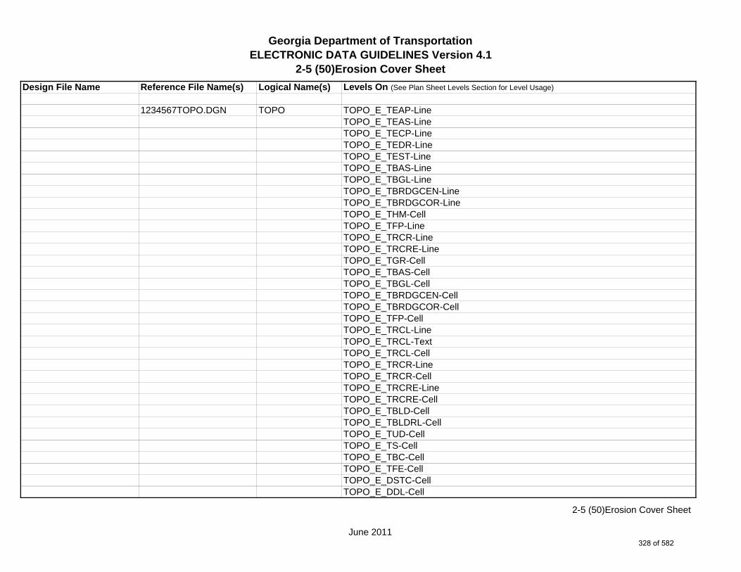
Georgia Department of TransportationELECTRONIC DATA GUIDELINES Version 4.1
2-5 (50)Erosion Cover Sheet
Design File Name Reference File Name(s) Logical Name(s) Levels On (See Plan Sheet Levels Section for Level Usage)
1234567TOPO.DGN TOPO TOPO_E_TEAP-LineTOPO_E_TEAS-LineTOPO_E_TECP-LineTOPO_E_TEDR-LineTOPO_E_TEST-LineTOPO_E_TBAS-LineTOPO_E_TBGL-LineTOPO_E_TBRDGCEN-LineTOPO_E_TBRDGCOR-LineTOPO_E_THM-CellTOPO_E_TFP-LineTOPO_E_TRCR-LineTOPO_E_TRCRE-LineTOPO_E_TGR-CellTOPO_E_TBAS-CellTOPO_E_TBGL-CellTOPO_E_TBRDGCEN-CellTOPO_E_TBRDGCOR-CellTOPO_E_TFP-CellTOPO_E_TRCL-LineTOPO_E_TRCL-TextTOPO_E_TRCL-CellTOPO_E_TRCR-LineTOPO_E_TRCR-CellTOPO_E_TRCRE-LineTOPO_E_TRCRE-CellTOPO_E_TBLD-CellTOPO_E_TBLDRL-CellTOPO_E_TUD-CellTOPO_E_TS-CellTOPO_E_TBC-CellTOPO_E_TFE-CellTOPO_E_DSTC-CellTOPO_E_DDL-Cell
June 2011
2-5 (50)Erosion Cover Sheet
328 of 582

Georgia Department of TransportationELECTRONIC DATA GUIDELINES Version 4.1
2-5 (50)Erosion Cover Sheet
Design File Name Reference File Name(s) Logical Name(s) Levels On (See Plan Sheet Levels Section for Level Usage)
TOPO_E_TCAN-CellTOPO_E_THCR-CellTOPO_E_THRL-CellTOPO_E_TMHCR-CellTOPO_E_TMHRL-CellTOPO_E_TWELL-LineTOPO_E_TGFV-LineTOPO_E_TGMW-LineTOPO_E_TGP-LineTOPO_E_TGPI-LineTOPO_E_TFT-LineTOPO_E_TGST-LineTOPO_E_TGVP-LineTOPO_E_DCEF-LineTOPO_E_DCB-LineTOPO_E_DCWE-LineTOPO_E_DDCB-LineTOPO_E_DDI-LineTOPO_E_DHWE-LineTOPO_E_DJB-LineTOPO_E_DPC-LineTOPO_E_DPM-LineTOPO_E_DPP-LineTOPO_E_UOEL-CellTOPO_E_UOTL-CellTOPO_E_UELBOX-CellTOPO_E_UPP-CellTOPO_E_ULP-CellTOPO_E_UTP-CellTOPO_E_UTPD-CellTOPO_E_UGP-CellTOPO_E_UPGA-CellTOPO_E_UYLE-CellTOPO_E_UYLG-Cell
June 2011
2-5 (50)Erosion Cover Sheet
329 of 582
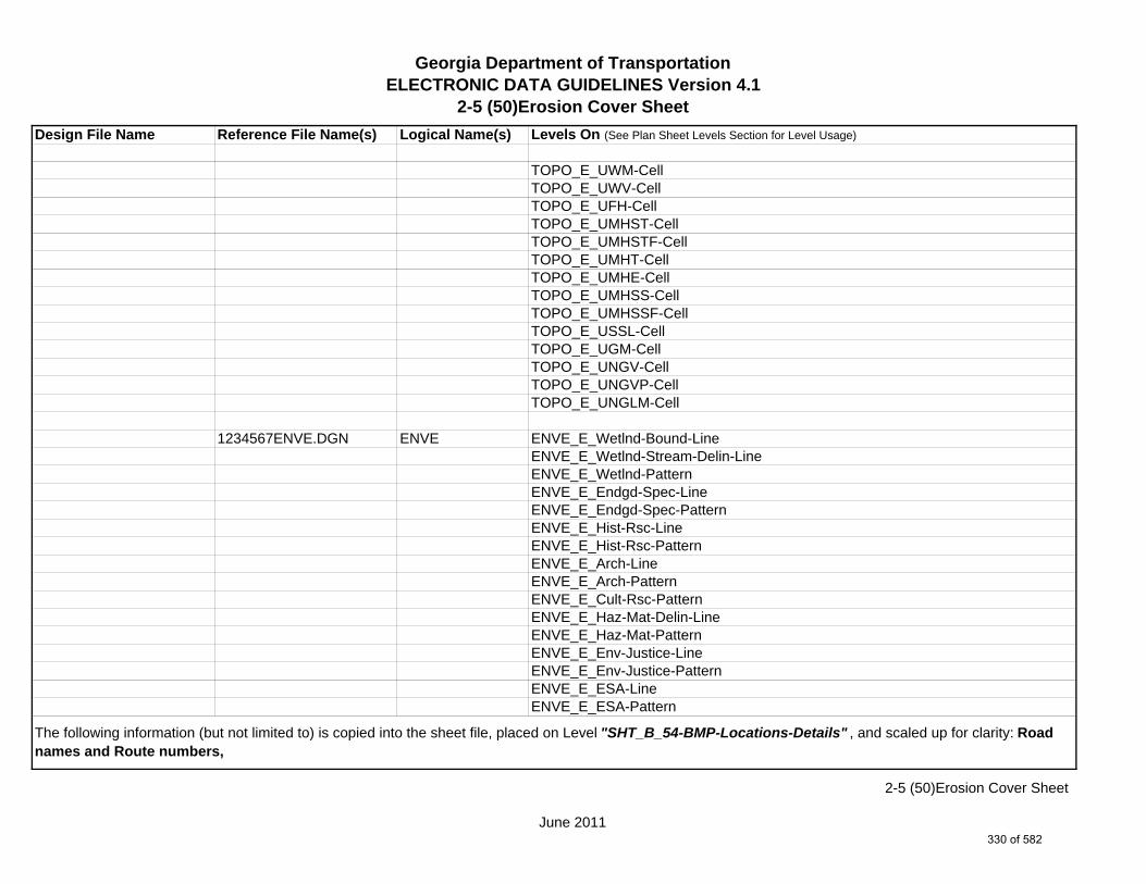
Georgia Department of TransportationELECTRONIC DATA GUIDELINES Version 4.1
2-5 (50)Erosion Cover Sheet
Design File Name Reference File Name(s) Logical Name(s) Levels On (See Plan Sheet Levels Section for Level Usage)
TOPO_E_UWM-CellTOPO_E_UWV-CellTOPO_E_UFH-CellTOPO_E_UMHST-CellTOPO_E_UMHSTF-CellTOPO_E_UMHT-CellTOPO_E_UMHE-CellTOPO_E_UMHSS-CellTOPO_E_UMHSSF-CellTOPO_E_USSL-CellTOPO_E_UGM-CellTOPO_E_UNGV-CellTOPO_E_UNGVP-CellTOPO_E_UNGLM-Cell
1234567ENVE.DGN ENVE ENVE_E_Wetlnd-Bound-LineENVE_E_Wetlnd-Stream-Delin-LineENVE_E_Wetlnd-PatternENVE_E_Endgd-Spec-LineENVE_E_Endgd-Spec-PatternENVE_E_Hist-Rsc-LineENVE_E_Hist-Rsc-PatternENVE_E_Arch-LineENVE_E_Arch-PatternENVE_E_Cult-Rsc-PatternENVE_E_Haz-Mat-Delin-LineENVE_E_Haz-Mat-PatternENVE_E_Env-Justice-LineENVE_E_Env-Justice-PatternENVE_E_ESA-LineENVE_E_ESA-Pattern
The following information (but not limited to) is copied into the sheet file, placed on Level "SHT_B_54-BMP-Locations-Details" , and scaled up for clarity: Road names and Route numbers,
June 2011
2-5 (50)Erosion Cover Sheet
330 of 582
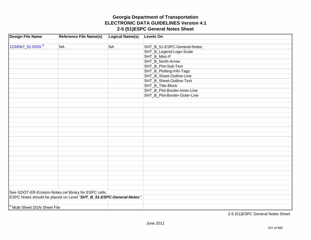
Georgia Department of TransportationELECTRONIC DATA GUIDELINES Version 4.1
2-5 (51)ESPC General Notes Sheet
Design File Name Reference File Name(s) Logical Name(s) Levels On
1234567_51.DGN m NA NA SHT_B_51-ESPC-General-NotesSHT_B_Legend-Logo-ScaleSHT_B_Misc-PSHT_B_North-ArrowSHT_B_Plot-Sub-TextSHT_B_Plotting-Info-TagsSHT_B_Sheet-Outline-LineSHT_B_Sheet-Outline-TextSHT_B_Title-BlockSHT_B_Plot-Border-Inner-LineSHT_B_Plot-Border-Outer-Line
See GDOT-ER-Erosion-Notes.cel library for ESPC cells.ESPC Notes should be placed on Level "SHT_B_51-ESPC-General-Notes ".
m Multi Sheet DGN Sheet File
June 2011
2-5 (51)ESPC General Notes Sheet
331 of 582

Georgia Department of TransportationELECTRONIC DATA GUIDELINES Version 4.1
2-5 (52)Erosion Cont. Legend
Design File Name Reference File Name(s) Logical Name(s) Levels On
1234567_52.DGN m NA NA SHT_B_52-Erosion-Cont-LegendSHT_B_Legend-Logo-ScaleSHT_B_Misc-PSHT_B_North-ArrowSHT_B_Plot-Sub-TextSHT_B_Plotting-Info-TagsSHT_B_Sheet-Outline-LineSHT_B_Sheet-Outline-TextSHT_B_Title-BlockSHT_B_Plot-Border-Inner-LineSHT_B_Plot-Border-Outer-Line
m Multi Sheet DGN Sheet File
June 2011
2-5 (52)Erosion Cont. Legend
332 of 582

Georgia Department of TransportationELECTRONIC DATA GUIDELINES Version 4.1
2-5 (53)ESPCP Drainage Area Map
Design File Name Reference File Name(s) Logical Name(s) Levels On (See Plan Sheet Levels Section for Level Usage)
1234567_53-001.DGN s NA NA SHT_B_53-ERC-Drainage-Area-MapSHT_B_Legend-Logo-ScaleSHT_B_Misc-PSHT_B_North-ArrowSHT_B_Plot-Sub-TextSHT_B_Plotting-Info-TagsSHT_B_Sheet-Outline-LineSHT_B_Sheet-Outline-TextSHT_B_Title-BlockSHT_B_Plot-Border-Inner-LineSHT_B_Plot-Border-Outer-Line
1234567MAIN.DGN MAIN MAIN_P_CONSTCL-LineMAIN_P_SIDECL-LineMAIN_P_EOP-LineMAIN_P_Bridge-LineMAIN_P_Retain-Wall-Line
1234567DRNG.DGN DRNG DRNG_P_BASIN-Boundary-Major-LineDRNG_P_Cross-Drain-and-Culv-LineDRNG_P_Bridge-Culv-Line
1234567ENVE.DGN ENVE ENVE_E_Wetlnd-Bound-LineENVE_E_Wetlnd-Stream-Delin-LineENVE_E_Wetlnd-Stream-TextENVE_E_Wetlnd-PatternENVE_E_Wetlnd-ShapeENVE_E_Endgd-Spec-LineENVE_E_Endgd-Spec-TextENVE_E_Endgd-Spec-PatternENVE_E_Endgd-Spec-ShapeENVE_E_Hist-Rsc-Line
s Single Sheet DGN Sheet File
June 2011
2-5 (53)ESPCP Drainage Area Map
333 of 582
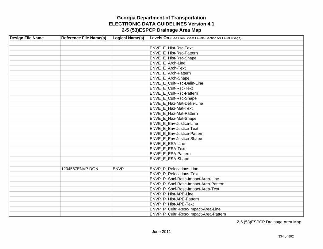
Georgia Department of TransportationELECTRONIC DATA GUIDELINES Version 4.1
2-5 (53)ESPCP Drainage Area Map
Design File Name Reference File Name(s) Logical Name(s) Levels On (See Plan Sheet Levels Section for Level Usage)
ENVE_E_Hist-Rsc-TextENVE_E_Hist-Rsc-PatternENVE_E_Hist-Rsc-ShapeENVE_E_Arch-LineENVE_E_Arch-TextENVE_E_Arch-PatternENVE_E_Arch-ShapeENVE_E_Cult-Rsc-Delin-LineENVE_E_Cult-Rsc-TextENVE_E_Cult-Rsc-PatternENVE_E_Cult-Rsc-ShapeENVE_E_Haz-Mat-Delin-LineENVE_E_Haz-Mat-TextENVE_E_Haz-Mat-PatternENVE_E_Haz-Mat-ShapeENVE_E_Env-Justice-LineENVE_E_Env-Justice-TextENVE_E_Env-Justice-PatternENVE_E_Env-Justice-ShapeENVE_E_ESA-LineENVE_E_ESA-TextENVE_E_ESA-PatternENVE_E_ESA-Shape
1234567ENVP.DGN ENVP ENVP_P_Relocations-LineENVP_P_Relocations-TextENVP_P_Socl-Resc-Impact-Area-LineENVP_P_Socl-Resc-Impact-Area-PatternENVP_P_Socl-Resc-Impact-Area-TextENVP_P_Hist-APE-LineENVP_P_Hist-APE-PatternENVP_P_Hist-APE-TextENVP_P_Cultrl-Resc-Impact-Area-LineENVP_P_Cultrl-Resc-Impact-Area-Pattern
June 2011
2-5 (53)ESPCP Drainage Area Map
334 of 582

Georgia Department of TransportationELECTRONIC DATA GUIDELINES Version 4.1
2-5 (53)ESPCP Drainage Area Map
Design File Name Reference File Name(s) Logical Name(s) Levels On (See Plan Sheet Levels Section for Level Usage)
ENVP_P_Cultrl-Resc-Impact-Area-TextENVP_P_Wetlnd-Impact-Area-LineENVP_P_Wetlnd-Impact-Area-PatternENVP_P_Wetlnd-Impact-Area-TextENVP_P_Wetlnd-Mitigat-Site-LineENVP_P_Wetlnd-Mitigat-Site-PatternENVP_P_Wetlnd-Mitigat-Site-TextENVP_P_Fldplain-Impact-Area-LineENVP_P_Fldplain-Impact-Area-PatternENVP_P_Fldplain-Impact-Area-TextENVP_P_Impacted-USTENVP_P_Noise-Study-ReceptENVP_P_Noise-Study-ReadingsENVP_P_Noise-Study-Proj-Noise-LvlsENVP_P_Noise-Study-Noise-ContENVP_P_Noise-Study-Impacted-PropENVP_P_Viewshed-Vis-ImpactENVP_P_Fldplain-Impact-Area-LineENVP_P_Fldplain-Impact-Area-PatternENVP_P_Fldplain-Impact-Area-Text
June 2011
2-5 (53)ESPCP Drainage Area Map
335 of 582

Georgia Department of TransportationELECTRONIC DATA GUIDELINES Version 4.1
2-5 (54)BMP Location Details
Design File Name Reference File Name(s) Logical Name(s) Levels On (See Plan Sheet Levels Section for Level Usage)
1234567_54.DGN m NA NA SHT_B_54-BMP-Location-DetailsSHT_B_Legend-Logo-ScaleSHT_B_Misc-PSHT_B_North-ArrowSHT_B_Plot-Sub-TextSHT_B_Plotting-Info-TagsSHT_B_Sheet-Outline-LineSHT_B_Sheet-Outline-TextSHT_B_Title-BlockSHT_B_Plot-Border-Inner-LineSHT_B_Plot-Border-Outer-Line
1234567MAIN.DGN MAIN MAIN_P_CONSTCL-LineMAIN_P_CONSTCL-Tic-Sta-TextMAIN_P_SIDECL-LineMAIN_P_SIDECL-Tic-Sta-TextMAIN_P_EOP-LineMAIN_P_EPSHLDR-LineMAIN_P_Appr-Slab-LineMAIN_P_Bridge-LineMAIN_P_Driveway-LineMAIN_P_Curb-Gutter-LineMAIN_P_Sidewalk-LineMAIN_P_Guardrail-LineMAIN_P_Median-Side-Barrier-LineMAIN_P_Retain-Wall-LineMAIN_P_Sound-Barrier-Wall-LineMAIN_P_Fence-LineMAIN_P_Misc-Const-Feat-LineMAIN_P_Details-End-Proj-CL-Intersect-Label-TextMAIN_P_Details-Begin-End-Const-Limit-Const-Label-TextMAIN_P_Details-RouteName-CL-Text
m Multi Sheet DGN Sheet File
June 2011
2-5 (54)BMP Location Details
336 of 582

Georgia Department of TransportationELECTRONIC DATA GUIDELINES Version 4.1
2-5 (54)BMP Location Details
Design File Name Reference File Name(s) Logical Name(s) Levels On (See Plan Sheet Levels Section for Level Usage)
1234567DRNG.DGN DRNG DRNG_P_Storm-Drain-StructDRNG_P_Storm-Drain-Pipe-LineDRNG_P_Storm-Drain-Pipe-TextDRNG_P_Ditch-and-Channel-LineDRNG_P_Cross-Drain-and-Culv-LineDRNG_P_Cross-Drain-and-Culv-TextDRNG_P_Bridge-Culv-LineDRNG_P_Bridge-Culv-TextDRNG_P_Sediment-Basin-LineDRNG_P_Sediment-Basin-TextDRNG_P_Detention-Pond-LineDRNG_P_Detention-Pond-TextDRNG_P_Perm-Riprap-PatternDRNG_P_Perm-Ditch-Protect-TextDRNG_P_Perm-Ditch-Protect-Line
1234567REQD.DGN REQD REQD_P_REQD-RW-Ltd-AccessREQD_P_REQD-RW-Desc-TextREQD_P_PESMT-LineREQD_P_PESMT-Desc-TextREQD_P_TESMT-LineREQD_P_TESMT-Desc-TextREQD_P_DWESMT-LineREQD_P_DWESMT-Desc-Text
1234567SIGN.DGN SIGN SIGN_P_OVHD_Sign-Structure-and-Strain-Pole
1234567SGNL.DGN SGNL
1234567LIMT.DGN LIMT LIMT_P_STKCUT_Const-Limit-Cut-LineLIMT_P_CUT_Const-Limit-Cut-CellLIMT_P_STKFIL_Const-Limit-Fill-LineLIMT_P_FILL_Const-Limit-Fill-Cell
June 2011
2-5 (54)BMP Location Details
337 of 582

Georgia Department of TransportationELECTRONIC DATA GUIDELINES Version 4.1
2-5 (54)BMP Location Details
Design File Name Reference File Name(s) Logical Name(s) Levels On (See Plan Sheet Levels Section for Level Usage)
1234567STE#.DGN STE# STE_P_DETCL-Tic-Sta-TextSTE_P_STGD-Traf-Flow-ArrowSTE_P_STGD-Current-Stage-HatchSTE_P_STGD-Current-Stage-TextSTE_P_STGD-Temp-Drain-StructSTE_P_STGD-Temp-Drain-Struct-TextSTE_P_STGD-Temp-Pvmt-WidenSTE_P_STGD-Temp-BarrierSTE_P_STGD-Const-LimitSTE_P_STGD-MiscSTE_P_EROCTRL-Silt-Fence-Type-ASTE_P_EROCTRL-Silt-Fence-Type-BSTE_P_EROCTRL-Silt-Fence-Type-CSTE_P_EROCTRL-Baled-StrawSTE_P_EROCTRL-Silt-Reten-BarrierSTE_P_EROCTRL-Ditch-Chk-Baled-StrawSTE_P_EROCTRL-Ditch-Chk-Temp-Rip-RapSTE_P_EROCTRL-Ditch-Chk-Silt-Fence-Type-ASTE_P_EROCTRL-Ditch-Chk-Silt-Fence-Type-BSTE_P_EROCTRL-Ditch-Chk-Silt-Fence-Type-CSTE_P_EROCTRL-Silt-Ctrl-GateSTE_P_EROCTRL-Inlet-Sed-TrapSTE_P_EROCTRL-Slope-StabilSTE_P_EROCTRL-Const-EntranceSTE_P_EROCTRL-Temp-Pipe-Slope-DrainSTE_P_EROCTRL-Temp-Earth-BermSTE_P_EROCTRL-Diver-ChanlSTE_P_EROCTRL-Gen-Eros-Ctrl-TextSTE_P_EROCTRL-Ditch-Protect-Bitum-RovSTE_P_EROCTRL-Ditch-Protect-Mat-Blanket
June 2011
2-5 (54)BMP Location Details
338 of 582

Georgia Department of TransportationELECTRONIC DATA GUIDELINES Version 4.1
2-5 (54)BMP Location Details
Design File Name Reference File Name(s) Logical Name(s) Levels On (See Plan Sheet Levels Section for Level Usage)
1234567PROP.DGN PROP PROP_E_PAR-PL-LinePROP_E_RWE-Line PROP_E_PAR-PL-TextPROP_E_RWRR-LinePROP_E_RWRR-TextPROP_E_RWU-LinePROP_E_RWU-TextPROP_E_POEL-LinePROP_E_POEL-Text
1234567TOPO.DGN TOPO TOPO_E_TEAP-LineTOPO_E_TEAP-TextTOPO_E_TEAS-LineTOPO_E_TEAS-TextTOPO_E_TECP-LineTOPO_E_TECP-TextTOPO_E_TEDR-LineTOPO_E_TEDR-TextTOPO_E_TEST-LineTOPO_E_TEST-TextTOPO_E_TEDD-LineTOPO_E_TEDD-TextTOPO_E_TEAD-LineTOPO_E_TEAD-TextTOPO_E_TECD-LineTOPO_E_TECD-TextTOPO_E_TAC-LineTOPO_E_TAC-TextTOPO_E_TCGF-LineTOPO_E_TCGF-TextTOPO_E_TCGT-LineTOPO_E_TCGT-TextTOPO_E_THC-LineTOPO_E_THC-Text
June 2011
2-5 (54)BMP Location Details
339 of 582

Georgia Department of TransportationELECTRONIC DATA GUIDELINES Version 4.1
2-5 (54)BMP Location Details
Design File Name Reference File Name(s) Logical Name(s) Levels On (See Plan Sheet Levels Section for Level Usage)
TOPO_E_TVG-LineTOPO_E_TVG-TextTOPO_E_TSW-LineTOPO_E_TSW-TextTOPO_E_TGR-LineTOPO_E_TGR-TextTOPO_E_TBAS-LineTOPO_E_TBAS-TextTOPO_E_TBGL-LineTOPO_E_TBGL-TextTOPO_E_TBRDGCEN-LineTOPO_E_TBRDGCEN-TextTOPO_E_TBRDGCOR-LineTOPO_E_TBRDGCOR-TextTOPO_E_THM-CellTOPO_E_THM-TextTOPO_E_THM-LineTOPO_E_TFP-LineTOPO_E_TFP-TextTOPO_E_TRCR-LineTOPO_E_TRCR-TextTOPO_E_TRCRE-LineTOPO_E_TRCRE-TextTOPO_E_TBLD-LineTOPO_E_TBLDRL-LineTOPO_E_TUD-LineTOPO_E_TS-LineTOPO_E_TBC-LineTOPO_E_TFE-LineTOPO_E_DSTC-LineTOPO_E_DDL-LineTOPO_E_TCAN-LineTOPO_E_THCR-LineTOPO_E_THRL-Line
June 2011
2-5 (54)BMP Location Details
340 of 582
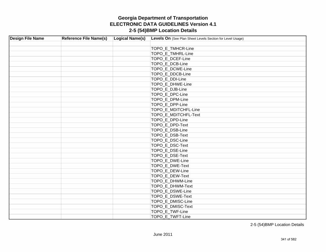
Georgia Department of TransportationELECTRONIC DATA GUIDELINES Version 4.1
2-5 (54)BMP Location Details
Design File Name Reference File Name(s) Logical Name(s) Levels On (See Plan Sheet Levels Section for Level Usage)
TOPO_E_TMHCR-LineTOPO_E_TMHRL-LineTOPO_E_DCEF-LineTOPO_E_DCB-LineTOPO_E_DCWE-LineTOPO_E_DDCB-LineTOPO_E_DDI-LineTOPO_E_DHWE-LineTOPO_E_DJB-LineTOPO_E_DPC-LineTOPO_E_DPM-LineTOPO_E_DPP-LineTOPO_E_MDITCHFL-LineTOPO_E_MDITCHFL-TextTOPO_E_DPD-LineTOPO_E_DPD-TextTOPO_E_DSB-LineTOPO_E_DSB-TextTOPO_E_DSC-LineTOPO_E_DSC-TextTOPO_E_DSE-LineTOPO_E_DSE-TextTOPO_E_DWE-LineTOPO_E_DWE-TextTOPO_E_DEW-LineTOPO_E_DEW-TextTOPO_E_DHWM-LineTOPO_E_DHWM-TextTOPO_E_DSWE-LineTOPO_E_DSWE-TextTOPO_E_DMISC-LineTOPO_E_DMISC-TextTOPO_E_TWF-LineTOPO_E_TWFT-Line
June 2011
2-5 (54)BMP Location Details
341 of 582

Georgia Department of TransportationELECTRONIC DATA GUIDELINES Version 4.1
2-5 (54)BMP Location Details
Design File Name Reference File Name(s) Logical Name(s) Levels On (See Plan Sheet Levels Section for Level Usage)
TOPO_E_TWFB-LineTOPO_E_TGRV-LineTOPO_E_DADB-LineTOPO_E_DADB-LineTOPO_E_DADB-LineTOPO_E_DSPURDK-LineTOPO_E_UOEL-CellTOPO_E_UOTL-CellTOPO_E_UELBOX-CellTOPO_E_UPP-CellTOPO_E_ULP-CellTOPO_E_UTP-CellTOPO_E_UTPD-CellTOPO_E_UGP-CellTOPO_E_UPGA-CellTOPO_E_UYLE-CellTOPO_E_UYLG-CellTOPO_E_UWM-CellTOPO_E_UWV-CellTOPO_E_UFH-CellTOPO_E_UMHST-CellTOPO_E_UMHSTF-CellTOPO_E_UMHT-CellTOPO_E_UMHE-CellTOPO_E_UMHSS-CellTOPO_E_UMHSSF-CellTOPO_E_USSL-CellTOPO_E_UGM-CellTOPO_E_UNGV-CellTOPO_E_UNGVP-CellTOPO_E_UNGLM-CellTOPO_E_DL-Text
June 2011
2-5 (54)BMP Location Details
342 of 582
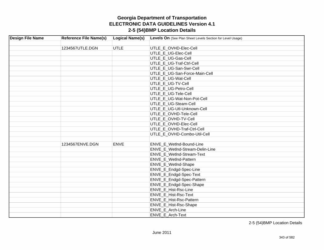
Georgia Department of TransportationELECTRONIC DATA GUIDELINES Version 4.1
2-5 (54)BMP Location Details
Design File Name Reference File Name(s) Logical Name(s) Levels On (See Plan Sheet Levels Section for Level Usage)
1234567UTLE.DGN UTLE UTLE_E_OVHD-Elec-CellUTLE_E_UG-Elec-CellUTLE_E_UG-Gas-CellUTLE_E_UG-Traf-Ctrl-CellUTLE_E_UG-San-Swr-CellUTLE_E_UG-San-Force-Main-CellUTLE_E_UG-Wat-CellUTLE_E_UG-TV-CellUTLE_E_UG-Petro-CellUTLE_E_UG-Tele-CellUTLE_E_UG-Wat-Non-Pot-CellUTLE_E_UG-Steam-CellUTLE_E_UG-Utl-Unknown-CellUTLE_E_OVHD-Tele-CellUTLE_E_OVHD-TV-CellUTLE_E_OVHD-Elec-CellUTLE_E_OVHD-Traf-Ctrl-CellUTLE_E_OVHD-Combo-Util-Cell
1234567ENVE.DGN ENVE ENVE_E_Wetlnd-Bound-LineENVE_E_Wetlnd-Stream-Delin-LineENVE_E_Wetlnd-Stream-TextENVE_E_Wetlnd-PatternENVE_E_Wetlnd-ShapeENVE_E_Endgd-Spec-LineENVE_E_Endgd-Spec-TextENVE_E_Endgd-Spec-PatternENVE_E_Endgd-Spec-ShapeENVE_E_Hist-Rsc-LineENVE_E_Hist-Rsc-TextENVE_E_Hist-Rsc-PatternENVE_E_Hist-Rsc-ShapeENVE_E_Arch-LineENVE_E_Arch-Text
June 2011
2-5 (54)BMP Location Details
343 of 582
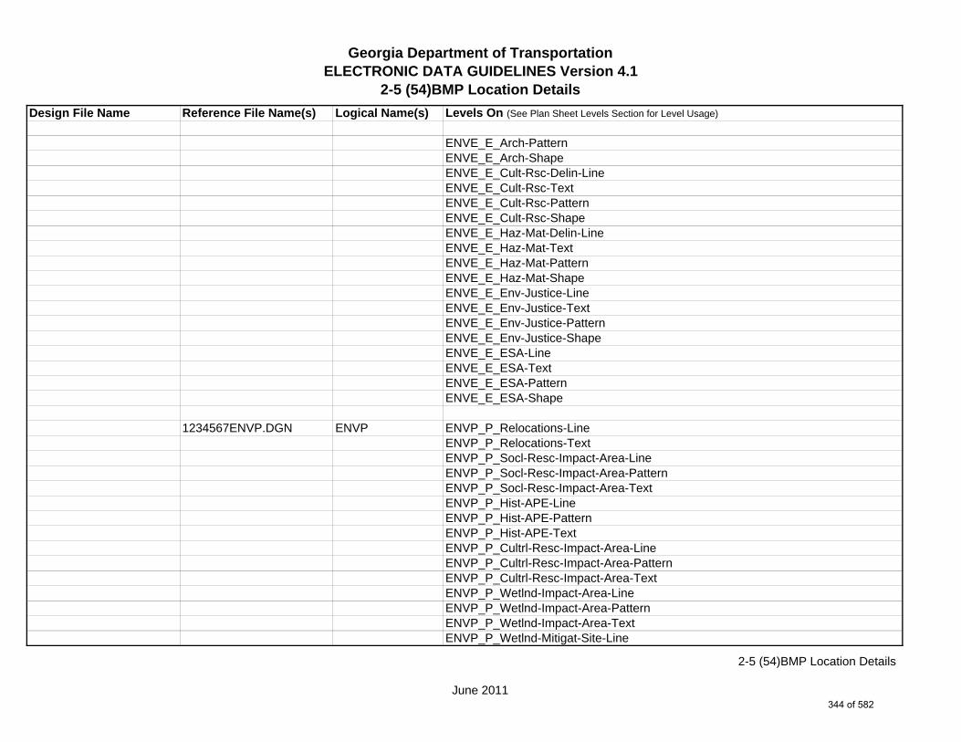
Georgia Department of TransportationELECTRONIC DATA GUIDELINES Version 4.1
2-5 (54)BMP Location Details
Design File Name Reference File Name(s) Logical Name(s) Levels On (See Plan Sheet Levels Section for Level Usage)
ENVE_E_Arch-PatternENVE_E_Arch-ShapeENVE_E_Cult-Rsc-Delin-LineENVE_E_Cult-Rsc-TextENVE_E_Cult-Rsc-PatternENVE_E_Cult-Rsc-ShapeENVE_E_Haz-Mat-Delin-LineENVE_E_Haz-Mat-TextENVE_E_Haz-Mat-PatternENVE_E_Haz-Mat-ShapeENVE_E_Env-Justice-LineENVE_E_Env-Justice-TextENVE_E_Env-Justice-PatternENVE_E_Env-Justice-ShapeENVE_E_ESA-LineENVE_E_ESA-TextENVE_E_ESA-PatternENVE_E_ESA-Shape
1234567ENVP.DGN ENVP ENVP_P_Relocations-LineENVP_P_Relocations-TextENVP_P_Socl-Resc-Impact-Area-LineENVP_P_Socl-Resc-Impact-Area-PatternENVP_P_Socl-Resc-Impact-Area-TextENVP_P_Hist-APE-LineENVP_P_Hist-APE-PatternENVP_P_Hist-APE-TextENVP_P_Cultrl-Resc-Impact-Area-LineENVP_P_Cultrl-Resc-Impact-Area-PatternENVP_P_Cultrl-Resc-Impact-Area-TextENVP_P_Wetlnd-Impact-Area-LineENVP_P_Wetlnd-Impact-Area-PatternENVP_P_Wetlnd-Impact-Area-TextENVP_P_Wetlnd-Mitigat-Site-Line
June 2011
2-5 (54)BMP Location Details
344 of 582

Georgia Department of TransportationELECTRONIC DATA GUIDELINES Version 4.1
2-5 (54)BMP Location Details
Design File Name Reference File Name(s) Logical Name(s) Levels On (See Plan Sheet Levels Section for Level Usage)
ENVP_P_Wetlnd-Mitigat-Site-PatternENVP_P_Wetlnd-Mitigat-Site-TextENVP_P_Fldplain-Impact-Area-LineENVP_P_Fldplain-Impact-Area-PatternENVP_P_Fldplain-Impact-Area-TextENVP_P_Impacted-USTENVP_P_Noise-Study-ReceptENVP_P_Noise-Study-ReadingsENVP_P_Noise-Study-Proj-Noise-LvlsENVP_P_Noise-Study-Noise-ContENVP_P_Noise-Study-Impacted-PropENVP_P_Viewshed-Vis-ImpactENVP_P_Fldplain-Impact-Area-LineENVP_P_Fldplain-Impact-Area-PatternENVP_P_Fldplain-Impact-Area-Text
June 2011
2-5 (54)BMP Location Details
345 of 582

Georgia Department of TransportationELECTRONIC DATA GUIDELINES Version 4.1
2-5 (55)EC Watershed Map-Site Mon.
Design File Name Reference File Name(s) Logical Name(s) Levels On (See Plan Sheet Levels Section for Level Usage)
1234567_55-001.DGN s NA NA SHT_B_55-Watershed-Map-Site-MonSHT_B_Legend-Logo-ScaleSHT_B_Misc-PSHT_B_North-ArrowSHT_B_Plot-Sub-TextSHT_B_Plotting-Info-TagsSHT_B_Sheet-Outline-LineSHT_B_Sheet-Outline-TextSHT_B_Title-BlockSHT_B_Plot-Border-Inner-LineSHT_B_Plot-Border-Outer-Line
1234567MAIN.DGN MAIN MAIN_P_CONSTCL-LineMAIN_P_SIDECL-LineMAIN_P_EOP-LineMAIN_P_Appr-Slab-LineMAIN_P_Bridge-LineMAIN_P_Retain-Wall-Line
1234567DRNG.DGN DRNG DRNG_P_BASIN-Boundary-Major-Line
DRNG_P_Cross-Drain-and-Culv-LineDRNG_P_Bridge-Culv-Line
1234567ENVE.DGN ENVE ENVE_E_Wetlnd-Bound-LineENVE_E_Wetlnd-Stream-Delin-LineENVE_E_Wetlnd-Stream-TextENVE_E_Wetlnd-PatternENVE_E_Wetlnd-ShapeENVE_E_Endgd-Spec-LineENVE_E_Endgd-Spec-TextENVE_E_Endgd-Spec-PatternENVE_E_Endgd-Spec-Shape
s Single Sheet DGN Sheet File
June 2011
2-5 (55)EC Watershed Map-Site Mon.
346 of 582

Georgia Department of TransportationELECTRONIC DATA GUIDELINES Version 4.1
2-5 (55)EC Watershed Map-Site Mon.
Design File Name Reference File Name(s) Logical Name(s) Levels On (See Plan Sheet Levels Section for Level Usage)
ENVE_E_Hist-Rsc-LineENVE_E_Hist-Rsc-TextENVE_E_Hist-Rsc-PatternENVE_E_Hist-Rsc-ShapeENVE_E_Arch-LineENVE_E_Arch-TextENVE_E_Arch-PatternENVE_E_Arch-ShapeENVE_E_Cult-Rsc-Delin-LineENVE_E_Cult-Rsc-TextENVE_E_Cult-Rsc-PatternENVE_E_Cult-Rsc-ShapeENVE_E_Haz-Mat-Delin-LineENVE_E_Haz-Mat-TextENVE_E_Haz-Mat-PatternENVE_E_Haz-Mat-ShapeENVE_E_Env-Justice-LineENVE_E_Env-Justice-TextENVE_E_Env-Justice-PatternENVE_E_Env-Justice-ShapeENVE_E_ESA-LineENVE_E_ESA-TextENVE_E_ESA-PatternENVE_E_ESA-Shape
1234567ENVP.DGN ENVP ENVP_P_Relocations-LineENVP_P_Relocations-TextENVP_P_Socl-Resc-Impact-Area-LineENVP_P_Socl-Resc-Impact-Area-PatternENVP_P_Socl-Resc-Impact-Area-TextENVP_P_Hist-APE-LineENVP_P_Hist-APE-PatternENVP_P_Hist-APE-TextENVP_P_Cultrl-Resc-Impact-Area-Line
June 2011
2-5 (55)EC Watershed Map-Site Mon.
347 of 582
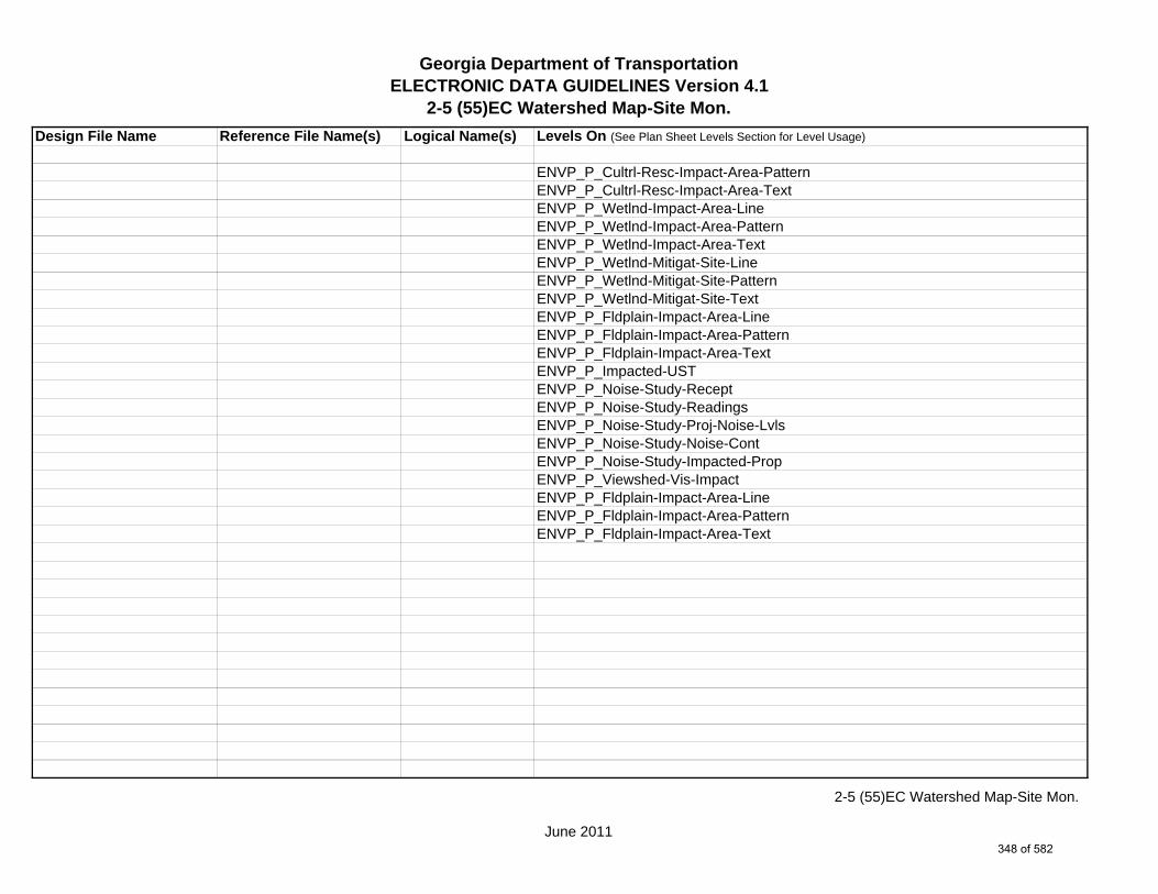
Georgia Department of TransportationELECTRONIC DATA GUIDELINES Version 4.1
2-5 (55)EC Watershed Map-Site Mon.
Design File Name Reference File Name(s) Logical Name(s) Levels On (See Plan Sheet Levels Section for Level Usage)
ENVP_P_Cultrl-Resc-Impact-Area-PatternENVP_P_Cultrl-Resc-Impact-Area-TextENVP_P_Wetlnd-Impact-Area-LineENVP_P_Wetlnd-Impact-Area-PatternENVP_P_Wetlnd-Impact-Area-TextENVP_P_Wetlnd-Mitigat-Site-LineENVP_P_Wetlnd-Mitigat-Site-PatternENVP_P_Wetlnd-Mitigat-Site-TextENVP_P_Fldplain-Impact-Area-LineENVP_P_Fldplain-Impact-Area-PatternENVP_P_Fldplain-Impact-Area-TextENVP_P_Impacted-USTENVP_P_Noise-Study-ReceptENVP_P_Noise-Study-ReadingsENVP_P_Noise-Study-Proj-Noise-LvlsENVP_P_Noise-Study-Noise-ContENVP_P_Noise-Study-Impacted-PropENVP_P_Viewshed-Vis-ImpactENVP_P_Fldplain-Impact-Area-LineENVP_P_Fldplain-Impact-Area-PatternENVP_P_Fldplain-Impact-Area-Text
June 2011
2-5 (55)EC Watershed Map-Site Mon.
348 of 582

(56)Erosion Construction Detail
Design File Name Reference File Name(s) Logical Name(s) Levels On
1234567_56-001.DGN NA NA SHT_B_56-Erosion-Construction-DetailSHT_B_Legend-Logo-ScaleSHT_B_Misc-PSHT_B_North-ArrowSHT_B_Plot-Sub-TextSHT_B_Plotting-Info-TagsSHT_B_Sheet-Outline-LineSHT_B_Sheet-Outline-TextSHT_B_Title-Block
5/2/2011
(56)Erosion Construction Detail
349 of 582
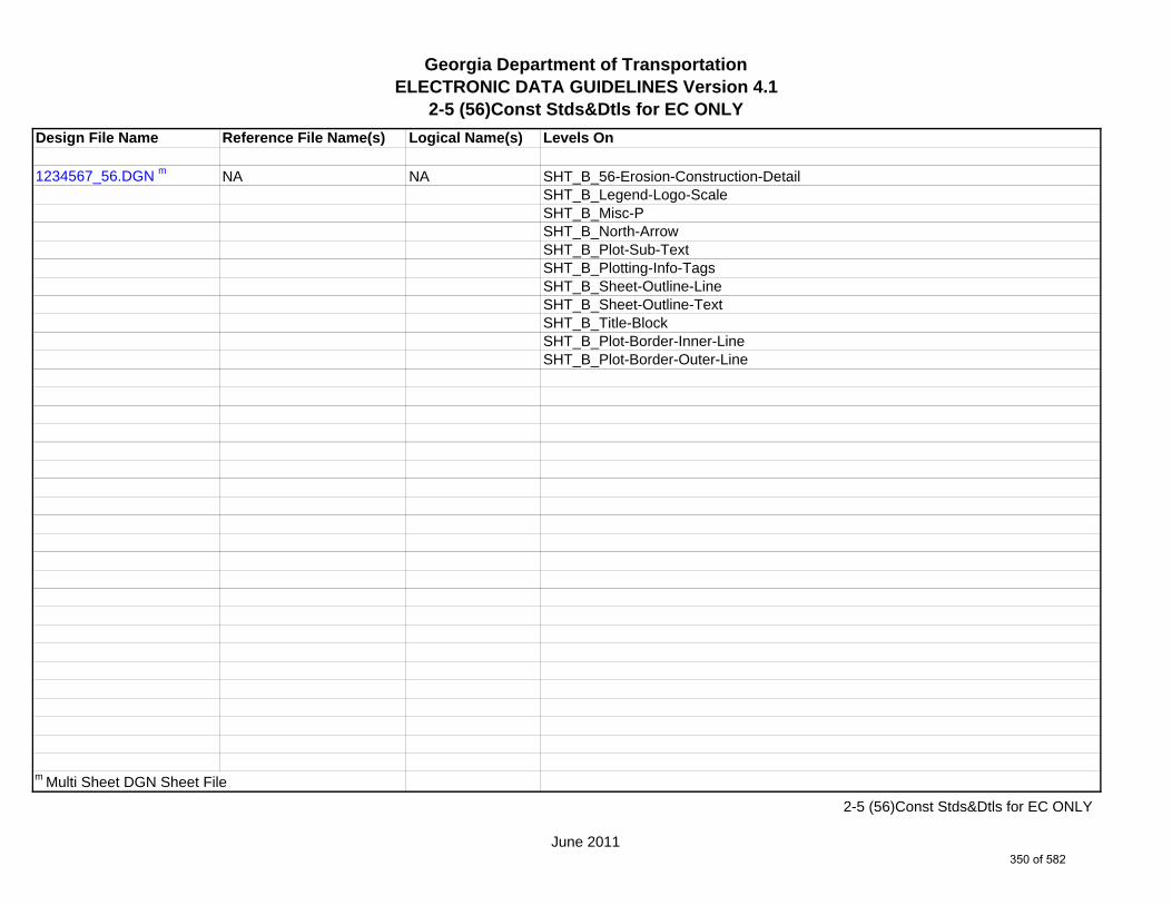
Georgia Department of TransportationELECTRONIC DATA GUIDELINES Version 4.1
2-5 (56)Const Stds&Dtls for EC ONLY
Design File Name Reference File Name(s) Logical Name(s) Levels On
1234567_56.DGN m NA NA SHT_B_56-Erosion-Construction-DetailSHT_B_Legend-Logo-ScaleSHT_B_Misc-PSHT_B_North-ArrowSHT_B_Plot-Sub-TextSHT_B_Plotting-Info-TagsSHT_B_Sheet-Outline-LineSHT_B_Sheet-Outline-TextSHT_B_Title-BlockSHT_B_Plot-Border-Inner-LineSHT_B_Plot-Border-Outer-Line
m Multi Sheet DGN Sheet File
June 2011
2-5 (56)Const Stds&Dtls for EC ONLY
350 of 582

Georgia Department of TransportationELECTRONIC DATA GUIDELINES Version 4.1
2-5 (60)Right of Way Plans-CoverDesign File Name Reference File Name(s) Logical Name(s) Levels On (See Plan Sheet Levels Section for Level Usage)
1234567_60-001.DGN s NA NA SHT_B_01-CoverSHT_B_Legend-Logo-ScaleSHT_B_Misc-PSHT_B_North-ArrowSHT_B_Plot-Sub-TextSHT_B_Plotting-Info-TagsSHT_B_Sheet-Outline-LineSHT_B_Sheet-Outline-TextSHT_B_Title-BlockSHT_B_Plot-Border-Inner-LineSHT_B_Plot-Border-Outer-Line
1234567MAIN.DGN MAIN MAIN_P_CONSTCL-LineMAIN_P_CONSTCL-Tic-Sta-TextMAIN_P_CONSTCL-PC-PT-Sta-Ldr-TextMAIN_P_CONSTCL-Brng-TextMAIN_P_SIDECL-LineMAIN_P_EOP-LineMAIN_P_Appr-Slab-LineMAIN_P_Bridge-LineMAIN_P_Sidewalk-LineMAIN_P_Median-Side-Barrier-Line
1234567REQD.DGN REQD REQD_P_Parcel-Owner-#-TextREQD_P_REQD-RW-LineREQD_P_REQD-RW-Ltd-Access
1234567PROP.DGN PROP PROP_E_PAR-PL-LinePROP_E_RWE-Line PROP_E_RWRR-LinePROP_E_RWU-LinePROP_E_POEL-Line
s Single Sheet DGN Sheet File
June 2011
2-5 (60)Right of Way Plans-Cover
351 of 582
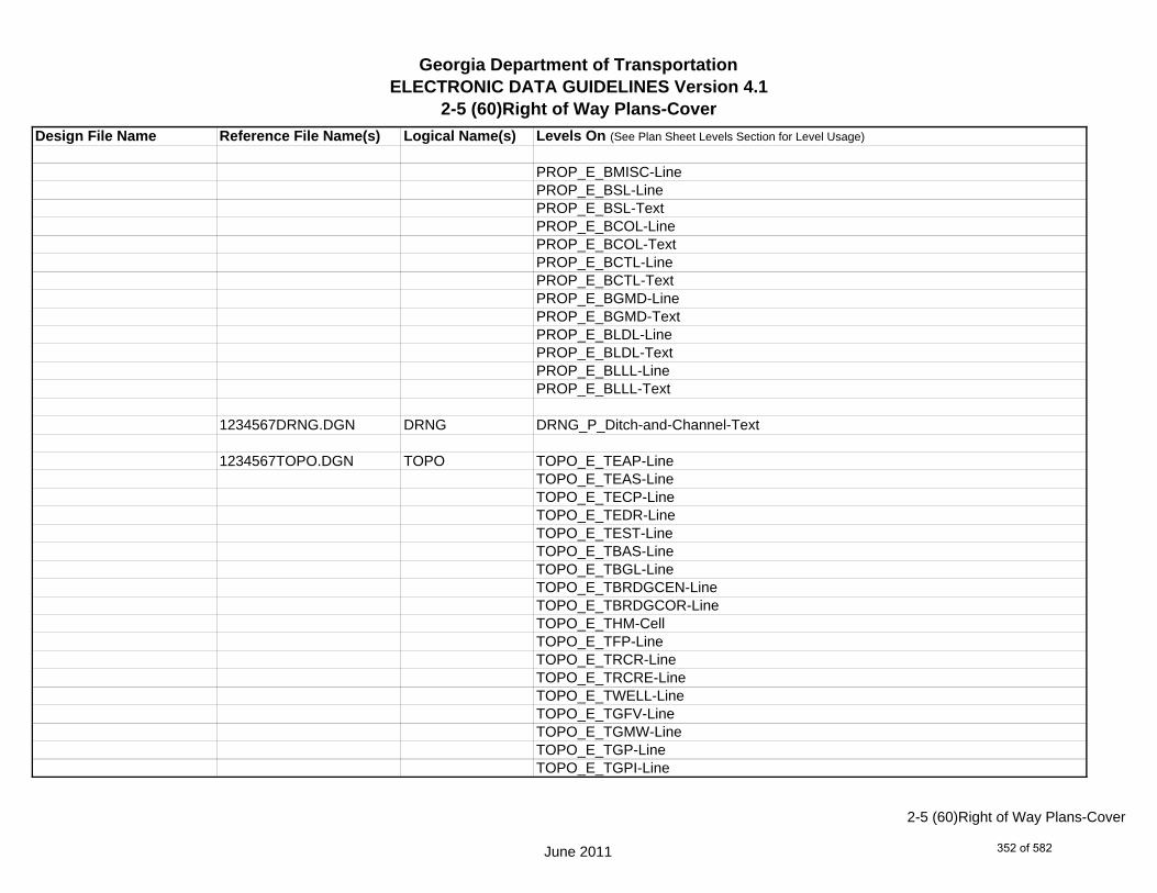
Georgia Department of TransportationELECTRONIC DATA GUIDELINES Version 4.1
2-5 (60)Right of Way Plans-CoverDesign File Name Reference File Name(s) Logical Name(s) Levels On (See Plan Sheet Levels Section for Level Usage)
PROP_E_BMISC-LinePROP_E_BSL-LinePROP_E_BSL-TextPROP_E_BCOL-LinePROP_E_BCOL-TextPROP_E_BCTL-LinePROP_E_BCTL-TextPROP_E_BGMD-LinePROP_E_BGMD-TextPROP_E_BLDL-LinePROP_E_BLDL-TextPROP_E_BLLL-LinePROP_E_BLLL-Text
1234567DRNG.DGN DRNG DRNG_P_Ditch-and-Channel-Text
1234567TOPO.DGN TOPO TOPO_E_TEAP-LineTOPO_E_TEAS-LineTOPO_E_TECP-LineTOPO_E_TEDR-LineTOPO_E_TEST-LineTOPO_E_TBAS-LineTOPO_E_TBGL-LineTOPO_E_TBRDGCEN-LineTOPO_E_TBRDGCOR-LineTOPO_E_THM-CellTOPO_E_TFP-LineTOPO_E_TRCR-LineTOPO_E_TRCRE-LineTOPO_E_TWELL-LineTOPO_E_TGFV-LineTOPO_E_TGMW-LineTOPO_E_TGP-LineTOPO_E_TGPI-Line
June 2011
2-5 (60)Right of Way Plans-Cover
352 of 582

Georgia Department of TransportationELECTRONIC DATA GUIDELINES Version 4.1
2-5 (60)Right of Way Plans-CoverDesign File Name Reference File Name(s) Logical Name(s) Levels On (See Plan Sheet Levels Section for Level Usage)
TOPO_E_TFT-LineTOPO_E_TGST-LineTOPO_E_TGVP-LineTOPO_E_DCEF-LineTOPO_E_DCB-LineTOPO_E_DCWE-LineTOPO_E_DDCB-LineTOPO_E_DDI-LineTOPO_E_DHWE-LineTOPO_E_DJB-LineTOPO_E_DPC-LineTOPO_E_DPM-LineTOPO_E_DPP-LineTOPO_E_MDITCHFL-LineTOPO_E_DPD-LineTOPO_E_DSB-LineTOPO_E_DSC-LineTOPO_E_DSE-LineTOPO_E_DWE-LineTOPO_E_DEW-LineTOPO_E_DHWM-LineTOPO_E_DSWE-LineTOPO_E_DMISC-LineTOPO_E_TGR-CellTOPO_E_TBAS-CellTOPO_E_TBGL-CellTOPO_E_TBRDGCEN-CellTOPO_E_TBRDGCOR-CellTOPO_E_TFP-CellTOPO_E_TRCL-LineTOPO_E_TRCL-TextTOPO_E_TRCL-CellTOPO_E_TRCR-CellTOPO_E_TRCRE-Cell
June 2011
2-5 (60)Right of Way Plans-Cover
353 of 582
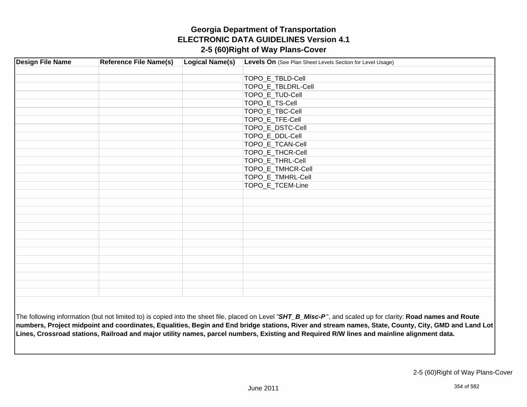
Georgia Department of TransportationELECTRONIC DATA GUIDELINES Version 4.1
2-5 (60)Right of Way Plans-CoverDesign File Name Reference File Name(s) Logical Name(s) Levels On (See Plan Sheet Levels Section for Level Usage)
TOPO_E_TBLD-CellTOPO_E_TBLDRL-CellTOPO_E_TUD-CellTOPO_E_TS-CellTOPO_E_TBC-CellTOPO_E_TFE-CellTOPO_E_DSTC-CellTOPO_E_DDL-CellTOPO_E_TCAN-CellTOPO_E_THCR-CellTOPO_E_THRL-CellTOPO_E_TMHCR-CellTOPO_E_TMHRL-CellTOPO_E_TCEM-Line
The following information (but not limited to) is copied into the sheet file, placed on Level "SHT_B_Misc-P ", and scaled up for clarity: Road names and Route numbers, Project midpoint and coordinates, Equalities, Begin and End bridge stations, River and stream names, State, County, City, GMD and Land Lot Lines, Crossroad stations, Railroad and major utility names, parcel numbers, Existing and Required R/W lines and mainline alignment data.
June 2011
2-5 (60)Right of Way Plans-Cover
354 of 582

Georgia Department of TransportationELECTRONIC DATA GUIDELINES Version 4.1
2-5 (60)Right of Way Plans-Sheets
Design File Name Reference File Name(s) Logical Name(s) Levels On (See Plan Sheet Levels Section for Level Usage)
1234567_60-002.DGN s NA NA SHT_B_60-Right-of-WaySHT_B_Legend-Logo-ScaleSHT_B_Misc-PSHT_B_North-ArrowSHT_B_Plot-Sub-TextSHT_B_Plotting-Info-TagsSHT_B_Sheet-Outline-LineSHT_B_Sheet-Outline-TextSHT_B_Title-BlockSHT_B_Plot-Border-Inner-LineSHT_B_Plot-Border-Outer-Line
1234567MAIN.DGN MAIN MAIN_P_CONSTCL-LineMAIN_P_CONSTCL-Tic-Sta-TextMAIN_P_CONSTCL-PC-PT-Sta-Ldr-TextMAIN_P_CONSTCL-Brng-TextMAIN_P_CONSTCL-CellMAIN_P_CONSTCL-Curve-Data-TextMAIN_P_SIDECL-LineMAIN_P_SIDECL-Tic-Sta-TextMAIN_P_SIDECL-PC-PT-Sta-Ldr-TextMAIN_P_SIDECL-Brng-TextMAIN_P_SIDECL-CellMAIN_P_SIDECL-Curve-Data-TextMAIN_P_EOP-LineMAIN_P_EOP-TextMAIN_P_EOP-CellMAIN_P_Bridge-LineMAIN_P_Bridge-TextMAIN_P_Driveway-LineMAIN_P_Driveway-TextMAIN_P_Curb-Gutter-Line
s Single Sheet DGN Sheet File
June 2011
2-5 (60)Right of Way Plans-Sheets
355 of 582

Georgia Department of TransportationELECTRONIC DATA GUIDELINES Version 4.1
2-5 (60)Right of Way Plans-Sheets
Design File Name Reference File Name(s) Logical Name(s) Levels On (See Plan Sheet Levels Section for Level Usage)
MAIN_P_Curb-Gutter-TextMAIN_P_Sidewalk-LineMAIN_P_Sidewalk-TextMAIN_P_Guardrail-LineMAIN_P_Guardrail-TextMAIN_P_Median-Side-Barrier-LineMAIN_P_Median-Side-Barrier-TextMAIN_P_Retain-Wall-LineMAIN_P_Retain-Wall-TextMAIN_P_Sound-Barrier-Wall-LineMAIN_P_Sound-Barrier-Wall-TextMAIN_P_Fence-LineMAIN_P_Fence-TextMAIN_P_Misc-Const-Feat-LineMAIN_P_Misc-Const-Feat-TextMAIN_P_Details-End-Proj-CL-Intersect-Label-TextMAIN_P_Details-Begin-End-Const-Limit-Const-Label-TextMAIN_P_Details-RouteName-CL-TextMAIN_P_Details-Rdwy-DimMAIN_P_Misc-Detail-Info
1234567DRNG.DGN DRNG DRNG_P_Storm-Drain-StructDRNG_P_Storm-Drain-Pipe-LineDRNG_P_Ditch-and-Channel-LineDRNG_P_Cross-Drain-and-Culv-LineDRNG_P_Bridge-Culv-LineDRNG_P_Sediment-Basin-LineDRNG_P_Detention-Pond-LineDRNG_P_Perm-Riprap-PatternDRNG_P_Perm-Ditch-Protect-TextDRNG_P_Perm-Ditch-Protect-Line
June 2011
2-5 (60)Right of Way Plans-Sheets
356 of 582

Georgia Department of TransportationELECTRONIC DATA GUIDELINES Version 4.1
2-5 (60)Right of Way Plans-Sheets
Design File Name Reference File Name(s) Logical Name(s) Levels On (See Plan Sheet Levels Section for Level Usage)
1234567REQD.DGN REQD REQD_P_Parcel-Owner-TextREQD_P_Parcel-Owner-#-TextREQD_P_Parcel-Reqd-RW-Tract#-TextREQD_P_RWRM-RW-CellREQD_P_RWRM-RW-LineREQD_P_RWRM-RW-MarkerREQD_P_RWRM-RW-TextREQD_P_REQD-RW-CellREQD_P_REQD-RW-Pnt#-TextREQD_P_REQD-RW-LineREQD_P_REQD-RW-Ltd-AccessREQD_P_REQD-RW-Desc-TextREQD_P_REQD-RW-Alg-Name-TextREQD_P_PESMT-Pnt#-TextREQD_P_PESMT-LineREQD_P_PESMT-Sta-Offset-FlagREQD_P_PESMT-Desc-TextREQD_P_PESMT-PatternREQD_P_PESMT-Alg-Name-TextREQD_P_PESMT-CellREQD_P_TESMT-Pnt#-TextREQD_P_TESMT-LineREQD_P_TESMT-Sta-Offset-FlagREQD_P_TESMT-Desc-TextREQD_P_TESMT-PatternREQD_P_TESMT-Alg-Name-TextREQD_P_TESMT-CellREQD_P_DWESMT-Pnt#-TextREQD_P_DWESMT-LineREQD_P_DWESMT-Sta-Offset-FlagREQD_P_DWESMT-Desc-TextREQD_P_DWESMT-PatternREQD_P_North-East-Coord-Label-Text
June 2011
2-5 (60)Right of Way Plans-Sheets
357 of 582
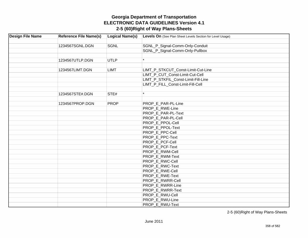
Georgia Department of TransportationELECTRONIC DATA GUIDELINES Version 4.1
2-5 (60)Right of Way Plans-Sheets
Design File Name Reference File Name(s) Logical Name(s) Levels On (See Plan Sheet Levels Section for Level Usage)
1234567SGNL.DGN SGNL SGNL_P_Signal-Comm-Only-ConduitSGNL_P_Signal-Comm-Only-Pullbox
1234567UTLP.DGN UTLP *
1234567LIMT.DGN LIMT LIMT_P_STKCUT_Const-Limit-Cut-LineLIMT_P_CUT_Const-Limit-Cut-CellLIMT_P_STKFIL_Const-Limit-Fill-LineLIMT_P_FILL_Const-Limit-Fill-Cell
1234567STE#.DGN STE# *
1234567PROP.DGN PROP PROP_E_PAR-PL-LinePROP_E_RWE-Line PROP_E_PAR-PL-TextPROP_E_PAR-PL-CellPROP_E_PPOL-CellPROP_E_PPOL-TextPROP_E_PPC-CellPROP_E_PPC-TextPROP_E_PCF-CellPROP_E_PCF-TextPROP_E_RWM-CellPROP_E_RWM-TextPROP_E_RWC-CellPROP_E_RWC-TextPROP_E_RWE-CellPROP_E_RWE-TextPROP_E_RWRR-CellPROP_E_RWRR-LinePROP_E_RWRR-TextPROP_E_RWU-CellPROP_E_RWU-LinePROP_E_RWU-Text
June 2011
2-5 (60)Right of Way Plans-Sheets
358 of 582

Georgia Department of TransportationELECTRONIC DATA GUIDELINES Version 4.1
2-5 (60)Right of Way Plans-Sheets
Design File Name Reference File Name(s) Logical Name(s) Levels On (See Plan Sheet Levels Section for Level Usage)PROP_E_POEL-CellPROP_E_POEL-LinePROP_E_POEL-TextPROP_E_BMISC-CellPROP_E_BMISC-LinePROP_E_BMISC-TextPROP_E_BSL-CellPROP_E_BSL-LinePROP_E_BSL-TextPROP_E_BCOL-CellPROP_E_BCOL-LinePROP_E_BCOL-TextPROP_E_BCTL-CellPROP_E_BCTL-LinePROP_E_BCTL-TextPROP_E_BGMD-CellPROP_E_BGMD-Pnt#-Alg-Name-TextPROP_E_BGMD-LinePROP_E_BGMD-TextPROP_E_BLDL-CellPROP_E_BLDL-Pnt#-Alg-Name-TextPROP_E_BLDL-LinePROP_E_BLLL-CellPROP_E_BLLL-LinePROP_E_BLLL-Text
1234567TOPO.DGN TOPO TOPO_E_TEAP-LineTOPO_E_TEAS-LineTOPO_E_TECP-LineTOPO_E_TEDR-LineTOPO_E_TEST-LineTOPO_E_TEDD-LineTOPO_E_TEAD-LineTOPO_E_TECD-LineTOPO_E_TAC-Line
June 2011
2-5 (60)Right of Way Plans-Sheets
359 of 582
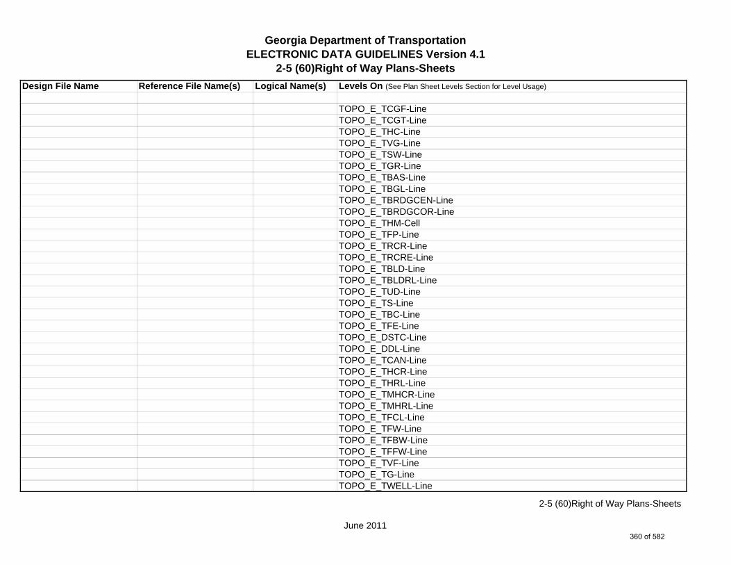
Georgia Department of TransportationELECTRONIC DATA GUIDELINES Version 4.1
2-5 (60)Right of Way Plans-Sheets
Design File Name Reference File Name(s) Logical Name(s) Levels On (See Plan Sheet Levels Section for Level Usage)
TOPO_E_TCGF-LineTOPO_E_TCGT-LineTOPO_E_THC-LineTOPO_E_TVG-LineTOPO_E_TSW-LineTOPO_E_TGR-LineTOPO_E_TBAS-LineTOPO_E_TBGL-LineTOPO_E_TBRDGCEN-LineTOPO_E_TBRDGCOR-LineTOPO_E_THM-CellTOPO_E_TFP-LineTOPO_E_TRCR-LineTOPO_E_TRCRE-LineTOPO_E_TBLD-LineTOPO_E_TBLDRL-LineTOPO_E_TUD-LineTOPO_E_TS-LineTOPO_E_TBC-LineTOPO_E_TFE-LineTOPO_E_DSTC-LineTOPO_E_DDL-LineTOPO_E_TCAN-LineTOPO_E_THCR-LineTOPO_E_THRL-LineTOPO_E_TMHCR-LineTOPO_E_TMHRL-LineTOPO_E_TFCL-LineTOPO_E_TFW-LineTOPO_E_TFBW-LineTOPO_E_TFFW-LineTOPO_E_TVF-LineTOPO_E_TG-LineTOPO_E_TWELL-Line
June 2011
2-5 (60)Right of Way Plans-Sheets
360 of 582

Georgia Department of TransportationELECTRONIC DATA GUIDELINES Version 4.1
2-5 (60)Right of Way Plans-Sheets
Design File Name Reference File Name(s) Logical Name(s) Levels On (See Plan Sheet Levels Section for Level Usage)
TOPO_E_TGFV-LineTOPO_E_TGMW-LineTOPO_E_TGP-LineTOPO_E_TGPI-LineTOPO_E_TFT-LineTOPO_E_TGST-LineTOPO_E_TGVP-LineTOPO_E_DCEF-LineTOPO_E_DCB-LineTOPO_E_DCWE-LineTOPO_E_DDCB-LineTOPO_E_DDI-LineTOPO_E_DHWE-LineTOPO_E_DJB-LineTOPO_E_DPC-LineTOPO_E_DPM-LineTOPO_E_DPP-LineTOPO_E_MDITCHFL-LineTOPO_E_DPD-LineTOPO_E_DSB-LineTOPO_E_DSC-LineTOPO_E_DSE-LineTOPO_E_DWE-LineTOPO_E_DEW-LineTOPO_E_DHWM-LineTOPO_E_DSWE-LineTOPO_E_DMISC-LineTOPO_E_TWF-LineTOPO_E_TWFT-LineTOPO_E_TWFB-LineTOPO_E_TSATDSH-LineTOPO_E_TWL-LineTOPO_E_TWL-TextTOPO_E_TTRE-Line
June 2011
2-5 (60)Right of Way Plans-Sheets
361 of 582
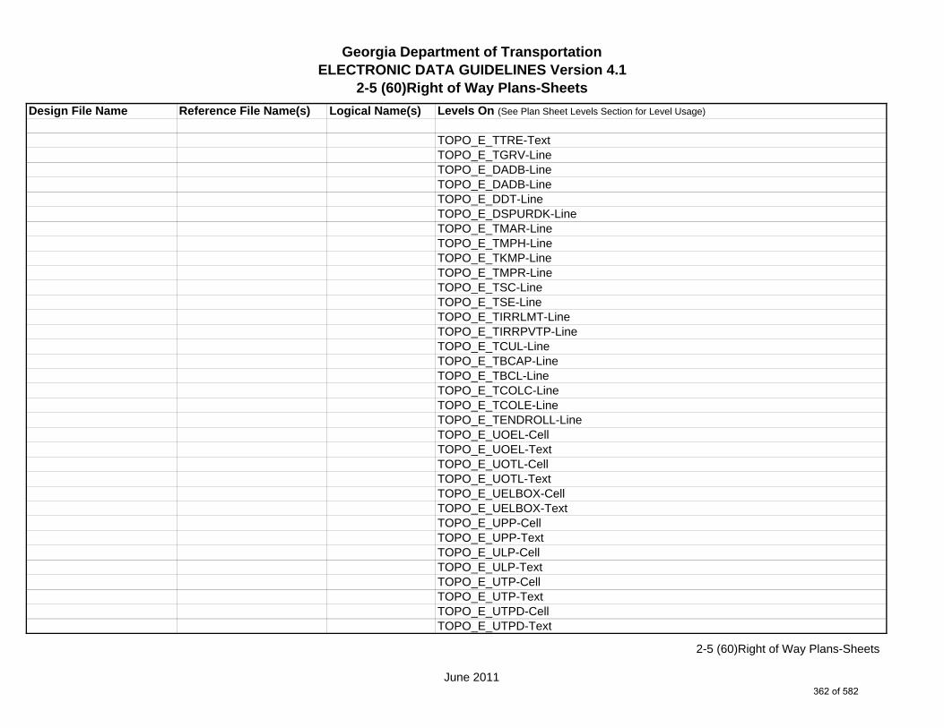
Georgia Department of TransportationELECTRONIC DATA GUIDELINES Version 4.1
2-5 (60)Right of Way Plans-Sheets
Design File Name Reference File Name(s) Logical Name(s) Levels On (See Plan Sheet Levels Section for Level Usage)
TOPO_E_TTRE-TextTOPO_E_TGRV-LineTOPO_E_DADB-LineTOPO_E_DADB-LineTOPO_E_DDT-LineTOPO_E_DSPURDK-LineTOPO_E_TMAR-LineTOPO_E_TMPH-LineTOPO_E_TKMP-LineTOPO_E_TMPR-LineTOPO_E_TSC-LineTOPO_E_TSE-LineTOPO_E_TIRRLMT-LineTOPO_E_TIRRPVTP-LineTOPO_E_TCUL-LineTOPO_E_TBCAP-LineTOPO_E_TBCL-LineTOPO_E_TCOLC-LineTOPO_E_TCOLE-LineTOPO_E_TENDROLL-LineTOPO_E_UOEL-CellTOPO_E_UOEL-TextTOPO_E_UOTL-CellTOPO_E_UOTL-TextTOPO_E_UELBOX-CellTOPO_E_UELBOX-TextTOPO_E_UPP-CellTOPO_E_UPP-TextTOPO_E_ULP-CellTOPO_E_ULP-TextTOPO_E_UTP-CellTOPO_E_UTP-TextTOPO_E_UTPD-CellTOPO_E_UTPD-Text
June 2011
2-5 (60)Right of Way Plans-Sheets
362 of 582

Georgia Department of TransportationELECTRONIC DATA GUIDELINES Version 4.1
2-5 (60)Right of Way Plans-Sheets
Design File Name Reference File Name(s) Logical Name(s) Levels On (See Plan Sheet Levels Section for Level Usage)
TOPO_E_UGP-CellTOPO_E_UGP-TextTOPO_E_UPGA-CellTOPO_E_UPGA-TextTOPO_E_UYLE-CellTOPO_E_UYLE-TextTOPO_E_UYLG-CellTOPO_E_UYLG-TextTOPO_E_UWM-CellTOPO_E_UWM-TextTOPO_E_UWV-CellTOPO_E_UWV-TextTOPO_E_UFH-CellTOPO_E_UFH-TextTOPO_E_UMHST-CellTOPO_E_UMHST-TextTOPO_E_UMHSTF-CellTOPO_E_UMHSTF-TextTOPO_E_UMHT-CellTOPO_E_UMHT-TextTOPO_E_UMHE-CellTOPO_E_UMHE-TextTOPO_E_UMHSS-CellTOPO_E_UMHSS-TextTOPO_E_UMHSSF-CellTOPO_E_UMHSSF-TextTOPO_E_USSL-CellTOPO_E_USSL-TextTOPO_E_UGM-CellTOPO_E_UGM-TextTOPO_E_UNGV-CellTOPO_E_UNGV-TextTOPO_E_UNGVP-CellTOPO_E_UNGVP-Text
June 2011
2-5 (60)Right of Way Plans-Sheets
363 of 582

Georgia Department of TransportationELECTRONIC DATA GUIDELINES Version 4.1
2-5 (60)Right of Way Plans-Sheets
Design File Name Reference File Name(s) Logical Name(s) Levels On (See Plan Sheet Levels Section for Level Usage)
TOPO_E_UNGLM-CellTOPO_E_UNGLM-TextTOPO_E_TMISC-Pnt-CellTOPO_E_TMISC-Line
1234567LGHT.DGN LGHT *
1234567LNSC.DGN LNSC *
1234567ENVP.DGN ENVP *
1234567ENVE.DGN ENVE ENVE_E_Wetlnd-Bound-LineENVE_E_Wetlnd-Stream-Delin-LineENVE_E_Wetlnd-Stream-TextENVE_E_Wetlnd-PatternENVE_E_Wetlnd-ShapeENVE_E_Endgd-Spec-LineENVE_E_Endgd-Spec-TextENVE_E_Endgd-Spec-PatternENVE_E_Endgd-Spec-ShapeENVE_E_Hist-Rsc-LineENVE_E_Hist-Rsc-TextENVE_E_Hist-Rsc-PatternENVE_E_Hist-Rsc-ShapeENVE_E_Arch-LineENVE_E_Arch-TextENVE_E_Arch-PatternENVE_E_Arch-ShapeENVE_E_Cult-Rsc-Delin-LineENVE_E_Cult-Rsc-TextENVE_E_Cult-Rsc-PatternENVE_E_Cult-Rsc-ShapeENVE_E_Haz-Mat-Delin-LineENVE_E_Haz-Mat-TextENVE_E_Haz-Mat-Pattern
June 2011
2-5 (60)Right of Way Plans-Sheets
364 of 582
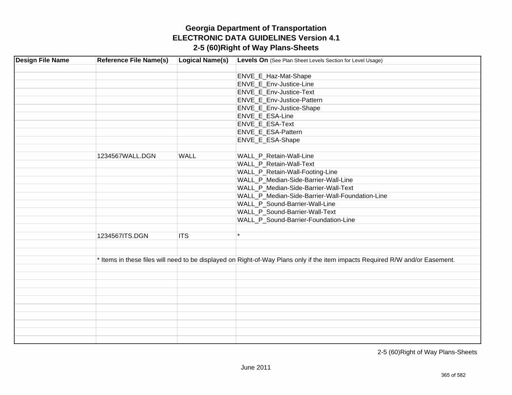
Georgia Department of TransportationELECTRONIC DATA GUIDELINES Version 4.1
2-5 (60)Right of Way Plans-Sheets
Design File Name Reference File Name(s) Logical Name(s) Levels On (See Plan Sheet Levels Section for Level Usage)
ENVE_E_Haz-Mat-ShapeENVE_E_Env-Justice-LineENVE_E_Env-Justice-TextENVE_E_Env-Justice-PatternENVE_E_Env-Justice-ShapeENVE_E_ESA-LineENVE_E_ESA-TextENVE_E_ESA-PatternENVE_E_ESA-Shape
1234567WALL.DGN WALL WALL_P_Retain-Wall-LineWALL_P_Retain-Wall-TextWALL_P_Retain-Wall-Footing-LineWALL_P_Median-Side-Barrier-Wall-LineWALL_P_Median-Side-Barrier-Wall-TextWALL_P_Median-Side-Barrier-Wall-Foundation-LineWALL_P_Sound-Barrier-Wall-LineWALL_P_Sound-Barrier-Wall-TextWALL_P_Sound-Barrier-Foundation-Line
1234567ITS.DGN ITS *
* Items in these files will need to be displayed on Right-of-Way Plans only if the item impacts Required R/W and/or Easement.
June 2011
2-5 (60)Right of Way Plans-Sheets
365 of 582

Georgia Department of TransportationELECTRONIC DATA GUIDELINES Version 4.1
2-5 Sheet Layout
Design File Name Reference File Name(s) Logical Name(s) Levels On (See Plan Sheet Levels Section for Level Usage)
SHEETLAYOUT.DGN NA NA SHT_B_Clip-Border-CellSHT_B_Clip-Border-LineSHT_B_Clip-Border-Text
June 2011
2-5 Sheet Layout
366 of 582
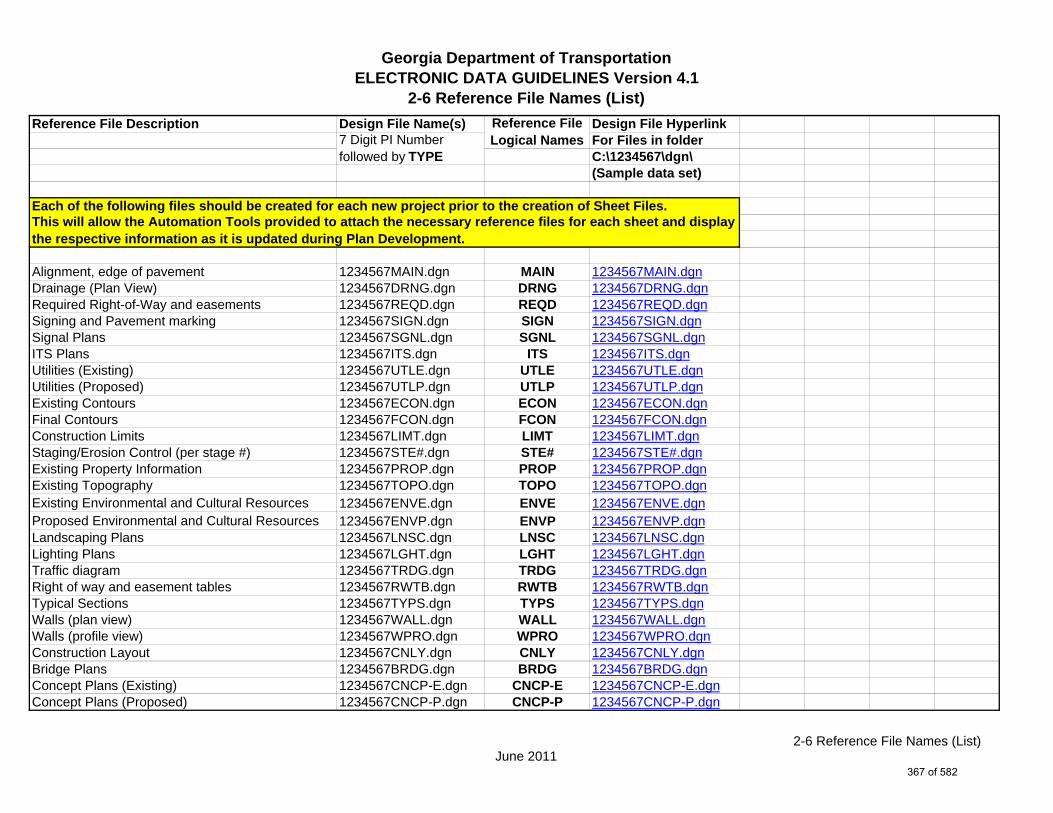
Georgia Department of TransportationELECTRONIC DATA GUIDELINES Version 4.1
2-6 Reference File Names (List)
Reference File Description Design File Name(s) Design File HyperlinkFor Files in folderC:\1234567\dgn\(Sample data set)
Each of the following files should be created for each new project prior to the creation of Sheet Files.
Alignment, edge of pavement 1234567MAIN.dgn MAIN 1234567MAIN.dgnDrainage (Plan View) 1234567DRNG.dgn DRNG 1234567DRNG.dgnRequired Right-of-Way and easements 1234567REQD.dgn REQD 1234567REQD.dgnSigning and Pavement marking 1234567SIGN.dgn SIGN 1234567SIGN.dgnSignal Plans 1234567SGNL.dgn SGNL 1234567SGNL.dgnITS Plans 1234567ITS.dgn ITS 1234567ITS.dgnUtilities (Existing) 1234567UTLE.dgn UTLE 1234567UTLE.dgnUtilities (Proposed) 1234567UTLP.dgn UTLP 1234567UTLP.dgnExisting Contours 1234567ECON.dgn ECON 1234567ECON.dgnFinal Contours 1234567FCON.dgn FCON 1234567FCON.dgnConstruction Limits 1234567LIMT.dgn LIMT 1234567LIMT.dgnStaging/Erosion Control (per stage #) 1234567STE#.dgn STE# 1234567STE#.dgnExisting Property Information 1234567PROP.dgn PROP 1234567PROP.dgnExisting Topography 1234567TOPO.dgn TOPO 1234567TOPO.dgnExisting Environmental and Cultural Resources 1234567ENVE.dgn ENVE 1234567ENVE.dgnProposed Environmental and Cultural Resources 1234567ENVP.dgn ENVP 1234567ENVP.dgnLandscaping Plans 1234567LNSC.dgn LNSC 1234567LNSC.dgnLighting Plans 1234567LGHT.dgn LGHT 1234567LGHT.dgnTraffic diagram 1234567TRDG.dgn TRDG 1234567TRDG.dgnRight of way and easement tables 1234567RWTB.dgn RWTB 1234567RWTB.dgnTypical Sections 1234567TYPS.dgn TYPS 1234567TYPS.dgnWalls (plan view) 1234567WALL.dgn WALL 1234567WALL.dgnWalls (profile view) 1234567WPRO.dgn WPRO 1234567WPRO.dgnConstruction Layout 1234567CNLY.dgn CNLY 1234567CNLY.dgnBridge Plans 1234567BRDG.dgn BRDG 1234567BRDG.dgnConcept Plans (Existing) 1234567CNCP-E.dgn CNCP-E 1234567CNCP-E.dgnConcept Plans (Proposed) 1234567CNCP-P.dgn CNCP-P 1234567CNCP-P.dgn
7 Digit PI Number followed by TYPE
This will allow the Automation Tools provided to attach the necessary reference files for each sheet and display the respective information as it is updated during Plan Development.
Reference File Logical Names
June 20112-6 Reference File Names (List)
367 of 582
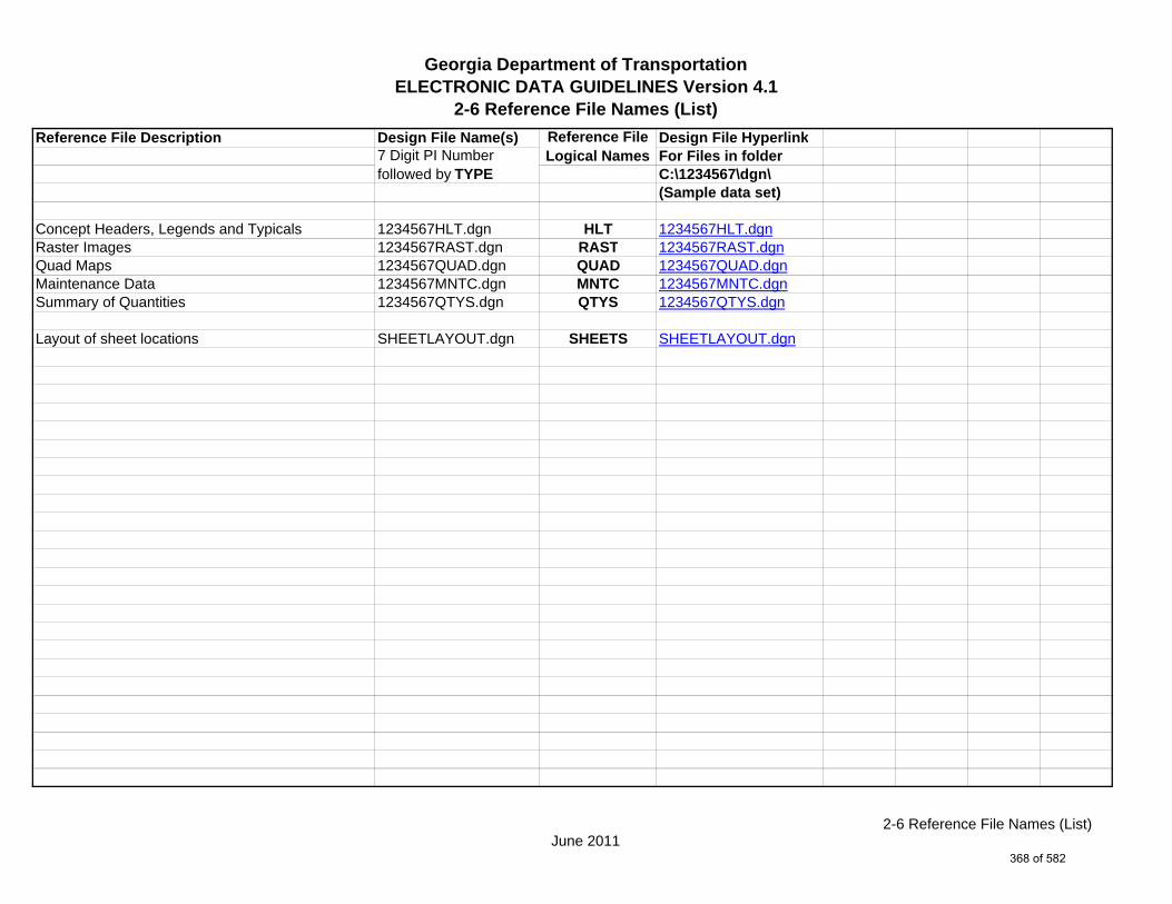
Georgia Department of TransportationELECTRONIC DATA GUIDELINES Version 4.1
2-6 Reference File Names (List)
Reference File Description Design File Name(s) Design File HyperlinkFor Files in folderC:\1234567\dgn\(Sample data set)
Concept Headers, Legends and Typicals 1234567HLT.dgn HLT 1234567HLT.dgnRaster Images 1234567RAST.dgn RAST 1234567RAST.dgnQuad Maps 1234567QUAD.dgn QUAD 1234567QUAD.dgnMaintenance Data 1234567MNTC.dgn MNTC 1234567MNTC.dgnSummary of Quantities 1234567QTYS.dgn QTYS 1234567QTYS.dgn
Layout of sheet locations SHEETLAYOUT.dgn SHEETS SHEETLAYOUT.dgn
Reference File Logical Names7 Digit PI Number
followed by TYPE
June 20112-6 Reference File Names (List)
368 of 582

Georgia Department of Transportation ELECTRONIC DATA GUIDELINES Version 4.1
2-7 Reference File Names and Levels Schemes
The following sections describe in a spreadsheet format the MicroStation Reference File Names and Level Schemes that shall be used on all Georgia Department of Transportation plan sheets.
369 of 582
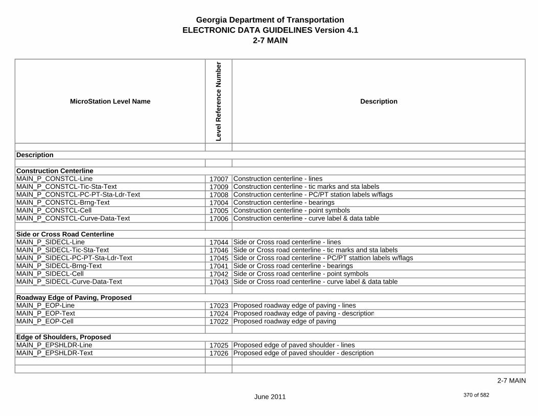
Georgia Department of TransportationELECTRONIC DATA GUIDELINES Version 4.1
2-7 MAIN
MicroStation Level Name
Leve
l Ref
eren
ce N
umbe
r
Description
MAIN_P_CONSTCL-Line 17007 Construction centerline - linesMAIN_P_CONSTCL-Tic-Sta-Text 17009 Construction centerline - tic marks and sta labelsMAIN_P_CONSTCL-PC-PT-Sta-Ldr-Text 17008 Construction centerline - PC/PT station labels w/flagsMAIN_P_CONSTCL-Brng-Text 17004 Construction centerline - bearingsMAIN_P_CONSTCL-Cell 17005 Construction centerline - point symbolsMAIN_P_CONSTCL-Curve-Data-Text 17006 Construction centerline - curve label & data table
MAIN_P_SIDECL-Line 17044 Side or Cross road centerline - linesMAIN_P_SIDECL-Tic-Sta-Text 17046 Side or Cross road centerline - tic marks and sta labelsMAIN_P_SIDECL-PC-PT-Sta-Ldr-Text 17045 Side or Cross road centerline - PC/PT stattion labels w/flagsMAIN_P_SIDECL-Brng-Text 17041 Side or Cross road centerline - bearingsMAIN_P_SIDECL-Cell 17042 Side or Cross road centerline - point symbolsMAIN_P_SIDECL-Curve-Data-Text 17043 Side or Cross road centerline - curve label & data table
MAIN_P_EOP-Line 17023 Proposed roadway edge of paving - linesMAIN_P_EOP-Text 17024 Proposed roadway edge of paving - descriptionMAIN_P_EOP-Cell 17022 Proposed roadway edge of paving
MAIN_P_EPSHLDR-Line 17025 Proposed edge of paved shoulder - linesMAIN_P_EPSHLDR-Text 17026 Proposed edge of paved shoulder - description
Description
Roadway Edge of Paving, Proposed
Construction Centerline
Side or Cross Road Centerline
Edge of Shoulders, Proposed
June 2011
2-7 MAIN
370 of 582

Georgia Department of TransportationELECTRONIC DATA GUIDELINES Version 4.1
2-7 MAIN
MicroStation Level Name
Leve
l Ref
eren
ce N
umbe
r
Description
MAIN_P_Appr-Slab-Line 17000 Approach slab - linesMAIN_P_Appr-Slab-Text 17001 Approach slab - description
MAIN_P_Bridge-Line 17002 Proposed bridge - linesMAIN_P_Bridge-Text 17003 Proposed bridge - description
MAIN_P_Driveway-Line 17020 Driveway - linesMAIN_P_Driveway-Text 17021 Driveway - description
MAIN_P_Curb-Gutter-Line 17013 Proposed curb & gutter - lines - gutter line & back of curbMAIN_P_Curb-Gutter-Text 17014 Proposed curb & gutter - description
MAIN_P_Sidewalk-Line 17047 Sidewalk - linesMAIN_P_Sidewalk-Text 17048 Sidewalk - description
MAIN_P_Guardrail-Line 17029 Proposed guardrail - lines and anchorMAIN_P_Guardrail-Text 17030 Proposed guardrail - description
Approach Slabs, Proposed
Sidewalk Face & Back, Proposed
Guardrail, Proposed
Bridge Planimetrics, Proposed
Driveways, Proposed
Curb & Gutter, Proposed
Description
June 2011
2-7 MAIN
371 of 582

Georgia Department of TransportationELECTRONIC DATA GUIDELINES Version 4.1
2-7 MAIN
MicroStation Level Name
Leve
l Ref
eren
ce N
umbe
r
Description
MAIN_P_Median-Side-Barrier-Line 17032 Proposed median or side barrier - linesMAIN_P_Median-Side-Barrier-Text 17033 Proposed median or side barrier - description
MAIN_P_Retain-Wall-Line 17037 Proposed retaining wall - linesMAIN_P_Retain-Wall-Text 17038 Proposed retaining wall - description
MAIN_P_Sound-Barrier-Wall-Line 17049 Proposed sound barrier wall - linesMAIN_P_Sound-Barrier-Wall-Text 17050 Proposed sound barrier wall - description
MAIN_P_Fence-Line 17027 Proposed fence - linesMAIN_P_Fence-Text 17028 Proposed fence - description
MAIN_P_Misc-Const-Feat-Line 17034 Proposed misc. construction feature - linesMAIN_P_Misc-Const-Feat-Text 17035 Proposed misc. construction feature - description
MAIN_P_CROWN-Cell 17010 Crown point - cellMAIN_P_CROWN-Line 17011 Crown point - linesMAIN_P_CROWN-Text 17012 Crown point - text
Median or Side Barrier, Proposed
Retaining Wall, Proposed
Sound Barrier Wall, Proposed
Fence, Proposed
Crown Point
Construction Feature, Miscellaneous, Proposed
Description
June 2011
2-7 MAIN
372 of 582

Georgia Department of TransportationELECTRONIC DATA GUIDELINES Version 4.1
2-7 MAIN
MicroStation Level Name
Leve
l Ref
eren
ce N
umbe
r
Description
MAIN_P_Details-End-Proj-CL-Intersect-Label-Text 17016 Begin/end project & centerline intersection labelsMAIN_P_Details-Begin-End-Const-Limit-Const-Label-Text 17015 Begin/end construction and limit of construction labelsMAIN_P_Details-RouteName-CL-Text 17018 Route # / road names and centerline label (CL Cell)MAIN_P_Details-Rdwy-Dim 17017 Roadway dimensionsMAIN_P_Details-Super-Elev-Trans-Label-Text 17019 Superelevation transition labelsMAIN_P_Misc-Detail-Info 17036 Miscellaneous detail information
MAIN_P_Lane-Line 17031 Lane lines (intersection and transition layout guides)MAIN_P_Lane-Text 17052 Lane lines - textMAIN_P_Lane-Cell 17053 Lane lines - cellsMAIN_P_Matchline-Line 17054 Plan Sheet Matchlines - linesMAIN_P_Matchline-Text 17055 Plan Sheet Matchlines - textMAIN_P_SHLDR-Hinge-Pnt-Alg 17039 Shoulder hinge point alignmentMAIN_P_SHLDR-Line 17040 Shoulder lines
MAIN_P_Misc 17051 Miscellaneous notes for designer (not plotted)
Roadway Details
Design Guides
Description
June 2011
2-7 MAIN
373 of 582

Georgia Department of TransportationELECTRONIC DATA GUIDELINES Version 4.1
2-7 DRNG
MicroStation Level Name
Leve
l Ref
eren
ce N
umbe
r
Description
DRNG_P_BASIN-Boundary-Major-Line 6000 Drainage area boundary (major) - lineDRNG_P_BASIN-Boundary-Major-Text 6003 Drainage area boundary (major) - descriptionDRNG_P_SBASIN-Boundary-Sub-Sys-Line 6019 Drainage area boundary (sub-system) - lineDRNG_P_SBASIN-Boundary-Sub-Sys-Text 6021 Drainage area boundary (sub-system) - description
DRNG_P_Storm-Drain-Struct-Text 6029 Storm drain structures number labelDRNG_P_Storm-Drain-Struct 6028 Storm drain structures (catch basin, junction boxes,drop inlets,
flared end sections etc…)DRNG_P_Storm-Drain-Pipe-Line 6026 Storm drain pipes (line)DRNG_P_Storm-Drain-Pipe-Text 6027 Storm drain pipe flow arrows and descriptions
DRNG_P_Ditch-and-Channel-Line 6012 Ditch and channel lines with flow arrowsDRNG_P_Ditch-and-Channel-Text 6013 Ditch and channel text
DRNG_P_Cross-Drain-and-Culv-Line 6006 Cross drain and culvert LinesDRNG_P_Cross-Drain-and-Culv-Text 6007 Cross drain and culvert flow arrows and descriptions
Description
Drainage Areas
(Side Drain, Median Drain, Yard Drain, Slope Drain, etc…)Storm Drain Systems, Proposed
Ditches and Channels, Proposed
Cross Drains and Culverts, Proposed (Items shown on drainage area map)
June 2011
2-7 DRNG
374 of 582
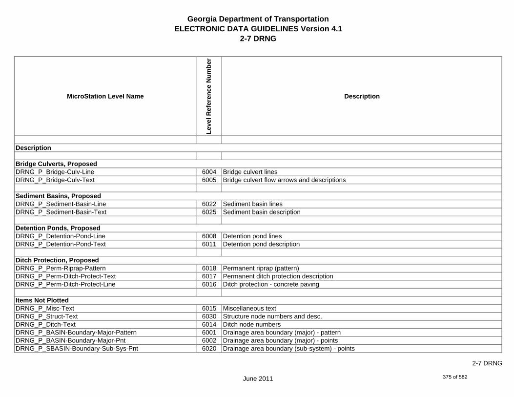
Georgia Department of TransportationELECTRONIC DATA GUIDELINES Version 4.1
2-7 DRNG
MicroStation Level Name
Leve
l Ref
eren
ce N
umbe
r
Description
DRNG_P_Bridge-Culv-Line 6004 Bridge culvert linesDRNG_P_Bridge-Culv-Text 6005 Bridge culvert flow arrows and descriptions
DRNG_P_Sediment-Basin-Line 6022 Sediment basin linesDRNG_P_Sediment-Basin-Text 6025 Sediment basin description
DRNG_P_Detention-Pond-Line 6008 Detention pond linesDRNG_P_Detention-Pond-Text 6011 Detention pond description
DRNG_P_Perm-Riprap-Pattern 6018 Permanent riprap (pattern)DRNG_P_Perm-Ditch-Protect-Text 6017 Permanent ditch protection descriptionDRNG_P_Perm-Ditch-Protect-Line 6016 Ditch protection - concrete paving
DRNG_P_Misc-Text 6015 Miscellaneous textDRNG_P_Struct-Text 6030 Structure node numbers and desc.DRNG_P_Ditch-Text 6014 Ditch node numbersDRNG_P_BASIN-Boundary-Major-Pattern 6001 Drainage area boundary (major) - patternDRNG_P_BASIN-Boundary-Major-Pnt 6002 Drainage area boundary (major) - pointsDRNG_P_SBASIN-Boundary-Sub-Sys-Pnt 6020 Drainage area boundary (sub-system) - points
Items Not Plotted
Bridge Culverts, Proposed
Sediment Basins, Proposed
Detention Ponds, Proposed
Ditch Protection, Proposed
Description
June 2011
2-7 DRNG
375 of 582

Georgia Department of TransportationELECTRONIC DATA GUIDELINES Version 4.1
2-7 DRNG
MicroStation Level Name
Leve
l Ref
eren
ce N
umbe
r
Description
DRNG_P_Sediment-Basin-Pnt-Symbol 6023 Sediment basins point symbolDRNG_P_Sediment-Basin-Pnt-Text 6024 Sediment basins point # textDRNG_P_Detention-Pond-Pnt-Symbol 6009 Detention pond point symbolDRNG_P_Detention-Pond-Pnt-Text 6010 Detention pond point # text
DRNG_P_Misc 6031 Miscellaneous Designer notes (not plotted)
Description
June 2011
2-7 DRNG
376 of 582

Georgia Department of TransportationELECTRONIC DATA GUIDELINES Version 4.1
2-7 REQD
MicroStation Level Name
Leve
l Ref
eren
ce N
umbe
r
Description
REQD_P_Parcel-Owner-Text 24009 Property / Parcel owner nameREQD_P_Parcel-Owner-#-Text 24008 Property / Parcel owner numberREQD_P_Parcel-Reqd-RW-Tract#-Text 24010 Required R/W tract number and sheet number reference
REQD_P_RWRM-RW-Cell 24026 Required R/W Marker - cellREQD_P_RWRM-RW-Line 24027 Required R/W Marker - lineREQD_P_RWRM-RW-Marker 24028 Required R/W MarkerREQD_P_RWRM-RW-Text 24029 Required R/W Marker - textREQD_P_REQD-RW-Cell 24020 Required R/W points/cellREQD_P_REQD-RW-Pnt#-Text 24024 Required R/W point # text and leader lineREQD_P_REQD-RW-Line 24022 Required R/W linesREQD_P_REQD-RW-Ltd-Access 24023 Required limited access R/W lines and cellsREQD_P_REQD-RW-Sta-Offset-Flag 24025 Required R/W station and offsets flag (See Plan Presentation Guide)REQD_P_REQD-RW-Desc-Text 24021 Required R/W description and leader lineREQD_P_REQD-RW-Alg-Name-Text 24019 Required R/W alignment name (not plotted)
Description
Parcel Owner Name, Number, etc…
Required R/W Point, Line, Shape, etc...
June 2011
2-7 REQD
377 of 582

Georgia Department of TransportationELECTRONIC DATA GUIDELINES Version 4.1
2-7 REQD
MicroStation Level Name
Leve
l Ref
eren
ce N
umbe
r
Description
REQD_P_PESMT-Pnt#-Text 24017 Permanent easement point # text and leader lineREQD_P_PESMT-Line 24015 Permanent easement linesREQD_P_PESMT-Sta-Offset-Flag 24018 Permanent easement station and offsets flag (See Plan Presentation Guide)REQD_P_PESMT-Desc-Text 24014 Permanent easement description and leader lineREQD_P_PESMT-Pattern 24016 Permanent easement patterningREQD_P_PESMT-Alg-Name-Text 24012 Permanent easement alignment name (not plotted)REQD_P_PESMT-Cell 24013 Required Perm Esmt points/cell
REQD_P_TESMT-Pnt#-Text 24035 Temporary easement point # text and leader lineREQD_P_TESMT-Line 24033 Temporary easement linesREQD_P_TESMT-Sta-Offset-Flag 24036 Temporary easement station and offsets flag (See Plan Presentation Guide)REQD_P_TESMT-Desc-Text 24032 Temporary easement description and leader lineREQD_P_TESMT-Pattern 24034 Temporary easement patterningREQD_P_TESMT-Alg-Name-Text 24030 Temporary easement alignment name (not plotted)REQD_P_TESMT-Cell 24031 Temporary easement
REQD_P_DWESMT-Pnt#-Text 24005 Driveway easement point # text and leader lineREQD_P_DWESMT-Line 24003 Driveway easement linesREQD_P_DWESMT-Sta-Offset-Flag 24006 Driveway easement station and offsets flag (See Plan Presentation Guide)REQD_P_DWESMT-Desc-Text 24002 Driveway easement description and leader lineREQD_P_DWESMT-Pattern 24004 Driveway easement patterningREQD_P_DWESMT-Alg-Name-Text 24000 Driveway alignment name (not plotted)REQD_P_DWESMT-Cell 24001 Required Driveway Esmt points/cell
Driveway Easement
Permanent Easement
Temporary Easement
Description
June 2011
2-7 REQD
378 of 582

Georgia Department of TransportationELECTRONIC DATA GUIDELINES Version 4.1
2-7 REQD
MicroStation Level Name
Leve
l Ref
eren
ce N
umbe
r
Description
REQD_P_North-East-Coord-Label-Text 24007 Northing / Easting coordinate label
REQD_P_Pattern-Shape 24011 Shapes for patterning
REQD_P_Misc 24037 Miscellaneous Designer Notes (not plotted)
Northing/Easting Coordinates
Items not Plotted
Description
June 2011
2-7 REQD
379 of 582
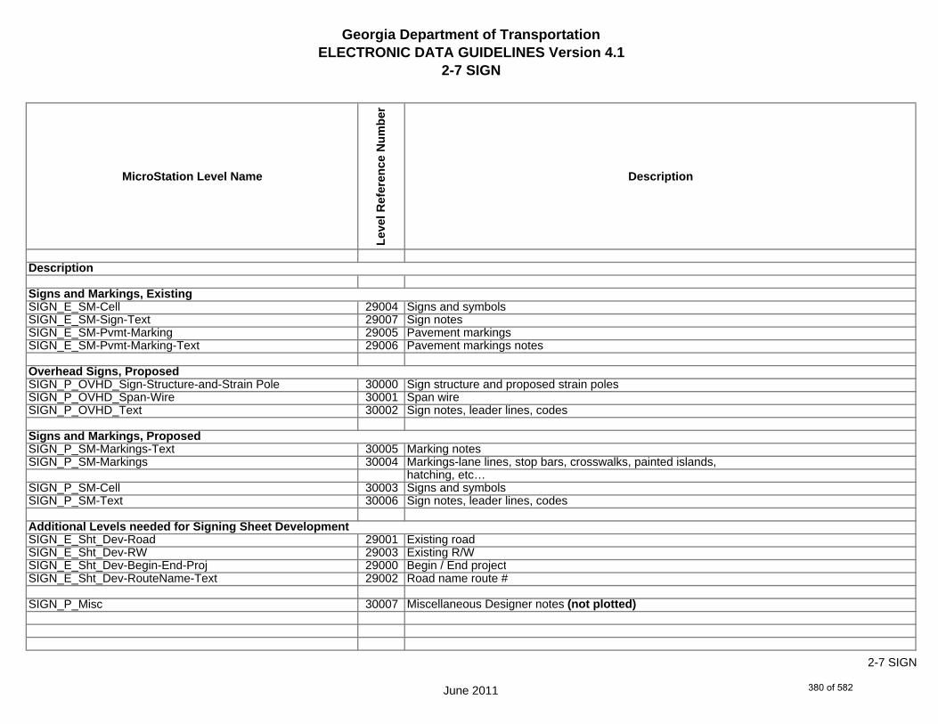
Georgia Department of TransportationELECTRONIC DATA GUIDELINES Version 4.1
2-7 SIGN
MicroStation Level Name
Leve
l Ref
eren
ce N
umbe
r
Description
SIGN_E_SM-Cell 29004 Signs and symbolsSIGN_E_SM-Sign-Text 29007 Sign notesSIGN_E_SM-Pvmt-Marking 29005 Pavement markingsSIGN_E_SM-Pvmt-Marking-Text 29006 Pavement markings notes
SIGN_P_OVHD_Sign-Structure-and-Strain Pole 30000 Sign structure and proposed strain polesSIGN_P_OVHD_Span-Wire 30001 Span wireSIGN_P_OVHD_Text 30002 Sign notes, leader lines, codes
SIGN_P_SM-Markings-Text 30005 Marking notesSIGN_P_SM-Markings 30004 Markings-lane lines, stop bars, crosswalks, painted islands,
hatching, etc…SIGN_P_SM-Cell 30003 Signs and symbolsSIGN_P_SM-Text 30006 Sign notes, leader lines, codes
SIGN_E_Sht_Dev-Road 29001 Existing roadSIGN_E_Sht_Dev-RW 29003 Existing R/WSIGN_E_Sht_Dev-Begin-End-Proj 29000 Begin / End projectSIGN_E_Sht_Dev-RouteName-Text 29002 Road name route #
SIGN_P_Misc 30007 Miscellaneous Designer notes (not plotted)
Description
Signs and Markings, Existing
Additional Levels needed for Signing Sheet Development
Overhead Signs, Proposed
Signs and Markings, Proposed
June 2011
2-7 SIGN
380 of 582

Georgia Department of TransportationELECTRONIC DATA GUIDELINES Version 4.1
2-7 SGNL
MicroStation Level Name
Leve
l Ref
eren
ce N
umbe
r
Description
SGNL_E_Signal-Signal 26007 Signal (Poles, Span Wire, Heads, Loops Notes)SGNL_E_Signal-Controller 26006 ControllerSGNL_E_Signal-Conduit-and-Pullbox 26005 Conduit and pullboxesSGNL_E_Signal-Text 26008 Signal Notes
SGNL_P_Signal-Sign 27010 SignsSGNL_P_Signal-Signal-Pole 27014 Signal PolesSGNL_P_Signal-Mast-Arms 27006 Mast ArmsSGNL_P_Signal-Span-Wire 27015 Span WireSGNL_P_Signal-Control-Cabinet 27002 Control CabinetSGNL_P_Signal-Shared-Signal-and-Comm-Conduit 27008 Shared Signal & Comm. ConduitsSGNL_P_Signal-Shared-Signal-and-Comm-Pullbox 27009 Shared Signal & Comm. Pullboxes (TP 4 & 5)SGNL_P_Signal-Head-and-Street-Name-Text 27003 Signal Heads, Pedestrian Heads, & Overhead Street NamesSGNL_P_Signal-Pedestrian-Pedestal-Pole 27007 Pedestrian Pedestal PolesSGNL_P_Signal-Comm-Only-Conduit 27000 Communication Only ConduitsSGNL_P_Signal-Comm-Only-Pullbox 27001 Communication Only Pullboxes (TP 4 & 5)SGNL_P_Signal-Loop 27004 LoopsSGNL_P_Signal-Signal-Only-Pullbox 27012 Signal Only PullboxesSGNL_P_Signal-Signal-Only-Pullbox-TP2 27013 Signal Only Pullboxes (TP 2)SGNL_P_Signal-Signal-Only-Conduit 27011 Signal Only ConduitsSGNL_P_Signal-Loop-lead-In 27005 Loop lead-InSGNL_P_Signal-Text 27016 Notes, Quantities, Signs, etc…SGNL_P_Signal-AerialFiber 27018 Aerial fiber linesSGNL_P_Signal-UndergroundFiber 27019 Underground fiber lines
Description
Signals, Existing
Signals, Proposed
June 2011
2-7 SGNL
381 of 582

Georgia Department of TransportationELECTRONIC DATA GUIDELINES Version 4.1
2-7 SGNL
MicroStation Level Name
Leve
l Ref
eren
ce N
umbe
r
Description
SGNL_E_Sht_Dev-Road 26001 Existing RoadSGNL_E_Sht_Dev-RW 26003 Existing R/WSGNL_E_Sht_Dev-Sidewalk 26004 Sidewalk (Existing)SGNL_E_Sht_Dev-Begin-End-Proj 26000 Begin / End ProjectSGNL_E_Sht_Dev-RouteName 26002 Road Name Route #
SGNL_P_Misc 27017 Miscellaneous Designer notes (not plotted)
Additional Levels needed for Signing sheet Development
Description
June 2011
2-7 SGNL
382 of 582
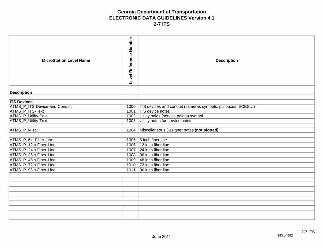
Georgia Department of TransportationELECTRONIC DATA GUIDELINES Version 4.1
2-7 ITS
MicroStation Level Name
Leve
l Ref
eren
ce N
umbe
r
Description
ATMS_P_ITS-Device-and-Conduit 1000 ITS devices and conduit (cameras symbols, pullboxes, ECBS…)ATMS_P_ITS-Text 1001 ITS device notesATMS_P_Utility-Pole 1002 Utility poles (service points) symbolATMS_P_Utility-Text 1003 Utility notes for service points
ATMS_P_Misc 1004 Miscellaneous Designer notes (not plotted)
ATMS_P_6in-Fiber-Line 1005 6 inch fiber lineATMS_P_12in-Fiber-Line 1006 12 inch fiber lineATMS_P_24in-Fiber-Line 1007 24 inch fiber lineATMS_P_36in-Fiber-Line 1008 36 inch fiber lineATMS_P_48in-Fiber-Line 1009 48 inch fiber lineATMS_P_72in-Fiber-Line 1010 72 inch fiber lineATMS_P_96in-Fiber-Line 1011 96 inch fiber line
Description
ITS Devices
June 20112-7 ITS
383 of 582

Georgia Department of TransportationELECTRONIC DATA GUIDELINES Version 4.1
2-7 UTLE
MicroStation Level Name
Leve
l Ref
eren
ce N
umbe
r
Description
UTLE_E_Elec-Cell 35030 Electrical cellUTLE_E_UG-Elec-Text 35034 Electrical (Underground) [Text-label,size,type]UTLE_E_UG-Elec-Line 35031 Electrical (Underground) lineUTLE_E_UG-Elec-Line-Qual-B 35032 Electrical (Underground) line [Quality Level B]UTLE_E_UG-Elec-Line-Qual-C 35033 Electrical (Underground) line [Quality Level C]UTLE_E_Elec-Vault-Line 35286 Electrical Vault line
UTLE_E_Gas-Cell 35035 Gas cellUTLE_E_UG-Gas-Text 35054 Gas (Underground) [Text-label,size,type]UTLE_E_UG-Gas-Line 35036 Gas (Underground) lineUTLE_E_UG-Gas-Line-Qual-B 35052 Gas (Underground) line [Quality Level B]UTLE_E_UG-Gas-Line-Qual-C 35053 Gas (Underground) line [Quality Level C]*UTLE_E_UG-Gas-Line-24 35037 24 inch Underground Gas line - 20 Scale Plans^UTLE_E_UG-Gas-Line-24-50 35196 24 inch Underground Gas line - 50 Scale Plans*UTLE_E_UG-Gas-Line-24-Qual-B 35038 24 inch Underground Gas line [Quality Level B] - 20 Scale Plans^UTLE_E_UG-Gas-Line-24-Qual-B-50 35197 24 inch Underground Gas line [Quality Level B] - 50 Scale Plans*UTLE_E_UG-Gas-Line-24-Qual-C 35039 24 inch Underground Gas line [Quality Level C] - 20 Scale Plans^UTLE_E_UG-Gas-Line-24-Qual-C-50 35198 24 inch Underground Gas line [Quality Level C] - 50 Scale Plans*UTLE_E_UG-Gas-Line-30 35040 30 inch Underground Gas line - 20 Scale Plans^UTLE_E_UG-Gas-Line-30-50 35199 30 inch Underground Gas line - 50 Scale Plans*UTLE_E_UG-Gas-Line-30-Qual-B 35041 30 inch Underground Gas line [Quality Level B] - 20 Scale Plans
* Denotes level for use in 20 Scale Plans.^ Denotes level for use in 50 Scale Plans.
Description
Underground Utilities, Existing
June 2011
2-7 UTLE
384 of 582

Georgia Department of TransportationELECTRONIC DATA GUIDELINES Version 4.1
2-7 UTLE
MicroStation Level Name
Leve
l Ref
eren
ce N
umbe
r
Description
^UTLE_E_UG-Gas-Line-30-Qual-B-50 35200 30 inch Underground Gas line [Quality Level B] - 50 Scale Plans*UTLE_E_UG-Gas-Line-30-Qual-C 35042 30 inch Underground Gas line [Quality Level C] - 20 Scale Plans^UTLE_E_UG-Gas-Line-30-Qual-C-50 35201 30 inch Underground Gas line [Quality Level C] - 50 Scale Plans*UTLE_E_UG-Gas-Line-36 35043 36 inch Underground Gas line - 20 Scale Plans^UTLE_E_UG-Gas-Line-36-50 35202 36 inch Underground Gas line - 50 Scale Plans*UTLE_E_UG-Gas-Line-36-Qual-B 35044 36 inch Underground Gas line [Quality Level B] - 20 Scale Plans^UTLE_E_UG-Gas-Line-36-Qual-B-50 35203 36 inch Underground Gas line [Quality Level B] - 50 Scale Plans*UTLE_E_UG-Gas-Line-36-Qual-C 35045 36 inch Underground Gas line [Quality Level C] - 20 Scale Plans^UTLE_E_UG-Gas-Line-36-Qual-C-50 35204 36 inch Underground Gas line [Quality Level C] - 50 Scale Plans*UTLE_E_UG-Gas-Line-42 35046 42 inch Underground Gas line - 20 Scale Plans^UTLE_E_UG-Gas-Line-42-50 35205 42 inch Underground Gas line - 50 Scale Plans*UTLE_E_UG-Gas-Line-42-Qual-B 35047 42 inch Underground Gas line [Quality Level B] - 20 Scale Plans^UTLE_E_UG-Gas-Line-42-Qual-B-50 35206 42 inch Underground Gas line [Quality Level B] - 50 Scale Plans*UTLE_E_UG-Gas-Line-42-Qual-C 35048 42 inch Underground Gas line [Quality Level C] - 20 Scale Plans^UTLE_E_UG-Gas-Line-42-Qual-C-50 35207 42 inch Underground Gas line [Quality Level C] - 50 Scale Plans*UTLE_E_UG-Gas-Line-48 35049 48 inch Underground Gas line - 20 Scale Plans^UTLE_E_UG-Gas-Line-48-50 35208 48 inch Underground Gas line - 50 Scale Plans*UTLE_E_UG-Gas-Line-48-Qual-B 35050 48 inch Underground Gas line [Quality Level B] - 20 Scale Plans^UTLE_E_UG-Gas-Line-48-Qual-B-50 35209 48 inch Underground Gas line [Quality Level B] - 50 Scale Plans*UTLE_E_UG-Gas-Line-48-Qual-C 35051 48 inch Underground Gas line [Quality Level C] - 20 Scale Plans^UTLE_E_UG-Gas-Line-48-Qual-C-50 35210 48 inch Underground Gas line [Quality Level C] - 50 Scale Plans
* Denotes level for use in 20 Scale Plans.^ Denotes level for use in 50 Scale Plans.
Description
June 2011
2-7 UTLE
385 of 582

Georgia Department of TransportationELECTRONIC DATA GUIDELINES Version 4.1
2-7 UTLE
MicroStation Level Name
Leve
l Ref
eren
ce N
umbe
r
Description
UTLE_E_Traf-Ctrl-Cell 35125 Traffic Control cellUTLE_E_UG-Traf-Ctrl-Text 35129 Traffic Control (Underground) [Text-label,size,type]UTLE_E_UG-Traf-Ctrl-Line 35126 Traffic Control (Underground) lineUTLE_E_UG-Traf-Ctrl-Line-Qual-B 35127 Traffic Control (Underground) line [Quality Level B]UTLE_E_UG-Traf-Ctrl-Line-Qual-C 35128 Traffic Control (Underground) line [Quality Level C]
UTLE_E_San-Swr-Cell 35080 Sanitary Sewer cellUTLE_E_UG-San-Swr-Text 35099 Sanitary Sewer (Underground) [Text-label,size,type]UTLE_E_UG-San-Swr-Line 35081 Sanitary Sewer (Underground) lineUTLE_E_UG-San-Swr-Line-Qual-B 35097 Sanitary Sewer (Underground) line [Quality Level B]UTLE_E_UG-San-Swr-Line-Qual-C 35098 Sanitary Sewer (Underground) line [Quality Level C]*UTLE_E_UG-San-Swr-Line-24 35082 24 inch Underground Sanitary Sewer line - 20 Scale Plans^UTLE_E_UG-San-Swr-Line-24-50 35226 24 inch Underground Sanitary Sewer line - 50 Scale Plans*UTLE_E_UG-San-Swr-Line-24-Qual-B 35083 24 inch Underground Sanitary Sewer line [Quality Level B] - 20 Scale Plans^UTLE_E_UG-San-Swr-Line-24-Qual-B-50 35227 24 inch Underground Sanitary Sewer line [Quality Level B] - 50 Scale Plans*UTLE_E_UG-San-Swr-Line-24-Qual-C 35084 24 inch Underground Sanitary Sewer line [Quality Level C] - 20 Scale Plans^UTLE_E_UG-San-Swr-Line-24-Qual-C-50 35228 24 inch Underground Sanitary Sewer line [Quality Level C] - 50 Scale Plans*UTLE_E_UG-San-Swr-Line-30 35085 30 inch Underground Sanitary Sewer line - 20 Scale Plans^UTLE_E_UG-San-Swr-Line-30-50 35229 30 inch Underground Sanitary Sewer line - 50 Scale Plans*UTLE_E_UG-San-Swr-Line-30-Qual-B 35086 30 inch Underground Sanitary Sewer line [Quality Level B] - 20 Scale Plans^UTLE_E_UG-San-Swr-Line-30-Qual-B-50 35230 30 inch Underground Sanitary Sewer line [Quality Level B] - 50 Scale Plans*UTLE_E_UG-San-Swr-Line-30-Qual-C 35087 30 inch Underground Sanitary Sewer line [Quality Level C] - 20 Scale Plans
* Denotes level for use in 20 Scale Plans.^ Denotes level for use in 50 Scale Plans.
Description
June 2011
2-7 UTLE
386 of 582

Georgia Department of TransportationELECTRONIC DATA GUIDELINES Version 4.1
2-7 UTLE
MicroStation Level Name
Leve
l Ref
eren
ce N
umbe
r
Description
^UTLE_E_UG-San-Swr-Line-30-Qual-C-50 35231 30 inch Underground Sanitary Sewer line [Quality Level C] - 50 Scale Plans*UTLE_E_UG-San-Swr-Line-36 35088 36 inch Underground Sanitary Sewer line - 20 Scale Plans^UTLE_E_UG-San-Swr-Line-36-50 35232 36 inch Underground Sanitary Sewer line - 50 Scale Plans*UTLE_E_UG-San-Swr-Line-36-Qual-B 35089 36 inch Underground Sanitary Sewer line [Quality Level B] - 20 Scale Plans^UTLE_E_UG-San-Swr-Line-36-Qual-B-50 35233 36 inch Underground Sanitary Sewer line [Quality Level B] - 50 Scale Plans*UTLE_E_UG-San-Swr-Line-36-Qual-C 35090 36 inch Underground Sanitary Sewer line [Quality Level C] - 20 Scale Plans^UTLE_E_UG-San-Swr-Line-36-Qual-C-50 35234 36 inch Underground Sanitary Sewer line [Quality Level C] - 50 Scale Plans*UTLE_E_UG-San-Swr-Line-42 35091 42 inch Underground Sanitary Sewer line - 20 Scale Plans^UTLE_E_UG-San-Swr-Line-42-50 35235 42 inch Underground Sanitary Sewer line - 50 Scale Plans*UTLE_E_UG-San-Swr-Line-42-Qual-B 35092 42 inch Underground Sanitary Sewer line [Quality Level B] - 20 Scale Plans^UTLE_E_UG-San-Swr-Line-42-Qual-B-50 35236 42 inch Underground Sanitary Sewer line [Quality Level B] - 50 Scale Plans*UTLE_E_UG-San-Swr-Line-42-Qual-C 35093 42 inch Underground Sanitary Sewer line [Quality Level C] - 20 Scale Plans^UTLE_E_UG-San-Swr-Line-42-Qual-C-50 35237 42 inch Underground Sanitary Sewer line [Quality Level C] - 50 Scale Plans*UTLE_E_UG-San-Swr-Line-48 35094 48 inch Underground Sanitary Sewer line - 20 Scale Plans^UTLE_E_UG-San-Swr-Line-48-50 35238 48 inch Underground Sanitary Sewer line - 50 Scale Plans*UTLE_E_UG-San-Swr-Line-48-Qual-B 35095 48 inch Underground Sanitary Sewer line [Quality Level B] - 20 Scale Plans^UTLE_E_UG-San-Swr-Line-48-Qual-B-50 35239 48 inch Underground Sanitary Sewer line [Quality Level B] - 50 Scale Plans*UTLE_E_UG-San-Swr-Line-48-Qual-C 35096 48 inch Underground Sanitary Sewer line [Quality Level C] - 20 Scale Plans^UTLE_E_UG-San-Swr-Line-48-Qual-C-50 35240 48 inch Underground Sanitary Sewer line [Quality Level C] - 50 Scale PlansUTLE_E_San-Force-Main-Cell 35075 Sanitary Force Main cellUTLE_E_UG-San-Force-Main-Text 35079 Sanitary Force Main (Underground) [Text-label,size,type]UTLE_E_UG-San-Force-Main-Line 35076 Sanitary Force Main (Underground) line
* Denotes level for use in 20 Scale Plans.^ Denotes level for use in 50 Scale Plans.
Description
June 2011
2-7 UTLE
387 of 582

Georgia Department of TransportationELECTRONIC DATA GUIDELINES Version 4.1
2-7 UTLE
MicroStation Level Name
Leve
l Ref
eren
ce N
umbe
r
Description
UTLE_E_UG-San-Force-Main-Line-Qual-B 35077 Sanitary Force Main (Underground) line [Quality Level B]UTLE_E_UG-San-Force-Main-Line-Qual-C 35078 Sanitary Force Main (Underground) line [Quality Level C]
UTLE_E_Wat-Cell 35138 Water cellUTLE_E_UG-Wat-Text 35177 Water (Underground) [Text-label,size,type]UTLE_E_UG-Wat-Line 35139 Water (Underground) lineUTLE_E_UG-Wat-Line-Qual-B 35155 Water (Underground) line [Quality Level B]UTLE_E_UG-Wat-Line-Qual-C 35156 Water (Underground) line [Quality Level C]*UTLE_E_UG-Wat-Line-24 35140 24 inch Underground Water line - 20 Scale Plans^UTLE_E_UG-Wat-Line-24-50 35256 24 inch Underground Water line - 50 Scale Plans*UTLE_E_UG-Wat-Line-24-Qual-B 35141 24 inch Underground Water line [Quality Level B] - 20 Scale Plans^UTLE_E_UG-Wat-Line-24-Qual-B-50 35257 24 inch Underground Water line [Quality Level B] - 50 Scale Plans*UTLE_E_UG-Wat-Line-24-Qual-C 35142 24 inch Underground Water line [Quality Level C] - 20 Scale Plans^UTLE_E_UG-Wat-Line-24-Qual-C-50 35258 24 inch Underground Water line [Quality Level C] - 50 Scale Plans*UTLE_E_UG-Wat-Line-30 35143 30 inch Underground Water line - 20 Scale Plans^UTLE_E_UG-Wat-Line-30-50 35259 30 inch Underground Water line - 50 Scale Plans*UTLE_E_UG-Wat-Line-30-Qual-B 35144 30 inch Underground Water line [Quality Level B] - 20 Scale Plans^UTLE_E_UG-Wat-Line-30-Qual-B-50 35260 30 inch Underground Water line [Quality Level B] - 50 Scale Plans*UTLE_E_UG-Wat-Line-30-Qual-C 35145 30 inch Underground Water line [Quality Level C] - 20 Scale Plans^UTLE_E_UG-Wat-Line-30-Qual-C-50 35261 30 inch Underground Water line [Quality Level C] - 50 Scale Plans*UTLE_E_UG-Wat-Line-36 35146 36 inch Underground Water line - 20 Scale Plans^UTLE_E_UG-Wat-Line-36-50 35262 36 inch Underground Water line - 50 Scale Plans
* Denotes level for use in 20 Scale Plans.^ Denotes level for use in 50 Scale Plans.
Description
June 2011
2-7 UTLE
388 of 582
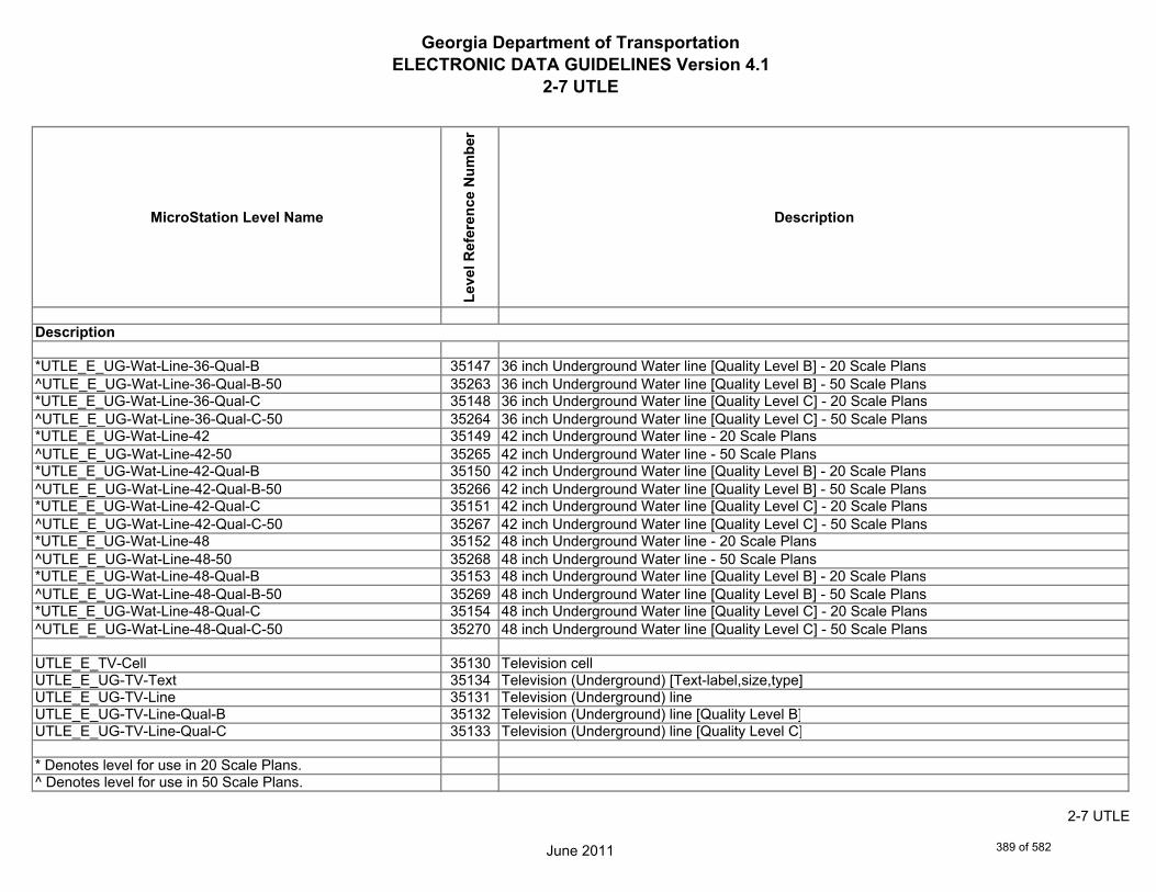
Georgia Department of TransportationELECTRONIC DATA GUIDELINES Version 4.1
2-7 UTLE
MicroStation Level Name
Leve
l Ref
eren
ce N
umbe
r
Description
*UTLE_E_UG-Wat-Line-36-Qual-B 35147 36 inch Underground Water line [Quality Level B] - 20 Scale Plans^UTLE_E_UG-Wat-Line-36-Qual-B-50 35263 36 inch Underground Water line [Quality Level B] - 50 Scale Plans*UTLE_E_UG-Wat-Line-36-Qual-C 35148 36 inch Underground Water line [Quality Level C] - 20 Scale Plans^UTLE_E_UG-Wat-Line-36-Qual-C-50 35264 36 inch Underground Water line [Quality Level C] - 50 Scale Plans*UTLE_E_UG-Wat-Line-42 35149 42 inch Underground Water line - 20 Scale Plans^UTLE_E_UG-Wat-Line-42-50 35265 42 inch Underground Water line - 50 Scale Plans*UTLE_E_UG-Wat-Line-42-Qual-B 35150 42 inch Underground Water line [Quality Level B] - 20 Scale Plans^UTLE_E_UG-Wat-Line-42-Qual-B-50 35266 42 inch Underground Water line [Quality Level B] - 50 Scale Plans*UTLE_E_UG-Wat-Line-42-Qual-C 35151 42 inch Underground Water line [Quality Level C] - 20 Scale Plans^UTLE_E_UG-Wat-Line-42-Qual-C-50 35267 42 inch Underground Water line [Quality Level C] - 50 Scale Plans*UTLE_E_UG-Wat-Line-48 35152 48 inch Underground Water line - 20 Scale Plans^UTLE_E_UG-Wat-Line-48-50 35268 48 inch Underground Water line - 50 Scale Plans*UTLE_E_UG-Wat-Line-48-Qual-B 35153 48 inch Underground Water line [Quality Level B] - 20 Scale Plans^UTLE_E_UG-Wat-Line-48-Qual-B-50 35269 48 inch Underground Water line [Quality Level B] - 50 Scale Plans*UTLE_E_UG-Wat-Line-48-Qual-C 35154 48 inch Underground Water line [Quality Level C] - 20 Scale Plans^UTLE_E_UG-Wat-Line-48-Qual-C-50 35270 48 inch Underground Water line [Quality Level C] - 50 Scale Plans
UTLE_E_TV-Cell 35130 Television cellUTLE_E_UG-TV-Text 35134 Television (Underground) [Text-label,size,type]UTLE_E_UG-TV-Line 35131 Television (Underground) lineUTLE_E_UG-TV-Line-Qual-B 35132 Television (Underground) line [Quality Level B]UTLE_E_UG-TV-Line-Qual-C 35133 Television (Underground) line [Quality Level C]
* Denotes level for use in 20 Scale Plans.^ Denotes level for use in 50 Scale Plans.
Description
June 2011
2-7 UTLE
389 of 582

Georgia Department of TransportationELECTRONIC DATA GUIDELINES Version 4.1
2-7 UTLE
MicroStation Level Name
Leve
l Ref
eren
ce N
umbe
r
Description
UTLE_E_Petro-Cell 35055 Petroleum cellUTLE_E_UG-Petro-Text 35074 Petroleum (Underground) [Text-label,size,type]UTLE_E_UG-Petro-Line 35056 Petroleum (Underground) lineUTLE_E_UG-Petro-Line-Qual-B 35072 Petroleum (Underground) line [Quality Level B]UTLE_E_UG-Petro-Line-Qual-C 35073 Petroleum (Underground) line [Quality Level C]*UTLE_E_UG-Petro-Line-24 35057 24 inch Underground Pertoleum line - 20 Scale Plans^UTLE_E_UG-Petro-Line-24-50 35211 24 inch Underground Pertoleum line - 50 Scale Plans*UTLE_E_UG-Petro-Line-24-Qual-B 35058 24 inch Underground Pertoleum line [Quality Level B] - 20 Scale Plans^UTLE_E_UG-Petro-Line-24-Qual-B-50 35212 24 inch Underground Pertoleum line [Quality Level B] - 50 Scale Plans*UTLE_E_UG-Petro-Line-24-Qual-C 35059 24 inch Underground Pertoleum line [Quality Level C] - 20 Scale Plans^UTLE_E_UG-Petro-Line-24-Qual-C-50 35213 24 inch Underground Pertoleum line [Quality Level C] - 50 Scale Plans*UTLE_E_UG-Petro-Line-30 35060 30 inch Underground Petroleum line - 20 Scale Plans^UTLE_E_UG-Petro-Line-30-50 35214 30 inch Underground Petroleum line - 50 Scale Plans*UTLE_E_UG-Petro-Line-30-Qual-B 35061 30 inch Underground Petroleum line [Quality Level B] - 20 Scale Plans^UTLE_E_UG-Petro-Line-30-Qual-B-50 35215 30 inch Underground Petroleum line [Quality Level B] - 50 Scale Plans*UTLE_E_UG-Petro-Line-30-Qual-C 35062 30 inch Underground Petroleum line [Quality Level C] - 20 Scale Plans^UTLE_E_UG-Petro-Line-30-Qual-C-50 35216 30 inch Underground Petroleum line [Quality Level C] - 50 Scale Plans*UTLE_E_UG-Petro-Line-36 35063 36 inch Underground Petroleum line - 20 Scale Plans^UTLE_E_UG-Petro-Line-36-50 35217 36 inch Underground Petroleum line - 50 Scale Plans*UTLE_E_UG-Petro-Line-36-Qual-B 35064 36 inch Underground Petroleum line [Quality Level B] - 20 Scale Plans^UTLE_E_UG-Petro-Line-36-Qual-B-50 35218 36 inch Underground Petroleum line [Quality Level B] - 50 Scale Plans*UTLE_E_UG-Petro-Line-36-Qual-C 35065 36 inch Underground Petroleum line [Quality Level C] - 20 Scale Plans
* Denotes level for use in 20 Scale Plans.^ Denotes level for use in 50 Scale Plans.
Description
June 2011
2-7 UTLE
390 of 582
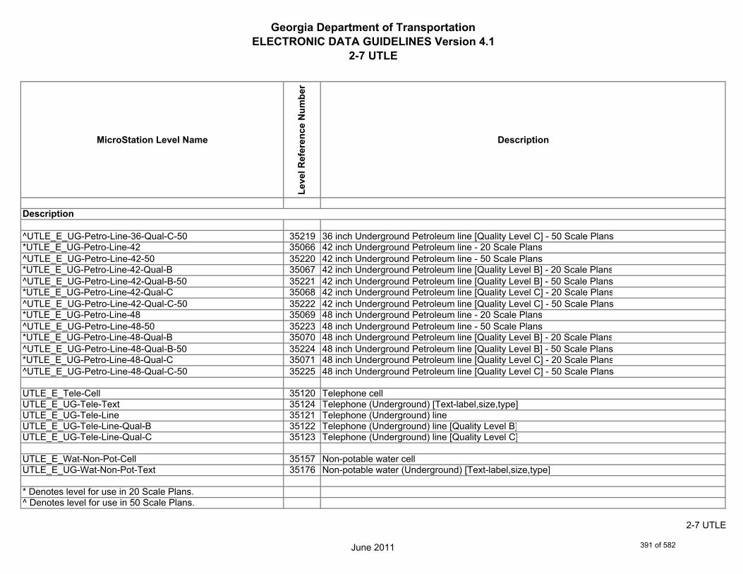
Georgia Department of TransportationELECTRONIC DATA GUIDELINES Version 4.1
2-7 UTLE
MicroStation Level Name
Leve
l Ref
eren
ce N
umbe
r
Description
^UTLE_E_UG-Petro-Line-36-Qual-C-50 35219 36 inch Underground Petroleum line [Quality Level C] - 50 Scale Plans*UTLE_E_UG-Petro-Line-42 35066 42 inch Underground Petroleum line - 20 Scale Plans^UTLE_E_UG-Petro-Line-42-50 35220 42 inch Underground Petroleum line - 50 Scale Plans*UTLE_E_UG-Petro-Line-42-Qual-B 35067 42 inch Underground Petroleum line [Quality Level B] - 20 Scale Plans^UTLE_E_UG-Petro-Line-42-Qual-B-50 35221 42 inch Underground Petroleum line [Quality Level B] - 50 Scale Plans*UTLE_E_UG-Petro-Line-42-Qual-C 35068 42 inch Underground Petroleum line [Quality Level C] - 20 Scale Plans^UTLE_E_UG-Petro-Line-42-Qual-C-50 35222 42 inch Underground Petroleum line [Quality Level C] - 50 Scale Plans*UTLE_E_UG-Petro-Line-48 35069 48 inch Underground Petroleum line - 20 Scale Plans^UTLE_E_UG-Petro-Line-48-50 35223 48 inch Underground Petroleum line - 50 Scale Plans*UTLE_E_UG-Petro-Line-48-Qual-B 35070 48 inch Underground Petroleum line [Quality Level B] - 20 Scale Plans^UTLE_E_UG-Petro-Line-48-Qual-B-50 35224 48 inch Underground Petroleum line [Quality Level B] - 50 Scale Plans*UTLE_E_UG-Petro-Line-48-Qual-C 35071 48 inch Underground Petroleum line [Quality Level C] - 20 Scale Plans^UTLE_E_UG-Petro-Line-48-Qual-C-50 35225 48 inch Underground Petroleum line [Quality Level C] - 50 Scale Plans
UTLE_E_Tele-Cell 35120 Telephone cellUTLE_E_UG-Tele-Text 35124 Telephone (Underground) [Text-label,size,type]UTLE_E_UG-Tele-Line 35121 Telephone (Underground) lineUTLE_E_UG-Tele-Line-Qual-B 35122 Telephone (Underground) line [Quality Level B]UTLE_E_UG-Tele-Line-Qual-C 35123 Telephone (Underground) line [Quality Level C]
UTLE_E_Wat-Non-Pot-Cell 35157 Non-potable water cellUTLE_E_UG-Wat-Non-Pot-Text 35176 Non-potable water (Underground) [Text-label,size,type]
* Denotes level for use in 20 Scale Plans.^ Denotes level for use in 50 Scale Plans.
Description
June 2011
2-7 UTLE
391 of 582

Georgia Department of TransportationELECTRONIC DATA GUIDELINES Version 4.1
2-7 UTLE
MicroStation Level Name
Leve
l Ref
eren
ce N
umbe
r
Description
UTLE_E_UG-Wat-Non-Pot-Line 35158 Non-potable water (Underground) lineUTLE_E_UG-Wat-Non-Pot-Line-Qual-B 35174 Non-potable water (Underground) line [Quality Level B]UTLE_E_UG-Wat-Non-Pot-Line-Qual-C 35175 Non-potable water (Underground) line [Quality Level C]*UTLE_E_UG-Wat-Non-Pot-Line-24 35159 24 inch Underground Non-potable water line - 20 Scale Plans^UTLE_E_UG-Wat-Non-Pot-Line-24-50 35271 24 inch Underground Non-potable water line - 50 Scale Plans*UTLE_E_UG-Wat-Non-Pot-Line-24-Qual-B 35160 24 inch Underground Non-potable water line [Quality Level B] - 20 Scale Plans^UTLE_E_UG-Wat-Non-Pot-Line-24-Qual-B-50 35272 24 inch Underground Non-potable water line [Quality Level B] - 50 Scale Plans*UTLE_E_UG-Wat-Non-Pot-Line-24-Qual-C 35161 24 inch Underground Non-potable water line [Quality Level C] - 20 Scale Plans^UTLE_E_UG-Wat-Non-Pot-Line-24-Qual-C-50 35273 24 inch Underground Non-potable water line [Quality Level C] - 50 Scale Plans*UTLE_E_UG-Wat-Non-Pot-Line-30 35162 30 inch Underground Non-potable water line - 20 Scale Plans^UTLE_E_UG-Wat-Non-Pot-Line-30-50 35274 30 inch Underground Non-potable water line - 50 Scale Plans*UTLE_E_UG-Wat-Non-Pot-Line-30-Qual-B 35163 30 inch Underground Non-potable water line [Quality Level B] - 20 Scale Plans^UTLE_E_UG-Wat-Non-Pot-Line-30-Qual-B-50 35275 30 inch Underground Non-potable water line [Quality Level B] - 50 Scale Plans*UTLE_E_UG-Wat-Non-Pot-Line-30-Qual-C 35164 30 inch Underground Non-potable water line [Quality Level C] - 20 Scale Plans^UTLE_E_UG-Wat-Non-Pot-Line-30-Qual-C-50 35276 30 inch Underground Non-potable water line [Quality Level C] - 50 Scale Plans*UTLE_E_UG-Wat-Non-Pot-Line-36 35165 36 inch Underground Non-potable water line - 20 Scale Plans^UTLE_E_UG-Wat-Non-Pot-Line-36-50 35277 36 inch Underground Non-potable water line - 50 Scale Plans*UTLE_E_UG-Wat-Non-Pot-Line-36-Qual-B 35166 36 inch Underground Non-potable water line [Quality Level B] - 20 Scale Plans^UTLE_E_UG-Wat-Non-Pot-Line-36-Qual-B-50 35278 36 inch Underground Non-potable water line [Quality Level B] - 50 Scale Plans*UTLE_E_UG-Wat-Non-Pot-Line-36-Qual-C 35167 36 inch Underground Non-potable water line [Quality Level C] - 20 Scale Plans^UTLE_E_UG-Wat-Non-Pot-Line-36-Qual-C-50 35279 36 inch Underground Non-potable water line [Quality Level C] - 50 Scale Plans*UTLE_E_UG-Wat-Non-Pot-Line-42 35168 42 inch Underground non-potable water line - 20 Scale Plans
* Denotes level for use in 20 Scale Plans.^ Denotes level for use in 50 Scale Plans.
Description
June 2011
2-7 UTLE
392 of 582
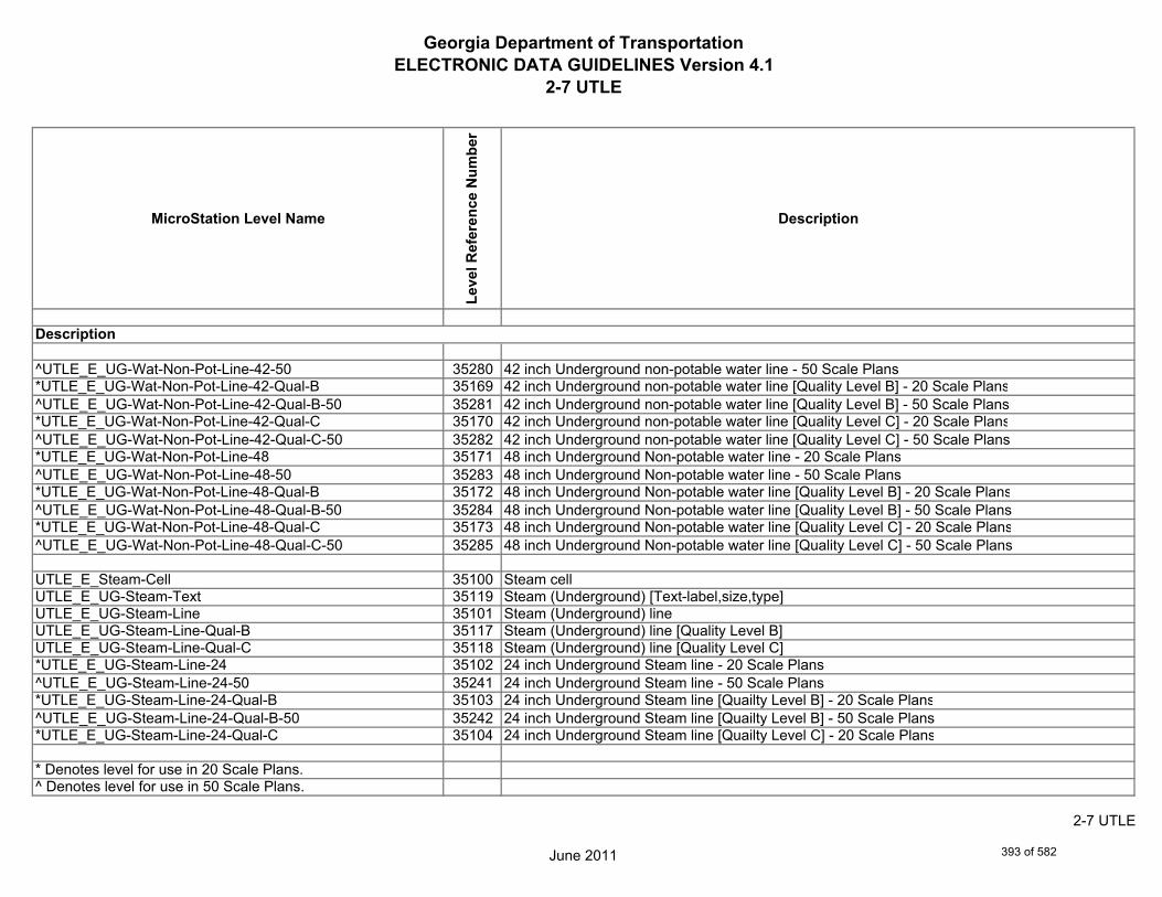
Georgia Department of TransportationELECTRONIC DATA GUIDELINES Version 4.1
2-7 UTLE
MicroStation Level Name
Leve
l Ref
eren
ce N
umbe
r
Description
^UTLE_E_UG-Wat-Non-Pot-Line-42-50 35280 42 inch Underground non-potable water line - 50 Scale Plans*UTLE_E_UG-Wat-Non-Pot-Line-42-Qual-B 35169 42 inch Underground non-potable water line [Quality Level B] - 20 Scale Plans^UTLE_E_UG-Wat-Non-Pot-Line-42-Qual-B-50 35281 42 inch Underground non-potable water line [Quality Level B] - 50 Scale Plans*UTLE_E_UG-Wat-Non-Pot-Line-42-Qual-C 35170 42 inch Underground non-potable water line [Quality Level C] - 20 Scale Plans^UTLE_E_UG-Wat-Non-Pot-Line-42-Qual-C-50 35282 42 inch Underground non-potable water line [Quality Level C] - 50 Scale Plans*UTLE_E_UG-Wat-Non-Pot-Line-48 35171 48 inch Underground Non-potable water line - 20 Scale Plans^UTLE_E_UG-Wat-Non-Pot-Line-48-50 35283 48 inch Underground Non-potable water line - 50 Scale Plans*UTLE_E_UG-Wat-Non-Pot-Line-48-Qual-B 35172 48 inch Underground Non-potable water line [Quality Level B] - 20 Scale Plans^UTLE_E_UG-Wat-Non-Pot-Line-48-Qual-B-50 35284 48 inch Underground Non-potable water line [Quality Level B] - 50 Scale Plans*UTLE_E_UG-Wat-Non-Pot-Line-48-Qual-C 35173 48 inch Underground Non-potable water line [Quality Level C] - 20 Scale Plans^UTLE_E_UG-Wat-Non-Pot-Line-48-Qual-C-50 35285 48 inch Underground Non-potable water line [Quality Level C] - 50 Scale Plans
UTLE_E_Steam-Cell 35100 Steam cellUTLE_E_UG-Steam-Text 35119 Steam (Underground) [Text-label,size,type]UTLE_E_UG-Steam-Line 35101 Steam (Underground) lineUTLE_E_UG-Steam-Line-Qual-B 35117 Steam (Underground) line [Quality Level B]UTLE_E_UG-Steam-Line-Qual-C 35118 Steam (Underground) line [Quality Level C]*UTLE_E_UG-Steam-Line-24 35102 24 inch Underground Steam line - 20 Scale Plans^UTLE_E_UG-Steam-Line-24-50 35241 24 inch Underground Steam line - 50 Scale Plans*UTLE_E_UG-Steam-Line-24-Qual-B 35103 24 inch Underground Steam line [Quailty Level B] - 20 Scale Plans^UTLE_E_UG-Steam-Line-24-Qual-B-50 35242 24 inch Underground Steam line [Quailty Level B] - 50 Scale Plans*UTLE_E_UG-Steam-Line-24-Qual-C 35104 24 inch Underground Steam line [Quailty Level C] - 20 Scale Plans
* Denotes level for use in 20 Scale Plans.^ Denotes level for use in 50 Scale Plans.
Description
June 2011
2-7 UTLE
393 of 582

Georgia Department of TransportationELECTRONIC DATA GUIDELINES Version 4.1
2-7 UTLE
MicroStation Level Name
Leve
l Ref
eren
ce N
umbe
r
Description
^UTLE_E_UG-Steam-Line-24-Qual-C-50 35243 24 inch Underground Steam line [Quailty Level C] - 50 Scale Plans*UTLE_E_UG-Steam-Line-30 35105 30 inch Underground Steam line - 20 Scale Plans^UTLE_E_UG-Steam-Line-30-50 35244 30 inch Underground Steam line - 50 Scale Plans*UTLE_E_UG-Steam-Line-30-Qual-B 35106 30 inch Underground Steam line [Quality Level B] - 20 Scale Plans^UTLE_E_UG-Steam-Line-30-Qual-B-50 35245 30 inch Underground Steam line [Quality Level B] - 50 Scale Plans*UTLE_E_UG-Steam-Line-30-Qual-C 35107 30 inch Underground Steam line [Quality Level C] - 20 Scale Plans^UTLE_E_UG-Steam-Line-30-Qual-C-50 35246 30 inch Underground Steam line [Quality Level C] - 50 Scale Plans*UTLE_E_UG-Steam-Line-36 35108 36 inch Underground Steam line - 20 Scale Plans^UTLE_E_UG-Steam-Line-36-50 35247 36 inch Underground Steam line - 50 Scale Plans*UTLE_E_UG-Steam-Line-36-Qual-B 35109 36 inch Underground Steam line [Quality Level B] - 20 Scale Plans^UTLE_E_UG-Steam-Line-36-Qual-B-50 35248 36 inch Underground Steam line [Quality Level B] - 50 Scale Plans*UTLE_E_UG-Steam-Line-36-Qual-C 35110 36 inch Underground Steam line [Quality Level C] - 20 Scale Plans^UTLE_E_UG-Steam-Line-36-Qual-C-50 35249 36 inch Underground Steam line [Quality Level C] - 50 Scale Plans*UTLE_E_UG-Steam-Line-42 35111 42 inch Underground Steam line - 20 Scale Plans^UTLE_E_UG-Steam-Line-42-50 35250 42 inch Underground Steam line - 50 Scale Plans*UTLE_E_UG-Steam-Line-42-Qual-B 35112 42 inch Underground Steam line [Quality Level B] - 20 Scale Plans^UTLE_E_UG-Steam-Line-42-Qual-B-50 35251 42 inch Underground Steam line [Quality Level B] - 50 Scale Plans*UTLE_E_UG-Steam-Line-42-Qual-C 35113 42 inch Underground Steam line [Quality Level C] - 20 Scale Plans^UTLE_E_UG-Steam-Line-42-Qual-C-50 35252 42 inch Underground Steam line [Quality Level C] - 50 Scale Plans*UTLE_E_UG-Steam-Line-48 35114 48 inch Underground Steam line - 20 Scale Plans^UTLE_E_UG-Steam-Line-48-50 35253 48 inch Underground Steam line - 50 Scale Plans*UTLE_E_UG-Steam-Line-48-Qual-B 35115 48 inch Underground Steam line [Quality Level B] - 20 Scale Plans
* Denotes level for use in 20 Scale Plans.^ Denotes level for use in 50 Scale Plans.
Description
June 2011
2-7 UTLE
394 of 582

Georgia Department of TransportationELECTRONIC DATA GUIDELINES Version 4.1
2-7 UTLE
MicroStation Level Name
Leve
l Ref
eren
ce N
umbe
r
Description
^UTLE_E_UG-Steam-Line-48-Qual-B-50 35254 48 inch Underground Steam line [Quality Level B] - 50 Scale Plans*UTLE_E_UG-Steam-Line-48-Qual-C 35116 48 inch Underground Steam line [Quality Level C] - 20 Scale Plans^UTLE_E_UG-Steam-Line-48-Qual-C-50 35255 48 inch Underground Steam line [Quality Level C] - 50 Scale Plans
UTLE_E_UG-Utl-Unknown-Line-Qual-B 35136 Unknown Utility (Underground) line [Quality Level B Only]UTLE_E_UG-Utl-Unknown-Text 35137 Unknown Utility (Underground) [Text-label,size,type]
UTLE_E_UG-Gas-Line-User-Def 35178 Gas User Defined Width (Underground) lineUTLE_E_UG-Gas-Line-User-Def-Qual-B 35179 Gas User Defined Width (Underground) line [Quality Level B]UTLE_E_UG-Gas-Line-User-Def-Qual-C 35180 Gas User Defined Width (Underground) line [Quality Level C]
UTLE_E_UG-Petro-Line-User-Def 35181 Petroleum User Defined Width (Underground) lineUTLE_E_UG-Petro-Line-User-Def-Qual-B 35182 Petroleum User Defined Width (Underground) line [Quality Level B]UTLE_E_UG-Petro-Line-User-Def-Qual-C 35183 Petroleum User Defined Width (Underground) line [Quality Level C]UTLE_E_UG-San-Swr-User-Def-Line 35184 Sanitary Sewer User Defined Width (Underground) lineUTLE_E_UG-San-Swr-User-Def-Line-Qual-B 35185 Sanitary Sewer User Defined Width (Underground) line [Quality Level B]UTLE_E_UG-San-Swr-User-Def-Line-Qual-C 35186 Sanitary Sewer User Defined Width (Underground) line [Quality Level C]
UTLE_E_UG-Steam-User-Def-Line 35187 Steam User Defined Width (Underground) lineUTLE_E_UG-Steam-User-Def-Line-Qual-B 35188 Steam User Defined Width (Underground) line [Quality Level B]UTLE_E_UG-Steam-User-Def-Line-Qual-C 35189 Steam User Defined Width (Underground) line [Quality Level C]
* Denotes level for use in 20 Scale Plans.^ Denotes level for use in 50 Scale Plans.
Description
June 2011
2-7 UTLE
395 of 582
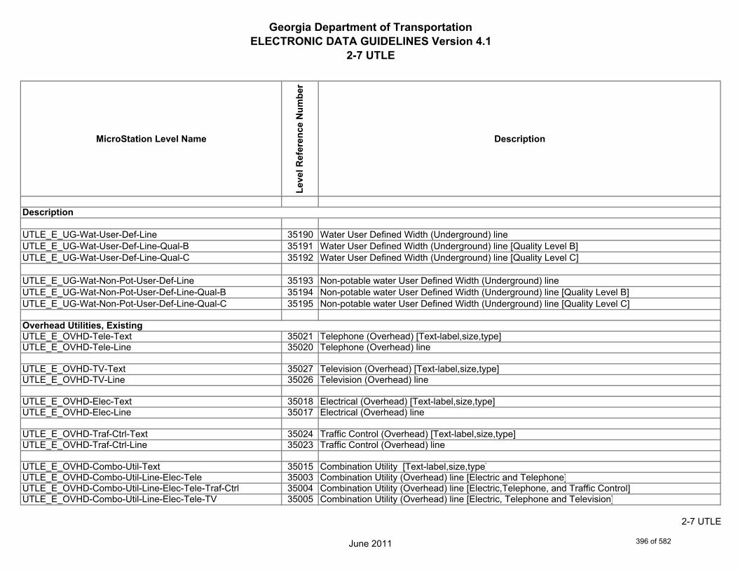
Georgia Department of TransportationELECTRONIC DATA GUIDELINES Version 4.1
2-7 UTLE
MicroStation Level Name
Leve
l Ref
eren
ce N
umbe
r
Description
UTLE_E_UG-Wat-User-Def-Line 35190 Water User Defined Width (Underground) lineUTLE_E_UG-Wat-User-Def-Line-Qual-B 35191 Water User Defined Width (Underground) line [Quality Level B]UTLE_E_UG-Wat-User-Def-Line-Qual-C 35192 Water User Defined Width (Underground) line [Quality Level C]
UTLE_E_UG-Wat-Non-Pot-User-Def-Line 35193 Non-potable water User Defined Width (Underground) lineUTLE_E_UG-Wat-Non-Pot-User-Def-Line-Qual-B 35194 Non-potable water User Defined Width (Underground) line [Quality Level B]UTLE_E_UG-Wat-Non-Pot-User-Def-Line-Qual-C 35195 Non-potable water User Defined Width (Underground) line [Quality Level C]
UTLE_E_OVHD-Tele-Text 35021 Telephone (Overhead) [Text-label,size,type]UTLE_E_OVHD-Tele-Line 35020 Telephone (Overhead) line
UTLE_E_OVHD-TV-Text 35027 Television (Overhead) [Text-label,size,type]UTLE_E_OVHD-TV-Line 35026 Television (Overhead) line
UTLE_E_OVHD-Elec-Text 35018 Electrical (Overhead) [Text-label,size,type]UTLE_E_OVHD-Elec-Line 35017 Electrical (Overhead) line
UTLE_E_OVHD-Traf-Ctrl-Text 35024 Traffic Control (Overhead) [Text-label,size,type]UTLE_E_OVHD-Traf-Ctrl-Line 35023 Traffic Control (Overhead) line
UTLE_E_OVHD-Combo-Util-Text 35015 Combination Utility [Text-label,size,type]UTLE_E_OVHD-Combo-Util-Line-Elec-Tele 35003 Combination Utility (Overhead) line [Electric and Telephone]UTLE_E_OVHD-Combo-Util-Line-Elec-Tele-Traf-Ctrl 35004 Combination Utility (Overhead) line [Electric,Telephone, and Traffic Control]UTLE_E_OVHD-Combo-Util-Line-Elec-Tele-TV 35005 Combination Utility (Overhead) line [Electric, Telephone and Television]
Overhead Utilities, Existing
Description
June 2011
2-7 UTLE
396 of 582
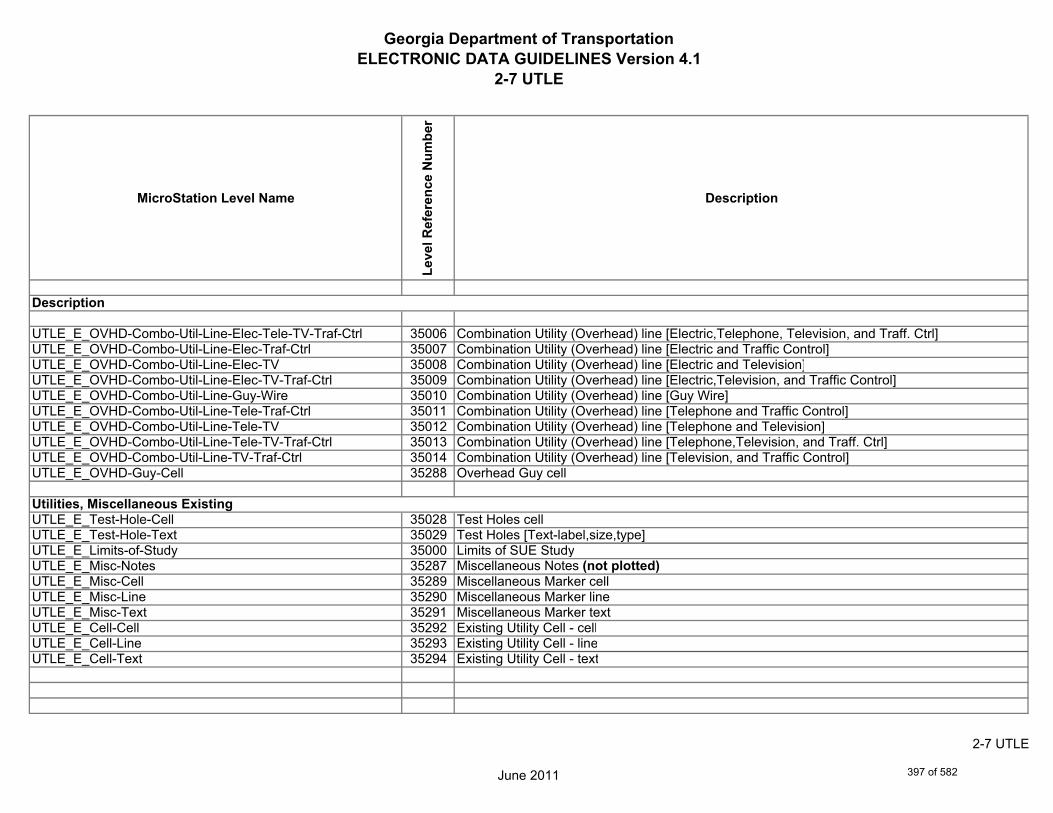
Georgia Department of TransportationELECTRONIC DATA GUIDELINES Version 4.1
2-7 UTLE
MicroStation Level Name
Leve
l Ref
eren
ce N
umbe
r
Description
UTLE_E_OVHD-Combo-Util-Line-Elec-Tele-TV-Traf-Ctrl 35006 Combination Utility (Overhead) line [Electric,Telephone, Television, and Traff. Ctrl]UTLE_E_OVHD-Combo-Util-Line-Elec-Traf-Ctrl 35007 Combination Utility (Overhead) line [Electric and Traffic Control]UTLE_E_OVHD-Combo-Util-Line-Elec-TV 35008 Combination Utility (Overhead) line [Electric and Television]UTLE_E_OVHD-Combo-Util-Line-Elec-TV-Traf-Ctrl 35009 Combination Utility (Overhead) line [Electric,Television, and Traffic Control]UTLE_E_OVHD-Combo-Util-Line-Guy-Wire 35010 Combination Utility (Overhead) line [Guy Wire]UTLE_E_OVHD-Combo-Util-Line-Tele-Traf-Ctrl 35011 Combination Utility (Overhead) line [Telephone and Traffic Control]UTLE_E_OVHD-Combo-Util-Line-Tele-TV 35012 Combination Utility (Overhead) line [Telephone and Television]UTLE_E_OVHD-Combo-Util-Line-Tele-TV-Traf-Ctrl 35013 Combination Utility (Overhead) line [Telephone,Television, and Traff. Ctrl]UTLE_E_OVHD-Combo-Util-Line-TV-Traf-Ctrl 35014 Combination Utility (Overhead) line [Television, and Traffic Control]UTLE_E_OVHD-Guy-Cell 35288 Overhead Guy cell
UTLE_E_Test-Hole-Cell 35028 Test Holes cellUTLE_E_Test-Hole-Text 35029 Test Holes [Text-label,size,type]UTLE_E_Limits-of-Study 35000 Limits of SUE StudyUTLE_E_Misc-Notes 35287 Miscellaneous Notes (not plotted)UTLE_E_Misc-Cell 35289 Miscellaneous Marker cellUTLE_E_Misc-Line 35290 Miscellaneous Marker lineUTLE_E_Misc-Text 35291 Miscellaneous Marker textUTLE_E_Cell-Cell 35292 Existing Utility Cell - cellUTLE_E_Cell-Line 35293 Existing Utility Cell - lineUTLE_E_Cell-Text 35294 Existing Utility Cell - text
Utilities, Miscellaneous Existing
Description
June 2011
2-7 UTLE
397 of 582
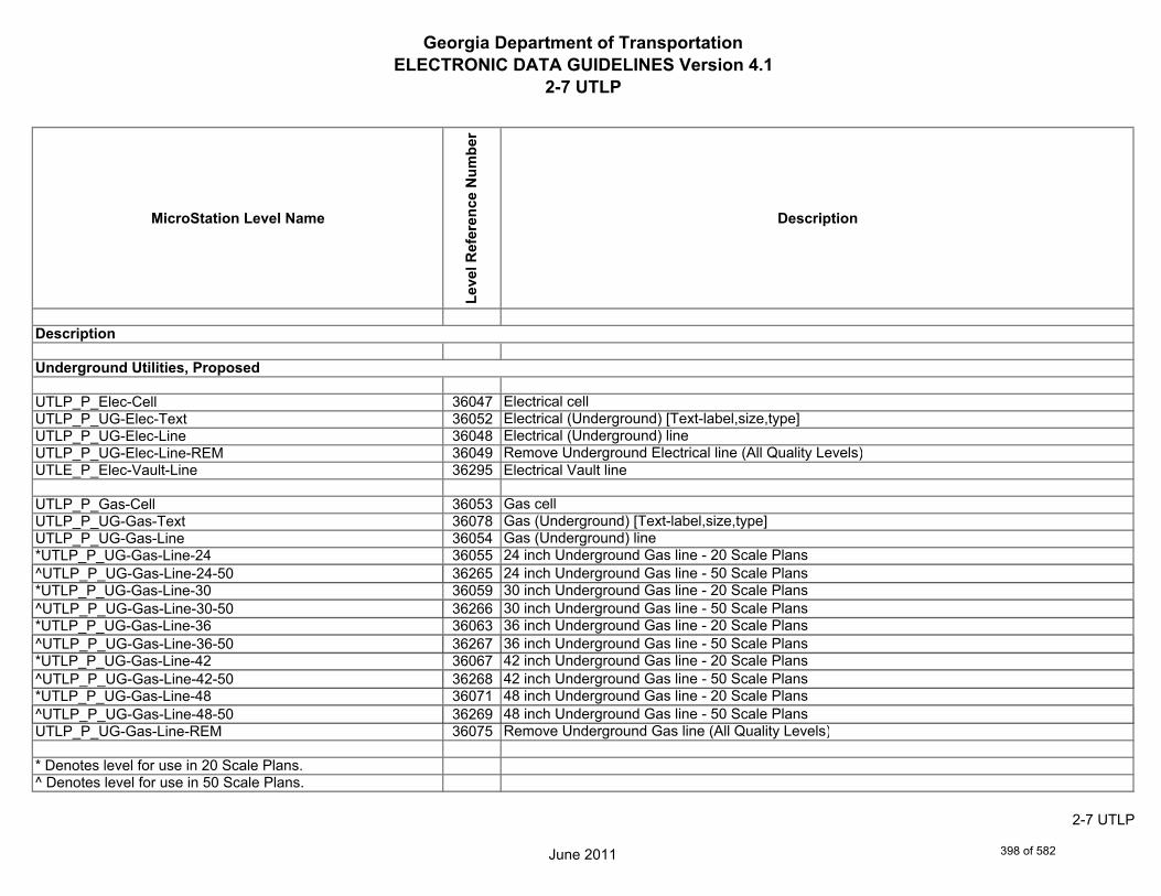
Georgia Department of TransportationELECTRONIC DATA GUIDELINES Version 4.1
2-7 UTLP
MicroStation Level Name
Leve
l Ref
eren
ce N
umbe
r
Description
UTLP_P_Elec-Cell 36047 Electrical cellUTLP_P_UG-Elec-Text 36052 Electrical (Underground) [Text-label,size,type]UTLP_P_UG-Elec-Line 36048 Electrical (Underground) lineUTLP_P_UG-Elec-Line-REM 36049 Remove Underground Electrical line (All Quality Levels)UTLE_P_Elec-Vault-Line 36295 Electrical Vault line
UTLP_P_Gas-Cell 36053 Gas cellUTLP_P_UG-Gas-Text 36078 Gas (Underground) [Text-label,size,type]UTLP_P_UG-Gas-Line 36054 Gas (Underground) line*UTLP_P_UG-Gas-Line-24 36055 24 inch Underground Gas line - 20 Scale Plans^UTLP_P_UG-Gas-Line-24-50 36265 24 inch Underground Gas line - 50 Scale Plans*UTLP_P_UG-Gas-Line-30 36059 30 inch Underground Gas line - 20 Scale Plans^UTLP_P_UG-Gas-Line-30-50 36266 30 inch Underground Gas line - 50 Scale Plans*UTLP_P_UG-Gas-Line-36 36063 36 inch Underground Gas line - 20 Scale Plans^UTLP_P_UG-Gas-Line-36-50 36267 36 inch Underground Gas line - 50 Scale Plans*UTLP_P_UG-Gas-Line-42 36067 42 inch Underground Gas line - 20 Scale Plans^UTLP_P_UG-Gas-Line-42-50 36268 42 inch Underground Gas line - 50 Scale Plans*UTLP_P_UG-Gas-Line-48 36071 48 inch Underground Gas line - 20 Scale Plans^UTLP_P_UG-Gas-Line-48-50 36269 48 inch Underground Gas line - 50 Scale PlansUTLP_P_UG-Gas-Line-REM 36075 Remove Underground Gas line (All Quality Levels)
* Denotes level for use in 20 Scale Plans.^ Denotes level for use in 50 Scale Plans.
Description
Underground Utilities, Proposed
June 2011
2-7 UTLP
398 of 582

Georgia Department of TransportationELECTRONIC DATA GUIDELINES Version 4.1
2-7 UTLP
MicroStation Level Name
Leve
l Ref
eren
ce N
umbe
r
Description
UTLP_P_Petro-Cell 36079 Petroleum cellUTLP_P_UG-Petro-Text 36104 Petroleum (Underground) [Text-label,size,type]UTLP_P_UG-Petro-Line 36080 Petroleum (Underground) line*UTLP_P_UG-Petro-Line-24 36081 24 inch Underground Petroleum line - 20 Scale Plans^UTLP_P_UG-Petro-Line-24-50 36270 24 inch Underground Petroleum line - 50 Scale Plans*UTLP_P_UG-Petro-Line-30 36085 30 inch Underground Petroleum line - 20 Scale Plans^UTLP_P_UG-Petro-Line-30-50 36271 30 inch Underground Petroleum line - 50 Scale Plans*UTLP_P_UG-Petro-Line-36 36089 36 inch Underground Petroleum line - 20 Scale Plans^UTLP_P_UG-Petro-Line-36-50 36272 36 inch Underground Petroleum line - 50 Scale Plans*UTLP_P_UG-Petro-Line-42 36093 42 inch Underground Petroleum line - 20 Scale Plans^UTLP_P_UG-Petro-Line-42-50 36273 42 inch Underground Petroleum line - 50 Scale Plans*UTLP_P_UG-Petro-Line-48 36097 48 inch Underground Petroleum line - 20 Scale Plans^UTLP_P_UG-Petro-Line-48-50 36274 48 inch Underground Petroleum line - 50 Scale PlansUTLP_P_UG-Petro-Line-REM 36101 Remove Underground Petroleum line (All Quality Levels)
UTLP_P_San-Force-Main-Cell 36105 Sanitary Force Main cellUTLP_P_UG-San-Force-Main-Text 36110 Sanitary Force Main (Underground) [Text-label,size,type]UTLP_P_UG-San-Force-Main-Line 36106 Sanitary Force Main (Underground) lineUTLP_P_UG-San-Force-Main-Line-REM 36107 Remove Underground Sanitary Force Main line (All Quality Levels)
UTLP_P_UG-San-Swr-Cell 36111 Sanitary Sewer (Underground) cellUTLP_P_UG-San-Swr-Text 36136 Sanitary Sewer (Underground) [Text-label,size,type]
* Denotes level for use in 20 Scale Plans.^ Denotes level for use in 50 Scale Plans.
Description
June 2011
2-7 UTLP
399 of 582

Georgia Department of TransportationELECTRONIC DATA GUIDELINES Version 4.1
2-7 UTLP
MicroStation Level Name
Leve
l Ref
eren
ce N
umbe
r
Description
UTLP_P_UG-San-Swr-Line 36112 Sanitary Sewer (Underground) line*UTLP_P_UG-San-Swr-Line-24 36113 24 inch Underground Sanitary Sewer line - 20 Scale Plans^UTLP_P_UG-San-Swr-Line-24-50 36275 24 inch Underground Sanitary Sewer line - 50 Scale Plans
*UTLP_P_UG-San-Swr-Line-30 36117 30 inch Underground Sanitary Sewer line - 20 Scale Plans^UTLP_P_UG-San-Swr-Line-30-50 36276 30 inch Underground Sanitary Sewer line - 50 Scale Plans*UTLP_P_UG-San-Swr-Line-36 36121 36 inch Underground Sanitary Sewer line - 20 Scale Plans^UTLP_P_UG-San-Swr-Line-36-50 36277 36 inch Underground Sanitary Sewer line - 50 Scale Plans*UTLP_P_UG-San-Swr-Line-42 36125 42 inch Underground Sanitary Sewer line - 20 Scale Plans^UTLP_P_UG-San-Swr-Line-42-50 36278 42 inch Underground Sanitary Sewer line - 50 Scale Plans*UTLP_P_UG-San-Swr-Line-48 36129 48 inch Underground Sanitary Sewer line - 20 Scale Plans^UTLP_P_UG-San-Swr-Line-48-50 36279 48 inch Underground Sanitary Sewer line - 50 Scale PlansUTLP_P_UG-San-Swr-Line-REM 36133 Remove Underground Sanitary Sewer line (All Quality Levels)
UTLP_P_Steam-Cell 36137 Steam cellUTLP_P_UG-Steam-Text 36162 Steam (Underground) [Text-label,size,type]UTLP_P_UG-Steam-Line 36138 Steam (Underground) line*UTLP_P_UG-Steam-Line-24 36139 24 inch Underground Steam line - 20 Scale Plans^UTLP_P_UG-Steam-Line-24-50 36280 24 inch Underground Steam line - 50 Scale Plans*UTLP_P_UG-Steam-Line-30 36143 30 inch Underground Steam line - 20 Scale Plans^UTLP_P_UG-Steam-Line-30-50 36281 30 inch Underground Steam line - 50 Scale Plans*UTLP_P_UG-Steam-Line-36 36147 36 inch Underground Steam line - 20 Scale Plans
* Denotes level for use in 20 Scale Plans.^ Denotes level for use in 50 Scale Plans.
Description
June 2011
2-7 UTLP
400 of 582
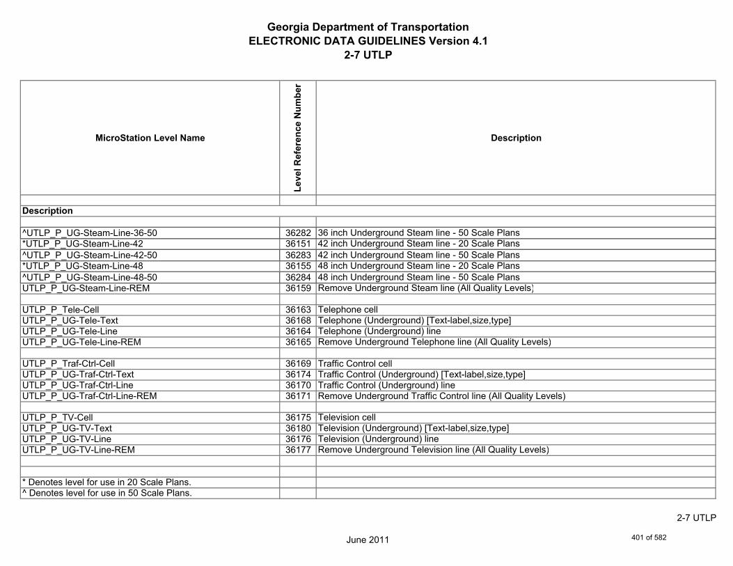
Georgia Department of TransportationELECTRONIC DATA GUIDELINES Version 4.1
2-7 UTLP
MicroStation Level Name
Leve
l Ref
eren
ce N
umbe
r
Description
^UTLP_P_UG-Steam-Line-36-50 36282 36 inch Underground Steam line - 50 Scale Plans*UTLP_P_UG-Steam-Line-42 36151 42 inch Underground Steam line - 20 Scale Plans^UTLP_P_UG-Steam-Line-42-50 36283 42 inch Underground Steam line - 50 Scale Plans*UTLP_P_UG-Steam-Line-48 36155 48 inch Underground Steam line - 20 Scale Plans^UTLP_P_UG-Steam-Line-48-50 36284 48 inch Underground Steam line - 50 Scale PlansUTLP_P_UG-Steam-Line-REM 36159 Remove Underground Steam line (All Quality Levels)
UTLP_P_Tele-Cell 36163 Telephone cellUTLP_P_UG-Tele-Text 36168 Telephone (Underground) [Text-label,size,type]UTLP_P_UG-Tele-Line 36164 Telephone (Underground) lineUTLP_P_UG-Tele-Line-REM 36165 Remove Underground Telephone line (All Quality Levels)
UTLP_P_Traf-Ctrl-Cell 36169 Traffic Control cellUTLP_P_UG-Traf-Ctrl-Text 36174 Traffic Control (Underground) [Text-label,size,type]UTLP_P_UG-Traf-Ctrl-Line 36170 Traffic Control (Underground) lineUTLP_P_UG-Traf-Ctrl-Line-REM 36171 Remove Underground Traffic Control line (All Quality Levels)
UTLP_P_TV-Cell 36175 Television cellUTLP_P_UG-TV-Text 36180 Television (Underground) [Text-label,size,type]UTLP_P_UG-TV-Line 36176 Television (Underground) lineUTLP_P_UG-TV-Line-REM 36177 Remove Underground Television line (All Quality Levels)
* Denotes level for use in 20 Scale Plans.^ Denotes level for use in 50 Scale Plans.
Description
June 2011
2-7 UTLP
401 of 582

Georgia Department of TransportationELECTRONIC DATA GUIDELINES Version 4.1
2-7 UTLP
MicroStation Level Name
Leve
l Ref
eren
ce N
umbe
r
Description
UTLP_P_Wat-Cell 36184 Water cellUTLP_P_UG-Wat-Text 36235 Water (Underground) [Text-label,size,type]UTLP_P_UG-Wat-Line 36185 Water (Underground) line*UTLP_P_UG-Wat-Line-24 36186 24 inch Underground Water line - 20 Scale Plans^UTLP_P_UG-Wat-Line-24-50 36285 24 inch Underground Water line - 50 Scale Plans*UTLP_P_UG-Wat-Line-30 36190 30 inch Underground Water line - 20 Scale Plans^UTLP_P_UG-Wat-Line-30-50 36286 30 inch Underground Water line - 50 Scale Plans*UTLP_P_UG-Wat-Line-36 36194 36 inch Underground Water line - 20 Scale Plans^UTLP_P_UG-Wat-Line-36-50 36287 36 inch Underground Water line - 50 Scale Plans*UTLP_P_UG-Wat-Line-42 36198 42 inch Underground Water line - 20 Scale Plans^UTLP_P_UG-Wat-Line-42-50 36288 42 inch Underground Water line - 50 Scale Plans*UTLP_P_UG-Wat-Line-48 36202 48 inch Underground Water line - 20 Scale Plans^UTLP_P_UG-Wat-Line-48-50 36289 48 inch Underground Water line - 50 Scale PlansUTLP_P_UG-Wat-Line-REM 36206 Remove Underground Water line (All Quality Levels)
UTLP_P_Wat-Non-Pot-Cell 36209 Non-potable water cellUTLP_P_UG-Wat-Non-Pot-Text 36234 Non-potable water (Underground) [Text-label,size,type]UTLP_P_UG-Wat-Non-Pot-Line 36210 Non-potable water (Underground) line*UTLP_P_UG-Wat-Non-Pot-Line-24 36211 24 inch Underground Non-potable water line - 20 Scale Plans^UTLP_P_UG-Wat-Non-Pot-Line-24-50 36290 24 inch Underground Non-potable water line - 50 Scale Plans*UTLP_P_UG-Wat-Non-Pot-Line-30 36215 30 inch Underground Non-potable water line - 20 Scale Plans
* Denotes level for use in 20 Scale Plans.^ Denotes level for use in 50 Scale Plans.
Description
June 2011
2-7 UTLP
402 of 582

Georgia Department of TransportationELECTRONIC DATA GUIDELINES Version 4.1
2-7 UTLP
MicroStation Level Name
Leve
l Ref
eren
ce N
umbe
r
Description
^UTLP_P_UG-Wat-Non-Pot-Line-30-50 36291 30 inch Underground Non-potable water line - 50 Scale Plans*UTLP_P_UG-Wat-Non-Pot-Line-36 36219 36 inch Underground Non-potable water line - 20 Scale Plans^UTLP_P_UG-Wat-Non-Pot-Line-36-50 36292 36 inch Underground Non-potable water line - 50 Scale Plans*UTLP_P_UG-Wat-Non-Pot-Line-42 36223 42 inch Underground Non-potable water line - 20 Scale Plans^UTLP_P_UG-Wat-Non-Pot-Line-42-50 36293 42 inch Underground Non-potable water line - 50 Scale Plans*UTLP_P_UG-Wat-Non-Pot-Line-48 36227 48 inch Underground Non-potable water line - 20 Scale Plans^UTLP_P_UG-Wat-Non-Pot-Line-48-50 36294 48 inch Underground Non-potable water line - 50 Scale PlansUTLP_P_UG-Wat-Non-Pot-Line-REM 36231 Remove Underground Non-potable water line (All Quality Levels)
UTLP_P_UG-Gas-Line-User-Def 36236 Gas User Defined Width (Underground) lineUTLP_P_UG-Gas-Line-User-Def-REM 36237 Remove Underground User Defined Width Gas lineUTLP_P_UG-Petro-Line-User-Def 36240 Petroleum User Defined Width (Underground) lineUTLP_P_UG-Petro-Line-User-Def-REM 36241 Remove User Defined Width Petroleum (Underground) lineUTLP_P_UG-San-Swr-Line-User-Def 36244 Sanitary Sewer User Defined Width (Underground) lineUTLP_P_UG-San-Swr-Line-User-Def-REM 36245 Remove User Defined Width Sanitary Sewer (Underground) lineUTLP_P_UG-Steam-Line-User-Def 36248 Steam User Defined Width (Underground) lineUTLP_P_UG-Steam-Line-User-Def-REM 36249 Remove Steam User Defined Width (Underground) lineUTLP_P_UG-Wat-Line-User-Def 36252 Water User Defined Width (Underground) lineUTLP_P_UG-Wat-Line-User-Def-REM 36253 Remove Water User Defined Width (Underground) lineUTLP_P_UG-Wat-Non-Pot-User-Def-Line 36256 Non-potable water User Defined Width (Underground) lineUTLP_P_UG-Wat-Non-Pot-Line-User-Def-REM 36257 Remove Non-potable water User Defined Width (Underground) line
* Denotes level for use in 20 Scale Plans.^ Denotes level for use in 50 Scale Plans.
Description
June 2011
2-7 UTLP
403 of 582

Georgia Department of TransportationELECTRONIC DATA GUIDELINES Version 4.1
2-7 UTLP
MicroStation Level Name
Leve
l Ref
eren
ce N
umbe
r
Description
UTLP_P_OVHD-Tele-Text 36036 Telephone (Overhead) [Text-label,size,type]UTLP_P_OVHD-Tele-Line 36034 Telephone (Overhead) lineUTLP_P_OVHD-Tele-Line-REM 36035 Remove Telephone (Overhead) line
UTLP_P_OVHD-TV-Text 36044 Television (Overhead) [Text-label,size,type]UTLP_P_OVHD-TV-Line 36042 Television (Overhead) lineUTLP_P_OVHD-TV-Line-REM 36043 Remove Television (Overhead) line
UTLP_P_OVHD-Elec-Text 36031 Electrical (Overhead) [Text-label,size,type]UTLP_P_OVHD-Elec-Line 36029 Electrical (Overhead) lineUTLP_P_OVHD-Elec-Line-REM 36030 Remove Electrical (Overhead) line
UTLP_P_OVHD-Traf-Ctrl-Text 36040 Traffic Control (Overhead) [Text-label,size,type]UTLP_P_OVHD-Traf-Ctrl-Line 36038 Traffic Control (Overhead) lineUTLP_P_OVHD-Traf-Ctrl-Line-REM 36039 Remove Traffic Control (Overhead) line
UTLP_P_OVHD-Combo-Util-Text 36027 Combination Utility [Text-label,size,type]UTLP_P_OVHD-Combo-Util-Line-Elec-Tele 36003 Combination Utility (Overhead) line [Electric and Telephone]UTLP_P_OVHD-Combo-Util-Line-Elec-Tele-REM 36018 Remove Combination Utility (Overhead) line [Electric and Telephone]UTLP_P_OVHD-Combo-Util-Line-Elec-Tele-Traf-Ctrl 36004 Combination Utility (Overhead) line [Electric,Telephone, and Traffic Control]UTLP_P_OVHD-Combo-Util-Line-Elec-Tele-Traf-Ctrl-REM 36005 Remove Combination Utility (Overhead) line [Electric,Telephone, and Traff. Ctrl]UTLP_P_OVHD-Combo-Util-Line-Elec-Tele-TV 36006 Combination Utility (Overhead) line [Electric, Telephone and Television]UTLP_P_OVHD-Combo-Util-Line-Elec-Tele-TV-REM 36007 Remove Combination Utility (Overhead) line [Electric, Telephone and Television]UTLP_P_OVHD-Combo-Util-Line-Elec-Tele-TV-Traf-Ctrl 36008 Combination Utility (Overhead) line [Electric,Telephone,Television, and Traff. Ctrl]UTLP_P_OVHD-Combo-Util-Line-Elec-Tele-TV-Traf-Ctrl-REM 36009 Remove Combination Utility (Overhead) line [Elec., Tele.,TV, and Traff. Ctrl]
Overhead Utilities, Proposed
Description
June 2011
2-7 UTLP
404 of 582

Georgia Department of TransportationELECTRONIC DATA GUIDELINES Version 4.1
2-7 UTLP
MicroStation Level Name
Leve
l Ref
eren
ce N
umbe
r
Description
UTLP_P_OVHD-Combo-Util-Line-Elec-Traf-Ctrl 36010 Combination Utility (Overhead) line [Electric and Traffic Control]UTLP_P_OVHD-Combo-Util-Line-Elec-Traf-Ctrl-REM 36011 Remove Combination Utility (Overhead) line [Electric and Traffic Control]UTLP_P_OVHD-Combo-Util-Line-Elec-TV 36012 Combination Utility (Overhead) line [Electric and Television]UTLP_P_OVHD-Combo-Util-Line-Elec-TV-REM 36013 Remove Combination Utility (Overhead) line [Electric and Television]UTLP_P_OVHD-Combo-Util-Line-Elec-TV-Traf-Ctrl 36014 Combination Utility (Overhead) line [Electric,Television, and Traffic Control]UTLP_P_OVHD-Combo-Util-Line-Elec-TV-Traf-Ctrl-REM 36015 Remove Combination Utility (Overhead) line [Electric,Television, and Traff. Ctrl]UTLP_P_OVHD-Combo-Util-Line-Tele-TV 36021 Combination Utility (Overhead) line [Telephone and Television]UTLP_P_OVHD-Combo-Util-Line-Tele-TV-REM 36022 Remove Combination Utility (Overhead) line [Telephone and Television]UTLP_P_OVHD-Combo-Util-Line-Tele-Traf-Ctrl 36019 Combination Utility (Overhead) line [Telephone and Traffic Control]UTLP_P_OVHD-Combo-Util-Line-Tele-Traf-Ctrl-REM 36020 Remove Combination Utility (Overhead) line [Telephone and Traffic Control]UTLP_P_OVHD-Combo-Util-Line-Tele-TV-Traf-Ctrl 36023 Combination Utility (Overhead) line [Telephone,Television, and Traff. Ctrl]UTLP_P_OVHD-Combo-Util-Line-Tele-TV-Traf-Ctrl-REM 36024 Remove Combination Utility (Overhead) line [Telephone,TV, and Traff. Ctrl]UTLP_P_OVHD-Combo-Util-Line-TV-Traf-Ctrl 36025 Combination Utility (Overhead) line [Television, and Traffic Control]UTLP_P_OVHD-Combo-Util-Line-TV-Traf-Ctrl-REM 36026 Remove Combination Utility (Overhead) line [Television, and Traffic Control]
UTLP_P_OVHD-Guy-Wire-Line 36016 Overhead Guy Wire lineUTLP_P_OVHD-Guy-Cell 36260 Guy Wire (overhead) cellUTLP_P_OVHD-Guy-Line 36261 Guy Wire (overhead) lineUTLP_P_OVHD-Guy-Line-REM 36262 Remove Guy Wire (overhead) lineUTLP_P_OVHD-Guy-Text 36263 Guy Wire (Overhead) [Text-label,size,type]UTLP_P_OVHD-Combo-Util-Line-Elec-Tele-REM 36264 Remove Combination Utility (Overhead) line [Electric and Telephone]
Description
June 2011
2-7 UTLP
405 of 582

Georgia Department of TransportationELECTRONIC DATA GUIDELINES Version 4.1
2-7 UTLP
MicroStation Level Name
Leve
l Ref
eren
ce N
umbe
r
Description
UTLP_P_Misc-Notes 36296 Miscellaneous Notes (not plotted)
UTLP_P_Cell-Cell 36297 Proposed Utility Cell - cellUTLP_P_Cell-Line 36298 Proposed Utility Cell - lineUTLP_P_Cell-Text 36299 Proposed Utility Cell - text
Utilities, Miscellaneous Proposed
Description
June 2011
2-7 UTLP
406 of 582
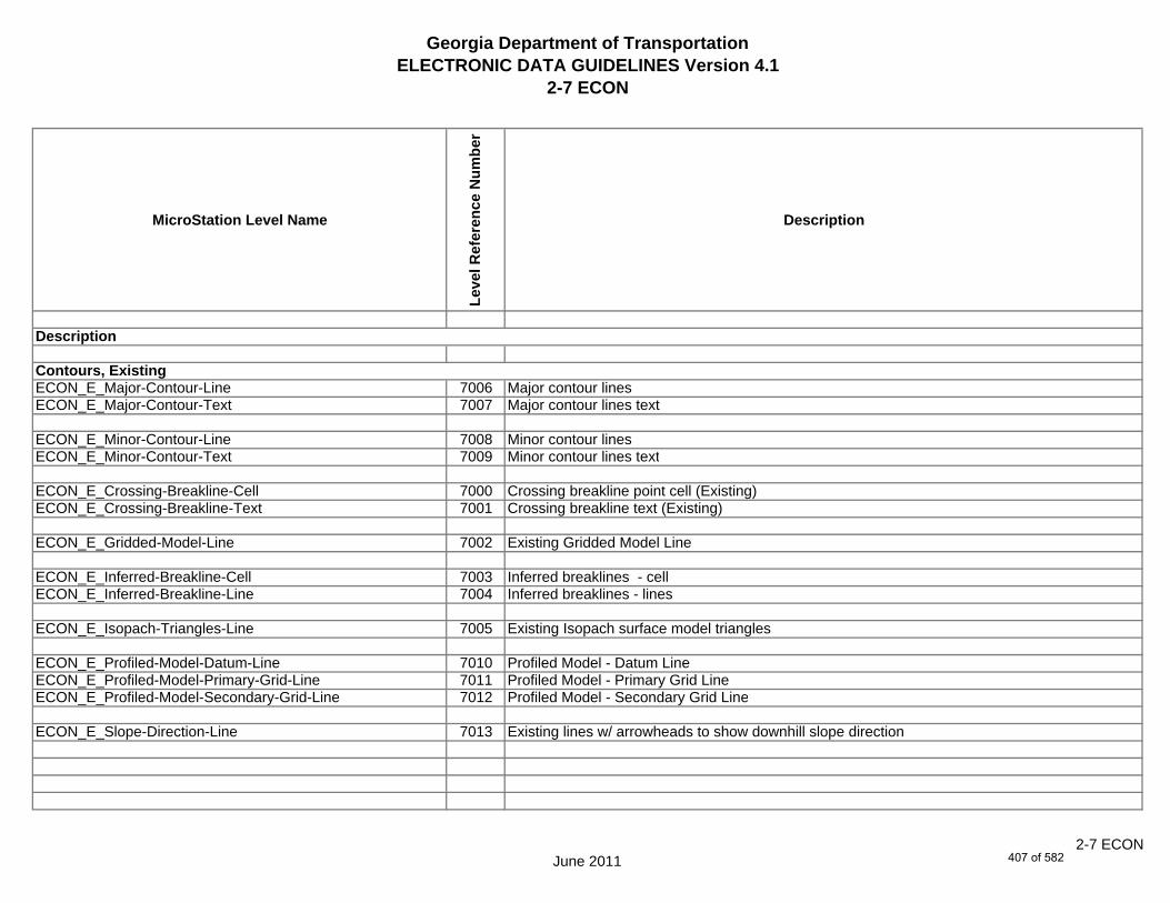
Georgia Department of TransportationELECTRONIC DATA GUIDELINES Version 4.1
2-7 ECON
MicroStation Level Name
Leve
l Ref
eren
ce N
umbe
r
Description
ECON_E_Major-Contour-Line 7006 Major contour linesECON_E_Major-Contour-Text 7007 Major contour lines text
ECON_E_Minor-Contour-Line 7008 Minor contour linesECON_E_Minor-Contour-Text 7009 Minor contour lines text
ECON_E_Crossing-Breakline-Cell 7000 Crossing breakline point cell (Existing)ECON_E_Crossing-Breakline-Text 7001 Crossing breakline text (Existing)
ECON_E_Gridded-Model-Line 7002 Existing Gridded Model Line
ECON_E_Inferred-Breakline-Cell 7003 Inferred breaklines - cellECON_E_Inferred-Breakline-Line 7004 Inferred breaklines - lines
ECON_E_Isopach-Triangles-Line 7005 Existing Isopach surface model triangles
ECON_E_Profiled-Model-Datum-Line 7010 Profiled Model - Datum LineECON_E_Profiled-Model-Primary-Grid-Line 7011 Profiled Model - Primary Grid LineECON_E_Profiled-Model-Secondary-Grid-Line 7012 Profiled Model - Secondary Grid Line
ECON_E_Slope-Direction-Line 7013 Existing lines w/ arrowheads to show downhill slope direction
Description
Contours, Existing
June 20112-7 ECON
407 of 582

Georgia Department of TransportationELECTRONIC DATA GUIDELINES Version 4.1
2-7 ECON
MicroStation Level Name
Leve
l Ref
eren
ce N
umbe
r
Description
ECON_E_Surface-Triangles-Line 7014 Existing surface model trianglesECON_E_Surface-Perimeter-Line 7015 Outermost edge of Existing surface modelECON_E_Surface-Triangles-Bogus-Line 7016 Existing surface model bogus traianglesECON_E_Surface-Triangles-Enhancement-Line 7017 Existing surface model enhancement triangles
Description
June 20112-7 ECON
408 of 582

Georgia Department of TransportationELECTRONIC DATA GUIDELINES Version 4.1
2-7 FCON
MicroStation Level Name
Leve
l Ref
eren
ce N
umbe
r
Description
FCON_P_Major-Contour-Line 10004 Major contour linesFCON_P_Major-Contour-Text 10005 Major contour lines text
FCON_P_Minor-Contour-Line 10006 Minor contour linesFCON_P_Minor-Contour-Text 10007 Minor contour lines text
FCON_P_Crossing-Breakline-Cell 10000 Crossing breakline point cell (Proposed)FCON_P_Crossing-Breakline-Text 10001 Crossing breakline text (Proposed)
FCON_P_Gridded-Model-Line 10002 Grided Model Line
FCON_P_Isopach-Triangles-Line 10003 Proposed Isopach surface model triangles
FCON_P_Profiled-Model-Datum-Line 10008 Profiled Model - Datum LineFCON_P_Profiled-Model-Primary-Grid-Line 10009 Profiled Model - Primary Grid LineFCON_P_Profiled-Model-Secondary-Grid-Line 10010 Profiled Model - Secondary Grid Line
FCON_P_Slope-Direction-Line 10011 Proposed lines w/ arrowheads to show downhill slope direction
FCON_P_Surface-Triangles-Line 10012 Proposed surface model trianglesFCON_P_Surface-Perimeter-Line 10013 Outermost edge of Proposed surface modelFCON_P_Surface-Spot-Elevation-Text 10014 Proposed spot elevation - text
FCON_P_Misc 10015 Miscellaneous Notes (not plotted)
Description
Contours, Proposed
June 2011
2-7 FCON
409 of 582

Georgia Department of TransportationELECTRONIC DATA GUIDELINES Version 4.1
2-7 LIMT
MicroStation Level Name
Leve
l Ref
eren
ce N
umbe
r
Description
LIMT_P_STKCUT_Const-Limit-Cut-Line 13002 Construction Limits cut line
LIMT_P_CUT_Const-Limit-Cut-Cell 13000 Construction Limits cut cell - C
LIMT_P_STKFIL_Const-Limit-Fill-Line 13003 Construction Limits fill lineLIMT_P_FILL_Const-Limit-Fill-Cell 13001 Construction Limits fill cell - F
LIMT_P_Misc 13004 Miscellaneous Designer notes (not plotted)
Description
Construction Limits
June 2011
2-7 LIMT
410 of 582

Georgia Department of TransportationELECTRONIC DATA GUIDELINES Version 4.1
2-7 STE#
MicroStation Level Name
Leve
l Ref
eren
ce N
umbe
r
Description
STE_P_DETCL-Line 31003 Detour centerline - linesSTE_P_DETCL-Tic-Sta-Text 31005 Detour centerline - tic marks and sta labelsSTE_P_DETCL-PC-PT-Sta-Ldr-Text 31004 Detour centerline - PC/PT station labels w/FlagsSTE_P_DETCL-Brng-Text 31000 Detour centerline - bearingsSTE_P_DETCL-Curve-Data-Text 31002 Detour centerline - curve label & data tableSTE_P_DETCL-Cell 31001 Detour centerline - point symbols
STE_P_STGD-Narrative-Text 31034 Staged const. details - sequence of construction narrativeSTE_P_STGD-Traf-Flow-Arrow 31039 Staged const. details - traffic flow arrows and edge of travelwaySTE_P_STGD-Current-Stage-Hatch 31031 Staged const. details - current stage hatching (const. & removal)STE_P_STGD-Current-Stage-Text 31032 Staged const. details - current stage labels and travelway dimensionsSTE_P_STGD-Current-Stage-Hatch-Removal 31041 To be removed cross hatchingSTE_P_STGD-Current-Stage-Hatch-Perm-Pvmt 31042 Permanent pavement hatchingSTE_P_STGD-Current-Stage-Hatch-Conc-Median 31043 Concrete median hatchingSTE_P_STGD-Current-Stage-Hatch-Mill-Overlay 31044 Mill and Overlay hatchingSTE_P_STGD-Current-Stage-Hatch-Temp-Pvmt 31045 Temporary pavement hatching
STE_P_STGD-Temp-Drain-Struct 31036 Staged const. details - temp. drainage structuresSTE_P_STGD-Temp-Drain-Struct-Text 31037 Staged const. details - temp. drainage structures - descriptionsSTE_P_STGD-Temp-Pvmt-Widen 31038 Staged const. details - temp. pavement/wideningSTE_P_STGD-Temp-Barrier 31035 Staged const. details - temp. barrier/barricadesSTE_P_STGD-Const-Limit 31030 Staged const. details - construction Limits
Description
On-Site Detour Centerline
Staged Construction Details
June 2011
2-7 STE#
411 of 582
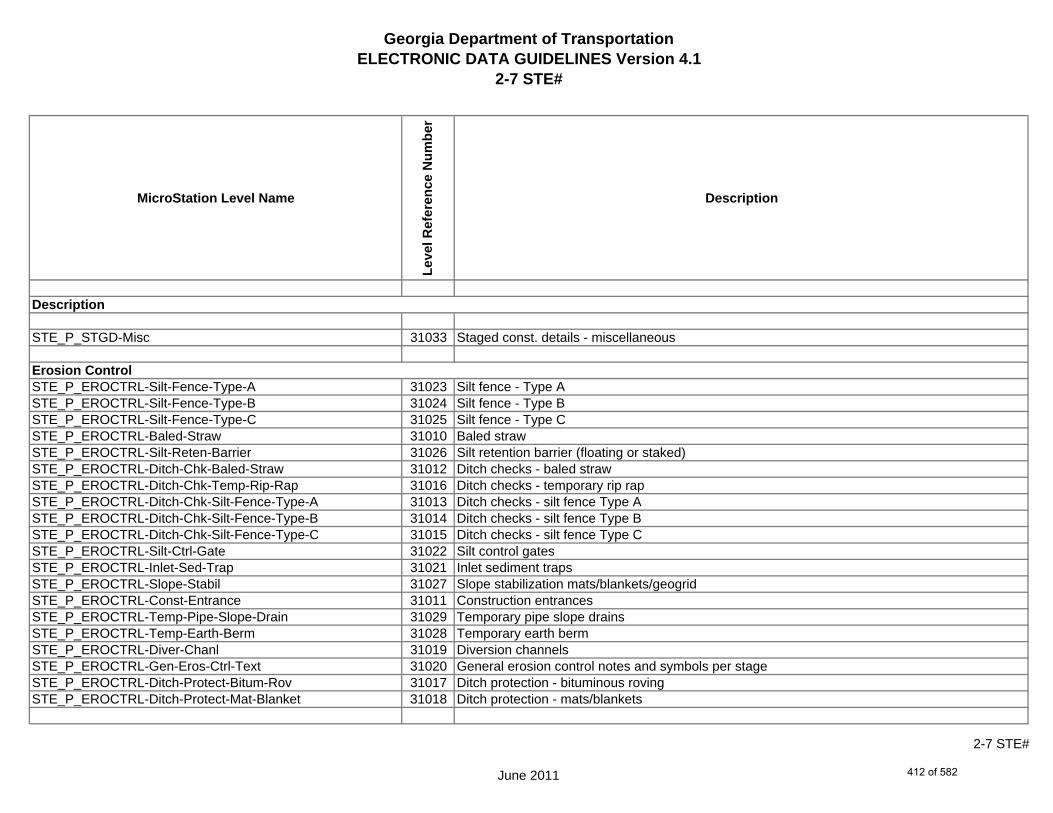
Georgia Department of TransportationELECTRONIC DATA GUIDELINES Version 4.1
2-7 STE#
MicroStation Level Name
Leve
l Ref
eren
ce N
umbe
r
Description
STE_P_STGD-Misc 31033 Staged const. details - miscellaneous
STE_P_EROCTRL-Silt-Fence-Type-A 31023 Silt fence - Type ASTE_P_EROCTRL-Silt-Fence-Type-B 31024 Silt fence - Type BSTE_P_EROCTRL-Silt-Fence-Type-C 31025 Silt fence - Type CSTE_P_EROCTRL-Baled-Straw 31010 Baled strawSTE_P_EROCTRL-Silt-Reten-Barrier 31026 Silt retention barrier (floating or staked)STE_P_EROCTRL-Ditch-Chk-Baled-Straw 31012 Ditch checks - baled strawSTE_P_EROCTRL-Ditch-Chk-Temp-Rip-Rap 31016 Ditch checks - temporary rip rapSTE_P_EROCTRL-Ditch-Chk-Silt-Fence-Type-A 31013 Ditch checks - silt fence Type ASTE_P_EROCTRL-Ditch-Chk-Silt-Fence-Type-B 31014 Ditch checks - silt fence Type BSTE_P_EROCTRL-Ditch-Chk-Silt-Fence-Type-C 31015 Ditch checks - silt fence Type CSTE_P_EROCTRL-Silt-Ctrl-Gate 31022 Silt control gatesSTE_P_EROCTRL-Inlet-Sed-Trap 31021 Inlet sediment trapsSTE_P_EROCTRL-Slope-Stabil 31027 Slope stabilization mats/blankets/geogridSTE_P_EROCTRL-Const-Entrance 31011 Construction entrancesSTE_P_EROCTRL-Temp-Pipe-Slope-Drain 31029 Temporary pipe slope drainsSTE_P_EROCTRL-Temp-Earth-Berm 31028 Temporary earth bermSTE_P_EROCTRL-Diver-Chanl 31019 Diversion channelsSTE_P_EROCTRL-Gen-Eros-Ctrl-Text 31020 General erosion control notes and symbols per stageSTE_P_EROCTRL-Ditch-Protect-Bitum-Rov 31017 Ditch protection - bituminous rovingSTE_P_EROCTRL-Ditch-Protect-Mat-Blanket 31018 Ditch protection - mats/blankets
Erosion Control
Description
June 2011
2-7 STE#
412 of 582

Georgia Department of TransportationELECTRONIC DATA GUIDELINES Version 4.1
2-7 STE#
MicroStation Level Name
Leve
l Ref
eren
ce N
umbe
r
Description
STE_P_EROCTRL-A 31050 Erosion Control Linestyle ASTE_P_EROCTRL-B 31051 Erosion Control Linestyle BSTE_P_EROCTRL-Be 31052 Erosion Control Linestyle BeSTE_P_EROCTRL-C 31053 Erosion Control Linestyle CSTE_P_EROCTRL-Ch-Br 31054 Erosion Control Linestyle Ch-Br (Bituminous Treated Roving)STE_P_EROCTRL-Ch-C 31055 Erosion Control Linestyle Ch-C (Channel Concrete)STE_P_EROCTRL-Ch-PSRM 31056 Erosion Control Linestyle Ch-PSRM (Channel Perm Soil Rein Mat)STE_P_EROCTRL-Ch-Rp1 31057 Erosion Control Linestyle Ch-Rp1 (Channel Rip Rap Type 1)STE_P_EROCTRL-Ch-Rp3 31058 Erosion Control Linestyle Ch-Rp3 (Channel Rip Rap Type 3)STE_P_EROCTRL-Ch-TRM1 31059 Erosion Control Linestyle Ch-TRM1STE_P_EROCTRL-Ch-TRM2 31060 Erosion Control Linestyle Ch-TRM2STE_P_EROCTRL-Ch-V 31061 Erosion Control Linestyle Ch-VSTE_P_EROCTRL-Di 31062 Erosion Control Linestyle Di (Diversion Channel)STE_P_EROCTRL-Dc-A 31063 Erosion Control Linestyle Dc-A (Diversion Channel Type A)STE_P_EROCTRL-Dc-B 31064 Erosion Control Linestyle Dc-B (Diversion Channel Type B)STE_P_EROCTRL-Dc-C 31065 Erosion Control Linestyle Dc-C (Diversion Channel Type C)STE_P_EROCTRL-Dn1 31066 Erosion Control Linestyle Dn1 (Down Drain Flexible)STE_P_EROCTRL-Dn2-A 31067 Erosion Control Linestyle Dn2-A (Down Drain Concrete)STE_P_EROCTRL-Dn2-B 31068 Erosion Control Linestyle Dn2-B (Down Drain Concrete)STE_P_EROCTRL-Dn2-1 31069 Erosion Control Linestyle Dn2-1 (Down Drain Conc. Type 1)STE_P_EROCTRL-Dn2-2 31070 Erosion Control Linestyle Dn2-2 (Down Drain Conc. Type 2)STE_P_EROCTRL-Dn3 31071 Erosion Control Linestyle Dn3 (Down Drain Metal)STE_P_EROCTRL-Ds1 31072 Erosion Control Linestyle Ds1 (Temporary Mulch)STE_P_EROCTRL-Ds2 31073 Erosion Control Linestyle Ds2 (Temporary Grassing)
Description
June 2011
2-7 STE#
413 of 582
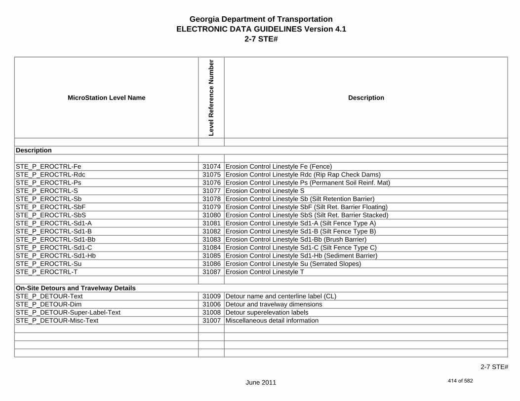
Georgia Department of TransportationELECTRONIC DATA GUIDELINES Version 4.1
2-7 STE#
MicroStation Level Name
Leve
l Ref
eren
ce N
umbe
r
Description
STE_P_EROCTRL-Fe 31074 Erosion Control Linestyle Fe (Fence)STE_P_EROCTRL-Rdc 31075 Erosion Control Linestyle Rdc (Rip Rap Check Dams)STE_P_EROCTRL-Ps 31076 Erosion Control Linestyle Ps (Permanent Soil Reinf. Mat)STE_P_EROCTRL-S 31077 Erosion Control Linestyle SSTE_P_EROCTRL-Sb 31078 Erosion Control Linestyle Sb (Silt Retention Barrier)STE_P_EROCTRL-SbF 31079 Erosion Control Linestyle SbF (Silt Ret. Barrier Floating)STE_P_EROCTRL-SbS 31080 Erosion Control Linestyle SbS (Silt Ret. Barrier Stacked)STE_P_EROCTRL-Sd1-A 31081 Erosion Control Linestyle Sd1-A (Silt Fence Type A)STE_P_EROCTRL-Sd1-B 31082 Erosion Control Linestyle Sd1-B (Silt Fence Type B)STE_P_EROCTRL-Sd1-Bb 31083 Erosion Control Linestyle Sd1-Bb (Brush Barrier)STE_P_EROCTRL-Sd1-C 31084 Erosion Control Linestyle Sd1-C (Silt Fence Type C)STE_P_EROCTRL-Sd1-Hb 31085 Erosion Control Linestyle Sd1-Hb (Sediment Barrier)STE_P_EROCTRL-Su 31086 Erosion Control Linestyle Su (Serrated Slopes)STE_P_EROCTRL-T 31087 Erosion Control Linestyle T
STE_P_DETOUR-Text 31009 Detour name and centerline label (CL)STE_P_DETOUR-Dim 31006 Detour and travelway dimensionsSTE_P_DETOUR-Super-Label-Text 31008 Detour superelevation labelsSTE_P_DETOUR-Misc-Text 31007 Miscellaneous detail information
On-Site Detours and Travelway Details
Description
June 2011
2-7 STE#
414 of 582

Georgia Department of TransportationELECTRONIC DATA GUIDELINES Version 4.1
2-7 STE#
MicroStation Level Name
Leve
l Ref
eren
ce N
umbe
r
Description
STE_P_Temporary-Sediment-Basin-Line 31088 Temporary Sediment basin linesSTE_P_Temporary-Sediment-Basin-Pnt-Symbol 31089 Temporary Sediment basins point symbolSTE_P_Temporary-Sediment-Basin-Pnt-Text 31090 Temporary Sediment basins point # textSTE_P_Temporary-Sediment-Basin-Text 31091 Temporary Sediment basin description
STE_P_Misc 31040 Miscellaneous Designer notes (not plotted)
Description
June 2011
2-7 STE#
415 of 582

Georgia Department of TransportationELECTRONIC DATA GUIDELINES Version 4.1
2-7 PROP
MicroStation Level Name
Leve
l Ref
eren
ce N
umbe
r
Description
PROP_E_PAROWN-Prop-Parcl-Text 22058 Property / Parcel owner name
PROP_E_PAR-PL-Alg-Name-Text 22059 Property line alignment namePROP_E_PAR-PL-Line 22061 Property line line and PL cellPROP_E_RWE-Line 22076 Existing Limited Access, R/W lines, and cellsPROP_E_PAR-PL-Text 22062 Property line line descriptionPROP_E_PAR-PL-Cell 22060 Property line - cell
PROP_E_PPOL-Cell 22071 Property point on line point symbolPROP_E_PPOL-Text 22072 Property point on line point # textPROP_E_PPC-Cell 22069 Property point computed point symbolPROP_E_PPC-Text 22070 Property point computed point # textPROP_E_PCF-Cell 22063 Property corner found point symbolPROP_E_PCF-Text 22064 Property corner found point # text
PROP_E_RWM-Cell 22078 Right of way marker found point symbolPROP_E_RWM-Text 22079 Right of way marker found point # textPROP_E_RWC-Cell 22073 Right of way computed point symbolPROP_E_RWC-Text 22074 Right of way computed point # textPROP_E_RWE-Cell 22075 Right of way prescription point point symbolPROP_E_RWE-Text 22077 Right of way prescription point point # text
Description
Property and Right of Way InformationParcel Owner and Information
Property Line
Property Line, Points
Right of Way, Points
June 2011
2-7 PROP
416 of 582

Georgia Department of TransportationELECTRONIC DATA GUIDELINES Version 4.1
2-7 PROP
MicroStation Level Name
Leve
l Ref
eren
ce N
umbe
r
Description
PROP_E_RWRR-Cell 22080 Right of way railroad point symbolPROP_E_RWRR-Pnt#-Alg-Name-Text 22082 Right of way railroad point # text, alignment namePROP_E_RWRR-Line 22081 Right of way railroad linePROP_E_RWRR-Text 22083 Right of way railroad line description
PROP_E_RWU-Cell 22084 Right of way utility company point symbolPROP_E_RWU-Pnt#-Alg-Name-Text 22086 Right of way utility company point # text, alignment namePROP_E_RWU-Line 22085 Right of way utility company linePROP_E_RWU-Text 22087 Right of way utility company line description
PROP_E_POEL-Cell 22065 Easement line point symbolPROP_E_POEL-Pnt#-Alg-Name-Text 22067 Easement line point # text, alignment namePROP_E_POEL-Line 22066 Easement line linePROP_E_POEL-Text 22068 Easement line description
PROP_E_BMISC-Cell 22050 Property boundary, miscellaneous, existing, point symbolPROP_E_BMISC-Pnt#-Alg-Name-Text 22052 Property boundary, miscellaneous, existing, point # text, alignment namePROP_E_BMISC-Line 22051 Property boundary line, existing, linePROP_E_BMISC-Text 22053 Property boundary line, existing, line description
Right of Way, Railroad
Right of Way, Utility Company
Existing Easement
Property Boundary Line, Miscellaneous
Description
June 2011
2-7 PROP
417 of 582

Georgia Department of TransportationELECTRONIC DATA GUIDELINES Version 4.1
2-7 PROP
MicroStation Level Name
Leve
l Ref
eren
ce N
umbe
r
Description
PROP_E_BSL-Cell 22054 State line, point symbolPROP_E_BSL-Pnt#-Alg-Name-Text 22056 State line, point # text, alignment namePROP_E_BSL-Line 22055 State line, linePROP_E_BSL-Text 22057 State line, line description
PROP_E_BCOL-Cell 22030 County line, point symbolPROP_E_BCOL-Pnt#-Alg-Name-Text 22032 County line, point # text, alignment namePROP_E_BCOL-Line 22031 County line, linePROP_E_BCOL-Text 22033 County line, line description
PROP_E_BCTL-Cell 22034 City limit line, point symbolPROP_E_BCTL-Pnt#-Alg-Name-Text 22036 City limit line, point # text, alignment namePROP_E_BCTL-Line 22035 City limit line, linePROP_E_BCTL-Text 22037 City limit line, line description
PROP_E_BGMD-Cell 22038 Georgia militia district, point symbolPROP_E_BGMD-Pnt#-Alg-Name-Text 22040 Georgia militia district, point # text, alignment namePROP_E_BGMD-Line 22039 Georgia militia district, linePROP_E_BGMD-Text 22041 Georgia militia district, line description
Description
Boundary FeaturesState Line
County Line
City Limit Line
Georgia Militia District
June 2011
2-7 PROP
418 of 582

Georgia Department of TransportationELECTRONIC DATA GUIDELINES Version 4.1
2-7 PROP
MicroStation Level Name
Leve
l Ref
eren
ce N
umbe
r
Description
PROP_E_BLDL-Cell 22042 Land district line, point symbolPROP_E_BLDL-Pnt#-Alg-Name-Text 22044 Land district line, point # text, alignment namePROP_E_BLDL-Line 22043 Land district line, linePROP_E_BLDL-Text 22045 Land district line, line description
PROP_E_BLLL-Cell 22046 Land lot line, point symbolPROP_E_BLLL-Pnt#-Alg-Name-Text 22048 Land lot line, point # text, alignment namePROP_E_BLLL-Line 22047 Land lot line, linePROP_E_BLLL-Text 22049 Land lot line, line description
PROP_E_ACL-Cell 22001 A field survey Alignment centerline point symbolPROP_E_ACL-Pnt#-Text 22006 A field survey Alignment centerline point # textPROP_E_ACL-Pnt-Text 22007 A field survey Alignment point symbol descriptionPROP_E_ACL-Elev-Text 22003 A field survey Alignment centerline elevationPROP_E_ACL-Line 22004 A field survey Alignment centerline linePROP_E_ACL-Text 22008 A field survey Alignment centerline descriptionPROP_E_ACL-Tic-Text 22009 A field survey Alignment centerline tics -- (N/A)PROP_E_ACL-PC-PT 22005 A field survey Alignment PC/PT -- (N/A)PROP_E_ACL-Brng-RouteName-Text 22000 A field survey Alignment bearings, route #, road name.etc.PROP_E_ACL-Curve-Data-Text 22002 A field survey Alignment curve data -- (N/A)
Description
Land District Line
Land Lot Line
Calculated Existing AlignmentCenterline
June 2011
2-7 PROP
419 of 582

Georgia Department of TransportationELECTRONIC DATA GUIDELINES Version 4.1
2-7 PROP
MicroStation Level Name
Leve
l Ref
eren
ce N
umbe
r
Description
PROP_E_APC-Cell 22010 Point on curve, point symbolPROP_E_APC-Pnt#-Text 22012 Point on curve, point # textPROP_E_APC-Elev-Text 22011 Point on curve, elevationPROP_E_APC-Text 22013 Point on curve, description
PROP_E_API-Cell 22014 Point of intersection, point symbolPROP_E_API-Pnt#-Text 22016 Point of intersection, point # textPROP_E_API-Elev-Text 22015 Point of intersection, elevationPROP_E_API-Text 22017 Point of intersection, description
PROP_E_APT-Cell 22026 Point of tangency, point symbolPROP_E_APT-Pnt#-Text 22028 Point of tangency, point # textPROP_E_APT-Elev-Text 22027 Point of tangency, elevationPROP_E_APT-Text 22029 Point of tangency, description
PROP_E_APOT-Cell 22022 Point on tangency, point symbolPROP_E_APOT-Pnt#-Text 22024 Point on tangency, point # textPROP_E_APOT-Elev-Text 22023 Point on tangency, elevationPROP_E_APOT-Text 22025 Point on tangency, description
Description
Field Located, Point of Intersection
Field Located, Point of Tangency
Field Located, Point on Tangency
Field Located, Point on Curve
June 2011
2-7 PROP
420 of 582

Georgia Department of TransportationELECTRONIC DATA GUIDELINES Version 4.1
2-7 PROP
MicroStation Level Name
Leve
l Ref
eren
ce N
umbe
r
Description
PROP_E_APOC-Cell 22018 Point of curvature, point symbolPROP_E_APOC-Pnt#-Text 22020 Point of curvature, point # textPROP_E_APOC-Elev-Text 22019 Point of curvature, elevationPROP_E_APOC-Text 22021 Point of curvature, description
Description
Field Located, Point of Curvature
June 2011
2-7 PROP
421 of 582

Georgia Department of TransportationELECTRONIC DATA GUIDELINES Version 4.1
2-7 TOPO
MicroStation Level Name
Leve
l Ref
eren
ce N
umbe
r
Description
TOPO_E_TEAP-Line 32187 K5 Edge of asphalt pavement, existing lineTOPO_E_TEAP-Text 32188 K37 Edge of asphalt pavement, existing line descriptionTOPO_E_TEAP-Cell 32186 Edge of asphalt pavement, existing point symbol, # text, description, elevation
TOPO_E_TEAS-Line 32190 K6 Edge of asphalt shoulder, existing lineTOPO_E_TEAS-Text 32191 Edge of asphalt shoulder, existing line descriptionTOPO_E_TEAS-Cell 32189 Edge of asphalt shoulder, existing point symbol, # text, description, elevation
TOPO_E_TECP-Line 32196 Edge of concrete pavement, existing lineTOPO_E_TECP-Text 32197 Edge of concrete pavement, existing line descriptionTOPO_E_TECP-Cell 32195 Edge of concrete pavement, existing point symbol, # text, description, elevation
TOPO_E_TEDR-Line 32202 K9 Edge of dirt road, existing lineTOPO_E_TEDR-Text 32203 Edge of dirt road, existing line descriptionTOPO_E_TEDR-Cell 32201 Edge of dirt road, existing point symbol, # text, description, elevation
Photogramatric mapping codes are shown in italics in thelevel description field for topography levels. These codes arefor use by the Department's Photogrametry Office ONLY.
Description
Edge of Asphalt Pavement, Existing
Edge of Asphalt Shoulder, Existing
Edge of Concrete Pavement, Existing
Edge of Dirt Road, Existing
June 2011
2-7 TOPO
422 of 582

Georgia Department of TransportationELECTRONIC DATA GUIDELINES Version 4.1
2-7 TOPO
MicroStation Level Name
Leve
l Ref
eren
ce N
umbe
r
Description
TOPO_E_TDR-Line 32181 Dirt road, C/L, existing lineTOPO_E_TDR-Text 32182 Dirt road, C/L, existing line descriptionTOPO_E_TDR-Cell 32180 Dirt road, C/L, existing point symbol, # text, description, elevation
TOPO_E_TEST-Line 32208 Edge of surface treatment road, existing lineTOPO_E_TEST-Text 32209 Edge of surface treatment road, existing line descriptionTOPO_E_TEST-Cell 32207 Edge of surface treatment road, existing point symbol, # text, description, elevation
TOPO_E_TEDD-Line 32199 Dirt drive, edge, existing lineTOPO_E_TEDD-Text 32200 Dirt drive, edge, existing line descriptionTOPO_E_TEDD-Cell 32198 Dirt drive, edge, existing point symbol, # text, description, elevation
TOPO_E_TDD-Line 32178 Dirt drive, C/L, existing lineTOPO_E_TDD-Text 32179 Dirt drive, C/L, existing line descriptionTOPO_E_TDD-Cell 32177 Dirt drive, C/L, existing point symbol, # text, description, elevation
Photogramatric mapping codes are shown in italics in thelevel description field for topography levels. These codes arefor use by the Department's Photogrametry Office ONLY.
Dirt Road, C/L, Existing
Description
Edge of Surface Treatment, Existing
Edge of Dirt Drive, Existing
Dirt Drive, C/L, Existing
June 2011
2-7 TOPO
423 of 582
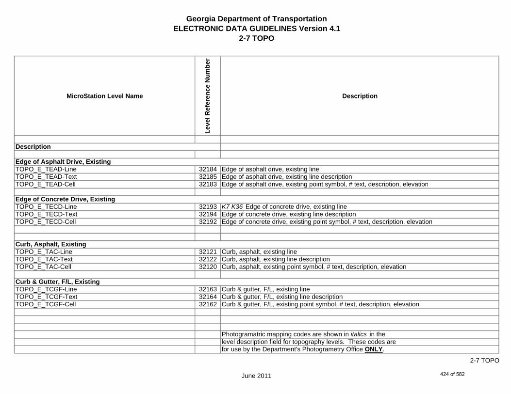
Georgia Department of TransportationELECTRONIC DATA GUIDELINES Version 4.1
2-7 TOPO
MicroStation Level Name
Leve
l Ref
eren
ce N
umbe
r
Description
TOPO_E_TEAD-Line 32184 Edge of asphalt drive, existing lineTOPO_E_TEAD-Text 32185 Edge of asphalt drive, existing line descriptionTOPO_E_TEAD-Cell 32183 Edge of asphalt drive, existing point symbol, # text, description, elevation
TOPO_E_TECD-Line 32193 K7 K36 Edge of concrete drive, existing lineTOPO_E_TECD-Text 32194 Edge of concrete drive, existing line descriptionTOPO_E_TECD-Cell 32192 Edge of concrete drive, existing point symbol, # text, description, elevation
TOPO_E_TAC-Line 32121 Curb, asphalt, existing lineTOPO_E_TAC-Text 32122 Curb, asphalt, existing line descriptionTOPO_E_TAC-Cell 32120 Curb, asphalt, existing point symbol, # text, description, elevation
TOPO_E_TCGF-Line 32163 Curb & gutter, F/L, existing lineTOPO_E_TCGF-Text 32164 Curb & gutter, F/L, existing line descriptionTOPO_E_TCGF-Cell 32162 Curb & gutter, F/L, existing point symbol, # text, description, elevation
Photogramatric mapping codes are shown in italics in thelevel description field for topography levels. These codes arefor use by the Department's Photogrametry Office ONLY.
Edge of Asphalt Drive, Existing
Edge of Concrete Drive, Existing
Curb, Asphalt, Existing
Curb & Gutter, F/L, Existing
Description
June 2011
2-7 TOPO
424 of 582

Georgia Department of TransportationELECTRONIC DATA GUIDELINES Version 4.1
2-7 TOPO
MicroStation Level Name
Leve
l Ref
eren
ce N
umbe
r
Description
TOPO_E_TCGT-Line 32166 K154 Curb & gutter, top, existing lineTOPO_E_TCGT-Text 32167 Curb & gutter, top, existing line descriptionTOPO_E_TCGT-Cell 32165 Curb & gutter, top, existing point symbol, # text, description, elevation
TOPO_E_THC-Line 32259 Header curb, existing lineTOPO_E_THC-Text 32263 Header curb, existing line descriptionTOPO_E_THC-Cell 32258 Header curb, existing point symbol, # text, description, elevation
TOPO_E_TVG-Line 32341 V-gutter, existing lineTOPO_E_TVG-Text 32342 V-gutter, existing line descriptionTOPO_E_TVG-Cell 32340 V-gutter, existing point symbol, # text, description, elevation
TOPO_E_TSW-Line 32329 K17 Sidewalk, edge, existing lineTOPO_E_TSW-Text 32330 Sidewalk, edge, existing line descriptionTOPO_E_TSW-Cell 32328 Sidewalk, edge, existing point symbol, # text, description, elevation
Photogramatric mapping codes are shown in italics in thelevel description field for topography levels. These codes arefor use by the Department's Photogrametry Office ONLY.
V-Gutter, Existing
Sidewalk, Edge, Existing
Header Curb, Existing
Curb & Gutter, Top, Existing
Description
June 2011
2-7 TOPO
425 of 582

Georgia Department of TransportationELECTRONIC DATA GUIDELINES Version 4.1
2-7 TOPO
MicroStation Level Name
Leve
l Ref
eren
ce N
umbe
r
Description
TOPO_E_TGR-Line 32246 Guardrail, existing lineTOPO_E_TGR-Text 32247 Guardrail, existing line descriptionTOPO_E_TGR-Cell 32245 Guardrail, existing point symbol, # text, description, elevation
TOPO_E_TBAS-Line 32124 Bridge approach slab, edge, existing lineTOPO_E_TBAS-Text 32125 Bridge approach slab, edge, existing line descriptionTOPO_E_TBAS-Cell 32123 Bridge approach slab, edge, existing point symbol, # text, description, elevation
TOPO_E_TBGL-Line 32136 Bridge gutter line, existing lineTOPO_E_TBGL-Text 32137 Bridge gutter line, existing line descriptionTOPO_E_TBGL-Cell 32135 Bridge gutter line, existing point symbol, # text, description, elevation
TOPO_E_TBRDGCEN-Line 32145 Bridge end, center - existing lineTOPO_E_TBRDGCEN-Text 32146 Bridge end, center - existing line textTOPO_E_TBRDGCEN-Cell 32144 Bridge end, center - existing cell
Photogramatric mapping codes are shown in italics in thelevel description field for topography levels. These codes arefor use by the Department's Photogrametry Office ONLY.
Bridge End, Center
Bridge Gutter Line, Existing
Bridge, Approach Slab, Edge
Guardrail, Existing
Description
June 2011
2-7 TOPO
426 of 582

Georgia Department of TransportationELECTRONIC DATA GUIDELINES Version 4.1
2-7 TOPO
MicroStation Level Name
Leve
l Ref
eren
ce N
umbe
r
Description
TOPO_E_TBRDGCOR-Line 32148 K14 Bridge end, corner - existing lineTOPO_E_TBRDGCOR-Text 32149 Bridge end, corner - existing line textTOPO_E_TBRDGCOR-Cell 32147 Bridge end, corner - existing cell
TOPO_E_THM-Cell 32264 K40 Historical monument - existing point cellTOPO_E_THM-Text 32266 Historical monument - existing line descriptionTOPO_E_THM-Line 32265 Historical monument - existing point symbol, # text, description, elevation
TOPO_E_TFP-Line 32223 Flag pole - existing point cellTOPO_E_TFP-Text 32224 Flag pole - existing line descriptionTOPO_E_TFP-Cell 32222 Flag pole - existing point symbol, # text, description, elevation
TOPO_E_TRCL-Line 32305 Railroad centerline, existing lineTOPO_E_TRCL-Text 32306 Railroad centerline, existing line descriptionTOPO_E_TRCL-Cell 32304 Railroad centerline, existing point symbol, # text, description, elevation
Photogramatric mapping codes are shown in italics in thelevel description field for topography levels. These codes arefor use by the Department's Photogrametry Office ONLY.
Description
Railroad Centerline, Existing
Flag Pole
Historical Monument
June 2011
2-7 TOPO
427 of 582

Georgia Department of TransportationELECTRONIC DATA GUIDELINES Version 4.1
2-7 TOPO
MicroStation Level Name
Leve
l Ref
eren
ce N
umbe
r
Description
TOPO_E_TRCR-Line 32311 Railroad, top of rail, existing lineTOPO_E_TRCR-Text 32312 Railroad, top of rail, existing line descriptionTOPO_E_TRCR-Cell 32307 Railroad, top of rail, existing point symbol, # text, description, elevation
TOPO_E_TRCRE-Line 32309 K16 K161 Map top of railroad rail - lineTOPO_E_TRCRE-Text 32310 Map top of railroad rail - textTOPO_E_TRCRE-Cell 32308 Map top of railroad rail - cell
TOPO_E_TBLD-Line 32139 Building corner, existing lineTOPO_E_TBLD-Text 32143 Building corner, existing line descriptionTOPO_E_TBLD-Cell 32138 Building corner, existing point symbol, # text, description, elevation
TOPO_E_TBLDRL-Line 32141 K18b Building roof line corner, existing lineTOPO_E_TBLDRL-Text 32142 Building roof line corner, existing line descriptionTOPO_E_TBLDRL-Cell 32140 Building roof line corner, existing point symbol, # text, description, elevation
Photogramatric mapping codes are shown in italics in thelevel description field for topography levels. These codes arefor use by the Department's Photogrametry Office ONLY.
Railroad, Top of Rail (Mapping)
Description
Building Roof Line, Corner
Railroad, Top of Rail, Existing
Building Corner
June 2011
2-7 TOPO
428 of 582

Georgia Department of TransportationELECTRONIC DATA GUIDELINES Version 4.1
2-7 TOPO
MicroStation Level Name
Leve
l Ref
eren
ce N
umbe
r
Description
TOPO_E_TUD-Line 32335 K21 Uncovered deck - existing lineTOPO_E_TUD-Text 32336 Uncovered deck - existing line descriptionTOPO_E_TUD-Cell 32334 Uncovered deck - existing point symbol, # text, description, elevation
TOPO_E_TS-Line 32326 Steps - existing lineTOPO_E_TS-Text 32327 Steps - existing line descriptionTOPO_E_TS-Cell 32320 Steps - existing point symbol, # text. Description, elevation
TOPO_E_TBC-Line 32131 Brick column - existing lineTOPO_E_TBC-Text 32134 Brick column - existing line descriptionTOPO_E_TBC-Cell 32129 Brick column - existing point symbol, # text, description, elevation
TOPO_E_TFE-Line 32217 Floor elevation - existing lineTOPO_E_TFE-Text 32218 Floor elevation - existing line descriptionTOPO_E_TFE-Cell 32216 Floor elevation - existing point symbol, # text, description, elevation
Photogramatric mapping codes are shown in italics in thelevel description field for topography levels. These codes arefor use by the Department's Photogrametry Office ONLY.
Uncovered Deck, Existing
Floor Elevation, Existing
Steps, Existing
Brick Column, Exsiting
Description
June 2011
2-7 TOPO
429 of 582
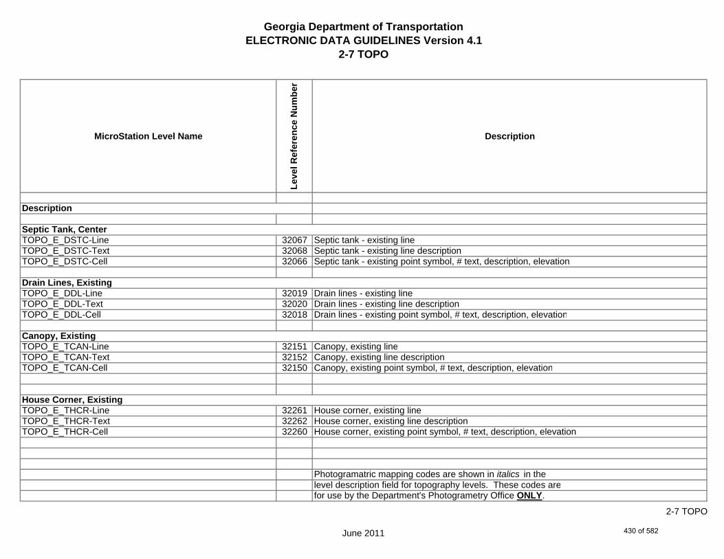
Georgia Department of TransportationELECTRONIC DATA GUIDELINES Version 4.1
2-7 TOPO
MicroStation Level Name
Leve
l Ref
eren
ce N
umbe
r
Description
TOPO_E_DSTC-Line 32067 Septic tank - existing lineTOPO_E_DSTC-Text 32068 Septic tank - existing line descriptionTOPO_E_DSTC-Cell 32066 Septic tank - existing point symbol, # text, description, elevation
TOPO_E_DDL-Line 32019 Drain lines - existing lineTOPO_E_DDL-Text 32020 Drain lines - existing line descriptionTOPO_E_DDL-Cell 32018 Drain lines - existing point symbol, # text, description, elevation
TOPO_E_TCAN-Line 32151 Canopy, existing lineTOPO_E_TCAN-Text 32152 Canopy, existing line descriptionTOPO_E_TCAN-Cell 32150 Canopy, existing point symbol, # text, description, elevation
TOPO_E_THCR-Line 32261 House corner, existing lineTOPO_E_THCR-Text 32262 House corner, existing line descriptionTOPO_E_THCR-Cell 32260 House corner, existing point symbol, # text, description, elevation
Photogramatric mapping codes are shown in italics in thelevel description field for topography levels. These codes arefor use by the Department's Photogrametry Office ONLY.
House Corner, Existing
Canopy, Existing
Drain Lines, Existing
Septic Tank, Center
Description
June 2011
2-7 TOPO
430 of 582
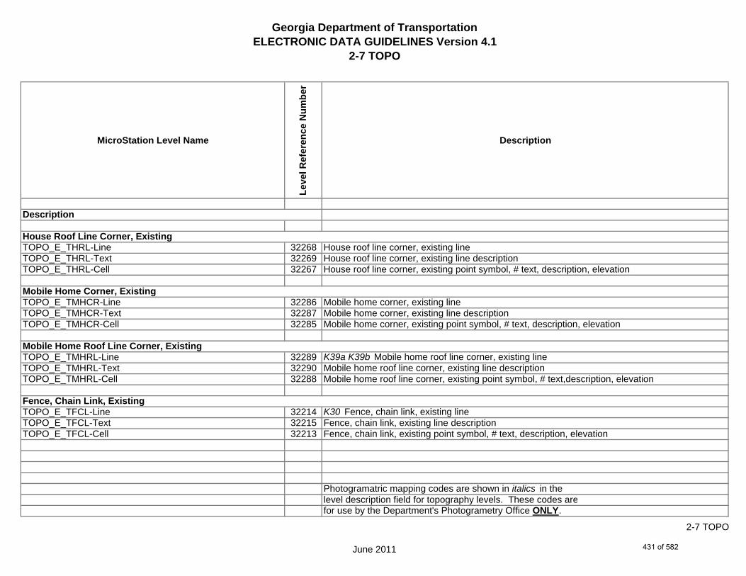
Georgia Department of TransportationELECTRONIC DATA GUIDELINES Version 4.1
2-7 TOPO
MicroStation Level Name
Leve
l Ref
eren
ce N
umbe
r
Description
TOPO_E_THRL-Line 32268 House roof line corner, existing lineTOPO_E_THRL-Text 32269 House roof line corner, existing line descriptionTOPO_E_THRL-Cell 32267 House roof line corner, existing point symbol, # text, description, elevation
TOPO_E_TMHCR-Line 32286 Mobile home corner, existing lineTOPO_E_TMHCR-Text 32287 Mobile home corner, existing line descriptionTOPO_E_TMHCR-Cell 32285 Mobile home corner, existing point symbol, # text, description, elevation
TOPO_E_TMHRL-Line 32289 K39a K39b Mobile home roof line corner, existing lineTOPO_E_TMHRL-Text 32290 Mobile home roof line corner, existing line descriptionTOPO_E_TMHRL-Cell 32288 Mobile home roof line corner, existing point symbol, # text,description, elevation
TOPO_E_TFCL-Line 32214 K30 Fence, chain link, existing lineTOPO_E_TFCL-Text 32215 Fence, chain link, existing line descriptionTOPO_E_TFCL-Cell 32213 Fence, chain link, existing point symbol, # text, description, elevation
Photogramatric mapping codes are shown in italics in thelevel description field for topography levels. These codes arefor use by the Department's Photogrametry Office ONLY.
Fence, Chain Link, Existing
Mobile Home Corner, Existing
Mobile Home Roof Line Corner, Existing
House Roof Line Corner, Existing
Description
June 2011
2-7 TOPO
431 of 582

Georgia Department of TransportationELECTRONIC DATA GUIDELINES Version 4.1
2-7 TOPO
MicroStation Level Name
Leve
l Ref
eren
ce N
umbe
r
Description
TOPO_E_TFW-Line 32229 Fence, wood, existing lineTOPO_E_TFW-Text 32230 Fence, wood, existing line descriptionTOPO_E_TFW-Cell 32228 Fence, wood, existing point symbol, # text, description, elevation
TOPO_E_TFBW-Line 32211 Fence, barbed wire, existing lineTOPO_E_TFBW-Text 32212 Fence, barbed wire, existing line descriptionTOPO_E_TFBW-Cell 32210 Fence, barbed wire, existing point symbol, # text, description, elevation
TOPO_E_TFFW-Line 32220 Fence, field wire, existing lineTOPO_E_TFFW-Text 32221 Fence, field wire, existing line descriptionTOPO_E_TFFW-Cell 32219 Fence, field wire, existing point symbol, # text, description, elevation
TOPO_E_TVF-Line 32338 Fence, pvc, existing lineTOPO_E_TVF-Text 32339 Fence, pvc, existing line descriptionTOPO_E_TVF-Cell 32337 Fence, pvc, existing point symbol, # text, description, elevation
Photogramatric mapping codes are shown in italics in thelevel description field for topography levels. These codes arefor use by the Department's Photogrametry Office ONLY.
Description
Fence, Field Wire, Existing
Fence, Barbed Wire, Existing
Fence, Wood, Existing
Fence, Vinyl (PVC), Exsiting
June 2011
2-7 TOPO
432 of 582

Georgia Department of TransportationELECTRONIC DATA GUIDELINES Version 4.1
2-7 TOPO
MicroStation Level Name
Leve
l Ref
eren
ce N
umbe
r
Description
TOPO_E_TG-Line 32235 Gate - existing lineTOPO_E_TG-Text 32254 Gate - existing line descriptionTOPO_E_TG-Cell 32231 Gate - existing point symbol, # text, description, elevation
TOPO_E_TWELL-Line 32344 Well, existing point point cellTOPO_E_TWELL-Text 32345 Well, existing line descriptionTOPO_E_TWELL-Cell 32343 Well, existing point symbol, # text, description, elevation
TOPO_E_TGFV-Line 32233 Gasoline filler valve, existing point cellTOPO_E_TGFV-Text 32234 Gasoline filler valve, existing line descriptionTOPO_E_TGFV-Cell 32232 Gasoline filler valve, existing point symbol, # text, description, elevation
TOPO_E_TGMW-Line 32237 Gasoline monitoring well, existing point cellTOPO_E_TGMW-Text 32238 Gasoline monitoring well, existing line descriptionTOPO_E_TGMW-Cell 32236 Gasoline monitoring well, existing point symbol, # text, description, elevation
Photogramatric mapping codes are shown in italics in thelevel description field for topography levels. These codes arefor use by the Department's Photogrametry Office ONLY.
Well, Existing
Gate, Existing
Description
Gasoline Filler Valve, Existing
Gasoline Monitoring Well, Existing
June 2011
2-7 TOPO
433 of 582

Georgia Department of TransportationELECTRONIC DATA GUIDELINES Version 4.1
2-7 TOPO
MicroStation Level Name
Leve
l Ref
eren
ce N
umbe
r
Description
TOPO_E_TGP-Line 32243 Gasoline pump, existing point cellTOPO_E_TGP-Text 32244 Gasoline pump, existing line descriptionTOPO_E_TGP-Cell 32239 Gasoline pump, existing point symbol, # text, description, elevation
TOPO_E_TGPI-Line 32241 Gasoline pump island, existing lineTOPO_E_TGPI-Text 32242 Gasoline pump island, existing line descriptionTOPO_E_TGPI-Cell 32240 Gasoline pump island, existing point symbol, # text, description, elevation
TOPO_E_TFT-Line 32226 Fuel tank - existing lineTOPO_E_TFT-Text 32227 Fuel tank - existing line description TOPO_E_TFT-Cell 32225 Fuel tank - existing point symbol, # text, description, elevation
TOPO_E_TGST-Line 32252 K74 Gasoline storage tank, end, existing lineTOPO_E_TGST-Text 32253 Gasoline storage tank, end, existing line descriptionTOPO_E_TGST-Cell 32251 Gasoline storage tank, end, existing point symbol, # text, description, elevation
Photogramatric mapping codes are shown in italics in thelevel description field for topography levels. These codes arefor use by the Department's Photogrametry Office ONLY.
Description
Fuel Tank, Existing
Gasoline Storage Tank, End, Existing
Gasoline Pump Island, Existing
Gasoline Pump, Existing
June 2011
2-7 TOPO
434 of 582

Georgia Department of TransportationELECTRONIC DATA GUIDELINES Version 4.1
2-7 TOPO
MicroStation Level Name
Leve
l Ref
eren
ce N
umbe
r
Description
TOPO_E_TGVP-Line 32256 Gasoline vent pipe, existing point cellTOPO_E_TGVP-Text 32257 Gasoline vent pipe, existing line descriptionTOPO_E_TGVP-Cell 32255 Gasoline vent pipe, existing point symbol, # text, description, elevation
TOPO_E_DCEF-Line 32007 Culvert end, F/L cellTOPO_E_DCEF-Text 32008 Culvert end, F/L line description (Elevation, type, size, etc.)TOPO_E_DCEF-Cell 32006 Culvert end, F/L point symbol, # text, description, elevation
TOPO_E_DCB-Line 32004 K65 Single catch basin existing point cellTOPO_E_DCB-Text 32005 Single catch basin existing description (Elevation, type, size, etc.)TOPO_E_DCB-Cell 32003 Single catch basin existing point symbol, # text, description, elevation
TOPO_E_DCWE-Line 32010 Culvert, wingwall end line/cellTOPO_E_DCWE-Text 32011 Culvert, wingwall end line description (Elevation, type, size, etc.)TOPO_E_DCWE-Cell 32009 Culvert, wingwall end point symbol, # text, description, elevation
Photogramatric mapping codes are shown in italics in thelevel description field for topography levels. These codes arefor use by the Department's Photogrametry Office ONLY.
Single Catch Basin, Gutter F/L
Culvert End, Flow Line
Culvert, Wingwall End
Gasoline Vent Pipe, Existing
Description
June 2011
2-7 TOPO
435 of 582
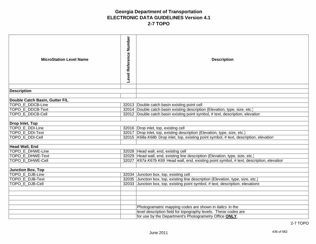
Georgia Department of TransportationELECTRONIC DATA GUIDELINES Version 4.1
2-7 TOPO
MicroStation Level Name
Leve
l Ref
eren
ce N
umbe
r
Description
TOPO_E_DDCB-Line 32013 Double catch basin existing point cellTOPO_E_DDCB-Text 32014 Double catch basin existing description (Elevation, type, size, etc.)TOPO_E_DDCB-Cell 32012 Double catch basin existing point symbol, # text, description, elevation
TOPO_E_DDI-Line 32016 Drop inlet, top, existing cellTOPO_E_DDI-Text 32017 Drop inlet, top, existing description (Elevation, type, size, etc.)TOPO_E_DDI-Cell 32015 K68a K68b Drop inlet, top, existing point symbol, # text, description, elevation
TOPO_E_DHWE-Line 32028 Head wall, end, existing cellTOPO_E_DHWE-Text 32029 Head wall, end, existing line description (Elevation, type, size, etc.)TOPO_E_DHWE-Cell 32027 K67a K67b K69 Head wall, end, existing point symbol, # text, description, elevation
TOPO_E_DJB-Line 32034 Junction box, top, existing cellTOPO_E_DJB-Text 32035 Junction box, top, existing line description (Elevation, type, size, etc.)TOPO_E_DJB-Cell 32033 Junction box, top, existing point symbol, # text, description, elevations
Photogramatric mapping codes are shown in italics in thelevel description field for topography levels. These codes arefor use by the Department's Photogrametry Office ONLY.
Head Wall, End
Junction Box, Top
Double Catch Basin, Gutter F/L
Drop Inlet, Top
Description
June 2011
2-7 TOPO
436 of 582

Georgia Department of TransportationELECTRONIC DATA GUIDELINES Version 4.1
2-7 TOPO
MicroStation Level Name
Leve
l Ref
eren
ce N
umbe
r
Description
TOPO_E_DPC-Line 32043 Drainage pipe, F/L, C existing lineTOPO_E_DPC-Text 32044 Drainage pipe, F/L, C existing line description (Elevation, type, size, etc.)TOPO_E_DPC-Cell 32042 Drainage pipe, F/L, C existing point symbol, # text, description, elevation
TOPO_E_DPM-Line 32049 Drainage pipe, F/L, M - existing lineTOPO_E_DPM-Text 32050 Drainage pipe, F/L, M - existing line description (Elevation, type, size, etc.)TOPO_E_DPM-Cell 32048 Drainage pipe, F/L, M - existing point symbol, # text, description, elevation
TOPO_E_DPP-Line 32052 Drainage pipe, F/L, P - existing lineTOPO_E_DPP-Text 32053 Drainage pipe, F/L, P - existing line description (Elevation, type, size, etc.)TOPO_E_DPP-Cell 32051 Drainage pipe, F/L, P - existing point symbol, # text, description, elevation
TOPO_E_MDITCHFL-Line 32079 K43 K151 Map ditch flow line - existing lineTOPO_E_MDITCHFL-Text 32080 Map ditch flow line - existing line description (Elevation, type, size, etc.)TOPO_E_MDITCHFL-Cell 32078 Map ditch flow line - cell
Photogramatric mapping codes are shown in italics in thelevel description field for topography levels. These codes arefor use by the Department's Photogrametry Office ONLY.
Drainage Pipe, F/L, C
Drainage Pipe, F/L, M
Drainage Pipe, F/L, P
Ditch Flow Line (Mapping), Existing
Description
June 2011
2-7 TOPO
437 of 582

Georgia Department of TransportationELECTRONIC DATA GUIDELINES Version 4.1
2-7 TOPO
MicroStation Level Name
Leve
l Ref
eren
ce N
umbe
r
Description
TOPO_E_DPD-Line 32046 K63 Paved ditch - existing lineTOPO_E_DPD-Text 32047 Paved ditch - existing line description (Elevation, type, size, etc.)TOPO_E_DPD-Cell 32045 Paved ditch - existing point symbol, # text, description, elevation
TOPO_E_DSB-Line 32055 Stream bank top, existing lineTOPO_E_DSB-Text 32056 Stream bank top, existing line description (Elevation, type, size, etc.)TOPO_E_DSB-Cell 32054 Stream bank top, existing point symbol, # text, description, elevation
TOPO_E_DSC-Line 32058 Stream center F/L, existing lineTOPO_E_DSC-Text 32059 Stream center F/L, existing line description (Elevation, type, size, etc.)TOPO_E_DSC-Cell 32057 Stream center F/L, existing point symbol, # text, description, elevation
TOPO_E_DSE-Line 32061 K41 K42 Stream edge, existing lineTOPO_E_DSE-Text 32062 Stream edge, existing line description (Elevation, type, size, etc.)TOPO_E_DSE-Cell 32060 Stream edge, existing point symbol, # text, description, elevation
Photogramatric mapping codes are shown in italics in thelevel description field for topography levels. These codes arefor use by the Department's Photogrametry Office ONLY.
Paved Ditch, Exsiting
Stream Bank Top
Description
Stream Center F/L
Stream Edge
June 2011
2-7 TOPO
438 of 582

Georgia Department of TransportationELECTRONIC DATA GUIDELINES Version 4.1
2-7 TOPO
MicroStation Level Name
Leve
l Ref
eren
ce N
umbe
r
Description
TOPO_E_DWE-Line 32076 Top of water elevations, existing lineTOPO_E_DWE-Text 32077 Top of water elevations, existing line description (Elevation, type, size, etc.)TOPO_E_DWE-Cell 32075 Top of water elevations, existing point symbol, # text, description, elevation
TOPO_E_DEW-Line 32025 K49 K151 K160 K162 Edge of water, existing lineTOPO_E_DEW-Hatch-Line 32507 Edge of water, existing lineTOPO_E_DEW-Text 32026 Edge of water, existing line description (Elevation, type, size, etc.)TOPO_E_DEW-Cell 32024 Edge of water, existing point symbol, # text, description, elevation
TOPO_E_DHWM-Line 32031 High water mark - existing lineTOPO_E_DHWM-Text 32032 High water mark - existing line description (Elevation, type, size, etc.)TOPO_E_DHWM-Cell 32030 High water mark - existing point symbol, # text, description, elevation
TOPO_E_DSWE-Line 32070 Swamp edge, existing lineTOPO_E_DSWE-Text 32071 Swamp edge, existing line description (Elevation, type, size, etc.)TOPO_E_DSWE-Cell 32069 K51 K54 Swamp edge, existing point symbol, # text, description, elevation
Photogramatric mapping codes are shown in italics in thelevel description field for topography levels. These codes arefor use by the Department's Photogrametry Office ONLY.
Edge of Water
High Water Mark
Swamp Edge
Top of Water Elevation
Description
June 2011
2-7 TOPO
439 of 582

Georgia Department of TransportationELECTRONIC DATA GUIDELINES Version 4.1
2-7 TOPO
MicroStation Level Name
Leve
l Ref
eren
ce N
umbe
r
Description
TOPO_E_DMISC-Line 32037 Misc. drainage feature, existing lineTOPO_E_DMISC-Text 32038 Misc. drainage feature, existing line description (Elevation, type, size, etc.)TOPO_E_DMISC-Cell 32036 Misc. drainage feature, existing point symbol, # text, description, elevation
TOPO_E_TWF-Line 32350 K15 Wall face, existing lineTOPO_E_TWF-Text 32352 Wall face, existing line descriptionTOPO_E_TWF-Cell 32349 Wall face, existing point symbol, # text, description, elevation
TOPO_E_TWFT-Line 32353 K29 K163 Wall face top, existing lineTOPO_E_TWFT-Text 32354 Wall face top, existing line descriptionTOPO_E_TWFT-Cell 32351 Wall face top, existing point symbol, # text, description, elevation
TOPO_E_TWFB-Line 32347 Wall face bottom, existing lineTOPO_E_TWFB-Text 32348 Wall face bottom, existing line descriptionTOPO_E_TWFB-Cell 32346 Wall face bottom, existing point symbol, # text, description, elevation
Photogramatric mapping codes are shown in italics in thelevel description field for topography levels. These codes arefor use by the Department's Photogrametry Office ONLY.
Wall Face, Top, Existing
Wall Face, Bottom, Existing
Description
Misc. Drainage Feature
Wall Face, Existing
June 2011
2-7 TOPO
440 of 582
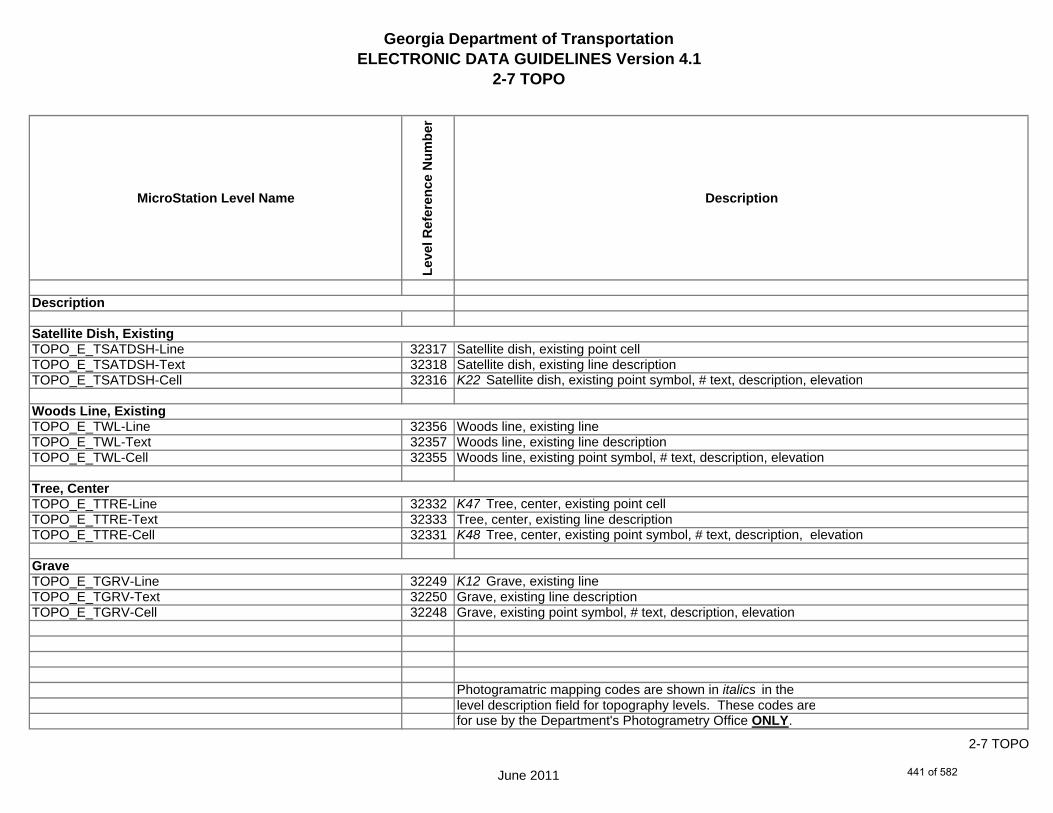
Georgia Department of TransportationELECTRONIC DATA GUIDELINES Version 4.1
2-7 TOPO
MicroStation Level Name
Leve
l Ref
eren
ce N
umbe
r
Description
TOPO_E_TSATDSH-Line 32317 Satellite dish, existing point cellTOPO_E_TSATDSH-Text 32318 Satellite dish, existing line descriptionTOPO_E_TSATDSH-Cell 32316 K22 Satellite dish, existing point symbol, # text, description, elevation
TOPO_E_TWL-Line 32356 Woods line, existing lineTOPO_E_TWL-Text 32357 Woods line, existing line descriptionTOPO_E_TWL-Cell 32355 Woods line, existing point symbol, # text, description, elevation
TOPO_E_TTRE-Line 32332 K47 Tree, center, existing point cellTOPO_E_TTRE-Text 32333 Tree, center, existing line descriptionTOPO_E_TTRE-Cell 32331 K48 Tree, center, existing point symbol, # text, description, elevation
TOPO_E_TGRV-Line 32249 K12 Grave, existing lineTOPO_E_TGRV-Text 32250 Grave, existing line descriptionTOPO_E_TGRV-Cell 32248 Grave, existing point symbol, # text, description, elevation
Photogramatric mapping codes are shown in italics in thelevel description field for topography levels. These codes arefor use by the Department's Photogrametry Office ONLY.
Satellite Dish, Existing
Woods Line, Existing
Tree, Center
Grave
Description
June 2011
2-7 TOPO
441 of 582
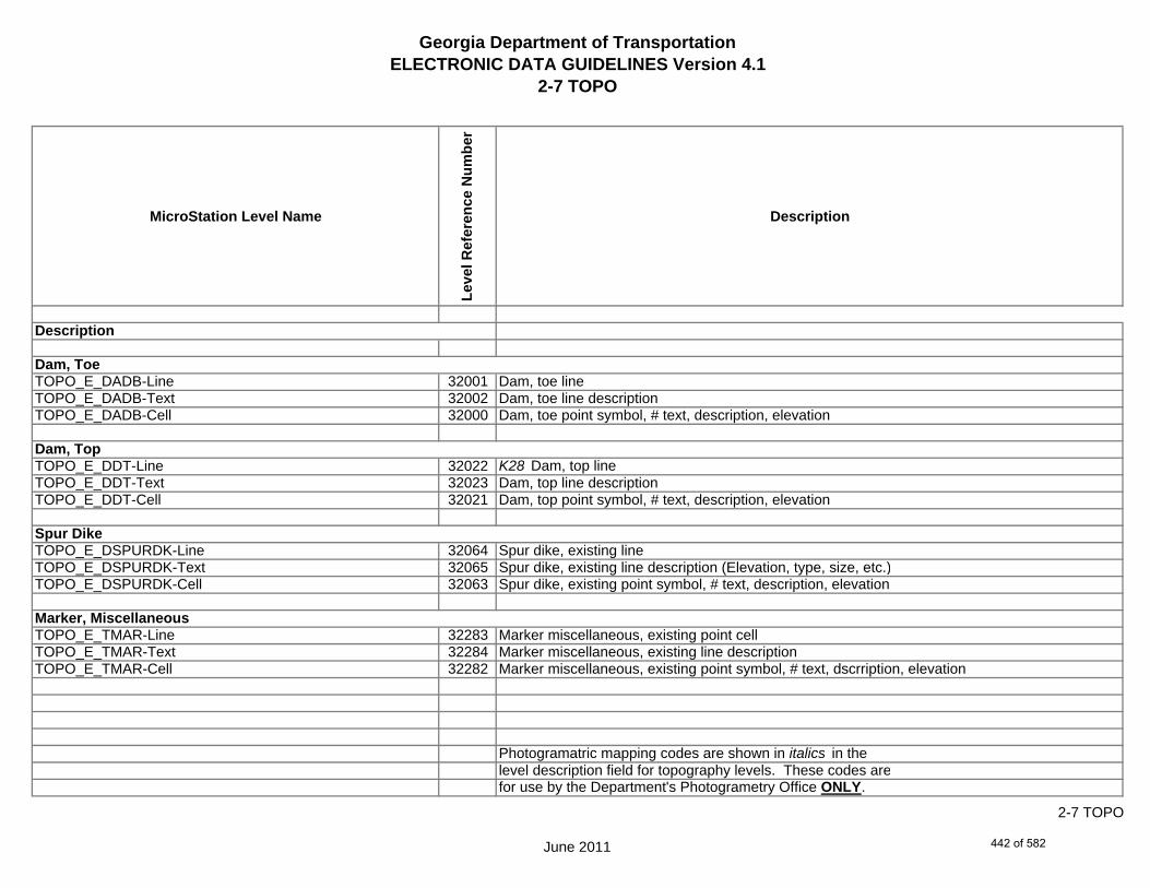
Georgia Department of TransportationELECTRONIC DATA GUIDELINES Version 4.1
2-7 TOPO
MicroStation Level Name
Leve
l Ref
eren
ce N
umbe
r
Description
TOPO_E_DADB-Line 32001 Dam, toe lineTOPO_E_DADB-Text 32002 Dam, toe line descriptionTOPO_E_DADB-Cell 32000 Dam, toe point symbol, # text, description, elevation
TOPO_E_DDT-Line 32022 K28 Dam, top lineTOPO_E_DDT-Text 32023 Dam, top line descriptionTOPO_E_DDT-Cell 32021 Dam, top point symbol, # text, description, elevation
TOPO_E_DSPURDK-Line 32064 Spur dike, existing lineTOPO_E_DSPURDK-Text 32065 Spur dike, existing line description (Elevation, type, size, etc.)TOPO_E_DSPURDK-Cell 32063 Spur dike, existing point symbol, # text, description, elevation
TOPO_E_TMAR-Line 32283 Marker miscellaneous, existing point cellTOPO_E_TMAR-Text 32284 Marker miscellaneous, existing line descriptionTOPO_E_TMAR-Cell 32282 Marker miscellaneous, existing point symbol, # text, dscrription, elevation
Photogramatric mapping codes are shown in italics in thelevel description field for topography levels. These codes arefor use by the Department's Photogrametry Office ONLY.
Dam, Toe
Dam, Top
Spur Dike
Marker, Miscellaneous
Description
June 2011
2-7 TOPO
442 of 582
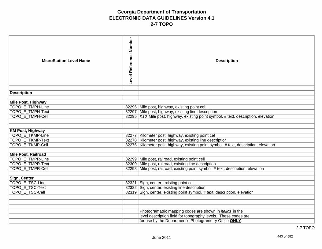
Georgia Department of TransportationELECTRONIC DATA GUIDELINES Version 4.1
2-7 TOPO
MicroStation Level Name
Leve
l Ref
eren
ce N
umbe
r
Description
TOPO_E_TMPH-Line 32296 Mile post, highway, existing point cellTOPO_E_TMPH-Text 32297 Mile post, highway, existing line descriptionTOPO_E_TMPH-Cell 32295 K10 Mile post, highway, existing point symbol, # text, description, elevation
TOPO_E_TKMP-Line 32277 Kilometer post, highway, existing point cellTOPO_E_TKMP-Text 32278 Kilometer post, highway, existing line descriptionTOPO_E_TKMP-Cell 32276 Kilometer post, highway, existing point symbol, # text, description, elevation
TOPO_E_TMPR-Line 32299 Mile post, railroad, existing point cellTOPO_E_TMPR-Text 32300 Mile post, railroad, existing line descriptionTOPO_E_TMPR-Cell 32298 Mile post, railroad, existing point symbol, # text, description, elevation
TOPO_E_TSC-Line 32321 Sign, center, existing point cellTOPO_E_TSC-Text 32322 Sign, center, existing line descriptionTOPO_E_TSC-Cell 32319 Sign, center, existing point symbol, # text, description, elevation
Photogramatric mapping codes are shown in italics in thelevel description field for topography levels. These codes arefor use by the Department's Photogrametry Office ONLY.
Mile Post, Highway
KM Post, Highway
Mile Post, Railroad
Sign, Center
Description
June 2011
2-7 TOPO
443 of 582

Georgia Department of TransportationELECTRONIC DATA GUIDELINES Version 4.1
2-7 TOPO
MicroStation Level Name
Leve
l Ref
eren
ce N
umbe
r
Description
TOPO_E_TSE-Line 32324 K24a K24b K24c Sign, end, existing point cellTOPO_E_TSE-Text 32325 Sign, end, existing line descriptionTOPO_E_TSE-Cell 32323 K13 Sign, end, existing point symbol, # text, description, elevation
TOPO_E_TIRRLMT-Line 32271 Irrigation limit, existing lineTOPO_E_TIRRLMT-Text 32272 Irrigation limit, existing line descriptionTOPO_E_TIRRLMT-Cell 32270 Irrigation limit, existing point symbol, # text, description, elevation
TOPO_E_TIRRPVTP-Line 32274 Irrigation pump turning point, existing point line/cellTOPO_E_TIRRPVTP-Text 32275 Irrigation pump turning point, existing line descriptionTOPO_E_TIRRPVTP-Cell 32273 Irrigation pump turning point, existing point symbol, # text, description, elevation
TOPO_E_TCUL-Line 32175 Cultivation line, existing lineTOPO_E_TCUL-Text 32176 Cultivation line, existing line descriptionTOPO_E_TCUL-Cell 32174 Cultivation line, existing point symbol, # text, description, elevation
Photogramatric mapping codes are shown in italics in thelevel description field for topography levels. These codes arefor use by the Department's Photogrametry Office ONLY.
Irrigation Limit
Irrigation Pump Turning Point
Cultivation Line
Description
Sign, End
June 2011
2-7 TOPO
444 of 582
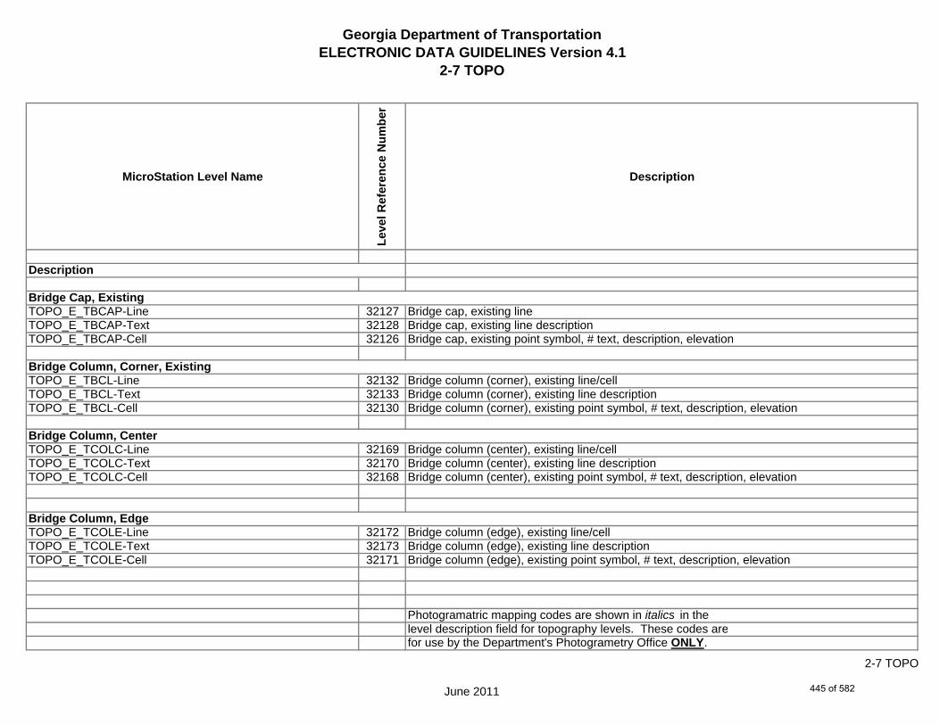
Georgia Department of TransportationELECTRONIC DATA GUIDELINES Version 4.1
2-7 TOPO
MicroStation Level Name
Leve
l Ref
eren
ce N
umbe
r
Description
TOPO_E_TBCAP-Line 32127 Bridge cap, existing lineTOPO_E_TBCAP-Text 32128 Bridge cap, existing line descriptionTOPO_E_TBCAP-Cell 32126 Bridge cap, existing point symbol, # text, description, elevation
TOPO_E_TBCL-Line 32132 Bridge column (corner), existing line/cellTOPO_E_TBCL-Text 32133 Bridge column (corner), existing line descriptionTOPO_E_TBCL-Cell 32130 Bridge column (corner), existing point symbol, # text, description, elevation
TOPO_E_TCOLC-Line 32169 Bridge column (center), existing line/cellTOPO_E_TCOLC-Text 32170 Bridge column (center), existing line descriptionTOPO_E_TCOLC-Cell 32168 Bridge column (center), existing point symbol, # text, description, elevation
TOPO_E_TCOLE-Line 32172 Bridge column (edge), existing line/cellTOPO_E_TCOLE-Text 32173 Bridge column (edge), existing line descriptionTOPO_E_TCOLE-Cell 32171 Bridge column (edge), existing point symbol, # text, description, elevation
Photogramatric mapping codes are shown in italics in thelevel description field for topography levels. These codes arefor use by the Department's Photogrametry Office ONLY.
Bridge Cap, Existing
Bridge Column, Center
Bridge Column, Edge
Bridge Column, Corner, Existing
Description
June 2011
2-7 TOPO
445 of 582
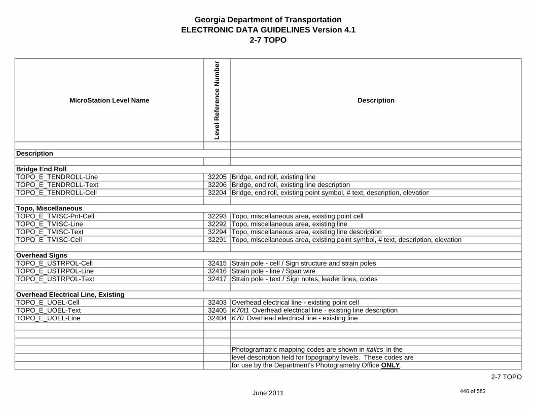
Georgia Department of TransportationELECTRONIC DATA GUIDELINES Version 4.1
2-7 TOPO
MicroStation Level Name
Leve
l Ref
eren
ce N
umbe
r
Description
TOPO_E_TENDROLL-Line 32205 Bridge, end roll, existing lineTOPO_E_TENDROLL-Text 32206 Bridge, end roll, existing line descriptionTOPO_E_TENDROLL-Cell 32204 Bridge, end roll, existing point symbol, # text, description, elevation
TOPO_E_TMISC-Pnt-Cell 32293 Topo, miscellaneous area, existing point cellTOPO_E_TMISC-Line 32292 Topo, miscellaneous area, existing lineTOPO_E_TMISC-Text 32294 Topo, miscellaneous area, existing line descriptionTOPO_E_TMISC-Cell 32291 Topo, miscellaneous area, existing point symbol, # text, description, elevation
TOPO_E_USTRPOL-Cell 32415 Strain pole - cell / Sign structure and strain polesTOPO_E_USTRPOL-Line 32416 Strain pole - line / Span wireTOPO_E_USTRPOL-Text 32417 Strain pole - text / Sign notes, leader lines, codes
TOPO_E_UOEL-Cell 32403 Overhead electrical line - existing point cellTOPO_E_UOEL-Text 32405 K70t1 Overhead electrical line - existing line descriptionTOPO_E_UOEL-Line 32404 K70 Overhead electrical line - existing line
Photogramatric mapping codes are shown in italics in thelevel description field for topography levels. These codes arefor use by the Department's Photogrametry Office ONLY.
Overhead Signs
Topo, Miscellaneous
Bridge End Roll
Description
Overhead Electrical Line, Existing
June 2011
2-7 TOPO
446 of 582

Georgia Department of TransportationELECTRONIC DATA GUIDELINES Version 4.1
2-7 TOPO
MicroStation Level Name
Leve
l Ref
eren
ce N
umbe
r
Description
TOPO_E_UOTL-Cell 32406 Overhead telephone line - existing point cellTOPO_E_UOTL-Text 32408 Overhead telephone line - existing line descriptionTOPO_E_UOTL-Line 32407 Overhead telephone line - existing line
TOPO_E_UELBOX-Cell 32358 Electrical box - existing point cellTOPO_E_UELBOX-Text 32360 Electrical box - existing line descriptionTOPO_E_UELBOX-Line 32359 K80 Electrical box - existing line
TOPO_E_UPP-Cell 32409 K72 Power pole, center - existing point cellTOPO_E_UPP-Text 32411 Power pole, center - existing line descriptionTOPO_E_UPP-Line 32410 Power pole, center - existing line
TOPO_E_ULP-Cell 32373 K71 K73 K75 Light pole, center - existing point cellTOPO_E_ULP-Text 32375 Light pole, center - existing line descriptionTOPO_E_ULP-Line 32374 Light pole, center - existing line
Photogramatric mapping codes are shown in italics in thelevel description field for topography levels. These codes arefor use by the Department's Photogrametry Office ONLY.
Electrical Box, Existing
Power Pole, Center
Overhead Telephone Line, Existing
Light Pole, Center
Description
June 2011
2-7 TOPO
447 of 582
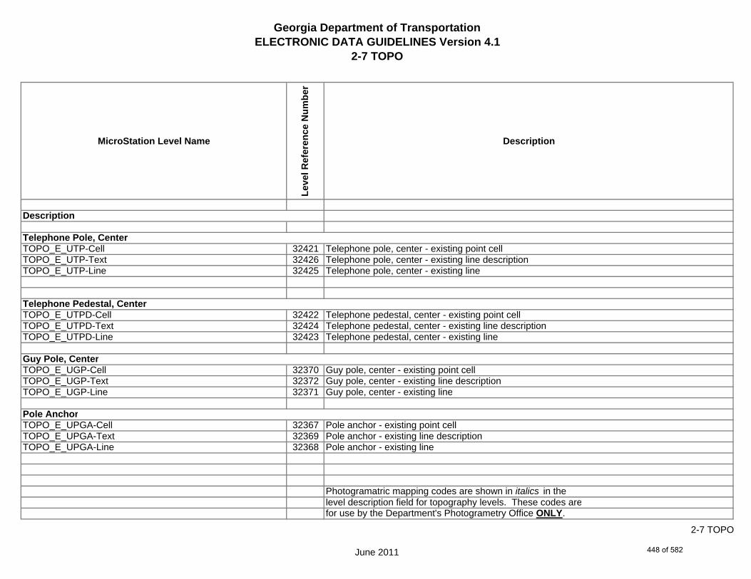
Georgia Department of TransportationELECTRONIC DATA GUIDELINES Version 4.1
2-7 TOPO
MicroStation Level Name
Leve
l Ref
eren
ce N
umbe
r
Description
TOPO_E_UTP-Cell 32421 Telephone pole, center - existing point cellTOPO_E_UTP-Text 32426 Telephone pole, center - existing line descriptionTOPO_E_UTP-Line 32425 Telephone pole, center - existing line
TOPO_E_UTPD-Cell 32422 Telephone pedestal, center - existing point cellTOPO_E_UTPD-Text 32424 Telephone pedestal, center - existing line descriptionTOPO_E_UTPD-Line 32423 Telephone pedestal, center - existing line
TOPO_E_UGP-Cell 32370 Guy pole, center - existing point cellTOPO_E_UGP-Text 32372 Guy pole, center - existing line descriptionTOPO_E_UGP-Line 32371 Guy pole, center - existing line
TOPO_E_UPGA-Cell 32367 Pole anchor - existing point cellTOPO_E_UPGA-Text 32369 Pole anchor - existing line descriptionTOPO_E_UPGA-Line 32368 Pole anchor - existing line
Photogramatric mapping codes are shown in italics in thelevel description field for topography levels. These codes arefor use by the Department's Photogrametry Office ONLY.
Telephone Pedestal, Center
Guy Pole, Center
Pole Anchor
Telephone Pole, Center
Description
June 2011
2-7 TOPO
448 of 582

Georgia Department of TransportationELECTRONIC DATA GUIDELINES Version 4.1
2-7 TOPO
MicroStation Level Name
Leve
l Ref
eren
ce N
umbe
r
Description
TOPO_E_UYLE-Cell 32433 Yard light, electrical - existing point cellTOPO_E_UYLE-Text 32435 Yard light, electrical - existing line descriptionTOPO_E_UYLE-Line 32434 Yard light, electrical - existing line
TOPO_E_UYLG-Cell 32436 Yard light, gas - existing point cellTOPO_E_UYLG-Text 32438 Yard light, gas - existing line descriptionTOPO_E_UYLG-Line 32437 Yard light, gas - existing line
TOPO_E_UWM-Cell 32427 Water meter, center - existing point cellTOPO_E_UWM-Text 32429 Water meter, center - existing line descriptionTOPO_E_UWM-Line 32428 Water meter, center - existing line
TOPO_E_UWV-Cell 32430 Water valve - existing point cellTOPO_E_UWV-Text 32432 Water valve - existing line descriptionTOPO_E_UWV-Line 32431 Water valve - existing line
Photogramatric mapping codes are shown in italics in thelevel description field for topography levels. These codes arefor use by the Department's Photogrametry Office ONLY.
Yard Light, Electrical
Water Meter, Center
Water Valve
Yard Light, Gas
Description
June 2011
2-7 TOPO
449 of 582
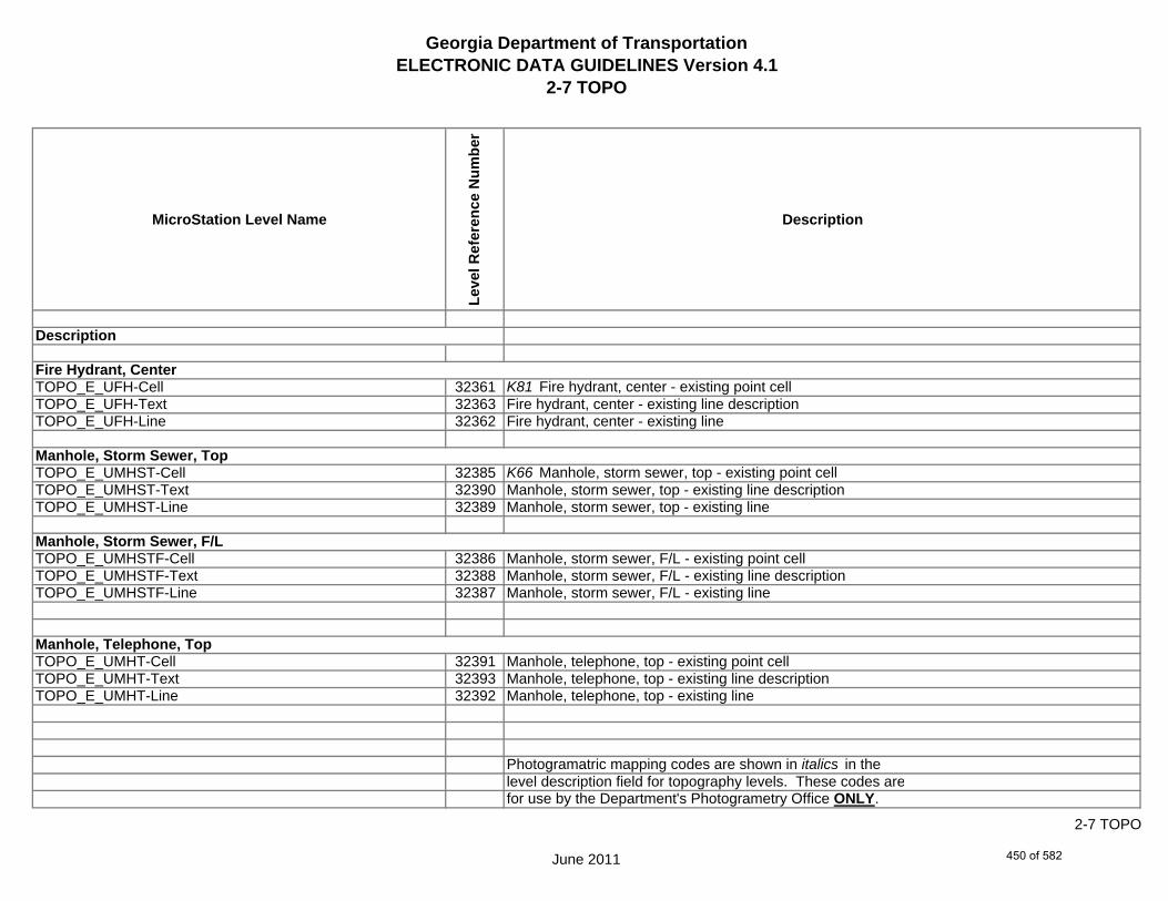
Georgia Department of TransportationELECTRONIC DATA GUIDELINES Version 4.1
2-7 TOPO
MicroStation Level Name
Leve
l Ref
eren
ce N
umbe
r
Description
TOPO_E_UFH-Cell 32361 K81 Fire hydrant, center - existing point cellTOPO_E_UFH-Text 32363 Fire hydrant, center - existing line descriptionTOPO_E_UFH-Line 32362 Fire hydrant, center - existing line
TOPO_E_UMHST-Cell 32385 K66 Manhole, storm sewer, top - existing point cellTOPO_E_UMHST-Text 32390 Manhole, storm sewer, top - existing line descriptionTOPO_E_UMHST-Line 32389 Manhole, storm sewer, top - existing line
TOPO_E_UMHSTF-Cell 32386 Manhole, storm sewer, F/L - existing point cellTOPO_E_UMHSTF-Text 32388 Manhole, storm sewer, F/L - existing line descriptionTOPO_E_UMHSTF-Line 32387 Manhole, storm sewer, F/L - existing line
TOPO_E_UMHT-Cell 32391 Manhole, telephone, top - existing point cellTOPO_E_UMHT-Text 32393 Manhole, telephone, top - existing line descriptionTOPO_E_UMHT-Line 32392 Manhole, telephone, top - existing line
Photogramatric mapping codes are shown in italics in thelevel description field for topography levels. These codes arefor use by the Department's Photogrametry Office ONLY.
Manhole, Storm Sewer, F/L
Manhole, Storm Sewer, Top
Fire Hydrant, Center
Manhole, Telephone, Top
Description
June 2011
2-7 TOPO
450 of 582
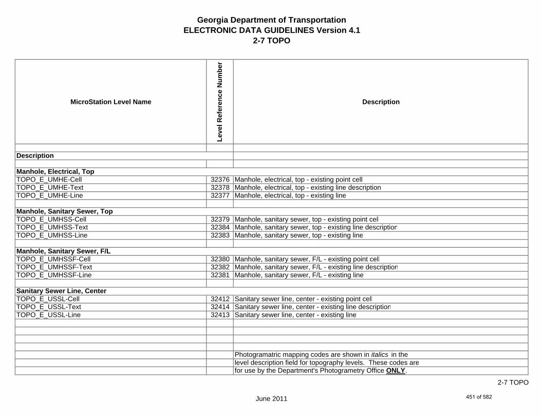
Georgia Department of TransportationELECTRONIC DATA GUIDELINES Version 4.1
2-7 TOPO
MicroStation Level Name
Leve
l Ref
eren
ce N
umbe
r
Description
TOPO_E_UMHE-Cell 32376 Manhole, electrical, top - existing point cellTOPO_E_UMHE-Text 32378 Manhole, electrical, top - existing line descriptionTOPO_E_UMHE-Line 32377 Manhole, electrical, top - existing line
TOPO_E_UMHSS-Cell 32379 Manhole, sanitary sewer, top - existing point cellTOPO_E_UMHSS-Text 32384 Manhole, sanitary sewer, top - existing line descriptionTOPO_E_UMHSS-Line 32383 Manhole, sanitary sewer, top - existing line
TOPO_E_UMHSSF-Cell 32380 Manhole, sanitary sewer, F/L - existing point cellTOPO_E_UMHSSF-Text 32382 Manhole, sanitary sewer, F/L - existing line descriptionTOPO_E_UMHSSF-Line 32381 Manhole, sanitary sewer, F/L - existing line
TOPO_E_USSL-Cell 32412 Sanitary sewer line, center - existing point cellTOPO_E_USSL-Text 32414 Sanitary sewer line, center - existing line descriptionTOPO_E_USSL-Line 32413 Sanitary sewer line, center - existing line
Photogramatric mapping codes are shown in italics in thelevel description field for topography levels. These codes arefor use by the Department's Photogrametry Office ONLY.
Sanitary Sewer Line, Center
Manhole, Electrical, Top
Manhole, Sanitary Sewer, Top
Manhole, Sanitary Sewer, F/L
Description
June 2011
2-7 TOPO
451 of 582

Georgia Department of TransportationELECTRONIC DATA GUIDELINES Version 4.1
2-7 TOPO
MicroStation Level Name
Leve
l Ref
eren
ce N
umbe
r
Description
TOPO_E_UGM-Cell 32364 Gas meter, center - existing point cellTOPO_E_UGM-Text 32366 Gas meter, center - existing line descriptionTOPO_E_UGM-Line 32365 Gas meter, center - existing line
TOPO_E_UNGV-Cell 32397 K89 Gas valve, center - existing point cellTOPO_E_UNGV-Text 32402 Gas valve, center - existing line descriptionTOPO_E_UNGV-Line 32398 Gas valve, center - existing line
TOPO_E_UNGVP-Cell 32399 Sanitary vent pipe - existing point cellTOPO_E_UNGVP-Text 32401 Sanitary vent pipe - existing line descriptionTOPO_E_UNGVP-Line 32400 Sanitary vent pipe - existing line
TOPO_E_UNGLM-Cell 32394 Gas line marker - existing point celTOPO_E_UNGLM-Text 32396 Gas line marker - existing line descriptionTOPO_E_UNGLM-Line 32395 Gas line marker - existing line
Photogramatric mapping codes are shown in italics in thelevel description field for topography levels. These codes arefor use by the Department's Photogrametry Office ONLY.
Gas Meter, Center
Gas Valve, Center
Gas Vent Pipe
Gas Line Marker
Description
June 2011
2-7 TOPO
452 of 582
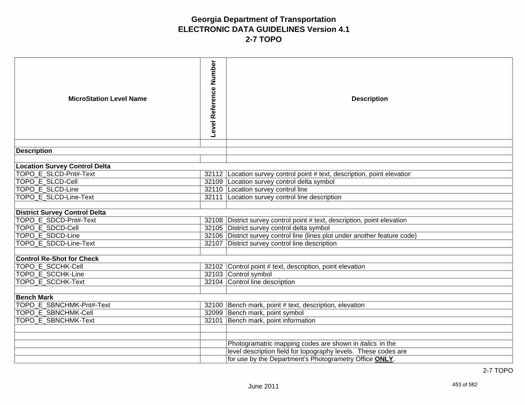
Georgia Department of TransportationELECTRONIC DATA GUIDELINES Version 4.1
2-7 TOPO
MicroStation Level Name
Leve
l Ref
eren
ce N
umbe
r
Description
TOPO_E_SLCD-Pnt#-Text 32112 Location survey control point # text, description, point elevationTOPO_E_SLCD-Cell 32109 Location survey control delta symbolTOPO_E_SLCD-Line 32110 Location survey control lineTOPO_E_SLCD-Line-Text 32111 Location survey control line description
TOPO_E_SDCD-Pnt#-Text 32108 District survey control point # text, description, point elevationTOPO_E_SDCD-Cell 32105 District survey control delta symbolTOPO_E_SDCD-Line 32106 District survey control line (lines plot under another feature code)TOPO_E_SDCD-Line-Text 32107 District survey control line description
TOPO_E_SCCHK-Cell 32102 Control point # text, description, point elevationTOPO_E_SCCHK-Line 32103 Control symbolTOPO_E_SCCHK-Text 32104 Control line description
TOPO_E_SBNCHMK-Pnt#-Text 32100 Bench mark, point # text, description, elevationTOPO_E_SBNCHMK-Cell 32099 Bench mark, point symbolTOPO_E_SBNCHMK-Text 32101 Bench mark, point information
Photogramatric mapping codes are shown in italics in thelevel description field for topography levels. These codes arefor use by the Department's Photogrametry Office ONLY.
Location Survey Control Delta
District Survey Control Delta
Description
Control Re-Shot for Check
Bench Mark
June 2011
2-7 TOPO
453 of 582
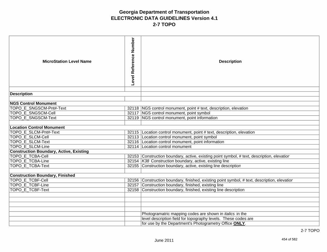
Georgia Department of TransportationELECTRONIC DATA GUIDELINES Version 4.1
2-7 TOPO
MicroStation Level Name
Leve
l Ref
eren
ce N
umbe
r
Description
TOPO_E_SNGSCM-Pnt#-Text 32118 NGS control monument, point # text, description, elevationTOPO_E_SNGSCM-Cell 32117 NGS control monument, point symbolTOPO_E_SNGSCM-Text 32119 NGS control monument, point information
TOPO_E_SLCM-Pnt#-Text 32115 Location control monument, point # text, description, elevationTOPO_E_SLCM-Cell 32113 Location control monument, point symbolTOPO_E_SLCM-Text 32116 Location control monument, point informationTOPO_E_SLCM-Line 32114 Location control monument
TOPO_E_TCBA-Cell 32153 Construction boundary, active, existing point symbol, # text, description, elevationTOPO_E_TCBA-Line 32154 K38 Construction boundary, active, existing lineTOPO_E_TCBA-Text 32155 Construction boundary, active, existing line description
TOPO_E_TCBF-Cell 32156 Construction boundary, finished, existing point symbol, # text, description, elevationTOPO_E_TCBF-Line 32157 Construction boundary, finished, existing lineTOPO_E_TCBF-Text 32158 Construction boundary, finished, existing line description
Photogramatric mapping codes are shown in italics in thelevel description field for topography levels. These codes arefor use by the Department's Photogrametry Office ONLY.
Location Control Monument
Description
Construction Boundary, Finished
NGS Control Monument
Construction Boundary, Active, Existing
June 2011
2-7 TOPO
454 of 582

Georgia Department of TransportationELECTRONIC DATA GUIDELINES Version 4.1
2-7 TOPO
MicroStation Level Name
Leve
l Ref
eren
ce N
umbe
r
Description
TOPO_E_TLIML-Cell 32279 Limit line, existing point symbol, # text, description, elevationTOPO_E_TLIML-Line 32280 K88b Limit line, existing lineTOPO_E_TLIML-Text 32281 Limit line, existing line description
TOPO_E_MJLL-Cell 32084 Map job limit line - existing point symbol, # text, description, elevationTOPO_E_MJLL-Line 32085 K150 Map job limit line - existing lineTOPO_E_MJLL-Text 32086 Map job limit line - existing line description
TOPO_E_MSEWLINE-Cell 32096 Map sew line - existing point symbol, # text, description, elevationTOPO_E_MSEWLINE-Line 32097 K157 Map sew line - existing lineTOPO_E_MSEWLINE-Text 32098 Map sew line - existing line description
TOPO_E_TPBL-Cell 32301 Terrain point on break line, existing point symbol, # text, description, elevationTOPO_E_TPBL-Line 32302 K165 Terrain point on break line, existing lineTOPO_E_TPBL-Text 32303 Terrain point on break line, existing line description
Photogramatric mapping codes are shown in italics in thelevel description field for topography levels. These codes arefor use by the Department's Photogrametry Office ONLY.
Description
Sew Line (Mapping)
Job Limit Line (Mapping)
Limit Line, Existing
Terrain Point on Break Line
June 2011
2-7 TOPO
455 of 582
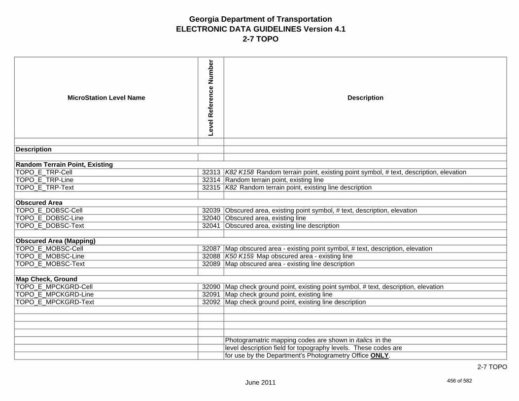
Georgia Department of TransportationELECTRONIC DATA GUIDELINES Version 4.1
2-7 TOPO
MicroStation Level Name
Leve
l Ref
eren
ce N
umbe
r
Description
TOPO_E_TRP-Cell 32313 K82 K158 Random terrain point, existing point symbol, # text, description, elevationTOPO_E_TRP-Line 32314 Random terrain point, existing lineTOPO_E_TRP-Text 32315 K82 Random terrain point, existing line description
TOPO_E_DOBSC-Cell 32039 Obscured area, existing point symbol, # text, description, elevationTOPO_E_DOBSC-Line 32040 Obscured area, existing lineTOPO_E_DOBSC-Text 32041 Obscured area, existing line description
TOPO_E_MOBSC-Cell 32087 Map obscured area - existing point symbol, # text, description, elevationTOPO_E_MOBSC-Line 32088 K50 K159 Map obscured area - existing lineTOPO_E_MOBSC-Text 32089 Map obscured area - existing line description
TOPO_E_MPCKGRD-Cell 32090 Map check ground point, existing point symbol, # text, description, elevationTOPO_E_MPCKGRD-Line 32091 Map check ground point, existing lineTOPO_E_MPCKGRD-Text 32092 Map check ground point, existing line description
Photogramatric mapping codes are shown in italics in thelevel description field for topography levels. These codes arefor use by the Department's Photogrametry Office ONLY.
Description
Random Terrain Point, Existing
Map Check, Ground
Obscured Area
Obscured Area (Mapping)
June 2011
2-7 TOPO
456 of 582

Georgia Department of TransportationELECTRONIC DATA GUIDELINES Version 4.1
2-7 TOPO
MicroStation Level Name
Leve
l Ref
eren
ce N
umbe
r
Description
TOPO_E_MPCKPAV-Cell 32093 Map check pavement point, existing point symbol, # text, description, elevationTOPO_E_MPCKPAV-Line 32094 Map check pavement point, existing lineTOPO_E_MPCKPAV-Text 32095 Map check pavement point. existing line description
TOPO_E_X_SurveyorDefined-Cell 32439 Surveyor Defined Value - Point SymbolTOPO_E_X_SurveyorDefined-Line 32440 Surveyor Defined Value - LineTOPO_E_X_SurveyorDefined-Text 32441 Surveyor Defined Value - Point Text
TOPO_E_XX-Cell 32442 Surveyor defined value - cellTOPO_E_XX-Line 32443 Surveyor defined value - lineTOPO_E_XX-Text 32444 Surveyor defined value - text
TOPO_E_TECS-Cell 32445 Edge of concrete shoulder, existing point symbol, # text, description, elevationTOPO_E_TECS-Line 32446 Edge of concrete shoulder, existing lineTOPO_E_TECS-Text 32447 Edge of concrete shoulder, existing line description
Photogramatric mapping codes are shown in italics in thelevel description field for topography levels. These codes arefor use by the Department's Photogrametry Office ONLY.
Surveyor Defined
Surveyor Defined
Edge of Concrete Shoulder
Map Check, Pavement
Description
June 2011
2-7 TOPO
457 of 582

Georgia Department of TransportationELECTRONIC DATA GUIDELINES Version 4.1
2-7 TOPO
MicroStation Level Name
Leve
l Ref
eren
ce N
umbe
r
Description
TOPO_E_POOL-Cell 32448 Pool, existing point symbol, # text, description, elevationTOPO_E_POOL-Line 32449 K41 Pool, existing lineTOPO_E_POOL-Text 32450 Pool, existing line description
TOPO_E_ORCH-Cell 32451 Orchard, existing point symbol, # text, description, elevationTOPO_E_ORCH-Line 32452 K26a K26b Orchard, existing lineTOPO_E_ORCH-Text 32453 Orchard, existing line description
TOPO_E_TRLN-Cell 32454 Tree line, center, existing point symbol, # text, description, elevationTOPO_E_TRLN-Line 32455 K47 Tree line, center, existing point cellTOPO_E_TRLN-Text 32456 K58 Tree line, center, existing line description
TOPO_E_QUAR-Cell 32457 K34 Quarry, center, existing point symbol, # text, description, elevationTOPO_E_QUAR-Line 32458 K33 Quarry, center, existing point cellTOPO_E_QUAR-Text 32459 Quarry, center, existing line description
Photogramatric mapping codes are shown in italics in thelevel description field for topography levels. These codes arefor use by the Department's Photogrametry Office ONLY.
Description
Orchard
Pool
Tree Line
Quarry
June 2011
2-7 TOPO
458 of 582

Georgia Department of TransportationELECTRONIC DATA GUIDELINES Version 4.1
2-7 TOPO
MicroStation Level Name
Leve
l Ref
eren
ce N
umbe
r
Description
TOPO_E_DOCW-Cell 32460 Culvert odd, wingwall end point symbol, # text, description, elevationTOPO_E_DOCW-Line 32461 K64 Culvert odd, wingwall end line/cellTOPO_E_DOCW-Text 32462 Culvert odd, wingwall end line description (Elevation, type, size, etc.)
TOPO_E_TWBR-Cell 32463 Wall barrier - cellTOPO_E_TWBR-Line 32464 K31 Wall barrier - lineTOPO_E_TWBR-Text 32465 Wall barrier - text
TOPO_E_CRBR-Cell 32466 Curb road, existing point symbol, # text, description, elevationTOPO_E_CRBR-Line 32467 K8 Curb road, existing lineTOPO_E_CRBR-Text 32468 Curb road, existing line description
TOPO_E_FNDN-Cell 32469 Foundation, existing point symbol, # text, description, elevationTOPO_E_FNDN-Line 32470 K19a Foundation, existing lineTOPO_E_FNDN-Text 32471 Foundation, existing line description
Photogramatric mapping codes are shown in italics in thelevel description field for topography levels. These codes arefor use by the Department's Photogrametry Office ONLY.
Description
Culvert odd Wingwall
Wall Barrier
Curb Road
Foundation
June 2011
2-7 TOPO
459 of 582

Georgia Department of TransportationELECTRONIC DATA GUIDELINES Version 4.1
2-7 TOPO
MicroStation Level Name
Leve
l Ref
eren
ce N
umbe
r
Description
TOPO_E_RUIN-Cell 32472 Ruins, existing point symbol, # text, description, elevationTOPO_E_RUIN-Line 32473 K19b Ruins, existing lineTOPO_E_RUIN-Text 32474 Ruins, existing line description
TOPO_E_CONT-Cell 32475 Contour, existing point symbol, # text, description, elevationTOPO_E_CONT-Index-Line 32476 K83 Index contour, existing lineTOPO_E_CONT-Intermed-Line 32477 Intermediate contour, existing lineTOPO_E_CONT-Depress-Line 32478 K86 Depress contour, existing lineTOPO_E_CONT-Hidden-Line 32479 K87 Hidden contour, existing lineTOPO_E_CONT-Text 32480 Contour, existing line description
TOPO_E_ELEV-Cell 32481 Elevation, existing point symbol, # text, description, elevationTOPO_E_ELEV-Line 32482 Elevation, existing lineTOPO_E_ELEV-Text 32483 Elevation, existing line description
TOPO_E_TANK-Cell 32484 Tank, existing point symbol, # text, description, elevationTOPO_E_TANK-Line 32485 K23 Tank, existing lineTOPO_E_TANK-Text 32486 Tank, existing line description
Photogramatric mapping codes are shown in italics in thelevel description field for topography levels. These codes arefor use by the Department's Photogrametry Office ONLY.
Ruins
Contours
Elevations
Tank
Description
June 2011
2-7 TOPO
460 of 582
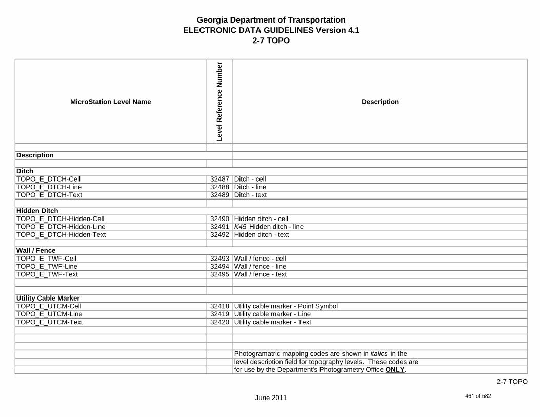
Georgia Department of TransportationELECTRONIC DATA GUIDELINES Version 4.1
2-7 TOPO
MicroStation Level Name
Leve
l Ref
eren
ce N
umbe
r
Description
TOPO_E_DTCH-Cell 32487 Ditch - cellTOPO_E_DTCH-Line 32488 Ditch - lineTOPO_E_DTCH-Text 32489 Ditch - text
TOPO_E_DTCH-Hidden-Cell 32490 Hidden ditch - cellTOPO_E_DTCH-Hidden-Line 32491 K45 Hidden ditch - lineTOPO_E_DTCH-Hidden-Text 32492 Hidden ditch - text
TOPO_E_TWF-Cell 32493 Wall / fence - cellTOPO_E_TWF-Line 32494 Wall / fence - lineTOPO_E_TWF-Text 32495 Wall / fence - text
TOPO_E_UTCM-Cell 32418 Utility cable marker - Point SymbolTOPO_E_UTCM-Line 32419 Utility cable marker - LineTOPO_E_UTCM-Text 32420 Utility cable marker - Text
Photogramatric mapping codes are shown in italics in thelevel description field for topography levels. These codes arefor use by the Department's Photogrametry Office ONLY.
Ditch
Hidden Ditch
Description
Wall / Fence
Utility Cable Marker
June 2011
2-7 TOPO
461 of 582

Georgia Department of TransportationELECTRONIC DATA GUIDELINES Version 4.1
2-7 TOPO
MicroStation Level Name
Leve
l Ref
eren
ce N
umbe
r
Description
TOPO_E_TCEM-Cell 32159 Cemetery boundary line - cellTOPO_E_TCEM-Line 32160 K27 Cemetery boundary line - lineTOPO_E_TCEM-Text 32161 Cemetery boundary line - text
TOPO_E_DWB-Cell 32072 Wetland boundary - cellTOPO_E_DWB-Line 32073 Wetland boundary - lineTOPO_E_DWB-Text 32074 Wetland boundary - text
TOPO_E_MISC-Cell 32081 Miscellaneous - cellTOPO_E_MISC-Line 32082 Miscellaneous - lineTOPO_E_MISC-Text 32083 K59 K88a Miscellaneous - text
TOPO_E_GOLF-Cell 32498 Golf Course - cellTOPO_E_GOLF-Line 32499 K39b Golf Course - lineTOPO_E_GOLF-Text 32500 Golf Course - Text
TOPO_E_Basketball-Court-Cell 32501 Basketball Court - cellTOPO_E_Basketball-Court-Line 32532 Basketball Court - lineTOPO_E_Basketball-Court-Text 32533 Basketball Court - text
Photogramatric mapping codes are shown in italics in thelevel description field for topography levels. These codes arefor use by the Department's Photogrametry Office ONLY.
Miscellaneous Topography
Cemetery Boundary Line
Wetland Boundary
Description
June 2011
2-7 TOPO
462 of 582

Georgia Department of TransportationELECTRONIC DATA GUIDELINES Version 4.1
2-7 TOPO
MicroStation Level Name
Leve
l Ref
eren
ce N
umbe
r
Description
TOPO_E_Flow-Arrow-Cell 32502 K56 Flow Arrow - cellTOPO_E_Iron-Pin-Placed-Cell 32503 Iron Pin Placed - cellTOPO_E_RIVER-TIC-MARK-Cell 32504 River Tic Mark - cellTOPO_E_WATER-SURFACE-Cell 32505 Water Surface - cellTOPO_E_Tic2-Cell 32496 Grid Tic - CellTOPO_E_Tic2-Text 32506 Grid Tic - text
TOPO_E_BUILD-Cell 32508 Building - cellTOPO_E_BUILD-Line 32509 Building - lineTOPO_E_BUILD-Text 32510 Building - text
TOPO_E_USIGNAL-Cell 32511 K11 Signal - cellTOPO_E_USIGNAL-Line 32512 Signal - lineTOPO_E_USIGNAL-Text 32513 Signal - text
TOPO_E_RIDGE-Cell 32514 Ridge - cellTOPO_E_RIDGE-Line 32515 K46 Ridge - lineTOPO_E_RIDGE-Text 32516 Ridge - text
TOPO_E_DITCH-Taper-Cell 32517 K53 Ditch Taper - cell
Photogramatric mapping codes are shown in italics in thelevel description field for topography levels. These codes arefor use by the Department's Photogrametry Office ONLY.
Description
June 2011
2-7 TOPO
463 of 582

Georgia Department of TransportationELECTRONIC DATA GUIDELINES Version 4.1
2-7 TOPO
MicroStation Level Name
Leve
l Ref
eren
ce N
umbe
r
Description
TOPO_E_UTIL-Cell 32518 K78 Utility Line - cellTOPO_E_UTIL-Line 32519 Utility Line - lineTOPO_E_UTIL-Text 32520 Utility Line - text
TOPO_E_PHOTO-CTRL-Cell 32521 K88c Photo Control - cellTOPO_E_PHOTO-CTRL-Line 32522 Photo Control - lineTOPO_E_PHOTO-CTRL-Text 32523 Photo Control - text
TOPO_E_TRAIL-Cell 32524 Trail- cellTOPO_E_TRAIL-Line 32525 Trail - lineTOPO_E_TRAIL-Text 32526 Trail - text
TOPO_E_TEL-Cell 32527 Emergency Lane - cellTOPO_E_TEL-Line 32528 K152 Emergency Lane - lineTOPO_E_TEL-Text 32529 Emergency Lane - text
TOPO_E_TSCALE-Cell 32530 Scale Bar - cellTOPO_E_MSHEET-Cell 32531 Mapping Sheet - cell
Photogramatric mapping codes are shown in italics in thelevel description field for topography levels. These codes arefor use by the Department's Photogrametry Office ONLY.
Description
June 2011
2-7 TOPO
464 of 582

Georgia Department of TransportationELECTRONIC DATA GUIDELINES Version 4.1
2-7 ENVE
MicroStation Level Name
Leve
l Ref
eren
ce N
umbe
r
Description
ENVE_E_Wetlnd-Bound-Line 8028 Wetland Boundary, linesENVE_E_Wetlnd-Stream-Delin-Line 8031 Stream Delineation, linesENVE_E_Wetlnd-Stream-Text 8032 Wetland and Stream, description & labelsENVE_E_Wetlnd-Pattern 8029 Wetlands, patterningENVE_E_Wetlnd-Shape 8030 Wetlands, shapes for patterning
ENVE_E_Endgd-Spec-Line 8008 Endangered Species, lines & cells (delineations)ENVE_E_Endgd-Spec-Text 8011 Endangered Species, description & labelsENVE_E_Endgd-Spec-Pattern 8009 Endangered Species, patterningENVE_E_Endgd-Spec-Shape 8010 Endangered Species, shapes for patterning
ENVE_E_Hist-Rsc-Line 8024 Historic Resource, lines & cells (delineations)ENVE_E_Hist-Rsc-Text 8027 Historic Resource, description & labelsENVE_E_Hist-Rsc-Pattern 8025 Historic Resource, patterningENVE_E_Hist-Rsc-Shape 8026 Historic Resource, shapes for patterning
ENVE_E_Arch-Line 8000 Archaeological Resource, linesENVE_E_Arch-Text 8003 Archaeological Resource, description & labelsENVE_E_Arch-Pattern 8001 Archaeological Resource, patterningENVE_E_Arch-Shape 8002 Archaeological Resource, shapes for patterning
Archaeology
Description
ENVE (Existing Environmental Impacts and Mitigation File)Wetlands
Ecology
History
June 2011
2-7 ENVE
465 of 582

Georgia Department of TransportationELECTRONIC DATA GUIDELINES Version 4.1
2-7 ENVE
MicroStation Level Name
Leve
l Ref
eren
ce N
umbe
r
Description
ENVE_E_Cult-Rsc-Delin-Line 8004 Cultural Resource, lines & cells (delineations)ENVE_E_Cult-Rsc-Text 8007 Cultural Resource, description & labelsENVE_E_Cult-Rsc-Pattern 8005 Cultural Resource, patterningENVE_E_Cult-Rsc-Shape 8006 Cultural Resource, shapes for patterning
ENVE_E_Haz-Mat-Delin-Line 8020 Hazardous Material, lines & cells (delineations)ENVE_E_Haz-Mat-Text 8023 Hazardous Material, description & labelsENVE_E_Haz-Mat-Pattern 8021 Hazardous Material, patterningENVE_E_Haz-Mat-Shape 8022 Hazardous Material, shapes for patterning
ENVE_E_Env-Justice-Line 8012 Environmental Justice, linesENVE_E_Env-Justice-Text 8015 Environmental Justice, description & labelsENVE_E_Env-Justice-Pattern 8013 Environmental Justice, patterningENVE_E_Env-Justice-Shape 8014 Environmental Justice, shapes for patterning
ENVE_E_ESA-Line 8016 ESA, linesENVE_E_ESA-Text 8019 ESA, description & labelsENVE_E_ESA-Pattern 8017 ESA, patterningENVE_E_ESA-Shape 8018 ESA, shapes for patterning
Includes Wetlands and Ecologically Significant Areas; Historic, Archaelogical & Park Boundaries
Description
Parklands & Cultural Resources
Hazardous Material Locations (USTs)
Environmental Justice
Environmentaly Sensative Areas (for Final Construction Plans)
June 2011
2-7 ENVE
466 of 582

Georgia Department of TransportationELECTRONIC DATA GUIDELINES Version 4.1
2-7 ENVE
MicroStation Level Name
Leve
l Ref
eren
ce N
umbe
r
Description
ENVE_E_ORNGFENCE-Line 8033 Orange FenceENVE_E_Environmental-Boundary-Line 8034 Environmental Boundary lineENVE_E_Environmental-Notes-Text 8035 Environmental Notes
Description
Misc.
June 2011
2-7 ENVE
467 of 582

Georgia Department of TransportationELECTRONIC DATA GUIDELINES Version 4.1
2-7 ENVP
MicroStation Level Name
Leve
l Ref
eren
ce N
umbe
r
Description
ENVP_P_Relocations-Line 9015 Relocations, lines ("X" over buildings to be taken)ENVP_P_Relocations-Text 9016 Relocations, textENVP_P_Socl-Resc-Impact-Area-Line 9017 Social resource impact areas, linesENVP_P_Socl-Resc-Impact-Area-Pattern 9018 Social resource impact areas, patterningENVP_P_Socl-Resc-Impact-Area-Text 9019 Social resource impact areas, text
ENVP_P_Hist-APE-Line 9006 History Area of Potential Effect (APE), linesENVP_P_Hist-APE-Pattern 9007 History Area of Potential Effect (APE), patterningENVP_P_Hist-APE-Text 9008 History Area of Potential Effect (APE), text
ENVP_P_Cultrl-Resc-Impact-Area-Line 9000 Cultural resource impact areas, linesENVP_P_Cultrl-Resc-Impact-Area-Pattern 9001 Cultural resource impact areas, patterningENVP_P_Cultrl-Resc-Impact-Area-Text 9002 Cultural resource impact areas, text
ENVP_P_Wetlnd-Impact-Area-Line 9021 Wetland impact areas, linesENVP_P_Wetlnd-Impact-Area-Pattern 9022 Wetland impact areas, patterningENVP_P_Wetlnd-Impact-Area-Text 9023 Wetland impact areas, text
Description
ENVP (Proposed Environmental Impacts and Mitigation file)Social Impacts and Mitigation
Cultural Impacts and Mitigation
Impacts to Natural Resources and Mitigation
June 2011
2-7 ENVP
468 of 582

Georgia Department of TransportationELECTRONIC DATA GUIDELINES Version 4.1
2-7 ENVP
MicroStation Level Name
Leve
l Ref
eren
ce N
umbe
r
Description
ENVP_P_Wetlnd-Mitigat-Site-Line 9024 Wetland Mitigation sites, linesENVP_P_Wetlnd-Mitigat-Site-Pattern 9025 Wetland Mitigation sites, patterningENVP_P_Wetlnd-Mitigat-Site-Text 9026 Wetland Mitigation sites, text
ENVP_P_Fldplain-Impact-Area-Line 9003 Floodplain impact areas, linesENVP_P_Fldplain-Impact-Area-Pattern 9004 Floodplain impact areas, patterningENVP_P_Fldplain-Impact-Area-Text 9005 Floodplain impact areas, text
ENVP_P_Impacted-UST 9009 Impacted UST's
ENVP_P_Noise-Study-Recept 9014 Noise study - receptorsENVP_P_Noise-Study-Readings 9013 Noise study - readingsENVP_P_Noise-Study-Proj-Noise-Lvls 9012 Noise study - projected noise levelsENVP_P_Noise-Study-Noise-Cont 9011 Noise study - noise contoursENVP_P_Noise-Study-Impacted-Prop 9010 Noise study - impacted properties
ENVP_P_Viewshed-Vis-Impact 9020 Viewshed, Visual ImpactsENVP_P_ORNGFENCE-Line 9027 Orange FenceENVP_P_Misc 9028 Miscellaneous Designer notes (not plotted)
Impacts to Physical Resources and Mitigation
Description
Misc.
June 2011
2-7 ENVP
469 of 582

Georgia Department of TransportationELECTRONIC DATA GUIDELINES Version 4.1
2-7 LNSC
MicroStation Level Name
Leve
l Ref
eren
ce N
umbe
r
Description
LNSC_E_Tree-Conif 14003 Tree - ConiferousLNSC_E_Tree-Decid 14004 Tree - DeciduousLNSC_E_Tree 14002 Tree Cell (Generic Tree Symbol)LNSC_E_Tree-Everg 14006 Tree - EvergreenLNSC_E_Tree-Pine 14007 Tree - PineLNSC_E_Shrub-Conif 14008 Shrub - ConiferousLNSC_E_Shrub_Decid 14009 Shrub - DeciduousLNSC_E_Tree-Line 14005 Tree LineLNSC_E_Revision-Bubble 14010 Revision BubbleLNSC_E_Swamp 14001 Swamp or MarshLNSC_E_Annotation-Text 14000 Existing landscape annotation
LNSC_R_Tree 16001 Tree Cell (Generic Tree Symbol)LNSC_R_Annotation-Text 16000 Remove landscape annotation
Description
Landscaping, Existing
Landscaping, Remove
June 2011
2-7 LNSC
470 of 582

Georgia Department of TransportationELECTRONIC DATA GUIDELINES Version 4.1
2-7 LNSC
MicroStation Level Name
Leve
l Ref
eren
ce N
umbe
r
Description
LNSC_P_Tree-Conif 15002 Tree - ConiferousLNSC_P_Tree-Decid 15003 Tree - DeciduousLNSC_P_Tree 15001 Tree Cell (Generic Tree Symbol)LNSC_P_Tree-Everg 15006 Tree - Evergreen (symbol)LNSC_P_Tree-Stump 15004 Tree StumpLNSC_P_Annotation-Text 15000 Proposed landscape annotation
LNSC_P_Misc 15005 Miscellaneous Designer notes (not plotted)
Landscaping, Proposed
Description
June 2011
2-7 LNSC
471 of 582
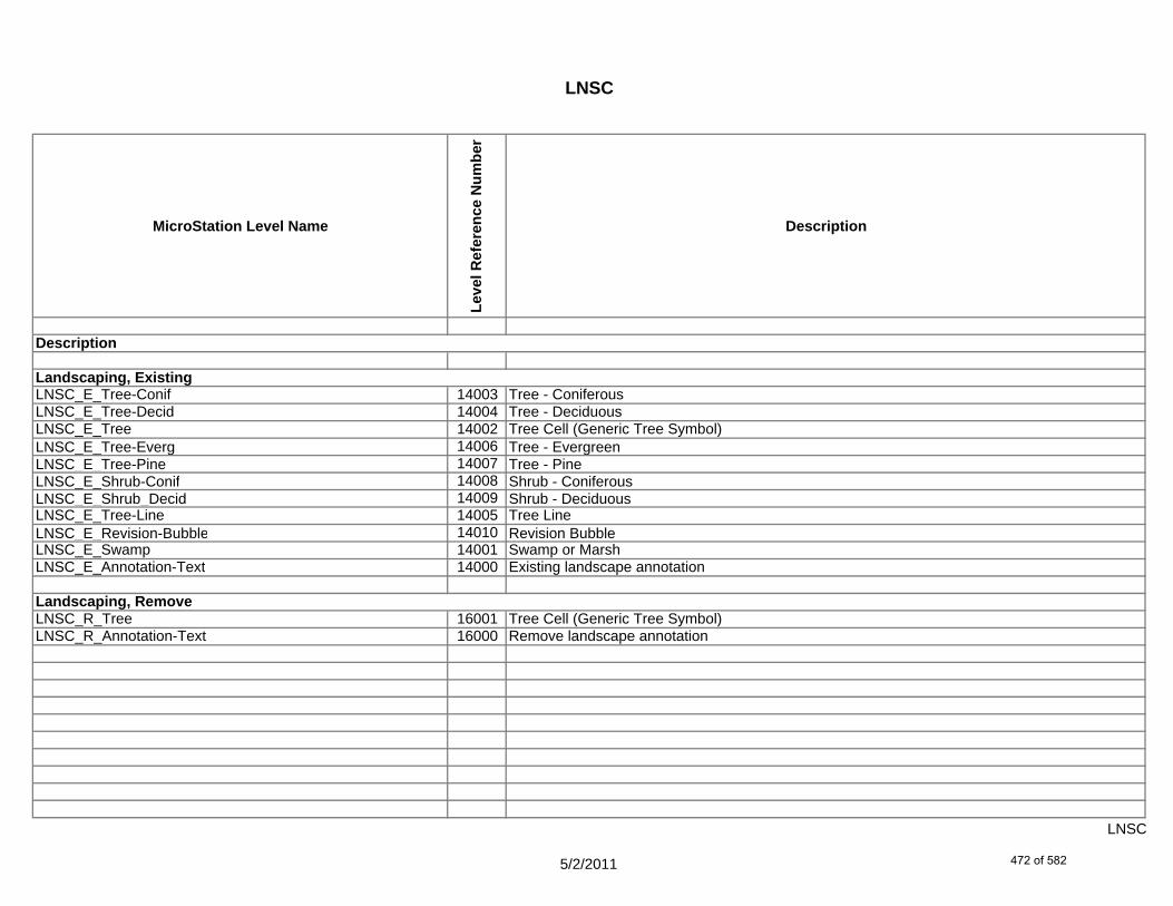
LNSC
MicroStation Level Name
Leve
l Ref
eren
ce N
umbe
r
Description
LNSC_E_Tree-Conif 14003 Tree - ConiferousLNSC_E_Tree-Decid 14004 Tree - DeciduousLNSC_E_Tree 14002 Tree Cell (Generic Tree Symbol)LNSC_E_Tree-Everg 14006 Tree - EvergreenLNSC_E_Tree-Pine 14007 Tree - PineLNSC_E_Shrub-Conif 14008 Shrub - ConiferousLNSC_E_Shrub_Decid 14009 Shrub - DeciduousLNSC_E_Tree-Line 14005 Tree LineLNSC_E_Revision-Bubble 14010 Revision BubbleLNSC_E_Swamp 14001 Swamp or MarshLNSC_E_Annotation-Text 14000 Existing landscape annotation
LNSC_R_Tree 16001 Tree Cell (Generic Tree Symbol)LNSC_R_Annotation-Text 16000 Remove landscape annotation
Description
Landscaping, Existing
Landscaping, Remove
5/2/2011
LNSC
472 of 582

LNSC
MicroStation Level Name
Leve
l Ref
eren
ce N
umbe
r
Description
LNSC_P_Tree-Conif 15002 Tree - ConiferousLNSC_P_Tree-Decid 15003 Tree - DeciduousLNSC_P_Tree 15001 Tree Cell (Generic Tree Symbol)LNSC_P_Tree-Everg 15006 Tree - Evergreen (symbol)LNSC_P_Tree-Stump 15004 Tree StumpLNSC_P_Annotation-Text 15000 Proposed landscape annotation
LNSC_P_Misc 15005 Miscellaneous Designer notes (not plotted)
Landscaping, Proposed
Description
5/2/2011
LNSC
473 of 582

Georgia Department of TransportationELECTRONIC DATA GUIDELINES Version 4.1
2-7 LGHT
MicroStation Level Name
Leve
l Ref
eren
ce N
umbe
r
Description
LGHT_P_Std-Cell 12026 Lighting standard symbol (cell)LGHT_P_Std-#-Text 12025 Lighting standard #LGHT_P_Std-Text 12028 Lighting standard descriptionLGHT_P_Std-Sta-Offset-Text 12027 Lighting standard station & offset
LGHT_P_High-Mast-Cell 12015 High mast lighting tower symbol (cell)LGHT_P_High-Mast-#-Text 12014 High mast lighting tower #LGHT_P_High-Mast-Text 12017 High mast lighting tower descriptionLGHT_P_High-Mast-Sta-Offset-Text 12016 High mast lighting tower station & offset
LGHT_P_Underpass-Luminaire-Cell 12030 Underpass luminaire symbol (cell)LGHT_P_Underpass-Luminaire-#-Text 12029 Underpass luminaire #LGHT_P_Underpass-Luminaire-Text 12032 Underpass luminaire descriptionLGHT_P_Underpass-Luminaire-Sta-Offset-Text 12031 Underpass luminaire station & offset
Service Points, ProposedLGHT_P_Servc-Pt-Cell 12022 Service point symbol (cell)LGHT_P_Servc-Pt-#-Text 12021 Service point #LGHT_P_Servc-Pt-Text 12024 Service point descriptionLGHT_P_Servc-Pt-Sta-Offset-Text 12023 Service point station & offset
Description
Roadway Lighting, Proposed
High-mast Roadway Lighting, Proposed
Underpass Lighting, Proposed
June 2011
2-7 LGHT
474 of 582
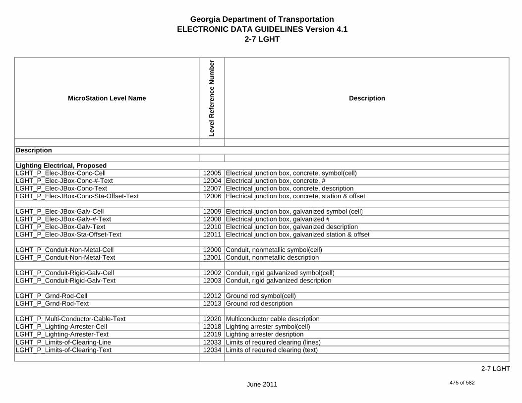
Georgia Department of TransportationELECTRONIC DATA GUIDELINES Version 4.1
2-7 LGHT
MicroStation Level Name
Leve
l Ref
eren
ce N
umbe
r
Description
LGHT_P_Elec-JBox-Conc-Cell 12005 Electrical junction box, concrete, symbol(cell)LGHT_P_Elec-JBox-Conc-#-Text 12004 Electrical junction box, concrete, #LGHT_P_Elec-JBox-Conc-Text 12007 Electrical junction box, concrete, descriptionLGHT_P_Elec-JBox-Conc-Sta-Offset-Text 12006 Electrical junction box, concrete, station & offset
LGHT_P_Elec-JBox-Galv-Cell 12009 Electrical junction box, galvanized symbol (cell)LGHT_P_Elec-JBox-Galv-#-Text 12008 Electrical junction box, galvanized #LGHT_P_Elec-JBox-Galv-Text 12010 Electrical junction box, galvanized descriptionLGHT_P_Elec-JBox-Sta-Offset-Text 12011 Electrical junction box, galvanized station & offset
LGHT_P_Conduit-Non-Metal-Cell 12000 Conduit, nonmetallic symbol(cell)LGHT_P_Conduit-Non-Metal-Text 12001 Conduit, nonmetallic description
LGHT_P_Conduit-Rigid-Galv-Cell 12002 Conduit, rigid galvanized symbol(cell)LGHT_P_Conduit-Rigid-Galv-Text 12003 Conduit, rigid galvanized description
LGHT_P_Grnd-Rod-Cell 12012 Ground rod symbol(cell)LGHT_P_Grnd-Rod-Text 12013 Ground rod description
LGHT_P_Multi-Conductor-Cable-Text 12020 Multiconductor cable descriptionLGHT_P_Lighting-Arrester-Cell 12018 Lighting arrester symbol(cell)LGHT_P_Lighting-Arrester-Text 12019 Lighting arrester desriptionLGHT_P_Limits-of-Clearing-Line 12033 Limits of required clearing (lines)LGHT_P_Limits-of-Clearing-Text 12034 Limits of required clearing (text)
Lighting Electrical, Proposed
Description
June 2011
2-7 LGHT
475 of 582
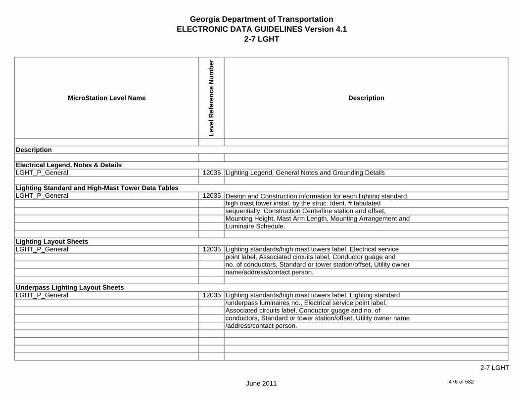
Georgia Department of TransportationELECTRONIC DATA GUIDELINES Version 4.1
2-7 LGHT
MicroStation Level Name
Leve
l Ref
eren
ce N
umbe
r
Description
LGHT_P_General 12035 Lighting Legend, General Notes and Grounding Details
LGHT_P_General 12035 Design and Construction information for each lighting standard,high mast tower instal. by the struc. Ident. # tabulatedsequentially, Construction Centerline station and offset,Mounting Height, Mast Arm Length, Mounting Arrangement andLuminaire Schedule.
LGHT_P_General 12035 Lighting standards/high mast towers label, Electrical servicepoint label, Associated circuits label, Conductor guage andno. of conductors, Standard or tower station/offset, Utility ownername/address/contact person.
LGHT_P_General 12035 Lighting standards/high mast towers label, Lighting standard/underpass luminaires no., Electrical service point label,Associated circuits label, Conductor guage and no. of conductors, Standard or tower station/offset, Utility owner name/address/contact person.
Lighting Standard and High-Mast Tower Data Tables
Lighting Layout Sheets
Underpass Lighting Layout Sheets
Electrical Legend, Notes & Details
Description
June 2011
2-7 LGHT
476 of 582

Georgia Department of TransportationELECTRONIC DATA GUIDELINES Version 4.1
2-7 LGHT
MicroStation Level Name
Leve
l Ref
eren
ce N
umbe
r
Description
LGHT_P_General 12035 Lowering Device details and specifications, Pole base details,Head frame and luminaire ring details, Electrical junction boxdetails, Electrical pull box details, Electrical conduit stuboutdetails, Luminaire mounting details.
LGHT_P_General 12035 Wiring Diagram, Service Point data, Circuit Breakerspecifications, Contactor specifications, Circuit table, Conductorsize and type, Number of conductors, Misc. electrical wiringspecifications, Service Panel specifications.
LGHT_P_General 12035 Single Line Diagram for each service point, Legend of allsymbols, Circuit breaker specifications, Circuit table, Conductorsize and type, Number of conductors, Misc. electrical wiringspecifications, Surge Suppressor specifications.
LGHT_P_General 12035 Foundation Elevation View, Foundation Plan View, Foundationnotes and details, Reinforcement Schedule, FoundationQuantities.
Lighting Foundation Detail Sheets
Lighting Detail Sheets
Schematic Diagram Sheets
Single Line Diagram Sheets
Description
June 2011
2-7 LGHT
477 of 582

Georgia Department of TransportationELECTRONIC DATA GUIDELINES Version 4.1
2-7 LGHT
MicroStation Level Name
Leve
l Ref
eren
ce N
umbe
r
Description
LGHT_P_General 12035 Details for mounting light standards on, Light Standards footingdetails, Special mounting details for specific projectrequirements.
LGHT_P_Misc 12036 Miscellaneous Designer notes (not plotted)
Miscellaneous Lighting and Electrical Detail Sheets
Description
June 2011
2-7 LGHT
478 of 582

Georgia Department of TransportationELECTRONIC DATA GUIDELINES Version 4.1
2-7 TRDG
MicroStation Level Name
Leve
l Ref
eren
ce N
umbe
r
Description
Traffic DataTRDG_P_Line 33000 Lines and Arrow Heads
TRDG_P_Text-DHV 33003 Text - DHV (Design Hour Volume)TRDG_P_Text-ADT 33004 Text - ADT (Average Daily Traffic)TRDG_P_Text-Percent-Trucks 33005 Text - Percent Trucks
TRDG_P_Divider-Line 33006 Divider LinesTRDG_P_Cell 33002 Text - Road Names, Other DataTRDG_P_Text 33001 Text
TRDG_P_Misc 33007 Miscellaneous Designer notes (not plotted)
Description
June 2011
2-7 TRDG
479 of 582

Georgia Department of TransportationELECTRONIC DATA GUIDELINES Version 4.1
2-7 RWTB
MicroStation Level Name
Leve
l Ref
eren
ce N
umbe
r
Description
RWTB_P_Text 25000 Right of Way and Easement Tables
RWTB_P_Misc 25001 Miscellaneous Designer notes (not plotted)
Description
To be developed
June 2011
2-7 RWTB
480 of 582

Georgia Department of TransportationELECTRONIC DATA GUIDELINES Version 4.1
2-7 TYPS
MicroStation Level Name
Leve
l Ref
eren
ce N
umbe
r
Description
TYPS_P_Pvmt-Dsgn-Legend 34007 Pavement Design LegendTYPS_P_Slope-Label-Dim 34008 Dimensions, Cross Slopes and Slope LabelsTYPS_P_Traf-Flow-Arrow 34009 Traffic Flow ArrowsTYPS_P_Line-Fin-Grade-Grass 34003 Finished Grade Lines - GrassedTYPS_P_Line-Fin-Grade-Conc 34002 Finished Grade Lines - ConcreteTYPS_P_Line-Fin-Grade-Asph 34001 Finished Grade Lines - AsphaltTYPS_P_Line-Subgrade 34004 Subgrade LinesTYPS_P_Misc-Note-Text 34005 Miscellaneous NotesTYPS_P_Line-Exist-Grnd 34000 Existing Ground LinesTYPS_P_Vehicle 34010 VehiclesTYPS_P_Pedestrian 34006 Pedestrians
TYPS_P_Misc 34011 Miscellaneous notes for designer (not plotted)
Description
Typical Sections
June 2011
2-7 TYPS
481 of 582
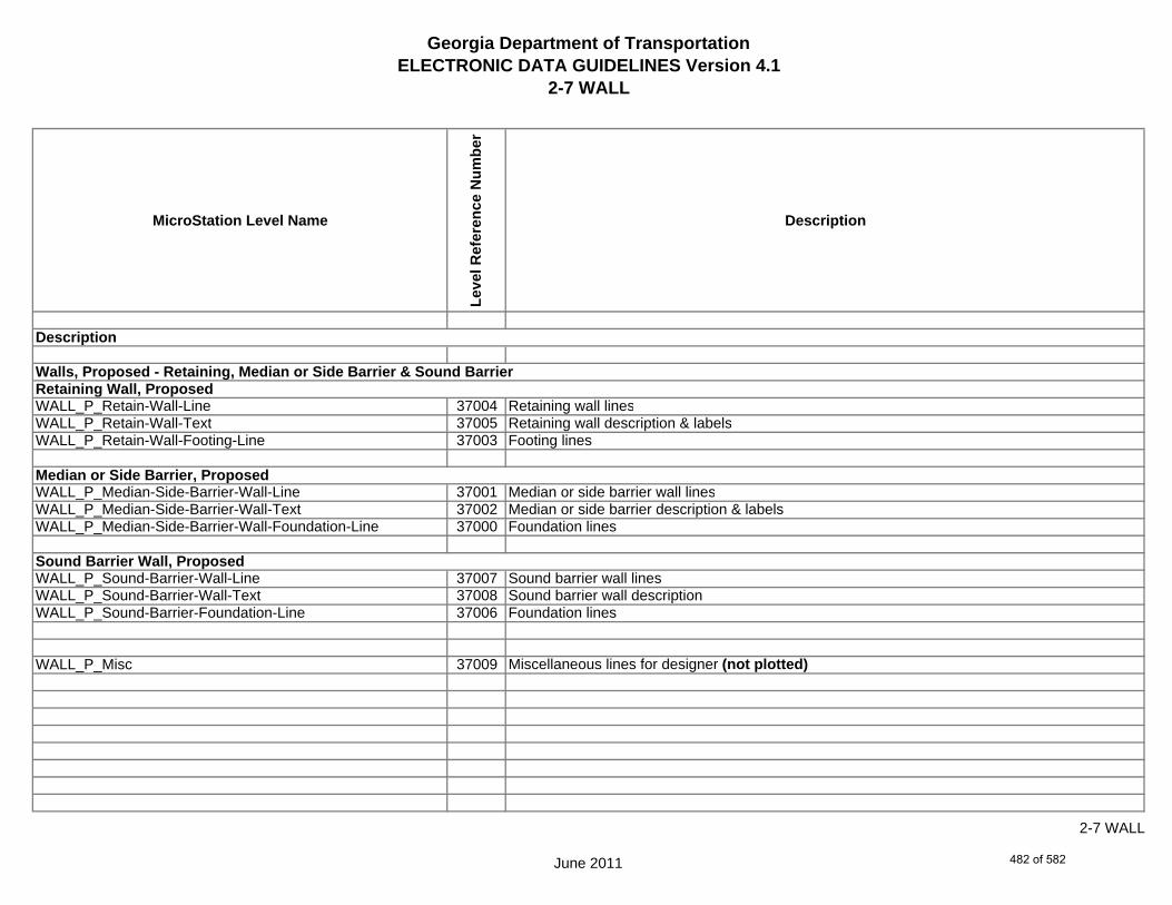
Georgia Department of TransportationELECTRONIC DATA GUIDELINES Version 4.1
2-7 WALL
MicroStation Level Name
Leve
l Ref
eren
ce N
umbe
r
Description
WALL_P_Retain-Wall-Line 37004 Retaining wall linesWALL_P_Retain-Wall-Text 37005 Retaining wall description & labelsWALL_P_Retain-Wall-Footing-Line 37003 Footing lines
WALL_P_Median-Side-Barrier-Wall-Line 37001 Median or side barrier wall linesWALL_P_Median-Side-Barrier-Wall-Text 37002 Median or side barrier description & labelsWALL_P_Median-Side-Barrier-Wall-Foundation-Line 37000 Foundation lines
WALL_P_Sound-Barrier-Wall-Line 37007 Sound barrier wall linesWALL_P_Sound-Barrier-Wall-Text 37008 Sound barrier wall descriptionWALL_P_Sound-Barrier-Foundation-Line 37006 Foundation lines
WALL_P_Misc 37009 Miscellaneous lines for designer (not plotted)
Description
Walls, Proposed - Retaining, Median or Side Barrier & Sound BarrierRetaining Wall, Proposed
Median or Side Barrier, Proposed
Sound Barrier Wall, Proposed
June 2011
2-7 WALL
482 of 582

Georgia Department of TransportationELECTRONIC DATA GUIDELINES Version 4.1
2-7 WPRO
MicroStation Level Name
Leve
l Ref
eren
ce N
umbe
r
Description
WPRO_P_Grid-Sta-Elev 38003 Grid Stations & ElevationsWPRO_P_Increment-Elev 38004 Incremental elevations
WPRO_P_Retain-Wall-Envlp-Line 38007 Retaining Wall envelope linesWPRO_P_Retain-Wall-Text 38008 Retaining Wall description & labels
WPRO_P_Median-Side-Barrier-Wall-Envlp-Line 38005 Median or Side Barrier Wall envelope linesWPRO_P_Median-Side-Barrier-Wall-Text 38006 Median or Side Barrier Wall description & labels
WPRO_P_Sound-Barrier-Wall-Envlp-Line 38009 Sound Barrier Wall Envelope linesWPRO_P_Sound-Barrier-Wall-Text 38010 Sound Barrier Wall description & labels
WPRO_P_Exist-Ground 38000 Existing Ground
WPRO_P_Finish-Ground-Face-of-Wall 38002 Finished Ground (face of wall)WPRO_P_Finish-Ground-Back-of-Wall 38001 Finished Ground (back of wall)
WPRO_P_Misc 38011 Miscellaneous lines for designer (not plotted)
Description
Retaining Wall Profiles, Proposed
June 2011
2-7 WPRO
483 of 582

Georgia Department of TransportationELECTRONIC DATA GUIDELINES Version 4.1
2-7 CNLY
MicroStation Level Name
Leve
l Ref
eren
ce N
umbe
r
Description
CNLY_P_CONSTCL-Line 5008 Construction centerline - linesCNLY_P_CONSTCL-Tic-Sta-Text 5010 Construction centerline - tic marks and sta labelsCNLY_P_CONSTCL-PC-PT-Sta-Ldr-Text 5009 Construction centerline - PC/PT station labels w/flagsCNLY_P_CONSTCL-Brng-Text 5006 Construction centerline - bearingsCNLY_P_CONSTCL-Curve-Data-Text 5007 Construction centerline - curve label & data table
CNLY_P_SIDECL-Line 5040 Side or Cross road centerline - linesCNLY_P_SIDECL-Tic-Sta-Text 5042 Side or Cross road centerline - tic marks and sta labelsCNLY_P_SIDECL-PC-PT-Sta-Ldr-Text 5041 Side or Cross road centerline - PC/PT station labels w/flagsCNLY_P_SIDECL-Brng-Text 5038 Side or Cross road centerline - bearingsCNLY_P_SIDECL-Curve-Data-Text 5039 Side or Cross road centerline - curve label & data table
CNLY_P_Rdwy-EOP-Line 5031 Roadway edge of paving - linesCNLY_P_Rdwy-EOP-Text 5032 Roadway edge of paving - description
CNLY_P_EPSHLDR-Line 5020 Edge of paved shoulder - linesCNLY_P_EPSHLDR-Text 5021 Edge of paved shoulder - description
CNLY_P_Appr-Slab-Line 5000 Approach slab - linesCNLY_P_Appr-Slab-Text 5001 Approach slab - description
Description
Construction Centerline
Side or Cross Road Centerline
Roadway Edge of Paving, Proposed
Edge of Shoulders, Proposed
Approach Slabs, Proposed
June 2011
2-7 CNLY
484 of 582
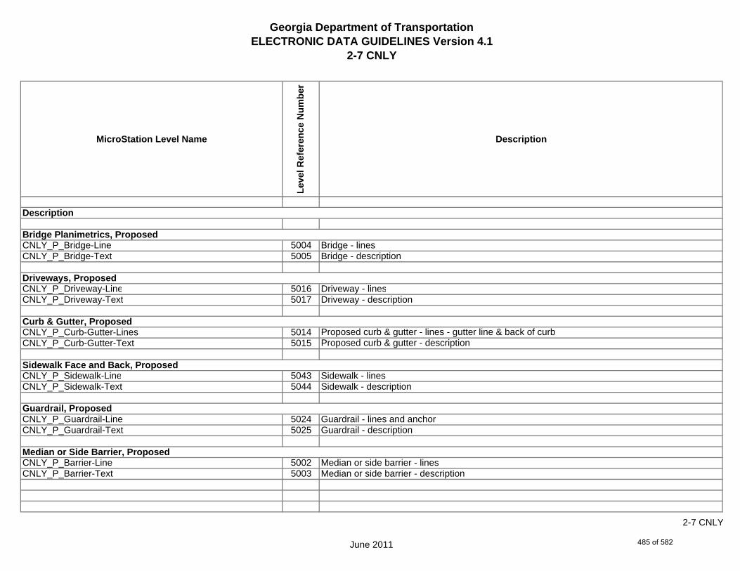
Georgia Department of TransportationELECTRONIC DATA GUIDELINES Version 4.1
2-7 CNLY
MicroStation Level Name
Leve
l Ref
eren
ce N
umbe
r
Description
CNLY_P_Bridge-Line 5004 Bridge - linesCNLY_P_Bridge-Text 5005 Bridge - description
CNLY_P_Driveway-Line 5016 Driveway - linesCNLY_P_Driveway-Text 5017 Driveway - description
CNLY_P_Curb-Gutter-Lines 5014 Proposed curb & gutter - lines - gutter line & back of curbCNLY_P_Curb-Gutter-Text 5015 Proposed curb & gutter - description
CNLY_P_Sidewalk-Line 5043 Sidewalk - linesCNLY_P_Sidewalk-Text 5044 Sidewalk - description
CNLY_P_Guardrail-Line 5024 Guardrail - lines and anchorCNLY_P_Guardrail-Text 5025 Guardrail - description
CNLY_P_Barrier-Line 5002 Median or side barrier - linesCNLY_P_Barrier-Text 5003 Median or side barrier - description
Median or Side Barrier, Proposed
Bridge Planimetrics, Proposed
Driveways, Proposed
Curb & Gutter, Proposed
Sidewalk Face and Back, Proposed
Guardrail, Proposed
Description
June 2011
2-7 CNLY
485 of 582

Georgia Department of TransportationELECTRONIC DATA GUIDELINES Version 4.1
2-7 CNLY
MicroStation Level Name
Leve
l Ref
eren
ce N
umbe
r
Description
CNLY_P_Ret-Wall-Line 5036 Retaining wall - linesCNLY_P_Ret-Wall-Text 5037 Retaining wall - description
CNLY_P_Sound Barrier-Line 5045 Sound barrier wall - linesCNLY_P_Sound Barrier-Text 5046 Sound barrier wall - description
CNLY_P_Fence-Line 5022 Fence - linesCNLY_P_Fence-Text 5023 Fence - description
CNLY_P_Misc-Const-Feat-Line 5026 Misc. construction feature - linesCNLY_P_Misc-Const-Feat-Text 5027 Misc. construction feature - description
CNLY_P_CROWN-Cell 5011 Crown point - cellCNLY_P_CROWN-Line 5012 Crown point - linesCNLY_P_CROWN-Text 5013 Crown point - text
Retaining Wall, Proposed
Sound Barrier Wall, Proposed
Fence, Proposed
Construction Feature, Miscellaneous, Proposed
Crown Point, Proposed
Description
June 2011
2-7 CNLY
486 of 582

Georgia Department of TransportationELECTRONIC DATA GUIDELINES Version 4.1
2-7 CNLY
MicroStation Level Name
Leve
l Ref
eren
ce N
umbe
r
Description
CNLY_P_Rdwy-Begin-End-Proj-CL-Text 5029 Begin/end project & centerline intersection labelsCNLY_P_Rdwy-Begin-Const-Limit-of-Const-Text 5028 Begin/end construction and limit of construction labelsCNLY_P_Rdwy-RouteName-Text 5034 Route # / road names and centerline label (CL Cell)CNLY_P_Rdwy-Dim 5030 Roadway dimensionsCNLY_P_Rdwy-Super-Trans-Label-Text 5035 Superelevation transition labelsCNLY_P_Rdwy-Misc-Dtl-Info-Text 5033 Miscellaneous detail information
CNLY_P_Dsgn-Guide-Lane-Line 5018 Lane lines (intersection and transition layout guides)CNLY_P_Dsgn-Guide-Shldr-Hinge-Pt-Alg 5019 Shoulder hinge point alignment
CNLY_P_Misc 5047 Miscellaneous lines for designer (not plotted)
Design Guides
Roadway Details, Proposed
Description
June 2011
2-7 CNLY
487 of 582
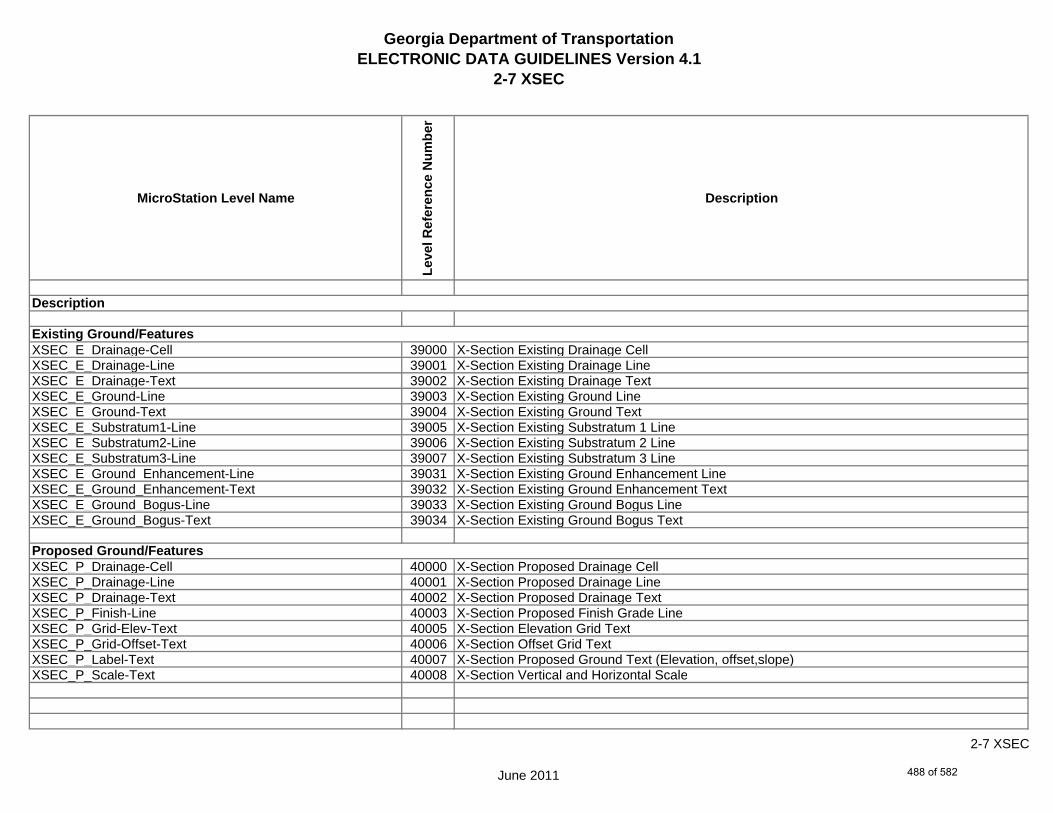
Georgia Department of TransportationELECTRONIC DATA GUIDELINES Version 4.1
2-7 XSEC
MicroStation Level Name
Leve
l Ref
eren
ce N
umbe
r
Description
XSEC_E_Drainage-Cell 39000 X-Section Existing Drainage CellXSEC_E_Drainage-Line 39001 X-Section Existing Drainage LineXSEC_E_Drainage-Text 39002 X-Section Existing Drainage TextXSEC_E_Ground-Line 39003 X-Section Existing Ground LineXSEC_E_Ground-Text 39004 X-Section Existing Ground TextXSEC_E_Substratum1-Line 39005 X-Section Existing Substratum 1 LineXSEC_E_Substratum2-Line 39006 X-Section Existing Substratum 2 LineXSEC_E_Substratum3-Line 39007 X-Section Existing Substratum 3 LineXSEC_E_Ground_Enhancement-Line 39031 X-Section Existing Ground Enhancement LineXSEC_E_Ground_Enhancement-Text 39032 X-Section Existing Ground Enhancement TextXSEC_E_Ground_Bogus-Line 39033 X-Section Existing Ground Bogus LineXSEC_E_Ground_Bogus-Text 39034 X-Section Existing Ground Bogus Text
XSEC_P_Drainage-Cell 40000 X-Section Proposed Drainage CellXSEC_P_Drainage-Line 40001 X-Section Proposed Drainage LineXSEC_P_Drainage-Text 40002 X-Section Proposed Drainage TextXSEC_P_Finish-Line 40003 X-Section Proposed Finish Grade LineXSEC_P_Grid-Elev-Text 40005 X-Section Elevation Grid TextXSEC_P_Grid-Offset-Text 40006 X-Section Offset Grid TextXSEC_P_Label-Text 40007 X-Section Proposed Ground Text (Elevation, offset,slope)XSEC_P_Scale-Text 40008 X-Section Vertical and Horizontal Scale
Description
Existing Ground/Features
Proposed Ground/Features
June 2011
2-7 XSEC
488 of 582

Georgia Department of TransportationELECTRONIC DATA GUIDELINES Version 4.1
2-7 XSEC
MicroStation Level Name
Leve
l Ref
eren
ce N
umbe
r
Description
XSEC_P_Stage1-Line 40009 X-Section Proposed Staging1 LineXSEC_P_Stage2-Line 40010 X-Section Proposed Staging2 LineXSEC_P_Stage3-Line 40011 X-Section Proposed Staging3 LineXSEC_P_Stage4-Line 40012 X-Section Proposed Staging4 LineXSEC_P_Stage5-Line 40013 X-Section Proposed Staging5 LineXSEC_P_Station-Text 40014 X-Section Station TextXSEC_P_Subgrade-Line 40015 X-Section Proposed Subgrade LineXSEC_P_Xslope-Text 40016 X-Section Proposed Ground XSlope TextXSEC_P_Misc 40017 Miscellaneous Designer notes (not plotted)XSEC_P_Component-Blue-Line 40018 X-Section Proposed Component Blue LineXSEC_P_Component-Cyan-Line 40019 X-Section Proposed Component Cyan LineXSEC_P_Component-Green-Line 40020 X-Section Proposed Component Green LineXSEC_P_Component-Orange-Line 40021 X-Section Proposed Component Orange LineXSEC_P_Component-Purple-Line 40022 X-Section Proposed Component Purple LineXSEC_P_Component-Red-Line 40023 X-Section Proposed Component Red LineXSEC_P_Component-White-Line 40024 X-Section Proposed Component White LineXSEC_P_Component-Yellow-Line 40025 X-Section Proposed Component Yellow LineXSEC_P_Label-Point 40026 X-Section Proposed Point Label
Description
Proposed Ground/Features
June 2011
2-7 XSEC
489 of 582

Georgia Department of TransportationELECTRONIC DATA GUIDELINES Version 4.1
2-7 PROF
MicroStation Level Name
Leve
l Ref
eren
ce N
umbe
r
Description
PROF_E_Drainage-Cell 20000 Profile Existing Drainage CellPROF_E_Drainage-Line 20001 Profile Existing Drainage LinePROF_E_Drainage-Text 20002 Profile Existing Drainage TextPROF_E_Ground-Line 20003 Profile Existing Ground LinePROF_E_Ground-Text 20004 Profile Existing Ground TextPROF_E_Substratum1-Line 20005 Profile Existing Substratum 1 LinePROF_E_Substratum2-Line 20006 Profile Existing Substratum 2 LinePROF_E_Substratum3-Line 20007 Profile Existing Substratum 3 LinePROF_E_Ground_Bogus-Line 20008 Profile Existing Ground Bogus LinePROF_E_Ground_Bogus-Text 20009 Profile Existing Ground Bogus TextPROF_E_Ground_Enhancement-Line 20010 Profile Existing Ground Enhancement LinePROF_E_Ground_Enhancement-Text 20011 Profile Existing Ground Enhancement Text
PROF_P_Drainage-Cell 21000 Profile Proposed Drainage CellPROF_P_Drainage-Line 21001 Profile Proposed Drainage LinePROF_P_Drainage-Text 21002 Profile Proposed Drainage TextPROF_P_Finish-Elev-Text 21003 Profile Proposed Elevation TextPROF_P_Finish-Line 21004 Profile Proposed Finish Grade LinePROF_P_Finish-Pt-Cell 21005 Profile Proposed Finish Grade Key PointsPROF_P_Finish-Text 21006 Profile Proposed Finish Grade Annotation (Curve data, slope, etc.)PROF_P_Grid-Elev-Text 21007 Profile Elevation Grid Text
Description
Existing Ground/Features
Proposed Ground/Features
June 2011
2-7 PROF
490 of 582
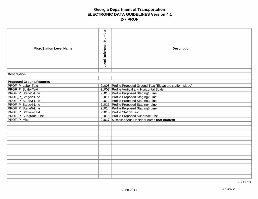
Georgia Department of TransportationELECTRONIC DATA GUIDELINES Version 4.1
2-7 PROF
MicroStation Level Name
Leve
l Ref
eren
ce N
umbe
r
Description
PROF_P_Label-Text 21008 Profile Proposed Ground Text (Elevation, station, slope)PROF_P_Scale-Text 21009 Profile Vertical and Horizontal ScalePROF_P_Stage1-Line 21010 Profile Proposed Staging1 LinePROF_P_Stage2-Line 21011 Profile Proposed Staging2 LinePROF_P_Stage3-Line 21012 Profile Proposed Staging3 LinePROF_P_Stage4-Line 21013 Profile Proposed Staging4 LinePROF_P_Stage5-Line 21014 Profile Proposed Staging5 LinePROF_P_Station-Text 21015 Profile Station TextPROF_P_Subgrade-Line 21016 Profile Proposed Subgrade LinePROF_P_Misc 21017 Miscellaneous Designer notes (not plotted)
Proposed Ground/Features
Description
June 2011
2-7 PROF
491 of 582

Georgia Department of TransportationELECTRONIC DATA GUIDELINES Version 4.1
2-7 BRDG
MicroStation Level Name
Leve
l Ref
eren
ce N
umbe
r
Description
BRDG_P_Bridge-Line 2000 Bridge - Reserved for future developmentBRDG_P_Bridge-Text 2001 Bridge - Reserved for future development
BRDG_P_Bridge-Misc 2002 Miscellaneous Designer notes (not plotted)
Description
Bridge Features
June 2011
2-7 BRDG
492 of 582
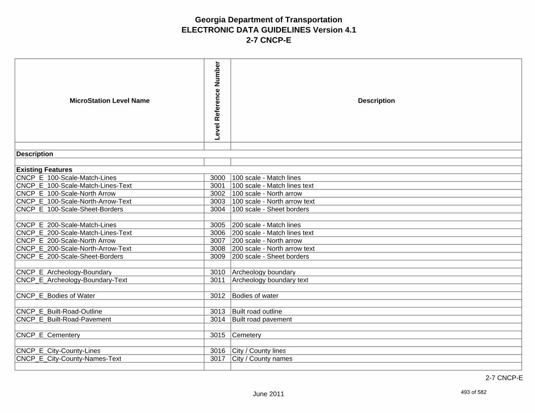
Georgia Department of TransportationELECTRONIC DATA GUIDELINES Version 4.1
2-7 CNCP-E
MicroStation Level Name
Leve
l Ref
eren
ce N
umbe
r
Description
CNCP_E_100-Scale-Match-Lines 3000 100 scale - Match linesCNCP_E_100-Scale-Match-Lines-Text 3001 100 scale - Match lines textCNCP_E_100-Scale-North Arrow 3002 100 scale - North arrowCNCP_E_100-Scale-North-Arrow-Text 3003 100 scale - North arrow textCNCP_E_100-Scale-Sheet-Borders 3004 100 scale - Sheet borders
CNCP_E_200-Scale-Match-Lines 3005 200 scale - Match linesCNCP_E_200-Scale-Match-Lines-Text 3006 200 scale - Match lines textCNCP_E_200-Scale-North Arrow 3007 200 scale - North arrowCNCP_E_200-Scale-North-Arrow-Text 3008 200 scale - North arrow textCNCP_E_200-Scale-Sheet-Borders 3009 200 scale - Sheet borders
CNCP_E_Archeology-Boundary 3010 Archeology boundaryCNCP_E_Archeology-Boundary-Text 3011 Archeology boundary text
CNCP_E_Bodies of Water 3012 Bodies of water
CNCP_E_Built-Road-Outline 3013 Built road outlineCNCP_E_Built-Road-Pavement 3014 Built road pavement
CNCP_E_Cementery 3015 Cemetery
CNCP_E_City-County-Lines 3016 City / County linesCNCP_E_City-County-Names-Text 3017 City / County names
Description
Existing Features
June 2011
2-7 CNCP-E
493 of 582
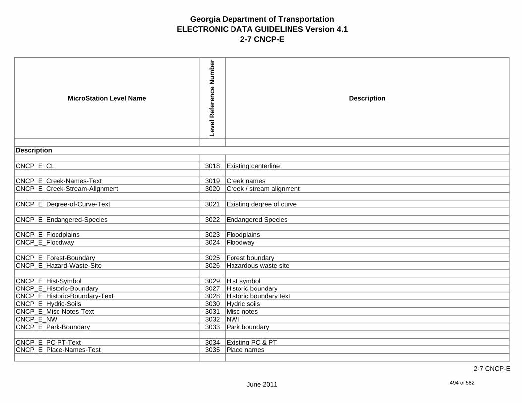
Georgia Department of TransportationELECTRONIC DATA GUIDELINES Version 4.1
2-7 CNCP-E
MicroStation Level Name
Leve
l Ref
eren
ce N
umbe
r
Description
CNCP_E_CL 3018 Existing centerline
CNCP_E_Creek-Names-Text 3019 Creek namesCNCP_E_Creek-Stream-Alignment 3020 Creek / stream alignment
CNCP_E_Degree-of-Curve-Text 3021 Existing degree of curve
CNCP_E_Endangered-Species 3022 Endangered Species
CNCP_E_Floodplains 3023 FloodplainsCNCP_E_Floodway 3024 Floodway
CNCP_E_Forest-Boundary 3025 Forest boundaryCNCP_E_Hazard-Waste-Site 3026 Hazardous waste site
CNCP_E_Hist-Symbol 3029 Hist symbolCNCP_E_Historic-Boundary 3027 Historic boundaryCNCP_E_Historic-Boundary-Text 3028 Historic boundary textCNCP_E_Hydric-Soils 3030 Hydric soilsCNCP_E_Misc-Notes-Text 3031 Misc notesCNCP_E_NWI 3032 NWICNCP_E_Park-Boundary 3033 Park boundary
CNCP_E_PC-PT-Text 3034 Existing PC & PTCNCP_E_Place-Names-Test 3035 Place names
Description
June 2011
2-7 CNCP-E
494 of 582
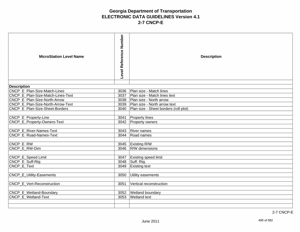
Georgia Department of TransportationELECTRONIC DATA GUIDELINES Version 4.1
2-7 CNCP-E
MicroStation Level Name
Leve
l Ref
eren
ce N
umbe
r
Description
CNCP_E_Plan-Size-Match-Lines 3036 Plan size - Match linesCNCP_E_Plan-Size-Match-Lines-Text 3037 Plan size - Match lines textCNCP_E_Plan-Size-North-Arrow 3038 Plan size - North arrowCNCP_E_Plan-Size-North-Arrow-Text 3039 Plan size - North arrow textCNCP_E_Plan-Size-Sheet-Borders 3040 Plan size - Sheet borders (roll plot)
CNCP_E_Property-Line 3041 Property linesCNCP_E_Property-Owners-Text 3042 Property owners
CNCP_E_River-Names-Text 3043 River namesCNCP_E_Road-Names-Text 3044 Road names
CNCP_E_RW 3045 Existing R/WCNCP_E_RW-Dim 3046 R/W dimensions
CNCP_E_Speed Limit 3047 Existing speed limitCNCP_E_Suff-Rtg 3048 Suff. Rtg.CNCP_E_Text 3049 Existing text
CNCP_E_Utility-Easements 3050 Utility easements
CNCP_E_Vert-Reconstruction 3051 Vertical reconstruction
CNCP_E_Wetland-Boundary 3052 Wetland boundaryCNCP_E_Wetland-Text 3053 Wetland text
Description
June 2011
2-7 CNCP-E
495 of 582

Georgia Department of TransportationELECTRONIC DATA GUIDELINES Version 4.1
2-7 CNCP-P
MicroStation Level Name
Leve
l Ref
eren
ce N
umbe
r
Description
CNCP_P_ALT-Centerline 4000 ALT CenterlineCNCP_P_Arrow-Directions 4001 Arrow directions
CNCP_P_Barricades 4002 BarricadesCNCP_P_Bridge 4003 Proposed bridge
CNCP_P_Degree-of-Curve 4004 Proposed Degree of CurveCNCP_P_Descriptive-Text 4005 Descriptive textCNCP_P_Displacements 4006 DisplacementsCNCP_P_Filled-Lane-Shapes 4007 Filled-Lane-ShapesCNCP_P_Lane-Out-line 4008 Lane out-lineCNCP_P_Other-Projects 4009 Other projectsCNCP_P_PC-PT-Text 4010 Proposed PC & PTCNCP_P_Project-Termini 4011 Project TerminiCNCP_P_Raised-Median 4012 Raised medianCNCP_P_Removed-Existing-Road 4013 Removed existing road
CNCP_P_RW 4014 Proposed R/WCNCP_P_RW-Dim 4015 R/W dimensionsCNCP_P_Vert-Reconstruction 4016 Verticle reconstruction
CNCP_P_Misc 4017 Miscellaneous Designer notes (not plotted)
Description
Proposed Features
June 2011
2-7 CNCP-P
496 of 582
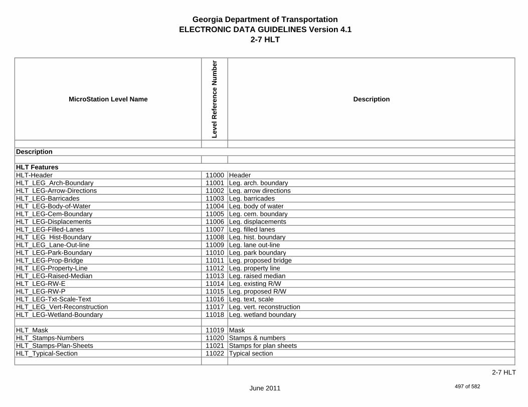
Georgia Department of TransportationELECTRONIC DATA GUIDELINES Version 4.1
2-7 HLT
MicroStation Level Name
Leve
l Ref
eren
ce N
umbe
r
Description
HLT-Header 11000 HeaderHLT_LEG_Arch-Boundary 11001 Leg. arch. boundaryHLT_LEG-Arrow-Directions 11002 Leg. arrow directionsHLT_LEG-Barricades 11003 Leg. barricadesHLT_LEG-Body-of-Water 11004 Leg. body of waterHLT_LEG-Cem-Boundary 11005 Leg. cem. boundaryHLT_LEG-Displacements 11006 Leg. displacementsHLT_LEG-Filled-Lanes 11007 Leg. filled lanesHLT_LEG_Hist-Boundary 11008 Leg. hist. boundaryHLT_LEG_Lane-Out-line 11009 Leg. lane out-lineHLT_LEG-Park-Boundary 11010 Leg. park boundaryHLT_LEG-Prop-Bridge 11011 Leg. proposed bridgeHLT_LEG-Property-Line 11012 Leg. property lineHLT_LEG-Raised-Median 11013 Leg. raised medianHLT_LEG-RW-E 11014 Leg. existing R/WHLT_LEG-RW-P 11015 Leg. proposed R/WHLT_LEG-Txt-Scale-Text 11016 Leg. text, scaleHLT_LEG_Vert-Reconstruction 11017 Leg. vert. reconstructionHLT_LEG-Wetland-Boundary 11018 Leg. wetland boundary
HLT_Mask 11019 MaskHLT_Stamps-Numbers 11020 Stamps & numbersHLT_Stamps-Plan-Sheets 11021 Stamps for plan sheetsHLT_Typical-Section 11022 Typical section
Description
HLT Features
June 2011
2-7 HLT
497 of 582
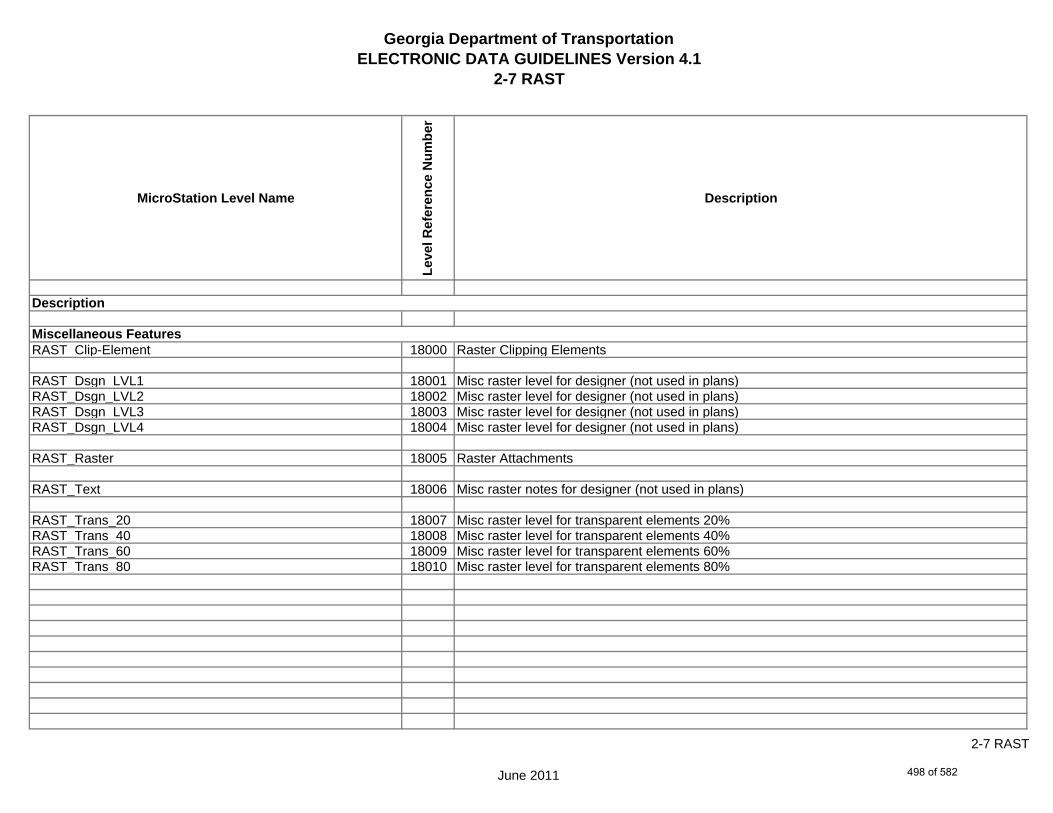
Georgia Department of TransportationELECTRONIC DATA GUIDELINES Version 4.1
2-7 RAST
MicroStation Level Name
Leve
l Ref
eren
ce N
umbe
r
Description
RAST_Clip-Element 18000 Raster Clipping Elements
RAST_Dsgn_LVL1 18001 Misc raster level for designer (not used in plans)RAST_Dsgn_LVL2 18002 Misc raster level for designer (not used in plans)RAST_Dsgn_LVL3 18003 Misc raster level for designer (not used in plans)RAST_Dsgn_LVL4 18004 Misc raster level for designer (not used in plans)
RAST_Raster 18005 Raster Attachments
RAST_Text 18006 Misc raster notes for designer (not used in plans)
RAST_Trans_20 18007 Misc raster level for transparent elements 20%RAST_Trans_40 18008 Misc raster level for transparent elements 40%RAST_Trans_60 18009 Misc raster level for transparent elements 60%RAST_Trans_80 18010 Misc raster level for transparent elements 80%
Description
Miscellaneous Features
June 2011
2-7 RAST
498 of 582

Georgia Department of TransportationELECTRONIC DATA GUIDELINES Version 4.1
2-7 QUAD
MicroStation Level Name
Leve
l Ref
eren
ce N
umbe
r
Description
QUAD_County-Shape-Line 41000 County Boundary Line ShapeQUAD_County-Text 41001 County Name Text
QUAD_DOQQ-Point 41002 USGS Digital Ortho Quarter Quadrangle Grid CornersQUAD_DOQQ-Shape-Line 41003 USGS Digital Ortho Quarter Quadrangle Grid LinesQUAD_DOQQ-Text 41004 USGS Digital Ortho Quarter Quadrangle Name Text
QUAD_EW-Zone-Boundary-Line 41005 GDOT East-West Zone Boundary Line
QUAD_Lat-Long-Text 41006 Latitude and Longitude Text
QUAD_Quadmap-Point 41007 USGS Quadrangle Map Grid CornersQUAD_Quadmap-Point 41008 USGS Quadrangle Map Grid LinesQUAD_Quadmap-Point 41009 USGS Quadrangle Map Name and GDOT Quadrangle Number Text
QUAD_State-Boundary-Line 41010 County Boundary Line Shape
Description
Miscellaneous Features
June 2011
2-7 QUAD
499 of 582

Georgia Department of TransportationELECTRONIC DATA GUIDELINES Version 4.1
2-7 MNTC
MicroStation Level Name
Leve
l Ref
eren
ce N
umbe
r
Description
MNTC_P_Maintenance-Line 19000 Maintenance - Reserved for future developmentMNTC_P_Maintenance-Text 19001 Maintenance - Reserved for future development
MNTC_P_Misc 19002 Miscellaneous Designer notes (not plotted)
Description
Maintenance Features
June 2011
2-7 MNTC
500 of 582

Georgia Department of TransportationELECTRONIC DATA GUIDELINES Version 4.1
2-7 QTYS
MicroStation Level Name
Leve
l Ref
eren
ce N
umbe
r
Description
QTYS_P_Quantities-Line 23000 Quantities - Reserved for future developmentQTYS_P_Quantities-Text 23001 Quantities - Reserved for future development
QTYS_P_Misc 23002 Miscellaneous Designer notes (not plotted)
Description
Quantities Features
June 2011
2-7 QTYS
501 of 582

Georgia Department of Transportation ELECTRONIC DATA GUIDELINES Version 4.1
3-1 Supporting Files (Downloaded)
The following sections describes the files available for download off of the following Georgia Department of Transportation web site for MicroStation and InRoads. http://www.dot.ga.gov/doingbusiness/PoliciesManuals/roads/Pages/default.aspx
502 of 582

Georgia Department of TransportationELECTRONIC DATA GUIDELINES Version 4.1
3-2 Cells Libraries
Cell Library Name Cell Selector File Name Number of CellsCurrent
Revsion Date for File
(Typical) Plan
Scales
GDOT-DR-1001B Concrete Headwalls.cel N/A
206 4/18/2011 1
GDOT-DR-1033D Catch Basins.cel N/A
82 4/18/2011 1
GDOT-DR-1033E Catch Basins.cel N/A
86 4/18/2011 1
GDOT-DR-1033F Catch Basins.cel N/A
90 4/18/2011 1
GDOT-DR-1033G Catch Basins.cel N/A
82 4/18/2011 1
GDOT-DR-1034D Catch Basins.cel N/A
41 4/18/2011 1
GDOT-DR-1034E Catch Basins.cel N/A
45 4/18/2011 1
GDOT-DR-1034F Catch Basins.cel N/A
49 4/18/2011 1
GDOT-DR-1034G Catch Basins.cel N/A
41 4/18/2011 1
GDOT-DR-1120 Flared End Sections.cel N/A
43 4/18/2011 1
GDOT-DR-1125 Inlet-Outlet Headwalls.cel N/A
79 4/18/2011 1
GDOT-DR-2321 Reinforced Concrete Box Culverts.cel N/A
41 4/18/2011 1
GDOT-DR-2322 Reinforced Concrete Box Culverts.cel N/A
8 4/18/2011 1
June 2011
3-2 Cells Libraries
503 of 582

Georgia Department of TransportationELECTRONIC DATA GUIDELINES Version 4.1
3-2 Cells Libraries
Cell Library Name Cell Selector File Name Number of CellsCurrent
Revsion Date for File
(Typical) Plan
Scales
GDOT-DR-2323 Reinforced Concrete Box Culverts.cel N/A
16 4/18/2011 1
GDOT-DR-2324 Reinforced Concrete Box Culverts.cel N/A
16 4/18/2011 1
GDOT-DR-2326 Reinforced Concrete Box Culverts.cel N/A
8 4/18/2011 1
GDOT-DR-2327 Reinforced Concrete Box Culverts.cel N/A
8 4/18/2011 1
GDOT-DR-9031-S Median Drop Inlets.cel N/A
6 4/18/2011 1
GDOT-DR-D3 Median Drop Inlets Special Design.cel N/A
18 4/18/2011 1
GDOT-DR-D39 Safety Slope End Sections.cel N/A
21 4/18/2011 1
GDOT-DR-D4 Ditch Drop Inlets.cel N/A
206 4/18/2011 1
GDOT-DR-D5 Safety Inlets With Grates.cel N/A
21 4/18/2011 1
GDOT-DR-D6 Safety Grates.cel N/A
12 4/18/2011 1
GDOT-DR-Labels and Notes.cel N/A
22 4/18/2011 1
GDOT-EL-Concept.cel GDOT-EL-Concept.csf 29 6/13/2011 N/A
GDOT-EL-Traffic.cel GDOT-EL-Traffic.csf 40 4/18/2011 N/A
June 2011
3-2 Cells Libraries
504 of 582
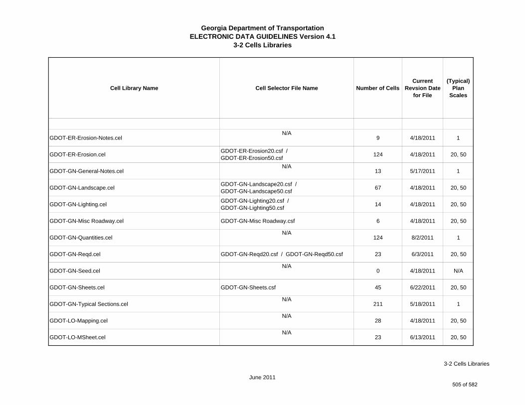
Georgia Department of TransportationELECTRONIC DATA GUIDELINES Version 4.1
3-2 Cells Libraries
Cell Library Name Cell Selector File Name Number of CellsCurrent
Revsion Date for File
(Typical) Plan
Scales
GDOT-ER-Erosion-Notes.celN/A
9 4/18/2011 1
GDOT-ER-Erosion.cel GDOT-ER-Erosion20.csf / GDOT-ER-Erosion50.csf 124 4/18/2011 20, 50
GDOT-GN-General-Notes.celN/A
13 5/17/2011 1
GDOT-GN-Landscape.cel GDOT-GN-Landscape20.csf / GDOT-GN-Landscape50.csf 67 4/18/2011 20, 50
GDOT-GN-Lighting.cel GDOT-GN-Lighting20.csf / GDOT-GN-Lighting50.csf 14 4/18/2011 20, 50
GDOT-GN-Misc Roadway.cel GDOT-GN-Misc Roadway.csf 6 4/18/2011 20, 50
GDOT-GN-Quantities.cel N/A
124 8/2/2011 1
GDOT-GN-Reqd.cel GDOT-GN-Reqd20.csf / GDOT-GN-Reqd50.csf 23 6/3/2011 20, 50
GDOT-GN-Seed.cel N/A
0 4/18/2011 N/A
GDOT-GN-Sheets.cel GDOT-GN-Sheets.csf 45 6/22/2011 20, 50
GDOT-GN-Typical Sections.cel N/A
211 5/18/2011 1
GDOT-LO-Mapping.cel N/A
28 4/18/2011 20, 50
GDOT-LO-MSheet.cel N/A
23 6/13/2011 20, 50
June 2011
3-2 Cells Libraries
505 of 582
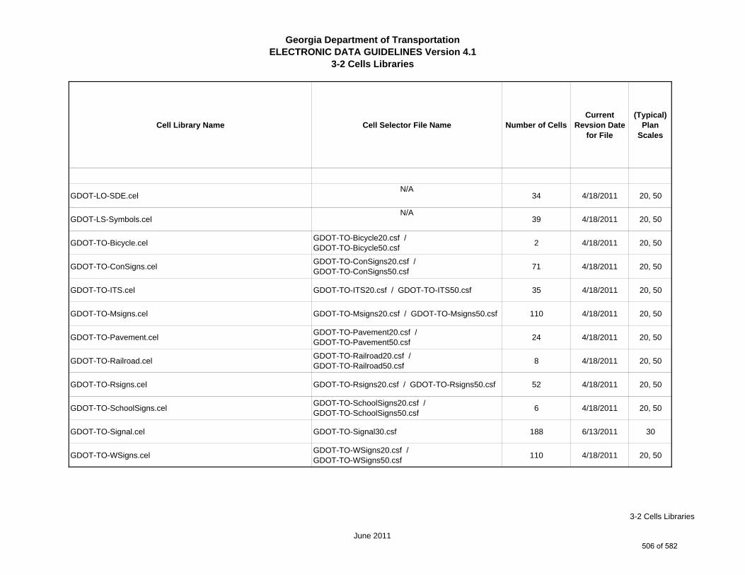
Georgia Department of TransportationELECTRONIC DATA GUIDELINES Version 4.1
3-2 Cells Libraries
Cell Library Name Cell Selector File Name Number of CellsCurrent
Revsion Date for File
(Typical) Plan
Scales
GDOT-LO-SDE.cel N/A
34 4/18/2011 20, 50
GDOT-LS-Symbols.cel N/A
39 4/18/2011 20, 50
GDOT-TO-Bicycle.cel GDOT-TO-Bicycle20.csf / GDOT-TO-Bicycle50.csf 2 4/18/2011 20, 50
GDOT-TO-ConSigns.cel GDOT-TO-ConSigns20.csf / GDOT-TO-ConSigns50.csf 71 4/18/2011 20, 50
GDOT-TO-ITS.cel GDOT-TO-ITS20.csf / GDOT-TO-ITS50.csf 35 4/18/2011 20, 50
GDOT-TO-Msigns.cel GDOT-TO-Msigns20.csf / GDOT-TO-Msigns50.csf 110 4/18/2011 20, 50
GDOT-TO-Pavement.cel GDOT-TO-Pavement20.csf / GDOT-TO-Pavement50.csf 24 4/18/2011 20, 50
GDOT-TO-Railroad.cel GDOT-TO-Railroad20.csf / GDOT-TO-Railroad50.csf 8 4/18/2011 20, 50
GDOT-TO-Rsigns.cel GDOT-TO-Rsigns20.csf / GDOT-TO-Rsigns50.csf 52 4/18/2011 20, 50
GDOT-TO-SchoolSigns.cel GDOT-TO-SchoolSigns20.csf / GDOT-TO-SchoolSigns50.csf 6 4/18/2011 20, 50
GDOT-TO-Signal.cel GDOT-TO-Signal30.csf 188 6/13/2011 30
GDOT-TO-WSigns.cel GDOT-TO-WSigns20.csf / GDOT-TO-WSigns50.csf 110 4/18/2011 20, 50
June 2011
3-2 Cells Libraries
506 of 582
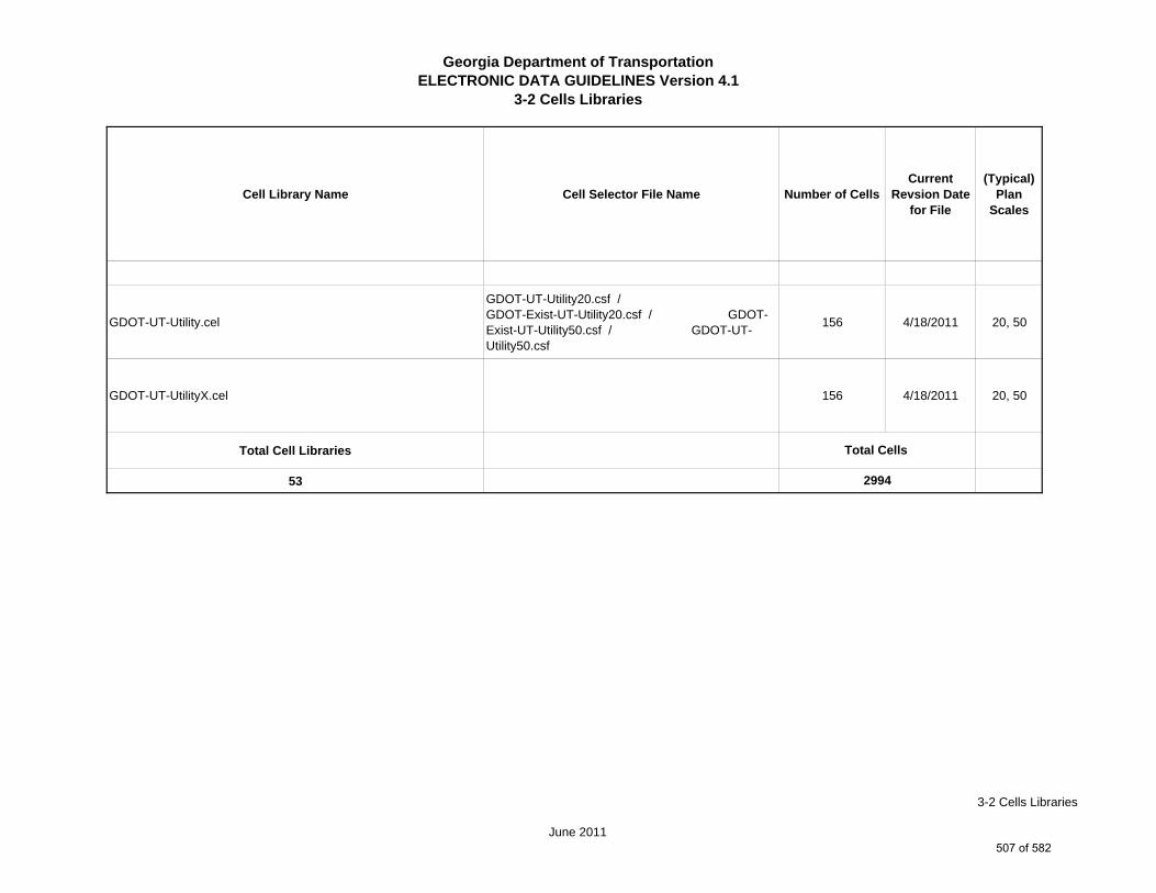
Georgia Department of TransportationELECTRONIC DATA GUIDELINES Version 4.1
3-2 Cells Libraries
Cell Library Name Cell Selector File Name Number of CellsCurrent
Revsion Date for File
(Typical) Plan
Scales
GDOT-UT-Utility.cel
GDOT-UT-Utility20.csf / GDOT-Exist-UT-Utility20.csf / GDOT-Exist-UT-Utility50.csf / GDOT-UT-Utility50.csf
156 4/18/2011 20, 50
GDOT-UT-UtilityX.cel 156 4/18/2011 20, 50
Total Cell Libraries
53
Total Cells
2994
June 2011
3-2 Cells Libraries
507 of 582

Georgia Department of Transportation ELECTRONIC DATA GUIDELINES Version 4.1
4-1 Master Level Name and ByLevel Symbology Index
The following sections describe in a spreadsheet format the Master MicroStation Level Name and Bylevel Symbology Index that shall be used on all Georgia Department of Transportation plan sheets.
508 of 582
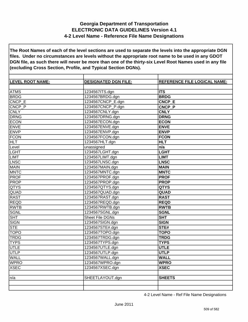
Georgia Department of TransportationELECTRONIC DATA GUIDELINES Version 4.1
4-2 Level Name - Reference File Name Designations
LEVEL ROOT NAME: DESIGNATED DGN FILE: REFERENCE FILE LOGICAL NAME:
ATMS 1234567ITS.dgn ITSBRDG 1234567BRDG.dgn BRDGCNCP_E 1234567CNCP_E.dgn CNCP_ECNCP_P 1234567CNCP_P.dgn CNCP_PCNLY 1234567CNLY.dgn CNLYDRNG 1234567DRNG.dgn DRNGECON 1234567ECON.dgn ECONENVE 1234567ENVE.dgn ENVEENVP 1234567ENVP.dgn ENVPFCON 1234567FCON.dgn FCONHLT 1234567HLT.dgn HLTLevel unassigned n/aLGHT 1234567LGHT.dgn LGHTLIMT 1234567LIMT.dgn LIMTLNSC 1234567LNSC.dgn LNSCMAIN 1234567MAIN.dgn MAINMNTC 1234567MNTC.dgn MNTCPROF 1234567PROF.dgn PROFPROP 1234567PROP.dgn PROPQTYS 1234567QTYS.dgn QTYSQUAD 1234567QUAD.dgn QUADRAST 1234567RAST.dgn RASTREQD 1234567REQD.dgn REQDRWTB 1234567RWTB.dgn RWTBSGNL 1234567SGNL.dgn SGNLSHT Sheet File DGNs SHTSIGN 1234567SIGN.dgn SIGNSTE 1234567STE#.dgn STE#TOPO 1234567TOPO.dgn TOPOTRDG 1234567TRDG.dgn TRDGTYPS 1234567TYPS.dgn TYPSUTLE 1234567UTLE.dgn UTLEUTLP 1234567UTLP.dgn UTLPWALL 1234567WALL.dgn WALLWPRO 1234567WPRO.dgn WPROXSEC 1234567XSEC.dgn XSEC
n/a SHEETLAYOUT.dgn SHEETS
The Root Names of each of the level sections are used to separate the levels into the appropriate DGN files. Under no circumstances are levels without the appropriate root name to be used in any GDOT DGN file, as such there will never be more than one of the thirty-six Level Root Names used in any file (excluding Cross Section, Profile, and Typical Section DGNs).
June 2011
4-2 Level Name - Ref File Name Designations
509 of 582
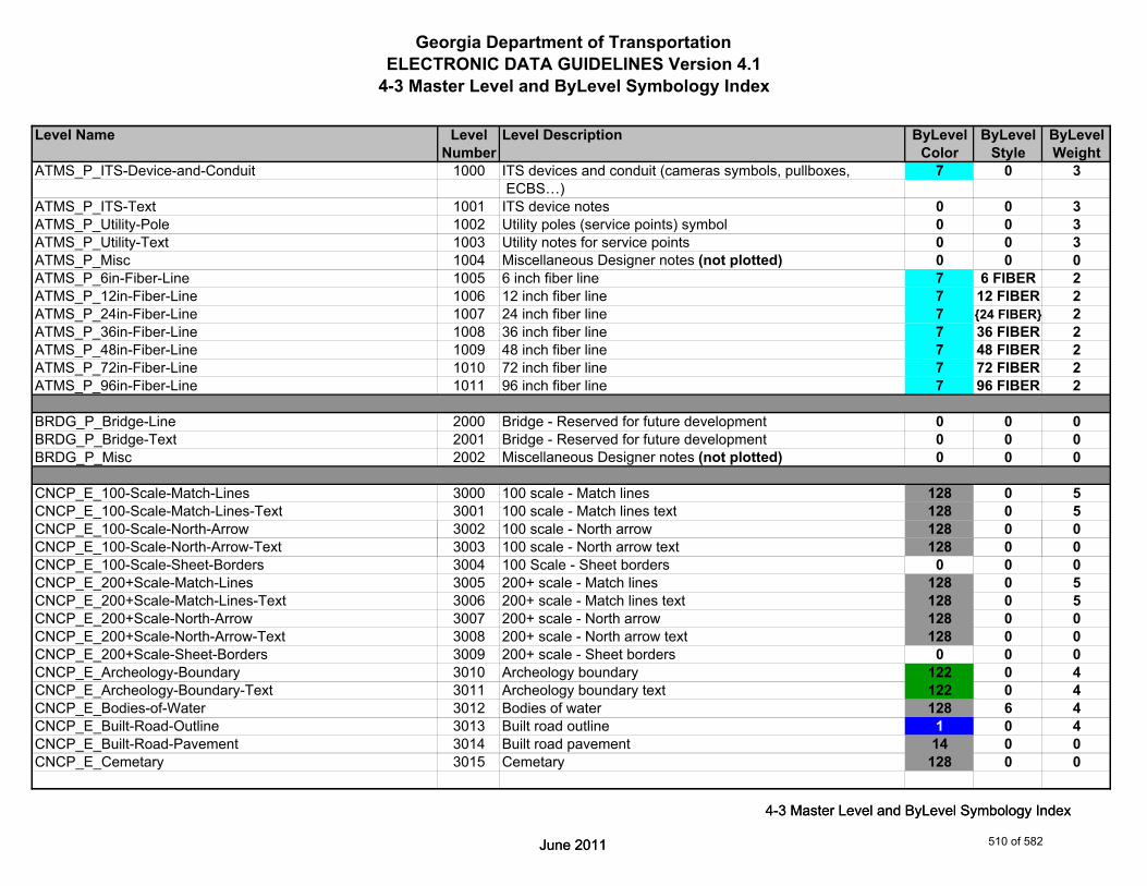
Georgia Department of TransportationELECTRONIC DATA GUIDELINES Version 4.1
4-3 Master Level and ByLevel Symbology Index
Level Name Level Level Description ByLevel ByLevel ByLevelNumber Color Style Weight
ATMS_P_ITS-Device-and-Conduit 1000 ITS devices and conduit (cameras symbols, pullboxes, 7 0 3 ECBS…)
ATMS_P_ITS-Text 1001 ITS device notes 0 0 3ATMS_P_Utility-Pole 1002 Utility poles (service points) symbol 0 0 3ATMS_P_Utility-Text 1003 Utility notes for service points 0 0 3ATMS_P_Misc 1004 Miscellaneous Designer notes (not plotted) 0 0 0ATMS_P_6in-Fiber-Line 1005 6 inch fiber line 7 6 FIBER 2ATMS_P_12in-Fiber-Line 1006 12 inch fiber line 7 12 FIBER 2ATMS_P_24in-Fiber-Line 1007 24 inch fiber line 7 {24 FIBER} 2ATMS_P_36in-Fiber-Line 1008 36 inch fiber line 7 36 FIBER 2ATMS_P_48in-Fiber-Line 1009 48 inch fiber line 7 48 FIBER 2ATMS_P_72in-Fiber-Line 1010 72 inch fiber line 7 72 FIBER 2ATMS_P_96in-Fiber-Line 1011 96 inch fiber line 7 96 FIBER 2
BRDG_P_Bridge-Line 2000 Bridge - Reserved for future development 0 0 0BRDG_P_Bridge-Text 2001 Bridge - Reserved for future development 0 0 0BRDG_P_Misc 2002 Miscellaneous Designer notes (not plotted) 0 0 0
CNCP_E_100-Scale-Match-Lines 3000 100 scale - Match lines 128 0 5CNCP_E_100-Scale-Match-Lines-Text 3001 100 scale - Match lines text 128 0 5CNCP_E_100-Scale-North-Arrow 3002 100 scale - North arrow 128 0 0
June 2011
4-3 Master Level and ByLevel Symbology Index
CNCP_E_100-Scale-North-Arrow-Text 3003 100 scale - North arrow text 128 0 0CNCP_E_100-Scale-Sheet-Borders 3004 100 Scale - Sheet borders 0 0 0CNCP_E_200+Scale-Match-Lines 3005 200+ scale - Match lines 128 0 5CNCP_E_200+Scale-Match-Lines-Text 3006 200+ scale - Match lines text 128 0 5CNCP_E_200+Scale-North-Arrow 3007 200+ scale - North arrow 128 0 0CNCP_E_200+Scale-North-Arrow-Text 3008 200+ scale - North arrow text 128 0 0CNCP_E_200+Scale-Sheet-Borders 3009 200+ scale - Sheet borders 0 0 0CNCP_E_Archeology-Boundary 3010 Archeology boundary 122 0 4CNCP_E_Archeology-Boundary-Text 3011 Archeology boundary text 122 0 4CNCP_E_Bodies-of-Water 3012 Bodies of water 128 6 4CNCP_E_Built-Road-Outline 3013 Built road outline 1 0 4CNCP_E_Built-Road-Pavement 3014 Built road pavement 14 0 0CNCP_E_Cemetary 3015 Cemetary 128 0 0
June 2011
4-3 Master Level and ByLevel Symbology Index
510 of 582
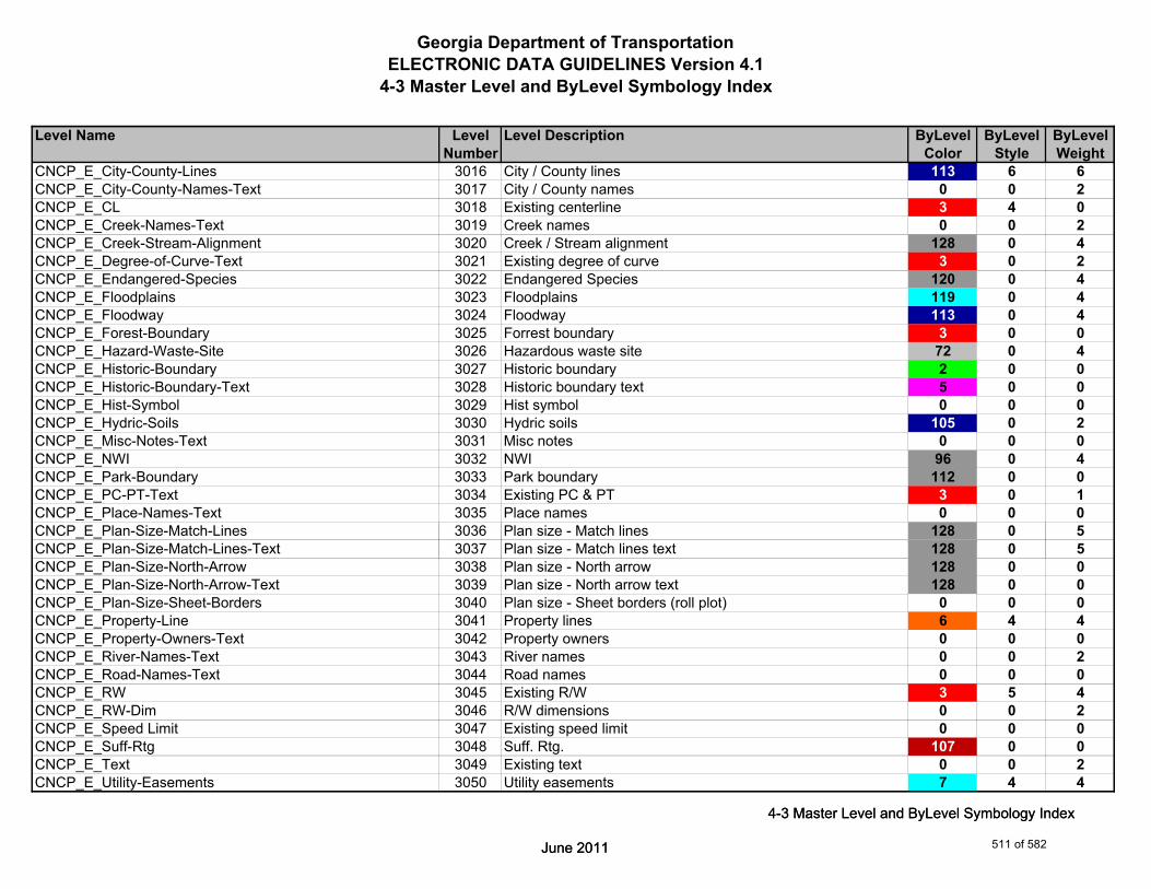
Georgia Department of TransportationELECTRONIC DATA GUIDELINES Version 4.1
4-3 Master Level and ByLevel Symbology Index
Level Name Level Level Description ByLevel ByLevel ByLevelNumber Color Style Weight
CNCP_E_City-County-Lines 3016 City / County lines 113 6 6CNCP_E_City-County-Names-Text 3017 City / County names 0 0 2CNCP_E_CL 3018 Existing centerline 3 4 0CNCP_E_Creek-Names-Text 3019 Creek names 0 0 2CNCP_E_Creek-Stream-Alignment 3020 Creek / Stream alignment 128 0 4CNCP_E_Degree-of-Curve-Text 3021 Existing degree of curve 3 0 2CNCP_E_Endangered-Species 3022 Endangered Species 120 0 4CNCP_E_Floodplains 3023 Floodplains 119 0 4CNCP_E_Floodway 3024 Floodway 113 0 4CNCP_E_Forest-Boundary 3025 Forrest boundary 3 0 0CNCP_E_Hazard-Waste-Site 3026 Hazardous waste site 72 0 4CNCP_E_Historic-Boundary 3027 Historic boundary 2 0 0CNCP_E_Historic-Boundary-Text 3028 Historic boundary text 5 0 0CNCP_E_Hist-Symbol 3029 Hist symbol 0 0 0CNCP_E_Hydric-Soils 3030 Hydric soils 105 0 2CNCP_E_Misc-Notes-Text 3031 Misc notes 0 0 0CNCP_E_NWI 3032 NWI 96 0 4CNCP_E_Park-Boundary 3033 Park boundary 112 0 0CNCP_E_PC-PT-Text 3034 Existing PC & PT 3 0 1CNCP_E_Place-Names-Text 3035 Place names 0 0 0CNCP_E_Plan-Size-Match-Lines 3036 Plan size - Match lines 128 0 5
June 2011
4-3 Master Level and ByLevel Symbology Index
CNCP_E_Plan-Size-Match-Lines-Text 3037 Plan size - Match lines text 128 0 5CNCP_E_Plan-Size-North-Arrow 3038 Plan size - North arrow 128 0 0CNCP_E_Plan-Size-North-Arrow-Text 3039 Plan size - North arrow text 128 0 0CNCP_E_Plan-Size-Sheet-Borders 3040 Plan size - Sheet borders (roll plot) 0 0 0CNCP_E_Property-Line 3041 Property lines 6 4 4CNCP_E_Property-Owners-Text 3042 Property owners 0 0 0CNCP_E_River-Names-Text 3043 River names 0 0 2CNCP_E_Road-Names-Text 3044 Road names 0 0 0CNCP_E_RW 3045 Existing R/W 3 5 4CNCP_E_RW-Dim 3046 R/W dimensions 0 0 2CNCP_E_Speed Limit 3047 Existing speed limit 0 0 0CNCP_E_Suff-Rtg 3048 Suff. Rtg. 107 0 0CNCP_E_Text 3049 Existing text 0 0 2CNCP_E_Utility-Easements 3050 Utility easements 7 4 4
June 2011
4-3 Master Level and ByLevel Symbology Index
511 of 582

Georgia Department of TransportationELECTRONIC DATA GUIDELINES Version 4.1
4-3 Master Level and ByLevel Symbology Index
Level Name Level Level Description ByLevel ByLevel ByLevelNumber Color Style Weight
CNCP_E_Vert-Reconstruction 3051 Vertical reconstruction 0 0 1CNCP_E_Wetland-Boundary 3052 Wetland boundary 222 0 0CNCP_E_Wetland-Text 3053 Wetland text 0 0 2
CNCP_P_ALT-Centerline 4000 ALT Centerline 38 7 1CNCP_P_Arrow-Directions 4001 Arrow directions 1 0 2CNCP_P_Barricades 4002 Barricades 2 0 4CNCP_P_Bridge 4003 Proposed bridge 89 0 2CNCP_P_Degree-of-Curve 4004 Proposed Degree of Curve 38 0 0CNCP_P_Descriptive-Text 4005 Descriptive text 0 0 2CNCP_P_Displacements 4006 Displacements 135 0 4CNCP_P_Filled-Lane-Shapes 4007 Filled-Lane-Shapes 44 0 0CNCP_P_Lane-Out-line 4008 Lane out-line 1 0 2CNCP_P_Other-Projects 4009 Other projects 1 0 2CNCP_P_PC-PT-Text 4010 Proposed PC & PT 38 0 2CNCP_P_Project-Termini 4011 Project Termini 0 0 2CNCP_P_Raised-Median 4012 Raised median 24 0 0CNCP_P_Remove-Existing-Road 4013 Remove existing road 0 0 0CNCP_P_RW 4014 Proposed R/W 88 0 8CNCP_P_RW-Dim 4015 R/W dimensions 0 0 2CNCP_P_Vert-Reconstruction 4016 Vertical reconstruction 111 0 1
( )
June 2011
4-3 Master Level and ByLevel Symbology Index
CNCP_P_Misc 4017 Miscellaneous Designer notes (not plotted) 0 0 0CNCP_P_Vert-Reconstruction-Hatching 4018 Vertical reconstruction hatching 111 0 2
CNLY_P_Appr-Slab-Line 5000 Approach slab - lines 4 0 2CNLY_P_Appr-Slab-Text 5001 Approach slab - description 5 0 2CNLY_P_Barrier-Line 5002 Median or side barrier - lines 4 0 2CNLY_P_Barrier-Text 5003 Median or side barrier - description 5 0 2CNLY_P_Bridge-Line 5004 Bridge - lines 0 0 4CNLY_P_Bridge-Text 5005 Bridge - description 4 0 2CNLY_P_CONSTCL-Brng-Text 5006 Construction centerline - bearings 6 0 3CNLY_P_CONSTCL-Curve-Data-Text 5007 Construction centerline - curve label & data table 6 0 3CNLY_P_CONSTCL-Line 5008 Construction centerline - lines 6 0 4CNLY_P_CONSTCL-PC-PT-Sta-Ldr-Text 5009 Construction centerline - PC/PT station labels w/flags 6 0 3CNLY_P_CONSTCL-Tic-Sta-Text 5010 Construction centerline - tic marks and sta labels 6 0 4
June 2011
4-3 Master Level and ByLevel Symbology Index
512 of 582
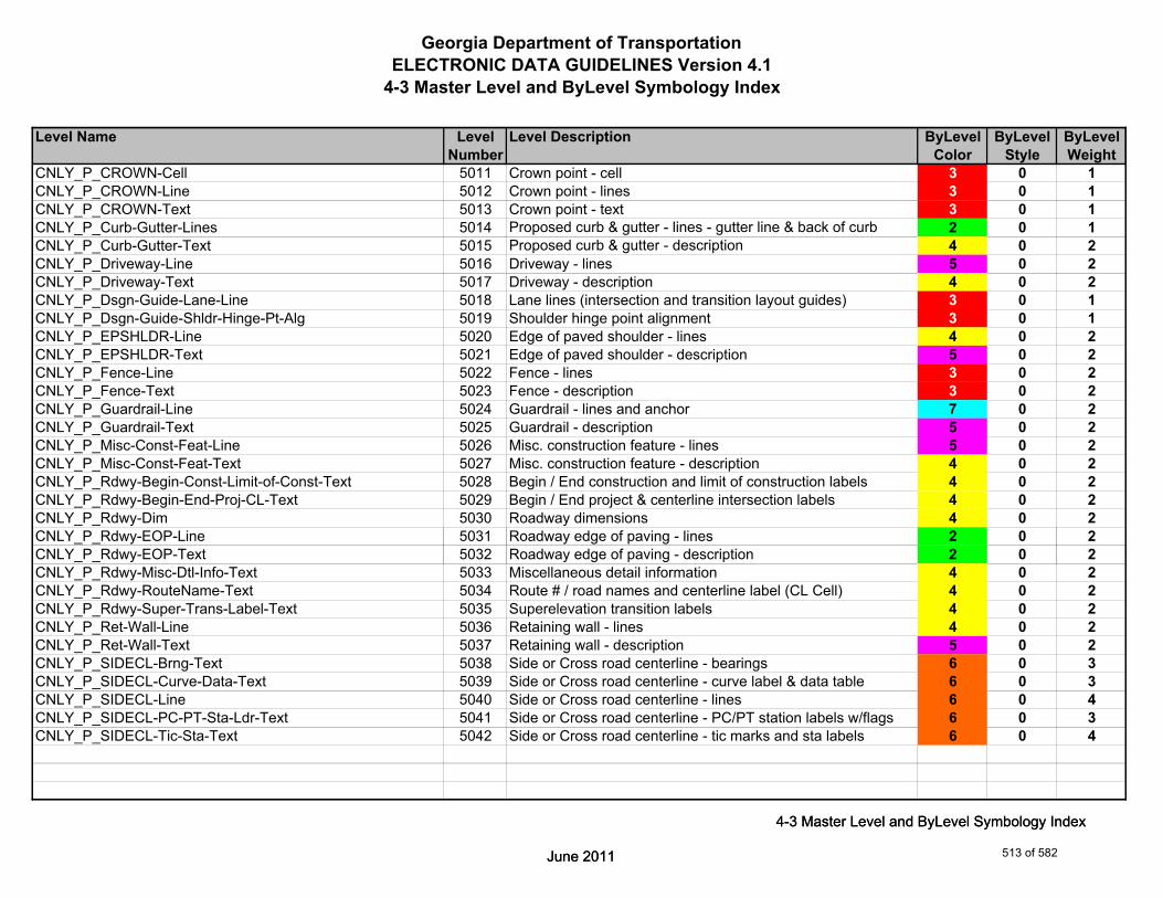
Georgia Department of TransportationELECTRONIC DATA GUIDELINES Version 4.1
4-3 Master Level and ByLevel Symbology Index
Level Name Level Level Description ByLevel ByLevel ByLevelNumber Color Style Weight
CNLY_P_CROWN-Cell 5011 Crown point - cell 3 0 1CNLY_P_CROWN-Line 5012 Crown point - lines 3 0 1CNLY_P_CROWN-Text 5013 Crown point - text 3 0 1CNLY_P_Curb-Gutter-Lines 5014 Proposed curb & gutter - lines - gutter line & back of curb 2 0 1CNLY_P_Curb-Gutter-Text 5015 Proposed curb & gutter - description 4 0 2CNLY_P_Driveway-Line 5016 Driveway - lines 5 0 2CNLY_P_Driveway-Text 5017 Driveway - description 4 0 2CNLY_P_Dsgn-Guide-Lane-Line 5018 Lane lines (intersection and transition layout guides) 3 0 1CNLY_P_Dsgn-Guide-Shldr-Hinge-Pt-Alg 5019 Shoulder hinge point alignment 3 0 1CNLY_P_EPSHLDR-Line 5020 Edge of paved shoulder - lines 4 0 2CNLY_P_EPSHLDR-Text 5021 Edge of paved shoulder - description 5 0 2CNLY_P_Fence-Line 5022 Fence - lines 3 0 2CNLY_P_Fence-Text 5023 Fence - description 3 0 2CNLY_P_Guardrail-Line 5024 Guardrail - lines and anchor 7 0 2CNLY_P_Guardrail-Text 5025 Guardrail - description 5 0 2CNLY_P_Misc-Const-Feat-Line 5026 Misc. construction feature - lines 5 0 2CNLY_P_Misc-Const-Feat-Text 5027 Misc. construction feature - description 4 0 2CNLY_P_Rdwy-Begin-Const-Limit-of-Const-Text 5028 Begin / End construction and limit of construction labels 4 0 2CNLY_P_Rdwy-Begin-End-Proj-CL-Text 5029 Begin / End project & centerline intersection labels 4 0 2CNLY_P_Rdwy-Dim 5030 Roadway dimensions 4 0 2CNLY_P_Rdwy-EOP-Line 5031 Roadway edge of paving - lines 2 0 2
June 2011
4-3 Master Level and ByLevel Symbology Index
CNLY_P_Rdwy-EOP-Text 5032 Roadway edge of paving - description 2 0 2CNLY_P_Rdwy-Misc-Dtl-Info-Text 5033 Miscellaneous detail information 4 0 2CNLY_P_Rdwy-RouteName-Text 5034 Route # / road names and centerline label (CL Cell) 4 0 2CNLY_P_Rdwy-Super-Trans-Label-Text 5035 Superelevation transition labels 4 0 2CNLY_P_Ret-Wall-Line 5036 Retaining wall - lines 4 0 2CNLY_P_Ret-Wall-Text 5037 Retaining wall - description 5 0 2CNLY_P_SIDECL-Brng-Text 5038 Side or Cross road centerline - bearings 6 0 3CNLY_P_SIDECL-Curve-Data-Text 5039 Side or Cross road centerline - curve label & data table 6 0 3CNLY_P_SIDECL-Line 5040 Side or Cross road centerline - lines 6 0 4CNLY_P_SIDECL-PC-PT-Sta-Ldr-Text 5041 Side or Cross road centerline - PC/PT station labels w/flags 6 0 3CNLY_P_SIDECL-Tic-Sta-Text 5042 Side or Cross road centerline - tic marks and sta labels 6 0 4
June 2011
4-3 Master Level and ByLevel Symbology Index
513 of 582

Georgia Department of TransportationELECTRONIC DATA GUIDELINES Version 4.1
4-3 Master Level and ByLevel Symbology Index
Level Name Level Level Description ByLevel ByLevel ByLevelNumber Color Style Weight
CNLY_P_Sidewalk-Line 5043 Sidewalk - lines 4 0 1CNLY_P_Sidewalk-Text 5044 Sidewalk - description 5 0 1CNLY_P_Sound Barrier-Line 5045 Sound barrier wall - lines 4 0 2CNLY_P_Sound Barrier-Text 5046 Sound barrier wall - description 5 0 2CNLY_P_Misc 5047 Miscellaneous lines for designer (not plotted) 0 0 0
DRNG_P_BASIN-Boundary-Major-Line 6000 Drainage area boundary (major) - line 0 0 1DRNG_P_BASIN-Boundary-Major-Pattern 6001 Drainage area boundary (major) - pattern 0 0 1DRNG_P_BASIN-Boundary-Major-Pnt 6002 Drainage area boundary (major) - points 0 0 1DRNG_P_BASIN-Boundary-Major-Text 6003 Drainage area boundary (major) - description 0 0 2DRNG_P_Bridge-Culv-Line 6004 Bridge culvert lines 1 0 2DRNG_P_Bridge-Culv-Text 6005 Bridge culvert flow arrows and descriptions 1 0 2DRNG_P_Cross-Drain-and-Culv-Line 6006 Cross drain and culvert Lines 1 0 2DRNG_P_Cross-Drain-and-Culv-Text 6007 Cross drain and culvert flow arrows and descriptions 1 0 2DRNG_P_Detention-Pond-Line 6008 Detention pond lines 4 0 2DRNG_P_Detention-Pond-Pnt-Symbol 6009 Detention pond point symbol 4 0 2DRNG_P_Detention-Pond-Pnt-Text 6010 Detention pond point # text 4 0 2DRNG_P_Detention-Pond-Text 6011 Detention pond description 4 0 2DRNG_P_Ditch-and-Channel-Line 6012 Ditch and channel lines with flow arrows 4 0 2DRNG_P_Ditch-and-Channel-Text 6013 Ditch and channel text 4 0 2DRNG_P_Ditch-Text 6014 Ditch node numbers 0 0 0
June 2011
4-3 Master Level and ByLevel Symbology Index
DRNG_P_Misc-Text 6015 Miscellaneous text 1 0 2DRNG_P_Perm-Ditch-Protect-Line 6016 Ditch protection - concrete paving 4 0 2DRNG_P_Perm-Ditch-Protect-Text 6017 Permanent ditch protection description 0 0 2DRNG_P_Perm-Riprap-Pattern 6018 Permanent riprap (pattern) 0 0 2DRNG_P_SBASIN-Boundary-Sub-Sys-Line 6019 Drainage area boundary (sub-system) - line 2 0 1DRNG_P_SBASIN-Boundary-Sub-Sys-Pnt 6020 Drainage area boundary (sub-system) - points 0 0 1DRNG_P_SBASIN-Boundary-Sub-Sys-Text 6021 Drainage area boundary (sub-system) - description 2 0 2DRNG_P_Sediment-Basin-Line 6022 Sediment basin lines 4 0 2DRNG_P_Sediment-Basin-Pnt-Symbol 6023 Sediment basins point symbol 0 0 0DRNG_P_Sediment-Basin-Pnt-Text 6024 Sediment basins point # text 0 0 0DRNG_P_Sediment-Basin-Text 6025 Sediment basin description 4 0 2
June 2011
4-3 Master Level and ByLevel Symbology Index
514 of 582

Georgia Department of TransportationELECTRONIC DATA GUIDELINES Version 4.1
4-3 Master Level and ByLevel Symbology Index
Level Name Level Level Description ByLevel ByLevel ByLevelNumber Color Style Weight
DRNG_P_Storm-Drain-Pipe-Line 6026 Storm drain pipes (line) 1 0 2DRNG_P_Storm-Drain-Pipe-Text 6027 Storm drain pipe flow arrows and descriptions 1 0 2DRNG_P_Storm-Drain-Struct 6028 Storm drain structures (catch basin, junction boxes,drop 1 0 2
inlets, flared end sections etc…)DRNG_P_Storm-Drain-Struct-Text 6029 Storm drain structures number label 1 0 2DRNG_P_Struct-Text 6030 Structure node numbers and desc. 0 0 0DRNG_P_Misc 6031 Miscellaneous Designer notes (not plotted) 0 0 0
ECON_E_Crossing-Breakline-Cell 7000 Crossing breakline point cell (Existing) 4 0 1ECON_E_Crossing-Breakline-Text 7001 Crossing breakline text (Existing) 4 0 1ECON_E_Gridded-Model-Line 7002 Existing Gridded Model Line 2 0 0ECON_E_Inferred-Breakline-Cell 7003 Inferred breaklines - cell 3 0 1ECON_E_Inferred-Breakline-Line 7004 Inferred breaklines - lines 3 0 3ECON_E_Isopach-Triangles-Line 7005 Existing Isopach surface model triangles 2 2 3ECON_E_Major-Contour-Line 7006 Major contour lines 4 0 1ECON_E_Major-Contour-Text 7007 Major contour lines text 5 0 1ECON_E_Minor-Contour-Line 7008 Minor contour lines 1 0 1ECON_E_Minor-Contour-Text 7009 Minor contour lines text 9 0 1ECON_E_Profiled-Model-Datum-Line 7010 Profiled Model - Datum Line 3 0 0ECON_E_Profiled-Model-Primary-Grid-Line 7011 Profiled Model - Primary Grid Line 0 0 0ECON_E_Profiled-Model-Secondary-Grid-Line 7012 Profiled Model - Secondary Grid Line 0 0 0
June 2011
4-3 Master Level and ByLevel Symbology Index
ECON_E_Slope-Direction-Line 7013 Existing lines w/ arrowheads to show downhill slope 1 0 0 direction
ECON_E_Surface-Triangles-Line 7014 Existing surface model triangles 2 2 0ECON_E_Surface-Perimeter-Line 7015 Outermost edge of Existing surface model 0 0 0ECON_E_Surface-Triangles-Bogus-Line 7016 Existing surface model bogus triangles 10 2 0ECON_E_Surface Triangles-Enhancement-Line 7017 Existing surface model enhancement triangles 10 2 0
ENVE_E_Arch-Line 8000 Archaeological Resource, lines 3 ENVIR 0ENVE_E_Arch-Pattern 8001 Archaeological Resource, patterning 3 0 0ENVE_E_Arch-Shape 8002 Archaeological Resource, shapes for patterning 3 0 0ENVE_E_Arch-Text 8003 Archaeological Resource, description & labels 3 0 0
June 2011
4-3 Master Level and ByLevel Symbology Index
515 of 582
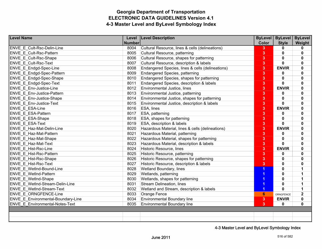
Georgia Department of TransportationELECTRONIC DATA GUIDELINES Version 4.1
4-3 Master Level and ByLevel Symbology Index
Level Name Level Level Description ByLevel ByLevel ByLevelNumber Color Style Weight
ENVE_E_Cult-Rsc-Delin-Line 8004 Cultural Resource, lines & cells (delineations) 3 0 0ENVE_E_Cult-Rsc-Pattern 8005 Cultural Resource, patterning 3 0 0ENVE_E_Cult-Rsc-Shape 8006 Cultural Resource, shapes for patterning 3 0 0ENVE_E_Cult-Rsc-Text 8007 Cultural Resource, description & labels 3 0 0ENVE_E_Endgd-Spec-Line 8008 Endangered Species, lines & cells (delineations) 3 ENVIR 0ENVE_E_Endgd-Spec-Pattern 8009 Endangered Species, patterning 3 0 0ENVE_E_Endgd-Spec-Shape 8010 Endangered Species, shapes for patterning 3 0 0ENVE_E_Endgd-Spec-Text 8011 Endangered Species, description & labels 3 0 0ENVE_E_Env-Justice-Line 8012 Environmental Justice, lines 3 ENVIR 0ENVE_E_Env-Justice-Pattern 8013 Environmental Justice, patterning 3 0 0ENVE_E_Env-Justice-Shape 8014 Environmental Justice, shapes for patterning 3 0 0ENVE_E_Env-Justice-Text 8015 Environmental Justice, description & labels 3 0 0ENVE_E_ESA-Line 8016 ESA, lines 3 ENVIR 0ENVE_E_ESA-Pattern 8017 ESA, patterning 3 0 0ENVE_E_ESA-Shape 8018 ESA, shapes for patterning 3 0 0ENVE_E_ESA-Text 8019 ESA, description & labels 3 0 0ENVE_E_Haz-Mat-Delin-Line 8020 Hazardous Material, lines & cells (delineations) 3 ENVIR 0ENVE_E_Haz-Mat-Pattern 8021 Hazardous Material, patterning 3 0 0ENVE_E_Haz-Mat-Shape 8022 Hazardous Material, shapes for patterning 3 0 0ENVE_E_Haz-Mat-Text 8023 Hazardous Material, description & labels 3 0 0ENVE_E_Hist-Rsc-Line 8024 Historic Resource, lines 3 ENVIR 0
June 2011
4-3 Master Level and ByLevel Symbology Index
ENVE_E_Hist-Rsc-Pattern 8025 Historic Resource, patterning 3 0 0ENVE_E_Hist-Rsc-Shape 8026 Historic Resource, shapes for patterning 3 0 0ENVE_E_Hist-Rsc-Text 8027 Historic Resource, description & labels 3 0 0ENVE_E_Wetlnd-Bound-Line 8028 Wetland Boundary, lines 1 0 1ENVE_E_Wetlnd-Pattern 8029 Wetlands, patterning 1 0 1ENVE_E_Wetlnd-Shape 8030 Wetlands, shapes for patterning 1 0 1ENVE_E_Wetlnd-Stream-Delin-Line 8031 Stream Delineation, lines 1 0 1ENVE_E_Wetlnd-Stream-Text 8032 Wetland and Stream, description & labels 1 0 1ENVE_E_ORNGFENCE-Line 8033 Orange Fence 6 ORNGFENCE 2ENVE_E_Environmental-Boundary-Line 8034 Environmental Boundary line 3 ENVIR 0ENVE_E_Environmental-Notes-Text 8035 Environmental Boundary line 3 0 0
June 2011
4-3 Master Level and ByLevel Symbology Index
516 of 582
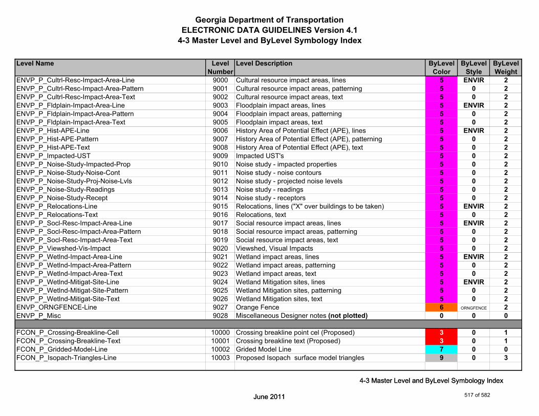
Georgia Department of TransportationELECTRONIC DATA GUIDELINES Version 4.1
4-3 Master Level and ByLevel Symbology Index
Level Name Level Level Description ByLevel ByLevel ByLevelNumber Color Style Weight
ENVP_P_Cultrl-Resc-Impact-Area-Line 9000 Cultural resource impact areas, lines 5 ENVIR 2ENVP_P_Cultrl-Resc-Impact-Area-Pattern 9001 Cultural resource impact areas, patterning 5 0 2ENVP_P_Cultrl-Resc-Impact-Area-Text 9002 Cultural resource impact areas, text 5 0 2ENVP_P_Fldplain-Impact-Area-Line 9003 Floodplain impact areas, lines 5 ENVIR 2ENVP_P_Fldplain-Impact-Area-Pattern 9004 Floodplain impact areas, patterning 5 0 2ENVP_P_Fldplain-Impact-Area-Text 9005 Floodplain impact areas, text 5 0 2ENVP_P_Hist-APE-Line 9006 History Area of Potential Effect (APE), lines 5 ENVIR 2ENVP_P_Hist-APE-Pattern 9007 History Area of Potential Effect (APE), patterning 5 0 2ENVP_P_Hist-APE-Text 9008 History Area of Potential Effect (APE), text 5 0 2ENVP_P_Impacted-UST 9009 Impacted UST's 5 0 2ENVP_P_Noise-Study-Impacted-Prop 9010 Noise study - impacted properties 5 0 2ENVP_P_Noise-Study-Noise-Cont 9011 Noise study - noise contours 5 0 2ENVP_P_Noise-Study-Proj-Noise-Lvls 9012 Noise study - projected noise levels 5 0 2ENVP_P_Noise-Study-Readings 9013 Noise study - readings 5 0 2ENVP_P_Noise-Study-Recept 9014 Noise study - receptors 5 0 2ENVP_P_Relocations-Line 9015 Relocations, lines ("X" over buildings to be taken) 5 ENVIR 2ENVP_P_Relocations-Text 9016 Relocations, text 5 0 2ENVP_P_Socl-Resc-Impact-Area-Line 9017 Social resource impact areas, lines 5 ENVIR 2ENVP_P_Socl-Resc-Impact-Area-Pattern 9018 Social resource impact areas, patterning 5 0 2ENVP_P_Socl-Resc-Impact-Area-Text 9019 Social resource impact areas, text 5 0 2ENVP_P_Viewshed-Vis-Impact 9020 Viewshed, Visual Impacts 5 0 2
June 2011
4-3 Master Level and ByLevel Symbology Index
ENVP_P_Wetlnd-Impact-Area-Line 9021 Wetland impact areas, lines 5 ENVIR 2ENVP_P_Wetlnd-Impact-Area-Pattern 9022 Wetland impact areas, patterning 5 0 2ENVP_P_Wetlnd-Impact-Area-Text 9023 Wetland impact areas, text 5 0 2ENVP_P_Wetlnd-Mitigat-Site-Line 9024 Wetland Mitigation sites, lines 5 ENVIR 2ENVP_P_Wetlnd-Mitigat-Site-Pattern 9025 Wetland Mitigation sites, patterning 5 0 2ENVP_P_Wetlnd-Mitigat-Site-Text 9026 Wetland Mitigation sites, text 5 0 2ENVP_ORNGFENCE-Line 9027 Orange Fence 6 ORNGFENCE 2ENVP_P_Misc 9028 Miscellaneous Designer notes (not plotted) 0 0 0
FCON_P_Crossing-Breakline-Cell 10000 Crossing breakline point cel (Proposed) 3 0 1FCON_P_Crossing-Breakline-Text 10001 Crossing breakline text (Proposed) 3 0 1FCON_P_Gridded-Model-Line 10002 Grided Model Line 7 0 0FCON_P_Isopach-Triangles-Line 10003 Proposed Isopach surface model triangles 9 0 3
June 2011
4-3 Master Level and ByLevel Symbology Index
517 of 582
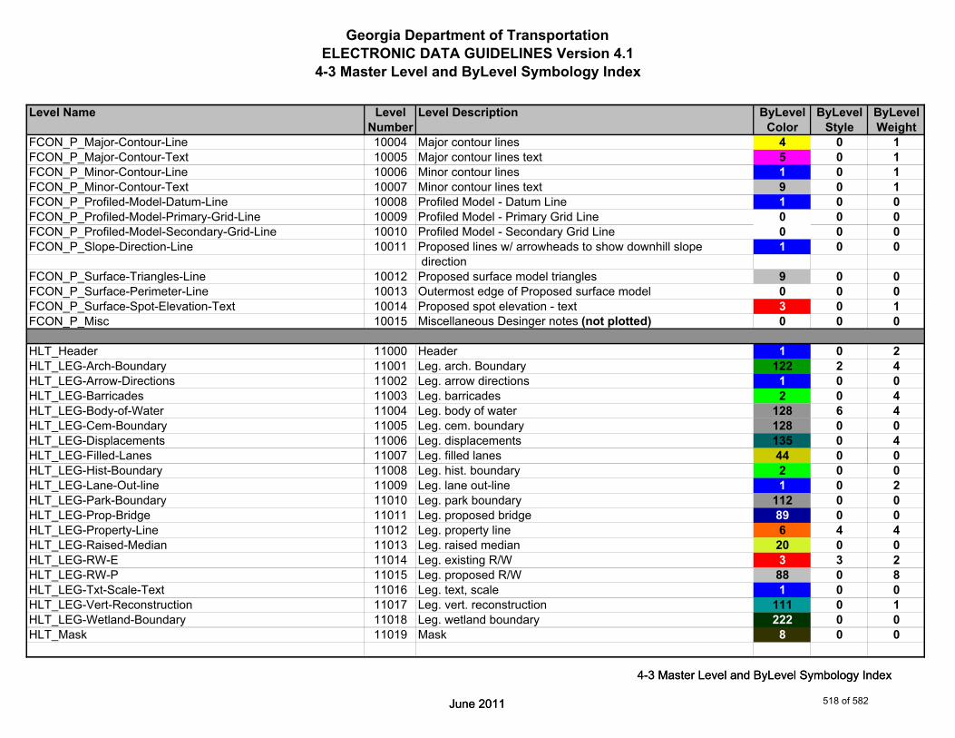
Georgia Department of TransportationELECTRONIC DATA GUIDELINES Version 4.1
4-3 Master Level and ByLevel Symbology Index
Level Name Level Level Description ByLevel ByLevel ByLevelNumber Color Style Weight
FCON_P_Major-Contour-Line 10004 Major contour lines 4 0 1FCON_P_Major-Contour-Text 10005 Major contour lines text 5 0 1FCON_P_Minor-Contour-Line 10006 Minor contour lines 1 0 1FCON_P_Minor-Contour-Text 10007 Minor contour lines text 9 0 1FCON_P_Profiled-Model-Datum-Line 10008 Profiled Model - Datum Line 1 0 0FCON_P_Profiled-Model-Primary-Grid-Line 10009 Profiled Model - Primary Grid Line 0 0 0FCON_P_Profiled-Model-Secondary-Grid-Line 10010 Profiled Model - Secondary Grid Line 0 0 0FCON_P_Slope-Direction-Line 10011 Proposed lines w/ arrowheads to show downhill slope 1 0 0
directionFCON_P_Surface-Triangles-Line 10012 Proposed surface model triangles 9 0 0FCON_P_Surface-Perimeter-Line 10013 Outermost edge of Proposed surface model 0 0 0FCON_P_Surface-Spot-Elevation-Text 10014 Proposed spot elevation - text 3 0 1FCON_P_Misc 10015 Miscellaneous Desinger notes (not plotted) 0 0 0
HLT_Header 11000 Header 1 0 2HLT_LEG-Arch-Boundary 11001 Leg. arch. Boundary 122 2 4HLT_LEG-Arrow-Directions 11002 Leg. arrow directions 1 0 0HLT_LEG-Barricades 11003 Leg. barricades 2 0 4HLT_LEG-Body-of-Water 11004 Leg. body of water 128 6 4HLT_LEG-Cem-Boundary 11005 Leg. cem. boundary 128 0 0HLT_LEG-Displacements 11006 Leg. displacements 135 0 4
June 2011
4-3 Master Level and ByLevel Symbology Index
HLT_LEG-Filled-Lanes 11007 Leg. filled lanes 44 0 0HLT_LEG-Hist-Boundary 11008 Leg. hist. boundary 2 0 0HLT_LEG-Lane-Out-line 11009 Leg. lane out-line 1 0 2HLT_LEG-Park-Boundary 11010 Leg. park boundary 112 0 0HLT_LEG-Prop-Bridge 11011 Leg. proposed bridge 89 0 0HLT_LEG-Property-Line 11012 Leg. property line 6 4 4HLT_LEG-Raised-Median 11013 Leg. raised median 20 0 0HLT_LEG-RW-E 11014 Leg. existing R/W 3 3 2HLT_LEG-RW-P 11015 Leg. proposed R/W 88 0 8HLT_LEG-Txt-Scale-Text 11016 Leg. text, scale 1 0 0HLT_LEG-Vert-Reconstruction 11017 Leg. vert. reconstruction 111 0 1HLT_LEG-Wetland-Boundary 11018 Leg. wetland boundary 222 0 0HLT_Mask 11019 Mask 8 0 0
June 2011
4-3 Master Level and ByLevel Symbology Index
518 of 582

Georgia Department of TransportationELECTRONIC DATA GUIDELINES Version 4.1
4-3 Master Level and ByLevel Symbology Index
Level Name Level Level Description ByLevel ByLevel ByLevelNumber Color Style Weight
HLT_Stamps-Numbers 11020 Stamps & numbers 2 0 0HLT_Stamps-Plan-Sheets 11021 Stamps for plan sheets 2 0 0HLT_Typical-Section 11022 Typical section 1 0 1
LGHT_P_Conduit-Non-Metal-Cell 12000 Conduit, nonmetallic symbol (cell) 2 0 2LGHT_P_Conduit-Non-Metal-Text 12001 Conduit, nonmetallic description 2 0 2LGHT_P_Conduit-Rigid-Galv-Cell 12002 Conduit, rigid galvanized symbol (cell) 2 0 2LGHT_P_Conduit-Rigid-Galv-Text 12003 Conduit, rigid galvanized description 2 0 2LGHT_P_Elec-JBox-Conc-#-Text 12004 Electrical junction box, concrete, # 2 0 2LGHT_P_Elec-JBox-Conc-Cell 12005 Electrical junction box, concrete, symbol (cell) 2 0 2LGHT_P_Elec-JBox-Conc-Sta-Offset-Text 12006 Electrical junction box, concrete, station & offset 2 0 2LGHT_P_Elec-JBox-Conc-Text 12007 Electrical junction box, concrete, description 2 0 2LGHT_P_Elec-JBox-Galv-#-Text 12008 Electrical junction box, galvanized # 2 0 2LGHT_P_Elec-JBox-Galv-Cell 12009 Electrical junction box, galvanized symbol (cell) 2 0 2LGHT_P_Elec-JBox-Galv-Text 12010 Electrical junction box, galvanized description 2 0 2LGHT_P_Elec-JBox-Sta-Offset-Text 12011 Electrical junction box, galvanized station & offset 2 0 2LGHT_P_Grnd-Rod-Cell 12012 Ground rod symbol(cell) 2 0 2LGHT_P_Grnd-Rod-Text 12013 Ground rod description 2 0 2LGHT_P_High-Mast-#-Text 12014 High mast lighting tower # (text) 2 0 2LGHT_P_High-Mast-Cell 12015 High mast lighting tower symbol (cell) 2 0 2LGHT_P_High-Mast-Sta-Offset-Text 12016 High mast lighting tower station & offset 2 0 2
June 2011
4-3 Master Level and ByLevel Symbology Index
LGHT_P_High-Mast-Text 12017 High mast lighting tower description 2 0 2LGHT_P_Lighting-Arrester-Cell 12018 Lighting arrester symbol(cell) 2 0 2LGHT_P_Lighting-Arrester-Text 12019 Lighting arrester desription 2 0 2LGHT_P_Multi-Conductor-Cable-Text 12020 Multiconductor cable description 2 0 2LGHT_P_Servc-Pt-#-Text 12021 Service point # 52 0 2LGHT_P_Servc-Pt-Cell 12022 Service point symbol (cell) 52 0 2LGHT_P_Servc-Pt-Sta-Offset-Text 12023 Service point station & offset 52 0 2LGHT_P_Servc-Pt-Text 12024 Service point description 52 0 2LGHT_P_Std-#-Text 12025 Lighting standard # 1 0 2LGHT_P_Std-Cell 12026 Lighting standard symbol (cell) 1 0 2LGHT_P_Std-Sta-Offset-Text 12027 Lighting standard station & offset 1 0 2LGHT_P_Std-Text 12028 Lighting standard description 1 0 2
June 2011
4-3 Master Level and ByLevel Symbology Index
519 of 582
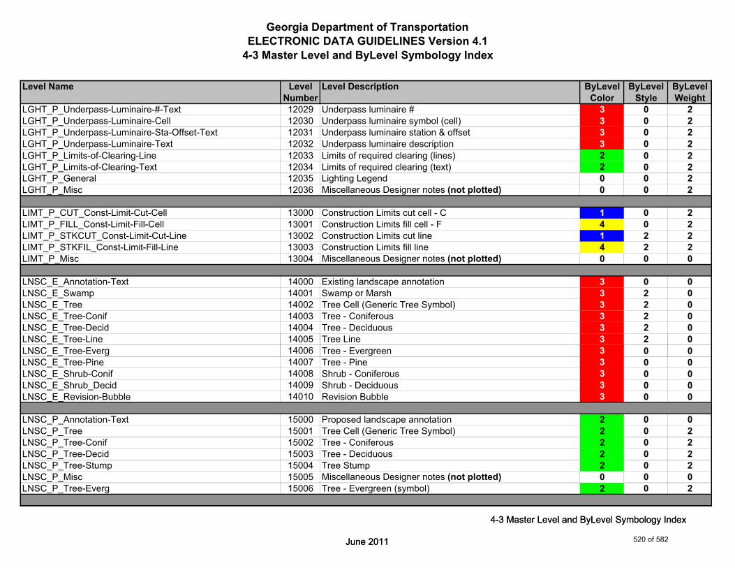
Georgia Department of TransportationELECTRONIC DATA GUIDELINES Version 4.1
4-3 Master Level and ByLevel Symbology Index
Level Name Level Level Description ByLevel ByLevel ByLevelNumber Color Style Weight
LGHT_P_Underpass-Luminaire-#-Text 12029 Underpass luminaire # 3 0 2LGHT_P_Underpass-Luminaire-Cell 12030 Underpass luminaire symbol (cell) 3 0 2LGHT_P_Underpass-Luminaire-Sta-Offset-Text 12031 Underpass luminaire station & offset 3 0 2LGHT_P_Underpass-Luminaire-Text 12032 Underpass luminaire description 3 0 2LGHT_P_Limits-of-Clearing-Line 12033 Limits of required clearing (lines) 2 0 2LGHT_P_Limits-of-Clearing-Text 12034 Limits of required clearing (text) 2 0 2LGHT_P_General 12035 Lighting Legend 0 0 2LGHT_P_Misc 12036 Miscellaneous Designer notes (not plotted) 0 0 2
LIMT_P_CUT_Const-Limit-Cut-Cell 13000 Construction Limits cut cell - C 1 0 2LIMT_P_FILL_Const-Limit-Fill-Cell 13001 Construction Limits fill cell - F 4 0 2LIMT_P_STKCUT_Const-Limit-Cut-Line 13002 Construction Limits cut line 1 2 2LIMT_P_STKFIL_Const-Limit-Fill-Line 13003 Construction Limits fill line 4 2 2LIMT_P_Misc 13004 Miscellaneous Designer notes (not plotted) 0 0 0
LNSC_E_Annotation-Text 14000 Existing landscape annotation 3 0 0LNSC_E_Swamp 14001 Swamp or Marsh 3 2 0LNSC_E_Tree 14002 Tree Cell (Generic Tree Symbol) 3 2 0LNSC_E_Tree-Conif 14003 Tree - Coniferous 3 2 0LNSC_E_Tree-Decid 14004 Tree - Deciduous 3 2 0LNSC_E_Tree-Line 14005 Tree Line 3 2 0
June 2011
4-3 Master Level and ByLevel Symbology Index
LNSC_E_Tree-Everg 14006 Tree - Evergreen 3 0 0LNSC_E_Tree-Pine 14007 Tree - Pine 3 0 0LNSC_E_Shrub-Conif 14008 Shrub - Coniferous 3 0 0LNSC_E_Shrub_Decid 14009 Shrub - Deciduous 3 0 0LNSC_E_Revision-Bubble 14010 Revision Bubble 3 0 0
LNSC_P_Annotation-Text 15000 Proposed landscape annotation 2 0 0LNSC_P_Tree 15001 Tree Cell (Generic Tree Symbol) 2 0 2LNSC_P_Tree-Conif 15002 Tree - Coniferous 2 0 2LNSC_P_Tree-Decid 15003 Tree - Deciduous 2 0 2LNSC_P_Tree-Stump 15004 Tree Stump 2 0 2LNSC_P_Misc 15005 Miscellaneous Designer notes (not plotted) 0 0 0LNSC_P_Tree-Everg 15006 Tree - Evergreen (symbol) 2 0 2
June 2011
4-3 Master Level and ByLevel Symbology Index
520 of 582

Georgia Department of TransportationELECTRONIC DATA GUIDELINES Version 4.1
4-3 Master Level and ByLevel Symbology Index
Level Name Level Level Description ByLevel ByLevel ByLevelNumber Color Style Weight
LNSC_R_Annotation-Text 16000 Remove landscape annotation 3 0 0LNSC_R_Tree 16001 Tree Cell (Generic Tree Symbol) 3 0 1
MAIN_P_Appr-Slab-Line 17000 Approach slab - lines 4 0 2MAIN_P_Appr-Slab-Text 17001 Approach slab - description 5 0 2MAIN_P_Bridge-Line 17002 Proposed bridge - lines 0 0 4MAIN_P_Bridge-Text 17003 Proposed bridge - description 4 0 2MAIN_P_CONSTCL-Brng-Text 17004 Construction centerline - bearings 6 0 3MAIN_P_CONSTCL-Cell 17005 Construction centerline - point symbols 6 0 4MAIN_P_CONSTCL-Curve-Data-Text 17006 Construction centerline - curve label & data table 6 0 3MAIN_P_CONSTCL-Line 17007 Construction centerline - lines 6 0 4MAIN_P_CONSTCL-PC-PT-Sta-Ldr-Text 17008 Construction centerline - PC/PT station labels w/flags 6 0 3MAIN_P_CONSTCL-Tic-Sta-Text 17009 Construction centerline - tic marks and sta labels 6 0 4MAIN_P_CROWN-Cell 17010 Crown point - cell 3 0 1MAIN_P_CROWN-Line 17011 Crown point - lines 3 0 1MAIN_P_CROWN-Text 17012 Crown point - text 3 0 1MAIN_P_Curb-Gutter-Line 17013 Proposed curb & gutter - lines - gutter line & back of curb 2 0 1MAIN_P_Curb-Gutter-Text 17014 Proposed curb & gutter - description 4 0 2MAIN_P_Details-Begin-End-Const-Limit-Const-Label-Text 17015 Begin / End construction and limit of construction labels 4 0 2MAIN_P_Details-End-Proj-CL-Intersect-Label-Text 17016 Begin / End project & centerline intersection labels 4 0 2MAIN_P_Details-Rdwy-Dim 17017 Roadway dimensions 4 0 2
June 2011
4-3 Master Level and ByLevel Symbology Index
MAIN_P_Details-RouteName-CL-Text 17018 Route # / road names and centerline label (CL Cell) 4 0 2MAIN_P_Details-Super-Elev-Trans-Label-Text 17019 Superelevation transition labels 4 0 2MAIN_P_Driveway-Line 17020 Driveway - lines 5 0 2MAIN_P_Driveway-Text 17021 Driveway - description 4 0 2MAIN_P_EOP-Cell 17022 Proposed roadway edge of paving 2 0 2MAIN_P_EOP-Line 17023 Proposed roadway edge of paving - lines 2 0 2MAIN_P_EOP-Text 17024 Proposed roadway edge of paving - description 2 0 2MAIN_P_EPSHLDR-Line 17025 Proposed edge of paved shoulder - lines 4 0 2MAIN_P_EPSHLDR-Text 17026 Proposed edge of paved shoulder - description 5 0 2MAIN_P_Fence-Line 17027 Proposed fence - lines 3 0 2MAIN_P_Fence-Text 17028 Proposed fence - description 3 0 2MAIN_P_Guardrail-Line 17029 Proposed guardrail - lines and anchor 7 0 2MAIN_P_Guardrail-Text 17030 Proposed guardrail - description 5 0 2MAIN_P_Lane-Line 17031 Lane lines (intersection and transition layout guides) 3 0 1
June 2011
4-3 Master Level and ByLevel Symbology Index
521 of 582
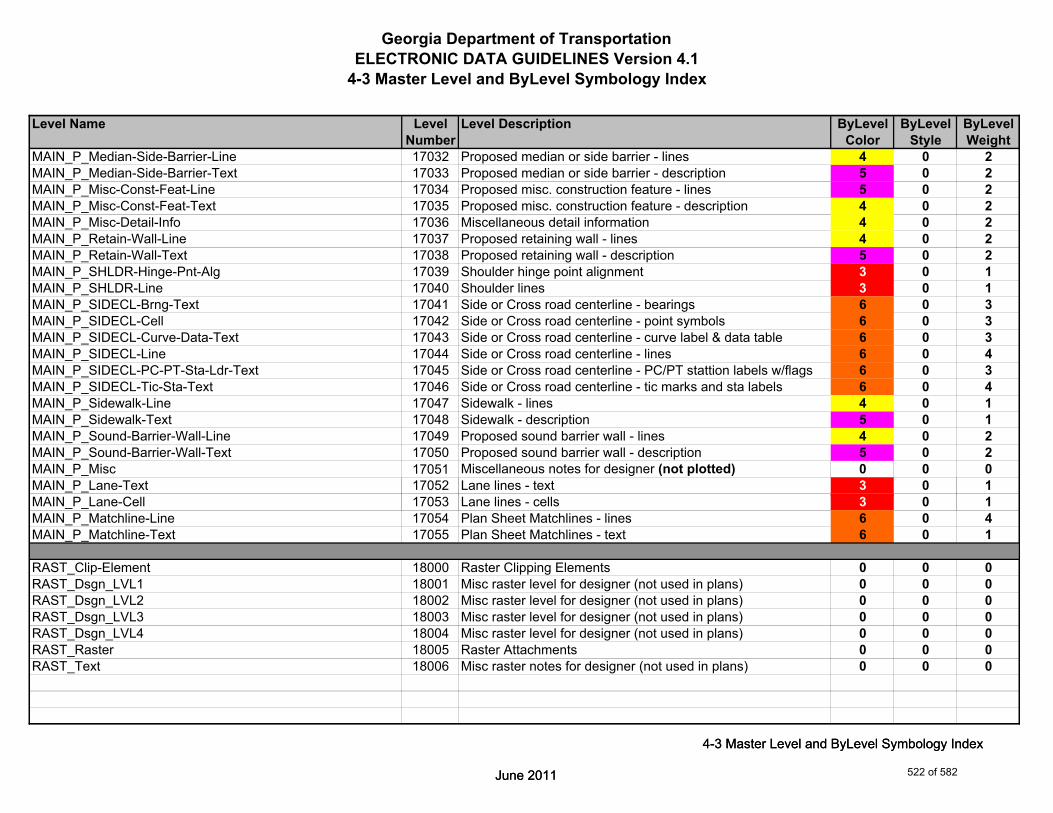
Georgia Department of TransportationELECTRONIC DATA GUIDELINES Version 4.1
4-3 Master Level and ByLevel Symbology Index
Level Name Level Level Description ByLevel ByLevel ByLevelNumber Color Style Weight
MAIN_P_Median-Side-Barrier-Line 17032 Proposed median or side barrier - lines 4 0 2MAIN_P_Median-Side-Barrier-Text 17033 Proposed median or side barrier - description 5 0 2MAIN_P_Misc-Const-Feat-Line 17034 Proposed misc. construction feature - lines 5 0 2MAIN_P_Misc-Const-Feat-Text 17035 Proposed misc. construction feature - description 4 0 2MAIN_P_Misc-Detail-Info 17036 Miscellaneous detail information 4 0 2MAIN_P_Retain-Wall-Line 17037 Proposed retaining wall - lines 4 0 2MAIN_P_Retain-Wall-Text 17038 Proposed retaining wall - description 5 0 2MAIN_P_SHLDR-Hinge-Pnt-Alg 17039 Shoulder hinge point alignment 3 0 1MAIN_P_SHLDR-Line 17040 Shoulder lines 3 0 1MAIN_P_SIDECL-Brng-Text 17041 Side or Cross road centerline - bearings 6 0 3MAIN_P_SIDECL-Cell 17042 Side or Cross road centerline - point symbols 6 0 3MAIN_P_SIDECL-Curve-Data-Text 17043 Side or Cross road centerline - curve label & data table 6 0 3MAIN_P_SIDECL-Line 17044 Side or Cross road centerline - lines 6 0 4MAIN_P_SIDECL-PC-PT-Sta-Ldr-Text 17045 Side or Cross road centerline - PC/PT stattion labels w/flags 6 0 3MAIN_P_SIDECL-Tic-Sta-Text 17046 Side or Cross road centerline - tic marks and sta labels 6 0 4MAIN_P_Sidewalk-Line 17047 Sidewalk - lines 4 0 1MAIN_P_Sidewalk-Text 17048 Sidewalk - description 5 0 1MAIN_P_Sound-Barrier-Wall-Line 17049 Proposed sound barrier wall - lines 4 0 2MAIN_P_Sound-Barrier-Wall-Text 17050 Proposed sound barrier wall - description 5 0 2MAIN_P_Misc 17051 Miscellaneous notes for designer (not plotted) 0 0 0MAIN_P_Lane-Text 17052 Lane lines - text 3 0 1
June 2011
4-3 Master Level and ByLevel Symbology Index
MAIN_P_Lane-Cell 17053 Lane lines - cells 3 0 1MAIN_P_Matchline-Line 17054 Plan Sheet Matchlines - lines 6 0 4MAIN_P_Matchline-Text 17055 Plan Sheet Matchlines - text 6 0 1
RAST_Clip-Element 18000 Raster Clipping Elements 0 0 0RAST_Dsgn_LVL1 18001 Misc raster level for designer (not used in plans) 0 0 0RAST_Dsgn_LVL2 18002 Misc raster level for designer (not used in plans) 0 0 0RAST_Dsgn_LVL3 18003 Misc raster level for designer (not used in plans) 0 0 0RAST_Dsgn_LVL4 18004 Misc raster level for designer (not used in plans) 0 0 0RAST_Raster 18005 Raster Attachments 0 0 0RAST_Text 18006 Misc raster notes for designer (not used in plans) 0 0 0
June 2011
4-3 Master Level and ByLevel Symbology Index
522 of 582

Georgia Department of TransportationELECTRONIC DATA GUIDELINES Version 4.1
4-3 Master Level and ByLevel Symbology Index
Level Name Level Level Description ByLevel ByLevel ByLevelNumber Color Style Weight
RAST_Trans_20 18007 Misc raster level for transparent elements 20% 0 0 0RAST_Trans_40 18008 Misc raster level for transparent elements 40% 0 0 0RAST_Trans_60 18009 Misc raster level for transparent elements 60% 0 0 0RAST_Trans_80 18010 Misc raster level for transparent elements 80% 0 0 0
MNTC_P_Maintenance-Line 19000 Maintenance - Reserved for future development 0 0 0MNTC_P_Maintenance-Text 19001 Maintenance - Reserved for future development 0 0 0MNTC_P_Misc 19002 Miscellaneous Designer level (not plotted) 0 0 0
PROF_E_Drainage-Cell 20000 Profile Existing Drainage Cell 0 0 2PROF_E_Drainage-Line 20001 Profile Existing Drainage Line 7 2 4PROF_E_Drainage-Text 20002 Profile Existing Drainage Text 0 0 4PROF_E_Ground-Line 20003 Profile Existing Ground Line 2 2 3PROF_E_Ground-Text 20004 Profile Existing Ground Text 2 0 1PROF_E_Substratum1-Line 20005 Profile Existing Substratum 1 Line 5 2 2PROF_E_Substratum2-Line 20006 Profile Existing Substratum 2 Line 6 2 2PROF_E_Substratum3-Line 20007 Profile Existing Substratum 3 Line 7 2 2PROF_E_Ground_Bogus-Line 20008 Profile Existing Ground Bogus Line 10 2 3PROF_E_Ground_Bogus-Text 20009 Profile Existing Ground Bogus Text 10 0 1PROF_E_Ground_Enhancement-Line 20010 Profile Existing Ground Enhancement Line 10 2 3PROF_E_Ground_Enhancement-Text 20011 Profile Existing Ground Enhancement Text 10 0 1
June 2011
4-3 Master Level and ByLevel Symbology Index
PROF_P_Drainage-Cell 21000 Profile Proposed Drainage Cell 0 0 2PROF_P_Drainage-Line 21001 Profile Proposed Drainage Line 7 0 4PROF_P_Drainage-Text 21002 Profile Proposed Drainage Text 0 0 4PROF_P_Finish-Elev-Text 21003 Profile Proposed Elevation Text 3 0 3PROF_P_Finish-Line 21004 Profile Proposed Finish Grade Line 3 0 3PROF_P_Finish-Pt-Cell 21005 Profile Proposed Finish Grade Key Points 3 0 3PROF_P_Finish-Text 21006 Profile Proposed Finish Grade Annotation (Curve data, slope, 1 0 3
etc.)PROF_P_Grid-Elev-Text 21007 Profile Elevation Grid Text 3 0 2PROF_P_Label-Text 21008 Profile Proposed Ground Text (Elevation, station, slope) 4 0 3PROF_P_Scale-Text 21009 Profile Vertical and Horizontal Scale 3 0 2
June 2011
4-3 Master Level and ByLevel Symbology Index
523 of 582
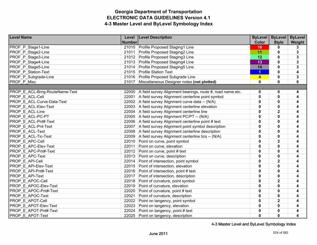
Georgia Department of TransportationELECTRONIC DATA GUIDELINES Version 4.1
4-3 Master Level and ByLevel Symbology Index
Level Name Level Level Description ByLevel ByLevel ByLevelNumber Color Style Weight
PROF_P_Stage1-Line 21010 Profile Proposed Staging1 Line 10 0 3PROF_P_Stage2-Line 21011 Profile Proposed Staging2 Line 11 0 3PROF_P_Stage3-Line 21012 Profile Proposed Staging3 Line 12 0 3PROF_P_Stage4-Line 21013 Profile Proposed Staging4 Line 13 0 3PROF_P_Stage5-Line 21014 Profile Proposed Staging5 Line 14 0 3PROF_P_Station-Text 21015 Profile Station Text 1 0 4PROF_P_Subgrade-Line 21016 Profile Proposed Subgrade Line 4 0 3PROF_P_Misc 21017 Miscellaneous Designer notes (not plotted) 0 0 0
PROP_E_ACL-Brng-RouteName-Text 22000 A field survey Alignment bearings, route #, road name.etc. 0 0 4PROP_E_ACL-Cell 22001 A field survey Alignment centerline point symbol 0 0 4PROP_E_ACL-Curve-Data-Text 22002 A field survey Alignment curve data -- (N/A) 0 0 4PROP_E_ACL-Elev-Text 22003 A field survey Alignment centerline elevation 0 0 4PROP_E_ACL-Line 22004 A field survey Alignment centerline line 0 2 4PROP_E_ACL-PC-PT 22005 A field survey Alignment PC/PT -- (N/A) 0 0 4PROP_E_ACL-Pnt#-Text 22006 A field survey Alignment centerline point # text 0 0 4PROP_E_ACL-Pnt-Text 22007 A field survey Alignment point symbol description 0 0 4PROP_E_ACL-Text 22008 A field survey Alignment centerline description 0 0 4PROP_E_ACL-Tic-Text 22009 A field survey Alignment centerline tics -- (N/A) 0 0 4PROP_E_APC-Cell 22010 Point on curve, point symbol 0 2 4PROP_E_APC-Elev-Text 22011 Point on curve, elevation 0 0 4
June 2011
4-3 Master Level and ByLevel Symbology Index
PROP_E_APC-Pnt#-Text 22012 Point on curve, point # text 0 0 4PROP_E_APC-Text 22013 Point on curve, description 0 0 4PROP_E_API-Cell 22014 Point of intersection, point symbol 0 2 4PROP_E_API-Elev-Text 22015 Point of intersection, elevation 0 0 4PROP_E_API-Pnt#-Text 22016 Point of intersection, point # text 0 0 4PROP_E_API-Text 22017 Point of intersection, description 0 0 4PROP_E_APOC-Cell 22018 Point of curvature, point symbol 0 2 4PROP_E_APOC-Elev-Text 22019 Point of curvature, elevation 0 0 4PROP_E_APOC-Pnt#-Text 22020 Point of curvature, point # text 0 0 4PROP_E_APOC-Text 22021 Point of curvature, description 0 0 4PROP_E_APOT-Cell 22022 Point on tangency, point symbol 0 2 4PROP_E_APOT-Elev-Text 22023 Point on tangency, elevation 0 0 4PROP_E_APOT-Pnt#-Text 22024 Point on tangency, point # text 0 0 4PROP_E_APOT-Text 22025 Point on tangency, description 0 0 4
June 2011
4-3 Master Level and ByLevel Symbology Index
524 of 582

Georgia Department of TransportationELECTRONIC DATA GUIDELINES Version 4.1
4-3 Master Level and ByLevel Symbology Index
Level Name Level Level Description ByLevel ByLevel ByLevelNumber Color Style Weight
PROP_E_APT-Cell 22026 Point of tangency, point symbol 0 2 4PROP_E_APT-Elev-Text 22027 Point of tangency, elevation 0 0 4PROP_E_APT-Pnt#-Text 22028 Point of tangency, point # text 0 0 4PROP_E_APT-Text 22029 Point of tangency, description 0 0 4PROP_E_BCOL-Cell 22030 County line, point symbol 2 6 4PROP_E_BCOL-Line 22031 County line, line 2 6 6PROP_E_BCOL-Pnt#-Alg-Name-Text 22032 County line, point # text, alignment name 2 0 4PROP_E_BCOL-Text 22033 County line, line description 2 0 4PROP_E_BCTL-Cell 22034 City limit line, point symbol 4 7 4PROP_E_BCTL-Line 22035 City limit line, line 4 7 0PROP_E_BCTL-Pnt#-Alg-Name-Text 22036 City limit line, point # text, alignment name 4 0 4PROP_E_BCTL-Text 22037 City limit line, line description 4 0 4PROP_E_BGMD-Cell 22038 Georgia militia district, point symbol 5 4 4PROP_E_BGMD-Line 22039 Georgia militia district, line 5 4 4PROP_E_BGMD-Pnt#-Alg-Name-Text 22040 Georgia militia district, point # text, alignment name 5 0 4PROP_E_BGMD-Text 22041 Georgia militia district, line description 5 0 4PROP_E_BLDL-Cell 22042 Land district line, point symbol 6 4 4PROP_E_BLDL-Line 22043 Land district line, line 6 4 4PROP_E_BLDL-Pnt#-Alg-Name-Text 22044 Land district line, point # text, alignment name 6 0 4PROP_E_BLDL-Text 22045 Land district line, line description 6 0 4PROP_E_BLLL-Cell 22046 Land lot line, point symbol 7 6 4
June 2011
4-3 Master Level and ByLevel Symbology Index
PROP_E_BLLL-Line 22047 Land lot line, line 7 6 4PROP_E_BLLL-Pnt#-Alg-Name-Text 22048 Land lot line, point # text, alignment name 7 0 4PROP_E_BLLL-Text 22049 Land lot line, line description 7 0 4PROP_E_BMISC-Cell 22050 Property boundary, miscellaneous, existing, point symbol 7 7 2PROP_E_BMISC-Line 22051 Property boundary line, existing, line 7 7 2PROP_E_BMISC-Pnt#-Alg-Name-Text 22052 Property boundary, miscellaneous, existing, point # text, 7 0 2
alignment namePROP_E_BMISC-Text 22053 Property boundary line, existing, line description 7 0 2PROP_E_BSL-Cell 22054 State line, point symbol 3 6 6PROP_E_BSL-Line 22055 State line, line 3 6 6PROP_E_BSL-Pnt#-Alg-Name-Text 22056 State line, point # text, alignment name 3 0 4PROP_E_BSL-Text 22057 State line, line description 3 0 4
June 2011
4-3 Master Level and ByLevel Symbology Index
525 of 582

Georgia Department of TransportationELECTRONIC DATA GUIDELINES Version 4.1
4-3 Master Level and ByLevel Symbology Index
Level Name Level Level Description ByLevel ByLevel ByLevelNumber Color Style Weight
PROP_E_PAROWN-Prop-Parcl-Text 22058 Property / Parcel owner name 0 0 3PROP_E_PAR-PL-Alg-Name-Text 22059 Property line alignment name 7 0 2PROP_E_PAR-PL-Cell 22060 Property line - cell 7 7 2PROP_E_PAR-PL-Line 22061 Property line line and PL cell 7 7 2PROP_E_PAR-PL-Text 22062 Property line line description 7 0 2PROP_E_PCF-Cell 22063 Property corner found point symbol 7 7 2PROP_E_PCF-Text 22064 Property corner found point # text 7 0 2PROP_E_POEL-Cell 22065 Easement line point symbol 0 3 2PROP_E_POEL-Line 22066 Easement line line 0 3 2PROP_E_POEL-Pnt#-Alg-Name-Text 22067 Easement line point # text, alignment name 0 0 2PROP_E_POEL-Text 22068 Easement line description 0 0 2PROP_E_PPC-Cell 22069 Property point computed point symbol 7 7 2PROP_E_PPC-Text 22070 Property point computed point # text 7 0 2PROP_E_PPOL-Cell 22071 Property point on line point symbol 7 7 2PROP_E_PPOL-Text 22072 Property point on line point # text 7 0 2PROP_E_RWC-Cell 22073 Right of way computed point symbol 4 7 2PROP_E_RWC-Text 22074 Right of way computed point # text 4 0 2PROP_E_RWE-Cell 22075 Right of way prescription point point symbol 4 7 3PROP_E_RWE-Line 22076 Existing Limited Access, R/W lines, and cells 0 7 3PROP_E_RWE-Text 22077 Right of way prescription point point # text 4 0 2PROP_E_RWM-Cell 22078 Right of way marker found point symbol 4 3 2
June 2011
4-3 Master Level and ByLevel Symbology Index
PROP_E_RWM-Text 22079 Right of way marker found point # text 4 3 2PROP_E_RWRR-Cell 22080 Right of way railroad point symbol 4 3 2PROP_E_RWRR-Line 22081 Right of way railroad line 4 3 2PROP_E_RWRR-Pnt#-Alg-Name-Text 22082 Right of way railroad point # text, alignment name 4 0 2PROP_E_RWRR-Text 22083 Right of way railroad line description 4 0 2PROP_E_RWU-Cell 22084 Right of way utility company point symbol 4 3 2PROP_E_RWU-Line 22085 Right of way utility company line 4 3 2PROP_E_RWU-Pnt#-Alg-Name-Text 22086 Right of way utility company point # text, alignment name 4 0 2PROP_E_RWU-Text 22087 Right of way utility company line description 4 0 2
QTYS_P_Quantities-Line 23000 Quantities - Reserved for future development 0 0 0QTYS_P_Quantities-Text 23001 Quantities - Reserved for future development 0 0 0QTYS_P_Misc 23002 Miscellaneous Designer level (not plotted) 0 0 0
June 2011
4-3 Master Level and ByLevel Symbology Index
526 of 582

Georgia Department of TransportationELECTRONIC DATA GUIDELINES Version 4.1
4-3 Master Level and ByLevel Symbology Index
Level Name Level Level Description ByLevel ByLevel ByLevelNumber Color Style Weight
REQD_P_DWESMT-Alg-Name-Text 24000 Driveway alignment name 4 0 2REQD_P_DWESMT-Cell 24001 Required Driveway Esmt points/cell 4 0 2REQD_P_DWESMT-Desc-Text 24002 Driveway easement description and leader line 4 0 2REQD_P_DWESMT-Line 24003 Driveway easement lines 4 0 2REQD_P_DWESMT-Pattern 24004 Driveway easement patterning 4 0 1REQD_P_DWESMT-Pnt#-Text 24005 Driveway easement point # text and leader line 4 0 2REQD_P_DWESMT-Sta-Offset-Flag 24006 Driveway easement station and offsets flag 4 0 2REQD_P_North-East-Coord-Label-Text 24007 Northing / Easting coordinate label 0 0 2REQD_P_Parcel-Owner-#-Text 24008 Property / Parcel owner number 3 0 2REQD_P_Parcel-Owner-Text 24009 Property / Parcel owner name 3 0 2REQD_P_Parcel-Reqd-RW-Tract#-Text 24010 Required R/W tract number and sheet number reference 3 0 2REQD_P_Pattern-Shape 24011 Shapes for patterning 0 0 0REQD_P_PESMT-Alg-Name-Text 24012 Permanent easement alignment name 2 0 2REQD_P_PESMT-Cell 24013 Required Perm Esmt points/cell 2 0 2REQD_P_PESMT-Desc-Text 24014 Permanent easement description and leader line 2 0 2REQD_P_PESMT-Line 24015 Permanent easement lines 2 0 2REQD_P_PESMT-Pattern 24016 Permanent easement patterning 2 0 1REQD_P_PESMT-Pnt#-Text 24017 Permanent easement point # text and leader line 2 0 2REQD_P_PESMT-Sta-Offset-Flag 24018 Permanent easement station and offsets flag 2 0 2REQD_P_REQD-RW-Alg-Name-Text 24019 Required R/W alignment name 3 0 2REQD_P_REQD-RW-Cell 24020 Required R/W points/cell 3 0 4
June 2011
4-3 Master Level and ByLevel Symbology Index
REQD_P_REQD-RW-Desc-Text 24021 Required R/W description and leader line 3 0 3REQD_P_REQD-RW-Line 24022 Required R/W lines 3 0 4REQD_P_REQD-RW-Ltd-Access 24023 Required limited access R/W lines and cells 3 0 4REQD_P_REQD-RW-Pnt#-Text 24024 Required R/W point # text and leader line 3 0 2REQD_P_REQD-RW-Sta-Offset-Flag 24025 Required R/W station and offsets flag 3 0 2REQD_P_RWRM-RW-Cell 24026 Required R/W Marker - cell 3 0 4REQD_P_RWRM-RW-Line 24027 Required R/W Marker - line 3 0 4REQD_P_RWRM-RW-Marker 24028 Required R/W Marker 3 0 4REQD_P_RWRM-RW-Text 24029 Required R/W Marker - text 3 0 2
June 2011
4-3 Master Level and ByLevel Symbology Index
527 of 582
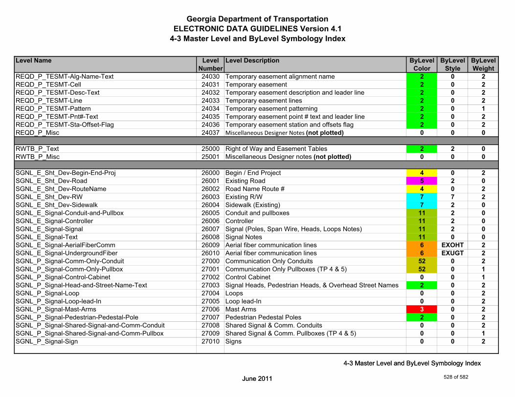
Georgia Department of TransportationELECTRONIC DATA GUIDELINES Version 4.1
4-3 Master Level and ByLevel Symbology Index
Level Name Level Level Description ByLevel ByLevel ByLevelNumber Color Style Weight
REQD_P_TESMT-Alg-Name-Text 24030 Temporary easement alignment name 2 0 2REQD_P_TESMT-Cell 24031 Temporary easement 2 0 2REQD_P_TESMT-Desc-Text 24032 Temporary easement description and leader line 2 0 2REQD_P_TESMT-Line 24033 Temporary easement lines 2 0 2REQD_P_TESMT-Pattern 24034 Temporary easement patterning 2 0 1REQD_P_TESMT-Pnt#-Text 24035 Temporary easement point # text and leader line 2 0 2REQD_P_TESMT-Sta-Offset-Flag 24036 Temporary easement station and offsets flag 2 0 2REQD_P_Misc 24037 Miscellaneous Designer Notes (not plotted) 0 0 0
RWTB_P_Text 25000 Right of Way and Easement Tables 2 2 0RWTB_P_Misc 25001 Miscellaneous Designer notes (not plotted) 0 0 0
SGNL_E_Sht_Dev-Begin-End-Proj 26000 Begin / End Project 4 0 2SGNL_E_Sht_Dev-Road 26001 Existing Road 5 2 0SGNL_E_Sht_Dev-RouteName 26002 Road Name Route # 4 0 2SGNL_E_Sht_Dev-RW 26003 Existing R/W 7 7 2SGNL_E_Sht_Dev-Sidewalk 26004 Sidewalk (Existing) 7 2 0SGNL_E_Signal-Conduit-and-Pullbox 26005 Conduit and pullboxes 11 2 0SGNL_E_Signal-Controller 26006 Controller 11 2 0SGNL_E_Signal-Signal 26007 Signal (Poles, Span Wire, Heads, Loops Notes) 11 2 0SGNL_E_Signal-Text 26008 Signal Notes 11 0 0
June 2011
4-3 Master Level and ByLevel Symbology Index
SGNL_E_Signal-AerialFiberComm 26009 Aerial fiber communication lines 6 EXOHT 2SGNL_E_Signal-UndergroundFiber 26010 Aerial fiber communication lines 6 EXUGT 2SGNL_P_Signal-Comm-Only-Conduit 27000 Communication Only Conduits 52 0 2SGNL_P_Signal-Comm-Only-Pullbox 27001 Communication Only Pullboxes (TP 4 & 5) 52 0 1SGNL_P_Signal-Control-Cabinet 27002 Control Cabinet 0 0 1SGNL_P_Signal-Head-and-Street-Name-Text 27003 Signal Heads, Pedestrian Heads, & Overhead Street Names 2 0 2SGNL_P_Signal-Loop 27004 Loops 0 0 2SGNL_P_Signal-Loop-lead-In 27005 Loop lead-In 0 0 2SGNL_P_Signal-Mast-Arms 27006 Mast Arms 3 0 2SGNL_P_Signal-Pedestrian-Pedestal-Pole 27007 Pedestrian Pedestal Poles 2 0 2SGNL_P_Signal-Shared-Signal-and-Comm-Conduit 27008 Shared Signal & Comm. Conduits 0 0 2SGNL_P_Signal-Shared-Signal-and-Comm-Pullbox 27009 Shared Signal & Comm. Pullboxes (TP 4 & 5) 0 0 1SGNL_P_Signal-Sign 27010 Signs 0 0 2
June 2011
4-3 Master Level and ByLevel Symbology Index
528 of 582
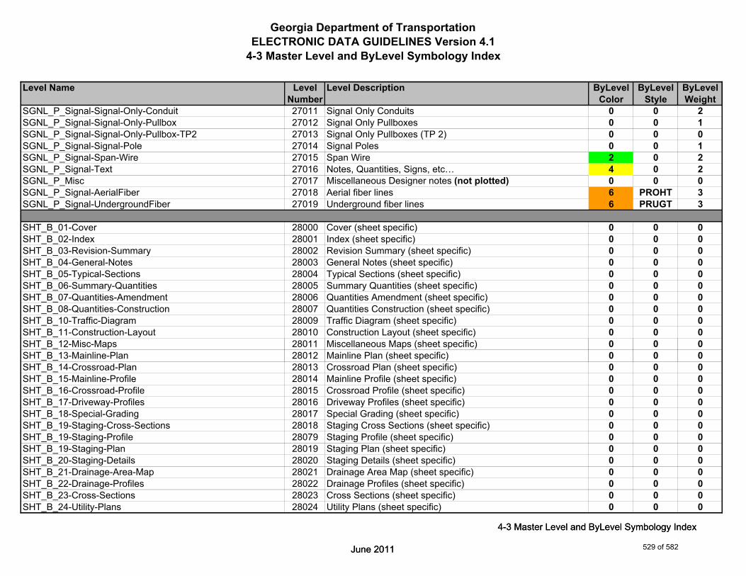
Georgia Department of TransportationELECTRONIC DATA GUIDELINES Version 4.1
4-3 Master Level and ByLevel Symbology Index
Level Name Level Level Description ByLevel ByLevel ByLevelNumber Color Style Weight
SGNL_P_Signal-Signal-Only-Conduit 27011 Signal Only Conduits 0 0 2SGNL_P_Signal-Signal-Only-Pullbox 27012 Signal Only Pullboxes 0 0 1SGNL_P_Signal-Signal-Only-Pullbox-TP2 27013 Signal Only Pullboxes (TP 2) 0 0 0SGNL_P_Signal-Signal-Pole 27014 Signal Poles 0 0 1SGNL_P_Signal-Span-Wire 27015 Span Wire 2 0 2SGNL_P_Signal-Text 27016 Notes, Quantities, Signs, etc… 4 0 2SGNL_P_Misc 27017 Miscellaneous Designer notes (not plotted) 0 0 0SGNL_P_Signal-AerialFiber 27018 Aerial fiber lines 6 PROHT 3SGNL_P_Signal-UndergroundFiber 27019 Underground fiber lines 6 PRUGT 3
SHT_B_01-Cover 28000 Cover (sheet specific) 0 0 0SHT_B_02-Index 28001 Index (sheet specific) 0 0 0SHT_B_03-Revision-Summary 28002 Revision Summary (sheet specific) 0 0 0SHT_B_04-General-Notes 28003 General Notes (sheet specific) 0 0 0SHT_B_05-Typical-Sections 28004 Typical Sections (sheet specific) 0 0 0SHT_B_06-Summary-Quantities 28005 Summary Quantities (sheet specific) 0 0 0SHT_B_07-Quantities-Amendment 28006 Quantities Amendment (sheet specific) 0 0 0SHT_B_08-Quantities-Construction 28007 Quantities Construction (sheet specific) 0 0 0SHT_B_10-Traffic-Diagram 28009 Traffic Diagram (sheet specific) 0 0 0SHT_B_11-Construction-Layout 28010 Construction Layout (sheet specific) 0 0 0SHT_B_12-Misc-Maps 28011 Miscellaneous Maps (sheet specific) 0 0 0
June 2011
4-3 Master Level and ByLevel Symbology Index
SHT_B_13-Mainline-Plan 28012 Mainline Plan (sheet specific) 0 0 0SHT_B_14-Crossroad-Plan 28013 Crossroad Plan (sheet specific) 0 0 0SHT_B_15-Mainline-Profile 28014 Mainline Profile (sheet specific) 0 0 0SHT_B_16-Crossroad-Profile 28015 Crossroad Profile (sheet specific) 0 0 0SHT_B_17-Driveway-Profiles 28016 Driveway Profiles (sheet specific) 0 0 0SHT_B_18-Special-Grading 28017 Special Grading (sheet specific) 0 0 0SHT_B_19-Staging-Cross-Sections 28018 Staging Cross Sections (sheet specific) 0 0 0SHT_B_19-Staging-Profile 28079 Staging Profile (sheet specific) 0 0 0SHT_B_19-Staging-Plan 28019 Staging Plan (sheet specific) 0 0 0SHT_B_20-Staging-Details 28020 Staging Details (sheet specific) 0 0 0SHT_B_21-Drainage-Area-Map 28021 Drainage Area Map (sheet specific) 0 0 0SHT_B_22-Drainage-Profiles 28022 Drainage Profiles (sheet specific) 0 0 0SHT_B_23-Cross-Sections 28023 Cross Sections (sheet specific) 0 0 0SHT_B_24-Utility-Plans 28024 Utility Plans (sheet specific) 0 0 0
June 2011
4-3 Master Level and ByLevel Symbology Index
529 of 582
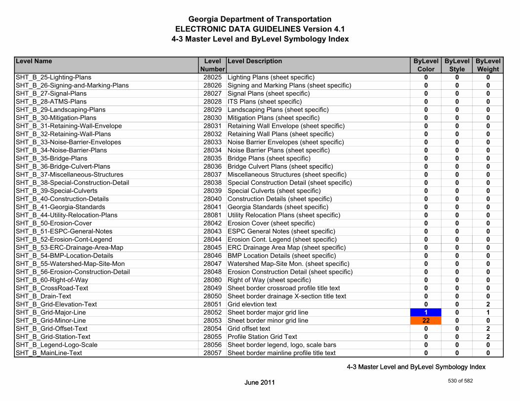
Georgia Department of TransportationELECTRONIC DATA GUIDELINES Version 4.1
4-3 Master Level and ByLevel Symbology Index
Level Name Level Level Description ByLevel ByLevel ByLevelNumber Color Style Weight
SHT_B_25-Lighting-Plans 28025 Lighting Plans (sheet specific) 0 0 0SHT_B_26-Signing-and-Marking-Plans 28026 Signing and Marking Plans (sheet specific) 0 0 0SHT_B_27-Signal-Plans 28027 Signal Plans (sheet specific) 0 0 0SHT_B_28-ATMS-Plans 28028 ITS Plans (sheet specific) 0 0 0SHT_B_29-Landscaping-Plans 28029 Landscaping Plans (sheet specific) 0 0 0SHT_B_30-Mitigation-Plans 28030 Mitigation Plans (sheet specific) 0 0 0SHT_B_31-Retaining-Wall-Envelope 28031 Retaining Wall Envelope (sheet specific) 0 0 0SHT_B_32-Retaining-Wall-Plans 28032 Retaining Wall Plans (sheet specific) 0 0 0SHT_B_33-Noise-Barrier-Envelopes 28033 Noise Barrier Envelopes (sheet specific) 0 0 0SHT_B_34-Noise-Barrier-Plans 28034 Noise Barrier Plans (sheet specific) 0 0 0SHT_B_35-Bridge-Plans 28035 Bridge Plans (sheet specific) 0 0 0SHT_B_36-Bridge-Culvert-Plans 28036 Bridge Culvert Plans (sheet specific) 0 0 0SHT_B_37-Miscellaneous-Structures 28037 Miscellaneous Structures (sheet specific) 0 0 0SHT_B_38-Special-Construction-Detail 28038 Special Construction Detail (sheet specific) 0 0 0SHT_B_39-Special-Culverts 28039 Special Culverts (sheet specific) 0 0 0SHT_B_40-Construction-Details 28040 Construction Details (sheet specific) 0 0 0SHT_B_41-Georgia-Standards 28041 Georgia Standards (sheet specific) 0 0 0SHT_B_44-Utility-Relocation-Plans 28081 Utility Relocation Plans (sheet specific) 0 0 0SHT_B_50-Erosion-Cover 28042 Erosion Cover (sheet specific) 0 0 0SHT_B_51-ESPC-General-Notes 28043 ESPC General Notes (sheet specific) 0 0 0SHT_B_52-Erosion-Cont-Legend 28044 Erosion Cont. Legend (sheet specific) 0 0 0
June 2011
4-3 Master Level and ByLevel Symbology Index
SHT_B_53-ERC-Drainage-Area-Map 28045 ERC Drainage Area Map (sheet specific) 0 0 0SHT_B_54-BMP-Location-Details 28046 BMP Location Details (sheet specific) 0 0 0SHT_B_55-Watershed-Map-Site-Mon 28047 Watershed Map-Site Mon. (sheet specific) 0 0 0SHT_B_56-Erosion-Construction-Detail 28048 Erosion Construction Detail (sheet specific) 0 0 0SHT_B_60-Right-of-Way 28080 Right of Way (sheet specific) 0 0 0SHT_B_CrossRoad-Text 28049 Sheet border crossroad profile title text 0 0 0SHT_B_Drain-Text 28050 Sheet border drainage X-section title text 0 0 0SHT_B_Grid-Elevation-Text 28051 Grid elevtion text 0 0 2SHT_B_Grid-Major-Line 28052 Sheet border major grid line 1 0 1SHT_B_Grid-Minor-Line 28053 Sheet border minor grid line 22 0 0SHT_B_Grid-Offset-Text 28054 Grid offset text 0 0 2SHT_B_Grid-Station-Text 28055 Profile Station Grid Text 0 0 2SHT_B_Legend-Logo-Scale 28056 Sheet border legend, logo, scale bars 0 0 0SHT_B_MainLine-Text 28057 Sheet border mainline profile title text 0 0 0
June 2011
4-3 Master Level and ByLevel Symbology Index
530 of 582

Georgia Department of TransportationELECTRONIC DATA GUIDELINES Version 4.1
4-3 Master Level and ByLevel Symbology Index
Level Name Level Level Description ByLevel ByLevel ByLevelNumber Color Style Weight
SHT_B_Major-Elevation-Tic-Line 28058 Elevation tick marks major 3 0 2SHT_B_Major-Offset-Tic-Line 28059 X-Section Offset Tick Marks major 3 0 2SHT_B_Major-Station-Tic-Line 28060 Profile Station Tick Marks major 3 0 2SHT_B_Match-Lines-Line 28061 Sheet border match line lines 6 0 4SHT_B_Match-Lines-Text 28062 Sheet border match line text 4 0 3SHT_B_Minor-Elevation-Tic-Line 28063 Elevation tick marks minor 3 0 0SHT_B_Minor-Offset-Tic-Line 28064 X-Section Offset Tick Marks minor 3 0 0SHT_B_Minor-Station-Tic-Line 28065 Profile Station Tick Marks minor 3 0 0SHT_B_Misc-NP 28066 Sheet border miscellaneous items, notes, etc. (not plotted) 0 0 0SHT_B_Misc-P 28067 Sheet border miscellaneous items, notes, etc. (plotted) 0 0 0SHT_B_North-Arrow 28068 Sheet border north arrow 0 0 0SHT_B_Plot-Sub-Text 28069 Sheet border plot substitution text 0 0 0SHT_B_Plotting-Info-Tags 28070 Sheet border plotting information tags 0 0 0SHT_B_Right-of-Way 28071 Right-of-Way (sheet specific) 0 0 0SHT_B_Sheet-Outline-Line 28072 Sheet border sheet outline lines 0 0 0SHT_B_Sheet-Outline-Text 28073 Sheet border sheet outline text 0 0 0SHT_B_Stage-Text 28074 Sheet border staging X-section title text 0 0 0SHT_B_Title-Block 28075 Sheet border title block 0 0 0SHT_B_Xsec-Text 28076 Sheet border earthwork X-section title text 0 0 0SHT_P_Major-Station-Tic-Line 28077 Profile Station Tick Marks 0 0 2SHT_P_Minor-Station-Tic-Line 28078 Profile Station Tick Marks 0 0 0
June 2011
4-3 Master Level and ByLevel Symbology Index
SHT_B_Clip-Border-Cell 28082 Clip border - cell 4 0 2SHT_B_Clip-Border-Line 28083 Clip border - line 4 0 2SHT_B_Clip-Border-Text 28084 Clip border - text 4 0 2SHT_B_Clip-Border-Inner-Line 28085 Plot border inner line 4 0 6SHT_B_Plot-Border-Outer-Line 28086 Plot border outer line 2 0 0SHT_B_Summary-Quantities-Cell 28087 Summary Quantities - cell 2 0 0SHT_B_Summary-Quantities-Line 28088 Summary Quantities - line 2 0 0SHT_B_Summary-Quantities-Text 28089 Summary Quantities - text 2 0 0
SIGN_E_Sht_Dev-Begin-End-Proj 29000 Begin / End project 4 0 2SIGN_E_Sht_Dev-Road 29001 Existing road 5 2 0SIGN_E_Sht_Dev-RouteName-Text 29002 Road name route # 4 0 2SIGN_E_Sht_Dev-RW 29003 Existing R/W 7 7 2SIGN_E_SM-Cell 29004 Signs and symbols 12 0 0
June 2011
4-3 Master Level and ByLevel Symbology Index
531 of 582
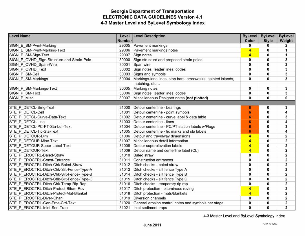
Georgia Department of TransportationELECTRONIC DATA GUIDELINES Version 4.1
4-3 Master Level and ByLevel Symbology Index
Level Name Level Level Description ByLevel ByLevel ByLevelNumber Color Style Weight
SIGN_E_SM-Pvmt-Marking 29005 Pavement markings 0 0 2SIGN_E_SM-Pvmt-Marking-Text 29006 Pavement markings notes 4 0 1SIGN_E_SM-Sign-Text 29007 Sign notes 4 0 1SIGN_P_OVHD_Sign-Structure-and-Strain-Pole 30000 Sign structure and proposed strain poles 0 0 3SIGN_P_OVHD_Span-Wire 30001 Span wire 0 0 2SIGN_P_OVHD_Text 30002 Sign notes, leader lines, codes 0 0 3SIGN_P_SM-Cell 30003 Signs and symbols 0 0 3SIGN_P_SM-Markings 30004 Markings-lane lines, stop bars, crosswalks, painted islands, 0 0 3
hatching, etc…SIGN_P_SM-Markings-Text 30005 Marking notes 0 0 3SIGN_P_SM-Text 30006 Sign notes, leader lines, codes 0 0 3SIGN_P_Misc 30007 Miscellaneous Designer notes (not plotted) 0 0 0
STE_P_DETCL-Brng-Text 31000 Detour centerline - bearings 6 0 3STE_P_DETCL-Cell 31001 Detour centerline - point symbols 6 0 4STE_P_DETCL-Curve-Data-Text 31002 Detour centerline - curve label & data table 6 0 3STE_P_DETCL-Line 31003 Detour centerline - lines 6 0 4STE_P_DETCL-PC-PT-Sta-Ldr-Text 31004 Detour centerline - PC/PT station labels w/Flags 6 0 3STE_P_DETCL-Tic-Sta-Text 31005 Detour centerline - tic marks and sta labels 6 0 4STE_P_DETOUR-Dim 31006 Detour and travelway dimensions 4 0 2STE_P_DETOUR-Misc-Text 31007 Miscellaneous detail information 4 0 2
June 2011
4-3 Master Level and ByLevel Symbology Index
STE_P_DETOUR-Super-Label-Text 31008 Detour superelevation labels 4 0 2STE_P_DETOUR-Text 31009 Detour name and centerline label (CL) 4 0 2STE_P_EROCTRL-Baled-Straw 31010 Baled straw 0 0 2STE_P_EROCTRL-Const-Entrance 31011 Construction entrances 0 0 2STE_P_EROCTRL-Ditch-Chk-Baled-Straw 31012 Ditch checks - baled straw 0 0 2STE_P_EROCTRL-Ditch-Chk-Silt-Fence-Type-A 31013 Ditch checks - silt fence Type A 0 0 2STE_P_EROCTRL-Ditch-Chk-Silt-Fence-Type-B 31014 Ditch checks - silt fence Type B 0 0 2STE_P_EROCTRL-Ditch-Chk-Silt-Fence-Type-C 31015 Ditch checks - silt fence Type C 0 0 2STE_P_EROCTRL-Ditch-Chk-Temp-Rip-Rap 31016 Ditch checks - temporary rip rap 0 0 2STE_P_EROCTRL-Ditch-Protect-Bitum-Rov 31017 Ditch protection - bituminous roving 4 0 2STE_P_EROCTRL-Ditch-Protect-Mat-Blanket 31018 Ditch protection - mats/blankets 4 0 2STE_P_EROCTRL-Diver-Chanl 31019 Diversion channels 0 0 2STE_P_EROCTRL-Gen-Eros-Ctrl-Text 31020 General erosion control notes and symbols per stage 0 0 2STE_P_EROCTRL-Inlet-Sed-Trap 31021 Inlet sediment traps 0 0 2
June 2011
4-3 Master Level and ByLevel Symbology Index
532 of 582

Georgia Department of TransportationELECTRONIC DATA GUIDELINES Version 4.1
4-3 Master Level and ByLevel Symbology Index
Level Name Level Level Description ByLevel ByLevel ByLevelNumber Color Style Weight
STE_P_EROCTRL-Silt-Ctrl-Gate 31022 Silt control gates 0 0 2STE_P_EROCTRL-Silt-Fence-Type-A 31023 Silt fence - Type A 0 0 2STE_P_EROCTRL-Silt-Fence-Type-B 31024 Silt fence - Type B 0 0 2STE_P_EROCTRL-Silt-Fence-Type-C 31025 Silt fence - Type C 0 0 2STE_P_EROCTRL-Silt-Reten-Barrier 31026 Silt retention barrier (floating or staked) 0 0 2STE_P_EROCTRL-Slope-Stabil 31027 Slope stabilization mats/blankets/geogrid 0 0 2STE_P_EROCTRL-Temp-Earth-Berm 31028 Temporary earth berm 0 0 2STE_P_EROCTRL-Temp-Pipe-Slope-Drain 31029 Temporary pipe slope drains 0 0 2STE_P_STGD-Const-Limit 31030 Staged const. details - construction Limits 0 0 2STE_P_STGD-Current-Stage-Hatch 31031 Staged const. details - current stage hatching (const. & 0 0 1
removal)STE_P_STGD-Current-Stage-Text 31032 Staged const. details - current stage labels and travelway 0 0 2
dimensionsSTE_P_STGD-Misc 31033 Staged const. details - miscellaneous 0 0 2STE_P_STGD-Narrative-Text 31034 Staged const. details - sequence of construction narrative 0 0 3STE_P_STGD-Temp-Barrier 31035 Staged const. details - temp. barrier/barricades 0 0 3STE_P_STGD-Temp-Drain-Struct 31036 Staged const. details - temp. drainage structures 0 0 0STE_P_STGD-Temp-Drain-Struct-Text 31037 Staged const. details - temp. drainage structures - 0 0 2
descriptionsSTE_P_STGD-Temp-Pvmt-Widen 31038 Staged const. details - temp. pavement/widening 0 0 2STE_P_STGD-Traf-Flow-Arrow 31039 Staged const. details - traffic flow arrows and edge of 0 0 3
June 2011
4-3 Master Level and ByLevel Symbology Index
travelwaySTE_P_Misc 31040 Miscellaneous Designer notes (not plotted) 0 0 0STE_P_STGD-Current-Stage-Hatch-Removal 31041 To be removed cross hatching 3 1 0STE_P_STGD-Current-Stage-Hatch-Perm-Pvmt 31042 Permanent pavement hatching 4 3 0STE_P_STGD-Current-Stage-Hatch-Conc-Median 31043 Concrete median hatching 1 4 0STE_P_STGD-Current-Stage-Hatch-Mill-Overlay 31044 Mill and Overlay hatching 5 5 0STE_P_STGD-Current-Stage-Hatch-Temp-Pvmt 31045 Temporary pavement hatching 2 2 0
STE_P_EROCTRL-A 31050 Erosion Control Linestyle A 4 A 2STE_P_EROCTRL-B 31051 Erosion Control Linestyle B 4 B 2STE_P_EROCTRL-Be 31052 Erosion Control Linestyle Be 4 Be 2STE_P_EROCTRL-C 31053 Erosion Control Linestyle C 4 C 2STE_P_EROCTRL-Ch-Br 31054 Erosion Control Linestyle Ch-Br (Bituminous Treated Roving) 4 Ch-Br-20 2STE_P_EROCTRL-Ch-C 31055 Erosion Control Linestyle Ch-C (Channel Concrete) 4 Ch-C-20 2
June 2011
4-3 Master Level and ByLevel Symbology Index
533 of 582

Georgia Department of TransportationELECTRONIC DATA GUIDELINES Version 4.1
4-3 Master Level and ByLevel Symbology Index
Level Name Level Level Description ByLevel ByLevel ByLevelNumber Color Style Weight
STE_P_EROCTRL-Ch-PSRM 31056 Erosion Control Linestyle Ch-PSRM (Channel Perm Soil 4 Ch-PSRM 2 Rein Mat)
STE_P_EROCTRL-Ch-Rp1 31057 Erosion Control Linestyle Ch-Rp1 (Channel Rip Rap Type 1) 4 Ch-Rp1 2STE_P_EROCTRL-Ch-Rp3 31058 Erosion Control Linestyle Ch-Rp3 (Channel Rip Rap Type 3) 4 Ch-Rp3 2STE_P_EROCTRL-Ch-TRM1 31059 Erosion Control Linestyle Ch-TRM1 4 Ch-TRM1-20 2STE_P_EROCTRL-Ch-TRM2 31060 Erosion Control Linestyle Ch-TRM2 4 Ch-TRM2-20 2STE_P_EROCTRL-Ch-V 31061 Erosion Control Linestyle Ch-V 4 Ch-V 2STE_P_EROCTRL-Di 31062 Erosion Control Linestyle Di (Diversion Channel) 4 Di 2STE_P_EROCTRL-Dc-A 31063 Erosion Control Linestyle Dc-A (Diversion Channel Type A) 4 Dc-A 2STE_P_EROCTRL-Dc-B 31064 Erosion Control Linestyle Dc-B (Diversion Channel Type B) 4 Dc-B 2STE_P_EROCTRL-Dc-C 31065 Erosion Control Linestyle Dc-C (Diversion Channel Type C) 4 Dc-C 2STE_P_EROCTRL-Dn1 31066 Erosion Control Linestyle Dn1 (Down Drain Flexible) 4 Dn1 2STE_P_EROCTRL-Dn2-A 31067 Erosion Control Linestyle Dn2-A (Down Drain Concrete) 4 Dn2-20 2STE_P_EROCTRL-Dn2-B 31068 Erosion Control Linestyle Dn2-B (Down Drain Concrete) 4 Dn2B-20 2STE_P_EROCTRL-Dn2-1 31069 Erosion Control Linestyle Dn2-1 (Down Drain Conc. Type 1) 4 Dn21 2STE_P_EROCTRL-Dn2-2 31070 Erosion Control Linestyle Dn2-2 (Down Drain Conc. Type 2) 4 Dn22 2STE_P_EROCTRL-Dn3 31071 Erosion Control Linestyle Dn3 (Down Drain Metal) 4 Dn3 2STE_P_EROCTRL-Ds1 31072 Erosion Control Linestyle Ds1 (Temporary Mulch) 4 Ds1 2STE_P_EROCTRL-Ds2 31073 Erosion Control Linestyle Ds3 (Temporary Grassing) 4 Ds2 2STE_P_EROCTRL-Fe 31074 Erosion Control Linestyle Fe (Fence) 4 Fe 2STE_P_EROCTRL-Rdc 31075 Erosion Control Linestyle Rdc (Rip Rap Check Dams) 4 Rdc 2
June 2011
4-3 Master Level and ByLevel Symbology Index
STE_P_EROCTRL-Ps 31076 Erosion Control Linestyle Ps (Permanent Soil Reinf. Mat) 4 PSRM 2STE_P_EROCTRL-S 31077 Erosion Control Linestyle S 4 S 2STE_P_EROCTRL-Sb 31078 Erosion Control Linestyle Sb (Silt Retention Barrier) 4 Sb 2STE_P_EROCTRL-SbF 31079 Erosion Control Linestyle SbF (Silt Ret. Barrier Floating) 4 Sb-F 2STE_P_EROCTRL-SbS 31080 Erosion Control Linestyle SbS (Silt Ret. Barrier Stacked) 4 Sb-S 2STE_P_EROCTRL-Sd1-A 31081 Erosion Control Linestyle Sd1-A (Silt Fence Type A) 4 Sd1-A 2STE_P_EROCTRL-Sd1-B 31082 Erosion Control Linestyle Sd1-B (Silt Fence Type B) 4 Sd1-B 2STE_P_EROCTRL-Sd1-Bb 31083 Erosion Control Linestyle Sd1-Bb (Brush Barrier) 4 Sd1-Bb 2STE_P_EROCTRL-Sd1-C 31084 Erosion Control Linestyle Sd1-C (Silt Fence Type C) 4 Sd1-C 2STE_P_EROCTRL-Sd1-Hb 31085 Erosion Control Linestyle Sd1-Hb (Sediment Barrier) 4 Sd1-Hb 2STE_P_EROCTRL-Su 31086 Erosion Control Linestyle Su (Serrated Slopes) 4 Su 2STE_P_EROCTRL-T 31087 Erosion Control Linestyle T 4 T 2
June 2011
4-3 Master Level and ByLevel Symbology Index
534 of 582

Georgia Department of TransportationELECTRONIC DATA GUIDELINES Version 4.1
4-3 Master Level and ByLevel Symbology Index
Level Name Level Level Description ByLevel ByLevel ByLevelNumber Color Style Weight
STE_P_Temporary-Sediment-Basin-Line 31088 Temporary Sediment basin lines 4 0 2STE_P_Temporary-Sediment-Basin-Pnt-Symbol 31089 Temporary Sediment basins point symbol 0 0 0STE_P_Temporary-Sediment-Basin-Pnt-Text 31090 Temporary Sediment basins point # text 0 0 0STE_P_Temporary-Sediment-Basin-Text 31091 Temporary Sediment basin description 4 0 2
TOPO_E_DADB-Cell 32000 Dam, toe point symbol, # text, description, elevation 11 2 0TOPO_E_DADB-Line 32001 Dam, toe line 11 2 0TOPO_E_DADB-Text 32002 Dam, toe line description 11 0 0TOPO_E_DCB-Cell 32003 K65 Single catch basin existing point symbol, # text, 1 2 0
description, elevationTOPO_E_DCB-Line 32004 K65 Single catch basin existing point cell 1 2 0TOPO_E_DCB-Text 32005 Single catch basin existing description (Elevation, type, 1 0 0
size, etc.)TOPO_E_DCEF-Cell 32006 Culvert end, F/L point symbol, # text, description, elevation 1 2 0TOPO_E_DCEF-Line 32007 Culvert end, F/L cell 1 2 0TOPO_E_DCEF-Text 32008 Culvert end, F/L line description (Elevation, type, size, etc.) 1 0 0TOPO_E_DCWE-Cell 32009 Culvert, wingwall end point symbol, # text, description, 1 2 0
elevationTOPO_E_DCWE-Line 32010 Culvert, wingwall end line/cell 1 2 0TOPO_E_DCWE-Text 32011 Culvert, wingwall end line description (Elevation, type, size, 1 0 0
etc.)
June 2011
4-3 Master Level and ByLevel Symbology Index
TOPO_E_DDCB-Cell 32012 Double catch basin existing point symbol, # text, 1 2 0 description, elevation
TOPO_E_DDCB-Line 32013 Double catch basin existing point cell 1 2 0TOPO_E_DDCB-Text 32014 Double catch basin existing description (Elevation, type, 1 0 0
size, etc.)TOPO_E_DDI-Cell 32015 K68a K68b Drop inlet, top, existing point symbol, # text, 1 2 0
description, elevationTOPO_E_DDI-Line 32016 Drop inlet, top, existing cell 1 2 0TOPO_E_DDI-Text 32017 Drop inlet, top, existing description (Elevation, type, size, 1 0 0
etc.)
Photogrammetric mapping codes are shown in italics in thedescription field for topography levels. These codes are foruse by the Department's Photogrammetry Office ONLY.
June 2011
4-3 Master Level and ByLevel Symbology Index
535 of 582

Georgia Department of TransportationELECTRONIC DATA GUIDELINES Version 4.1
4-3 Master Level and ByLevel Symbology Index
Level Name Level Level Description ByLevel ByLevel ByLevelNumber Color Style Weight
TOPO_E_DDL-Cell 32018 Drain lines - cell 1 2 0TOPO_E_DDL-Line 32019 Drain lines - line 1 2 0TOPO_E_DDL-Text 32020 Drain lines - text 1 0 0TOPO_E_DDT-Cell 32021 Dam, top point symbol, # text, description, elevation 6 0 0TOPO_E_DDT-Line 32022 K28 Dam, top line 6 0 1TOPO_E_DDT-Text 32023 Dam, top line description 6 0 0TOPO_E_DEW-Cell 32024 Edge of water, existing point symbol, # text, description, 1 0 0
elevationTOPO_E_DEW-Line 32025 K49 K151 K160 K162 Edge of water, existing line 1 3 4TOPO_E_DEW-Hatch-Line 32507 Edge of water, existing line 1 0 0TOPO_E_DEW-Text 32026 Edge of water, existing line description (Elevation, type, 1 0 0
size, etc.)TOPO_E_DHWE-Cell 32027 K67a K67b K69 Head wall, end, existing point symbol, 1 2 0
# text, description, elevationTOPO_E_DHWE-Line 32028 Head wall, end, existing cell 1 2 0TOPO_E_DHWE-Text 32029 Head wall, end, existing line description (Elevation, type, 1 0 0
size, etc.)TOPO_E_DHWM-Cell 32030 High water mark - cell 1 2 0TOPO_E_DHWM-Line 32031 High water mark - line 1 2 0TOPO_E_DHWM-Text 32032 High water mark - text 1 0 0TOPO_E_DJB-Cell 32033 Junction box, top, existing point symbol, # text, description, 1 2 0
June 2011
4-3 Master Level and ByLevel Symbology Index
elevationTOPO_E_DJB-Line 32034 Junction box, top, existing cell 1 2 0TOPO_E_DJB-Text 32035 Junction box, top, existing line description (Elevation, type, 1 0 0
size, etc.)TOPO_E_DMISC-Cell 32036 Misc. drainage feature, existing point symbol, # text, 1 2 0
description, elevationTOPO_E_DMISC-Line 32037 Misc. drainage feature, existing line 1 2 0TOPO_E_DMISC-Text 32038 Misc. drainage feature, existing line description (Elevation, 1 0 0
type, size, etc.)
Photogrammetric mapping codes are shown in italics in thedescription field for topography levels. These codes are foruse by the Department's Photogrammetry Office ONLY.
June 2011
4-3 Master Level and ByLevel Symbology Index
536 of 582

Georgia Department of TransportationELECTRONIC DATA GUIDELINES Version 4.1
4-3 Master Level and ByLevel Symbology Index
Level Name Level Level Description ByLevel ByLevel ByLevelNumber Color Style Weight
TOPO_E_DOBSC-Cell 32039 Obscured area - cell 3 3 4TOPO_E_DOBSC-Line 32040 Obscured area - line 3 3 4TOPO_E_DOBSC-Text 32041 Obscured area - text 3 0 0TOPO_E_DPC-Cell 32042 Drainage pipe, F/L, C - cell 1 6 0TOPO_E_DPC-Line 32043 Drainage pipe, F/L, C - line 1 6 0TOPO_E_DPC-Text 32044 Drainage pipe, F/L, C - text 1 0 0TOPO_E_DPD-Cell 32045 Paved ditch - cell 7 3 0TOPO_E_DPD-Line 32046 K63 Paved ditch - line 7 3 0TOPO_E_DPD-Text 32047 Paved ditch - text 7 0 0TOPO_E_DPM-Cell 32048 Drainage pipe, F/L, M - cell 1 6 0TOPO_E_DPM-Line 32049 Drainage pipe, F/L, M - line 1 6 0TOPO_E_DPM-Text 32050 Drainage pipe, F/L, M - text 1 0 0TOPO_E_DPP-Cell 32051 Drainage pipe, F/L, P - cell 1 6 0TOPO_E_DPP-Line 32052 Drainage pipe, F/L, P - line 1 6 0TOPO_E_DPP-Text 32053 Drainage pipe, F/L, P - text 1 0 0TOPO_E_DSB-Cell 32054 Stream bank top, existing point symbol, # text, description, 1 2 0
elevationTOPO_E_DSB-Line 32055 Stream bank top, existing line 1 2 0TOPO_E_DSB-Text 32056 Stream bank top, existing line description (Elevation, type, 1 0 0
size, etc.)TOPO_E_DSC-Cell 32057 Stream center F/L, existing point symbol, # text, 1 6 0
June 2011
4-3 Master Level and ByLevel Symbology Index
description, elevationTOPO_E_DSC-Line 32058 Stream center F/L, existing line 1 6 0TOPO_E_DSC-Text 32059 Stream center F/L, existing line description (Elevation, type, 1 0 0
size, etc.)TOPO_E_DSE-Cell 32060 Stream edge, existing point symbol, # text, description, 1 3 0
elevationTOPO_E_DSE-Line 32061 K41 K42 Stream edge, existing line 1 3 4TOPO_E_DSE-Text 32062 Stream edge, existing line description (Elevation, type, size, 1 0 0
etc.)
Photogrammetric mapping codes are shown in italics in thedescription field for topography levels. These codes are foruse by the Department's Photogrammetry Office ONLY.
June 2011
4-3 Master Level and ByLevel Symbology Index
537 of 582

Georgia Department of TransportationELECTRONIC DATA GUIDELINES Version 4.1
4-3 Master Level and ByLevel Symbology Index
Level Name Level Level Description ByLevel ByLevel ByLevelNumber Color Style Weight
TOPO_E_DSPURDK-Cell 32063 Spur dike, existing point symbol, # text, description, 11 2 0 elevation
TOPO_E_DSPURDK-Line 32064 Spur dike, existing line 11 2 0TOPO_E_DSPURDK-Text 32065 Spur dike, existing line description (Elevation, type, size, 11 0 0
etc.)TOPO_E_DSTC-Cell 32066 Septic tank - cell 2 0 1TOPO_E_DSTC-Line 32067 Septic tank - line 2 0 2TOPO_E_DSTC-Text 32068 Septic tank - text 2 0 2TOPO_E_DSWE-Cell 32069 K51 K54 Swamp edge, existing point symbol, # text, 1 2 0
description, elevationTOPO_E_DSWE-Line 32070 Swamp edge, existing line 1 2 0TOPO_E_DSWE-Text 32071 Swamp edge, existing line description (Elevation, type, size, 1 0 0
etc.)TOPO_E_DWB-Cell 32072 Wetland boundary - cell 0 0 0TOPO_E_DWB-Line 32073 Wetland boundary - line 0 0 0TOPO_E_DWB-Text 32074 Wetland boundary - text 0 0 0TOPO_E_DWE-Cell 32075 Top of water elevations, existing point symbol, # text, 1 2 0
description, elevationTOPO_E_DWE-Line 32076 Top of water elevations, existing line 1 2 0TOPO_E_DWE-Text 32077 Top of water elevations, existing line description (Elevation, 1 0 0
type, size, etc.)
June 2011
4-3 Master Level and ByLevel Symbology Index
TOPO_E_MDITCHFL-Cell 32078 Map ditch flow line - cell 1 6 0TOPO_E_MDITCHFL-Line 32079 K43 K151 Map ditch flow line - line 1 6 0TOPO_E_MDITCHFL-Text 32080 Map ditch flow line - text 1 0 0TOPO_E_MISC-Cell 32081 Miscellaneous - cell 0 2 0TOPO_E_MISC-Line 32082 Miscellaneous - line 0 2 0TOPO_E_MISC-Text 32083 K59 K88a Miscellaneous - text 0 0 0TOPO_E_MJLL-Cell 32084 Map job limit line - cell 5 0 0TOPO_E_MJLL-Line 32085 K150 Map job limit line - line 5 0 0TOPO_E_MJLL-Text 32086 Map job limit line - text 5 0 0
Photogrammetric mapping codes are shown in italics in thedescription field for topography levels. These codes are foruse by the Department's Photogrammetry Office ONLY.
June 2011
4-3 Master Level and ByLevel Symbology Index
538 of 582

Georgia Department of TransportationELECTRONIC DATA GUIDELINES Version 4.1
4-3 Master Level and ByLevel Symbology Index
Level Name Level Level Description ByLevel ByLevel ByLevelNumber Color Style Weight
TOPO_E_MOBSC-Cell 32087 Map obscure area - cell 3 3 4TOPO_E_MOBSC-Line 32088 K50 K159 Map obscure area - line 3 3 4TOPO_E_MOBSC-Text 32089 Map obscure area - text 3 0 0TOPO_E_MPCKGRD-Cell 32090 Map check ground - cell 3 0 0TOPO_E_MPCKGRD-Line 32091 Map check ground - line 3 0 0TOPO_E_MPCKGRD-Text 32092 Map check ground - text 3 0 0TOPO_E_MPCKPAV-Cell 32093 Map check pavement - cell 7 0 0TOPO_E_MPCKPAV-Line 32094 Map check pavement - line 7 0 0TOPO_E_MPCKPAV-Text 32095 Map check pavement - text 7 0 0TOPO_E_MSEWLINE-Cell 32096 Map sew line - cell 0 0 0TOPO_E_MSEWLINE-Line 32097 K157 Map sew line - line 0 3 0TOPO_E_MSEWLINE-Text 32098 Map sew line - text 0 0 0TOPO_E_SBNCHMK-Cell 32099 Bench mark, point symbol 14 2 0TOPO_E_SBNCHMK-Pnt#-Text 32100 Bench mark, point # text, description, elevation 14 0 0TOPO_E_SBNCHMK-Text 32101 Bench mark, point information 14 0 0TOPO_E_SCCHK-Cell 32102 Control re-shot for check - cell 14 0 0TOPO_E_SCCHK-Line 32103 Control re-shot for check - line 14 2 0TOPO_E_SCCHK-Text 32104 Control re-shot for check - text 14 0 0TOPO_E_SDCD-Cell 32105 District survey control delta symbol 14 2 0TOPO_E_SDCD-Line 32106 District survey control line (lines plot under another feature 14 2 0TOPO_E_SDCD-Line-Text 32107 District survey control line description 14 0 0
June 2011
4-3 Master Level and ByLevel Symbology Index
TOPO_E_SDCD-Pnt#-Text 32108 District survey control point # text, description, point 14 0 0 elevation
TOPO_E_SLCD-Cell 32109 Location survey control delta symbol 14 2 0TOPO_E_SLCD-Line 32110 Location survey control line 14 2 0TOPO_E_SLCD-Line-Text 32111 Location survey control line description 14 0 0TOPO_E_SLCD-Pnt#-Text 32112 Location survey control point # text, description, point 14 0 0
elevation
Photogrammetric mapping codes are shown in italics in thedescription field for topography levels. These codes are foruse by the Department's Photogrammetry Office ONLY.
June 2011
4-3 Master Level and ByLevel Symbology Index
539 of 582

Georgia Department of TransportationELECTRONIC DATA GUIDELINES Version 4.1
4-3 Master Level and ByLevel Symbology Index
Level Name Level Level Description ByLevel ByLevel ByLevelNumber Color Style Weight
TOPO_E_SLCM-Cell 32113 Location control monument, point symbol 14 2 0TOPO_E_SLCM-Line 32114 Location control monument 14 2 0TOPO_E_SLCM-Pnt#-Text 32115 Location control monument, point # text, description, 14 0 0
elevationTOPO_E_SLCM-Text 32116 Location control monument, point information 14 0 0
elevationTOPO_E_SNGSCM-Cell 32117 NGS control monument, point symbol 14 2 0TOPO_E_SNGSCM-Pnt#-Text 32118 NGS control monument, point # text, description, elevation 14 0 0TOPO_E_SNGSCM-Text 32119 NGS control monument, point information 14 0 0TOPO_E_TAC-Cell 32120 Curb, asphalt, existing point symbol, # text, description, 5 2 0
elevationTOPO_E_TAC-Line 32121 Curb, asphalt, existing line 5 2 0TOPO_E_TAC-Text 32122 Curb, asphalt, existing line description 5 0 0TOPO_E_TBAS-Cell 32123 Bridge approach slab, edge, existing point symbol, # text, 15 2 0
description, elevationTOPO_E_TBAS-Line 32124 Bridge approach slab, edge, existing line 15 2 0TOPO_E_TBAS-Text 32125 Bridge approach slab, edge, existing line description 15 0 0TOPO_E_TBCAP-Cell 32126 Bridge cap, existing point symbol, # text, description, 14 2 0
elevationTOPO_E_TBCAP-Line 32127 Bridge cap, existing line 14 2 0TOPO_E_TBCAP-Text 32128 Bridge cap, existing line description 14 0 0
June 2011
4-3 Master Level and ByLevel Symbology Index
TOPO_E_TBC-Cell 32129 Brick column - cell 7 2 0TOPO_E_TBC-Line 32130 Brick column - line 7 2 0TOPO_E_TBC-Text 32131 Brick column - text 7 0 0TOPO_E_TBCL-Cell 32132 Bridge column (corner), existing point symbol, # text, 14 2 0
description, elevationTOPO_E_TBCL-Line 32133 Bridge column (corner), existing line/cell 14 2 0TOPO_E_TBCL-Text 32134 Bridge column (corner), existing line description 14 0 0
Photogrammetric mapping codes are shown in italics in thedescription field for topography levels. These codes are foruse by the Department's Photogrammetry Office ONLY.
June 2011
4-3 Master Level and ByLevel Symbology Index
540 of 582

Georgia Department of TransportationELECTRONIC DATA GUIDELINES Version 4.1
4-3 Master Level and ByLevel Symbology Index
Level Name Level Level Description ByLevel ByLevel ByLevelNumber Color Style Weight
TOPO_E_TBGL-Cell 32135 Bridge gutter line, existing point symbol, # text, description, 15 2 0 elevation
TOPO_E_TBGL-Line 32136 Bridge gutter line, existing line 15 2 0TOPO_E_TBGL-Text 32137 Bridge gutter line, existing line description 4 0 0TOPO_E_TBLD-Cell 32138 Building corner, existing point symbol, # text, description, 0 2 0
elevationTOPO_E_TBLD-Line 32139 Building corner, existing line 0 2 0TOPO_E_TBLD-Text 32140 Building corner, existing line description 0 0 0TOPO_E_TBLDRL-Cell 32141 Building roof line corner, existing point symbol, # text, 0 2 0
description, elevationTOPO_E_TBLDRL-Line 32142 K18b Building roof line corner, existing line 0 2 0TOPO_E_TBLDRL-Text 32143 Building roof line corner, existing line description 0 0 0TOPO_E_TBRDGCEN-Cell 32144 Bridge end, center - cell 15 2 0TOPO_E_TBRDGCEN-Line 32145 Bridge end, center - line 15 2 0TOPO_E_TBRDGCEN-Text 32146 Bridge end, center - text 4 0 0TOPO_E_TBRDGCOR-Cell 32147 Bridge end, corner - cell 15 2 0TOPO_E_TBRDGCOR-Line 32148 K14 Bridge end, corner - line 15 2 0TOPO_E_TBRDGCOR-Text 32149 Bridge end, corner - text 4 0 0TOPO_E_TCAN-Cell 32150 Canopy, existing point symbol, # text, description, elevation 0 2 0TOPO_E_TCAN-Line 32151 Canopy, existing line 0 2 0TOPO_E_TCAN-Text 32152 Canopy, existing line description 0 0 0
June 2011
4-3 Master Level and ByLevel Symbology Index
TOPO_E_TCBA-Cell 32153 Construction boundary, active, existing point symbol, # text, 0 0 0 description, elevation
TOPO_E_TCBA-Line 32154 K38 Construction boundary, active, existing line 0 0 0TOPO_E_TCBA-Text 32155 Construction boundary, active, existing line description 0 0 0TOPO_E_TCBF-Cell 32156 Construction boundary, finished, existing point symbol, 2 2 0
# text, description, elevationTOPO_E_TCBF-Line 32157 Construction boundary, finished, existing line 2 2 0TOPO_E_TCBF-Text 32158 Construction boundary, finished, existing line description 2 0 0
Photogrammetric mapping codes are shown in italics in thedescription field for topography levels. These codes are foruse by the Department's Photogrammetry Office ONLY.
June 2011
4-3 Master Level and ByLevel Symbology Index
541 of 582

Georgia Department of TransportationELECTRONIC DATA GUIDELINES Version 4.1
4-3 Master Level and ByLevel Symbology Index
Level Name Level Level Description ByLevel ByLevel ByLevelNumber Color Style Weight
TOPO_E_TCEM-Cell 32159 Cemetery boundary line - cell 0 3 0TOPO_E_TCEM-Line 32160 K27 Cemetery boundary line - line 0 3 0TOPO_E_TCEM-Text 32161 Cemetery boundary line - text 0 0 0TOPO_E_TCGF-Cell 32162 Curb & gutter, F/L, existing point symbol, # text, description, 11 0 0
elevationTOPO_E_TCGF-Line 32163 Curb & gutter, F/L, existing line 11 0 0TOPO_E_TCGF-Text 32164 Curb & gutter, F/L, existing line description 11 0 0TOPO_E_TCGT-Cell 32165 Curb & gutter, top, existing point symbol, # text, description, 10 0 0
elevationTOPO_E_TCGT-Line 32166 K154 Curb & gutter, top, existing line 10 0 0TOPO_E_TCGT-Text 32167 Curb & gutter, top, existing line description 10 0 0TOPO_E_TCOLC-Cell 32168 Bridge column (center), existing point symbol, # text, 14 2 0
description, elevationTOPO_E_TCOLC-Line 32169 Bridge column (center), existing line/cell 14 2 0TOPO_E_TCOLC-Text 32170 Bridge column (center), existing line description 4 0 0TOPO_E_TCOLE-Cell 32171 Bridge column (edge), existing point symbol, # text, 14 2 0
description, elevationTOPO_E_TCOLE-Line 32172 Bridge column (edge), existing line/cell 14 2 0TOPO_E_TCOLE-Text 32173 Bridge column (edge), existing line description 4 0 0TOPO_E_TCUL-Cell 32174 Cultivation line, existing point symbol, # text, description, 2 2 0
elevation
June 2011
4-3 Master Level and ByLevel Symbology Index
TOPO_E_TCUL-Line 32175 Cultivation line, existing line 2 2 0TOPO_E_TCUL-Text 32176 Cultivation line, existing line description 2 0 0TOPO_E_TDD-Cell 32177 Dirt drive, edge, existing point symbol, # text, description, 11 6 0
elevationTOPO_E_TDD-Line 32178 Dirt drive, edge, existing line 11 6 0TOPO_E_TDD-Text 32179 Dirt drive, edge, existing line description 11 0 0TOPO_E_TDR-Cell 32180 Dirt road, C/L, existing point symbol, # text, description, 11 6 0
elevationTOPO_E_TDR-Line 32181 Dirt road, C/L, existing line 11 6 0TOPO_E_TDR-Text 32182 Dirt road, C/L, existing line description 11 0 0
Photogrammetric mapping codes are shown in italics in thedescription field for topography levels. These codes are foruse by the Department's Photogrammetry Office ONLY.
June 2011
4-3 Master Level and ByLevel Symbology Index
542 of 582

Georgia Department of TransportationELECTRONIC DATA GUIDELINES Version 4.1
4-3 Master Level and ByLevel Symbology Index
Level Name Level Level Description ByLevel ByLevel ByLevelNumber Color Style Weight
TOPO_E_TEAD-Cell 32183 Edge of asphalt drive, existing point symbol, # text, 5 2 0 description, elevation
TOPO_E_TEAD-Line 32184 Edge of asphalt drive, existing line 5 2 0TOPO_E_TEAD-Text 32185 Edge of asphalt drive, existing line description 5 0 0TOPO_E_TEAP-Cell 32186 Edge of asphalt pavement, existing point symbol, # text, 5 0 0
description, elevationTOPO_E_TEAP-Line 32187 K5 Edge of asphalt pavement, existing line 5 0 0TOPO_E_TEAP-Text 32188 K37 Edge of asphalt pavement, existing line description 5 0 0TOPO_E_TEAS-Cell 32189 Edge of asphalt shoulder, existing point symbol, # text, 6 3 0
description, elevationTOPO_E_TEAS-Line 32190 K6 Edge of asphalt shoulder, existing line 6 3 0TOPO_E_TEAS-Text 32191 Edge of asphalt shoulder, existing line description 6 0 0TOPO_E_TECD-Cell 32192 Edge of concrete drive, existing point symbol, # text, 7 3 0
description, elevationTOPO_E_TECD-Line 32193 K7 K36 Edge of concrete drive, existing line 7 3 0TOPO_E_TECD-Text 32194 Edge of concrete drive, existing line description 7 0 0TOPO_E_TECP-Cell 32195 Edge of concrete pavement, existing point symbol, # text, 7 2 0
description, elevationTOPO_E_TECP-Line 32196 Edge of concrete pavement, existing line 7 2 0TOPO_E_TECP-Text 32197 Edge of concrete pavement, existing line description 7 0 0TOPO_E_TEDD-Cell 32198 Edge of dirt drive - cell 14 2 0
June 2011
4-3 Master Level and ByLevel Symbology Index
TOPO_E_TEDD-Line 32199 Edge of dirt drive - line 14 2 0TOPO_E_TEDD-Text 32200 Edge of dirt drive - text 14 0 0TOPO_E_TEDR-Cell 32201 Edge of surface treatment road, existing point symbol, 11 2 0
# text, description, elevationTOPO_E_TEDR-Line 32202 K9 Edge of dirt road, existing line 11 2 0TOPO_E_TEDR-Text 32203 Edge of dirt road, existing line description 11 0 0TOPO_E_TENDROLL-Cell 32204 Bridge, end roll, existing point symbol, # text, description, 14 2 0
elevationTOPO_E_TENDROLL-Line 32205 Bridge, end roll, existing line 14 2 0TOPO_E_TENDROLL-Text 32206 Bridge, end roll, existing line description 4 0 0
Photogrammetric mapping codes are shown in italics in thedescription field for topography levels. These codes are foruse by the Department's Photogrammetry Office ONLY.
June 2011
4-3 Master Level and ByLevel Symbology Index
543 of 582

Georgia Department of TransportationELECTRONIC DATA GUIDELINES Version 4.1
4-3 Master Level and ByLevel Symbology Index
Level Name Level Level Description ByLevel ByLevel ByLevelNumber Color Style Weight
TOPO_E_TEST-Cell 32207 Edge of surface treatment road, existing point symbol, 9 2 0 # text, description, elevation
TOPO_E_TEST-Line 32208 Edge of surface treatment road, existing line 9 2 0TOPO_E_TEST-Text 32209 Edge of surface treatment road, existing line description 9 0 0TOPO_E_TFBW-Cell 32210 Fence, barbed wire, existing point symbol, # text, 9 2 0
description, elevationTOPO_E_TFBW-Line 32211 Fence, barbed wire, existing line 9 2 0TOPO_E_TFBW-Text 32212 Fence, barbed wire, existing line description 9 0 0TOPO_E_TFCL-Cell 32213 Fence, chain link, existing point symbol, # text, description, 10 0 0
elevationTOPO_E_TFCL-Line 32214 K30 Fence, chain link, existing line 10 0 0TOPO_E_TFCL-Text 32215 Fence, chain link, existing line description 10 0 0TOPO_E_TFE-Cell 32216 Floor elevation - cell 0 2 0TOPO_E_TFE-Line 32217 Floor elevation - line 0 2 0TOPO_E_TFE-Text 32218 Floor elevation - text 0 0 0TOPO_E_TFFW-Cell 32219 Fence, field wire, existing point symbol, # text, description, 11 2 0
elevationTOPO_E_TFFW-Line 32220 Fence, field wire, existing line 11 2 0TOPO_E_TFFW-Text 32221 Fence, field wire, existing line description 11 0 0TOPO_E_TFP-Cell 32222 Flag pole - cell 11 2 0TOPO_E_TFP-Line 32223 Flag pole - line 11 2 0
June 2011
4-3 Master Level and ByLevel Symbology Index
TOPO_E_TFP-Text 32224 Flag pole - text 11 0 0TOPO_E_TFT-Cell 32225 Fuel tank - cell 6 2 0TOPO_E_TFT-Line 32226 Fuel tank - line 6 2 0TOPO_E_TFT-Text 32227 Fuel tank - text 6 0 0TOPO_E_TFW-Cell 32228 Fence, wood, existing point symbol, # text, description, 2 2 0
elevationTOPO_E_TFW-Line 32229 Fence, wood, existing line 2 2 0TOPO_E_TFW-Text 32230 Fence, wood, existing line description 2 0 0
Photogrammetric mapping codes are shown in italics in thedescription field for topography levels. These codes are foruse by the Department's Photogrammetry Office ONLY.
June 2011
4-3 Master Level and ByLevel Symbology Index
544 of 582

Georgia Department of TransportationELECTRONIC DATA GUIDELINES Version 4.1
4-3 Master Level and ByLevel Symbology Index
Level Name Level Level Description ByLevel ByLevel ByLevelNumber Color Style Weight
TOPO_E_TG-Cell 32231 Gate - cell 9 2 0TOPO_E_TG-Line 32232 Gate - line 9 2 0TOPO_E_TG-Text 32233 Gate - text 9 0 0TOPO_E_TGFV-Cell 32234 Gasoline filler valve, existing point symbol, # text, 6 2 0
description, elevationTOPO_E_TGFV-Line 32235 Gasoline filler valve, existing point cell 6 2 0TOPO_E_TGFV-Text 32236 Gasoline filler valve, existing line description 6 0 0TOPO_E_TGMW-Cell 32237 Gasoline monitoring well, existing point symbol, # text, 52 2 0
description, elevationTOPO_E_TGMW-Line 32238 Gasoline monitoring well, existing point cell 52 2 0TOPO_E_TGMW-Text 32239 Gasoline monitoring well, existing line description 52 0 0TOPO_E_TGP-Cell 32240 Gasoline pump, existing point symbol, # text, description, 6 2 0
elevationTOPO_E_TGP-Line 32241 Gasoline pump, existing point cell 6 2 0TOPO_E_TGP-Text 32242 Gasoline pump, existing line description 6 0 0TOPO_E_TGPI-Cell 32243 Gasoline pump island, existing point symbol, # text, 6 2 0
description, elevationTOPO_E_TGPI-Line 32244 Gasoline pump island, existing line 6 2 0TOPO_E_TGPI-Text 32245 Gasoline pump island, existing line description 6 0 0TOPO_E_TGR-Cell 32246 Guard rail, existing point symbol, # text, description, 12 0 0
elevationG
June 2011
4-3 Master Level and ByLevel Symbology Index
TOPO_E_TGR-Line 32247 K12 Guard rail, existing line 12 0 0TOPO_E_TGR-Text 32248 Guard rail, existing line description 12 0 0TOPO_E_TGRV-Cell 32249 Grave, existing point symbol, # text, description, elevation 3 2 0TOPO_E_TGRV-Line 32250 Grave, existing line 3 2 0TOPO_E_TGRV-Text 32251 Grave, existing line description 3 0 0TOPO_E_TGST-Cell 32252 Gasoline storage tank, end, existing point symbol, # text, 6 2 0
description, elevationTOPO_E_TGST-Line 32253 K74 Gasoline storage tank, end, existing line 6 2 0TOPO_E_TGST-Text 32254 Gasoline storage tank, end, existing line description 6 0 0
Photogrammetric mapping codes are shown in italics in thedescription field for topography levels. These codes are foruse by the Department's Photogrammetry Office ONLY.
June 2011
4-3 Master Level and ByLevel Symbology Index
545 of 582
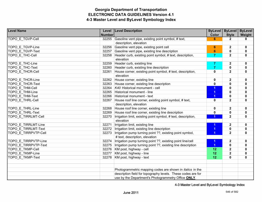
Georgia Department of TransportationELECTRONIC DATA GUIDELINES Version 4.1
4-3 Master Level and ByLevel Symbology Index
Level Name Level Level Description ByLevel ByLevel ByLevelNumber Color Style Weight
TOPO_E_TGVP-Cell 32255 Gasoline vent pipe, existing point symbol, # text, 6 2 0 description, elevation
TOPO_E_TGVP-Line 32256 Gasoline vent pipe, existing point cell 6 2 0TOPO_E_TGVP-Text 32257 Gasoline vent pipe, existing line description 6 0 0TOPO_E_THC-Cell 32258 Header curb, existing point symbol, # text, description, 7 2 0
elevationTOPO_E_THC-Line 32259 Header curb, existing line 7 2 0TOPO_E_THC-Text 32260 Header curb, existing line description 7 0 0TOPO_E_THCR-Cell 32261 House corner, existing point symbol, # text, description, 0 2 0
elevationTOPO_E_THCR-Line 32262 House corner, existing line 0 2 0TOPO_E_THCR-Text 32263 House corner, existing line description 0 0 0TOPO_E_THM-Cell 32264 K40 Historical monument - cell 1 0 0TOPO_E_THM-Line 32265 Historical monument - line 1 0 0TOPO_E_THM-Text 32266 Historical monument - text 1 0 0TOPO_E_THRL-Cell 32267 House roof line corner, existing point symbol, # text, 0 2 0
description, elevationTOPO_E_THRL-Line 32268 House roof line corner, existing line 0 2 0TOPO_E_THRL-Text 32269 House roof line corner, existing line description 0 0 0TOPO_E_TIRRLMT-Cell 32270 Irrigation limit, existing point symbol, # text, description, 1 2 0
elevation
June 2011
4-3 Master Level and ByLevel Symbology Index
TOPO_E_TIRRLMT-Line 32271 Irrigation limit, existing line 1 2 0TOPO_E_TIRRLMT-Text 32272 Irrigation limit, existing line description 1 0 0TOPO_E_TIRRPVTP-Cell 32273 Irrigation pump turning point ??, existing point symbol, 1 2 0
# text, description, elevationTOPO_E_TIRRPVTP-Line 32274 Irrigation pump turning point ??, existing point line/cell 1 2 0TOPO_E_TIRRPVTP-Text 32275 Irrigation pump turning point ??, existing line description 1 0 0TOPO_E_TKMP-Cell 32276 KM post, highway - cell 12 2 0TOPO_E_TKMP-Line 32277 KM post, highway - line 12 2 0TOPO_E_TKMP-Text 32278 KM post, highway - text 12 0 0
Photogrammetric mapping codes are shown in italics in thedescription field for topography levels. These codes are foruse by the Department's Photogrammetry Office ONLY.
June 2011
4-3 Master Level and ByLevel Symbology Index
546 of 582

Georgia Department of TransportationELECTRONIC DATA GUIDELINES Version 4.1
4-3 Master Level and ByLevel Symbology Index
Level Name Level Level Description ByLevel ByLevel ByLevelNumber Color Style Weight
TOPO_E_TLIML-Cell 32279 Limit line, existing point symbol, # text, description, 0 3 0 elevation
TOPO_E_TLIML-Line 32280 K88b Limit line, existing line 0 3 0TOPO_E_TLIML-Text 32281 Limit line, existing line description 0 0 0TOPO_E_TMAR-Cell 32282 Marker miscellaneous, existing point symbol, # text, 7 2 0
description, elevationTOPO_E_TMAR-Line 32283 Marker miscellaneous, existing point cell 7 2 0TOPO_E_TMAR-Text 32284 Marker miscellaneous, existing line description 7 0 0TOPO_E_TMHCR-Cell 32285 Mobile home corner, existing point symbol, # text, 0 2 0
description, elevationTOPO_E_TMHCR-Line 32286 Mobile home corner, existing line 0 2 0TOPO_E_TMHCR-Text 32287 Mobile home corner, existing line description 0 0 0TOPO_E_TMHRL-Cell 32288 Mobile home roof line corner, existing point symbol, # text, 0 3 0
description, elevationTOPO_E_TMHRL-Line 32289 K39a K39b Mobile home roof line corner, existing line 0 3 0TOPO_E_TMHRL-Text 32290 Mobile home roof line corner, existing line description 0 0 0TOPO_E_TMISC-Cell 32291 Topo, miscellaneous area, existing point symbol, # text, 0 2 0
description, elevationTOPO_E_TMISC-Line 32292 Topo, miscellaneous area, existing line 0 2 0TOPO_E_TMISC-Pnt-Cell 32293 Topo, miscellaneous area, existing point cell 0 2 0TOPO_E_TMISC-Text 32294 Topo, miscellaneous area, existing line description 0 0 0
#
June 2011
4-3 Master Level and ByLevel Symbology Index
TOPO_E_TMPH-Cell 32295 K10 Mile post, highway, existing point symbol, # text, 12 2 0 description, elevation
TOPO_E_TMPH-Line 32296 Mile post, highway, existing point cell 12 2 0TOPO_E_TMPH-Text 32297 Mile post, highway, existing line description 12 0 0TOPO_E_TMPR-Cell 32298 Mile post, railroad, existing point symbol, # text, description, 12 2 0
elevationTOPO_E_TMPR-Line 32299 Mile post, railroad, existing point cell 12 2 0TOPO_E_TMPR-Text 32300 Mile post, railroad, existing line description 12 0 0
Photogrammetric mapping codes are shown in italics in thedescription field for topography levels. These codes are foruse by the Department's Photogrammetry Office ONLY.
June 2011
4-3 Master Level and ByLevel Symbology Index
547 of 582

Georgia Department of TransportationELECTRONIC DATA GUIDELINES Version 4.1
4-3 Master Level and ByLevel Symbology Index
Level Name Level Level Description ByLevel ByLevel ByLevelNumber Color Style Weight
TOPO_E_TPBL-Cell 32301 Terrain point on break line, existing point symbol, # text, 1 2 0 description, elevation
TOPO_E_TPBL-Line 32302 K165 Terrain point on break line, existing line 1 2 0TOPO_E_TPBL-Text 32303 Terrain point on break line, existing line description 1 0 0TOPO_E_TRCL-Cell 32304 Railroad centerline, existing point symbol, # text, 15 6 0
description, elevationTOPO_E_TRCL-Line 32305 Railroad centerline, existing line 15 6 0TOPO_E_TRCL-Text 32306 Railroad centerline, existing line description 15 0 0TOPO_E_TRCR-Cell 32307 Railroad, top of rail, existing point symbol, # text, 15 2 0
description, elevationTOPO_E_TRCR-Line 32308 Railroad, top of rail, existing line 15 2 0TOPO_E_TRCR-Text 32309 Railroad, top of rail, existing line description 15 0 0TOPO_E_TRCRE-Cell 32310 Map top of railroad rail - cell 8 0 0TOPO_E_TRCRE-Line 32311 K16 K161 Krr Map top of railroad rail - line 8 0 0TOPO_E_TRCRE-Text 32312 Map top of railroad rail - text 8 0 0TOPO_E_TRP-Cell 32313 K82 K158 Random terrain point, existing point symbol, 0 2 0
# text, description, elevationTOPO_E_TRP-Line 32314 Random terrain point, existing line 0 2 0TOPO_E_TRP-Text 32315 K82 Random terrain point, existing line description 0 0 0TOPO_E_TS-Cell 32316 Steps - cell 7 2 0TOPO_E_TS-Line 32317 Steps - line 7 2 0
June 2011
4-3 Master Level and ByLevel Symbology Index
TOPO_E_TS-Text 32318 Steps - text 7 0 0TOPO_E_TSATDSH-Cell 32319 K22 Satellite dish, existing point symbol, # text, description, 12 2 0
elevationTOPO_E_TSATDSH-Line 32320 Satellite dish, existing point cell 12 2 0TOPO_E_TSATDSH-Text 32321 Satellite dish, existing line description 12 0 0TOPO_E_TSC-Cell 32322 Sign, center - cell 12 2 0TOPO_E_TSC-Line 32323 Sign, center - line 12 2 0TOPO_E_TSC-Text 32324 Sign, center - text 12 0 0
Photogrammetric mapping codes are shown in italics in thedescription field for topography levels. These codes are foruse by the Department's Photogrammetry Office ONLY.
June 2011
4-3 Master Level and ByLevel Symbology Index
548 of 582

Georgia Department of TransportationELECTRONIC DATA GUIDELINES Version 4.1
4-3 Master Level and ByLevel Symbology Index
Level Name Level Level Description ByLevel ByLevel ByLevelNumber Color Style Weight
TOPO_E_TSE-Cell 32325 K13 Sign, end - cell 7 0 0TOPO_E_TSE-Line 32326 K24a K24b K24c Sign, end - line 7 0 0TOPO_E_TSE-Text 32327 Sign, end - text 7 0 0TOPO_E_TSW-Cell 32328 Sidewalk, edge, existing point symbol, # text, description, 11 0 0
elevationTOPO_E_TSW-Line 32329 K17 Sidewalk, edge, existing line 11 0 0TOPO_E_TSW-Text 32330 Sidewalk, edge, existing line description 11 0 0TOPO_E_TTRE-Cell 32331 K48 Tree, center, existing point symbol, # text, description, 2 0 0
elevationTOPO_E_TTRE-Line 32332 K47 Tree, center, existing point cell 2 0 0TOPO_E_TTRE-Text 32333 Tree, center, existing line description 2 0 0TOPO_E_TUD-Cell 32334 Uncovered deck - cell 9 2 0TOPO_E_TUD-Line 32335 K21 Uncovered deck - line 9 2 0TOPO_E_TUD-Text 32336 Uncovered deck - text 9 0 0TOPO_E_TVF-Cell 32337 Vinyl fence - cell 14 2 0TOPO_E_TVF-Line 32338 Vinyl fence - line 14 2 0TOPO_E_TVF-Text 32339 Vinyl fence - text 14 0 0TOPO_E_TVG-Cell 32340 V-gutter, existing point symbol, # text, description, elevation 7 2 0TOPO_E_TVG-Line 32341 V-gutter, existing line 7 2 0TOPO_E_TVG-Text 32342 V-gutter, existing line description 7 0 0TOPO_E_TWELL-Cell 32343 Well, existing point symbol, # text, description, elevation 7 2 0
June 2011
4-3 Master Level and ByLevel Symbology Index
TOPO_E_TWELL-Line 32344 Well, existing point point cell 7 2 0TOPO_E_TWELL-Text 32345 Well, existing line description 7 0 0TOPO_E_TWF-Cell 32346 Wall face, existing point symbol, # text, description, 3 0 3
elevationTOPO_E_TWF-Line 32347 K15 Wall face, existing line 3 0 3TOPO_E_TWF-Text 32348 Wall face, existing line description 3 0 0TOPO_E_TWFB-Cell 32349 Wall face bottom - cell 7 0 0TOPO_E_TWFB-Line 32350 Wall face bottom - line 7 0 0TOPO_E_TWFB-Text 32351 Wall face bottom - text 7 0 0
Photogrammetric mapping codes are shown in italics in thedescription field for topography levels. These codes are foruse by the Department's Photogrammetry Office ONLY.
June 2011
4-3 Master Level and ByLevel Symbology Index
549 of 582

Georgia Department of TransportationELECTRONIC DATA GUIDELINES Version 4.1
4-3 Master Level and ByLevel Symbology Index
Level Name Level Level Description ByLevel ByLevel ByLevelNumber Color Style Weight
TOPO_E_TWFT-Cell 32352 Wall face top - cell 7 0 0TOPO_E_TWFT-Line 32353 K29 K163 Wall face top - line 7 0 0TOPO_E_TWFT-Text 32354 Wall face top - text 7 0 0TOPO_E_TWL-Cell 32355 Woods line, existing point symbol, # text, description, 2 0 0
elevationTOPO_E_TWL-Line 32356 Woods line, existing line 2 0 0TOPO_E_TWL-Text 32357 Woods line, existing line description 2 0 0TOPO_E_UELBOX-Cell 32358 Electrical box - cell 3 2 2TOPO_E_UELBOX-Line 32359 K80 Electrical box - line 3 2 2TOPO_E_UELBOX-Text 32360 Electrical box - text 3 0 2TOPO_E_UFH-Cell 32361 K81 Fire hydrant, center - cell 1 2 2TOPO_E_UFH-Line 32362 Fire hydrant, center - line 1 2 2TOPO_E_UFH-Text 32363 Fire hydrant, center - text 1 0 2TOPO_E_UGM-Cell 32364 Gas meter, center - cell 52 2 2TOPO_E_UGM-Line 32365 Gas meter, center - line 52 2 2TOPO_E_UGM-Text 32366 Gas meter, center - text 52 0 2TOPO_E_UPGA-Cell 32367 Pole anchor - cell 0 2 2TOPO_E_UPGA-Line 32368 Pole anchor - line 0 2 2TOPO_E_UPGA-Text 32369 Pole anchor - text 0 0 2TOPO_E_UGP-Cell 32370 Guy pole, center - cell 0 2 2TOPO_E_UGP-Line 32371 Guy pole, center - line 0 2 2
June 2011
4-3 Master Level and ByLevel Symbology Index
TOPO_E_UGP-Text 32372 Guy pole, center - text 0 0 2TOPO_E_ULP-Cell 32373 K71 K73 K75 Light pole, center - cell 3 2 2TOPO_E_ULP-Line 32374 Light pole, center - line 3 2 2TOPO_E_ULP-Text 32375 Light pole, center - text 3 0 2TOPO_E_UMHE-Cell 32376 Manhole, electrical, top - cell 3 2 2TOPO_E_UMHE-Line 32377 Manhole, electrical, top - line 3 2 2TOPO_E_UMHE-Text 32378 Manhole, electrical, top - text 3 0 2TOPO_E_UMHSS-Cell 32379 Manhole, sanitary sewer, top - cell 2 2 2TOPO_E_UMHSS-Line 32380 Manhole, sanitary sewer, top - line 2 2 2TOPO_E_UMHSS-Text 32381 Manhole, sanitary sewer, top - text 2 0 2
Photogrammetric mapping codes are shown in italics in thedescription field for topography levels. These codes are foruse by the Department's Photogrammetry Office ONLY.
June 2011
4-3 Master Level and ByLevel Symbology Index
550 of 582
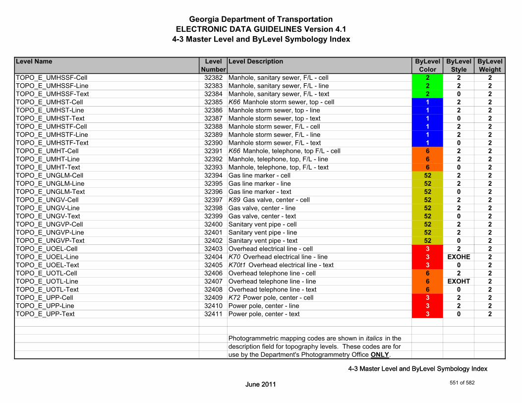
Georgia Department of TransportationELECTRONIC DATA GUIDELINES Version 4.1
4-3 Master Level and ByLevel Symbology Index
Level Name Level Level Description ByLevel ByLevel ByLevelNumber Color Style Weight
TOPO_E_UMHSSF-Cell 32382 Manhole, sanitary sewer, F/L - cell 2 2 2TOPO_E_UMHSSF-Line 32383 Manhole, sanitary sewer, F/L - line 2 2 2TOPO_E_UMHSSF-Text 32384 Manhole, sanitary sewer, F/L - text 2 0 2TOPO_E_UMHST-Cell 32385 K66 Manhole storm sewer, top - cell 1 2 2TOPO_E_UMHST-Line 32386 Manhole storm sewer, top - line 1 2 2TOPO_E_UMHST-Text 32387 Manhole storm sewer, top - text 1 0 2TOPO_E_UMHSTF-Cell 32388 Manhole storm sewer, F/L - cell 1 2 2TOPO_E_UMHSTF-Line 32389 Manhole storm sewer, F/L - line 1 2 2TOPO_E_UMHSTF-Text 32390 Manhole storm sewer, F/L - text 1 0 2TOPO_E_UMHT-Cell 32391 K66 Manhole, telephone, top F/L - cell 6 2 2TOPO_E_UMHT-Line 32392 Manhole, telephone, top, F/L - line 6 2 2TOPO_E_UMHT-Text 32393 Manhole, telephone, top, F/L - text 6 0 2TOPO_E_UNGLM-Cell 32394 Gas line marker - cell 52 2 2TOPO_E_UNGLM-Line 32395 Gas line marker - line 52 2 2TOPO_E_UNGLM-Text 32396 Gas line marker - text 52 0 2TOPO_E_UNGV-Cell 32397 K89 Gas valve, center - cell 52 2 2TOPO_E_UNGV-Line 32398 Gas valve, center - line 52 2 2TOPO_E_UNGV-Text 32399 Gas valve, center - text 52 0 2TOPO_E_UNGVP-Cell 32400 Sanitary vent pipe - cell 52 2 2TOPO_E_UNGVP-Line 32401 Sanitary vent pipe - line 52 2 2TOPO_E_UNGVP-Text 32402 Sanitary vent pipe - text 52 0 2
June 2011
4-3 Master Level and ByLevel Symbology Index
TOPO_E_UOEL-Cell 32403 Overhead electrical line - cell 3 2 2TOPO_E_UOEL-Line 32404 K70 Overhead electrical line - line 3 EXOHE 2TOPO_E_UOEL-Text 32405 K70t1 Overhead electrical line - text 3 0 2TOPO_E_UOTL-Cell 32406 Overhead telephone line - cell 6 2 2TOPO_E_UOTL-Line 32407 Overhead telephone line - line 6 EXOHT 2TOPO_E_UOTL-Text 32408 Overhead telephone line - text 6 0 2TOPO_E_UPP-Cell 32409 K72 Power pole, center - cell 3 2 2TOPO_E_UPP-Line 32410 Power pole, center - line 3 2 2TOPO_E_UPP-Text 32411 Power pole, center - text 3 0 2
Photogrammetric mapping codes are shown in italics in thedescription field for topography levels. These codes are foruse by the Department's Photogrammetry Office ONLY.
June 2011
4-3 Master Level and ByLevel Symbology Index
551 of 582
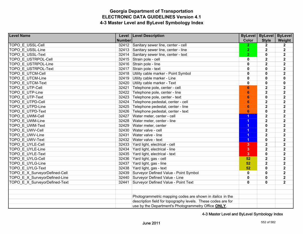
Georgia Department of TransportationELECTRONIC DATA GUIDELINES Version 4.1
4-3 Master Level and ByLevel Symbology Index
Level Name Level Level Description ByLevel ByLevel ByLevelNumber Color Style Weight
TOPO_E_USSL-Cell 32412 Sanitary sewer line, center - cell 2 2 2TOPO_E_USSL-Line 32413 Sanitary sewer line, center - line 2 2 2TOPO_E_USSL-Text 32414 Sanitary sewer line, center - text 2 0 2TOPO_E_USTRPOL-Cell 32415 Strain pole - cell 0 2 2TOPO_E_USTRPOL-Line 32416 Strain pole - line 0 2 2TOPO_E_USTRPOL-Text 32417 Strain pole - text 0 0 2TOPO_E_UTCM-Cell 32418 Utility cable marker - Point Symbol 0 0 2TOPO_E_UTCM-Line 32419 Utility cable marker - Line 0 0 0TOPO_E_UTCM-Text 32420 Utility cable marker - Text 0 0 0TOPO_E_UTP-Cell 32421 Telephone pole, center - cell 6 2 2TOPO_E_UTP-Line 32422 Telephone pole, center - line 6 2 2TOPO_E_UTP-Text 32423 Telephone pole, center - text 6 0 2TOPO_E_UTPD-Cell 32424 Telephone pedestal, center - cell 6 2 2TOPO_E_UTPD-Line 32425 Telephone pedestal, center - line 6 2 2TOPO_E_UTPD-Text 32426 Telephone pedestal, center - text 6 0 2TOPO_E_UWM-Cell 32427 Water meter, center - cell 1 2 2TOPO_E_UWM-Line 32428 Water meter, center - line 1 2 2TOPO_E_UWM-Text 32429 Water meter, center 1 0 2TOPO_E_UWV-Cell 32430 Water valve - cell 1 2 2TOPO_E_UWV-Line 32431 Water valve - line 1 2 2TOPO_E_UWV-Text 32432 Water valve - text 1 0 2
June 2011
4-3 Master Level and ByLevel Symbology Index
TOPO_E_UYLE-Cell 32433 Yard light, electrical - cell 3 2 2TOPO_E_UYLE-Line 32434 Yard light, electrical - line 3 2 2TOPO_E_UYLE-Text 32435 Yard light, electrical - text 3 0 2TOPO_E_UYLG-Cell 32436 Yard light, gas - cell 52 2 2TOPO_E_UYLG-Line 32437 Yard light, gas - line 52 2 2TOPO_E_UYLG-Text 32438 Yard light, gas - text 52 0 2TOPO_E_X_SurveyorDefined-Cell 32439 Surveyor Defined Value - Point Symbol 0 0 2TOPO_E_X_SurveyorDefined-Line 32440 Surveyor Defined Value - Line 0 0 2TOPO_E_X_SurveyorDefined-Text 32441 Surveyor Defined Value - Point Text 0 0 2
Photogrammetric mapping codes are shown in italics in thedescription field for topography levels. These codes are foruse by the Department's Photogrammetry Office ONLY.
June 2011
4-3 Master Level and ByLevel Symbology Index
552 of 582
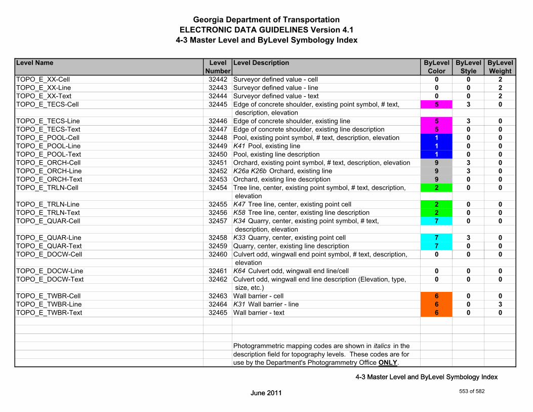
Georgia Department of TransportationELECTRONIC DATA GUIDELINES Version 4.1
4-3 Master Level and ByLevel Symbology Index
Level Name Level Level Description ByLevel ByLevel ByLevelNumber Color Style Weight
TOPO_E_XX-Cell 32442 Surveyor defined value - cell 0 0 2TOPO_E_XX-Line 32443 Surveyor defined value - line 0 0 2TOPO_E_XX-Text 32444 Surveyor defined value - text 0 0 2TOPO_E_TECS-Cell 32445 Edge of concrete shoulder, existing point symbol, # text, 5 3 0
description, elevationTOPO_E_TECS-Line 32446 Edge of concrete shoulder, existing line 5 3 0TOPO_E_TECS-Text 32447 Edge of concrete shoulder, existing line description 5 0 0TOPO_E_POOL-Cell 32448 Pool, existing point symbol, # text, description, elevation 1 0 0TOPO_E_POOL-Line 32449 K41 Pool, existing line 1 0 0TOPO_E_POOL-Text 32450 Pool, existing line description 1 0 0TOPO_E_ORCH-Cell 32451 Orchard, existing point symbol, # text, description, elevation 9 3 0TOPO_E_ORCH-Line 32452 K26a K26b Orchard, existing line 9 3 0TOPO_E_ORCH-Text 32453 Orchard, existing line description 9 0 0TOPO_E_TRLN-Cell 32454 Tree line, center, existing point symbol, # text, description, 2 0 0
elevationTOPO_E_TRLN-Line 32455 K47 Tree line, center, existing point cell 2 0 0TOPO_E_TRLN-Text 32456 K58 Tree line, center, existing line description 2 0 0TOPO_E_QUAR-Cell 32457 K34 Quarry, center, existing point symbol, # text, 7 0 0
description, elevationTOPO_E_QUAR-Line 32458 K33 Quarry, center, existing point cell 7 3 0TOPO_E_QUAR-Text 32459 Quarry, center, existing line description 7 0 0
June 2011
4-3 Master Level and ByLevel Symbology Index
TOPO_E_DOCW-Cell 32460 Culvert odd, wingwall end point symbol, # text, description, 0 0 0 elevation
TOPO_E_DOCW-Line 32461 K64 Culvert odd, wingwall end line/cell 0 0 0TOPO_E_DOCW-Text 32462 Culvert odd, wingwall end line description (Elevation, type, 0 0 0
size, etc.)TOPO_E_TWBR-Cell 32463 Wall barrier - cell 6 0 0TOPO_E_TWBR-Line 32464 K31 Wall barrier - line 6 0 3TOPO_E_TWBR-Text 32465 Wall barrier - text 6 0 0
Photogrammetric mapping codes are shown in italics in thedescription field for topography levels. These codes are foruse by the Department's Photogrammetry Office ONLY.
June 2011
4-3 Master Level and ByLevel Symbology Index
553 of 582

Georgia Department of TransportationELECTRONIC DATA GUIDELINES Version 4.1
4-3 Master Level and ByLevel Symbology Index
Level Name Level Level Description ByLevel ByLevel ByLevelNumber Color Style Weight
TOPO_E_CRBR-Cell 32466 Curb road, existing point symbol, # text, description, 10 0 0 elevation
TOPO_E_CRBR-Line 32467 K8 Curb road, existing line 10 0 2TOPO_E_CRBR-Text 32468 Curb road, existing line description 10 0 0TOPO_E_FNDN-Cell 32469 Foundation, existing point symbol, # text, description, 0 2 0
elevationTOPO_E_FNDN-Line 32470 K19a Foundation, existing line 0 2 0TOPO_E_FNDN-Text 32471 Foundation, existing line description 0 0 0TOPO_E_RUIN-Cell 32472 Ruins, existing point symbol, # text, description, elevation 0 2 0TOPO_E_RUIN-Line 32473 K19b Ruins, existing line 0 2 0TOPO_E_RUIN-Text 32474 Ruins, existing line description 0 0 0TOPO_E_CONT-Cell 32475 Contour, existing point symbol, # text, description, elevation 4 2 0TOPO_E_CONT-Depress-Line 32476 K86 Depress contour, existing line 4 0 0TOPO_E_CONT-Hidden-Line 32477 K87 Hidden contour, existing line 5 1 0TOPO_E_CONT-Index-Line 32478 K83 Index contour, existing line 13 0 2TOPO_E_CONT-Intermed-Line 32479 Intermediate contour, existing line 7 0 0TOPO_E_CONT-Text 32480 Contour, existing line description 13 0 1TOPO_E_ELEV-Cell 32481 Elevation, existing point symbol, # text, description, 0 0 0
elevationTOPO_E_ELEV-Line 32482 Elevation, existing line 13 0 1TOPO_E_ELEV-Text 32483 Elevation, existing line description 4 0 0
June 2011
4-3 Master Level and ByLevel Symbology Index
TOPO_E_TANK-Cell 32484 Tank, existing point symbol, # text, description, elevation 11 0 0TOPO_E_TANK-Line 32485 K23 Tank, existing line 11 0 0TOPO_E_TANK-Text 32486 Tank, existing line description 11 0 0TOPO_E_DTCH-Cell 32487 Ditch - cell 1 0 0TOPO_E_DTCH-Line 32488 Ditch - line 1 6 0TOPO_E_DTCH-Text 32489 Ditch - text 1 0 0TOPO_E_DTCH-Hidden-Cell 32490 Hidden ditch - cell 0 0 0TOPO_E_DTCH-Hidden-Line 32491 K45 Hidden ditch - line 0 6 0TOPO_E_DTCH-Hidden-Text 32492 Hidden ditch - text 0 0 0
Photogrammetric mapping codes are shown in italics in thedescription field for topography levels. These codes are foruse by the Department's Photogrammetry Office ONLY.
June 2011
4-3 Master Level and ByLevel Symbology Index
554 of 582

Georgia Department of TransportationELECTRONIC DATA GUIDELINES Version 4.1
4-3 Master Level and ByLevel Symbology Index
Level Name Level Level Description ByLevel ByLevel ByLevelNumber Color Style Weight
TOPO_E_TWFE-Cell 32493 Wall / fence - cell 7 0 0TOPO_E_TWFE-Line 32494 Wall / fence - line 7 0 0TOPO_E_TWFE-Text 32495 Wall / fence - text 7 0 0TOPO_E_Tic2-Cell 32496 Grid Tic - Cell 0 0 0TOPO_E_Corner-Line 32497 Limits of mapping corners - line 0 0 0TOPO_E_GOLF-Cell 32498 Golf Course - Cell 0 0 0TOPO_E_GOLF-Line 32499 K39b Golf Course - Line 0 3 0TOPO_E_GOLF-Text 32500 Golf Course - Text 0 0 0TOPO_E_Basketball-Court-Cell 32501 Basketball Court - cell 1 2 0TOPO_E_Basketball-Court-Line 32532 Basketball Court - line 1 2 0TOPO_E_Basketball-Court-Text 32533 Basketball Court - text 1 0 0TOPO_E_Flow-Arrow-Cell 32502 K56 Flow Arrow - cell 7 0 0TOPO_E_Iron-Pin-Placed-Cell 32503 Iron Pin Placed - cell 0 0 0TOPO_E_RIVER-TIC-MARK-Cell 32504 River Tic Mark - cell 0 0 0TOPO_E_WATER-SURFACE-Cell 32505 Water Surface - cell 1 0 0TOPO_E_Tic2-Text 32506 Grid Tic - text 0 1 0TOPO_E_DEW-Hatch-Line 32507 Edge of water, existing cell 1 0 0TOPO_E_BUILD-Cell 32508 Building - cell 0 0 0TOPO_E_BUILD-Line 32509 Building - line 0 0 0TOPO_E_BUILD-Text 32510 Building - text 0 0 0TOPO_E_USIGNAL-Cell 32511 K11 Signal - cell 4 0 0
June 2011
4-3 Master Level and ByLevel Symbology Index
TOPO_E_USIGNAL-Line 32512 Signal - line 4 0 0TOPO_E_USIGNAL-Text 32513 Signal - text 4 0 0TOPO_E_RIDGE-Cell 32514 Ridge - cell 6 0 0TOPO_E_RIDGE-Line 32515 K46 Ridge - line 6 0 0TOPO_E_RIDGE-Text 32516 Ridge - text 6 0 0TOPO_E_DITCH-Taper-Cell 32517 K53 Ditch Taper - cell 1 0 0TOPO_E_UTIL-Cell 32518 K78 Utility Line - cell 10 3 0TOPO_E_UTIL-Line 32519 Utility Line - line 10 3 0TOPO_E_UTIL-Text 32520 Utility Line - text 10 0 0
Photogrammetric mapping codes are shown in italics in thedescription field for topography levels. These codes are foruse by the Department's Photogrammetry Office ONLY.
June 2011
4-3 Master Level and ByLevel Symbology Index
555 of 582
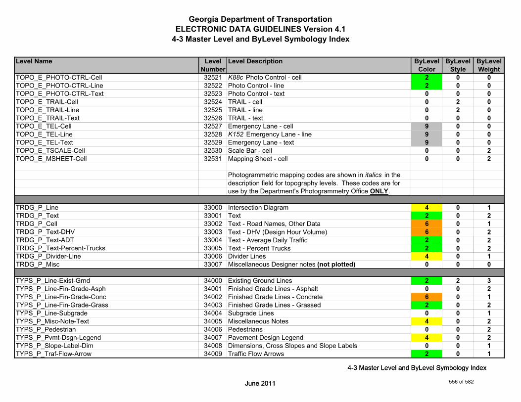
Georgia Department of TransportationELECTRONIC DATA GUIDELINES Version 4.1
4-3 Master Level and ByLevel Symbology Index
Level Name Level Level Description ByLevel ByLevel ByLevelNumber Color Style Weight
TOPO_E_PHOTO-CTRL-Cell 32521 K88c Photo Control - cell 2 0 0TOPO_E_PHOTO-CTRL-Line 32522 Photo Control - line 2 0 0TOPO_E_PHOTO-CTRL-Text 32523 Photo Control - text 0 0 0TOPO_E_TRAIL-Cell 32524 TRAIL - cell 0 2 0TOPO_E_TRAIL-Line 32525 TRAIL - line 0 2 0TOPO_E_TRAIL-Text 32526 TRAIL - text 0 0 0TOPO_E_TEL-Cell 32527 Emergency Lane - cell 9 0 0TOPO_E_TEL-Line 32528 K152 Emergency Lane - line 9 0 0TOPO_E_TEL-Text 32529 Emergency Lane - text 9 0 0TOPO_E_TSCALE-Cell 32530 Scale Bar - cell 0 0 2TOPO_E_MSHEET-Cell 32531 Mapping Sheet - cell 0 0 2
Photogrammetric mapping codes are shown in italics in thedescription field for topography levels. These codes are foruse by the Department's Photogrammetry Office ONLY.
TRDG_P_Line 33000 Intersection Diagram 4 0 1TRDG_P_Text 33001 Text 2 0 2TRDG_P_Cell 33002 Text - Road Names, Other Data 6 0 1TRDG_P_Text-DHV 33003 Text - DHV (Design Hour Volume) 6 0 2TRDG_P_Text-ADT 33004 Text - Average Daily Traffic 2 0 2
June 2011
4-3 Master Level and ByLevel Symbology Index
TRDG_P_Text-Percent-Trucks 33005 Text - Percent Trucks 2 0 2TRDG_P_Divider-Line 33006 Divider Lines 4 0 1TRDG_P_Misc 33007 Miscellaneous Designer notes (not plotted) 0 0 0
TYPS_P_Line-Exist-Grnd 34000 Existing Ground Lines 2 2 3TYPS_P_Line-Fin-Grade-Asph 34001 Finished Grade Lines - Asphalt 0 0 2TYPS_P_Line-Fin-Grade-Conc 34002 Finished Grade Lines - Concrete 6 0 1TYPS_P_Line-Fin-Grade-Grass 34003 Finished Grade Lines - Grassed 2 0 2TYPS_P_Line-Subgrade 34004 Subgrade Lines 0 0 1TYPS_P_Misc-Note-Text 34005 Miscellaneous Notes 4 0 2TYPS_P_Pedestrian 34006 Pedestrians 0 0 2TYPS_P_Pvmt-Dsgn-Legend 34007 Pavement Design Legend 4 0 2TYPS_P_Slope-Label-Dim 34008 Dimensions, Cross Slopes and Slope Labels 0 0 1TYPS_P_Traf-Flow-Arrow 34009 Traffic Flow Arrows 2 0 1
June 2011
4-3 Master Level and ByLevel Symbology Index
556 of 582
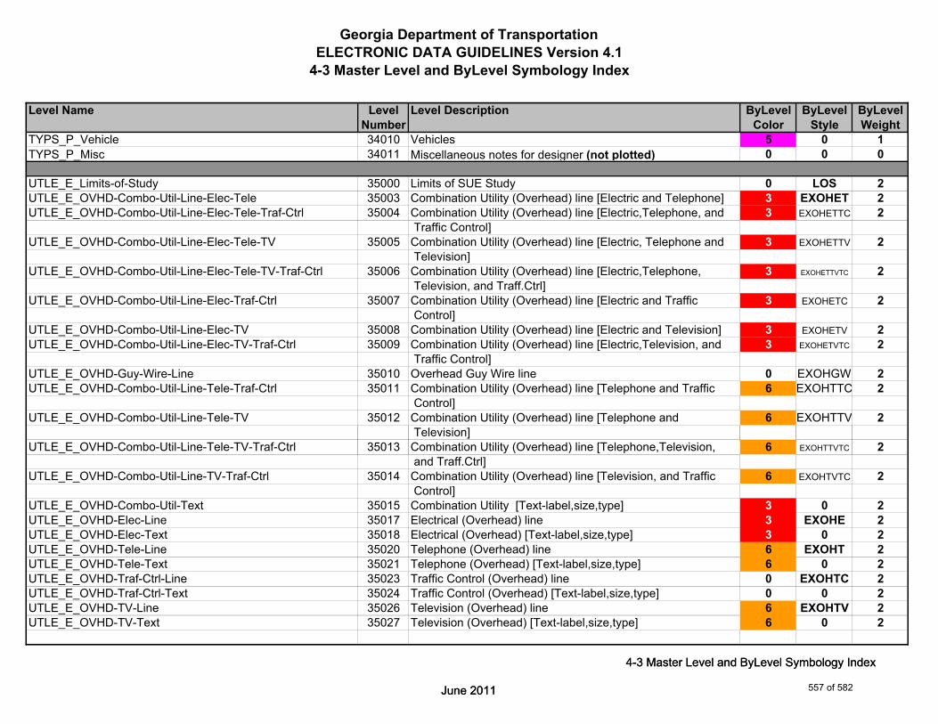
Georgia Department of TransportationELECTRONIC DATA GUIDELINES Version 4.1
4-3 Master Level and ByLevel Symbology Index
Level Name Level Level Description ByLevel ByLevel ByLevelNumber Color Style Weight
TYPS_P_Vehicle 34010 Vehicles 5 0 1TYPS_P_Misc 34011 Miscellaneous notes for designer (not plotted) 0 0 0
UTLE_E_Limits-of-Study 35000 Limits of SUE Study 0 LOS 2UTLE_E_OVHD-Combo-Util-Line-Elec-Tele 35003 Combination Utility (Overhead) line [Electric and Telephone] 3 EXOHET 2UTLE_E_OVHD-Combo-Util-Line-Elec-Tele-Traf-Ctrl 35004 Combination Utility (Overhead) line [Electric,Telephone, and 3 EXOHETTC 2
Traffic Control]UTLE_E_OVHD-Combo-Util-Line-Elec-Tele-TV 35005 Combination Utility (Overhead) line [Electric, Telephone and 3 EXOHETTV 2
Television]UTLE_E_OVHD-Combo-Util-Line-Elec-Tele-TV-Traf-Ctrl 35006 Combination Utility (Overhead) line [Electric,Telephone, 3 EXOHETTVTC 2
Television, and Traff.Ctrl]UTLE_E_OVHD-Combo-Util-Line-Elec-Traf-Ctrl 35007 Combination Utility (Overhead) line [Electric and Traffic 3 EXOHETC 2
Control]UTLE_E_OVHD-Combo-Util-Line-Elec-TV 35008 Combination Utility (Overhead) line [Electric and Television] 3 EXOHETV 2UTLE_E_OVHD-Combo-Util-Line-Elec-TV-Traf-Ctrl 35009 Combination Utility (Overhead) line [Electric,Television, and 3 EXOHETVTC 2
Traffic Control]UTLE_E_OVHD-Guy-Wire-Line 35010 Overhead Guy Wire line 0 EXOHGW 2UTLE_E_OVHD-Combo-Util-Line-Tele-Traf-Ctrl 35011 Combination Utility (Overhead) line [Telephone and Traffic 6 EXOHTTC 2
Control]UTLE_E_OVHD-Combo-Util-Line-Tele-TV 35012 Combination Utility (Overhead) line [Telephone and 6 EXOHTTV 2
Television]
June 2011
4-3 Master Level and ByLevel Symbology Index
UTLE_E_OVHD-Combo-Util-Line-Tele-TV-Traf-Ctrl 35013 Combination Utility (Overhead) line [Telephone,Television, 6 EXOHTTVTC 2 and Traff.Ctrl]
UTLE_E_OVHD-Combo-Util-Line-TV-Traf-Ctrl 35014 Combination Utility (Overhead) line [Television, and Traffic 6 EXOHTVTC 2 Control]
UTLE_E_OVHD-Combo-Util-Text 35015 Combination Utility [Text-label,size,type] 3 0 2UTLE_E_OVHD-Elec-Line 35017 Electrical (Overhead) line 3 EXOHE 2UTLE_E_OVHD-Elec-Text 35018 Electrical (Overhead) [Text-label,size,type] 3 0 2UTLE_E_OVHD-Tele-Line 35020 Telephone (Overhead) line 6 EXOHT 2UTLE_E_OVHD-Tele-Text 35021 Telephone (Overhead) [Text-label,size,type] 6 0 2UTLE_E_OVHD-Traf-Ctrl-Line 35023 Traffic Control (Overhead) line 0 EXOHTC 2UTLE_E_OVHD-Traf-Ctrl-Text 35024 Traffic Control (Overhead) [Text-label,size,type] 0 0 2UTLE_E_OVHD-TV-Line 35026 Television (Overhead) line 6 EXOHTV 2UTLE_E_OVHD-TV-Text 35027 Television (Overhead) [Text-label,size,type] 6 0 2
June 2011
4-3 Master Level and ByLevel Symbology Index
557 of 582

Georgia Department of TransportationELECTRONIC DATA GUIDELINES Version 4.1
4-3 Master Level and ByLevel Symbology Index
Level Name Level Level Description ByLevel ByLevel ByLevelNumber Color Style Weight
UTLE_E_Test-Hole-Cell 35028 Test Holes cell 0 0 1UTLE_E_Test-Hole-Text 35029 Test Holes [Text-label,size,type] 0 0 2UTLE_E_Elec-Cell 35030 Electrical cell 3 0 1UTLE_E_UG-Elec-Line 35031 Electrical (Underground) line 3 EXUGE 2UTLE_E_UG-Elec-Line-Qual-B 35032 Electrical (Underground) line [Quality Level B] 3 EXUGE-B 2UTLE_E_UG-Elec-Line-Qual-C 35033 Electrical (Underground) line [Quality Level C] 3 EXUGE-C 2UTLE_E_UG-Elec-Text 35034 Electrical (Underground) [Text-label,size,type] 3 0 2UTLE_E_Gas-Cell 35035 Gas cell 52 0 1UTLE_E_UG-Gas-Line 35036 Gas (Underground) line 52 EXUGG 2*UTLE_E_UG-Gas-Line-24 35037 24 inch Underground Gas line - 20 Scale Plans 52 EXUGG-24 2^UTLE_E_UG-Gas-Line-24-50 35196 24 inch Underground Gas line - 50 Scale Plans 52 EXUGG-24-50 2*UTLE_E_UG-Gas-Line-24-Qual-B 35038 24 inch Underground Gas line [Quality Level B] - 20 Scale 52 EXUGG-24B 2
Plans^UTLE_E_UG-Gas-Line-24-Qual-B-50 35197 24 inch Underground Gas line [Quality Level B] - 50 Scale 52 EXUGG-24B-50 2
Plans*UTLE_E_UG-Gas-Line-24-Qual-C 35039 24 inch Underground Gas line [Quality Level C] - 20 Scale 52 EXUGG-24C 2
Plans^UTLE_E_UG-Gas-Line-24-Qual-C-50 35198 24 inch Underground Gas line [Quality Level C] - 50 Scale 52 EXUGG-24C-50 2
Plans*UTLE_E_UG-Gas-Line-30 35040 30 inch Underground Gas line - 20 Scale Plans 52 EXUGG-30 2^UTLE_E_UG-Gas-Line-30-50 35199 30 inch Underground Gas line - 50 Scale Plans 52 EXUGG-30-50 2
June 2011
4-3 Master Level and ByLevel Symbology Index
*UTLE_E_UG-Gas-Line-30-Qual-B 35041 30 inch Underground Gas line [Quality Level B] - 20 Scale 52 EXUGG-30B 2 Plans
^UTLE_E_UG-Gas-Line-30-Qual-B-50 35200 30 inch Underground Gas line [Quality Level B] - 50 Scale 52 EXUGG-30B-50 2 Plans
*UTLE_E_UG-Gas-Line-30-Qual-C 35042 30 inch Underground Gas line [Quality Level C] - 20 Scale 52 EXUGG-30C 2 Plans
^UTLE_E_UG-Gas-Line-30-Qual-C-50 35201 30 inch Underground Gas line [Quality Level C] - 50 Scale 52 EXUGG-30C-50 2 Plans
*Denotes level for 20 Scale Plans.^Denotes level for 50 Scale Plans.
June 2011
4-3 Master Level and ByLevel Symbology Index
558 of 582

Georgia Department of TransportationELECTRONIC DATA GUIDELINES Version 4.1
4-3 Master Level and ByLevel Symbology Index
Level Name Level Level Description ByLevel ByLevel ByLevelNumber Color Style Weight
*UTLE_E_UG-Gas-Line-36 35043 36 inch Underground Gas line - 20 Scale Plans 52 EXUGG-36 2^UTLE_E_UG-Gas-Line-36-50 35202 36 inch Underground Gas line - 50 Scale Plans 52 EXUGG-36-50 2*UTLE_E_UG-Gas-Line-36-Qual-B 35044 36 inch Underground Gas line [Quality Level B] - 20 Scale 52 EXUGG-36B 2
Plans^UTLE_E_UG-Gas-Line-36-Qual-B-50 35203 36 inch Underground Gas line [Quality Level B] - 50 Scale 52 EXUGG-36B-50 2
Plans*UTLE_E_UG-Gas-Line-36-Qual-C 35045 36 inch Underground Gas line [Quality Level C] - 20 Scale 52 EXUGG-36C 2
Plans^UTLE_E_UG-Gas-Line-36-Qual-C-50 35204 36 inch Underground Gas line [Quality Level C] - 50 Scale 52 EXUGG-36C-50 2
Plans*UTLE_E_UG-Gas-Line-42 35046 42 inch Underground Gas line - 20 Scale Plans 52 EXUGG-42 2^UTLE_E_UG-Gas-Line-42-50 35205 42 inch Underground Gas line - 50 Scale Plans 52 EXUGG-42-50 2*UTLE_E_UG-Gas-Line-42-Qual-B 35047 42 inch Underground Gas line [Quality Level B] - 20 Scale 52 EXUGG-42B 2
Plans^UTLE_E_UG-Gas-Line-42-Qual-B-50 35206 42 inch Underground Gas line [Quality Level B] - 50 Scale 52 EXUGG-42B-50 2
Plans*UTLE_E_UG-Gas-Line-42-Qual-C 35048 42 inch Underground Gas line [Quality Level C] - 20 Scale 52 EXUGG-42C 2
Plans^UTLE_E_UG-Gas-Line-42-Qual-C-50 35207 42 inch Underground Gas line [Quality Level C] - 50 Scale 52 EXUGG-42C-50 2
Plans*UTLE_E_UG-Gas-Line-48 35049 48 inch Underground Gas line - 20 Scale Plans 52 EXUGG-48 2
June 2011
4-3 Master Level and ByLevel Symbology Index
^UTLE_E_UG-Gas-Line-48-50 35208 48 inch Underground Gas line - 50 Scale Plans 52 EXUGG-48-50 2*UTLE_E_UG-Gas-Line-48-Qual-B 35050 48 inch Underground Gas line [Quality Level B] - 20 Scale 52 EXUGG-48B 2
Plans^UTLE_E_UG-Gas-Line-48-Qual-B-50 35209 48 inch Underground Gas line [Quality Level B] - 50 Scale 52 EXUGG-48B-50 2
Plans*UTLE_E_UG-Gas-Line-48-Qual-C 35051 48 inch Underground Gas line [Quality Level C] - 20 Scale 52 EXUGG-48C 2
Plans^UTLE_E_UG-Gas-Line-48-Qual-C-50 35210 48 inch Underground Gas line [Quality Level C] - 50 Scale 52 EXUGG-48C-50 2
Plans
*Denotes level for 20 Scale Plans.^Denotes level for 50 Scale Plans.
June 2011
4-3 Master Level and ByLevel Symbology Index
559 of 582
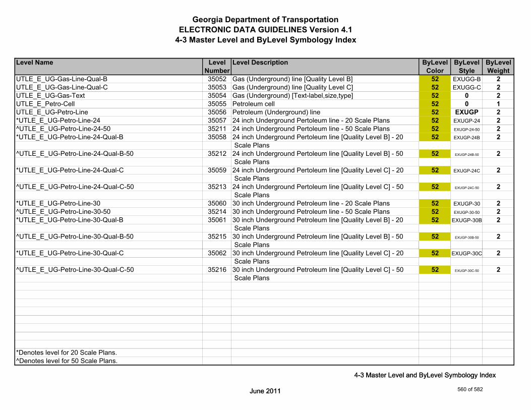
Georgia Department of TransportationELECTRONIC DATA GUIDELINES Version 4.1
4-3 Master Level and ByLevel Symbology Index
Level Name Level Level Description ByLevel ByLevel ByLevelNumber Color Style Weight
UTLE_E_UG-Gas-Line-Qual-B 35052 Gas (Underground) line [Quality Level B] 52 EXUGG-B 2UTLE_E_UG-Gas-Line-Qual-C 35053 Gas (Underground) line [Quality Level C] 52 EXUGG-C 2UTLE_E_UG-Gas-Text 35054 Gas (Underground) [Text-label,size,type] 52 0 2UTLE_E_Petro-Cell 35055 Petroleum cell 52 0 1UTLE_E_UG-Petro-Line 35056 Petroleum (Underground) line 52 EXUGP 2*UTLE_E_UG-Petro-Line-24 35057 24 inch Underground Pertoleum line - 20 Scale Plans 52 EXUGP-24 2^UTLE_E_UG-Petro-Line-24-50 35211 24 inch Underground Pertoleum line - 50 Scale Plans 52 EXUGP-24-50 2*UTLE_E_UG-Petro-Line-24-Qual-B 35058 24 inch Underground Pertoleum line [Quality Level B] - 20 52 EXUGP-24B 2
Scale Plans^UTLE_E_UG-Petro-Line-24-Qual-B-50 35212 24 inch Underground Pertoleum line [Quality Level B] - 50 52 EXUGP-24B-50 2
Scale Plans*UTLE_E_UG-Petro-Line-24-Qual-C 35059 24 inch Underground Pertoleum line [Quality Level C] - 20 52 EXUGP-24C 2
Scale Plans^UTLE_E_UG-Petro-Line-24-Qual-C-50 35213 24 inch Underground Pertoleum line [Quality Level C] - 50 52 EXUGP-24C-50 2
Scale Plans*UTLE_E_UG-Petro-Line-30 35060 30 inch Underground Petroleum line - 20 Scale Plans 52 EXUGP-30 2^UTLE_E_UG-Petro-Line-30-50 35214 30 inch Underground Petroleum line - 50 Scale Plans 52 EXUGP-30-50 2*UTLE_E_UG-Petro-Line-30-Qual-B 35061 30 inch Underground Petroleum line [Quality Level B] - 20 52 EXUGP-30B 2
Scale Plans^UTLE_E_UG-Petro-Line-30-Qual-B-50 35215 30 inch Underground Petroleum line [Quality Level B] - 50 52 EXUGP-30B-50 2
Scale Plans
June 2011
4-3 Master Level and ByLevel Symbology Index
*UTLE_E_UG-Petro-Line-30-Qual-C 35062 30 inch Underground Petroleum line [Quality Level C] - 20 52 EXUGP-30C 2 Scale Plans
^UTLE_E_UG-Petro-Line-30-Qual-C-50 35216 30 inch Underground Petroleum line [Quality Level C] - 50 52 EXUGP-30C-50 2 Scale Plans
*Denotes level for 20 Scale Plans.^Denotes level for 50 Scale Plans.
June 2011
4-3 Master Level and ByLevel Symbology Index
560 of 582
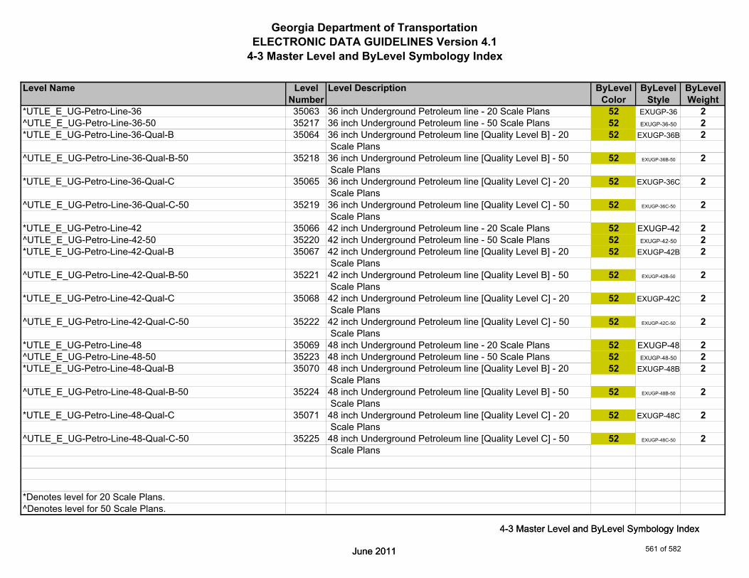
Georgia Department of TransportationELECTRONIC DATA GUIDELINES Version 4.1
4-3 Master Level and ByLevel Symbology Index
Level Name Level Level Description ByLevel ByLevel ByLevelNumber Color Style Weight
*UTLE_E_UG-Petro-Line-36 35063 36 inch Underground Petroleum line - 20 Scale Plans 52 EXUGP-36 2^UTLE_E_UG-Petro-Line-36-50 35217 36 inch Underground Petroleum line - 50 Scale Plans 52 EXUGP-36-50 2*UTLE_E_UG-Petro-Line-36-Qual-B 35064 36 inch Underground Petroleum line [Quality Level B] - 20 52 EXUGP-36B 2
Scale Plans^UTLE_E_UG-Petro-Line-36-Qual-B-50 35218 36 inch Underground Petroleum line [Quality Level B] - 50 52 EXUGP-36B-50 2
Scale Plans*UTLE_E_UG-Petro-Line-36-Qual-C 35065 36 inch Underground Petroleum line [Quality Level C] - 20 52 EXUGP-36C 2
Scale Plans^UTLE_E_UG-Petro-Line-36-Qual-C-50 35219 36 inch Underground Petroleum line [Quality Level C] - 50 52 EXUGP-36C-50 2
Scale Plans*UTLE_E_UG-Petro-Line-42 35066 42 inch Underground Petroleum line - 20 Scale Plans 52 EXUGP-42 2^UTLE_E_UG-Petro-Line-42-50 35220 42 inch Underground Petroleum line - 50 Scale Plans 52 EXUGP-42-50 2*UTLE_E_UG-Petro-Line-42-Qual-B 35067 42 inch Underground Petroleum line [Quality Level B] - 20 52 EXUGP-42B 2
Scale Plans^UTLE_E_UG-Petro-Line-42-Qual-B-50 35221 42 inch Underground Petroleum line [Quality Level B] - 50 52 EXUGP-42B-50 2
Scale Plans*UTLE_E_UG-Petro-Line-42-Qual-C 35068 42 inch Underground Petroleum line [Quality Level C] - 20 52 EXUGP-42C 2
Scale Plans^UTLE_E_UG-Petro-Line-42-Qual-C-50 35222 42 inch Underground Petroleum line [Quality Level C] - 50 52 EXUGP-42C-50 2
Scale Plans*UTLE_E_UG-Petro-Line-48 35069 48 inch Underground Petroleum line - 20 Scale Plans 52 EXUGP-48 2
June 2011
4-3 Master Level and ByLevel Symbology Index
^UTLE_E_UG-Petro-Line-48-50 35223 48 inch Underground Petroleum line - 50 Scale Plans 52 EXUGP-48-50 2*UTLE_E_UG-Petro-Line-48-Qual-B 35070 48 inch Underground Petroleum line [Quality Level B] - 20 52 EXUGP-48B 2
Scale Plans^UTLE_E_UG-Petro-Line-48-Qual-B-50 35224 48 inch Underground Petroleum line [Quality Level B] - 50 52 EXUGP-48B-50 2
Scale Plans*UTLE_E_UG-Petro-Line-48-Qual-C 35071 48 inch Underground Petroleum line [Quality Level C] - 20 52 EXUGP-48C 2
Scale Plans^UTLE_E_UG-Petro-Line-48-Qual-C-50 35225 48 inch Underground Petroleum line [Quality Level C] - 50 52 EXUGP-48C-50 2
Scale Plans
*Denotes level for 20 Scale Plans.^Denotes level for 50 Scale Plans.
June 2011
4-3 Master Level and ByLevel Symbology Index
561 of 582

Georgia Department of TransportationELECTRONIC DATA GUIDELINES Version 4.1
4-3 Master Level and ByLevel Symbology Index
Level Name Level Level Description ByLevel ByLevel ByLevelNumber Color Style Weight
UTLE_E_UG-Petro-Line-Qual-B 35072 Petroleum (Underground) line [Quality Level B] 52 EXUGP-B 2UTLE_E_UG-Petro-Line-Qual-C 35073 Petroleum (Underground) line [Quality Level C] 52 EXUGP-C 2UTLE_E_UG-Petro-Text 35074 Petroleum (Underground) [Text-label,size,type] 52 0 2UTLE_E_San-Force-Main-Cell 35075 Sanitary Force Main cell 2 0 1UTLE_E_UG-San-Force-Main-Line 35076 Sanitary Force Main (Underground) line 2 EXUGSFM 2UTLE_E_UG-San-Force-Main-Line-Qual-B 35077 Sanitary Force Main (Underground) line [Quality Level B] 2 EXUGSFM-B 2UTLE_E_UG-San-Force-Main-Line-Qual-C 35078 Sanitary Force Main (Underground) line [Quality Level C] 2 EXUGSFM-C 2UTLE_E_UG-San-Force-Main-Text 35079 Sanitary Force Main (Underground) [Text-label,size,type] 2 0 2UTLE_E_San-Swr-Cell 35080 Sanitary Sewer cell 2 0 1UTLE_E_UG-San-Swr-Line 35081 Sanitary Sewer (Underground) line 2 EXUGSS 2*UTLE_E_UG-San-Swr-Line-24 35082 24 inch Underground Sanitary Sewer line - 20 Scale Plans 2 EXUGSS-24 2^UTLE_E_UG-San-Swr-Line-24-50 35226 24 inch Underground Sanitary Sewer line - 50 Scale Plans 2 EXUGSS-24-50 2*UTLE_E_UG-San-Swr-Line-24-Qual-B 35083 24 inch Underground Sanitary Sewer line [Quality Level B] - 2 EXUGSS-24B 2
20 Scale Plans^UTLE_E_UG-San-Swr-Line-24-Qual-B-50 35227 24 inch Underground Sanitary Sewer line [Quality Level B] - 2 EXUGSS-24B-50 2
50 Scale Plans*UTLE_E_UG-San-Swr-Line-24-Qual-C 35084 24 inch Underground Sanitary Sewer line [Quality Level C] - 2 EXUGSS-24C 2
20 Scale Plans^UTLE_E_UG-San-Swr-Line-24-Qual-C-50 35228 24 inch Underground Sanitary Sewer line [Quality Level C] - 2 EXUGSS-24C-50 2
50 Scale Plans*UTLE_E_UG-San-Swr-Line-30 35085 30 inch Underground Sanitary Sewer line - 20 Scale Plans 2 EXUGSS-30 2
June 2011
4-3 Master Level and ByLevel Symbology Index
^UTLE_E_UG-San-Swr-Line-30-50 35229 30 inch Underground Sanitary Sewer line - 50 Scale Plans 2 EXUGSS-30-50 2*UTLE_E_UG-San-Swr-Line-30-Qual-B 35086 30 inch Underground Sanitary Sewer line [Quality Level B] - 2 EXUGSS-30B 2
20 Scale Plans^UTLE_E_UG-San-Swr-Line-30-Qual-B-50 35230 30 inch Underground Sanitary Sewer line [Quality Level B] - 2 EXUGSS-30B-50 2
50 Scale Plans*UTLE_E_UG-San-Swr-Line-30-Qual-C 35087 30 inch Underground Sanitary Sewer line [Quality Level C] - 2 EXUGSS-30C 2
20 Scale Plans^UTLE_E_UG-San-Swr-Line-30-Qual-C-50 35231 30 inch Underground Sanitary Sewer line [Quality Level C] - 2 EXUGSS-30C-50 2
50 Scale Plans
*Denotes level for 20 Scale Plans.^Denotes level for 50 Scale Plans.
June 2011
4-3 Master Level and ByLevel Symbology Index
562 of 582

Georgia Department of TransportationELECTRONIC DATA GUIDELINES Version 4.1
4-3 Master Level and ByLevel Symbology Index
Level Name Level Level Description ByLevel ByLevel ByLevelNumber Color Style Weight
*UTLE_E_UG-San-Swr-Line-36 35088 36 inch Underground Sanitary Sewer line - 20 Scale Plans 2 EXUGSS-36 2^UTLE_E_UG-San-Swr-Line-36-50 35232 36 inch Underground Sanitary Sewer line - 50 Scale Plans 2 EXUGSS-36-50 2*UTLE_E_UG-San-Swr-Line-36-Qual-B 35089 36 inch Underground Sanitary Sewer line [Quality Level B] - 2 EXUGSS-36B 2
20 Scale Plans^UTLE_E_UG-San-Swr-Line-36-Qual-B-50 35233 36 inch Underground Sanitary Sewer line [Quality Level B] - 2 EXUGSS-36B-50 2
50 Scale Plans*UTLE_E_UG-San-Swr-Line-36-Qual-C 35090 36 inch Underground Sanitary Sewer line [Quality Level C] - 2 EXUGSS-36C 2
20 Scale Plans^UTLE_E_UG-San-Swr-Line-36-Qual-C-50 35234 36 inch Underground Sanitary Sewer line [Quality Level C] - 2 EXUGSS-36C-50 2
50 Scale Plans*UTLE_E_UG-San-Swr-Line-42 35091 42 inch Underground Sanitary Sewer line - 20 Scale Plans 2 EXUGSS-42 2^UTLE_E_UG-San-Swr-Line-42-50 35235 42 inch Underground Sanitary Sewer line - 50 Scale Plans 2 EXUGSS-42-50 2*UTLE_E_UG-San-Swr-Line-42-Qual-B 35092 42 inch Underground Sanitary Sewer line [Quality Level B] - 2 EXUGSS-42B 2
20 Scale Plans^UTLE_E_UG-San-Swr-Line-42-Qual-B-50 35236 42 inch Underground Sanitary Sewer line [Quality Level B] - 2 EXUGSS-42B-50 2
50 Scale Plans*UTLE_E_UG-San-Swr-Line-42-Qual-C 35093 42 inch Underground Sanitary Sewer line [Quality Level C] - 2 EXUGSS-42C 2
20 Scale Plans^UTLE_E_UG-San-Swr-Line-42-Qual-C-50 35237 42 inch Underground Sanitary Sewer line [Quality Level C] - 2 EXUGSS-42C-50 2
50 Scale Plans*UTLE_E_UG-San-Swr-Line-48 35094 48 inch Underground Sanitary Sewer line - 20 Scale Plans 2 EXUGSS-48 2
June 2011
4-3 Master Level and ByLevel Symbology Index
^UTLE_E_UG-San-Swr-Line-48-50 35238 48 inch Underground Sanitary Sewer line - 50 Scale Plans 2 EXUGSS-48-50 2*UTLE_E_UG-San-Swr-Line-48-Qual-B 35095 48 inch Underground Sanitary Sewer line [Quality Level B] - 2 EXUGSS-48B 2
20 Scale Plans^UTLE_E_UG-San-Swr-Line-48-Qual-B-50 35239 48 inch Underground Sanitary Sewer line [Quality Level B] - 2 EXUGSS-48B-50 2
50 Scale Plans*UTLE_E_UG-San-Swr-Line-48-Qual-C 35096 48 inch Underground Sanitary Sewer line [Quality Level C] - 2 EXUGSS-48C 2
20 Scale Plans^UTLE_E_UG-San-Swr-Line-48-Qual-C-50 35240 48 inch Underground Sanitary Sewer line [Quality Level C] - 2 EXUGSS-48C-50 2
50 Scale PlansUTLE_E_UG-San-Swr-Line-Qual-B 35097 Sanitary Sewer (Underground) line [Quality Level B] 2 EXUGSS-B 2UTLE_E_UG-San-Swr-Line-Qual-C 35098 Sanitary Sewer (Underground) line [Quality Level C] 2 EXUGSS-C 2
*Denotes level for 20 Scale Plans.^Denotes level for 50 Scale Plans.
June 2011
4-3 Master Level and ByLevel Symbology Index
563 of 582

Georgia Department of TransportationELECTRONIC DATA GUIDELINES Version 4.1
4-3 Master Level and ByLevel Symbology Index
Level Name Level Level Description ByLevel ByLevel ByLevelNumber Color Style Weight
UTLE_E_UG-San-Swr-Text 35099 Sanitary Sewer (Underground) [Text-label,size,type] 2 0 2UTLE_E_Steam-Cell 35100 Steam cell 52 0 1UTLE_E_UG-Steam-Line 35101 Steam (Underground) line 52 EXUGSTM 2*UTLE_E_UG-Steam-Line-24 35102 24 inch Underground Steam line - 20 Scale Plans 52 EXUGSTM-24 2^UTLE_E_UG-Steam-Line-24-50 35241 24 inch Underground Steam line - 50 Scale Plans 52 EXUGSTM-24-50 2*UTLE_E_UG-Steam-Line-24-Qual-B 35103 24 inch Underground Steam line [Quailty Level B] - 20 Scale 52 EXUGSTM-24B 2
Plans^UTLE_E_UG-Steam-Line-24-Qual-B-50 35242 24 inch Underground Steam line [Quailty Level B] - 50 Scale 52 EXUGSTM-24B-50 2
Plans*UTLE_E_UG-Steam-Line-24-Qual-C 35104 24 inch Underground Steam line [Quailty Level C] - 20 Scale 52 EXUGSTM-24C 2
Plans^UTLE_E_UG-Steam-Line-24-Qual-C-50 35243 24 inch Underground Steam line [Quailty Level C] - 50 Scale 52 EXUGSTM-24C-50 2
Plans*UTLE_E_UG-Steam-Line-30 35105 30 inch Underground Steam line - 20 Scale Plans 52 EXUGSTM-30 2^UTLE_E_UG-Steam-Line-30-50 35244 30 inch Underground Steam line - 50 Scale Plans 52 EXUGSTM-30-50 2*UTLE_E_UG-Steam-Line-30-Qual-B 35106 30 inch Underground Steam line [Quality Level B] - 20 Scale 52 EXUGSTM-30B 2
Plans^UTLE_E_UG-Steam-Line-30-Qual-B-50 35245 30 inch Underground Steam line [Quality Level B] - 50 Scale 52 EXUGSTM-30B-50 2
Plans*UTLE_E_UG-Steam-Line-30-Qual-C 35107 30 inch Underground Steam line [Quality Level C] - 20 Scale 52 EXUGSTM-30C 2
Plans
June 2011
4-3 Master Level and ByLevel Symbology Index
^UTLE_E_UG-Steam-Line-30-Qual-C-50 35246 30 inch Underground Steam line [Quality Level C] - 50 Scale 52 EXUGSTM-30C-50 2 Plans
*UTLE_E_UG-Steam-Line-36 35108 36 inch Underground Steam line - 20 Scale Plans 52 EXUGSTM-36 2^UTLE_E_UG-Steam-Line-36-50 35247 36 inch Underground Steam line - 50 Scale Plans 52 EXUGSTM-36-50 2*UTLE_E_UG-Steam-Line-36-Qual-B 35109 36 inch Underground Steam line [Quality Level B] - 20 Scale 52 EXUGSTM-36B 2
Plans^UTLE_E_UG-Steam-Line-36-Qual-B-50 35248 36 inch Underground Steam line [Quality Level B] - 50 Scale 52 EXUGSTM-36B-50 2
Plans*UTLE_E_UG-Steam-Line-36-Qual-C 35110 36 inch Underground Steam line [Quality Level C] - 20 Scale 52 EXUGSTM-36C 2
Plans^UTLE_E_UG-Steam-Line-36-Qual-C-50 35249 36 inch Underground Steam line [Quality Level C] - 50 Scale 52 EXUGSTM-36C-50 2
Plans*Denotes level for 20 Scale Plans.^Denotes level for 50 Scale Plans.
June 2011
4-3 Master Level and ByLevel Symbology Index
564 of 582
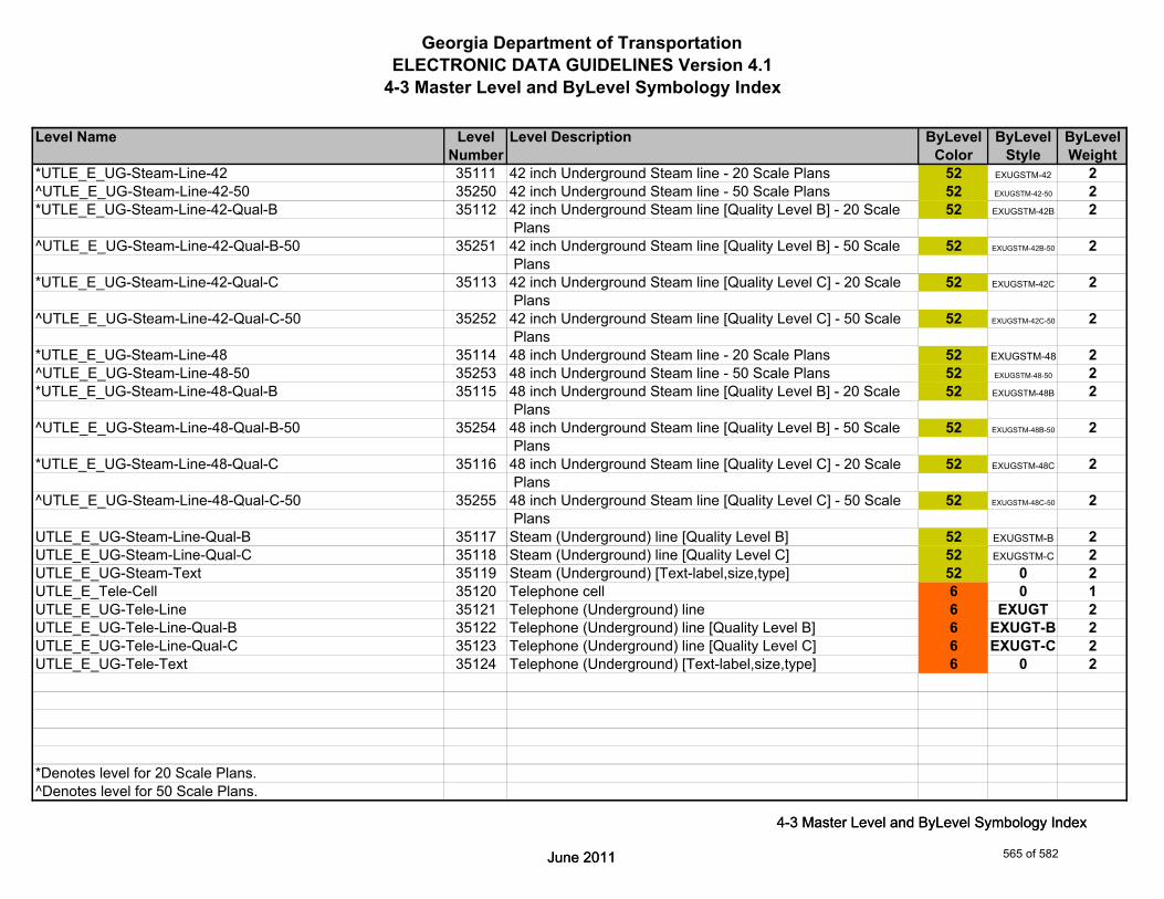
Georgia Department of TransportationELECTRONIC DATA GUIDELINES Version 4.1
4-3 Master Level and ByLevel Symbology Index
Level Name Level Level Description ByLevel ByLevel ByLevelNumber Color Style Weight
*UTLE_E_UG-Steam-Line-42 35111 42 inch Underground Steam line - 20 Scale Plans 52 EXUGSTM-42 2^UTLE_E_UG-Steam-Line-42-50 35250 42 inch Underground Steam line - 50 Scale Plans 52 EXUGSTM-42-50 2*UTLE_E_UG-Steam-Line-42-Qual-B 35112 42 inch Underground Steam line [Quality Level B] - 20 Scale 52 EXUGSTM-42B 2
Plans^UTLE_E_UG-Steam-Line-42-Qual-B-50 35251 42 inch Underground Steam line [Quality Level B] - 50 Scale 52 EXUGSTM-42B-50 2
Plans*UTLE_E_UG-Steam-Line-42-Qual-C 35113 42 inch Underground Steam line [Quality Level C] - 20 Scale 52 EXUGSTM-42C 2
Plans^UTLE_E_UG-Steam-Line-42-Qual-C-50 35252 42 inch Underground Steam line [Quality Level C] - 50 Scale 52 EXUGSTM-42C-50 2
Plans*UTLE_E_UG-Steam-Line-48 35114 48 inch Underground Steam line - 20 Scale Plans 52 EXUGSTM-48 2^UTLE_E_UG-Steam-Line-48-50 35253 48 inch Underground Steam line - 50 Scale Plans 52 EXUGSTM-48-50 2*UTLE_E_UG-Steam-Line-48-Qual-B 35115 48 inch Underground Steam line [Quality Level B] - 20 Scale 52 EXUGSTM-48B 2
Plans^UTLE_E_UG-Steam-Line-48-Qual-B-50 35254 48 inch Underground Steam line [Quality Level B] - 50 Scale 52 EXUGSTM-48B-50 2
Plans*UTLE_E_UG-Steam-Line-48-Qual-C 35116 48 inch Underground Steam line [Quality Level C] - 20 Scale 52 EXUGSTM-48C 2
Plans^UTLE_E_UG-Steam-Line-48-Qual-C-50 35255 48 inch Underground Steam line [Quality Level C] - 50 Scale 52 EXUGSTM-48C-50 2
PlansUTLE_E_UG-Steam-Line-Qual-B 35117 Steam (Underground) line [Quality Level B] 52 EXUGSTM-B 2
June 2011
4-3 Master Level and ByLevel Symbology Index
UTLE_E_UG-Steam-Line-Qual-C 35118 Steam (Underground) line [Quality Level C] 52 EXUGSTM-C 2UTLE_E_UG-Steam-Text 35119 Steam (Underground) [Text-label,size,type] 52 0 2UTLE_E_Tele-Cell 35120 Telephone cell 6 0 1UTLE_E_UG-Tele-Line 35121 Telephone (Underground) line 6 EXUGT 2UTLE_E_UG-Tele-Line-Qual-B 35122 Telephone (Underground) line [Quality Level B] 6 EXUGT-B 2UTLE_E_UG-Tele-Line-Qual-C 35123 Telephone (Underground) line [Quality Level C] 6 EXUGT-C 2UTLE_E_UG-Tele-Text 35124 Telephone (Underground) [Text-label,size,type] 6 0 2
*Denotes level for 20 Scale Plans.^Denotes level for 50 Scale Plans.
June 2011
4-3 Master Level and ByLevel Symbology Index
565 of 582

Georgia Department of TransportationELECTRONIC DATA GUIDELINES Version 4.1
4-3 Master Level and ByLevel Symbology Index
Level Name Level Level Description ByLevel ByLevel ByLevelNumber Color Style Weight
UTLE_E_Traf-Ctrl-Cell 35125 Traffic Control cell 0 0 1UTLE_E_UG-Traf-Ctrl-Line 35126 Traffic Control (Underground) line 0 EXUGTC 2UTLE_E_UG-Traf-Ctrl-Line-Qual-B 35127 Traffic Control (Underground) line [Quality Level B] 0 EXUGTC-B 2UTLE_E_UG-Traf-Ctrl-Line-Qual-C 35128 Traffic Control (Underground) line [Quality Level C] 0 EXUGTC-C 2UTLE_E_UG-Traf-Ctrl-Text 35129 Traffic Control (Underground) [Text-label,size,type] 0 0 2UTLE_E_TV-Cell 35130 Television cell 6 0 1UTLE_E_UG-TV-Line 35131 Television (Underground) line 6 EXUGTV 2UTLE_E_UG-TV-Line-Qual-B 35132 Television (Underground) line [Quality Level B] 6 EXUGTV-B 2UTLE_E_UG-TV-Line-Qual-C 35133 Television (Underground) line [Quality Level C] 6 EXUGTV-C 2UTLE_E_UG-TV-Text 35134 Television (Underground) [Text-label,size,type] 6 0 2UTLE_E_UG-Utl-Unknown-Line-Qual-B 35136 Unknown Utility (Underground) line [Quality Level B Only] 0 EXUGUNK-B 2UTLE_E_UG-Utl-Unknown-Text 35137 Unknown Utility (Underground) [Text-label,size,type] 0 0 2UTLE_E_Wat-Cell 35138 Water cell 1 0 1UTLE_E_UG-Wat-Line 35139 Water (Underground) line 1 EXUGW 2*UTLE_E_UG-Wat-Line-24 35140 24 inch Underground Water line - 20 Scale Plans 1 EXUGW-24 2^UTLE_E_UG-Wat-Line-24-50 35256 24 inch Underground Water line - 50 Scale Plans 1 EXUGW-24-50 2*UTLE_E_UG-Wat-Line-24-Qual-B 35141 24 inch Underground Water line [Quality Level B] - 20 Scale 1 EXUGW-24B 2
Plans^UTLE_E_UG-Wat-Line-24-Qual-B-50 35257 24 inch Underground Water line [Quality Level B] - 50 Scale 1 EXUGW-24B-50 2
Plans*UTLE_E_UG-Wat-Line-24-Qual-C 35142 24 inch Underground Water line [Quality Level C] - 20 Scale 1 EXUGW-24C 2
June 2011
4-3 Master Level and ByLevel Symbology Index
Plans^UTLE_E_UG-Wat-Line-24-Qual-C-50 35258 24 inch Underground Water line [Quality Level C] - 50 Scale 1 EXUGW-24C-50 2
Plans
*Denotes level for 20 Scale Plans.^Denotes level for 50 Scale Plans.
June 2011
4-3 Master Level and ByLevel Symbology Index
566 of 582
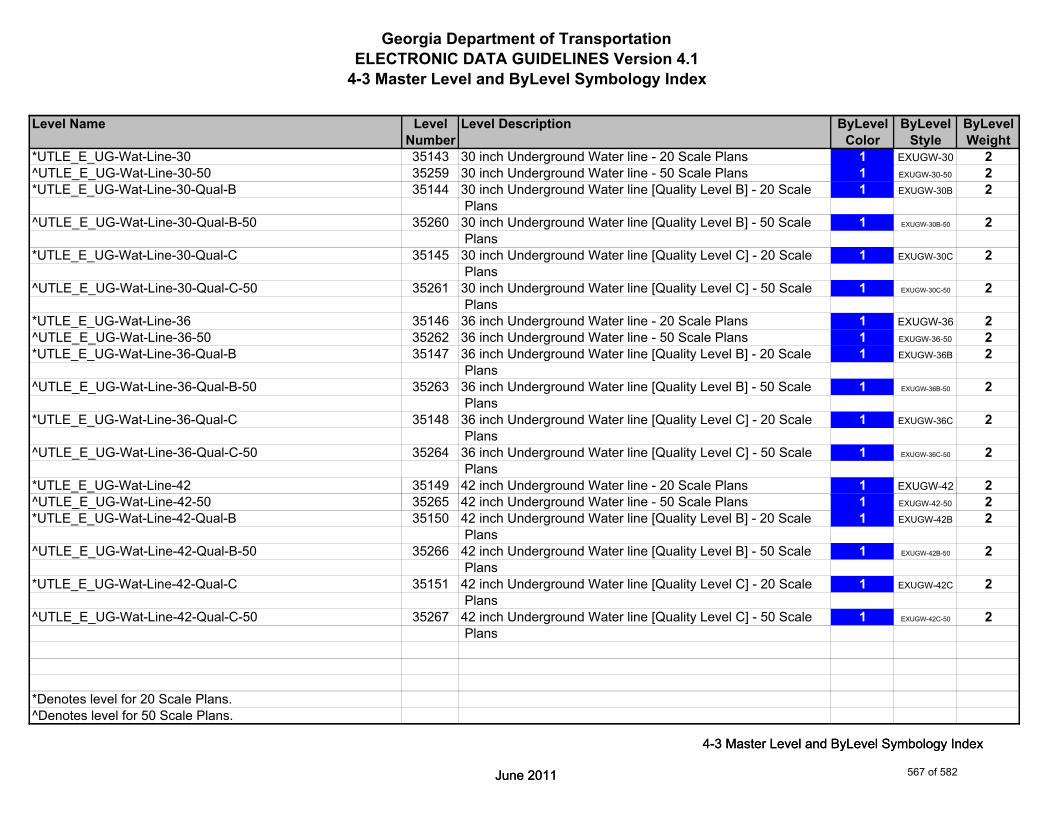
Georgia Department of TransportationELECTRONIC DATA GUIDELINES Version 4.1
4-3 Master Level and ByLevel Symbology Index
Level Name Level Level Description ByLevel ByLevel ByLevelNumber Color Style Weight
*UTLE_E_UG-Wat-Line-30 35143 30 inch Underground Water line - 20 Scale Plans 1 EXUGW-30 2^UTLE_E_UG-Wat-Line-30-50 35259 30 inch Underground Water line - 50 Scale Plans 1 EXUGW-30-50 2*UTLE_E_UG-Wat-Line-30-Qual-B 35144 30 inch Underground Water line [Quality Level B] - 20 Scale 1 EXUGW-30B 2
Plans^UTLE_E_UG-Wat-Line-30-Qual-B-50 35260 30 inch Underground Water line [Quality Level B] - 50 Scale 1 EXUGW-30B-50 2
Plans*UTLE_E_UG-Wat-Line-30-Qual-C 35145 30 inch Underground Water line [Quality Level C] - 20 Scale 1 EXUGW-30C 2
Plans^UTLE_E_UG-Wat-Line-30-Qual-C-50 35261 30 inch Underground Water line [Quality Level C] - 50 Scale 1 EXUGW-30C-50 2
Plans*UTLE_E_UG-Wat-Line-36 35146 36 inch Underground Water line - 20 Scale Plans 1 EXUGW-36 2^UTLE_E_UG-Wat-Line-36-50 35262 36 inch Underground Water line - 50 Scale Plans 1 EXUGW-36-50 2*UTLE_E_UG-Wat-Line-36-Qual-B 35147 36 inch Underground Water line [Quality Level B] - 20 Scale 1 EXUGW-36B 2
Plans^UTLE_E_UG-Wat-Line-36-Qual-B-50 35263 36 inch Underground Water line [Quality Level B] - 50 Scale 1 EXUGW-36B-50 2
Plans*UTLE_E_UG-Wat-Line-36-Qual-C 35148 36 inch Underground Water line [Quality Level C] - 20 Scale 1 EXUGW-36C 2
Plans^UTLE_E_UG-Wat-Line-36-Qual-C-50 35264 36 inch Underground Water line [Quality Level C] - 50 Scale 1 EXUGW-36C-50 2
Plans*UTLE_E_UG-Wat-Line-42 35149 42 inch Underground Water line - 20 Scale Plans 1 EXUGW-42 2
June 2011
4-3 Master Level and ByLevel Symbology Index
^UTLE_E_UG-Wat-Line-42-50 35265 42 inch Underground Water line - 50 Scale Plans 1 EXUGW-42-50 2*UTLE_E_UG-Wat-Line-42-Qual-B 35150 42 inch Underground Water line [Quality Level B] - 20 Scale 1 EXUGW-42B 2
Plans^UTLE_E_UG-Wat-Line-42-Qual-B-50 35266 42 inch Underground Water line [Quality Level B] - 50 Scale 1 EXUGW-42B-50 2
Plans*UTLE_E_UG-Wat-Line-42-Qual-C 35151 42 inch Underground Water line [Quality Level C] - 20 Scale 1 EXUGW-42C 2
Plans^UTLE_E_UG-Wat-Line-42-Qual-C-50 35267 42 inch Underground Water line [Quality Level C] - 50 Scale 1 EXUGW-42C-50 2
Plans
*Denotes level for 20 Scale Plans.^Denotes level for 50 Scale Plans.
June 2011
4-3 Master Level and ByLevel Symbology Index
567 of 582

Georgia Department of TransportationELECTRONIC DATA GUIDELINES Version 4.1
4-3 Master Level and ByLevel Symbology Index
Level Name Level Level Description ByLevel ByLevel ByLevelNumber Color Style Weight
*UTLE_E_UG-Wat-Line-48 35152 48 inch Underground Water line - 20 Scale Plans 1 EXUGW-48 2^UTLE_E_UG-Wat-Line-48-50 35268 48 inch Underground Water line - 50 Scale Plans 1 EXUGW-48-50 2*UTLE_E_UG-Wat-Line-48-Qual-B 35153 48 inch Underground Water line [Quality Level B] - 20 Scale 1 EXUGW-48B 2
Plans^UTLE_E_UG-Wat-Line-48-Qual-B-50 35269 48 inch Underground Water line [Quality Level B] - 50 Scale 1 EXUGW-48B-50 2
Plans*UTLE_E_UG-Wat-Line-48-Qual-C 35154 48 inch Underground Water line [Quality Level C] - 20 Scale 1 EXUGW-48C 2
Plans^UTLE_E_UG-Wat-Line-48-Qual-C-50 35270 48 inch Underground Water line [Quality Level C] - 50 Scale 1 EXUGW-48C-50 2
PlansUTLE_E_UG-Wat-Line-Qual-B 35155 Water (Underground) line [Quality Level B] 1 EXUGW-B 2UTLE_E_UG-Wat-Line-Qual-C 35156 Water (Underground) line [Quality Level C] 1 EXUGW-C 2UTLE_E_Wat-Non-Pot-Cell 35157 Non-potable water cell 1 0 1UTLE_E_UG-Wat-Non-Pot-Line 35158 Non-potable water (Underground) line 1 EXUGNW 2*UTLE_E_UG-Wat-Non-Pot-Line-24 35159 24 inch Underground Non-potable water line - 20 Scale Plans 1 EXUGNW-24 2^UTLE_E_UG-Wat-Non-Pot-Line-24-50 35271 24 inch Underground Non-potable water line - 50 Scale Plans 1 EXUGNW-24-50 2*UTLE_E_UG-Wat-Non-Pot-Line-24-Qual-B 35160 24 inch Underground Non-potable water line [Quality Level B] 1 EXUGNW-24B 2
- 20 Scale Plans^UTLE_E_UG-Wat-Non-Pot-Line-24-Qual-B-50 35272 24 inch Underground Non-potable water line [Quality Level B] 1 EXUGNW-24B-50 2
- 50 Scale Plans*UTLE_E_UG-Wat-Non-Pot-Line-24-Qual-C 35161 24 inch Underground Non-potable water line [Quality Level C] 1 EXUGNW-24C 2
June 2011
4-3 Master Level and ByLevel Symbology Index
- 20 Scale Plans^UTLE_E_UG-Wat-Non-Pot-Line-24-Qual-C-50 35273 24 inch Underground Non-potable water line [Quality Level C] 1 EXUGNW-24C-50 2
- 50 Scale Plans
*Denotes level for 20 Scale Plans.^Denotes level for 50 Scale Plans.
June 2011
4-3 Master Level and ByLevel Symbology Index
568 of 582

Georgia Department of TransportationELECTRONIC DATA GUIDELINES Version 4.1
4-3 Master Level and ByLevel Symbology Index
Level Name Level Level Description ByLevel ByLevel ByLevelNumber Color Style Weight
*UTLE_E_UG-Wat-Non-Pot-Line-30 35162 30 inch Underground Non-potable water line - 20 Scale Plans 1 EXUGNW-30 2^UTLE_E_UG-Wat-Non-Pot-Line-30-50 35274 30 inch Underground Non-potable water line 50 Scale 1 EXUGNW-30-50 2*UTLE_E_UG-Wat-Non-Pot-Line-30-Qual-B 35163 30 inch Underground Non-potable water line [Quality Level B] 1 EXUGNW-30B 2
- 20 Scale Plans^UTLE_E_UG-Wat-Non-Pot-Line-30-Qual-B-50 35275 30 inch Underground Non-potable water line [Quality Level B] 1 EXUGNW-30B-50 2
- 50 Scale Plans*UTLE_E_UG-Wat-Non-Pot-Line-30-Qual-C 35164 30 inch Underground Non-potable water line [Quality Level C] 1 EXUGNW-30C 2
- 20 Scale Plans^UTLE_E_UG-Wat-Non-Pot-Line-30-Qual-C-50 35276 30 inch Underground Non-potable water line [Quality Level C] 1 EXUGNW-30C-50 2
- 50 Scale Plans*UTLE_E_UG-Wat-Non-Pot-Line-36 35165 36 inch Underground Non-potable water line - 20 Scale Plans 1 EXUGNW-36 2^UTLE_E_UG-Wat-Non-Pot-Line-36-50 35277 36 inch Underground Non-potable water line - 50 Scale Plans 1 EXUGNW-36-50 2*UTLE_E_UG-Wat-Non-Pot-Line-36-Qual-B 35166 36 inch Underground Non-potable water line [Quality Level B] 1 EXUGNW-36B 2
- 20 Scale Plans^UTLE_E_UG-Wat-Non-Pot-Line-36-Qual-B-50 35278 36 inch Underground Non-potable water line [Quality Level B] 1 EXUGNW-36B-50 2
- 50 Scale Plans*UTLE_E_UG-Wat-Non-Pot-Line-36-Qual-C 35167 36 inch Underground Non-potable water line [Quality Level C] 1 EXUGNW-36C 2
- 20 Scale Plans^UTLE_E_UG-Wat-Non-Pot-Line-36-Qual-C-50 35279 36 inch Underground Non-potable water line [Quality Level C] 1 EXUGNW-36C-50 2
- 50 Scale Plans*UTLE_E_UG-Wat-Non-Pot-Line-42 35168 42 inch Underground non-potable water line - 20 Scale Plans 1 EXUGNW-42 2
June 2011
4-3 Master Level and ByLevel Symbology Index
^UTLE_E_UG-Wat-Non-Pot-Line-42-50 35280 42 inch Underground non-potable water line 50 Scale 1 EXUGNW-42-50 2*UTLE_E_UG-Wat-Non-Pot-Line-42-Qual-B 35169 42 inch Underground non-potable water line [Quality Level B] 1 EXUGNW-42B 2
- 20 Scale Plans^UTLE_E_UG-Wat-Non-Pot-Line-42-Qual-B-50 35281 42 inch Underground non-potable water line [Quality Level B] 1 EXUGNW-42B-50 2
- 50 Scale Plans*UTLE_E_UG-Wat-Non-Pot-Line-42-Qual-C 35170 42 inch Underground non-potable water line [Quality Level C] 1 EXUGNW-42C 2
- 20 Scale Plans^UTLE_E_UG-Wat-Non-Pot-Line-42-Qual-C-50 35282 42 inch Underground non-potable water line [Quality Level C] 1 EXUGNW-42C-50 2
- 50 Scale Plans
*Denotes level for 20 Scale Plans.^Denotes level for 50 Scale Plans.
June 2011
4-3 Master Level and ByLevel Symbology Index
569 of 582

Georgia Department of TransportationELECTRONIC DATA GUIDELINES Version 4.1
4-3 Master Level and ByLevel Symbology Index
Level Name Level Level Description ByLevel ByLevel ByLevelNumber Color Style Weight
*UTLE_E_UG-Wat-Non-Pot-Line-48 35171 48 inch Underground Non-potable water line - 20 Scale Plans 1 EXUGNW-48 2*UTLE_E_UG-Wat-Non-Pot-Line-48-50 35283 48 inch Underground Non-potable water line - 50 Scale Plans 1 EXUGNW-48-50 2*UTLE_E_UG-Wat-Non-Pot-Line-48-Qual-B 35172 48 inch Underground Non-potable water line [Quality Level B] 1 EXUGNW-48B 2
- 20 Scale Plans^UTLE_E_UG-Wat-Non-Pot-Line-48-Qual-B-50 35284 48 inch Underground Non-potable water line [Quality Level B] 1 EXUGNW-48B-50 2
- 50 Scale Plans*UTLE_E_UG-Wat-Non-Pot-Line-48-Qual-C 35173 48 inch Underground Non-potable water line [Quality Level C] 1 EXUGNW-48C 2
- 20 Scale Plans^UTLE_E_UG-Wat-Non-Pot-Line-48-Qual-C-50 35285 48 inch Underground Non-potable water line [Quality Level C] 1 EXUGNW-48C-50 2
- 50 Scale PlansUTLE_E_UG-Wat-Non-Pot-Line-Qual-B 35174 Non-potable water (Underground) line [Quality Level B] 1 EXUGNW-B 2UTLE_E_UG-Wat-Non-Pot-Line-Qual-C 35175 Non-potable water (Underground) line [Quality Level C] 1 EXUGNW-C 2UTLE_E_UG-Wat-Non-Pot-Text 35176 Non-potable water (Underground) [Text-label,size,type] 1 0 2UTLE_E_UG-Wat-Text 35177 Water (Underground) [Text-label,size,type] 1 0 2UTLE_E_UG-Gas-Line-User-Def 35178 Gas User Defined Width (Underground) line 52 EXUGG 2UTLE_E_UG-Gas-Line-User-Def-Qual-B 35179 Gas User Defined Width (Underground) line [Quality Level B] 52 EXUGG-B 2UTLE_E_UG-Gas-Line-User-Def-Qual-C 35180 Gas User Defined Width (Underground) line [Quality Level C] 52 EXUGG-C 2UTLE_E_UG-Petro-Line-User-Def 35181 Petroleum User Defined Width (Underground) line 52 EXUGP 2UTLE_E_UG-Petro-Line-User-Def-Qual-B 35182 Petroleum User Defined Width (Underground) line [Quality 52 EXUGP-B 2
Level B]UTLE_E_UG-Petro-Line-User-Def-Qual-C 35183 Petroleum User Defined Width (Underground) line [Quality 52 EXUGP-C 2
June 2011
4-3 Master Level and ByLevel Symbology Index
Level C]UTLE_E_UG-San-Swr-User-Def-Line 35184 Sanitary Sewer User Defined Width (Underground) line 2 EXUGSS 2UTLE_E_UG-San-Swr-User-Def-Line-Qual-B 35185 Sanitary Sewer User Defined Width (Underground) line 2 EXUGSS-B 2
[Quality Level B]UTLE_E_UG-San-Swr-User-Def-Line-Qual-C 35186 Sanitary Sewer User Defined Width (Underground) line 2 EXUGSS-C 2
[Quality Level C]
*Denotes level for 20 Scale Plans.^Denotes level for 50 Scale Plans.
June 2011
4-3 Master Level and ByLevel Symbology Index
570 of 582

Georgia Department of TransportationELECTRONIC DATA GUIDELINES Version 4.1
4-3 Master Level and ByLevel Symbology Index
Level Name Level Level Description ByLevel ByLevel ByLevelNumber Color Style Weight
UTLE_E_UG-Steam-User-Def-Line 35187 Steam User Defined Width (Underground) line 52 EXUGSTM 2UTLE_E_UG-Steam-User-Def-Line-Qual-B 35188 Steam User Defined Width (Underground) line [Quality 52 EXUGSTM-B 2
Level B]UTLE_E_UG-Steam-User-Def-Line-Qual-C 35189 Steam User Defined Width (Underground) line [Quality 52 EXUGSTM-C 2
Level C]UTLE_E_UG-Wat-User-Def-Line 35190 Water User Defined Width (Underground) line 1 EXUGW 2UTLE_E_UG-Wat-User-Def-Line-Qual-B 35191 Water User Defined Width (Underground) line [Quality 1 EXUGW-B 2
Level B]UTLE_E_UG-Wat-User-Def-Line-Qual-C 35192 Water User Defined Width (Underground) line [Quality 1 EXUGW-C 2
Level C]UTLE_E_UG-Wat-Non-Pot-User-Def-Line 35193 Non-potable water User Defined Width (Underground) line 1 EXUGNW 2UTLE_E_UG-Wat-Non-Pot-User-Def-Line-Qual-B 35194 Non-potable water User Defined Width (Underground) line 1 EXUGNW-B 2
[Quality Level B]UTLE_E_UG-Wat-Non-Pot-User-Def-Line-Qual-C 35195 Non-potable water User Defined Width (Underground) line 1 EXUGNW-C 2
[Quality Level C]UTLE_E_Elec-Vault-Line 35286 Elictrical Vault line 5 1 1UTLE_E_Misc-Notes 35287 Miscellaneous Notes (not plotted) 0 0 0UTLE_E_OVHD-Guy-Cell 35288 Overhead Guy cell 6 0 2UTLE_E_Misc-Cell 35289 Miscellaneous Marker cell 0 0 1UTLE_E_Misc-Line 35290 Miscellaneous Marker line 0 0 1UTLE_E_Misc-Text 35291 Miscellaneous Marker text 0 0 1
June 2011
4-3 Master Level and ByLevel Symbology Index
UTLE_E_Cell-Cell 35292 Existing Utility Cell - cell 2 0 1UTLE_E_Cell-Line 35293 Existing Utility Cell - line 2 0 1UTLE_E_Cell-Text 35294 Existing Utility Cell - text 2 0 1
June 2011
4-3 Master Level and ByLevel Symbology Index
571 of 582

Georgia Department of TransportationELECTRONIC DATA GUIDELINES Version 4.1
4-3 Master Level and ByLevel Symbology Index
Level Name Level Level Description ByLevel ByLevel ByLevelNumber Color Style Weight
UTLP_P_OVHD-Combo-Util-Line-Elec-Tele 36003 Combination Utility (Overhead) line [Electric and Telephone] 3 PROHET 3UTLP_P_OVHD-Combo-Util-Line-Elec-Tele-Traf-Ctrl 36004 Combination Utility (Overhead) line [Electric,Telephone, 3 PROHETTC 3
and Traffic Control]UTLP_P_OVHD-Combo-Util-Line-Elec-Tele-Traf-Ctrl-REM 36005 Remove Combination Utility (Overhead) line [Electric, 3 TBR - EXOHETTC 2
Telephone, and Traff.Ctrl]UTLP_P_OVHD-Combo-Util-Line-Elec-Tele-TV 36006 Combination Utility (Overhead) line [Electric, Telephone 3 PROHETTV 3
Television]UTLP_P_OVHD-Combo-Util-Line-Elec-Tele-TV-REM 36007 Remove Combination Utility (Overhead) line [Electric, 3 TBR - EXOHETTV 2
Telephone and Television]UTLP_P_OVHD-Combo-Util-Line-Elec-Tele-TV-Traf-Ctrl 36008 Combination Utility (Overhead) line [Electric,Telephone, 3 PROHETTVTC 3
Television, and Traff.Ctrl]UTLP_P_OVHD-Combo-Util-Line-Elec-Tele-TV-Traf-Ctrl-REM 36009 Remove Combination Utility (Overhead) line [Elec., Tele., 3 TBR - EXOHETTVTC 2
TV, and Traff. Cntrl]UTLP_P_OVHD-Combo-Util-Line-Elec-Traf-Ctrl 36010 Combination Utility (Overhead) line [Electric and Traffic 3 PROHETC 3
Control]UTLP_P_OVHD-Combo-Util-Line-Elec-Traf-Ctrl-REM 36011 Remove Combination Utility (Overhead) line [Electric and 3 TBR - EXOHETC 2
Traffic Control]UTLP_P_OVHD-Combo-Util-Line-Elec-TV 36012 Combination Utility (Overhead) line [Electric and Television] 3 PROHETV 3UTLP_P_OVHD-Combo-Util-Line-Elec-TV-REM 36013 Remove Combination Utility (Overhead) line [Electric and 3 TBR - EXOHETV 2
Television]UTLP_P_OVHD-Combo-Util-Line-Elec-TV-Traf-Ctrl 36014 Combination Utility (Overhead) line [Electric,Television, and 3 PROHETVTC 3
June 2011
4-3 Master Level and ByLevel Symbology Index
Traffic Control]UTLP_P_OVHD-Combo-Util-Line-Elec-TV-Traf-Ctrl-REM 36015 Remove Combination Utility (Overhead) line [Electric, 3 TBR - EXOHETVTC 2
Television, and Traff.Ctrl]UTLP_P_OVHD-Guy-Wire-Line 36016 Overhead Guy Wire line 0 PROHGW 3
June 2011
4-3 Master Level and ByLevel Symbology Index
572 of 582

Georgia Department of TransportationELECTRONIC DATA GUIDELINES Version 4.1
4-3 Master Level and ByLevel Symbology Index
Level Name Level Level Description ByLevel ByLevel ByLevelNumber Color Style Weight
UTLP_P_OVHD-Combo-Util-Lines-Elec-Tele-REM 36018 Remove Combination Utility (Overhead) line [Electric and 3 TBR - EXOHET 2 Telephone]
UTLP_P_OVHD-Combo-Util-Line-Tele-Traf-Ctrl 36019 Combination Utility (Overhead) line [Telephone and Traffic 6 PROHTTC 3 Control]
UTLP_P_OVHD-Combo-Util-Line-Tele-Traf-Ctrl-REM 36020 Remove Combination Utility (Overhead) line [Telephone and 6 TBR - EXOHTTC 2 Traffic Control]
UTLP_P_OVHD-Combo-Util-Line-Tele-TV 36021 Combination Utility (Overhead) line [Telephone and 6 PROHTTV 3 Television]
UTLP_P_OVHD-Combo-Util-Line-Tele-TV-REM 36022 Remove Combination Utility (Overhead) line [Telephone and 6 TBR - EXOHTTV 2 Television]
UTLP_P_OVHD-Combo-Util-Line-Tele-TV-Traf-Ctrl 36023 Combination Utility (Overhead) line [Telephone,Television, 6 PROHTTVTC 3 and Traff.Ctrl]
UTLP_P_OVHD-Combo-Util-Line-Tele-TV-Traf-Ctrl-REM 36024 Remove Combination Utility (Overhead) line [Telephone,TV 6 TBR - EXOHTTVTC 2 and Traff. Cntrl]
UTLP_P_OVHD-Combo-Util-Line-TV-Traf-Ctrl 36025 Combination Utility (Overhead) line [Television, and 6 PROHTVTC 3 Traffic Control]
UTLP_P_OVHD-Combo-Util-Line-TV-Traf-Ctrl-REM 36026 Remove Combination Utility (Overhead) line [Television, and 6 TBR - EXOHTVTC 2 Traffic Control]
UTLP_P_OVHD-Combo-Util-Text 36027 Combination Utility [Text-label,size,type] 3 0 3UTLP_P_OVHD-Elec-Line 36029 Electrical (Overhead) line 3 PROHE 3UTLP_P_OVHD-Elec-Line-REM 36030 Remove Electrical (Overhead) line 3 TBR - EXOHE 2
El i l (O h d) [T l b l i ]
June 2011
4-3 Master Level and ByLevel Symbology Index
UTLP_P_OVHD-Elec-Text 36031 Electrical (Overhead) [Text-label,size,type] 3 0 2UTLP_P_OVHD-Tele-Line 36034 Telephone (Overhead) line 6 PROHT 3UTLP_P_OVHD-Tele-Line-REM 36035 Remove Telephone (Overhead) line 6 TBR - EXOHT 2UTLP_P_OVHD-Tele-Text 36036 Telephone (Overhead) [Text-label,size,type] 6 0 2UTLP_P_OVHD-Traf-Ctrl-Line 36038 Traffic Control (Overhead) line 0 PROHTC 3UTLP_P_OVHD-Traf-Ctrl-Line-REM 36039 Remove Traffic Control (Overhead) line 0 TBR - EXOHTC 2UTLP_P_OVHD-Traf-Ctrl-Text 36040 Traffic Control (Overhead) [Text-label,size,type] 0 0 2UTLP_P_OVHD-TV-Line 36042 Television (Overhead) line 6 PROHTV 3UTLP_P_OVHD-TV-Line-REM 36043 Remove Television (Overhead) line 6 TBR - EXOHTV 2UTLP_P_OVHD-TV-Text 36044 Television (Overhead) [Text-label,size,type] 6 0 2
June 2011
4-3 Master Level and ByLevel Symbology Index
573 of 582
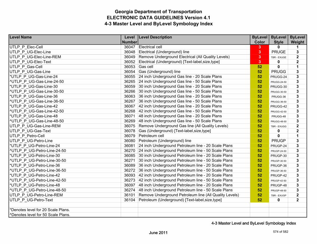
Georgia Department of TransportationELECTRONIC DATA GUIDELINES Version 4.1
4-3 Master Level and ByLevel Symbology Index
Level Name Level Level Description ByLevel ByLevel ByLevelNumber Color Style Weight
UTLP_P_Elec-Cell 36047 Electrical cell 3 0 1UTLP_P_UG-Elec-Line 36048 Electrical (Underground) line 3 PRUGE 3UTLP_P_UG-Elec-Line-REM 36049 Remove Underground Electrical (All Quality Levels) 3 TBR - EXUGE 2UTLP_P_UG-Elec-Text 36052 Electrical (Underground) [Text-label,size,type] 3 0 2UTLP_P_Gas-Cell 36053 Gas cell 52 0 1UTLP_P_UG-Gas-Line 36054 Gas (Underground) line 52 PRUGG 3*UTLP_P_UG-Gas-Line-24 36055 24 inch Underground Gas line - 20 Scale Plans 52 PRUGG-24 3^UTLP_P_UG-Gas-Line-24-50 36265 24 inch Underground Gas line - 50 Scale Plans 52 PRUGG-24-50 3*UTLP_P_UG-Gas-Line-30 36059 30 inch Underground Gas line - 20 Scale Plans 52 PRUGG-30 3^UTLP_P_UG-Gas-Line-30-50 36266 30 inch Underground Gas line - 50 Scale Plans 52 PRUGG-30-50 3*UTLP_P_UG-Gas-Line-36 36063 36 inch Underground Gas line - 20 Scale Plans 52 PRUGG-36 3^UTLP_P_UG-Gas-Line-36-50 36267 36 inch Underground Gas line - 50 Scale Plans 52 PRUGG-36-50 3*UTLP_P_UG-Gas-Line-42 36067 42 inch Underground Gas line - 20 Scale Plans 52 PRUGG-42 3^UTLP_P_UG-Gas-Line-42-50 36268 42 inch Underground Gas line - 50 Scale Plans 52 PRUGG-42-50 3*UTLP_P_UG-Gas-Line-48 36071 48 inch Underground Gas line - 20 Scale Plans 52 PRUGG-48 3^UTLP_P_UG-Gas-Line-48-50 36269 48 inch Underground Gas line - 50 Scale Plans 52 PRUGG-48-50 3UTLP_P_UG-Gas-Line-REM 36075 Remove Underground Gas line (All Quality Levels) 52 TBR - EXUGG 2UTLP_P_UG-Gas-Text 36078 Gas (Underground) [Text-label,size,type] 52 0 2UTLP_P_Petro-Cell 36079 Petroleum cell 52 0 1UTLP_P_UG-Petro-Line 36080 Petroleum (Underground) line 52 PRUGP 3*UTLP_P_UG-Petro-Line-24 36081 24 inch Underground Petroleum line - 20 Scale Plans 52 PRUGP-24 3
24 i h U d d P l li 0 S l Pl
June 2011
4-3 Master Level and ByLevel Symbology Index
^UTLP_P_UG-Petro-Line-24-50 36270 24 inch Underground Petroleum line - 50 Scale Plans 52 PRUGP-24-50 3*UTLP_P_UG-Petro-Line-30 36085 30 inch Underground Petroleum line - 20 Scale Plans 52 PRUGP-30 3^UTLP_P_UG-Petro-Line-30-50 36271 30 inch Underground Petroleum line - 50 Scale Plans 52 PRUGP-30-50 3*UTLP_P_UG-Petro-Line-36 36089 36 inch Underground Petroleum line - 20 Scale Plans 52 PRUGP-36 3^UTLP_P_UG-Petro-Line-36-50 36272 36 inch Underground Petroleum line - 50 Scale Plans 52 PRUGP-36-50 3*UTLP_P_UG-Petro-Line-42 36093 42 inch Underground Petroleum line - 20 Scale Plans 52 PRUGP-42 3^UTLP_P_UG-Petro-Line-42-50 36273 42 inch Underground Petroleum line - 50 Scale Plans 52 PRUGP-42-50 3*UTLP_P_UG-Petro-Line-48 36097 48 inch Underground Petroleum line - 20 Scale Plans 52 PRUGP-48 3^UTLP_P_UG-Petro-Line-48-50 36274 48 inch Underground Petroleum line - 50 Scale Plans 52 PRUGP-48-50 3UTLP_P_UG-Petro-Line-REM 36101 Remove Underground Petroleum line (All Quality Levels) 52 TBR - EXUGP 2UTLP_P_UG-Petro-Text 36104 Petroleum (Underground) [Text-label,size,type] 52 0 2
*Denotes level for 20 Scale Plans.^Denotes level for 50 Scale Plans.
June 2011
4-3 Master Level and ByLevel Symbology Index
574 of 582

Georgia Department of TransportationELECTRONIC DATA GUIDELINES Version 4.1
4-3 Master Level and ByLevel Symbology Index
Level Name Level Level Description ByLevel ByLevel ByLevelNumber Color Style Weight
UTLP_P_San-Force-Main-Cell 36105 Sanitary Force Main cell 2 0 1UTLP_P_UG-San-Force-Main-Line 36106 Sanitary Force Main (Underground) line 2 PRUGSFM 3UTLP_P_UG-San-Force-Main-Line-REM 36107 Remove Underground Sanitary Force Main line (All Quality 2 TBR - EXUGSFM 2UTLP_P_UG-San-Force-Main-Text 36110 Sanitary Force Main (Underground) [Text-label,size,type] 2 0 2UTLP_P_San-Swr-Cell 36111 Sanitary Sewer cell 2 0 1UTLP_P_UG-San-Swr-Line 36112 Sanitary Sewer (Underground) line 2 PRUGSS 3*UTLP_P_UG-San-Swr-Line-24 36113 24 inch Underground Sanitary Sewer line - 20 Scale Plans 2 PRUGSS-24 3^UTLP_P_UG-San-Swr-Line-24-50 36275 24 inch Underground Sanitary Sewer line - 50 Scale Plans 2 PRUGSS-24-50 3*UTLP_P_UG-San-Swr-Line-30 36117 30 inch Underground Sanitary Sewer line - 20 Scale Plans 2 PRUGSS-30 3^UTLP_P_UG-San-Swr-Line-30-50 36276 30 inch Underground Sanitary Sewer line - 50 Scale Plans 2 PRUGSS-30-50 3*UTLP_P_UG-San-Swr-Line-36 36121 36 inch Underground Sanitary Sewer line - 20 Scale Plans 2 PRUGSS-36 3^UTLP_P_UG-San-Swr-Line-36-50 36277 36 inch Underground Sanitary Sewer line - 50 Scale Plans 2 PRUGSS-36-50 3*UTLP_P_UG-San-Swr-Line-42 36125 42 inch Underground Sanitary Sewer line - 20 Scale Plans 2 PRUGSS-42 3^UTLP_P_UG-San-Swr-Line-42-50 36278 42 inch Underground Sanitary Sewer line - 50 Scale Plans 2 PRUGSS-42-50 3*UTLP_P_UG-San-Swr-Line-48 36129 48 inch Underground Sanitary Sewer line - 20 Scale Plans 2 PRUGSS-48 3^UTLP_P_UG-San-Swr-Line-48-50 36279 48 inch Underground Sanitary Sewer line - 50 Scale Plans 2 PRUGSS-48-50 3UTLP_P_UG-San-Swr-Line-REM 36133 Remove Underground Sanitary Sewer line (All Quality 2 TBR - EXUGSS 2
Levels)UTLP_P_UG-San-Swr-Text 36136 Sanitary Sewer (Underground) [Text-label,size,type] 2 0 2UTLP_P_Steam-Cell 36137 Steam cell 52 0 1UTLP_P_UG-Steam-Line 36138 Steam (Underground) line 52 PRUGSTM 3
24 i h U d d S li 20 S l Pl
June 2011
4-3 Master Level and ByLevel Symbology Index
*UTLP_P_UG-Steam-Line-24 36139 24 inch Underground Steam line - 20 Scale Plans 52 PRUGSTM-24 3^UTLP_P_UG-Steam-Line-24-50 36280 24 inch Underground Steam line - 50 Scale Plans 52 PRUGSTM-24-50 3*UTLP_P_UG-Steam-Line-30 36143 30 inch Underground Steam line - 20 Scale Plans 52 PRUGSTM-30 3^UTLP_P_UG-Steam-Line-30-50 36281 30 inch Underground Steam line - 50 Scale Plans 52 PRUGSTM-30-50 3*UTLP_P_UG-Steam-Line-36 36147 36 inch Underground Steam line - 20 Scale Plans 52 PRUGSTM-36 3^UTLP_P_UG-Steam-Line-36-50 36282 36 inch Underground Steam line - 50 Scale Plans 52 PRUGSTM-36-50 3*UTLP_P_UG-Steam-Line-42 36151 42 inch Underground Steam line - 20 Scale Plans 52 PRUGSTM-42 3^UTLP_P_UG-Steam-Line-42-50 36283 42 inch Underground Steam line - 50 Scale Plans 52 PRUGSTM-42-50 3*UTLP_P_UG-Steam-Line-48 36155 48 inch Underground Steam line - 20 Scale Plans 52 PRUGSTM-48 3^UTLP_P_UG-Steam-Line-48-50 36284 48 inch Underground Steam line - 50 Scale Plans 52 PRUGSTM-48-50 3UTLP_P_UG-Steam-Line-REM 36159 Remove Underground Steam line (All Quality Levels) 52 TBR - EXUGSTM 2
*Denotes level for 20 Scale Plans.^Denotes level for 50 Scale Plans.
June 2011
4-3 Master Level and ByLevel Symbology Index
575 of 582

Georgia Department of TransportationELECTRONIC DATA GUIDELINES Version 4.1
4-3 Master Level and ByLevel Symbology Index
Level Name Level Level Description ByLevel ByLevel ByLevelNumber Color Style Weight
UTLP_P_UG-Steam-Text 36162 Steam (Underground) [Text-label,size,type] 52 0 2UTLP_P_Tele-Cell 36163 Telephone cell 6 0 1UTLP_P_UG-Tele-Line 36164 Telephone (Underground) line 6 PRUGT 3UTLP_P_UG-Tele-Line-REM 36165 Remove Underground Telephone line (All Quality Levels) 6 TBR - EXUGT 2UTLP_P_UG-Tele-Text 36168 Telephone (Underground) [Text-label,size,type] 6 0 2UTLP_P_Traf-Ctrl-Cell 36169 Traffic Control cell 0 0 1UTLP_P_UG-Traf-Ctrl-Line 36170 Traffic Control (Underground) line 0 PRUGTC 3UTLP_P_UG-Traf-Ctrl-Line-REM 36171 Remove Underground Traffic Control line (All Quality Levels) 0 TBR - EXOHTC 2UTLP_P_UG-Traf-Ctrl-Text 36174 Traffic Control (Underground) [Text-label,size,type] 0 0 2UTLP_P_TV-Cell 36175 Television cell 6 0 1UTLP_P_UG-TV-Line 36176 Television (Underground) line 6 PRUGTV 3UTLP_P_UG-TV-Line-REM 36177 Remove Underground Television line (All Quality Levels) 6 TBR - EXUGTV 2UTLP_P_UG-TV-Text 36180 Television (Underground) [Text-label,size,type] 6 0 2UTLP_P_Wat-Cell 36184 Water cell 1 0 1UTLP_P_UG-Wat-Line 36185 Water (Underground) line 1 PRUGW 3*UTLP_P_UG-Wat-Line-24 36186 24 inch Underground Water line - 20 Scale Plans 1 PRUGW-24 3^UTLP_P_UG-Wat-Line-24-50 36285 24 inch Underground Water line - 50 Scale Plans 1 PRUGW-24-50 3*UTLP_P_UG-Wat-Line-30 36190 30 inch Underground Water line - 20 Scale Plans 1 PRUGW-30 3^UTLP_P_UG-Wat-Line-30-50 36286 30 inch Underground Water line - 50 Scale Plans 1 PRUGW-30-50 3*UTLP_P_UG-Wat-Line-36 36194 36 inch Underground Water line - 20 Scale Plans 1 PRUGW-36 3^UTLP_P_UG-Wat-Line-36-50 36287 36 inch Underground Water line - 50 Scale Plans 1 PRUGW-36-50 3
42 i h U d d W li 20 S l Pl
June 2011
4-3 Master Level and ByLevel Symbology Index
*UTLP_P_UG-Wat-Line-42 36198 42 inch Underground Water line - 20 Scale Plans 1 PRUGW-42 3^UTLP_P_UG-Wat-Line-42-50 36288 42 inch Underground Water line - 50 Scale Plans 1 PRUGW-42-50 3*UTLP_P_UG-Wat-Line-48 36202 48 inch Underground Water line - 20 Scale Plans 1 PRUGW-48 3^UTLP_P_UG-Wat-Line-48-50 36289 48 inch Underground Water line - 50 Scale Plans 1 PRUGW-48-50 3UTLP_P_UG-Wat-Line-REM 36206 Remove Underground Water line (All Quality Levels) 1 TBR - EXUGW 2
*Denotes level for 20 Scale Plans.^Denotes level for 50 Scale Plans.
June 2011
4-3 Master Level and ByLevel Symbology Index
576 of 582

Georgia Department of TransportationELECTRONIC DATA GUIDELINES Version 4.1
4-3 Master Level and ByLevel Symbology Index
Level Name Level Level Description ByLevel ByLevel ByLevelNumber Color Style Weight
UTLP_P_Wat-Non-Pot-Cell 36209 Non-potable water cell 1 0 1UTLP_P_UG-Wat-Non-Pot-Line 36210 Non-potable water (Underground) line 1 PRUGNW 3*UTLP_P_UG-Wat-Non-Pot-Line-24 36211 24 inch Underground Non-potable water line - 20 Scale Plans 1 PRUGNW-24 3^UTLP_P_UG-Wat-Non-Pot-Line-24-50 36290 24 inch Underground Non-potable water line - 50 Scale Plans 1 PRUGNW-24-50 3*UTLP_P_UG-Wat-Non-Pot-Line-30 36215 30 inch Underground Non-potable water line - 20 Scale Plans 1 PRUGNW-30 3^UTLP_P_UG-Wat-Non-Pot-Line-30-50 36291 30 inch Underground Non-potable water line - 50 Scale Plans 1 PRUGNW-30-50 3*UTLP_P_UG-Wat-Non-Pot-Line-36 36219 36 inch Underground Non-potable water line - 20 Scale Plans 1 PRUGNW-36 3^UTLP_P_UG-Wat-Non-Pot-Line-36-50 36292 36 inch Underground Non-potable water line - 50 Scale Plans 1 PRUGNW-36-50 3*UTLP_P_UG-Wat-Non-Pot-Line-42 36223 42 inch Underground Non-potable water line - 20 Scale Plans 1 PRUGNW-42 3^UTLP_P_UG-Wat-Non-Pot-Line-42-50 36293 42 inch Underground Non-potable water line - 50 Scale Plans 1 PRUGNW-42-50 3*UTLP_P_UG-Wat-Non-Pot-Line-48 36227 48 inch Underground Non-potable water line - 20 Scale Plans 1 PRUGNW-48 3^UTLP_P_UG-Wat-Non-Pot-Line-48-50 36294 48 inch Underground Non-potable water line - 50 Scale Plans 1 PRUGNW-48-50 3UTLP_P_UG-Wat-Non-Pot-Line-REM 36231 Remove Underground Non-potable water line (All Quality 1 TBR - EXUGNW 2
Levels)UTLP_P_UG-Wat-Non-Pot-Text 36234 Non-potable water (Underground) [Text-label,size,type] 1 0 2UTLP_P_UG-Wat-Text 36235 Water (Underground) [Text-label,size,type] 1 0 2UTLP_P_UG-Gas-Line-User-Def 36236 Gas User Defined Width (Underground) line 52 PRUGG 3UTLP_P_UG-Petro-Line-User-Def 36240 Petroleum User Defined Width (Underground) line 52 PRUGP 3UTLP_P_UG-San-Swr-Line-User-Def 36244 Sanitary Sewer User Defined Width (Underground) line 2 PRUGSS 3UTLP_P_UG-Steam-Line-User-Def 36248 Steam User Defined Width (Underground) line 52 PRUGSTM 3UTLP_P_UG-Wat-Line-User-Def 36252 Water User Defined Width (Underground) line 1 PRUGW 3
N bl U D fi d Wid h (U d d) li
June 2011
4-3 Master Level and ByLevel Symbology Index
UTLP_P_UG-Wat-Non-Pot-User-Def-Line 36256 Non-potable water User Defined Width (Underground) line 1 PRUGNW 3UTLP_P_OVHD-Guy-Cell 36260 Guy Wire (overhead) cell 0 0 1UTLP_P_OVHD-Guy-Line 36261 Guy Wire (overhead) line 0 PROHGW 3UTLP_P_OVHD-Guy-Line-REM 36262 Remove Guy Wire (overhead) line 0 TBR - EXOHGW 2UTLP_P_OVHD-Guy-Text 36263 Guy Wire (Overhead) [Text-label,size,type] 0 0 2UTLP_P_OVHD-Combo-Util-Line-Elec-Tele-REM 36264 Remove Combination Utility (Overhead) line [Electric and 3 TBR - EXOHET 2
Telephone]UTLP_P_Elec-Vault-Line 36295 Electrical Vault line 5 0 1UTLP_P_Misc-Notes 36296 Miscellaneous Notes (not plotted) 0 0 0
*Denotes level for 20 Scale Plans.^Denotes level for 50 Scale Plans.
June 2011
4-3 Master Level and ByLevel Symbology Index
577 of 582

Georgia Department of TransportationELECTRONIC DATA GUIDELINES Version 4.1
4-3 Master Level and ByLevel Symbology Index
Level Name Level Level Description ByLevel ByLevel ByLevelNumber Color Style Weight
UTLE_P_Cell-Cell 36297 Existing Utility Cell - cell 1 0 1UTLE_P_Cell-Line 36298 Miscellaneous Marker line 1 0 1UTLE_P_Cell-Text 36299 Miscellaneous Marker text 1 0 1
WALL_P_Median-Side-Barrier-Wall-Foundation-Line 37000 Foundation lines 4 2 1WALL_P_Median-Side-Barrier-Wall-Line 37001 Median or side barrier wall lines 7 0 2WALL_P_Median-Side-Barrier-Wall-Text 37002 Median or side barrier description & labels 7 0 2WALL_P_Retain-Wall-Footing-Line 37003 Footing lines 4 2 1WALL_P_Retain-Wall-Line 37004 Retaining wall lines 7 0 2WALL_P_Retain-Wall-Text 37005 Retaining wall description & labels 7 0 2WALL_P_Sound-Barrier-Foundation-Line 37006 Foundation lines 4 2 1WALL_P_Sound-Barrier-Wall-Line 37007 Sound barrier wall lines 7 0 2WALL_P_Sound-Barrier-Wall-Text 37008 Sound barrier wall description 7 0 2WALL_P_Misc 37009 Miscellaneous lines for designer (not plotted) 0 0 0
WPRO_P_Exist-Ground 38000 Existing Ground 2 2 1WPRO_P_Finish-Ground-Back-of-Wall 38001 Finished Ground (back of wall) 0 6 1WPRO_P_Finish-Ground-Face-of-Wall 38002 Finished Ground (face of wall) 0 0 1WPRO_P_Grid-Sta-Elev 38003 Grid Stations & Elevations 7 0 2WPRO_P_Increment-Elev 38004 Incremental elevations 7 0 2WPRO_P_Median-Side-Barrier-Wall-Envlp-Line 38005 Median or Side Barrier Wall envelope lines 0 0 2
June 2011
4-3 Master Level and ByLevel Symbology Index
WPRO_P_Median-Side-Barrier-Wall-Text 38006 Median or Side Barrier Wall description & labels 0 0 2WPRO_P_Retain-Wall-Envlp-Line 38007 Retaining Wall envelope lines 0 0 2WPRO_P_Retain-Wall-Text 38008 Retaining Wall description & labels 0 0 2WPRO_P_Sound-Barrier-Wall-Envlp-Line 38009 Sound Barrier Wall Envelope lines 0 0 2WPRO_P_Sound-Barrier-Wall-Text 38010 Sound Barrier Wall description & labels 0 0 2WPRO_P_Misc 38011 Miscellaneous lines for designer (not plotted) 0 0 0
XSEC_E_Drainage-Cell 39000 X-Section Existing Drainage Cell 0 0 2XSEC_E_Drainage-Line 39001 X-Section Existing Drainage Line 7 2 4XSEC_E_Drainage-Text 39002 X-Section Existing Drainage Text 0 0 4XSEC_E_Ground-Line 39003 X-Section Existing Ground Line 2 2 3XSEC_E_Ground-Text 39004 X-Section Existing Ground Text 2 0 3
June 2011
4-3 Master Level and ByLevel Symbology Index
578 of 582
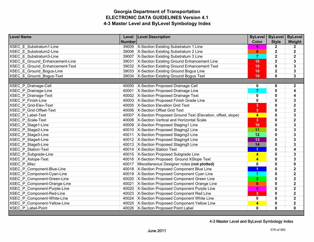
Georgia Department of TransportationELECTRONIC DATA GUIDELINES Version 4.1
4-3 Master Level and ByLevel Symbology Index
Level Name Level Level Description ByLevel ByLevel ByLevelNumber Color Style Weight
XSEC_E_Substratum1-Line 39005 X-Section Existing Substratum 1 Line 5 2 2XSEC_E_Substratum2-Line 39006 X-Section Existing Substratum 2 Line 6 2 2XSEC_E_Substratum3-Line 39007 X-Section Existing Substratum 3 Line 7 2 2XSEC_E_Ground_Enhancement-Line 39031 X-Section Existing Ground Enhancement Line 10 2 3XSEC_E_Ground_Enhancement-Text 39032 X-Section Existing Ground Enhancement Text 10 0 3XSEC_E_Ground_Bogus-Line 39033 X-Section Existing Ground Bogus Line 10 2 3XSEC_E_Ground_Bogus-Text 39034 X-Section Existing Ground Bogus Text 10 0 3
XSEC_P_Drainage-Cell 40000 X-Section Proposed Drainage Cell 0 0 2XSEC_P_Drainage-Line 40001 X-Section Proposed Drainage Line 7 0 4XSEC_P_Drainage-Text 40002 X-Section Proposed Drainage Text 0 0 4XSEC_P_Finish-Line 40003 X-Section Proposed Finish Grade Line 0 0 3XSEC_P_Grid-Elev-Text 40005 X-Section Elevation Grid Text 3 0 2XSEC_P_Grid-Offset-Text 40006 X-Section Offset Grid Text 3 0 2XSEC_P_Label-Text 40007 X-Section Proposed Ground Text (Elevation, offset, slope) 4 0 3XSEC_P_Scale-Text 40008 X-Section Vertical and Horizontal Scale 3 0 2XSEC_P_Stage1-Line 40009 X-Section Proposed Staging1 Line 10 0 3XSEC_P_Stage2-Line 40010 X-Section Proposed Staging2 Line 11 0 3XSEC_P_Stage3-Line 40011 X-Section Proposed Staging3 Line 12 0 3XSEC_P_Stage4-Line 40012 X-Section Proposed Staging4 Line 13 0 3XSEC_P_Stage5-Line 40013 X-Section Proposed Staging5 Line 14 0 3
June 2011
4-3 Master Level and ByLevel Symbology Index
XSEC_P_Station-Text 40014 X-Section Station Text 1 0 4XSEC_P_Subgrade-Line 40015 X-Section Proposed Subgrade Line 4 0 3XSEC_P_Xslope-Text 40016 X-Section Proposed Ground XSlope Text 4 0 3XSEC_P_Misc 40017 Miscellaneous Designer notes (not plotted) 0 0 0XSEC_P_Component-Blue-Line 40018 X-Section Proposed Component Blue Line 1 0 2XSEC_P_Component-Cyan-Line 40019 X-Section Proposed Component Cyan Line 7 0 2XSEC_P_Component-Green-Line 40020 X-Section Proposed Component Green Line 2 0 2XSEC_P_Component-Orange-Line 40021 X-Section Proposed Component Orange Line 6 0 2XSEC_P_Component-Purple-Line 40020 X-Section Proposed Component Purple Line 5 0 2XSEC_P_Component-Red-Line 40023 X-Section Proposed Component Red Line 3 0 2XSEC_P_Component-White-Line 40024 X-Section Proposed Component White Line 0 0 2XSEC_P_Component-Yellow-Line 40025 X-Section Proposed Component Yellow Line 4 0 2XSEC_P_Label-Point 40026 X-Section Proposed Point Label 0 0 0
June 2011
4-3 Master Level and ByLevel Symbology Index
579 of 582

Georgia Department of TransportationELECTRONIC DATA GUIDELINES Version 4.1
4-3 Master Level and ByLevel Symbology Index
Level Name Level Level Description ByLevel ByLevel ByLevelNumber Color Style Weight
QUAD_County-Shape-Line 41000 County Boundary Line Shape 170 0 2QUAD_County-Text 41001 County Name Text 170 0 0QUAD_DOQQ-Point 41002 USGS Digital Ortho Quarter Quadrangle Grid Corners 1 0 10QUAD_DOQQ-Shape-Line 41003 USGS Digital Ortho Quarter Quadrangle Grid Lines 7 2 1QUAD_DOQQ-Text 41004 USGS Digital Ortho Quarter Quandrangle Name Text 7 0 1QUAD_EW-Zone-Boundary-Line 41005 GDOT East-West Zone Boundary Line 2 2 6QUAD_Lat-Long-Text 41006 Latitude and Longitude Text 0 0 0QUAD_Quadmap-Point 41007 USGS Quadrangle Map Grid Corners 0 0 10QUAD_Quadmap-Shape-Line 41008 USGS Quadrangle Map Grid Lines 4 0 2QUAD_Quadmap-Text 41009 USGS Quadrangle Map Name and GDOT Quadrangle - 4 0 0
Number TextQUAD_State-Boundary-Line 41010 County Boundary Line Shape 80 4 6
Level_1 90001 Level 1 0 0 0Level_2 90002 Level 2 0 0 0Level_3 90003 Level 3 0 0 0Level_4 90004 Level 4 0 0 0Level_5 90005 Level 5 0 0 0Level_6 90006 Level 6 0 0 0Level_7 90007 Level 7 0 0 0Level_8 90008 Level 8 0 0 0
June 2011
4-3 Master Level and ByLevel Symbology Index
Level_9 90009 Level 9 0 0 0Level_10 90010 Level 10 0 0 0Level_11 90011 Level 11 0 0 0Level_12 90012 Level 12 0 0 0Level_13 90013 Level 13 0 0 0Level_14 90014 Level 14 0 0 0Level_15 90015 Level 15 0 0 0Level_16 90016 Level 16 0 0 0Level_17 90017 Level 17 0 0 0Level_18 90018 Level 18 0 0 0Level_19 90019 Level 19 0 0 0Level_20 90020 Level 20 0 0 0Level_21 90021 Level 21 0 0 0Level_22 90022 Level 22 0 0 0
June 2011
4-3 Master Level and ByLevel Symbology Index
580 of 582

Georgia Department of TransportationELECTRONIC DATA GUIDELINES Version 4.1
4-3 Master Level and ByLevel Symbology Index
Level Name Level Level Description ByLevel ByLevel ByLevelNumber Color Style Weight
Level_23 90023 Level 23 0 0 0Level_24 90024 Level 24 0 0 0Level_25 90025 Level 25 0 0 0Level_26 90026 Level 26 0 0 0Level_27 90027 Level 27 0 0 0Level_28 90028 Level 28 0 0 0Level_29 90029 Level 29 0 0 0Level_30 90030 Level 30 0 0 0Level_31 90031 Level 31 0 0 0Level_32 90032 Level 32 0 0 0Level_33 90033 Level 33 0 0 0Level_34 90034 Level 34 0 0 0Level_35 90035 Level 35 0 0 0Level_36 90036 Level 36 0 0 0Level_37 90037 Level 37 0 0 0Level_38 90038 Level 38 0 0 0Level_39 90039 Level 39 0 0 0Level_40 90090 Level 40 0 0 0Level_41 90041 Level 41 0 0 0Level_42 90042 Level 42 0 0 0Level_43 90043 Level 43 0 0 0
June 2011
4-3 Master Level and ByLevel Symbology Index
Level_44 90044 Level 44 0 0 0Level_45 90045 Level 45 0 0 0Level_46 90046 Level 46 0 0 0Level_47 90047 Level 47 0 0 0Level_48 90048 Level 48 0 0 0Level_49 90049 Level 49 0 0 0Level_50 90050 Level 50 0 0 0Level_51 90051 Level 51 0 0 0Level_52 90052 Level 52 0 0 0Level_53 90053 Level 53 0 0 0Level_54 90054 Level 54 0 0 0Level_55 90055 Level 55 0 0 0Level_56 90056 Level 56 0 0 0Level_57 90057 Level 57 0 0 0
June 2011
4-3 Master Level and ByLevel Symbology Index
581 of 582
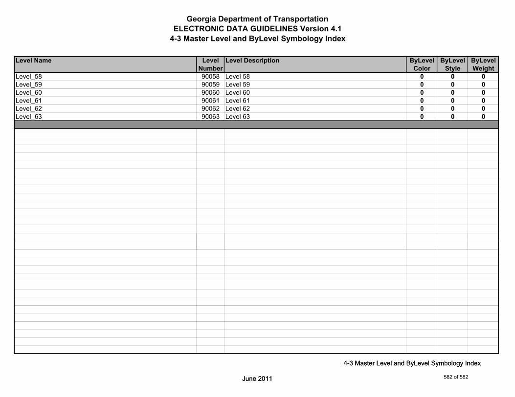
Georgia Department of TransportationELECTRONIC DATA GUIDELINES Version 4.1
4-3 Master Level and ByLevel Symbology Index
Level Name Level Level Description ByLevel ByLevel ByLevelNumber Color Style Weight
Level_58 90058 Level 58 0 0 0Level_59 90059 Level 59 0 0 0Level_60 90060 Level 60 0 0 0Level_61 90061 Level 61 0 0 0Level_62 90062 Level 62 0 0 0Level_63 90063 Level 63 0 0 0
June 2011
4-3 Master Level and ByLevel Symbology Index
June 2011
4-3 Master Level and ByLevel Symbology Index
582 of 582