GEOGRAPHY HANDBOOK How Do I Study Geography? Geography Handbook.
Upload
truongdiepCategory
view
215download
1
General Certificate of Secondary EducationJune 2008
GEOGRAPHY (SPECIFICATION A) 3031/1FPaper 1FOUNDATION TIER FWednesday 4 June 2008 9.00 am to 10.45 am
Time allowed: 1 hour 45 minutes
Instructions
• Use black ink or black ball-point pen. • Fill in the boxes at the top of this page.
• Use case studies to support your answers where appropriate.• You must answer the questions in the spaces provided. Answers
written in margins or on blank pages will not be marked.• Do all rough work in this book. Cross through any work you do not
want to be marked.• If you need extra paper use the Supplementary Answer Sheets.
Information
• The maximum mark for this paper is 70.• The marks for questions are shown in brackets.• You will be assessed on your ability to:
• present relevant information in a form and style that suits its purpose;
• ensure that text is legible and that spelling, punctuation andgrammar are accurate;
• use specialist vocabulary where appropriate.• LEDC is a Less Economically Developed Country.• MEDC is a More Economically Developed Country.
3031/1FM/J3031/1F 6/6/6/6/
Surname Other Names
Centre Number Candidate Number
Candidate Signature
For Examiner’s Use
(JUN0830311F01)
For this paper you must have:
• the Ordnance Survey map extract (enclosed)
• the insert (enclosed).
You may use a calculator.
SECTION A SkillsAnswer ALL questions.
SECTION B People and the Natural EnvironmentAnswer THREE questions only.
For Examiner’s Use
Question Mark Question Mark
1 9
2 10
3
4
5
6
7
8
Total (Column 1)
Total (Column 2)
TOTAL
Examiner’s Initials
G159721_3031_1F_June_2008 16/1/08 15:50 Page 1
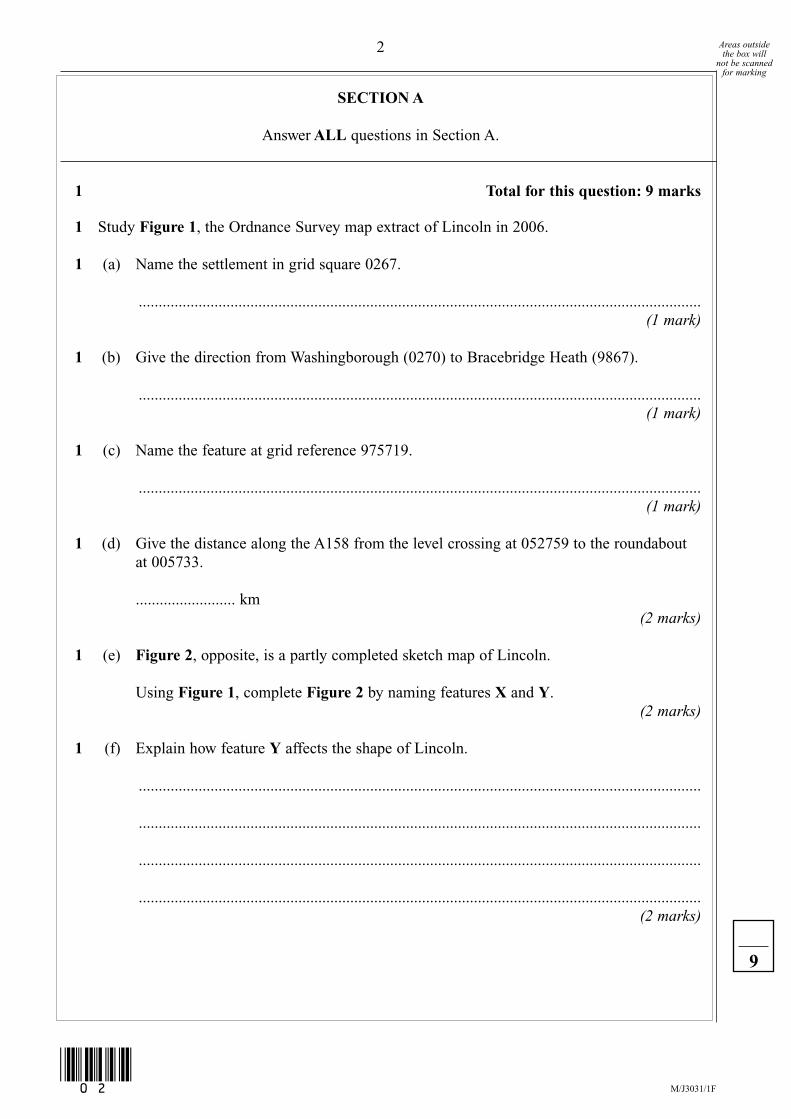
SECTION A
Answer ALL questions in Section A.
1 Total for this question: 9 marks
1 Study Figure 1, the Ordnance Survey map extract of Lincoln in 2006.
1 (a) Name the settlement in grid square 0267.
.............................................................................................................................................(1 mark)
1 (b) Give the direction from Washingborough (0270) to Bracebridge Heath (9867).
.............................................................................................................................................(1 mark)
1 (c) Name the feature at grid reference 975719.
.............................................................................................................................................(1 mark)
1 (d) Give the distance along the A158 from the level crossing at 052759 to the roundaboutat 005733.
......................... km(2 marks)
1 (e) Figure 2, opposite, is a partly completed sketch map of Lincoln.
Using Figure 1, complete Figure 2 by naming features X and Y.(2 marks)
1 (f) Explain how feature Y affects the shape of Lincoln.
.............................................................................................................................................
.............................................................................................................................................
.............................................................................................................................................
.............................................................................................................................................(2 marks)
2 Areas outsidethe box will
not be scannedfor marking
M/J3031/1F(02)
9
G159721_3031_1F_June_2008 10/12/07 11:57 Page 2

Figure 2
Turn over for the next question
Lincoln
BracebridgeHeath
92 93 94 95 96 97 98 99 00 01
92 93 94 95 96 97 98 99 00 01
75
74
73
72
71
70
69
68
67
66
75
74
73
72
71
70
69
68
67
66
NKey
Built-up areaEdge of built-up area
0 1 km
X.....................................
Y.....................................
3 Areas outsidethe box will
not be scannedfor marking
M/J3031/1F
Turn over
▲
(03)
G159721_3031_1F_June_2008 10/12/07 11:57 Page 3
2 Total for this question: 10 marks
2 Study Figure 3, on the insert, an Ordnance Survey map extract of Lincoln in 1980, andFigure 1, the Ordnance Survey map extract of Lincoln in 2006.
2 (a) Name a service in Bracebridge Heath (9867) in 1980 that was no longer there in 2006.
.............................................................................................................................................(1 mark)
2 (b) Grid squares 9571 and 9572 are outlined in Figure 3.Describe how the land use has changed in these squares between 1980 and 2006.
.............................................................................................................................................
.............................................................................................................................................
.............................................................................................................................................
.............................................................................................................................................
.............................................................................................................................................
.............................................................................................................................................(3 marks)
2 (c) Study Figure 4 which is a sketch map showing the built-up area of Birchwood (9369)in 2006.
Figure 4
92 93 94 95
92 93 94 9568
69
70
71
68
69
70
71
Built-up area1980Lakes
Roads
Edge of built-uparea 2006
KeyB1378
B1190
4 Areas outsidethe box will
not be scannedfor marking
M/J3031/1F(04)
G159721_3031_1F_June_2008 10/12/07 11:57 Page 4

2 (c) (i) On Figure 4, shade the built-up area of Birchwood in 1980.(2 marks)
2 (c) (ii) Describe how Birchwood has changed between 1980 and 2006.
....................................................................................................................................
....................................................................................................................................
....................................................................................................................................
....................................................................................................................................
....................................................................................................................................
....................................................................................................................................
....................................................................................................................................
....................................................................................................................................(4 marks)
(Extra space) .............................................................................................................
....................................................................................................................................
....................................................................................................................................
....................................................................................................................................
Turn over for the next question
5 Areas outsidethe box will
not be scannedfor marking
10
M/J3031/1F
Turn over
▲
(05)
G159721_3031_1F_June_2008 10/12/07 11:57 Page 5

3 Total for this question: 6 marks
3 Study Figure 5 which shows the number of visitors to Lincoln Cathedral in a recent year.
Figure 5
3 (a) A bar graph could be drawn to present this information.Complete the vertical axis on the graph paper below.
(2 marks)
Jan Feb Mar Apr May Jun Jul Aug Sep Oct Nov DecMonth
DO NOT DRAWTHE BAR GRAPH
MonthNumber of Visitors
(000’s)
January 13
February 16
March 14
April 15
May 10
June 18
July 11
August 16
September 19
October 10
November 13
December 15
6 Areas outsidethe box will
not be scannedfor marking
M/J3031/1F(06)
G159721_3031_1F_June_2008 16/1/08 15:51 Page 6
3 (b) Describe the changes shown in Figure 5.
.............................................................................................................................................
.............................................................................................................................................
.............................................................................................................................................
.............................................................................................................................................
.............................................................................................................................................
.............................................................................................................................................
.............................................................................................................................................
.............................................................................................................................................(4 marks)
(Extra space) .......................................................................................................................
.............................................................................................................................................
.............................................................................................................................................
.............................................................................................................................................
END OF SECTION A
Turn over for Section B
7 Areas outsidethe box will
not be scannedfor marking
6
M/J3031/1F
Turn over
▲
(07)
G159721_3031_1F_June_2008 10/12/07 11:57 Page 7
SECTION B
Answer THREE questions only in Section B.
Use case studies to support your answers where appropriate.
4 Tectonic Activity Total for this question: 15 marks
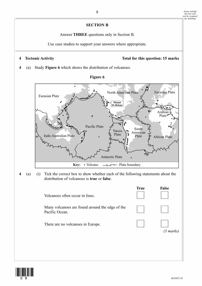
4 (a) Study Figure 6 which shows the distribution of volcanoes.
Figure 6
4 (a) (i) Tick the correct box to show whether each of the following statements about thedistribution of volcanoes is true or false.
True False
Volcanoes often occur in lines. � �Many volcanoes are found around the edge of thePacific Ocean. � �There are no volcanoes in Europe. � �
(3 marks)
Eurasian PlateNorth American Plate
MountSt Helens
Eurasian Plate
African Plate
Pacific PlateNazcaPlate
ArabianPlate
SouthAmerican
Plate
Antarctic Plate
Indo-Australian Plate
Volcano Plate boundaryKey:
8 Areas outsidethe box will
not be scannedfor marking
M/J3031/1F(08)
G159721_3031_1F_June_2008 10/12/07 11:57 Page 8

4 (a) (ii) The location of Mount St Helens, in the USA, is shown on Figure 6. Thisvolcano occurs at a compressional (destructive) plate boundary.
Figure 7 is a cross-section of a compressional (destructive) plate boundary.
Figure 7
Label Figure 7 to explain why volcanoes such as Mount St Helens occur atcompressional plate boundaries.Choose four correct labels from the list below.
Write the letter in the correct box.
A Magma moves towards the surface through a vent.
B Oceanic crust sinks below continental crust.
C Continental crust is less dense than oceanic crust.
D Plates are moving apart.
E Friction and heat melt rock.(4 marks)
Question 4 continues on the next page
Sea
Direction of plate movementKey:
9 Areas outsidethe box will
not be scannedfor marking
M/J3031/1F
Turn over
▲
(09)
G159721_3031_1F_June_2008 16/1/08 15:52 Page 9

4 (b) Study Figure 8, on the insert, which shows information about the area north of thecrater of Mount St Helens, an active volcano.
4 (b) (i) Give one physical and one human attraction shown on Figure 8.
Physical attraction .....................................................................................................
Human attraction .......................................................................................................(2 marks)
4 (b) (ii) Figure 8 lists the activities which are not allowed in the Restricted Area of Mount St Helens. For one of these activities, suggest why it is not allowed.
....................................................................................................................................
....................................................................................................................................
....................................................................................................................................
....................................................................................................................................(2 marks)
4 (c) Earthquakes are another example of tectonic activity. Describe the primary and secondary effects of an earthquake.
.............................................................................................................................................
.............................................................................................................................................
.............................................................................................................................................
.............................................................................................................................................
.............................................................................................................................................
.............................................................................................................................................
.............................................................................................................................................
.............................................................................................................................................(4 marks)
(Extra space) .......................................................................................................................
.............................................................................................................................................
.............................................................................................................................................
.............................................................................................................................................
10 Areas outsidethe box will
not be scannedfor marking
15
M/J3031/1F(10)
G159721_3031_1F_June_2008 10/12/07 11:57 Page 10
5 Rocks and Landscapes Total for this question: 15 marks
5 (a) Complete the sentences below to give the meaning of the different types of rocks.Choose the correct words from this list.
metamorphic sedimentary igneous
................................. rocks are formed by volcanic activity.
................................. rocks are formed by the compression of particles into layers.
................................. rocks have been changed by heat and pressure.(2 marks)
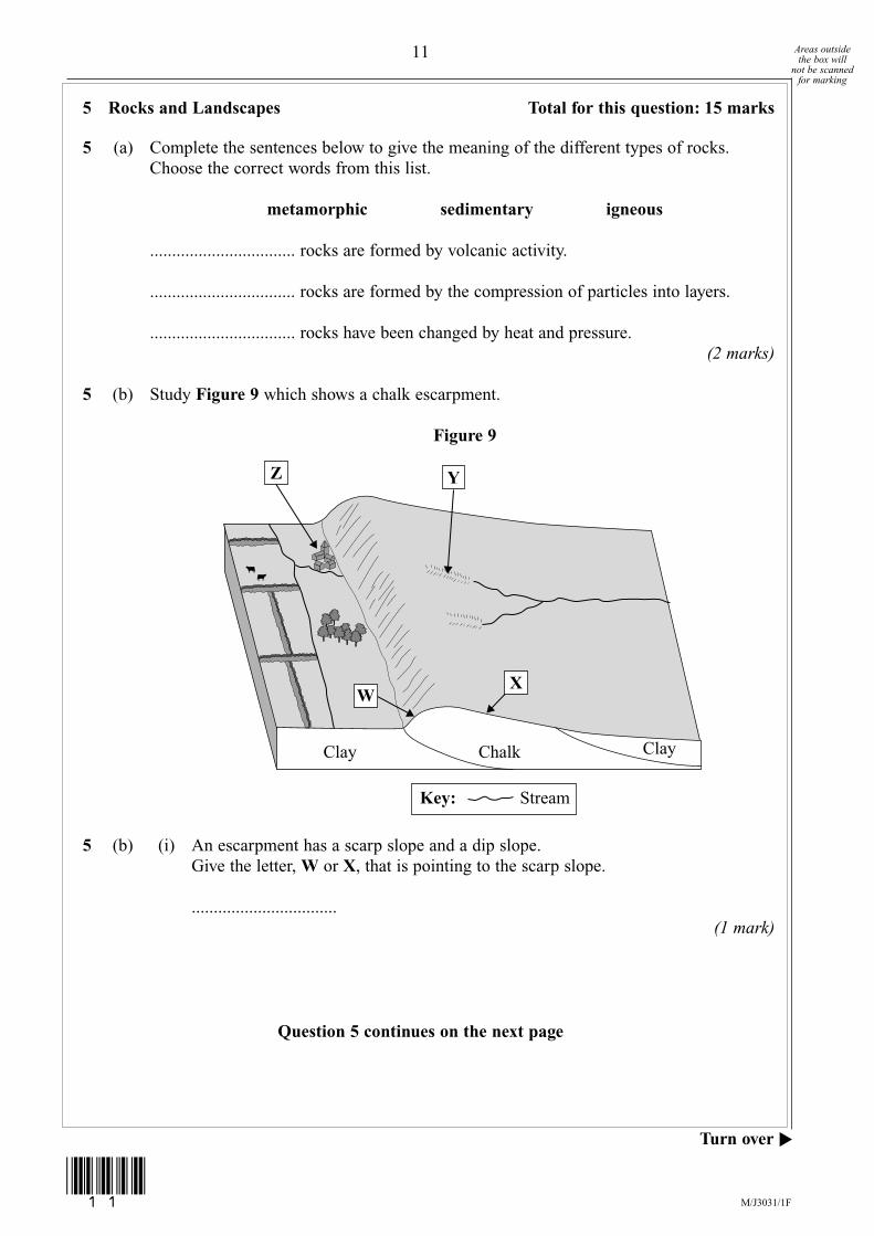
5 (b) Study Figure 9 which shows a chalk escarpment.
Figure 9
5 (b) (i) An escarpment has a scarp slope and a dip slope.Give the letter, W or X, that is pointing to the scarp slope.
................................. (1 mark)
Question 5 continues on the next page
Clay
Y
W
ClayChalk
X
Key: Stream
Z
11 Areas outsidethe box will
not be scannedfor marking
M/J3031/1F
Turn over
▲
(11)
G159721_3031_1F_June_2008 10/12/07 11:57 Page 11

5 (b) (ii) Complete the paragraph below to explain how an escarpment is formed.Choose the correct words from this list.
tilted faster higher horizontal
less lower more slower
Layers of chalk and clay are ............................................. due to earth movements.
The chalk is ............................................. resistant than clay. The clay erodes
............................................. than the chalk. Over time, the chalk stands
............................................. than the clay and forms an escarpment.(4 marks)
5 (b) (iii) Name landform Y.
....................................................................................................................................(1 mark)
5 (b) (iv) Why is a settlement found at Z?
....................................................................................................................................
....................................................................................................................................
....................................................................................................................................
....................................................................................................................................
....................................................................................................................................
....................................................................................................................................(3 marks)
12 Areas outsidethe box will
not be scannedfor marking
M/J3031/1F(12)
G159721_3031_1F_June_2008 10/12/07 11:57 Page 12
5 (c) Granite is another type of rock.Describe the land use of areas of granite.
.............................................................................................................................................
.............................................................................................................................................
.............................................................................................................................................
.............................................................................................................................................
.............................................................................................................................................
.............................................................................................................................................
.............................................................................................................................................
.............................................................................................................................................(4 marks)
(Extra space) .......................................................................................................................
.............................................................................................................................................
.............................................................................................................................................
.............................................................................................................................................
Turn over for the next question
13 Areas outsidethe box will
not be scannedfor marking
15
M/J3031/1F
Turn over
▲
(13)
G159721_3031_1F_June_2008 10/12/07 11:57 Page 13
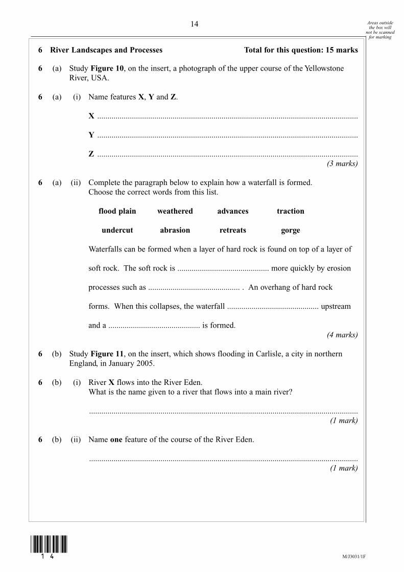
6 River Landscapes and Processes Total for this question: 15 marks
6 (a) Study Figure 10, on the insert, a photograph of the upper course of the YellowstoneRiver, USA.
6 (a) (i) Name features X, Y and Z.
X ................................................................................................................................
Y ................................................................................................................................
Z ................................................................................................................................(3 marks)
6 (a) (ii) Complete the paragraph below to explain how a waterfall is formed.Choose the correct words from this list.
flood plain weathered advances traction
undercut abrasion retreats gorge
Waterfalls can be formed when a layer of hard rock is found on top of a layer of
soft rock. The soft rock is ............................................. more quickly by erosion
processes such as ............................................. . An overhang of hard rock
forms. When this collapses, the waterfall ............................................. upstream
and a ............................................. is formed.(4 marks)
6 (b) Study Figure 11, on the insert, which shows flooding in Carlisle, a city in northernEngland, in January 2005.
6 (b) (i) River X flows into the River Eden.What is the name given to a river that flows into a main river?
....................................................................................................................................(1 mark)
6 (b) (ii) Name one feature of the course of the River Eden.
....................................................................................................................................(1 mark)
14 Areas outsidethe box will
not be scannedfor marking
M/J3031/1F(14)
G159721_3031_1F_June_2008 10/12/07 11:57 Page 14

6 (b) (iii) Give two facts about the location of the flooding in Carlisle.
1 .................................................................................................................................
....................................................................................................................................
2 .................................................................................................................................
....................................................................................................................................(2 marks)
6 (b) (iv) With the help of Figure 11, suggest why Carlisle flooded in January 2005.
....................................................................................................................................
....................................................................................................................................
....................................................................................................................................
....................................................................................................................................
....................................................................................................................................
....................................................................................................................................
....................................................................................................................................
....................................................................................................................................(4 marks)
(Extra space) .............................................................................................................
....................................................................................................................................
....................................................................................................................................
....................................................................................................................................
Turn over for the next question
15 Areas outsidethe box will
not be scannedfor marking
M/J3031/1F
Turn over
▲
(15)
15
G159721_3031_1F_June_2008 10/12/07 11:57 Page 15

7 Glacial Landscapes and Processes Total for this question: 15 marks
7 (a) Study Figure 12, on the insert, a photograph of Lauterbrunnen Valley, Switzerland, anupland glaciated area.
7 (a) (i) Name features X, Y and Z.Choose the correct features from this list.
drumlin truncated spur arête pyramidal peak hanging valley
X ................................................................................................................................
Y ................................................................................................................................
Z ................................................................................................................................(3 marks)
7 (a) (ii) Study Figure 13, two cross sections showing the formation of a glacial trough.
Figure 13
Label Figure 13, to explain the formation of a glacial trough.Choose four correct labels from the list below.Write the letter in the correct box.
A Ice occupied a river valley
B Freeze thaw weathering attacked the valley floor
C Moraine was found below and within the ice
D Snow collected in a corrie
E The V-shaped valley has become a U-shaped valley
F Abrasion and plucking eroded the floor and sides of the valley
(4 marks)
Ice Ice
16 Areas outsidethe box will
not be scannedfor marking
M/J3031/1F(16)
G159721_3031_1F_June_2008 16/1/08 15:52 Page 16
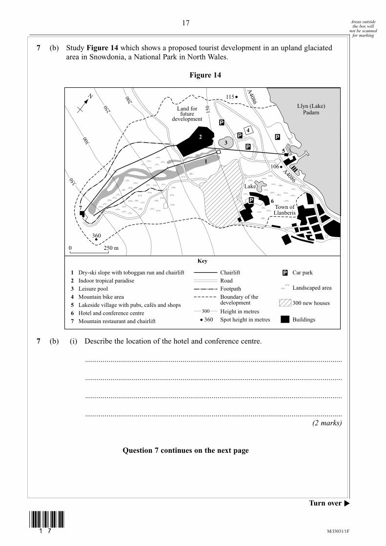
7 (b) Study Figure 14 which shows a proposed tourist development in an upland glaciatedarea in Snowdonia, a National Park in North Wales.
Figure 14
7 (b) (i) Describe the location of the hotel and conference centre.
....................................................................................................................................
....................................................................................................................................
....................................................................................................................................
....................................................................................................................................(2 marks)
Question 7 continues on the next page
Llyn (Lake)Padarn
Land forfuture
development
A4086
A4086115
360
7
1
3
Town ofLlanberis
Lake
300
350
200
150
250
360
106
N
0 250 m
24
5
6
Key
1 Dry-ski slope with toboggan run and chairlift Chairlift
300
Road2 Indoor tropical paradise3 Leisure pool4 Mountain bike area5 Lakeside village with pubs, cafés and shops6 Hotel and conference centre7 Mountain restaurant and chairlift
FootpathBoundary of thedevelopment
Car park
Landscaped area
300 new houses
BuildingsHeight in metresSpot height in metres
17 Areas outsidethe box will
not be scannedfor marking
M/J3031/1F
Turn over
▲
(17)
G159721_3031_1F_June_2008 10/12/07 11:57 Page 17
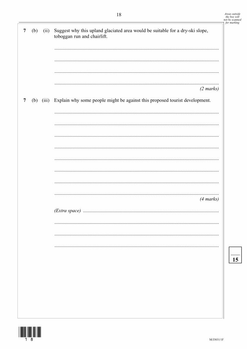
7 (b) (ii) Suggest why this upland glaciated area would be suitable for a dry-ski slope,toboggan run and chairlift.
....................................................................................................................................
....................................................................................................................................
....................................................................................................................................
....................................................................................................................................(2 marks)
7 (b) (iii) Explain why some people might be against this proposed tourist development.
....................................................................................................................................
....................................................................................................................................
....................................................................................................................................
....................................................................................................................................
....................................................................................................................................
....................................................................................................................................
....................................................................................................................................
....................................................................................................................................(4 marks)
(Extra space) .............................................................................................................
....................................................................................................................................
....................................................................................................................................
....................................................................................................................................
18 Areas outsidethe box will
not be scannedfor marking
15
M/J3031/1F(18)
G159721_3031_1F_June_2008 10/12/07 11:57 Page 18

8 Coastal Landscapes and Processes Total for this question: 15 marks
8 (a) Tick the correct box to show whether each of the following statements aboutdestructive and constructive waves is true or false.
True False
Destructive waves are more frequent than constructive waves. � �Destructive waves are steeper than constructive waves. � �Destructive waves have a stronger swash than backwash. � �
(3 marks)
8 (b) Study Figure 15, on the insert, an Ordnance Survey map extract of Start Point, SouthDevon.
8 (b) (i) Name the three types of landform, X, Y and Z, resulting from coastal erosion.
X ................................................................................................................................
Y ................................................................................................................................
Z ................................................................................................................................(3 marks)
Question 8 continues on the next page
19 Areas outsidethe box will
not be scannedfor marking
M/J3031/1F
Turn over
▲
(19)
G159721_3031_1F_June_2008 10/12/07 11:57 Page 19
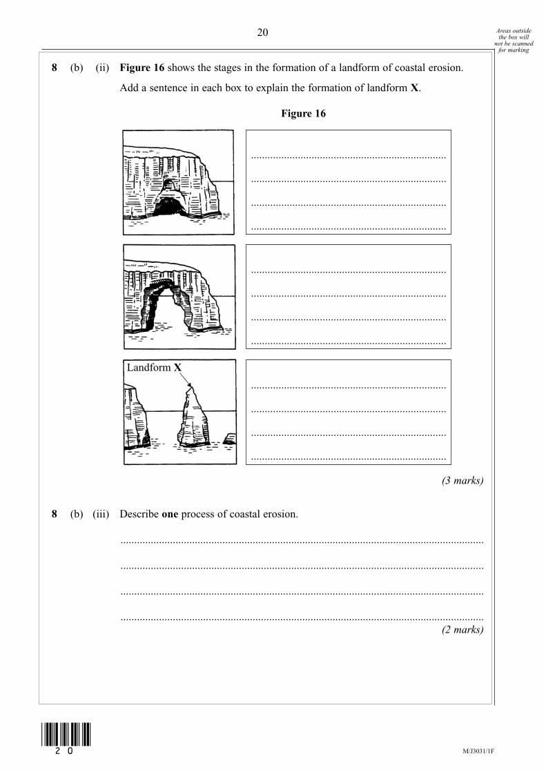
8 (b) (ii) Figure 16 shows the stages in the formation of a landform of coastal erosion.
Add a sentence in each box to explain the formation of landform X.
Figure 16
(3 marks)
8 (b) (iii) Describe one process of coastal erosion.
....................................................................................................................................
....................................................................................................................................
....................................................................................................................................
....................................................................................................................................(2 marks)
Landform X
.......................................................................
.......................................................................
.......................................................................
.......................................................................
.......................................................................
.......................................................................
.......................................................................
.......................................................................
.......................................................................
.......................................................................
.......................................................................
.......................................................................
20 Areas outsidethe box will
not be scannedfor marking
M/J3031/1F(20)
G159721_3031_1F_June_2008 10/12/07 11:57 Page 20
8 (c) Study Figure 17, on the insert, a photograph of coastal defences at Mappleton, eastYorkshire.Explain how the coast is being protected from erosion by the sea.
.............................................................................................................................................
.............................................................................................................................................
.............................................................................................................................................
.............................................................................................................................................
.............................................................................................................................................
.............................................................................................................................................
.............................................................................................................................................
.............................................................................................................................................(4 marks)
(Extra space) .......................................................................................................................
.............................................................................................................................................
.............................................................................................................................................
.............................................................................................................................................
Turn over for the next question
21 Areas outsidethe box will
not be scannedfor marking
15
M/J3031/1F
Turn over
▲
(21)
G159721_3031_1F_June_2008 10/12/07 11:57 Page 21

9 Weather and Climate Total for this question: 15 marks
9 (a) Study Figure 18 which is a synoptic chart of the British Isles for 3 January 2007.
Figure 18
9 (a) (i) Name features X, Y and Z.Choose the correct labels from this list.
high pressure warm front occluded front
cold front low pressure isobar isotherm
X ................................................................................................................................
Y ................................................................................................................................
Z ................................................................................................................................(3 marks)
1024
1016
1000
992984
1016 Isobar
Key
The Atlantic Noon Today
X
Y
Z1024
1016
1008
1000
976984
992
22 Areas outsidethe box will
not be scannedfor marking
M/J3031/1F(22)
G159721_3031_1F_June_2008 16/1/08 15:53 Page 22
9 (a) (ii) The synoptic chart, Figure 18, suggests that the winds are likely to be quite strongover the British Isles. Give one piece of evidence for this from the chart.
....................................................................................................................................
....................................................................................................................................(1 mark)
9 (a) (iii) On Figure 18, mark with the letter L an area of light winds.(1 mark)
9 (a) (iv) Describe what is likely to happen to the temperature, cloud and rainfall as thewarm front passes overhead.
Temperature ...............................................................................................................
....................................................................................................................................
....................................................................................................................................
Cloud .........................................................................................................................
....................................................................................................................................
....................................................................................................................................
Rainfall ......................................................................................................................
....................................................................................................................................
....................................................................................................................................(3 marks)
9 (b) Tick the correct box to show whether each of the following statements about tropicalstorms (hurricanes) is true or false.
True False
Ocean temperatures need to be at least 27°C. � �The eye is the centre of the tropical storm. � �Tropical storms form between 30° and 40° north and southof the equator. � �
(3 marks)
Question 9 continues on the next page
23 Areas outsidethe box will
not be scannedfor marking
M/J3031/1F
Turn over
▲
(23)
G159721_3031_1F_June_2008 10/12/07 11:57 Page 23

9 (c) Study Figure 19 which describes responses to a tropical storm – Hurricane Katrina inNew Orleans, USA in August 2005.
9 (c) Explain why the people of New Orleans were unhappy with the response of theauthorities to Hurricane Katrina.
.............................................................................................................................................
.............................................................................................................................................
.............................................................................................................................................
.............................................................................................................................................
.............................................................................................................................................
.............................................................................................................................................
.............................................................................................................................................
.............................................................................................................................................(4 marks)
(Extra space) .......................................................................................................................
.............................................................................................................................................
24 Areas outsidethe box will
not be scannedfor marking
M/J3031/1F(24)
15
G159721_3031_1F_June_2008 10/12/07 11:57 Page 24
Figure 19 cannot be reproduced here due to third-party copyright constraints.

10 Ecosystems Total for this question: 15 marks
10 (a) Study Figure 20 which shows a coniferous tree.
Figure 20
10 (a) (i) On Figure 20, mark with an arrow and label one characteristic of each of thefollowing parts of a coniferous tree.
branchesleavesroots
(3 marks)Question 10 continues on the next page
25 Areas outsidethe box will
not be scannedfor marking
M/J3031/1F
Turn over
▲
(25)
G159721_3031_1F_June_2008 10/12/07 11:57 Page 25
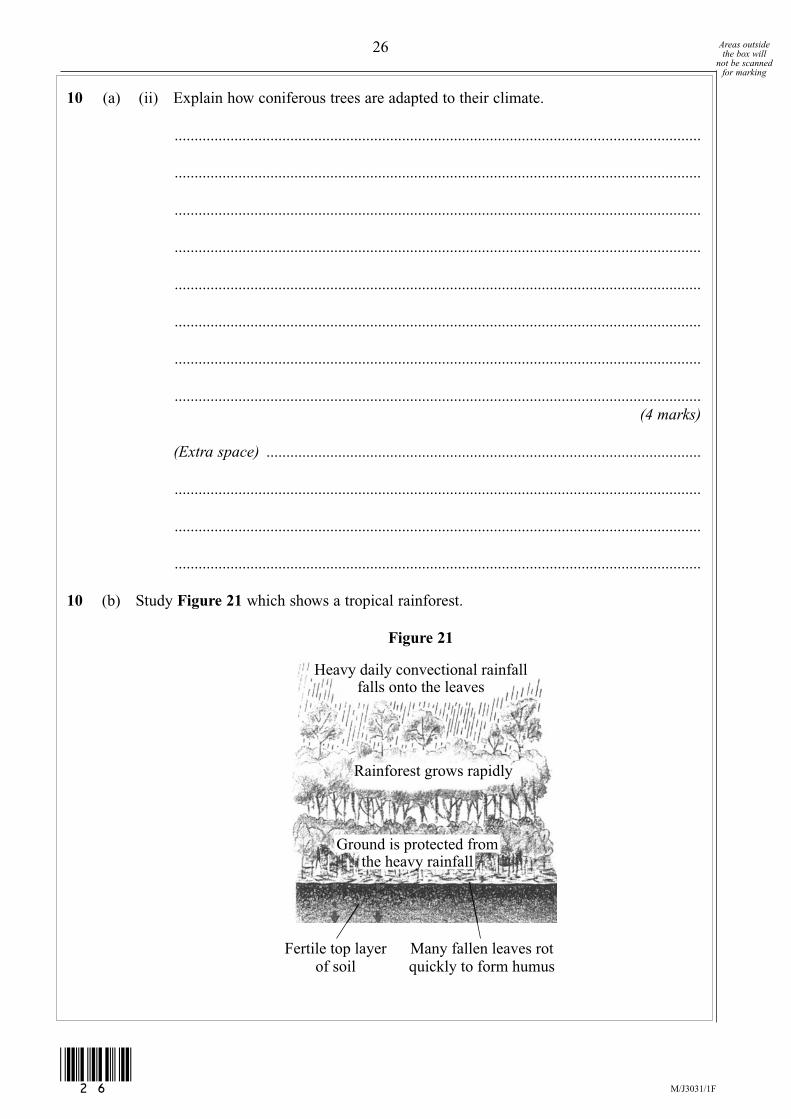
10 (a) (ii) Explain how coniferous trees are adapted to their climate.
....................................................................................................................................
....................................................................................................................................
....................................................................................................................................
....................................................................................................................................
....................................................................................................................................
....................................................................................................................................
....................................................................................................................................
....................................................................................................................................(4 marks)
(Extra space) .............................................................................................................
....................................................................................................................................
....................................................................................................................................
....................................................................................................................................
10 (b) Study Figure 21 which shows a tropical rainforest.
Figure 21
Heavy daily convectional rainfallfalls onto the leaves
Rainforest grows rapidly
Fertile top layerof soil
Many fallen leaves rotquickly to form humus
Ground is protected fromthe heavy rainfall
26 Areas outsidethe box will
not be scannedfor marking
M/J3031/1F(26)
G159721_3031_1F_June_2008 10/12/07 11:57 Page 26

10 (b) (i) Deforestation is the cutting down of trees.Give one reason for deforestation.
....................................................................................................................................
....................................................................................................................................(1 mark)
10 (b) (ii) Where are most nutrients (plant foods) stored in a tropical rainforest beforedeforestation?
....................................................................................................................................
....................................................................................................................................(1 mark)
10 (b) (iii) How are nutrients returned to the soil before deforestation?
....................................................................................................................................
....................................................................................................................................(1 mark)
10 (b) (iv) Why does soil erosion occur after deforestation?
....................................................................................................................................
....................................................................................................................................
....................................................................................................................................
....................................................................................................................................
....................................................................................................................................
....................................................................................................................................
....................................................................................................................................
....................................................................................................................................
....................................................................................................................................(3 marks)
Question 10 continues on the next page
27 Areas outsidethe box will
not be scannedfor marking
M/J3031/1F
Turn over
▲
(27)
G159721_3031_1F_June_2008 10/12/07 11:57 Page 27
10 (c) Describe how replanting of trees is an example of sustainable management.
.............................................................................................................................................
.............................................................................................................................................
.............................................................................................................................................
.............................................................................................................................................
.............................................................................................................................................
.............................................................................................................................................(2 marks)
END OF QUESTIONS
ACKNOWLEDGEMENT OF COPYRIGHT-HOLDERS AND PUBLISHERS
Permission to reproduce all copyright material has been applied for. In some cases, efforts to contact copyright-holders have been unsuccessful andAQA will be happy to rectify any omissions of acknowledgements in future papers if notified.
Question 3 Figure 5: courtesy of Lincoln CathedralQuestion 4 Figure 6: vulcan.wr.usgs.gov/cascades volcano observatoryQuestion 7 Figure 14: from Understanding GCSE Geography: Teacher’s Resource Pack 2nd Ed. by Ann Bowen and John Pallister. Reprinted by
permission of Pearson Publishers Oxford Ltd.Question 8 Figure 16: D. WAUGH, Key Geography for GCSE, Teacher’s Resource Guide, Stanley ThornesQuestion 9 Figure 18: The Indedpendent, 3 January 2007Question 10 Figure 21: D. WAUGH, Key Geography for GCSE, Book 2, Stanley Thornes
Copyright © 2008 AQA and its licensors. All rights reserved.
28 Areas outsidethe box will
not be scannedfor marking
15
M/J3031/1F(28)
G159721_3031_1F_June_2008 16/1/08 15:53 Page 28

General Certificate of Secondary Education
June 2008
GEOGRAPHY (SPECIFICATION A) 3031/1F
Insert
INSERT TO M/Jun08/3031/1FTurn over
▲
G159721_3031_1F_June_2008_Insert 10/12/07 12:09 Page 1
Figure 3
2
INSERT TO M/Jun08/3031/1F
G159721_3031_1F_June_2008_Insert 16/1/08 15:41 Page 2
Figure 3 cannot be reproduced here due to third-party copyright constraints.
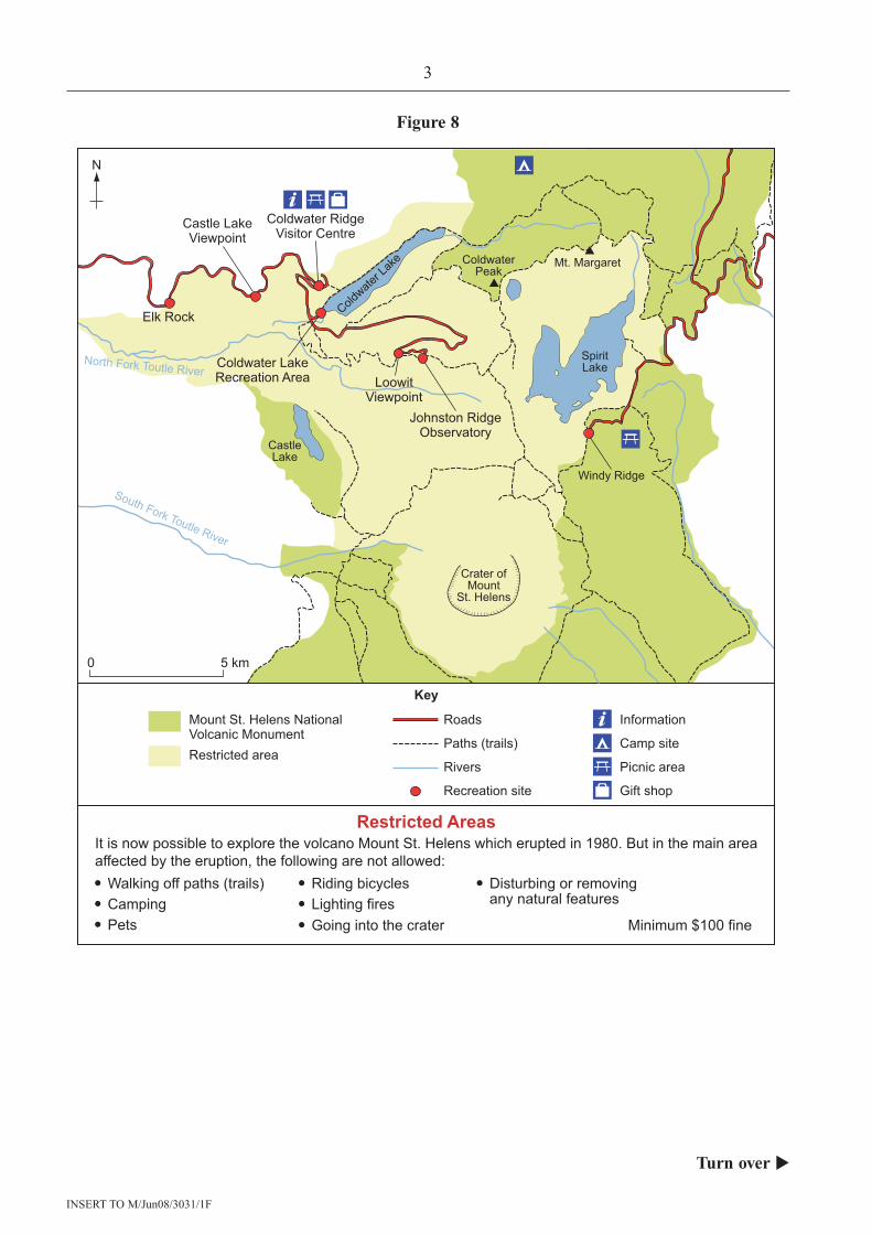
Figure 8
3
INSERT TO M/Jun08/3031/1F
Turn over
▲
N
0 5 km
Key
Crater ofMount
St. Helens
Mount St. Helens NationalVolcanic Monument
Roads
Elk Rock
Coldwater RidgeVisitor Centre
Castle LakeViewpoint
Paths (trails)
Rivers
Information
Camp site
Picnic areaRestricted area
Recreation site
Restricted AreasIt is now possible to explore the volcano Mount St. Helens which erupted in 1980. But in the main areaaffected by the eruption, the following are not allowed:
Minimum $100 fine
Walking off paths (trails)CampingPets
Riding bicycles Disturbing or removingany natural featuresLighting fires
Going into the crater
Gift shop
Coldwater LakeRecreation Area Loowit
Viewpoint
ColdwaterPeak
Windy Ridge
SpiritLake
CastleLake
Coldwate
r Lak
e Mt. Margaret
South Fork Toutle River
North Fork Toutle River
Johnston RidgeObservatory
G159721_3031_1F_June_2008_Insert 10/12/07 12:09 Page 3
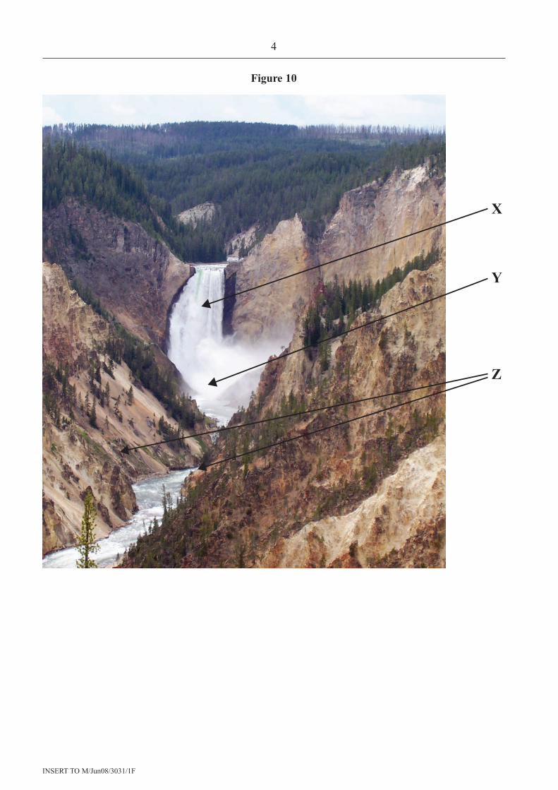
Figure 10
4
INSERT TO M/Jun08/3031/1F
X
Y
Z
G159721_3031_1F_June_2008_Insert 10/12/07 12:09 Page 4

Figure 11
5
INSERT TO M/Jun08/3031/1F
Turn over
▲
G159721_3031_1F_June_2008_Insert 10/12/07 12:09 Page 5
Figure 11 cannot be reproduced here due to third-party copyright constraints.
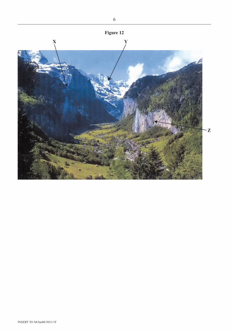
Figure 12
6
INSERT TO M/Jun08/3031/1F
X Y
Z
G159721_3031_1F_June_2008_Insert 10/12/07 12:09 Page 6
Figure 15
7
INSERT TO M/Jun08/3031/1F
Turn over
▲
G159721_3031_1F_June_2008_Insert 16/1/08 15:43 Page 7
Figure 15 cannot be reproduced here due to third-party copyright constraints.
ACKNOWLEDGEMENT OF COPYRIGHT-HOLDERS AND PUBLISHERS
Figure 8: Used with permission from Northwest Interpretive Association
Figure 12: Photo courtesy of Ben Starr
Copyright © 2008 AQA and its licensors. All rights reserved.
8
INSERT TO M/Jun08/3031/1F
G159721_3031_1F_June_2008_Insert 10/12/07 12:09 Page 8
Figure 17 cannot be reproduced here due to third-party copyright constraints.
Figure 17