FSEIS Chapter 2 - Hampton Roads Crossing...
73
Final Supplemental Environmental Impact Statement Chapter 2: Alternatives April 2017 2-1 2. ALTERNATIVES 2.1 INTRODUCTION Substantive edits that have been made to this Final SEIS since the publication of the Draft SEIS are indicated with underlined text. This chapter describes the alternatives development process for the HRCS SEIS, including the identification of an initial range of alternatives previously considered, the range of reasonable alternatives retained for detailed analysis, and the Preferred Alternative. The alternatives analysis was prepared as part of a comprehensive process that incorporated input from the public as well as local, state, and federal agencies. This SEIS includes analysis of a range of reasonable improvement alternatives. Based on the process for retaining alternatives discussed later in this chapter, the No-Build Alternative and four build alternatives have been evaluated and a Preferred Alternative was identified. These retained build alternatives are identified as Alternative A, Alternative B, Alternative C, and Alternative D. Each retained alternative and the Preferred Alternative represents a set of improvements that form a stand-alone solution to the identified needs. Additional details on alternatives development are provided in the HRCS Alternatives Technical Report. 2.2 ALTERNATIVES DEVELOPMENT, EVALUATION, AND THE IDENTIFICATION OF A PREFERRED ALTERNATIVE At the initiation of the HRCS SEIS, VDOT and FHWA developed a coordination plan for the study to ensure the document supports and meets the decision-making needs of the federal Cooperating Agencies, to the extent practicable. VDOT, FHWA, and federal agencies that have jurisdiction by law on FHWA/VDOT projects are developing an agreement to merge the NEPA/Section 404 process. More information on the Section 404 process can be found in Section 2.1 of the HRCS Natural Resources Technical Report. While this agreement is still being developed, FHWA and VDOT agreed to use the basic framework of that agreement for the HRCS. Namely, FHWA and VDOT have agreed to have three concurrence points for the federal Cooperating Agencies for: 1. Purpose and Need; 2. Alternatives to be Retained for Analysis; and 3. Recommended Preferred Alternative. Other proposed components of the merged process under development such as timelines, roles and responsibilities of the federal agencies, other concurrence points, etc. are not included as part of the HRCS coordination plan. The HRCS involved a process for identifying the Preferred Alternative that merged requirements of the National Environmental Policy Act (NEPA) and the Clean Water Act (CWA). As such, identification of Alternative A as the Preferred Alternative considered a broad range of factors that included: 1) Purpose and Need; 2) impacts to environmental resources relevant to determining the preliminary Least Environmentally Damaging Practicable Alternative (LEDPA), per CWA Section 404(b)(1) guidance; 3) input from Cooperating Agencies; and 4) cost in light of regional funding priorities and funding availability.
Transcript of FSEIS Chapter 2 - Hampton Roads Crossing...

Final Supplemental Environmental Impact Statement
Chapter 2: Alternatives
April 2017 2-1
2. ALTERNATIVES
2.1 INTRODUCTION
Substantive edits that have been made to this Final SEIS since the publication of the Draft SEIS are
indicated with underlined text.
This chapter describes the alternatives development process for the HRCS SEIS, including the identification
of an initial range of alternatives previously considered, the range of reasonable alternatives retained for
detailed analysis, and the Preferred Alternative. The alternatives analysis was prepared as part of a
comprehensive process that incorporated input from the public as well as local, state, and federal
agencies.
This SEIS includes analysis of a range of reasonable improvement alternatives. Based on the process for
retaining alternatives discussed later in this chapter, the No-Build Alternative and four build alternatives
have been evaluated and a Preferred Alternative was identified. These retained build alternatives are
identified as Alternative A, Alternative B, Alternative C, and Alternative D. Each retained alternative and
the Preferred Alternative represents a set of improvements that form a stand-alone solution to the
identified needs. Additional details on alternatives development are provided in the HRCS Alternatives
Technical Report.
2.2 ALTERNATIVES DEVELOPMENT, EVALUATION, AND THE IDENTIFICATION OF A
PREFERRED ALTERNATIVE
At the initiation of the HRCS SEIS, VDOT and FHWA developed a coordination plan for the study to ensure
the document supports and meets the decision-making needs of the federal Cooperating Agencies, to the
extent practicable. VDOT, FHWA, and federal agencies that have jurisdiction by law on FHWA/VDOT
projects are developing an agreement to merge the NEPA/Section 404 process. More information on the
Section 404 process can be found in Section 2.1 of the HRCS Natural Resources Technical Report. While
this agreement is still being developed, FHWA and VDOT agreed to use the basic framework of that
agreement for the HRCS. Namely, FHWA and VDOT have agreed to have three concurrence points for the
federal Cooperating Agencies for:
1. Purpose and Need;
2. Alternatives to be Retained for Analysis; and
3. Recommended Preferred Alternative.
Other proposed components of the merged process under development such as timelines, roles and
responsibilities of the federal agencies, other concurrence points, etc. are not included as part of the HRCS
coordination plan.
The HRCS involved a process for identifying the Preferred Alternative that merged requirements of the
National Environmental Policy Act (NEPA) and the Clean Water Act (CWA). As such, identification of
Alternative A as the Preferred Alternative considered a broad range of factors that included: 1) Purpose
and Need; 2) impacts to environmental resources relevant to determining the preliminary Least
Environmentally Damaging Practicable Alternative (LEDPA), per CWA Section 404(b)(1) guidance; 3) input
from Cooperating Agencies; and 4) cost in light of regional funding priorities and funding availability.

Final Supplemental Environmental Impact Statement
Chapter 2: Alternatives
April 2017 2-2
On October 20, 2016, HRTPO and HRTAC, whose members include representatives from all of the localities
in the region, unanimously endorsed Alternative A as their Preferred Alternative. Following the
Coordination Plan for the study, VDOT then recommended to USACE that Alternative A be considered as
the Preferred Alternative and requested USACE’s comment and/or concurrence that Alternative A could
be considered the preliminary LEDPA. Following the process laid out in the Coordination Plan, on
November 16, 2016, USACE and the other federal Cooperating Agencies (the Federal Transit
Administration, the US National Oceanic and Atmospheric Administration, the US Navy, and the US Coast
Guard) concurred and/or did not object to recommending Alternative A as the Preferred Alternative.
Following this concurrence, in a letter dated December 2, 2016, USACE found no reason to disagree that
Alternative A may be considered the preliminarily LEDPA. Based on this input, on December 7, 2016, the
CTB identified Alternative A as the Preferred Alternative for the HRCS.
The HRTPO and HRTAC actions included setting aside $4.031 Billion, in year of expenditure dollars, for a
Preferred Alternative in the HRTPO LRTP (HRTPO January 19, 2017 Board Meeting Notes, Item #13). FHWA
will only issue a ROD to complete the NEPA process for improvements that are fully funded for
construction in the region’s LRTP.
2.2.1 Previous Studies
The HRCS SEIS alternatives evaluation is informed by several previous studies including the 2001 HRCS
FEIS and ROD; the 2012 HRBT Draft EIS; and the 2003, 2011, and 2013 re-evaluations of the 2001 FEIS.
Since the SEIS is being prepared for the 2001 FEIS, the starting point for the consideration of alternatives
is the alternatives evaluated in the original EIS.
HRCS FEIS (2001)
The HRCS FEIS (Hampton Roads Crossing Study Final Environmental Impact Study, 2001) documented the
Preferred Alternative for the HRCS. The FEIS evaluated three Candidate Build Alternatives (CBAs): 1, 2,
and 9. CBA 9 was identified as the Preferred Alternative. More detail on the alternatives evaluated in the
original HRCS FEIS is provided in Section 2.3 of this report. Modified versions of CBAs 1, 2, and 9 have
been reevaluated in this SEIS as Alternatives A, B, and C, respectively.
2003 FEIS Re-evaluation
In November 2003, FHWA and VDOT completed a re-evaluation of the FEIS (Hampton Roads Crossing
Study Re-evaluation, 2003) that analyzed implementing a portion of the Preferred Alternative based on
an unsolicited public-private partnership proposal. The data included in the re-evaluation documented
that there did not appear to be any changes to the project or the surrounding environment that resulted
in significant environmental impacts not already evaluated in the FEIS.
2011 EA Re-evaluation
FHWA and VDOT prepared an Environmental Assessment (EA) re-evaluation of the HRCS FEIS
(Environmental Assessment Reevaluation of Hampton Roads Crossing Study FEIS: Candidate Build
Alternative CBA 9 - Segments 1 & 3, 2011) covering Segments 1 and 3 of CBA 9, locally referred to as
“Patriots Crossing”, from the 2001 HRCS FEIS. Segment 1 would provide a new roadway and bridge from
the southern end of the MMMBT to the planned I-564 Intermodal Connector in Norfolk while Segment 3
would provide a new facility extending south from Segment 1 along the east side of CIDMMA to VA 164.

Final Supplemental Environmental Impact Statement
Chapter 2: Alternatives
April 2017 2-3
HRBT (2012)
The HRBT Draft EIS (DEIS) (Hampton Roads Bridge-Tunnel Draft Environmental Impact Statement, 2012)
evaluated a range of alternatives within the I-64 HRBT Study Area Corridor, with the same study limits as
CBA 1 from the original HRCS FEIS and Alternative A in the current study. The Study Area included I-64
from the I-64 interchange with I-664 in the City of Hampton to the I-64 interchange with I-564 in the City
of Norfolk, a distance of approximately 13.1 miles, including the 3.5-mile-long HRBT. Three build
alternatives (Build-8, Build-8 Managed, and Build-10) were retained for detailed study.
During the public review of the HRBT DEIS, there was a clear lack of public or political support for the level
of impacts associated with any of the build alternatives. Specifically, potential impacts to the historic
district at Hampton University, Hampton National Cemetery, and the high number of displacements were
key issues identified by the public, elected officials, and University and Veterans Affairs officials. Given
this public opposition, a Preferred Alternative was not identified and the study did not advance. On August
20, 2015, FHWA rescinded its Notice of Intent to prepare the HRBT DEIS, citing public and agency
comments and concerns over the magnitude of potential environmental impacts to a variety of resources,
such as impacts to historic resources as well as communities and neighborhoods.
2013 Revised EA Re-evaluation
This 2013 document (Revised Environmental Assessment Reevaluation of Hampton Roads Crossing Study
FEIS: Candidate Build Alternative CBA 9 - Segments 1 & 3, 2013) revised the 2011 EA Re-evaluation of the
2001 FEIS. However, due to lack of funding for the project, FHWA was unable to approve the EA
Re-evaluation. As the project continued to be considered for advancement, FHWA and VDOT agreed that
it was appropriate to prepare an SEIS.
2.2.2 Methods for Assessing Ability of Each Alternative to Meet Needs
Methods for assessing the ability of each Alternative to meet the project needs were derived from each
of the seven study need elements as described in Section 1.4 and Section 1.5 and are described in the
following sections.
Accommodate Travel Demand
The population of the Hampton Roads region is expected to increase from 1.7 million in 2010 to 2.04
million by 2040 (HRTPO, 2013b). Average weekday daily traffic at the HRBT is expected to increase 26
percent. Similarly, average weekday daily traffic is expected to increase 41 percent at the MMMBT, 60
percent on I-564, and 29 percent on VA 164 in the Study Area Corridors.
Each retained alternative was assessed for its ability to provide improvements to important sections of
the roadway network that would accommodate future travel demand.
Improve Transit Access
In 2011, the Virginia Department of Rail and Public Transportation (DRPT), in cooperation with others,
identified transit needs in Hampton Roads from a regional perspective, including the need for planning,
building, and maintaining an integrated, high-speed/high-capacity transit system that would help relieve
traffic congestion and connect activity centers throughout Hampton Roads. The plan calls for additional
crossings over Hampton Roads, including dedicated transit facilities if improvements were made to the
HRBT or another crossing. DRPT completed a study in November 2015 that recommended high frequency

Final Supplemental Environmental Impact Statement
Chapter 2: Alternatives
April 2017 2-4
bus rapid transit (BRT) service in a fixed guideway or in shared high occupancy vehicle (HOV) or high
occupancy toll (HOT) lanes (DRPT, 2015).
Each retained alternative was assessed for its ability to improve transit access across Hampton Roads
either by improving transit capacity or access to transit.
Increase Regional Accessibility
Regional transportation accessibility focuses on getting people and goods to destinations in high demand.
It is enhanced by increasing the speed of travel to reach a destination and the subsequent reduction in
travel time. Moreover, for transportation to be accessible, it needs to be reliable so that people and goods
arrive as planned. Each retained alternative was assessed for its ability to increase accessibility to regional
activity centers. The alternatives evaluation focused on two key factors: increase capacity and relieve
congestion.
Increase Capacity
Inadequate capacity leads to congestion, which has an adverse effect on travel time and travel reliability.
Traffic volumes on sections of I-64, I-664, I-564 and VA 164 routinely exceed capacity during peak periods.
Due to constricted horizontal and vertical clearances, tunnels provide less capacity than landside
roadways.
Each retained alternative was assessed for its ability to increase capacity to existing facilities or add new
access to and from regional activity centers using roadways on new location.
Relieve Congestion
Because peak traffic exceeds existing capacity and there are only three crossings connecting the Peninsula
to the Southside (HRBT, MMMBT, and the James River Bridge), non-recurring incidents during peak travel
times can cause prolonged traffic jams that essentially bring the I-64 and I-664 corridors to a standstill,
which in turn has a domino effect on traffic on intersecting roadways.
Each retained alternative was assessed for its ability to relieve congestion on key roadway sections
including I-64, I-664, I-564, and VA 164.
Address Geometric Deficiencies
Some elements along the mainline, interchanges, bridges, and tunnels along the I-64, I-664, I-564, and VA
164 Study Area Corridors do not meet the 2011 AASHTO and 2015 VDOT design standards based on the
design speed. Geometric deficiencies identified in the Study Area Corridors include narrow median
shoulders on the mainline and low vertical clearance within the existing tunnels under Hampton Roads.
The screening criteria derived from this need are primarily based on the design guidelines presented in
the HRCS Alternatives Technical Report.
Two key issues are representative of the geometric deficiencies of existing facilities in the Study Area
Corridors: shoulder width and vertical clearance in tunnels.
Shoulder Width
Throughout the Study Area, left shoulders do not meet current 12-foot interstate design standards
provided by A Policy on Geometric Design of Highway and Streets (AASHTO, 2011) and the Road Design
Manual (VDOT, 2015) for design speed. The MMMBT and HRBT bridge sections between the tunnels and

Final Supplemental Environmental Impact Statement
Chapter 2: Alternatives
April 2017 2-5
the landside roadways have ten-foot wide right shoulders and 4-foot wide left shoulders that do not meet
these current design standards (see Section 2.5 for details on current design standards). The roadways
through the tunnels do not have shoulders consistent with current standards.
As described in the purpose and need, the lack of adequate shoulder width results in roadway congestion
and management problems during incidents or minor construction/inspection activities because one or
more of the travel lanes must be closed to through traffic. Providing adequate shoulder widths that meet
design standards would allow emergency vehicles to use shoulders to access incidents; allow vehicles
involved in an incident to pull out of the travel lane; and allow additional roadway width for maintenance
of traffic during construction, maintenance, and inspection activities.
Each retained alternative was assessed for its ability to provide shoulder widths that meet current design
standards.
Vertical Clearance in Tunnels
The existing vertical clearance for the HRBT is 13 feet 6 inches for the westbound tunnel and 14 feet 6
inches for the eastbound tunnel, and the vertical clearance for the MMMBT is 14 feet 6 inches. These
clearances are substandard. AASHTO minimum clearance is 16 feet, while VDOT requires 16 feet 6 inches
for resurfacing activities. This limited vertical clearance is problematic for some trucks, particularly on the
westbound HRBT. On the westbound HRBT, over 1,600 trucks a year in 2015 (more than four trucks per
day) were prevented from using the tunnel and forced to turn around and travel in the eastbound
direction to use the higher clearance MMMBT. Each truck turnaround process requires traffic to stop in
both directions. Providing adequate vertical clearance in the westbound tunnel would allow all standard
height trucks to cross the HRBT and eliminate the need to remove overheight vehicles from the traffic
stream.
Accordingly, each retained alternative was assessed for its ability to provide vertical clearance in the
tunnels that meet current design standards.
Enhance Emergency Evacuation Capability
Future road networks should include considerations for improving the capacity and options for evacuating
citizens from the region. If the transportation network capacity does not accommodate the growth in
population and their needs in time of emergency, the timely and efficient evacuation of the population
will continue to be hampered.
Each retained alternative was assessed for its ability to enhance emergency evacuation capacity along
existing evacuation routes or by adding new routes.
Improve Strategic Military Connectivity
I-64, I-564, I-664, and VA 164 provide connections for the movement of military personnel and equipment
within the Study Area Corridors. These roadways are part of the Strategic Highway Network (STRAHNET),
which is designated by FHWA in coordination with the US Department of Defense (DoD) (US Army, 2012).
STRAHNET is the minimum network of highways that are important to the United States' strategic defense
policy. With growing traffic volumes that exceed capacity, future military mobility and connectivity will
increasingly decline in the Study Area Corridors which would result in a decrease in mobility for
commuters who work at the more than 20 military installations located in the region. It will slow military
travel between installations, and impact the efficient and timely movement of cargo and personnel during
military operations, including at Ports for National Defense (PND) Program ports in the Hampton Roads

Final Supplemental Environmental Impact Statement
Chapter 2: Alternatives
April 2017 2-6
region. Future needs include providing adequate capacity and reduced travel time and increased reliability
for STRAHNET Study Area Corridors.
Each retained alternative was assessed for its ability to improve strategic military connectivity by providing
adequate capacity, and increased reliability for the STRAHNET network by improving access to facilities.
Increase Access to Port Facilities
With freight volumes expected to grow in the future due to expansion of the Panama Canal, trucks will
further contribute to and be impacted by roadway congestion. Each retained alternative was assessed for
its ability to accommodate increased truck traffic from the Port of Virginia expansion while addressing
congestion and the need to improve capacity to and from the ports.
2.3 ALTERNATIVES PREVIOUSLY CONSIDERED
2.3.1 HRCS FEIS (2001)
The 2001 study initially considered 45 alternatives included in the Major Investment Study (MIS) that
ranged from congestion management strategies to the construction of a new crossing. The assessment of
these initial alternatives included three levels of screening to identify the alternative corridor(s) that
would meet the study’s purpose and need. After the first two screenings were completed, 11
transportation corridors or alternatives remained. Of those 11 transportation corridors, three alternatives
were carried forward as CBAs for detailed analysis: Transportation Corridor 1, Transportation Corridor 2
Modified, and Transportation Corridor 9.
Alternatives Retained for Detailed Analysis
Transportation Corridor 1
Transportation Corridor 1 was retained for detailed analysis in the FEIS as CBA 1. It would provide a new
crossing parallel to the existing I-64 HRBT. CBA 1 would begin near the I-664 interchange in Hampton and
would widen I-64 to eight general purpose travel lanes plus two multimodal lanes to the I-564 interchange
in Norfolk.
Transportation Corridor 2 Modified
Transportation Corridor 2 Modified was retained for detailed analysis as CBA 2. It would include all of CBA
1, widen I-564 in Norfolk to eight general purpose travel lanes plus two multimodal lanes, and construct
a new four lane alignment that would begin at the I-564/I-64 interchange in Norfolk, extend across the
Elizabeth River, travel along the east side of CIDMMA, and connect to VA 164 in Portsmouth.
Transportation Corridor 9
Transportation Corridor 9 was retained for detailed analysis as CBA 9. It would widen I-664 to eight general
purpose travel lanes plus two multimodal lanes on the Peninsula, widen to six general purpose lanes on
the south side of the MMMBT, and provide a new parallel bridge tunnel adjacent to the MMMBT. CBA 9
would include a new roadway and bridge tunnel extending from I-664 to I-564 in Norfolk. This alternative
would also widen I-564 to eight general purpose travel lanes plus two multimodal lanes and include a
four-lane connection along the east side of CIDMMA connecting to VA 164 in Portsmouth. This alternative
was identified as the Preferred Alternative in the 2001 FEIS and ROD, but this designation has been set
aside for this SEIS.

Final Supplemental Environmental Impact Statement
Chapter 2: Alternatives
April 2017 2-7
Alternatives Not Retained for Further Analysis
Transportation Corridors 2 and 3
Transportation Corridors 2 and 3 would provide a new crossing from Newport News to Norfolk, operating
as a separate facility from I-664 MMMBT with a connection to VA 164. These Transportation Corridors
were eliminated from further detailed study based on the ease of implementation and potential
environmental impacts.
Transportation Corridor 4
Transportation Corridor 4 would provide a new crossing parallel to the I-664 MMMBT and widen I-664 on
the Southside and the Peninsula. This corridor was eliminated from further detailed study based on its
inability to reduce traffic at the HRBT, address origin and destination patterns, or provide a direct
connection to the major ports or naval facilities.
Transportation Corridors 5, 6, 7, 10, and 11
Transportation Corridors 5, 6, 7, 10, and 11 would provide a new facility along the CSXT rail corridor from
Newport News to I-64. These corridors were eliminated from further detailed study as a full typical section
based on the criteria of ease of implementation and cost. The alternatives were not practicable because
of the exorbitant cost for construction along the CSXT rail line, as well as the logistics, high impact and
associated costs of relocating a large number of residences. Furthermore, these alternatives each
encroached on areas containing potential habitat for federally listed threatened and endangered species.
Transportation Corridor 8
Transportation Corridor 8 would provide a new crossing parallel to the MMMBT with a new connection
to Norfolk and Portsmouth, including provision of a rail crossing of Hampton Roads, with no VA 164
connection. This alternative was eliminated from further detailed study because it did not provide new
access to Portsmouth Marine Terminal or to the potential access between Naval Base Norfolk and the
naval installations in Portsmouth, and it did not provide for a diversion point from I-64 during congestion
causing incidents.
2.3.2 HRBT (2012)
A range of alternatives was initially considered in the 2012 HRBT DEIS, based on the Purpose and Need
from that study, and a process that incorporated input from the public as well as local, state, and federal
government agencies. The Purpose and Need for the HRBT DEIS identified a Level of Service (LOS) D as
the screening threshold used for the study alternatives carried forward. An LOS threshold is not included
in the HRCS. Level of Service (LOS) is not considered the best indicator of improvements to the network,
as it does not capture measurable improvements made within a given letter grade. In 2016, FHWA revised
its guidance on LOS on the National Highway System to clarify that there is no LOS requirement on the
highway system (FHWA, 2016).
See Section 2.2 for more information on the public and agency lack of support for any of the build
alternatives and FHWA’s subsequent actions on the HRBT DEIS.

Final Supplemental Environmental Impact Statement
Chapter 2: Alternatives
April 2017 2-8
Alternatives Retained for Detailed Analysis
The three retained build alternatives evaluated for the HRBT DEIS included the same termini for each
alternative: improvements to I-64 would extend from just north of the I-664 interchange in Hampton,
across the HRBT, and end at I-564 in Norfolk. These alternatives were not advanced beyond the HRBT
DEIS.
Build-8
The Build-8 Alternative would provide four continuous mainline lanes in each direction of I-64 throughout
the limits of the study. Through Hampton, this alternative would require one lane of widening in each
direction of I-64. Through Norfolk, this alternative would require the addition of two lanes in each
direction of I-64.
Build-8 Managed
The Build-8 Managed Alternative is similar to the Build-8 Alternative, and would provide four continuous
mainline lanes in each direction of I-64; however, some or all of the travel lanes would have been managed
using tolls and/or vehicle occupancy restrictions (HOV, HOT, local bus service, and/or bus rapid transit).
Build-10
The Build-10 Alternative would provide five continuous mainline lanes in each direction of I-64. Through
the Hampton section, this alternative would involve widening both directions of I-64 by two lanes. In
Norfolk, this alternative would involve widening both directions of I-64 by three lanes.
Alternatives Not Retained for Further Analysis
Transportation System Management (TSM) / Transportation Demand Management (TDM)
TSM/TDM improvements maximize the efficiency of the current transportation system or reduce the
demand for travel on the system through the implementation of low-cost improvements. Examples of
TSM activities include the addition of turn lanes, optimized signalization at intersections, and Intelligent
Transportation Systems. Examples of TDM activities include ride sharing, van and carpooling, installation
of park and ride facilities, and encouragement of telecommuting. TSM/TDM improvements, by their
nature, are minor and therefore would not address inadequate capacity, congestion, or geometric
deficiencies. Notwithstanding, the Retained Build Alternatives did not preclude TSM/TDM elements from
being implemented in conjunction with a Build Alternative. While not a standalone alternative, TSM/TDM
improvements could be implemented independently or included as part of a Preferred Alternative in this
HRCS SEIS.
Rehabilitation or Reconstruction of the Existing HRBT
This alternative would include rehabilitation of the superstructure or reconstruction of the substructure
and superstructure of the HRBT approach bridges. Bridge rehabilitation would consist of the removal and
replacement of the existing bridge superstructure, crack sealing, repair, jacketing existing piling,
replacement of piling, and the replacement of parapets. The cost for rehabilitation was estimated to be
$256M for the HRBT approach bridges and $48M for the MMMBT approach bridges. Reconstruction
would consist of complete substructure (piers/foundations) and superstructure replacement, including
raising and widening the structures to meet the current design standards. The cost for reconstruction was
estimated to be $360M for the HRBT approach bridges and $855M for the MMMBT approach bridges.

Final Supplemental Environmental Impact Statement
Chapter 2: Alternatives
April 2017 2-9
This alternative would not increase roadway capacity to alleviate current or future unacceptable and
unreliable levels of traffic service, operating speeds, or travel times. While not a standalone alternative,
rehabilitation or reconstruction was included as a component of the Retained Build Alternatives in the
HRBT DEIS.
Replacement of the Existing HRBT
This alternative would include complete removal of the existing HRBT in conjunction with reconstruction
of a new crossing facility in the same location. Geometrically deficient roadway infrastructure would be
replaced by a new facility that would meet current design standards for shoulder widths, vertical clearance
in tunnels, and vertical clearance above water for approach bridges. However, this alternative would not
address the identified capacity needs as it only replaces the existing HRBT and would not provide
additional capacity. This alternative would result in an unreasonably high level of disruption to regional
travel during the construction period.
Build-6 Alternative
The Build-6 alternative presented in the 2012 HRBT DEIS would include construction of two additional
lanes of capacity on I-64 at the Hampton Roads crossing and within the Norfolk section of the corridor, so
that a continuous six-lane facility would extend from I-664 to I-564. The alternative would include a new
two-lane bridge-tunnel at the Hampton Roads crossing. This alternative would partially address geometric
deficiencies of existing facilities by constructing a new bridge-tunnel that would meet current design
standards for shoulders, vertical clearance in tunnels, and vertical clearance over water. However, two
additional lanes on the roadway would not provide adequate capacity to alleviate congestion for current
or future traffic within the study corridor, and did not meet the LOS screening threshold established for
the HRBT DEIS.
Build-12 Alternative
The Build-12 Alternative would construct six additional lanes of capacity on I-64 within the Hampton
portion of the corridor, and eight additional lanes of capacity on I-64 on the Hampton Roads Bridge-Tunnel
and within the Norfolk section of the corridor. This expansion would result in a continuous twelve-lane
facility that would extend from I-664 to I-564. The alternative would improve capacity and address
geometric deficiencies of existing facilities by constructing a new bridge-tunnel that would meet current
design standards for shoulders, vertical clearance in tunnels, and vertical clearance above water.
However, the Build-12 Alternative would likely result in proportionally greater impacts to right-of-way,
wetlands, streams, historic properties, and community facilities compared to the other retained
alternatives. The alternative was not advanced because the Retained Build Alternatives in the 2012 HRBT
DEIS adequately addressed the transportation needs and satisfied the LOS screening threshold with less
environmental impact.
High Bridge Crossing
The high bridge alternative would involve a new cable-stayed or suspension bridge parallel to the existing
HRBT over the Hampton Roads channel. The bridge would be built to carry a sufficient number of lanes of
I-64 over Hampton Roads to address the capacity need. This alternative would fully address the geometric
deficiencies of the existing HRBT facilities by constructing a new bridge that would have full shoulders, no
vertical clearance issues, and meet or exceed the minimum height above mean high water (MHW).
However, a high bridge creates logistical challenges in terms of shipping and military vulnerability, and

Final Supplemental Environmental Impact Statement
Chapter 2: Alternatives
April 2017 2-10
presents environmental impacts that a tunnel does not. Although a high bridge over Hampton Roads could
be a feasible alternative from an engineering perspective and would address the stated transportation
needs, the alternative created additional problems that made it unreasonable to retain.
Light or Heavy Rail Transit
This alternative would include dedicated light or heavy rail transit on a new structure across Hampton
Roads. The existing bridge-tunnels would remain. The Light or Heavy Rail Transit Alternative was not
retained for further evaluation because it would not address the geometric deficiency needs identified by
the 2012 HRBT DEIS study. The alternative would have limited ability to address capacity on the HRBT
given the limited potential ridership. It also would require substantial new rail transit connections on the
Peninsula and Southside, and it would have limited ability to accommodate existing and future traffic
volumes on the HRBT.
Bus Transit
This alternative would include expansion of existing bus transit services within the study corridor and
across Hampton Roads. This service could be in the form of an increase in bus service, or a dedicated
(express bus or bus rapid transit) facility. As a stand-alone alternative, increased bus service or a dedicated
bus facility would not involve roadway or bridge-tunnel improvements; therefore, it would not address
the identified geometric deficiencies. Expansion of the existing bus transit network alone would not
attract enough riders to substantially address the capacity need within the I-64 HRBT corridor based on
current and future bus ridership across the HRBT. Although a bus transit alternative was not a viable
stand-alone alternative because it did not address capacity and geometric deficiency needs, it was
considered as a component of the Retained Build Alternatives in the HRBT DEIS.
Ferry Service
This alternative would provide a service to carry vehicles across Hampton Roads via water transport
(hydrofoil or ferry). This alternative would not address the geometric deficiencies of the existing facilities,
because no improvements would be made to the I-64 roadway or existing bridge-tunnel. It also would not
address capacity needs because ridership would be expected to range between 600 and 1100 vehicles
daily, or approximately one percent of the existing traffic volume and less than one percent of the
projected 2040 No-Build volume on the HRBT. Consequently, ferry service did not meet the purpose and
need of the study.
2.4 VERIFICATION FOR NOT RETAINING PREVIOUS ALTERNATIVES IN THIS SEIS
Each of the alternatives previously considered and not retained for further analysis from prior studies
(described in the previous sections) were reassessed at the initiation of this SEIS to determine if they
would meet the updated purpose and need. VDOT provided FHWA and the federal Cooperating Agencies
with a table, similar to the one below, which presented all of the alternatives considered in previous
studies. This information was used in informing the federal concurrence on alternatives retained for
analysis in this SEIS. Table 2-1 summarizes the justification for eliminating alternatives that were not
retained for analysis from previous studies.

Final Supplemental Environmental Impact Statement
Chapter 2: Alternatives
April 2017 2-11
Table 2-1: Verification for Not Including in SEIS
2001 HRCS FEIS
Alternative Justification
Transportation Corridors 2 and 3
Not retained for SEIS. The alternatives are not practicable because of the logistics of constructing a new facility that is separate from the MMMBT. The alternatives would not address existing geometric deficiencies.
Transportation Corridor 4
Not retained for SEIS. This alternative would not provide adequate capacity/congestion relief, transportation reliability, improved access to port facilities, or improved military connectivity. The alternative does not address existing geometric deficiencies.
Transportation Corridors 5, 6, 7, 10, and 11
Not retained for SEIS. The alternatives are not practicable because of the exorbitant cost for construction along the CSX line, as well as the logistics of displacing a large number of homes.
Transportation Corridor 8
Not retained for SEIS. The alternative would provide inadequate capacity/congestion relief, transportation reliability, and access to port and military facilities. This alternative was previously eliminated because it did not meet capacity needs. These needs have increased since this determination in 2001.
2012 HRBT DEIS
Alternative Justification
Transportation System Management / Transportation Demand Management
Not retained for SEIS due to inadequate capacity, congestion relief, and transportation reliability, as well as inability to address existing geometric deficiencies. This alternative would not improve access to port facilities, increase military connectivity, improve regional accessibility and capacity for evacuation, or improve intermodal access. While not a standalone alternative, TSM/TDM improvements could be implemented independently or included as part of a Preferred Alternative.
Rehabilitation or Reconstruction of the Existing HRBT
Not retained for SEIS due to inadequate capacity, congestion relief, and transportation reliability, as well as inability to address existing geometric deficiencies. This alternative would not improve access to port facilities, increase military connectivity, improve regional accessibility and capacity for evacuation, or improve intermodal access. While not a standalone alternative, rehabilitation or reconstruction could be included as a component of the alternatives retained for analysis.
Replacement of the Existing HRBT
Not retained for SEIS due to inadequate capacity, congestion relief, and transportation reliability. This alternative would not improve access to port facilities, increase military connectivity, improve regional accessibility and capacity for evacuation, or improve intermodal access. Further, this alternative is not acceptable because of the impact to travel during construction.
Build-8 Alternative/Build 8-Managed
Not retained for SEIS. See Section 2.2 for more information on the public and agency lack of support for any of the build alternatives and FHWA’s subsequent actions on the HRBT DEIS.
Build-10 Not retained for SEIS. See Section 2.2 for more information on the public and agency lack of support for any of the build alternatives and FHWA’s subsequent actions on the HRBT DEIS.

Final Supplemental Environmental Impact Statement
Chapter 2: Alternatives
April 2017 2-12
Build-12 Alternative Not retained for SEIS. See Section 2.2 for more information on the public and agency lack of support for any of the build alternatives and FHWA’s subsequent actions on the HRBT DEIS.
High Bridge Crossing Not retained for SEIS. A high bridge crossing of Hampton Roads would not address existing geometric deficiencies, and it could create vulnerability issues for the ports and the military.
Light or Heavy Rail Transit
Not retained for SEIS. The alternative would provide inadequate capacity/congestion relief and transportation reliability. It would not improve access to port facilities or increase military connectivity. Hampton Roads Transit provided VDOT with ridership projections and a recommendation that light or heavy rail transit not be considered further.
Bus Transit
Not retained for SEIS as a stand-alone alternative due to inadequate capacity/congestion relief and transportation reliability. It would not improve access to port facilities or increase military connectivity. It would not improve regional accessibility and capacity for evacuation. Hampton Roads Transit provided VDOT with ridership projections and a recommendation that high frequency bus rapid transit or enhanced bus service be included with the alternatives retained for analysis.
2012 HRBT DEIS
Alternative Justification
Ferry Service
Not retained for SEIS due to inadequate capacity/congestion relief and transportation reliability. It would not improve access to port facilities, increase military connectivity, or improve regional accessibility and capacity for evacuation. The alternative would not address geometric deficiencies.
2.5 DESIGN CRITERIA
Retained alternatives were developed based on the AASHTO Policy on the Geometric Design of Highways
and Streets (2011), the VDOT Road Design Manual (2015), and the VDOT Road and Bridge Standards
(2008). Structural design parameters guided the design of new structures crossing Hampton Roads and
were based on recommendations by the Port of Virginia and the Virginia Maritime Association for vertical
clearances and channel width for shipping as provided during scoping. Mainline and interchange
geometric design guidelines used in the development of alternatives are presented in the HRCS
Alternatives Technical Report.
In its resolution of December 7, 2016, CTB indicated that the board would be briefed on and have the
opportunity to endorse a managed lane concept should it be identified and the appropriate analysis and
financial plans are in place. Such action would occur after a ROD has been issued and VDOT can advance
with more detailed design and procurement activities. As of the publication of this SEIS, a managed lane
strategy for the Preferred Alternative, such as HOT or HOV lanes, has not yet been determined and the
HRTPO LRTP does not rely on toll revenues to construct the project. Should a management strategy be
selected, the final design would accommodate additional roadway elements related to the specific
strategy, such as lane entrances and exits. A four-foot wide buffer between general purpose and managed
lanes is already included in the LOD assumed in this Final SEIS; however, future design decisions related
to a managed lane concept could modify the roadway typical section and/or result in minor shifts to the
LOD. Design refinements that take managed lanes into account could be explored as part of the detailed

Final Supplemental Environmental Impact Statement
Chapter 2: Alternatives
April 2017 2-13
design that occurs following the issuance of an FHWA NEPA decision. These refinements also would seek
to minimize impacts to environmental resources and surrounding properties.
Stormwater management facilities have not been included within the LOD to determine the associated
environmental impacts or the specific parcels that would be impacted. Additional signage and
maintenance of traffic activities are anticipated to occur beyond the study area LOD.
Noise barrier activities are anticipated to occur beyond the study area LOD and were not included in the
calculation of right-of-way and environmental impacts. The noise analysis contained in this SEIS was
conducted in accordance with 23 CFR 772 using planning level design data. Final design traffic data would
inform more detailed noise analyses during the final design and permitting phases of the study, after the
issuance of the ROD. Final noise analysis would dictate the final selection and placement of noise barriers
that may fall outside the NEPA LOD. During final design, noise barriers may not be included beyond the
area of proposed roadway improvements.
Existing roadways were widened to the median wherever possible to minimize impacts. Design exceptions
that could reduce the overall LOD and environmental impacts were not considered as part of this SEIS.
The NEPA study evaluates a reasonable range of alternatives and allowed for hybrid or new alternatives
to be identified. The analysis of these alternatives presents the worst-case impact for the area within the
determined LOD. The impacts provided in the SEIS are preliminary estimates based on the current
planning-level engineering which is appropriate for the NEPA analysis. The final impacts would be
determined during the final design and permitting process after a ROD is issued.
Following the issuance of a ROD from FHWA, design refinements would be explored as the project moves
into final design and extend into the permitting stages to minimize impacts to sensitive environmental,
cultural, or community resources.
Additional details on the alternatives can be found in the HRCS Alternatives Technical Report, except for
information that has been designated Sensitive Security Information that is controlled under 49 CFR parts
15 and 1520.
2.6 ALTERNATIVES RETAINED FOR DETAILED STUDY
This section presents the five alternatives retained for detailed study. Each alternative description
addresses how transit could function within the alternative. The description of each Build Alternative also
addresses how the alternative meets the Purpose and Need.
2.6.1 No-Build Alternative
Under the No-Build Alternative, the Study Area Corridors would remain as they are today. VDOT would
continue maintenance and repairs of the existing roadways, bridges, and tunnels as needed, with no
substantial changes to current capacity or management activities. No-Build typical sections are shown in
Figure 2-1 through Figure 2-3.

Final Supplemental Environmental Impact Statement
Chapter 2: Alternatives
April 2017 2-14
Figure 2-1: I-64 No-Build Typical Sections

Final Supplemental Environmental Impact Statement
Chapter 2: Alternatives
April 2017 2-15
Figure 2-2: I-664 No-Build Typical Sections

Final Supplemental Environmental Impact Statement
Chapter 2: Alternatives
April 2017 2-16
Figure 2-3: VA 164 No-Build Typical Sections

Final Supplemental Environmental Impact Statement
Chapter 2: Alternatives
April 2017 2-17
Transit
In the Study Area Corridors, HRT express bus service that travels through both the HRBT and MMMBT is
called the ‘Metro Area Express’ (MAX). MAX across the HRBT and MMMBT is the only public transit option
that connects the Peninsula with the Southside. The Tide is a light rail system operated by HRT within the
confines of the City of Norfolk, with plans to expand the system into a regional high capacity transit
system.
2.6.2 Alternative A
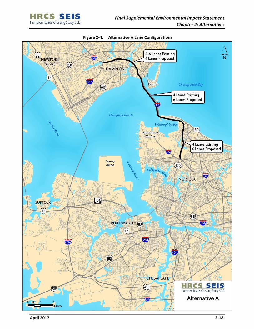
Alternative A is based on CBA 1 from the 2001 HRCS FEIS. Alternative A begins at the I-64/I-664
interchange in Hampton and creates a consistent six-lane facility by widening I-64 to the I-564 interchange
in Norfolk. A parallel bridge-tunnel would be constructed west of the existing I-64 HRBT. See Section 2.2
for more information on the public and agency lack of support for any of the build alternatives and FHWA’s
subsequent actions on the HRBT DEIS. Consequently, VDOT and FHWA have committed that
improvements proposed in the HRCS SEIS to the I-64 corridor would be largely confined to existing
right-of-way. To meet this commitment, Alternative A consists of a six-lane facility. Lane configurations
are shown in Figure 2-4 and summarized in Table 2-2. Alternative A plan sheets are included in
Appendix B.
Table 2-2: Alternative A Lane Configurations
Roadway Alignments Existing Lanes Proposed Lanes
I-64 (Hampton) 4-6 6
I-64 (HRBT and Norfolk) 4 6
Mainline
In general, Alternative A would include one lane of widening in each direction along I-64 south of the HRBT
in Norfolk. Along the Willoughby Spit, the existing bridges would maintain their northern edges and widen
to the south to include the third travel lane and additional shoulder width. The westbound bridge would
be widened toward the median and the eastbound bridge would be widened to the outside. Between Exit
267 – US 60/VA 143 Settlers Landing Road and Exit 268 – VA 169 South Mallory Street in Hampton,
eastbound I-64 currently narrows to two travel lanes, with three travel lanes westbound. Under
Alternative A, one additional through lane would extend along I-64 eastbound between the two
interchanges to maintain lane continuity. From South Mallory Street to the HRBT, in addition to widening,
roadway improvements would include geometric modifications needed to tie into the new eastbound
bridge and tunnel.
Sound walls exist in many locations along this segment and are located a minimum of 16 feet beyond the
edge of the existing travel lane. The existing sound walls are proposed to remain in place in this segment
unless design-level noise analysis determines that they offer inadequate mitigation, requiring the
consideration of taller barriers. Proposed typical sections are shown in Figure 2-5.
Final Supplemental Environmental Impact Statement
Chapter 2: Alternatives
April 2017 2-18
Figure 2-4: Alternative A Lane Configurations

Final Supplemental Environmental Impact Statement
Chapter 2: Alternatives
April 2017 2-19
Figure 2-5: I-64 Proposed Typical Sections

Final Supplemental Environmental Impact Statement
Chapter 2: Alternatives
April 2017 2-20
Interchanges
Interchange improvements would include adjustments to the ramps to accommodate the widened
mainline. No major interchange reconfigurations are proposed at the following exits:
Exit 267 – US 60/VA 143 Settlers Landing Road
Exit 268 – VA 169 South Mallory Street
Exit 273 – US 60/4th View Street
Exit 274 – West Bay Avenue
The westbound entrance ramp from Granby Street to I-64 just north of Norfolk Naval Station Gate
22 and the Forest Lawn Cemetery
The eastbound entrance ramp from Norfolk Naval Station Gate 22 to I-64
HRBT Tunnel and Approach Bridges
The two sets of existing HRBT approach bridges currently carry two lanes per direction. Under Alternative
A, the eastbound I-64 bridge would be modified to carry two westbound lanes. A new bridge would be
constructed to the west of the existing bridges to carry the eastbound lanes. The SEIS layouts and cost
estimates assume these structures are built at an elevation consistent with current design standards (see
Section 2.5 for details on current design standards). Figure 2-6 shows the approach bridge typical sections.
The existing vertical clearance for the westbound HRBT tunnel is 13 feet 6 inches, which is problematic
for some trucks. Options to increase the vertical clearance in the westbound tunnel to allow all standard
height trucks to cross the HRBT and eliminate the existing process of removing overheight vehicles from
the traffic stream prior to the tunnel entrance have been explored. However, the logistics of increasing
the vertical clearance in an existing tunnel are challenging and more detailed design will be necessary to
determine if these options are feasible.
If it is determined that increasing the vertical clearance is not a viable option at the westbound tunnel, an
additional option would be considered and has been included in the footprint of Alternative A. Overheight
trucks that are not deterred by previous signage or detection systems would be routed around the south
portal island to enter I-64 eastbound, and be redirected to the MMMBT. In this way, only one westbound
travel lane would need to be stopped to remove the overheight truck from the roadway. Eastbound traffic
would not need to be stopped because an acceleration lane would be added to the eastbound approach
bridge departing the tunnel. This would only be required on the westbound tunnels, because the new
eastbound tunnels would be constructed to current design standards (see Section 2.5).
Transit
For the purpose of this SEIS, the form of transit to be accommodated is assumed to be BRT. While
transit-only facilities are not included in Alternative A, transit would be enhanced by increasing capacity
along the I-64 Study Area Corridor. In addition to increased capacity, the corridor has been sized for HOT
and/or HOV lanes. As with any alternative, if this alternative were to include HOT or tolled lanes, transit
could operate in these lanes. DRPT’s November 2015 study included the travel time advantage of high
frequency BRT service in HOV or HOT lanes (DRPT, 2015).

Final Supplemental Environmental Impact Statement
Chapter 2: Alternatives
April 2017 2-21
Figure 2-6: I-64 Approach Bridges to Tunnel Typical Section

Final Supplemental Environmental Impact Statement
Chapter 2: Alternatives
April 2017 2-22
Only Alternative C includes dedicated transit facilities in specific locations. If this alternative was identified
as the Preferred Alternative, transit could have been included elsewhere.
3-4-3
This option was presented by the Hampton Roads Transportation Planning Organization (HRTPO) on
November 19, 2015. The option would increase capacity on I-64 by adding lanes in existing right-of-way.
It would include three lanes per direction approaching the tunnel in Hampton, four lanes per direction on
the HRBT, and three lanes in both directions south of the HRBT.
This option is further reviewed in Appendix D of the HRCS Alternatives Technical Report. While it has not
been included with any of the alternatives, it could be applied to any alternative that includes
improvements to the I-64 Study Area Corridor. This option would result in a 15 to 20 percent increase to
the tunnel costs and a commensurate increase to the environmental impacts due to the additional tunnel
and bridge width.
Cost
The preliminary cost estimate was derived using a cost per mile methodology in VDOT’s Project Cost
Estimating System (PCES) Program. Specific costs for non-standard elements such as dredging costs, were
based on recent data from comparable projects. The estimated cost of Alternative A is approximately $3.3
Billion in 2016 dollars and includes a 40 percent contingency. The cost estimate and supporting
documentation can be found in Appendix B and Appendix C of the HRCS Alternatives Technical Report.
Ability to Meet Needs
The following summarizes how Alternative A would meet the needs identified in Chapter 1. The means by
which this alternative meets some of these needs is illustrated in the traffic operations comparison
presented in Section 2.7. The statements below are consistent with the methods described in Section
2.2.2.
Accommodate travel demand: Alternative A would expand capacity along the I-64 Study Area
Corridor which is one of four corridors being considered in this study. The I-64 corridor carries the
greatest amount of traffic of the four corridors and the HRBT carries the greatest amount of traffic
of the three Hampton Roads Crossings (HRBT, MMMBT, James River Bridge).
Improve transit access: Alternative A would expand capacity on the I-64 Study Area Corridor by
adding a lane in each direction, which currently serves three different MAX bus routes. However,
adding only one lane in each direction to the highest capacity Study Area Corridor would have a
limited benefit on the access and reliability of transit operations within the Study Area.
Additionally, this Alternative only connects Hampton and Norfolk.
Increase regional accessibility: Alternative A would only expand capacity by adding one lane in
each direction along the I-64 Study Area Corridor, which is the highest capacity Study Area
Corridor and only connects Hampton and Norfolk. As a result, it would have a limited impact on
regional access to activity centers and attractions and a limited benefit to congestion relief.
Address geometric deficiencies: Alternative A would address geometric deficiencies along the I-64
corridor by widening shoulders, constructing a new tunnel that would meet current design

Final Supplemental Environmental Impact Statement
Chapter 2: Alternatives
April 2017 2-23
standards (see Section 2.5), and offering a means for turning truck traffic around in the
westbound direction to reduce the impact of geometric deficiencies in the existing tunnels.
Improve strategic military connectivity: While Alternative A would enhance capacity along the
I-64 Study Area Corridor, which is part of STRAHNET, the other STRAHNET facilities in the Study
Area would continue to see a decline in military mobility and connectivity. The US Navy has stated
that improvements to the I-64 Study Area Corridor only does not improve direct military
connectivity to the Norfolk Naval Base, the largest military facility in the Study Area.
Enhance emergency evacuation: The Virginia Hurricane Preparedness Guide (VDOT, 2015)
provides the public with guidance on evacuation routes. Alternative A would provide limited
capacity improvements for those regions directed to use the HRBT as a primary evacuation route
from Hampton Roads. However, it would not improve capacity for those regions directed to follow
other evacuation routes including the MMMBT, the other major evacuation crossing between the
Peninsula and Southside that falls within the Study Area corridors.
Increase access to port facilities: While Alternative A would expand interstate capacity along the
I-64 corridor which would benefit freight traffic, it would not increase capacity to and from any
port facilities.
2.6.3 Alternative B
Alternative B is based on CBA 2 from the 2001 HRCS FEIS. Alternative B would include all the improvements
from Alternative A as well as the existing I-564 corridor that extends from its intersection with I-64 west
toward the Elizabeth River. I-564 would be extended to connect to a new bridge-tunnel across the
Elizabeth River (i.e., the I-564 Connector). A new roadway (the VA 164 Connector) would extend south
from the I-564 Connector along the east side of the Craney Island Dredged Material Management Area
(CIDMMA), and connect to existing VA 164 just west of the Virginia International Gateway Boulevard
Interchange. VA 164 would be widened from this interchange west to I-664. Alternative B lane
configurations are shown in Figure 2-7 and summarized in Table 2-3. Alternative B plan sheets are
included in Appendix B.
The inclusion of the VA 164 Study Area Corridor is new to the HRCS. During the initial public scoping efforts
conducted as part of the SEIS, the public suggested that improvements to VA 164 could supplement or
replace more expensive over-water movements that had previously been analyzed in the 2001 HRCS FEIS.
Improvements to VA 164 were incorporated into Alternative B to provide a basis to evaluate this public
suggestion.

Final Supplemental Environmental Impact Statement
Chapter 2: Alternatives
April 2017 2-24
Figure 2-7: Alternative B Lane Configurations

Final Supplemental Environmental Impact Statement
Chapter 2: Alternatives
April 2017 2-25
Table 2-3: Alternative B Lane Configurations
Roadway Alignments Existing Lanes Proposed Lanes
I-64 (Hampton) 4-6 6
I-64 (HRBT and Norfolk) 4 6
I-564 6 6
I-564 Connector none 4
VA 164 Connector none 4
VA 164 4 6
Note: The I-564 Intermodal Connector (IC) is a separate project from HRCS and lies between the I-564
Connector and I-564. It is under construction and would be completed regardless of whether the HRCS
improvements are made and therefore is included under the No-Build Alternative and is not listed with
other proposed improvements.
Mainline
Along the I-64 Study Area Corridor, Alternative B would include the same improvements as Alternative A.
Along the I-564 Connector Study Area Corridor, Alternative B would include two new travel lanes in each
direction. The proposed roadway would be located in the median of the I-564 IC alignment, and merge
into the I-564 IC alignment west of I-564. The I-564 IC would then merge into existing I-564. Proposed
typical sections in the I-564 Study Area Corridor are shown in Figure 2-8. The I-564 Connector includes a
tunnel crossing of the Elizabeth River, which would connect to the VA 164 Connector.
In 2006, the USACE issued a Feasibility Study and Environmental Impact Statement for an eastward
expansion of the CIDMMA to resolve projected dredged material capacity issues and provide a new
marine terminal site on the expanded area. The CIDMMA expansion is currently underway with diversion
dikes under construction in 2016. The marine terminal site is expected to be operational in the late
2020s/early 2030s depending on funding authorization (Port of Virginia, 2015b). The VA 164 Connector
would traverse the east side of the existing CIDMMA. The CIDMMA expansion extends to the east of the
proposed roadway. Plans for the proposed eastward expansion included right-of-way for the VA 164
Connector. The proposed horizontal alignment for Alternative B is consistent with this plan for
right-of-way. If this Study Area Corridor was identified as part of a Preferred Alternative, additional
coordination would have occurred during development of the Final SEIS with USACE, US Coast Guard
(USCG), US Navy, and the Virginia Port Authority to determine required elevations and alignments of the
structure to accommodate the agencies’ security and access needs. These modifications would impact the
cost of the alignment. Final elevations and alignments would not be confirmed until the design and
permitting process. The timeline for this permitting process would depend on the order of
implementation for a Preferred Alternative and available funding. Proposed typical sections in the VA 164
Connector Study Area Corridor are shown in Figure 2-9.
Along the VA 164 Study Area Corridor, Alternative B would include an additional lane in each direction to
provide six continuous mainline lanes in each direction. Widening would occur into the median. The
existing median includes two Commonwealth Railway rail lines which operate on VDOT-owned property.
A six-foot high, two and one-half foot wide crash wall would be constructed in each direction between
the travel lanes and the rail lines. More detail on the proposed widening locations is shown on Figures 23
through 25C in Appendix B.

Final Supplemental Environmental Impact Statement
Chapter 2: Alternatives
April 2017 2-26
Figure 2-8: Proposed I-564 Typical Sections

Final Supplemental Environmental Impact Statement
Chapter 2: Alternatives
April 2017 2-27
Figure 2-9: Proposed VA 164 Connector Typical Sections

Final Supplemental Environmental Impact Statement
Chapter 2: Alternatives
April 2017 2-28
Because widening would occur to the median, the existing sound walls along the VA 164 Study Area
Corridor would remain unless noise analysis determines greater mitigation is necessary. Proposed typical
sections in the VA 164 Study Area Corridor are shown in Figure 2-10.
Interchanges
Alternative B would include all the interchange improvements included under Alternative A. In addition,
Alternative B would include interchange improvements that would be compatible with the separate I-564
IC. The I-564 IC includes an interchange to provide access to Naval Station Norfolk (NAVSTA Norfolk) and
Norfolk International Terminal (NIT) for westbound traffic. Alternative B would complete the interchange
movements by adding access from the eastbound I-564 Connector to NAVSTA Norfolk and NIT and to the
westbound I-564 Connector to NAVSTA Norfolk and NIT. Traffic exiting the facilities would be able to travel
eastbound or westbound on the I-564 Connector.
This proposed interchange would replace an interchange considered in the HRCS FEIS that provided a
connection to Hampton Boulevard. This interchange is no longer feasible due to the construction of the
I-564 IC and changes in the existing geometry of Hampton Boulevard. If this Study Area Corridor had been
identified as part of the Preferred Alternative, the configuration and location of this interchange would
be dependent on coordination with the US Navy and Port of Virginia and would have been included in the
Final SEIS. More detail on the proposed interchange is shown on Figures 29B through 32C in Appendix B.
In the VA 164 Connector Study Area Corridor, two interchanges were included in the CIDMMA Feasibility
Study to access the future port (Port of Virginia, 2015b). They are not included as part of this SEIS, but the
VA 164 Connector has been designed to accommodate them in the future. The VA 164 Connector Study
Area Corridor would also include a new interchange with VA 164. The existing VA 164 interchange with
Virginia International Gateway (VIG) Drive would be reconfigured due to its proximity to the proposed
interchange. Collector-distributor (C-D) roads would be constructed to accommodate the ramp
movements at the VA 164 interchange with the VA 164 Connector, the VA 164 interchange with VIG Drive,
and the westbound entrance ramp to VA 164 from Cedar Lane.
HRBT Tunnel and Approach Bridges
Alternative B includes the same improvements to the tunnel and approach bridges as Alternative A in the
I-64 Study Area Corridor.
Transit
For the purpose of this SEIS, the form of transit to be accommodated is assumed to be BRT. While
transit-only facilities are not included in Alternative B, transit would be enhanced by increasing capacity
along I-64 and VA 164 Study Area Corridors and by adding new capacity along the I-564 Connector and
the VA 164 Connector. In addition to increased capacity, the corridors have been sized for HOT and/or
HOV lanes. As with any alternative, if Alternative B were identified as a Preferred Alternative and included
HOT or tolled lanes, transit could operate in these lanes. DRPT’s November 2015 study included the travel
time advantage of high frequency BRT service in HOV or HOT lanes (DRPT, 2015).

Final Supplemental Environmental Impact Statement
Chapter 2: Alternatives
April 2017 2-29
Figure 2-10: Proposed VA 164 Typical Sections

Final Supplemental Environmental Impact Statement
Chapter 2: Alternatives
April 2017 2-30
Cost
The preliminary cost estimate was derived using a cost per mile methodology in VDOT’s PCES Cost
Estimate Program. Specific costs for non-standard elements such as dredging costs, were based on recent
data from comparable projects. The estimated cost of Alternative B is approximately $6.6 billion in 2016
dollars and includes a 40 percent contingency. These costs are based on the current footprint and a
potential elevated structure along the VA 164 Connector as noted above would increase the project cost.
The cost estimate and supporting documentation can be found in Appendix B and Appendix C of the HRCS
Alternatives Technical Report.
Ability to Meet Needs
The following summarizes how Alternative B would meet the needs identified in Chapter 1. The means by
which this alternative meets some of these needs is illustrated in the traffic operations comparison
presented in Section 2.7. The statements below are consistent with the methods described in Section
2.2.2.
Accommodate travel demand: Alternative B would expand capacity along the I-64, I-564, and VA
164 Study Area Corridors, three of the four Study Area corridors being considered in this study. It
also would create a new connection between I-64 and I-664 via the I-564 Connector and
improvements to VA 164.
Improve transit access: Alternative B would expand capacity along the I-64, I-564, and VA 164
Study Area Corridors, which currently serve four different MAX bus routes. It also would create a
new connection between I-64 and I-664 via the I-564 Connector and improvements to VA 164. As
such, these improvements would improve the access and reliability of transit operations better
than Alternative A.
Increase regional accessibility: Alternative B would expand capacity along the I-64, I-564, and VA
164 Study Area Corridors. Along with increasing capacity, the alternative would provide a new
water crossing to connect I-64 with I-664. All of these improvements would serve to improve
access to regional activity centers and attractions and reduce regional congestion along the
Alternative B Study Area Corridors.
Address geometric deficiencies: Alternative B would address geometric deficiencies along I-64,
similar to Alternative A. The alternative would also address geometric deficiencies along VA 164
and limited deficiencies along I-564, as well.
Improve strategic military connectivity: Alternative B would enhance capacity along two
STRAHNET corridors, I-64 and I-564. The new water crossing and connection between I-64 and
I-664 would improve military connectivity within the region and improve direct military
connectivity to the Norfolk Naval Base, the largest military facility in the Study Area.
Enhance emergency evacuation: Alternative B would enhance capacity along evacuation routes
designated in the Virginia Hurricane Preparedness Guide (VDOT, 2015), including those regions
directed to use the HRBT as a primary evacuation route from Hampton Roads, and would provide
a new connection between these routes. Similar to Alternative A, it would not improve capacity
for those regions directed to follow other evacuation routes including the MMMBT, the other
major evacuation crossing between the Peninsula and Southside that falls within the Study Area
corridors.
Final Supplemental Environmental Impact Statement
Chapter 2: Alternatives
April 2017 2-31
Increase access to port facilities: Alternative B would expand interstate capacity to enhance the
movement of freight in the region in and out of the Norfolk International Terminal (NIT) with the
proposed construction of the I-564 IC and the I-564 Connector. Likewise, the movement of freight
in and out of the CIDMMA Terminals and VIG Terminals would be improved by construction of
the VA 164 Connector. It also would provide new connections between these expanded facilities
and improve access to existing and planned port facilities, including the Port of Virginia which
moves freight through the NIT, Newport News Marine Terminal, the VIG Terminal, and
Portsmouth Marine Terminal. A new marine terminal at CIDMMA is expected to be operational
in the late 2020’s/early 2030’s (Port of Virginia, 2015b).
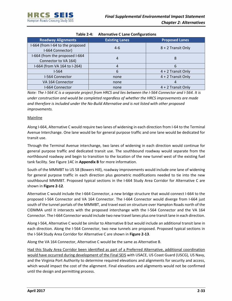
2.6.4 Alternative C
Alternative C is based on CBA 9 from the 2001 HRCS FEIS. Alternative C would include widening along
I-664 beginning at the I-664/I-64 interchange in Hampton and continuing south to the I-264 interchange
in Chesapeake. It would include the same improvements along I-564, the I-564 Connector, and the VA 164
Connector that were considered in Alternative B. This alternative would not include improvements to I-64
or to VA 164 beyond the connector. Instead, this alternative would include the conversion of two existing
lanes on I-564 in Norfolk to transit-only lanes. The decision to include transit-only lanes was based on
input from DRPT and is discussed in Section 2.2.2. The inclusion of HOT or HOV in these transit-only lanes
has not been considered but would have been documented in the Final SEIS if it were identified as part of
the Preferred Alternative.
This transit conversion would continue from I-564 along the I-564 Connector to its intersection with the
VA 164 Connector. At that point, a new bridge structure (I-664 Connector) would continue west and tie
into I-664. The transit-only lanes would extend across the I-564 Connector and I-664 Connector and
continue north along I-664 to its terminus at I-64. Vehicles using the transit-only lanes wishing to continue
south of Hampton Roads on I-664 would need to merge into the general purpose lanes prior to the
MMMBT.
The dedicated transit facilities are limited to these locations in keeping with CBA 9 in the 2001 HRCS FEIS.
Alternative C lane configurations are shown in Figure 2-11 and summarized in Table 2-4. Alternative C
plan sheets are included in Appendix B.

Final Supplemental Environmental Impact Statement
Chapter 2: Alternatives
April 2017 2-32
Figure 2-11: Alternative C Lane Configurations
Final Supplemental Environmental Impact Statement
Chapter 2: Alternatives
April 2017 2-33
Table 2-4: Alternative C Lane Configurations
Roadway Alignments Existing Lanes Proposed Lanes
I-664 (from I-64 to the proposed I-664 Connector)
4-6 8 + 2 Transit Only
I-664 (from the proposed I-664 Connector to VA 164)
4 8
I-664 (from VA 164 to I-264) 4 6
I-564 6 4 + 2 Transit Only
I-564 Connector none 4 + 2 Transit Only
VA 164 Connector none 4
I-664 Connector none 4 + 2 Transit Only
Note: The I-564 IC is a separate project from HRCS and lies between the I-564 Connector and I-564. It is
under construction and would be completed regardless of whether the HRCS improvements are made
and therefore is included under the No-Build Alternative and is not listed with other proposed
improvements.
Mainline
Along I-664, Alternative C would require two lanes of widening in each direction from I-64 to the Terminal
Avenue Interchange. One lane would be for general purpose traffic and one lane would be dedicated for
transit use.
Through the Terminal Avenue interchange, two lanes of widening in each direction would continue for
general purpose traffic and dedicated transit use. The southbound roadway would separate from the
northbound roadway and begin to transition to the location of the new tunnel west of the existing fuel
tank facility. See Figure 14C in Appendix B for more information.
South of the MMMBT to US 58 (Bowers Hill), roadway improvements would include one lane of widening
for general purpose traffic in each direction plus geometric modifications needed to tie into the new
southbound MMMBT. Proposed typical sections in the I-664 Study Area Corridor for Alternative C are
shown in Figure 2-12.
Alternative C would include the I-664 Connector, a new bridge structure that would connect I-664 to the
proposed I-564 Connector and VA 164 Connector. The I-664 Connector would diverge from I-664 just
south of the tunnel portals of the MMMBT, and travel east on structure over Hampton Roads north of the
CIDMMA until it intersects with the proposed interchange with the I-564 Connector and the VA 164
Connector. The I-664 Connector would include two new travel lanes plus one transit lane in each direction.
Along I-564, Alternative C would be similar to Alternative B but would include an additional transit lane in
each direction. Along the I-564 Connector, two new tunnels are proposed. Proposed typical sections in
the I-564 Study Area Corridor for Alternative C are shown in Figure 2-13.
Along the VA 164 Connector, Alternative C would be the same as Alternative B.
Had this Study Area Corridor been identified as part of a Preferred Alternative, additional coordination
would have occurred during development of the Final SEIS with USACE, US Coast Guard (USCG), US Navy,
and the Virginia Port Authority to determine required elevations and alignments for security and access,
which would impact the cost of the alignment. Final elevations and alignments would not be confirmed
until the design and permitting process.

Final Supplemental Environmental Impact Statement
Chapter 2: Alternatives
April 2017 2-34
Figure 2-12: I-664 Alternative C Typical Sections

Final Supplemental Environmental Impact Statement
Chapter 2: Alternatives
April 2017 2-35
Figure 2-13: I-564 Alternative C Typical Sections

Final Supplemental Environmental Impact Statement
Chapter 2: Alternatives
April 2017 2-36
Interchanges
Interchange improvements would include adjusting the ramp areas to accommodate the widened
mainline at the following interchanges along I-664:
Exit 2 – Powhatan Parkway
Exit 3 – Aberdeen Road
Exit 4 – Chestnut Street
Exit 8 – College Drive/VA 135
Exit 10 – Pughsville Road/VA 659
Exit 11 – Portsmouth Boulevard/VA 337
Exit 12 – Dock Landing Road
Partial or complete reconstruction would be required at the following interchanges along I-664:
Exit 5 – Warwick Boulevard/34th Street/35th Street
Exit 6 – 26th Street/27th Street
Exit 9 – VA 164/US Route 17
In addition, a new interchange would connect I-664 to the I-664 Connector. Upon exiting from the tunnel,
southbound general purpose traffic traveling east would exit onto a flyover ramp to the I-664 Connector.
Southbound transit-only lanes would also be directed to the I-664 Connector and would not continue
south on I-664. General purpose traffic traveling westbound on the I-664 connector would either head
northbound onto I-664 via a directional ramp or southbound onto I-664 via a flyover ramp. Transit-only
lanes would be directed to northbound I-664.
MMMBT Approach Bridges and Tunnel and other Harbor Crossings
The two existing I-664 approach bridges currently carry two lanes per direction. In Alternative C, the
eastbound I-664 bridge would be modified to carry two northbound lanes. Two new approach bridges
would be constructed to the west (upstream) of the existing I-664 bridges. The SEIS layouts and cost
estimates assume these structures are built at an elevation consistent with current design standards (see
Section 2.5). The new approach bridges would accommodate four southbound travel lanes and two
dedicated transit lanes (one lane northbound and one lane southbound). The dedicated transit bridge
would exit to the I-664 Connector and the southbound bridge would continue along I-664.
The southbound MMMBT tunnel would be modified to carry two northbound lanes. Two new tunnels
carrying the southbound lanes and transit lanes would be constructed.
On April 29, 2016, VDOT requested comments from USACE on the proposed alternatives relative to their
potential influence or impact on federal navigation projects. USACE has authority over these projects
under Section 408 of the Rivers and Harbors Act of 1899 and its official review under Section 408 would
occur during the permitting process. In its response dated June 29, 2016, USACE stated that it will require
continued unconstrained navigable access to CIDMMA (USACE, 2016). In addition, USACE stated plans
should be developed to at least 60% completion before the Section 408 review and approval could occur.
The proposed I-664 Connector bridge is currently designed to provide 100 feet of vertical clearance across

Final Supplemental Environmental Impact Statement
Chapter 2: Alternatives
April 2017 2-37
an 800-foot wide channel to the CIDMMA. While it remains undetermined as to whether these dimensions
meet USACE’s need for unconstrained access, it does provide a potential scenario required to achieve the
necessary clearance. Had this section been included as part of a Preferred Alternative, any information
would remain conceptual until final design plans are advanced to permitting. If a USACE permit was issued
for a structure that provided unconstrained navigable access to CIDMMA, VDOT would then move to
obtain a bridge permit from USCG. A final bridge height for any structure would not be set until the USCG
has issued a bridge permit. The timeline for this permitting process would depend on the order of
implementation for a Preferred Alternative and available funding. For agency correspondence, refer to
Appendix D.
Transit
For the purpose of this SEIS, transit is assumed to be BRT. Transit-only lanes would be included on I-664
between I-64 in Hampton and the I-664 Connector. They would continue along the I-664 Connector, I-564
Connector, and I-564. In addition to increased capacity, the corridors have been sized for HOT and/or HOV
lanes. As with any alternative, if Alternative C were identified as a Preferred Alternative and included HOT
or tolled lanes in the I-664 Study Area Corridor south of the MMMBT or in the VA 164 Study Area Corridors,
transit could operate in these lanes. DRPT’s November 2015 study included the benefits of high frequency
BRT service in HOV or HOT lanes (DRPT, 2015). Additionally, transit would be enhanced by adding new
capacity along the VA 164 Connector. These lanes would provide a competitive time advantage for transit
operating along these Study Area Corridors.
Cost
The preliminary cost estimate was derived using a cost per mile methodology in VDOT’s PCES Cost
Estimate Program. Specific costs for non-standard elements such as dredging costs, were based on recent
data from comparable projects. The estimated cost of Alternative C is approximately $12.5 billion in 2016
dollars and includes a 40 percent contingency. This cost is based on the current footprint and a potential
elevated structure along the VA 164 Connector as noted in Alternative B would increase the project cost.
If the VA 164 Connector were included in the Preferred Alternative, refinements to the cost estimate
would have been developed as part of the Final SEIS. The cost estimate and supporting documentation
can be found in Appendix B and Appendix C of the HRCS Alternatives Technical Report.
Ability to Meet Needs
The following summarizes how Alternative C would meet the needs identified in Chapter 1. The means by
which this alternative meets some of these needs is illustrated in the traffic operations comparison
presented in Section 2.7. The statements below are consistent with the methods described in Section
2.2.2.
Accommodate travel demand: Alternative C would expand capacity along the I-664 and I-564
Study Area Corridors, two of the four Study Area corridors being considered in this study. It also
would create two new connections between I-64 and I-664 via the I-564/I-664 Connector and the
164 Connector/improvements to VA 164.
Improve transit access: Alternative C would include transit-only lanes along I-664 and the
proposed I-664/I-564 Connectors which currently serve three different MAX bus routes. These
dedicated lanes would provide a travel time advantage for transit and more reliably connect the
Peninsula and Southside regions of Hampton Roads for transit users. Because of the dedicated

Final Supplemental Environmental Impact Statement
Chapter 2: Alternatives
April 2017 2-38
transit lanes, these improvements would improve transit access better than the other
alternatives.
Increase regional accessibility: Alternative C would expand capacity along the I-664 and I-564
Study Area Corridors and improve accessibility to regional activity centers and attractions. Along
with increasing capacity, the alternative would provide two new water crossings to connect I-64
and I-664 which would reduce regional congestion along the Alternative C Study Area Corridors.
Address geometric deficiencies: Alternative C would address the limited geometric deficiencies
identified along I-664 and I-564 but would not do anything to address the geometric deficiencies
associated with the I-64 corridor and the HRBT.
Improve strategic military connectivity: Alternative C would enhance capacity along two
STRAHNET corridors, I-664 and I-564. The new water crossing and connection between I-64 and
I-664 would improve military connectivity within the region and improve direct military
connectivity to the Norfolk Naval Base, the largest military facility in the Study Area.
Enhance emergency evacuation: Alternative C would enhance capacity along evacuation routes
designated in the Virginia Hurricane Preparedness Guide (VDOT, 2015), including those regions
directed to use the MMMBT as a primary evacuation route from Hampton Roads, and provide
two new connections between these routes. It would not improve capacity for those regions
directed to follow other evacuation routes including the HRBT, the other major evacuation
crossing between the Peninsula and Southside that falls within the Study Area Corridors.
Increase access to port facilities: Alternative C would expand interstate capacity to enhance the
movement of freight in the region in and out of the NIT with the proposed construction of the
I-564 IC and the I-564 Connector. Likewise, the movement of freight in and out of the CIDMMA
Terminals and VIG Terminals would be improved by construction of the VA 164 Connector. It also
would provide two new connections between these expanded facilities and improve access to
existing and planned port facilities, including the Port of Virginia which moves freight through the
NIT, Newport News Marine Terminal, the VIG Terminal, and Portsmouth Marine Terminal. A new
marine terminal at CIDMMA is expected to be operational in the late 2020’s/early 2030’s (Port of
Virginia, 2015b).
2.6.5 Alternative D
Alternative D is a combination of the sections that comprise Alternatives B and C, although Alternative D
does not contain dedicated transit-only lanes. Alternative D lane configurations are shown in Figure 2-14
and summarized in Table 2-5. Alternative D plan sheets are included in Appendix B.
Alternative D was not included in the 2001 FEIS or any of the subsequent re-evaluations. This new
alternative was identified during the initial scoping efforts for the SEIS. Compared to Alternative C, this
alternative does not include a dedicated transit lane in order to provide a comparison of costs and impacts
along the I-664, I-664 Connector, and I-564 Connector Study Area Corridors to inform the identification of
a Preferred Alternative. This alternative was included in response to initial comments and financial
estimates prepared by the Hampton Roads Transportation Accountability Commission that suggested the
organization could fund improvements to all the Study Area Corridors over time.

Final Supplemental Environmental Impact Statement
Chapter 2: Alternatives
April 2017 2-39
Table 2-5: Alternative D Lane Configurations
Roadway Alignments Existing Lanes Proposed Lanes
I-64 (Hampton) 4-6 6
I-64 (HRBT and Norfolk) 4 6
I-664 (from I-64 to VA 164) 4-6 8
I-664 (from VA 164 to I-264) 4 6
I-664 Connector None 4
I-564 6 6
I-564 Connector none 4
VA 164 Connector none 4
VA 164 4 6
Note: The I-564 IC is a separate project from HRCS and lies between the I-564 Connector and I-564. It is under construction and would be completed regardless of whether the HRCS improvements are made and therefore is included under the No-Build Alternative and is not listed with other proposed improvements.
Mainline
Alternative D would include the same improvements along the I-64 Study Area Corridor as Alternatives A
and B. It would include the same improvements along the I-564 Connector, VA 164 Connector, and VA
164 Study Area Corridors as Alternative B. Table 2-6 compares the Alternative D lane configuration in each
Study Area Corridor to Alternatives A, B, and C.
Table 2-6: Alternative D Study Area Corridor Configuration
Study Area Corridor Proposed Configuration
I-64 (Hampton) Same as Alternatives A and B
I-64 (HRBT and Norfolk) Same as Alternatives A and B
I-664 (from I-64 to VA 164) New Configuration
I-664 (from VA 164 to I-264) Same as Alternative C
I-664 Connector New Configuration
I-564 Same as Alternative B
I-564 Connector Same as Alternative B
VA 164 Connector Same as Alternative B
VA 164 Same as Alternative B
Along the I-664 Study Area Corridor from I-64 to the Terminal Avenue Interchange, Alternative D would
require one lane of widening in each direction for general purpose traffic. Proposed typical sections in the
I-664 Study Area Corridor for Alternative D are shown in Figure 2-15.
Through the Terminal Avenue interchange, two lanes of widening in each direction would continue for
general purpose traffic. The southbound roadway would separate from the northbound roadway and
begin to transition to the location of the new tunnel west of the existing fuel tank facility. See Figure 14D
in Appendix B for more information.
South of the MMMBT to US 58 (Bowers Hill), Alternative D would be the same as Alternative C.

Final Supplemental Environmental Impact Statement
Chapter 2: Alternatives
April 2017 2-40
Figure 2-14: Alternative D Lane Configurations

Final Supplemental Environmental Impact Statement
Chapter 2: Alternatives
April 2017 2-41
Alternative D would include the I-664 Connector, a new roadway that would connect I-664 to the
proposed I-564 Connector and VA 164 Connector. The I-664 Connector would diverge from I-664 just
south of the tunnel portals of the MMMBT, and travel east on structure over Hampton Roads north of
CIDMMA until it intersects with the proposed interchange with the I-564 Connector and the VA 164
Connector. The I-664 Connector would include two new travel lanes in each direction.
Along the I-564 Study Area Corridor, VA 164 Connector Study Area Corridor, and the VA 164 Study Area
Corridor, Alternative D would be the same as Alternative B.
If this Study Area Corridor had been identified as part of a Preferred Alternative, additional coordination
would have occured during the development of the Final SEIS with USACE, US Coast Guard (USCG), US
Navy, and the Virginia Port Authority to determine required elevations and alignments for security and
access, which could impact the cost of the alignment. Final elevations and alignments would not be
confirmed until the design and permitting process.
Interchanges
Alternative D would include the same interchange improvements in the I-64 Study Area Corridor as
Alternatives A and B. It would also include the same interchange improvements in the I-564 Connector
Study Area Corridor and VA 164 Study Area Corridor as Alternative B. It would include the same
interchange improvements in the I-664 Study Area Corridor as Alternative C.
A new interchange would connect I-664 to the I-664 Connector. Upon exiting from the tunnel, southbound
general purpose traffic heading east would exit onto a flyover ramp to the I-664 Connector. General
purpose traffic traveling westbound on the I-664 Connector would either head northbound onto I-664 via
a directional ramp or southbound onto I-664 via a flyover ramp.
HRBT and MMMBT Approach Bridges and Tunnels and Other Harbor Crossings
Alternative D would include the same improvements to the approach bridges over Hampton Roads in the
I-64 Study Area Corridor as Alternatives A and B.
Along I-664, the two existing approach bridges currently carry two lanes per direction. In Alternative D,
the existing southbound I-664 bridge would be modified to carry two northbound lanes. One new bridge
would be constructed a minimum of 35 feet to the west of the existing bridges to accommodate four
southbound travel lanes. The SEIS layouts and cost estimates assume these structures are built at an
elevation consistent with current design standards (see Section 2.5) and would carry four northbound
travel lanes. Trucks traveling northbound would be required to use the existing northbound approach
bridge and tunnel due to the proximity of the existing truck weigh and inspection station.
The southbound MMMBT tunnel would be modified to carry two northbound lanes. Both tunnels would
be rehabilitated and upgraded. One new tunnel carrying the northbound lanes would be constructed.
The proposed I-664 Connector bridges are currently designed to provide unrestricted horizontal and
vertical access to CIDMMA. Bridge heights presented in this SEIS are considered planning level and are
based on preliminary engineering, survey of local boaters, and input from VDOT, USACE, Port of Virginia,
and the Virginia Maritime Association. A final bridge height for any structure would not be set until the
USCG has issued a bridge permit. The timeline for this permitting process would depend on the given
Operationally Independent Section and/or bridge structure that was being advanced.

Final Supplemental Environmental Impact Statement
Chapter 2: Alternatives
April 2017 2-42
Figure 2-15: I-664 Alternative D Typical Sections

Final Supplemental Environmental Impact Statement
Chapter 2: Alternatives
April 2017 2-43
Transit
For the purpose of this SEIS, the form of transit to be accommodated is assumed to be BRT. While
transit-only facilities are not included in Alternative D, transit would be enhanced by increasing capacity
in the I-64, I-664, and VA 164 Study Area Corridors and by adding new capacity along the I-564 Connector,
I-664 Connector, and the VA 164 Connector. In addition to increased capacity, the corridors have been
sized for HOT and/or HOV lanes.
As with any alternative, if Alternative D were identified as a Preferred Alternative and included HOT or
tolled lanes, transit could operate in these lanes. DRPT’s November 2015 study included the travel time
advantage of high frequency BRT service in HOV or HOT lanes (DRPT, 2015).
Cost
The preliminary cost estimate was derived using a cost per mile methodology in VDOT’s PCES Cost
Estimate Program. Specific costs for non-standard elements such as dredging costs, were based on recent
data from comparable projects. The estimated cost of Alternative D is approximately $11.9 billion in 2016
dollars and includes a 40 percent contingency. This cost is based on the current footprint and a potential
elevated structure along the VA 164 Connector, as noted in Alternative B, would increase the project cost.
If the VA 164 Connector were included in the Preferred Alternative, refinements to the cost estimate
would have been developed as part of the Final SEIS. The cost estimate and supporting documentation
can be found in Appendix B and Appendix C of the HRCS Alternatives Technical Report.
Ability to Meet Needs
The following summarizes how Alternative D would meet the needs identified in Chapter 1. The means
by which this alternative meets some of these needs is illustrated in the traffic operations comparison
presented in Section 2.7. The statements below are consistent with the methods described in Section
2.2.2.
Accommodate travel demand: Alternative D would expand capacity along the I-64, I-564, I-664,
and VA 164 Study Area Corridors, which is all four Study Area corridors being considered in this
study. It also would create a new connection between I-64 and I-664 via the I-564, I-664, and VA
164 Connectors and improvements to VA 164.
Improve transit access: Alternative D would expand capacity along the I-64, I-564, I-664 and VA
164 Study Area Corridors, which currently serve six different MAX bus routes. It would also create
two new connections between I-64 and I-664 via the I-564, I-664, and VA 164 Connectors and the
improvements to VA 164. Given the scope of these improvements, they would improve the access
and reliability of transit operations between population centers in Hampton Roads better than
Alternatives A and B.
Increase regional accessibility: Alternative D would expand capacity along the I-64, I-564, I-664,
and VA 164 Study Area Corridors and improve accessibility to regional activity centers and
attractions better than the other alternatives. Along with increasing capacity, the alternative
would provide two new water crossings to connect I-64 with I-664 which would reduce regional
congestion along the Alternative D Study Area Corridors.

Final Supplemental Environmental Impact Statement
Chapter 2: Alternatives
April 2017 2-44
Address geometric deficiencies: Alternative D would address all the identified geometric
deficiencies along the Study Area corridors. This includes the geometric deficiencies along I-64
and VA 164 and limited deficiencies along I-664 and I-564.
Improve strategic military connectivity: Alternative D would enhance capacity along three
STRAHNET corridors, I-64, I-664, and I-564. The new water crossing and connection between I-64
and I-664 would improve military connectivity within the region and improve direct military
connectivity to the Norfolk Naval Base, the largest military facility in the Study Area.
Enhance emergency evacuation: Alternative D would enhance capacity along designated
evacuation routes and provide two new connections between these routes. This includes the
HRBT and the MMMBT, the two primary evacuation crossings between the Peninsula and
Southside that fall within the Study Area Corridors.
Increase access to port facilities: Alternative D would expand interstate capacity to enhance the
movement of freight in the region in and out of the NIT with the proposed construction of the
I-564 IC and the I-564 Connector. Likewise, the movement of freight in and out of the CIDMMA
Terminals and VIG Terminals would be improved by construction of the VA 164 Connector. It also
would provide new connections between these expanded facilities and improve access to existing
and planned port facilities, including the Port of Virginia which moves freight through the NIT,
Newport News Marine Terminal, the VIG Terminal, and Portsmouth Marine Terminal. A new
marine terminal at CIDMMA is expected to be operational in the late 2020’s/early 2030’s (Port of
Virginia, 2015b).
2.7 PREFERRED ALTERNATIVE
The Preferred Alternative is similar to Alternative A as described in the Draft SEIS and Section 2.6.2 of this
Final SEIS. While the western terminus of Alternative A is I-64 / I-664, improvements considered under
the Preferred Alternative begin west of Exit 264 – US 60/VA 143 Settlers Landing Road on I-64 in Hampton
and result in a consistent six-lane facility by widening I-64 to the I-564 interchange in Norfolk. The
Preferred Alternative lane configurations are shown in Figure 2-16.
Mainline
Between Exit 267 – US 60/VA 143 Settlers Landing Road and Exit 268 – VA 169 South Mallory Street in
Hampton, eastbound I-64 currently narrows to two travel lanes plus an auxiliary lane, while westbound
I-64 includes three travel lanes. Under the Preferred Alternative, one additional through lane would be
added along I-64 eastbound between the two interchanges to maintain three continuous through lanes
plus an auxiliary lane. From Mallory Street to the HRBT, the Preferred Alternative would include one
additional lane of widening in each direction plus geometric modifications needed to tie into the new
eastbound bridge and tunnel.
In general, the Preferred Alternative would include one lane of widening in each direction along I-64 south
of the HRBT in Norfolk, widening into the existing median where possible to minimize impacts. As I-64
crosses the Willoughby Spit in Norfolk, the existing bridges would maintain their northern edges and
widen to the south to include the third travel lane and additional shoulder width. The westbound bridge
would be widened toward the median and the eastbound bridge would be widened to the outside, to
avoid impacts to the existing properties and boat ramps along Willoughby Bay.
VDOT is committed to avoiding permanent impacts to Hampton University. Since the publication of the

Final Supplemental Environmental Impact Statement
Chapter 2: Alternatives
April 2017 2-45
Draft SEIS, Alternative A was examined to see if modifications could be made so that none of the property
of Hampton University would be impacted. While these modifications would allow Hampton University
property to be avoided, a final decision on the design option would be made during the design phase. A
Memorandum of Agreement (MOA) will be prepared to specify how temporary access along the Hampton
University property would be provided during construction. The design modifications that have been
incorporated into the Preferred Alternative are described in the following paragraph.
Along eastbound I-64 just north of the Mallory Street interchange, the steepness of the side slopes would
be increased to a ratio of 2:1 and guardrail added to avoid permanent impacts to Hampton University
property. Along eastbound I-64 between the Settlers Landing Road interchange and the Mallory Street
interchange, the shoulder width would be reduced from eight feet wide to four feet wide and a retaining
wall included to eliminate permanent impacts to Hampton University property. The proposed eastbound
HRBT approach bridge would be shifted to the east, locating the proposed HRBT eastbound approach
bridge in the location of the existing HRBT eastbound approach bridge and reconstructing the existing
eastbound approach bridge to the east to minimize impacts to the Strawberry Banks property, which is
owned by Hampton University. Additionally, along eastbound I-64 between the Mallory Street
interchange and the HRBT eastbound approach bridge, a retaining wall would be included to further avoid
permanent impacts to Hampton University property. These design modifications are for illustrative
purposes to demonstrate that permanent impacts to Hampton University can be avoided. During the
design process, these modifications would be given further consideration along with other modifications
that may be identified.
To further assess options to avoid permanent impacts to Hampton University property, an Inventory
Corridor was established along the length of the existing HRBT and approaches, extending from the
eastern edge of the existing bridge-tunnels to 30 feet beyond the western edge of the proposed bridge-
tunnel considered as part of the Preferred Alternative. This Inventory Corridor, illustrated on Figures 4
through 6 in Appendix B, extends from the approach bridges in Hampton to the approach bridges in
Norfolk. While the Preferred Alternative has been laid out in a specific location within this corridor, the
entire Inventory Corridor could be utilized during design and construction and the final design option
would fit within its limits, allowing for flexibility in design to avoid permanent impacts to Hampton
University property. Impacts described in Section 3.9.1 are based on the Preferred Alignment presented
in this SEIS. However, the final design would determine final impacts within this Inventory Corridor.
VDOT is also committed to avoiding permanent impacts to the Willoughby Boat Ramp. To avoid impacts
to the boat ramp, the costs and layouts in this Final SEIS assume a retaining wall would be included along
eastbound I-64 between the bridge over Bayville Street and the bridge over Willoughby Bay. While these
engineering modifications are presented to demonstrate that the impacts can be avoided, a final decision
on how avoidance would be achieved will be made during the design phase of the project.
Finally, VDOT is committed to avoiding permanent impacts to the US Navy properties. Since publication
of the Draft SEIS, more detailed research has been conducted to refine the existing right-of-way files using
as-built plans. The property boundaries between the interstate and US Navy properties, however, are too
complex to be delineated at this planning level and require land survey that is to be completed following
the publication of this Final SEIS. Therefore, no engineering modifications or refinements were applied to
the Preferred Alternative for the Final SEIS to avoid Navy property along eastbound I-64 south of
Willoughby Bay. The need for modifications and refinements would be determined following the issuance
of a ROD during more detailed design efforts; however, no improvements would impact Navy property.
Proposed typical sections are shown in Figure 2-17.

Final Supplemental Environmental Impact Statement
Chapter 2: Alternatives
April 2017 2-46
Figure 2-16: Preferred Alternative Lane Configurations

Final Supplemental Environmental Impact Statement
Chapter 2: Alternatives
April 2017 2-47
Figure 2-17: Preferred Alternative Proposed Typical Sections

Final Supplemental Environmental Impact Statement
Chapter 2: Alternatives
March 2017 2-48
Interchanges
The Preferred Alternative would include all the interchange improvements included under Alternative A.
HRBT Tunnel and Approach Bridges
The two sets of existing HRBT approach bridges currently carry two lanes each. Under the Preferred
Alternative, an additional bridge tunnel would be constructed to provide the additional capacity necessary
to create a consistent six-lane facility. For the purposes of this SEIS, it is assumed that the new structure
would carry three eastbound lanes. The existing HRBT approach bridges and tunnels would be restriped
to carry three westbound lanes. The final layout of these lanes would be determined during final design
as the alignment is set within the Inventory Corridor. The SEIS layouts and cost estimates assume these
structures are built at an elevation consistent with current design standards (see Section 2.5). Figure 2-
18 shows the northern approach bridge typical sections and Figure 2-19 shows the southern approach
bridge typical sections.
The Preferred Alternative would include the same existing HRBT tunnel clearance options included under
Alternative A.
Transit
As described in Section 2.6.2, Alternative A accommodates transit through expanded mainline capacity
and the potential for managed lanes such as HOV or HOT lanes that could provide transit with a travel
time advantage over personal vehicles in the general purpose lanes. The CTB did not recommend a
management strategy as part of its identification of a Preferred Alternative, but reserved the opportunity
to be briefed on and approve such a concept should it be identified during more detailed design and
funding reviews following the issuance of a ROD. These decisions should consider the comments made by
DRPT on the Draft SEIS, which recommended that capacity expansion in the Preferred Alternative be in
the form of user/vehicle or price-restricted lanes in order to incentivize transit usage and provide better
mobility options for low-income populations that commute across Hampton Roads. See DRPT’s comments
in Appendix H.
Cost
While the alignment of the Preferred Alternative has been modified from that presented under
Alternative A in the Draft SEIS, the planning-level cost estimate of $3.3 billion is still applicable. This
estimate is presented in 2016 dollars and includes a 40 percent contingency. The cost estimate and
supporting documentation can be found in Appendix B and Appendix C of the HRCS Alternatives Technical
Report.

Final Supplemental Environmental Impact Statement
Chapter 2: Alternatives
April 2017 2-49
Figure 2-18: Preferred Alternative Northern Approach Bridges to Tunnel Typical Section

Final Supplemental Environmental Impact Statement
Chapter 2: Alternatives
April 2017 2-50
Figure 2-19: Preferred Alternative Southern Approach Bridges to Tunnel Typical Section

Final Supplemental Environmental Impact Statement
Chapter 2: Alternatives
April 2017 2-51
Commitments
As part of this Final SEIS, VDOT is making the following commitments and will request that FHWA include
them in its anticipated ROD.
1. There would be no permanent impact or acquisition of Hampton University property.
2. There would be no permanent impact or acquisition of the Willoughby Boat Ramp property.
3. There would be no permanent impact or acquisition of Navy property.
4. VDOT is conducting a wetland delineation for the project, and will obtain a preliminary
Jurisdictional Determination from USACE following the issuance of a ROD. VDOT acknowledges
that the USACE permit would require analysis of design options and an alternatives analysis would
be required for stormwater (SWM) facilities if any such facilities are proposed for location within
streams or wetlands. Every effort should be made and documented to avoid and minimize impacts
to Waters of the US, particularly from SWM facilities. These efforts and analysis of design options
would be included in a permit application for the project. It is acknowledged that there are limited
existing mitigation credits and/or opportunities for wetlands and subaquatic vegetation and these
mitigation requirements will be addressed in future permit applications.
Similar analysis or details during permitting would be expected for detailing erosion and sediment
controls, dredging best management practices, and invasive species control. In its letter dated
January 23, 2017, NOAA also stated that it could not provide substantive comments on resources
under its jurisdiction until the means, methods, and materials for construction have been
determined. Future permit applications, that would come during detailed design following a ROD,
also would provide this level of detail.
Cultural resource determinations made in the Effect Determination correspondence (Section
3.9.3) with VDHR and commitments made in the Programmatic Agreement (Appendix I) are based
on the general layouts prescribed in this Final SEIS. Commitments made in the Programmatic
Agreement provide VDHR and others with opportunity to review future designs for consistency
with these determinations and commitments.
2.8 OPERATIONAL ANALYSIS OF ALTERNATIVES
To evaluate how the alternatives could improve traffic operations along the Study Area Corridors, VDOT
and FHWA worked with the Cooperating and Participating Agencies to identify four “hot spot corridors”
along the Study Area Corridors that currently experience high levels of congestion. These areas are:
I-64 - HRBT
I-564
I-664 - MMMBT
I-664 - Bowers Hill
As these areas experience high levels of congestion currently, it can be anticipated that they also would
be the most highly congested areas along the Study Area Corridors in the future. The agencies identified
data available from the travel demand model that could be used to compare the alternatives, including

Final Supplemental Environmental Impact Statement
Chapter 2: Alternatives
April 2017 2-52
estimated travel time, speed, and delay, as well as daily Vehicle Hours Traveled (VHT) and daily Vehicle
Miles Traveled (VMT). These measures were chosen because in an urban environment, such as the one
that surrounds the Study Area Corridors, Level of Service (LOS) is not considered the best indicator of
improvements to the network, as it does not capture measurable improvements made within a given
letter grade. In 2016, FHWA revised its guidance on LOS on the National Highway System to clarify that
there is no LOS requirement on the highway system (FHWA, 2016).
Complete traffic forecasting and analysis results for each alternative are included in the Traffic Technical
Report for each Study Area Corridor. Results for the four “hot spot corridors” are presented below along
with summary tables and figures that show how different alternatives could improve operations in these
hot spot corridors.
2.8.1 HRBT
Table 2-7 shows the travel demand model output for the section of I-64 between I-664 and I-564, which
includes the HRBT bottleneck. Several performance measures are provided that indicate projected travel
demand on the facility (daily vehicles miles traveled) and the level of congestion (travel time delay and
daily vehicle hours traveled).
Table 2-7 indicates that under No-Build conditions, both VMT and VHT are projected to increase, along
with significant increases in delay, in particular in the westbound direction. Compared to the No-Build
alternative, delays are projected to decline under all alternatives, with the largest reductions projected
under Alternative D. Additionally, the improvements in travel time and reductions in delay are illustrated
in Figures 2-20 through 2-22.
Table 2-7: I-64 HRBT PM Peak Travel Time Comparison – between I-664 and I-564
Performance Measure
Existing (2015)
No-Build (2034)
Alternative A (2034)
Alternative B (2034)
Alternative C (2034)
Alternative D (2034)
PM Peak Travel Time (minutes)
EB 20 26 18 18 19 15
WB 25 45 32 31 30 23
PM Peak Speed
(congested speed MPH)
EB 36 28 40 41 38 49
WB 29 16 23 24 24 32
PM Peak Delay
(minutes)
EB 7 13 5 5 6 2
WB 12 33 19 18 18 10
Daily VHT 32,234 49,300 47,800 46,100 34,700 35,200
Daily VMT 1,099,600 1,313,900 1,673,800 1,654,900 1,209,800 1,506,000
Total Delay 11,000 27,100 19,700 18,300 14,400 9,900
Note: Total Delay was added to as a performance measure to better reflect corridor and system impacts based on comments received from HRTPO.

Final Supplemental Environmental Impact Statement
Chapter 2: Alternatives
April 2017 2-53
Figure 2-20: I-64 HRBT PM Peak Traffic Travel Time Comparison
Figure 2-21: I-64 HRBT 2034 PM Peak Hour Travel Time for No-Build Conditions
0
10
20
30
40
50
Travel Time(Eastbound)
Travel Time(Westbound)
No-Build (2034)
A (2034)
B (2034)
C (2034)
D (2034)
0
10
20
30
40
50
2034 No-Build Travel Time
Travel Time(Eastbound)
Travel Time(Westbound)
29
% D
ecre
ase
31
% D
ecre
ase
33
% D
ecre
ase
49
% D
ecre
ase
31
% D
ecre
ase
31
% D
ecre
ase
27
% D
ecre
ase
42
% D
ecre
ase Min
ute
s
Min
ute
s

Final Supplemental Environmental Impact Statement
Chapter 2: Alternatives
April 2017 2-54
Figure 2-22: 2034 PM Peak Hour Travel Time Savings along I-64 HRBT Compared to No-Build Conditions
2.8.2 I-564
Table 2-8 shows the travel demand model output for the section of I-564 and the Intermodal Connector
between I-64 and the proposed NIT/Navy interchange.
Table 2-8 indicates that under No-Build and Alternative A conditions, both VMT and VHT are projected to
increase, compared to existing conditions, although delays are projected to remain minimal. However,
with the construction of the I-564 Connector, VA 164 Connector and I-664 Connector under Alternatives
B, C and D, VMT as well as VHT is projected to increase considerably, because I-564 will carry traffic that
will cross the Elizabeth River. Along with these traffic volume increases, travel times are projected to
increase, but because this section of I-564 comprises a relatively short segment, delay is not projected to
increase more than two minutes under Alternative D. Additionally, changes in travel time and delay are
illustrated in Figures 2-23 through 2-25.
8
13
8
14
7
1511
22
2034 Travel Time Savings(Eastbound)
2034 Travel Time Savings(Westbound)
A B C D
Min
ute
s

Final Supplemental Environmental Impact Statement
Chapter 2: Alternatives
April 2017 2-55
Table 2-8: I-564 AM Peak Travel Time Comparison - between I-64 and the Proposed NIT/Navy
Interchange
Performance Measure
Existing (2015)
No-Build (2034)
Alternative A (2034)
Alternative B (2034)
Alternative C (2034)
Alternative D (2034)
AM Peak Travel Time (minutes)
EB 2 3 3 6 5 5
WB 2 3 3 4 4 4
PM Peak Speed
(congested speed MPH)
EB 56 58 60 26 30 32
WB 47 50 52 39 38 38
PM Peak Delay
(minutes)
EB 0 0 0 2 2 2
WB 0.3 0 0 0 1 1
Daily VHT 1,024 1,200 1,200 2,900 5,800 5,400
Daily VMT 51,200 67,500 68,600 103,500 209,500 202,500
Total Delay 0 100 100 700 2,300 2,000
Note: Total Delay was added to as a performance measure to better reflect corridor and system impacts based on comments received from HRTPO.
Figure 2-23: I-564 AM Peak Traffic Travel Time Comparison
01234567
Travel Time(Eastbound)
Travel Time(Westbound)
No-Build
A
B
C
D
No
Ch
ange
No
Ch
ange
10
0%
Incr
ease
67
% In
crea
se
67
% In
crea
se
33
% In
crea
se
67
% In
crea
se
33
% In
crea
se
Min
ute
s

Final Supplemental Environmental Impact Statement
Chapter 2: Alternatives
April 2017 2-56
Figure 2-24: I-564 2034 AM Peak Hour Travel Time for No-Build Conditions
Figure 2-25: 2034 AM Peak Hour Travel Time Savings along I-564 Compared to No-Build Conditions
Note: Alternatives B, C, D include new location connections to VA 164 and/or I-664; the alternatives see
an increase in travel time along I-564. There is no change in travel time under Alternative A.
2.8.3 MMMBT
Table 2-9 shows the travel demand model output for the section of I-664 between I-64 and College Drive,
which includes the MMMBT bottleneck.
0
1
2
3
4
2034 No-Build Travel Time
Travel Time(Eastbound)
Travel Time(Westbound)
0 0
-3
-1
-2
-1
-2
-1
2034 Travel Time Savings(Eastbound)
2034 Travel Time Savings(Westbound)
A B* C* D*
Min
ute
s
Min
ute
s

Final Supplemental Environmental Impact Statement
Chapter 2: Alternatives
April 2017 2-57
Table 2-9 indicates that under No-Build conditions, both VMT and VHT are projected to increase, along
with significant increases in delay, particularly in the southbound direction. Compared to the No-Build
alternative, delays are projected to decline under all alternatives, with the largest reductions projected
under Alternatives C and D. Additionally, improvements in travel time and reductions in delay are
illustrated in Figures 2-26 through 2-28.
Table 2-9: I-664 MMMBT PM Peak Travel Time Comparison - between I-64 and College Drive
Performance Measure
Existing (2015)
No-Build (2034)
Alternative A (2034)
Alternative B (2034)
Alternative C (2034)
Alternative D (2034)
PM Peak Travel Time (minutes)
SB 12 21 18 17 12 12
NB 19 22 17 17 13 12
PM Peak Speed
(congested speed MPH)
SB 58 33 39 41 55 56
NB 37 31 41 40 52 56
PM Peak Delay
(minutes)
SB 0 10 6 5 1 1
NB 7 11 5 6 2 1
Daily VHT 18,551 26,100 21,300 20,900 26,300 23,400
Daily VMT 838,200 1,087,800 1,018,300 1,006,900 1,475,500 1,352,800
Total Delay 1,600 8,500 5,000 4,800 2,700 1,900
Note: Total Delay was added to as a performance measure to better reflect corridor and system impacts based on comments received from HRTPO.
Figure 2-26: I-664 MMMBT PM Peak Traffic Travel Time Comparison
0
5
10
15
20
25
Travel Time(Southbound)
Travel Time(Northbound)
No-Build
A
B
C
D14
% D
ecre
ase
43
% D
ecre
ase
19
% D
ecre
ase
43
% D
ecre
ase
23
% D
ecre
ase
23
% D
ecre
ase
41
% D
ecre
ase
46
% D
ecre
ase
Min
ute
s

Final Supplemental Environmental Impact Statement
Chapter 2: Alternatives
April 2017 2-58
Figure 2-27: I-664 MMMBT 2034 PM Peak Hour Travel Time for No-Build Conditions
Figure 2-28: 2034 PM Peak Hour Travel Time Savings along I-664 MMMBT Compared to No-Build Conditions
2.8.4 I-664 Bowers Hill
Table 2-10 shows the travel demand model output for the section of I-664 between VA 164 and I-264,
which includes the Bowers Hill bottleneck.
Table 2-10 indicates that under No-Build conditions, both VMT and VHT are projected to increase, along
with a minor increase in delay in the northbound direction. Compared to the No-Build alternative, delays
are projected to decline under Alternatives C and D in the southbound direction, and under Alternatives
19
20
21
22
23
24
2034 No-Build TravelTime
Travel Time(Southbound)
Travel Time(Northbound)
35
45
9 9910
2034 Travel Time Savings(Southbound)
2034 Travel Time Savings(Northbound)
A B C D
Min
ute
s
Min
ute
s

Final Supplemental Environmental Impact Statement
Chapter 2: Alternatives
April 2017 2-59
B, C and D in the northbound direction. In fact, under Alternatives C and D delays are projected to be
minimal with speeds at or near free-flow conditions during the PM peak period. Additionally,
improvements in travel time and reductions in delay are illustrated in Figures 2-29 through 2-31.
Table 2-10: I-664 Bowers Hill PM Peak Travel Time Comparison - between VA 164 and I-264
Performance Measure
Existing (2015)
No-Build (2034)
Alternative A (2034)
Alternative B (2034)
Alternative C (2034)
Alternative D (2034)
PM Peak Travel Time (minutes)
SB 8 8 8 8 7 7
NB 8 10 9 9 7 7
PM Peak Speed
(congested speed MPH)
SB 50 54 56 52 59 59
NB 51 43 44 46 57 59
PM Peak Delay
(minutes)
SB 1 1 1 1 0 0
NB 1 3 3 2 0 0
Daily VHT 12,330 13,300 12,400 12,500 13,500 12,800
Daily VMT 622,030 706,300 678,300 683,300 825,600 796,500
Total Delay 900 3,100 2,600 2,600 1,600 1,400
Note: Total Delay was added to as a performance measure to better reflect corridor and system impacts based on comments received from HRTPO.
Figure 2-29: I-664 Bowers Hill PM Peak Traffic Travel Time Comparison
0
2
4
6
8
10
12
Travel Time(Southbound)
Travel Time(Northbound)
No-Build
A
B
C
D
Min
ute
s
13
% d
ecre
ase
No
Ch
ange
No
Ch
ange
30
% d
ecre
ase
10
% d
ecre
ase
10
% d
ecre
ase
13
% d
ecre
ase
30
% d
ecre
ase
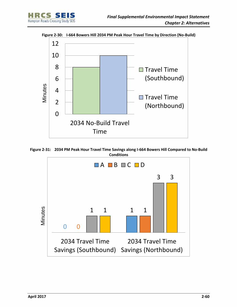
Final Supplemental Environmental Impact Statement
Chapter 2: Alternatives
April 2017 2-60
Figure 2-30: I-664 Bowers Hill 2034 PM Peak Hour Travel Time by Direction (No-Build)
Figure 2-31: 2034 PM Peak Hour Travel Time Savings along I-664 Bowers Hill Compared to No-Build
Conditions
0
2
4
6
8
10
12
2034 No-Build TravelTime
Travel Time(Southbound)
Travel Time(Northbound)
0
1
0
11
3
1
3
2034 Travel TimeSavings (Southbound)
2034 Travel TimeSavings (Northbound)
A B C D
Min
ute
s
Min
ute
s

Final Supplemental Environmental Impact Statement
Chapter 2: Alternatives
April 2017 2-61
2.9 OPERATIONAL ANALYSIS OF THE PREFERRED ALTERNATIVE
After the Draft SEIS was completed, the Hampton Roads Transportation Planning Organization (HRTPO)
released an update of the regional travel demand model on August 8, 2016. This model update
incorporates the latest adopted land use forecasts for a new horizon year (2040) as well as the
transportation improvement projects for the latest adopted long range transportation plan. The updated
HRTPO socio-economic forecasts project a 2% lower total population, and a 4% increase in total
employment within the Hampton Roads region compared to the 2034 forecast. The change in total
employment includes a 32 percent increase in retail employment, and a 4 percent decrease in non-retail
employment.
For this Final SEIS, forecasts for the Preferred Alternative were updated using the updated HRTPO
socio-economic data and transportation network improvements. Care should be taken when comparing
the 2034 results to the 2040 results because the 2040 results were updated based on more recent land
use forecasts and horizon years. This section is being presented to meet a commitment made to the region
during the development of the Draft SEIS. The hot-spot corridor analyses were updated based on the new
2040 travel demand model. Results are provided below and more detailed information can be found in
the updated HRCS Traffic and Transportation Technical Report.
2.9.1 HRBT
Table 2-11 shows the travel demand model output for the section of I-64 between I-664 and I-564, which
includes the HRBT bottleneck. Several performance measures are provided that indicate projected travel
demand on the facility (daily vehicles miles traveled) and the level of congestion (travel time delay and
daily vehicle hours traveled).
Table 2-11 indicates that under No-Build conditions, both VMT and VHT are projected to increase, along
with significant increases in delay, particularly in the westbound direction. Compared to the No-Build
Alternative, delays are projected to decline under the Preferred Alternative, despite an increase in VMT.
Additionally, the improvements in travel time and reductions in delay are illustrated in Figures 2-32
through 2-34.
Table 2-11: I-64 HRBT PM Peak Travel Time Comparison – between I-664 and I-564
Performance Measure Existing (2015)
No-Build (2040)
Preferred Alternative
(2040)
PM Peak Travel Time (minutes)
EB 20 25 18
WB 25 50 37
PM Peak Speed (congested speed MPH)
EB 36 28 39
WB 29 14 18
PM Peak Delay (minutes)
EB 7 14 6
WB 12 39 0
Daily VHT 32,234 56,100 53,980
Daily VMT 1,099,600 1,349,800 1,717,400
Daily Delay 11,000 27,100 25,100
Note: Total Delay was added to as a performance measure to better reflect corridor and system impacts based on comments received from HRTPO.

Final Supplemental Environmental Impact Statement
Chapter 2: Alternatives
April 2017 2-62
Figure 2-32: I-64 HRBT PM Peak Traffic Travel Time Comparison (Preferred Alternative)
Figure 2-33: I-64 HRBT 2040 PM Peak Hour Travel Time for No-Build Conditions
0
10
20
30
40
50
60
Travel Time(Eastbound)
Travel Time(Westbound)
No-Build (2040)
Preferred Alternative(2040)
0
20
40
60
2040 No-Build Travel Time
Travel Time(Eastbound)
Travel Time(Westbound)
26
% D
ecre
ase
29
% D
ecre
ase Min
ute
s
Min
ute
s

Final Supplemental Environmental Impact Statement
Chapter 2: Alternatives
April 2017 2-63
Figure 2-34: 2040 PM Peak Hour Travel Time Savings along I-64 HRBT Compared to No-Build Conditions
2.9.2 I-564
Table 2-12 shows the travel demand model output for the section of I-564 and the Intermodal Connector
between I-64 and the proposed NIT/Navy interchange.
Table 2-12 indicates that under No-Build and Preferred Alternative conditions, both VMT and VHT are
projected to increase, compared to existing conditions, although delays are projected to remain minimal.
Additionally, changes in travel time and delay are illustrated in Figures 2-35 and 2-36.
Table 2-12: I-564 AM Peak Travel Time Comparison - between I-64 and the Proposed NIT/Navy
Interchange
Performance Measure Existing (2015)
No-Build (2040)
Preferred Alternative
(2010)
AM Peak Travel Time (minutes)
EB 2 2 2
WB 2 3 3
PM Peak Speed (congested speed MPH)
EB 56 60 60
WB 47 53 54
PM Peak Delay (minutes)
EB 0 0 0
WB 0.3 0 0
Daily VHT 1,024 1,200 1,200
Daily VMT 51,200 67,600 69,100
Total Delay 0 100 100
Note: Total Delay was added to as a performance measure to better reflect corridor and system impacts based on comments received from HRTPO.
7
13
2040 Travel Time Savings(Eastbound)
2040 Travel Time Savings(Westbound)
Preferred Alternative
Min
ute
s

Final Supplemental Environmental Impact Statement
Chapter 2: Alternatives
April 2017 2-64
Figure 2-35: I-564 AM Peak Traffic Travel Time Comparison
Figure 2-36: I-564 2034 AM Peak Hour Travel Time for No-Build Conditions
2.9.3 MMMBT
Table 2-13 shows the travel demand model output for the section of I-664 between I-64 and College Drive,
which includes the MMMBT bottleneck.
Table 2-13 indicates that under No-Build conditions, both VMT and VHT are projected to increase, along
with significant increases in delay, in particular in the northbound direction. Under the Preferred
Alternative, delays, VMT, and VHT are projected to decrease as traffic would be expected to shift to the
HRBT. Additionally, improvements in travel time and reductions in delay are illustrated in Figures 2-37
through 2-39.
0
1
2
3
4
5
6
Travel Time(Eastbound)
Travel Time(Westbound)
No-Build (2040)
PreferredAlternative(2040)
0
1
2
3
4
2040 No-Build Travel Time
Travel Time(Eastbound)
Travel Time(Westbound)
No
Ch
ange
No
Ch
ange
Min
ute
s
Min
ute
s

Final Supplemental Environmental Impact Statement
Chapter 2: Alternatives
April 2017 2-65
Table 2-13: I-664 MMMBT PM Peak Travel Time Comparison - between I-64 and College Drive
Performance Measure Existing (2015)
No-Build (2040)
Preferred Alternative
(2040)
PM Peak Travel Time (minutes)
SB 12 15 14
NB 19 25 19
PM Peak Speed (congested speed MPH)
SB 58 45 47
NB 37 28 36
PM Peak Delay (minutes)
SB 0 4 4
NB 7 14 8
Daily VHT 18,551 24,200 20,000
Daily VMT 838,200 1,046,800 975,800
Total Delay 1,600 8,500 4,400
Note: Total Delay was added to as a performance measure to better reflect corridor and system impacts based on comments received from HRTPO.
Figure 2-37: I-664 MMMBT PM Peak Traffic Travel Time Comparison
0
5
10
15
20
25
30
Travel Time(Southbound)
Travel Time(Northbound)
No-Build (2040)
Preferred Alternative(2040)
3%
Dec
reas
e
24
% D
ecre
ase
Min
ute
s

Final Supplemental Environmental Impact Statement
Chapter 2: Alternatives
April 2017 2-66
Figure 2-38: I-664 MMMBT 2040 PM Peak Hour Travel Time for No-Build Conditions
Figure 2-39: 2040 PM Peak Hour Travel Time Savings along I-664 MMMBT Compared to No-Build Conditions
2.9.4 I-664 Bowers Hill
Table 2-14 shows the travel demand model output for the section of I-664 between VA 164 and I-264,
which includes the Bowers Hill bottleneck.
Table 2-14 indicates that under No-Build conditions, both VMT and VHT are projected to increase, along
with an increase in delay in the southbound direction. Compared to the No-Build alternative, delays are
projected to decline slightly in the southbound direction VMT and delays are projected to decrease under
101214161820222426
2040 No-Build TravelTime
Travel Time(Southbound)
Travel Time(Northbound)
1
6
2040 Travel Time Savings(Southbound)
2040 Travel Time Savings(Northbound)
Preferred Alternative
Min
ute
s
Min
ute
s

Final Supplemental Environmental Impact Statement
Chapter 2: Alternatives
April 2017 2-67
the Preferred Alternative, indicating a traffic shift to the HRBT. Additionally, improvements in travel time
and reductions in delay are illustrated in Figures 2-40 through 2-42.
Table 2-14: I-664 Bowers Hill PM Peak Travel Time Comparison - between VA 164 and I-264
Performance Measure Existing (2015)
No-Build (2040)
Preferred Alternative
(2040)
PM Peak Travel Time (minutes)
SB 8 11 10
NB 8 7 7
PM Peak Speed (congested speed MPH) SB 50 58 59
NB 51 44 47
PM Peak Delay (minutes) SB 1 1 1
NB 1 4 3
Daily VHT 12,330 12,700 12,000
Daily VMT 622,030 689,500 669,100
Total Delay 900 3,100 2,400
Note: Total Delay was added to as a performance measure to better reflect corridor and system impacts based on comments received from HRTPO.
Figure 2-40: I-664 Bowers Hill PM Peak Traffic Travel Time Comparison
0
2
4
6
8
10
12
Travel Time(Southbound)
Travel Time(Northbound)
No-Build (2040)
Preferred Alternative(2040)M
inu
tes
No
Ch
ange
5%
de
crea
se

Final Supplemental Environmental Impact Statement
Chapter 2: Alternatives
April 2017 2-68
Figure 2-41: I-664 Bowers Hill 2040 PM Peak Hour Travel Time by Direction (No-Build)
Figure 2-42: 2040 PM Peak Hour Travel Time Savings along I-664 Bowers Hill Compared to No-Build
Conditions
0
2
4
6
8
10
12
2040 No-Build TravelTime
Travel Time(Southbound)
Travel Time(Northbound)
1
0
2040 Travel TimeSavings (Southbound)
2040 Travel TimeSavings (Northbound)
Preferred Alternative
Min
ute
s
Min
ute
s

Final Supplemental Environmental Impact Statement
Chapter 2: Alternatives
April 2017 2-69
2.10 OPERATIONALLY INDEPENDENT SECTIONS
VDOT anticipates that improvements from the Preferred Alternative would be designed, funded, and
constructed as a single project. Because Alternative A was identified as the Preferred Alternative and is
fully funded for construction in the region’s LRTP, it is anticipated that a ROD would be issued for the
entire Preferred Alternative and not for a combination of operationally independent sections (OISs). The
remainder of this section remains the same as it was presented in the Draft SEIS.
Given the magnitude and scope of the alternatives, it is expected that a Preferred Alternative could be
implemented in stages or OISs. An OIS is a portion of an alternative that could be built and function as a
viable transportation facility with a logical terminus even if other portions of the alternative are not
advanced (FHWA, 2007). The OISs are comprised of various roadway alignments and were developed by
identifying sections of roadway improvements that if constructed, could function independently. This
means that a section of roadway improvements could be constructed and immediately opened to the
travelling public. Part of this analysis included the evaluation of adjacent roadways and whether the
proposed improvements would tie into existing roadways.
Additionally, different sections within an OIS also could be replaced with another. Appendix A includes
figures showing the alignment segments considered in this SEIS.
The VA 164 Connector by itself is not included in this SEIS as an OIS, but could become an OIS should the
CIDMMA site be constructed prior to the implementation of this portion of an alternative. If the CIDMMA
site is not constructed, there is no logical termini along this corridor. Once constructed, this section or a
portion of this section could be identified as an OIS. The OISs are listed on Table 2-15 below and shown
on Figure 2-43.
Table 2-15: Operationally Independent Sections
OIS Number OIS Name
I I-664 from I-264 to US 58
II I-664 from US 58 to VA 164
III I-664 from VA 164 to MMMBT/Terminal Avenue Exit
IV I-664 from MMMBT/Terminal Avenue Exit to I-64
V I-64 from I-664 to Mallory Street Exit
VI I-64 from Mallory Street Exit to I-564
VII I-564, I-564 Connector, and I-664 Connector
VIII I-564, I-564 Connector, and VA 164 Connector
IX I-664 Connector, I-564 Connector, and VA 164 Connector
X VA 164 Connector
XI VA 164
2.11 POTENTIAL HYBRID ALTERNATIVES
Because Alternative A was selected as the Preferred Alternative a hybrid alternative has not been analyzed
in this Final SEIS. The remainder of this section remains the same as it was presented in the Draft SEIS.

Final Supplemental Environmental Impact Statement
Chapter 2: Alternatives
April 2017 2-70
Following the release of the SEIS and an opportunity for public review and comment, the OISs could
ultimately be combined to form “hybrid” alternatives. The OIS strategy described in Section 2.8 allows for
the identification of a “hybrid” alternative in addition to the alternatives described in this chapter that
could reduce impacts and costs while achieving purpose and need. Depending on the nature of a hybrid
alternative, if selected, public involvement opportunities may be offered to solicit additional public
comment.
If a hybrid is identified as the Preferred Alternative, it would be presented to the public and fully
documented in the Final SEIS. The cost and impact information in this SEIS, however, provides preliminary
information on potential hybrids.
2.12 PHASED IMPLEMENTATION APPROACH
VDOT anticipates that improvements from the Preferred Alternative would be designed, funded, and
constructed as a single project. Because Alternative A was identified as the Preferred Alternative and is
fully funded for construction in the region’s LRTP, it is anticipated that a ROD would be issued for the
entire Preferred Alternative and not for an OIS or combination of OISs as funding becomes available. The
remainder of this section remains the same as it was presented in the Draft SEIS.
The implementation of the Preferred Alternative could occur via the construction of OIS. Each alternative
has been developed using OISs. Impacts for the alignment segments that make up the OISs have been
provided in this SEIS and respective technical documents. Appendix A includes figures showing the
alignment segments and the environmental and property impacts broken down by alignment segment.
Once the Preferred Alternative is properly documented in the Final SEIS and the first OIS or a group of
OISs is included in the HRTPO Long-Range Transportation Plan, the HRTPO Transportation Improvement
Program, and the Statewide Transportation Improvement Program, it is expected that VDOT would then
request a ROD for the first OIS or a group of OISs from FHWA.
Once a ROD is issued for an OIS or group of OISs, that section would be advanced into the final engineering
design phase. It is during this phase that design details including the precise disturbance limits,
right-of-way requirements, certifications, and permits would be applied for. Certifications and permits
would be obtained for items such as impacts to Waters of the United States, including wetlands, navigable
waters, coastal zone management areas, stormwater management, and erosion and sediment control.
Any necessary mitigation measures would also be finalized through coordination with the appropriate
agencies.
The OISs would move into the right-of-way acquisition and utility relocation phases following final design.
The acquisition of right-of-way would follow the most current state and federal regulations before
construction would be initiated.

Final Supplemental Environmental Impact Statement
Chapter 2: Alternatives
April 2017 2-71
Figure 2-43: Operationally Independent Sections

Final Supplemental Environmental Impact Statement
Chapter 2: Alternatives
April 2017 2-72
2.13 ORDER OF IMPLEMENTATION
The potential order of implementation could document the order in which VDOT anticipates requesting
RODs from FHWA to allow the alternative to be implemented in OISs, if necessary. The order of
implementation presented below for each Build Alternative is an example of how the Preferred
Alternative could be presented, and is not meant to represent a recommended order.
VDOT anticipates that improvements from the Preferred Alternative would be designed, funded, and
constructed at the same time. Because Alternative A was identified as the Preferred Alternative and is
fully funded for construction in the region’s LRTP, it is anticipated that a ROD would be issued for the
entire Preferred Alternative and is not anticipated that to be implemented in OISs. Therefore, an order of
implementation has not been recommended as part of this Final SEIS. The remainder of this section
remains the same as it was presented in the Draft SEIS.
2.13.1 Alternative A
An illustrative order of implementation of OISs for Alternative A is shown in Table 2-16.
Table 2-16: Alternative A Order of Implementation
OIS Alignment Segments
VI I-64 from Mallory Street Exit to I-564
V I-64 from I-664 to Mallory Street Exit
2.13.2 Alternative B
An illustrative order of implementation of OISs for Alternative B is shown in Table 2-17.
Table 2-17: Alternative B Order of Implementation
OIS Alignment Segments
VI I-64 from Mallory Street Exit to I-564
V I-64 from I-664 to Mallory Street Exit
VIII I-564, I-564 Connector, and VA 164 Connector
XI VA 164
2.13.3 Alternative C
An illustrative order of implementation of OISs for Alternative C is shown in Table 2-18.
Table 2-18: Alternative C Order of Implementation
OIS Alignment Segments
III I-664 from VA 164 to MMMBT/Terminal Avenue Exit
VII I-564, I-564 Connector, and I-664 Connector
IV I-664 from MMMBT/Terminal Avenue Exit to I-64
II I-664 from US 58 to VA 164
I I-664 from I-264 to US 58
X VA 164 Connector

Final Supplemental Environmental Impact Statement
Chapter 2: Alternatives
April 2017 2-73
2.13.4 Alternative D
An illustrative order of implementation of OISs for Alternative D is shown in Table 2-19.
Table 2-19: Alternative D Order of Implementation
OIS Alignment Segments
VI I-64 from Mallory Street Exit to I-564
V I-64 from I-664 to Mallory Street Exit
VIII I-564, I-564 Connector, and VA 164 Connector
XI VA 164
III I-664 from VA 164 to MMMBT/Terminal Avenue Exit
IV I-664 from MMMBT/Terminal Avenue Exit to I-64
II I-664 from US 58 to VA 164
I I-664 from I-264 to US 58
IX I-664 Connector