FRESHWATER ECOLOGICAL ASSESSMENT AS PART OF THE ...
72
FRESHWATER ECOLOGICAL ASSESSMENT AS PART OF THE ENVIRONMENTAL ASSESSMENT AND AUTHORISATION PROCESS FOR THE PROPOSED UPGRADE OF A PORTION OF ALLANDALE ROAD MIDRAND, GAUTENG PROVINCE Prepared for Century Property Development November 2016 Prepared by: Scientific Aquatic Services Report author: C. Pretorius Report reviewer: S. van Staden (Pr. Sci. Nat) Report reference: SAS 216262 Date: November 2016 Scientific Aquatic Services CC CC Reg No 2003/078943/23 Vat Reg. No. 4020235273 PO Box 751779 Gardenview 2047 Tel: 011 616 7893 Fax: 086 724 3132 E-mail: [email protected]
Transcript of FRESHWATER ECOLOGICAL ASSESSMENT AS PART OF THE ...

FRESHWATER ECOLOGICAL ASSESSMENT AS PART OF
THE ENVIRONMENTAL ASSESSMENT AND
AUTHORISATION PROCESS FOR THE PROPOSED
UPGRADE OF A PORTION OF ALLANDALE ROAD
MIDRAND, GAUTENG PROVINCE
Prepared for
Century Property Development
November 2016
Prepared by: Scientific Aquatic Services Report author: C. Pretorius Report reviewer: S. van Staden (Pr. Sci. Nat) Report reference: SAS 216262
Date: November 2016
Scientific Aquatic Services CC CC Reg No 2003/078943/23 Vat Reg. No. 4020235273 PO Box 751779 Gardenview 2047 Tel: 011 616 7893 Fax: 086 724 3132 E-mail: [email protected]

SAS 216262 November 2016
ii
EXECUTIVE SUMMARY
MANAGEMENT SUMMARY
Scientific Aquatic Services (SAS) was appointed to conduct a freshwater assessment as part of the environmental assessment and authorisation process for the upgrade of a portion of Allandale Road within the Midrand area, Gauteng Province, hereafter referred to as the proposed “linear development”. The portion of Allandale Road (M39) proposed to be upgraded stretches from the intersection of Allandale Road and Pitts Avenue (north western end) to approximately 28m before the interchange of Allendale Road and Harry Galaun Drive (eastern end). The purpose of this report is to assess the freshwater resources traversed by the proposed linear development, to provide supporting, detailed information to guide the proposed activities, and to ensure the ongoing functioning of the freshwater resources that would be affected. A further goal is to support local and regional conservation requirements and the provision of ecological services in the local area while attempting to guide development in line with the principles of sustainable development. The study also aims to identify and quantify any impacts of the project on the freshwater resources, and to present a set of mitigation measures to minimise impacts on the receiving aquatic environment. The assessment took the following approach:
A desktop study was conducted, in which freshwater resources were identified for on-site investigation, and relevant national and provincial databases were consulted. The results of the desktop study are presented in Section 3 of this report;
A field assessment took place in November 2016, in order to ground-truth the identified freshwater resources identified by the relevant national, provincial and municipal datasets.
Two freshwater resources were identified during the site assessment, namely a tributary of the Jukskei River and a channelled valley bottom wetland, which is already being traversed by Allandale Road;
The detailed results of the field assessment are contained in Section 4 of this report; Both these freshwater resources are considered to be largely modified (PES: D) but still has
the ability to deliver Intermediate ecosrevices. Due to the vegetation group these resources are located in, they were awarded a High ecological importance.
Following the assessment of the ecological status of the freshwater resources, the DWS risk assessment was applied to ascertain the significance of perceived impacts arising from the construction of the proposed linear development. The results of the risk assessment are summarised in the table below:
The findings of the freshwater resource assessment indicates that the freshwater resources are deemed to be in a largely modified condition, and is therefore of considered to be of limited ecological importance and sensitivity. Based on these findings, and the results of the risk assessment, it is the opinion of the ecologist that although the potential exists for the proposed linear development to have a negative impact on the freshwater resources, adherence to cogent, well-conceived and ecologically sensitive construction design, and the mitigation measures provided in this report as well as general good construction practice and impact mitigation will greatly reduce the significance of perceived impacts. It is the opinion of the specialist therefore that the proposed linear development be considered favourably if it can be ensured that the ecological integrity of the freshwater resources and the ecological and socio-cultural services the affected resources provide
are not further compromised.

SAS 216262 November 2016
iii
No. P
has
es
Activity Aspect
Ris
k
Rat
ing
1
Co
nst
ruct
ion
Site preparation prior to construction of culverts and roadway, including placement of contractor laydown areas and storage facilities
*Vehicular transport and access to the site, site clearing; *Removal of vegetation and associated disturbances to soils; *Miscellaneous activities by construction personnel
L
Excavation within freshwater resources for foundations
Temporary in-channel diversion of resources to allow for excavations to take place
M
*Movement of construction machinery/vehicles within the freshwater resources; and *Possible spills / leaks from construction vehicles
L
*Disturbances to soils of the freshwater resources; and *Removal of topsoil and creation of soil stockpiles
L
Extension of culverts and construction of roadway
*Movement of construction machinery/vehicles within the freshwater resources; and *Possible spills / leaks from construction vehicles
L
*Possible discard of construction material within the freshwater resources L
*Ongoing disturbances to soils as culverts are installed M
Re-profiling of slopes in the vicinity of the culverts
*Ongoing disturbances to soils; and *Removal of vegetation
L
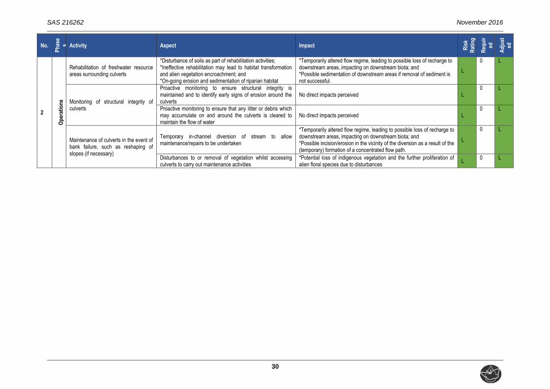
2
Op
erat
ion
s
Rehabilitation of freshwater resource areas surrounding culverts
*Disturbance of soils as part of rehabilitation activities; *Ineffective rehabilitation may lead to habitat transformation and alien vegetation encroachment; and *On-going erosion and sedimentation of riparian habitat
L
Monitoring of structural integrity of culverts
Proactive monitoring to ensure structural integrity is maintained and to identify early signs of erosion around the culverts
L
Proactive monitoring to ensure that any litter or debris which may accumulate on and around the culverts is cleared to maintain the flow of water
L
Maintenance of culverts in the event of bank failure, such as reshaping of slopes (if necessary)
Temporary in-channel diversion of stream to allow maintenance/repairs to be undertaken
L
Disturbances to or removal of vegetation whilst accessing culverts to carry out maintenance activities
L
In conclusion, it is the opinion of the ecologist that although the potential exists for the proposed linear development to have a negative impact on the freshwater resource and its associated riparian zone, adherence to cogent, well-conceived and ecologically sensitive site development plans, and the mitigation measures provided in this report as well as general good practice mitigation will greatly reduce the significance of perceived impacts. It is the opinion of the specialist therefore that the proposed linear development be considered favourably, with the proviso that strict adherence to mitigation measures is enforced, and as recommended, more culverts be installed underneath Allandale Road, in order to ensure that the ecological integrity of the freshwater resource and the ecological and socio-cultural services it provides is not further compromised.

SAS 216262 November 2016
iv
DOCUMENT GUIDE
Relevant section in report
Details of the specialist who prepared the report Appendix G
The expertise of that person to compile a specialist report including a curriculum vita Appendix G
A declaration that the person is independent in a form as may be specified by the competent authority
Appendix G
An indication of the scope of, and the purpose for which, the report was prepared Section 1.2
Assumption and limitations Section 1.3
A description of the methodology adopted in preparing the report Appendix C & D
The specific identified sensitivity of the site Section 4.4
Indicators considered during wetland delineation and parameters adopted in allocating a buffer for the resource
Section 4.4
A description of the findings and potential implications of such findings on the impact of the proposed activity, including identified alternatives, on the environment
Section 5
Management and mitigation measures for inclusion in the Environmental Management Programme (EMPr)
Section 5 and Appendix F
Any monitoring requirements for inclusion in the EMPr or environmental authorisation Section 5
Conclusion and opinion based on the results and impact assessments Section 6
References utilised for this study Section 7
Indemnity and terms of use of the report Appendix A
Legislative requirements Appendix B
Present Ecological State (PES), Ecoservices and Ecological Importance and Sensitivity (EIS) results
Appendix E

SAS 216262 November 2016
v
TABLE OF CONTENTS
EXECUTIVE SUMMARY ...................................................................................................... ii DOCUMENT GUIDE ............................................................................................................ iv TABLE OF CONTENTS ....................................................................................................... v LIST OF FIGURES .............................................................................................................. vi LIST OF TABLES ................................................................................................................ vi GLOSSARY OF TERMS .................................................................................................... vii ACRONYMS ........................................................................................................................ ix 1 INTRODUCTION ....................................................................................................... 1 1.1 Background ............................................................................................................... 1 1.2 Scope of Work ........................................................................................................... 4 1.3 Assumptions and Limitations ..................................................................................... 5 1.4 Legislative Requirements .......................................................................................... 6 2 ASSESSMENT APPROACH .................................................................................... 6 2.1 Freshwater resource Field Verification....................................................................... 6 2.2 Sensitivity Mapping.................................................................................................... 7 2.3 Risk Assessment and Recommendations .................................................................. 7 3 RESULTS OF THE DESKTOP ANALYSIS ............................................................... 7 4 RESULTS ............................................................................................................... 15 4.1 Freshwater Resource Characterisation .................................................................... 15 4.2 Field Verification Results ......................................................................................... 18 4.3 Delineation and Sensitivity Mapping ........................................................................ 23 5 RISK ASSESSMENT .............................................................................................. 26 5.1 Risk Analyses .......................................................................................................... 27 5.1.1 Consideration of impacts and application of mitigation measures ............................ 27 6 CONCLUSION ........................................................................................................ 33 7 REFERENCES ........................................................................................................ 34 APPENDIX A - Indemnity ................................................................................................. 36 APPENDIX B - Legislation ............................................................................................... 37 APPENDIX C - Method of Assessment ........................................................................... 38 APPENDIX D - Risk Assessment Methodology ............................................................. 45 APPENDIX E - Freshwater Assessment Results ........................................................... 49 APPENDIX F - Risk Analysis ........................................................................................... 52 APPENDIX G - Specialist Details .................................................................................... 58

SAS 216262 November 2016
vi
LIST OF FIGURES
Figure 1: A digital satellite image depicting the location of the proposed linear development in relation to the surrounding area. .............................................. 2
Figure 2: The proposed linear development depicted on a 1:50 000 topographical map in relation to the surrounding area..................................................................... 3
Figure 3: Locality of the natural channeled valley bottom wetland in relation to the linear development, according to NFEPA (2011). ........................................... 10
Figure 4: Locality of the Jukskei River in relation to the linear development, according to NFEPA (2011). ........................................................................................... 11
Figure 5: Gauteng C Plan v3.3 indicating various CBAs and ESAs in the immediate vicinity of the linear development. ................................................................... 12
Figure 6: Wetland and river buffers associated with the linear development according to the Gauteng C-Plan v3.3............................................................................. 13
Figure 7: Wetland features associated with the linear development as indicated by the CoJ Wetland layer (2014). .............................................................................. 14
Figure 8: A stormwater outlet facilitating water underneath Allandale Road (At the intersection of Allandale Road and Greig Street). ........................................... 16
Figure 9: Conceptual presentation of the freshwater resources delineation undertaken during the field assessment, in relation to the proposed linear development. .. 17
Figure 10: Conceptual presentation of the freshwater resources and the associated 32m buffer in accordance with GDARD guidelines in relation to the proposed linear development. ........................................................................................ 25
LIST OF TABLES
Table 1: Desktop data relating to the characteristics of the freshwater resource associated with the linear development and surrounding region. ......................... 9
Table 2: Characterisation of the freshwater resource associated with the linear development. ..................................................................................................... 16
Table 3: Summary of the assessment of the unnamed tributary of the Jukskei River ...... 19 Table 4: Summary of the assessment of the Channelled Valley Bottom wetland ............. 21 Table 5: A summary of the risk assessment relating to the construction and operation
of the proposed linear development within the assessed freshwater resources. 29

SAS 216262 November 2016
vii
GLOSSARY OF TERMS
Alien vegetation: Plants that do not occur naturally within the area but have
been introduced either intentionally or unintentionally.
Vegetation species that originate from outside of the
borders of the biome -usually international in origin.
Alluvial soil: A deposit of sand, mud, etc. formed by flowing water, or
the sedimentary matter deposited thus within recent
times, especially in the valleys of large rivers.
Biodiversity: The number and variety of living organisms on earth, the
millions of plants, animans and micro-organisms, the
genes they contain, the evolutionary history and potential
they encompass and the ecosystems, ecological
processes and landscape of which they are integral parts.
Buffer: A strip of land surrounding a wetland or riparian area in
which activities are controlled or restricted, in order to
reduce the impact of adjacent land uses on the wetland or
riparian area.
Catchment: The area contributing to runoff at a particular point in a
river system.
Chroma: The relative purity of the spectral colour which decreases
with increasing greyness.
Delineation (of a freshwater resource): To determine the boundary of a freshwater
resource based on soil, vegetation and/or hydrological
indicators.
Ecoregion: An ecoregion is a "recurring pattern of ecosystems
associated with characteristic combinations of soil and
landform that characterise that region”.
Facultative species: Species usually found in wetlands (76%-99% of
occurrences) but occasionally found in non-wetland areas.
Groundwater: Subsurface water in the saturated zone below the water
table.
Hydromorphic soil: A soil that in its undrained condition is saturated or
flooded long enough to develop anaerobic conditions
favouring the growth and regeneration of hydrophytic
vegetation (vegetation adapted to living in anaerobic
soils).
SAS 216262 November 2016
viii
Hydrology: The study of the occurrence, distribution and movement of
water over, on and under the land surface.
Hydromorphy: A process of gleying and mottling resulting from the
intermittent or permanent presence of excess water in the
soil profile.
Indigenous vegetation: Vegetation occurring naturally within a defined area.
Obligate species: Species almost always found in wetlands (>99% of
occurences).
Perennial: Flows all year round.
Seasonal zone of wetness: The zone of a wetland that lies between the Temporary
and Permanent zones and is characterised by saturation
from three to ten months of the year, within 50cm of the
surface.
Temporary zone of wetness: The outer zone of a wetland characterised by saturation
within 50cm of the surface for less than three months of
the year.

SAS 216262 November 2016
ix
ACRONYMS
BAR Basic Assessment Report
CBA Critical Biodiversity Area
CoJ City of Johannesburg
CSIR Council of Scientific and Industrial Research
DWA Department of Water Affairs
DWAF Department of Water Affairs and Forestry
DWS Department of Water and Sanitation
EAP Environmental Assessment Practitioner
ECO Environmental Control Officer
EI Ecological Importance
EIA Environmental Impact Assessment
EIS Ecological Importance and Sensitivity
ES Ecological Sensitivity
ESA Ecological Support Area
FEPA Freshwater Ecosystem Priority Areas
GDARD Gauteng Department of Agriculture and Rural Development
GIS Geographic Information System
GPS Global Positioning System
HGM Hydro-geomorphic
IHI Index of Habitat Integrity
MAP Mean Annual Precipitation
NEMA National Environmental Management Act
NFEPA National Freshwater Ecosystem Priority Areas
NWA National Water Act
PES Present Ecological State
REC Recommended Ecological Category
RQS Research Quality Services
SANBI South African National Biodiversity Institute
SANParks South African National Parks
SAS Scientific Aquatic Services
subWMA Sub-Water Management Area
WMA Water Management Area
WRC Water Research Commission
SAS 216262 November 2016
1
1 INTRODUCTION
1.1 Background
Scientific Aquatic Services (SAS) was appointed to conduct a freshwater assessment as part
of the environmental assessment and authorisation process for the upgrade of a portion of
Allandale Road within the Midrand area, Gauteng Province, hereafter referred to as the
proposed “linear development”. The portion of Allandale Road (M39) proposed to be
upgraded stretches from the intersection of Allandale Road and Pitts Avenue (north western
end) to approximately 28m before the interchange of Allendale Road and Harry Galaun
Drive (eastern end) (Figure 1 & 2).
The purpose of this report is to define the ecology of the freshwater resources, mapping of
the freshwater resource and its associated riparian zone, define areas of increased
Ecological Importance and Sensitivity (EIS), and to define the Present Ecological State
(PES) of the freshwater resource associated with the linear development. In addition, this
report aims to define the socio-cultural and ecological service provision of the freshwater
resource and the Recommended Ecological Category (REC) for the freshwater resource. It
is a further objective of this study to provide detailed information to guide the proposed
project activities in the vicinity of the freshwater resource, in order to ensure the ongoing
functioning of the ecosystem, such that local and regional conservation requirements and
the provision of ecological services in the local area are supported while considering the
need for sustainable economic development.
This report, after consideration and a description of the ecological integrity of the freshwater
resources associated with the proposed linear development, must guide the Environmental
Assessment Practitioner (EAP) and authorities, by means of a reasoned opinion and
recommendations, as to the viability of the proposed development activities in relation to the
freshwater resources.

SAS 216262 November 2016
2
Figure 1: A digital satellite image depicting the location of the proposed linear development in relation to the surrounding area.

SAS 216262 November 2016
3
Figure 2: The proposed linear development depicted on a 1:50 000 topographical map in relation to the surrounding area.
SAS 216262 November 2016
4
1.2 Scope of Work
Specific outcomes in terms of this report are outlined below:
A background study of relevant national, provincial and municipal datasets (such as
National Freshwater Ecosystem Priority Areas [NFEPA] and the DWS RQS PES/EIS
database) was undertaken to aid in defining the EIS of the freshwater resources;
Freshwater resources within the vicinity and traversed by the linear development
were delineated according to “DWAF, 2008: A practical Guideline Procedure for the
Identification and Delineation of Wetlands and Riparian Zones”. Aspects such as soil
morphological characteristics, vegetation types and wetness were used to delineate
the various zones of wetness (permanent and temporary) according to the
guidelines. Buffer zones were then allocated to the freshwater resources;
All freshwater resources within 500m of the freshwater resources identified within the
vicinity and traversed by the linear development were delineated on a desktop basis
in accordance with GN 509 of 2016 as it pertains to the National Water Act, 2016;
The classification assessment of the freshwater resources was undertaken according
to the Classification System for Wetlands and other Aquatic Ecosystems in South
Africa. User Manual: Inland systems (Ollis et al., 2013);
The EIS of the freshwater resources were determined according to the method
described by Rountree & Kotze, (2013);
The services provided by the freshwater resources traversed or within the vicinity of
the linear development were assessed according to the method of Kotze et al (2009)
in which services to the ecology of the site as well as services to the people of the
area were defined;
The PES of the freshwater resources traversed or in the vicinity of the linear
development was assessed according to the resource directed measures guideline
as advocated by Macfarlane et al., (2008);
The freshwater resources were mapped in relation to the linear development. In
addition to the freshwater resource boundaries, relevant regulated and/ or buffer
zones as stipulated by the various provincial guidelines and national legislation, was
applied to the freshwater resource boundaries; and
The DWS Risk Assessment Matrix was applied to identify potential impacts that may
affect the resource as a result of the proposed development, and to aim to quantify
the significance thereof.
SAS 216262 November 2016
5
1.3 Assumptions and Limitations
The following assumptions and limitations are applicable to this report:
The determination of the freshwater resource and its associated riparian zone
boundary, and the assessment thereof is confined to the linear development, and
does not include the neighbouring and adjacent properties, which were only
considered as part of the desktop assessment;
The riparian and freshwater resource delineation as presented in this report is
regarded as a best estimate of the riparian and freshwater resource boundary, based
on the site conditions present at the time of assessment;
The delineation of the freshwater resources as presented in this report is regarded as
a best estimate of the boundaries based on the site conditions present at the time of
assessment. Global Positioning System (GPS) technology is inherently inaccurate
and some inaccuracies due to the use of handheld GPS instrumentation may occur.
Current and historical anthropogenic activities have severely impacted on the
freshwater ecology of the area, and therefore it was difficult to accurately assess the
boundaries of the freshwater resources. If more accurate assessments are required,
the freshwater resources will need to be surveyed and pegged according to
surveying principles;
Wetlands, riparian zones, and terrestrial zones create transitional areas where an
ecotone is formed as vegetation species change from terrestrial to
obligate/facultative species. Within this transition zone, some variation of opinion on
the riparian boundary may occur. However, if the DWAF (2008) method is followed,
all assessors should get largely similar results;
The data presented in this report is based on a single site visit undertaken in
November 2016. The effects of natural seasonal and long-term variation in the
ecological conditions are therefore unknown, as aquatic and terrestrial ecosystems
are dynamic and complex. It is therefore possible that aspects of the ecology along
Allandale Road, some of which may be important, could have been overlooked; and
With ecology being dynamic and complex, certain aspects (some of which may be
important) may have been overlooked. However, it is expected that the proposed
development activities have been accurately assessed and considered, based on the
field observations and the consideration of existing studies and monitoring data in
terms of riparian and wetland ecology.

SAS 216262 November 2016
6
1.4 Legislative Requirements
The following legislative requirements and provincial guidelines were taken into
consideration during the assessment. A detailed description of these is presented in
Appendix B:
National Environmental Management Act (NEMA) (Act No. 107 of 1998);
National Water Act (NWA) (Act No. 36 of 1998);
General Notice (GN) 509 as published in the Government Gazette 40229 of 2016 as
it relates to the NWA (Act 36 of 1998); and
GDARD Minimum Requirements for Biodiversity Assessments Version 3 (GDARD,
2014).
2 ASSESSMENT APPROACH
2.1 Freshwater resource Field Verification
For the purposes of this investigation, a riparian zone is defined in the National Water Act
(NWA) (1998) as including “the physical structure and associated vegetation of the areas
associated with a freshwater resource which are commonly characterised by alluvial soils,
and which are inundated or flooded to an extent and with a frequency sufficient to support
vegetation of species with a composition and physical structure distinct from those of
adjacent land areas.”, whereas the definition of a wetland habitat as defined in the NWA
(1998) is “a land which is transitional between terrestrial and aquatic systems where the
water table is usually at or near the surface, or the land is periodically covered with shallow
water, and which land in normal circumstances supports or would support vegetation
typically adapted to life in saturated soil.”
The freshwater resource delineation took place according to the method presented in the
“Updated manual for the identification and delineation of wetland and riparian resources”
published by DWAF in 2008. The foundation of the method is based on the fact that
wetlands have several distinguishing factors including the following:
The presence of water at or near the ground surface;
Distinctive hydromorphic soils;
Vegetation adapted to saturated soils; and
The presence of alluvial soils in stream systems.

SAS 216262 November 2016
7
A field assessment was undertaken in November 2016, during which the presence of any
freshwater resource characteristics as defined by DWAF (2008) and freshwater resource
habitat as defined by the NWA, were noted. In addition to the delineation process, a detailed
assessment of the delineated freshwater resources was undertaken, at which time factors
affecting the integrity of the freshwater resources were taken into consideration and aided in
the determination of the functioning and the ecological and socio-cultural services provided
by the freshwater resource and its associated riparian zone. A detailed explanation of the
methods of assessment is provided in Appendix C of this report.
2.2 Sensitivity Mapping
All freshwater resources traversed by the linear development were considered and were
delineated with the use of a Global Positioning System (GPS). Geographic Information
System (GIS) was used to project these features onto digital satellite imagery and
topographic maps. The sensitivity map presented in Section 4.4 should guide the design and
layout of the development.
2.3 Risk Assessment and Recommendations
Following the completion of the assessment, a risk assessment was conducted (please refer
to Appendix D for the method of approach) and recommendations were developed to
address and mitigate impacts associated with the proposed development. These
recommendations also include general management measures, which apply to the proposed
development as a whole. Mitigation measures have been developed to address issues in all
phases throughout the life of the operation including planning, construction and operation
through to after care and maintenance. The detailed site specific mitigation measures are
outlined in Section 5 of this report, whilst the general management measures which are
considered to be best practice mitigation applicable to this project, are outlined in Appendix
F.
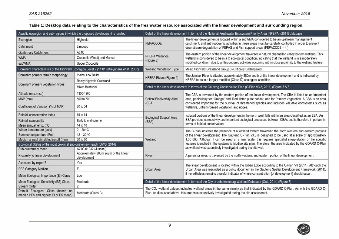
3 RESULTS OF THE DESKTOP ANALYSIS
The following section contains data accessed as part of the desktop assessment and are
presented as a “dashboard” report below (Table 1). The dashboard report aims to present
concise summaries of the data on as few pages as possible in order to allow for integration
of results by the reader to take place. Where required, further discussion and interpretation

SAS 216262 November 2016
8
is provided, and information that was considered to be of particular importance was
emboldened.
It is important to note that although all data sources used provide useful and often verifiable,
high quality data, the various databases used do not always provide an entirely accurate
indication of the linear developments’ actual site characteristics at the scale required to
inform the Environmental Impact Assessment (EIA) process. However, this information is
considered to be useful as background information to the study. Thus, this data was used as
a guideline to inform the assessment and to focus on areas and aspects of increased
conservation importance.
SAS 216262 November 2016
9
Table 1: Desktop data relating to the characteristics of the freshwater resource associated with the linear development and surrounding region.
Aquatic ecoregion and sub-regions in which the proposed development is located Detail of the linear development in terms of the National Freshwater Ecosystem Priority Area (NFEPA) (2011) database
Ecoregion Highveld FEPACODE
The linear development is located within a subWMA considered to be an upstream management catchment, and anthropogenic activities in these areas must be carefully controlled in order to prevent downstream degradation of FEPAS and Fish support areas (FEPACODE = 4.) Catchment Limpopo
Quaternary Catchment A21C NFEPA Wetlands (Figure 3)
The eastern portion of the linear development traverses a natural channelled valley bottom wetland. This wetland is considered to be in a C ecological condition, indicating that the wetland is in a moderately modified condition, due to anthropogenic activities occurring within close proximity to the wetland feature.
WMA Crocodile (West) and Marico
subWMA Upper Crocodile
Dominant characteristics of the Highveld Ecoregion Level 2 (11.01) (Kleynhans et al., 2007) Wetland Vegetation Type Mesic Highveld Grassland Group 3 (Critically Endangered)
Dominant primary terrain morphology Plains; Low Relief NFEPA Rivers (Figure 4)
The Jukskei River is situated approximately 880m south of the linear development and is indicated by NFEPA to be in a largely modified (Class D) ecological condition.
Dominant primary vegetation types Rocky Highveld Grassland
Mixed Bushveld Detail of the linear development in terms of the Gauteng Conservation Plan (C-Plan V3.3, 2011) (Figure 5 & 6)
Altitude (m a.m.s.l) 1300-1900
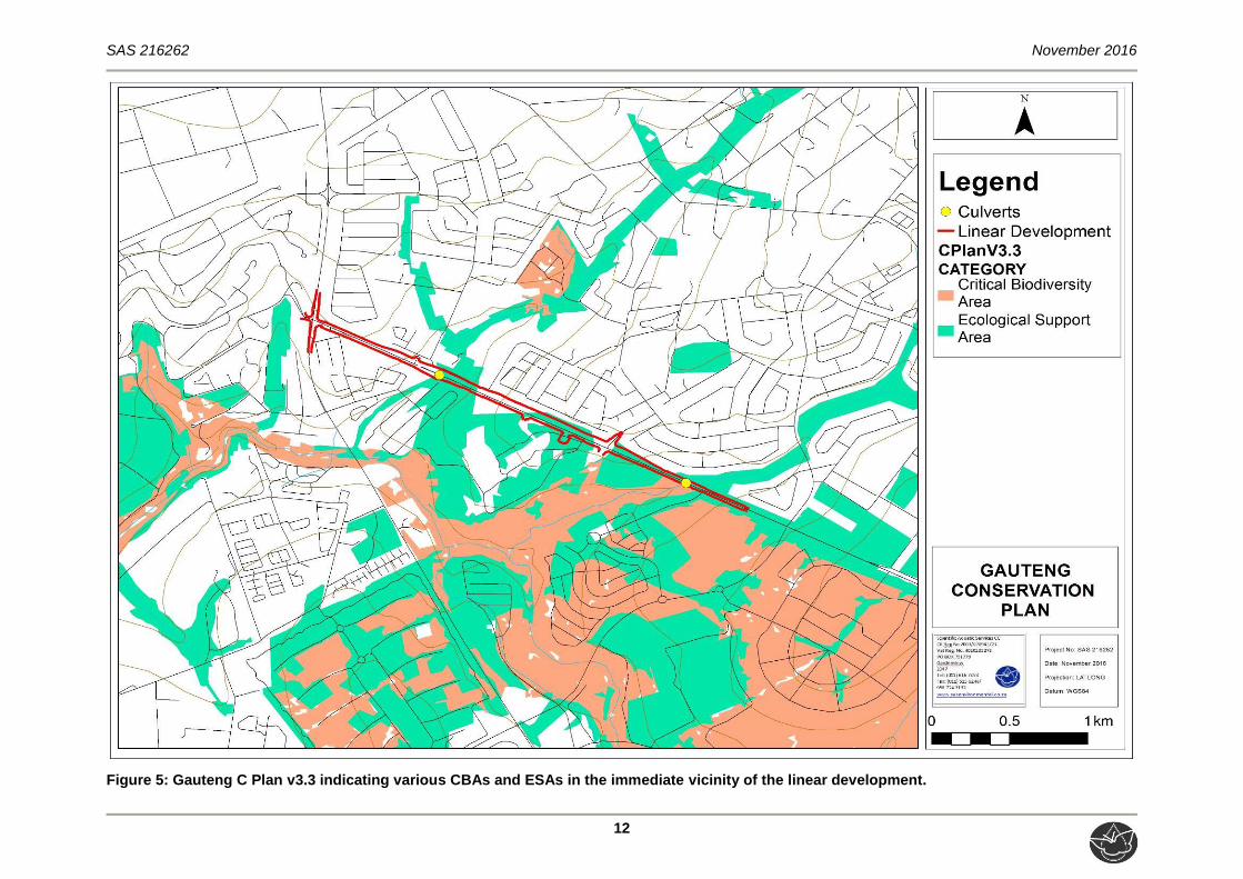
Critical Biodiversity Area (CBA)
The CBA is traversed by the eastern portion of the linear development. The CBA is listed as an Important area, particularly for “Orange” and ‘Red’ listed plant habitat, and for Primary Vegetation. A CBA is an area considered important for the survival of threatened species and includes valuable ecosystems such as wetlands, untransformed vegetation and ridges.
MAP (mm) 500 to 700
Coefficient of Variation (% of MAP) 20 to 34
Rainfall concentration index 55 to 64 Ecological Support Area (ESA)
Isolated portions of the linear development in the north west falls within an area classified as an ESA. An ESA provides connectivity and important ecological processes between CBAs and is therefore important in terms of habitat conservation
Rainfall seasonality Early to mid summer
Mean annual temp. (°C) 14 to 18
Winter temperature (July) 0 – 20 C
Wetland
The C-Plan indicates the presence of a wetland system traversing the north western and eastern portions of the linear development. The Gauteng C-Plan v3.3 is designed to be used at a scale of approximately 1:50 000. Although it can be used at a finer scale, this requires specialist interpretation of the specific features identified in the systematic biodiversity plan. Therefore, the area indicated by the GDARD C-Plan as wetland was extensively investigated during the site visit.
Summer temperature (Feb) 12 – 30 C
Median annual simulated runoff (mm) 20 to 60
Ecological Status of the most proximal sub-quaternary reach (DWS, 2014)
Sub-quaternary reach A21C-01232 (Jukskei)
Proximity to linear development Approximately 880m south of the linear development
River A perennial river, is traversed by the north western, and eastern portion of the linear development.
Assessed by expert? Yes
Urban Area The linear development is located within the Urban Edge according to the C-Plan V3 (2011). Although the Urban Area was rescinded as a policy document in the Gauteng Spatial Development Framework (2011), it nevertheless remains a useful indicator of where concentration [of development] should occur.
PES Category Median E
Mean Ecological Importance (EI) Class Low
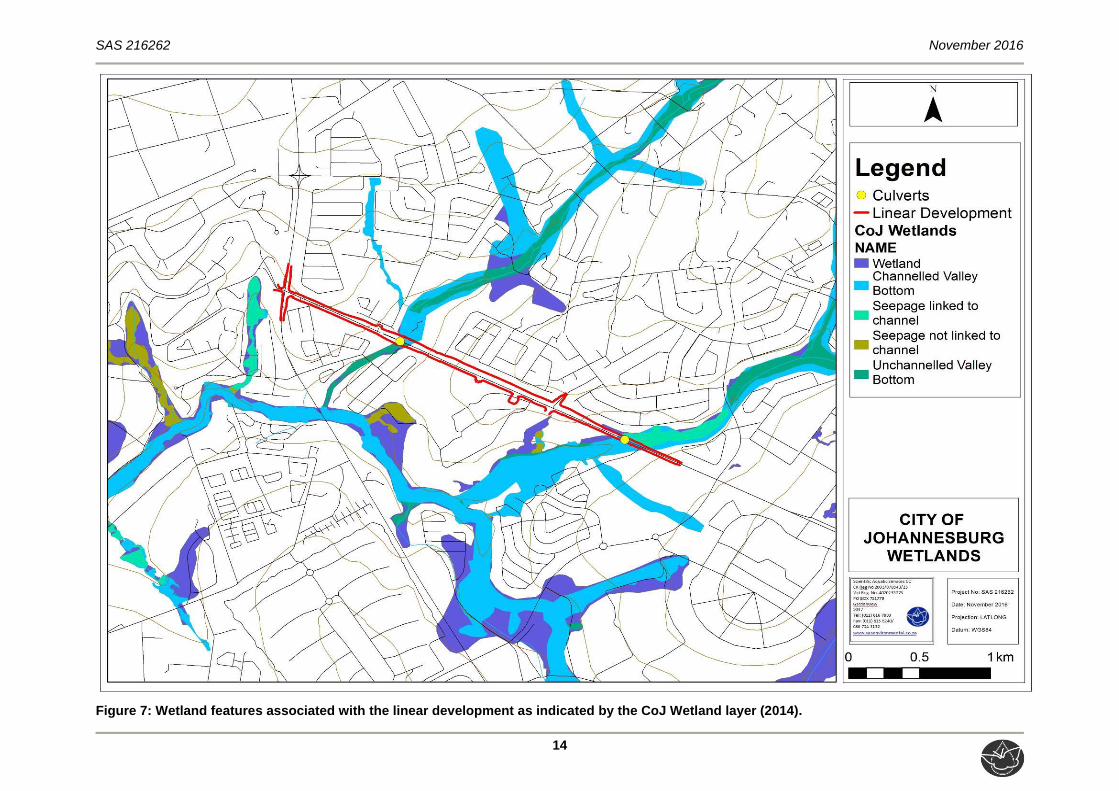
Mean Ecological Sensitivity (ES) Class Moderate Detail of the linear development in terms of the City of Johannesburg Wetland Database (CoJ, 2014) (Figure 7)
Stream Order 2 The COJ wetland dataset indicates wetland areas in the same vicinity as that indicated by the GDARD C-Plan. As with the GDARD C-Plan. As discussed above, this area was extensively investigated during the site assessment.
Default Ecological Class (based on median PES and highest EI or ES mean)
Moderate (Class C)

SAS 216262 November 2016
10
Figure 3: Locality of the natural channeled valley bottom wetland in relation to the linear development, according to NFEPA (2011).

SAS 216262 November 2016
11
Figure 4: Locality of the Jukskei River in relation to the linear development, according to NFEPA (2011).
SAS 216262 November 2016
12
Figure 5: Gauteng C Plan v3.3 indicating various CBAs and ESAs in the immediate vicinity of the linear development.

SAS 216262 November 2016
13
Figure 6: Wetland and river buffers associated with the linear development according to the Gauteng C-Plan v3.3.
SAS 216262 November 2016
14
Figure 7: Wetland features associated with the linear development as indicated by the CoJ Wetland layer (2014).

SAS 216262 November 2016
15
4 RESULTS
4.1 Freshwater Resource Characterisation
In preparation for the field assessment, aerial photographs, digital satellite imagery and
provincial and national wetland databases (as outlined in Section 3 of this report) were used
to identify areas of interest at a desktop level. All possible measures were undertaken to
ensure that all freshwater resources associated with the linear development were delineated
and assessed.
As noted in Section 3, both the GDARD C-Plan (2011) and the City of Joburg wetland
datasets (2014) indicated wetland resources (Wetland buffer on GDARD CPlan) being
traversed by the already existing Allandale Road, in addition to the freshwater resource
(Jukskei River) located at the southern end of the linear development. The maps in Section 3
also indicates that the resources being traversed by Allandale Road is connected to the
Jukskei River. The area indicated on these two datasets was therefore carefully investigated
during the site assessment to determine whether any wetland or riparian zone indicators
were present which would lead to the area being defined as a wetland or riparian resource.
Therefore, two freshwater systems were identified during the site assessment. The first is
classified as an unnamed tributary of the Jukskei River, being traversed by the northern
section of the proposed linear development, and the second is classified as a channelled
valley bottom wetland (being traversed by the eastern section of the proposed linear
development).
In addition to the above mentioned wetland/riparian resources, an area of artificial saturated
soils supporting some species associated with wetlands was also identified during the field
survey, but was not indicated by the NFEPA (2011) database. This feature is located at the
intersection of Allandale Road and Greig Street (center portion of the proposed linear
development). This feature was not assessed since it is apparent from historical and current
digital satellite imagery as well as observations made during the site assessment that it was
formed due to the presence of a stormwater outlet facilitating runoff underneath the road
(Figure 8), and that this feature would not persist under “normal circumstances” as per the
definition of a wetland in the NWA.

SAS 216262 November 2016
16
Figure 8: A stormwater outlet facilitating water underneath Allandale Road (At the intersection of Allandale Road and Greig Street).
The identified freshwater resources, were classified (according to the Classification System
outlined in Appendix C of this report) as an Inland Systems falling within the Highveld
Aquatic Ecoregion, and within the Mesic Highveld Grassland Group 3 WetVeg groups. The
table below present the classification from level 3 to 4 of the Wetland Classification System,
and the locality of the above mentioned features in relation to the proposed linear
development, are depicted in the figure below.
Table 2: Characterisation of the freshwater resource associated with the linear development.
Freshwater resource
Level 3: Landscape unit Level 4: HGM Type
Unnamed tributary of the Jukskei River
Valley floor: The typically gently sloping, lowest surface of a valley
River: a linear landform with clearly discernible bed and banks, which permanently or periodically carries a concentrated flow of water.
Channelled Valley Bottom wetland
Channelled valley bottom wetland: A valley bottom wetland with a river channel running through it.

SAS 216262 November 2016
17
Figure 9: Conceptual presentation of the freshwater resources delineation undertaken during the field assessment, in relation to the proposed linear development.

SAS 216262 November 2016
18
4.2 Field Verification Results
The tables below summarise the findings of the field assessment in terms of relevant
aspects of freshwater ecology, which include the following:
PES, incorporating aspects such as hydrology, vegetation and geomorphology;
Service provision of the resources, which incorporates biodiversity maintenance,
flood attenuation, streamflow regulation and assimilation, to name a few;
The EIS is guided by the results obtained from the assessment of PES and service
provision of the resources;
An appropriate REC to guide the management of the resources with the intent of
enhancing the ecological integrity of the resources where feasible;
Assessment of impacts of the construction and operation of the proposed
development on the resources; and
Presentation of mitigatory measures to minimise impacts of the proposed
development on freshwater resources.
The details pertaining to the methodology used to assess the various features is contained in
Appendix C of this report and Appendix E presents the calculations for the freshwater
resources identified to be traversed by the proposed linear development.
It should be noted that due to the extent of the freshwater resources, only the portions being
traversed by the proposed linear development were assessed; however, catchment-wide
impacts were taken into consideration during the assessment. The results of the
assessments are presented in the tables below.
SAS 216262 November 2016
19
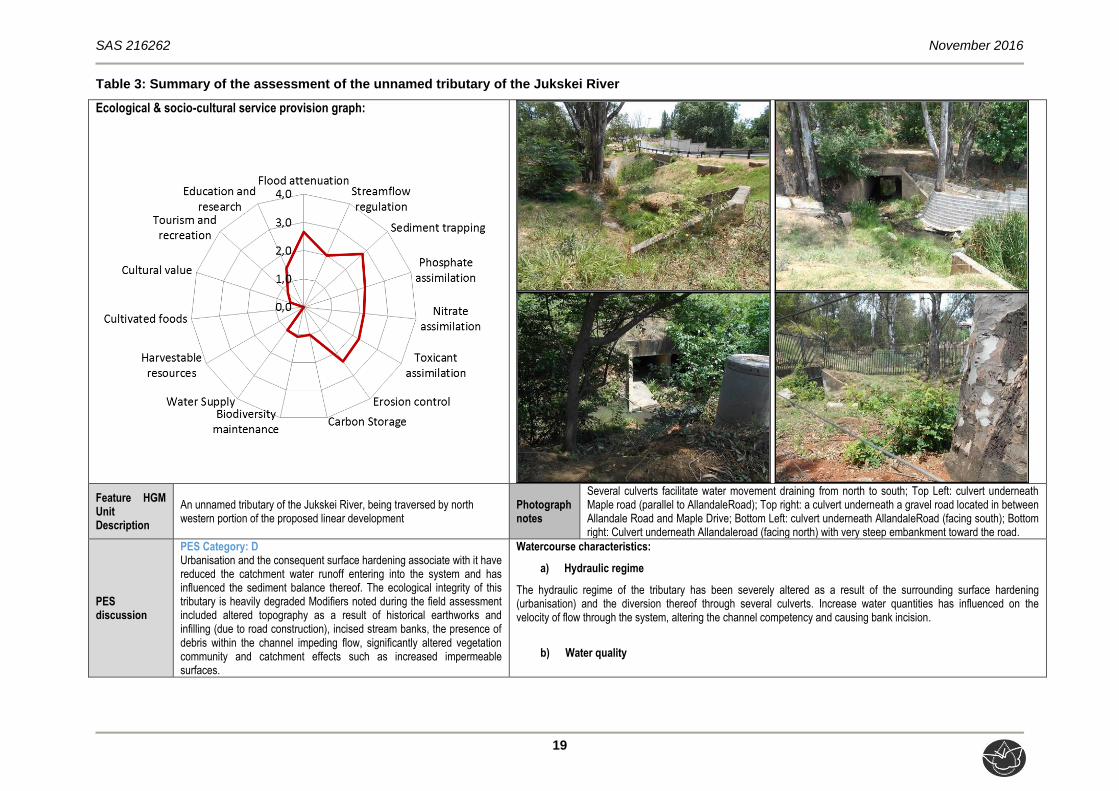
Table 3: Summary of the assessment of the unnamed tributary of the Jukskei River
Ecological & socio-cultural service provision graph:
Feature HGM Unit Description
An unnamed tributary of the Jukskei River, being traversed by north western portion of the proposed linear development
Photograph notes
Several culverts facilitate water movement draining from north to south; Top Left: culvert underneath Maple road (parallel to AllandaleRoad); Top right: a culvert underneath a gravel road located in between Allandale Road and Maple Drive; Bottom Left: culvert underneath AllandaleRoad (facing south); Bottom right: Culvert underneath Allandaleroad (facing north) with very steep embankment toward the road.
PES discussion
PES Category: D Urbanisation and the consequent surface hardening associate with it have reduced the catchment water runoff entering into the system and has influenced the sediment balance thereof. The ecological integrity of this tributary is heavily degraded Modifiers noted during the field assessment included altered topography as a result of historical earthworks and infilling (due to road construction), incised stream banks, the presence of debris within the channel impeding flow, significantly altered vegetation community and catchment effects such as increased impermeable surfaces.
Watercourse characteristics:
a) Hydraulic regime
The hydraulic regime of the tributary has been severely altered as a result of the surrounding surface hardening (urbanisation) and the diversion thereof through several culverts. Increase water quantities has influenced on the velocity of flow through the system, altering the channel competency and causing bank incision.
b) Water quality

SAS 216262 November 2016
20
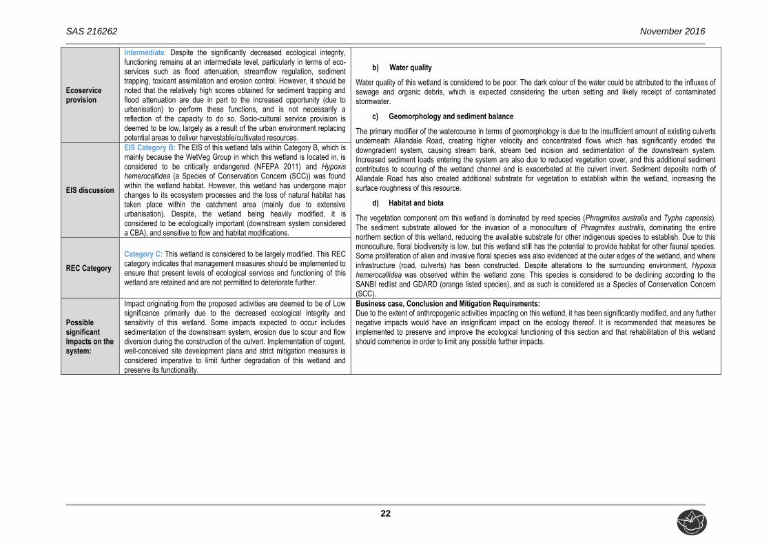
Ecoservice provision
Intermediate: Despite the significantly decreased ecological integrity, functioning remains at an intermediate level, particularly in terms of eco-services such as flood attenuation, sediment trapping, toxicant assimilation, and erosion control. Socio-cultural service provision is deemed to be low, largely as a result of the urban environment surrounding the system, reducing the opportunity to provide services such as water for human use, tourism and recreation, and biodiversity maintenance.
Water quality in this section of the tributary was found to be impaired. This is attributed primarily to the adverse effects of stormwater runoff originating in the highly urbanised environment, since stormwater runoff generally transports pollutants, including sewage from a failing sewer network, nutrients and sediment.
c) Geomorphology and sediment balance
Due to increased velocity of stormwater inputs because of the increased impermeable surfaces and loss of vegetation in the catchment, modifiers to the geomorphology of the tributary can mainly be attributed to stream bank and stream bed incision and erosion. Increased sediment into the system are also anticipated due to reduced vegetation cover and impermeable surfaces, which contributes to stream bed scouring (especially at long drops of the culverts).
d) Habitat and biota
Proliferation of alien and invasive floral species have resulted due to altered soil profiles arising from disturbances associated with urbanisation (e.g. earthworks and infilling). Even though this area is considered to be an Ecological Support Area (ESA) (C-Plan, v3.3, 2011), due to the large degree of vegetation removal surrounding this portion of the tributary, Species of Conservation Concern (SCC) are considered highly unlikely to utilise the riparian zone within the immediate vicinity of the proposed linear development as a result of the degree of modification.
EIS discussion
EIS Category B: This system is considered to be ecologically important which is largely due to the conservation and protection status of the applicable WetVeg group. However, a more accurate reflection of the ecological importance and sensitivity is a Category C, due to the significantly impaired ecological integrity of the portion of the tributary assessed, indicating that is not sensitive to flow and habitat modifications.
REC Category
Category C: This portion of the tributary is considered to be largely modified, especially due to the presence of several culverts. This REC category indicates that management measures should be implemented to ensure that present levels of ecological services and functioning of the tributary are retained and are not permitted to deteriorate further, so as to possibly reinstate habitat and increase ecoservice delivery.
Possible significant Impacts on the system:
Some impacts are expected to occur, which include sedimentation of the downstream system, erosion due to scour and stream diversion during the construction of the culvert. All perceived impacts on this tributary are deemed to be of Low significance, primarily due to the decreased ecological integrity and sensitivity of the tributary. However, the implementation of cogent, well-conceived site development plans and strict mitigation measures is nevertheless considered imperative.
Business case, Conclusion and Mitigation Requirements: Since this section of the tributary is deemed to have been significantly modified, it is deemed unlikely that further negative impacts would have a significant impact on the ecology of this section, although cognisance must be taken of downstream, cumulative effects of such impacts. Therefore, it is recommended that measures be implemented to preserve and improve the ecological functioning of this section

SAS 216262 November 2016
21
Table 4: Summary of the assessment of the Channelled Valley Bottom wetland
Ecological & socio-cultural service provision graph:
Feature HGM Unit Description
Channelled Valley Bottom wetland being traversed by the eastern portion of the proposed linear development.
Photograph notes
The existing culvert system underneath Allandale Road (Top left) currently does not have enough capacity to facilitate the natural flow of water to the down gradient system, causing back flood to the north of the road (Top right). Bottom: The culverts underneath Allandale road are inadequate to spread water across the wetland unit and the concentration of flow has led to critical erosion and incision of the wetland leading to a serious change to the ecological integrity of the system
PES discussion
PES Category: D Although the NFEPA (2011) indicated this wetland to be in a C ecological condition (indicating that the wetland is in a moderately modified condition), the results of the Wetland IHI assessment indicate that the PES is a Category D signifying the more appropriate sate of this resource, which is largely modified. The development of the culvert underneath Allandale road are inadequate to spread water across the wetland unit and the concentration of flow has led to severe erosion and incision of the wetland impacting on the ecological integrity of the system.
Watercourse characteristics:
a) Hydraulic regime
The hydraulic regime of this wetland has been critically altered as a result of the surrounding road infrastructure and surface hardening (urbanisation). Catchment wide hardening and additional inputs from stormwater runoff from the roads, contributes to the quantity of surface water entering the system, altering the drainage patterns of the wetland. Due to the insufficient amount of existing culverts underneath Allandale Road, diffuse flows north of the road has been concentrated to flow through the culverts, creating a more channelled and higher flowing velocity system downstream.
SAS 216262 November 2016
22
Ecoservice provision
Intermediate: Despite the significantly decreased ecological integrity, functioning remains at an intermediate level, particularly in terms of eco-services such as flood attenuation, streamflow regulation, sediment trapping, toxicant assimilation and erosion control. However, it should be noted that the relatively high scores obtained for sediment trapping and flood attenuation are due in part to the increased opportunity (due to urbanisation) to perform these functions, and is not necessarily a reflection of the capacity to do so. Socio-cultural service provision is deemed to be low, largely as a result of the urban environment replacing potential areas to deliver harvestable/cultivated resources.
b) Water quality
Water quality of this wetland is considered to be poor. The dark colour of the water could be attributed to the influxes of sewage and organic debris, which is expected considering the urban setting and likely receipt of contaminated stormwater.
c) Geomorphology and sediment balance
The primary modifier of the watercourse in terms of geomorphology is due to the insufficient amount of existing culverts underneath Allandale Road, creating higher velocity and concentrated flows which has significantly eroded the downgradient system, causing stream bank, stream bed incision and sedimentation of the downstream system. Increased sediment loads entering the system are also due to reduced vegetation cover, and this additional sediment contributes to scouring of the wetland channel and is exacerbated at the culvert invert. Sediment deposits north of Allandale Road has also created additional substrate for vegetation to establish within the wetland, increasing the surface roughness of this resource.
d) Habitat and biota
The vegetation component om this wetland is dominated by reed species (Phragmites australis and Typha capensis). The sediment substrate allowed for the invasion of a monoculture of Phragmites australis, dominating the entire northern section of this wetland, reducing the available substrate for other indigenous species to establish. Due to this monoculture, floral biodiversity is low, but this wetland still has the potential to provide habitat for other faunal species. Some proliferation of alien and invasive floral species was also evidenced at the outer edges of the wetland, and where infrastructure (road, culverts) has been constructed. Despite alterations to the surrounding environment, Hypoxis hemerocallidea was observed within the wetland zone. This species is considered to be declining according to the SANBI redlist and GDARD (orange listed species), and as such is considered as a Species of Conservation Concern (SCC).
EIS discussion
EIS Category B: The EIS of this wetland falls within Category B, which is mainly because the WetVeg Group in which this wetland is located in, is considered to be critically endangered (NFEPA 2011) and Hypoxis hemerocallidea (a Species of Conservation Concern (SCC)) was found within the wetland habitat. However, this wetland has undergone major changes to its ecosystem processes and the loss of natural habitat has taken place within the catchment area (mainly due to extensive urbanisation). Despite, the wetland being heavily modified, it is considered to be ecologically important (downstream system considered a CBA), and sensitive to flow and habitat modifications.
REC Category
Category C: This wetland is considered to be largely modified. This REC category indicates that management measures should be implemented to ensure that present levels of ecological services and functioning of this wetland are retained and are not permitted to deteriorate further.
Possible significant Impacts on the system:
Impact originating from the proposed activities are deemed to be of Low significance primarily due to the decreased ecological integrity and sensitivity of this wetland. Some impacts expected to occur includes sedimentation of the downstream system, erosion due to scour and flow diversion during the construction of the culvert. Implementation of cogent, well-conceived site development plans and strict mitigation measures is considered imperative to limit further degradation of this wetland and preserve its functionality.
Business case, Conclusion and Mitigation Requirements: Due to the extent of anthropogenic activities impacting on this wetland, it has been significantly modified, and any further negative impacts would have an insignificant impact on the ecology thereof. It is recommended that measures be implemented to preserve and improve the ecological functioning of this section and that rehabilitation of this wetland should commence in order to limit any possible further impacts.

SAS 216262 November 2016
23
4.3 Delineation and Sensitivity Mapping
The freshwater resource delineation as presented in this report are regarded as a best
estimate of the freshwater resource boundaries based on the site conditions present at the
time; however, use was made of historical and current digital satellite imagery to further aid
in the delineation of the freshwater resources.
During the assessment, the following indicators were used to delineate the boundaries of the
riparian zone associated with the freshwater resource:
Terrain units were used to determine in which parts of the landscape the freshwater
resource would most likely occur in, as rivers are easily distinguishable, and the
extent of its associated riparian zone, if present, can often readily be determined.
Vegetation, although significantly altered in terms of species composition, was
utilised to identify and confirm the boundary of the freshwater resource boundaries,
as the floral community structure differed from that of the surrounding terrestrial
areas; and
Current and historical digital satellite imagery was utilised to aid in the delineation of
the freshwater resources. In this regard, special mention is made of the need to
ensure that features displaying a diversity of digital signatures were identified in order
to allow for field verification, and specific mention is made of the following:
Freshwater resource vegetation: a distinct increase in density as well as tree size
near drainage lines;
Hue: with drainage lines and outcrops displaying soils of varying chroma created
by varying vegetation cover and soil conditions identified; and
Texture: with areas displaying various textures, created by varying vegetation
cover and soil conditions being identified.
Following the delineation of the freshwater resources, consideration was given to the
legislative requirements pertaining to the application of buffer zones around the freshwater
resources. The definition and motivation for a regulated zone of activity as well as buffer
zone for the protection of the freshwater resources can be summarised as follows:
Activity 12 (xii) (c) of GN 983 of the Environmental Impact Assessment (EIA)
Regulations (2014), of the NEMA, 1998 (Act 107 of 1998) must be considered in
defining the relevant regulated zone associated with any watercourse. This Listed
Activity states that any development exceeding 100 m2 within a watercourse, in front
of a development setback or, if no development setback exists, within 32 metres of a
watercourse, measures from the edge of a watercourse, excluding where such
SAS 216262 November 2016
24
development occurs within an urban area will require an Environmental Authorisation
(EA) in terms of the NEMA, 1998 (Act 107 of 1998);
The extent of a watercourse as per the Water Use Authorisation (WUA) in terms of
the NWA, 1998 (Act 36 of 1998) defines a watercourse as “(a) a river or spring; (b) a
natural channel in which water flows regularly or intermittently; (c) a wetland, lake or
dam into which, or from which, water flows; and (d) reference to a watercourse
includes, where relevant, its bed and banks”. Further to this GN 509 of 2016 defines
a regulated area of a watercourse for section 21 (c) or (i) of the Act water uses as
“(a) the outer edge of the 1 in 100 year flood line and/or delineated riparian habitat,
whichever is the greatest distance, measured from the middle of the watercourse of a
river, spring, natural channel, lake or dam; (b) in the absence of a determined 1 in
100 year flood line or riparian area the area within 100 m from the edge of a
watercourse where the edge of the watercourse is the first identifiable annual bank fill
flood bench; or (c) a 500 m radius from the delineated boundary (extent) of any
wetland or pan will trigger a WUA in terms of section 21 (c) and (i) of the NWA, 1998
(Act 36 of 1998); and
According to the GDARD Minimum Requirements for Biodiversity Assessments
(2014) a 32m buffer is recommended around riparian zones located within an urban
area.
Due to the linear nature of the proposed development, it is considered impractical to
prescribe a buffer zone, or to effectively implement it, since the proposed development will
require construction activities to take place through the freshwater features and any
stipulated buffer zone. Nevertheless, it must be ensured that further disturbances to the
freshwater resources as a result of the proposed development are minimised and that the
duration of disturbance is limited, and any activities occurring within the riparian zone or
wetland boundary, including rehabilitation, must be authorised by the DWS in terms of
Section 21 (c) & (i) of the National Water Act (Act 36 of 1998).
Therefore, in order to prevent further degradation of the freshwater resources, only essential
construction activities, personnel, and vehicles must be permitted within these areas.
Furthermore, no contractor laydown areas or non-essential activities (such as the storage of
building materials) must be permitted to occur within 32m of the freshwater resource zone. A
32m zone of regulation is conceptually depicted around the freshwater resources in the
figure below, in order to guide the relevant parties during the planning stage in order to
ensure that non-essential activities are located outside of the 32m buffer.

SAS 216262 November 2016
25
Figure 10: Conceptual presentation of the freshwater resources and the associated 32m buffer in accordance with GDARD guidelines in relation to the proposed linear development.

SAS 216262 November 2016
26
5 RISK ASSESSMENT
The DWS Risk Assessment Matrix, in terms of GN 509, calculated the significance of
perceived impacts on the key drivers and receptors (hydrology, water quality,
geomorphology, habitat and biota) of the freshwater resources assessed within the focus
area.
When evaluating the potential impacts of the proposed linear development on the freshwater
resources, the following aspects were taken into consideration:
The already existing culverts underneath Allandale Road, which traverses the two
identified freshwater resources, will be extended and the roadway upgraded, thus,
the impact of this activity will inevitably impact on the tributary of the Jukskei River
and the channelled valley bottom wetland;
Whilst the portion of the tributary of the Jukskei River and the channelled valley
bottom wetland to be traversed by the proposed linear development is not considered
to be particularly ecologically sensitive as a result of historical and ongoing impacts
(associated primarily with the already existing road traversing it and rapid urban
development in the catchment), this nevertheless mean that development should
occur without adequate mitigation to prevent further impacts;
The activities are all highly site specific, not of a significant extent relative to the area
of the freshwater resources assessed, and therefore have a limited spatial extent;
While the operation of the roadway and culverts will be a permanent activity, the
construction thereof is envisioned to take no more than a few months. However, the
frequency of the construction impacts may be daily during this time;
All impacts are considered to be easily detectable and the mitigation measures
thereof are considered to be easily practicable; and
It is highly recommended that the proponent make provision for small-scale
rehabilitation of the areas of the freshwater resources which may be impacted upon
by edge effects relating to construction activities, as this will aid in restoring the
ecology of the system, thereby improving ecological service provision and aiding in
minimising risks such as flooding. During such rehabilitation, focus should take place
on biodiversity reinstatement and functionality of the freshwater resources. The area
must then be rehabilitated to conditions as close as possible to the original or pre-
construction state.
SAS 216262 November 2016
27
Since the proposed activities will necessitate construction activities directly within the
freshwater resources it is imperative that strict mitigation measures be implemented
throughout all phases of the proposed construction of the culverts and roadway, particularly
during construction, in order to reduce the impact significance of associated activities on the
freshwater resources.
5.1 Risk Analyses
5.1.1 Consideration of impacts and application of mitigation measures
The results of the risk assessment are summarised in Table 5 below, including key
mitigation measures for each activity. There are four key ecological impacts on the
freshwater resources that are anticipated to occur namely:
Loss of riparian habitat and ecological structure;
Changes to the sociocultural and service provision;
Impacts on the hydrology and sediment balance of the riparian system; and
Impacts on water quality.
Various activities and development aspects (tabulated in Appendix F) may lead to these
impacts, however, these impacts can be adequately minimized or avoided provided the
mitigation measures provided in this report are implemented and adhered to.
Since the construction method statement and design of the culverts is similar, and as the
sensitivity of the two freshwater resources does not vary significantly, the risk assessment
matrix was only applied once for the extension of the culvert and construction of the
roadway. Kindly refer to Appendix F for a comprehensive mitigation list, including good
housekeeping practices.
When applying the risk assessment method, allowance can be made for scores which are
just outside the LOW risk class to be manually amended (to a maximum of 25), after
considering additional mitigation measures, alternatives (methods) or specific activities, in
order to reduce a risk rating class from Medium to Low.
The insufficient capacity of the already existing culverts underneath Allandale Road
(especially within the channelled valley bottom wetland) has caused significant degradation
to the hydrological functioning of this wetland. Therefore, it is recommended that more
culverts should be installed underneath Allandale Road within the channelled valley bottom
wetland. Increasing the amount of culverts would allow storm flows north of Allandale Road
to be spread across the entire wetland unit and minimise downstream erosion and incision
SAS 216262 November 2016
28
due to the concentrated and turbulent flow. Surrounding catchment hardening has also
attributed to the high level of sedimentation of the system. The absence of sufficient culverts
and the effects of catchment hardening was taken into consideration when applying the risk
assessment, and it is the opinion of the ecologists that, due to the significantly decreased
ecological integrity of the freshwater resources, the reduction of some impact ratings from
‘Medium’ to ‘Low’ is justified, with the proviso that the stipulated mitigation measures,
specifically mentioning sufficient and ecologically sound stormwater management (thus an
increase in culverts underneath Allendale Road) are implemented. Thus, whilst the risk
rating is perceived to be a ‘medium’ class pertaining to certain activities (i.e. temporary
diversion of flow; disturbance activities during installation of culverts), taking into
consideration the relatively low sensitivity of the freshwater resources, the relatively small
area which will be directly impacted during installation, the risk ratings were adjusted
accordingly to reflect a ‘low’ risk class. The table below presents a summary of the risk
assessment (please refer to Appendix E for additional detail).
Assuming that the strict enforcement of cogent, well-developed mitigation measures takes
place, the significance of impacts arising from all other construction phase activities
associated with the proposed development, is predominantly low. Similarly, once the culverts
are in place, and assuming that there is no failure of the structures, impacts associated with
rehabilitation of the freshwater resource areas surrounding the culverts will have very low
impact significance.

SAS 216262 November 2016
29
Table 5: A summary of the risk assessment relating to the construction and operation of the proposed linear development within the assessed
freshwater resources.
No.
Ph
ases
Activity Aspect Impact
Ris
k
Rat
ing
Req
uir
ed
sco
re
adju
stm
en
t A
dju
sted
risk
rat
ing
1
Co
nst
ruct
ion
Site preparation prior to construction of culverts and roadway, including placement of contractor laydown areas and storage facilities
*Vehicular transport and access to the site, site clearing; *Removal of vegetation and associated disturbances to soils; *Miscellaneous activities by construction personnel
*Exposure of soils, leading to increased runoff, erosion and stream incision, and thus increased sedimentation of the freshwater resources; *Increased sedimentation of freshwater habitat, leading to smothering of flora and benthic biota and potentially further altering surface water quality; *Decreased ecoservice provision; and *Proliferation of alien vegetation as a result of disturbances.
L 0 L
Excavation within freshwater resources for foundations
Temporary in-channel diversion of resources to allow for excavations to take place
*Altered flow regime, leading to possible loss of recharge to downstream areas, impacting on downstream biota; *Possible incision/erosion in the vicinity of the diversion as a result of the (temporary) formation of a concentrated flow path; *Possible sedimentation of downstream areas during the diversion; *Possible moisture stress to riparian vegetation downstream/downgradient of the diversion (applicable to the Tributary of the Jukskei River)
M -9 L
*Movement of construction machinery/vehicles within the freshwater resources; and *Possible spills / leaks from construction vehicles
*Disturbances of soils leading to increased alien vegetation proliferation, and in turn to further altered riparian habitat; *Possible contamination of freshwater soils and surface water, leading to further reduced ability to support biodiversity; and *Altered runoff patterns, leading to increased erosion and sedimentation of the freshwater resources habitat.
L 0 L
*Disturbances to soils of the freshwater resources; and *Removal of topsoil and creation of soil stockpiles
L 0 L
Extension of culverts and construction of roadway
*Movement of construction machinery/vehicles within the freshwater resources; and *Possible spills / leaks from construction vehicles
*Disturbances of soils leading to increased alien vegetation proliferation, and in turn to further altered freshwater resource habitat; *Possible contamination of soils and surface water, leading to further reduced ability to support biodiversity.
L 0 L
*Possible discard of construction material within the freshwater resources
*Alterations to flow patterns; and *Possible contamination of water.
L 0 L
*Ongoing disturbances to soils as culverts are installed *Increased sedimentation of areas downstream of the installation site M -9 L
Re-profiling of slopes in the vicinity of the culverts
*Ongoing disturbances to soils; and *Removal of vegetation
*Increased sedimentation as a result of disturbances; and *Potential loss of indigenous vegetation and the further proliferation of alien floral species due to disturbances
L 0 L
SAS 216262 November 2016
30
No.
Ph
ase
s Activity Aspect Impact
Ris
k
Rat
ing
Req
uir
ed
sco
re
adju
st
men
t
Ad
just
ed
risk
rati
ng
2
Op
erat
ion
s
Rehabilitation of freshwater resource areas surrounding culverts
*Disturbance of soils as part of rehabilitation activities; *Ineffective rehabilitation may lead to habitat transformation and alien vegetation encroachment; and *On-going erosion and sedimentation of riparian habitat
*Temporarily altered flow regime, leading to possible loss of recharge to downstream areas, impacting on downstream biota; and *Possible sedimentation of downstream areas if removal of sediment is not successful.
L
0 L
Monitoring of structural integrity of culverts
Proactive monitoring to ensure structural integrity is maintained and to identify early signs of erosion around the culverts
No direct impacts perceived L 0 L
Proactive monitoring to ensure that any litter or debris which may accumulate on and around the culverts is cleared to maintain the flow of water
No direct impacts perceived L 0 L
Maintenance of culverts in the event of bank failure, such as reshaping of slopes (if necessary)
Temporary in-channel diversion of stream to allow maintenance/repairs to be undertaken
*Temporarily altered flow regime, leading to possible loss of recharge to downstream areas, impacting on downstream biota; and *Possible incision/erosion in the vicinity of the diversion as a result of the (temporary) formation of a concentrated flow path.
L
0 L
Disturbances to or removal of vegetation whilst accessing culverts to carry out maintenance activities
*Potential loss of indigenous vegetation and the further proliferation of alien floral species due to disturbances
L 0 L
SAS 216262 November 2016
31
5.1.2 Impact Mitigation
General “good practice” mitigation measures applicable to the proposed linear development
are provided in Appendix F, and these should be implemented in conjunction with those
stipulated below.
No storage of materials, contractor laydown areas, or re-fueling of vehicles must be
permitted within the freshwater resource areas or the recommended buffer zones;
Clearing of some vegetation will be necessary at the culvert construction sites.
Wherever possible, indigenous vegetation must be protected, and clearing should
focus on the removal of alien vegetation;
The duration of impacts on the freshwater resources should be minimised as far as
possible by ensuring that the duration of time in which flow alteration and
sedimentation will take place is minimised – therefore the construction period should
be kept as short as possible, and if at all feasible, construction activities should be
scheduled for the drier months/low flow season to decrease the risk of erosion during
heavy thunderstorms;
The following mitigation measures are applicable to the creation of any temporary
stream diversions:
Prior to creating any required diversions, erosion and sediment controls such as
sandbags and protection of exposed soils with suitable geotextiles, must be
implemented around the site, in order to minimise the risk of sedimentation of the
downstream areas;
The inlet and outlet of temporary stream diversions must be stabilized using
appropriate erosion control techniques, and the outlet of the diversion must be
monitored for erosion; and
Following completion of the extension of the culverts, the stream diversion must
be removed and the affected area rehabilitated.
Ensure that the functionality of the permanent, seasonal and temporary zones of
the freshwater resources is maintained through provision of measures to ensure
that soil wetting conditions are maintained and the freshwater resource functions
are reinstated;
Erosion control measures around the culvert construction sites are considered
crucial. Such measures may include sandbags to stabilize banks and side slopes,
and protection of exposed soils with suitable geotextiles such as hessian sheeting;
Adequate stormwater management must be incorporated into the rehabilitation plan
in order to prevent erosion and the associated sedimentation of the freshwater
resources. In this regard special mention is made of:
SAS 216262 November 2016
32
Sheet runoff from cleared areas, paved surfaces and roadway needs to be
curtailed; and
Runoff from paved surfaces should be slowed down by the strategic placement of
energy dispersing structures;
During the construction and operational phases of the rehabilitation process, erosion
control measures should be installed on roadways to prevent gully formation and
siltation of the freshwater resources; and
Following the construction of the culverts, establishment of indigenous vegetation
must be undertaken, as per the recommendations of the Landscape Architect.

SAS 216262 November 2016
33
6 CONCLUSION
Scientific Aquatic Services (SAS) was appointed to conduct a freshwater assessment as part
of the environmental assessment and authorisation process for the upgrade of a portion of
Allandale Road within the Midrand area, Gauteng Province.
The background information available from national, provincial and municipal databases
indicates that the proposed linear development traverses one freshwater resource, namely a
channelled valley bottom wetland, however, during the site assessment a tributary of the
Jukskei River was also identified to be traversed by the linear development. Both these
freshwater resources were determined to be in a heavily modified state, mainly due to
historical and current anthropogenic activities, and especially due to the roadway that
traverses it.
Based on the findings of the freshwater resource assessment and the results of the risk
assessment, it is the opinion of the ecologist that although the potential exists for the
proposed linear development to have a negative impact on the freshwater resources,
adherence to cogent, well-conceived and ecologically sensitive site development plans, and
the mitigation measures provided in this report as well as general good practice mitigation
will greatly reduce the significance of perceived impacts. Specific mention is made to
increase the number of culverts underneath Allandale Road within the channelled valley
bottom wetland, in order to ensure that storm flows are spread across the entire wetland unit
in order to ensure that natural wetting patters are maintained and that downstream erosion
and incision due to the concentration of flow and the creation of turbulent flow is minimised.
Furthermore rehabilitation of the wetland resources downgradient of the existing culverts
under Allandale Road at the channelled valley bottom wetland should be implemented. It is
the opinion of the specialist therefore that the proposed linear development be considered
favourably, with the proviso that strict adherence to mitigation measures is enforced, in order
to ensure that the ecological integrity of the freshwater resources and the ecological and
socio-cultural services it provides is not further compromised.

SAS 216262 November 2016
34
7 REFERENCES
Department of Water Affairs (DWA). 1999. South Africa Version 1.0 of Resource Directed
Measures for Protection of Water Resources. [Appendix W3].
Department of Water Affairs and Forestry (DWAF). 2005. Final draft: A practical field
procedure for identification and delineation of wetlands and Riparian areas.
Department of Water Affairs and Forestry (DWAF). 2007. Manual for the assessment of
a Wetland Habitat Integrity for South African floodplain and channelled bottom
wetland types by M. Rountree (ed); C.P. Todd, C.J. Kleynhans, A.L. Batchelor, M. D.
Louw, D. Kotze, D. Walters, S. Schroeder, P. Illgner, M. Uys, and G.C. Marneweck.
Report No. N/0000/00/WEI/0407. Resource Quality Services, Department of Water
Affairs and Forestry, Pretoria, South Africa.
Department of Water Affairs and Forestry (DWAF). 2008. Updated Manual for the
Identification and Delineation of Wetlands and Riparian Areas, prepared by M.
Rountree, A. L. Batchelor, J. MacKenzie and D. Hoare. Report no. X. Stream Flow
Reduction Activities, Department of Water Affairs and Forestry, Pretoria, South
Africa.
Department of Water and Sanitation (DWS). 2014. Present Ecological State, Ecological
Importance and Ecological Sensitivity database for Primary Drainage Region Y as
developed by the RQS Department of the DWS. Available at
http://www.dwa.gov.za/iwqs/rhp/eco/peseismodel.aspx retrieved 28th July 2014.
Gauteng Department of Agriculture and Rural Development. 2011. GIS Data – C-Plan
Version 3.3
Gauteng Department of Agriculture and Rural Development. 2014. Technical Report for
the Gauteng Conservation Plan (Gauteng C-Plan v3.3). Gauteng Department of
Agriculture and Rural Development: Nature Conservation Directorate. Online
available: http://bgis.sanbi.org/gauteng/project.asp
Gauteng Department of Agriculture and Rural Development. 2014. Minimum
Requirements for Biodiversity Assessments. Version 3. Johannesburg.
Kleynhans C.J. 1999. A procedure for the determination of the ecological reserve for the
purposes of the national water balance model for South African River. Institute of
Water Quality Studies, Department of Water Affairs & Forestry, Pretoria.
SAS 216262 November 2016
35
Kleynhans C.J., Thirion C. and Moolman J. 2005. A Level 1 Ecoregion Classification
System for South Africa, Lesotho and Swaziland. Report No. N/0000/00/REQ0104.
Resource Quality Services, Department of Water Affairs and Forestry, Pretoria
Kleynhans, CJ. 1996. A qualitative procedure for the assessment of the habitat integrity
status of the Luvuvhu River. Journal of Aquatic Ecosystem Health 5: 41 - 54
Kotze D.C., Marneweck G.C., Batchelor A.L., Lindley D.S. and Collins N.B. 2009. WET-
EcoServices: A technique for rapidly assessing ecosystem services supplied by
wetlands. WRC Report No. TT 339/09. Water Research Commission, Pretoria.
Macfarlane D.M., Kotze D.C., Ellery W.N., Walters D., Koopman V., Goodman P. and
Goge C. 2008. WET-Health: A technique for rapidly assessing wetland health. WRC
Report No. TT 340/08. Water Research Commission, Pretoria.
Mucina, L. & Rutherford, M.C. (Eds). 2006. The Vegetation of South Africa, Lesotho and
Swaziland. Strelitzia 19. South African National Biodiversity Institute, Pretoria, RSA.
National Environmental Management Act (NEMA) 107 of 1998
National Water Act (NWA) 36 of 1998.
Nel, JL, Driver, A., Strydom W.F., Maherry, A., Petersen, C., Hill, L., Roux, D.J,
Nienaber, S., Van Deventer, H., Swartz, E. & Smith-Adao, L.B. 2011. Atlas of
Freshwater Ecosystem Priority Areas in South Africa: Maps to support sustainable
development of water resources. Water Research Commission Report No. TT
500/11, Water Research Commission, Pretoria.
NFEPA: Driver, A., Nel, J.L., Snaddon, K., Murruy, K., Roux, D.J., Hill, L., Swartz, E.R.,
Manuel, J. and Funke, N. 2011. Implementation Manual for Freshwater Ecosystem
Priority Areas. Water Research Commission. Report No. 1801/1/11. Online available:
http://bgis.sanbi.org/nfepa/project.asp
Ollis, D.J., Snaddon, C.D., Job, N.M. & Mbona, N. 2013. Classification System for
Wetlands and other Aquatic Ecosystems in South Africa. User Manual: Inland
Systems. SANBI Biodiversity Series 22. South African Biodiversity Institute, Pretoria.
SANBI. 2016. The South African National Biodiversity Institute is thanked for the use of data
from the National Herbarium, Pretoria (PRE) Computerised Information System
(PRECIS).
Scientific Aquatic Services (SAS). 2016. Freshwater Ecological Assessment as part of the
Environmental Assessment and Authorisation Process for the proposed Allandale
K73 Bridge Crossing, Midrand, Gauteng Province.
SAS 216262 November 2016
36
APPENDIX A - Indemnity
INDEMNITY AND TERMS OF USE OF THIS REPORT
The findings, results, observations, conclusions and recommendations given in this report are based
on the author’s best scientific and professional knowledge as well as available information. The report
is based on survey and assessment techniques which are limited by time and budgetary constraints
relevant to the type and level of investigation undertaken and SAS CC and its staff reserve the right to
modify aspects of the report including the recommendations if and when new information may
become available from ongoing research or further work in this field, or pertaining to this investigation.
Although SAS CC exercises due care and diligence in rendering services and preparing documents,
SAS CC accepts no liability and the client, by receiving this document, indemnifies SAS CC and its
directors, managers, agents and employees against all actions, claims, demands, losses, liabilities,
costs, damages and expensed arising from or in connection with services rendered, directly or
indirectly by SAS CC and by the use of the information contained in this document.
This report must not be altered or added to without the prior written consent of the author. This also
refers to electronic copies of this report which are supplied for the purposes of inclusion as part of
other reports, including main reports. Similarly, any recommendations, statements or conclusions
drawn from or based on this report must make reference to this report. If these form part of a main
report relating to this investigation or report, this report must be included in its entirety as an appendix
or separate section to the main report.

SAS 216262 November 2016
37
APPENDIX B - Legislation
LEGISLATIVE REQUIREMENTS
National Environmental Management Act, 1998
The National Environmental Management Act (NEMA) (Act 107 of 1998) and the associated Regulations (GNR 982) as amended in 2014, states that prior to any development taking place within a wetland or riparian area, an environmental authorisation process needs to be followed. This could follow either the Basic Assessment Report (BAR) process (GNR 983) or the Environmental Impact Assessment (EIA) (GNR 984) process depending on the scale of the impact. Provincial regulations as set out in GNR 985 must also be considered. National Water Act, 1998
The National Water Act (NWA) (Act 36 of 1998) recognises that the entire ecosystem and not just the water itself in any given water resource constitutes the resource and as such needs to be conserved. No activity may therefore take place within a freshwater resource unless it is authorised by the Department of Water and Sanitation (DWS). Any area within a wetland or riparian zone is therefore excluded from development unless authorisation is obtained from the DWS in terms of Section 21 (c) & (i). However, according to General Notice 1199 as published in the Government Gazette No. 32805 of 2009, it must be noted that as defined by the Replacement General Authorisation in terms of Section 39 of the National Water Act, on account of the extremely sensitive nature of wetlands and estuaries, the section 21(c) and (i) water use General Authorisation does not apply to:
Any development within a distance of 500 meters upstream or downstream from the boundary of any wetland; and
Any estuary or any water resource within a distance of 500 meters upstream from the salt mixing zone of any estuary.
General Notice 509 as published in the Government Gazette 40229 of 2016 as it relates to the NWA (Act 36 of 1998) In accordance with GN509 of 2016, a regulated area of a watercourse for section 21c and 21i of the NWA, 1998 is defined as:
a) the outer edge of the 1 in 100 year flood line and/or delineated riparian habitat, whichever is the greatest distance, measured from the middle of the watercourse of a river, spring, natural channel, lake or dam;
b) in the absence of a determined 1 in 100 year flood line or riparian area the area within 100 m from the edge of a watercourse where the edge of the watercourse is the first identifiable annual bank fill flood bench; or
c) a 500 m radius from the delineated boundary (extent) of any wetland or pan. GDARD Requirements for Biodiversity Assessments Version 3 (GDARD, 2014).
The biodiversity assessment must comply with the minimum requirements as stipulated by GDARD Version 3 of 2014 and must contain the following information:
The riparian delineation must be undertaken according to the DWAF guidelines; The riparian zone and a protective buffer zone, beginning from the outer edge of the riparian
zone, must be designated as sensitive in a sensitivity map. Guidelines for buffer zone widths pertaining to riparian zones are as follows:
32m for riparian zones for rivers/streams occurring inside urban areas; and
100m for riparian zones for rivers/streams occurring outside urban areas.

SAS 216262 November 2016
38
APPENDIX C – Method of Assessment
FRESHWATER INVESTIGATION METHOD OF ASSESSMENT
1. Desktop Study
Prior to the commencement of the field assessment, a background study, including a literature review, was conducted in order to determine the ecoregion and ecostatus of the larger aquatic system within which the freshwater features present or in close proximity of the proposed linear development are located. Aspects considered as part of the literature review are discussed in the sections that follow. 1.1 National Freshwater Ecosystem Priority Areas (NFEPA; 2011)
The NFEPA project is a multi-partner project between the Council of Scientific and Industrial Research (CSIR), Water Research Commission (WRC), South African National Biodiversity Institute (SANBI), DWA, South African Institute of Aquatic Biodiversity (SAIAB) and South African National Parks (SANParks). The project responds to the reported degradation of freshwater ecosystem condition and associated biodiversity, both globally and in South Africa. It uses systematic conservation planning to provide strategic spatial priorities of conserving South Africa’s freshwater biodiversity, within the context of equitable social and economic development.
The NFEPA project aims to identify a national network of freshwater conservation areas and to explore institutional mechanisms for their implementation. Freshwater ecosystems provide a valuable, natural resource with economic, aesthetic, spiritual, cultural and recreational value. However, the integrity of freshwater ecosystems in South Africa is declining at an alarming rate, largely as a consequence of a variety of challenges that are practical (managing vast areas of land to maintain connectivity between freshwater ecosystems), socio-economic (competition between stakeholders for utilisation) and institutional (building appropriate governance and co-management mechanisms).
The NFEPA database was searched for information in terms of conservation status of rivers, wetland habitat and wetland features present in the vicinity of or within the proposed linear development.
1.2 Department of Water and Sanitation (DWS) Resource Quality Information Services Present Ecological State / Ecological Importance and Sensitivity (PES/EIS) Database (2012)
The PES/EIS database as developed by the DWS RQIS department was utilised to obtain background information on the project area. The PES/EIS database has been made available to consultants since mid-August 2014. The information from this database is based on information at a sub-quaternary catchment reach (subquat reach) level with the descriptions of the aquatic ecology based on the information collated by the DWS RQIS department from all reliable sources of reliable information such as SA RHP sites, EWR sites and Hydro WMS sites. The results obtained serve to summarise this information as a background to the conditions of the freshwater resource traversed by the proposed linear development.
2. Classification System for Wetlands and other Aquatic Ecosystems in South
Africa
The freshwater features encountered within the proposed linear development were assessed using the Classification System for Wetlands and other Aquatic Ecosystems in South Africa. User Manual: Inland Systems (Ollis et al., 2013), hereafter referred to as the “Classification System”. A summary of Levels 1 to 4 of the classification system are presented in Table C1 and C2, below.

SAS 216262 November 2016
39
Table C1: Proposed classification structure for Inland Systems, up to Level 3.
WETLAND / AQUATIC ECOSYSTEM CONTEXT
LEVEL 1: SYSTEM
LEVEL 2: REGIONAL SETTING
LEVEL 3: LANDSCAPE UNIT
Inland Systems
DWA Level 1 Ecoregions OR NFEPA WetVeg Groups OR Other special framework
Valley Floor
Slope
Plain
Bench (Hilltop / Saddle / Shelf)
Table C2: Hydrogeomorphic (HGM) Unit for the Inland System, showing the primary HGM Types at Level 4A and the subcategories at Level 4B to 4C.
FUNCTIONAL UNIT
LEVEL 4: HYDROGEOMORPHIC (HGM) UNIT
HGM type Longitudinal zonation/ Landform / Outflow drainage
Landform / Inflow drainage
A B C
River
Mountain headwater stream Active channel
Riparian zone
Mountain stream Active channel
Riparian zone
Transitional Active channel
Riparian zone
Upper foothills Active channel
Riparian zone
Lower foothills Active channel
Riparian zone
Lowland river Active channel
Riparian zone
Rejuvenated bedrock fall Active channel
Riparian zone
Rejuvenated foothills Active channel
Riparian zone
Upland floodplain Active channel
Riparian zone
Channelled valley-bottom wetland (not applicable) (not applicable)
Unchannelled valley-bottom wetland (not applicable) (not applicable)
Floodplain wetland Floodplain depression (not applicable)
Floodplain flat (not applicable)
Depression
Exorheic With channelled inflow
Without channelled inflow
Endorheic With channelled inflow
Without channelled inflow
Dammed With channelled inflow
Without channelled inflow
Seep With channelled outflow (not applicable)
Without channelled outflow (not applicable)
Wetland flat (not applicable) (not applicable)

SAS 216262 November 2016
40
Level 1: Inland systems
From the Classification System, Inland Systems are defined as aquatic ecosystems that have no existing connection to the ocean1 (i.e. characterised by the complete absence of marine exchange and/or tidal influence) but which are inundated or saturated with water, either permanently or periodically. It is important to bear in mind, however, that certain Inland Systems may have had a historical connection to the ocean, which in some cases may have been relatively recent.
Level 2: Ecoregions & NFEPA Wetland Vegetation Groups
For Inland Systems, the regional spatial framework that has been included at Level 2 of the classification system is that of DWA’s Level 1 Ecoregions for aquatic ecosystems (Kleynhans et al., 2005). There are a total of 31 Ecoregions across South Africa, including Lesotho and Swaziland. DWA Ecoregions have most commonly been used to categorise the regional setting for national and regional water resource management applications, especially in relation to rivers.
The Vegetation Map of South Africa, Swaziland and Lesotho (Mucina & Rutherford, 2006) groups vegetation types across the country according to Biomes, which are then divided into Bioregions. To categorise the regional setting for the wetland component of the National Freshwater Ecosystem Priority Areas (NFEPA) project, wetland vegetation groups (referred to as WetVeg Groups) were derived by further splitting bioregions into smaller groups through expert input (Nel et al., 2011). There are currently 133 NFEPA WetVeg Groups. It is envisaged that these groups could be used as a special framework for the classification of wetlands in national- and regional-scale conservation planning and wetland management initiatives.
Level 3: Landscape Setting
At Level 3 of the Classification System, for Inland Systems, a distinction is made between four Landscape Units (Table C1) on the basis of the landscape setting (i.e. topographical position) within which an HGM Unit is situated, as follows (Ollis et al., 2013):
Slope: an included stretch of ground that is not part of a valley floor, which is typically located on the side of a mountain, hill or valley.
Valley floor: The base of a valley, situated between two distinct valley side-slopes. Plain: an extensive area of low relief characterised by relatively level, gently undulating or
uniformly sloping land. Bench (hilltop/saddle/shelf): an area of mostly level or nearly level high ground (relative to the
broad surroundings), including hilltops/crests (areas at the top of a mountain or hill flanked by down-slopes in all directions), saddles (relatively high-lying areas flanked by down-slopes on two sides in one direction and up-slopes on two sides in an approximately perpendicular direction), and shelves/terraces/ledges (relatively high-lying, localised flat areas along a slope, representing a break in slope with an up-slope one side and a down-slope on the other side in the same direction).
Level 4: Hydrogeomorphic Units
Seven primary HGM Types are recognised for Inland Systems at Level 4A of the Classification System (Table C2), on the basis of hydrology and geomorphology (Ollis et al., 2013), namely:
River: a linear landform with clearly discernible bed and banks, which permanently or periodically carries a concentrated flow of water.
Channelled valley-bottom wetland: a valley-bottom wetland with a river channel running through it.
Unchannelled valley-bottom wetland: a valley-bottom wetland without a river channel running through it.
Floodplain wetland: the mostly flat or gently sloping land adjacent to and formed by an alluvial river channel, under its present climate and sediment load, which is subject to periodic inundation by over-topping of the channel bank.
1 Most rivers are indirectly connected to the ocean via an estuary at the downstream end, but where marine exchange (i.e. the presence of seawater) or tidal fluctuations are detectable in a river channel that is permanently or periodically connected to the ocean, it is defined as part of the estuary.

SAS 216262 November 2016
41
Depression: a landform with closed elevation contours that increases in depth from the perimeter to a central area of greatest depth, and within which water typically accumulates.
Wetland Flat: a level or near-level wetland area that is not fed by water from a river channel, and which is typically situated on a plain or a bench. Closed elevation contours are not evident around the edge of a wetland flat
Seep: a wetland area located on (gently to steeply) sloping land, which is dominated by the colluvial (i.e. gravity-driven), unidirectional movement of material down-slope. Seeps are often located on the side-slopes of a valley but they do not, typically, extend into a valley floor.
The above terms have been used for the primary HGM Units in the classification system to try and ensure consistency with the wetland classification terms currently in common usage in South Africa. Similar terminology (but excluding categories for “channel”, “flat” and “valleyhead seep”) is used, for example, in the recently developed tools produced as part of the Wetland Management Series including WET-Health (Macfarlane et al., 2008), WET-IHI (DWAF, 2007) and WET-EcoServices (Kotze et al., 2009).
3. Index of Habitat Integrity (IHI)
To assess the PES of the freshwater resource and its associated riparian zone, the Index of Habitat Integrity (IHI) for South African floodplain and channelled valley bottom wetland types (DWAF Resource Quality Services, 2007) was used. The WETLAND-IHI is a tool developed for use in the National Aquatic Ecosystem Health Monitoring Programme (NAEHMP), formerly known as the River Health Programme (RHP). The WETLAND-IHI has been developed to allow the NAEHMP to include floodplain and channelled valley bottom wetland types to be assessed. The output scores from the WETLAND-IHI model are presented in A-F ecological categories (table below), and provide a score of the PES of the habitat integrity of the riparian system being examined.
Table C3: Descriptions of the A-F ecological categories (after Kleynhans, 1996, 1999).
Ecological Category
PES (% Score)
Description
A 90-100% Unmodified, natural.
B 80-90% Largely natural with few modifications. A small change in natural habitats and biota may have taken place but the ecosystem functions are essentially unchanged.
C 60-80% Moderately modified. Loss and change of natural habitat and biota have occurred, but the basic ecosystem functions are still predominantly unchanged.
D 40-60% Largely modified. A large loss of natural habitat, biota and basic ecosystem functions has occurred. 20-40% Seriously modified. The loss of natural habitat, biota and basic ecosystem functions is extensive.
E 20-40% Seriously modified. The loss of natural habitat, biota and basic ecosystem functions is extensive.
F 0-20% Critically/Extremely modified. Modifications have reached a critical level and the system has been modified completely with an almost complete loss of natural habitat and biota. In the worst instances, the basic ecosystem functions have been destroyed and the changes are irreversible.
4. Wetland Function Assessment
“The importance of a water resource, in ecological social or economic terms, acts as a modifying or
motivating determinant in the selection of the management class”.2 The assessment of the ecosystem
services supplied by the identified freshwater features was conducted according to the guidelines as described by Kotze et al. (2009). An assessment was undertaken that examines and rates the following services according to their degree of importance and the degree to which the service is provided:
2 Department of Water Affairs and Forestry, South Africa Version 1.0 of Resource Directed Measures for Protection of Water Resources, 1999

SAS 216262 November 2016
42
Flood attenuation Stream flow regulation Sediment trapping Phosphate trapping Nitrate removal Toxicant removal Erosion control Carbon storage Maintenance of biodiversity Water supply for human use Natural resources Cultivated foods Cultural significance Tourism and recreation Education and research
The characteristics were used to quantitatively determine the value, and by extension sensitivity, of the freshwater features. Each characteristic was scored to give the likelihood that the service is being provided. The scores for each service were then averaged to give an overall score to the freshwater features.
Table C4: Classes for determining the likely extent to which a benefit is being supplied.
Score Rating of the likely extent to which the benefit is being supplied
<0.5 Low
0.6-1.2 Moderately low
1.3-2 Intermediate
2.1-3 Moderately high
>3 High
5. Ecological Importance and Sensitivity (EIS)
The method used for the EIS determination was adapted from the method as provided by DWA (1999) for floodplains. The method takes into consideration PES scores obtained for WET-Health as well as function and service provision to enable the assessor to determine the most representative EIS category for the feature being assessed. A series of determinants for EIS are assessed on a scale of 0 to 4, where 0 indicates no importance and 4 indicates very high importance. The mean of the determinants is used to assign the EIS category as listed in Table C5 below.

SAS 216262 November 2016
43
Table C5: Descriptions of the EIS Categories.
EIS Category Range of
Mean
Recommended Ecological Management
Class3
Very high Wetlands that are considered ecologically important and sensitive on a national or even international level. The biodiversity of these wetlands is usually very sensitive to flow and habitat modifications.
>3 and <=4 A
High Wetlands that are considered to be ecologically important and sensitive. The biodiversity of these wetlands may be sensitive to flow and habitat modifications.
>2 and <=3
B
Moderate Wetlands that are considered to be ecologically important and sensitive on a provincial or local scale. The biodiversity of these wetlands is not usually sensitive to flow and habitat modifications.
>1 and <=2
C
Low/marginal Wetlands that are not ecologically important and sensitive at any scale. The biodiversity of these wetlands is ubiquitous and not sensitive to flow and habitat modifications.
>0 and <=1
D
6. Recommended Ecological Category (REC)
“A high management class relates to the flow that will ensure a high degree of sustainability and a low risk of ecosystem failure. A low management class will ensure marginal maintenance of sustainability, but carries a higher risk of ecosystem failure.” 4
The REC (Table C6) was determined based on the results obtained from the PES, reference conditions and EIS of the resource (sections above). Followed by realistic recommendations, mitigation, and rehabilitation measures to achieve the desired REC. A freshwater feature may receive the same class for the PES as the REC if the freshwater feature is deemed in good condition, and therefore must stay in good condition. Otherwise, an appropriate REC should be assigned in order to prevent any further degradation as well as enhance the PES of the freshwater feature.
Table C6: Description of REC classes.
Class Description
A Unmodified, natural
B Largely natural with few modifications
C Moderately modified
D Largely modified
7. Riparian Delineation
For the purposes of this investigation, a riparian zone is defined in the National Water Act (NWA) (1998) as including “the physical structure and associated vegetation of the areas associated with a freshwater resource which are commonly characterised by alluvial soils, and which are inundated or flooded to an extent and with a frequency sufficient to support vegetation of species with a composition and physical structure distinct from those of adjacent land areas.” The riparian zone delineation took place according to the method presented in the “Updated manual for the identification and delineation of wetland and riparian resources” published by DWAF in 2008.
3 Ed’s note: Author to confirm exact wording for version 1.1 4 Department of Water Affairs and Forestry, South Africa Version 1.0 of Resource Directed Measures for Protection of Water Resources 1999

SAS 216262 November 2016
44
The foundation of the method is based on the fact that wetlands have several distinguishing factors including the following:
The presence of water at or near the ground surface; Distinctive hydromorphic soils; Vegetation adapted to saturated soils; and The presence of alluvial soils in stream systems.
By observing the evidence of these features in the form of indicators, wetlands and riparian zones can be delineated and identified. If the use of these indicators and the interpretation of the findings are applied correctly, then the resulting delineation can be considered accurate (DWA, 2005 & 2008). Riparian and wetland zones can be divided into three zones (DWA, 2005 & 2008). The permanent zone of wetness is nearly always saturated. The seasonal zone is saturated for a significant part of the rainy season and the temporary zone surrounds the seasonal zone and is only saturated for a short period of the year, but is saturated for a sufficient period, under normal circumstances, to allow for the formation of hydromorphic soils and the growth of wetland vegetation.

SAS 216262 November 2016
45
APPENDIX D – Risk Assessment Methodology
In order for the EAP to allow for sufficient consideration of all environmental impacts, impacts were assessed using a common, defensible method of assessing significance that will enable comparisons to be made between risks/impacts and will enable authorities, stakeholders and the client to understand the process and rationale upon which risks/impacts have been assessed. The method to be used for assessing risks/impacts is outlined in the sections below.
The first stage of the risk/impact assessment is the identification of environmental activities, aspects and impacts. This is supported by the identification of receptors and resources, which allows for an understanding of the impact pathway and an assessment of the sensitivity to change. The definitions used in the impact assessment are presented below.
An activity is a distinct process or task undertaken by an organisation for which a responsibility can be assigned. Activities also include facilities or infrastructure that is possessed by an organisation.
An environmental aspect is an ‘element of an organizations activities, products and services which can interact with the environment’5. The interaction of an aspect with the environment may result in an impact.
Environmental risks/impacts are the consequences of these aspects on environmental resources or receptors of particular value or sensitivity, for example, disturbance due to noise and health effects due to poorer air quality. In the case where the impact is on human health or wellbeing, this should be stated. Similarly, where the receptor is not anthropogenic, then it should, where possible, be stipulated what the receptor is.
Receptors can comprise, but are not limited to, people or human-made systems, such as local residents, communities and social infrastructure, as well as components of the biophysical environment such as freshwater features, flora and riverine systems.
Resources include components of the biophysical environment. Frequency of activity refers to how often the proposed activity will take place. Frequency of impact refers to the frequency with which a stressor (aspect) will impact on the
receptor. Severity refers to the degree of change to the receptor status in terms of the reversibility of
the impact; sensitivity of receptor to stressor; duration of impact (increasing or decreasing with time); controversy potential and precedent setting; threat to environmental and health standards.
Spatial extent refers to the geographical scale of the impact. Duration refers to the length of time over which the stressor will cause a change in the
resource or receptor.
The significance of the impact is then assessed by rating each variable numerically according to the defined criteria (refer to the table below). The purpose of the rating is to develop a clear understanding of influences and processes associated with each impact. The severity, spatial scope and duration of the impact together comprise the consequence of the impact and when summed can obtain a maximum value of 15. The frequency of the activity, impact, legal issues and the detection of the impact together comprise the likelihood of the impact occurring and can obtain a maximum value of 20. The values for likelihood and consequence of the impact are then read off a significance rating matrix and are used to determine whether mitigation is necessary6.
The model outcome of the impacts was then assessed in terms of impact certainty and consideration of available information. The Precautionary Principle is applied in line with South Africa’s National Environmental Management Act (No. 108 of 1997) in instances of uncertainty or lack of information, by increasing assigned ratings or adjusting final model outcomes. In certain instances, where a variable or outcome requires rational adjustment due to model limitations, the model outcomes have been adjusted.
5 The definition has been aligned with that used in the ISO 14001 Standard.
6 Some risks/impacts that have low significance will however still require mitigation
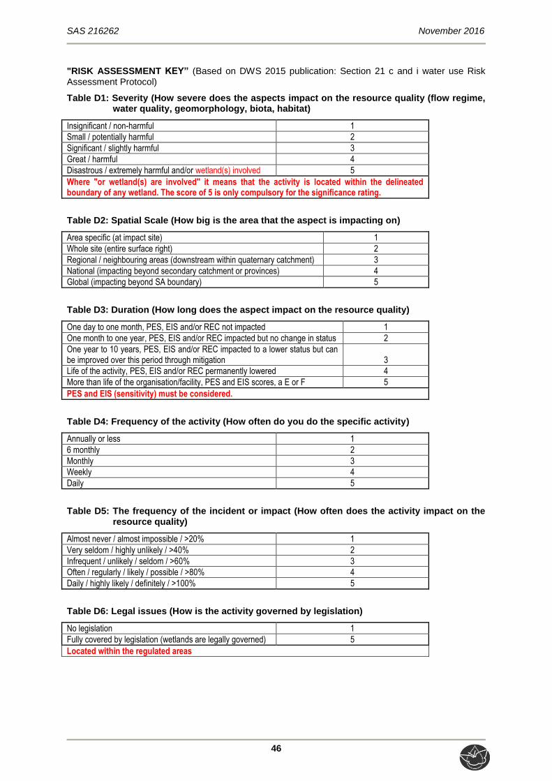
SAS 216262 November 2016
46
"RISK ASSESSMENT KEY” (Based on DWS 2015 publication: Section 21 c and i water use Risk Assessment Protocol)
Table D1: Severity (How severe does the aspects impact on the resource quality (flow regime, water quality, geomorphology, biota, habitat)
Insignificant / non-harmful 1
Small / potentially harmful 2
Significant / slightly harmful 3
Great / harmful 4
Disastrous / extremely harmful and/or wetland(s) involved 5
Where "or wetland(s) are involved" it means that the activity is located within the delineated boundary of any wetland. The score of 5 is only compulsory for the significance rating.
Table D2: Spatial Scale (How big is the area that the aspect is impacting on)
Area specific (at impact site) 1
Whole site (entire surface right) 2
Regional / neighbouring areas (downstream within quaternary catchment) 3
National (impacting beyond secondary catchment or provinces) 4
Global (impacting beyond SA boundary) 5
Table D3: Duration (How long does the aspect impact on the resource quality)
One day to one month, PES, EIS and/or REC not impacted 1
One month to one year, PES, EIS and/or REC impacted but no change in status 2
One year to 10 years, PES, EIS and/or REC impacted to a lower status but can be improved over this period through mitigation 3
Life of the activity, PES, EIS and/or REC permanently lowered 4
More than life of the organisation/facility, PES and EIS scores, a E or F 5
PES and EIS (sensitivity) must be considered.
Table D4: Frequency of the activity (How often do you do the specific activity)
Annually or less 1
6 monthly 2
Monthly 3
Weekly 4
Daily 5
Table D5: The frequency of the incident or impact (How often does the activity impact on the resource quality)
Almost never / almost impossible / >20% 1
Very seldom / highly unlikely / >40% 2
Infrequent / unlikely / seldom / >60% 3
Often / regularly / likely / possible / >80% 4
Daily / highly likely / definitely / >100% 5
Table D6: Legal issues (How is the activity governed by legislation)
No legislation 1
Fully covered by legislation (wetlands are legally governed) 5
Located within the regulated areas
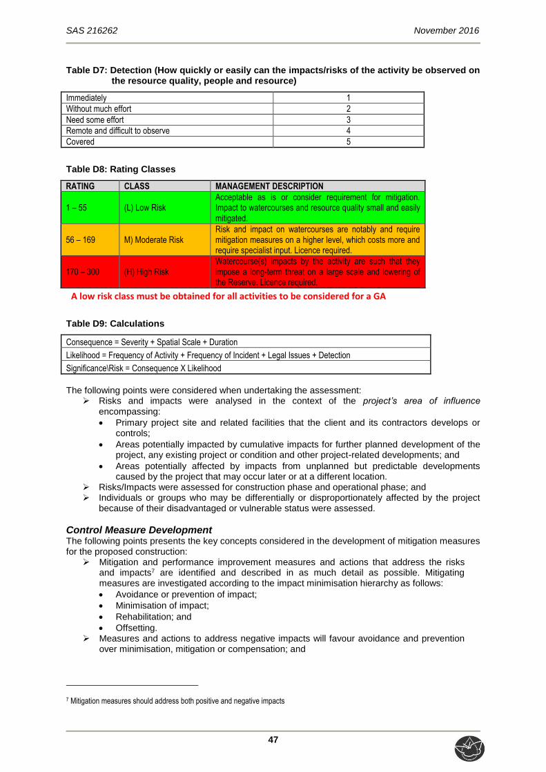
SAS 216262 November 2016
47
Table D7: Detection (How quickly or easily can the impacts/risks of the activity be observed on the resource quality, people and resource)
Immediately 1
Without much effort 2
Need some effort 3
Remote and difficult to observe 4
Covered 5
Table D8: Rating Classes
RATING CLASS MANAGEMENT DESCRIPTION
1 – 55 (L) Low Risk Acceptable as is or consider requirement for mitigation. Impact to watercourses and resource quality small and easily mitigated.
56 – 169 M) Moderate Risk Risk and impact on watercourses are notably and require mitigation measures on a higher level, which costs more and require specialist input. Licence required.
170 – 300 (H) High Risk Watercourse(s) impacts by the activity are such that they impose a long-term threat on a large scale and lowering of the Reserve. Licence required.
A low risk class must be obtained for all activities to be considered for a GA
Table D9: Calculations
Consequence = Severity + Spatial Scale + Duration
Likelihood = Frequency of Activity + Frequency of Incident + Legal Issues + Detection
Significance\Risk = Consequence X Likelihood
The following points were considered when undertaking the assessment:
Risks and impacts were analysed in the context of the project’s area of influence encompassing:
Primary project site and related facilities that the client and its contractors develops or controls;
Areas potentially impacted by cumulative impacts for further planned development of the project, any existing project or condition and other project-related developments; and
Areas potentially affected by impacts from unplanned but predictable developments caused by the project that may occur later or at a different location.
Risks/Impacts were assessed for construction phase and operational phase; and Individuals or groups who may be differentially or disproportionately affected by the project
because of their disadvantaged or vulnerable status were assessed.
Control Measure Development The following points presents the key concepts considered in the development of mitigation measures for the proposed construction:
Mitigation and performance improvement measures and actions that address the risks and impacts7 are identified and described in as much detail as possible. Mitigating measures are investigated according to the impact minimisation hierarchy as follows:
Avoidance or prevention of impact;
Minimisation of impact;
Rehabilitation; and
Offsetting. Measures and actions to address negative impacts will favour avoidance and prevention
over minimisation, mitigation or compensation; and
7 Mitigation measures should address both positive and negative impacts

SAS 216262 November 2016
48
Desired outcomes are defined, and have been developed in such a way as to be measurable events with performance indicators, targets and acceptable criteria that can
be tracked over defined periods, wherever possible. Recommendations Recommendations were developed to address and mitigate potential impacts on the wetland ecology of the resources in traversed or in close proximity of the proposed pipelines.

SAS 216262 November 2016
49
APPENDIX E – Freshwater Assessment Results
PRESENT ECOLOGICAL STATE (PES), ECOSERVICES AND ECOLOGICAL
IMPORTANCE AND SENSITIVITY (EIS) RESULTS
Table E1: Presentation of the results of the WET-IHI assessment applied to the unnamed tributary of the Jukskei River
OVERALL PRESENT ECOLOGICAL STATE (PES) SCORE
Ranking Weighting Score Confidence Rating
PES Category
DRIVING PROCESSES: 100 2,4
Hydrology 1 100 2,3 3,4 D
Geomorphology 2 80 2,7 3,9 D
Water Quality 3 30 2,2 2,0 D
WETLAND LANDUSE ACTIVITIES: 80 2,8 4,0
Vegetation Alteration Score 1 100 2,8 4,0 D
OVERALL SCORE: 2,6 Confidence Rating
PES % 48,4
PES Category: D 1,8
Table E2: Presentation of the results of the WET-IHI assessment applied to the channelled valley bottom wetland
OVERALL PRESENT ECOLOGICAL STATE (PES) SCORE
Ranking Weighting Score Confidence Rating
PES Category
DRIVING PROCESSES: 100 2,4
Hydrology 1 100 2,3 3,4 D
Geomorphology 2 80 2,7 3,9 D
Water Quality 3 30 2,2 2,0 D
WETLAND LANDUSE ACTIVITIES: 80 2,8 4,0
Vegetation Alteration Score 1 100 2,8 4,0 D
OVERALL SCORE: 2,6 Confidence Rating
PES % 48,4
PES Category: D 1,8

SAS 216262 November 2016
50
Table E3: Presentation of the results of the ecosystem services provided by the freshwater resources
Ecosystem service Trib. Of Jukskei CVB
Flood attenuation 2,7 2,5
Streamflow regulation 2,0 2,4
Sediment trapping 2,8 2,4
Phosphate assimilation 2,3 2,3
Nitrate assimilation 2,1 2,0
Toxicant assimilation 2,3 2,1
Erosion control 2,4 2,1
Carbon Storage 1,0 1,5
Biodiversity maintenance 1,1 1,4
Water Supply 1,0 1,0
Harvestable resources 0,0 0,0
Cultivated foods 0,0 0,0
Cultural value 0,5 0,5
Tourism and recreation 0,8 0,9
Education and research 1,5 1,5
SUM 22,4 22,6
Average score 1,5 1,5

SAS 216262 November 2016
51
Table E4: Presentation of the EIS assessment applied to the freshwater resources
FRESHWATER RESOURCE: CVB Tributary of
Jukskei
Ecological Importance and Sensitivity Score (0-4) Score (0-4)
Biodiversity support A (average)
2,00 1,33
Presence of Red Data species 1 1
Populations of unique species 2 1
Migration/breeding/feeding sites 3 2
Landscape scale B (average)
2,00 1,80
Protection status of the wetland 1 1
Protection status of the vegetation type 4 4
Regional context of the ecological integrity 2 2
Size and rarity of the wetland type/s present 1 1
Diversity of habitat types 2 1
Sensitivity of the wetland C (average)
1,33 1,00
Sensitivity to changes in floods 2 1
Sensitivity to changes in low flows/dry season 1 1
Sensitivity to changes in water quality 1 1
ECOLOGICAL IMPORTANCE & SENSITIVITY (max of A,B or C)
B B
Hydro-Functional Importance Score (0-4)
Reg
ula
tin
g &
su
pp
ort
ing
ben
efit
s Flood attenuation 3 3
Streamflow regulation 3 3
Wat
er Q
ual
ity
En
han
cem
ent
Sediment trapping 2 2
Phosphate assimilation 2 2
Nitrate assimilation 2 2
Toxicant assimilation 1 1
Erosion control 1 1
Carbon storage 1 1
HYDRO-FUNCTIONAL IMPORTANCE (average score) 2 2
Direct Human Benefits Score (0-4)
Su
bsi
sten
ce
ben
efit
s
Water for human use 0 0
Harvestable resources 0 0
Cultivated foods 0 0
Cu
ltu
ral
ben
efit
s Cultural heritage 1 1
Tourism and recreation 1 1
Education and research 1 1
DIRECT HUMAN BENEFITS (average score) 0,50 0,50
SAS 216262 November 2016
52
APPENDIX F – Risk Analysis
IMPACT ANALYSIS AND MITIGATION MEASURES
General management and good housekeeping practices
The following essential mitigation measures are considered to be standard best practice measures applicable to development of this nature, and must be implemented during all phases of the proposed development activities, in conjunction with those stipulated in the individual tables in the following sections which define the mitigatory measures specific to the minimisation of impacts on wetland aquatic resources:
Development footprint
The linear development footprint area should remain as small as possible and should not unnecessarily encroach into the freshwater resources. It must be ensured that the freshwater resource habitat is off-limits to non-essential construction vehicles and non-essential personnel, with contractor laydown areas, storage of construction materials and vehicles, and all other amenities to be placed outside the freshwater resources and the associated 32m zone of regulation;
Planning of temporary roads and/or access routes should avoid freshwater resources and be restricted to existing roads where possible;
Appropriate sanitary facilities must be provided for the life of the construction and all waste removed to an appropriate waste facility;
All hazardous chemicals should be stored in designated area which are not located near freshwater resource areas;
No informal fires should be permitted in or near the construction area; Restrict construction to the non-rainy periods if possible to avoid further sedimentation of the
freshwater resources and to minimise the severity of disturbance of the freshwater resources and in-stream habitat;
Access to the construction site should be limited to a single entry point on each bank to minimise compaction of soils, loss of vegetation and increased erosion;
Edge effects of activities, particularly erosion and alien/weed control need to be strictly managed; and
Ensure that an adequate number of litter bins are provided and ensure the proper disposal of waste and spills.
Vehicle access
It must be ensured that all hazardous storage containers and storage areas comply with the relevant South African Bureau of Standards (SABS) standards to prevent leakage. All vehicles must be regularly inspected for leaks. Re-fuelling must take place on a sealed surface area to prevent ingress of hydrocarbons into the topsoil;
In the event of a vehicle breakdown, maintenance of vehicles must take place with care and the recollection of spillage should be practiced near the surface area to prevent ingress of hydrocarbons into topsoil and subsequent habitat loss; and
All spills should they occur, should be immediately cleaned up and treated accordingly. Records of spills and waste removal should be kept by the appointed ECO and submitted as part of the audit / monitoring report, as specified in the Environmental Management Programme (EMPr).
Vegetation
Proliferation of alien and invasive species is expected within any disturbed areas. The vegetation component within the freshwater resources is already transformed as a result of alien plant invasion; therefore these species should be eradicated and controlled to prevent their spread beyond the project footprint. Alien plant seed dispersal within the top layers of the soil within footprint areas, that will have an impact on future rehabilitation, has to be controlled;
Removal of the alien and weed species encountered within the freshwater resources must take place in order to comply with existing legislation (amendments to the regulations under

SAS 216262 November 2016
53
the Conservation of Agricultural Resources Act, 1983 and Section 28 of the National Environmental Management Act, 1998). Removal of species should take place throughout the construction, operational, and maintenance phases;
Species specific and area specific eradication recommendations:
Care should be taken with the choice of herbicide to ensure that no additional impact and loss of indigenous plant species occurs due to the herbicide used;
Footprint areas should be kept as small as possible when removing alien plant species; and
No vehicles should be allowed to drive through designated sensitive wetland areas during the eradication of alien and weed species.
Soils
Incorporate adequate erosion and stormwater management measures during all phases of the project, in order to prevent erosion and the associated sedimentation of the freshwater resources. Management measures may include berms, silt fences, hessian curtains, stormwater diversion away from areas susceptible to erosion and stormwater attenuation. Care should however be taken so as to avoid additional disturbance during the implementation of these measures In this regard specific attention should be given to the attenuation of stormwater in order to prevent erosion;
Strategic installation of erosion berms should be implemented during construction to slow down runoff from paved surfaces, prevent gully formation ans slow down sheet runoff. Berms every 50m should be installed where any disturbed soils have a slope of less than 2%, every 25m where the track slopes between 2% and 10%, every 20m where the track slopes between 10% and 15% and every 10m where the track slope is greater than 15%;
Any areas where active erosion is observed must be immediately rehabilitated (re-shaping of slopes, revegetation with indigenous species where necessary, etc.) in such a way as to ensure that the hydrology and geomorphological characteristics of the area are re-instated to conditions which are as natural as possible;
A soil management plan, including erosion / run-off control for construction phase should be developed and implemented;
Concurrent rehabilitation of the sides lopes and embankments should take place throughout the construction and operational phases of this development, in order to limit further erosion and thus sedimentation of the freshwater system;
Any areas where bank failure is observed, due to the effects of the proposed culvert and road development, should be immediately repaired by employing one of the individual techniques below or a combination thereof, including:
Re-sloping of banks to a maximum of a 1:3 slope;
Revegetation of re-profiled slopes;
Temporary stabilisation of slopes using geotextiles; and
Installation of gabions and reno mattresses. No stockpiles must be permitted within the freshwater resources or its associated 32m buffer
zone. All soil stockpiles must be protected by water diversion berms on the upgradient edge of the stockpile and a suitable geotextile such as Geojute or hessian sheeting, to avoid runoff and sediment from the stockpiles reaching the freshwater resource and/or riparian habitat;
Such stockpiles must either be removed or levelled following the completion of construction activities;
As it is unavoidable that the freshwater resources will be affected, disturbance to the freshwater resources must be minimised and suitably rehabilitated. The design of the maintenance interventions (such as gabions) should allow for the freshwater resources soil conditions to be maintained both upstream and downstream to such a degree that the freshwater resource vegetation community structures are maintained. In this regard, special mention is made of:
The design of the maintenance interventions should ensure that the permanent zone should have inundated soil conditions throughout the year extending to the soil surface;
The design of the maintenance interventions should ensure that the seasonal zone should have water-logged soils within 500mm of the soil surface at all times; and
The temporary zone should have waterlogged soil conditions occurring to within 300mm of the land surface during the summer season.
Storm water must be managed accordingly to ensure that no sediment deposits occur within the freshwater resource; and

SAS 216262 November 2016
54
Monitor areas close to the freshwater resource for further erosion and incision, during site clearing in the pre-construction phase and throughout the construction phase.
Rehabilitation
All soils compacted as a result of construction activities falling outside of project footprint areas should be ripped and profiled. Special attention should be paid to alien and invasive control within these areas. Alien and invasive vegetation control should take place throughout all construction and rehabilitation phases to prevent loss of freshwater habitat;
Side slope and embankment vegetation cover should be monitored to ensure that sufficient vegetation is present to bind these soils and prevent further erosion;
Construction rubble must be collected and disposed of at a suitable landfill site; and All alien vegetation within the freshwater resources as a result of edge effects from the
construction activities should be removed upon completion of construction. Alien vegetation control within the freshwater feature should take place for a minimum period of two growing seasons after construction is completed. Alien vegetation control should take place with manual labour; no vehicles must be permitted during the control / monitoring phase.
Freshwater and and Instream Habitat Flow continuity within the freshwater resources has already been severely affected due to channel and bed modifications in the form of instream-barriers such as already existing culverts, as well as catchment hardening. It is considered essential therefore that disturbances within the freshwater resources must be minimised as far as possible. Specific considerations in this regard are detailed in Section 5.1.1 of this report.
Risk Analyses
Impact ratings on the riparian ecology
The tables below serve to summarise the anticipated impacts that are anticipated during the construction of the proposed linear development as well as the mitigation measures that must be implemented in order to maintain and enhance the ecological integrity of the freshwater resources.

SAS 216262 November 2016
55
Table F1: Risk Assessment Matrix applied to the freshwater resources.
No.
Ph
ases
Activity Aspect Impact
Co
nse
qu
ence
Lik
elih
oo
d
Sig
nif
ican
ce
Ris
k R
atin
g
Co
nfi
den
ce
leve
l
Control Measures
Req
uir
ed
sco
re
adju
stm
ent
Ad
just
ed r
isk
rati
ng
1
Co
nst
ruct
ion
Site preparation prior to construction of culverts and roadway, including placement of contractor laydown areas and storage facilities
*Vehicular transport and access to the site, site clearing; *Removal of vegetation and associated disturbances to soils; *Miscellaneous activities by construction personnel
*Exposure of soils, leading to increased runoff, erosion and stream incision, and thus increased sedimentation of the freshwater resources; *Increased sedimentation of freshwater habitat, leading to smothering of flora and benthic biota and potentially further altering surface water quality; *Decreased ecoservice provision; and *Proliferation of alien vegetation as a result of disturbances.
5 9 45 L 3
*Contractor laydown areas, vehicle re-fuelling areas and material storage facilities to remain outside of the delineated freshwater resources and the GDARD recommended buffer zone; *All development footprint areas to remain as small as possible and vegetation clearing to be limited to what is absolutely essential; *Vegetation removal to be kept to a minimum, and preferably only alien floral species to be removed; *Retain as much indigenous vegetation as possible; *Exposed soils to be protected by means of a suitable geotextile covering such as hessian sheeting; *Where possible, existing roads are to be used to gain access to site, and should avoid crossing freshwater resource habitat unnecessarily, but if it is essential crossings should be made at right angles; *Areas where bank failure is observed as a result of such stream crossings should be immediately repaired; and *The freshwater resource areas in which no proposed activities will occur, should be clearly demarcated with danger tape by an ECO and marked as a no-go area.
0 L
Excavation within freshwater resources for foundations
Temporary in-channel diversion of resources to allow for excavations to take place
*Altered flow regime, leading to possible loss of recharge to downstream areas, impacting on downstream biota; *Possible incision/erosion in the vicinity of the diversion as a result of the (temporary) formation of a concentrated flow path; *Possible sedimentation of downstream areas during the diversion; *Possible moisture stress to riparian vegetation downstream/downgradient of the diversion (applicable to the Tributary of the Jukskei River)
5 13 65 M 3
*Activity will result in bank destabilisation, and reduction in bank incision and sedimentation of the freshwater resources; *Ensure sediment control devices are in place prior to diverting the stream; *Ensure that the creation of the diversion does not result in a significant water level difference upstream or downstream of the installation site; *The duration of impacts on the freshwater areas should be minimised as far as possible by ensuring that the duration of time in which flow alteration and sedimentation will take place is minimised – therefore the construction period should be kept as short as possible; and *Restrict construction of culverts to the drier months wherever possible (especially for the sake of channel diversions), so as to limit the possibility of permanent changes to the system.
-9 L
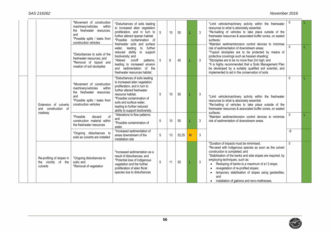
SAS 216262 November 2016
56
*Movement of construction machinery/vehicles within the freshwater resources; and *Possible spills / leaks from construction vehicles
*Disturbances of soils leading to increased alien vegetation proliferation, and in turn to further altered riparian habitat; *Possible contamination of freshwater soils and surface water, leading to further reduced ability to support biodiversity; and *Altered runoff patterns, leading to increased erosion and sedimentation of the freshwater resources habitat.
5 10 50 L 3
*Limit vehicle/machinery activity within the freshwater resources to what is absolutely essential; *Re-fuelling of vehicles to take place outside of the freshwater resources & associated buffer zones, on sealed surfaces; *Maintain sediment/erosion control devices to minimise risk of sedimentation of downstream areas; *Topsoil stockpiles are to be protected by means of protective coverings such as hessian sheeting; *Stockpiles are to be no more than 2m high; and *It is highly recommended that a Soils Management Plan be developed by a suitably qualified soil scientist, and implemented to aid in the conservation of soils
0 L
*Disturbances to soils of the freshwater resources; and *Removal of topsoil and creation of soil stockpiles
5 9 45 L 3
0 L
Extension of culverts and construction of roadway
*Movement of construction machinery/vehicles within the freshwater resources; and *Possible spills / leaks from construction vehicles
*Disturbances of soils leading to increased alien vegetation proliferation, and in turn to further altered freshwater resource habitat; *Possible contamination of soils and surface water, leading to further reduced ability to support biodiversity.
5 10 50 L 3 *Limit vehicle/machinery activity within the freshwater resources to what is absolutely essential; *Re-fuelling of vehicles to take place outside of the freshwater resources & associated buffer zones, on sealed surfaces; *Maintain sediment/erosion control devices to minimise risk of sedimentation of downstream areas.
0 L
*Possible discard of construction material within the freshwater resources
*Alterations to flow patterns; and *Possible contamination of water.
5 10 50 L 3
0 L
*Ongoing disturbances to soils as culverts are installed
*Increased sedimentation of areas downstream of the installation site
5 13 52,25 M 3 -9
Re-profiling of slopes in the vicinity of the culverts
*Ongoing disturbances to soils; and *Removal of vegetation
*Increased sedimentation as a result of disturbances; and *Potential loss of indigenous vegetation and the further proliferation of alien floral species due to disturbances
5 11 55 L 3
*Duration of impacts must be minimised; *Re-seed with indigenous species as soon as the culvert construction is completed; and *Stabilisation of the banks and side slopes are required, by employing techniques, such as:
Resloping of banks to a maximum of a1:3 slope;
revegetation of re-profiled slopes;
temporary stabilisation of slopes using geotextiles; and
installation of gabions and reno-mattresses.
0

SAS 216262 November 2016
57
No. P
has
es
Activity Aspect Impact
Co
nse
qu
ence
Lik
elih
oo
d
Sig
nif
ican
ce
Ris
k R
atin
g
Co
nfi
den
ce
leve
l
Control Measures
Req
uir
ed
sco
re
adju
stm
ent
Ad
just
ed r
isk
rati
ng
2
Op
erat
ion
s
Rehabilitation of freshwater resource areas surrounding culverts
*Disturbance of soils as part of rehabilitation activities; *Ineffective rehabilitation may lead to habitat transformation and alien vegetation encroachment; and *On-going erosion and sedimentation of riparian habitat
*Temporarily altered flow regime, leading to possible loss of recharge to downstream areas, impacting on downstream biota; and *Possible sedimentation of downstream areas if removal of sediment is not successful.
5 8 40 L 3
*Limit vehicle/machinery activity within the freshwater resources to what is absolutely essential; *Maintain sediment/erosion control devices to minimise risk of sedimentation of downstream areas. *Duration of impacts must be minimised; *Re-seed with indigenous species as soon as the culvert construction is completed
0 L
Monitoring of structural integrity of culverts
Proactive monitoring to ensure structural integrity is maintained and to identify early signs of erosion around the culverts
No direct impacts perceived 5 8 40 L 3 There should be no need to encroach the active channels of the resources to obtain a visual assessment of the structural integrity of the culverts.
0 L
Proactive monitoring to ensure that any litter or debris which may accumulate on and around the culverts is cleared to maintain the flow of water
No direct impacts perceived 5 8 40 L 3 There should be no need to encroach the active channels of the resources to obtain a visual assessment of the structural integrity of the culverts.
0 L
Maintenance of culverts in the event of bank failure, such as reshaping of slopes (if necessary)
Temporary in-channel diversion of stream to allow maintenance/repairs to be undertaken
*Temporarily altered flow regime, leading to possible loss of recharge to downstream areas, impacting on downstream biota; and *Possible incision/erosion in the vicinity of the diversion as a result of the (temporary) formation of a concentrated flow path.
5 11 55 L 3
*Activity will result in bank destabilisation, and reduction in bank incision and sedimentation of the resource; *Ensure sediment control devices are in place prior to diverting the stream; *Ensure that the creation of the diversion does not result in a significant water level difference upstream or downstream of the installation site; *The duration of impacts on the freshwater resources should be minimised as far as possible by ensuring that the duration of time in which flow alteration and sedimentation will take place is minimised – therefore the construction period should be kept as short as possible.
0 L
Disturbances to or removal of vegetation whilst accessing culverts to carry out maintenance activities
*Potential loss of indigenous vegetation and the further proliferation of alien floral species due to disturbances
5 10 50 L 3
*Ensure that the footprint area of cleared vegetation remains as small as possible; *Limit clearing of indigenous vegetation; and *If deemed necessary, re-seed with indigenous vegetation once maintenance activities have been completed.
0 L
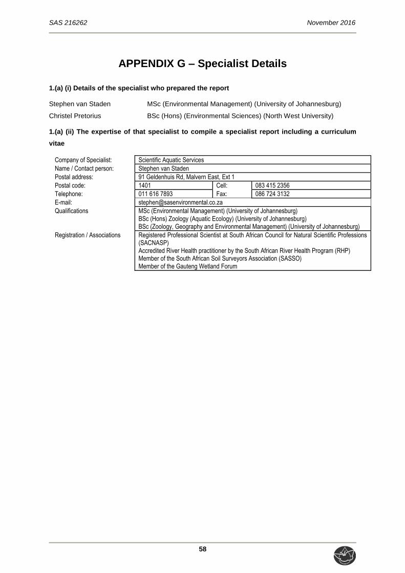
SAS 216262 November 2016
58
APPENDIX G – Specialist Details
1.(a) (i) Details of the specialist who prepared the report
Stephen van Staden MSc (Environmental Management) (University of Johannesburg)
Christel Pretorius BSc (Hons) (Environmental Sciences) (North West University)
1.(a) (ii) The expertise of that specialist to compile a specialist report including a curriculum
vitae
Company of Specialist: Scientific Aquatic Services
Name / Contact person: Stephen van Staden
Postal address: 91 Geldenhuis Rd, Malvern East, Ext 1
Postal code: 1401 Cell: 083 415 2356
Telephone: 011 616 7893 Fax: 086 724 3132
E-mail: [email protected]
Qualifications MSc (Environmental Management) (University of Johannesburg) BSc (Hons) Zoology (Aquatic Ecology) (University of Johannesburg) BSc (Zoology, Geography and Environmental Management) (University of Johannesburg)
Registration / Associations Registered Professional Scientist at South African Council for Natural Scientific Professions (SACNASP) Accredited River Health practitioner by the South African River Health Program (RHP) Member of the South African Soil Surveyors Association (SASSO) Member of the Gauteng Wetland Forum
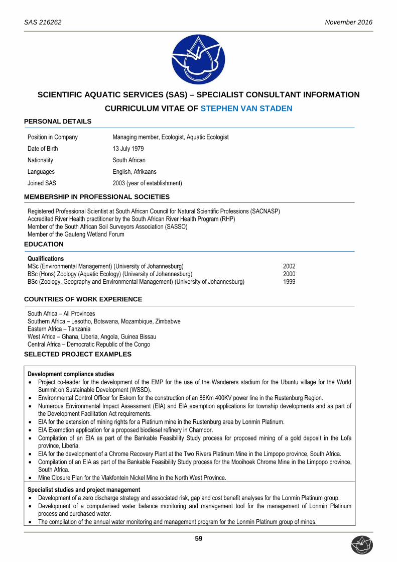
SAS 216262 November 2016
59
SCIENTIFIC AQUATIC SERVICES (SAS) – SPECIALIST CONSULTANT INFORMATION
CURRICULUM VITAE OF STEPHEN VAN STADEN
PERSONAL DETAILS
Position in Company Managing member, Ecologist, Aquatic Ecologist
Date of Birth 13 July 1979
Nationality South African
Languages English, Afrikaans
Joined SAS 2003 (year of establishment)
MEMBERSHIP IN PROFESSIONAL SOCIETIES
Registered Professional Scientist at South African Council for Natural Scientific Professions (SACNASP) Accredited River Health practitioner by the South African River Health Program (RHP) Member of the South African Soil Surveyors Association (SASSO) Member of the Gauteng Wetland Forum
EDUCATION
Qualifications
MSc (Environmental Management) (University of Johannesburg) 2002 BSc (Hons) Zoology (Aquatic Ecology) (University of Johannesburg) 2000 BSc (Zoology, Geography and Environmental Management) (University of Johannesburg) 1999
COUNTRIES OF WORK EXPERIENCE
South Africa – All Provinces Southern Africa – Lesotho, Botswana, Mozambique, Zimbabwe Eastern Africa – Tanzania West Africa – Ghana, Liberia, Angola, Guinea Bissau Central Africa – Democratic Republic of the Congo
SELECTED PROJECT EXAMPLES
Development compliance studies
Project co-leader for the development of the EMP for the use of the Wanderers stadium for the Ubuntu village for the World Summit on Sustainable Development (WSSD).
Environmental Control Officer for Eskom for the construction of an 86Km 400KV power line in the Rustenburg Region.
Numerous Environmental Impact Assessment (EIA) and EIA exemption applications for township developments and as part of the Development Facilitation Act requirements.
EIA for the extension of mining rights for a Platinum mine in the Rustenburg area by Lonmin Platinum.
EIA Exemption application for a proposed biodiesel refinery in Chamdor.
Compilation of an EIA as part of the Bankable Feasibility Study process for proposed mining of a gold deposit in the Lofa province, Liberia.
EIA for the development of a Chrome Recovery Plant at the Two Rivers Platinum Mine in the Limpopo province, South Africa.
Compilation of an EIA as part of the Bankable Feasibility Study process for the Mooihoek Chrome Mine in the Limpopo province, South Africa.
Mine Closure Plan for the Vlakfontein Nickel Mine in the North West Province.
Specialist studies and project management
Development of a zero discharge strategy and associated risk, gap and cost benefit analyses for the Lonmin Platinum group.
Development of a computerised water balance monitoring and management tool for the management of Lonmin Platinum process and purchased water.
The compilation of the annual water monitoring and management program for the Lonmin Platinum group of mines.

SAS 216262 November 2016
60
Analyses of ground water for potable use on a small diamond mine in the North West Province.
Project management and overview of various soil and land capability studies for residential, industrial and mining developments.
The design of a stream diversion of a tributary of the Olifants River for a proposed opencast coal mine.
Waste rock dump design for a gold mine in the North West province.
Numerous wetland delineation and function studies in the North West, Gauteng and Mpumalanga Kwa-Zulu Natal provinces, South Africa.
Hartebeespoort Dam Littoral and Shoreline PES and rehabilitation plan.
Development of rehabilitation principles and guidelines for the Crocodile West Marico Catchment, DWAF North West.
Aquatic and water quality monitoring and compliance reporting
Development of the Resource Quality Objective framework for Water Use licensing in the Crocodile West Marico Water Management Area.
Development of the Resource Quality Objectives for the Local Authorities in the Upper Crocodile West Marico Water Management Area.
Development of the 2010 State of the Rivers Report for the City of Johannesburg.
Development of an annual report detailing the results of the Lonmin Platinum groups water monitoring program.
Development of an annual report detailing the results of the Everest Platinum Mine water monitoring program.
Initiation and management of a physical, chemical and biological monitoring program, President Steyn Gold Mine Welkom.
Aquatic biomonitoring programs for several Xstrata Alloys Mines and Smelters.
Aquatic biomonitoring programs for several Anglo Platinum Mines.
Aquatic biomonitoring programs for African Rainbow Minerals Mines.
Aquatic biomonitoring programs for several Assmang Chrome Operations.
Aquatic biomonitoring programs for Petra Diamonds.
Aquatic biomonitoring programs for several coal mining operations.
Aquatic biomonitoring programs for several Gold mining operations.
Aquatic biomonitoring programs for several mining operations for various minerals including iron ore, and small platinum and chrome mining operations.
Aquatic biomonitoring program for the Valpre bottled water plant (Coca Cola South Africa).
Aquatic biomonitoring program for industrial clients in the paper production and energy generation industries.
Aquatic biomonitoring programs for the City of Tshwane for all their Waste Water Treatment Works.
Baseline aquatic ecological assessments for numerous mining developments.
Baseline aquatic ecological assessments for numerous residential commercial and industrial developments.
Baseline aquatic ecological assessments in southern, central and west Africa.
Lalini Dam assessment with focus on aquatic fish community analysis.
Musami Dam assessment with focus on the FRAI and MIRAI aquatic community assessment indices.
Wetland delineation and wetland function assessment
Wetland biodiversity studies for three copper mines on the copper belt in the Democratic Republic of the Congo.
Wetland biodiversity studies for proposed mining projects in Guinea Bissau, Liberia and Angola in West Africa.
Terrestrial and wetland biodiversity studies for developments in the mining industry.
Terrestrial and wetland biodiversity studies for developments in the residential commercial and industrial sectors.
Development of wetland riparian resource protection measures for the Hartbeespoort Dam as part of the Harties Metsi A Me integrated biological remediation program.
Priority wetland mammal species studies for numerous residential, commercial, industrial and mining developments throughout South Africa.
Terrestrial ecological studies and biodiversity studies
Development of a biodiversity offset plan for Xstrata Alloys Rustenburg Operations.
Biodiversity Action plans for numerous mining operations of Anglo Platinum throughout South Africa in line with the NEMBA requirements.
Biodiversity Action plans for numerous mining operations of Assmang Chrome throughout South Africa in line with the NEMBA requirements.
Biodiversity Action plans for numerous mining operations of Xstrata Alloys and Mining throughout South Africa in line with the NEMBA requirements.
Biodiversity Action plan for the Nkomati Nickel and Chrome Mine Joint Venture.
Terrestrial and wetland biodiversity studies for three copper mines on the copper belt in the Democratic Republic of the Congo.
Terrestrial and wetland biodiversity studies for proposed mining projects in Guinea Bissau, Liberia and Angola in West Africa.
Numerous terrestrial ecological assessments for proposed platinum and coal mining projects.
Numerous terrestrial ecological assessments for proposed residential and commercial property developments throughout most of South Africa.
Specialist Giant bullfrog (Pyxicephalus adspersus) studies for several proposed residential and commercial development projects in Gauteng, South Africa.
SAS 216262 November 2016
61
Specialist Marsh sylph (Metisella meninx) studies for several proposed residential and commercial development projects in Gauteng, South Africa.
Project management of several Red Data Listed (RDL) bird studies with special mention of African grass owl (Tyto capensis).
Project management of several studies for RDL Scorpions, spiders and beetles for proposed residential and commercial development projects in Gauteng, South Africa.
Specialist assessments of terrestrial ecosystems for the potential occurrence of RDL spiders and owls.
Project management and site specific assessment on numerous terrestrial ecological surveys including numerous studies in the Johannesburg-Pretoria area, Witbank area, and the Vredefort dome complex.
Biodiversity assessments of estuarine areas in the Kwa-Zulu Natal and Eastern Cape provinces. Impact assessment of a spill event on a commercial maize farm including soil impact assessments.
Fisheries management studies
Tamryn Manor (Pty.) Ltd. still water fishery initiation, enhancement and management.
Verlorenkloof Estate fishery management strategising, fishery enhancement, financial planning and stocking strategy.
Mooifontein fishery management strategising, fishery enhancement and stocking programs.
Wickams retreat management strategising.
Gregg Brackenridge management strategising and stream recalibration design and stocking strategy.
Eljira Farm baseline fishery study compared against DWAF 1996 aquaculture and aquatic ecosystem guidelines.
SAS 216262 November 2016
62
SCIENTIFIC AQUATIC SERVICES (SAS) – SPECIALIST CONSULTANT INFORMATION
CURRICULUM VITAE OF CHRISTEL PRETORIUS
PERSONAL DETAILS
Position in Company Junior Wetland Ecologist
Date of Birth 22 March 1990
Nationality South African
Languages English, Afrikaans
Joined SAS January 2016
EDUCATION
Qualifications
BSc (Hons) Environmental Sciences (North West University) 2012 BSc Environmental and Biological Sciences (North West University) 2011
COUNTRIES OF WORK EXPERIENCE
South Africa – KwaZulu Natal, Northern Cape, Gauteng, Mpumalanga, Free State SELECTED PROJECT EXAMPLES
Wetland Assessments
Baseline freshwater assessment as part of the environmental assessment and authorisation process for the proposed National Route 3 (N3) Van Reenen Village Caltex Interchange, KwaZulu Natal
Basic assessment for the proposed construction of supporting electrical infrastructure for the Victoria West Wind Farm, Victoria West, Northern Cape Province
Freshwater Ecological Assessment in Support of the WULA Associated with the Rehabilitation of the Wetland Resources in Ecopark, Centurion, Gauteng
Wetland Ecological Assessment for the Proposed Mixed Land Use Development (Kosmosdal Extension 92) on the remainder of Portion 2 of the farm Olievenhoutbosch 389 Jr, City of Tshwane Metropolitan Municipality, Gauteng Province
Freshwater Ecological Assessment for the Mokate Pig Production and Chicken Broiler Facility on the farm Rietvalei Portion 1 and 6 near Delmas, Mpumalanga
Wetland Ecological Assessment as part of the Environmental Assessment and Authorisation Process for the Proposed Relocation of a Dragline from the Kromdraai Section to Navigation Section of the Anglo American Landau Colliery in Mpumalanga
Freshwater Assessment as part of the Environmental Assessment and Authorisation Process for a proposed 132kv powerline and associated infrastructure for the proposed Kalkaar Solar Thermal Power Plant near Kimberley, Free State and Northern Cape Provinces
Freshwater Ecological Assessment of the Freshwater Prospect Stream in the AEL Operational Area, Modderfontein, Gauteng
Specialist Freshwater Scoping and Environmental Impact Assessment for the Proposed Development of the Platberg and Teekloof Wind Energy Facility and Supporting Electrical Infrastructure near Victoria West, Northern Cape Province
Wetland Ecological Assessment as part of the Environmental Assessment and Authorisation Process for the Proposed Development of Wilgedraai, Vaaldam Settlement 1777, Free State Province
Freshwater Resource Delineation and Assessment as part of the consolidation of four Environmental Management Plans at the Graspan Colliery, in Middelburg, Mpumalanga Province
Freshwater Assessment as part of the Water Use Authorisation for the proposed Copperton Wind Energy Facility, Northern Cape.
Freshwater Resource and Water Quality Ecological Assessment for the Lakefield Manor Residential project, Boksburg, Gauteng Province

SAS 216262 November 2016
63
1.(b) a declaration that the specialist is independent in a form as may be specified by the competent authority I, Stephen van Staden, declare that –
I act as the independent specialist in this application; I will perform the work relating to the application in an objective manner, even if this results in
views and findings that are not favourable to the applicant; I declare that there are no circumstances that may compromise my objectivity in performing
such work; I have expertise in conducting the specialist report relevant to this application, including
knowledge of the relevant legislation and any guidelines that have relevance to the proposed activity;
I will comply with the applicable legislation; I have not, and will not engage in, conflicting interests in the undertaking of the activity; I undertake to disclose to the applicant and the competent authority all material information in
my possession that reasonably has or may have the potential of influencing - any decision to be taken with respect to the application by the competent authority; and - the objectivity of any report, plan or document to be prepared by myself for submission to the competent authority;
All the particulars furnished by me in this form are true and correct
---------------------------------------------------------------------------
Signature of the Specialist