Fox Resources Ltd Shareholder...
20
1 ABN: 44 079 902 499 10 Abbotsford Street, West Leederville, Western Australia 6007 PO Box 1386, West Leederville Perth Western Australia 6901 Tel: 61 8 9318 5600 Fax: 61 8 9238 1380 Web: www.foxresources.com.au Email: [email protected] 30 May 2018 Fox Resources Ltd Shareholder Update Dear Shareholders, Announcement - Fox Resources Limited 132.8Mt Inferred Resource Bundaberg Project Highlights: v Drilling allows Coal Inferred Resource of 132.8Mt at the Bundaberg Project EPC 1523 (32% increase) v Fox Resources Ltd has a 50% share in EPC 1523 v Coal Quality sampling program confirmed and analyses underway. Fox Resources Ltd (“Company”) is pleased to announce that an updated Inferred Resource has been estimated at the Bundaberg Project, Fox’s share is 50% or 66.4Mt. Figure 1 shows the location of the Fox Resources 50% share tenement in the Bundaberg region. The addition of three (3) new boreholes (details given in Table 2 and Appendix 1) has allowed updated modelling that has increased the coking coal Resource (estimated at an Inferred level of confidence) to 132.8Mt from a previous estimate of 101.2Mt which is an increase of 31.2%. The Resource has been estimated in accordance with the 2012 JORC Code and the 2014 Coal guidelines with all information outlined in Appendix 1 below. Previous laboratory testing of the three main seams GU, GL1, and GL2 reported raw ash <20% with raw calorific values exceeding 7,000KCal/kg for large sections of the seams. The raw total sulphur was manageable with the highest value 0.87%. A coking coal indicator, raw crucible swell number, returned large sections of the seam reported numbers exceeding 8.0.
Transcript of Fox Resources Ltd Shareholder...
1
ABN: 44 079 902 499
10 Abbotsford Street, West Leederville, Western Australia 6007 PO Box 1386, West Leederville Perth Western Australia 6901
Tel: 61 8 9318 5600 Fax: 61 8 9238 1380 Web: www.foxresources.com.au Email: [email protected]
30 May 2018
Fox Resources Ltd Shareholder Update Dear Shareholders,
Announcement - Fox Resources Limited
132.8Mt Inferred Resource
Bundaberg Project
Highlights:
v Drilling allows Coal Inferred Resource of 132.8Mt at the Bundaberg Project EPC 1523 (32% increase)
v Fox Resources Ltd has a 50% share in EPC 1523 v Coal Quality sampling program confirmed and analyses underway.
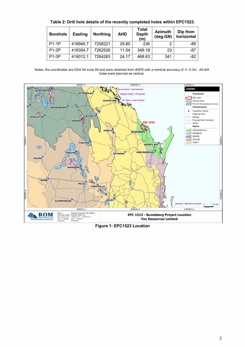
Fox Resources Ltd (“Company”) is pleased to announce that an updated Inferred Resource has been estimated at the Bundaberg Project, Fox’s share is 50% or 66.4Mt. Figure 1 shows the location of the Fox Resources 50% share tenement in the Bundaberg region. The addition of three (3) new boreholes (details given in Table 2 and Appendix 1) has allowed updated modelling that has increased the coking coal Resource (estimated at an Inferred level of confidence) to 132.8Mt from a previous estimate of 101.2Mt which is an increase of 31.2%. The Resource has been estimated in accordance with the 2012 JORC Code and the 2014 Coal guidelines with all information outlined in Appendix 1 below. Previous laboratory testing of the three main seams GU, GL1, and GL2 reported raw ash <20% with raw calorific values exceeding 7,000KCal/kg for large sections of the seams. The raw total sulphur was manageable with the highest value 0.87%. A coking coal indicator, raw crucible swell number, returned large sections of the seam reported numbers exceeding 8.0.
2
The Coal Quality sampling from P1-2P and P1-3P has now shifted to generating two composite clean products, one at CF1.45 and the other at CF1.60 and testing these for a range of coking and thermal properties. The results will be released once completed. Fox’s CEO, Mr Bruce Garlick added “Fox owns 50% of the EPC 1523 Bundaberg EPC tenement which as advised on the 11 January 2018 is subject to a signed Share Sale Agreement (SSA). The latest inferred resource increases Fox’s share in the SSA to $1.9m in cash or 9,534,750 shares at 20c per share in a new listed entity (which will effectively own all of EPC 1523, amongst other tenements) or a combination of cash and shares at Fox’s election. The sale is expected to be finalised in a couple of months, and the sale under the SSA is subject to various conditions precedent being satisfied refer the 11 January 2018 announcement. It should be noted that whilst significant further work is required to complete various studies into possible development options, obtaining this enlarged Inferred Resource Estimate is highly encouraging and bodes well for the future of the Bundaberg project” Table 1 below details the Inferred Resource Estimates on Fox’s 50%, and Zimprop’s 50% owned EPC1523 while Table 2, below, details the location, depth, dip and azimuth of all the recent drilling completed in EPC1523 by Fox Resources. Figure 2 shows the previous and new Inferred Mask for the Burrum Coal Measures within EPC1523.
Table 1 Inferred Resource Estimates on EPC1523 (50% Fox, Zimprop 50%).
Tenement Formation Inferred Tonnage
(Mt)
Raw Ash % adb
Raw Volatile Matter %
adb
Raw Crucible
Swell Number
Raw total Sulphur (% adb)
EPC1523 Burrum Coal Measures
132.8 19.0 22.5 8.0 0.87
Note the total tonnages may not total due to rounding.
3
Table 2: Drill hole details of the recently completed holes within EPC1523.
Borehole Easting Northing AHD Total Depth
(m)
Azimuth (deg.GN)
Dip from horizontal
P1-1P 418946.7 7258221 29.80 236 2 -89
P1-2P 418354.7 7262526 11.54 349.18 23 -87
P1-3P 419012.1 7264283 24.17 468.63 341 -82
Notes: the coordinates are GDA 94 zone 56 and were obtained from dGPS with a nominal accuracy of +/- 0.3m. All drill holes were planned as vertical.
Figure 1: EPC1523 Location
4
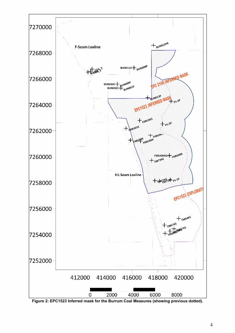
Figure 2: EPC1523 Inferred mask for the Burrum Coal Measures (showing previous dotted).
5
Introduction The results of the recent Fox Resources exploration drilling have all been reported under the new 2012 JORC code and following the principles of the 2014 Coal guidelines. In particular, a similar application of the “reasonable prospects” for eventual economic extraction has been applied to each coal seam. Accordingly, all seams from X4 to DL (and the H1 to H2) have been excluded from the current estimate. Borehole intersections have shown that, although some of these seams obtain thicknesses of 2.0m maximum they mostly average around 0.30 – 0.5m in thickness. Some of these seams, particularly the “C” seam have low ash (<20%) but most are around 35-50%. Despite these facts, there is currently insufficient data to show that 0.4m of X1 seam at 250m depth would pass the “reasonable prospects” test and hence the exclusion.
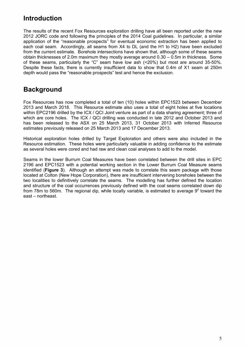
Background Fox Resources has now completed a total of ten (10) holes within EPC1523 between December 2013 and March 2018. This Resource estimate also uses a total of eight holes at five locations within EPC2196 drilled by the ICX / QCI Joint venture as part of a data sharing agreement; three of which are core holes. The ICX / QCI drilling was conducted in late 2012 and October 2013 and has been released to the ASX on 25 March 2013, 31 October 2013 with Inferred Resource estimates previously released on 25 March 2013 and 17 December 2013. Historical exploration holes drilled by Target Exploration and others were also included in the Resource estimation. These holes were particularly valuable in adding confidence to the estimate as several holes were cored and had raw and clean coal analyses to add to the model. Seams in the lower Burrum Coal Measures have been correlated between the drill sites in EPC 2196 and EPC1523 with a potential working section in the Lower Burrum Coal Measure seams identified (Figure 3). Although an attempt was made to correlate this seam package with those located at Colton (New Hope Corporation), there are insufficient intervening boreholes between the two localities to definitively correlate the seams. The modelling has further defined the location and structure of the coal occurrences previously defined with the coal seams correlated down dip from 78m to 560m. The regional dip, while locally variable, is estimated to average 90 toward the east – northeast.
6
Figure 3: Bundaberg Project – Examples of Coal Seams from Latest drilling
7
Further information including the results of analytical and coal quality tests are expected in the coming weeks. Future exploration on EPC1523 are likely to include drilling programs consisting of a combination of widely-spaced structural and large-diameter cored holes so as to improve the confidence in the resource. About Fox Resources Fox Resources is an exploration company with exploration interests in the Queensland Coal region. Fox has completed drilling a planned three-hole program with the aim of defining a premium hard coking coal resource at its 50% owned Bundaberg Coking Coal Project in southeast Queensland. Fox Resources acquired its 50% interest in EPC 1523 previously held by Currawong Coal Pty Ltd, a joint venture of Cliff’s Natural Resources Pty Ltd, Conarco Minerals Pty Ltd and XLX Pty Ltd. Fox Resources Ltd has signed a contract with Bundaberg Coal Pty Ltd to sell its 50% share in the Bundaberg EPC 1523 project, and this is based on Fox’s 50 % share of the inferred resource which equals 66.4Mt. Forward-Looking Statements: This document may include forward-looking statements. Forward-looking statements include but are not limited to statements concerning Fox Resources Limited’s (Fox) planned exploration program and other statements that are not historical facts. When used in this document, the words such as “could”, “plan”, “estimate”, “expect”, “intend”, “may”, “potential”, “should”, and similar expressions are forward-looking statements. Although Fox believes that its expectations reflected in these forward-looking statements are reasonable, such statements involve risks and uncertainties and no assurance can be given that actual results will be consistent with these forward-looking statements.

8
STATEMENT OF COAL COMPETENCE AND COMPLIANCE Technical information on Fox Resources Limited's Queensland coal projects discussed in this ASX Release have been compiled by Mr Mark Biggs, Principal Geologist of ROM Resources Pty Ltd. The Minescape Resource model is based on factual geological data provided by Fox Resources over a period of three months, from the ICX/QCI Joint Venture over the past year as well as pre-existing data from Government stratigraphic drilling and other historical private company coal exploration. Interpolation and extrapolation of data has been avoided in most cased but where necessary it was done with due consideration of the 2012 JORC Code and the 2014 Coal Guidelines. Competent Persons Statement Mr Biggs is a member of the Australasian Institute of Mining and Metallurgy and has the experience relevant to the style and type of coal deposit under consideration and to the activity which is being undertaken to qualify as a Competent Person as defined by the Australasian Code for Reporting of Minerals Resources and Reserves (JORC) 2012. Mark Biggs consents to the inclusion in the report of the matters based on this information in the form and context in which it appears. The report is based on factual geological data acquired by Fox Resources Limited on EPC1523 over a period of several months along with work conducted by International Coal and Queensland Coal Investments on EPC2196. This latest resource estimate is current as of 22nd May 2018. Appendix 1 below details exploration work undertaken by Fox Resources while exploration conducted by ICX/QCI has been previously reported as a part of their ASX release on 17 December 2013 and previous ASX releases in March and October 2013; Appendix 2 details the estimation and reporting of Resources.
Name Job Title Registration Experience (Years) Signed
M Biggs Principal Geologist ROM Resources Pty Ltd
AusIMM 107188 33
9
Appendix 1
This Appendix details Section 1 and 2 of the JORC Code 2012 Edition for the work conducted by Fox Resources, work conducted by ICX/QCI has been previously reported as a part of their ASX release on 17 December 2013 and previous ASX releases in March and October 2013.
Section 3 ‘Estimation and Reporting of Mineral Resources’ is detailed in Appendix 2 below,
Sections 4 ‘Estimation and Reporting of Ore Reserves’ and 5 ‘Estimation and Report of Diamonds and Other gemstones’ have not been included as they are not applicable to this deposit type or stage of exploration.
Section1&2SamplingTechniquesandData–FoxResourcesCriteria JORC Code explanation Commentary
Sampling techniques
• Nature and quality of sampling (eg cut channels, random chips, or specific specialised industry standard measurement tools appropriate to the minerals under investigation, such as down hole gamma sondes, or handheld XRF instruments, etc). These examples should not be taken as limiting the broad meaning of sampling.
• Include reference to measures taken to ensure sample representivity and the appropriate calibration of any measurement tools or systems used.
• Aspects of the determination of mineralisation that are Material to the Public Report.
• In cases where ‘industry standard’ work has been done this would be relatively simple (eg ‘reverse circulation drilling was used to obtain 1 m samples from which 3 kg was pulverised to produce a 30 g charge for fire assay’). In other cases more explanation may be required, such as where there is coarse gold that has inherent sampling problems. Unusual commodities or mineralisation types (eg submarine nodules) may warrant disclosure of detailed information.
• Samples have only been taken from Diamond core of 61mm diameter as samples that have been obtained from the rotary chip drilling have been too contaminated or washed away by the high-water flows encountered in some holes. Where core has been taken recoveries have exceeded 98%
• Sample representatively has not yet been confirmed however the comparison between the Diamond Core samples and geophysical logs will be done once the geophysical logging has been completed.
• Core samples from the hole P1-2P and P1-3P have been taken and stored in a freezer and have been dispatched to ALS Laboratory in Brisbane for coal quality analysis. An RFA has been created and implemented along with a suitable analyses methodology.
• The findings to date warrant additional exploration within the area to define the extent of the deposit, the spatial variability of the coal and stratigraphy.
• Additional data has been obtained from the tenure immediately adjacent to the north (EPC2196 ICX/QCI JV) through a data-sharing arrangement which will allow, once the data is integrated and correlated additional information to construct Points of Observation
Drilling techniques
• Drill type (eg core, reverse circulation, open-hole hammer, rotary air blast, auger, Bangka, sonic, etc) and details (eg core diameter, triple or standard tube, depth of diamond tails, face-sampling bit or other type, whether core is oriented and if so, by what method, etc).
• Diamond Core drilling was used for the twin of the initial chip hole. Standard HQ core drilling was undertaken with core obtained from a diamond tail with the pre-collar drilled to approximately 250m. The pre-collar was drilled with open hole rotary drilling.
Drill sample • Method of recording and • The core recovery was done on a drill run basis
10
Criteria JORC Code explanation Commentary
recovery assessing core and chip sample recoveries and results assessed.
• Measures taken to maximise sample recovery and ensure representative nature of the samples.
• Whether a relationship exists between sample recovery and grade and whether sample bias may have occurred due to preferential loss/gain of fine/coarse material.
using the drillers depths and determining the recovery percentage from the drill run length and the length of core returned. Core recovery was excellent with recovery generally >90%. Sample mass laboratory was also very good with recoveries mostly exceeding 85% against a theoretical sample mass calculation. Overall total recovery (core recovery x sample mass recovery) exceeded 83% for each sample analysed.
Logging • Whether core and chip samples have been geologically and geotechnically logged to a level of detail to support appropriate Mineral Resource estimation, mining studies and metallurgical studies.
• Whether logging is qualitative or quantitative in nature. Core (or costean, channel, etc) photography.
• The total length and percentage of the relevant intersections logged.
• All the samples have been geologically logged based on geological contacts and coding using the Australian industry standard CoalLog system.
• All holes have been geophysically logged with a deviation tool (for hole deviation), gamma, density and resistivity probes. Geophysical logging of the core hole has also been undertaken once the hole is completed.
• Geological logging is qualitative with samples of each metre collected into a core tray and all samples have been photographed. All core has been retained and stored in a freezer prior to coal quality analysis.
• The total length of the drill hole has been geologically logged. Drilling deeper in the stratigraphy to the north in an adjacent tenement has not intersected any coal seams below the seams correlated to drill holes on adjacent tenements.
Sub-sampling techniques and sample preparation
• If core, whether cut or sawn and whether quarter, half or all core taken.
• If non-core, whether riffled, tube sampled, rotary split, etc and whether sampled wet or dry.
• For all sample types, the nature, quality and appropriateness of the sample preparation technique.
• Quality control procedures adopted for all sub-sampling stages to maximise representivity of samples.
• Measures taken to ensure that the sampling is representative of the in situ material collected, including for instance results for field duplicate/second-half sampling.
• Whether sample sizes are appropriate to the grain size of the material being sampled.
• The core has been sampled using coal industry standard procedures. Samples have been stored in a freezer to retain the coal quality properties prior to the analysis.
• Due to the lack of sample mass of the samples, no sub-sampling has been done.
• A RFA (Request for Analysis) has been generated which outlines the sample collected and the proposed sampling of plys, instructions to make up composites once ply analyses are available and finally, requests for suitable float/sink washability testing.
Quality of assay data and laboratory tests
• The nature, quality and appropriateness of the assaying and laboratory procedures used and whether the technique is considered partial or total.
• For geophysical tools, spectrometers, handheld XRF instruments, etc, the parameters used in
• Raw coal analytical sampling or laboratory testing has been completed at this stage, the samples have been forwarded for clean coal composite laboratory analysis.
• Geophysical logging by deviation tool, gamma, density and resistivity has been conducted on the initial hole with this to be completed on the core hole once it is completed using calibrated sondes undertaking industry standard techniques, reading
11
Criteria JORC Code explanation Commentary determining the analysis including instrument make and model, reading times, calibrations factors applied and their derivation, etc.
• Nature of quality control procedures adopted (eg standards, blanks, duplicates, external laboratory checks) and whether acceptable levels of accuracy (ie lack of bias) and precision have been established.
times and logging speeds. • Analytical sampling that has been reported
however industry standard quality control standard (NATA) sampling has been undertaken for the recently submitted samples.
Verification of sampling and assaying
• The verification of significant intersections by either independent or alternative company personnel.
• The use of twinned holes. • Documentation of primary
data, data entry procedures, data verification, data storage (physical and electronic) protocols.
• Discuss any adjustment to assay data.
• Xplore Resources are independently managing the exploration with the geological and geophysical logging, with data provided to ROM Resources, an independent geological consultancy. Sampling has been undertaken as directed by ROM Resources.
• A twin hole of an initial chip hole for FXBU006R was completed and logged.
• The geophysical logging is being undertaken by an independent geophysical logging company (GEOLOG) that sent the logging data to Explore Resources who then sent the logging files to ROM Resources.
Location of data points
• Accuracy and quality of surveys used to locate drill holes (collar and down-hole surveys), trenches, mine workings and other locations used in Mineral Resource estimation.
• Specification of the grid system used.
• Quality and adequacy of topographic control.
• The Drill hole collar of the exploration holes is initially being surveyed using a hand-held GPS. The GPS integrated for an extended period therefore the accuracy is believed to be +/- 3m in easting and northing however the elevation is not considered accurate. Final survey will be by licenced surveyors using theodolite or differential GPS technologies. The grid system is Map Grid of Australia (MGA) GDA94 zone 56.
Data spacing and distribution
• Data spacing for reporting of Exploration Results.
• Whether the data spacing and distribution is sufficient to establish the degree of geological and grade continuity appropriate for the Mineral Resource and Ore Reserve estimation procedure(s) and classifications applied.
• Whether sample compositing has been applied.
• Exploration drilling was completed on approximately 1500 m spacing. The seven holes completed have successfully tested the stratigraphic position within EPC 1523. The closest drill hole that tests this stratigraphic position is approximately 1,800m (FXBU001R) to the south of the nearest hole in EPC 2196. There are insufficient holes in EPC1523 to determine Indicated or Measured Resource estimates currently, but by the end of the program there should be sufficient drilling information to report Inferred Resources.
• There has been no compositing of the samples.
Orientation of data in relation to geological structure
• Whether the orientation of sampling achieves unbiased sampling of possible structures and the extent to which this is known, considering the deposit type.
• If the relationship between the drilling orientation and the orientation of key mineralised structures is considered to have introduced a sampling bias, this should be assessed and reported if material.
• Drilling to date has established that the regional strike is about 340 degrees and that the exploration plan is drill boreholes on perpendicular section lines to assess dip and variability. No faulting was observed during the drilling program to date, although a small fault was added at the modelling stage to account for a perturbation of structure contours around FXBU003R
Sample • The measures taken to ensure sample security.
• The core was collected directly from the drill rig and remained in the control of Moultrie Group who
12
Criteria JORC Code explanation Commentary
security delivered it directly to the analytical laboratory.
Audits or reviews
• The results of any audits or reviews of sampling techniques and data.
• No Audits have been performed
Mineral tenement and land tenure status
• Type, reference name/number, location and ownership including agreements or material issues with third parties such as joint ventures, partnerships, overriding royalties, native title interests, historical sites, wilderness or national park and environmental settings.
• The security of the tenure held at the time of reporting along with any known impediments to obtaining a licence to operate in the area.
• The exploration lease, EPC 1523 is held 100% by Fox Resources Limited (FXR)
• A native title claim has been lodged over the area by the Port Curtis Coral Coast Registered Native Title Claimants. A Cultural Heritage management Agreement (CHMA) has been executed between Fox Resources Limited and Port Curtis Coral Coast Registered Native Title Claimants
• There are no identified cultural heritage sites within the tenement
• There are several environmental impediments and conditions that exist within the lease including several endangered regional ecosystems that require a 500m buffer around the identified sites. The accuracy or validity of the ERE’s remains to be confirmed by modern mapping.
• The tenement is extensively covered by privately-held farmland that is used for various crops including sugar cane and other vegetables along with small scale farming.
Exploration done by other parties
• Acknowledgment and appraisal of exploration by other parties.
There has been coal exploration undertaken since the 1960s in the surrounding region which has targeted coal within the Burrum Coal Measures. Thiess Exploration in EPC79C (1969 - QDEX: CR2954) drilled core hole 76C-2 to a depth of 97.5m just outside the south-west corner of the area now covered by EPC 2195. This hole intersected two coal seams of 0.3m and 1.52m thickness at depths of 51.8m and 57.6m respectively. No coal quality data is available.
Target Exploration in EPC 82C (1970 - QDEX:
CR3355) drilled 16 open and partly-cored drill holes
(TM series) within the area south of EPC 2196. Coal
seams between 0.21m and 1.68m thick were
encountered however these thicknesses are based on
non-geophysically logged open holes. Most drill holes
intersected two thin coal seams ranging from 0.09m to
1.58m apart. One of the cored holes, TM75K6
intersected three thin coal seams between 0.49 and
0.62m over an interval of 2.49m (Figure 4). The coal
quality data indicates coking coal characteristics with
the potential to be prime coking coal.
Figure 4: Coal Quality for Borehole TM75K6
13
Criteria JORC Code explanation Commentary
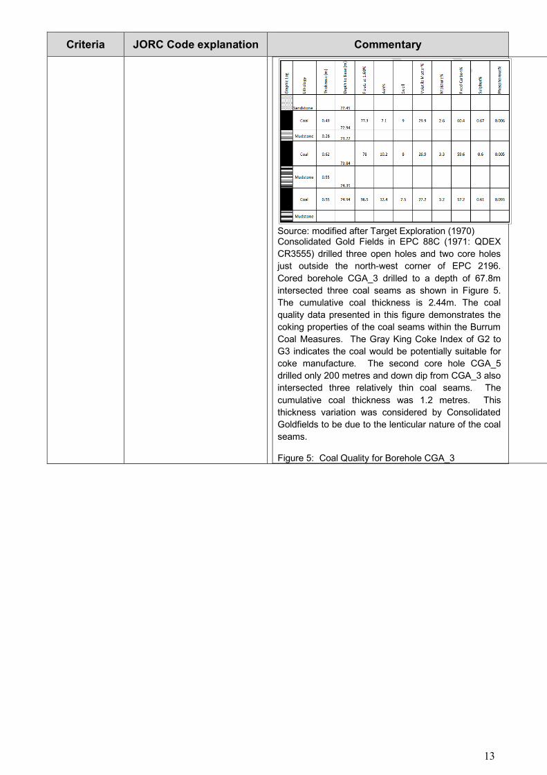
Source: modified after Target Exploration (1970) Consolidated Gold Fields in EPC 88C (1971: QDEX
CR3555) drilled three open holes and two core holes
just outside the north-west corner of EPC 2196.
Cored borehole CGA_3 drilled to a depth of 67.8m
intersected three coal seams as shown in Figure 5.
The cumulative coal thickness is 2.44m. The coal
quality data presented in this figure demonstrates the
coking properties of the coal seams within the Burrum
Coal Measures. The Gray King Coke Index of G2 to
G3 indicates the coal would be potentially suitable for
coke manufacture. The second core hole CGA_5
drilled only 200 metres and down dip from CGA_3 also
intersected three relatively thin coal seams. The
cumulative coal thickness was 1.2 metres. This
thickness variation was considered by Consolidated
Goldfields to be due to the lenticular nature of the coal
seams.
Figure 5: Coal Quality for Borehole CGA_3
14
Criteria JORC Code explanation Commentary
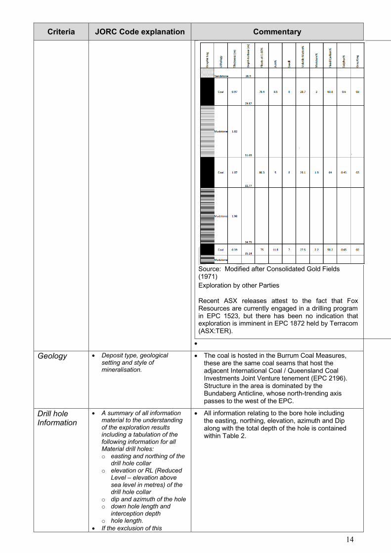
Source: Modified after Consolidated Gold Fields (1971)
Exploration by other Parties
Recent ASX releases attest to the fact that Fox Resources are currently engaged in a drilling program in EPC 1523, but there has been no indication that exploration is imminent in EPC 1872 held by Terracom (ASX:TER).
•
Geology • Deposit type, geological setting and style of mineralisation.
• The coal is hosted in the Burrum Coal Measures, these are the same coal seams that host the adjacent International Coal / Queensland Coal Investments Joint Venture tenement (EPC 2196). Structure in the area is dominated by the Bundaberg Anticline, whose north-trending axis passes to the west of the EPC.
Drill hole Information
• A summary of all information material to the understanding of the exploration results including a tabulation of the following information for all Material drill holes: o easting and northing of the
drill hole collar o elevation or RL (Reduced
Level – elevation above sea level in metres) of the drill hole collar
o dip and azimuth of the hole o down hole length and
interception depth o hole length.
• If the exclusion of this
• All information relating to the bore hole including the easting, northing, elevation, azimuth and Dip along with the total depth of the hole is contained within Table 2.
15
Criteria JORC Code explanation Commentary information is justified on the basis that the information is not Material and this exclusion does not detract from the understanding of the report, the Competent Person should clearly explain why this is the case.
Data aggregation methods
• In reporting Exploration Results, weighting averaging techniques, maximum and/or minimum grade truncations (eg cutting of high grades) and cut-off grades are usually Material and should be stated.
• Where aggregate intercepts incorporate short lengths of high grade results and longer lengths of low grade results, the procedure used for such aggregation should be stated and some typical examples of such aggregations should be shown in detail.
• The assumptions used for any reporting of metal equivalent values should be clearly stated.
• Geological logging of the core generally has confirmed the thickness of the geophysically interpreted coal seams.
• There has been no previous raw coal quality model constructed. Data from FXBU006Q will be pooled with data made available from the ICX/QCI Joint Venture
Relationship between mineralisation widths and intercept lengths
• These relationships are particularly important in the reporting of Exploration Results.
• If the geometry of the mineralisation with respect to the drill hole angle is known, its nature should be reported.
• If it is not known and only the down hole lengths are reported, there should be a clear statement to this effect (eg ‘down hole length, true width not known’).
• The boreholes in this program were planned to be vertical hole and based on the interpreted strike and dip of the geological units from the drilling in the adjacent tenement and the stratigraphic correlation diagram presented in the previous ASX release suggests that the true width west-northwest is interpreted as being >95% of the down hole intersection width. Borehole deviation tools have been run and shown that all boreholes deviate by amounts varying between 1-7 degrees from vertical, with most deviations having a dip direction of northwest.
Diagrams • Appropriate maps and sections (with scales) and tabulations of intercepts should be included for any significant discovery being reported These should include, but not be limited to a plan view of drill hole collar locations and appropriate sectional views.
• Figure 1 above shows the location of the completed and planned drill holes.
Balanced reporting
• Where comprehensive reporting of all Exploration Results is not practicable, representative reporting of both low and high grades and/or widths should be practiced to avoid misleading reporting of Exploration Results.
• All exploration results within the Bundaberg area have been reported. Some historical holes have been used in the construction of the geological model however only historical holes that contain coal quality analysis have been used as points of reference in the resource estimation.
Other substantive exploration data
• Other exploration data, if meaningful and material, should be reported including (but not limited to): geological observations; geophysical survey results; geochemical survey results; bulk samples –
• The modelling and CP report will document all data and assumptions used.

16
Criteria JORC Code explanation Commentary size and method of treatment; metallurgical test results; bulk density, groundwater, geotechnical and rock characteristics; potential deleterious or contaminating substances.
Further work • The nature and scale of planned further work (eg tests for lateral extensions or depth extensions or large-scale step-out drilling).
• Diagrams clearly highlighting the areas of possible extensions, including the main geological interpretations and future drilling areas, provided this information is not commercially sensitive.
• As outlined in the text above there are a series of further holes planned for the tenement. The exact location of these holes and the order that they will be drilled will be determined once modelling is complete.
17
Appendix 2
Appendix 2 details Sections 3 ‘Estimation and Reporting of Mineral Resources of the JORC Code 2012 Edition’.
Technical Data A methodology for modelling the deposit appropriately to meet the 2012 JORC Code has been devised, and involved identifying “coaly” piles out of the full geological sequence, based on the long and short –spaced down-hole geophysical density logs and assigning a composite relative density to each ply. Stringent cut-off parameters were applied to the coal plies thus:
• <0.2m excluded (for reporting);
• >1.75kg/m3 relative density (air dried basis) excluded;
• >55% raw ash excluded;
• Plies above the base of weathering excluded
• >520m depth below the ground surface excluded;
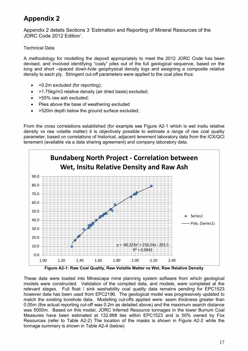
From the cross correlations established (for example see Figure A2-1 which is wet insitu relative density vs raw volatile matter) it is objectively possible to estimate a range of raw coal quality parameter, based on correlations of historical, adjacent tenement laboratory data from the ICX/QCI tenement (available via a data sharing agreement) and company laboratory data.
Figure A2-1: Raw Coal Quality, Raw Volatile Matter vs Wet, Raw Relative Density These data were loaded into Minescape mine planning system software from which geological models were constructed. Validation of the compiled data, and models, were completed at the relevant stages. Full float / sink washability coal quality data remains pending for EPC1523 however data has been used from EPC2196. The geological model was progressively updated to match the existing borehole data. Modelling cut-offs applied were: seam thickness greater than 0.05m (the actual reporting cut-off was 0.2m as detailed above) and the maximum search distance was 5000m. Based on this model, JORC Inferred Resource tonnages in the lower Burrum Coal Measures have been estimated at 132.8Mt lies within EPC1523 and is 50% owned by Fox Resources (refer to Table A2-2) The location of the masks is shown in Figure A2-2 while the tonnage summary is shown in Table A2-4 (below)
y = -40.223x2 + 216.24x - 201.5R² = 0.9943
0.0
10.0
20.0
30.0
40.0
50.0
60.0
70.0
80.0
90.0
1.00 1.20 1.40 1.60 1.80 2.00 2.20 2.40
Bundaberg North Project - Correlation between Wet, Insitu Relative Density and Raw Ash
Series1
Poly. (Series1)
18
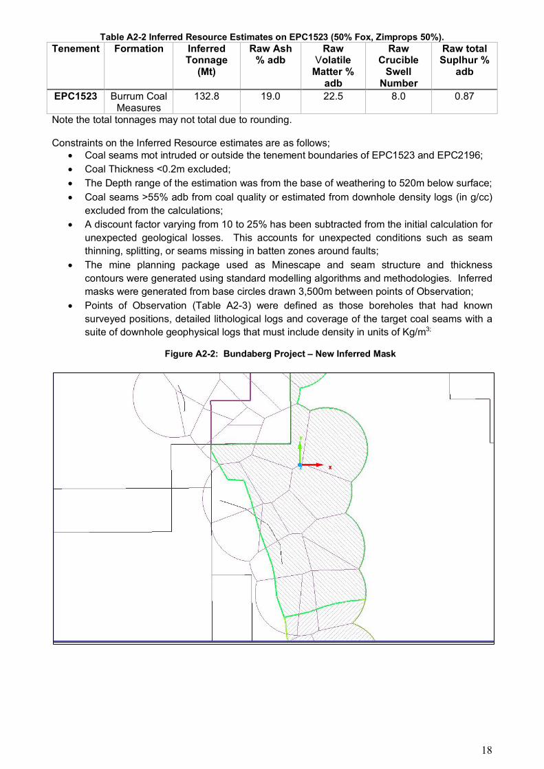
Table A2-2 Inferred Resource Estimates on EPC1523 (50% Fox, Zimprops 50%). Tenement Formation Inferred
Tonnage (Mt)
Raw Ash % adb
Raw Volatile
Matter % adb
Raw Crucible
Swell Number
Raw total Suplhur %
adb
EPC1523 Burrum Coal Measures
132.8 19.0 22.5 8.0 0.87
Note the total tonnages may not total due to rounding. Constraints on the Inferred Resource estimates are as follows;
• Coal seams mot intruded or outside the tenement boundaries of EPC1523 and EPC2196;
• Coal Thickness <0.2m excluded;
• The Depth range of the estimation was from the base of weathering to 520m below surface;
• Coal seams >55% adb from coal quality or estimated from downhole density logs (in g/cc)
excluded from the calculations;
• A discount factor varying from 10 to 25% has been subtracted from the initial calculation for
unexpected geological losses. This accounts for unexpected conditions such as seam
thinning, splitting, or seams missing in batten zones around faults;
• The mine planning package used as Minescape and seam structure and thickness
contours were generated using standard modelling algorithms and methodologies. Inferred
masks were generated from base circles drawn 3,500m between points of Observation;
• Points of Observation (Table A2-3) were defined as those boreholes that had known
surveyed positions, detailed lithological logs and coverage of the target coal seams with a
suite of downhole geophysical logs that must include density in units of Kg/m3;
Figure A2-2: Bundaberg Project – New Inferred Mask
19
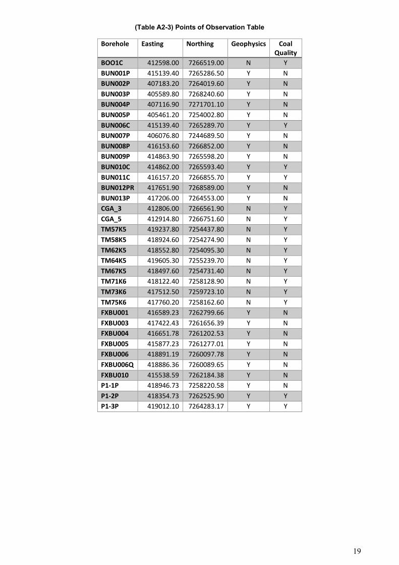
(Table A2-3) Points of Observation Table
Borehole Easting Northing Geophysics Coal Quality
BOO1C 412598.00 7266519.00 N Y BUN001P 415139.40 7265286.50 Y N BUN002P 407183.20 7264019.60 Y N BUN003P 405589.80 7268240.60 Y N BUN004P 407116.90 7271701.10 Y N BUN005P 405461.20 7254002.80 Y N BUN006C 415139.40 7265289.70 Y Y BUN007P 406076.80 7244689.50 Y N BUN008P 416153.60 7266852.00 Y N BUN009P 414863.90 7265598.20 Y N BUN010C 414862.00 7265593.40 Y Y BUN011C 416157.20 7266855.70 Y Y BUN012PR 417651.90 7268589.00 Y N BUN013P 417206.00 7264553.00 Y N CGA_3 412806.00 7266561.90 N Y CGA_5 412914.80 7266751.60 N Y TM57K5 419237.80 7254437.80 N Y TM58K5 418924.60 7254274.90 N Y TM62K5 418552.80 7254095.30 N Y TM64K5 419605.30 7255239.70 N Y TM67K5 418497.60 7254731.40 N Y TM71K6 418122.40 7258128.90 N Y TM73K6 417512.50 7259723.10 N Y TM75K6 417760.20 7258162.60 N Y FXBU001 416589.23 7262799.66 Y N FXBU003 417422.43 7261656.39 Y N FXBU004 416651.78 7261202.53 Y N FXBU005 415877.23 7261277.01 Y N FXBU006 418891.19 7260097.78 Y N FXBU006Q 418886.36 7260089.65 Y N FXBU010 415538.59 7262184.38 Y N P1-1P 418946.73 7258220.58 Y N P1-2P 418354.73 7262525.90 Y Y P1-3P 419012.10 7264283.17 Y Y

20
Table A2-4 Breakdown of the Inferred Resources at various depths below the surface.
BLOCKNAME SEAM INCLUDE TOTALVOLUME PLANAREA ROOFAREA TOPSLOPE TOPSLOPEDIR MASS TRUEVERTTHK TRUETHK RECOVERY PARTVOLUME BLOCKAREA TOPSURFACE BOTSURFACE TOPO BHTE BHWE RRD ASH ESTASH ESTSE ESTVM IM CSN VM SE TS
1523_INFERRED F N 13561.01 3709.96 3724.47 7.42 116.67 22639.53 0.37 0.36 100.00 3070.08 3766.34 F_ROOF F_FLOOR 27.02 0.92 -7.43 1.57 48.9 44.9 17.48 18.4 2.7 15.1 12.47 0.32
1523_INFERRED GU Y 26578.56 3764.06 3778.45 7.36 115.70 39910.94 0.71 0.70 100.00 4170.05 3766.34 GU_ROOF GU_FLOOR 27.10 0.98 -7.45 1.50 32.0 32.3 22.55 21.6 2.5 19.9 20.44 0.45
1523_INFERRED GL1L Y 29581.11 3763.04 3777.70 7.44 114.54 39935.03 0.79 0.78 100.00 6942.62 3766.34 GL1L_ROOF GL1L_FLOOR 27.10 0.98 -7.44 1.35 15.9 15.2 24.90 22.7 1.6 8.0 26.2 33.07 0.71
1523_INFERRED GL1U Y 18635.31 3761.55 3775.96 7.37 115.67 27818.43 0.50 0.49 100.00 4831.44 3766.34 GL1U_ROOF GL1U_FLOOR 27.10 0.98 -7.45 1.40 25.8 23.4 25.55 22.7 1.9 5.5 20.2 21.55 0.59
1523_INFERRED GL2U Y 17945.55 3716.89 3731.71 7.49 113.84 25123.77 0.48 0.48 100.00 3806.27 3766.34 GL2U_ROOF GL2U_FLOOR 27.09 1.03 -7.39 1.42 26.8 26.2 24.73
1523_INFERRED GL2L N 7148.04 3351.73 3365.64 7.68 106.62 10007.26 0.21 0.21 100.00 0.00 3766.34 GL2L_ROOF GL2L_FLOOR 27.51 1.44 -6.87 1.39 23.2 23.5 25.45
Notes: (1) mass units 1kt (2) raw qualities (both laboratory and estimated) shown
(2) Seams F, GL2L not reported as Inferred, but listed as partings sometimes <2m.