foundations · Examining sedimentary rocks of the Valley & Ridge province in West Virginia. ......
15
1 Newsletter of the Geo2YC division of the National Association of Geoscience Teachers Volume III, Issue 3: September 2014 A Precambrian experience by Andy Buddington Spokane Community College I would like to thank NAGT and the Dottie Stout committee for awarding me some much needed professional development assistance. As most of you that teach at 2-year institutions know, securing funds for basic research is often very difficult to impossible. So this professional development grant from NAGT is a real “shot in the arm” for the project I’m working on. The project involves mapping and petrologic analysis of recently recognized early Proterozoic to Archean-aged rocks just south of Coeur d’Alene, Idaho. Originally mapped as “Cretaceous orthogneiss”, it was a big surprise when a roadside outcrop dated by a Washington State University grad student produced an age of 1.86 Ga, thus establishing some of the oldest Laurentian crust in this part of the Pacific Northwest. I immediately thought that this would be a great opportunity to do some basic field mapping in my back yard, and maybe do a little petrologic work for fun. Phase one of the project includes field mapping and sampling of rocks. The second phase, and the part where I will apply my Dottie Stout funding, involves laboratory research including the petrologic and petrographic characterizations of the units collected. The funding will pay for thin sections and geochemical analyses. Finally, I plan to develop a seminar class for majors that will focus on how geologic research is done. I will use this Precambrian project as a guideline for how a research project is conceived and implemented from start to finish, along with the various aspects of both field and laboratory research in the Earth Sciences. The seminar class (2-credit Independent Study) will meet weekly to discuss the topics of research implementation, methodology, and data analysis. As part of the seminar, students will attend a field trip to the field area where they will collect samples for detailed hand sample examination and point counting classification. They will also get to examine pre-made thin sections from the study area as well as use the point count data to classify the different units. For the final part of the seminar, students will get the opportunity to present what they learn, in the form of short presentations, to the Research Club here at Spokane Community College. Numerous studies have shown that getting students involved in research as early as possible in their college careers leads toward higher retention and graduation rates, and higher GPA’s. Even the most basic research experience benefits students significantly. Thanks to NAGT and the Dottie Stout grant, Earth Science students at my institution will get the opportunity to experience the excitement and benefits of science research. foundations Andy in the Wind River range, Wyoming
Transcript of foundations · Examining sedimentary rocks of the Valley & Ridge province in West Virginia. ......

1
Newsletter of the Geo2YC division of the National Association of Geoscience Teachers Volume III, Issue 3: September 2014
A Precambrian experience
by Andy Buddington Spokane Community College
I would like to thank NAGT and the Dottie Stout committee for awarding me some much needed professional development assistance. As most of you that teach at 2-year institutions know, securing funds for basic research is often very difficult to impossible. So this professional development grant from NAGT is a real “shot in the arm” for the project I’m working on. The project involves mapping and petrologic analysis of recently recognized early Proterozoic to Archean-aged rocks just south of Coeur d’Alene, Idaho. Originally mapped as “Cretaceous orthogneiss”, it was a big surprise when a roadside outcrop dated by a Washington State University grad student produced an age of 1.86 Ga, thus establishing some of the oldest Laurentian crust in this part of the Pacific Northwest. I immediately thought that this would be a great opportunity to do some basic field mapping in my back yard, and maybe do a little petrologic work for fun. Phase one of the project includes field mapping and sampling of rocks. The second phase, and the part where I will apply my Dottie Stout funding, involves laboratory research including the petrologic and petrographic characterizations of the units collected. The funding will pay for thin sections and geochemical analyses. Finally, I plan to develop a seminar class for majors that will focus on how geologic research is done. I will use this Precambrian project as a guideline for how a research project is conceived and implemented from start to finish, along with the various aspects of both
field and laboratory research in the Earth Sciences. The seminar class (2-credit Independent Study) will meet weekly to discuss the topics of research implementation, methodology, and data analysis. As part of the seminar, students will attend a field trip to the field area where they will collect samples for detailed hand sample examination and point counting classification. They will also get to examine pre-made thin sections from the study area as well as use the point count data to classify the different units. For the final part of the seminar, students will get the opportunity to present what they learn, in the form of short presentations, to the Research Club here at Spokane Community College.
Numerous studies have shown that getting students involved in research as early as possible in their college careers leads toward higher retention and graduation rates, and higher GPA’s. Even the most basic research experience benefits students significantly. Thanks to NAGT and the Dottie Stout grant, Earth Science students at my institution will get the opportunity to experience the excitement and benefits of science research.
foundations
Andy in the Wind River range, Wyoming
2
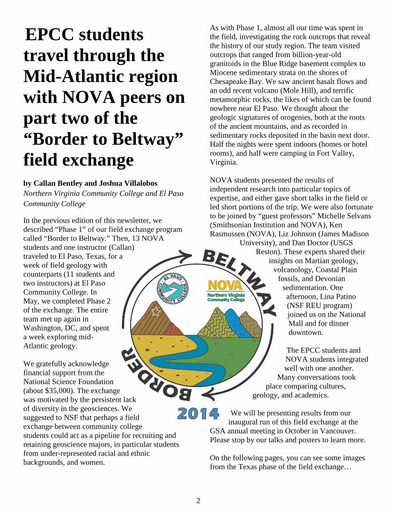
EPCC students travel through the Mid-Atlantic region with NOVA peers on part two of the “Border to Beltway” field exchange by Callan Bentley and Joshua Villalobos Northern Virginia Community College and El Paso Community College
In the previous edition of this newsletter, we described “Phase 1” of our field exchange program called “Border to Beltway.” Then, 13 NOVA students and one instructor (Callan) traveled to El Paso, Texas, for a week of field geology with counterparts (11 students and two instructors) at El Paso Community College. In May, we completed Phase 2 of the exchange. The entire team met up again in Washington, DC, and spent a week exploring mid-Atlantic geology. We gratefully acknowledge financial support from the National Science Foundation (about $35,000). The exchange was motivated by the persistent lack of diversity in the geosciences. We suggested to NSF that perhaps a field exchange between community college students could act as a pipeline for recruiting and retaining geoscience majors, in particular students from under-represented racial and ethnic backgrounds, and women.
As with Phase 1, almost all our time was spent in the field, investigating the rock outcrops that reveal the history of our study region. The team visited outcrops that ranged from billion-year-old granitoids in the Blue Ridge basement complex to Miocene sedimentary strata on the shores of Chesapeake Bay. We saw ancient basalt flows and an odd recent volcano (Mole Hill), and terrific metamorphic rocks, the likes of which can be found nowhere near El Paso. We thought about the geologic signatures of orogenies, both at the roots of the ancient mountains, and as recorded in sedimentary rocks deposited in the basin next door. Half the nights were spent indoors (homes or hotel rooms), and half were camping in Fort Valley, Virginia. NOVA students presented the results of independent research into particular topics of expertise, and either gave short talks in the field or led short portions of the trip. We were also fortunate to be joined by “guest professors” Michelle Selvans (Smithsonian Institution and NOVA), Ken Rasmussen (NOVA), Liz Johnson (James Madison
University), and Dan Doctor (USGS Reston). These experts shared their
insights on Martian geology, volcanology, Coastal Plain
fossils, and Devonian sedimentation. One afternoon, Lina Patino (NSF REU program) joined us on the National Mall and for dinner downtown. The EPCC students and NOVA students integrated well with one another.
Many conversations took place comparing cultures,
geology, and academics.
We will be presenting results from our inaugural run of this field exchange at the
GSA annual meeting in October in Vancouver. Please stop by our talks and posters to learn more. On the following pages, you can see some images from the Texas phase of the field exchange…

3
In the Mid-Atlantic region, geologic history and human history intertwine in unexpected ways. Here, the students visit Chapman’s Mill, site of a Civil War battle. The mill’s location is determined by a resistant fin of quartz arenite.
We examined Neoproterozoic sedimentary rocks that may record “Snowball Earth” glaciation.
When you’re wading through grass up to your waist, you know you’re not in Texas anymore.
The EPCC students were particularly enthusiastic about trying our local Chesapeake Bay crabs.
NOVA professor Ken Rasmussen led the Coastal Plain excursion.
Border to Beltway 2014 poses on the crest of Skyline Drive (Shenandoah National Park), with the ridge of Massanutten in the background.

4
Examining sedimentary rocks of the Valley & Ridge province in West Virginia.
We got to see the Potomac River in flood stage, more water than ever fills the Rio Grande.
The B2B crew stopped by the White House for a photo opportunity with the president (Obama is way, way, way, way, way in the background).
The students examined the sedimentary signature of the first two stages of Appalachian mountain building in the rocks of the classic Tumbling Run section near Strasburg, Virginia.
Lycopsid bark fossil found on Day 5 in the field.
Dan Doctor of the United States Geological Survey led the Corridor H trip.
5
Building the Ocean Science 2YC community: Community College Faculty at ASLO and the Ocean Sciences Meetings by Jan Hodder and Allison Beauregard Oregon Institute of Marine Biology, University of Oregon and Northwest Florida State College To continue to facilitate our efforts to build an ocean science two-year college (2YC) community, we have received funding from the National Science Foundation (NSF) for the past two years to facilitate the attendance of 2YC faculty at the Association for the Sciences of Limnology and Oceanography (ASLO) and Ocean Sciences meetings. At this year’s Ocean Sciences meeting, held in Hawaii, 27 2YC faculty who teach ocean science topics were supported by NSF to attend the entire meeting. We offered several opportunities for these faculty including an all- day workshop that focused on oceanography teaching resources and practices in two-year colleges. Topics covered included using on-line data, resources for teaching oceanography and including ocean career information in courses, and presentations about what 2YC faculty are doing in their ocean science courses. The workshop goals and products can be seen here. We also sponsored a paper and poster session within the meeting on opportunities and challenges of teaching introductory oceanography to undergraduates. The abstracts for this session can be viewed here. Almost all the 2YC faculty presented a paper and a poster in one of the meeting’s sessions. One of the faculty organized a group visit to the local aquarium and others arranged informal meetings to discuss common interests. Participants valued the opportunity to network with others who teach oceanography, to learn about current research in ocean sciences, make new contacts and discover resources to utilize in their teaching.
Community College Professors Get Outstanding Achievements Awards by Joshua Villalobos El Paso Community College
As community college professors we are accustomed to going above and beyond our duties to reach our students and sometimes our community. Sharing, and maintaining, our enthusiasm for geology to our audience is often a challenge considering our workloads, diverse student populations, and limited resources. Still, several of our peers in our 2YC community have chosen to take their devotion to the geosciences to new levels and have made profound changes in their community and to the geosciences. This year two geoscience educators will be recognized for their outstanding achievements to the geosciences at the fall meetings of GSA and AGU. At this year’s Geological Society of America’s Annual Meeting in Vancouver, Callan Bentley of Northern Virginia (NOVA) Community College will be the recipient of GSA’s Geoscience Education Division’s Biggs Earth Science Teaching Award. The Biggs award honors innovative and effective teaching from earth science instructors and faculty from all academic institutions engaged in undergraduate education, who have been teaching full-time for 10 years or less. Since 2007, Callan Bentley has posted +1000 posts about geoscience topics that he has encountered through his geological travels through his AGU blog Mountain Beltway which has since become a valuable resource for geoscience education for students, faculty, and enthusiast from around the world. His efforts on innovative pedagogies such as; the use of GigaPans, taking students to locales such as the Northern Rocky Mountains, Canadian Rockies, Eastern California, and West Texas through his NOVA Regional Field Geology courses, and other emerging technologies including podcasts, distance learning, virtual field work, Google Earth have given students and fellow faculty a valuable resource to learn from and a model to build on.
6
Also being honored this year, at this year’s American Geophysical Union Annual Meeting in San Francisco, is Scott Mandia of Suffolk County Community College of Long Island, New York. Scott will be recognized with the AGU Ambassador Award. This will be the first year the Ambassador Award will be presented with Scott being the sole 2YC professor of the 5 inaugural recipients chosen. The Ambassador Award recognizes AGU members who have made outstanding contributions in at least one of the four fields: societal impact, service to the Earth and space community, leadership of science, and talent pool and career development. Scott will be recognized for his work in the dissemination and education on the cause and effects of climate change and global warming along with the legal issues that engulf them both. His blog Global Warming: Man or Myth? and his work on the Climate Science Rapid Response Team, have provided an invaluable service to provide accurate information on climate science for government individuals and media who have climate questions. So the next time you see either you either Scott, Callan, or any of the many 2YC faculty who have been recognized for their outstanding work thank them not only for what they do for their students and to community but also for representing what 2YC professors can achieve.
President’s column by Merry Wilson Scottsdale Community College It’s that time of year – a new semester and academic year! I realize I’ve become entirely institutionalized. My year starts in August and ends
in May, and there is some “summertime” in the middle. As I started to regain focus on my job again, I realized that eruptions in Iceland, sinkholes in Siberia, and earthquakes in Napa perversely excite me.
Finding new websites that have great teaching tools,
like my very own Arizona State Geological Survey’s interactive map of geologic hazards or Dr. Laura Guertin’s ePortfolio, has also been helping to generate ideas and re-invigorate my curriculum. And, of course, I’m thinking about GSA in a few short months. There are a variety of short-courses designed with the 2YC in mind, like:
• 517A. Teaching Geoscience in Society: Building Relevance and Interest in the Geosciences by Adding InTeGrate Resources to Your Class
• 517B. Improving Spatial Thinking in the Geological Sciences
• 517C. Student Learning Outcomes and Program Assessment
• 517D. Extreme Makeover Geosciences Style—Infusing Existing Curricula with the Spirit of the New Next Generation Science Standards (NGSS): Integrating Content, Scientific and Design Practices, and Cross-Cutting Themes
• 518A. Teaching Controversial Issues 1: Climate and Energy
• 518D. Teaching Controversial Issues 2: Evolution of Life and Earth
• 519A. Digital Mapping and Data Collection for Field Environments
• 519B. GigaPan and GigaMacro for the Geosciences
• 519C. Google Maps Engine, Earth Engine, and Big GeoData
• 519D. Using Google Earth to Teach Interpretation of Geologic Processes, Bedrock Structures, and Geologic History
And that’s just on Saturday!!! The Geo2YC division is sponsoring several of these, as well as technical sessions throughout the week. I’ve struggled with registration, because I’m having trouble deciding what would most benefit my teaching and learning. If you are planning to attend GSA, please come to our annual 2YC meeting, Sunday 5:00-6:00. This is just prior to the Education Reception from 6:00-8:00. If this is your first GSA, please reach out so that we can help you navigate the system and take advantage of opportunities available. If you’ve attended many GSAs, please reach out and tell me what I’ve been missing! As always, if there is anything I can do to assist you, please let me know.
Merry
7
Vaughn receives latest Outstanding Adjunct Faculty Award
by Allison Beauregard Northwest Florida State College
We are proud to announce Thomas Vaughn of Middlesex Community College as the current Outstanding Adjunct Faculty awardee for the Geo2YC Division of NAGT. Thomas has received several prestigious teaching awards, including the Presidential Award for Excellence in Mathematics and Science; the Massachusetts Science Teacher of the Year; the Massachusetts Science Leader of the Year; the Distinguished Alumni from Boston University, UMass/Lowell, and Lesley University; and the Pathfinder Award for innovative use of technology in the classroom by the state of Massachusetts.
Thomas teaches Introduction to Oceanography and Marine Biology and Environmental Studies at Middlesex Community College, where his students value the high quality of his instruction. Regarding this role, he feels that “… the topics we [Geoscience faculty] teach are extremely important for the future of our planet. I have always devoted the necessary time and effort into my student lessons so that they learn significant content about Planet Earth. Some of my students have chosen to go on into majors in the geosciences.” In addition to the Middlesex community, Thomas is also a highly valued and active member of the Geoscience Education community. In this role, he has served two terms as the President of the NAGT New England Section, served on his campus’s Science Standards Revision Committee, and has had important input into the formulation of earth science standards in Massachusetts since 1996.
Congratulations to Thomas from all of us on the executive council of Geo2YC. Our programs wouldn’t be what they are without our part-time faculty and we are glad to be able to recognize Thomas in the amazing efforts he has contributed toward his department. He truly represents what makes the job of an adjunct faculty such a
challenge, and why we are so fortunate to have such great colleagues in our community. We are please to award Thomas with an honorary membership to the Geo2YC Division of NAGT for 2014 and he will be included in the pool to be our annual outstanding adjunct faculty awardee to be announced at GSA 2014 in Vancouver. If you know of one of your adjunct faculty who deserves recognition, please nominate them at: http://nagt.org/nagt/divisions/2yc/oafa_nomination.html.
EarthEd2YC on Hiatus until February 2015 Earth Education Resources for Two-Year College Faculty (EarthEd2YC) launched in March 2014 with a monthly webinar series that draws participants from across the country. Each webinar includes 30 minutes of professional development for full-time and part-time faculty seeking educational resources and other guidance from NASA’s Science Mission Directorate (SMD) Earth Science Education and Public Outreach Forum(SMD E/PO) and NAGT’s Geosciences for Two-Year Colleges (Geo2YC) professional division. The webinars are recorded and made available for later viewing. For example, the April webinar can be viewed at: https://www.youtube.com/watch?v=8cMzpbrxP80. Funding has been renewed through October 2015. EarthEd2YC is extending summer hiatus through the end of 2014 but we plan to be bigger and better in 2015! Presenters are always welcome. If you have resources designed for 2YC audiences and would like to host a webinar in the series, please contact Suzanne Metlay at [email protected]
foundations is edited by Callan Bentley, Northern Virginia Community College. Please get in
touch with your feedback: [email protected]

Education and outrEach
Cour
tesy
of D
ean
Live
lybr
ooks
Dean Livelybrooks
It’s 3 a.m.We’re on the starboard fantail of the R/V New
Horizon in rough seas. Our job is to recover an ocean-bottom seismometer that has been lying in 160 meters of water off the west coast of Vancouver Island, where it has been recording seismic signals and long-period pressure trends for the past year. The yellow seismometer, having received a remote command via sonic signal to release its anchor and rise to the surface, floats low in dark, roiling seas. One moment it is five meters below the deck, the next it is even with the railing. Connecting lines to it so we can winch it onto the deck is problematic. Erik
Bengston and Erika Jefferson, students at Portland Community College and Mt. Hood Community College, respectively, stand ready at the railing, hook lines in hand. They are experiencing what earth scientists do for a living as part of the Cascadia Initiative’s CC@Sea program.
CC@Sea places Oregon community college stu-dents aboard oceanographic research cruises, such as the R/V New Horizon, operated by the Scripps Institution of Oceanography, with the goal of giving these students a potentially life-changing experi-ence to share with their peers on their home com-munity college campuses.
COMMUniTy COllege
Research experiences for community college students build the STEM pipeline
Maya Tolstoy of the Lamont-Doherty Earth Observatory, chief scientist of the 2011 CC@Sea cruise, sits on an ocean-bottom seismometer as it is prepared for deployment on the R/V Wecoma.
aT seaaT sea
38 EARTH April 2013 www.earthmagazine.org
cbentley
Text Box
Originally printed in the April 2013 issue of EARTH Magazine, published by the American Geosciences Institute, and reprinted here with their permission.

Education and outrEachA
ll: c
ourt
esy
of D
ean
Live
lybr
ooks
With funding from the National Science Foundation (NSF), CC@Sea grew out of a previous community college-university collaboration: the NSF-funded Undergraduate Catalytic Outreach and Research Experience (UCORE) program. During the five years of UCORE, groups of three to six students each from six Oregon community colleges spent 10 summer weeks on the University of Oregon campus, working on projects alongside faculty and graduate students in chemistry, geological sciences and physics research groups (see sidebar page 43). Participants returned to their home community college campuses and tutored, gave talks, helped lead teaching labs, and recruited other students into science, technology, engineering and math (STEM) career pathways.
UCORE participants were five times more likely to transfer to a four-year university than were other community college students. In addition, the three participating University of Oregon science depart-ments saw a 10 percent increase in undergradu-ate enrollment on average, mostly attributable to interest from community college transfer students, including those influenced by UCORE participants on community college campuses. UCORE thus worked toward the goals of the NSF STEM Talent Enhancement Program (or STEP) to increase the number and diversity of STEM majors graduating from U.S. colleges and universities. CC@Sea picks up where UCORE left off in 2012, further building upon the earlier program.
CC@Sea participant Michelle Richter with the R/V Wecoma.
CC@Sea participant Erika Jefferson takes video on the fantail of the R/V New Horizon. Recovered Scripps Aba-lone ocean-bottom seismometers can be seen in the background.
CC@Sea participant Eric Head practices donning a survival suit as part of cruise safety procedures.
“Team Bubbles”: (left to right) Ore-gon State University graduate student Mark Williams, CC@Sea participant Eric Head and intern Paige Czoski, an undergraduate at New Mexico Tech, appear to still be awake after spending all night peering at acoustic surveys of a methane vent site.
EARTH April 2013 39www.earthmagazine.org
Education and outrEach
Cour
tesy
of D
ean
Live
lybr
ooks
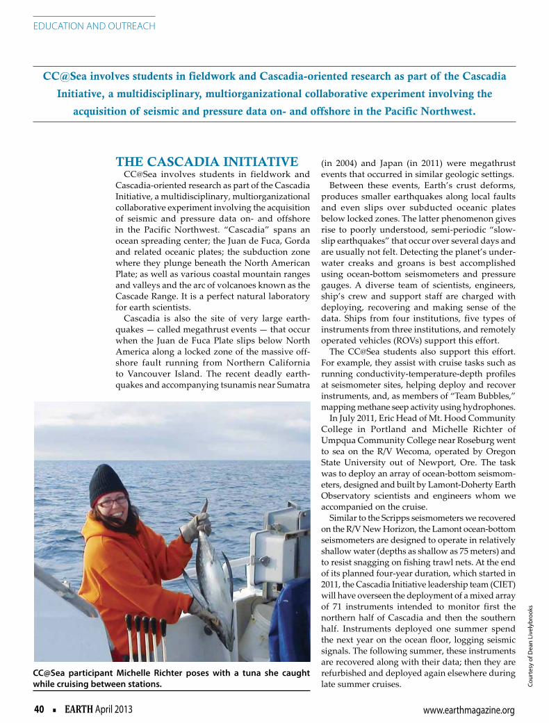
The CasCadia iniTiaTiveCC@Sea involves students in fieldwork and
Cascadia-oriented research as part of the Cascadia Initiative, a multidisciplinary, multiorganizational collaborative experiment involving the acquisition of seismic and pressure data on- and offshore in the Pacific Northwest. “Cascadia” spans an ocean spreading center; the Juan de Fuca, Gorda and related oceanic plates; the subduction zone where they plunge beneath the North American Plate; as well as various coastal mountain ranges and valleys and the arc of volcanoes known as the Cascade Range. It is a perfect natural laboratory for earth scientists.
Cascadia is also the site of very large earth-quakes — called megathrust events — that occur when the Juan de Fuca Plate slips below North America along a locked zone of the massive off-shore fault running from Northern California to Vancouver Island. The recent deadly earth-quakes and accompanying tsunamis near Sumatra
(in 2004) and Japan (in 2011) were megathrust events that occurred in similar geologic settings.
Between these events, Earth’s crust deforms, produces smaller earthquakes along local faults and even slips over subducted oceanic plates below locked zones. The latter phenomenon gives rise to poorly understood, semi-periodic “slow-slip earthquakes” that occur over several days and are usually not felt. Detecting the planet’s under-water creaks and groans is best accomplished using ocean-bottom seismometers and pressure gauges. A diverse team of scientists, engineers, ship’s crew and support staff are charged with deploying, recovering and making sense of the data. Ships from four institutions, five types of instruments from three institutions, and remotely operated vehicles (ROVs) support this effort.
The CC@Sea students also support this effort. For example, they assist with cruise tasks such as running conductivity-temperature-depth profiles at seismometer sites, helping deploy and recover instruments, and, as members of “Team Bubbles,” mapping methane seep activity using hydrophones.
In July 2011, Eric Head of Mt. Hood Community College in Portland and Michelle Richter of Umpqua Community College near Roseburg went to sea on the R/V Wecoma, operated by Oregon State University out of Newport, Ore. The task was to deploy an array of ocean-bottom seismom-eters, designed and built by Lamont-Doherty Earth Observatory scientists and engineers whom we accompanied on the cruise.
Similar to the Scripps seismometers we recovered on the R/V New Horizon, the Lamont ocean-bottom seismometers are designed to operate in relatively shallow water (depths as shallow as 75 meters) and to resist snagging on fishing trawl nets. At the end of its planned four-year duration, which started in 2011, the Cascadia Initiative leadership team (CIET) will have overseen the deployment of a mixed array of 71 instruments intended to monitor first the northern half of Cascadia and then the southern half. Instruments deployed one summer spend the next year on the ocean floor, logging seismic signals. The following summer, these instruments are recovered along with their data; then they are refurbished and deployed again elsewhere during late summer cruises.
CC@sea involves students in fieldwork and Cascadia-oriented research as part of the Cascadia
initiative, a multidisciplinary, multiorganizational collaborative experiment involving the
acquisition of seismic and pressure data on- and offshore in the Pacific northwest.
CC@Sea participant Michelle Richter poses with a tuna she caught while cruising between stations.
40 EARTH April 2013 www.earthmagazine.org

Education and outrEachBo
th: c
ourt
esy
of D
ean
Live
lybr
ooks
sPOTlighT On researCh CrUises
During the exciting seven-day cruise in 2012 on the New Horizon, Erik and Erika grew to appre-ciate the team effort needed to deploy electronic equipment underwater as the cruise progressed. They saw firsthand how everyone worked together.
Captain Ian Lawrence or Mates Rene Buck or Jack Purdy piloted the New Horizon to a site. There, marine engineer Martin Rapa — who had designed the bright yellow Teflon-coated Scripps Abalone seismometers — or engineers Paul Georgief and Ray Klein communicated with the ocean-bottom seismometers on the seafloor via acoustic signals, giving them commands such as “wake up.”
Aboard the ship, the tension rose palpably dur-ing every recovery, as we all listened closely for the chirps sent back by the instrument in response. The number of these chirps would tell us whether the instrument was still alive, if it had awakened as instructed, and if it had dropped its ballast and was ascending to the surface.
Back on the bridge, the captain or a mate, some-times with help from an assistant boatswain, moni-tored the radio direction finder for signals from the device. The recovery crew, led by NOAA cruise veteran and marine tech Matt Fowler and Scripps marine tech Josh Manger, pulled on rain gear, boots and safety gear before going out on deck, using the Nautilus crane to winch the seismometer onto the deck. The data from the instrument were down-loaded to computers once on board. Chief scientist Bob Dziak then made the important decisions as to where to go next.
It took several weeks for the data to be processed, including correcting for clock drift, determining
the final orientation of the three components of the seismometer after deployment, and removing extra-neous signals from, say, an octopus that decided the yellow Scripps Abalone made a fine shelter.
One message that Erik and Erika took back to their home community colleges is that science — marine geoscience in this instance — is an enter-prise requiring many hands, pairs of eyes and skill sets. The image of the lone scientist with a white lab coat and crazy hair just doesn’t fit.
This summer, CC@Sea-ers, who live on the University of Oregon campus for the summer while preparing for and finishing up after their cruises, will accompany scientists and crew on the Woods Hole Oceanographic Institution’s R/V Atlantis, equipped to use the ROV Jason to connect lines and recover Lamont ocean-bottom seismometers off Cape Mendocino, Calif.
And, like the UCORE and previous CC@Sea participants before them, when the students return from their research cruises, they will produce edu-cational and outreach videos telling stories about Cascadia science, and they will be supported at their home institutions as they help spread the word about geoscience and other STEM careers.
The instrument package deployed under a Lamont ocean-bottom seismometer is supported by three feet and self-levels on the ocean floor.
The crew prepares a Lamont ocean-bot-tom seismometer to deploy from the R/V Wecoma. At the end of the line is the release mechanism, which responds to acoustic signals from the ship.
One message that erik and erika took back to their
home community colleges is that science — marine
geoscience in this instance — is an enterprise requiring
many hands, pairs of eyes and skill sets. The image of
the lone scientist with a white lab coat
and crazy hair just doesn’t fit.
EARTH April 2013 41www.earthmagazine.org

Education and outrEach
Cour
tesy
of D
ean
Live
lybr
ooks
CaTalyzing inTeresT in sCienCe Careers
Through the UCORE and CC@Sea programs, 134 community college students have gained valuable experience in physical science research. They have also demonstrated that community college students can make solid contributions to research.
One of the primary reasons that community college students can be such assets is their strong work ethic; they typically hold several jobs dur-ing their studies and come to programs such as UCORE and CC@Sea ready to work hard. Because of this, University of Oregon scientists have been enthusiastic about developing CC@Sea and UCORE projects and working with participants.
Through summer research and ensuing “STEM career catalytic outreach” (as NSF describes it) on community college campuses, UCORE and CC@Sea participants have developed skills to par-ticipate in scientific discourse, promoting lively discussions of science in order to process their own experiences and to relate them to others. This bonding around science has meant that par-ticipants, upon return to their home campuses, effected changes in perception of science and engineering departments among other students and faculty on those campuses.
Based on interviews with students and faculty at UCORE participating community colleges, my colleague Clare Strawn (an Oregon-based
program evaluator for the International Society for Technology in Education in Washington, D.C.) and I have tracked this effect. Beyond cementing par-ticipants’ pursuit of four-year STEM degrees, com-munity college faculty have told us, for example, that students see the UCORE and CC@Sea students “greet [us professors] by name, and that really cre-ates a positive and welcoming sense and reduces some of the ‘science is scary’ feeling.”
This speaks to an important point for the design of future STEM career outreach programs: Considerable time is spent developing programs to maximize impact on participants, but frequently much less thought is given to how to leverage their experiences to positively affect nonparticipating students, STEM faculty, and the institutions in which they study and work. By working with “critical-mass-sized” groups of students from spe-cific institutions, including community colleges, outreach programs can do more than change the lives of participants, they can increase STEM pipe-line flow upstream and down.
Livelybrooks is a tenured senior instructor in the Department of Physics at the University of Oregon. His research interests include science education and outreach, magnetotellurics and dynamic margin model constraints. He is a geophysicist serving as the Cascadia Initiative Expedition Team Education and Outreach specialist. More information can be found at http://cascadia.uoregon.edu/CIET/ccsea.
The scientific crew of Leg 3 of the Cascadia Initiative sailed aboard the R/V New Horizon last summer. Erik Bengston is front row second from left, Erika Jefferson is rear row left and the author is middle row third from right.
42 EARTH April 2013 www.earthmagazine.org

CC@Sea: Spotlight on UCoRe pRojeCtS
Education and outrEachBo
th: c
ourt
esy
of D
ean
Live
lybr
ooks
The National Science Foundation-funded Undergraduate Catalytic Outreach and Research Experience (UCORE) program ran
from 2007 to 2012 and involved 132 students from six different community colleges in Oregon. During the five years of the UCORE program, groups of three to six community college students from each campus spent 10 weeks in the summer on the University of Oregon campus, working on proj-ects alongside graduate students and faculty in chemistry, geological sciences and physics research groups. Listed below are some of the projects in which the students were involved.
geomoRphology of the oRegon CoaSt Range
UCORE participants Beckah Pickard and Tim Stimpson, undergraduates at the Rock Creek cam-pus of Portland Community College (PCC) and Umpqua Community College (UCC) near Roseburg, Ore., respectively, spent the summer of 2010 work-ing in University of Oregon geomorphologist Josh Roering’s research group, helping graduate student Jill Marshall characterize the geomorphology of the Oregon Coast Range, which overlies the Cascadia Subduction Zone.
Beckah and Tim dug holes and trenches where they measured the depth to bedrock, characterized
Spotlight on UCoRe projects
soil-forming processes as biotic or abiotic, and mea-sured the diameter of tree stumps in study areas. The students’ research contributed to an improved under-standing of how vegetation and ecosystem dynamics contribute to erosion and landforms, which, in turn, affect forest fire trends, marine sedimentation and fish genetics, among other things.
UCORE fellows and University of Oregon faculty, students and staff attend the 2010 end-of-summer UCORE poster session.
Research sponsor professor Josh Roering of the University of Oregon and 2010 UCORE fellow Beckah Pickard with her poster presentation on her research characterizing the geomorphology of the Oregon Coast Range.
EARTH April 2013 43www.earthmagazine.org

CC@Sea: Spotlight on UCoRe pRojeCtS
Education and outrEach
Gen
e Iw
atsu
bo, U
.S. G
eolo
gica
l Sur
vey
aRSeniC Contamination of wateR wellS
University of Oregon biogeochemist Qusheng Jin is interested in how bacteria found in groundwater convert insoluble, relatively benign sulfur and arsenic found in Cascadian volcanic rocks into more hazard-ous mobile forms that contaminate well water. He is also interested in producing generalized models of how microbial diversity impacts biogeochemistry in specific environments. Undergraduates Victor Benavides Montes and Jesse Klinger — of the Sylvania and Rock Creek campuses of PCC, respec-tively — assisted in the summer of 2010 with soft-ware tools such as the Geochemist’s Workbench.
Under Jin’s guidance, Victor and Jesse devel-oped mathematical models for how organisms and nutrients would evolve in a hypothetical test cube, testing how microbial diversity, particularly among sulfate-reducing bacteria, impacts ecosystem func-tion and environmental alteration.
“I thought the science [that university scientists] worked on was way too far-fetched for any of it to be put into laymen’s terms or for me to understand,” Victor says. “But after working with Qusheng Jin and seeing all my other UCORE fellows’ labs, I noticed that these ideas can be very attainable. We are all curious people looking for fundamental and pretty simple answers.”
The summer before Victor and Jesse’s project, PCC-Sylvania student Matthew Gibson spent his UCORE summer helping Jin collect water samples in wells in Lane and Douglas counties in Oregon, testing for arsenic contamination and relating it to how bacteria in aquifers process arsenic from fixed to more mobile (and thus hazardous) chemical forms.
“My UCORE experience gave me some insight into the world of groundwater hydrology, which I wouldn’t have otherwise received,” Matthew says. He plans to pursue certification as a registered geologist after finishing his bachelor’s in geology with a GIS and computer science concentration at Portland State University (PSU) this year. Victor’s career trajectory was also strongly influenced by participation in UCORE, he says. “I truly believe without the UCORE credentials, this domino effect — an REU [a National Science Foundation Research Experience for Undergraduates program], research in a PSU lab, and impending com-pletion of a bachelor’s — would’ve never happened.”
Dome BUilDing on moUnt St. helenS
Following the catastrophic eruption of Mount St. Helens in 1980, the volcano’s dome began building again in 2004, occasionally erupting small volumes of dacite that built substantial, rocky spines in the crater. Scientists are interested in how dome-building erup-tions might relate to episodic “drumbeat” earthquakes detected below the mountain.
In 2009, UCORE participant Naomi Meacham, then a student at UCC, worked with University of Oregon geophysicist Alan Rempel’s research team to help ana-lyze stereographic digital images documenting dome growth within the crater. Digital elevation models were developed and analyzed to quantify dome growth, characterize associated faulting and compare fault slip with seismic records of drumbeat earthquakes.
epiSoDiC tRemoR anD Slip in CaSCaDia
University of Oregon researchers Ray Weldon, David Schmidt and I (Dean Livelybrooks) study “slow earth-quakes,” known as episodic tremor and slip, in Cascadia. In particular, we’re interested in how these earthquakes transfer stress seaward to a zone that’s locked on the Cascadia Fault, and how that stress, in turn, results in surface deformation on the coast and at the “epicen-ters” of episodic tremor and slip.
Over two UCORE field seasons, community college students, including Stacy Smith (2008, PCC-Sylvania, now a graduate of PSU with a degree in geology), Codi Quimby (2009, Mt. Hood Community College,
Some UCORE students have studied Mount St. Helens, which began erupting a new lava dome in 2004. The volcano is seen here in October 2004 from the Johnston Ridge Observatory.
44 EARTH April 2013 www.earthmagazine.org

CC@Sea: Spotlight on UCoRe pRojeCtS
Education and outrEachA
ll: c
ourt
esy
of D
ean
Live
lybr
ooks
now double-majoring in geology and anthropol-ogy at PSU), Jamee Buhr (2010, formerly at Mt. Hood Community College, now a geology major at PSU) and Brittany (Croes) Symes (2010, PCC-Sylvania) helped install and run a network of tide gauges along coastal rivers, the Puget Sound and the Olympic Peninsula in Washington. Careful processing of the resulting data revealed small amounts of uplift associated with active coastal deformation, as well as episodic tremor and slip events farther inland.
Installing tide gauges can be challenging. Jamee and Brittany recall wading into deep, cold water at 6 a.m. on a lonely beach along the Strait of Juan de Fuca to see if they could install a gauge on an abandoned piling once used to tie up timber barges. Cold water pouring in over their chest waders forced them to retreat back to the beach. Another time, after a particularly difficult installation, Jamee ended up swimming in the ocean, holding an unprotected video camera above her head to record and calibrate water level on a gauge.
“I so enjoyed and was amazed by my opportunity to participate in the UCORE research program that I couldn’t stop talking about it,” Jamee says. “I always carry my great UCORE experience with me and wow my fellow classmates at Portland State with the knowl-edge and advantages I gained through participating in the program.”
It is stories like these that the students carried back to their community college peers to demonstrate the fun and excitement of scientific research.
DL
Symes (on ladder) and Burh (foreground) and former University of Oregon physics student Tamela Maciel install a tide gauge near Aber-deen, Wash., as part of an array to measure small water-level changes associated with episodic tremor and slip.
2010 UCORE fellows Brittany (Croes) Symes (left) and Jamee Burh (right) with their posters about their projects on episodic tremor and slip.
EARTH April 2013 45www.earthmagazine.org