Emerging Islamic Representations in the Cambodian Muslim ...

FORMATION OF THE ISLAMIC CITY: A SECOND ARCHAEOLOGICAL PERIOD OF URBAN
TRANSITION
DONALD WHITCOMB
AbstrAct
This paper will explore archaeological patterns of Islamic urbanism based on the conceptualisation of Bacharach (1991) and the ‘palatine complex’ discussed in Wheatley (2001). This second phase has been described for the cities of Baghdad and Samarra; it is most clear in the succession of foundations in Egypt leading up to al-Qahira. Recent excavations on cities of southern Bilad al-Sham illustrate this ‘palatine complex’ development, as in the examples of Qaysarea, Ramla, and Tabariya during the late Abbasid and Fatimid periods. Bacharach describes this urban pattern as ‘the transformation of urban centers into Muslim cities’ (1991: 120-1), which may lead to a model for the Middle Islamic city.
This examination of the transformations of the Islamic city may begin with the archaeological site of Ayla (modern Aqaba, Jordan). Excavations undertaken by the author from 1986 to 1995 revealed an early Islamic town, founded before or during the Umayyad period and continuing into the Fatimid period. The geographer Eugen Wirth compares the plan of al-Qahira with that of Ayla, as ‘zwei frühislamische Gründungsstädte’ (2000: fig. 22). This paper takes as its premise the intriguing comparison and its implications about the early development of the Islamic city (Fig. 1). On a basis of scale and presumed complexity this comparison would seem a matter of ‘apples to oranges’, and indeed one might question the urban nature of both Ayla and al-Qahira in its earliest phase. Neither foundation was a misr, strictly speaking; or, depending on one’s definition, could they both have been part of this phenomenon?
Defining the Misr
The meaning of the misr (pl. amsar) has been much discussed in the study of the beginnings of the Islamic city. The Muslim conquest brought Arab armies into the highly urbanised provinces of the Byzantine and Sasanian empires. These troops were settled in camps, often styled garrisons, near older centres; these foundations

Donald Whitcomb620
prospered and almost always became famous Islamic cities, Basra, Kufa, Fustat, Qayrawan. The list of amsar can be expanded to include virtually any place Muslims settled in numbers (Reitmeyer 1912) and indeed, the cognate ‘tamsir’ seems to mean to settle or found a settlement.1
The physical structure of the misr usually begins with an assumption of the camp of tents, then some mudbrick, and finally some stone structures; this is accompanied by assumptions of disorganised if not chaotic layout. Better understanding of camps and, more importantly, Arab familiarity with cities and their own urban tradition has revised these prejudicial concepts. Moreover, as Kubiak notes concerning Fustat, this misr was at least the third founded and its leaders must have realised they were planning a future capital city (1987: 66). Each foundation had a central district with the jami‘ mosque and dar al-imara, also dars (also called qasrs; elite residences); around this centre the khitat or ethnic allotments were marked out (as the name implies). Needless to say, archaeological evidence for the amsar is only slowly focusing on indirect hypotheses and lines of evidence.
seconDAry AMsAr: the PAlAtine coMPlex
In a recent seminar, I presented a paper on problems of urbanism in the second transition, 850-1100, what might be termed the process ‘from misr to madina’. 2 One may begin with Bacharach’s three phases in locational analysis of early Islamic cities. His earliest phase stresses the centrality of the mosque tied with the dar al-imara, the unified focus of religion and administration that was surrounded by open markets and residential blocks (1991). His second phase describes a radical shift with the foundation of a new ‘palatine complex’ away from the population, that is, separated from the older urban centre. While there are earlier examples, the pattern is writ largest and in most dramatic fashion in the foundation of Samarra in Iraq. Samarra presents a sequence of separate foundations in the 9th century: from Qatul in the south, to Muta‘sim’s ‘Surra man ra‘a’ in the center, to al-Mutawakkiliyya in the north. This last ‘city’ is the clearest illustration of the process, since it was founded and soon abandoned around AD 860 (Fig. 2). This new foundation consisted of a residential area, the mosque of Abu Dulaf, and separate palace complex of al-Ja‘fari (Northedge 2007).
In 868, just after al-Mutawakkil’s ill-fated expansion of Samarra, Ibn Tulun consolidated his rule with the foundation of al-Qata’i‘ in direct imitation of Samarra. The urban history of Cairo begins with Fustat, the misr founded in 642, and then a
1 For a well considered usage of the terms misr and tamsir, see the recent article by Kennedy 2006.2 This paper is a short version of a longer study of ‘Urban cycles and the archaeology of the Middle
Islamic city’, prepared for a seminar on the Concept of Urban Change at the Hebrew University in 2009. I wish to thank Drs Gideon Avni and Ronnie Ellenblum for their advice and encouragement in this research.

Formation Of The Islamic City 621
series of expansions to the north. Ibn Tulun laid out a grid of 1000 wards around an exceptionally large mosque, palaces and elite residences (of which only the famed mosque remains). After another century, the Fatimids founded yet another city on very similar principles (military sectors, palaces, a mosque, and elite residences: Denoix 2008). A distinction for this 10th-century ‘palatine complex’ was, for the first time, a strong city wall (Fig. 3). The resulting settlement was a ‘compound city’; the continuing vitality of Fustat induced some observers to speak of the misrayn (old and new, lower and upper), or indeed the older pattern of rabad (birun) and madina (shahristan).
Al-Qahira was organised as a formal, palatial complex: central was first the palace of al-Mu‘izz and secondly that of al-‘Aziz. An axial street and parade ground is remembered in the toponym ‘Bayn al-Qasrayn’ (between the two palaces). The first mosque, al-Azhar, was in the south-eastern sector. Much of the remainder was left open or marked out as allotments for tribal or ethnic groups (i.e. khitat).
exAMPles froM PAlestine
A few specific examples may be drawn from southern Bilad al-Sham in order to elicit features of urbanism in the late Abbasid and Fatimid period as a second transition and the precursor of the Middle Islamic city. This period and particularly the 11th century is often taken as a dramatic break, an ‘archaeological fault’ (Ehrlich 2002: 52), with a decline of ‘state’, the rise of nomads, and even earthquakes (AD 1033 and 1068). In addition, a new ethnic of military capability appeared, the Turkish presence. It has often been seen as a cultural wasteland; and thus Kennedy can state that ‘between the death of Harun al-Rashid in 809 and the coming of the Fatimids in 969 there is not a single extant dated monument in the entire area of greater Syria’ (2001: 235; 1992: 106). Even more implausibly, LaBianca finds no settlement remains for the same period (1990: 241); archaeologically, at least, one is dealing with a transitional period (Whitcomb 1994, 1995).
One might begin with Caesarea (or Qaysariyya) due to the extensive excavations and recent syntheses of this information. The inner harbour and Area LL excavations demonstrate the foundation of a new urban district with a new orientation apparently laid out in the late 9th century (Arnon 2008; Stabler et al. 2008). The mosque proposed by many to be located on the Temple Platform is in an unusual position, however admired by al-Muqaddasi and Nasir-i Khusraw in the late 10th-11th century. The 9th-century walls also suggest a later Islamic settlement (these were incorporated into the Crusader fortifications: G. Avni, pers. com.).
Thus the city witnessed by al-Muqaddasi was not that of Mu‘awiya, of the 640s or later. This early Islamic foundation was probably located to the south-east, the likely area of the hadir (pre-Islamic Arab settlement), the early Islamic fort (built upon the Classical theatre), and a possible mosque (Fig. 4). The original Islamic town became
Donald Whitcomb622
the populous suburb, the rabad, in relation to the madina or new urban extension laid out in Tulunid and developed in Fatimid times (Whitcomb 2011).
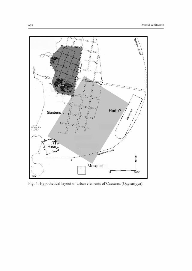
While this port served the maritime interests of these Egyptian dynasties, the city of Ramla continued in its role as capital of Filastin (as witnessed by its mint designation: Avni and Gutfeld 2008). Extensive salvage and larger excavations have sought to determine the structure of this city. For many scholars, the town of ‘Anjar, built in the same years, might serve as a model with its four axial gates named for principal destinations (al-Quds, Lud, Yafa, and Misr [Egypt]; Luz 1997, Whitcomb 1995: 492). However, al-Muqaddasi lists three additional gates located to the south-east, making a systematic circuit around the city of Ramla. By the late 10th century (and thus antecedent to the earthquakes and arrival of the Seljuqs), the city had expanded with this new ‘palatine complex’ with its own mosque and walls. Thus Ramla was a compound city of a rabad (the old city) and the new Fatimid madina (Fig. 5).
Farther to the north was Tiberias (or Tabariyya), the prosperous capital of al-Urdunn. Again archaeological research has shown an extensive early Islamic occupation, and the recent discovery of the jami mosque places the early Islamic town firmly in the middle of the extended site (Cytryn-Silverman 2009). Once thought to be the misr of Tabariyya (Harrison 1992), the orthogonal layout under the modern town may have been another ‘palatine complex’ of the Fatimid period (Fig. 6). This new city, perhaps with the Jasmine mosque mentioned by Nasir-i Khusraw, attracted the Crusaders for development (as had the palatine foundations in Caesarea and Ramla).
suMMAtion
These cities may be described as ‘dynastic towns’ and seem to recapitulate the experience of the amsar, that is, development from camp to garrison to city. In this later period, this was an accelerated process due to the known structural model being sought. There was an intentionality and precise expectations of function and aesthetic for the resulting settlement. The new urban entity, grafted onto the older town (relatively, its qasaba), became a compound structure. In effect this relationship would have been identifiable to al-Muqaddasi and others experienced with cities of the eastern, Iranian world as the madina - rabad complex. The resulting urban form may be considered the precursor for the Islamic city of Mamluk and later times.
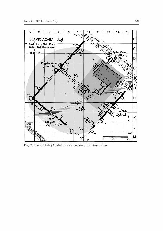
One may return to Ayla, where excavations show a settlement sequence from Iron-Age Tell Kheleifa, to Byzantine Aila, to early Islamic Ayla, and finally the 12th-century fort of Aqaba (Whitcomb 1988). Early Islamic Ayla was rebuilt in Abbasid times, possibly due to earthquake damage. By the 10th-11th century, one hears of troubles with the Qarmatians and Jarrahids, especially the battle of Aqaba in 982 and its sack in 1024. ‘Once again, the spectre of thundering hordes may be overdrawn and suggestions of decline and collapse mask complex social and religious movements’ (Whitcomb 2008: 490). Thus Aqaba illustrates a cyclical process of urbanism in which

Formation Of The Islamic City 623
the 11th century seems to mark a transition, as seems the case in many other sites and regions.
Internal development of Aqaba may illustrate a more subtle urban change within this period. The plan of the archaeological site shows the early walls, but most of the buildings excavated belong to the later Abbasid/Fatimid phases. Thus one might interpret the Central Pavilion as a ‘central palace’, see the mosque rebuilt in a peripheral location, and commercial expansion in a new seafront suq, all elements of a later phase of urban planning (Fig. 7). This pattern suggests that the ‘palatine complex’, the secondary misr, is not the only model for the Middle Islamic city. There were other transformations (archaeological patterns) that remain to be discovered, but this is the subject of another paper.
Bibliography
Arnon, Y.D.2008 Caesarea Maritima, the late periods (700-1291 CE), BAR International
Series 1771, Oxford.Avni, G., Gutfeld, O. 2008 Ramla: in E. Stern (ed.), New Encyclopedia of archaeological excavations
in the Holy Land 5, suppl. vol., Jerusalem, 2007-2010. Bacharach, J.L. 1991 Administrative Complexes, Palaces, and Citadels: Changes in the Loci of
Medieval Muslim Rule: in I. Bierman, R. Abou-El-Haj, D. Preziosi (eds), The Ottoman city and its parts: Urban structure and social order, New Rochelle, NY, 111-28.
Cytryn-Silverman, K. 2009 The Umayyad mosque of Tiberias: in Muqarnas 26, pp. 37-61.Denoix, S. 2008 Founded cities of the Arab world from the seventh to the eleventh centuries:
in S.K. Jayyusi (ed.), The City in the Islamic world, Vol. 1, Leiden, 115-39.
Ehrlich, M. 2002 The Frankish impact on the urban landscape of medieval Palestine: in Y.
Lev (ed.), Towns and material culture in the medieval Middle East, The Medieval Mediterranean 39, Leiden, 41-52.
Harrison, T.P. 1992 The Early Umayyad settlement at Tabariyah: A case of yet another misr?: in
Journal of Near Eastern Studies 51, pp. 51-59.

Donald Whitcomb624
Kennedy, H. 1992 Nomads and settled people in Bilad al-Sham in the fourth/ninth and fifth/
tenth centuries: in M.A. Bakhit, R. Schick (eds), Bilad al-Sham during the Abbasid period, Amman, pp. 105-113.
2001 Islam: in G.W. Bowersock, P. Brown, O. Grabar (eds), Interpreting Late Antiquity: Essays on the postclassical world, Cambridge, MA, 219-37.
2006 From Shahristan to Medina: in Studia Islamica 102-103, pp. 5-34.Kubiak, W.B.1987 Al-Fustat: Its Foundation and early urban development, Cairo.LaBianca, O.S. 1990 Sedentarization and nomadization: Food system cycles at Hesban and
vicinity in Transjordan, Hesban 1, Waltham, MA.Luz, N.1997 The Construction of an Islamic City in Palestine. The Case of Umayyad al-
Ramla: in Journal of the Royal Asiatic Society series 3, 7, pp. 27-54.Northedge, A.2007 The Historical topography of Samarra, London.Reitmeyer, E.1912 Die Städtegrundungen der Araber im Islam nach den arabischen
Historikern und Geographen, Munich.Stabler, J., Holum, K.G., Stanley, F.H., Risser, M., Iamim, A.2008 The Warehouse quarter (area LL) and the Temple Platform (area
TP), 1996-2000 and 2002 seasons: in Caesarea reports and studies: Excavations 1995-2007 within the old city and the ancient harbor, BAR International Series 1784, Oxford, 1-39.
Wheatley, P.2001 The Places where Men Pray Together: Cities in Islamic Lands, Chicago.Whitcomb, D.1988 A Fatimid residence at Aqaba, Jordan: in Annual of the Department of
Antiquities of Jordan 32, pp. 207-224.1994 Amsar in Syria? Syrian cities after the conquest: in ARAM Periodical 6, pp.
13-33.1995 Islam and the socio-cultural transition of Palestine, early Islamic period
(638-1099 C.E.): in T. Levy (ed.), The Archaeology of Society in the Holy Land, London, 488-501.
2008 The Umayyad and Abbasid periods: in R.B. Adams (ed.), Jordan, an archaeological reader, London, 483-93.
2011 Qaysariya as an early Islamic settlement: in K.G. Holum, H. Lapin (eds), Shaping the Middle East: Jews, Christians, and Muslims in an Age of Transition, Bethesda, MD, 65-82.
Wirth, E. 2000 Die Orientalische Stadt im islamischen Vorderasien und Nordafrika, Mainz.

Formation Of The Islamic City 625
Fig. 1: Comparison of ‘Kairo al-Qahira und Aqaba-Ayla’. Source: Wirth 2000: fig. 22.

Donald Whitcomb626
Fig. 2: Plan of the north section of Samarra. Source: after Northedge 2007: fig. 92.

Formation Of The Islamic City 627
Fig. 3: Hypothetical layout of regions of Fustat and al-Qahira.
Donald Whitcomb628
Fig. 4: Hypothetical layout of urban elements of Caesarea (Qaysariyya).
Formation Of The Islamic City 629
Fig. 5: Hypothetical layout of Ramla.

Donald Whitcomb630
Fig. 6: Hypothetical layout of Tiberias (Tabariyya).
Formation Of The Islamic City 631
Fig. 7: Plan of Ayla (Aqaba) as a secondary urban foundation.