Contentscf.forestry.oregonstate.edu/sites/cf/files/blodgett_plan.pdf · Blodgett Forest Plan 3...
55
Blodgett Forest Plan 1 Contents Contents .................................................................................................................... 1 The Planning Team ............................................................................................................. 3 Charge to the Team ............................................................................................................ 3 Introduction ............................................................................................................. 3 Development History .......................................................................................................... 3 Mission ........................................................................................................................ 5 Goals ............................................................................................................................ 5 1. Forest Structure ............................................................................................................. 5 Upland Areas .............................................................................................................. 5 Riparian Areas ............................................................................................................ 5 2. Revenue ......................................................................................................................... 5 3. Research, Demonstration and Extension ........................................................................ 5 4. Good Neighbor ............................................................................................................... 5 Preface ........................................................................................................................ 6 Upslope management philosophy ....................................................................................... 7 The role of dead wood .................................................................................................. 7 The role of hardwoods ................................................................................................. 8 Riparian management philosophy ...................................................................................... 8 Research, demonstration and extension ........................................................................... 10 Income stream ................................................................................................................. 10 Location .................................................................................................................. 11 Native American Use ................................................................................................. 13 History ..................................................................................................................... 13 Early Euro-American Use .......................................................................................... 13 Railroad Logging Era ................................................................................................. 14 Acquisition by OSC ................................................................................................... 14 Management under OSC (later OSU) ......................................................................... 15 Current Forest Condition ................................................................................ 16 Vegetation ........................................................................................................................ 17 Wildlife ............................................................................................................................. 18 Sensitive vertebrates ................................................................................................. 18 Fish ........................................................................................................................... 18 Geology ......................................................................................................................... 19 Cultural Resources .......................................................................................................... 20 Railroad grades ......................................................................................................... 20 Logging camp ............................................................................................................ 20 Native American Sites ................................................................................................ 20 Desired Future Condition ............................................................................... 20
-
Upload
truongkhanh -
Category
Documents
-
view
215 -
download
3
Transcript of Contentscf.forestry.oregonstate.edu/sites/cf/files/blodgett_plan.pdf · Blodgett Forest Plan 3...
Blodgett Forest Plan 1
Contents
Contents ....................................................................................................................1The Planning Team............................................................................................................. 3Charge to the Team ............................................................................................................ 3
Introduction .............................................................................................................3Development History .......................................................................................................... 3
Mission........................................................................................................................5
Goals............................................................................................................................51. Forest Structure ............................................................................................................. 5
Upland Areas .............................................................................................................. 5Riparian Areas ............................................................................................................ 5
2. Revenue ......................................................................................................................... 53. Research, Demonstration and Extension ........................................................................ 54. Good Neighbor ............................................................................................................... 5
Preface ........................................................................................................................6Upslope management philosophy ....................................................................................... 7
The role of dead wood .................................................................................................. 7The role of hardwoods ................................................................................................. 8
Riparian management philosophy ...................................................................................... 8Research, demonstration and extension ........................................................................... 10Income stream ................................................................................................................. 10
Location .................................................................................................................. 11Native American Use ................................................................................................. 13
History ..................................................................................................................... 13Early Euro-American Use .......................................................................................... 13Railroad Logging Era ................................................................................................. 14Acquisition by OSC ................................................................................................... 14Management under OSC (later OSU) ......................................................................... 15
Current Forest Condition................................................................................ 16Vegetation ........................................................................................................................ 17Wildlife ............................................................................................................................. 18
Sensitive vertebrates ................................................................................................. 18Fish ........................................................................................................................... 18
Geology ......................................................................................................................... 19Cultural Resources .......................................................................................................... 20
Railroad grades ......................................................................................................... 20Logging camp ............................................................................................................ 20Native American Sites ................................................................................................ 20
Desired Future Condition ............................................................................... 20
2 Blodgett Forest Plan
Planning Process ................................................................................................ 22Choice of Stand Types and Management Units ................................................................. 23Prescription Development................................................................................................. 23
Upland Stands .......................................................................................................... 23Existing Stands .................................................................................................. 23Future Stands .................................................................................................... 24
Riparian stands ......................................................................................................... 24Prescription Development ................................................................................... 24Stream types ...................................................................................................... 24Management Regime= ......................................................................................... 25
Wood Delivery to Streams ................................................................................................ 26Forest Health Considerations .................................................................................... 28
Wind................................................................................................................... 28Fire..................................................................................................................... 28Pathogenic fungi and insects .............................................................................. 28
Prescribed burning........................................................................................................... 29Exotic Species .................................................................................................................. 30Cultural Resources .......................................................................................................... 30Transportation System ..................................................................................................... 31Determining Levels of Dead Wood .................................................................................... 32
Goal Achievement ............................................................................................. 34Forest Structure ............................................................................................................... 35Net Revenue ..................................................................................................................... 36Research, Demonstration and Extension .......................................................................... 36Good Neighbor ................................................................................................................. 36
Harvest Schedule ................................................................................................ 36Assumptions .................................................................................................................... 37
Log Price and Harvest Costs ...................................................................................... 37Log Prices ........................................................................................................... 37Harvest Costs ..................................................................................................... 37Reforestation Costs ............................................................................................. 39
Defect and breakage .................................................................................................. 40Harvest Schedule Results ................................................................................................. 40
Forest Structure ........................................................................................................ 41Harvest Volumes ....................................................................................................... 41Income ...................................................................................................................... 41
Monitoring............................................................................................................. 47Sensitive species monitoring ...................................................................................... 47Response of biotic communities to dead wood ........................................................... 47
Communication and Decision Making ..................................................... 48Interpreting and Revising the Forest Plan ......................................................................... 49
Demonstration and Extension Activities ................................................. 50Potential Audience ..................................................................................................... 51
Resource Professionals ....................................................................................... 51General Public .................................................................................................... 51
Develop Partnerships ................................................................................................ 51Facilities .................................................................................................................... 51Personnel .................................................................................................................. 52
Literature Cited.................................................................................................... 52

Blodgett Forest Plan 3
Introduction
The Planning Team
The planning team was made up of the following
faculty members:
John Sessions (chair), Forest Engineering
Douglas Brodie, Forest Resources
John Hayes, Forest Science
David Hibbs, Forest Science
Katy Kavanagh, Forestry Extension
David Marshall, Forest Resources
Michael Newton, Forest Science
Arne Skaugset, Forest Engineering
Staff to the team were:
Noel Bachellor, Research Forests
Doug Bateman, Forest Science
Debbie Johnson, Research Forests
Dave Lysne, Research Forests
Ann Rogers, Research Forests
Janet Ross, Research Forests
Brian Sharer, Forest Resources
Jeff Starnes, Research Forests
Charge to the Team
To design a plan that will:
1. Develop the Blodgett Tract as a model research
and demonstration forest emphasizing maximization
of economic efficiency while meeting public goals for
environmental protection, especially fish and wildlife
habitat.
2. Demonstrate COPE findings on a larger scale than
was used during the COPE studies, with careful
documentation of economic costs and returns.
Development History
On September 30, 1997 the Dean formed the team
that would develop the Blodgett Tract plan. On
November 13 the team had its first meeting in Peavy
Hall where it received its charge from the Dean.
Subsequently a team field trip was made to the
Blodgett Tract on December 1, followed by a meeting
in Astoria where the team drafted an action plan and
established a Summer 1998 delivery date for the
presentation of a draft plan to the Dean.
The team held 10 meetings which occurred on the
afternoons of January 15, February 16, March 16,
April 24, May 15, June 2, July 2, August 3, 10 and
14. A work-in-progress presentation was made to the
Dean and Administrative committee on August 17.
In a follow-up email the Dean requested additional
information on the sensitivity of the harvest schedule
to forest structure goals. Following summer recess,
the team had a meeting on October 15 to review the
first draft of the planning document and make
decisions for completing the written plan. On
December 15 -16 the team and staff again visited the
Blodgett Tract to review the plan in the field. On
April 20, 1999 the plan was delivered to the Dean
and Administrative committee.
4 Blodgett Forest Plan
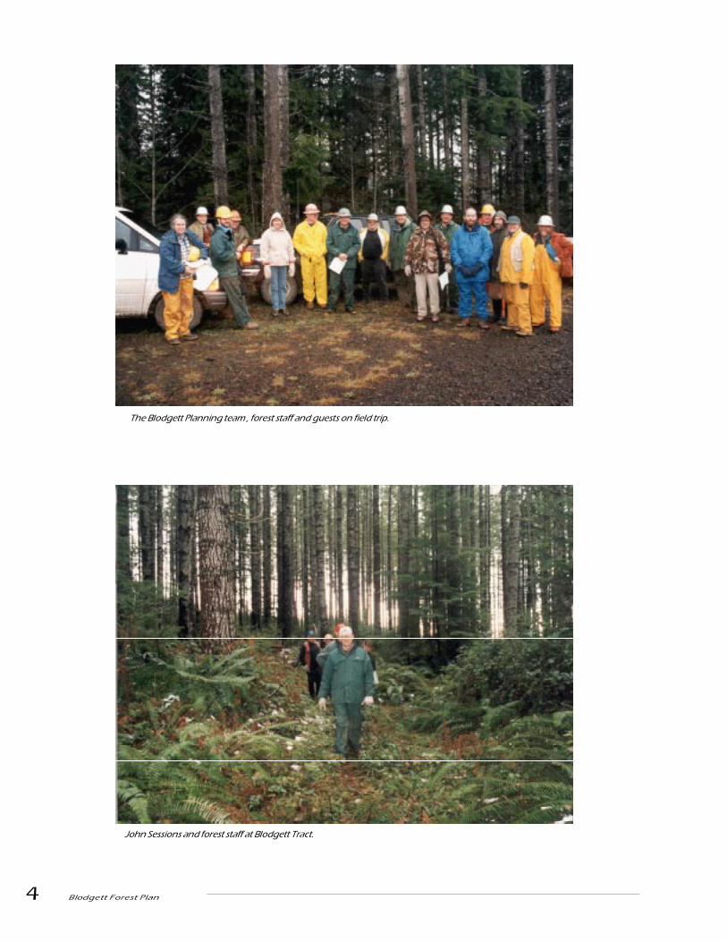
John Sessions and forest staff at Blodgett Tract.
The Blodgett Planning team , forest staff and guests on field trip.
Blodgett Forest Plan 5
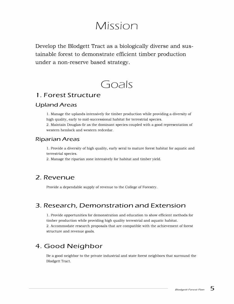
Mission
Develop the Blodgett Tract as a biologically diverse and sus-
tainable forest to demonstrate efficient timber production
under a non-reserve based strategy.
Goals1. Forest Structure
Upland Areas
1. Manage the uplands intensively for timber production while providing a diversity of
high quality, early to mid-successional habitat for terrestrial species.
2. Maintain Douglas-fir as the dominant species coupled with a good representation of
western hemlock and western redcedar.
Riparian Areas
1. Provide a diversity of high quality, early seral to mature forest habitat for aquatic and
terrestrial species.
2. Manage the riparian zone intensively for habitat and timber yield.
2. Revenue
Provide a dependable supply of revenue to the College of Forestry.
3. Research, Demonstration and Extension
1. Provide opportunities for demonstration and education to show efficient methods for
timber production while providing high quality terrestrial and aquatic habitat.
2. Accommodate research proposals that are compatible with the achievement of forest
structure and revenue goals.
4. Good Neighbor
Be a good neighbor to the private industrial and state forest neighbors that surround the
Blodgett Tract.

6 Blodgett Forest Plan

Blodgett Forest Plan 7
Upslope managementphilosophy
The Blodgett Forest Plan is designed to provide a
variety of habitat conditions for wildlife in the context
of an actively and intensively managed forest. Many
of the ideas for this plan are derived from observa-
tions and findings of the recently completed Coastal
Oregon Productivity Enhancement (COPE) program.
The plan attempts to provide adequate habitat for the
diversity of species using forest habitats ranging from
early seral, open habitats to mature forest conditions.
This approach hinges on two fundamental strategies:
1) a landscape plan that provides a significant
proportion (> 20%) of the landscape in older forest
habitat with one large contiguous block of habitat (>
200 acres) in this condition at any point in time; and
2) maintenance of snags and fallen logs throughout
the landscape, with an emphasis on larger structures
in the older forest habitat. Other activities, such as
management of riparian and upland hardwood
patches, will complement these strategies. Limiting
the amount of habitat in densely stocked stands that
are in the competitive exclusion stage (the stage
which has the smallest number of wildlife species
associated with it) is implicit to this approach.
Information from the COPE program suggests that
thinning can be used to promote development of
structural characteristics that are found in older
forests (Barbour et al. 1997, Hayes et al. 1997). In
addition, while the numbers of a few wildlife species
decrease following thinning, COPE studies have not
found any species that are extirpated from stands
following thinning, and the short-term influences of
thinning are negligible or positive for many species
(Hayes et al. 1998). Although the long-term effects of
thinning on wildlife are less clear, current informa-
tion suggests that the influences will be positive for
species associated with older forest stands (Hayes et
al. 1997). These findings were integral to the man-
agement plan developed for the Blodgett Tract.
Blodgett will be used to demonstrate these findings
and may be used to test some of the underlying
assumptions and questions behind them.
Dedicating a significant proportion of the Blodgett
Forest to the development of older forest conditions
will provide habitat for species that use large diam-
eter trees, snags and logs. By allocating a portion of
this habitat to a large contiguous block, two func-
tions are served. First, the block should provide
better habitat for species using mature forest habitat
with large home ranges (e.g., forest carnivores,
pileated woodpeckers). In addition, given the rela-
tively short period of time that stands will occur in an
older forest condition (as short as 20 years), there is
concern that the older forest habitat may not be fully
functional prior to its harvest. This is especially a
concern for species with limited vagility, such as
some species of amphibians and lichens. After the
initial acreage goals are achieved for mature forest
habitat, the contiguous block of mature forest will
move across the landscape as forest management
activities proceed. As a consequence, this design
should provide relatively short dispersal distances
through favorable habitat for species and individuals
occupying mature forest habitat that is lost by
logging.
The role of dead wood
Dead wood, in the form of snags and fallen logs, is
one of the most critical factors influencing the
presence and abundance of wildlife species in
coniferous forests of Oregon. Snags are used exten-
sively by many species of birds for nesting, foraging,
and roosting, by bats for roosting, and by several
Preface

8 Blodgett Forest Plan
other species of mammals, including flying squirrels,
martens, and others for den sites. Downed wood is a
critical habitat component for a diversity of wildlife
species, especially for mammals and amphibians.
Wildlife use downed wood for a number of functions,
including sites for feeding, reproduction, resting, and
cover.
Despite the existing empirical data (see page 30),
assessment of the number of logs that should be
retained, created, or managed for in stands on the
Blodgett tract is problematic for a number of reasons.
1) Response to logs is a multivariate problem and
noise resulting from other factors (e.g., previous
disturbance history, differences in moisture regimes,
processes occurring at larger spatial scales such as
the landscape level) have made it difficult to separate
the �signal� from the �noise.� 2) It is possible to
gather a large amount of data on some species that
use logs, such as deer mice, but many of these
species are of minimal management concern. It is
difficult to gather large amounts of data for many of
the species of greater management concern because
these species may be difficult to study (e.g., sala-
manders occurring in the interior of decaying logs) or
are relatively rare (e.g., some species of forest carni-
vores). 3) It is difficult to distinguish between use,
preference, strong association, and dependence,
complicating interpretation of implications of the
data that do exist. One function of the OSU Re-
search Forests is to contribute to resolving forest
management issues. As a result, rather than estab-
lishing a policy of managing for a fixed amount of
downed wood in the Blodgett Tract, an adaptive
approach will be pursued. This approach will involve
active manipulation of levels of downed wood in the
forest, and monitoring key biotic responses over time.
The intent of this approach is to gain information
that can be used to determine future guidelines for
management of downed wood on the Blodgett Tract
as well as other forest lands in western Oregon.
The role of hardwoods
Hardwoods play a variety of ecological roles in our
conifer dominated landscape. COPE found that
although the Coast Range is dominated by coniferous
forests, deciduous vegetation has been a long-
standing source of diversity and productivity that
exerts control over succession (Hobbs, in press). As is
true for any tree species, each of our hardwood
species plays a critical role in the life cycle of a
variety of insect and wildlife species. The abundance
and diversity of birds is positively correlated with
hardwood abundance in landscapes dominated by
conifers (Carey et al. 1991, McGarigal and McComb
1992, Hagar et al. 1996).
Alder is best known in this capacity; as a
nitrogen-fixing species, it can contribute up to 200
kg/ha/yr. Having scattered alder patches and
occasional alder trees within young stands can make
very significant contributions to the soil nitrogen pool
and so improve general tree growth. Bigleaf maple
and other hardwoods have been implicated in
improved nutrient cycling in conifer forests. The
easily decomposed litter of these species mixes with
and hastens the decomposition of the conifer litter,
thus increasing the rate of nutrient cycling. Hard-
wood stands support a very different understory
community compared to conifer stands, with a higher
number of species that are in an assemblage rarely
found in conifer stands.
Riparian managementphilosophy
Riparian areas are a special part of the Blodgett Tract
landscape. COPE found that riparian forests differ
from upland forests in their dynamics and ecosystem
patterns and require different approaches to ecosys-
tem management (Hobbs, in press). They support a
greater diversity of plant species and communities
than the uplands. Their hardwood stands and
aquatic environments provide habitat to wildlife
found infrequently in the uplands. The aquatic
system provides habitat for fish and a connectivity
for organisms, organic material and sediment beyond
the bounds of the Tract itself. For all of these rea-
sons, the riparian area is a focus of attention and
special management guidelines. At the same time,
many riparian processes and functions are poorly
understood so recommendations for management
guidelines are based on current knowledge and need
to be re-examined as our knowledge base changes.
COPE research results indicated a lack of both
conifer and hardwood regeneration in Coast Range
Blodgett Forest Plan 9
riparian zones (Nierenberg, 1996). These results
emphasize the importance of active riparian area
management to establish riparian trees directly
adjacent to Coast Range streams. COPE studies also
showed that large diameter woody debris was re-
quired to form high quality aquatic habitat when
introduced into Coast Range streams (Skaugset et
al., 1994). Simulation of results from COPE plot
studies showed that conifer woody debris would grow
to a sufficient size to create high quality aquatic
habitat sooner in actively and intensely managed
riparian zones (Emmingham and Maas, 1994). The
Blodgett plan includes active management of riparian
areas to establish and grow riparian overstory trees,
both conifer and hardwood, to act as a supply of
large woody debris to the streams of the Blodgett
Tract.
In developing riparian guidelines, we have recognized
several principles. 1) Maintenance of in-stream dead
wood is essential. In contrast to most existing dead
wood guidelines today, our guidelines set standards
for dead wood input levels rather than in-stream
loading levels or on-bank tree stocking levels. This
distinction makes it clear what amount of the trees
growing on the bank are needed to meet dead wood
goals and how much is in excess of this need and so
available to meet other goals. We believe that this
approach will result in higher and more consistent
dead wood loading through time compared to
unmanaged riparian systems or those managed
under current ODF regulations. 2) Hardwood types
are important riparian forest types. Historically, the
streams of the Blodgett Tract had more hardwood
forest than conifer. We are reducing this hardwood
domination (to a 50/50 hardwood/conifer mix) to
increase the production of longer lasting dead wood.
3) In the absence of fire or other large disturbances
in riparian areas, natural tree regeneration is usually
inadequate to maintain forest cover and stocking in
the long run. Therefore, active management for
regeneration is required where natural advance
regeneration is inadequate. 4) Many riparian goals
(e.g., dead wood, wildlife habitat, timber) involve the
presence of large trees. Active management of these
stands will promote these goals.
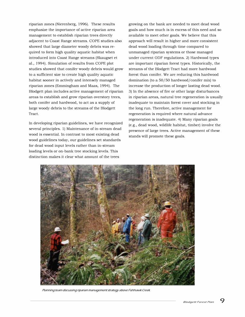
Planning team discussing riparian management strategy above Fishhawk Creek.
10 Blodgett Forest Plan
Research, demonstrationand extension
The plan for the Blodgett Tract provides an opportu-
nity for the College of Forestry to demonstrate the
findings from the Coastal Oregon Productivity
Enhancement (COPE) project and other research
efforts through the use of active riparian manage-
ment and the development of complex forest struc-
tures in both the upland and riparian areas. These
demonstrations will be used by the College�s exten-
sion program.
Formal research studies currently installed on the
tract will help us better understand the growth and
development of actively managed conifer and hard-
wood forests with different treatments. Over time the
College hopes to attract more research on some of
the fundamental habitat issues that the management
strategies in this plan attempt to address.
Income stream
The College of Forestry needs a high and dependable
flow of revenue to support forest operations, re-
search, demonstration and other college programs. A
moderate amount of period to period fluctuation has
been permitted in Blodgett harvest schedules since
the Blodgett Tract represents only a portion of total
revenue, and operations will not necessarily be
conducted at the Blodgett Tract for each year of the
five year planning period.
The 8000 thinning and regeneration harvest planning
prescriptions used in the analysis were selected to
control the rate at which stands can be moved
towards the large tree goal by moderate to heavy
thinning regimes and to provide thinning revenue
during time spans when final harvest rate is low.
Special prescriptions were developed for stands with
windthrow concerns. The regenerated stand pre-
scription uses precommercial thinning to quickly
achieve large tree goals in the second rotation
facilitating harvest of current stands.
Native American Use

Blodgett Forest Plan 11
Location
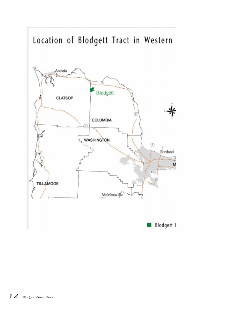
The Blodgett Tract is a 2,440 acre forest located in
Columbia County about four miles south of the
Columbia River in the upper Nehalem basin. The
western boundary of the tract is the Clatsop County
line which is also the eastern boundary of the
Clatsop State Forest. The other three sides of the
tract are surrounded by private industrial forest
lands.
State forest lands in the north coast region are
actively managed by the Oregon Department of
Forestry to maintain patches of different habitat
types across the landscape. These patches may
contain remnant old growth trees, snags, residual
live trees, down wood and multi-layered canopies.
While the structure of individual stands in this
management strategy will change constantly, the
range of stand structures and their relative abun-
dance across the landscape are expected to remain
reasonably stable. Silvicultural treatments include
thinning and regeneration harvest. Private indus-
trial forest lands in the North Coast are generally
managed under 40-60 year rotations that end in
regeneration harvests. Harvests that occur on
private and state lands must comply with the Oregon
Forest Practices Act.
Information about the management of Oregon�s State
forest lands and the text of the forest practice rules
can be found at http://www.odf.state.or.us/.
12 Blodgett Forest Plan
Blodgett Forest Plan 13
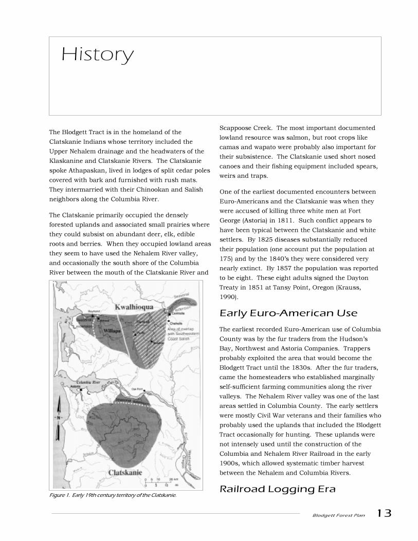
The Blodgett Tract is in the homeland of the
Clatskanie Indians whose territory included the
Upper Nehalem drainage and the headwaters of the
Klaskanine and Clatskanie Rivers. The Clatskanie
spoke Athapaskan, lived in lodges of split cedar poles
covered with bark and furnished with rush mats.
They intermarried with their Chinookan and Salish
neighbors along the Columbia River.
The Clatskanie primarily occupied the densely
forested uplands and associated small prairies where
they could subsist on abundant deer, elk, edible
roots and berries. When they occupied lowland areas
they seem to have used the Nehalem River valley,
and occasionally the south shore of the Columbia
River between the mouth of the Clatskanie River and
Scappoose Creek. The most important documented
lowland resource was salmon, but root crops like
camas and wapato were probably also important for
their subsistence. The Clatskanie used short nosed
canoes and their fishing equipment included spears,
weirs and traps.
One of the earliest documented encounters between
Euro-Americans and the Clatskanie was when they
were accused of killing three white men at Fort
George (Astoria) in 1811. Such conflict appears to
have been typical between the Clatskanie and white
settlers. By 1825 diseases substantially reduced
their population (one account put the population at
175) and by the 1840�s they were considered very
nearly extinct. By 1857 the population was reported
to be eight. These eight adults signed the Dayton
Treaty in 1851 at Tansy Point, Oregon (Krauss,
1990).
Early Euro-American Use
The earliest recorded Euro-American use of Columbia
County was by the fur traders from the Hudson�s
Bay, Northwest and Astoria Companies. Trappers
probably exploited the area that would become the
Blodgett Tract until the 1830s. After the fur traders,
came the homesteaders who established marginally
self-sufficient farming communities along the river
valleys. The Nehalem River valley was one of the last
areas settled in Columbia County. The early settlers
were mostly Civil War veterans and their families who
probably used the uplands that included the Blodgett
Tract occasionally for hunting. These uplands were
not intensely used until the construction of the
Columbia and Nehalem River Railroad in the early
1900s, which allowed systematic timber harvest
between the Nehalem and Columbia Rivers.
Railroad Logging Era
History
Figure 1. Early 19th century territory of the Clatskanie.

14 Blodgett Forest Plan
The Kerry Line proceeded from the Columbia River at
Kerry, entered a tunnel at the top of the hill (part of
this tunnel lies on the Blodgett Tract), and came out
in the Nehalem Valley. Construction of the line was
completed by 1914 and a major camp associated
with the railroad logging activities called �Horseshoe
Camp� was established along the banks of Fishhawk
Creek (Labbe and Goe, 1995) on the Blodgett Tract.
As many as ten camps were along the line. The Kerry
Company operated the line to serve their own needs,
as well as those of other operators. By 1927, 145
million board feet of 300 to 500 year old timber was
removed from 2060 acres of the Blodgett Tract
(approximately 70 MBF/acre) (Voorhies 1952).
Acquisition by OSC
After the land was harvested, the Oregon State
College School of Forestry was contacted by the
Blodgett Timber Company. In 1928 John W. Blodgett
wrote:
�It has been my unpleasant experience to witnessthe vanishing of the white pine industry in mynative state, Michigan. The result has been theabandonment of prosperous sawmill villages,
farms, and various community enterprises,combined with the consequent decrease ingeneral industrial activities, with their largeaccompanying payrolls. I cannot but be im-pressed by the fact that Oregon, a state in which Ihave long been interested, is headed directlytoward a like condition unless it profits byMichigan�s sad experience and formulates andfollows some sound definite policy with a view tokeeping the cut over lands producing timber...
With the thought in mind of aiding and expeditingthe gathering and correlating of data necessary tothe formulation of a sound reforestation programfor Western Oregon, I am glad to offer your collegea compact tract of about 2400 acres of cut-overland to be used for such experimental forestrypurposes. It bore a heavy stand of the finestyellow fir, so there can be no doubt of its adapt-
ability for such use...�
George Peavy (Dean of the School of Forestry) then
examined the property and he concluded in his
remarks to Earl B. Tanner of the Blodgett Timber
Company, �Now that I have been over the Columbia
County tract with you I am prepared to recommend
definitely the acceptance of the area by the College if
and when Mr. Blodgett decides to offer it to the Board
Kerry Line head engineer Whistling Joe Warner (far right) with his crew on Bridge #8 in 1924. Usedwith permission of the Mist-Birkenfeld Historical Society, Mist, Oregon.

Blodgett Forest Plan 15
of Regents. I believe that the tract is admirably
suited to the purpose proposed by Mr. Blodgett, viz.,
research work in reforestation (Peavy 1928).� The
land was transferred to the school in 1929.
Management under OSC(later OSU)
In October, 1934 (7 years after harvest was com-
pleted), an escaped slash fire burned most of the
tract. All but small islands of the existing reproduc-
tion were destroyed (Mason, 1938).
Early management focused on reforestation and fire
protection. This included the installation of a 25-
man fire protection crew under the direction of the
School of Forestry in 1940. The �Tunnel Lookout�
was established as part of the overall fire manage-
ment of this area of the coast range.
Little reforestation research was ever conducted on
the tract and in 1942 the Blodgett Company became
concerned that the School of Forestry was �not living
up to the spirit of the transaction.� The company felt
that the tract was not being used to provide technical
information and that it should be turned over to the
Oregon State Forestry Department. Paul Dunn (Dean
of the School of Forestry) states in 1943 that �There
is no question that this area and the other lands
have not been used to the fullest extent.� In 1943,
George Peavy (President of OSC) wrote that there was
a desire to exchange the land for property more
readily accessible to Corvallis, but World War II put
these plans on hold.
In 1959 the School of Forestry entered a cooperative
agreement with the State Board of Forestry which
gave the State Board management control of the
Blodgett tract with 25% of the revenue from the tract
going to the state and 75% to the school. This
agreement resulted in occasional timber harvest
activities until 1980 when the agreement was termi-
nated. Direct management of the Blodgett Tract
reverted then to the College of Forestry.
Between 1986 and 1996 24 MMBF were removed
through thinning and clearcut harvests by the
College of Forestry Research Forests.
The Blodgett Tract in 1942
16 Blodgett Forest Plan
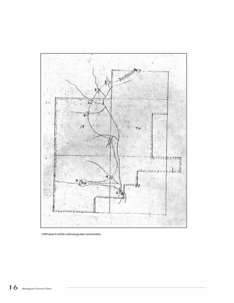
1940 sketch of the railroad grades and trestles.
Blodgett Forest Plan 17
Current Forest Condition
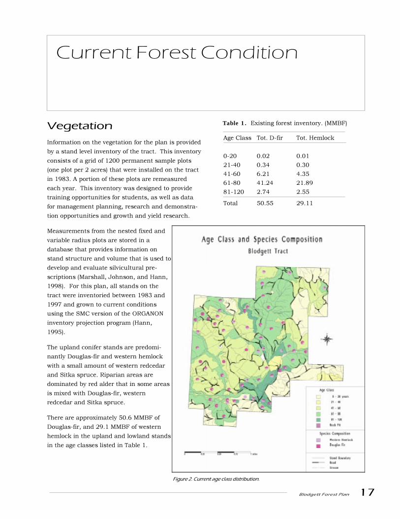
Vegetation
Information on the vegetation for the plan is provided
by a stand level inventory of the tract. This inventory
consists of a grid of 1200 permanent sample plots
(one plot per 2 acres) that were installed on the tract
in 1983. A portion of these plots are remeasured
each year. This inventory was designed to provide
training opportunities for students, as well as data
for management planning, research and demonstra-
tion opportunities and growth and yield research.
Measurements from the nested fixed and
variable radius plots are stored in a
database that provides information on
stand structure and volume that is used to
develop and evaluate silvicultural pre-
scriptions (Marshall, Johnson, and Hann,
1998). For this plan, all stands on the
tract were inventoried between 1983 and
1997 and grown to current conditions
using the SMC version of the ORGANON
inventory projection program (Hann,
1995).
The upland conifer stands are predomi-
nantly Douglas-fir and western hemlock
with a small amount of western redcedar
and Sitka spruce. Riparian areas are
dominated by red alder that in some areas
is mixed with Douglas-fir, western
redcedar and Sitka spruce.
There are approximately 50.6 MMBF of
Douglas-fir, and 29.1 MMBF of western
hemlock in the upland and lowland stands
in the age classes listed in Table 1.
Figure 2. Current age class distribution.
Table 1. Existing forest inventory. (MMBF)
Age Class Tot. D-fir Tot. Hemlock
0-20 0.02 0.01
21-40 0.34 0.30
41-60 6.21 4.35
61-80 41.24 21.89
81-120 2.74 2.55
Total 50.55 29.11
18 Blodgett Forest Plan
Wildlife
Sensitive vertebrates
Northern spotted owls
The Blodgett Tract has areas that may be suitable for
spotted owl nesting, roosting and foraging. There is a
large amount of dead wood to help support prey
populations, and some areas of the forest have trees
with nesting platforms that have resulted from bear
damage and ice storms.
The tract has been surveyed every year since 1990
for spotted owls. Responses were recorded in 1990,
1994 and 1998. These birds were not located in the
follow-up surveys. As a result of this survey work
the Research Forest believes that there are no active
spotted owl sites on the property at this
time. Annual surveys are planned to
continue.
Marbled murrelets
Surveys for murrelets were completed in
1995 and 1996 on units that were
scheduled for harvest. No murrelets
were observed. There are very few
suitable nest trees for murrelets on the
tract, so these surveys have not been
continued.
Fish
The Fishhawk drainage system was
identified as an Aquatic Diversity Area by
the American Fisheries Society (AFS),
Essential Salmonid Habitat by Division
of State Lands (DSL), a Source Water-
shed by the Oregon Department of Fish
and Wildlife (ODFW) and a Core Salmon
Area (CSA) for coho salmon in the
Oregon Plan.
When ODFW surveyed the Fishhawk
drainage in 1996 they found an adult
abundance of > 30 coho/mile which is
considered very good for the Nehalem
Basin. Based on Tom Nickelson�s coho
model, there are >2000 smolts/mile
predicted on the main Fishhawk Creek
system. McCoon Creek has > 21,000
smolts/mile predicted.
Habitat on our portion of Fishhawk Creek is gener-
ally regarded as fair to good. There is adequate
shade, but few big conifers in the riparian area to
contribute dead wood in the future. The desired
volume of woody debris exists, but it is mostly
distributed in smaller (>3m x 0.15m) single pieces
rather than large key pieces (10m x 0.6m) in complex
debris jams. There is less than the desired percent
gravel and greater than desired percent silt, sand and
organics.
The high percentages of silt and sand are mainly due
to the incompetent bedrock which underlies the
forest and a legacy of throughfills found in old
railroad grades. Only two throughfills exist on the
forest but numerous throughfills are located on the
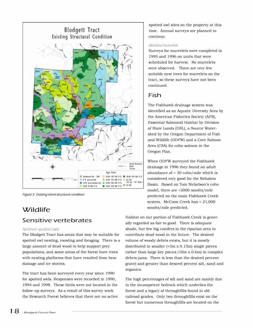
Figure 3. Existing stand structural condition.

Blodgett Forest Plan 19
surrounding ownerships with many located upstream
of the Blodgett Tract. The throughfills on the forest
will be monitored by forest staff and they will be
managed on a case-by-case basis.
The geology of the Blodgett Tract is such that the
frequency of mass wasting is not likely to be influ-
enced by vegetative cover. The major source of
controllable erosion from ongoing forest management
is roads. Maintenance and reconstruction of existing
roads is a high priority and the construction of new
roads will be in such a manner that chronic acceler-
ated erosion is minimized. These activities will take
place within the framework of the Oregon Forest
Practice Rules and will be technically and economi-
cally feasible.
Baseline temperature data was collected for
Fishhawk, the North Fork of Fishhawk and two of its
tributaries, Trestle, and Wrongway Creeks, because
these are tributaries of the Nehalem River which is
considered water quality limited for temperature by
the Department of Environmental Quality. Maximum
stream temperatures were below the 64 degree State
water quality standard on all of the days and all
stream locations monitored. The planned manage-
ment activities are unlikely to influence the range of
temperatures occurring in fish-bearing streams on
the Blodgett Tract.
Geology
The Blodgett Tract is located predominantly within
the Fishhawk watershed and drains into the Nehalem
River, however the northernmost part of the tract
occupies the ridge between the Nehalem and Colum-
bia River watersheds and a small portion of the forest
drains into the Columbia River. Most of the tract is
drained by the Fishhawk, North Fork Fishhawk,
Trestle and Wrongway Creeks.
The Tract is underlain by marine sedimentary rock.
The rock is composed of tuffaceous silts and sands
that were derived from sand and volcanic debris from
landmasses to the east, and were laid down when
this area was shallow sea. There are intrusions of
basalt in the sedimentary rock that were intruded
when the rock was still submarine. These basalt
intrusions show up in road cuts on an irregular
basis. The sandstone is very incompetent and thus
weathers easily. This is evidenced by an almost
complete lack of bedrock outcrops on the forest,
including the road cuts.
The terrain that has developed on the Blodgett Tract,
has for the most part, gentle, rounded and short
slopes. This is a legacy of the incompetent and easily
weathered bedrock. For the Tract, 74% of the area
has a slope less than 35%, 23% is between 36 and
60% and only 3% of the area is greater than 60%
slope. Risk of a landslide greatly increases for slopes
greater than 60%. Slopes 80% and greater represent
terrain at high risk for debris slides. There is virtu-
ally no high risk terrain in the Blodgett Tract, which
means that the tract does not support the classic
debris flow/debris avalanche morphology. The tract
tends to have deeper rotational-slump landslide
features or earthflows as opposed to debris flows.
The only shallow-translational slides observed were
small features that are classed as debris slides with
the slide deposit remaining at the foot of the land-
slide scarp that did not transition into debris flows or
avalanches. The only debris avalanche observed on
the tract was initiated at a large throughfill from an
old, abandoned railroad grade off of the tract. The
terrain does show evidence, both on the tract and
immediately adjacent to it, that earthflows and
rotational slumps dominate mass movement pro-
cesses.
The soils on the Blodgett Tract are comprised pre-
dominantly of two series. They are the Scaponia-
Braun series and the Tolke series. Both of these are
deep, 40-60 inches to bedrock, well-drained, loamy
soils. These soils, in combination with the abundant
moisture, annual precipitation for the tract is 60-110
inches, give the tract its high site class and high
productivity. The Braun series is a mesic Dystic
Eutrochrept, the Scaponia series is a mesic Umbric
20 Blodgett Forest Plan
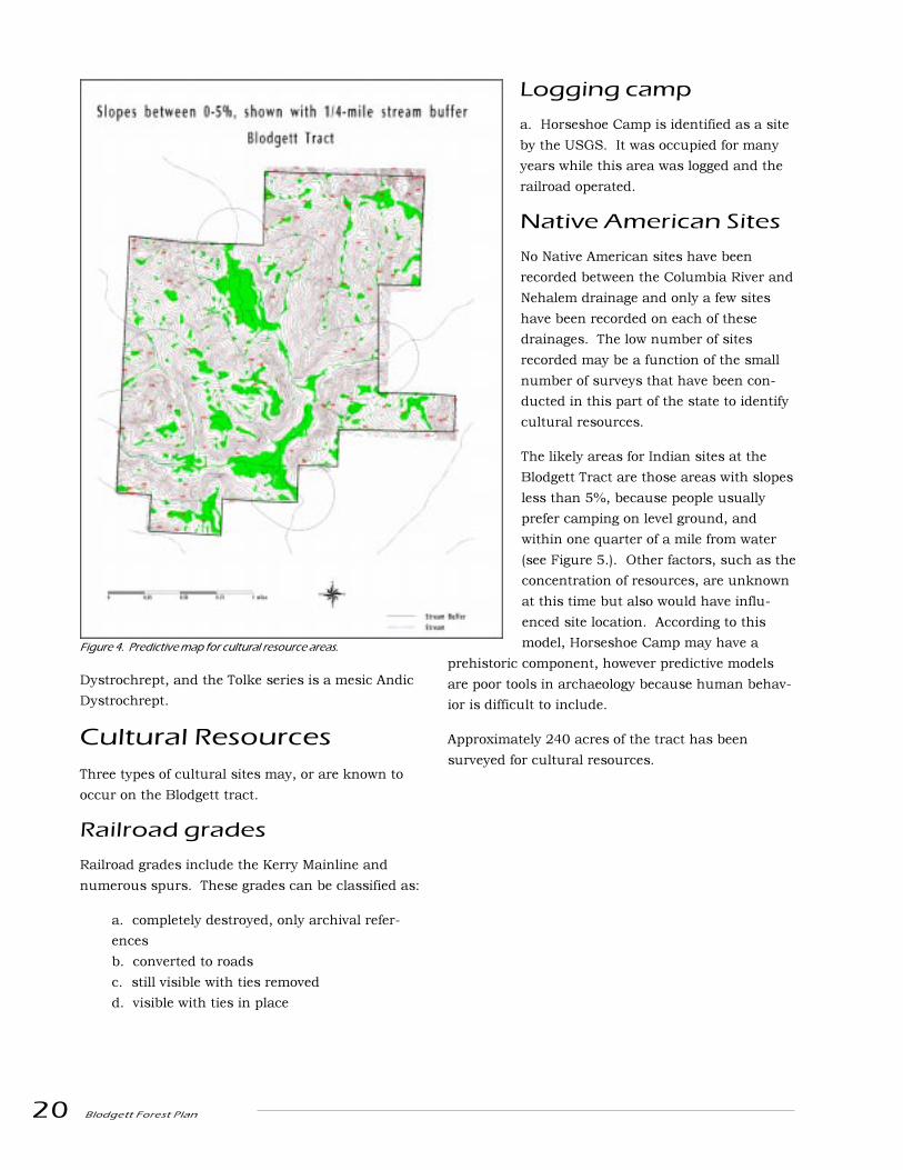
Figure 4. Predictive map for cultural resource areas.
Dystrochrept, and the Tolke series is a mesic Andic
Dystrochrept.
Cultural Resources
Three types of cultural sites may, or are known to
occur on the Blodgett tract.
Railroad grades
Railroad grades include the Kerry Mainline and
numerous spurs. These grades can be classified as:
a. completely destroyed, only archival refer-
ences
b. converted to roads
c. still visible with ties removed
d. visible with ties in place
Logging camp
a. Horseshoe Camp is identified as a site
by the USGS. It was occupied for many
years while this area was logged and the
railroad operated.
Native American Sites
No Native American sites have been
recorded between the Columbia River and
Nehalem drainage and only a few sites
have been recorded on each of these
drainages. The low number of sites
recorded may be a function of the small
number of surveys that have been con-
ducted in this part of the state to identify
cultural resources.
The likely areas for Indian sites at the
Blodgett Tract are those areas with slopes
less than 5%, because people usually
prefer camping on level ground, and
within one quarter of a mile from water
(see Figure 5.). Other factors, such as the
concentration of resources, are unknown
at this time but also would have influ-
enced site location. According to this
model, Horseshoe Camp may have a
prehistoric component, however predictive models
are poor tools in archaeology because human behav-
ior is difficult to include.
Approximately 240 acres of the tract has been
surveyed for cultural resources.

Blodgett Forest Plan 21
Desired Future Condition
The Blodgett Forest will be actively managed to
provide diverse structural conditions suitable for a
variety of animal and plant species, while at the same
time providing revenue from these management
activities for the College of Forestry. These condi-
tions will range from open, �early seral� to mature
forest, but not old growth.
Using active management, rather than a reserve
strategy, to move contiguous blocks of the Blodgett
Forest towards mature forest characteristics is the
central approach to the Blodgett Forest Plan.
Through active management we will accelerate the
development of large trees and some other structural
components of mature forest while meeting the
revenue goal, using thinning techniques suggested by
COPE results.
Riparian areas along large perennial streams will be
managed to develop stands that alternate between
hardwood dominated and conifer types. The hard-
wood type is dominated by alder but may contain
conifers or other hardwoods. The conifer type is
dominated by Douglas-fir, redcedar, hemlock and
Sitka spruce and may contain some hardwoods.
Recognizing the dynamics of riparian forests from
COPE studies, riparian areas along intermittent
streams will be managed to develop like the upland
stands, but will contain hardwoods where they occur
naturally.
Natural hemlock regeneration under thinned stand.

22 Blodgett Forest Plan

Blodgett Forest Plan 23
Choice of Stand Typesand Management Units
The Blodgett Forest is broken into stand types that
generally represent areas of homogenous overstory
species composition and stocking. The stand types
were developed from 1:12,000 color aerial photo-
graphs, type designations made by field crews along
transects spaced 330 feet apart, and extensive field
reconnaissance. There are 79 stand types that are
represented in the harvest scheduling analysis.
Management units were constructed by engineers on
the forest staff who used slope class information built
from a 7 meter DEM that was developed from recent
and historic aerial photos, existing and proposed
road locations, stream information, logging patterns
used in previous entries, and field reconnaissance.
The boundaries of these units were designed to
ensure that solutions from the harvest scheduling
simulation could be feasibly logged and are intended
to provide a framework for the development of logging
plans. There are 103 management units.
The identification of management units led to a
classification of areas that have special logging issues
associated with them. Forest staff decided that some
units could not be thinned in the first entry because
of operability issues. The staff also identified units
that would be more expensive to log because artificial
anchors would be required.
In riparian stands that flank the large perennial
streams, prescriptions were developed that empha-
sized either conifer or hardwood management.
Approximately 50% of perennial stream length is
planned to be in stands dominated by hardwoods
and 50% in stands dominated by conifers with no
more than approximately 1000' of stream length in a
given type. Stands on opposite sides of a stream may
be different types. To accommodate these prescrip-
tions, the riparian stands were divided into smaller
units so that each 1000' segment could be repre-
sented in the harvest schedule.
The stand types (both the upland and riparian areas)
were intersected with the management units to
create subunits, so that the stand differences within
the management units could be recognized in the
yield projections that were developed for the harvest
scheduling analysis. This created the base set of 200
harvest scheduling units.
PrescriptionDevelopment
Upland Stands
The upland forest, which lies above the break in
slope beyond the influence of past floodwaters,
occupies about ninety percent of the Blodgett Tract.
Eighty-six percent of the upland forest area supports
mixed Douglas-fir and hemlock forests that are over
60 years old.
Existing Stands
Fifteen percent of the forest greater than 50 years old
has been designated as unsuitable for thinning.
These stands will be clearcut harvested.
Background on thinning prescriptions
Using knowledge gained from thinning studies in
COPE, the silviculture subcommittee of the forest
planning team designed a set of thinning prescrip-
tions to accelerate the development of the thinnable
forest towards the large tree goal. These prescriptions
were modeled in ORGANON using a sample set of
stand types that represented the range of existing
site and stocking characteristics. The results were
presented to the planning team and feedback from
Planning Process
24 Blodgett Forest Plan
team members was used to modify the prescriptions.
This process was repeated several times and after 43
prescriptions were modeled we were able to draw the
following conclusions:
1. There was a significant amount of variability
in the response of different stand types to
different treatment regimes, which convinced us
that modeling these types of treatments with
stand level inventory data was very important.
2. In general, the treatment regimes for existing
stands with the lower basal area or RDI thinning
targets in the first thinning entry met the large
tree goal earlier than other treatment regimes
and favored the development of understory
conifers which were identified as important
habitat features for some wildlife species. These
treatment regimes also created the greatest
threat for catastrophic windthrow from severe
winter and spring storms, and produced the
lowest total volume.
3. The treatment regimes that involved no
thinning, or relatively light thinnings produced
the highest total volume over a 100 year plan-
ning period, but took significantly longer to
reach the large tree target and did not favor
understory growth.
4. It took longer to reach the large tree target
when thinning proportionally throughout the
diameter classes than it did when thinning from
below.
5. Although many different treatment regimes
were suggested and modeled, the results for any
given stand followed only a few different general
trajectories.
Discussions that weighed the benefits of maintaining
high levels of growing stock through light thinnings
(which produced more volume over time with less
windthrow risk) against moving to lower levels using
heavy thinnings (which produced big trees faster and
potentially more complex understories) led to a
classification of the 200 harvest scheduling units into
high and low windthrow risk. �High� risk units were
those with slopes exposed to the south/ southwest-
erly winter storm winds and that had never been
thinned before, as well as units on more moderate
exposures that are adjacent to clearcuts that could
channel winds into them.
It was then decided that on the areas with high
windthrow risk and stands with existing heavy basal
areas, not more than 40% of the basal area will be
removed in the first entry, and the residual basal
area will always be near or above 150 ft2. The
subsequent entry will occur after about 15 years and
may go down to a minimum basal area target of
120ft2. Areas with lower windthrow risk will have
heavier thinnings in the first entry (down to 110-120
ft2 residual basal area), with an additional entry after
15 years to 120 ft 2.
It was also decided that we would thin from below
even though this would create stands that are more
structurally uniform because we can meet our big
tree goal faster than thinning proportionally through
the diameter classes. Understory structure will be
provided by the shrub and hemlock seedling layer
that develops between thinning entries. (See figure 6
on page 34.)
Future Stands
The future stands were modeled the same way as the
existing stands, except that a pre-commercial thin-
ning from below to an SDI of 110 occurs two years
after crown closure (which happens when the stand
is about 14 years old).
Riparian stands
Prescription Development
Recognizing the role of disturbance in riparian forest
from studies in COPE, the silviculture subcommittee
considered three different kinds of riparian situa-
tions. Each will have a different management regime
that is based on the characteristics of the stream.
The terms large, medium, small, perennial, and
intermittent stream are as defined in ODF Forest
Practice Rules Chapter 629, Division 640 and maps
created by ODF from these regulations.
Stream types
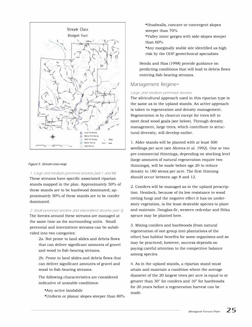
Blodgett Forest Plan 25
1. Large and medium perennial streams (size L and M)
These streams have specific associated riparian
stands mapped in the plan. Approximately 50% of
these stands are to be hardwood dominated; ap-
proximately 50% of these stands are to be conifer
dominated.
2. Small perennial streams and intermittent streams (size S)
The forests around these streams are managed at
the same time as the surrounding units. Small
perennial and intermittent streams can be subdi-
vided into two categories:
2a. Not prone to land slides and debris flows
that can deliver significant amounts of gravel
and wood to fish-bearing streams.
2b. Prone to land slides and debris flows that
can deliver significant amounts of gravel and
wood to fish-bearing streams.
The following characteristics are considered
indicative of unstable conditions:
�Any active landslide
�Uniform or planar slopes steeper than 80%
�Headwalls, concave or convergent slopes
steeper than 70%
�Valley inner gorges with side-slopes steeper
than 60%
�Any marginally stable site identified as high
risk by the ODF geotechnical specialists
Benda and Sias (1998) provide guidance on
predicting conditions that will lead to debris flows
entering fish-bearing streams.
Management Regime=
Large and medium perennial streams
The silvicultural approach used in this riparian type is
the same as in the upland stands. An active approach
is taken to regeneration and density management.
Regeneration is by clearcut except for trees left to
meet dead wood goals (see below). Through density
management, large trees, which contribute to struc-
tural diversity, will develop earlier.
1. Alder stands will be planted with at least 500
seedlings per acre (see Ahrens et al. 1992). One or two
pre-commercial thinnings, depending on stocking level
(large amounts of natural regeneration require two
thinnings), will be made before age 20 to reduce
density to 180 stems per acre. The first thinning
should occur between age 8 and 12.
2. Conifers will be managed as in the upland prescrip-
tion. Hemlock, because of its low resistance to wood
rotting fungi and the negative effect it has on under-
story vegetation, is the least desirable species to plant
and maintain. Douglas-fir, western redcedar and Sitka
spruce may be planted here.
3. Mixing conifers and hardwoods (from natural
regeneration of one group into plantations of the
other) has habitat benefits for some organisms and so
may be practiced; however, success depends on
paying careful attention to the competitive balance
among species.
4. As in the upland stands, a riparian stand must
attain and maintain a condition where the average
diameter of the 20 largest trees per acre is equal to or
greater than 30" for conifers and 16� for hardwoods
for 20 years before a regeneration harvest can be
made.
Figure 5. Stream class map.

26 Blodgett Forest Plan
Wood Delivery to Streams
There are no precedents for setting silvicultural goals pertaining to maintenance of dead wood levels in
streams. The Blodgett Tract appears to have adequate logs and rootwad structure in the main stream
channels. The guidelines in the Blodgett plan are a first approximation of a level of availability and provision
for placement in streams to maintain wood at existing levels or higher.
There are several important works from which the following guidelines were derived. Murphy and Koski
(1989) observed that 84% of the dead wood falling into Alaska streams came from within 33 feet of the bank.
McDade (1987) observed the same relationship in first, second and third-order streams in Oregon, but with
73% coming from within 50 feet. Murphy and Koski (1989) also reported that it was the larger pieces that
led to greater longevity in streams and more stable structures. Thus, it appears that the primary source of
local dead wood is very close to the stream itself. Obviously, the additional wood from debris avalanches
originates further away from the stream, but these events occur infrequently on the Blodgett Tract.
Levels of wood desirable are arguable. Whereas opinions vary as to whether there is ever enough, there are
reports of levels found in old growth stands. We postulate that these represent the upper levels of historic
conditions. Specifically, in a COPE study by Van Sickle and Gregory (1990) dead wood input was estimated
at 1.5-15 pieces per 1000 feet per decade. Wood volume involved ranged from 17 to 235 ft3 per 1000 feet/
decade, depending on probability of treefall in that reach of Cascades old-growth. Murphy and Koski (1989)
observed a range of 44-137 total pieces of wood per 1000 feet in Alaska, with an average longevity of some
160 years, or 2-10 pieces per decade, about the center of the range reported by Van Sickle and Gregory
(1990). Allowing for variation in study conditions, we assume that a reasonable input average from old
growth would range around 300 ft3/1000 ft/decade of stream. To compensate for flood losses and ineffi-
ciency in placement, we determined that allocation of 600 ft3/1000 ft/decade would more than meet the
dead wood needs relative to standards for old growth.
Managed Douglas-fir on site II ground will have a height of some 170 feet in 100 years and diameter of over
33� in stands being managed for mature forest features, with 20 trees/ac being in those size classes for
about a fifth of their life spans. A stand with 240 square feet per acre would have the 20 large trees plus a
greater number of smaller trees, and support some 14,000 ft3 /ac and average a mean annual increment of
about 200 ft3 /ac (adapted from McArdle et al, 1961). Growth of such stands in stream buffers would
require intensive management. However, a streamside stand 33 feet wide on each side would grow 3000 ft3
/decade. Dedication of 20 percent of this over a 100 year period for woody debris is therefore our calcula-
tion of the type of buffer management that will meet woody debris requirements.
Most of the above trees will fall toward the stream naturally because of the tendency to fall downhill (Hibbs
and Sullivan, unpublished data). Thus, it is anticipated that the dead wood levels will be maintained.
However, at the time of each entry to these stands for silvicultural treatment, an inventory of the stream
protected by these adjacent stands will reveal the degree to which these trees are currently needed to
augment supplies.
Hardwoods are a special case. Productivity and ultimate size are less than that of conifers. We set a target
for hardwood areas that is 50% of the conifer target to account for this reduced productivity.
Blodgett Forest Plan 27
5. Trees that are leaning over the water or that are
within 20 feet of bank-full-width should not be
harvested (although these trees will also count
toward meeting dead wood goals if left during a
regeneration harvest). Thinning should be practiced
to maintain rapid diameter growth. In this 20 foot
zone, active regeneration should be practiced when
stocking levels drop below 15% RDI. For purposes of
bank stability, a large alder or cedar component is
desirable in this zone in all stands. Logging machines
should not enter this zone and logs passing over it
must be fully suspended.
6. Six hundred cubic feet of conifer volume per 1000
feet of stream per decade in conifer stands (300 cubic
feet of hardwoods in hardwood stands) will be
dedicated to in-stream woody debris. This means that
at the time of thinning and regeneration harvest, a
proportion of the standing volume is allocated to
woody debris. In a thinning, this material is felled
toward the stream. In a regeneration harvest, this
material is left standing until it falls by itself. Selec-
tion of leave trees should favor larger but not neces-
sarily better timber quality trees of the more rot-
resistant species. The remainder may be removed as
logs.
7. To meet these goals, a survey of the stream must
be done prior to each operation to determine how
much wood has entered the stream and the near-
stream (20') surface since the last entry through wind
throw or other means. This can be deducted from the
leave requirement. Leave requirements should be met
as close to the stream as possible. To count in a dead
wood survey, a piece of wood must (1) be at least 10
feet long, have a large end diameter of at least 10
inches in small streams and 14 inches in medium
and large streams, and either be in the stream or
have a major part of its length within 10 feet of the
high water mark or (2) be a standing tree previously
designated as a leave tree to meet dead wood require-
ments.
8. At some points in a rotation, the long-term average
of 600 cubic feet/1000 feet/decade may not be met
because the trees will be too small. Shortages at one
point in a rotation will be made up at a later time.
Small perennial and intermittent streams
Management is the same as along large perennial
streams except that (1) the 50/50 hardwood/conifer
rule does not apply and (2) the dead wood goal is to
provide 150 cubic feet per 1000 feet per decade. No
logging machines are allowed in this zone (except
during in-stream enhancement projects), and logs
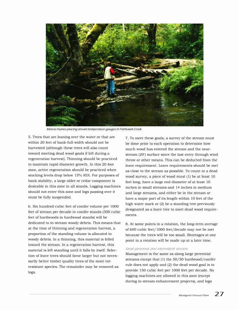
Marcia Humes placing stream temperature gauges in Fishhawk Creek.
28 Blodgett Forest Plan
passing over it must be fully suspended. Herbicide
application rules will follow ODF stream regulations.
1. Stable small perennial and intermittent streams
This is a 20 foot zone on either side of the stream.
Trees may be harvested in this zone, but shrub, herb
and duff layers on the stream bank within this zone
must be protected during logging. Disturbance is
permitted to enhance tree regeneration. No logging
machines are allowed in this zone and logs passing
over it must be fully suspended.
2. Unstable small perennial and intermittent streams thatcan deliver significant amounts of gravel and wood to fish-bearing streams
This is a 20 foot zone on either side of a stream and
extends from the location of instability to the fish-
bearing stream. The goal in this zone is to maintain a
high stocking level of larger conifer trees (24" plus) so
that debris flows, if they occur, will carry wood as
well as sediment into the fish-bearing stream.
Periodic regeneration and thinning will be needed to
maintain this stocking of large trees (hemlock is not
desirable). Thus, periodic regeneration harvests in
this zone are necessary. No more than 50% of the
length of a zone should be regenerated in any two
decade period. At the time of regeneration harvest,
25% of the standing volume should be dropped into
and left in the channel. No logging machines are
allowed in this zone and logs passing over it must be
fully suspended. Few of these streams exist at
Blodgett.
Forest HealthConsiderations
Abiotic and biotic disturbances are a part of the
Blodgett forest ecosystem. While it is recognized that
biotic and abiotic disturbances are important in
maintaining ecosystem biodiversity, poor manage-
ment practices can result in unintended outbreaks
and loss beyond an acceptable level. Acknowledging
potential disturbances and incorporating them into
management strategies and planning is an integral
component of maintaining forest health.
Wind
The thinning prescriptions and placement across the
landscape were designed to develop wind-firmness
over time and minimize catastrophic windthrow
risks.
Fire
The frequency, intensity and distribution of fire
varies considerably over the Pacific Northwest. The
Blodgett Tract is located in the coastal mountain
range of the Tsuga Heterophylla zone. Agee (1983)
describes the natural fire regime of this zone as
episodic rather than cyclical as specific fire return
intervals are difficult to quantify. Fires in this zone
are usually high intensity stand replacement fires,
characterized by occasional crown fires or severe
surface fires. Fire regimes are a function of tempera-
ture and moisture patterns, ignition patterns such as
lightning and human origin, vegetation characteris-
tics such as fuel loading and adaptations to fire.
Catastrophic fires in this region suppress the natural
successional pattern which would result in hemlock
dominant climax rather than the more common
Douglas-fir dominant stands represented in much of
this area. Fires in these regimes are associated with
drought years and east wind weather conditions in
late summer and fall that decrease humidity and are
combined with a combustion source. In the Columbia
Gorge, where topographic features are lower or
absent, there is a much stronger trend for fire spread
to the west. These fires may stop only at stand type
boundaries or under extreme conditions when fuels
are exhausted at barriers such as rock outcroppings
or streams. Young stands in this region may be
subject to frequent surface fire re-burns until crown
closure occurs (Agee 1983,1990). Fire impact will be
minimized with an aggressive fire suppression policy.
Pathogenic fungi and insects
Biotic disturbances include pathogenic fungi and
insects. The major pathogenic fungi include stem
rots, root rots and needle diseases. Stem rots are
usually associated with wounding and stumps so
they will be of particular concern in thinned stands.
Care to minimize wounding should be encouraged in
all forest operations. This includes the type of
equipment used, season of harvest and species
selection. Where unacceptable amounts of root rot
occurs, non-susceptible species (red alder or western
Blodgett Forest Plan 29
redcedar) should be selected for and/or planted.
Needle diseases have the greatest potential to impact
future management of Douglas-fir on the Blodgett
Tract. Ten miles to the west, management of Dou-
glas-fir is being discouraged by an extensive out-
break of Swiss needle cast (Phaeocryptopus
gaeumannii). The impact on Douglas-fir growth is
serious enough to stimulate some landowners to
switch to management of alternative species includ-
ing western hemlock, cedar, Sitka spruce and alder.
While this disease is not yet widespread on the
Blodgett Tract, it is present in the young plantations
and should be carefully monitored. Monitoring
should include a baseline aerial survey conducted in
the spring just prior to budbreak, followed by field
surveys on a limited basis. Insects of concern include
Sitka spruce tip weevil (Pissodes strobi), Douglas-fir
beetle (Dendroctonus pseudotsugae) and hemlock
looper (Lambdina fiscellaria lugubrosa). With the
exception of Sitka spruce tip weevil, none of these
species are currently causing major impacts. In the
past, hemlock looper has caused massive defoliation
in hemlock stands in neighboring Clatsop County
resulting in widespread mortality. In general, the
damage was associated with mature stands and is
not expected to be as much of a problem in the
Blodgett Tract due to the younger age of the forest
and the species mix. Douglas-fir beetle is only
damaging following major windthrow. The downed
trees provide good rearing habitat and allow popula-
tions to reach a level where successful attacks are
made on standing Douglas-fir. Salvaging downed
wood usually controls these outbreaks. Sitka spruce
tip weevil is an endemic insect that caused top death
on virtually all young spruce trees resulting in a
potential loss of competitive vigor and stem defor-
mity. Forest staff should consider planting Sitka
spruce weevil resistant stock, if it becomes available.
The list of diseases and insects here is not intended
to be an exhaustive review but to encourage recogni-
tion, education of forest staff, careful monitoring and
adaptation of management strategies. Current and
future abiotic and biotic disturbances should be
monitored with systematic reporting, record keeping
and incorporated in silvicultural prescriptions.
Prescribed burning
Prescribed burning can be used as a resource
management tool when managers evaluate the
historical role of fire and are familiar with the ecologi-
cal responses of vegetation and structure in the
system. Controlled use of fire to achieve specific
forest management objectives can provide beneficial
responses. Such management objectives include
control of competing vegetation, creation of seedbeds
and planting spots and overall improvement in the
efficiency of silvicultural prescriptions by removing
impediments to reforestation.
The use of fire as a management tool can have many
impacts, both beneficial and negative. Negative
impacts include visual and health impacts on air
quality, site quality, and wildlife habitat. Other
impacts include possible soil disturbance and
compaction from mechanical piling, effects on soil
productivity from intense burns creating hydrophobic
soils and risk of soil erosion. Prescribed burning may
also entail increased costs under circumstances of
escape due to containment costs and liability. Fire
may play an important role in both the creation and
loss of dead wood, affecting wildlife habitat and
nutrient recycling. In addition, higher merchantabil-
ity standards in recent years leave less logging
residue in the harvest unit than in previous decades.
With these objectives in mind, active fire protection
will be practiced to protect resources on the forest, as
well as addressing liability concerns from adjacent
landowners. Protection includes keeping roads and
access open and development of detailed wildfire
response plans for efficient containment. Prescribed
fire will primarily be used to achieve specific manage-
ment objectives such as creation of planting spots,
and overall improvement in the efficiency of silvicul-
tural operations. Slash burning is the preferred
method of disposing of logging residues and other
woody debris and vegetation that would otherwise
impede reforestation methods as well as create fire
liability risks.
Mechanical site preparation or broadcast burning
decisions will be formed on a unit by unit basis.
Burn plans will be developed ensuring consideration
and protection for all forest goals stated previously in

30 Blodgett Forest Plan
the plan including down woody debris and snag
levels and soil productivity. The burn plan will
describe the unit to be treated, objectives to be
achieved, pre and post burn monitoring require-
ments, fuel and weather conditions needed to meet
objectives, funding sources and limitations, burning
and containment procedures and personnel and
equipment needs. In addition, consideration of air
quality and visibility standards, and assessments of
risk of escape and resulting consequent damage will
be addressed. In Oregon, burn plans are required for
all prescribed burning on forestlands during fire
season.
Exotic Species
Populations of exotic species that have become
established on the Blodgett Tract should be main-
tained at low levels because these species can invade
and dominate parts of ecosystems changing the way
they function for endemic species within these
systems. False brome (Brachypodium sylvaticum),
English holly (Ilex aquifolium), Scotch broom (Cytisus
scoparius), Himalaya blackberry (Rubus discolor),
English Ivy (Hedera helix) and other species can
displace native plants that other native species
depend on.
Exotic vascular plant species should be managed
during harvest, site preparation, conifer release and
roadside maintenance. If persistent exotic under-
story species are identified during the preparation
work for these operations, they should be controlled.
In the case of harvest units, treatment should occur
before the unit is logged. Shrubs and perennial
herbs should be killed with systemic chemicals. If
exotic plants appear in young plantations, their
removal should be planned as a part of the regular
release program.
In general, invasive exotics (like false brome) should
be controlled before they become epidemic. Toward
this end, personnel who are working on other
projects at the tract, who are appropriately licensed
and trained to apply herbicides, should be equipped
with hand spraying equipment and instructions to
spot spray exotics that they notice where practical.
Exotic fauna should be managed by minimizing their
habitat consistent with the other goals of the plan.
Cultural Resources
The plan assumes that cultural sites and objects,
and antiquities of local, regional and national signifi-
cance will be protected.
To protect these resources:
1. A professionally supervised cultural resource
inventory program will be conducted at the tract and
project level in compliance with applicable state and
federal historic preservation legislation (see
www2.cr.nps.gov/laws/36cfr61.utm). The surveys
will be conducted according to an inventory plan and
research design agreed to by the Research Forest and
the State Historic Preservation Office (SHPO). Based
on this database, the Research Forests will develop
and maintain a tract-wide cultural resource overview
based on summaries of the cultural resource infor-
mation. This overview (especially of the railroads) will
make it easier to develop management plans that will
eliminate the need to consult with SHPO on a con-
tinuing basis.
2. Cultural resource properties located during
inventory will be evaluated by a professional archae-
ologist/historian to determine their eligibility for
listing on the National Register of Historic Places.
3. In concert with inventories and site evaluations,
the Research Forests will develop management plans
for the various classes of prehistoric and historic
resources found on the tract.
4. Protection of cultural resources will be coordi-
nated with the SHPO and the Advisory Council on
Historic Preservation as required by state and federal
historic preservation laws and regulations.
5. Protection of Native American cultural resources
will be coordinated with the tribes. This coordination
will include (but not necessarily be limited to) notifi-
cation to tribes of activities and potential impacts in
areas of known concerns. Opportunities for tribal
involvement in research of sites with known tribal
affiliations will be made.
6. Cultural resources may be developed for scientific
and educational purposes to the extent that the
integrity of the resource is maintained.
Blodgett Forest Plan 31
Transportation System
The plan currently assumes that the transportation
system will:
1. Provide cost effective access for all-season log
hauling and administrative traffic.
2. Protect watershed and fishery resource values.
This will involve:
1. Developing road management objectives for all
existing and proposed roads.
2. Integrating road management objectives with long-
term logging and stand tending needs and with soil
and watershed management objectives.
3. Developing an annual road maintenance plan in
accordance with the road management objectives.
Since we know that the existing transportation
system will require investment to provide for all-
season log hauling and that more investment is
required on some portions of the system to allow
timber harvest than others, over the next year (1999/
2000) the forest staff will complete road management
planning so that these costs can be disaggregated by
road segment. In addition, the staff will suggest a
new set of logging costs and harvest revenues that
reflect the seasonal fluctuations that are known to
occur. A transportation component to the scheduling
model will then be developed that can incorporate
this new information into the systems that the model
uses to search for the best timing and combination of
harvest units.
32 Blodgett Forest Plan
Determining Levels of Dead WoodSRS is a computer model based on data presented by Neitro et al. (1985) that is designed to assess the
number of snags needed to provide habitat for a variety of densities of primary cavity-nesting birds
(birds that excavate their own cavities for nest sites). The model is based on limited data for some
species. In addition, some of the assumptions concerning secondary-cavity users (species that use
cavities excavated by other species) and number of snags necessary to meet foraging needs of specific
primary cavity-nesting birds are questionable (Hayes and Hagar in press), and thus likely underesti-
mate the number of snags necessary to meet habitat needs for these cavity-users. However, it provides
a valuable estimate for assessing wildlife needs for number of snags, as long as it is recognized that
estimates are likely to be underestimates.
We used SRS to determine initial management guidelines for snags in the Blodgett Tract. These esti-
mates should be revisited as new information becomes available. For mature forest habitat, manage-
ment goals were based on a goal of providing habitat for 80% of the maximum potential population
levels for primary cavity-nesting birds. For this population level, SRS suggests maintaining 256 snags
per 100 acres exceeding 15 inches DBH. Of these, 66 should be greater than 17 inches DBH and 5 of
Snags in �Rowley Salvage� harvest unit.
Blodgett Forest Plan 33
these should be greater than 25 inches DBH. We opted to emphasize large snags in this habitat
type, and thus increased the guidelines for largest snags to at least 20 snags greater than 30
inches in diameter per 100 acres. We slightly increased the number of snags greater than 17
inches in diameter to 75 per 100 acres. For the remaining stands in the Blodgett Tract, numbers
of snags approximate numbers suggested by SRS to provide habitat for 60% of maximum
population levels (192 snags greater than 15 inches DBH, of which 50 exceed 17 inches DBH, of
which 4 exceed 25 inches DBH per 100 acres). However, as we are focusing our larger diameter
snags on stands providing mature forest habitat, our guidelines are for 200 snags per 100 acres
exceeding 15 inches in diameter.
A number of studies (e.g., Hayes and Cross 1987) and a plethora of anecdotal observations and
field observations indicate that large downed wood is used more than smaller logs. Although
diameter and length are often confounded, long length of material generally appears to be of
much less importance than large diameter (although this generality should not be taken to the
extreme). Increased size has been shown to result in both quantitative (amount of use by a
particular species) and functional (number and type of species using the dead wood and number
of functions served by the dead wood) increases in use.
One of the most comprehensive studies examining the response of small mammals to forest
characteristics is Carey and Johnson (1995). Carey and Johnson examined small mammal
communities in the Olympic Peninsula, southern Washington Cascades, Oregon Cascades, and
Oregon Coast Range. The results indicate that forest floor characteristics and understory
vegetation strongly influenced small mammal communities, with two factors (dead wood and
prevalence of shrub cover) playing primary roles. Carey and Johnson state �our empirical data
suggest that 15-20% cover of dead wood on the forest floor, well distributed across the site,
would be adequate for most small mammals, whereas 5-10% cover would not allow the mam-
mals to reach their potential abundances.� Carey and Johnson indicate that tall (1-2 m) stumps
from large trees, can help provide the dead wood needs of the stand. While contributing to the
needs, however, stumps are structurally very different from logs, and can provide only a part of
the solution to the dead wood needs of small mammals.
Butts (1997) found a linear relationship between ensatina (a species of amphibian) captures and
dead wood volume. In spring, there appears to be a threshold around 90 m3/ha (ca. 1300 ft3/
ac), below which this species did not occur. Although a similar relationship was obtained during
her fall trapping, no obvious lower threshold existed, though some stands with up to ca. 130 m3/
ha (ca. 1850 ft3/ac) dead wood had no ensatina captures, whereas all stands with greater
volumes had ensatina captures.
Thompson (1996) found core areas of home ranges of red-backed voles had a mean log volume of
ca. 240 m3/ha (ca. 3400 ft3/ac), whereas random sites had a mean log volume of 120 m3/ha (ca.
1700 ft3/ac). Differences between core areas and random were greatest for soft logs, and less
pronounced for hard logs. For managing for red-backed voles, Thompson recommended retain-
ing 236 m3/ha of logs in patches on 20% of the area and sufficient logs in intervening areas to
provide for cover and movement corridors.
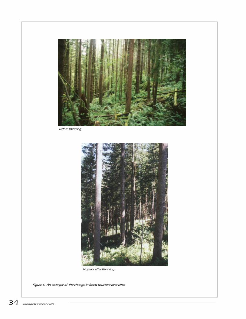
34 Blodgett Forest Plan
Figure 6. An example of the change in forest structure over time.
10 years after thinning.
Before thinning

Blodgett Forest Plan 35
Forest Structure
Achievement of the forest structure goal will be
measured by the time it takes to achieve the struc-
tural and connectivity goals. To meet these goals we
should:
1. Develop a mosaic of stands with at least 20% of
the forest at any time having at least 20 trees per
acre with an average DBH of at least 30 inches.
Once achieving this size criterion, maintain stands in
this size class for a minimum of 20 years. One
contiguous block at least 200 acres in size will be in
this mature forest condition at any point of time.
2. Develop some level of species and structural
diversity. One approach to achieving these goals is to
conduct commercial thinnings in a way that allows
for the survival and improved growth of some under
and mid-story trees. Generally, these are shade
tolerant species that have regenerated naturally as
older plantations become more open through density
dependent mortality or commercial thinning.
Operationally, assisting these younger trees requires
1) controlled felling to protect some patches of
regeneration, 2) heavier thinning above retained
patches of younger trees, and 3) precommercial
thinning of the younger trees if their density is high.
Gains from this management are retention of more
shade tolerant species, development of a vigorous
mid-story, and creation of a more structurally diverse
overstory through variable levels of thinning.
3. Maintain hardwood patches within 1000 feet of
any point in the forest. Hardwoods will propagate
themselves following harvest operations at the
Blodgett Tract. Most will resprout after cutting, and
alder readily seeds in on sites with soil disturbance.
Thus, it is reasonable to expect that there will be
enough hardwood natural regeneration to meet
stocking goals. The location of the natural regenera-
tion will be identified and protected to maintain these
species in the forest.
4. Ensure that snags in a range of decay states are
present throughout the forest land base. In the 20%
of the forest having at least 20 trees per acre with an
average DBH of at least 30 inches, at least 250 snags
per 100 acres exceeding 15 inches DBH in a range of
decay states should be present, of which at least 75
snags will exceed 17 inches DBH, of which at least
20 snags will exceed 30 inches DBH. The remaining
80% of the forest should have at least 200 snags per
100 acres exceeding 15 inches DBH.
5. Move towards maintaining approximately 50% of
the large and medium perennial stream length in
stands dominated by hardwoods and 50% in stands
dominated by conifers. No stand should occupy more
than about 1000 feet of stream length. Stands on
opposite sides of a stream do not need to be the same
type. The type of a stand may change between
rotations provided that the general balance between
hardwoods and conifers is maintained. These stands
should be operationally defined management units
and may extend beyond the riparian area into the
upland.
6. Management of dead wood will lead to variable
levels on the forest floor, with averages determined in
an adaptive management strategy. Recruitment will
be done as needed during harvest where deficiencies
occur.
7. Representative legacy structures will be main-
tained across the forest. (A subcommittee of the
McDonald-Dunn Forest Advisory committee is
currently developing a definition for legacy structures
which should be inserted here after it has gone
through the appropriate review process.)
Goal Achievement

36 Blodgett Forest Plan
Net Revenue
Achievement of the net revenue goal will be measured
by the size, timing and fluctuation of harvest rev-
enues.
Research,Demonstration andExtension
Research and demonstration work that is conducted
on the Blodgett Tract should be compatible with the
forest plan. Proposals for new projects must be
submitted to the Research Coordinator and be
accompanied by a plan that includes an explanation
of the project�s compatibility with the forest plan and
harvest schedule. Research plans will not be ac-
cepted without sunset clauses and approval from the
forest director.
Good Neighbor
We will consult periodically with the neighbors who
surround our property to understand whether they
have special concerns about our use of their roads or
needs that we can accommodate. We have agreed
with our neighbors to:
1. Maintain locked gates with signs posted that
outline the rules for day use entry by recreational
users.
2. Coordinate hunting access, fire prevention, haul
routes and associated road maintenance.

Blodgett Forest Plan 37
A harvest scheduling model was developed to help
determine the timing and treatment choices that
move the forest to the structure and revenue goals.
This model identifies which management prescription
to assign to each management unit that is consistent
with structural goals, wind risk, logging feasibility
and revenue goals. Approximately 8000 combina-
tions of treatment and timing choices were developed
for the harvest scheduling model to choose from.
The harvest scheduling model uses a two-phase
simulated annealing heuristic. Simulated annealing
is a technique for solving combinatorial problems
which has been used in a range of industries includ-
ing several large applications in forest planning. The
first phase of the harvest scheduling model deter-
mines the fastest possible way to reach and maintain
the big-tree goal of 500 acres meeting the large tree
criterion. The second phase then adds the results
from the first phase as a constraint so that any
solution to the second phase must reach the big-tree
goal in the time determined in the first phase. The
second phase of the scheduling model then adjusts
the assignment of prescription choices to even out
the net revenue while maintaining big tree acreage
and connectivity. The second phase also incorporates
a thinning goal to provide a relatively constant
thinning program to demonstrate increased diameter
growth through thinning.
A 100 year planning horizon was used with 5-year
planning periods. Harvest units that the staff is
currently planning were fixed in the harvest sched-
ule.
Net revenue is represented as a goal while achieve-
ment of the big tree acreage and connectivity are
represented as constraints. Relative emphasis on
period revenue is achieved by varying the target
revenue per period and the relative emphasis on
reaching the revenue goal. All solutions must meet
the forest structure constraints and arrive at the big
tree goal at the earliest time.
Assumptions
Log Price and Harvest Costs
Log Prices
The Oregon Department of Forestry log prices (Table
2) for domestically processed logs (delivered to a mill;
�pond value�) 1998 1st quarter were used in our model
because they seemed to fit the current log price trend
better than our most recent historical prices.
Harvest Costs
Stump-to-mill logging costs were developed for skyline
and tractor logging systems. Costs include: fell,
delimb, buck, yard, load, and haul. Separate costs
were developed for thinning and clearcutting.
Skyline costs for thinning
Skyline yarding costs ($/MBF net Scribner) were
computed using the USDA Forest Service Region 6
skyline appraisal model. The model computed $/MBF
costs by first calculating hourly owning and operating
Harvest Schedule
Log Grade Douglas-fir Hemlock
#2 saw 590 475
#3 saw 530 430
#4 saw 445 355
Table 2. Log prices used in harvest scheduling
analysis.

38 Blodgett Forest Plan
costs ($204.65) then dividing by hourly production
rates as log volumes were varied between 70 and 340
board feet, and as cut volumes were varied between 3
and 20 MBF per acre. Felling, loading and haul costs
were then added to the yarding costs.
Production rates for motor manual felling in
thinnings were calculated using a production equa-
tion developed from Oregon State University studies
conducted at Hebo and Yachats (1996, Kellogg, L.D.,
G.V. Milota and M. Miller, Jr.). The felling production
rate in thinnings was then divided into an hourly
owning and operating cost of $37.02. Loading costs
were calculated by dividing the hourly owning and
operating costs of $60.00 by the yarding production
rate. An experienced haul cost of $1.02/MBF/mile
was used.
Assumptions:
Yarding equipment and crew: three-drum yarder
with 50 foot tower for thinning, diesel powered slack-
pulling carriage, tail tree rigging, radios, landing
tractor, fire truck, 2 pick-up trucks, 6-person yarding
crew excluding a loader operator, acres/skyline road
= 1.9 for thinning, acres/landing = 3.1 for thinning,
road change time= 1.8 hours, landing change time
=2.4 hours, 47.8 effective minutes/hour, average
lateral distance= 45 feet, average slope yarding
distance=467 feet (from sample of 9 map profiles
from Blodgett assuming 45% slope and 50% rectan-
gular settings, payload=7500 pounds, sale size: 1
mmbf, overhead=15% on fell, buck, yard, and load,
profit and risk on fell, buck, yard, and load=12%.
Haul costs were computed for an average haul of 41
miles.
Skyline costs for clearcutting
Costs for clearcutting were calculated in the same
manner as described for skyline thinning; however, a
larger 70 foot tower with a more powerful yarder and
carriage increased hourly owning and operating cost
to $251.58. Setting size was increased to 7.5 acres,
acres per skyline road was decreased to 1.4 acres to
account for fan shaped settings, and payload was
increased to 10,000 pounds. Felling costs were
calculated using a regression equation for larger tree
sizes expected in regeneration cuts (Edwards, 1992).
Skyline Costs for Units That Require Artificial Anchors
In areas where there are inadequate stump or tree
anchors for guylines or skyline, additional costs were
added to include an extra rigging slinger, tipping
plate anchors and installation gear, and an addi-
tional tractor. In thinnings, the additional costs
ranged from $4.20 to $18.19 per MBF as cut volume
per acre was varied between 20 MBF and 3 MBF, and
when log size averaged 130 board feet. Additional
costs in clearcuts ranged from $3.93 to $7.80 per
MBF as cut volume per acre was varied between 60
MBF and 40 MBF, and when log size averaged 130
board feet. Additional costs in clearcuts ranged from
$2.96 to $4.87 per MBF as cut volume per acre was
Log Log
MBF Size Volume Cut Per Acre
3 5 10 15 20
0.07 8�x34� 339.90 273.42 224.93 206.92 198.25
0.13 10�x34� 285.47 218.97 169.29 152.45 146.33
0.17 12�x34� 272.49 210.95 161.25 144.44 135.76
0.24 14�x34� 270.64 204.13 153.92 137.63 128.95
0.34 16�x34� 266.80 200.30 150.61 133.78 125.12
Table 3. Skyline stump to mill costs for thinning
harvest units
Table 4. Skyline Stump to mill costs for clearcut
harvest units
Log Log
MBF Size Volume Cut Per Acre
40 60
0.13 10�x34� 139.17 134.81
0.17 12�x34� 124.71 120.31
0.24 14�x34� 118.79 114.39
0.34 16�x34� 113.99 109.62
0.45 18�x34� 111.5 107.13
MBF cut/acre 3 10 20
With anchors $303.66 $178.13 $150.53
Without anchors $285.47 $163.29 $146.33
difference $18.19 $8.84 $4.20
Table 5. A comparison of costs with and without
artificial anchors

Blodgett Forest Plan 39
varied between 60 MBF and 40 MBF, and when log
size averaged 170 board feet.
Tractor Logging Costs
Stump to mill logging costs for tractor were assumed
to be 85 percent of the stump to mill logging costs for
skyline.
Road Construction, Reconstruction and Maintenance Costs
It was assumed that road costs would average $50
per MBF for this analysis. Road costs will be refined
after a transportation plan is built for the Blodgett
Forest over the next year.
Sale Preparation and Administrative Costs
Sale preparation and administrative costs excluding
office overhead costs are estimated to be $17.57/
MBF on clearcut harvest units and $42.20/ MBF on
thinning harvest units. Sale preparation and admin-
istration costs are higher for a thinning sale, because
more acres must be designed, laid out and treated for
the same volume; logging production rates for
thinnings are generally lower, and sale administra-
tion is more intense.
Assumptions:
Sale preparation and administrative costs for
clearcutting: Sale size 1.9 MMBF, staff person days
for field layout = 33, mileage = 3,600 (11 round trips
@ 300 miles per trip plus 6 overnights at 50 miles
per overnight), per diem for 23 person days on
overnight trips @ $30 for food and $41.00 motel each
= $1633, contract cruising = $988.40. Staff time for
log sale and logging services contract preparation
including skyline analysis, road design, map making,
and appraisal = 23 days, OSU purchasing cost for
postage = $60, contract Proctor and CBR test = $500.
Staff time for Oregon Department of Forestry Forest
Practice Notice and Written Plan = 6 days, Silvicul-
ture prescription 0.5 days, archeology survey and
documentation = 6 days. Sale administration = 2.5
person days per week for 4 months plus 8 person
days for prospective purchaser show-me trips, bid
awards, and close out inspections = 51 person days,
mileage for 26 round trips @ 300 miles each = 8000
miles, per diem for 9 overnights and 16 days = $850,
accountant office time @ 1.5 days per week for 5
months = 33 days. Office overhead is not included.
Sale preparation and administrative costs for thin-
ning: Assumptions are the same as above except for
the following: acres treated will be approximately 3-4
times greater than clearcutting for the same volume.
Some sample marking of cut or leave trees will be
necessary. Therefore, staff person days for field
layout associated travel and per diem will increase by
a factor of 3.5. Contract cruising will increase by a
factor of 2. Sale administration will increase to 4
days per week due to greater complexity and care
required. Logging production will be reduced;
therefore, contract term will increase and sale
administration months will increase to 8 months.
Accountant time will increase to 9 months.
Reforestation Costs
Logger working in�Wrongway� harvest unit.

40 Blodgett Forest Plan
Mechanical site preparation or broadcast burning will
be made on a unit by unit basis. The decision will be
made post-logging based on the amount of slash,
number of planting spots, mountain beaver
(Aplodontia rufa) populations and proximity to
fishbearing streams. Excavator piling will cost $125
to $175 per acre. The cost for broadcast burning will
be $200 to $400 per acre.
In riparian hardwood conversion units most of the
standing hardwoods will be killed using herbicides
(hack and squirt) to open up the stand for regenera-
tion if the hardwoods are not logged. The cost of this
treatment will be $30 to $50 per acre.
All clearcut harvest units will receive chemical site
preparation. The cost of aerial application will be
$120 to $130 per acre. The cost of ground-based
application will be $140 to 170 per acre.
Planting will cost $200 to $250 per acre ($120 to
$140 per acre for seedlings and $80 to $110 per
acre for labor).
Follow up treatments may include grass control
($80 to $125 per acre) or basal treatment of
hardwood sprouts ($75 to $100 per acre).
Many harvest units will require mountain beaver
control which will cost $75 to $100 per acre.
Precommercial thinning will occur when planta-
tions are around 15 years old and is expected to
cost $100/acre.
For the purposes of the harvest scheduling model
we have chosen an average discounted reforesta-
tion cost of $500 per acre for all treatments.
Defect and breakage
It was assumed that defect will average 3% of the
gross volume and that an additional 2% would be
left on the ground from breakage, so all yields
were reduced by 5% in the harvest scheduling
analysis.
Harvest ScheduleResults
Following the Administrative Committee�s November
16 meeting where seven alternative harvest sched-
ules were presented and discussed, the Dean en-
dorsed the big tree, non-reserve based strategy
developed by the planning team. He requested some
refinement of the alternative that emphasized income
during the first fifteen years of the plan while reach-
ing the structural goals of the plan as quickly as
possible. This refinement would concentrate on
smoothing revenue during out-periods of the plan.
Given this direction, the team developed the harvest
schedule shown on page 41 which meets the forest
structural targets within 15 years and maintains the
desired forest structure during the remaining 80
years of the 100 year planning horizon. The harvest
schedule demonstrates the feasibility of achieving the
non-reserve based strategy, but should not be
considered the only way to do so. It does provide one
Eight year old plantation.

Blodgett Forest Plan 41
sequence of harvest treatments that can achieve the
planning goals. As operational experience is gained
during the first period of the plan, this plan will
undoubtedly be refined and modified. The planning
infrastructure developed during the preparation of
this plan should facilitate plan updates.
Forest Structure
The desired forest structure of a minimum of 500
acres of forest with stands where the expected largest
20 trees equal or exceed an average of 30 inches is
estimated to be achieved within 15 years (see page
42). By this time, the goal of maintaining a contigu-
ous block of at least 200 acres of these large trees is
also achieved. This contiguous block of stands of
large trees in the north of the Blodgett Tract shifts
slowly over the remaining 80 years of the planning
horizon and by the end of the planning horizon has
developed conditions which bridge the north and
south areas of the Blodgett Tract.
Harvest Volumes
During the first five-year period the harvest activity
(page 40) is divided almost equally between clearcuts
(249 acres) and thinnings (247 acres). This is a
relatively intense period of activity and provides a
harvest of about 3.2 million board feet per year.
Almost the same number of acres is projected for
harvest in the second five-year period with a some-
what lower harvest volume. Reducing the rate of
harvest would not affect the time to reach the desired
forest structure goals, but would provide a larger
number of acres with large trees.
Income
The harvest schedule provides approximately $0.9
million of net revenue annually during the first 5
years of the plan and $0.7 million annually during
the following ten years of the plan. The present net
value of the harvest schedule is approximately $15
million at a 4% discount rate. This present net worth
is approximately 70-75% of the present net worth
that could be realized in the absence of landscape
goals and if harvest age throughout the tract could
be as low as 60 years.

42 Blodgett Forest Plan

Blodgett Forest Plan 43

44 Blodgett Forest Plan

Blodgett Forest Plan 45

46 Blodgett Forest Plan

Blodgett Forest Plan 47
Monitoring is an essential component of the Blodgett
Forest Plan, and funds for its successful execution
should be made available from revenues generated by
the Research Forests.
The Research Forests staff will be responsible for
monitoring or contracting services to monitor activi-
ties on the Blodgett Forest to ensure that activities
and actions are compatible with the forest plan. A
monitoring plan should be developed that is consis-
tent with the framework and philosophy of the one
currently under development for the McDonald/
Dunn Forest. This plan should encompass, but not
be limited to, the following activities.
1. Compile a list of forest practices and operations.
2. Document costs of goal achievement. Procedures
toward this end will be developed by the staff working
with appropriate faculty during the first five years of
plan implementation.
3. Inventory tree frequency distributions, by species
and diameter.
4. Inventory amount, decay class, and distribution of
dead wood.
5. Inventory the distribution and amount of different
plant communities and their developmental stages.
6. Compile actual harvest levels and growth rates for
stands.
7. Compile a list of sensitive species actually or
potentially using the forest.
8. Assess use of plant communities by selected
species.
9. Determine issues of interest and concern to
neighbors and public.
10. Assess the location and spread of Swiss needle
cast and exotic plants.
Sensitive speciesmonitoring
The Research Forests staff will be responsible for
monitoring or contracting services to monitor status
of sensitive species on the Blodgett Forest. Protocols
should be consistent with guidelines established by
the U.S. Fish and Wildlife Service and National
Marine Fisheries Service.
Response of bioticcommunities to dead wood
It is generally accepted within the scientific commu-
nity that dead wood on the forest floor is an impor-
tant component of wildlife habitat. However, specif-
ics concerning the amount, distribution, size, and
decay classes of dead wood that should be retained
to provide for particular wildlife populations remain
elusive. The Blodgett Forest initially will manage
dead wood in an adaptive framework, in which
different levels of dead wood will be retained or
created in stands, and the response of selected
wildlife species will be monitored through time. Final
establishment of standards and guidelines for the
Blodgett Forest will be based on data collected on the
forest and on complementary data collected from
other areas.
Monitoring

48 Blodgett Forest Plan

Blodgett Forest Plan 49
In order to communicate the essence of the plan in
a manner that can be quickly understood by our
faculty, students, neighbors and visitors, a brochure
will be developed from this plan for distribution.
This brochure will summarize the key elements of
the plan in a concise, understandable manner and
will also be highlighted on the Blodgett Forest Web
site. In addition, a field guide will be written for the
forest staff.
As a part of our annual meeting with the faculty and
students in the College of Forestry, we will include
our summary of past and future operations on the
Blodgett Tract as they relate to goal achievement.
Interpreting andRevising the Forest Plan
The Forest Advisory Committee that is currently in
place for McDonald/Dunn Forest will provide
oversight for interpreting and revising the Blodgett
Tract plan. This group may at times wish to seek
involvement from a representative of the Clatsop
State Forest and any interested neighboring private
landowners.
The Forest Advisory Committee should meet periodi-
cally to review the activities that have taken place,
the monitoring data that has been collected, and the
achievements that show progress towards the goals
in the plan. This review will help the staff under-
stand if their interpretation of the plan is consistent
with the Advisory Committee�s interpretation and
will determine if the experience and data presented
warrant any changes to the plan.
It is at this meeting that:
1. Members of the forest staff can bring forward
topics for clarification and information that supports
changes to the plan. The committee then will decide
if more information or a broader range of expertise
should be brought in to evaluate these ideas and
concerns.
2. Staff will show how harvest volumes realized
compare to inventory, how the revenue generated
compares to revenue predicted, and how they have
decided to approach harvest schedule implementa-
tion for the period.
3. The results of any monitoring data that has been
collected that either supports or raises questions
about our management methods will be presented. A
part of this presentation will naturally focus on how
forest structures are evolving compared to those that
we seek to achieve through this forest plan.
4. Staff will present a summary that shows how the
work that has been completed in the past and
activities that are proposed for the future relate to
goal achievement.
This committee will then draft proposed changes to
the plan for the Dean�s review. The original text of the
plan, the changes that have been approved and the
most current version of the plan will reside on the
Web (to ensure that there is no confusion over
versions).
If assistance is needed before the annual meeting to
implement the plan, staff members will seek the
advice of those members of the faculty that are the
most interested and knowledgeable about the out-
come of the question that is being raised.
Communication andDecision Making

50 Blodgett Forest Plan
Fishhawk Falls

Blodgett Forest Plan 51
Under the proposed Blodgett Tract Management plan,
opportunities will evolve to demonstrate silvicultural
and management techniques in Pacific Northwest
coastal forests. Many of these techniques were
learned during COPE. This plan represents a unique
array of management and silvicultural activities in a
forested landscape dominated by economic objectives
coupled to short harvest rotations. In the near term,
management techniques in riparian areas to main-
tain and enhance fish habitat; road construction and
maintenance alternatives; and outputs from 85+ year
rotations with intermediate harvests will be of
particular interest. However, it needs to be recog-
nized that development of a demonstration area
requires careful planning through the formulation,
implementation and assessment of the management
plan. Adding demonstration and educational pro-
grams onto an ongoing program may not be success-
ful and may be reflected in missed opportunities.
Potential Audience
Resource Professionals
Northwest Oregon and southwest Washington are
heavily dominated by actively managed forestland.
The professionals that participate in this land
management range from foresters and loggers to fish
biologists and hydrologists. The major employers are
private industry and state agencies. In a recent
survey conducted by the College of Forestry Exten-
sion Program, it was apparent that this audience
wants localized, relevant one-day training and
educational opportunities that assist them in making
better management decisions. The Blodgett Tract
would provide an excellent opportunity for the land
managers and resource professionals to obtain such
training. The Blodgett Tract is within a 3-hour drive,
from Corvallis, OR, Hood River, OR, Olympia, WA
and Raymond, WA.
Demonstration andExtension Activities
General Public
The proximity of the Blodgett Tract to the Portland
Metro area offers the chance to involve the �metro-
public� in forest management activities. Day trips by
local school children; hiking clubs, environmental
organizations, and the public are just a few potential
opportunities. In addition, there are several local
groups such as watershed councils and local com-
munity leaders who have a direct interest in learning
more about forest management practices.
Develop Partnerships
There are numerous opportunities for the Blodgett
Tract to develop partnerships with several other
forestry and educational groups located in the region.
Several potential cooperators in education/demon-
stration programs are listed:
Oregon Forest Resources Institute (OFRI)
OSU Extension
Local Schools
Youth
Vocational Education
Oregon Trout
Fishhawk Lake Association
Magness Tree Farm
World Forestry Center
Oregon Small Woodlands Chapters in Columbia,
Washington and Clatsop Co.
Tree Farm Association
Upper Nehalem Watershed Council
Oregon Department of Forestry
Facilities
To have a successful educational program there
eventually needs to be an infrastructure to support
public attendance. The minimal requirements are

52 Blodgett Forest Plan
shelter from the rain/sun, restrooms and
running water. As things develop, plans could
be made for overnight accommodations,
cooking and indoor classroom space.
Personnel
Involvement of local educational professionals
is critical to the success of this program.
These professionals would come from Clatsop
Community College, Oregon Department of
Forestry and OSU Extension. Extension
would be at the center of the program. In
addition, an on-site OSU Forester would play
a very beneficial role in linking the research,
management and educational programs.
Fishhawk Creek

Blodgett Forest Plan 53
Literature Cited
Agee, J.K. 1993. Fire Ecology of Pacific Northwest Forests. Island Press, Washington, D.C.; Covelo, CA. 493p.
Ahrens, G.R., A. Dobkowski, and D.E. Hibbs. 1992. Red alder: Guidelines for successful regeneration. OSUForest Research Laboratory Special Publication 24.
Barbour, R.J., S. Johnston, J.P. Hayes, and G.F. Tucker. 1997. Simulated stand characteristics and woodproduct yields of Douglas-fir forest managed for ecosystem objectives. Forest Ecology and Management 91:305-219.
Benda, L.E. and J.C. Sias. 1998. Landscape controls on wood abundance in streams. Earth Systems Insti-tute, Seattle, Washington.
Blodgett, J. W. 1928. Letter of August 16, 1928 to J. K. Weatherford, Board of Regents, O.S.C.
Butts, S. R. 1997. Associations of forest floor vertebrates with coarse woody debris in managed forests,western Oregon Cascades. M.S. thesis, Oregon State University.
Carey, A. B., M. M. Hardt, S. P. Horton, and B. L. Biswell. 1991. Spring bird communities in the OregonCoast Range. Pages 123-142 in Ruggiero, L. F., D. B. Aubry, A. B. Carey, and M. H. Huff, tech. coords.Wildlife and vegetation of unmanaged Douglas-fir forests. USDA Forest Service Pacific Northwest ResearchStation General Technical Report PNW-GTR-285.
Carey, A. B., and M. L. Johnson. 1995. Small mammals in managed, naturally young, and old-growthforests. Ecological Applications 5:336-352.
Dunn, P. M. 1943. School of Forestry Lands: Blodgett Forest.
Edwards, Richard M. 1992. Logging planning, felling, and yarding costs in five alternative skyline groupselection harvests. Master of Forestry Paper. Dept. of Forestry Paper; Dept. of Forest Engineering, Collegeof Forestry, OSU, Corvallis, OR. 213 pages.
Emmingham, W. and K. Maas. 1994. Survival and growth of conifers released in alder-dominated coastalriparian zones. COPE Report Vol. 7, No. 2 & 3, p. 13-15.
Hagar, J. C., W. C. McComb, and W. H. Emmingham. 1996. Bird communities in commercially thinned andunthinned Douglas-fir stands of western Oregon. Wildlife Society Bulletin 24:353-366.
Hann, D.W., A.S. Hester, and C.L. Olsen. 1995. ORGANON user�s manual: Edition 5. Department of ForestResources, Oregon State University, Corvallis.
Hayes, J. P. and S. P. Cross. 1987. Characteristics of logs used by western red-backed voles (Clethrionomyscalifornicus) and deer mice (Peromyscus maniculatus). Canadian Field-Naturalist 101:543-546.
Hayes, J. P., S. Chan, W.H. Emmingham, J. Tappeiner, L. Kellogg, and J.D. Bailey. 1997. Wildlife response tothinning young forests in the Pacific Northwest. Journal of Forestry 95(8):28-33.

54 Blodgett Forest Plan
Hayes, J.P., M.C. Adam, R.G. Anthony, W.H. Emmingham, D.M. Gomez, D.J. Larson, K.G. Maas-Hebner, N.Suzuki, W.G. Thies, D.J. Westlind, and J.M. Weikel. 1998. Effects of commercial thinning on stand struc-ture and wildlife populations: A progress report, 1994-1997. Coastal Oregon Productivity EnhancementProgram, College of Forestry, Oregon State University, Corvallis, OR.
Hayes, J. P., and J. Hagar. In press. Ecology and management of wildlife and their habitats in the OregonCoast Range. In Hobbs, S. D., J. P. Hayes, R. L. Johnson, G. H. Reeves, T. A. Spies, and J. C. Tappeiner(eds.). Forest and stream management in the Oregon Coast Range.
Kellogg, L.D., G.V. Milota and M. Miller Jr., 1996. A comparison of skyline harvesting costs for alternativecommercial thinning prescriptions, Journal of Forest Engineering, 7(3):7-23.
Krauss, M. E. 1990. Kwalhioqua and Clatskine. In Handbook of North American Indians, Northwest Coast,edited by W. Suttles, pp. 530-532. Volume 7. Smithsonian Institute, Washington D. C.
Labbe, J. T. and V. Goe. 1995. Railroads in the Woods. Oso Publishing Company, Arlington.
McArdle, R. E., W. H. Meyer and D. Bruce 1961 Yield of Douglas-fir in the Pacific Northwest. USDA Bull.201. Washington DC. 74 p.
McDade, M. H. 1987 The source area for coarse woody debris in small streams in western Oregon andWashington. M. S. thesis. Oregon State University, Corvallis. 63 p.
McGarigal, K., and W. C. McComb. 1992. Streamside versus upslope breeding bird communities in theCentral Oregon Coast Range. Journal of Wildlife Management 56:10-23.
Mason, E. 1938. Memorandum to the files, Blodgett Tract. On file O.S.U. Research Forest Field Office.
Marshall, D.D., D.L. Johnson and D.W. Hann. 1998. A forest management information system for education,research and operations. Journal of Forestry 95(10):27-30.
Minore, Don, and Howard Weatherly. 1994. Riparian trees, shrubs and forest regeneration in the coastalmountains of Oregon. New Forests 8:249-263.
Munger, T. T. 1938. Forest Survey Type Map of the Oregon State College tract in Columbia County.
Murphy, M. L. and K. V. Koski 1989 Input and depletion of woody debris in Alaska streams and implica-tions for streamside management. N. Amer. J. Fish. Mgt. 9(4):427-436
Neim, A.R. and W.A. Niem. 1985. Oil and gas investigation of the Astoria Basin, Clatsop, and northernmostTillimook counties, northwest Oregon. Oregon Department of Geology and Mineral Industries. Oil and GasInvestigation )GI-14, scale 1:100,000.
Neim, A.R., P.D. Snavely, and W.A. Niem. 1990. Onshore-offshore geologic cross section from the Mist gasfield, northern Oregon Coast Range, to the northwest Oregon continental shelf. Oregon Dept. Geol. AndMineral Indus., Oil and Gas Inv. 17, 46 p.
Neitro, W. A., V. W. Binkley, S. P. Cline, R. W. Mannan, B. G. Marcot, D. Taylor, and F. F. Wagner. 1985.Snags (wildlife trees). Pages 129-169 in Brown, E. R., Tech. Ed. Management of wildlife and fish habitatsin forests of western Oregon and Washington. USDA Forest Service Publication R6-F&WL-192-1985.
Nettleton, H. I. 1954. General Notes on the Blodgett Tract.
Nierenberg, Tera. 1996. A characterization of unmanaged riparian overstories in the Central Oregon CoastRange. M.S. thesis, Oregon State University, Corvallis.
Orr, E.L., W.N. Orr, and E.M. Baldwin. 1992. Geology of Oregon. Fourth Edition. Dendall/Hunt PublishingCo. Dubuque, Iowa.

Blodgett Forest Plan 55
Peavy, G. 1928. Letter to Earl B. Tanner of the Blodgett Company.
Skaugset, A. E. Dent, D. Bateman, P. Connolly. 1994. The effect of woody debris piece size and orientation onaquatic habitat in Oregon Coast Range headwater streams. COPE Report Vol. 7, No. 4, p. 3-6.
Thompson, R. L. 1996. Home range and habitat use of western red-backed voles in mature coniferous forestsin the Oregon Cascades. M. S. Thesis, Oregon State University.
USDA Soil Conservation Service. 1986. Soil Survey of Columbia County, Oregon. 198 p.
Van Sickle J. and S. V. Gregory 1990 Modeling inputs of large woody debris to stream from falling trees.Can. J. For. Research 20:1593-1601
Voorhies, R. V. 1952. Aerial Photographs as an Aid in Preparing a Management Plan for the Blodgett Tract.Masters of Forestry, Oregon State College.
Walstad, J.D., S.R. Radosevich, D.V. Sandberg (eds.) 1990. Natural andPrescribed Fire in Pacific NorthwestForests. Oregon State University Press, Corvallis, Or. 317 p.
Wilson, S. 1938. Memorandum for the files, Blodgett Tract, June 14, 1938. On file O.S. U. Research ForestField Office.