Forest Development Plan Template
42
Transcript of Forest Development Plan Template


Supporting Document Hazelton Forest Stewardship Plan Replacement- 2018-2023
ii

Supporting Document Hazelton Forest Stewardship Plan Replacement- 2018-2023
iii
Table of Contents
SD 1 INTRODUCTION ................................................................................................................................ 1 1.1 Public Review and Comment Process .............................................................................................. 1 1.2 Public and Stakeholder Engagement Outside of the FSP Process ................................................. 2 1.3 Context of the FSP within the Existing Planning Framework ........................................................... 2 1.4 Interpretation ....................................................................................................................................... 3
SD 2 ADDITIONAL FSP INFORMATION .................................................................................................. 6 2.1 FSP Content Requiring Clarification .................................................................................................. 6
SD 3 INFORMATION DIRECTLY RELATED TO THE RESULTS AND STRATEGIES ....................... 9 3.1 Soils ................................................................................................................................................... 10 3.2 Timber ............................................................................................................................................... 12 3.3 Wildlife ............................................................................................................................................... 16 3.4 Water ................................................................................................................................................. 21 3.5 Fish .................................................................................................................................................... 26 3.6 Biodiversity ........................................................................................................................................ 28 3.7 Cultural Heritage Resources ............................................................................................................ 31 3.8 Recreation Resources ...................................................................................................................... 35 3.9 Resource Features ........................................................................................................................... 35 3.10 Visual Quality ................................................................................................................................. 36 3.11 Forage and Associated Plant Communities ................................................................................ 37 3.12 Consideration of Multiple Resource Value Assessment (MRVA) Reports................................. 37

i
Supporting Document Hazelton Forest Stewardship Plan Replacement 2018-2023
1
SD 1 INTRODUCTION This document is provided in support of the BCTS Hazelton Forest Stewardship Plan Replacement (FSP) for the Skeena Stikine Natural Resource District portion of the BC Timber Sales (BCTS) Skeena Business Area. This supporting document is organized as follows:
1) Section SD1: Introduction, public review and comment, context of this FSP within the current planning framework that exists on the FSP area and interpretation.
2) Section SD2: Discussion regarding specific FSP content that requires clarification.
3) Section SD3: General descriptions and discussion of issues with respect to each of the eleven forest values that have been identified in the Forest and Range Practices Act (FRPA), followed by information that relates directly to the strategies and results noted in the FSP. The general discussion allows a more conversational description of the intent of the FSP, and adds clarity and context to the enforceable strategies and results noted in the FSP. It is BCTS’ intent that this will simplify the FSP for the layperson.
This “Supporting Document” is not considered part of the Forest Stewardship Plan. Its purpose is to provide context for the strategies and results described in the FSP.
1.1 Public Review and Comment Process The FSP is a landscape level plan that demonstrates how BCTS will be consistent with established government objectives for managing the FRPA values within the specified Forest Development Units (FDU) of the plan. During the development of the FSP, First Nations, the public, and stakeholders were provided with an opportunity to review the results, strategies, and measures BCTS has developed. This opportunity was carried out in a manner that is consistent with Section 20 of the Forest Planning and Practices Regulation (FPPR). BCTS carried out the following actions:
1) Placed an advertisement in the Terrace Standard and the Smithers Interior News The advertisements ran in both papers on December 7, 2016 and again on January 4, 2017 and contained all the information required under FPPR Section 20(1).
2) Copies of the FSP were made available at the BCTS Skeena Timber Sales Office and the
Smithers, Hazelton, and Terrace public libraries. Copies were made available from December 7, 2016 to February 7th, 2017.
3) Completed a 60-day Public Review and Comment Period
The official period started on December 7, 2016 and ended on February 7, 2017 for a total of 63 days.
4) First Nations whose traditional territories or treaty areas overlapped with the FSP area
were sent information sharing letters. The letters described the purpose of the proposed FSP replacement and requested that the First Nation provide comment.
5) Identified Stakeholders (Trappers, Guide Outfitters, Range Tenure Holders, etc.) were sent
information sharing letters. The letters described the purposed of the proposed FSP replacement and requested comment from the stakeholder.

Supporting Document Hazelton Forest Stewardship Plan Replacement 2018-2023
2
1.2 Public and Stakeholder Engagement Outside of the FSP Process BCTS recognizes the importance of effectively communicating our plans to the public, stakeholders, and other interested parties. Outside of the legally required FSP, detailed operational information about BCTS operations, via the BCTS Skeena Business Area Five Year Operating Plan, is made available through the following BCTS web link: Skeena Business Area BC Timber Sales Five Year Operating Plan: https://www.for.gov.bc.ca/bcts/areas/TSK/TSK-Five-Year-Plan.htm The five year plan is updated annually and consists of an overview map, table, and Google Earth .kmz file detailing the location, size, volume, and planned year of auction for BCTS planned blocks over the five year period. In addition to the posting of the five year plan BCTS:
1) Consults with First Nations at the site level (blocks and roads) and in accordance with applicable agreements and provincial standards; and,
2) Information shares with various stakeholder groups regarding planned BCTS operational activities. These stakeholder groups include crown tenure holders, guide outfitters, trapline holders, range tenure holders, private land owners, and water licence holders.
1.3 Context of the FSP within the Existing Planning Framework The FSP is located within the Skeena Stikine Natural Resource District, and the related FDUs are located within the Kispiox Timber Supply Area (TSA). Several strategic planning initiatives have occurred within these areas:
1.3.1 Gitanyow Lax’yip Land Use Plan The Gitanyow Lax’yip Land Use Plan was approved on March 28, 2012 and is applicable within the Cranberry FDU of the Hazelton FSP. The management goals, objectives, measures/indicators and targets of the plan apply throughout the Gitanyow Lax’yip (the traditional territory of Gitanyow). The plan is the outcome of collaborative strategic land use planning undertaken by Gitanyow and the Province for the Gitanyow Lax’yip, which are overlapped by the Nass, Cranberry, Kalum, and Kispiox planning areas.
1.3.2 Cranberry Sustainable Resource Management Plan The Cranberry Sustainable Resource Management Plan was developed in partnership with the Nisga’a Lisims Government, Gitanyow, and the Province and was approved on June 22, 2012. The plan is applicable within the Cranberry FDU of the Hazelton FSP. The purpose of the plan is to provide long-term sustainability of jobs, communities, and natural resources in the Cranberry Landscape Unit. It is intended to provide a balance of social, economic and environmental values that meet the interests of all who have a concern for the area.
1.3.3 Kispiox Land and Resource Management Plan The Kispiox Land and Resource Management Plan was approved on April 25, 1996 and amended in March 2001. The plan provides management objectives and strategies for biodiversity, water, fisheries, riparian areas, roads, cultural heritage resources, protected areas, range and agriculture, recreation, scenic areas, timber, tourism, wildlife, minerals, petroleum and natural gas, and botanical forest products. The plan designates resource management zones for protection, special resource management and general resource development, and is applicable within the Cranberry, Kispiox, and West Babine FDUs.

Supporting Document Hazelton Forest Stewardship Plan Replacement 2018-2023
3
1.3.4 Kispiox LRMP Higher Level Plan Objectives for Biodiversity, Visual Quality, and Wildlife
The Kispiox LRMP Higher Level Plan Objectives for Biodiversity, Visual Quality, and Wildlife was approved on January 27, 2006 and is applicable within the Kispiox FDU of the Hazelton FSP. It was developed in response to changes in provincial forest legislation from the Forest Practices Code to the Forest and Range Practices Act. The plan serves as the functional interpretation of the Kispiox LRMP objectives for biodiversity, wildlife, and visual quality, under current legislation.
1.3.5 Xsu gwin lik’l’inswx: West Babine Sustainable Resource Management Plan The West Babine Sustainable Resource Management Plan was approved on August 1, 2004. The plan establishes the West Babine Landscape Unit and establishes landscape level objectives for Biodiversity, Wildlife and Fish, Water Quality and Hydrology, Cultural Heritage Resources, Visual Quality, Special management Zones, Babine River Corridor Wilderness Protected Area, Tourism, Forestry, Mineral and Energy Resources, Fisheries, Botanical Forest Products, Trapping, and Access Management. The plan applies within the West Babine FDU of the Hazelton FSP.
1.3.6 Gitwangak Land Use Plan for all Gitwangak Traditional Territory within the Kispiox, Kalum, and Bulkley Forest Districts
The objectives and strategies found within the Gitwangak Land Use Plan for all Gitwangak Traditional Territory within the Kispiox, Kalum, and Bulkley Forest Districts are specific to the Land Use Plan Area and reflect Gitwangak desires and vision regarding resource management on the Gitwangak Territories. The plan overlaps the Kispiox FDU of the Hazelton FSP and is considered by BCTS when operational activities are planned within the area.
1.4 Interpretation All references to the Forest and Range Practices Act, or to FRPA, mean the Forest and Range Practices Act (SBC 2002, s.69, current to March 3, 2017) All references to the Forest Planning and Practices Regulation, or to “FPPR”, mean the Forest Planning and Practices Regulation (BC Reg 177/2014, consolidated to February 29, 2016) as it was on March 3, 2017. All references to the Government Actions Regulation, or to GAR, mean the Government Actions Regulation (BC Reg 582/2004, effective Dec 13, 2004) as it was on March 3, 2017. All references to the Land Act mean the Land Act (Chapter 245[RSBC 1996], effective March 18 2013) as it was on March 3, 2017. All references to the Kispiox HLPO, mean the Kispiox LRMP Higher Level Plan Objectives for Biodiversity, Visual Quality and Wildlife Order (January 27, 2006). All references to the Kispiox LRMP, mean the Kispiox Land and Resource Management Plan (April 1996, Amended March 2001). All references to the West Babine SRMP, mean the Xsu gwin lik’l’inswx: West Babine Sustainable Resource Management Plan (March 2004). All references to the Cranberry SRMP, mean the Ministerial Order Land use Objectives Regulation Order Cranberry Sustainable Resource Management Plan (March 3, 2016). Unless otherwise noted, statements and information provided are current to March 3, 2017. Every effort has been made to ensure that current data have been used in map generation and analyses: i.e. current to March 3, 2017.
1.4.1 Acronyms Acronyms used in the FSP or Supporting Document are as follows: AIA: Archaeological Impact Assessment AOA: Archaeological Overview Assessment

Supporting Document Hazelton Forest Stewardship Plan Replacement 2018-2023
4
ATV: All Terrain Vehicle BA: Basal Area BCTS: BC Timber Sales BEC: Biological, Ecological, and Climatic; or Biogeoclimatic Ecosystem Classification BMP: Best Management Practices C&E: Compliance and Enforcement CDC: Conservation Data Center CMT: Culturally Modified Tree CWD: Coarse Woody Debris CWH: Coastal Western Hemlock DDM: Delegated Decision Maker ECA: Equivalent Clearcut Area EMS: Environmental Management System FDP: Forest Development Plan FDU: Forest Development Unit FL: Forest Licence FLTC: Forestry Licence to Cut FPPR: Forest Planning and Practices Regulation FRPA: Forest and Range Practices Act FSP: Forest Stewardship Plan FSP Holder: BC Timber Sales Skeena Business Area, Timber Sales Manager GAR: Government Actions Regulation GWM: General Wildlife Measure HLP: Higher Level Plan ICH: Interior Cedar-Hemlock LRMP: Land and Resource Management Plan LUOR: Land Use Order Regulation LU: Landscape Unit MAL: Ministry of Agriculture and Lands MH: Mountain Hemlock FLNRORD: Ministry (or Minister) of Forests, Lands, Natural Resource Operations & Rural
Development NAR: Net Area to be Reforested NDT: Natural Disturbance Type NSR: Not sufficiently restocked OGMA: Old Growth Management Area OSBG: Objectives set by Government Period of the FSP: The 5 year period commencing on the day of approval of the Hazelton Forest
Stewardship Plan Replacement FSP 2018-2023 QP: Qualified Professional RIC: Resource Inventory Committee RMA: Riparian Management Area RMZ: Riparian Management Zone RPBio: Registered Professional Biologist RPF: Registered Professional Forester RRZ: Riparian Reserve Zone SP: Site Plan

Supporting Document Hazelton Forest Stewardship Plan Replacement 2018-2023
5
SRMP: Sustainable Resource Management Plan SSNRD: Skeena Stikine Natural Resource District TSA: Timber Supply Area TSM: Timber Sales Manager, Skeena Business Area TSFA: Terrain Stability Field Assessment TSK: BC Timber Sales - Skeena Business Area TSL: Timber Sale Licence UWR: Ungulate Winter Range VIA: Visual Impact Assessment VQO: Visual Quality Objective VSC: Visual Sensitivity Class WAP: Watershed Assessment Procedure WHA: Wildlife Habitat Area WTP: Wildlife Tree Patch

Supporting Document Hazelton Forest Stewardship Plan Replacement- 2018-2023
6
SD 2 ADDITIONAL FSP INFORMATION
2.1 FSP Content Requiring Clarification
2.1.1 Summary
Clarification is useful for a number of issues that came up in the preparation of this FSP including the address of relevant objectives and information limitations. Inconsistencies and gaps in land use objectives showed up in a variety of ways that will be detailed in this section along with the approach taken by the TSM to address each issue. This discussion could serve to inform future revision processes for the applicable land use objectives.
Inconsistencies and gaps in land use objectives include: 1. Overlapping land use objectives for the Cranberry FDU (see SD Section 2.1. 2 ); 2. Gaps in established land use objectives for Biodiversity Wildlife Tree Patch Retention targets in the Babine,
Gitsegukla and West Babine LU’s and the absence of seral stage targets for a specific BEC subzone (see SD Section 2.1.3);
3. Inconsistencies in spatial boundaries affecting land use objectives within land use plans (see SD Section 2.1.4); and,
4. Inappropriate inclusion of elements in land use objectives (see SD Section 2.1.5).
Where inconsistencies within objectives arise from different legislation, section 149(2) of the FRPA sets out an initial hierarchy that deals with which objective would prevail. Section 149(2) states that if there is an inconsistency between an objective established or carried forward from 1) Land Use Objectives and an objective set under 2) Objectives in Regulation then the objective under 1) Land Use Objectives prevails to the extent of the inconsistency. This inconsistency may come in the form of providing a refinement of an objective, or even to the extent of completely replacing the objective set under 2) Objectives in Regulation. In this FSP, there is no reference to the FRPA or FPPR in cases where a land use objective solely applies. This is to avoid confusion around what objective applies and what result, strategy, practice requirement or measure is appropriate. In all cases the objective is as stated in the FSP. No additional interaction is intended, implied, or assumed to apply unless specifically stated in the FSP.
2.1.2 Overlapping Land Use Objectives (FRPA, Kispiox LRMP, and Cranberry SRMP LUOR Order) in the Cranberry FDU
There are several sets of land use objectives within the Cranberry FDU that were considered during the preparation of this FSP. Some of the objectives from the Gitanyow Land Use Plan do not have legal effect, and have not been addressed by the Cranberry SRMP LUOR Order. They have been used during the preparation of this FSP as reference information and have been evaluated for relevance against the applicable legal objectives and the nature of the FSP results and strategies that were developed across the entire area of application of this FSP.
In the Cranberry FDU, established Land Use Objectives from the Kispiox LRMP apply to part of the unit and objectives from the Cranberry SRMP LUOR apply over the entire FDU. The Kispiox Higher Level Plan Objectives for Biodiversity, Visual Quality and Wildlife specifically do not apply to this FDU. Unfortunately, having the Kispiox LRMP objectives , which apply to one part of the Cranberry FDU, and the Cranberry SRMP LUOR Order objectives apply everywhere in the FDU, results in two sets of objectives for this small landbase unless an alternative objective set can be established to harmonize these.
2.1.3 Gaps in Land Use Objectives - Biodiversity Indicators, and Threshold/Measures
During preparation of this FSP, gaps were identified in established land use objectives for Biodiversity Wildlife

Supporting Document Hazelton Forest Stewardship Plan Replacement- 2018-2023
7
Tree Patch Retention targets in the Babine, Gitsegukla and West Babine LU’s. Additionally, there was noted to be an absence of seral stage targets for a specific biogeoclimatic subzone. These gaps are detailed and discussed in Tables 1 below:
Table 1. Address of Gaps in Land Use Objectives, Indicators, and Threshold/Measures HLP Reference FSP Reference Description of HLP
Gap How FSP Addresses
the Gap Additional Information or
Rationale
Kispiox Higher Level Plan Objectives for Biodiversity, Visual Quality and Wildlife. Section 1.0 Biodiversity Objectives – Table 3 Wildlife Tree Patch Retention Targets
Result 2.7.2.1 Table 2-5
Babine and Gitsegukla Landscape Units missing from Kispiox HLPO Table 3, Landscape Unit Indicators and Threshold/Measures for Biodiversity – Wildlife Tree Retention in the Kispiox FDU.
Landscape Units and WTP Threshold / Measures added to FSP Table 2.5.
Targets for these LU’s had been established as part of the analysis process used to inform the Kispiox HLPO objectives. These have been brought forward from this analysis (Ardea Biological Consulting, Dec. 2004) and adopted by the FSP for consistency and completeness.
Kispiox Higher Level Plan Objectives for Biodiversity, Visual Quality and Wildlife. Section 1.0 Biodiversity Objectives – Table 1 Seral Stage Targets
Result 2.7.1.1, Strategy 2.7.1.2 Table 2-4
ESSFmc BEC subzone missing from Kispiox HLPO Table 1 NDT 2 listing.
ESSFmc BEC subzone added to FSP Table 2-4.
Targets for this BEC subzone had been established as part of the analysis process used to inform the Kispiox HLPO objectives. These have been brought forward from this analysis (Ardea Biological Consulting, Dec. 2004) and adopted by the FSP for consistency and completeness.
Xsu gwin lik’l’insxw: West Babine Sustainable Resource Management Plan Section 3.1.1.2 Management Direction for Biodiversity Table 5 Wildlife Tree Retention Targets
Objective 4.7.4 and Result 4.7.4.1 Table 4-8.
West Babine SRMP Table 5 does not include several Watershed / BEC Subzone Indicators and Threshold/Measures for Biodiversity – Wildlife Tree Retention
Added to FSP Table 4-8 the missing Watershed / BEC Subzone Indicators and Threshold/Measures for Biodiversity – Wildlife Tree Retention (refer to Table 3 below for details).
Targets for these Watershed / BEC Subzones had been established as part of the analysis process used to inform the Kispiox HLPO objectives. These have been brought forward from this analysis (Ardea Biological Consulting, Dec. 2004) and adopted by the FSP for consistency and completeness. These were modified to conform to the West Babine SRMP Table 17 format, specifying targets based on Block size, consistent with the SRMP Technical Report (p. 15). Refer to footnote 1 of Table 2 below.

Supporting Document Hazelton Forest Stewardship Plan Replacement- 2018-2023
8
Table 2. Additional Wildlife Tree Patch Retention Objective Targets Watershed2 BEC Subzone WTP Retention Target %
Blocks <= 80 ha Blocks > 80 ha1
1. Shelagyote ESSFmc 4 6 - 8
SBSmc 1 1.5 – 2
2. Babine River ESSFwv 4 6 – 8
3. Gail - Thomlinson ESSFmc 5 7.5 – 10
SBSmc 3 4.5 – 6
4. Nichyeskwa ESSFwv 4 6 – 8
5. Shedin ICHmc 4 6 – 8 1 The target specified for Blocks > 80 ha is based on the direction within the WB SRMP Technical Report (p. 15) and
reflects the range from 150 – 200 % of the target for Blocks <= 80 ha. 2 There is no ICH within the Hanawald watershed and so the existing target specified in the WB SRMP Table 5 will have
no effect.
2.1.4 Inconsistencies in Spatial Boundaries Affecting Land Use Objectives
Inconsistencies in spatial boundaries exist between the land use plans in effect for the area of the FSP and with related information that supports administration of these objectives. These are detailed and discussed below:
1. There were inconsistencies in approach to delineation of landscape unit boundaries between the Kispiox Higher Level Plan Objectives for Biodiversity, Visual Quality and Wildlife and the West Babine SRMP. Specifically, the Kispiox HLPO describes and delineated landscape units for the plan area on the basis of the Gitanyow and Gitxsan First Nation “Watersheds” defined by these First Nations for their administrative purposes. The West Babine SRMP did not use the same information source at the time that the West Babine Landscape Unit was delineated. The combined effect of the related Orders establishing the landscape units for each land use plan results in material areas of overlap between the West Babine Landscape Unit and the adjoining Middle Skeena North and South Gitxsan Watersheds. In accordance with the Orders, the West Babine Landscape Unit takes precedence in these areas of overlap and the FSP has been prepared accordingly. There is also a significant area of the Babine Gitxsan Watershed that is outside of the area of the West Babine Landscape Unit, resulting in a small landscape unit (Babine) relative to the others. In addition, a material portion of the Middle Skeena North Landscape Unit is partitioned from the majority portion of this LU by virtue of the West Babine Landscape Unit taking precedence in accordance with the Order. Future revision processes to these land use plans should strive to harmonize the landscape unit boundaries with the Gitxsan First Nation Watershed boundaries, thereby reducing the number of landscape units (by e.g. amalgamating the Babine and West Babine LU’s) and eliminating partitions in landscape units (Middle Skeena North).
2. There are inconsistencies in the spatial information used to prepare the FSP with regards to the Timber Supply Area boundaries and the Landscape Unit boundaries in locations where these are intended to be congruent. Specifically, the Cranberry Landscape Unit and the administrative divide between the Cranberry and Kispiox TSA’s should be harmonized in these locations in the spatial data sets used to prepare the FSP. This issue has been addressed by the FSP by means of the FDU boundaries given effect for the Plan as mapped.
3. There are inconsistencies in the spatial boundaries considered by reference information sources that are used to support implementation of the FSP. Specifically, the West Babine SRMP has established watershed boundaries to support the objectives for biodiversity, grizzly bears and water quality. The Kispiox Expert Water Panel (KEWP) has similarly established watershed boundaries in support of managing hydrological integrity and these boundaries may be considered integral to meeting the FSP
Supporting Document Hazelton Forest Stewardship Plan Replacement- 2018-2023
9
objectives for water. These watershed boundaries do not match within the West Babine Landscape Unit which results in the KEWP analysis products not effectively serving the monitoring of water quality indicators in the West Babine Landscape Unit. This inconsistency should be removed by revision of either the KEWP or the WB SRMP watershed boundaries. The West Babine Landscape Unit watershed boundaries as described by the SRMP will take precedence for purposes of this FSP.
2.1.5 Inconsistency of Elements in Land Use Objectives
The Kispiox Higher Level Plan Objectives for Biodiversity, Visual Quality and Wildlife Section 2.0 Visual Quality Objectives make reference to known scenic areas and specifically indicates that they are established through the related Order. The listing of known scenic areas includes references to recreation sites and areas, consistent with the Kispiox Land and Resources Management Plan. This listing includes 4 sites / areas that are located within the Cranberry Landscape Unit (Gitanyow Planning Area referred to in the Order) and are therefore not included by the Order (Tsugwenselda, Bonus, Derrick and Octopus Lakes). These sites are also within the Cranberry FDU and the Kispiox LRMP also does not apply to these locations.
This FSP has considered that all of the listed and existing recreation sites and areas within the FSP area are considered as Scenic Areas. The Tsugwenselda recreation site no longer exists and has been excluded from this listing within the FSP.
SD 3 INFORMATION DIRECTLY RELATED TO THE RESULTS AND STRATEGIES This section provides additional information on how the results or strategies identified in the FSP are consistent with objectives set by government and how they relate to the forest values identified in the FRPA. The section is organized by the forest values1 identified in the FRPA: this is to allow a natural flow to the wording and background discussions. Many strategies or results apply to more than one forest value. The following paragraphs remind the reader of the structure of Objectives, Strategies, and Results: Objectives are descriptions of how overall goals are to be achieved. In this case, the goals are increased flexibility in forest management, decreased administrative complexity, and maintenance of environmental protection. Objectives can vary from place to place, depending on the circumstances of the area. The FRPA defines three types of objectives:
1) Objectives set in regulation: These objectives are explicitly stated in the FPPR, and apply provincially.
2) Objectives enabled by regulation: The Government Action Regulation (GAR) provides authority to the Ministers of Forests Lands and Natural Resource Operations; Environment; or Agriculture to establish objectives for certain items described in the regulation. These objectives can apply at many different scales.
Notices providing information on habitat amount, distribution, and attributes have been provided for several wildlife species under section 7(2) of the FPPR (“Section 7" notices).
3) Land-use objectives: These are objectives specific to a certain area that have been established through a Landscape Unit Plan or some sort of higher-level plan such as a Land and Resource Management Plan. The Minister of FLNRORD sets these objectives.
1 Soils, Timber, Wildlife, Water, Fish, Biodiversity, Cultural heritage resources, Recreation resources, Resource features, Visual quality, and Forage.

Supporting Document Hazelton Forest Stewardship Plan Replacement- 2018-2023
10
Orders can be issued under the GAR for a variety of items. For example, in the Skeena Stikine Natural Resource District (SSNRD), Orders have established Landscape Units, Old Growth targets, and Ungulate Species, and established Wildlife Habitat Areas.
Strategies are:
• measurable or verifiable steps or practices that will be carried out in order to achieve consistency with a particular established objective, and
• the situations or circumstances that determine where in a forest development unit the steps or practices will be applied.
Results are:
• measurable or verifiable outcomes in respect of a particular established objective, and
• the situations or circumstances that determine where in a forest development unit the outcomes will be applied.
Practice Requirements: Under the Forest Planning and Practices Regulation (FPPR), default practice requirements are identified that are considered to achieve some of the objectives set by government. However, the FPPR allows an FSP to provide strategies or results that can also achieve these objectives, and by doing so, the default practice requirements will no longer apply to activities under the FSP. Some practice requirements can be affected by strategies or results. Under the FPPR, there are practices described that must be followed. However, some of these practice requirements are optional if in the FSP there are strategies or results provided for objectives that also meet the intent of the practice. Conversely, some of these optional practice requirements, if committed to in the FSP, relieve the FSP Holder from having to provide strategies or results for certain objectives. These “default” practice requirements are considered to achieve some of the objectives set by government. It is up to the FSP Holder to indicate whether the strategies and results in the FSP allows the FSP to be exempted from following these optional practice requirements, or whether, by following certain practice requirements, the FSP does not require strategies or results for certain objectives. The remainder of this section provides background information on the forest values, and the details associated with the formulation of strategies or results.
3.1 Soils
3.1.1 General Information Consistency with the soils objective is achieved through taking action on roads, which are a known conduit for the movement of erodible soils. Regular inspections will allow the risk of erosion to be mitigated. Soils within the area of the FSP are predominantly Humo-ferric podzols2 and are typical of the cool, moist climate, deep snow packs, and short growing season. The structure of the soils and its parent material is highly variable over the landscape, with clay- or silt-dominated soils being the most sensitive to erosion. Maintenance of forest soil is facilitated by keeping the soil where it is – this is accomplished through consistency with the objectives set by government for soils, as described in Sections 2.1, 3.1 and 4.1 of the FSP. Review of this section shows that currently, the only objectives are those set in regulation; there are no objectives enabled by regulation, nor are there any land use objectives.
2 Coarse, well-drained soil formed under cool, moist conditions that has its upper layers leached of organic matter and primary minerals.

Supporting Document Hazelton Forest Stewardship Plan Replacement- 2018-2023
11
BC Timber Sales (BCTS) has elected to follow the defaults outlined in Sections 35 and 36 of the FPPR in all three of the Forest Development Units (FDU) to ensure consistency with the objective for soils. These defaults describe limits for allowable soil disturbance on a site, and limits on the area that can be given over to roads or landings. In addition to these defaults, for roads that fall under BCTS’ responsibility (i.e. covered by a Forest Service Road, or Timber Sale License), BCTS will ensure a risk assessment is completed to determine and document an inspection frequency. Road maintenance inspections will be completed in accordance with the results of the assessment, or if a risk assessment has not been completed, a minimum inspection frequency of once per year will apply. BCTS will address maintenance issues identified through road inspections based on priorities set by BCTS.
In general, the intent of BCTS operations is to avoid areas having a high potential for landslides. When potentially unstable areas are unavoidable, operations will be prescribed and conducted in a manner that limits the risk of landslides and soil erosion. For instance, when operations are planned in areas with potential instability, risk of soil erosion or potential impact on the environment can be limited by following the results and recommendations of detailed terrain stability field assessments (See SD Section 3.1.2). As part of its Environmental Management System, BCTS has developed Best Management Practices (BMPs), Standard Operating Procedures (SOPs), and Environmental Field Procedures to mitigate the potential impacts of BCTS operational activities on soil. These include: Best Management Practices
• Water Quality: Erosion and Sediment Control • Terrain Stability
a. TSK Terrain Stability Management Model b. TSK Terrain Stability Assessment Decision and Documentation Tool
Standard Operating Procedures
• Heavy Rainfall Shutdown Environmental Field Procedures
• EFP 04 Roads, Bridges and Major Culverts • EFP 05 Harvesting • EFP 06 Fuel Handling
The BMPs, SOPs, and EFPs can be accessed from the following web link: https://www.for.gov.bc.ca/BCTS/Areas/TSK/TSK_ems.htm BCTS has also developed an Emergency Response Manual to deal with emergencies like landslides or road wash-outs.
3.1.2 Terrain Stability and Soil Erosion Forest development has the potential to cause, or be affected by, landslides and soil erosion events. In order to provide a locally relevant decision making framework to professionals involved in the management of terrain stability, BCTS has developed a Terrain Stability Management Model for implementation and evaluation. This model provides guidance regarding the completion of terrain assessments, establishes risk criteria for specified values, and provides strategies and a decision making process to analyze and document decisions concerning the management of terrain stability. Overview terrain stability and hazard mapping exists for the majority of BCTS’ operating areas which have stability concerns. Where overview assessments have not been completed, BCTS has mapping that identifies areas where slopes exceed 60%.

Supporting Document Hazelton Forest Stewardship Plan Replacement- 2018-2023
12
Terrain stability field assessments (TSFA) and/or site specific operational prescriptions may be prepared for those areas planned for development that have unstable or potentially unstable terrain, or that have high or very high soil erosion potential. Part of the terrain assessment report will include an evaluation of cut block/opening shape and size, or of proposed road locations, with a focus on their effect on soil erosion potential. TSFAs identify mitigation measures to minimize erosion and landslide potential within, adjacent to, and down slope of areas proposed for development. These measures may include relocating a section of road or block boundary, end hauling, full suspension cable harvesting, altering the season of harvesting, road deactivation, or other measures to maintain slope stability. TSFAs are conducted by Qualified Professionals (QP) in the fields of geomorphology, geology, or engineering. Sites requiring terrain stability field assessments are identified by BCTS personnel in the planning or layout stage and will generally be undertaken concurrent with block and road layout activities. Where a terrain stability field assessment is completed for an area, BCTS operations will be consistent with the assessment’s results and recommendations. In addition to the Terrain Stability Management Model and, as part of its Environmental Management System (EMS), BCTS has developed an Emergency Response Manual to deal with an emergency like a landslide.
3.2 Timber
3.2.1 General information The total annual allowable cut apportionment administered by the BCTS Skeena Business Area is 984, 524 m3 and, at the time of submission, the apportionment within the area of this FSP is 254,233 m3. The Interior Cedar-Hemlock (ICH) zone occurs in low to mid elevations in valley bottoms throughout most of the TSA and includes the highest diversity of tree species of any zone in the province. Mature forests in this zone are dominated by western hemlock, subalpine fir, western redcedar, amabilis fir and a spruce hybrid known as Roche spruce. Other species in the zone include lodgepole pine, Engelmann spruce, white spruce, trembling aspen, black cottonwood and birch. In the Sub-Boreal Spruce (SBS) zone, which occurs in the valley bottom of the Babine river in the eastern part of the TSA, the most common tree species are hybrid spruce, subalpine fir, lodgepole pine and trembling aspen. The Engelmann Spruce-Subalpine Fir (ESSF) zone is the uppermost forested zone in most of the Kispiox TSA, occurring above the ICH and SBS zones. At higher elevations this zone is comprised of parkland, and at lower elevations, continuous forests dominated by subalpine fir with components of hybrid spruce and lodgepole pine. The Coastal Western Hemlock (CWH) zone is limited to low-to-mid elevations in the western part of the TSA, with western hemlock,amabilis fir, mountain hemlock, lodgepole pine, trembling aspen and subalpine fir as dominant tree species. The Mountain Hemlock (MH) zone occurs above the CWH zone in the western portion of the TSA, with mountain hemlock and amabilis fir as dominant tree species. The Alpine Tundra (AT) zone occurs at high elevations above the ESSF and MH zones and is essentially treeless although trees in stunted form do occur at lower elevations. Vegetation in this zone is generally dominated by shrubs, herbs, mosses and lichens, with much of the alpine landscape lacking vegetation altogether, being comprised of rock, ice and snow. Consistency with the timber objective is achieved through the reforestation of harvested areas, so there will be timber for the forest industry in the future.

Supporting Document Hazelton Forest Stewardship Plan Replacement- 2018-2023
13
The Stocking Standards in this FSP are based on established standards that have undergone extensive review, including the consideration of economically and ecologically viable species, and the forest health risks associated with those species. An additional consideration for a viable timber industry is to ensure that there is a good mix of tree species within the forests covered by the FSP. This will allow for market response in the future, and also creates forests that are healthier and more resistant to disease, infestations and the impacts of climate change (See SD 3.2.5). The stocking standards referenced in the FSP include multiple species choices to allow achievement of this goal. In recognition of the value of cedar and cypress, both as an economic and a cultural species, where cedar and/or cypress is a preferred species in the stocking standard, reforestation efforts should be made to meet or exceed the original stand’s proportion of these species as measured by the well-spaced trees in the new stand. In order to maintain an economically viable timber profile, forest management must take into consideration those factors that can affect the health of the forest.
3.2.2 Insects and Disease BCTS is committed to managing the health of forest stands. The primary forest health management objective is to maintain, recover, or enhance the short and long term productivity of the timber resource by minimizing losses caused by insect, disease, windthrow, and other damaging agents to levels that are socially and economically acceptable. As early detection is one of the keys to preventing major outbreaks, stands are assessed on a regular basis through periodic surveys by the Ministry of FLNRORD. If an epidemic outbreak of insects or disease is detected, BCTS, in consultation with other agencies, will determine the appropriate course of action. Spruce Leader Weevil (Pissodes strobi) is one of the more common pests of the area. The current strategy is to limit the amount of spruce being reforested by planting or natural seeding depending on the leader weevil hazard. The hazard is dependent on the amount of leader weevil historically and currently found in an area and is classified as low, moderate or high. Another factor that influences how much spruce can be regenerated is the genetic properties of the seedlings that will be planted. If genetically resistant stock is used then the amount of spruce managed can be increased. Hemlock dwarf mistletoe (Arceuthobium tsugense) is present throughout the SSNRD. It does not kill its host, but can affect the form of the tree, making it less valuable from a commercial perspective. However, hemlock is well-adapted to living with mistletoe, growing well in spite of infestation: as long as the mistletoe is limited to the branches of a tree, it does not cause a significant degrading of timber quality. Where mistletoe infection is significant, acceptable prescriptions may include avoiding reforestation with hemlock immediately adjacent to standing timber, or cutting down tall residual stems (i.e. more than 3 meters high) in a harvested area. Since timber adjacent to cutblocks will have some level of infection it is difficult to eliminate mistletoe infection from managed stands. Highly productive sites have been shown to outgrow branch-infested mistletoe, making management of mistletoe less important in these areas. Voles (Microtus spp.) can cause considerable damage to young plantations. When planting in areas where voles are known to be a concern, collars can be placed around the seedlings for protection. This is a high maintenance solution and has only proven effective in some cases. Retaining perch trees or installing artificial perching structures can encourage vole predation by raptors. Overall, however, the primary strategy is to align planting activities with the boom and bust population cycle that voles typically follow. For example, fill planting may be prescribed for areas once vole populations are at the low end of their cycle. Northern Pitch Moth (Petrova albicapitana), Comandra Blister Rust (Cronartium comandrae), and Stalactiform Blister Rust (Cronartium coleosporiodes) Since there are a number of pine leading second growth stands that are close to becoming free growing and reaching green-up, these pests are of concern. The Pitch Moth typically weakens the leader/main stem making the stem susceptible to wind and snow breakage. Cronartium rusts typically weaken and deform stems and have a higher probability of causing
Supporting Document Hazelton Forest Stewardship Plan Replacement- 2018-2023
14
mortality. Because of the potential implications on second pass harvesting due to green-up constraints, stocking, wood quality, and growth and yield, FLNRORD’s current plan is to conduct an overview flight to determine the extent and risk of an infestation, conduct a literature review on potential treatments, and then develop a management strategy. BCTS will follow the Ministry’s activities closely. Dothistroma Needle Blight (Mycosphaerella pini) has recently been of concern: many young pine plantations have been attacked. There has been an aggressive effort to inventory the attacked areas and set priority for treatment, which consists mostly of underplanting non-susceptible species. It is believed that Dothistroma is usually endemic in the forest, but a series of warm, wet summers, combined with the prevalence of young stands at a susceptible age, has allowed it to grow significantly. The Ministry of FLNRORD has a program in place to address the hardest-hit stands, and for continued monitoring. In addition to monitoring existing plantations, another strategy is to limit the amount of pine planted into new plantations. Mountain Pine Beetle (Dendroctonus ponderosae) currently there are no epidemic populations within the BCTS operating areas. If epidemic populations do develop within the BCTS operating areas then a strategy involving salvage logging and/or fall and burn may be necessary. Tomentosus root rot (Inonotus tomentosus) and Annosus root disease (Heterobasidion annosum) are root diseases that naturally persist in forests throughout the SSNRD. Management strategies include harvesting the infested areas as part of normal cut block harvesting then reforesting the infection centers with less susceptible species. For Tomentosus root rot centers, Western Red Cedar and less susceptible conifer species, along with deciduous species are the preferred species to plant. For Annosus root disease centers, Lodgepole Pine and deciduous species are the preferred species to plant. Other viable treatments include stumping and knock over logging but these practices are expensive and would generally make harvesting the area uneconomical.
3.2.3 Windthrow Certain sites within the FSP area can be prone to windthrow due to characteristics in topography, soils or stand structure. Harvest plans can be designed to minimize windthrow events by recognizing sites where windthrow is likely to occur, and by considering strategies to reduce windthrow:
• Conduct windthrow assessments.
• Ensure the harvest boundary is located along a windfirm edge.
• Leave relatively straight boundaries; avoid sharp corners or indentations that are exposed to wind.
• Feather the forested edge and leave windfirm trees as a buffer adjacent to the harvest boundary.
• Topping and/or pruning in areas of high windthrow risk.
Harvesting of windthrow areas is based on a balance between the feasibility of harvesting the area and the protection of forest resources. In particular, riparian areas need to be assessed for the level of risk to the aquatic environment including the maintenance of large woody debris, and the effects of windthrow on wildlife habitat values. Of particular concern is the stability of residual timber in partial cut stands, interior reserves in clear-cut areas, and riparian reserve areas. BCTS manages windthrow by minimizing the occurrence and salvaging accessible windthrow.
1) Minimizing the amount of windthrow is achieved by taking into consideration the direction of prevailing winds and windthrow risk when prescribing silviculture systems and designing cut block boundaries. Feathering of susceptible block boundaries and wildlife tree patches has recently been prescribed and the effectiveness of this will be monitored once implemented.

Supporting Document Hazelton Forest Stewardship Plan Replacement- 2018-2023
15
Also being considered is thinning tree crowns on block boundaries to reduce the amount of edge windthrow, particularly where windthrow may impact other forest resources such as fish habitat. Site specific measures will be determined during block layout and prescribed in silviculture prescriptions.
The following are examples of tree characteristics that are considered when selecting wind firm trees and when designing a feathered edge: • small, open crowns • good root anchorage in deep, well-drained soils • no root or bole rot • low height-to-diameter ratio for stand (relatively large taper) • short trees • trees that have been growing in relatively open conditions • broad-leafed deciduous species • sound snags • sound, well-rooted veteran trees (e.g. dead top cedar)
2) Salvaging wind thrown timber where it occurs will be undertaken where economical. Areas of wind thrown timber larger than one (1) hectare in size are usually laid out and sold competitively. Where large blowdown events occur, adjacent susceptible timber is reviewed for its windthrow potential and high hazard areas may be proposed for harvests concurrent with the salvage of the wind thrown timber.
Removal of windthrow trees within riparian management areas (RMAs) will be considered where the integrity of stream banks will be protected. Where there are standing undamaged trees within RMAs, retention of these standing trees will provide a natural wind firm feathered boundary and also provide valuable riparian habitat. Within the Kispiox and West Babine FDUs, windthrown trees that have entered a stream channel will only be removed if they are determined to be negatively impacting the stream habitat and/or channel stability, or they can be removed without negatively impacting stream channel stability and water quality. Within the Cranberry FDU, widthrown trees within RRZ and RMZ areas will be managed in accordance with Result 3.7.2.1 of the FSP.
3.2.4 Fire Protection Forests in the BCTS operating areas generally consist of decadent hemlock/ balsam stands with some areas containing minor components of spruce, cedar or pine. Logging slash, one of the most hazardous fuel types, can create a high fire hazard unless managed appropriately. To minimize fire hazard, the following fuel management strategies may be used:
1) Salvage wind thrown timber wherever economical and environmentally practicable. 2) Pile roadside slash and landing accumulations concurrently with harvesting operations.
Where possible, slash piles will be burned in the fall when there is a reduced fire hazard. 3) For regenerating harvested areas close to communities extra strategies can be implemented.
The target number of trees can be increased to promote self-pruning resulting in reduced ladder fuels. Deciduous species can also be utilized within the limits of stocking standards in Appendix I Table A1 of the FSP. For these communities Fire Management Areas will be determined by the Wildfire Management Branch in the future.
Prescribed burning is an option primarily used for different purposes such as reducing the duff layer, creating plantable spots or reducing fuel loads, or creating conditions for growth of early seral stage species (e.g. berries for First Nations cultural use). At this time, BCTS does not plan to use prescribed burning on any areas. If fuel loading becomes a concern or site preparation for reforestation is required, then broadcast burning may be an option. The size and number of debris piles being burned at one time may be reduced in areas where smoke management is a concern.

Supporting Document Hazelton Forest Stewardship Plan Replacement- 2018-2023
16
3.2.5 Climate Change Adaptation Climate change projections suggest that the suitability of some tree species used for reforestation will be impacted by the expected changes in climate. It is expected that trees species currently suited to lower elevations will migrate upwards in elevation and tree species at lower latitudes will move north. To begin to address these projected changes, the FSP Stocking Standards have adopted the recommended species selection changes outlined in the Reference Guide for FDP Stocking Standards (Sept 1, 2016) table that were described in the Updates to the Reference Guide for FDP Stocking Standards (2014): Climate-Change Related Stocking Standard (FLNRO, 2014; Draft 3.3) document. The climate change stocking standards are highlighted in green within Appendix I Table A1 of the FSP.
3.2.6 Diversity, Ecological Resilience and Economics The stocking standards are designed to establish a diversity of various commercial tree species across the landscape which is consistent with guidance from the Chief Forester. Establishing a diversity of species at the cut-block and landscape level is beneficial to mitigate immediate and long term forest health concerns, such as biotic and abiotic influences. The overall goal is to manage for a range of preferred and acceptable species to support timber objectives. An additional benefit of managing for a variety of tree species on the landscape is the increase in the range of potential timber products that can be developed to assist in the region.
3.3 Wildlife
3.3.1 General Information Under the FRPA, identified wildlife species that are at risk can be managed through an FSP, a Wildlife Habitat Area (WHA), or a General Wildlife Measure (GWM). Consistent with Government Actions Regulation (GAR) Section 13, as amended on June 6, 2006, the Minister of Wildlife, Lands and Parks identified species of wildlife that require management. Strategies or results in the FSP that have been prepared to be consistent with the wildlife objective are centered on habitat maintenance strategies that may sustain viable populations of native wildlife species within their natural ranges. Rare, endangered, or regionally significant species are to be protected or enhanced. The successful achievement of the wildlife objectives is also linked to the implementation of biodiversity and riparian management strategies. For example, the establishment of riparian management areas, sensitive areas, old growth management areas, ecosystem networks and buffers, and group and single tree retention will provide critical components of wildlife habitat such as wildlife trees, vertical structure, snags, coarse woody debris sources, a variety of forest edge types, and migration and dispersal corridors. When a Notice of Habitat Attributes, Amount and Distribution is in place for a species, the FSP must describe strategies or results that are consistent with that Notice (See Section SD 3.3.2). If there is no Notice, strategies or results are not required. At times (e.g. as in the case of the Mountain Goat), Wildlife Habitat Areas may address the required habitat attributes, amount and distribution, and then strategies or results are not required under an FSP. In addition to the wildlife species identified through FRPA, there are also “red- or blue-listed” species identified through the Conservation Data Center (CDC), and these are also often referred to as “species at risk”. The CDC provides access to BC Species and Ecosystems Explorer that is a source for authoritative conservation information on plants, animals, and ecological communities (ecosystems) in British Columbia. Although specific site level information regarding the distribution of these CDC species and associations within the BCTS FDUs was not available via the Explorer. BCTS is aware of these species and associations, and will make note of any occurrences. However, from the perspective of FRPA, the CDC wildlife species are not addressed in the FSP unless they are also identified under the GAR.

Supporting Document Hazelton Forest Stewardship Plan Replacement- 2018-2023
17
Existing GAR orders can be accessed through the following web link: http://www.env.gov.bc.ca/wld/frpa/uwr/approved_uwr.html The management of species at risk within the BCTS Skeena Business Area, which includes the area of the FSP, is driven by the Species and Ecosystems of Management Concern, Management Guide prepared by Crispin S. Guppy, R.P.Bio. in 2008 and updated in March 2017. This guide provides a summary for all the species of management concern in the BCTS Skeena area, including a risk assessment for those species in the context of BCTS operations, a summary of the legal/policy and biological issues for each species, a concise synopsis of important information for each species, and management recommendations for each species. To complement the guide, BCTS has developed a standard operating procedure (SOP) that defines the responsibilities and procedures for identifying and managing species of management concern. This guide and SOP can be accessed through the following web link: https://www.for.gov.bc.ca/bcts/areas/TSK/TSK_ems.htm
3.3.2 Species at Risk Identified through GAR Of the species at risk identified under FRPA, Bull Trout, Coastal Tailed Frog, Fisher, Grizzly Bear, Marbled Murrelet, Moose and Wolverine are identified as occurring within the SSNRD. Caribou (northern mountain population) may also occur within the eastern reaches of the SSNRD, but according to information provided within the Ministry of FLNRORD’s website for Identified Wildlife, the potential range does not appear to overlap with this FSP. As of May 2018 notices providing descriptions of the habitat area, distribution, and attributes for the identified species at risk in the SSNRD have been issued by the Ministry of FLNRO for:
• Grizzly Bear
• Marbled Murrelet
3.3.3 Bull Trout Bull Trout are cold water specialists, well-distributed across BC, particularly in the interior watersheds. Bull Trout have historically been confused with Dolly Varden, and continue to be difficult to differentiate. There are three distinct life strategies with Bull Trout: full time stream residents; spawn in tributary streams and reside in lakes (adfluvial); spawn in tributaries, live in mainstream rivers (fluvial). There seem to be five habitat features that influence Bull Trout distribution and abundance: channel and hydraulic stability; substrate; cover; temperature; and the presence of migration corridors. Influences on habitat are likely to come from elimination of or restriction to habitat; sediment input; or habitat loss3. In general, the strategies and results in this FSP that are consistent with objectives set by government for biodiversity and riparian areas serve to protect channel stability, substrate, cover, temperature, and connectivity, which will benefit the bull trout and other fish species within all three FDUs. All streams that are designated as fish bearing are afforded appropriate protection through the default practice requirements under the FRPA. Within the West Babine FDU, the West Babine SRMP has identified the significant role that the Shelagyote River plays in providing staging/rearing, over wintering, and post-spawning habitat for Bull Trout in the area, and has provided protection to much of this habitat through the establishment of the Atna-Shelagyote SMZ, Core Ecosystems, and Landscape Corridors.
3 IWMS: Accounts and Measures for Managing Identified Wildlife (2004) – Bull Trout

Supporting Document Hazelton Forest Stewardship Plan Replacement- 2018-2023
18
3.3.4 Fisher Fisher is a large fur-bearing mammal of the weasel family with a wide distribution across the interior of BC. The FSP area exists on the western boundary of provincial fisher distribution. Fishers are solitary and do not interact with other fishers except at mating or as mothers raising their young. Fishers are omnivores but are preferentially carnivorous: their preferred prey is porcupine and hare. However, fisher will change their diet as necessary depending on prey availability. Most foraging occurs within mature or old-growth forests, though fisher may also make use of other forest types, depending on availability of prey. The key habitat features for fisher are availability of coarse woody debris, large wildlife trees, and canopy coverage in winter4. For fisher, the predominant impacts of clearcut logging are the reduction of canopy coverage and forest interior conditions leading to reduced connectivity of suitable habitat. The maintenance of connective corridors, specifically along riparian areas, within wetland forest types and to upland habitats is extremely important for maintaining habitat opportunities. The default riparian practices in the FPPR provide for the maintenance of riparian management areas along streams, lakes and wetlands. Critical habitats for fisher are generally riparian associated, with suitable resting and maternal denning sites possibly being limiting factors. Large coarse woody debris is important for both winter rest sites and as habitat for prey species. Maternal den sites are predominantly located in large, declining cottonwood. Fisher (as well as marten and other furbearers) may avoid large openings (25 ha +) because of the lack of cover and susceptibility to predators, therefore the maintenance of corridors or screening patches will reduce sighting distances and link unharvested forest stands. Management towards patch size distribution targets will also ensure that there are smaller openings on the landscape. Wildlife tree retention patches typically include large veterans and deciduous species that provide important opportunities for denning and cover habitat and they provide sources of coarse woody debris for resting and foraging sites. Fisher can also act as a representative furbearing species, so managing for fisher habitat will also provide some habitat value for other furbearers. This is a particularly important consideration for areas where trapping of wildlife (example: marten, weasel, and lynx) is an economic or cultural consideration.
3.3.5 Grizzly Bear Consistency with this wildlife objective is achieved through BCTS’ commitment for its operations:
• in the Kispiox FDU to be consistent with the Kispiox HLPO objectives and indicators for Grizzly Bear;
• in the Cranberry FDU to be consistent with the Cranberry SRMP objectives and indicators related to Grizzly Bear; and,
• in the West Babine FDU to be consistent with the West Babine SRMP objectives and thresholds and measures for Grizzly Bear.
3.3.6 Northern Goshawk The interior subspecies of the northern goshawk (Accipiter gentilis atricapillus), a blue listed species in British Columbia, is a raven-sized forest raptor with a circumpolar distribution inhabiting coniferous and mixed forest dominated landscapes. These birds have short, rounded wings and elongated tailed well adapted for manoeuvering through forested stands. DNA analysis indicated that the goshawks within the Kispiox Forest District are A. g. atricapillus subspecies. Recent population declines in the Kispiox Timber Supply Area have raised concerns about health of the Goshawk population. In response to these declines, and in recognition that the Northern Goshawk is a species of management concern, BCTS has developed standard operating procedures (SOPs) for Northern Goshawk, Northern Goshawk and Large Stick Nests, and Bird Nest Encounters. These SOPs
4 IWMS (2004). Accounts and Measures for Managing Identified Wildlife - Fisher
Supporting Document Hazelton Forest Stewardship Plan Replacement- 2018-2023
19
are applicable in all three FDUs of the FSP. In addition to these SOPs, the Cranberry SRMP LUOR Order established legal objectives for Goshawk within the Cranberry FDU.
3.3.7 Marbled Murrelet The Marbled Murrelet is dependent on large trees within old forests for its nest sites. In addition to the old forest that exists outside of the timber harvesting landbase, BCTS’ strategy which maintains the old growth proportion by landscape unit, will ensure that this old forest structure is maintained. This strategy will ensure a distribution of patch sizes is found on the landscape: this should reduce the amount of forest fragmentation, which is likely better for the murrelet (Accounts and Measures for Identified Wildlife – Marbled Murrelet, 2004). Consistency with the wildlife objective is achieved by allowing for the establishment of a range of patch sizes and seral stages. This is shown to be of benefit to Marbled Murrelet, Northern Goshawk, and Grizzly Bear (as per IWMS habitat characteristics) This strategy and result will allow a distribution of areas of different sizes (spatial) over an extended period of time (temporal). It is originally based on the established science of Natural Disturbance Types and the temporal and spatial distribution of disturbance, as described in the Biodiversity Guidebook (September 1995). Over time it is intended that development within a FDU will move towards the patch size and seral stage distribution targets that are in place for NDTs, and will be calculated separately for each LU that overlaps the FDU.
3.3.8 Wolverine The wolverine is not dependent on any particular habitat type. However, this carnivore is primarily a carrion feeder that often depends on ungulates as a food source (Accounts and Measures for Identified Wildlife – Wolverine, 2004). As a result, the wolverine’s range will often overlap with moose or mountain goat winter range, so it is expected that the strategies for moose and goat winter range, in conjunction with the FSP’s coarse filter biodiversity objectives such as patch size distribution and seral stage condition, will also benefit the wolverine.
3.3.9 Regionally Important Species Under section 13(2) of the GAR, the Minister of FLNRORD can identify regionally important species. As of May 2018, there have been no regionally important species identified within the SSNRD and the FSP area.
3.3.10 Specified Ungulate Species and Associated Ungulate Winter Range Under section 13(3) of the GAR, the Ministry of FLNRORD has identified the following as ungulate species for which an ungulate winter range may be required:
• Mule and black-tailed deer
• Elk
• Caribou
• Thinhorn sheep
• White-tailed deer
• Mountain Goat
• Bighorn Sheep
• Moose
As of May 2018, legally established ungulate winter range has only been identified for Mountain Goat (Order – Ungulate Winter Range #U-6-006).
3.3.11 Mountain Goat Ungulate Winter Range The description of the area, distribution, and attributes of mountain goat ungulate winter range (UWR) in the SSNRD correlate with UWR mapping for the area, and this mapping is shown on the FSP maps.
Supporting Document Hazelton Forest Stewardship Plan Replacement- 2018-2023
20
Legally established Mountain Goat Ungulate Winter Range polygons, established under Order – Ungulate Winter Range #U-6-006, have been established in all the FDUs covered under this FSP. Important mountain goat habitat is known to occur throughout the area of the FSP. Due to snow shedding properties, steep bedrock slopes with sharp ledges and overhangs, particularly southern exposures, are favored habitats to evade predators. Vertical ravines and canyons may serve as traditional seasonal movement areas. As summer progresses, goats will move upslope to alpine meadow habitats to feed on shrubs, grasses, sedges, and forbs. Goat populations tend to condense as winter approaches, retreating to lower elevations below timber line to escape heavy snows and cold temperatures. Winter foraging will occur in very close proximity to steep escape terrain, including areas of old growth forests where browse species such as coniferous trees, lichens, forbs, and mosses may be available. The rut may occur from late October to early December, with spring birthing and nursing in May or June typically being associated with extreme terrain. The over wintering and early spring birthing habitats are the most critical to goat populations and may be a concern for forest management and development activities. The UWR polygons established in Order #U-6-006 protect these areas of critical goat habitat, and include measures for the protection and conservation of mature forest cover adjacent to identified escape terrain and seasonal movement areas. Forage production at lower elevations may be enhanced by encouraging canopy openings that will promote edge habitats and extensive live crowns in open canopy coniferous regeneration. Access restrictions and road deactivation measures are provided to limit motorized access by hunters in proximity to goat habitat.
3.3.12 Moose Ungulate Winter Range As of May 2018, no Moose UWR Orders have been established within the area of this FSP. Notice – Indicators of the Amount, Distribution and Attributes of Wildlife Habitat Required for the Winter Survival of Ungulate Species in the Cranberry Timber Supply Area (Dec 4, 20014) applies to the supply block G of the Kispiox TSA, and falls outside the Cranberry FDU. Objectives for moose within the FSP area are provided by the Kispiox LRMP, Kispiox HLPO and the Cranberry SRMP. These objectives are addressed by FSP results 2.3.3.1, 2.3.3.2, 3.3.1.4, 4.3.1.1, and 4.3.1.2. These results are focused on the maintenance of security and thermal cover, and forage production within identified moose winter range. Spatial coverages of moose winter range in the Kispiox and West Babine FDUs are sourced from the Kispiox HLPO. The Cranberry SRMP identifies the moose winter range polygons within the Cranberry FDU.
3.3.13 Wildlife Habitat Areas In accordance with Government Actions Regulation (GAR) Section 10, the MOE can specify wildlife habitat areas and objectives for wildlife habitat areas (WHA). As of December 2017, WHAs have not been established within the area of the FSP.
3.3.14 Wildlife Habitat Features In accordance with GAR Section 11, the Ministry of FLNRORD can specify wildlife habitat features. As of May, 2018, there are no wildlife habitat features specified for the area covered by the FSP. BCTS has developed a field guide to support the appropriate management of wildlife habitat features (BCTS Skeena Field Guide to Wildlife Management and Rare Plant Identification) as they may be encountered in the field during the course of forest planning and development activities. Management

Supporting Document Hazelton Forest Stewardship Plan Replacement- 2018-2023
21
recommendations are included for wildlife habitat features such as; wallows, mineral licks, large stick nests, bear and wolverine dens, cliffs, caves, talus and scree slopes and other high value habitat features. This field guide is a key element of the Environmental Management System and is readily available from the BCTS Skeena website through the following web link: https://www.for.gov.bc.ca/bcts/areas/TSK/TSK_ems.htm
3.3.15 General Wildlife Measures In accordance with GAR section 9, the Ministry of FLNRORD can specify general wildlife measures. In June 2004, an updated version of the Identified Wildlife Management Strategy (IWMS) was released, providing an accounting of, and including general wildlife measures for, the management of species at risk identified in the May 6, 2004 notice. These accounts and measures have influenced the strategies and results for wildlife in this FSP. Legalized measures are considered and included in all site plans developed for BCTS operations: General Wildlife Measures for Mountain Goat UWR were established in the June 20, 2007 Order Ungulate Winter Range U-6-006 (Amended September 17, 2014).
3.4 Water
3.4.1 General Information The focus of water resource management is on the maintenance of water quality and quantity for: domestic, recreational, agricultural, industrial, and wildlife and fisheries needs. Under FRPA, the hydrological integrity of watersheds is protected and riparian areas maintained. Various actions function to protect water quality such as the establishment of riparian management areas, machine free zones, fell and yard away techniques around watercourses, terrain stability assessments and prescriptions (e.g. to avoid moderate to highly unstable sites), riparian classification (e.g. to determine fisheries values) and total chance planning (e.g. to provide optimum road placements and to minimize the total amount of road). Water quality and quantity also has value to the local fish populations. Fisheries values can be very high within the FSP area. Proper identification and classification of all riparian areas will enable protection of sensitive fish populations and habitats, and by extension, will also protect water quality. In the Cranberry FDU, areas have been identified as requiring special attention from a water management perspective. These areas are known as Water Management Units (WMU). Riparian classification of streams, lakes and wetlands will be initially identified at the landscape planning level and where available, are shown on the FSP maps (Appendix V). Generally, at this planning level all streams are conservatively classified using a default system of stream gradient and estimated width criteria, unless the stream has been inventoried (e.g. Skeena River). Non-inventoried streams with less than a 20% gradient and without discernible obstructions are, by default, classified as fish bearing streams. Non-inventoried streams which exceed the 20% gradient criteria are classified as non-fish bearing streams. Non-fish bearing stream reaches that are deemed to be especially important may be managed as fish bearing where appropriate. The classification on the FSP maps indicates whether the stream classification was inventoried or derived. Fisheries values, stream gradients, widths, and fish habitat suitability are further assessed at the stand level during the development activities. Water protection issues focus on the maintenance of water quality throughout the area in this plan. It is the intent of BCTS to conduct activities in a manner that minimizes any adverse effects on water quality and maintains the aquatic biological productivity of fish streams. There are many ways to conduct development activities to minimize adverse effects on water quality:

Supporting Document Hazelton Forest Stewardship Plan Replacement- 2018-2023
22
1) For roads in a partially built state, maintain drainage and stability at season's end. 2) Conduct road construction operations during appropriate construction windows. 3) Conduct road construction operations in snow-free conditions (except winter roads). 4) Ensure adequate yarding deflection has been achieved during the engineering phase. 5) Conduct winter ground-based harvesting operations on frozen ground and/or sufficient
snowpack in areas of wet ground and/or fine-textured soils. 6) Utilize site sensitive ground-based harvesting systems during summer operations where soil
conditions dictate. Immediate action will be taken to mitigate any adverse impacts on water quality and fish habitat that may occur during forestry operations. BCTS has developed Best Management Practices for Water Quality, Erosion and Sediment Control and these provide guidance when BCTS conducts forest development activities. This BMP is an element of the Environmental Management System and is readily available from the BCTS Skeena website through the following web link: https://www.for.gov.bc.ca/bcts/areas/TSK/TSK_ems.htm BCTS Skeena has completed Water Quality Effectiveness Evaluations (WQEE’s) in select areas as a direct management action to evaluate for any potential water quality concerns that may be attributed to BCTS related forest activities. These assessments follow established protocols that were designed by experts and serve to identify and quantify sediment sources, the degree of impact to any affected natural drainage (a stream, wetland or lake) and to determine management measures that would mitigate any adverse impacts that may have existed. BCTS will continue to apply these evaluations at targeted locations where roads intersect or are in proximity to natural drainages (e.g. bridge and stream culvert locations) and where water quality may be a concern. A high priority will be assigned to completing WQEE’s during all new road construction that entails stream crossings and for any road maintenance or deactivation activities that entail drainage structure removal or replacement. BCTS will place high priority on mitigating any instances where water quality concern ratings exceed acceptable thresholds.
3.4.2 Riparian Management Areas Riparian Management Areas (RMAs) are areas adjacent to streams, lakes and wetlands that are classifiable under the Forest and Range Practices Act. RMAs contain both high value timber and non-timber resources. Depending on the riparian classification, the RMA consists of a Riparian Reserve Zone (RRZ) and/or a Riparian Management Zone (RMZ). The identification and assessment of the RMA habitat and its incorporation into operational plans is critical to the management and conservation of riparian resources. The objective of the RMA is to conserve intact riparian habitats across the landscape and to protect those plants, animals and ecosystems that are dependent on riparian habitats. All classifiable riparian features will have a RMA established and any forestry operations prescribed within the RMA will ensure the conservation of water quality, fish and wildlife habitat, and biodiversity.

Supporting Document Hazelton Forest Stewardship Plan Replacement- 2018-2023
23
Where wildlife trees and/or wildlife tree patches are required to be retained within a cut block, the RMA will be reviewed for wildlife trees and/or wildlife tree patch designation prior to considering areas outside the RMA. Part of the challenge when managing and conserving RMA habitat in the area of the FSP is managing the risk of windthrow. In some cases, it may be more beneficial to clear cut immediately up to the riparian feature to avoid having retained timber blow down and negatively impact water quality or the habitat. In other cases, the habitat value may be high enough to warrant prescribing a wider RMZ than the minimum. Strategies for reducing the risk of windthrow will be considered where the windthrow risk in the RRZ is moderate to high. Any windthrow management strategy will consider the non-timber resource values in the RMA. BCTS has developed Best Management Practices for Windthrow Management as an element of the Environmental Management System and this BMP is available from the BCTS website through the following web link: https://www.for.gov.bc.ca/bcts/areas/TSK/TSK_ems.htm Fall and yard away is employed where possible on S5 and S6 streams. Any yarding over fish streams will include full suspension or other measures that protect bank stability and do not introduce deleterious substances into the stream. Safety and windthrow potential will also be considered before prescribing retention of trees that cannot be felled and yarded away since in some cases controlled falling and yarding may have less impact on the stream's habitat than uncontrolled windthrow. Where falling and yarding away is not possible, actions will be taken to limit the impact on stream banks. This may include: falling trees across so that the butt log clears the channel or the stem spans both stream banks; lifting out only those portions of the stem that can be removed without damaging the stream channel; retaining portions of the log on site as large organic debris (as long as the remaining portion of the log does not obstruct stream flow or fish passage). If the stream is within a gully then the management of the gully system must be assessed on a site-specific basis. Stream clean-out will be considered where harvesting debris enters the high water mark of a stream channel and has the potential to negatively impact either:
• stream bank or channel stability, or
• immediate or downstream water quality or fish habitat.
Where introduced harvesting debris is stable and will not negatively impact the riparian resource it will not be required to be removed. When harvesting and/or debris removal is planned within a gully, a gully assessment can prescribe how to conduct operations within the gully.
3.4.2.1 RIPARIAN BEST MANAGEMENT PRACTICES
The following table (Table 4) identifies some of the best management practices that may be prescribed in RMZs. The application of best management practices, as a supplement to prescribed requirements, is integral to ensuring riparian management objectives are achieved. In addition to generally accepted best management practices for riparian management that are described below for large streams (S1, S2 and S3), BCTS has prepared locally relevant best management practices specific to small streams (S4, S5 and S6) that have been reflected in the associated FSP results. These streams do not have riparian reserve zones prescribed in legislation and are vulnerable to undue impacts from forestry activities if suitable measures are not applied to maintain short and long-term channel stability and to reduce the amount of sediment and debris that is introduced in to the stream. The Skeena ‘Best Management Practices: Riparian Management for Small Streams’ is a key element of the Environmental Management System and is readily available from the BCTS website through the following web link:

Supporting Document Hazelton Forest Stewardship Plan Replacement- 2018-2023
24
https://www.for.gov.bc.ca/bcts/areas/TSK/TSK_ems.htm
Table 4 – Riparian Best Management Practices
Riparian Classification BMP Description
Wetlands and Lakes (all classes)
For those lakes and wetlands that have an RRZ, the primary objective of the RMZ is to maintain the integrity of the RRZ. Where there is a moderate to high risk of windthrow in the RRZ, feathering of the RMZ will be considered if suitable wind firm trees exist in the RMZ. Where suitable wind firm trees do not exist for protecting the RRZ from windthrow, options for the relocation and/or redesign of the boundary will be considered. For lakes and wetlands without an RRZ, the RMZ will function to maintain important wildlife habitat values adjacent to the riparian feature. The distribution and level of retention within the RMZ will be dependent on the site characteristics, stand conditions, windthrow hazard management, and wildlife habitat features. Important wildlife features such as major game trails, licks, denning sites and moist understory vegetation habitat will be buffered to maintain cover or visual screening.
Lakes and wetlands without an RRZ, within the RMZ non-merchantable trees, understory deciduous trees, shrubs, and herbaceous vegetation within ~5 m of the lake or wetland feature will be retained to the fullest extent possible.
S1, S2, S3 streams
The primary objective of the RMZ for these streams is to reduce the risk of windthrow in the reserve zone, and provide opportunities for meeting wildlife tree objectives. Generally, no harvesting will occur in RRZs except for road construction, the clearing of full suspension yarding corridors, the falling of danger trees, or other activities to meet the management objectives of non-timber resources. Salvage operations may occur where the operation results in a condition that is consistent with the management objectives of non-timber resources in the RRZ. Where there is a moderate to high risk of windthrow in the RRZ, feathering of the RMZ will be considered where suitable wind firm trees exist in the RMZ. Where no suitable wind firm trees exist, other treatments such as top pruning or crown thinning treatments may be prescribed within the RMZ and/or RRZ. Where these treatments are not suitable for protecting the RRZ from windthrow, options for the relocation and/or redesign of the boundary will be considered.

Supporting Document Hazelton Forest Stewardship Plan Replacement- 2018-2023
25
Table 4 – Riparian Best Management Practices Riparian Classification BMP Description
S4, S5 and S6 streams
Subject stream reach with homogenous channel pattern, level of incision, slope position and terrain feature.
Assess stream channel (bed and bank) for erodibility(average material size and particle types). If erodible, follow the
PROCESS FOR ERODIBLE CHANNELS. If the channel is non-erodible, follow the
PROCESS FOR NON-ERODIBLE CHANNELS.
Retain at least 10% basal area or area
within the RMZ.
END 1)Prescribe a wind firm and minimum 10 m wide riparian buffer and retain some or all larger trees.
2) At a minimum retain at least 10%of the basal area or area within the RMZ.
END
FOR ALL S4, S5, and S6 STREAMS:1) Prescribe the retention of non-merchantable trees less than 17.5 cm dbh, understory deciduous trees, shrubs, and herbaceous vegetation within the active floodplain and large woody debris contribution area.
2) Designate machine free buffers on the entire active floodplain.
3) Plan operation to minimize yarding within gullies or across channels.
Is a Fan Present?
Tailed Frogs Present?
Refer to Land Management
Handbook No. 57 (See References).
Refer to Guide to Species of
Management Concern (See References).
Non-erodible (non-alluvial) channel composed mainly of bedrock, angular blocks, interlocking boulders (256 mm in diameter), or rubble (greater than 64
mm in diameter).
Erodible (alluvial) channel composed mainly of fine sediment, sand, gravel and
cobble (partly to well rounded particles less than 256 mm in diameter) or angular rubble (less than 64 mm in diameter).
1) Prescribe wind firm and minimum 10 m wide riparian reserve.
2) Retain and buffer all wind firm stems that are providing direct bank stability.
3) At a minimum retain at least 10% of the basal area or area within the RMZ.
END
1)Designate minimum 5 m machine free buffers where the active floodplain is less than 5 m wide.
2) At a minimum retain at least 10% of the basal area or area within the RMZ.
END
YES
YES
PROCESS FOR NON-ERODIBLE CHANNELS
PROCESS FOR ERODIBLE CHANNELS
Does the S4, S5, or S6 stream flow directly into fish bearing habitat or a licenced drinking water source?
YES
NO
Is the stream an S6 that is smaller than 1.5m in
width?No Yes
Does the stream flow directly into fish bearing habitat or a
licenced drinking water source?
YES
NO
FOR ALL S4, S5, and S6 STREAMS:1) Prescribe the retention of non-merchantable trees less than 17.5 cm dbh, understory deciduous trees, shrubs, and herbaceous vegetation within 10 metres of the stream bank.
2) Designate machine free buffers within a minimum 5 m of the stream edge and extend to the top of the gully sidewalls, if present.
3) Plan operations to minimize yarding within gullies or across channels.
Where operationally feasible, it is preferable that the basal area retention requirements outlined in the Riparian Management Decision Key are achieved via dispersed retention in the RMZ. Where the achievement of dispersed retention in the RMZ is not operationally practical (eg. where retention would restrict or preclude cable yarding opportunities), the basal area retention requirements may be achieved through aggregate retention techniques.”
3.4.3 Lakeshore Management Zones In accordance with the Government Actions Regulation (GAR) section 6, the Minister of FLNRORD can specify lakeshore management areas and objectives.
Supporting Document Hazelton Forest Stewardship Plan Replacement- 2018-2023
26
As of May 2018, no lakeshore management zones have been established within the area covered by this FSP.
3.4.4 Community Watersheds In accordance with GAR section 8, the Minister of FLNRORD can designate a community watershed, and the Ministry can specify water quality objectives for a community watershed. Table 5 lists the known Community Watersheds within the area of the FSP:
Table 5 - Community Watersheds in the Kispiox TSA Chicago Creek Sikedakh Creek
Dale Creek Station Creek
Juniper Creek Ten Link Creek
Kitseguekla Creek Two Mile Creek
Quinmas Creek
3.4.5 Cranberry SRMP LUOR Order ECA Thresholds for Watersheds The Cranberry SRMP LUOR Order identifies 20 watersheds as having Equivalent Clearcut Area (ECA) thresholds. It also identifies the headwaters of several watersheds as Water Management Units (WMU). Within these WMUs, the objective is to maintain water quality and peak and low flows within the range of natural variability, and to protect the hydrologic integrity of the watersheds.
3.5 Fish
3.5.1 General Information The fisheries resource is important in the SSNRD. Anadromous salmonids are found in nearly all main river systems. Non-anadromous salmonids are present in most large creeks and rivers that have a low gradient (<20%). The resource supports a First Nation’s, commercial, and recreational fishery. The Ministry of FLNRORD and the federal Department of Fisheries and Oceans are the government agencies responsible for managing the fisheries resource. These agencies have the mandate to ensure that the productive capacity of fish bearing waters is maintained. BCTS is committed to maintaining the aquatic biological productivity of all anadromous and resident fish bearing streams within the FSP area. This will be achieved through planning that is designed to avoid damage to identified fish streams and habitat. Riparian inventories that provide riparian classifications within BCTS operations have been conducted. These assessments gathered together existing information, local knowledge and topography, allowing the determination of riparian classifications. BCTS has erred on the side of caution when assigning classifications and it is likely that we have identified more fish bearing streams than actually exist. This classification strategy ensures a conservative approach to managing the fisheries resources. Block specific riparian assessments are also completed as required as part of the site plan fieldwork. These assessments will confirm overview riparian classifications as well as classify additional riparian features not found at the overview scale. In May 2005, timing windows for in-stream work were published by the MoE5. These timing windows provide guidance for limiting the risk to damage to fish or eggs in the streambed. In-stream work windows within the BCTS FDUs are highly variable as they are dependent on the species of fish present as well as the conditions specific to the site and the nature of the works. BCTS will work with the Department of 5 MoE, 2006. Skeena Region Reduced Risk In-stream Work Windows and Measures

Supporting Document Hazelton Forest Stewardship Plan Replacement- 2018-2023
27
Fisheries and Oceans and/or MoE to ensure that appropriate timing windows and measures are followed when working in fish streams. The operating windows identified in the A User’s Guide to Working in and Around Water document produced by the Ministry of Environment will be considered as “best available information”. Any operations conducted outside these identified windows will include additional measures, as required, to ensure fish and fish habitat is protected. Road construction, modification, maintenance, deactivation and timber harvesting operations will utilize techniques required to minimize any sediment entering known fish streams or streams that flow directly into known fish streams. During operations, BC Timber Sales will provide contractors with any special practices and measures to ensure stream bank integrity is maintained and fish habitat is protected. Regular road maintenance, repair and cleaning of debris from culverts and streams, and careful logging practices are all ways to ensure that fish habitat is not adversely impacted.
3.5.2 Riparian Management Riparian areas occur adjacent to streams, lakes and wetlands. These include areas dominated by continuous high moisture content and the adjacent upland vegetation that exerts an influence upon them. Riparian management focuses on the maintenance of riparian zones for fishery, water and wildlife resources. The primary objective is to minimize or prevent impacts to these important resources. The FSP provides for two components for riparian management areas (RMA), i.e. riparian reserve zones (RRZ) and riparian management zones (RMZ) - see tables in SD Section 3.4.2 above. Usually, timber harvesting is not permitted in riparian reserve zones; however, harvesting can occur in riparian management zones although constraints may apply.
3.5.3 Streams The critical consideration for streams is maintenance of stream bank integrity. Generally, this is accomplished through the establishment of an RMA. For streams without an RRZ, BCTS will maintain streambank integrity through careful logging practices (e.g. fall and yard away), location of machine-free zones, or retention of some amount of stems around the stream. This last method is commonly referred to as basal area (BA) retention. The amount of retention will vary between different stream types. A range of basal area retention in riparian management zones may occur depending upon the windthrow hazard. While the limits are defined in BCTS’ results, the location of the retention is a site specific issue and will be determined at the field layout stage. Forest development may occur in close proximity or adjacent to all stream classes (S1 - S6). However, S6 streams represent the majority of the streams encountered throughout the licence area. The basal area retention prescribed at the stand level (e.g. site plan) may vary and is dependent on a multitude of site specific factors, including:
1) Harvest system utilized. 2) Existing topography of adjacent wetted perimeter and upland ground. 3) Windthrow risk. 4) Timber soundness/safety concerns. 5) Stream/reach value. 6) Wildlife habitat value. 7) Erosion/sedimentation/stability risk.
For all stream classes, BCTS does not attempt to address the level of basal area retention in riparian management zones in a spatially uniform manner in all instances. In some instances, BCTS accomplishes riparian management zone retention by extending reserve (no harvest) zone boundaries into management zone areas. Extended reserve zones are a common occurrence since site specific factors, such as natural

Supporting Document Hazelton Forest Stewardship Plan Replacement- 2018-2023
28
topographic features (e.g. top of gorge/gully) and stand structural changes play a significant role in the location of harvesting boundaries. To manage and conserve the timber and non-timber resources within RMAs, various management prescriptions will be prescribed, and where timber harvesting is planned a variety of silviculture systems and/or treatments will be prescribed. As a minimum, the widths of RMAs will follow those specified in the FSP. Wider RMAs will be prescribed when required to manage and conserve high valued riparian habitat, e.g. a sensitive fish population, or to protect unstable stream banks. Site specific strategies will be determined during site plan and/or road layout and design preparation. During the planning stage, streams and riparian areas within or adjacent to proposed cutblocks and roads will be identified and classified in accordance with this FSP. The location of fish bearing streams will be clearly marked on operational maps, and where necessary, appropriate machine free zones may also be prescribed. The FSP also provides for riparian reserves and riparian management zones. Stream classifications shown on maps are based on Resource Inventory Committee (RlC) and non-RlC standard fisheries inventories and field assessments of individual cutblocks.
3.5.3.1 WETLANDS AND LAKES
The same approach to riparian zone boundary determination will be utilized for wetlands and lakes as described in the SD Section 3.5.3 above. Stand structural changes and natural topographic features also play a key role in the location of management zone boundaries.
3.5.4 Fisheries Sensitive Watersheds In accordance with section 14 of the Government Actions Regulation, the Ministry of FLNRORD can identify a Fisheries Sensitive Watershed (FSW) and set objectives for such a watershed. To qualify for this designation, the watershed must be sensitive and contain significant fisheries values. As of May 2018, no FSWs have been designated within the FSP area. Objectives for established FSWs generally contain provisions to limit the equivalent clearcut area within subject watersheds and to limit the potential for fine sediment production associated with forest roads that may adversely affect water quality. This FSP includes results and strategies that align to these objectives. The FSP contains results and strategies regarding the management of equivalent clearcut area in applicable watersheds. Additionally, the patch size distribution and seral stage targets outlined in the FSP will serve to limit the rate of harvest in a manner similar to ECA thresholds. With respect to management of fine sediment production, BCTS conducts Water Quality Effectiveness Evaluations (WQEE’s) in targeted high priority locations. These evaluations identify and quantify the potential for fine sediment production and determine appropriate measures to mitigate any sites that exceed acceptable risk thresholds.
3.6 Biodiversity
3.6.1 General Information
Biodiversity (biological diversity) is the diversity of plants, animals, and other living organisms in all their forms and levels of organization, including genes, species, ecosystems, and the evolutionary and functional processes that link them. Two levels of biodiversity are considered: landscape and stand level. At the landscape level, watershed areas are amalgamated into Landscape Units, which are assigned either a low, medium, or high biodiversity emphasis in which “high” has the greatest importance for managing and conserving biological diversity. Stand level biodiversity is more site specific and includes the requirement to retain wildlife tree patches across the landscape, but also may include designating old growth management areas (OGMAs).
Supporting Document Hazelton Forest Stewardship Plan Replacement- 2018-2023
29
3.6.2 Landscape-level Biodiversity
A fundamental component of landscape level biodiversity is the landscape unit, and planning at the landscape level requires the determination of biodiversity emphasis for these LUs. Biodiversity emphasis assignments outline three broad options (low, intermediate, high) that reflect the provision of different levels of natural biodiversity for select landscape units. The Order Establishing Provincial Non-Spatial Old Growth Objectives, effective June 30, 2004, established landscape units (LU) and biodiversity emphasis for each LU. These biodiversity emphasis assignments consider management opportunities and objectives for known resources and seek to balance risks to biodiversity against the social and economic objectives of the Crown at a provincial level.
3.6.3 Old Growth The Order Establishing Provincial Non-Spatial Old Growth Objectives, effective June 30, 2004, establishes landscape units (LU) and biodiversity emphasis for each LU and retention levels for old growth by natural disturbance type. The Order requires an analysis of each LU with respect to the amount of old growth remaining by biogeoclimatic ecosystem classification. Within the FSP area, the old growth targets in the order have been superseded by Objectives from the Cranberry SRMP LUOR, Kispiox HLPO, and the West Babine SRMP Order. With respect to patch size targets, these are informed by considering that at the landscape level, natural openings will develop over time. These openings would be of various sizes, depending on how they originated (fire, wind, landslides, and avalanches). A forest management approach taken in this FSP is to provide for a distribution of different sized openings over time: i.e. a temporal and spatial distribution of blocks. Cutblock design, including size, shape, and pattern, will promote a range of small to medium sized, similarly aged forest patches on the landscape. Small scale disturbances will be mimicked through dispersed small clearcutting and clearcutting with wildlife tree retention areas. Some larger patches will be cut and aggregated to form larger openings, particularly at lower elevations and on drier aspects where fire disturbance was an historic influence. In areas of dispersed harvesting, the size range of leave areas will approximate that of harvested openings. Landforms, features and site sensitivity to development will be considered in cutblock design.
3.6.4 Cut Blocks or Patches Larger than 60 Hectares BCTS has elected to use FPPR s.12.4 to exempt itself from practice requirement (FPPR s 64) which restricts cutblock size to a maximum size of 60 ha. Consistent with FPPR s. 12.4, the FSP contains results (2.7.1.1, 3.7.1.1, 4.7.2.1) and strategies (2.7.1.2, 3.7.1.2, 4.7.2.2) to address the landscape level wildlife and biodiversity requirements outlined in FPPR s.9.
3.6.5 Coarse Woody Debris Coarse woody debris is important for many types of organisms in order to maintain a presence within the area. The timber stands within the FSP area are predominantly overmature and decadent. These overmature stands exhibit various stages of decay, which contributes to higher amounts of coarse woody debris on the site prior to harvesting activities. The nature of these forests means that a high level of non-merchantable material is typically left on site. During harvesting, additional breakage of trees occurs and is often left on site, as most is unmerchantable. Thriftier second growth stands will retain less CWD after harvesting compared to the typical over mature hemlock/balsam stands in the FSP area. Managing the recruitment of CWD is most important within managed second growth stands where CWD may be otherwise limited. Required levels of CWD retention are described in section 68 of the FPPR. Where site occupancy and fire hazard are not significant concerns, BCTS will attempt to avoid practices such as piling and burning (except for landings).These actions will provide essential habitat for those organisms that are dependent on coarse woody debris.

Supporting Document Hazelton Forest Stewardship Plan Replacement- 2018-2023
30
3.6.6 Stand Retention, Wildlife Trees Important stand structural attributes will be preserved through the establishment of Wildlife Tree Retention Areas (WTRA) and individual wildlife trees. Snags, culls and veterans provide valuable habitat for cavity nesting birds, raptors and small mammals while contributing to vertical density. Measures that were previously listed under wildlife (SD Section 3.3), water (SD Section 3.4), and fish (SD Section 3.5) contribute to the management of biodiversity. WTRAs are planned on a site-specific basis and usually identified first during the reconnaissance phase of block layout. Wherever possible, WTRAs will be located in constrained areas such as: inoperable areas, riparian management areas, unstable terrain, gullies, and scenic areas. The following are characteristics and habitat attributes that are looked for when evaluating the wildlife habitat of individual trees:
• internal decay,
• crevices,
• large brooms,
• active or recent use,
• current insect infestation,
• large nests,
• hunting perch,
• bear den,
• largest tree on site,
• locally important tree species.
Areas with a range of tree species and sizes will be prescribed for WTRA designation before areas with a simple stand structure. Wildlife tree patches will be designed to protect those trees with valuable wildlife tree attributes. If there are no wildlife trees within or adjacent to a cutblock then WTRAs will be located for long-term recruitment of wildlife trees and/or CWD, or as a minimum be representative of the pre-harvest stand conditions. This may result in the inclusion of both deciduous and coniferous species in the WTRA. Where practicable, WTRAs will be located in areas that would contribute to the conservation of rare plant communities and ecosystems. WTRAs will be located and designed to reduce the risk of windthrow. In high windthrow risk areas, WTRAs will be designated in the most wind firm timber, or WTRAs will be designated in areas of lower habitat value but in a more wind firm location. Timber with a relatively low height to diameter ratio will be identified for WTRA designation wherever practicable. It is expected and biologically acceptable to have some windthrow on the fringe of WTRAs. Wildlife tree patches should be retained for a minimum of one rotation. Minor salvage will generally not occur in WTP areas, but if there is to be some salvage of a WTRA, it will be replaced with equivalent suitable habitat as close to the original WTRA as possible. Since one of the objectives of retaining WTRAs is to recruit future CWD, WTRAs will not be replaced if they are subject to windthrow and not salvaged. BCTS has developed Best Management Practices for Stand Level Retention as a key element of the Environmental Management System and this document is available on the BCTS website through the following web link: https://www.for.gov.bc.ca/bcts/areas/TSK/TSK_ems.htm

Supporting Document Hazelton Forest Stewardship Plan Replacement- 2018-2023
31
3.7 Cultural Heritage Resources
3.7.1 BCTS Skeena Cultural Heritage Resource Evaluation Process
Cultural heritage resource (CHR) management is a complex and evolving aspect of forest management in British Columbia and it relies on an understanding of what these values are and where they are located on the land base. CHR’s are defined within the Forest Act as “an object, a site or the location of a traditional societal practice that is of historical, cultural or archaeological significance to British Columbia, a community or an aboriginal people.” The Forest Planning and Practices Regulation sets out the following objective: “to conserve, or, if necessary, protect cultural heritage resources that are:
1) The focus of a traditional use, by an aboriginal people, and that are of continuing importance to that people; and,
2) not regulated under the Heritage Conservation Act. ” The Forest Planning and Practices Regulation also sets out factors (FPPR Schedule 1) that may be considered in determining whether the CHR management strategies will be appropriate. In this forest management context, CHR’s have both archaeological and non-archaeological components. The non-archaeological component must be addressed through suitable results and strategies as established within Forest Stewardship Plans. The FSP has adopted strategies that rely on information sharing with First Nations in support of conducting a CHR Evaluation for proposed developments and developing appropriate management strategies. Cultural heritage resources include aboriginal interests and traditional practices, and archaeological sites. Aboriginal interests and traditional practices generally include the use of lands for specific activities integral to the culture of First Nations. Archaeological resources are sites that contain evidence of past human activity. The Forest and Range Evaluation Program (FREP) has made the statement that “Although there are some commonalities, each First Nation in BC has a unique interpretation of what the CHR value represents.” Given this broad nature of CHR’s, there are no pre-established qualification criteria that can be relied on by the Business Area to fully support all aspects of CHR management. For the archaeological subset of CHR’s there are trained archaeologists that can be relied upon to meet this need, but for the non-archaeological CHR subset, there are no readily available or developed standards that would address training and qualification requirements. There is also no comprehensive source of information on the nature and location of CHR features that may be relied upon to support identification in the field, including factors such as the relative importance, abundance or historical extent of use. Given these deficiencies and the need for BCTS to satisfactorily deliver on CHR management, the Skeena Business Area process involves the individuals that present a significant opportunity to effectively identify and locate these CHR features within proposed development areas – the field workers employed by BCTS. BCTS staff ensures that there is a functional level of knowledge and understanding by the field workers employed by BCTS, with regards to CHR identification for the site(s) to be evaluated. BCTS staff also ensure that there is effective information sharing with First Nations to support the CHR Evaluation process and to develop effective management strategies for CHR’s. At a minimum, the following information is reviewed and understood by the BCTS Skeena Business Area Planning Foresters, Practices Foresters, Operations Technologists and contract field workers involved in CHR Evaluations and the development of management strategies:
• BC Archaeological Resource Management Handbook for Foresters (March 2007, Archaeology Branch, Ministry of Tourism, Sport and the Arts) http://www.tca.gov.bc.ca/archaeology/docs/handbook_for_foresters.pdf
• Culturally Modified Trees of BC – A Handbook for the Identification and Recording of Culturally Modified Trees (2001, BC Ministry of Forests) http://www.tca.gov.bc.ca/archaeology/archaeology_professionals/cmthandbook.pdf

Supporting Document Hazelton Forest Stewardship Plan Replacement- 2018-2023
32
In addition to the documents listed above, when CHR Evaluations occur within the Gitanyow asserted territory, a review of the Gitanyow Policy Manual for Management of Cultural Heritage Resources (September 13, 2009 ) is suggested. This policy provides the Gitanyow perspective on the management of cultural heritage resources within their asserted territory. The Skeena Business Area has developed a Cultural Heritage Resource Evaluation (CHRE) process that identifies the evaluation procedure to follow for all proposed developments.The CHRE process and Guide are part of the Environmental Management System and are readily available on the BCTS website through the following web link: https://www.for.gov.bc.ca/bcts/areas/TSK/TSK_ems.htm A summary of the key elements of this process and the BCTS staff responsibilities is as follows: 1) The Planning Forester completes an information review of proposed developments against the
cultural heritage resource knowledge base maintained by the Business Area. This knowledge base includes all Archaeological Overview Assessments , Archaeological Inventory Assessments, Traditional Use Studies, Cultural Heritage Resource Inventories, etc. that exist for the Business Area. The focus of this office based information review is on the identification of known or indicated / potential CHR’s. The results of the information review are described on the CHR Pre-Harvest Evaluation Form within the Block / Road Summary section of the form. This is done to support the communication needs of those involved in the CHR Evaluation process. The results of this information review are provided to the Practices Forester / Operations Technologist responsible for further development planning.
2) The Practices Forester / Operations Technologist oversee the completion of the field based
portion of the CHR Evaluation. This is typically completed by the block and / or road layout and development contractor in the normal course of their field duties, but it may be conducted by BCTS personnel. Following are the key steps in completing this CHR Evaluation:
i. An evaluation for the presence of archaeological resources is made. In the event there
are archaeological features present and impacts cannot be avoided (as the preferred management strategy), an Archaeological Impact Assessment (AIA) is required to be conducted by a qualified archaeologist (as per applicable qualification criteria used by TSK). All archaeological features identified through this AIA process will then be subject to the management strategies developed by BCTS staff in conjunction with the archaeologist and the affected First Nation(s).
ii. An evaluation for the presence of non-archaeological cultural heritage resource features is
made. In the event there are non- archaeological CHR features present and impacts cannot be avoided (as the preferred management strategy), then BCTS staff will information share with the affected First Nation(s) to develop appropriate management strategies that will be applied. BCTS staff refers to the Forest Planning and Practices Regulation Schedule 1 for the relevant factors to be considered at this stage.
3.7.2 Traditional Uses and Activities
The following are some examples of First Nation traditional uses or activities on the land.
3.7.2.1 TRAPPING
Several trapping related species have been identified through objectives set by government (OSBGs) and Wildlife Notices for management under a Forest Stewardship Plan. Fisher and wolverine are two of these species, and the FSP supporting document describes management initiatives that will support their habitat. The premise is that implementation of the coarse filter biodiversity objectives (patch size
Supporting Document Hazelton Forest Stewardship Plan Replacement- 2018-2023
33
distribution and seral stage condition) will provide for their habitat, and the habitat needs of the other fur bearers in the area.
3.7.2.2 LOGGING
The form and purpose of traditional logging is important to identify, as is the cultural desire of the First Nations: i.e. is it to be able to continue to carry out logging in a traditional style, or is it to ensure continued access to the materials that were made available through traditional logging activities? The general intent of logging by First Nations was to provide building materials (i.e. for long houses, drying racks, etc.), or to provide logs for totem poles or canoes. These uses can be addressed within the FSP, and a particularly useful piece of information would be the amount of material needed. Cedar is the primary tree species utilized by First Nations, and often resulted in the marking of trees that became Culturally Modified Trees. The Cranberry SRMP LUOR order contains an objective related to identified cedar management areas. These areas have been identified spatially and are shown on the FSP maps (Appendix V). The Gitanyow Plan for a Long-Term Sustainable Supply of Cedar from Gitanyow Traditional Territory for Gitanyow Cultural and Domestic Purposes (March 12, 2008) serves as a valuable resource when planning operational activities within the Cranberry FDU of the FSP.
3.7.2.3 TRAIL DEVELOPMENT AND USE
Extensive trading networks existed in the FSP area prior to the arrival of the first European traders. In 2004 the Gitksan Watershed Authorities noted that “Trading was pervasive, with an extensive trail network that connected the coastal areas with the Pacific slope. The general cultural infrastructure was underpinned by this trail transportation framework, which linked together villages, home places, and fishing, hunting, spiritual and resource gathering locales. This transportation network continues to be important, connecting Gitxsan to ancient traditional sites and features as well as their past” (Gitxsan Watershed Authority, 2004). Early European traders often utilized the existing infrastructure to carry out trading activities. This use was described in Section 3.0 of the Telegraph Trail Management Plan (May, 2000) “Sections of the trail were traditionally used by natives before telegraph exploration even began in the area around 1866. Historical aboriginal use of the area along the Dominion Telegraph Trail is extensive. Traditionally used as hunting and fishing grounds, sections of the trail are now home to cache pits, village sites, and broken or lost tools” (Telegraph Trail Management Plan, 2000).
3.7.2.4 PLANT GATHERING
If specific areas can be identified that have a cultural value as plant gathering sites (e.g. berry picking), there is the potential to address them through a result or strategy – therefore it is important to discuss and determine the expectations for management of the sites. Alternatively, if plant gathering is determined to be a landscape level value, then there may not be a site-specific result necessary, but a seral stage requirement instead to ensure that opportunities for plant gathering continue over the long-term. Gathering of Cedar bark falls within this category, and is a significant activity carried out by First Nations that often resulted in Culturally Modified Trees. The West Babine SRMP spatially identifies Berry Habitat Management areas within the West Babine FDU and contains an objective related to the maintenance and enhancement of the berry resource. Additional information related to historical berry patches within the Kispiox TSA is provided by the report entitled The Importance, Traditional Use and Locations of Various Berry Species within the Gitxsan Traditional Territory6.
6 Budhwa, R (2007). The Importance, Traditional Use and Locations of Various Berry Species within the Gitxsan Traditional Territory.

Supporting Document Hazelton Forest Stewardship Plan Replacement- 2018-2023
34
3.7.2.5 FISHING AREAS
Fishing areas are generally identified in one of two ways: very specific sites that are of cultural importance (e.g. netting sites); or valley/ river/ creek systems that are identified as having been of cultural importance for fishing. These are generally handled through Riparian Reserve Zones and Riparian Management Zones. For specifically identified sites, it is important to discuss and determine the expectations for management of the sites (e.g. there may be a desire to manage activities around a historical processing area related to a netting site). Specific sites identified by First Nations will be addressed through the information sharing and consultation.
3.7.2.6 CAMPS & CAMPSITES
Specific camps or campsites, if identified as being of cultural importance, can be addressed through the FSP. It is important to determine the management expectations for these sites. If the sites are pre-contact, they would also be covered by the Heritage Conservation Act. Although some specific sites have been identified by several First Nations, many sites have not been made known to BCTS. To address these sites, BCTS refers planned development activities to the pertinent First Nation through applicable information sharing and consultation processes.
3.7.2.7 HUNTING
There are several species identified through OSBG and Wildlife Notices for management under an FSP. Management does not focus on the species, but rather, on their habitat. These are generally keystone species, and the premise is that managing for their habitat will also ensure that habitat needs of almost all the other species in the area will be met, and therefore, the species will continue. During information sharing and consultation processes it is valuable to note if there are areas of particular importance for cultural hunting activities: for example, information on goats may affect spatial designation of Ungulate Winter Range. The continued opportunity for this cultural activity is captured in the FSP through the strategies and results for wildlife, which, through management of “keystone” species, ensures that there is a continued supply of wildlife species for hunting.
3.7.2.8 SALMON
Salmon is of significant cultural importance, and is handled in the FSP in two ways: (1) identification of fishing areas (see above); or (2) maintenance of riparian habitat. Item (2) can be addressed in FSPs through riparian area management and the management of soils to limit sediment input.
3.7.2.9 MEDICINE
This topic includes the identification and collection of resources that can be used for traditional medicines. Generally, these will be medicinal plants. This item would be handled similarly to the traditional use of picking plants (see above). If specific sites can be identified as having a cultural value such as medicinal resource gathering or processing, there is the potential to address them through the CHRE process – therefore it is important to discuss and determine the expectations for management of the sites. Alternatively, if medicinal resource gathering is determined to be a landscape level value, then site-specific mitigation may not be necessary, but rather a landscape level strategy may be required to ensure that opportunities for medicinal resource gathering continue over the long-term.
3.7.2.10 CEDAR
In general, the First Nations within the SSNRD have identified Cedar (Western Red Cedar) as a tree species of continuing cultural importance (See SD Section 3.7.2.2). The primary desire has been to ensure that cedar is maintained on First Nation traditional territories in amounts and of the proper attributes to allow ongoing cultural use.
Supporting Document Hazelton Forest Stewardship Plan Replacement- 2018-2023
35
Cedar provides a valuable resource for traditional cultural activities: bark provides textiles, and the logs provide building materials (canoes, planks) and spiritual materials (totem poles). The stocking standards in this FSP prescribe Cedar where ecologically appropriate so that a continued supply of trees for bark stripping purposes is maintained, as is the supply of lumber (the modern form of planks). The SSNRD has a range of parks and protected areas, and also has spatially identified old growth areas. These areas will allow First Nations sustenance, traditional and cultural uses to occur on a substantial land base and contributes to ensuring that Cedar continues to be represented across the landscape.
3.7.3 Culturally-Modified Trees (CMTs)
Culturally Modified Trees (CMTs) can include any tree that has been modified through human activity. For the purposes of the FSP, a CMT is considered to be a tree modified through a cultural activity of a First Nation. These trees are split into two classes: pre-contact (i.e. before 1846) and post-contact (after 1846). There is limited discussion of pre-contact CMTs in the FSP as they are considered to be archaeological features and are protected and managed by the Heritage Conservation Act. Post-contact CMTs, however, have no formal protection or designation unless otherwise addressed by an established objective.
3.8 Recreation Resources
3.8.1 General Information According to the FRPA, the FSP must still provide strategies and results to be consistent with the higher level plan objectives that have been established on recreation sites and trails. Therefore, responsibility for approving the strategies or results still rests with the Ministry of FLNRORD’s Delegated Decision Maker. BCTS operations will not negatively affect identified recreation resource values within our operating areas. We will maintain the recreation resource by complying with the higher level plans established for the network of recreation sites and trails in the SSNRD. We will minimize the impact BCTS timber harvesting operations may have on high value recreation areas by assessing the potential impacts and prescribe mitigating measures where necessary and practical. Where recreation inventories exist, Site Plans will identify the recreation feature significance and recreation management class for the area so its relative importance is highlighted. If necessary, measures to protect specific recreation features and resources will be identified in the Site Plan. BCTS operations proposed within or adjacent to established sites and trails will be consistent with the management objectives (Higher Level Plans) for these features. Generally, this means no harvesting activities will occur within 10 metres of the feature. If additional measures are required to conserve the value of the recreation feature, and where practical, partial cutting or additional buffering may be used adjacent to the 10-metre reserve. These activities will be developed in communication with the Delegated Decision Maker (e.g. Recreation Officer) for the Ministry of FLNRORD.
3.9 Resource Features
3.9.1 General Information Section 5 of the Government Actions Regulation allows the identification of the following as resource features:
• surface or subsurface elements of a karst system;
• a range development;
• Crown land that is being used for research or experimental purposes;
• permanent sample sites used as snow courses by the Federal or Provincial government for the purpose of measuring the water content of the snow pack on a given area;
• a cultural heritage resource that is the focus of a traditional use by an aboriginal people and that is not regulated by the Heritage Conservation Act;
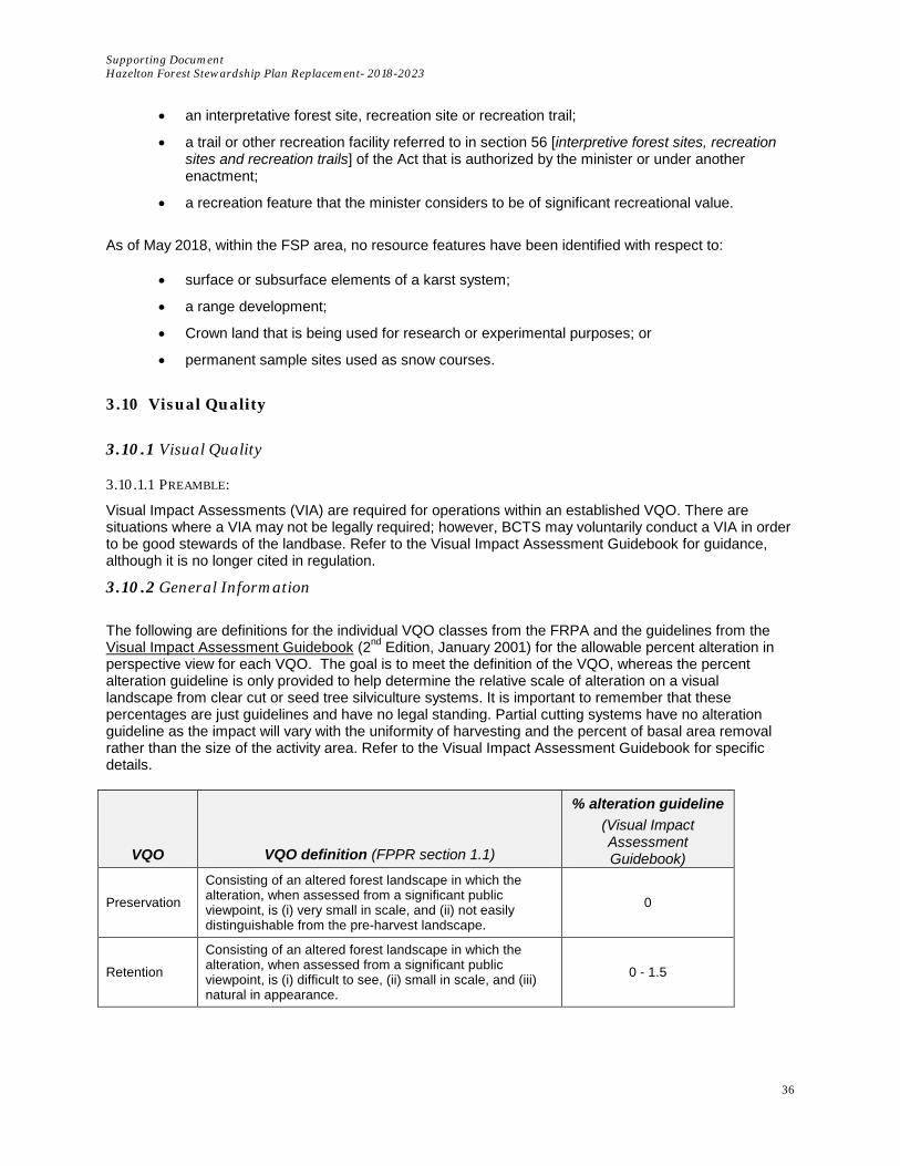
Supporting Document Hazelton Forest Stewardship Plan Replacement- 2018-2023
36
• an interpretative forest site, recreation site or recreation trail;
• a trail or other recreation facility referred to in section 56 [interpretive forest sites, recreation sites and recreation trails] of the Act that is authorized by the minister or under another enactment;
• a recreation feature that the minister considers to be of significant recreational value.
As of May 2018, within the FSP area, no resource features have been identified with respect to:
• surface or subsurface elements of a karst system;
• a range development;
• Crown land that is being used for research or experimental purposes; or
• permanent sample sites used as snow courses.
3.10 Visual Quality
3.10.1 Visual Quality
3.10.1.1 PREAMBLE:
Visual Impact Assessments (VIA) are required for operations within an established VQO. There are situations where a VIA may not be legally required; however, BCTS may voluntarily conduct a VIA in order to be good stewards of the landbase. Refer to the Visual Impact Assessment Guidebook for guidance, although it is no longer cited in regulation.
3.10.2 General Information The following are definitions for the individual VQO classes from the FRPA and the guidelines from the Visual Impact Assessment Guidebook (2nd Edition, January 2001) for the allowable percent alteration in perspective view for each VQO. The goal is to meet the definition of the VQO, whereas the percent alteration guideline is only provided to help determine the relative scale of alteration on a visual landscape from clear cut or seed tree silviculture systems. It is important to remember that these percentages are just guidelines and have no legal standing. Partial cutting systems have no alteration guideline as the impact will vary with the uniformity of harvesting and the percent of basal area removal rather than the size of the activity area. Refer to the Visual Impact Assessment Guidebook for specific details.
VQO VQO definition (FPPR section 1.1)
% alteration guideline (Visual Impact Assessment Guidebook)
Preservation
Consisting of an altered forest landscape in which the alteration, when assessed from a significant public viewpoint, is (i) very small in scale, and (ii) not easily distinguishable from the pre-harvest landscape.
0
Retention
Consisting of an altered forest landscape in which the alteration, when assessed from a significant public viewpoint, is (i) difficult to see, (ii) small in scale, and (iii) natural in appearance.
0 - 1.5

Supporting Document Hazelton Forest Stewardship Plan Replacement- 2018-2023
37
VQO VQO definition (FPPR section 1.1)
% alteration guideline (Visual Impact Assessment Guidebook)
Partial Retention
Consisting of an altered forest landscape in which the alteration, when assessed from a significant viewpoint, is (i) easy to see, (ii) small to medium in scale, and (iii) natural and not rectilinear or geometric in shape.
1.6 – 7.0
Modification
Consisting of an altered forest landscape in which the alteration, when assessed from a significant public viewpoint, (i) is very easy to see, and (ii) is (A) large in scale and natural in its appearance, or (B) small to medium in scale but with some angular characteristics.
7.1 – 18.0
Maximum Modification
Consisting of an altered forest landscape in which the alteration, when assessed from a significant public viewpoint, (i) is very easy to see, and (ii) is (A) very large in scale, (B) rectilinear and geometric in shape, or (C) both.
18.1 - 30.0
The Ministry of FLNRORD has completed a landscape inventory for the Kispiox TSA. Visual quality objectives (VQOs) are objectives defining an acceptable level of alteration to a specific visual landscape unit based on the physical characteristics and public concerns. Prior to any development in a known scenic area, the planned development is reviewed to assess the potential impacts on the visual resource. Visual Impact Assessments (VIAs) will be completed where BCTS development is proposed within known scenic areas. VIAs will be used to illustrate that the VQO will be met. To maximize timber development in scenic areas, BCTS will use visual landscape design techniques when designing cut blocks in highly sensitive areas. Properly designed blocks will blend development into the natural landscape. Where visual landscapes are highly sensitive, a variety of silviculture systems will be prescribed to minimize the visual impact. The FSP defines viewpoint criteria, and includes a minimum viewing time that is based on the Visual landscape Inventory: Procedures and Standards Manual (May 1997). If there is no area that meets the criteria for a viewpoint, a VIA will still be done: the lack of a viewpoint will just be factored into the assessment of how consistent the block design is with the VQO.
3.11 Forage and Associated Plant Communities
3.11.1 General Information
Forage in the context of this FSP is related to food required for livestock (i.e. for Range activities). There are several range tenure holders within the FSP area. There are no Objectives for Forage: and subsequently, there are no strategies or results required. However, the invasive plant measure identified in section 5.0 of the FSP will contribute to the maintenance of native plant communities by reducing the opportunities for invasive plant species to spread as a result of BCTS activities.
3.12 Consideration of Multiple Resource Value Assessment (MRVA) Reports Multiple Resource Value Assessment (MRVA) reports are a product of the Forest and Range Evaluation program (FREP) and are produced by the Ministry of Forests, Lands and Natural Resource Operations. The reports provide a summary assessment of field collected data regarding the current condition of the 11 resource values listed in the FRPA; biodiversity, cultural heritage, fish/riparian and watershed, forage and associated plant communities, recreation, resource features, soils, timber visual quality, water, and wildlife.
Supporting Document Hazelton Forest Stewardship Plan Replacement- 2018-2023
38
The Multiple Resource Value Assessment (MRVA) Kispiox Timber Supply Area Skeena-Stikine Natural Resource District (December 2013) report has been reviewed and the applicable District Manager comments have been identified and addressed as follows:
a) Implement good sediment control and water management practices when roads in the Kispiox are reactivated. • BCTS practices related to the management of soils and sediment control are outlined in SD
Section 3.1.
b) Place a greater emphasis on cultural heritage resources during the planning phase.
• SD section 3.7, in conjunction with the cultural heritage resources results and strategies from the FSP, demonstrate that BCTS places a high importance on the identification of cultural heritage resources at all phases of all stages of block development.
In addition to the Kispiox MRVA report, the following District Manager comments from the Multiple Resource Value Assessment (MRVA2) Lake Babine Nation Asserted Territory (September 2015) report were considered to have some applicability within the West Babine and Kispiox FDUs of the FSP:
a) Increase retention levels on small streams, especially the wider perennial small streams.
• BCTS efforts related to small stream riparian management are described in section SD Section 3.4.2.1.
b) Ensure ongoing communication between licensee and First Nation representatives.
• SD section 3.7, in conjunction with the cultural heritage resources results and strategies from
the FSP, will facilitate meaningful communication between BCTS and First Nations regarding the management of identified cultural heritage resources.
c) Avoid harvest within 500 m of known nesting areas and connect reserves to adjacent
mature and old forests.
• SD 3.3.6 provides further information about BCTS management of Goshawk within the area of the FSP.
d) Leave a larger range of retention over many cutblocks and improve retention quality be retaining higher levels of large dead and live trees.
• SD Sections 3.6.5 (Coarse Woody Debris) and 3.6.6 (Stand Retention, Wildlife Trees).