Forest County Potawatomi
16
The white-tailed deer is one of the most widely distributed species in the western hemisphere and can live in a variety of habi- tats. White-tailed deer are extremely eco- nomically and socially important to all peo- ples of North America, but are highly signifi- cant to Native American cultures in terms of tradition, subsistence, and spiritual values. When deer are overabundant, drastic reduc- tions in plant biomass and diversity can oc- cur in forest ecosystems. This could include the reduction and extirpation of culturally significant medicine plants, or rare and en- dangered species. Unregulated or liberalized hunting could potentially reduce this over- abundance and conserve plant diversity and regeneration. Alternatively, localized over- harvesting of deer could reduce the herd size to an unsustainable level, or negatively alter the sex and age structure of the local herd. These possible scenarios call a need for effec- tive censusing and management of the local deer herd. Management of deer herds is im- portant, complex, and socially sensitive, and therefore needs to occur with the best tech- niques available. Deer population estimates Forest County Potawatomi October - December 2011 Volume 1, Issue 3 Natural Resources Newsletter Inside this issue: Wildlife Information 1- 4 Air Information 5- 6 Water Information 7- 9 Botany/ Wetland Information 9- 10 Natural Resources Information 10 -11 Solid Waste Information 12 - 13 Oh Deer! White-tailed deer are the focus of fall activities…
Transcript of Forest County Potawatomi

The white-tailed deer is one of the most widely distributed species in the western hemisphere and can live in a variety of habi-tats. White-tailed deer are extremely eco-nomically and socially important to all peo-ples of North America, but are highly signifi-cant to Native American cultures in terms of tradition, subsistence, and spiritual values. When deer are overabundant, drastic reduc-tions in plant biomass and diversity can oc-cur in forest ecosystems. This could include the reduction and extirpation of culturally significant medicine plants, or rare and en-
dangered species. Unregulated or liberalized hunting could potentially reduce this over-abundance and conserve plant diversity and regeneration. Alternatively, localized over-harvesting of deer could reduce the herd size to an unsustainable level, or negatively alter the sex and age structure of the local herd. These possible scenarios call a need for effec-tive censusing and management of the local deer herd. Management of deer herds is im-portant, complex, and socially sensitive, and therefore needs to occur with the best tech-niques available.
D e e r p o p u l a t i o n e s t i m a t e s
Fo
re
st
Co
un
ty
P
ot
aw
at
om
i
O c t o b e r - D e c e m b e r 2 0 1 1
V o l u m e 1 , I s s u e 3
N a t u r a l R e s o u r c e s N e w s l e t t e r
I n s i d e t h i s i s s u e :
W i l d l i f e I n f o r m a t i o n
1 -4
A i r I n f o r m a t i o n
5 -6
W a t e r I n f o r m a t i o n
7 -9
B o t a n y /W e t l a n d I n f o r m a t i o n
9 -1 0
N a t u r a l R e s o u r c e s I n f o r m a t i o n
1 0- 1 1
S o l i d W a s t e I n f o r m a t i o n
1 2-1 3
Oh Deer! White-tailed deer are the focus of fall activities…

Several methods exist for surveying and estimating wildlife populations. Inventories may be used to survey populations repeatedly to show trends over time or gain detailed information on numbers or density at one point in time (absolute abundance). There are no “true” deer census techniques because it is not possible to obtain an exact count of a wild deer population. Instead, biologists must use population estimation procedures to estimate population density (# of deer per square mile), sex ratio (# bucks relative to # of does), and fawn recruitment (# of fawns born to does each year) from samples of a population. Several techniques are used to estimate population density such as spotlight surveys, deer drive count, pellet surveys, total area survey with a helicopter, or camera surveys. Two particularly effective and inexpensive techniques are spotlight surveys and camera surveys. Spotlight surveys are particularly useful in determining local deer densities, while camera surveys can provide insight into sex ratios and fawn recruitment in the herd. Spotlight surveys were conducted this fall in and around FCPC tribal land covered a total of 63 miles of roadway, survey-ing 1687 acres of land. A total of 75 deer were observed, however only 29 were able to be identified as either buck, doe, or fawn. Density calculations estimate the deer herd in southern Forest County as approximately 29 deer/mile2. This is slightly higher than the Wisconsin DNR estimates for all of Forest County, which is approximately 20 deer/mile2.
D e e r p o p u l a t i o n e s t i m a t e s c o n t . . .
Camera surveys were conducted over five weekly survey periods from August 9 –September 26 2011, for a total of 54 sites surveyed. Analysis of data this fall revealed that there were 1,420 total pictures of deer, as well as 430 pictures of black bears. Raccoons, sandhill cranes, and wild turkeys were also photographed. Of the deer pictures obtained, 880 (69%) were adult does, 168 (13%) were adult bucks and 223 (18%) were fawns. Of the 168 buck photos obtained, 36 unique in-dividual bucks were identified using antler characteristics. Using statistical techniques, cameras estimated a doe to buck ratio of approximately 4:1 in this area of Forest County, however differences in photo capture rate between males and females may cause this number to be biased towards does. Last year’s estimate was 2:1; a more likely ratio. More stud-ies will need to be conducted in future years to assess these estimates.
Page 2 N a t u r a l R e s o u r c e s N e w s l e t t e r
C w d t e s t i n g
Samples from tribal hunter-harvested deer were accepted on a volunteer basis again this year to test for Chronic Wasting Disease. A total of 31 samples were collected this year to be sent to the Wisconsin Diagnostic Veterinary Laboratory. This is an increase in samples over last year,
which yielded 21 samples, however in both years, only 10 different tribal hunters participated in the program, de-spite increases in incentives which included gift cards to Smith’s Sport and Hobby, and an raffle drawing for a red deer European mount.

Page 3 V o l u m e 1 , I s s u e 3
B i g b u c k c o n t e s t This year the Wildlife Resources Program introduced its first Big Buck Contest. Intended to increase awareness and par-ticipation within the Wildlife Resources Program, the contest was conducted during the 9-day regular gun season. Six tribal hunters participated, with the following 4 place-holders:
1st Place: Gises Thunder 2nd Place: Jamie Tuckwab
10 pt., 16 in. spread, 189 lbs. 8 pt., 14 ½ in. spread, 125 lbs.
3rd Place: Sonny Shepard 4th Place: Mariya Tuckwab
8 pt., 13 1/8 in. spread, 139 lbs. 8pt., 11 13/16 in. spread, 140 lbs.
Page 4 N a t u r a l R e s o u r c e s N e w s l e t t e r
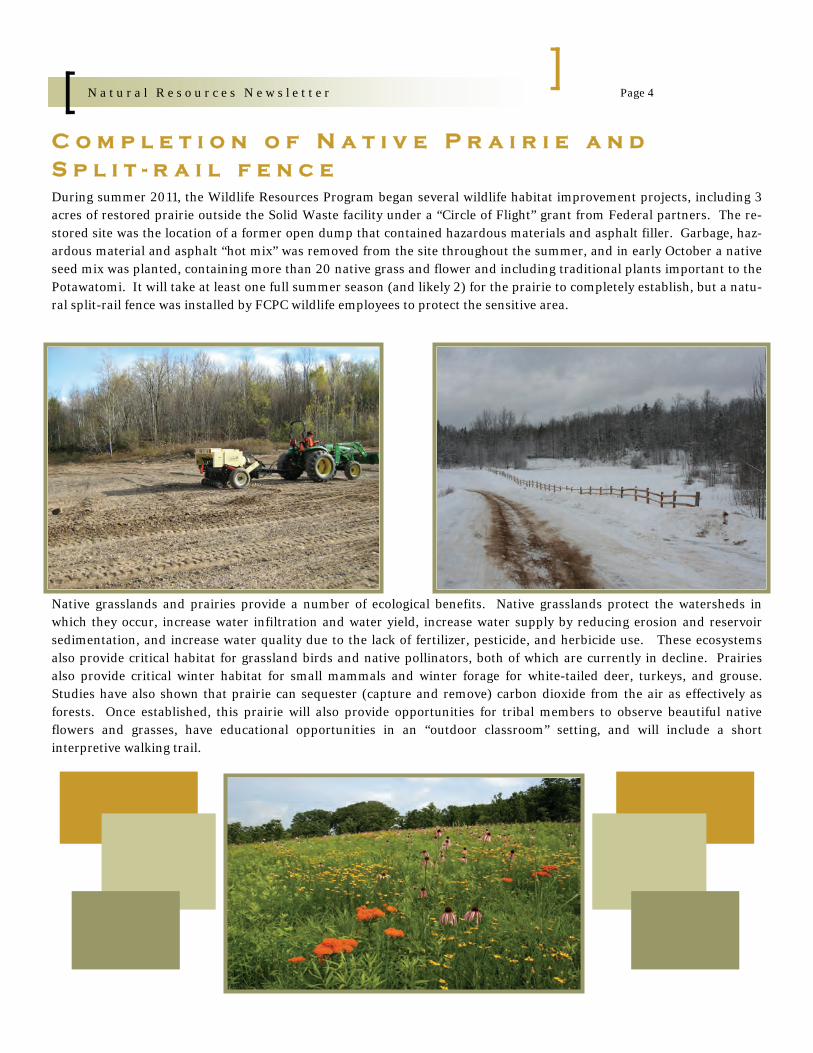
C o m p l e t i o n o f N a t i v e P r a i r i e a n d S p l i t - r a i l f e n c e During summer 2011, the Wildlife Resources Program began several wildlife habitat improvement projects, including 3 acres of restored prairie outside the Solid Waste facility under a “Circle of Flight” grant from Federal partners. The re-stored site was the location of a former open dump that contained hazardous materials and asphalt filler. Garbage, haz-ardous material and asphalt “hot mix” was removed from the site throughout the summer, and in early October a native seed mix was planted, containing more than 20 native grass and flower and including traditional plants important to the Potawatomi. It will take at least one full summer season (and likely 2) for the prairie to completely establish, but a natu-ral split-rail fence was installed by FCPC wildlife employees to protect the sensitive area.
Native grasslands and prairies provide a number of ecological benefits. Native grasslands protect the watersheds in which they occur, increase water infiltration and water yield, increase water supply by reducing erosion and reservoir sedimentation, and increase water quality due to the lack of fertilizer, pesticide, and herbicide use. These ecosystems also provide critical habitat for grassland birds and native pollinators, both of which are currently in decline. Prairies also provide critical winter habitat for small mammals and winter forage for white-tailed deer, turkeys, and grouse. Studies have also shown that prairie can sequester (capture and remove) carbon dioxide from the air as effectively as forests. Once established, this prairie will also provide opportunities for tribal members to observe beautiful native flowers and grasses, have educational opportunities in an “outdoor classroom” setting, and will include a short interpretive walking trail.

Page 5 V o l u m e 1 , I s s u e 3
Studies conducted by Dr. Carl Watras of the Wisconsin Depart-ment of Natural Resources (WDNR) in 2004 on Devil’s Lake on the FCPC Reservation revealed elevated levels of the toxic form of mercury, methylmercury, in the water and within the tissue of fish samples taken. Methlymercury is the form of mercury most easily consumed by small aquatic life forms that accumulates within body tissue and is passed on up the food chain into fish and then into birds, mammals and humans that eat the fish. The current tribal fish advisory for the consumption of fish taken from Devil’s lake includes restrictions for the general population for all fish except blue gills less than 7 inches, and no more than 1 meal a month for sensitive populations for all but 2
fish species. The FCPC air monitoring program started monitor-ing for mercury being deposited from the air in precipitation (rain/snow/dew) in June of 2005 with the installation of a mer-cury deposition collector. Data collected from these samples from 2005 to 2010 and analyzed by the National Atmospheric Deposition Network lab in Champagne, Illinois for samples col-lected from 2005 through 2010 reveal the most frequent deposi-tional values range between 10 and 200 nanograms per square meter (ng/m2, with a few “spikes” as high as 1400. The chart below also indicates that the trend for mercury deposition has been steady, with no measurable increases or decreases in mer-cury deposition.
M o n i t o r i n g f o r M e r c u r y a t F C P C ’ s A i r M o n i t o r i n g S i t e
While a nanogram is a VERY small fraction of a gram and it may appear that deposition levels are relatively low, elevated mercury levels in lakes and in fish tissue tell us that much lower levels of deposition are necessary before we begin to see a decrease in mercury in water and in fish tissue. Class I status enables the Tribe to review and provide input on any new permits for air pollution sources that may impact the Reserva-tion. Providing comments on air pollution permits and on new legislation, such as the U.S. Environmental Protection Agency’s (USEPA) legislation in 2011 that requires tighter pollution controls for mercury emissions from electric power plants, the largest crea-tor of mercury pollution.
A i r p o l l u t i o n p e r m i t s u n d e r r e v i e w
The FCPC Air Program has reviewed three air pollution permit applications submitted to the WDNR for approval, including:
Thyssen-Krupp, Waupaca, WI - an iron foundry; Aarrow-cast, Shawano, WI – an iron foundry; Orvana - Cotton-wood Mine, Wakefield, MI – underground copper mine

A new sign was installed this quarter to inform users of the overnight parking lot across from the new Stone Lake C-store that electrical plug-ins are available for use. In an effort to keep the air clean on FCPC lands and minimize any impacts to the Tribe’s Class I air the electrical hook-ups were installed during construction of the C-store for use by truckers and RV campers wishing to overnight at the parking area. Overnighters can turn off their diesel engines and gas generators, and power their heaters, air conditioners and lights by plugging in free of charge! In many cases across the country, driving vehicles is THE single greatest polluter, as emissions from millions of ve-hicles on the road each day all add up. Emissions from vehicles include nitrogen oxides and volatile organic com-pounds (VOCs), carbon monoxide and particulate matter, all of which cause problems for human health and affect plants and animals in the natural world around us. Vehi-cle emissions also include significant amounts of carbon dioxide, one of the primary pollutants responsible for cli-mate change. Doing what we can to minimize the impact of pollutants resulting from driving vehicles includes walking and/or riding a bike more and driving less; combining errands
into one trip as often as possible; and eliminating unnec-essary idling, all of which help to reduce emissions of harmful pollutants and improve the air we breathe and the health of individuals and the environment. Idling in particular, is unnecessary and is a waste of fuel and money. It results in getting zero miles per gallon and can damage engine components, including cylinders, spark plugs and exhaust systems, all of which cost money. Idling cars also spew tons of unnecessary pollutants and toxic chemicals, including green house gases responsible for climate change, into the air that could be omitted from the air if only the vehicle were turned off when sitting out of traffic for more than 30 seconds. The difference is sig-nificant enough to warrant anti-idling laws in 19 states including, Connecticut, Florida, and Oregon, and numer-ous cities and villages across the country. In an era where we are beginning to see the serious im-pacts of human industrial activity on climate change, it is crucial that we as individuals find ways to minimize our impact. Together, especially where vehicles are con-cerned, the combined effort among individuals can make a big difference.
H o o k - u p s P r o v i d e d f o r O v e r n i g h t T r u c k e r s a n d O t h e r s a t S t o n e L a k e C - s t o r e R e d u c e P o l l u t i o n
Page 6 N a t u r a l R e s o u r c e s N e w s l e t t e r

Page 7 V o l u m e 1 , I s s u e 3
T o r p e e C r e e k C u l v e r t R e p l a c e m e n t
Construction of a new culvert was recently completed at the Torpee Creek crossing on State Highway 32 just north of Carter, WI. Prior to replacement, the culvert system consisted of twin metal pipes that were both undersized and improperly installed above the natural elevation of the stream bottom. This caused water to be backed up upstream of the culvert, which caused a substantial in-crease in the water temperature and the amount of sedi-ment present throughout this section of Torpee Creek, while also depleting much of the habitat necessary for brook trout survival. In addition, the north culvert com-pletely collapsed in the summer of 2010, which caused all stream flow to be redirected through the south culvert. The majority of Torpee Creek contains a naturally repro-ducing population of brook trout. However annual elec-trofishing surveys upstream of Hwy 32 since 2008 show a decline in the brook trout population in this portion of the stream. In 2010 and 2011, no brook trout were observed in this portion of Torpee Creek. The combination of fish surveys and annual water temperature data indicated that this area was no longer suitable for brook trout. As a re-sult, the Natural Resources Department approached the Wisconsin Department of Transportation (DOT) about the possibility of replacing this culvert with a much larger, properly placed culvert system. The Wisconsin DOT was very receptive to the idea. Therefore, both the Tribe and the DOT began to pursue funding opportunities for this project. The FCPC NRD was able to secure a grant through the Bureau of Indian Affairs (BIA) Great Lakes Restoration Initiative to complete the design of the re-placement culvert. The FCPC Natural Resources Depart-ment worked cooperatively with the Wisconsin DOT, McMahon Engineers/Architects, and the United States Forest Service to design an appropriate replacement cul-
vert system. Upon completion of the construction plans for this project, the Wisconsin DOT was also able to se-cure funding through the Federal Highways Great Lakes Restoration Initiative to complete the construction phase of this project. Construction of the culvert began in late summer and was completed in early November. In addi-tion to the culvert replacement, decorative posts featuring the FCPC logo and the name of the stream were placed on the right side of the road as you approach Torpee Creek from either direction. The replacement culvert is a 24’ wide x 8’ tall bottomless box culvert that was designed to restore the natural tem-perature and flow, and enhance brook trout habitat throughout this portion of Torpee Creek, while also en-couraging wildlife passage beneath Highway 32. It is be-lieved that this project will significantly enhance the brook trout population in this portion of Torpee Creek. There-fore, the Natural Resources Department will continue to monitor the fish population and temperature at this loca-tion in the future, in order to monitor the success of this project.

B u g L a k e A c c e s s i b i l i t y P r o j e c t
Page 8 N a t u r a l R e s o u r c e s N e w s l e t t e r
Contractors recently completed a multi-component acces-sibility project near the southwest corner of Bug Lake. Included among the many elements of this project was the improvement of an existing access road that travels east off of Bug Lake Road. The improved access now leads to a porous concrete parking lot. Porous concrete differs from regular concrete due to the fact that it contains minimal fine material. This lack of fine material creates pores within the concrete surface that allow storm water and spring runoff to pass through the parking lot and more quickly recharge into the groundwater supply, while also decreasing parking lot runoff. In addition, a concrete pathway has been installed that extends from the parking lot to the new handicap accessi-ble fishing pier. The concrete pathway has been carefully designed and constructed to accommodate all Americans with Disabilities Act (ADA) requirements, in order to al-low wheelchair access to a new fishing pier. The fishing pier was also constructed to meet ADA requirements. The fishing pier platform features multiple fishing sta-tions and two large benches. Since Bug Lake water levels have fluctuated substantially over the past several years, the pier has also been designed to accommodate further
changes in the Bug Lake water levels. Bug Lake is stocked annually with brook and rainbow trout and also contains several other species of fish including northern pike, largemouth bass, yellow perch, and pumpkinseed. These individual fish species combine to provide a quality fish-ing opportunity. The Natural Resources Department continues to imple-ment projects at each of the Reservation Lakes that will enhance the accessibility of these lakes for all FCPC tribal members. Past projects include such things as installing a fishing pier and improving the boat landing at Bug Lake, while also improving the access road and boat landing at Devil’s Lake. In addition, the FCPC NRD is currently ex-ploring multiple accessibility improvement projects at Cloud and King Lakes, including such things as boat land-ing installation and enhancement, campground develop-ment, access road improvement, etc. as increasing accessi-bility to Tribal Lakes remains one of the Natural Re-sources Departments top priorities.

Page 9 V o l u m e 1 , I s s u e 3
2 0 11 M i n i - F y k e N e t t i n g In October, the FCPC Water Resources Program once again conducted their annual mini-fyke netting surveys on each Bug, Cloud, Devil’s, and King Lakes. These surveys are utilized as a way to estimate reproductive success of game fish species and identify potential pollution sources. The reproductive success of the majority of the lakes has remained relatively stable since fyke-netting surveys were first implemented in 2006, indicating that little to no pol-lution is occurring in these lakes. However, sampling results at Bug Lake have varied sig-nificantly over the past 6 years. The likely reason for this fluctuation in reproductive success is likely due to the sub-stantial decline in the Bug Lake waters levels since these surveys began, because routine water quality sampling at Bug Lake since 2006 has not indicated the presence of any chemical concerns that may be contributing to a decline in fish reproduction. The main issue associated with the wa-ter level decline is the fact that a large portion of Bug Lake that was likely used for spawning is now completely dry,
leaving very little of the shallow water habitat in Bug Lake that is necessary for many fish species to spawn. Things may be looking up for Bug Lake however, as an increase in pre-cipitation since the summer of 2010 has resulted in a gradual rise in Bug Lake water levels. The Water Re-sources Program began to see the results of this precipita-tion increase in the fall of 2011, as catch rates of young-of-year pumpkinseed nearly increased to 2006 levels and catch rates of young-of-year yellow perch substantially surpassed any of the past sampling events. The FCPC Wa-ter Resources Program will continue to annually monitor the reproductive success of fish species in each of these lakes, in order to ensure that the fish community in these lakes remains healthy and to quickly identify any pollu-tion sources that may be negatively impacting the water quality in these lakes.
G r e e t i n g s ! M y n a m e i s A s h l e y F e h r e n b a c h , and I began my position as Botanist and Wetlands Program Director on January 3, 2012. I am delighted to be a part of the Natural Resources team, and I am honored to have the opportunity to conserve and protect the plant and wetland resources of the Tribe. I grew up in Crandon, Wisconsin, and my love of the Forest County out-doors led me to pursue a career in natural resource conservation. I earned my Bachelor’s Degree in Biology-Field Biology and Ecology from the University of Wisconsin-Green Bay. During my undergraduate career, I worked as a botanist and field technician on the Wabikon Lake Forest Dynamics Plot, a long-term forest research plot established by researchers at UWGB in collaboration with the U.S. Forest Service and the Smithsonian Institution. Continued on page 10...
Page 10 N a t u r a l R e s o u r c e s N e w s l e t t e r
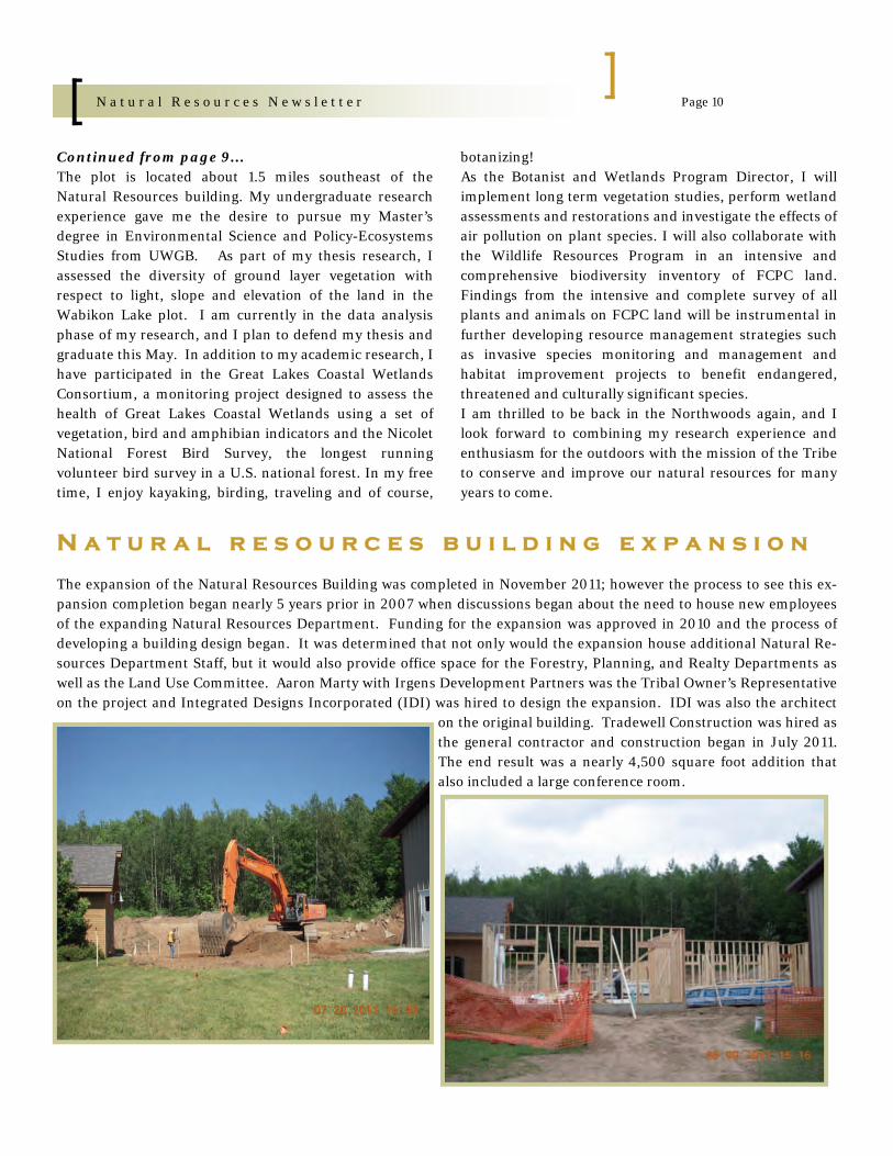
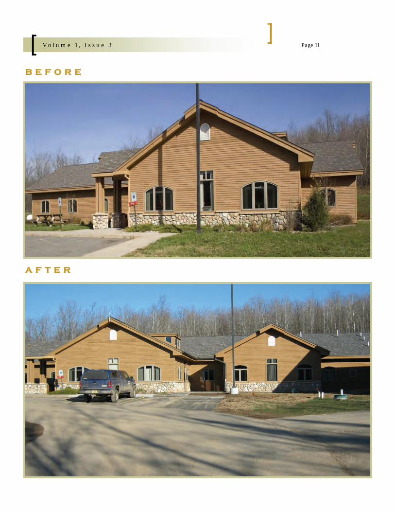
N a t u r a l r e s o u r c e s b u i l d i n g e x p a n s i o n
The expansion of the Natural Resources Building was completed in November 2011; however the process to see this ex-pansion completion began nearly 5 years prior in 2007 when discussions began about the need to house new employees of the expanding Natural Resources Department. Funding for the expansion was approved in 2010 and the process of developing a building design began. It was determined that not only would the expansion house additional Natural Re-sources Department Staff, but it would also provide office space for the Forestry, Planning, and Realty Departments as well as the Land Use Committee. Aaron Marty with Irgens Development Partners was the Tribal Owner’s Representative on the project and Integrated Designs Incorporated (IDI) was hired to design the expansion. IDI was also the architect
on the original building. Tradewell Construction was hired as the general contractor and construction began in July 2011. The end result was a nearly 4,500 square foot addition that also included a large conference room.
Continued from page 9... The plot is located about 1.5 miles southeast of the Natural Resources building. My undergraduate research experience gave me the desire to pursue my Master’s degree in Environmental Science and Policy-Ecosystems Studies from UWGB. As part of my thesis research, I assessed the diversity of ground layer vegetation with respect to light, slope and elevation of the land in the Wabikon Lake plot. I am currently in the data analysis phase of my research, and I plan to defend my thesis and graduate this May. In addition to my academic research, I have participated in the Great Lakes Coastal Wetlands Consortium, a monitoring project designed to assess the health of Great Lakes Coastal Wetlands using a set of vegetation, bird and amphibian indicators and the Nicolet National Forest Bird Survey, the longest running volunteer bird survey in a U.S. national forest. In my free time, I enjoy kayaking, birding, traveling and of course,
botanizing! As the Botanist and Wetlands Program Director, I will implement long term vegetation studies, perform wetland assessments and restorations and investigate the effects of air pollution on plant species. I will also collaborate with the Wildlife Resources Program in an intensive and comprehensive biodiversity inventory of FCPC land. Findings from the intensive and complete survey of all plants and animals on FCPC land will be instrumental in further developing resource management strategies such as invasive species monitoring and management and habitat improvement projects to benefit endangered, threatened and culturally significant species. I am thrilled to be back in the Northwoods again, and I look forward to combining my research experience and enthusiasm for the outdoors with the mission of the Tribe to conserve and improve our natural resources for many years to come.
Page 11 V o l u m e 1 , I s s u e 3
b e f o r e
a f t e r
Page 12 N a t u r a l R e s o u r c e s N e w s l e t t e r
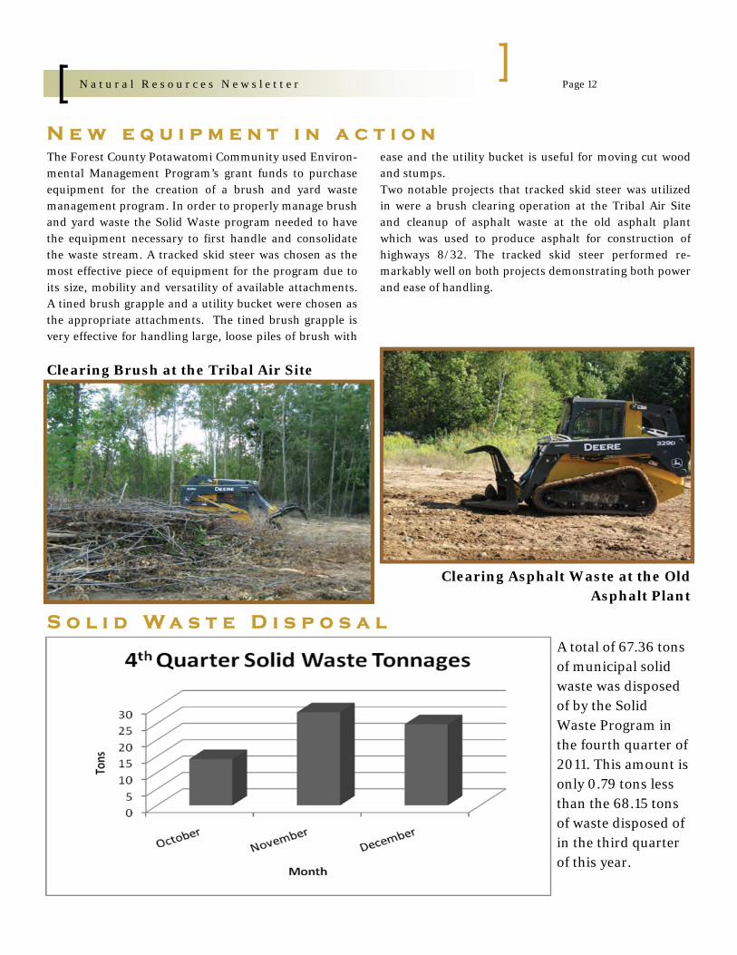
N e w e q u i p m e n t i n a c t i o n The Forest County Potawatomi Community used Environ-mental Management Program’s grant funds to purchase equipment for the creation of a brush and yard waste management program. In order to properly manage brush and yard waste the Solid Waste program needed to have the equipment necessary to first handle and consolidate the waste stream. A tracked skid steer was chosen as the most effective piece of equipment for the program due to its size, mobility and versatility of available attachments. A tined brush grapple and a utility bucket were chosen as the appropriate attachments. The tined brush grapple is very effective for handling large, loose piles of brush with
ease and the utility bucket is useful for moving cut wood and stumps. Two notable projects that tracked skid steer was utilized in were a brush clearing operation at the Tribal Air Site and cleanup of asphalt waste at the old asphalt plant which was used to produce asphalt for construction of highways 8/32. The tracked skid steer performed re-markably well on both projects demonstrating both power and ease of handling.
Clearing Brush at the Tribal Air Site
Clearing Asphalt Waste at the Old Asphalt Plant
S o l i d W a s t e D i s p o s a l A total of 67.36 tons of municipal solid waste was disposed of by the Solid Waste Program in the fourth quarter of 2011. This amount is only 0.79 tons less than the 68.15 tons of waste disposed of in the third quarter of this year.

Page 13 N a t u r a l R e s o u r c e s N e w s l e t t e r
281.71 tons of munici-pal solid waste were collected and proc-essed during 2011. When compared to the 269.34 tons for 2010, there was more solid waste collected and processed during the calendar year 2011.
H o w m u c h i s g e t t i n g r e c y c l e d ?
A total of 33.97 tons of recyclable cardboard, paper, glass, aluminum, plastic and tin were col-lected and processed in the fourth quarter of 2011. This amount has changed very little from the 32.37 tons that were collected in the third quarter of 2011.
The Solid Waste Pro-gram recycled a total of 132.16 tons of card-board, paper, glass, aluminum, plastic and tin during 2011. These tonnages are slightly down from the total of 133.4 tons recycled for the 2010.

Page 14 N a t u r a l R e s o u r c e s N e w s l e t t e r
Johnson Beaver Dam
Wildlife
2012 Bug Lake Fisheree

Page 15 N a t u r a l R e s o u r c e s N e w s l e t t e r
Chairman - Gus Frank & Senator Jim Holperin
Hen Houses
Open House 2012 Catered by the Stone Lake C-Store
Open House 2012
5320 Wensaut Lane P.O. Box 340 Crandon, WI 54520
Phone: 715-478-7222 Fax: 715-478-7225
www.fcpotawatomi.com/government/natural-resources
F o r e s t C o u n t y P o t a w a t o m i N a t u r a l R e s o u r c e s D e p a r t m e n t
N a t u r a l R e s o u r c e s D e p a r t m e n t P e r s o n n e l
Name Position Telephone Lawrence Daniels Natural Resources Administrator 715-478-7213
Nate Guldan Deputy Natural Resources Administrator 715-478-7205
Danielle Fatla Administrative Assistant 7715-478-4192
Receptionist 715-478-7222
Bill Alloway Natural Resources Technician 715-478-7210
Matt Steinbach Water Resources Program Director 715-478-7361
Ben Koski Aquatic Biologist 715-478-4436
Jason Spaude Natural Resources LTE 715-478-7210
Natalene Cummings Air Resources Program Director 715-478-7211
Joe Cebe Air Monitoring Specialist 715-478-4435
Heather Stricker Wildlife Resources Program Director 715-478-4196
Frank Shepard Wildlife Technician Advanced 715-478-4942
Joe Shepard Wildlife Technician 715-478-4962
Jeff Marshall Solid Waste Program Director 715-478-4817
Nitty Shepard Solid Waste Crew Member 715-478-7330
Phillip Wamego Solid Waste Crew Member 715-478-7330
Tony Daniels Solid Waste Crew Leader 715-478-7330
Greg Kitchell Solid Waste Crew Member 715-478-7330
Ashley Fehrenbach Botanist/Wetlands Program Director 715-478-4973