for sale BRUSHY BOTTOMS DUCK CLUB - Store & …s3.amazonaws.com/loa.data/inv/3260546/Brushy Bottoms...
17
OFFERED FOR SALE BRUSHY BOTTOMS DUCK CLUB A recreational investment opportunity. 150 (+/-) acres • Cross County, Arkansas OFFERED BY Licensed in Arkansas, Louisiana, Mississippi, Tennessee and Texas
Transcript of for sale BRUSHY BOTTOMS DUCK CLUB - Store & …s3.amazonaws.com/loa.data/inv/3260546/Brushy Bottoms...

offered for sale
BRUSHY BOTTOMS DUCK CLUBA recreational investment opportunity.
150 (+/-) acres • Cross County, Arkansas
offered by
L i c e n s e d i n A r k a n s a s , L o u i s i a n a , M i s s i s s i p p i , Te n n e s s e e a n d Te x a s

DISCLOSURE STATEMENTLile Real Estate, Inc. is the listing agency for the owner of the property described within this offering brochure.
A representative of Lile Real Estate, Inc. must be present to conduct a showing. The management of Lile Real Estate, Inc. respectfully requests that interested parties contact us in advance to schedule a proper showing and do not attempt to tour or trespass the property on their own. Thank you for your cooperation.
Some images shown within this offering brochure are used for representative purposes and may not have been taken on location at the subject property.
This offering subject to errors, omissions, change or withdrawal without notice. All information provided herein is in-tended as a general guideline and has been provided by sources deemed reliable, but the accuracy of which we cannot guarantee.

vICINITy MAp I
5/26/2016
map center: 35° 28' 26.45, 90° 55' 23.84
OverView Map
0mi 5.1mi 10.2mi
Subject Property

5/26/2016
map center: 35° 22' 53.39, 90° 56' 49.53
OverView Map
0ft 6378ft 12756ft
vICINITy MAp II
Subject Property
pROpERTy SUMMARy
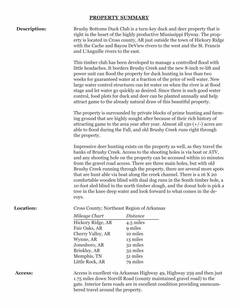
Description: Brushy Bottoms Duck Club is a turn-key duck and deer property that is right in the heart of the highly productive Mississippi Flyway. The prop-erty is located in Cross county, AR just outside the town of Hickory Ridge with the Cache and Bayou DeView rivers to the west and the St. Francis and L’Anguille rivers to the east.
This timber club has been developed to manage a controlled flood with little headaches. It borders Brushy Creek and the new 8-inch re-lift and power unit can flood the property for duck hunting in less than two weeks for guaranteed water at a fraction of the price of well water. New large water control structures can let water on when the river is at flood stage and let water go quickly as desired. Since there is such good water control, food plots for duck and deer can be planted annually and help attract game to the already natural draw of this beautiful property.
The property is surrounded by private blocks of prime hunting and farm-ing ground that are highly sought after because of their rich history of attracting game to the area year after year. Almost all 150 (+/-) acres are able to flood during the Fall, and old Brushy Creek runs right through the property.
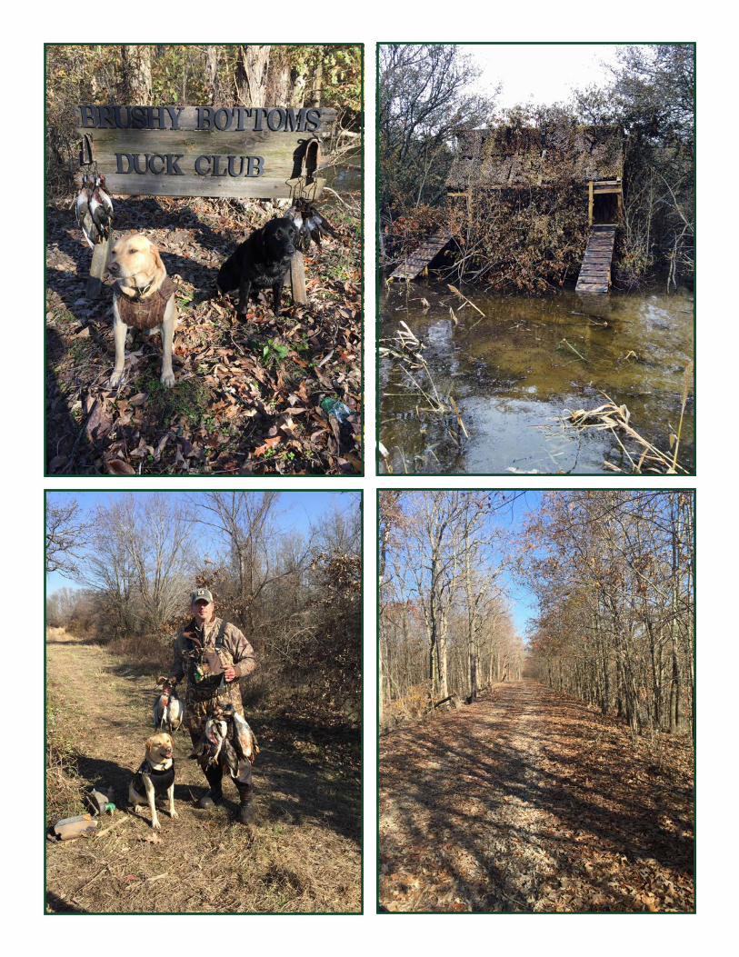
Impressive deer hunting exists on the property as well, as they travel the banks of Brushy Creek. Access to the shooting holes is via boat or ATV, and any shooting hole on the property can be accessed within 10 minutes from the gravel road access. There are three main holes, but with old Brushy Creek running through the property, there are several more spots that are hunt able via boat along the creek channel. There is a 16 X 20 comfortable wooden blind with dual dog runs in the South timber hole, a 10-foot sled blind in the north timber slough, and the donut hole is pick a tree in the knee deep water and look forward to what comes in the de-coys.
Location: Cross County; Northeast Region of Arkansas Mileage Chart Distance Hickory Ridge, AR 4.5 miles Fair Oaks, AR 9 miles Cherry Valley, AR 10 miles Wynne, AR 13 miles Jonesboro, AR 32 miles Brinkley, AR 32 miles Memphis, TN 51 miles Little Rock, AR 79 miles
Access: Access is excellent via Arkansas Highway 49, Highway 259 and then just 1.75 miles down Norvill Road (county maintained gravel road) to the gate. Interior farm roads are in excellent condition providing unencum-bered travel around the property.

pROpERTy SUMMARy
Improvements: - 20 foot metal storage container for ATVs and hunting gear. - Electricity runs next to the parking area if a lodge/cabin is desired. - 2 duck blinds. - Very efficient re-lift.
Acreage: 150 (+/-) Total Acres
Water Delivery/ New in 2015 - 30 foot 8 inch camelback style re-lift and power unit. Management: Excellent levee system and excellent water control structures.
Recreation: - Outstanding green-timber duck hunting and also provides opportunities for deer and other small game. - Access to the shooting holes is via boat and ATV. - There are three (3) shooting holes, two (2) of which have constructed
wooden and metal blinds. - White-tailed deer hunting.
Real Estate Taxes: $201.57
Mineral Rights: All owned by Seller (if any) shall be transferred, but the Seller does not warrant or guarantee ownership of such.
Offering Price: $750,000.00
Contact: Any questions concerning this offering or to schedule a property tour should be directed to Hunter Ziegler (cell: 901-351-5296 |
office: 901-260-4580) of Lile Real Estate, Inc.

AERIAL MAp
Cross CountyArkansas
5/26/2016
map center: 35° 21' 29.33, 90° 56' 0.91
Aerial Map
36-9N-1E
0ft 830ft 1660ft
Field borders provided by Farm Service Agency as of 5/21/2008.
North Timber Slough - 10 ft. Blind
Water Control Pipe
Water Control Pipe
Donut Hole
Main Slough Pipe
30’ 8” Camelback Re-liftwith New Power Unit
South Timber Hole16 x 20 Blind
Water Control Pipe
Gate & 20 ft.StorageContainer

SOIL MAp
State: ArkansasCrossCounty:36-9N-1ELocation:
Township: Hickory RidgeAcres: 153.33Date: 5/26/2016
Soils data provided by USDA and NRCS.
Soils Map
Area Symbol: AR037, Soil Area Version: 15Code Soil Description Acres Percent
of fieldNonIrrClassLegend
NonIrrClass*c
Commonbermudagrass
Corn
Cottonlint
Improvedbermudagrass
RiceIrrigated
Soybeans Tallfescue
Wheat
Za Zachary silt loam 146.45 95.5% IVw 6
He Henry silt loam, 0 to1 percent slopes
6.43 4.2% IIIw 5.5 70 120 30 6 30
ClB Calloway silt loam, 1to 3 percent slopes
0.45 0.3% IIe 6.5 90 700 9 38 8.5 35
Weighted Average 6 3.2 2.1 * 5 1.4 0.3 1.4
Area Symbol: AR037, Soil Area Version: 15*c: Using Capabilities Class Dominant Condition Aggregation Method
Soils data provided by USDA and NRCS.
TOpOgRAphy MAp
Cross CountyArkansas
5/26/2016
map center: 35° 21' 29.33, 90° 56' 0.91
Topography Map
36-9N-1E
0ft 830ft 1660ft
Field borders provided by Farm Service Agency as of 5/21/2008.


NOTES

L i c e n s e d i n A r k a n s a s , L o u i s i a n a , M i s s i s s i p p i , Te n n e s s e e a n d Te x a s
LILE REAL ESTATE, INC.
Arkansas - Corporate Office401 Autumn Road
Little Rock, AR 72211501.374.3411 501.374.0609 (fax)
Tennessee - Regional Office5521 Murray Avenue, Suite 110
Memphis, TN 38119901.260.4580 901.260.4582 (fax)