FLORAS AND VEGETATION OF TERTIARY FLUVIAL …fi.nm.cz/wp-content/static/article/2004_113.pdfbeen...
30
Introduction This work represents a slightly modified English version of the Ph. D. thesis of the author (Teodoridis 2003b). The pa- per is intended to provide a synhesis of palaeobotanical field investgations undertaken by the author from 1998 to 2003 in Central and Northern Bohemia (Teodoridis 2000, 2001, 2002, 2003a, in press, Sakala and Teodoridis 2001, Žák et al. 2003, Teodoridis and Kvaček in press). The aim of this study has been a detailed floristic revision of fluvial and deltaic floras of Central and Northern Bohemia in close cooperation with sedi- mentology, their correlation with deposits of the Most Basin and floristic assemblages of the Boreal Province of Europe. A new phytostratigraphical concept of the fluvial, delta and the Most Basin sediments is proposed, including a new palaeo- environmental model of the Žatec Delta and reconstructions of vegetation cover of the fluvial, delta and basin biotopes. Geology The geological framework of the area presented below is based on earlier publications (e.g. Malkovský et al. 1985, Váně 1985, Brus et al. 1987, Mach 2002) as well as on own field da- ta and consultations with M. Rajchl, K. Mach and K. Žák. Geology of fluvial sediments from Central and Northern Bohemia Isolated relics of Tertiary fluvial deposits occur in differ- ent parts of Central and Western Bohemia independently on the character of recent river system. The deposits consist mainly of sand, gravel and sandy intervals with irregularly distributed, variously thick lenses of clay or sandy clay, rarely containing any plant fossils. A detailed overview of the locali- ties and the geology of fluvial relicts in Central Bohemia was given by Pešek and Spudil (1986) and Žák et al. (2001). Pešek and Spudil (1986) investigated mainly lithology of these sediments and characterized them only in the frame of the Central River (River “C”) and its affluents D1 and D 2 . In addition, the preliminary report of Žák et al. (2003, fig. 2) presents a geographic overview of the fluvial relicts in Cen- tral Bohemia, and new data of the heavy minerals analysis in comparison with the older study (Čadek 1964, 1966). Žák et al. (2003) give also altitudes of these relics, which are impor- tant for their connection into fluvial system and their age. The fossiliferous relics at localities Klínec (U Slopu), Na Sulavě and the sandpit “U ručiček” are characterized below. to 4.3. Other, palaeobotanically “more or less sterile” fluvial rem- nants in Central and Western Bohemia were described, e.g. by Štorch in Barnet et al. (1991a, p. 16) – localities Mořina, Krupá and Běleč; Štorch in Barnet et al. (1991b, p. 17) – lo- calities Komárov, Osek, Žebrák, Strašice and Netolice; Mašek, Straka and Havlíček in Barnet et al. (1997, p. 15) – localities Česká Bříza, Borské pole (Plzeň), Žichlice, Kyšice and Chlum (Hurník and Knobloch 1966, Němejc et al. 2003); Havlíček and Štorch in Brunnerová et al. (1992, p. 12) – lo- calities Kobylisy and Zdiby, Mašek, Štorch and Straka in Dubec et al. (1993, p. 14) – localities Kosoř, Lochkov and Slivenec and Mašek in Drábková et al. (1998, p. 11) – locali- ties Broumy and Březová. 113 Acta Musei Nationalis Pragae, Series B, Natural History, 60 (3–4): 113–142 issued December 2004 Sborník Národního muzea, Serie B, Přírodní vědy, 60 (3–4): 113–142 FLORAS AND VEGETATION OF TERTIARY FLUVIAL SEDIMENTS OF CENTRAL AND NORTHERN BOHEMIA AND THEIR EQUIVALENTS IN DEPOSITS OF THE MOST BASIN (CZECH REPUBLIC) VASILIS TEODORIDIS Charles University, Institute of Biology and Environmental Education, Faculty of Education, M. D. Rettigové 4, 116 39 Prague 1, Czech Republic, e-mail: [email protected] Teodoridis, V. (2004): Floras and vegetation of Tertiary fluvial sediments of Central and Northern Bohemia and their equiva- lents in deposits of the Most Basin (Czech Republic). – Acta Mus. Nat. Pragae, Ser. B, Hist. Nat., 60 (3-4): 113-142. Praha. ISSN 0036-5343. Abstract. The present paper completely revises 9 floras from fluvial and 9 floras from deltaic sediments from the area of Cent- ral and Northern Bohemia. Based on palaeobotanical data, it attempts to show a new phytostratigraphical conception of these flu- vial and deltaic sediments and their possible connection with the deposits from the Most Basin including phytostratigraphical correlation within the Czech Republic (the Most Basin and fluvial sediments of Central and Northern Bohemia), and Oligo-Mio- cene floristic assemblages from the Boreal Province of Europe (the Weisselster Basin, the Bitterfeld Basin and elsewhere). In ad- dition, the paper sums up the existing geological and sedimentological data and information concerning reconstruction of the Tertiary river system in the Czech Republic and Saxony (South Germany). The paper focuses also on palaeoenvironmental in- terpretations of the vegetation cover in fluvial, deltaic and basin biotopes using CLAMP analysis. Finally, a possible palaeoen- viromental reconstruction of the Žatec Delta during Late Oligocene to Early Miocene is presented. ■ Czech Republic; Saxony; Most Basin; correlation; phytostratigraphy, palaeoecology; fossil flora; fluvial sediments; Žatec Delta; Upper Oligocene, Lower Miocene Received September 21, 2004
Transcript of FLORAS AND VEGETATION OF TERTIARY FLUVIAL …fi.nm.cz/wp-content/static/article/2004_113.pdfbeen...

Introduction
This work represents a slightly modified English versionof the Ph. D. thesis of the author (Teodoridis 2003b). The pa-per is intended to provide a synhesis of palaeobotanical fieldinvestgations undertaken by the author from 1998 to 2003 inCentral and Northern Bohemia (Teodoridis 2000, 2001, 2002,2003a, in press, Sakala and Teodoridis 2001, Žák et al. 2003,Teodoridis and Kvaček in press). The aim of this study hasbeen a detailed floristic revision of fluvial and deltaic floras ofCentral and Northern Bohemia in close cooperation with sedi-mentology, their correlation with deposits of the Most Basinand floristic assemblages of the Boreal Province of Europe.A new phytostratigraphical concept of the fluvial, delta and theMost Basin sediments is proposed, including a new palaeo-environmental model of the Žatec Delta and reconstructionsof vegetation cover of the fluvial, delta and basin biotopes.
Geology
The geological framework of the area presented below isbased on earlier publications (e.g. Malkovský et al. 1985, Váně1985, Brus et al. 1987, Mach 2002) as well as on own field da-ta and consultations with M. Rajchl, K. Mach and K. Žák.
Geology of fluvial sediments from Central andNorthern Bohemia
Isolated relics of Tertiary fluvial deposits occur in differ-ent parts of Central and Western Bohemia independently onthe character of recent river system. The deposits consist
mainly of sand, gravel and sandy intervals with irregularlydistributed, variously thick lenses of clay or sandy clay, rarelycontaining any plant fossils. A detailed overview of the locali-ties and the geology of fluvial relicts in Central Bohemia wasgiven by Pešek and Spudil (1986) and Žák et al. (2001).Pešek and Spudil (1986) investigated mainly lithology ofthese sediments and characterized them only in the frame ofthe Central River (River “C”) and its affluents D1 and D2. Inaddition, the preliminary report of Žák et al. (2003, fig. 2)presents a geographic overview of the fluvial relicts in Cen-tral Bohemia, and new data of the heavy minerals analysis incomparison with the older study (Čadek 1964, 1966). Žák etal. (2003) give also altitudes of these relics, which are impor-tant for their connection into fluvial system and their age. Thefossiliferous relics at localities Klínec (U Slopu), Na Sulavěand the sandpit “U ručiček” are characterized below. to 4.3.Other, palaeobotanically “more or less sterile” fluvial rem-nants in Central and Western Bohemia were described, e.g.by Štorch in Barnet et al. (1991a, p. 16) – localities Mořina,Krupá and Běleč; Štorch in Barnet et al. (1991b, p. 17) – lo-calities Komárov, Osek, Žebrák, Strašice and Netolice;Mašek, Straka and Havlíček in Barnet et al. (1997, p. 15) –localities Česká Bříza, Borské pole (Plzeň), Žichlice, Kyšiceand Chlum (Hurník and Knobloch 1966, Němejc et al. 2003);Havlíček and Štorch in Brunnerová et al. (1992, p. 12) – lo-calities Kobylisy and Zdiby, Mašek, Štorch and Straka inDubec et al. (1993, p. 14) – localities Kosoř, Lochkov andSlivenec and Mašek in Drábková et al. (1998, p. 11) – locali-ties Broumy and Březová.
113
Acta Musei Nationalis Pragae, Series B, Natural History, 60 (3–4): 113–142 issued December 2004Sborník Národního muzea, Serie B, Přírodní vědy, 60 (3–4): 113–142
FLORAS AND VEGETATION OF TERTIARY FLUVIAL SEDIMENTS OF CENTRALAND NORTHERN BOHEMIA AND THEIR EQUIVALENTS IN DEPOSITS OF THE MOSTBASIN (CZECH REPUBLIC)
VASILIS TEODORIDISCharles University, Institute of Biology and Environmental Education, Faculty of Education, M. D. Rettigové 4,116 39 Prague 1, Czech Republic, e-mail: [email protected]
Teodoridis, V. (2004): Floras and vegetation of Tertiary fluvial sediments of Central and Northern Bohemia and their equiva-lents in deposits of the Most Basin (Czech Republic). – Acta Mus. Nat. Pragae, Ser. B, Hist. Nat., 60 (3-4): 113-142. Praha.ISSN 0036-5343.
Abstract. The present paper completely revises 9 floras from fluvial and 9 floras from deltaic sediments from the area of Cent-ral and Northern Bohemia. Based on palaeobotanical data, it attempts to show a new phytostratigraphical conception of these flu-vial and deltaic sediments and their possible connection with the deposits from the Most Basin including phytostratigraphicalcorrelation within the Czech Republic (the Most Basin and fluvial sediments of Central and Northern Bohemia), and Oligo-Mio-cene floristic assemblages from the Boreal Province of Europe (the Weisselster Basin, the Bitterfeld Basin and elsewhere). In ad-dition, the paper sums up the existing geological and sedimentological data and information concerning reconstruction of theTertiary river system in the Czech Republic and Saxony (South Germany). The paper focuses also on palaeoenvironmental in-terpretations of the vegetation cover in fluvial, deltaic and basin biotopes using CLAMP analysis. Finally, a possible palaeoen-viromental reconstruction of the Žatec Delta during Late Oligocene to Early Miocene is presented.
■ Czech Republic; Saxony; Most Basin; correlation; phytostratigraphy, palaeoecology; fossil flora; fluvial sediments; ŽatecDelta; Upper Oligocene, Lower Miocene
Received September 21, 2004

A relatively continuous belt of the “Hlavačov Graveland Sand” is situated between Rakovník and Holedeč inNorthern Bohemia. The belt contains palaeobotanically im-portant localities, i.e. Hlavačov, U sv. Antonína, Nesuchyně,Velká Černoc, Želeč and Sádek – text-fig. 1, which are cha-racterized below. Lithologicaly, the “Hlavačov Gravel andSand” consists of boulder and gravel mainly from white oryellowish quartzites and black lydites together with brown-yellow to orange or light grey coloured sands. An importantfeature is the clay content (about 3–8 %), which is general-ly irregularly distributed in 1 to 3 clay layers 20–50 cm inthickness, forming laterally restricted, partly fossiliferouslenses of grey or yellow colours. Čadek (1966) and Bylová(in Váně 1981) analysed the heavy mineral spectrum, whichis dominated mainly by tourmaline, andalusite, sillimanite,rutile, zircone and staurolite (Čadek 1966). According toGabriel and Valín (1968), the “Hlavačov Gravel and Sand”appears to be a typical fluvial sedimentary body with chang-ing layers of different grain size and clay content, witha diagonal stratification and erosive boundaries inside theformation. For more information about geology and tecto-
nics of the “Hlavačov Gravel and Sand” see Bretšnajder(1952), Váně (1985) and Teodoridis (2002, 2003b).
Geology of the Most Basin
Malkovský et al. (1985) and Brus et al. (1987) gavecomprehensive information about the geological characterof the Most Basin. The Most Basin is a part of the Krušnéhory Graben, and it covers about 1000 km2 between theNeovolcanic centers of the Doupov Mts. in the southwestand the České Středohoří Mts. in the northwest (e.g.Kopecký 1978, Cajz et al. 1999). For detailed informationon the geology of the Most Basin see, e.g. Hurník (1960),Elznic et al. (1986), Váně (1987), Bůžek et al. (1992),Malkovský (1995), Mach (2000) and Suhr (2002).
Kopecký et al. (1960) and Váně (1960) defined the ŽatecDelta as a complex of Tertiary clastic sediments occurringin the SW part of the Most Basin over an area of 500 km2.The main accumulation period of these sediments isisochronous with the Main Coal Seam sensu Elznic et al.(1986), which was deposited in time interval from 22 to
114
Text-fig. 1. Location of the studied localities of the “Hlavačov Gravel and Sand”, the Žatec Delta and the fluvial localities in theCentral Bohemia. – Symbols: 1. U Sv. Antonína, 2. Hlavačov, 3. Nesuchyně, 4. Velká Černoc, 5. Sádek, 6. Želeč, 7. Holedeč, 8.Záhoří near Žatce, 9. Přívlaky, 10. Soběsuky, 11. Čermníky, 12. Chotěnice, 13. Lomazice, 14. Dolany, 15. Nechranice, 16. NaSulavě, 17. Klínec, 18. U Sloupu, 19. “U ručiček”, CH – Cheb Basin, SO – Sokolov Basin, MO – Most Basin, DH – Doupov Mts.,CS – České Středohoří Mts. (according to Mísař et al. 1982, Žák et al.2001).

20.5 MA (Shrbený 1994). Hurník (1971) and Brus (1982)focused on a detailed lithological study of the Žatec Delta.Hurník (1961, 1973) and Kvaček and Bůžek (1982) definedseveral plant associations based on macropalaeobotanicaldata from the Žatec Delta and reconstructed the vegetationcover of this area in relation to facies distribution. A newstudy in the area of the open mine of Libouš near Chomu-tov and the open-mine of Hrabák near Vršany shows that theinterpretation of the Žatec Delta as a “true” delta is lessprobable. The clastic sediments belonging to the Duchcovand Holešice Members sensu Domácí (1977) – text-fig. 2,can be interpreted as an anastomous, river system with lowgradient. The river flowed and crossed wide-ranging peatforests and prograded several times almost to the presentSW basin margin (Rajchl and Uličný 2001; in press). Ac-cording to Rajchl (personal communication 2003), this riversystem possibly represents an inland delta as today develop-ed in the river delta of the Okavango River (McCarthy et al.1986) or the lower reaches of the Saskatchewan River in
area of the Cumberland marshes (Pérez-Arlucea ET Smith1999). Rajchl (oral communication 2003) interpreted theclastic deposits (mainly sand and sandstone) of the basalpart of the Libkovice Member sensu Domácí (1977) asa “true” deltaic sediments of the most distal part of the deltain the view of new sedimentological investigations in the lo-cality Přívlaky and outcrops of the NW bank of theNechranice Reservoir.
Connection of fluvial and the Most Basin sedimentsThe problem of relating fluvial sediments of Central and
North Bohemia to the sediments of the Most Basin in thearea of the Žatec Delta has not been so far satisfactorilysolved. Two different models exist and they are based on thecommon opinion that the “Hlavačov Gravel and Sand” re-presents the terminal relict of the Central River sensu Pešekand Spudil (1986). The first model suggests a connection ofthe “Hlavačov Gravel and Sand” to nowadays denuded se-diments that may have overlay the Most Formation
115
Text-fig. 2. Summary of the stratigraphical classification of the Most Basin sediments (according to Kvaček and Hurník 2000).

(Malecha 1962). The second model, on the contrary, con-nects these fluvial sediments with the deposits of the MostFormation, based on detailed geological study in the “key”area of Holedeč and Měcholupy (e.g. Mitášová 1962, V.Kněžek 1964, J. Kněžek 1965, Sysel 1967, Kliner and Wür-mová 1975, Váně 1985, pp. 212–214). A furthter problem isto find exact fluvial equivalents in the frame of the MostFormation. Pešek and Spudil (1986) correlated the“Hlavačov Gravel and Sand” with the Main Coal Seam(Elznic et al. 1986) on the basis of identical heavy mineralspectra. In addition, Bůžek and Kvaček (1989a), Walther inLotsch et al. (1994) and Teodoridis (2002) interpreted sedi-ments of the Duchcov Member (Domácí 1977), includingthe Basal Coal Seam sensu Váně (1987), as an analogue ofthe “Hlavačov Gravel and Sand” on basis of the comparisonof the heavy minerals spectra from the “Hlavačov Graveland Sand” and the Thierbach Beds (Lotsch et al. 1994) aswell as palaeobotanical data of these fluvial sediments(Konzalová 1976, Bůžek and Kvaček 1989a, Mai andWalther 1991, Teodoridis 2002) – see below.
Reconstruction of the Tertiary river systemThe main base for a reconstruction of the Tertiary river
net is a detailed knowledge of tectonics and geomorphologi-cal development of the study area, comparative sedimento-logical and lithological-petrological analysis including theanalysis of the heavy minerals and the exact altitude of iso-lated fluvial relics. The problem of the Tertiary river net andits connection to sediments of the Most Basin was solved byseveral authors, e.g. Malkovský (1975, 1979, 1995), Pešek(1972), Pešek and Spudil (1986), Prosová (1974), Žák et al.(2001). According to Pešek and Spudil (1986), the“Hlavačov Gravel and Sand” can be interpreted as the ter-minal rest of the river “C” (Central River), which is thelongest Tertiary river of West and Central Bohemia (about130–150 km). The Central River sprang probably in the wa-tershed, which was a morphological elevation of the south-west part of the Central Bohemian Pluton in thesurroundings of Klatovy. The river “C” flowed through Švi-hov, Přeštice, Plzeň, along the Berounka River towardsČeská Bříza and Bohy to Kozojedy, where the continuationof the Central River is equivocal. The river “C“ continuedeither from Kozojedy northwards through Kožlany to NováVes by Čistá and then flowed towards northeast to Rakovník(Variant I). In the second model (Variant II), it curved bet-ween Kozojedy and Kožlany eastwards through Skryje,Karlova Ves to Zbečno, where the Central River continuednorthwestwards to Rakovník. Important rivers of the CzechTertiary are affluents of the river “C” (rivers A1, A2, A3, D1,D2, E and F), relics of which are found in the West and Cen-tral Bohemian sedimentary islands (Pešek and Spudil 1986,text-fig. 3). Pešek (1972) and Pešek and Spudil (1986)mainly focused on distinguishing the Tertiary and Carboni-ferous clastic relics in the area of Plzeň, their mutual con-nection and connection to the “Hlavačov Gravel and Sand”and the sediments of the Most Basin. These authors solved
marginally the area of Central Bohemia, where fluvial relicsconnected to the river D2 without a direct connection to theCentral River. Žák et al. (2001) applied heavy mineralanalysis in the study of allochtonous clastic deposits of theCzech Karst and solved in detail the connection of theserelics in Central Bohemia. Žák et al (2001, pp. 5–7) alsocommented on the discrepancy between the generally ac-cepted Tertiary river net models (Malkovský, Pešek, Spudil)and the first and second chronological paradox of the CzechKarst (Petrbok 1950, Kovanda and Herzogová 1986) andsome palaeontological findings near Karlštejn and Srbsko(Ložek in Kukla 1956).
Malkovský (1975, 1995) published another interpreta-tion of the Tertiary river system suggesting two main rivers,which drained the area of SW Bohemia (corresponding theCentral River sensu Pešek and Spudil 1986) and the areas ofNE Bohemia (corresponding the present river Cidlina) andSE Bohemia (corresponding the present river Sázava) in theLower Miocene (Upper Egerian-Lower Karpatian). Bothrivers conflux southward from Prague and continued to-wards the Rakovník area, where they flowed into the MostBasin (Text-fig. 4). Malkovský (1995) showed also possiblereconstructions of the river net for the Middle Miocene (up-per Karpatian-lower Badian) – Malkovský (1995, fig. 3B)and Pliocene (Malkovský 1995, fig. 3C).
All the above-mentioned models of the Tertiary river netare concentrated only on the Czech Republic. Nevertheless,the model based on the identical spectrum of heavy miner-als in the sediments of the “Hlavačov Gravel and Sand” andthe Thierbach Beds from the Weisselster Basin (Čadek1966, Ahrens et al. 1974) and the similarity in the floristiccomposition of these fluvial sediments (Walther in Lotsch etal. 1994, Teodoridis 2002; exists. Lotsch et al. (1994) pre-sumed possible connection of the two and suggested a con-temporaneous deposition of the Central River and theThierbach Rier within one river system. cca 300 km inlength with an estuary located in Saxony. On the other hand,Suhr (2003) noted another possible origin area of heavyminerals in Germany.
Methods and material
A binocular microscope was used for observations andstudies of the material. Leaf morphological terminology fol-lows Hickey (1973). Figures in text were created using Pho-toshop 6.0 and Corel Draw 9.0. According to Moravec et al.(2000), symbols for distinguishing vegetative storeys in en-vironmental reconstruction are used, i.e. E1 (herbs), E2(shrubs and lianas), E3 (trees under 25 m high) and E4(trees over 25 m high). Principles and methods of theCLAMP (Climate Leaf Analysis Multivariate Program) areexplained in, e.g. Wolfe (1990, 1993), Wolfe and Spicer(1999) or Teodoridis (2003b, p. 67). All available specimensfrom the localities Na Sulavě, Hlavačov, U Sv. Antonína(Na Bendovce), Nesuchyně, Velká Černoc, Holedeč andZáhoří near Žatec are housed in the collection of the Na-tional Museum, Prague; from the localities Klínec,
116

Hlavačov, U Sv. Antonína (Na Bendovce), Nesuchyně,Velká Černoc and Přívlaky in the collection of the Instituteof Geology and palaeontology, Faculty of Science, CharlesUniversity, Prague; from the localities “U ručiček” andŽeleč in the collection of the Department of Biology andEnvironmental Education, Faculty of Education, CharlesUniversity, Prague; from the locality Přívlaky in the collec-tion of the Regional Museum, Most and that from the locali-ties of the Pětipsy Area of the Žatec Delta in the collectionof the Czech Geological Survey, Prague.
List of abbreviations used in text and tables 4, 5, 6 fol-lows: A1, A2, A3, D1, D2, E, F – affluents of the the CentralRiver (River “C”) defined by Pešek and Spudil (1986); US– Series of Underlying Clay and Sand sensu Procházka1954, (= Underlying Formation and Lower Sandy ClayeyBeds with Basal Coal Seam of Seam Formation sensuHurník and Marek 1962); UISF – Upper Inter-Seam For-mation of the Seam Series sensu Procházka 1954 (= UpperInter-Seam Beds of the Seam Formation sensu Hurník andMarek 1962); OS – Series of Overlying Clay and Sand sen-su Procházka 1954 (= Overlying Formation sensu Hurníkand Marek 1962); Cho 14 (Chotěnice) – dug pit described
by Procházka (1956), Cho 26 (Chotěnice) – outcrop de-scribed by Procházka (1956), Lo 355 (Lomazice) – dug pitdescribed by Procházka (1956), Do 50 (Dolany) – gravel pitdescribed by Procházka (1955), Do 52 (Dolany) – outcropdescribed by Procházka (1956), So 274 (Soběsuky) – out-crops described by Procházka (1956), MAT – Mean Annu-al Temperature, WMMT – Warmest Month MeanTemperature, CMMT – Coldest Month Mean Temperature,MART – Mean Annual Range Temperature, 3WET – Pre-cipitation during 3 Consecutive Wettest Months, 3DRY –Precipitation during 3 Consecutive Driest Months, MAP –Mean Annual Precipitation.
Floras of fluvial sediments of Central Bohemiaand Northern Bohemia
Detail characterization of Tertiary fluvial sedimentaryrelics in Central Bohemia is given in the geological part ofthis paper. These relics are often palaeobotanically sterile.Hurník and Knobloch (1966) published a summary of theTertiary floras from the broader vicinity of Plzeň, i.e. locali-ties Ejpovice, Kyšice, Dobříč, Horní Bříza, U tří králů and
117
Text-fig. 3. Reconstruction of the TertiaryRiver net in Central and West Bohemia (ac-cording to Pešek and Spudil 1986). – Sym-bols: 1. Klatovy, 2. Švihov, 3. Přeštice, 4.Česká Bříza, 5. Třemošná, 6. Kozojedy, –variant I: 7. Kožlany, 8. Nová Ves near Čistá,– variant II: 9. Studená, 10. Skryje, 11.Karlova Ves, 12. Zbečno; A1, A2, A3, B1, D1
and D2 – sedimentary rests of the centralRiver affluents.

Býkovský les. Besides, Němejc et al. (2003) focused on thecomplex floristic revision including micropalaeontologicalanalysis of the localities Býkov, Jalovčiny, Dobřič near Janov,Zruč, Žihlice, Dnešice and Horní Bříza. On the basis of thefloristic analysis, these authors presume the Early Mioceneage for all mentioned localities excluding the locality HorníBříza, which stratigraphically belongs to the Middle Miocene(Upper Badenian-Lower Sarmatian) – Němejc et al. (2003).The leaf impressions have more or less fragmentary charac-ter, which indicates parautochtonous to allochtonous type of“river” fossil assemblages.
Locality Na SulavěRelatively large Tertiary fluvial relic called Na Sulavě is
located in the northeastern area from the village Černošice(Text-fig. 1). It contains fluvial sandstone and gravel andsand, which usually alternate with irregularly distributed claylenses. Liebus (1901) described the first fossil record oflimonitic wood as Cedroxylon hoheneggeri FELIX. from thesandstone. According to Sakala (personal communication), itis impossible to determinate this fossil without studying theoriginal material. However, Sakala presumes an indetermi-nate conifer wood, which does not contain resin ducts. Kun-ský (1928/29) dealt with sedimentology and palaeobotany ofthis locality when investigating Central Bohemian clastic flu-vial relics and described 6 taxa, i.e. Salvinia formosa HEER,Taxodium dubium STERNB., Arundo sp., Salix angusta A.BR., Salix longa A. BR. and Fagus feroniae HEER. AlsoNěmejc (1943) presented new leaf impressions fromlimonitic concretions at the meeting of the Czech Society forMineralogy and Geology (9th April 1940) and he assignedthis leaf material only to the generic level (i.e. Liquidambarsp., Cinnamomum sp., Acer sp., Ulmus sp., Carpinus sp.,Taxodium sp. in the proceedings of the meeting). Then Něme-jc (1949) revised his material and the original material ofKunský and listed Taxodium distichum miocenicum HEER,Salix lavateri HEER, Salix bilinica NĚMEJC, Betula sub-pubescens GOEPP., Betula prisca ETT., Corylus macquarii(FORBES) HEER, Ulmus longifolia UNG., Ulmus brauniiHEER, Liquidambar europaeum A. BR., and Cinnamomumscheuchzeri (HEER) FRENZEN. Unfortunately, Teodoridis(2001) had only a small fragment of the original material athis disposal for the revision (table 1).
Localities Klínec and U SloupuThese two relatively large relics located in the broader
vicinity of the villages Sloup and Klínec (Text-fig. 1) repre-sent fluvial sandstone and gravel and sand, irregularly alter-nating with fossiliferous clay lenses of white or greycoloured claystone (Kettner 1911). First Feistmantel (1881,p. 291) reported on the Tertiary character of these sediments(occurrence near an old sandpit Jíloviště) based on xylo-tomic differences between fossil woods from this locality,which are missing, with the so-called araucarits. Kettner(1911) studied the geology and palaeobotany of these sedi-
ments and excluded their Quaternary or Cretaceous age(Kettner 1991, p. 5) and described 6 taxa, i.e. Taxodiumdubium STERNB., Salvinia formosa HEER, Fagus feroniaeHEER, Salix macrophylla HEER, Quercus drymeja UNG.and Brasenia sp. Later Procházka (1916) revised and sup-plemented palaeobotanical occurrences from Klínec (i.e.Taxodium dubium STERNB., Salvinia formosa HEER,Fagus feroniae HEER, cf. Podogonium latifolium HEER,Quercus drymeja UNG., Potamogeton geniculatus A. BR.and Poacites aequalis ETT.) including a very abundantrecord of Stratiotes (Carpolithes) websteri (HEER) POT.Kunský (1928/29) reassigned this leaf and seed material toSalvinia formosa HEER, Taxodium dubium STERNB.,Salix angusta A. BR., Fagus feroniae HEER, Carpinusgrandis HEER, Acer trilobatus A. BR., cf. Sabal sp. andStratiotes websteri POT. Němejc (1949) revised all avail-able material and indentified Salvinia reussii ETT., Taxodi-um distichum miocenicum HEER, ? Salix bilinicaNĚMEJC, Alnus feroniae UNG., Juglans acuminata A.BR., ? Ulmus longifolia UNG. and Stratiotes kaltennord-heimensis ZENKER. He defined the stratigraphical range ofthe Klínec phase based on palaeobotanical data (see below).The last revision of the original material including ecologi-cal reconstruction and stratigraphical re-interpretation wasdone by Teodoridis (2001) – table 1. This fossil associationis characterized by common occurrences of Stratioteskaltennordheimensis (E1) and Salvinia reussii (E1) from thelocality Klínec (also known from the locality Holedeč, see
118
Table 1. Summary of the floristic composition on the localitiesNa Sulavě, Klínec and “U ručiček”. Symbols: (♣ – present,♣♣ – rare, ♣♣♣ – common.
Taxa Localities
Na Sulavě Klinec “U ručiček”
Alnus julianiformis – ♣♣ ♣♣Alnus sp. ♣ – ♣♣Betula sp. ♣♣ – ♣♣Betulaceae – – ♣♣Carya cf. serrifolia ♣ – –Daphnogene cinnamomifoliaf. cinnamomifolia ♣♣ – ♣♣Dicotylophyllum sp. 1 – ♣ –Dicotylophyllum sp. 2 ♣ – –Dicotylophyllum sp. 3 – ♣ –“Ficus” truncata – – ♣♣Glyptostrobus europaeus – – ♣♣Liquidambar europaea ♣♣ – ♣♣Myrica sp. – – ♣Podocarpium podocarpum – – ♣♣Populus zaddachiivar. brabenecii – – ♣♣Salix haidingeri ♣ ♣ ♣♣Salix varians – – ♣Salvinia reussii – ♣ ♣♣Smilax weberi – – ♣♣Stratioteskaltennordheimensis – ♣♣♣ –Taxodium dubium ♣♣ ♣♣ ♣♣Ulmus pyramidalis ♣♣ ♣♣ –

below). These elements are typical of aquatic vegetation orassociation of canebrakes, which can overlap towardsmixed swamp forest.
Locality “U ručiček”A relatively small relic of Tertiary clastic sediments (1
km2) occurs in the area among Karlštejn, Liteň and Bělče.At present, only two sandpits exist, i.e. “U ručiček” (NWpart of the relict) and a sandpit near Běleč (Text-fig. 1). Thelithology is typical of white, gray or light rusty colouredquartzitic sand with minor occurrence of gravel and sand.The fossil leaf flora is confined to one yellowish clay lens.The flora of the locality “U ručiček” has yielded 1 fern, 2conifers and 13 angiosperms (11 dicots, 1 monocot and 1taxon of uncertain systematic position), i.e. Salvinia reussiiETT., Taxodium dubium (STERNB.) HEER, Glyptostrobuseuropaeus (BRONGN.) UNG., Daphnogene cinnamomifo-lia UNG. f. cinnamomifolia, Liquidambar europaea A. BR.,Betula sp., Alnus julianiformis (STERNB.) Z. KVAČEK etHOLÝ, Alnus sp. sensu BŮŽEK, Betulaceae gen. et sp. div.et indet., Myrica sp., cf. Salix varians GOEPP., cf. Salixhaidingeri ETT. emend. BŮŽEK, cf. Populus zaddachiiHEER var. brabenecii TEODORIDIS, Podocarpiumpodocarpum (A. BR.) HERENDEEN, cf. “Ficus” truncataHEER sensu BŮŽEK and Smilax weberi WESSEL –Teodoridis in Žák et. al. (2003); table 1. An about 700 mmlong permineralized woody fragment is also known fromthis locality (Lachmanová unpubl.) that was determined asa taxon of Taxodiaceae or Cupressaceae (Sakala in Žák etal. 2003). Very interesting phenomenon of this locality isthe relatively common occurrence of Smilax weberi, whichhas been known until now only from the localities from theMost Basin (e.g. Čermníky – Bůžek 1971) and a rare oc-currence of Podocarpium podocarpum, which is a commonelement of the localities Holedeč (Teodoridis 2002),Přívlaky (Teodoridis in press) and Čermníky (Bůžek 1971).
“Hlavačov Gravel and Sand”All leaf impressions are determined only on the basis of
the morphological features due to thier poor preservation,which does not allowed to apply methods of cuticular analy-sis. The material has fragmentary character, which can be in-terpreted as parautochtonous to allochtonous oryctocoenoses.The location of partial localities of the “Hlavačov Gravel andSand” is shown in text-fig. 1. Plant impressions are more orless confined to irregularly distributed clay lenses.
Locality HlavačovThe locality Hlavačov is situated on the eastern, forest-
ed bank of the Lišany Creek among Rakovnik, Lužná andLišany. The first palaeobotanical reference is the record ofpermineralized woody fragment, which was assigned toQurecus sp. (Smetana 1926). However, the validity of thisdetermination is doubtful (Němejc 1953, Sakala personalcommunication). Němejc (1953) described 8 taxa of leaf
fossils, i.e. Taxodium distichum miocenicum HEER, Se-quoia langsdorfii HEER, Pinus sp., Betula prisca ETT., Al-nus sp. Ulmus longifolia UNG., Celtis sp. and Liquidambareuropaeum A. BR., which were at the disposal for this revi-sion excluding the pine needle (Němejc 1953, pl. 2, fig. 3).This needle fragment was associated with a cone scale ofPseudolarix schmidtgenii KRÄUSEL (coll. Němejc, un-publ.) according to Bůžek and Kvaček (1989a). Bůžek andKvaček (1989a) revised the original Němejc’s material andidentified Taxodium dubium (STERNB.) HEER, Pseudo-larix schmidtgenii KRÄUSEL, Populus heeri SAP., Betulasp., Alnus sp., Ulmus pyramidalis GOEPP. and Liquidambareuropaea A. BR. The last revision including the descriptionof new material was done by Teodoridis (2000, 2002, un-publ.); table 2. The common occurrence of Fagus saxonicaand Pseudolarix schmidtgenii is typical for this flora. Thisassociation is important for phytostratigraphical correlationof the “Hlavačov Gravel and Sand” with the floristic as-semblage Thierbach and Witznitz sensu Mai and Walther(1991) from the Weisselster Basin (Saxony, Germany) – seebelow. Two relatively small leaves (probably juvenile) ofPopulus zaddachii var. brabenecii (originally Celtis sp.Němejc 1953, pl. 1, figs 14, 15, and Populus heeri SAP.Bůžek and Kvaček 1989a) may be interpreted as connectingelements with more northern floras of the Pětipsy Area andHoledeč (Bůžek 1971, Teodoridis 2000, 2002).
Locality “U Sv. Antonína” (Na Bendovce)The locality presents the most southern occurrence of
the “Hlavačov Gravel and Sand” and it is situated nearRakovník in a facies of fine-grained brown or rusty sand-stone. Němejc (1949) described the first record of Fagussylvatica L. (non Fagus feroniae UNG.) from the river andbasin sediments of Central and Northern Bohemia. He ex-cluded this locality from the Klínec phase based on thementioned beech record and transferred it to the youngerZdiby phase. Bůžek and Kvaček (1989a) indicated a possi-ble affinity to Fagus attenuata GOEPP. ssp. seussensisKNOBLOCH, which was confirmed by Teodoridis (2001),i.e. Fagus saxonica Z. KVAČEK et WALTHER, includingan emendation of the stratigraphical conception of the flu-vial sediments from Central Bohemia. Beside the men-tioned F. attenuata ssp. seussensis, Bůžek and Kvaček(1989a) presented from the locality “U Sv. Antonína” 3 ad-ditional taxa (i.e. Salix cf. varians GOEPP., Alnus juliani-formis (STERNB.) Z. KVAČEK et HOLÝ and Ulmus sp.) asrevised original Němejc’s material. However, these taxawere not at the disposal for the later revision (Teodoridis2001) and Němejc (1949) has never published them.
Locality NesuchyněThis very important and rich locality is situated approxi-
mately in the widder of the continual belt of the “HlavačovGravel and Sand” at the place of the old sandpit Dykastanear Nesuchyně (or Rovina near Nesuchyně). The first fos-sil flora was recovered by Vachtl (1935), who described
119

only 10 taxa: Betula sp., Alnus sp., Carpinus sp., Juglanssp., Salix varians GOEPP., Salix longa A. BR., Ulmuslongifolia UNG., Ulmus carpinioides GOEPP., Liq-uidambar europaeum A. BR. and Cinnamomum polymor-phum A. BR. Němejc (1949) revised this material andcollected and described new ones, i.e. Salix macrophyllaHEER, Salix lavateri HEER, Betula subpubescens GOEPP.,Betula prisca ETT., Alnus feroniae UNG., Alnus rotundataGOEPP., Carpinus grandis UNG., Carya bilinica (UNG.)ETT., Ulmus longifolia UNG., Zelkova ungeri KOW., Liq-uidambar europeum A. BR. and Cinnamomum scheuchzeri(HEER) FRENZEN. Bůžek (1960) dealt with fragmentaryplant records from the core Ně-3a (depth 24.5–25 m) andassigned them to Carpinus grandis UNG., cf. Ulmus longi-folia UNG. and Poaceae gen. et. sp. indet. Later Bůžek andKvaček (1989a) collected numerous plant material there,and preliminarily assigned it to Woodwardia muensteriana(C. PRESL) KRÄUSEL, Salvinia reussii ETT., Taxodiumdubium (STERNB.) HEER, Sequoia couttsiae HEER,Glyptostrobus europaeus (BRONGN.) UNG., Tetraclinissalicornioides (UNG.) Z. KVAČEK, Pseudolarix schmidt-genii KRÄUSEL, Comptonia acutiloba BRONGN., Myricasp., Alnus cf. julianiformis (STERNB.) Z. KVAČEK etHOLÝ, Carpinus grandis UNG., Ulmus pyramidalisGOEPP., Ulmus sp., Acer integerrimum (VIVIANI)MASSALONGO, Vitis stricta (GOEPP.) KNOBLOCH, Til-ia sp., Liquidambar europaea A. BR., “Viburnum” at-lanticum ETT., “Quercus” bilinica UNG., Ailanthusconfucii UNG. and “Musa” bilinica ETT. New occurrencesof leaves and bracts of Tilia brabenecii BŮŽEK et Z.KVAČEK and leaves of Mahonia bilinica (UNG.) Z.KVAČEK et BŮŽEK were separately described in Bůžekand Kvaček (1994) and Kvaček and Bůžek (1994). The lastrevision of all the available original material and new mate-rial from the locality Nesuchyně was done by Teodoridis(2000, 2002) and Sakala and Teodoridis (2001); table 2.Similarly as the locality Hlavačov, the Nesuchyně flora con-tains also a phytostratigraphically important association ofPseudolarix schmidtgenii and Fagus saxonica includingcupulae of Fagus deucalionis. In addition most of theunique taxa occurred in Nesuchyně (e.g. Tetraclinis sal-icornoides, Mahonia bilinica, cf. Trigonobalanopsis rham-noides, cf. Castanea atavia, Salix macrophylla, Tiliabrabenecii and cf. Fraxinsus sp.). For detail information ofthe vegetation see Teodoridis (2002, p. 132, text-fig. 4).
Locality Velká ČernocThis locality is the biggest still working sandpit in the
belt of the “Hlavačov Gravel and Sand”, which is situated inthe forest about 1.5 km north from the village Velká Černoc.The flora has yielded 1 fern, 2 conifers and 12 angiosperms(11 dicots and 1 monocot), i.e. Salvinia reussii ETT., Pinussp., Taxodium dubium (STERNB.) HEER, Glyptostrobuseuropaeus (BRONGN.) UNG., Fagus saxonica Z.KVAČEK et WALTHER, Betula sp., Alnus julianiformis(STERNB.) Z. KVAČEK et HOLÝ, Alnus sp. sensu
BŮŽEK, Alnus kefersteinii (GOEPP.) UNG., Carya serrifo-lia (GOEPP.) KRÄUSEL, Salix varians GOEPP., Acer tri-cuspidatum BRONN sensu PROCHÁZKA et BŮŽEK, Acersp. and Zingiberoideophyllum liblarense KRÄUSEL etWEYLAND – Teodoridis (2000, 2002); table 2. Besides thevery common elements known from other localities of the“Hlavačov Gravel and Sand”, the flora contains severalunique taxa, i.e. incomplete pine needle (Pinus sp.) withpossible affinity to Pinus pseudostrobus BRONGN. (inter-preted as mesophytic element of wider uplands along riversystem), swamp maple (Acer tricuspidatum), monocot Zin-giberoideophyllum liblarense (also known from the localityNesuchyně) and permineralised trunk of Castanoxylonbavaricum associated with leaf impression of cf. Castaneaatavia from the locality Nesuchyně (Sakala and Teodoridis2001).
Lokalita SádekThe locality is situated in a relic occurrence of the
“Hlavačov Gravel and Sand”, which is presented as an iso-lated tectonic floe in the vicinity of a railway station Sádek(Váně 1985). Krejčí (1877, p. 899) published the first noteabout the existence of the palaeobotanically sterile Tertiarysediments in vicinity of Sádek. Kušta (1889, p. 223) de-scribed 10 taxa found in light grey claystone organized inrelatively thin layers (3 to 4 cm), i.e. Salvinia reussii ETT.,Taxodium distichum miocenicum HEER, Poacites laevis A.BR., Carpinus grandis UNG., Quercus sp., Dryandroideslignitum ETT., Acer trilobatum A. BR., Eucalyptus sp. andEugenia sp. Unfortunately, this original material is missing.Smetana collected a new material from Sádek, which is nowhoused in the collection of the National Museum, Pragueand contains only 5 fragmentary and poorly preservedleaves, i.e. Fagus saxonica Z. KVAČEK et WALTHER, Be-tulaceae gen. et sp. indet., Alnus julianiformis (STERNB.)Z. KVAČEK et HOLÝ and Ulmus pyramidalis GOEPP. –Teodoridis (unpubl.) and table 2.
Locality ŽelečThe flora from the locality Želeč is bound to either
greenish grey clay lenses or very thin layers of light to darkbrown or black coal clay. Bůžek and Kvaček visited this lo-cality during preparation of the excursion for the 26th Con-ference of ČSMG, Most 1987 and described some fossilplant material (i.e. Taxodium dubium (STERNB.) HEER,Betula sp., cf. Fagus sp. – Bůžek and Kvaček in Brus etal.1987; Bůžek and Kvaček 1989a). Later, both authors sup-plemented these sporadic records with a new material anddescribed 18 taxa, i.e. Salvinia reussii ETT., Taxodium du-bium (STERNB.) HEER, Glyptostrobus europaeus(BRONGN.) UNG., Daphnogene polymorpha (A. BR.).ETT., Liquidambar europaea A. BR., Alnus julianiformis(STERNB.) Z. KVAČEK et HOLÝ, Alnus sp., Betula sp. velAlnus sp., Ulmus pyramidalis GOEPP., cf. Zelkova zelkovi-folia (UNG.) BŮŽEK et KOTLABA, Myrica sp., Salix sp.
120

Fagus attenuata GOEPP. ssp. seussensis KNOBLOCH,Acer tricuspidatum BRONN, Acer integerrimum (VIV.)
MASSAL., Vitis teutonica A. BR., cf. Potamogeton sp. andPoaceae vel Cyperaceae gen. et sp. indet. (Bůžek and
121
Taxa Localities
Hlavačov Nesuchyně Velká Černoc Sádek Želeč Holedeč
cf. Acer sepultum – ♣♣ – – – ♣♣Acer sp. – – ♣ – – –Acer dasycarpoides – – – – – ♣♣Acer integerrimum – ♣♣ – – ♣ ♣♣Acer tricuspidatum – – ♣♣ ♣ ♣ ♣♣Acer pseudomonospessulanum – – – – – ♣♣Ailanthus confucii – ♣ – – – ♣Alnus kefersteinii – ♣♣ ♣♣ – ♣ ♣♣Alnus julianiformis – ♣♣ ♣♣ ♣♣ ♣ ♣♣Alnus sp. ♣ ♣♣ ♣♣ – – ♣♣Betula sp. ♣♣♣ ♣♣♣ ♣♣ – – ♣♣Betulaceae – ♣♣ ♣♣ ♣♣ ♣♣♣ ♣♣Carpinus grandis – ♣♣ – ♣♣ – ♣♣Carya bohemica – – – – – ♣Carya serrifolia – ♣♣ ♣♣ – – ♣♣Carya cf. serrifolia – – – – – ♣♣cf. Castanea atavia – ♣ – – – –Chaneya oeningensis – – – – – ♣Comptonia difformis – ♣♣ – – – ♣Daphnogene cinnamomifolia – ♣♣ – – ♣ ♣♣Fagus deucalionis – ♣ – – ♣ ♣♣Fagus saxonica – ♣♣♣ ♣♣ ♣♣ ♣♣ ♣♣“Ficus” truncata – – – – – ♣♣cf. Fraxinus sp. – ♣ – – – –Glyptostrobus europaeus – ♣♣ ♣♣ – ♣ ♣♣Juglans acuminata – ♣ – – – ♣Leguminosites tobischii – – – – – ♣♣Liquidambar europaea ♣♣♣ ♣♣♣ – – ♣ ♣♣♣Koelreuteria reticulata – – – – – ♣♣Mahonia bilinica – ♣♣ – – – –Myrica sp. – ♣♣ – – ♣ ♣ Paliurus tiliaefolius – – – – – ♣? Persoonia sp. – – – – – ♣♣Pinus sp. – – ♣ – – –Podocarpium podocarpum – – – – – ♣Populus populina – – – – – ♣Populus zaddachii var. brabenecii ♣♣ – – – – ♣♣♣cf. Potamogeton sp. – – – – ♣ –Pseudolarix schmidtgenii ♣ ♣♣ – – – –Rosa europaea – – – – – ♣♣Rubus merianii – – – – – ♣♣Salix haidingeri – ♣♣ – – – ♣♣♣Salix macrophylla – ♣ – – – –Salix varians ♣♣ ♣♣♣ ♣ – – ♣♣♣Salvinia reussii – ♣♣ ♣ ♣ ♣ ♣♣♣Stratiotes kaltennordheimensis – – – – – ♣♣Taxodium dubium ♣♣♣ ♣♣♣ ♣♣ ♣♣ ♣♣♣ ♣♣♣Tetraclinis salicornioides – ♣ – – – –Tilia brabenecii – ♣♣ – – – –cf. Trigonobalanopsis rhamnoides – ♣ – – – –Ulmus pyramidalis ♣♣♣ ♣♣♣ – ♣ ♣ ♣♣♣Ulmus sp. – ♣ – – – ♣“Viburnum” atlanticum – ♣ – – – ♣Vitis stricta – ♣♣ – – – ♣♣Vitis teutonica – ♣♣ – – ♣ –? Wisteria aff. fallax – – – – – ♣♣Woodwardia muensteriana – ♣ – – – –Zelkova zelkovifolia – ♣♣ – – ♣ ♣♣Zingiberoideophyllum liblarense – ♣ ♣ – – –
Table 2. Summary of the floristic composition on the localities of the “Hlavačov Gravel and Sand” (i.e. Hlavačov, Nesuchyně,Velká Černoc, Sádek and Želeč) and on the locality Holedeč. Symbols: ♣ – present, ♣♣ – rare, ♣♣♣ – common.

Kvaček 1989b). Most of the original material was at the dis-posal for the revision excluding the two later mentionedtaxa, whose validity was confirmed by Z. Kvaček (Kvačekpersonal communication 2003) – Teodoridis (2000, 2002);table 2. This locality is interesting in the occurrence of rela-tively complete fossil leaves confined to dark coal clay,which matches to paratochtonous oryctocenouse and lowdynamic sedimentary regime of oxbow lakes. This sedi-mentary-ecological model is comparable to the regime onthe locality Holedeč (see below).
Floras of the Žatec Delta
The below mentioned floras (localities) of the Žatecdelta can be geographically devided into two areas. The firstarea is the southeastern part of the Žatec Delta, which con-tains three studied localities (floras) of Holedeč, Záhoří nearŽatec and Přívlaky (Text-fig. 1). The fossil material is de-termined only on the basis of the morphological featuresdue to poor preservation. The leaf material has fragmentarycharacter and belongs to parautochtonous to allochtonousoryctocoenoses. The second area is the southwestern part ofthe Žatec Delta, which is known usually as the Pětipsy Areaand contains many localities, which were discovered main-ly by M. Procházka and Č. Bůžek. Author has chosen only6 localities for a revision (i.e. Čermníky, Chotěnice, Lo-mazice, Dolany, Soběsuky and Nechranice – text-fig. 1)from which the original material was available to study.Most of the fossils are impressions, and therefore their de-scriptions are based on morphological features; excludingrepresentatives of Lauraceae from the locality Čermníky,where Z. Kvaček used the methods of cuticular analysis fordetermination (Kvaček 1971, Bůžek and Kvaček 1974). Thestudied material is more complete than the material from thesoutheastern part of the Žatec Delta or “river” localities,which are typical for low dynamic sedimentary regime ofinland deltas or lakes. The floras of the Pětipsy Area repre-sent parautochtonous, rarely autochtonous oryctocoenoses(roots horizons recently exposed in the NW bank of theNechranice Reservoir). The studied floras of the PětipsyArea belong to three stratigraphical levels of the MostBasin, i.e. “US” (Series of Underlying Clay and Sand –Procházka 1954); “UISF” (Upper Inter-Seam Formation ofthe Seam Series – Procházka 1954); “OS” (Series of Over-lying Clay and Sand – Procházka 1954) – text-fig. 2.
Locality HoledečThe locality Holedeč belongs to the area of the Žatec
Delta of the Most Basin. Brabenec (1904) described 36 taxafrom grey to dark brown clay, i.e. Salvinia reticulata (ETT.)HEER, Salvinia formosa HEER, Taxodium dubium HEER,Glyptostrobus europaeus (BRONGN.) HEER, Populusattenuata A. BR., Populus heeri SAP., Salix lavateri HEER,Salix denticulata HEER, Salix augusta A. BR., Salix teneraA. BR., Juglans acuminata A. BR., Carya bohemicaBRABENEC, Carya bilinica (UNG.) ETT., Pterocarya
denticulata (WEB.) HEER, Carpinus grandis UNG., Ulmuslongifolia UNG., Ulmus braunii HEER, Planera ungeriETT., Ficus truncata HEER, Persoonia firma HEER,Dryandra acutiloba ETT., Santalum styriacum ETT.,Liquidambar europaeum A. BR., Acacia beneschiBRABENEC, Rhus meriani HEER, Rhus elegans VELEN.,Paliurus friči BRABENEC, Evonymus proserpinae ETT.,Acer trilobatum A. BR., Acer rüminianum HEER, Acermagnum VELEN., Acer nervatum VELEN., Acer decipensA. BR., Aesculus palaeocastanum ETT., Vitis teutonica A.BR., Porana macrantha HEER var punctata BRABENEC.The original profile was drawn by J. Beneš (in Brabenec1904, p. 2). Unfortunately, the published profile and loca-tion are insufficient for precious lithological connection tosediments of the “Hlavačov Gravel and Sand”, Upper Inter-Seam Member of the Most Formation or the Overlying For-mation (Hurník and Marek 1962) – see below. Later, Bůžekand Kvaček (1989a) proved leaves of Fagus attenuataGOEPP. ssp. seussensis KNOBLOCH (i.e. Fagus saxonicaZ. KVAČEK et WALTHER) including cupules (i.e. Fagusdeucalionis UNG.) from this locality that was the only un-equivocal record of beech from the Most Basin for a longtime (cf. locality Přívlaky). Some leaf material, collected byBrabenec, was revised by Bůžek (1971), i.e. Liquidambareuropaea A. BR., Leguminosites tobischii ENGELH.,Populus aff. heeri SAP., Paliurus tiliaefolius (UNG.)BŮŽEK, Acer integerrimum (VIVIANI) MASSALONGOand Koelreuteria reticulata (ETT.) EDWARDS; and byProcházka and Bůžek (1975) – i.e. Acer integerrimum(VIVIANI) MASSALONGO sensu PROCHÁZKA etBŮŽEK, Acer tricuspidatum BRONN sensu PROCHÁZKAet BŮŽEK, Acer dasycarpoides HEER sensu PROCHÁZ-KA et BŮŽEK and Acer pseudomonspessulanum UNG.Teodoridis (2000, 2002) worked out the complete revisionof all the available material from this locality (table 2) in-cluding the detailed reconstruction of the vegetation cover(Teodoridis 2002, p. 133, text-fig. 5). A predominate occur-rence of Salvinia reussii in association with Stratioteskaltennordheimensis (also known from the locality Klínec)shows a low dynamic sedimentary regime interpreted as theregime of oxbow lakes or distal part of inland delta and eco-logically mated to aquatic association or canebrakes. Thissedimentary interpretation also corresponds with the obvi-ous increase of relatively thermophilous elements, e.g.Leguminosites tobischii, Podocarpium podocarpum, Wiste-ria aff. fallax, Koelreuteria reticulata, Acer dasycarpoides,Acer pseudomonospessulanum, Chaneya oeningensis,Paliurus tiliaefolius in comparison with the deciduous, ri-parian elements. Teodoridis and Kvaček (in press) describeda new element – Chaneya oeningensis (UNG.) TEODO-RIDIS et Z. KVAČEK, which is known also from the local-ity Čermníky and Břešťany.
Locality Záhoří near ŽatecThe locality is situated in the wider vicinity of the town
of Žatec, about 1.5 km northwest and 7 km southeast from
122

the dam-wall of the Nechranice Reservoir (Text-fig. 1).Plant occurrences were probably found in sedimentary out-crops that are located on the left bank of the downcutting ofthe Ohře River. The plant-bearing sediments aremonotonous. The most common is silty claystone that isgrey to whitish in colour and yellowish sandstone. Brabeneccollected only this plant material in 1905 without prelimi-nary determinations. Teodoridis (2003a, unpubl.) revisedthis material including a detailed reconstruction of the veg-etation cover (Teodoridis 2003a, p. 266). The flora hasyielded 24 taxa (3 conifers, 19 dicots and 2 taxa of uncer-tain stratigraphical position), i.e. Taxodium dubium(STERNB.) HEER, Glyptostrobus europaeus (BRONGN.)UNG., Quasisequoia couttsiae (HEER) KUNZMANN,Laurophyllum sp., Daphnogene cinnamomifolia UNG. f.cinnamomifolia, Liquidambar europaea A. BR., “Parrotia”pristina (ETT.) STUR sensu BŮŽEK, Carya serrifolia(GOEPP.) KRÄUSEL, Carya cf. serrifolia (GOEPP.)KRÄUSEL, Betula sp., Alnus julianiformis (STERNB.) Z.KVAČEK et HOLÝ, cf. Alnus sp. sensu BŮŽEK, Compto-nia difformis (STERNB.) BERRY, cf. Salix haidingeri ETT.emend. BŮŽEK, Populus populina (BRONGN.)KNOBLOCH, Ulmus pyramidalis GOEPP., Zelkova zelkov-ifolia (UNG.) BŮŽEK et KOTLABA, Podocarpiumpodocarpum (A. BR.) HERENDEEN, cf. Wisteria aff. fal-lax (NATHORSI) TANAI et ONOE, Paliurus tiliaefolius(UNG.) BŮŽEK, Acer integerrimum (VIVIANI)MASSALONGO, Acer dasycarpoides HEER sensuPROCHÁZKA et BŮŽEK, “Viburnum” atlanticum ETT.and “Ficus” truncata HEER sensu BŮŽEK – table 3.
Locality PřívlakyPřívlaky is situated in the area of Žatec, about 4.5 km
northwest of Žatec and 3.7 km southeast of the dam-wall ofthe Nechranice Reservoir (Text-fig. 1). Plant occurrenceswere found in the old sandpit (about 250 m from the chapel)and on sedimentary outcrops in the downcutting of the OhřeRiver (outcrops above the village of Přívlaky). Fossiliferoussediments are silty claystone to sandy siltstone that are greyand yellowish in colour. Setting of sediments can be inter-preted as distal parts of delta bodies in lacustrine regime,contrary to former author’s opinion (distal crevasse splays)based on Rajchl (personal communication 2001). This lo-cality occurs in an area of obvious interaction of “true” deltaand lacustrine sediments /the Libkovice Member of theMost Formation (Domácí 1977)/ – Rajchl personal commu-nication (2003). The first palaeobotanical research was car-ried out by Konrádová (1959), who described 18 taxa fromthis locality, i.e. Salvinia sp., Taxodium miocenicum HEER,Populus sp., Salix angusta A. BR., Myrica acutiloba(STERNB.) SCHP., Myrica cf. salicina A. BR., Juglansacuminata A. BR., cf. Betula sp., cf. Alnus sp., Quercus sp.,Ulmus longifolia UNG., Zelkova ungeri KOV., cf. Ficustiliaefolia A. BR., Liquidambar europaeum A. BR., Parro-tia pristina ETT., Acer dasycarpoides HEER f. an-gustilobum PROCHÁZKA, cf. Diospyros brachysepala A.
BR. and Poaceae sp. Unfortunately, this material is missing.Z. Kvaček (personal communication) determined some ofthe leaf material from this area as Fagus saxonica Z.KVAČEK et WALTHER, which was collected by the formercurator of the Litvínov Museum, M. Sládek in 1983. LaterZ. Kvaček’s team in 1998–99, collected further materialwhich has become the main object for author’s floristicstudy including the reconstruction of vegetation cover(Teodoridis in press). The flora from Přívlaky has yielded23 taxa (1 coniferous and 22 dicots), i.e. Taxodium dubium(STERNB.) HEER, Liquidambar europaea A. BR., “Parro-tia” pristina (ETT.) STUR sensu BŮŽEK, Fagus saxonicaZ. KVAČEK et WALTHER, Betula sp., Alnus sp. sensuBŮŽEK, cf. Myrica sp., Comptonia difformis (STERNB.)BERRY, Carya cf. serrifolia (GOEPP.) KRÄUSEL, cf.Diospyros brachysepala A. BR. sensu HANTKE, Salixhaidingeri ETT. emend. BŮŽEK, cf. Populus populina(BRONGN.) KNOBLOCH, Populus sp., Ulmus pyrami-dalis GOEPP., Zelkova zelkovifolia (UNG.) BŮŽEK etKOTLABA, Rosa europaea (ETT.) Z. KVAČEK etHURNÍK, Podocarpium podocarpum (A. BR)HERENDEEN, cf. Vitis stricta (GOEPP.) KNOBLOCH, cf.
123
Table 3. Summary of the floristic composition on the localitiesZáhoří near Žatec and Přívlaky. Symbols: ♣ – present,♣♣ – rare, ♣♣♣ – common.
Taxa Localities
Záhoří near Žatec Přívlaky
Acer dasycarpoides ♣♣ ♣Acer integerrimum ♣♣ –Alnus julianiformis ♣♣ –Alnus sp. ♣ ♣♣♣Betula sp. ♣♣♣ ♣♣♣Carpinus grandis – ♣Carya cf. serrifolia ♣♣ ♣♣Carya serrifolia ♣♣ –Cercidiphyllum crenatum – –Comptonia difformis ♣♣ ♣♣♣Daphnogene cinnamomifolia ♣♣ –Diospyros brachysepala – ♣Fagus saxonica – ♣♣♣“Ficus” truncata ♣ –Glyptostrobus europaeus ♣♣ –Laurophyllum sp. ♣♣♣ –Liquidambar europaea ♣♣ ♣♣Myrica sp. – ♣Paliurus tiliaefolius ♣ –“Parrotia” pristina ♣ ♣♣Podocarpium podocarpum ♣ ♣♣♣Populus populina ♣♣ ♣♣Quasisequoia couttsiae ♣ –Rosa europaea – ♣♣Salix haidingerii ♣♣ ♣♣♣Sapindus facifolius – ♣♣Taxodium dubium ♣♣ –cf. Toxicodendron sp. – ♣Ulmus pyramidalis ♣♣ ♣♣♣“Viburnum” atlanticum ♣ –Vitis stricta – ♣Wisteria aff. falax ♣♣ –Zelkova zelkovifolia ♣ ♣♣♣
Toxicodendron sp., “Sapindus” falcifolius (A. BR.) A. BR.,Acer dasycarpoides HEER sensu PROCHÁZKA etBŮŽEK, Dicotylophyllum sp. 1 and Dicotylophyllum sp. 2– Teodoridis (in press); table 3.
The flora of Přívlaky is interesting in having absolutedominance of dicotyledons in contrary to conifers and ferns(so far 3 incomplete twigs of Taxodium dubium recoveredand unsubstantiated the occurrence of Savinia sp. in Konrá-dová 1959). This fact can be explained by the absence oftypical mixed swamp forest often overlapping to the associ-ation of aquatic vegetation that matches also to present sedi-mentary character of the locality Přívlaky.
Locality ČermníkyA collection of the fossil plants from the vicinity of the
village of Čermníky (today flooded by water of theNechranice Reservoir) is the richest locality of the PětipsyArea. The locality consists of 25 isolated outcrops and dugpits (detailed in Bůžek 1971, pp. 19–21) which were situat-ed on the left bank of the Ohře River eastward from thevillage. These floras belong to three different stratigraphicallevels, i.e. “US”, “UISF” and “OS”. The sedimentary andstratigraphical backgrounds are characterised in detail byProcházka (1954, 1955, 1956) and Bůžek (1959, 1971).Jokély (1858) probably first noted the fossil flora fromČermníky. He described Comptonia acutiloba BRONGN.,Carpinus betuloides UNG., Ulmus minuta GOEPP., Popu-lus mutabilis A. BR. and Ceanothus tiliaefolius UNG.; how-ever, the original material is missing and the laconiclocalisation and stratigraphical position are not preciselyknown. Procházka (1954, 1955, 1956) collected a greatquantity of fossil plant material from Čermníky and de-scribed from “US” – Taxodium distichum miocenicumHEER, Liquidambar europaeum A. BR. and Ulmus longifo-lia Ung; from “UISF” – Osmunda heeri Gaudin, Salviniaformosa HEER, Lastraea stiriaca (UNG.) HEER, Taxodiummiocenicum HEER, Taxodium distichum miocenicumHEER, Glyptostrobus europaeus HEER, Sequoia langsdor-fi HEER, Cercidiphyllum crenatum (UNG.) BROWN,Comptonia acutiloba BRONGN., Juglans acuminata A.BR., cf. Pterocarya denticulata (WEB) HEER, Betulaprisca ETT., Alnus feroniae (UNG.) CZECZOTT, Alnus cf.feroniae (UNG.) CZECZOTT, Corylus insignis HEER, Fa-gus sp., Parrotia pristina ETT., Parrotia pseudopopulusETT., cf. Parrotia pseudopopulus ETT., Liquidambar eu-ropaeum A. BR., Ulmus longifolia UNG., Ulmus sp., Zelko-va ungeri KOV., cf. Ficus tiliaefolia A. BR., cf. Ficustruncata HEER, Laurus reussii ETT., Laurus agathophyl-lum ETT., Persea speciosa HEER, cf. Persea speciosaHEER, Cinnamomum sp., Podogonium knorri HEER, Legu-minosae div. sp., Salix angusta A. BR., Populus heeri SAP.,Rhamnus sp., Zizyphus tiliaefolius (UNG.) HEER, cf. Pista-cia bohemica ETT., Acer trilobatum (STERNB.) A. BR.,Acer dasycarpoides HEER f. angustiloba PROCHÁZKA,Acer palaeopictum PROCHÁZKA, Acer decipiensis A.
BR., Smilax grandifolia UNG. and Smilax sp.; and from“OS” – Pinus rigios UNG., Glyptostrobus europaeusHEER, Comptonia acutiloba BRONGN., Ulmus sp. andAcer sp. Later Bůžek (1959) partly supplemented the floris-tic composition of “UISF” and described Taxodiummiocenicum HEER, Sequoia langsdorfi HEER, Alnus fero-niae (UNG.) CZECZOTT, Parrotia pristina ETT., Ulmuslongifolia UNG., Acer palaeopictum PROCHÁZKA, Zelko-va ungeri KOV., Comptonia diforme (STERNB.) BERRYand Poaceae div. sp.
Bůžek (1971) completely revised the original materialof Procházka from Čermníky including descriptions of newplant material within the framework of his Ph. D. thesis. Hedescribed the following taxa from “US” – Taxodium dubi-um (STERNB.) HEER, Ulmus pyramidalis GOEPP., Liqui-dambar europaea A. BR.; from “UISF” – Osmundaparschlugiana (UNG.) Andreánszky, Salvinia mildeanaGOEPP., Woodwardia muensteriana (C. PRESL inSTERNB.) KRÄUSEL, Abacopteris stiriaca (UNG.)Ching, Taxodium dubium (STERNB.) HEER, Glypto-strobus europaeus (BRONGN.) UNG., cf. Mahonia sp.,Cercidiphyllum crenatum (UNG.) Brown, Myrica sp.,Comptonia acutiloba BRONGN., Juglans acuminata A.BR. ex UNG., Juglans juglandiformis (STERNB.) Giebel,Carya serrifolia (GOEPP.) KRÄUSEL, Carya cf. serrifolia(GOEPP.) KRÄUSEL, Betula sp., Alnus sp., cf. Corylusinsignis HEER, Ostrya atlantidis UNG., Carpinus grandisUNG. sensu HEER, “Parrotia” pristina (ETT.) STUR,Liquidambar europaea A. BR., Ulmus pyramidalisGOEPP., Ulmus sp., Zelkova zelkovifolia (UNG.) BŮŽEKet KOTLABA, Celtis sp., Laurophyllum pseudoprincepsWEYLAND et KILPPER, Laurophyllum sp. 1, Lauro-phyllum sp. 2, cf. Laurophyllum sp., Daphnogene bilinica(UNG.) KVAČEK et KNOBLOCH, Rosa bohemica ETT.,Crategus sp., Leguminosites tobischii ENGELH., Wisteriaaff. fallax (NATHORST) TANAI et ONOE, cf. Colutea sp.,Diospyros brachysepala A. BR. sensu HANTKE, Salixvarians GOEPP., Salix haidingeri ETT. emend. BŮŽEK,Populus populina (BRONGN.) KNOBLOCH, Populus aff.heeri SAP., Dombeyopsis lobata UNG., Pteleaecarpumeuropaeum (BRONN) BŮŽEK et KNOBLOCH, cf. Fraxi-nus sp., Trapa sp., cf. Rhamnus sp. [= Alnus gaudinii(HEER) KNOBLOCH et KVAČEK in Teodoridis (2003a,table 1)] – table 4., Berchemia multinervis (A. BR.) HEER,Paliurus tiliaefolius (UNG.) BŮŽEK, cf. Ampelopsis sp., cf.Rhus pyrrhae UNG., Acer tricuspidatum BRONN, Acerintegerrimum (VIVIANI) MASSALONGO, Acer dasycar-poides HEER, Sapindus falcifolius (A. BR) A. BR., Koel-reuteria reticulata (ETT.) EDWARDS, Nyssa sp., cf. Abeliasp., Diversiphyllum aesculapi (HEER) BŮŽEK, Smilax we-beri WESSEL, Spirematospermum wetzleri (HEER)CHANDLER, Poaceae vel Cyperaceae div. gen. et sp.,“Ficus” truncata HEER sensu BŮŽEK, “Ficus” multinervisHEER, “Ficus” lobkowitzii ETT. “Persea” spinosa HEER,“Viburnum” atlanticum ETT., “Quercus” cruciata A. BR.,“Musa” sp., Podogonium oehningense (KOENING)
124

125
KIRCHH., Phyllites nemejcii BŮŽEK, Phyllites kvacekiiBŮŽEK, Dicotylophyllum sp. 1, Dicotylophyllum sp. 2,Fructus, Fructus vel semen; and from “OS” – Pinus sp.,Glyptostrobus europaeus (BRONGN.) UNG., Myrica sp.,Comptonia acutiloba BRONGN., Quercus lusaticaJÄHNICHEN, Daphnogene bilinica (UNG.) KVAČEK etKNOBLOCH, Pteleaecarpum europaeum (BRONN)BŮŽEK et KNOBLOCH, cf. Rhus pyrrhae UNG. Bůžekand Kvaček (1974) delt with most of the laurel elementswith preserved cuticles in a separate study, where they de-scribed from “UISF” – Laurophyllum nechranicenseBŮŽEK and Z. KVAČEK, Laurophyllum pseudoprincepsWEYLAND et KILPPER, Laurophyllum nemejciiKVAČEK, Daphnogene bilinica (UNG.) KVAČEK etKNOBLOCH, Laurophyllum sp. 1, Laurophyllum sp. 2, ?Laurophyllum sp. 3, ? Laurophyllum sp. 4, Laurophyllum sp.vel Daphnogene sp.; and from “OS” – Laurophyllum neme-jcii KVAČEK, Laurophyllum pseudoprinceps WEYLAND etKILPPER, Daphnogene bilinica (UNG.) KVAČEK etKNOBLOCH. The recent taxonomical revision of the locali-ty Čermníky was given by Teodoridis (2003a, table 1) andTeodoridis and Kvaček (in press) – table 4.
Locality Chotěnice
Floras from this locality are based on leaf impressionsfrom two different sites (marked as Cho 14 and 26), whichboth stratigraphically belong to the Upper Inter-Seam For-mation of the Seam Series (Procházka 1954). The first florafrom the site Cho 14 was found in brownish grey-yellowsandy clay during excavations, about 500 m NNE from thevillage Chotěnic near a road to Čachovice. The second out-crop Cho 26 was situated on the left bank of the river Ohřebetween villages Chotěnice and Běšice. The leaf impres-sions were confined to yellow to light grey sandy clay.Procházka (1956) described only 6 taxa from both outcrops(Taxodium miocenicum HEER, Glyptostrobus europaeusHEER, Zelkova ungeri KOV., Salix angusta A. BR., Musasp., Poaceae div. sp.), which were revised and assigned byBůžek (1971) to Taxodium dubium (STERNB.) HEER,Glyptostrobus europaeus (BRONGN.) UNG., Zelkovazelkovifolia (UNG.) BŮŽEK et KOTLABA, Salix haidin-geri ETT. emend. BŮŽEK, “Musa” sp. and Poaceae velCyperaceae div. gen. et sp., and by Teodoridis (2003a, un-publ) – table 4.
Text-fig. 4. Reconstruction of the Early Miocene River net in the Czech Massif (according to Malkovský 1995) – Late Egerian-Early Karpatian.

126
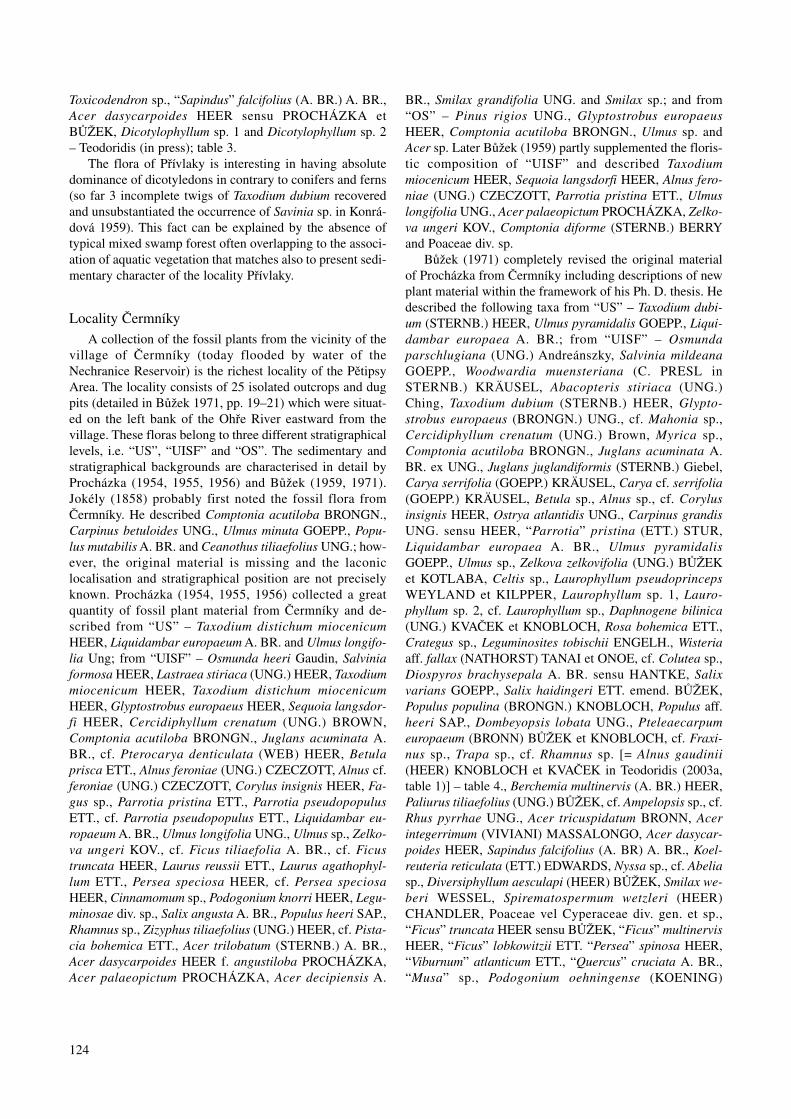
Taxa Stratigraphical position/Localities
US UISF OS
Čermníky Čermníky Chotěnice Lomazice Dolany Čermníky Dolany**
Acer dasycarpoides – ♣♣♣ – – – – –Acer integerrimum – ♣♣♣ – – – – –Acer tricuspidatum – ♣♣♣ – – ♣♣ – –cf. Alnus gaudinii – ♣♣♣ – ♣ – – –Alnus sp. – ♣♣♣ – – – – ♣cf. Ampelopsis sp. – ♣ – – – – –Berchemia multinervis – ♣♣ – – – – –Betula sp. – ♣♣ – – – – –Carpinus grandis – ♣♣ – – – – –Carya cf. serrifolia – ♣♣♣ – – – – –Carya serrifolia – ♣ – – – – –Celtis sp. – ♣♣ – – – – –Cercidiphyllum crenatum – ♣♣ – – ♣♣ – –Comptonia difformis – ♣♣♣ – – – ♣♣ ♦♣Craigia bronnii – ♣♣ – – – ♣ –Crategus sp. – ♣ – – – – –Daphnogene polymorpha – ♣♣♣ – – – ♣ –Decodon gibbosus – ♣ – – – – –Dicotylophyllum sp. 1 – ♣♣ – – – – –Dicotylophyllum sp. 2 – ♣♣ – – – – –Diospyros brachysepala – ♣♣ – – – – –Diversiphyllum aesculapi – ♣♣ – – – – –Dombeyopsis lobata – ♣♣♣ – – ♣♣♣ – –“Ficus” lobkowitzii – ♣♣ – – – – –“Ficus” truncata – ♣♣♣ – – – – –Fraxinus bilinica – ♣♣ – – ♣♣ – –cf. Fraxinus sp. – ♣ – – – – –Glyptostrobus europaeus – ♣♣♣ ♣♣ ♣♣ ♣♣ ♣♣ ♦♦Chaneya oeningensis – ♣ – – – – –Juglans acuminata – ♣♣♣ – – ♣♣ – –Koelreuteria reticulata – ♣ – – – – –Laurophyllum nechranicense – ♣ – – – – –Laurophyllum pseudoprinceps – ♣♣ – – – ♣♣ –Laurophyllum saxonicum – ♣ – – – ♣ –Leguminosites tobischii – ♣♣ – – – – –Liquidambar europaea ♣ ♣♣♣ – – – – –Mahonia bilinica – ♣ – – – – –Myrica sp. – ♣ – – – ♣ –Nyssa haidingeri – ♣♣ – – ♣♣♣ – –Nyssa ornithobroma – ♣ – – – – –Osmunda parschlugiana – ♣♣♣ – – – – –Ostrya atlantidis – ♣ – – – – –Paliurus tiliaefolius – ♣♣♣ – – – – –“Parrotia” pristina – ♣♣♣ – – – – –Phyllites kvacekii – ♣♣ – – – – –Phyllites nemejcii – ♣♣ – – – – –Pinus sp. – – – – – ♣ –Poaceae vel Cyperaceaediv. gen. et sp. – ♣♣♣ ♣♣ – – – –Podocarpium podocarpum – ♣♣♣ – – – – –Populus populina – ♣♣ – – – – –Populus zaddachii var. brabenecii – ♣♣ – – – – –Pronephrium stiricum – ♣♣ – – ♣♣ – –Pungiphyllum cruciatum – ♣♣ – – – – –Quercus rhenana – – – – – ♣♣ –cf. Rhus pyrrhae – ♣ – – – ♣ –Rosa europaea – ♣♣ – – – – –Rubus vrsovicensis – ♣ – – – – –Salix haidingeri – ♣♣♣ ♣♣ ♣♣ – – –
Table 4. Summary of the floristic composition on the localities of the Pětipsy Area in the Žatec Delta (i.e. localities Čermníky,Chotěnice, Lomazice, Dolany, Nechranice and Soběsuky). Symbols: US – the Series of the Underlying Clay and Sand sensuProcházka (1954), UISF – the Upper Inter-Seam Formation of the Seam Series sensu Procházka (1954), OS – the Series of theOverlying Clay and Sand sensu Procházka (1954); ** ♦ – locality Nechranice, ♠ – locality Soběsuky); ♣ – present, ♣♣ – rare,♣♣♣ – common.
127
Taxa Stratigraphical position/Localities
US UISF OS
Čermníky Čermníky Chotěnice Lomazice Dolany Čermníky Dolany**
Salix macrophylla – – – ♣ – – –Salix varians – ♣♣♣ – – – – –Salvinia reussii – ♣♣ – – – – –Sapindus falcifolius – ♣♣ – – – – –Smilax weberi – ♣♣ – – – – –Spirematospermum wetzleri – ♣ – – – – –Taxodium dubium ♣♣ ♣♣ ♣♣ – ♣♣ – –?? Trapa sp. – ♣ – – – – –Ulmus pyramidalis ♣♣ ♣♣♣ – – ♣♣ – ♣♠♠Ulmus sp. – ♣♣ – – – – –“Viburnum” atlanticum – ♣♣ – – – – –Wisteria aff. fallax – ♣♣♣ – – – – –Woodwardia muensteriana – ♣♣♣ – – ♣♣♣ – –Zelkova zelkovifolia – ♣♣♣ ♣♣ – – – –Zingiberoideophyllum liblarense – – ♣ – – – –
Table 4. Continued
Locality LomaziceThe locality was a dug pit marked as Lo 355 that was
situated near the church in Lomazice along the road to thevillage Poláky. The flora stratigraphically belongs to theUpper Inter-Seam Formation of the Seam Series (Procház-ka 1954) and was confined to grey sandy clay. Procházka(1956) described 4 taxa from there, i.e. Glyptostrobus eu-ropaeus HEER, Salix angusta A. BR., Salix macrophyllaHEER, cf. Rhamnus heeri ETT., which were revised byBůžek (1971) – Glyptostrobus europaeus (BRONGN.)UNG., Salix haidingeri ETT. emend. BŮŽEK, Salix macro-phylla HEER, cf. Rhamnus sp. [= Alnus gaudinii (HEER)KNOBLOCH et KVAČEK in Teodoridis (2003a, table 1)] –Teodoridis (2003a, unpubl.); table 4.
Locality DolanyFossil material was obtained from two different places
in broader vicinity of the village Dolany (marked as Do 50and 52). The locality Do 50 was a small gravel-pit westwardof the village, where the leaf impressions were confined tored sandy clays and stratigraphically belong to the UpperInter-Seam Formation of the Seam Series (Procházka1954). The second locality (Do 52) was also confined to redclaystone, belonging to the Series of the Overlying Sandand Clay (Procházka 1954). Procházka (1955, 1956) andBůžek (1959) described from there Pteris bilinica ETT.,Woodwardia roessneriana (UNG.) HEER, Taxodiummiocenicum HEER, Glyptostrobus europaeus HEER, cf. Se-quoia langsdorfi HEER, Cercidiphyllum crenatum (UNG.)BROWN, cf. Juglans acuminata A. BR., cf. Carya bilinica(UNG.) ETT., Alnus gaudinii (HEER) KNOBLOCH etKVAČEK, cf. Ficus tiliaefolia A. BR., Persea speciosaHEER, Acer trilobatum (STERNB.) A. BR. and Comptoniadiforme (STERNB.) BERRY (Bůžek 1959) from the local-ity Do 50 and Comptonia acutiloba BRONGN., Alnus fero-
niae (UNG.) CZECZOTT and Ulmus longifolia UNG. fromthe locality Do 52. Later, Bůžek (1971) revised all the avail-able material from Dolany and determined Woodwardiamuensteriana (C. PRESL in STERNB.) KRÄUSEL, Aba-copteris stiriaca (UNG.) Ching, Taxodium dubium(STERNB.) HEER, Glyptostrobus europaeus (BRONGN.)UNG., Cercidiphyllum crenatum (UNG.) Brown, Juglansacuminata A. BR. ex UNG., Juglans juglandiformis(STERNB.) Giebel, Ulmus pyramidalis GOEPP., Dombey-opsis lobata UNG., Acer tricuspidatum BRONN “Persea”spinosa HEER and Comptonia acutiloba BRONGN. from“UISF” and Comptonia acutiloba BRONGN., Alnus sp. andUlmus pyramidalis GOEPP. from “OS”. The recent revisionwas done by Teodoridis (2003a, unpubl.); table 4.
Locality SoběsukyThe outcrop marked as So 274 is situated on the left
bank of the Ohře River, about 900 m NNE from the villageof Soběsuky. A leaf impression originally described as Ul-mus longifolia UNG. (Ulmus pyramidalis GOEPP. in Bůžek1971; Teodoridis 2003a) was collected by Procházka (1956)from a yellow-brown pelosiderite concretion from yellowclay of the Series of the Overlying Clay and Sand (Procház-ka 1954).
Locality NechraniceČ. Bůžek collected leaf impressions from this locality in
the excavation during the construction of the dam of theNechranice Reservoir. The material is confined to grey clay,which stratigraphically belongs to the Upper Inter-SeamMember of the Seam Series (Procházka 1954). Bůžek(1971) described 2 taxa from there, i.e. Glyptostrobus eu-ropaeus (BRONGN.) UNG. and Comptonia acutilobaBRONGN. [= Comptonia difformis (STERNB.) BERRY inTeodoridis (2003a, table 1)] – table 4.

128
Phytostratigraphical correlations
Phytostratigraphical correlations of the fluvialsediments
On the basis of general floristic analysis of the floras ofthe “Hlavačov Gravel and Sand” (table 2), it is possible tocorrelate the floras of the localities Nesuchyně andHlavačov with the Late Oligocene floristic assemblage ofThierbach (Mai and Walther 1991). This correlation isbased on the occurrence of Pseudolarix schmidtgenii andFagus saxonica in association with other elements, e.g.Trigonobalanopsis rhamnoides, Taxodiaceae, Betulaceae (cf.table 2 and Mai and Walther 1991, pp. 147–161 and 153,161–166; Kvaček and Walther 2001, tables 6 and 7). The as-sociation of Pseudolarix schmidtgenii and Fagus saxonicadoes not occur in other floras of the “Hlavačov Gravel andSand”, where Pseudolarix schmidtgenii was missing.Nevertheless, the only presence of Fagus saxonica as an im-portant Late Oligocene element is not enough significant inview of new stratigraphical data from the locality Přívlaky(see below). This is in contrary to the former author’s -opinion (Teodoridis 2002, 2003a, in press). Insufficient in-vestigation and incomplete fossil collections can explainbetter the absence of Pseudolarix schmidtgenii in the locali-ties (i.e. Velká Černoc, Sádek and Želeč) rather than somespeculation about different character and composition ofthese floras, which would be probably caused by specificabiotic factors of the biotopes, or eventually different (prob-ably younger) character of this flora. Isochronous characterof the floras of the “Hlavačov Gravel and Sand” can beproved by continual sedimentation of this belt and similari-ty in the floristic composition of these floras (table 2). Veryinteresting fact supporting this floristic correlation is thesimilarity in spectra of heavy minerals of the “HlavačovGravel and Sand” (Čadek 1966) and the Thierbach Beds(Ahrens et al. 1974), which was at first published by Lotschet al. (1994). The team of German authors supposed a pos-sibility of the mutual association and genesis of both riversystems and interpreted the Central River (Pešek and Spudil1986) to be connected over central part of the Most Basinand Krušné hory Mts. with sediments of the ThierbachRiver in a single great river system. This concept wasproved by new sedimentological investigations in the ŽatecDelta connecting the deposits of the “Hlavačov Gravel andSand” with the basal delta sediments (Váně 1985, pp.212–214) and occurrence of clastic deposits (gravel, sand)in the underlying of the Seam Formation (Hurník andMarek 1962); Mach, Rajchl (personal communication2002). These clastic underlying sediments can be interpret-ed either in a direct context to the above mentioned greatriver system or as northeast sedimentary equivalent of the“Hlavačov Gravel and Sand” river system when acceptingthe objections published in Suhr (2003). He noticed an in-compatibility of the “Hlavačov Gravel and Sand” and Thier-bach Beds based on other possible sources of some heavyminerals in Germany and a new sedimentary model of theInland Delta for the fluvial system acting during the set of
sediments of the Basal Coal Seam (Váně 1987). It is possi-ble to correlate all floras of the “Hlavačov Gravel and Sand”with the flora of the locality Borna-Ost, i.e. the type locali-ty of the Thierbach floristic assemblage (Mai and Walther1991) and the locality Witznitz, which corresponds to thefloristic assemblage of Witznitz (Mai and Walther 1991).The macropalaeontological data from the Underlying For-mation and Lower Sandy Clayey Beds with Basal CoalSeam (Hurník and Marek 1962) are absolutely insufficientfor phytostratigrafical correlation (Bůžek 1971; table 4).However, the palynological data from these sediments ofthe lower part of the Most Formation sensu Shrbený (1994)show, besides relative common Miocene elements, alsomaximal abundance of Fagus pollen that occurred less fre-quently also in the middle and upper parts of the Most For-mation (Shrbený 1994); Konzalová (1976). On the basis ofthis Fagus pollen maximum and the above-mentioned factsof the sedimentary connection of the “Hlavačov Gravel andSand”, it is possible to correlate these deposits stratigraphi-cally to the Basal Coal Seam (Váně 1987) and its clasticequivalents that belong to the sediments of the DuchcovMember and the lower part of the Holešice Member(Domácí 1977) – text-fig. 2. Generally, the belt of the“Hlavačov Gravel and Sand” can be interpreted as an ero-sionally exposed lowermost part of the fluvial system thatbrought the clastic material into the area of the Most Basinduring depositon of the Underlying Formation and the Low-er Sandy Clayey Beds with the Basal Coal Seam (Hurníkand Marek 1962) that belong to the Duchcov Member andthe Lower part of the Holešice Member (Domací 1977).
The classification of fluvial sediments from the area ofCentral Bohemia comes out from a concept that distin-guished two different stratigraphical phases, i.e. the KlínecPhase (the Miocene age palaeobotanically fixed – e.g. Ket-tner 1911, Němejc 1943) and the Zdiby Phase (the Plioceneage without palaeobotanical proofs – Kodym and Matějka1920). According to Žebera (1972) and Žák et al. (2001) theoccurrence of tektites (impact before 15 MA – Balestrieri etal. 1998) in sediments of the Zdiby phase in Prague-Kobylisy revalues the age of these sediments to the MiddleMiocene or ? younger). This classical concept was general-ly accepted due to absence of palaeobotanical data in mostof the Tertiary sedimentary relics in Central Bohemia. Ac-cording to the floristic analysis of all available palaeo-botanical material and newly-collected material, Němejc(1949) corroborated the classification of the fluvial Tertiaryrelics in Central Bohemia and re-defined the stratigraphicalranges of the Klínec and Zdiby Phases and its equivalents(in Klínec Phase) in the Most Basin, i.e. the Klínec Phase,Lower Miocene, Overlying Formation (Hurník and Marek1962) of the Most Basin, the Zdiby phase, Upper Plioceneto Lower Pleistocene. Němejc (1949) assigned only the lo-cality of U Sv. Antonína into the Zdiby phase based on theoccurrence of leaf impressions that he determined as Fagussylvatica L. (Teodoridis 2001). Later, Nemějc (1964) re-de-fined stratigrafically the Klínec Phase and correlated it withthe Mydlovary Formation (Lower Badenian). Holý and

129
Bůžek (1966) critically evaluated the Němejc opinion anddefined the Klínec Phase using detailed palaeobotanicalstudy of the Žatec Facies (presence of Stratiotes kaltennord-heimensis) and correlated it to the sediments of the Lowerpart of the Seam Series (Procházka 1954). Teodoridis(2001) and Žák et al. (2003) noticed the similarity in thefloristic composition of fluvial relics in Central Bohemia,i.e. Klínec, Na Sulavě and “U ručiček” with the floras of the“Hlavačov Gravel and Sand” (cf. tables 1 and 2; table 5) andtherefore these floras could be correlated with the floristicassemblages of Thierbach and Witznitz (Mai and Walther1991) or Linz-Krumvíř sensu Kvaček and Walther (2001).On the other hand, it is unequivocal that the floras describedfrom fluvial islands contain very common elements of Ear-ly Miocene that are known from the localities belongingstratigraphically to the Seam Series (Procházka 1954), i.e.the Main Coal Seam (Elznic et al. 1986) – text-fig. 2, or theOverlying Formation (Hurník and Marek 1962), e.g. the lo-calities Čermníky (Bůžek 1971), Želénky (Kvaček andHurník 2000), Bílina (Kvaček 1998, Sakala 2000) etc.Therefore the suggested phytostratigraphical correlation ofthe Tertiary fluvial sediments from Central Bohemia withthe floristic assemblages of Boreal Europe and deposits ofthe Most Basin has speculative character.
Phytostratigraphical correlations of the Žatec Delta
The locality Holedeč belongs to the area of the ŽatecDelta (the Most Basin); however, Váně (1985) consideredthis locality to be a common tectonically isolated compo-nent of the “Hlavačov Gravel and Sand”. The flora ofHoledeč is confined to clay lenses that are lithologicallysimilar to the material from the nearby locality Záhoří nearŽatec. However, the lithological similarities cannot be usedfor correlation of the Holedeč flora. The interpretation ofFagus saxonica from Holedeč as a connecting element withthe floras of the “Hlavačov Gravel and Sand” is equivocaldue to new sedimentological interpretation of the Přívlakyflora (see below, cf. Teodoridis in press). The floristic com-position of the Holedeč flora shows considerable differen-ces from those of the “Hlavačov Gravel and Sand” in havingnew species e.g. Populus populina, Rosa europaea, Rubusmerianii, Leguminosites tobischii, Podocarpiumpodocarpum, Wisteria aff. fallax, Koelreuteria reticulata,Acer dasycarpoides, Acer pseudomonospessulanum,Chaneya oeningensis, Paliurus tiliaefolius, “Ficus” trunca-ta and ? Persoonia sp. These taxa are common in the partialflora of Čermníky from the Upper Inter-Seam Member ofthe Most Formation, which belongs to the Upper part of theHolešice Member (Domací 1977) [cf. table 5] and can beinterpreted as connecting elements of both floras importantfor correlation. Similarly as Holedeč, the flora of Záhořínear Žatec can be correlated with the flora of Čermníky be-longing to the Upper part of the Holešice Member (Domací1977). The correlation is based on floristic analysis of bothfloras (cf. tables 3 and 5) and on identical lithostratigraphi-cal position (Text-fig. 5).
The flora of the locality Přívlaky contains several ele-ments (cf. tables 3 and 5) that occur as common elements infloras of the Pětipsy Area and floras of the “Hlavačov Grav-el and Sand” (table 5). However, based on detailed study ofthe drilling documentation (Kliner and Würmová 1975) andprofiles (Collective of authors 1980) from this area, it ispossible to correlate the locality of Přívlaky to the lower-most part of the Overlying Formation (Hurník and Marek1962), i.e. basal part of the Libkovice Member of the MostFormation (Domácí 1977) without doubt (Text-fig. 5).A possible floristic equivalent with sediments of the MostBasin is the flora from the cores of MR 59, MR 58, LoM 16and Os 9 that stratigraphically belongs to deposits closelyunderlying the Lom Seam within the Libkovice Member ofthe Most Formation (Bůžek et al. 1993). These floras havesubtropical character and are usually correlated with thefloristic assemblage of Eichelskopf-Wiesa sensu Mai(1995), floristic zone VI sensu Mai (1967) /Eggenburgian-Ottnangian/. Alternatively and more probably, equivalentsare the potential floras from lower part of the OverlyingFormation (Hurník and Marek 1962), i.e. floras of thelowermost part of the Libkovice Member from NW bank ofthe Nechranice Reservoir. These floras contain commonbasin elements, e.g. Nyssa haidingeri, Taxodium dubium,Glyptostrobus europaeus, Alnus julianiformis and Ulmuspyramidalis Teodoridis (unpubl.). This correlation is provedboth by similarity of palaeofloristic composition and theidentical stratigraphical position of Přívlaky (i.e. closelyoverlying the Seam Series – Procházka 1954).
Floras of the Pětipsy Area (Žatec Delta) belong to thethree stratigraphically different positions in sedimentaryfilling of the Most Basin, i.e. the Series of the UnderlyingClay and Sand (Procházka 1954) – locality Čermníky; theUpper Inter-Seam Coal Formation of the Seam Series(Procházka 1954) – localities Čermníky, Chotěnice, Loma-zice and Dolany; and the Series of the Overlying Clay andSand (Procházka 1954) – Čermníky, Dolany, Soběsuky andNechranice (table 4, for next stratigraphical equivalents seetext-fig. 2).
On the basis of analogy of the floristic composition, it ispossible to correlate the floras of the Upper Inter-Seam CoalFormation of the Seam Series (Procházka 1954) with thefloristic assemblages of Bílina-Brandis (Mai 1995) and/orBitterfeld (Mai and Walther 1991). The occurrence of theindex fossil Schenkiella credneri in the floristic assemblageof Bílina-Brandis and its absence in floras of the floristic as-semblage Bitterfeld defines unequivocally the borderlinebetween both assemblages. Wójcicki and Kvaček (2002)completely revised all Bohemian occurrences of Schenkiel-la credneri and exactly defined the basal borderline of thefloristic assemblage Bílina-Brandis within the framework ofthe Most Basin deposits. This taxon is known from fossili-ferous horizons Nos. 21 and 24 sensu Bůžek et al. (1992)and from the close overlying sediments of the Main CoalSeam (Elznic et al. 1986) [= the Seam Series sensu Procház-ka (1954) in the Maxim Gorkij Mine (Wójcicki and Kvaček2002)]. Based on this fact, it is possible to safely correlate

130
Taxa Localities
Záhoří Pětipesy Area Přívlaky Holedeč “Hlavačov Fluvial sedi-near Gravel and ments of CentralŽatec US UISF OS Sand” Bohemia **
Acer dasycarpoides ♣ – ♣ – ♣ ♣ – –Acer integerrimum ♣ – ♣ – – ♣ ♣ –Acer pseudomonospessulanum – – – – – ♣ – –Acer tricuspidatum – – ♣ – – ♣ ♣ –Ailanthus confucii – – – – – ♣ ♣ –cf. Alnus gaudinii – – ♣ – – – – –Alnus julianiformis ♣ – – – – ♣ ♣ ♣Alnus kefersteini – – ♣ – – ♣ ♣ –Alnus sp. ♣ – ♣ ♣ ♣ ♣ ♣ ♣cf. Ampelopsis sp. – – ♣ – – – – –Berchemia multinervis – – ♣ – – – – –Betula sp. ♣ – ♣ ♣ ♣ ♣ ♣ ♣Carpinus grandis – – ♣ – ♣ ♣ ♣ –Carya cf. serrifolia ♣ – ♣ – ♣ ♣ – ♣Carya serrifolia ♣ – ♣ – – ♣ ♣ –cf. Castanea atavia – – – – – – ♣ –Celtis sp. – – ♣ – – – – –Cercidiphyllum crenatum – – ♣ ♣ – – – –Comptonia difformis ♣ – ♣ ♣ ♣ ♣ ♣ –Craigia bronnii – – ♣ – – – – –Crategus sp. – – ♣ – – – – –Daphnogene cinnamomifolia ♣ – ♣ ♣ – ♣ ♣ ♣Decodon gibbosus – – ♣ – – – – –Diospyros brachysepala – – ♣ – ♣ – – –Diversiphyllum aesculapi – – ♣ – – – – –Dombeyopsis lobata – – ♣ – – – – –Fagus deucalionis – – – – – ♣ ♣ –Fagus saxonica – – – – ♣ ♣ ♣ –“Ficus” lobkowitzii – – ♣ – – – – –“Ficus” truncata ♣ – ♣ – – ♣ – ♣Fraxinus bilinica – – ♣ – – – – –cf. Fraxinus sp. – – ♣ – – – ♣– –Glyptostrobus europaeus ♣ – ♣ ♣ – ♣ ♣ ♣Chaneya oeningensis – – ♣ – – ♣ – –Juglans acuminata – – ♣ – – ♣ ♣ –Koelreuteria reticulata – – ♣ – – ♣ – –Laurophyllum nechranicense – ♣ – – – – –Laurophyllum pseudoprinceps ?♣ – ♣ – – – – –Laurophyllum saxonicum ?♣ – ♣ – – – – –Leguminosites tobischii – – ♣ – – ♣ – –Liquidambar europaea ♣ ♣ ♣ – ♣ ♣ ♣ ♣Mahonia bilinica – – ?♣ – – – ♣ –Myrica sp. – – ♣ ♣ ♣ – ♣ ♣Nyssa haidingeri – – ♣ – – – – –Nyssa ornithobroma – – ♣ – – – – –Osmunda parschlugiana – – ♣ – – – – –Ostrya atlantidis – – ♣ – – – – –Paliurus tiliaefolius ♣ – ♣ – – ♣ – –“Parrotia” pristina ♣ – ♣ – ♣ – – –? Persoonia sp. – – – – – ♣ – –Phyllites kvacekii – – ♣ – – – – –Phyllites nemejcii – – ♣ – – – – –Pinus sp. – – – ♣ – – ♣ –Poaceae vel Cyperaceae – – ♣ – ♣ ♣ –Podocarpium podocarpum ♣ – ♣ – ♣ ♣ – ♣Populus populina ♣ – ♣ – ♣ ♣ – –Populus zaddachiivar. brabenecii – – ♣ – – ♣ ♣ ♣Pronephrium stiricum – – ♣ – – – – –Pseudolarix schmidtgenii – – – – – – ♣ –
Table 5. Summary of the floristic composition on the localities of the studied area. Symbols: US – the Series of the UnderlyingClay and Sand sensu Procházka (1954), UISF – the Upper Inter-Seam Formation of the Seam Series sensu Procházka (1954), OS– the Series of the Overlying Clay and Sand sensu Procházka (1954); ** (localities Klínec, Na Sulavě, and “U ručiček); ♣ – pre-sent, ♣♣ – rare, ♣♣♣ – common.

131
Table 5. Continued.
Taxa Localities
Záhoří Pětipesy Area Přívlaky Holedeč “Hlavačov Fluvial sedi-near Gravel and ments of CentralŽatec US UISF OS Sand” Bohemia **
Pungiphyllum cruciatum – – – ♣ – – – –Quasisequoia couttsiae ♣ – – – – – – –Quercus rhenana – – ♣ – – – – –cf. Rhus pyrrhae – – ♣ – – – – –Rosa europaea – – ♣ – ♣ ♣ – –Rubus meriani – – – – ♣ – –Rubus vrsovicensis – – ♣ – – – – –Salix haidingerii ♣ – ♣ – ♣ ♣ ♣ ♣Salix macrophylla – – ♣ – – – ♣ –Salix varians – – ♣ – – ♣ ♣ ♣Salvinia reussii – – ♣ – – ♣ ♣ ♣Sapindus facifolius – – ♣ – ♣ ♣ ♣ –Smilax weberi – – ♣ – – – – ♣Spirematospermum wetzleri – – – – – – – –Stratiotes kaltennordheimensis – – – – – ♣ – ♣Taxodium dubium ♣ ♣ ♣ – – ♣ ♣ ♣Tetraclinis salicornioides – – – – – – ♣ –Tilia brabenecii – – – – – – ♣ –cf. Toxicodendron sp. – – ♣ – ♣ – – –? Trapa sp. – – ♣ – – – – –cf. Trigonobalanopsis rhamnoides – – – – – – ♣ –Ulmus pyramidalis ♣ ♣ ♣ ♣ ♣ ♣ ♣ ♣Ulmus sp. – – ♣ – – – – –“Viburnum” atlanticum ♣ – ♣ – – ♣ ♣ –Vitis stricta – – – – ♣ ♣ ♣ –Wisteria aff. fallax ♣ – ♣ – – ♣ – –Woodwardia muensteriana – – ♣ – – – ♣ –Zelkova zelkovifolia ♣ – ♣ – ♣ ♣ ♣ –Zingiberoideophyllum liblarense – – ?♣ – – – ♣ –
floras of the Přívlaky (Text-fig. 5) and the floras of the Pěti-psy Area, which belong to the Overlying Formation (Hurníkand Marek 1962), to the floristic assemblage of Bílina-Brandis (Mai and Walther 1991), floristic zone IV (Mai1967). More problematic phytostratigraphical correlationsare these of sedimentological equivalents of the Upper In-ter-Seam Formation of the Seam Series (Procházka 1954).These floras show considerable similarity with floras of thefloristic assemblage Bílina-Brandis, but differ in occur-rences of Schenkiella credneri, or Vaccinioides lusatica,Engelhardia macroptera, E. orsbergensis, Pinus engel-hardtii, P. rigios and Trigonobalanopsis rhamnoides. Mostof these taxa (except for Schenkiella credneri) are typicalparaclimax to climax elements of the Engelhardia-Taxo-dium association sensu Kvaček and Bůžek (1982). A possibleinterpretation of absence of these elements in the floras ofthe Upper Inter-Seam Coal Formation of the Seam Series(Procházka 1954), due to specific environmental factors ofthe mentioned inland delta regime, is highly speculative andequivocal. Therefore, the most probable correlation of thesefloras is that with the floristic assemblage of Bitterfeld (Maiand Walther 1991), floristic zone III (Mai 1967). This flori-stic assemblage is based on the flora of Bitterfeld, whichcontains dominantly represented arctotertiary elements andshows relatively temperate character compared to the florasof the Bílina-Brandis floristic assemblage, probably due to
the riparian type of vegetation. Floras of the Bitterfeldfloristic assemblage, e.g. Glopa, Röse-Sausedlitz, Holz-weissig, Delitzsch and Muldenstein, stratigraphically be-long to the Main Bitterfeld Coal Seam including its closeunderlying and overlying sediments (“Bitterfelder Liegend-ton und Deckton”), and are mainly based on carpologicalmaterial (Mai and Walther 1991, pp. 161–176). Neverthe-less, these floras from the Bitterfeld Basin are comparableto floras of the Upper Inter-Seam Formation of the SeamSeries (Procházka 1954) based on their taxonomical com-position.
Mai (1995) correlated with doubt the so-called ŽatecDelta (Čermníky) and sediments between Žatec andRakovník (Hlavačov, Holedeč and Nesuchyně) to the flori-stic assemblage of Münzenberg-Bitterfeld. The flora ofMünzenberg is dated by faunal zone MN 1 that does notcorrespond to the dating of the basal part of the Main CoalSeam (Elznic et al. 1986) – MN3a to MN3b (Fejfar 1989,Fejfar and Kvaček 1993). Therefore, it can not be correlatedto the floras of the Žatec Delta, the “Hlavačov Gravel andSand” and Holedeč to the flora of Münzenberg. However,the correlation to the undated locality Bitterfeld is veryprobable, except for the floras of the Underlying Formationand the Lower Sandy Clayey Beds with the Basal CoalSeam (Hurník and Marek 1962) of the Most Basin and flo-ras of the “Hlavačov Gravel and Sand” (see above).
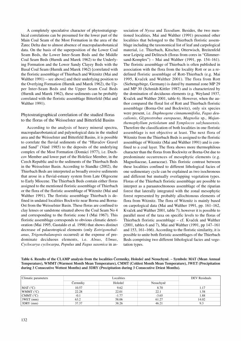
A completely speculative character of phytostratigrap-hical correlations can be presumed for the lower part of theMain Coal Seam of the Most Formation in the area of theŽatec Delta due to almost absence of macropalaeobotanicaldata. On the basis of the superposition of the Lower CoalSeam Beds, the Lower Inter-Seam Beds and the MiddleCoal Seam Beds (Hurník and Marek 1962) to the Underly-ing Formation and the Lower Sandy Clayey Beds with theBasal Coal Seam (Hurník and Marek 1962) [correlated withthe floristic assemblage of Thierbach and Witznitz (Mai andWalther 1991) – see above] and their underlying position tothe Overlying Formation (Hurník and Marek 1962), the Up-per Inter-Seam Beds and the Upper Seam Coal Beds(Hurník and Marek 1962), these sediments can be probablycorrelated with the floristic assemblage Bitterfeld (Mai andWalther 1991).
Phytostratigraphical correlation of the studied florasto the floras of the Weisselster and Bitterfeld Basins
According to the analysis of heavy mineral spectra,macropalaeobotanical and palynological data in the studiedarea and the Weisselster and Bitterfeld Basins, it is possibleto correlate the fluvial sediments of the “Hlavačov Graveland Sand” (Váně 1985) to the deposits of the underlyingcomplex of the Most Formation (Domácí 1977), i.e. Duch-cov Member and lower part of the Holešice Member, in theCzech Republic and to the sediments of the Thierbach Bedsin the Weisselster Basin. According to Standke (2002), theThierbach Beds are interpreted as broadly erosive sedimentsthat arose in a fluvial-estuary system from Late Oligoceneto Early Miocene. The Thierbach Beds contain either florasassigned to the mentioned floristic assemblage of Thierbachor the flora of the floristic assemblage of Witznitz (Mai andWalther 1991). The floristic assemblage Thierbach is de-fined in undated localities Bockwitz near Borna and Borna-Ost from the Weisselster Basin. These floras are confined toclay lenses or sandstone situated above the Coal Seam No 4and corresponding to the floristic zone I (Mai 1967). Thisfloristic assemblage corresponds to obvious climatic deteri-oration (Mai 1995, Gastaldo et al. 1998) that shows distinctdecrease of palaeotropical elements (only Eotrigonobal-anus, Trigonobalanopsis occurred) at the expense of pre-dominate deciduous elements, i.e. Alnus, Ulmus,Cyclocarya cyclocarpa, Populus and Fagus saxonica in as-
sociation of Nyssa and Taxodium. Besides, the two men-tioned localities, Mai and Walther (1991) presented otherlocalities that belonged to the Thierbach floristic assem-blage including the taxonomical list of leaf and carpologicalmaterial, i.e. Thierbach, Kitscher, Otterwisch, Breitenfeldnear Leipzig and Delitzsch (floras from cores in “Glimmer-sand-Komplex”) – Mai and Walther (1991, pp. 154–161).The floristic assemblage of Thierbach is often published inassociation with the flora from the locality Rott or as a re-defined floristic assemblage of Rott-Thierbach (e.g. Mai1995, Kvaček and Walther 2001). The flora from Rott(Siebengebirge, Germany) is dated by mammal zone MP 29and MP 30 (Schmidt-Kittler 1987) and is characterized bythe domination of deciduous elements (e.g. Weyland 1937,Kvaček and Walther 2001, table 6). However, when the au-thor compared the floral list of Rott and Thierbach floristicassemblage (Borna-Ost and Bockwitz), only six specieswere present, i.e. Daphnogene cinnamomifolia, Fagus deu-calionis, Glyptostrobus europaeus, Magnolia sp., Majan-themophyllum petiolatum and Symplocos salzhausensis.Therefore the classification of both localities in one floristicassemblage is not objective at least. The next flora ofWitznitz from the Thierbach Beds is assigned to the floristicassemblage of Witznitz (Mai and Walther 1991) and is con-fined to a coal layer. The flora shows more thermophilouscharacter than the floras from Bockwitz or Borna-Ost due topredominate occurrences of mesophytic elements (e.g.Magnoliaceae, Lauraceae). This floristic contrast betweenthese localities confined to different lithological facies ofone sedimentary cycle can be explained as two isochronousand different but mutually overlapping vegetation types.Floras of the Thierbach floristic assemblage are possible tointerpret as a paraautochtonous assemblage of the riparianforest that laterally integrated with the zonal mesophyticforest represented by probably allochtonous elements offlora from Witznitz. The flora of Witznitz is mainly basedon carpological data (Mai and Walther 1991, pp. 161–162,Kvaček and Walther 2001, table 7); however it is possible toparallel most of the taxa on specific levels to the floras ofThierbach floristic assemblage – cf. Kvaček and Walther(2001, tables 6 and 7), Mai and Walther (1991, pp 147–161and 153, 161–166). According to the floristic similarity, it ispossible to unite both floristic assemblages of the ThierbachBeds comprising two different lithological facies and vege-tation types.
132
Climatic parameters Localities DEV Residuals
Čermníky Holedeč Nesuchyně
MAT (°C) 10.57 9.62 8.70 1.17WMMT (°C) 22.28 22.01 22.1 1.58CMMT (°C) -0.1 -1.77 -3.65 1.883WET (mm) 63.2 58.06 61.27 14.023DRY (mm) 37.37 38.26 46.21 9.3
Table 6. Results of the CLAMP analysis from the localities Čermníky, Holedeč and Nesuchyně. – Symbols: MAT (Mean AnnualTemperature), WMMT (Warmest Month Mean Temperature), CMMT (Coldest Month Mean Temperature), 3WET (Precipitationduring 3 Consecutive Wettest Months) and 3DRY (Precipitation during 3 Consecutive Driest Months).
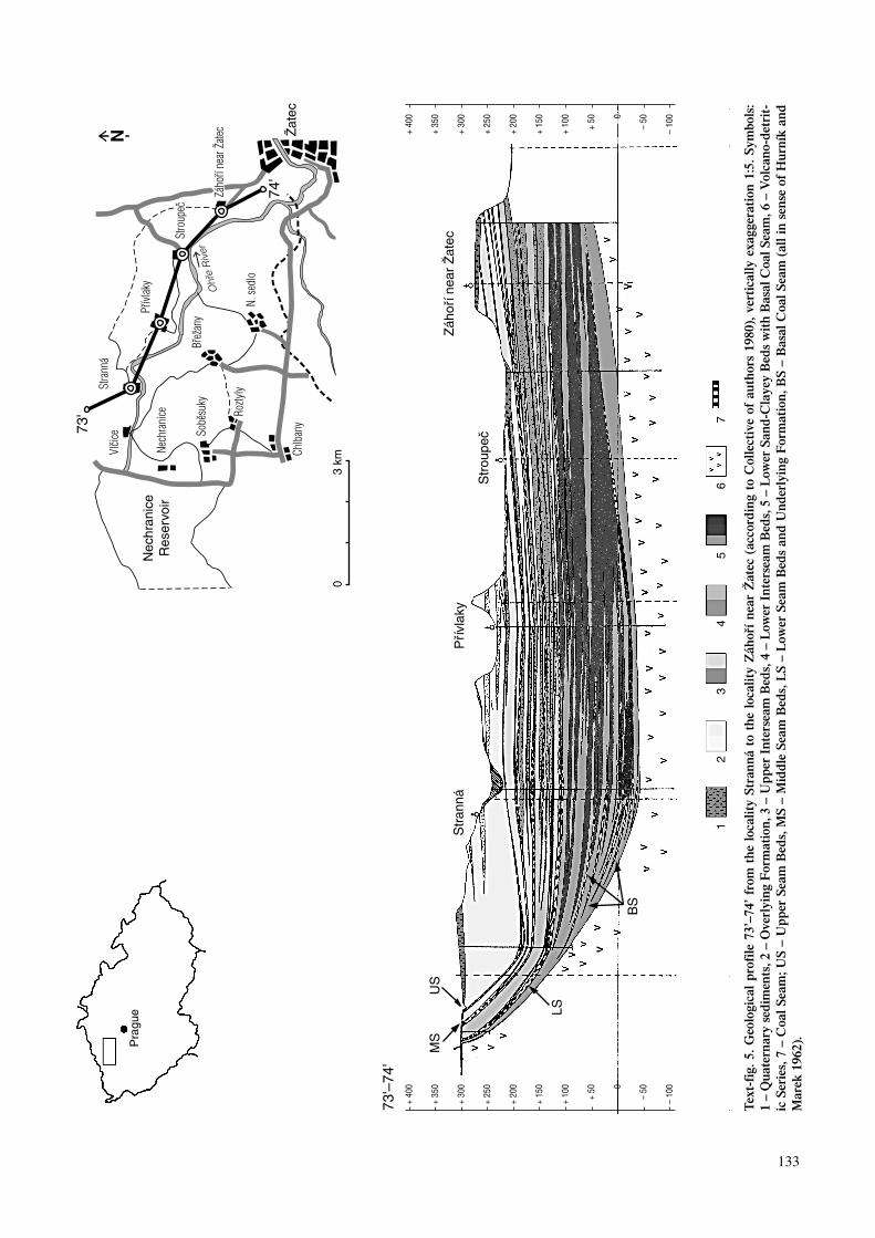
133
Tex
t-fi
g. 5
. G
eolo
gica
l p
rofi
le 7
3’–7
4’ f
rom
th
e lo
cali
ty S
tran
ná
to t
he
loca
lity
Záh
oří
nea
r Ž
atec
(ac
cord
ing
to C
olle
ctiv
e of
au
thor
s 19
80),
ver
tica
lly
exag
gera
tion
1:5
. S
ymbo
ls:
1–
Qu
ater
nar
y se
dim
ents
, 2–
Ove
rlyi
ng
For
mat
ion
, 3–
Up
per
In
ters
eam
Bed
s, 4
–L
ower
In
ters
eam
Bed
s, 5
–L
ower
San
d-C
laye
y B
eds
wit
h B
asal
Coa
l S
eam
, 6–
Vol
can
o-d
etri
t-ic
Ser
ies,
7–
Coa
l S
eam
; US
–U
pp
er S
eam
Bed
s, M
S –
Mid
dle
Sea
m B
eds,
LS
– L
ower
Sea
m B
eds
and
Un
der
lyin
g F
orm
atio
n, B
S –
Bas
al C
oal
Sea
m (
all
in s
ense
of
Hu
rník
an
dM
arek
196
2).
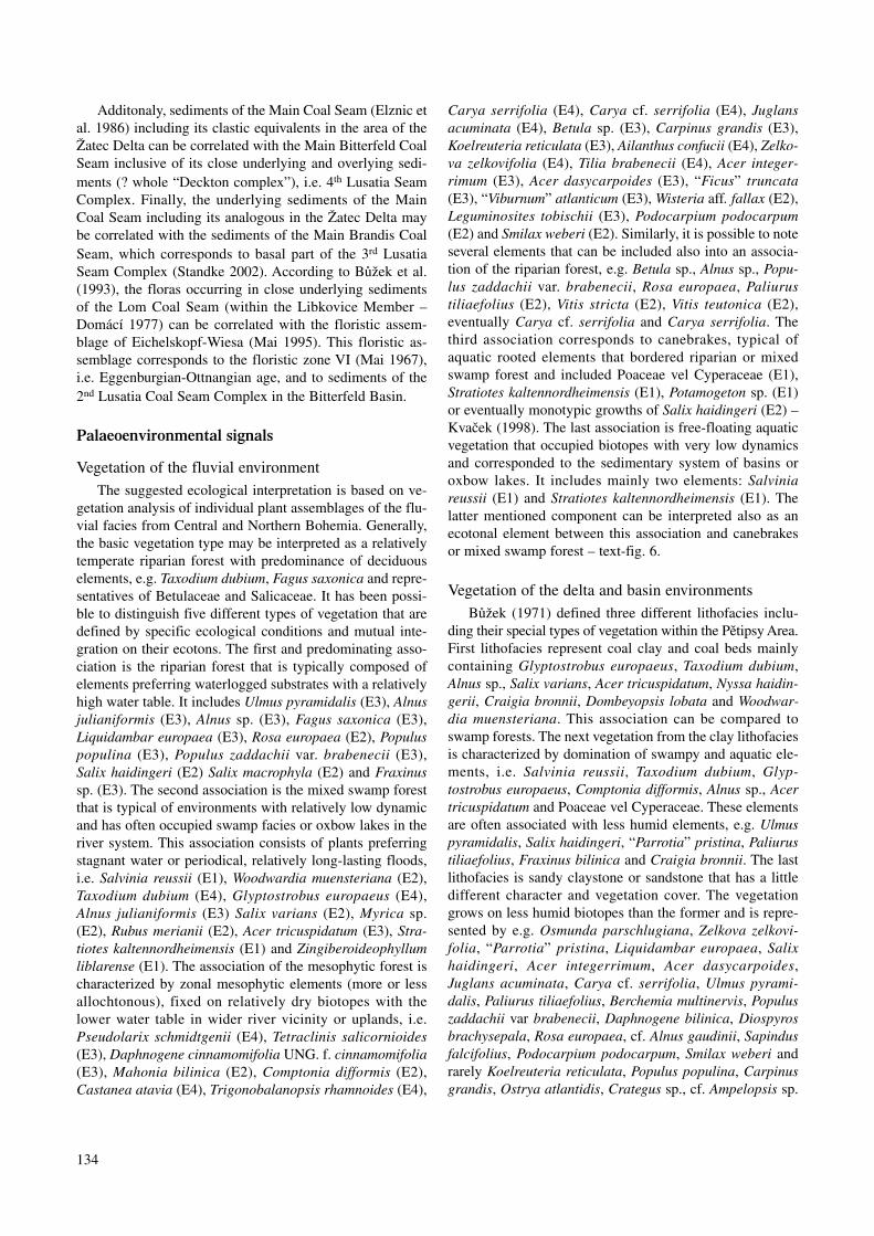
Additonaly, sediments of the Main Coal Seam (Elznic etal. 1986) including its clastic equivalents in the area of theŽatec Delta can be correlated with the Main Bitterfeld CoalSeam inclusive of its close underlying and overlying sedi-ments (? whole “Deckton complex”), i.e. 4th Lusatia SeamComplex. Finally, the underlying sediments of the MainCoal Seam including its analogous in the Žatec Delta maybe correlated with the sediments of the Main Brandis CoalSeam, which corresponds to basal part of the 3rd LusatiaSeam Complex (Standke 2002). According to Bůžek et al.(1993), the floras occurring in close underlying sedimentsof the Lom Coal Seam (within the Libkovice Member –Domácí 1977) can be correlated with the floristic assem-blage of Eichelskopf-Wiesa (Mai 1995). This floristic as-semblage corresponds to the floristic zone VI (Mai 1967),i.e. Eggenburgian-Ottnangian age, and to sediments of the2nd Lusatia Coal Seam Complex in the Bitterfeld Basin.
Palaeoenvironmental signals
Vegetation of the fluvial environmentThe suggested ecological interpretation is based on ve-
getation analysis of individual plant assemblages of the flu-vial facies from Central and Northern Bohemia. Generally,the basic vegetation type may be interpreted as a relativelytemperate riparian forest with predominance of deciduouselements, e.g. Taxodium dubium, Fagus saxonica and repre-sentatives of Betulaceae and Salicaceae. It has been possi-ble to distinguish five different types of vegetation that aredefined by specific ecological conditions and mutual inte-gration on their ecotons. The first and predominating asso-ciation is the riparian forest that is typically composed ofelements preferring waterlogged substrates with a relativelyhigh water table. It includes Ulmus pyramidalis (E3), Alnusjulianiformis (E3), Alnus sp. (E3), Fagus saxonica (E3),Liquidambar europaea (E3), Rosa europaea (E2), Populuspopulina (E3), Populus zaddachii var. brabenecii (E3),Salix haidingeri (E2) Salix macrophyla (E2) and Fraxinussp. (E3). The second association is the mixed swamp forestthat is typical of environments with relatively low dynamicand has often occupied swamp facies or oxbow lakes in theriver system. This association consists of plants preferringstagnant water or periodical, relatively long-lasting floods,i.e. Salvinia reussii (E1), Woodwardia muensteriana (E2),Taxodium dubium (E4), Glyptostrobus europaeus (E4),Alnus julianiformis (E3) Salix varians (E2), Myrica sp.(E2), Rubus merianii (E2), Acer tricuspidatum (E3), Stra-tiotes kaltennordheimensis (E1) and Zingiberoideophyllumliblarense (E1). The association of the mesophytic forest ischaracterized by zonal mesophytic elements (more or lessallochtonous), fixed on relatively dry biotopes with thelower water table in wider river vicinity or uplands, i.e.Pseudolarix schmidtgenii (E4), Tetraclinis salicornioides(E3), Daphnogene cinnamomifolia UNG. f. cinnamomifolia(E3), Mahonia bilinica (E2), Comptonia difformis (E2),Castanea atavia (E4), Trigonobalanopsis rhamnoides (E4),
Carya serrifolia (E4), Carya cf. serrifolia (E4), Juglansacuminata (E4), Betula sp. (E3), Carpinus grandis (E3),Koelreuteria reticulata (E3), Ailanthus confucii (E4), Zelko-va zelkovifolia (E4), Tilia brabenecii (E4), Acer integer-rimum (E3), Acer dasycarpoides (E3), “Ficus” truncata(E3), “Viburnum” atlanticum (E3), Wisteria aff. fallax (E2),Leguminosites tobischii (E3), Podocarpium podocarpum(E2) and Smilax weberi (E2). Similarly, it is possible to noteseveral elements that can be included also into an associa-tion of the riparian forest, e.g. Betula sp., Alnus sp., Popu-lus zaddachii var. brabenecii, Rosa europaea, Paliurustiliaefolius (E2), Vitis stricta (E2), Vitis teutonica (E2),eventually Carya cf. serrifolia and Carya serrifolia. Thethird association corresponds to canebrakes, typical ofaquatic rooted elements that bordered riparian or mixedswamp forest and included Poaceae vel Cyperaceae (E1),Stratiotes kaltennordheimensis (E1), Potamogeton sp. (E1)or eventually monotypic growths of Salix haidingeri (E2) –Kvaček (1998). The last association is free-floating aquaticvegetation that occupied biotopes with very low dynamicsand corresponded to the sedimentary system of basins oroxbow lakes. It includes mainly two elements: Salviniareussii (E1) and Stratiotes kaltennordheimensis (E1). Thelatter mentioned component can be interpreted also as anecotonal element between this association and canebrakesor mixed swamp forest – text-fig. 6.
Vegetation of the delta and basin environmentsBůžek (1971) defined three different lithofacies inclu-
ding their special types of vegetation within the Pětipsy Area.First lithofacies represent coal clay and coal beds mainlycontaining Glyptostrobus europaeus, Taxodium dubium,Alnus sp., Salix varians, Acer tricuspidatum, Nyssa haidin-gerii, Craigia bronnii, Dombeyopsis lobata and Woodwar-dia muensteriana. This association can be compared toswamp forests. The next vegetation from the clay lithofaciesis characterized by domination of swampy and aquatic ele-ments, i.e. Salvinia reussii, Taxodium dubium, Glyp-tostrobus europaeus, Comptonia difformis, Alnus sp., Acertricuspidatum and Poaceae vel Cyperaceae. These elementsare often associated with less humid elements, e.g. Ulmuspyramidalis, Salix haidingeri, “Parrotia” pristina, Paliurustiliaefolius, Fraxinus bilinica and Craigia bronnii. The lastlithofacies is sandy claystone or sandstone that has a littledifferent character and vegetation cover. The vegetationgrows on less humid biotopes than the former and is repre-sented by e.g. Osmunda parschlugiana, Zelkova zelkovi-folia, “Parrotia” pristina, Liquidambar europaea, Salixhaidingeri, Acer integerrimum, Acer dasycarpoides,Juglans acuminata, Carya cf. serrifolia, Ulmus pyrami-dalis, Paliurus tiliaefolius, Berchemia multinervis, Populuszaddachii var brabenecii, Daphnogene bilinica, Diospyrosbrachysepala, Rosa europaea, cf. Alnus gaudinii, Sapindusfalcifolius, Podocarpium podocarpum, Smilax weberi andrarely Koelreuteria reticulata, Populus populina, Carpinusgrandis, Ostrya atlantidis, Crategus sp., cf. Ampelopsis sp.
134

and Celtis sp. On the other hand, Bůžek (1971) also notedthe occurrence of swampy elements, i.e. Salvinia reussii,Glyptostrobus europaeus, Acer tricuspidatum, Dombeyo-psis lobata in allochtonous assemblages of this lithofacies.
Similarly as in the case of the mentioned structure of the“river” vegetation, it is possible to distinguish some partialassociations of delta and basin vegetation based on thefloristic analysis of the relevant localities. The associationsare defined by specific ecological factors. They integratedmutually on their ecotons (Text-fig. 7). The first typicalbasin association is the coniferous swamp forest that isidentical to the association of Glyptostrobus sensu Kvačekand Bůžek (1982). A relatively high water table and rela-tively long-lasting floods, changing to permanent floods inthe distal part of the basin characterize this association. Thedominant elements are representatives of the family Taxodi-aceae, i.e. Glyptostrobus europaeus (E4) and Quasisequoiacouttsiae (E4). The latter mentioned element is an importanttaxon known from several localities from the coal lithofa-cies of the Most Basin and the Břešťany Clay. However, it isonly proved from the Žatec Delta sediments in the localityZáhoří near Žatec (Teodoridis 2003a). The next associationoverlapping with the coniferous swamp forest towards wa-terside is an association of the mixed swamp forest that is
comparable to the Nyssa – Taxodium association sensuKvaček and Bůžek (1982) or the Most-Bílina palaeofloris-tic area sensu Hurník (1961). Besides the mentioned ele-ments of Taxodiaceae, this association includes alsoTaxodium dubium (E4), Alnus julianiformis (E3), Ulmuspyramidalis (E3), Nyssa haidingeri (E2), Acer tricuspida-tum (E3), Craigia bronnii (E3), Dombeyopsis lobata (E3),Cercidiphyllum crenatum (E3), Fraxinus bilinica (E3), Sal-ix varians (E2), Myrica sp. (E2), Quercus rhenana (E3) andWoodwardia muensteriana (E2) and is also confined to thecoal lithofacies. It is possible to define a partial sub-associa-tion containing monotonous stands of Quercus rhenana thatis usually interpreted as early succession or final phase ofswamp supported by the occurrence of this taxon in dark-grey clay in close underlying and overlying the coal seam(Kvaček and Bůžek 1982). Riparian forest is mainly con-fined to sandy clay or sand of the Žatec Delta. These sedi-ments can be easily interpreted as clastic relics of thecomplicated anastomosing river system of the inland delta.The association of the riparian forest corresponds to theParrotia – Ulmus pyramidalis association sensu Kvaček andBůžek (1982) or association of the levée riparian mixed de-ciduous broad-leaved forest sensu Boulter et al. (1993) andincludes, i.e. “Parrotia” pristina (E2), Salix haidingeri (E2),
135
Text-fig. 6. Reconstruction of vegetation cover in the river environment. – Symbols: 1. riparian forest, 2. mixed swamp forest, 3.mesophytic forest, 4. canebrakes, 5. aquatic vegetation; Aci – Acer integerrimum, Act – Acer tricuspidatum, Ai – Ailanthus con-fucii, Al – Alnus julianiformis, Be – Betula sp., Co – Comptonia difformis, Cy – Carya sp., Da – Daphnogene cinnamomifolia, Fa– Fagus saxonica, Fr – Fraxinus sp., Gl – Glyptostrobus europaeus, Ju – Juglans acuminata, L – Smilax weberi, Wisteria aff. fal-lax, Vitis sp., Li – Liquidambar europaea, Ma – Mahonia bilinica, My – Myrica sp., Pd – Podocarpium podocarpum, Po – Populussp., Ps – Pseudolarix schmidtgenii, Ru – Rubus merianii, Sh – Salix haidingeri, Sr – Salvinia reussii, St – Stratiotes kaltennord-heimensis, Sv – Salix varians, Ta – Taxodium dubium, Te – Tetraclinis salicornioides, Ti – Tilia brabencii, Ul – Ulmus pyramidalis,Wo – Woodwardia muensteriana, Ze – Zelkova zelkovifolia, Zi – Zingiberoideophyllum liblarense.

Ulmus pyramidalis (E3), Liquidambar europaea (E3), even-tually Alnus julianiformis (E3), Alnus sp. sensu Bůžek (E3),Rosa europaea (E2) and Comptonia difformis (E2). Kvačekand Bůžek (1982) supposed that several mesophytic ele-ments, such as Acer dasycarpoides (E3), A. integerrimum(E3), Zelkova zelkovifolia (E4), Daphnogene polymorpha(E3), Koelreuteria reticulata (E3), Paliurus tiliaefolius(E2), Podocarpium podocarpum (E2), “Ficus” truncata(E3), “Viburnum” atlanticum (E3), Smilax weberi (E2), Wis-teria aff. fallax (E2), Berchemia multinervis (E2) can be al-ternatively associated with the riparian forest. This opinionis possible. However, these mesophytic elements includingalso Carya cf. serrifolia (E4), Carya serrifolia (E4),Juglans acuminata (E4), Leguminosites tobischii (E3), Ma-honia bilinica (E2) are interpreted as possibly as al-lochtonous accessory plants growing on wider uplandsbordering basins and along rivers than more or less pa-rautochtonous or autochtonous elements from mesophyticbiotopes within the mentioned inland delta system. Free-floating aquatic vegetation was well developed and studiedin detail from the locality Bílina (Kvaček 1998). In the areaof the Žatec Delta (excluding Holedeč), this association ischaracterized only by Salvinia reussii (E1) and correspondsto the association of Salvinia reussii sensu Kvaček andBůžek (1982, p. 20). The aquatic vegetation often overlapsdistally with the coniferous swamp forest, mixed swampforest or the last defined association of canebrakes. This as-sociation is comparable to the Decodon – Poaceae velCyperaceae association sensu Kvaček and Bůžek (1982), orto horizons of aquatic vegetation sensu Hurník (1961, 1973)and is typical of aquatic rooted elements that bordered ri-parian or mixed swamp forests. The association of cane-brakes includes Poaceae vel Cyperaceae (E1),Zingiberoideophyllum liblarense (E1), Pronephrium stiri-acum (E2), Decodon gibbosus (E2), eventually Calamusdaemonorhops (E2), Sabal sp. (E2), Sparganium sp. (E1),Potamogeton sp. (E1), Proserpinaca reticulata (E1) andStratiotes kaltennordheimensis (E1) – e.g. Bůžek and Holý(1964), Holý and Bůžek (1966).
According to Kvaček (1998), the accumulation of Salixhaidingerii known from clastic sedimentary bodies (e.g.Bílina, Hrabák) is probably best interpreted as periodicallyflooded, pioneer, monotonous growths that occurred in as-sociation with aquatic vegetation (Bílina, horizon No 47),i.e. Salvinia reussii, Azolla sp., Lemna sp., Limnobiophyl-lum expansum (HEER) KVAČEK, Hydrochariphyllumbuzekii KVAČEK and Elephantosotis dvorakii KVAČEK.
The ecological interpretation is based on the floristicanalysis of the Pětipsy Area and the Žatec Delta (see above).The vegetation of the mixed swamp forest, riparian forest,canebrakes, aquatic plants and probably allochtonous meso-phytic forest has also been recognized in these types of en-vironment – text-fig. 7. The association of the coniferousswamp forest is typical of relatively high water table andlong-lasting flooding that may change to permanent flood-ing areas in the distal part of the basin. The coniferous
swamp forest represents only monotonous stands of Glyp-tostrobus europaeus and Quasisequoia couttsiae. Theseabove-mentioned associations match the new sedimentarymodel of the Žatec Delta, which is interpreted as a compli-cated anastomosing river system with low gradient, resem-bling recent inland deltas, e.g. the lower reaches of theSaskatchewan River in the area of the Cumberland marshes(Pérez-Arlucea and Smith 1999, Rajchl oral consultation2003, – text-fig. 8). The vegetation model of the Žatec andPětipsy area in stratification of the above-metioned associa-tions can be described as mutual integrations of the riparianforest (levée zone), mixed swamp forest (occasional flood-ing zone) and coniferous swamp forest (permanent floodingzone) within the main river channel and open water table.These three associations integrated with canebrakes andaquatic vegetation – text-fig. 8. This vegetation model cor-responds to the assemblages of the Pětipsy and Žatec areasthat are stratigraphically comparable with the sediments ofthe Main Coal Seam of the Most Basin (Elznic et al. 1986).Deposits (mainly sand and sandstone) and plant assem-blages of the Overlying complex, e.g. the basal part of theLibkovice Member (Domácí 1977), can be interpreted asconnected to a “true” delta, i.e. the distal part of the deltasedimentary system (locality Přívlaky, Nechranice, Sobě-suky, partly Čermníky a Dolany) – Rajchl (oral communi-cation 2003). In this case, the new environmental modelmust be modified to fit the condition in a delta. The vegeta-tion assemblages are identical, but their mosaic distributionchanged from the linear type (distribution and stratificationof vegetation along the river into open water table) to thefingered shaped type of delta (distribution and stratificationof vegetation assemblages perpendicularly to the river).
Palaeoclimatic signals
The palaeoclimatic reconstructions have come out fromthe CLAMP analysis, done on three localities, i. e.,Čermníky, Holedeč and Nesuchyně – table 6. The CLAMPanalysis results from Čermníky are similar to an assumptionof climate on this locality published by Knobloch andKvaček (1976). These authors correlated the vegetation ofČermníky to the Mixed Mesophytic Forest from southeast-ern Asia on the basis of the ratio of the entire and toothedleaves (i.e. 37:63 %). According to Wolfe (1979), the tem-perature character of the extant Mixed Mesophytic Forest isdefined: MAT = 10–13 °C, CMMT = 1–(-2) °C and MART= 20–29 °C. The ratio of the entire and toothed leaves fromHoledeč was specified on 33.3:66.6 %, which also matchesthe Mixed Mesophytic Forest from SE Asia. The lower valueof MAT based on CLAMP (9.62 °C) fits still the climateconditions of several localities from Japan, e.g. Hakoneya-ma (936 m alt.), Tsukubasan (869 m alt.), Asosan (1143m alt.), Funatsu (860 m alt.) and Ashio (647 m alt.), wherethe Mixed Mesophytic Forest grows (Wolfe 1979). Similarclimatic conditions can be assumed also in case of other lo-calities that stratigraphically belong to the deposits of the
136

Main Coal Seam of the Most Formation including theirclastic equivalents in the Žatec Delta (Záhoří near Žatce,Chotěnice, Lomazice and Dolany).
The CLAMP analysis results of the “Hlavačov Graveland Sand” show distinctly lower values of MAT and CMMTin comparison to the climatic data of the localitiesČermníky and Holedeč. The ratio of the entire and toothedleaves is 22.2:77.8 % there, which corresponds to the recentvegetation of the Mixed Northern Hardwood Forest fromthe area of SE Asia (MAT = 3–10 °C and MART =23–45 °C – Wolfe (1997). The decline of CMMT and MATon the localities of the “Hlavačov Gravel and Sand” (table6) is probably induced by a majority of toothed deciduouselements that are typical of dominated vegetation of ripari-an forest on these localities. The above-mentioned domina-tion of these azonal elements at the expense of more or lessentire-margined mesophytic elements (cf. the ratio oftoothed and entire leaves) distinctly distorts the wholepalaeoclimatic character of “riparian floras of HlavačovGravel and Sand”. Similar environmental conditions are al-so supposed at the stratigraphically comparable locality ofThierbach, where Mai and Walther (1983) and Mai (1995)defined MAT = 8–10 °C, CMMT = 0–(-4) °C, WMMT =23°C and MAP = 1500 mm.
The climate character of the localities that stratigraphi-
cally belong to the Overlying Formation (Hurník and Marek1962), i.e. Přívlaky, Čermníky, Dolany, Soběsuky andNechranice, and are correlated with the floristic assemblageof Bílina-Brandis can be compared with environmental as-pects of the localities Bílina and Brandis. According to Maiand Walther (1983, 1991) and Kvaček (1998), the climateregime of these localities is optimally humid and warm-temperate (i.e. MAT = 10–15 °C, CMMT = 0 °C, WMMT= 24–26 °C and MAP = 1800 mm) and corresponds to thevegetation of the Mixed Mesophytic forest from SE Asia.
Generally, the climate conditions of the investigatedarea were stable with gradual warming trends, culminatingwhen sediments of the Overlying Formation (Hurník andMarek 1962) of the Most Basin deposited. The climate dis-proportion between vegetation of fluvial sediments in Cen-tral Bohemia and that of the Most Basin, supported by theCLAMP proxies (Čermníky versus Nesuchyně), are in-duced by dominance of deciduous, riparian elements thatimitate the colder character of the “Hlavačov Gravel andSand” vegetation.
Conclusions
The Tertiary fluvial sediments of Central Bohemia havebeen located southwest of Prague and in broader surround-
137
Text-fig. 7. Reconstruction of vegetation cover in the delta and basin environments. – Symbols: 1. coniferous swamp forest, 2.mixed swamp forest including sub-association of Quercus rhenana, 3. canebrakes, 4. aquatic vegetation, 5. riparian forest, 6. mes-ophytic forest (often overlapping with association No. 5), Act – Acer tricuspidatum, Ad – Acer dasycarpoides, Ai – Acer integerri-mum, Al – Alnus julianiformis, Ce – Cercidiphyllum crenatum, Co – Comptonia difformis, Cy – Carya sp., Do – Dombeyopsislobata, Fr – Fraxinus bilinica, Gl – Glyptostrobus europaeus, Ju – Juglans acuminata, Ko – Koelreuteria reticulata, L – Smilax we-beri, Wisteria aff. fallax, Berchemia multinervis, La – Lauraceae (Daphnogene polymorpha), Li – Liquidambar europaea, My –Myrica sp., Ny – Nyssa haidingeri, P + Fi – Paliurus tiliaefolius, “Ficus” truncata, Pa – “Parrotia” pristina, Pd – Podocarpiumpodocarpum, Po-Cy – Poaceae vel Cyperaceae, Pro – Pronephrium stiriacum, Qr – Quercus rhenana, Qs – Quasisequoia couttsiae,Ro – Rosa europaea, Sh – Salix haidingeri, St – Stratiotes kaltennordheimensis, Sv – Salix varians, Sr – Salvinia reussii, Ta – Tax-odium dubium, Ul – Ulmus pyramidalis, Wo – Woodwardia muensteriana, Ze – Zelkova zelkovifolia, Zi – Zingiberoideophyllum li-blarense, cP – direction of peat compaction.

ing of Plzeň (Němějc et al. 2003). Unfortunately, the Tertiaryfluvial sediments of Central Bohemia are not fossiliferous inmost cases. The plant material was obtained from the classi-cal localities Klínec, U Sloupu (Kettner 1911) and Na Sulavě(Kunský 1928/29). Recently, Žák et al. (2003) discoveredand described a flora from the sandpit “U ručiček”. General-ly, 22 taxa (1 fern, 2 conifers and 19 angiosperms) were de-scribed with dominance of Betaulaceae, Salicaceae andTaxodiaceae from the three above-mentioned localities(Teodoridis 2001, Žák et al. 2003). Classification of fluvialsediments in the area of Central Bohemia comes out fromthe original conception that defines “the Klínec Phase”(Miocene – Kettner 1911, Němejc 1943) and “Zdiby Phase”(Pliocene – Kodym and Matějka 1920). Most described taxafrom fluvial sediments of Central Bohemia are commonelements of Early Miocene floras stratigraphically assignedto the deposits of the Most Formation. Therefore, a possibleprecise correlation of these floras with floristic assemblagesof Boreal Europe or sediments of the Most Basin is ofa speculative character.
The tertiary fluvial sediments of Northern Bohemia arerepresented by a sedimentary belt of the “Hlavačov Graveland Sand” that is located between Rakovník and Žatec(Teodoridis 2002). Generally, 42 taxa are known (2 ferns,5 conifers and 35 angiosperms) from six localities, i.e. St.Antonín, Hlavačov, Nesuchyně, Velká Černoc, Sádek andŽeleč. The locality Hlavačov and Nesuchyně are typical ofassociation of Fagus saxonica and Pseudolarix schmidt-genii. The occurrence of Populus zaddachii var. brabeneciifrom the locality Nesuchyně can be interpreted as a con-necting member with the floras of the Žatec Delta (locali-ties Čermníky and Holedeč) and “river” floras fromCentral Bohemia (locality “U ručiček”). The floras of“Hlavačov Gravel and Sand” can be correlated with theSeries of the Underlying Clay and Sand (Procházka 1954)and with the floristic assemblage of Thierbach (Mai andWalther 1991) and floristic assemblage of Witznitz (Maiand Walther 1991) on the basis of their floristic similari-ties. The continuous sedimentary belt of the “HlavačovGravel and Sand” represents an erosionally uncovered,lowermost part of fluvial system that had brought clasticmaterial in the Most Basin while the deposits of the Seriesof the Underlying Clay and Sand (Procházka 1954) in-cluding the Basal Coal Seam (Váně 1987) were deposited[i.e. sediments of the Duchcov Member and lowermostpart of the Holešice Member of the Most Formation (Do-mácí 1977)].
Floras of the Žatec Delta are divided into floras of thePětipsy Area (see below) and floras of south-eastern part ofthe Žatec Delta. The second group contains floras from thelocalities Holedeč, Záhoří near Žatec and Přívlaky. The flo-ra of Holedeč contains 44 taxa (1 fern, 2 conifers and 41 an-giosperms) with a predominant occurrence of Taxodiaceae,Fagaceae and Betulaceae in combination of new mesophy-tic elements (Teodoridis 2002). This flora is comparablewith the flora from the locality Čermníky that is strati-
graphically assigned to the Upper Inter-Seam Formation ofthe Seam Series (Procházka 1954) and with the floristic as-semblage Bitterfeld (Mai and Walther 1991). The flora ofZáhoří near Žatec has yielded 24 taxa (3 conifers and 21 an-giosperms) – Teodoridis (2003). The occurrences of one fe-male cone of Quasisequoia couttsiae and relatively frequentelements of Lauraceae are interesting. This flora belongs tothe uppermost part of the Upper Inter-Seam Formation ofthe Seam Series (Procházka 1954), i.e. upper part of theHolešice Member (Domácí 1977) on the basis of the studyof the geological profiles and drilling documentation of thisarea. The flora of Záhoří near Žatec is comparable with thefloristic assemblage Bitterfeld (Mai and Walther 1991). Theflora of Přívlaky consists of 23 taxa (1 conifer, 22 an-giosperms) – Teodoridis (in press). The absolute dominanceof angiosperms in this locality is interesting. Based on thestudy of the geological profiles and drilling documentationin surroundings of Přívlaky, it is possible to correlate thisflora more accurately with the basal part of the Series of theOverlying Clay and Sand (Procházka 1954), i.e. the basalpart of the Libkovice Member of the Most Formation(Domácí 1977) and with the floristic assemblage of Bílina-Brandis (Mai 1995). The floras of the Pětipsy Area are as-signed to three different stratigraphical levels of the MostFormation, i.e. the Series of the Underlying Clay and Sand(Procházka 1954) – locality Čermníky; the Upper Inter-Seam Formation of the Seam Series (Procházka 1954) – lo-calities Čermníky, Chotěnice, Lomazice and Dolany, andthe Series of the Overlying Clay and Sand (Procházka 1954)– localities Čermníky, Dolany, Nechranice and Soběsuky(Procházka 1954, 1955, 1956; Bůžek 1971). Generally, 76taxa (3 ferns, 4 conifers and 69 angiosperms) have beenknown with predominant occurrence of Taxodiaceae, Betu-laceae, Juglandaceae, Aceraceae, Salicaceae and Lauraceae(Bůžek 1971). The floras assigned to the Series of the Over-lying Clay and Sand (Procházka 1954) are correlated withthe floristic assemblage of Bílina-Brandis (Mai 1995) onthe basis of their floristic context and occurrence of the in-dex fossil Schenkiella credneri (Wójcicki and Kvaček 2002)in the floristic assemblage of Bílina-Brandis (Mai 1995)and its absence in the floristic assemblage of Bitterfeld (Maiand Walther 1991). The floras assigned to the Upper Inter-Seam Formation of the Seam Series (Procházka 1954) cor-respond to the floristic assemblage of Bitterfeld (Mai andWalther 1991) in spite of their affinity to the flora of Bílina.Any possible phytostratigraphical correlation of the LowerCoal Seam Formation (Procházka 1954), the Lower Inter-Seam Formation (Procházka 1954) and the Middle CoalSeam Formation (Procházka 1954) in the area of the ŽatecDelta are absolutely speculative due to the absence ofmacropalaeobotanical data. On the other hand, it is possibleto compare these sediments with the floristic assemblage ofBitterfeld (Mai and Walther 1991) on the basis of the su-perposition of these deposits on the Series of the Underly-ing Sand and Clay (Procházka 1954) in the Most Basin(correlation with the floristic assemblage of Thierbach and
138
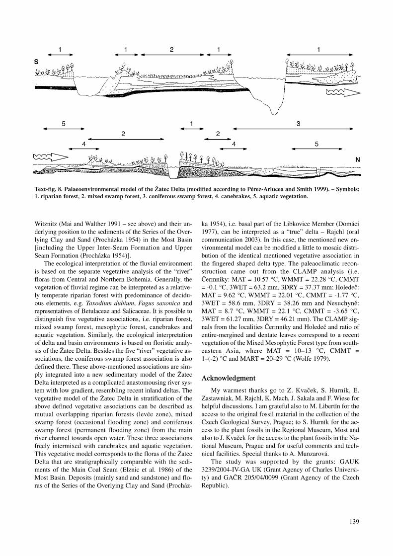
Witznitz (Mai and Walther 1991 – see above) and their un-derlying position to the sediments of the Series of the Over-lying Clay and Sand (Procházka 1954) in the Most Basin[including the Upper Inter-Seam Formation and UpperSeam Formation (Procházka 1954)].
The ecological interpretation of the fluvial environmentis based on the separate vegetative analysis of the “river”floras from Central and Northern Bohemia. Generally, thevegetation of fluvial regime can be interpreted as a relative-ly temperate riparian forest with predominance of decidu-ous elements, e.g. Taxodium dubium, Fagus saxonica andrepresentatives of Betulaceae and Salicaceae. It is possible todistinguish five vegetative associations, i.e. riparian forest,mixed swamp forest, mesophytic forest, canebrakes andaquatic vegetation. Similarly, the ecological interpretationof delta and basin environments is based on floristic analy-sis of the Žatec Delta. Besides the five “river” vegetative as-sociations, the coniferous swamp forest association is alsodefined there. These above-mentioned associations are sim-ply integrated into a new sedimentary model of the ŽatecDelta interpreted as a complicated anastomousing river sys-tem with low gradient, resembling recent inland deltas. Thevegetative model of the Žatec Delta in stratification of theabove defined vegetative associations can be described asmutual overlapping riparian forests (levée zone), mixedswamp forest (occasional flooding zone) and coniferousswamp forest (permanent flooding zone) from the mainriver channel towards open water. These three associationsfreely intermixed with canebrakes and aquatic vegetation.This vegetative model corresponds to the floras of the ŽatecDelta that are stratigraphically comparable with the sedi-ments of the Main Coal Seam (Elznic et al. 1986) of theMost Basin. Deposits (mainly sand and sandstone) and flo-ras of the Series of the Overlying Clay and Sand (Procház-
ka 1954), i.e. basal part of the Libkovice Member (Domácí1977), can be interpreted as a “true” delta – Rajchl (oralcommunication 2003). In this case, the mentioned new en-vironmental model can be modified a little to mosaic distri-bution of the identical mentioned vegetative association inthe fingered shaped delta type. The paleaoclimatic recon-struction came out from the CLAMP analysis (i.e.Čermníky: MAT = 10.57 °C, WMMT = 22.28 °C, CMMT= -0.1 °C, 3WET = 63.2 mm, 3DRY = 37.37 mm; Holedeč:MAT = 9.62 °C, WMMT = 22.01 °C, CMMT = -1.77 °C,3WET = 58.6 mm, 3DRY = 38.26 mm and Nesuchyně:MAT = 8.7 °C, WMMT = 22.1 °C, CMMT = -3.65 °C,3WET = 61.27 mm, 3DRY = 46.21 mm). The CLAMP sig-nals from the localities Čermníky and Holedeč and ratio ofentire-mergined and dentate leaves correspond to a recentvegetation of the Mixed Mesophytic Forest type from south-eastern Asia, where MAT = 10–13 °C, CMMT =1–(-2) °C and MART = 20–29 °C (Wolfe 1979).
Acknowledgment
My warmest thanks go to Z. Kvaček, S. Hurník, E.Zastawniak, M. Rajchl, K. Mach, J. Sakala and F. Wiese forhelpful discussions. I am grateful also to M. Libertín for theaccess to the original fossil material in the collection of theCzech Geological Survey, Prague; to S. Hurník for the ac-cess to the plant fossils in the Regional Museum, Most andalso to J. Kvaček for the access to the plant fossils in the Na-tional Museum, Prague and for useful comments and tech-nical facilities. Special thanks to A. Munzarová.
The study was supported by the grants: GAUK3239/2004-IV-GA UK (Grant Agency of Charles Universi-ty) and GAČR 205/04/0099 (Grant Agency of the CzechRepublic).
139
Text-fig. 8. Palaeoenvironmental model of the Žatec Delta (modified according to Pérez-Arlucea and Smith 1999). – Symbols:1. riparian forest, 2. mixed swamp forest, 3. coniferous swamp forest, 4. canebrakes, 5. aquatic vegetation.

References
Ahrens, H., Lotsch, D., Rohde, G., Steinike, K. (1974): Zur Herkun-ft der Sedimentschüttungen des westelbischen Tertiärs auf derBasis von Schwermineraluntersuchungen. – ZGI-Berlin, pp. 55.
Balestrieri, M. L., Bigazzi, G., Bouška, V., Labrin, E., Hadler, J. C.,Kitada, N., Osorio, A. M., Poupeau, G., Wadatsumi, K., Zuninga,A. (1998): Potential glass age standards for fission-track dating.An overwiev. In: van den Haute, P., de Corte, E. (eds): Advancesin fission-track geochronology. – Kluwer Acad. Publ, Amster-dam, pp. 287–304.
Barnet, I., Brunnerová, Z., Čadková, Z., Lysenko, V., Mentlík, T.,Müller, V. Pospíšil, J., Štorch, P., Tomášek, M. (1991a):Vysvětlivky k souboru geologických a ekologických účelovýchmap přírodních zdrojů v měřítku 1:50 000. – List 12–41 Beroun,ČGU Praha, pp. 1–53.
Barnet, I., Brunnerová, Z, Ciha, I., Čadková, Z., Čurda, J.,Lochmann, Z., Lysenko, V., Mrázek, P., Müller, V., Štorch, P.,Tomášek, M. (1991b): Vysvětlivky k souboru geologickýcha ekologických účelových map přírodních zdrojů v měřítku 1:50000. – List 12–34 Hořovice, ČGU Praha, pp. 1–53.
Barnet, I., Burda, J., Havlíček, V., Jinochová, J., Lochmann, Z.,Manová, M., Mašek, J., Mrázek, P., Müller, V., Nekovařík, Č.,Straka, J., Šalanský, K. (1997): Vysvětlivky k souboru geo-logických a ekologických účelových map přírodních zdrojův měřítku 1:50 000. – List 12–33 Plzeň, ČGÚ Praha, pp. 1–61.
Boulter, M. C., Hubbard, R. N. L. B., Kvaček, Z. (1993): A compar-ison of intuitive and objective interpretations of Miocene plantassemblages from north Bohemia. – Palaeogeogr., Palaeoclima-tol., Palaeoecol., 101: 81–96.
Brabence, B. (1904): O novém nalezišti třetihorních rostlin ve spod-ním pásmu vrstev žateckých. – Rozpr. Čes. Akad. Věd Umění, Tř.2, 13: 1–25.
Bretšnajder, P. (1952): Geologie střední a východní části rakovnicképánve. – DP Přírod. fak. Karlovy Univ. Praha, pp. 1–82.
Brunnerová, Z., Čadek, J., Havlíček, V., Hrkal, Z., Kleček, M., Král,J., Lysenko, V., Müller, V., Štorch, P., Tomášek, M., Veselý, J.(1992): Vysvětlivky k souboru geologických a ekologickýchúčelových map přírodních zdrojů v měřítku 1:50 000. – List12–24 Praha, ČGÚ Praha, pp. 1–33.
Brus, Z., Elznic, A., Hurník, S., Zelenka, O. (1987): Geologie oblasti.– XXVI. konference ČSMG. Most 1987, Geoindustria, Praha,pp. 1–163.
Brus, Z. (1982): Hlavní rysy sedimentace v prostoru štěpení hně-douhelné sloje mezi Mostem a Jirkovem v severočeské pánvi. –Sbor. 4. Uhel. geol. konf. Přírodov. fak. Praha, pp. 3–9.
Bůžek, Č. (1959): Zpráva o palaeobotanickém výzkumu Chomu-tovské a Pětipeské pánve. – Zprav. geol. výzk. v. r. 1957, 18–19.
Bůžek, Č. (1960): Drobný příspěvek k poznání květeny rakovnick-ého terciéru. – Zprav. geol. výzk. v. r. 1958, 10–11.
Bůžek, Č. (1971): Tertiary flora of the northern part of Pětipsy area(North-Bohemian Basin). – Rozpr. Ústř. Úst. geol., 36: 1–118.
Bůžek, Č., Holý, F. (1964): Small-sized Plants Remains from CoalFormation of the Chomutov-Most-Teplice Basin. – Sbor. geol.Věd, odd. P., 4:105–138.
Bůžek, Č., Kvaček, Z. (1974): Tertiary lauraceous leaves from thenorthern part of the Pětipsy area (North-Bohemian Basin). –Věst. ÚÚG, 49: 9–18.
Bůžek, Č., Kvaček, Z. (1989a): Nové nálezy třetihorní flóryv hlavačovských štěrkopíscích u Nesuchyně na Rakovnicku. –Zprávy o geol. výzk. v r. 1986: 22–24.
Bůžek, Č., Kvaček, Z. (1989b): Nové nálezy flóry v oblasti
hlavačovských štěrkopísků u Želce jihovýchodně od Měcholup.– Zprávy o geol. výzk. v r. 1987: 17–18.
Bůžek, Č., Kvaček, Z. (1994): An early miocene linden (Tilia) fromnort Bohemia and its possible relationship. – Acta UniversitatisCarolinae, Geol., 1–2 (1992): 97–102.
Bůžek, Č., Dvořák, Z., Kvaček, Z., Prokeš, M. (1992): Tertiary veg-etation and depositional environments of the Bílina delta in theNorth Bohemian brown coal basin. – Čas. Mineral. Geol., 37 (2):117–134.
Bůžek, Č., Kvaček, Z., Dvořák, Z., Prokeš, M. (1993): Terciérní veg-etace severočeské hnědouhelné pánve v pohledu nových dok-ladů. – Zpravodaj SHD 11/93: 38–51.
Cajz, V., Vokurka, K., Balogh, K., Lang, M., Ulrych, J. (1999): TheČeské středohoří Mts. – volcanostratigraphy and geochemistry. –Geolines, 9: 21–28.
Collective of authors (1980): Atlas geologických řezů severočeskéhnědouhelné pánve. – Báňské stavby, Osek a SHD Most. Most.
Čadek, J. (1964): Nové poznatky o palaeogeografii miocénních pán-ví severních Čech. – MS, Kandidátská disertační práce, PřF UKPraha, pp. 129.
Čadek, J. (1966): K palaeogeografii chomutovsko-mostecko-teplicképánve na základě studie těžkých minerálů. – Sbor. geol. Věd, Ř.G, 11: 77–114.
Domácí, L. (1977): Litostratigrafie třetihorních sedimentů v hně-douhelné severočeské pánvi. – Acta Univ. Carol. Geol., 1975 (1):75–80.
Drábková, E., Hrazdíra, P., Jinochová, J., Kinkor, V., Manová, M.,Mašek, J., Müller, V., Pačesová, E., Šalanský, K. (1998):Vysvětlivky k souboru geologických a ekologických účelovýchmap přírodních zdrojů v měřítku 1:50 000. – List 12–32 Zdice,ČGÚ Praha, pp. 1–33.
Dubec, O., Hrkal, Z., Jinochová, J., Lysenko, V., Mašek, J., Mrázek,P., Müller, V., Sáňka, V., Straka, J., Štorch, P. (1993): Vysvětlivkyk souboru geologických a ekologických účelových map přírod-ních zdrojů v měřítku 1:50 000. – List 12–42 Zbraslav, ČGÚPraha, pp. 1–33.
Elznic, A. (1970): Litofaciální vývoj a palaeogeografie terciéru naMostecku, Teplicku a Ústecku. – Zprav. stud. obl. vlastivěd.mus., přir. věd., 6: 3–19.
Elznic, A. (1973): Sedimenty neogénu a vývoj uhelné sloje vmostecké části severočeské pánve. – Sbor. geol. věd., odd. G., 24:175–204.
Elznic, A., Fišera, E., Hurník, S., Malkovský, M., Václ, J. (1986):Návrh neformálního stratigrafického členění terciéruseveročeské hnědouhelné pánve. – MS, Ústř. Úst. geol, pp. 1–13.P55527.
Feistmantel, K. (1881): Schotterablagerungen in der Umgebung vonPürglitz. – Věst. Čes. Král. Spol. nauk, 33: 287–297.
Fejfar, O. (1989): The Neogene vertebrate palaeontology sites ofCzechoslovakia, In Proc. NATO Adv. Res. Worksh. on EuropeanMammal Chronol. Plenum Press, New York, NY, 211–236.
Fejfar, O., Kvaček, Z. (1993): Excursion No. 3. Tertiary basins inNorthwest Bohemia. palaeontol. Ges. 63. Jahrestagung, Prag.Univ. Karl. Prague, pp. 1–35.
Gabriel, M., Valín, F. (1968): Relikty tercierních štěrkopísků na listuVelká Černoc. – Zpr. geol. výzk. v r. 1968: 166–169.
Gastaldo, R. A., Riegel, W., Püttmann, W., Linnemann, U. G., Zetter,R. (1998): A multidisciplinary approach to reconstruct the LateOligocene vegetation in Central Europe. – Rev. Palaeobot. Paly-nol., 101: 71–94.
Hickey, L. J. (1973): Classification of the architecture of dicotyle-donous leaves. – Amer. J. Bot., 60(1): 17–33.
140

Holý, F., Bůžek, Č. (1966): Seeds Stratiotes L. (Hydrocharitaceae) inthe Teriary of Czechoslovakkia – Sbor. geol. Věd Ř. P, 8:105–135.
Hurník, S. (1960): Příspěvek k tektonickým poměrům střední částijižního okraje chomutovsko-mostecké-teplické pánve. – Věst.ÚÚG. 34(4): 337–340.
Hurník, S. (1961): palaeofloristické oblasti nadložní série vseveročeském terciéru a jejich vztah k lithofaciálnímu vývoji. –Čas. Minerl. Geol., 4: 419–428.
Hurník, S. (1971): K otázce deltové sedimentace v mostecké částiSeveročeské hnědouhelné pánve. – MS, Kandidátská disertačnípráce, PřF UK Praha, pp. 1–110.
Hurník, S. (1973): Vegetation cover of the onshore part of theMiocene delta near Most in the North Bohemian browm-coalbasin. – Čas. Minerl. Geol., 18 (1): 57–62.
Hurník, S., Knobloch, E. (1966): Einige Ergebnisse paläontologisch-er und stratigraphischer Untersuchungen im Tertiär Böhmens. –Abh. Staatl. Mus. Mineral. Geol., 11: 17–161.
Hurník, S., Marek, D. (1962): Ke stratigrafii severočeského terciéruna východ od Doupovských hor. – Čas. Mineral. Geol., 7: 35–41.
Jokély, J. (1858): Die Tertiärablagerungen des Saazer Beckens undder Teplitzer Bucht. – Jahrbuch der k. k. geolog. Reichs-Anstalt,9: 4.
Kettner R. (1911): O uloženinách třetihorních štěrků a jílů u Sloupua Klínce ve stř. Čechách. – Věst. Čes. Král. Spol. nauk, 25: 1–9.
Kliner, K., Würmová, M. (1975): Závěrečná zpráva o hydrogeo-logickém průzkumu Žatecko-jih. Regionální hydrogeologie. –Geofond. Praha. FZ 5494.
Kněžek, J. (1965): Závěrečná zpráva o hydrogeologickém průzkumuseverně od obce Holedeč u Žatce (vrt HV-10). – MS GeofondPraha. P 17906
Kněžek, V. (1964): Závěrečná zpráva o hydrogeologickém průzkumuv Holodeči u Žatce (vrt H 3B). – MS Geofond Praha. P16633.
Knobloch, E., Kvaček, Z. (1976): Miozäne Blätterfloren vom Wes-trand der Bömischen Masse. – Rozpr. Ústř. Úst. geol., 42: 1–131.
Kodym, O., Matějka, A. (1920): Geologicko-morfologický příspěvekk poznání štěrků a vývoje říčních toků ve středních Čechách. –Sborník Čs. spol. zeměpis., 26: 17–32, 97–113.
Konrádová, H. (1959): Fytopalaeontologické zpracování třetihorníchlokalit Stranná, Přívlaky a Stroupeč u Žatce. – Zprávy o geol.výzkumu v r. 1957: 112–113.
Konzalová, M. (1976): Micropalaeontological (palynological) re-search of the Lower Miocene of Northern Bohemia. – Rozpr.ČSAV, ř. math.-přir. věd, 86 (12): 1–75.
Kopecký, L. (1978): Neoidic taphrogenic evolution and young alka-line volcanism of the Bohemian Massif. – Sbor. geol. věd. odd G,31: 91–104.
Kopecký, L., Malkovský, M., Václ, J. (1960): Přehled výsledkůvýzkumů ÚÚG v terciéru chomutovsko-mostecko-teplicképánve. Sbor. 1. geol. Konfer. v Teplicích, pp. 96–108.
Kovanda, J., Herzogová, J. (1986): Druhé chronologické paradoxonv Kruhovém lomu u Srbska. – Čes. Kras, 12: 59–62.
Krejčí, J. (1877): Geologie čili nauka o útvarech zemských se zvlášt-ním ohledem na krajiny českoslovanské. Praha. 1035 pp.
Kukla, J. (1956): Terasy Praha – Beroun. – MS Geofond, Praha.P9159.
Kunský, J. (1928/29): Studie o třetihorních štěrcích ve středníchČechách. – Sbor. SGÚ 1928–1929, 247–290.
Kušta, J. (1889): Otisky v třetihorním jílu u Sádku (Satkau) u Žatce.– Věstník Král. České spol. nauk, 1889 (2): 223–224.
Kvaček, Z. (1971): Fossil Lauraceae in the stratigraphy of the North-Bohemian Tertiary. – Sbor. geol. Věd, Ř. P, 13: 47–86.
Kvaček, Z. (1998): Bílina: a window on Early Miocene marshlandenvironments. – Rev. Palaeobot. Palynol., 101(1998): 111–123.
Kvaček, Z., Bůžek, Č. (1982): Třetihorní společenstva severočeskéhnědouhelné pánve ve vztahu k litofaciálnímu vývoji. – MS Úst.geol. geotech. Čs. akad. věd, Praha, pp. 1–46.
Kvaček, Z., Bůžek, Č. (1994): A new Early Miocene Mahonia Nutt.(Berberidaceae) of Europe. – Věst. Čes. geol. úst., 69(3): 59–62.
Kvaček, Z., Hurník, S. (2000): Revision of Miocene plants preservedin baked rocks in the North Bohemian Tertiary – Acta Mus. Nat.Pragae, Ser. B, Hist. Nat., 56 (1–2): 1–48.
Kvaček, Z., Walther, H. (2001): The Oligocene of Central Europeand the development of forest vegetation in space and time basedon magafossils. – Palaeontographica, B. 259 (1–6): 125–148.
Liebus, A. (1901): Geologische Wanderungen in der Umgebung vonPrag. – Sammlung Gemeinnütziger Vorträge., 42(6–8): 81–134.
Lotsch, D., Ahrens, H., Kretzschmar, W., Walther, H., Fischer, O.,Heinicke, L. (1994): Gliederungsmöglichkeiten der ThierbacherSchichten nach Ergebnissen paläobotanischer Untersuchungen.– Hallesches. Jahrb. Geowiss., 16: 1–21.
Mach, K. (2002): Anomální stavba hlavní hnědouhelné sloje v pros-toru miocénní bílinské delty a jejich geneze – MS-Disertačnípráce. Praha, pp. 1–85.
Mai, D. H. (1967): Die Florenzonen, der Florenwechsel und dieVorstellung über den Klimaablauf im Jungtertiär der DeutschenDemokratischen Republik. – Abh. zentr. geol. Inst. 10: 55–82.
Mai, D. H. (1995): Tertiäre Vegetationsgeschichte Europas. – GustavFischer Verlag. Jena. 691 pp.
Mai, D. H., Walther, H. (1983): Die fossilen Floren des Weisselster-Beckens und seiner Randgebiete. – Hall. Jb. Geowiss., 8: 59–74.
Mai, D. H., Walther, H. (1991): Die oligoz(nen Floren NW – Sach-sens und des Bitterfelder Raumes. – Abh. Staatl. Mus. Mineral.Geol., 38:1–230.
Malecha, A. (1962): Vývoj terciéru v jižní části žatecké oblasti. –Sbor. Ústř. Úst. geol., odd. G., 27(1960): 247–290.
Malkovský, M. (1975): Palaeogeography of the Miocene of the Bo-hemian Massif. – Věst. ÚÚG, 50 (1): 27–31.
Malkovský, M. (1979): Tektogeneze platformního pokryvu Českéhomasívu. – Knihovna ÚÚG, 53: 1–152.
Malkovský, M. (1995): Některé problémy chronostratigrafickéhočlenění terciéru Českého masívu. – In Hamršmíd, B. (ed.): Novévýsledky v terciéru západních Karpat. – Sborník referátů z 11.konference o mladším terciéru, Brno, 25.–26. 4. 1995. Hodonín.,25–37.
Malkovský, M. et al. (1985): Geologie severočeské hnědouhelnépánve a jejího okolí. ÚÚG. ČSAV. Praha. 424 pp.
McCarthy, T. S., Ellery, W. N., Rogers, K. H., Cairncross, B., Ellery,K. S. (1986): The roles of sedimentation and plant growth inchanging flow patterns in the Okavango Delta, Botswana. – Afr.J. Sci., 82: 579–584.
Mísař, Z., Dudek, A., Havlena, V., Weiss, J. (1982): Regionální ge-ologie ČSSR I – Český masív. SPN. Praha. 333pp.
Mitášová, D. (1962): Zpráva o vyhodnocení hydrogeologického vrtuV-10, provedeného v pramenní oblasti holedečské u Žatce v r.1961–62. – MS Geofond, Praha. P14298.
Moravec, J. et al. (2000): Fytocenologie. – Academia. Praha. 403 pp.Němejc, F. (1943): Novější palaeobotanické nálezy v českém ter-
ciéru. – Věst. stát. geol. Úst., 18: 43. Němejc, F. (1949): Rostlinné otisky středočeských neogenních ostro-
vů. – Stud. Bot. Čechoslov., 10 (1–3): 14–103. Němejc, F. (1953): Nálezy rostlinných otisků z jílových vložek
neogenních uloženin na Hlavačově mezi Rakovníkem a Lužnou.– Sbor. ÚÚG, odd. P., 20: 13–24.
141
Němejc, F. (1964): Biostratigraphical sequence of floras in the Ter-tiary of Czechoslovakia. – Čas. mineral. geol., 9 (1): 107–109.
Němejc, F., Kvaček, Z., Pacltová, B., Konzalová, M. (2003): Tertiaryplants of the Plzeň Basin (West Bohemia). – Acta UniversitatisCarolinae, 2002, 46(4): 121–176.
Pérez-Arlucea, M., Smith, N. D. (1999): Depositional patterns fol-lowing the 1870s avulsion of the Saskatchewan river (Cumber-land marshes, Saskatchewan, Canada). – J. Sed. Research,69(1): 62–73.
Pešek, J. (1972): Terciérní sedimenty ve středních a západníchČechách. – Sbor. Západočes. Muz., Odd. Přír. 6: 1–55.
Pešek, J., Spudil, J. (1986): Paleogeografie středočeského a zá-padočeského neogénu. – Studie ČSAV, 14–86: Praha, pp. 1–79.
Petrbok, J. (1950): Chronologické paradoxon terasových sedimentův Českém krasu. – Čs. kras, 3: 176–177.
Procházka, J. Sv. (1916): Stratiotes (Carpolites) Websteri (HEER)POT. a jiné rostliny z terciérních jílů klíneckých. – Věst. Král.Čes. spol. nauk., 1916 (4):1–7.
Procházka, M. (1954): Paleontologický výzkum chomutovskéa pětipeské pánve. – Zpr. geol. výzk. v r. 1953: 166–174.
Procházka, M. (1955): Fytopaleontologický výzkum chomutovskéa pětipeské pánve. – Zpr. geol. výzk. v r. 1954: 144–147.
Procházka, M. (1956): Paleontologický výzkum chomutovskéa pětipeské pánve. – Zpr. geol. výzk. v r. 1955: 179–184.
Procházka, M., Bůžek, Č. (1975): Maple leaves from Tertiary ofNorth Bohemia. – Rozpr. Ústř. Úst. geol., 41: 1–86.
Prosová, M. (1974): Geneze reliktního terciéru (sv. část Českéhomasívu). – DP Přir. fak. Karlovy Univ. Praha. pp. 1–99.
Rajchl, M., Uličný, D. (2001): Response of a Fluvial DepositionalSystém to Unequal Compaction of Underlying Peat (Neogene,Most Basin, Czech Republic). – GeoLines, 13 (2001): 105.
Rajchl, M., Uličný, D. (in press): Depositional record of an avulsivefluvial system controlled by peat compaction (Neogene, mostbasin, Czech Republic) – Sedimentology.
Sakala, J. (2000): Flora and vegetation of the roof of the main lig-nite seam in the mine Bílina (Most Basin, Lower Miocene). –Acta Mus. Nat. Pragae, 56 (1–2): 49–84.
Sakala, J., Teodoridis, V. (2001): Fossil wood and foliage of Cas-tanea (Fagaceae) from the Upper Oligocene of northern Bo-hemia. – Bull. Czech Geol. Surv., 76 (1): 23–27.
Shrbený, O. (1994): Terciér českého masívu. – In Klomínský, J.(ed.): Geologický atlas České republiky. Stratigrafie. – 2 str. 18tab.ČGÚ. Praha.
Schmidt-Kittler, N. (ed.): International Symposium on MammalianBiostatigraphy and Paleoecology of the European Paleogene,1987. – Münchner Geowissenschaftliche Abhandlungen, 1–312,111 Abb., 32 Tab., 13., Reihe A, Band 10. Verl. Pfeil. München
Smetana, V. (1926): O rozšíření třetihorního útvaru v pánvirakovnické a o jeho poměru k usazeninám pánve podrudo-horské. – Sbor. I. sjezdu slovanských geologů a ethnografův Praze 1924, Praha.
Standke, G. (2002): Das Tertiär zwischen Leipzig und Altenburg. –Beitr. Geol. Thüringen, 9: 41–73.
Suhr, P. (2002): The Bohemian Massif (BM) as catchment area forthe Northwest European Tertiary Basin (NW-ETB). – ExcursionGuide, Abstracts, Symposium Hibsch 2002, ČGS, Praha, p.111.
Suhr, P. (2003): The Bohemian Massif as Catchment Area for theNW European Tertiary Basin. – GeoLines 15 (2003): 147–159.
Sysel, P. (1967): Zpráva o hydrogeologickém průzkumu v Holodečiu Žatce (vrt HV-12). – MS Geofond, Praha. P 19949
Teodoridis, V. (2000): Třetihorní flóra a vegetace hlavačovských
štěrkopísků a oblasti okolí Holedeče a Měcholup. – M.Sc. The-sis, Facul. Scien. Charles Univ. Prague. pp. 1–89.
Teodoridis, V. (2001): Futher revision of Teritary floras of CentralBohemia: localities Na Bendovce (Sv. Antonín) near Rakovník,Klínec near Všenory and Na Sulavě near Černošice. – Bull.Czech Geol. Surv., 76 (4): 243–252.
Teodoridis, V. (2002): Tertiary flora and vegetation of the Hlavačovgravel and sand and the surroundings of Holedeč in the MostBasin (Czech Republic). – Acta Mus. Nat. Pragae, Ser. B, Hist.Nat. 57. (3–4): 103–140.
Teodoridis, V. (2003a): Tertiary flora and vegetation of the lokalityZáhoří near Žatec (Most Basin, Czech Republic) – Bull. CzechGeol. Surv., 76 (1): 23–27.
Teodoridis, V. (2003b): Flóry a vegetace terciérních fluviatilních sed-imentů středočeské a severočeské oblasti a jejich ekvivalenty vmostecké pánvi – Ph.D. Thesis, Facul. Scien. Charles Univ.Prague. pp. 1–109.
Teodoridis, V. (in press): Tertiary flora and vegetation of the localityPřívlaky near Žatec (Most Basin). – Acta Universitatis Carolinae.
Teodoridis, V., Kvaček, Z. (in press): The extinct genus ChaneyaWang et Manchester in the Tertiary of Europe – a revison of“Porana” flower like fruit remains from Öhningen and Bohemia.– Rev. Palaeobot. Palynol.
Vachtl, J. (1935): Nálezy třetihorní flóry na Rakovnicku. – Zvl.otisk. z Věst. Mus. spol. města Rakovníka, 25: 1–6.
Váně, M. (1960): Geologické podmínky vzniku uhelných ložisekv severočeské hnědouhelné pánvi. – Sbor. I. geol. konfer.o chomutovsko-mostecko-teplické pánvi. 66–79.
Váně, M. (1981): Závěrečná zprava Žatecko – štěrkopísek. – MSGeofond, Praha. P 21266.
Váně, M. (1985): Geologické poměry neogénních hlavačovskýchštěrkopísků mezi Rakovníkem a Holedečí. – Sborník Severočes.Muz. – Přír. Vědy, 14: 205–218.
Váně, M. (1987): Význam a postavení bazálních uhelných vrstevv terciéru severočeské hnědouhelné pánve. – Čas. mineral. geol.,32(3): 287–297.
Weyland, H. 1937. Beiträge zur Kenntnis der Rheinischen Tertiär-flora. – Palaeontographica B 83, 67–122.
Wójcicki, J. J., Kvaček, Z. (2002): Schenkiella genus novum, thornydisseminules of unknown affinities from the Lower miocene ofcentral Europe. – Acta Palaeobot., 42 (2): 109–116.
Wolfe, J. A. (1979): Temperature parameters of humid to mesic forestsof eastern Asia and relation of forests of other regions of the North-ern Hemisphere and Australia. – Geol. Surv. Prof. Pap., 1106: 1–37.
Wolfe, J. A. (1990): Palaeobotanical evidence for a marked tempera-ture increase following the Cretaceous/Tertiary boundary. Na-ture, 343: 153–156.
Wolfe, J. A. (1993): A method of obtaining climatic parameters fromleaf assemblages. U.S. Geol. Surv. Bull., 2040: 1–73.
Wolfe, J. A., Spicer, R. A. (1999): Fossil Leaf Character States: Mul-tivariate Analysis. – In Jones, T.P., and Rowe, N.P. (eds.): FossilPlants and Spores: Modern Techniques. Geological Society,London, 233–239.
Žák, K., Táborský, Z., Lachmanová, M., Pudilová, M. (2001): Využitítěžkých minerálů při studiu alochtonních klastických jeskynníchsedimentů Českého krasu. – Čes. Kras, 27 (2001): 5–14.
Žák, K., Teodoridis, V., Sakala, J. (2003): Nález flóry v terciérníchsedimentech u Karlštejna. – Zprávy o geol. výzk. v r. 2002:47–49.
Žebera, K. (1972): Vltavíny v katastrofálních přívalových sedi-mentech u Prahy. – Geol. Průzk., 2: 54–56.
142