Flood Management and Mitigation Programme - …€¦ · The MRC Flood Management and Mitigation...
54
Working Paper: Transboundary Flood Issue Identification January 2008 Flood Management and Mitigation Programme
Transcript of Flood Management and Mitigation Programme - …€¦ · The MRC Flood Management and Mitigation...

Working Paper:Transboundary Flood Issue Identifi cationJanuary 2008
Flood Management and Mitigation Programme

The MRC Flood Management and Mitigation Programme Component 3: Enhancing Cooperation in Addressing
Transboundary Flood Issues ---------------------------
Transboundary Flood Issue Identification
Working Paper
January 2008
This document has been accepted as Working Paper for reference by representatives of the MRC Member States during the Regional Consultation Meeting, held in HCMC, Vietnam, on 23rd September 2007
Mekong River CommissionFor Sustainable Developement

ii

iii
Table of Contents Abbreviations and AcronymsU.......................................................................................................v
Executive SummaryU ....................................................................................................................vii
1U UIntroductionU .........................................................................................................................1
2U UApproach and methodologyU................................................................................................2
3U UResults of regional synthesis and compilation processU.....................................................4 3.1U USynthesis of national perspectives on transboundary flood issuesU ........................................4
3.1.1U UGeneralU ......................................................................................................................4 3.1.2U UNationally-perceived transboundary flood issuesU .....................................................4 3.1.3U UNational frameworks for disaster management and regional cooperation on
flood managementU .....................................................................................................5 3.1.4U UNational constraints to addressing transboundary flood issuesU.................................6
3.2U UAn agreed working definition of transboundary flood issuesU................................................7 3.3U USynthesis of regional perspectives on transboundary flood issuesU ........................................8
3.3.1U UGroup 1. Issues related to Floodplain developments within the Mekong DeltaU .......8 3.3.2U UGroup 2: Issues related to Impacts of LMB upstream developments on the
Mekong DeltaU ............................................................................................................9 3.3.3U UGroup 3: Issues related to Impacts of upstream hydropower development in the
Upper Mekong Basin on the LMBU ..........................................................................10 3.3.4U UGroup 4. Issues related to Hydropower development and operation in the Se
San, Srepok, and Se Kong river basinsU....................................................................10 3.3.5U UGroup 5. Issues related to bank protection and port development; sand
excavation; dam-operation communications in upper reaches of the Mekong mainstreamU...............................................................................................................11
3.3.6U UGroup 6: Issues related to increased floods on tributaries in northwest CambodiaU 11 3.4 Approaches, support needs and opportunities to enhance cooperationU.................................12
3.4.1U UApproaches for addressing transboundary flood issuesU ..........................................13 3.4.2U UBilateral cooperation support needsU ........................................................................14 3.4.3U UMultilateral and regional cooperation support needs and opportunitiesU .................14
4U UFollow-up activities and next steps proposedU..................................................................16
UReferencesU ....................................................................................................................................17

iv
ANNEXES
UAnnex 1: A comparative analysis of National Flood Issue Study Reports .................................18
UAnnex 2: A compilation of transboundary flood issues as indicated in the National Flood Issue Study Reports .....................................................................................................28
UAnnex 3: Preferred mechanisms; role and contributions of the MRCS as expressed at the 1st regional meeting, June 22nd, 2007..............................................................................31
UAnnex 4: Summary information on nature, main effects and impact of transboundary flood issues............................................................................................................................33
UAnnex 5: Floods in the Mekong..................................................................................................35
UAnnex 6: Validity check of transboundary flood issues .............................................................37
UAnnex 7: Opportunities for the MRC to make a useful contribution..........................................39U

v
Abbreviations and Acronyms ADB Asian Development Bank AHNIP Appropriate Hydrological Network Improvement Project AIFP Agriculture, Irrigation and Forestry Programme ASEAN Association of Southeast Asian Nations BDP Basin Development Plan CEO Chief Executive Officer CSO Civil Society Organization DMP Drought Management Programme DSF Decision Support Framework EIA Environmental Impact Assessment EP Environment Programme FAO Food and Agriculture Organization (UN) FMMP Flood Management and Mitigation Programme FP Fisheries Programme GDP Gross Domestic Product GIS Geographic Information System GMS Greater Mekong Sub-region IBFM Integrated Basin Flow Management ICBP Integrated Capacity Building Programme ICCS International Cooperation and Communication Section IKMP Information and Knowledge Management Programme IWRM Integrated Water Resource Management JC Joint Committee KRA Key Result Area LMB Lower Mekong Basin MDG Millennium Development Goals MRC Mekong River Commission MRCS Mekong River Commission Secretariat MW Megawatts MWRAS Mekong Water Resources Assistance Strategy NAP Navigation Programme NCDC National Civil Defense Committee (Thailand) NCDM National Committee for Disaster Management (Cambodia, Lao PDR) NGO Non-Governmental Organization NMC National Mekong Committee RBO River Basin Organization RGC Royal Government of Cambodia SEA Strategic Environmental Impact Assessment TBEIA Transboundary Environmental Impact Assessment TOR Terms of Reference UNDP United Nations Development Programme WUP Water Utilisation Programme

vi

vii

viii

ix
Executive Summary This report summarizes the results of regional consultations on transboundary flood issues in the Lower Mekong Basin by Component 3 of the MRC Flood Management and Mitigation Programme (FMMP). Consultations were hold to prepare for the successful implementation of the component. During a regional workshop in October 2006, MRC members confirmed their support for enhanced cooperation activities. They also agreed that transboundary flood issues needed to be identified before developing the work plan and activities of the component.
In response, the programme initiated a process to identify transboundary flood issues in 2006. The activity followed a highly participatory bottom-up approach. The identification and consultation process started first with provincial, national and then bilateral and regional levels with full involvement of National Mekong Committees and national agencies.
The process defined working definition of transboundary flood issues as “any existing or potential substantial adverse impact on the natural, economic or social environment within an area of a Riparian State resulting from a change of the water conditions during the flood season and/or during the occurrence of floods of the Mekong River system caused by a human activity, originating wholly or in part from within one or more areas of one or more other Riparian StatesF
1F”
Six broad groups of transboundary flood issues related to:
1. floodplain development within the Mekong Delta;
2. upstream development in the Lower Mekong Basin that has an impact on the Mekong Delta;
3. upstream hydropower development in the Upper Mekong Basin;
4. hydropower project development and operation in the Se San, Srepok, and Se Kong river basins;
5. bank protection and port development, sand excavation, dam-operation communications in the upper reaches of the Mekong mainstream; and
6. increased flooding on tributaries in northwest Cambodia;
were mutually identified by the member countries based on the information provided in the national reports and the agreed working definition of transboundary flood issues.
Using the working definition of transboundary flood issues, the validity of each group was checked by identifying the main causes, effects and impacts. The issues require specific response strategies and actions to be addressed by enhanced cooperation based on technical and administrative priorities, capacities and support needs. Consultations with member States,
1 Use of this definition of Transboundary flood issues only applies in reference to the activities of component 3 identify, addressing and resolving differences or disputes among concerned parties of the MRB. In the broader application of the term “transboundary flood issues” includes both natural and man-influenced flood.

x
unanimously identified bilateral and multilateral arrangements as the preferred mechanisms. Strategies should:
• build on existing bilateral mechanism supported or facilitated by the MRC Secretariat in general and Component 3 in particular;
• share experiences and lessons learnt from bilateral mechanisms, expanding them to the multilateral and regional level where appropriate; and
• strengthen multilateral mechanisms such as the Mekong dialogue partnership by providing suitable tools and services from the MRC Secretariat (relating to Upper Mekong Basin developments and global concerns associated with climate change).
It was strongly suggested that transboundary flood issues must be managed in a coordinated manner, promoting inter-governmental and inter-agency cooperation while being based on integrated water resource management (IWRM) principles. With the involvement of the MRC Secretariat, the status of existing mechanisms will be raised and the technical profile and capabilities of members strengthened.
Support strategies will include technical and administrative aspects that respond to the specific needs of the main stakeholders and the contexts of member States. Important opportunities for cooperation exist within MRC programmes and through regional technical assistance being prepared by the Asian Development Bank and the World Bank with close MRC involvement.
Ways to ensure the successful implementation of Component 3 will be finalized in a document that is currently being revised.

1
1 Introduction In the aftermath of the devastating floods of 2000, the MRC Council charged the Secretariat to develop a strategy and program to deal with the threat of future flood disasters in the Mekong River basin. The MRC Strategy on Flood Management and Mitigation was published in 2001 (FMM Strategy) and outlined the role the MRC could play in the management of flood risk in the LMB (according to the mandate of the 1995 Agreement). The FMM Strategy led to the joint formulation by MRC and the four member countries of the Flood Management and Mitigation Program (FMMP). The FMMP has been approved by the Council in 2002 then it has been further updated and finalized in 2004. Both the FMM Strategy and the FMMP were formulated through a process of participation and consultation between MRCS, NMCs, national line agencies and CSOs.
The FMMP is based on priorities agreed upon by the four member countries, and its five components are closely interrelated. The Component 3 of FMMP is titled “Enhancing Cooperation in Addressing Transboundary Flood Issues”. The component is conceived to apply a range of approaches and mechanisms provided for under the 1995 Mekong Agreement.
Implementing the component’s activities aimed to build capacity to enhance cooperation in addressing transboundary differences and disputes, increasing trust and confidence among member States. The activities involve:
1. providing information and knowledge on “best” practices from both the international as well as the regional context;
2. building capacity and skills for actors and decision makers from relevant National Mekong Committees and line agencies to address differences and disputes over transboundary flood issues; and
3. providing administrative mechanisms, support and technical tools which member States can apply.
During a regional workshop in October 2006, member States confirmed their support for Component 3 and agreed that transboundary flood issues needed to be identified before the work plan and actions could be developed.
In response, the programme began a process to identify transboundary flood issues in late 2006. Taking a highly participatory bottom-up approach, it involved National Mekong Committees and line agencies.
The objective of this activity is to elaborate on transboundary flood issues of regional concern to be addressed by Component 3. The expected product is a well-structured compilation of relevant transboundary flood issues, indicating methodologies, including institutional and management aspects, which are relevant to address the issues. Specific objectives are to:
• synthesize national perspectives on transboundary flood issues;
• compile identified issues from the regional perspective of the Lower Mekong Basin; and

2
• elaborate on options for Component 3 in enhancing cooperation in addressing differences which may arise from such issues.
This Chapter of the report provides information concerning background and objectives of this activity. Chapter 2 gives an introduction on the approach and methodology highlighting how the identification process and consultations progressed. Results given in Chapter 3 include a synthesis of national perspectives on transboundary flood issues and a working definition of what such issues involve. A list of identified issues based on main causes and effects is included. This chapter also looks at differences in perspectives and perceptions as well as options for enhanced cooperation. Chapter 4 highlights the need for follow-up activities and proposed steps to be taken.
The body text of this document is supported by seven annexes: Annex 1 presents a comparative analysis of specific situation as indicated in the national flood issue study reports. It focuses on headings such as geography and climate, country socio-economic development, flood characteristics, definitions, transboundary flood issues, vulnerability of affected groups, legislation and addressing transboundary flood issues, main agencies, existing policies and strategic frameworks, priorities areas for support, mechanisms for addressing TB flood issues. Annex 2 contains a specific compilation of transboundary flood issues as indicated in the national flood issue study reports. Preferred mechanisms, roles and contributions for enhanced cooperation of the MRC Secretariat are given in Annex 3 reflecting the discussion during the regional meeting on 22nd, June 2007. Annex 4 summarizes the key characteristics of the identified transboundary flood issues describing their nature, main effects and impacts. Annex 5 provides background on the nature and the characteristics of floods in the Lower Mekong River Basin and Annex 6 presents the methodology used to carry out a validity check. Finally, opportunities for the MRC to make a useful contribution are indicated in Annex 7.
The main purpose of this report is to identify the regionally concerned transboundary flood issues that will build common understanding about transboundary flood issues as well as ways to address them between the member states. The identified issues will guide the design and further implementation of the FMMP component 3 for enhancing cooperation and building capacity of the MRC to better address the issues as well as differences and dispute in relation the issues.
2 Approach and methodology The identification work started in April 2007 with national consultation process. Participants included members of the committees, line agencies and institutions involved in flood management and mitigation. Before the workshops, the FMMP recruited four national experts on flood issues and tasked them with preparing national reports. National consultations included provincial activities.
In the national consultations, the preliminary results of the four national reports were presented to NMCs and line agencies. They succeeded in developing a common understanding of national perspectives on transboundary issues associated with floods. The FMMP team kept a low profile as observers at this phase, allowing information to be compiled internally and broad discussions to be held. The next steps were bilateral discussions between Cambodia and Viet Nam as well as Lao PDR and Thailand and a regional discussion.

3
During the discussions, it became clear that transboundary flood issues are a complex and diverse subject driven by both natural occurrences and human activities. Hence, the relationships between causes and effects were not always clear and careful scientific analysis was needed. Following the bilateral and regional discussions on transboundary flood issues, the identified issues were categorised into two groups: i) transboundary flood issues (real or perceived to be real) and ii) pending/unclear issues (potential or anticipated)F
2F.
Issues categorised as pending required further analysis to clarify the nature of the causes (physical and structural; management and operation of hydraulic systems; land and water use practices; other). The analysis helped to focus resources on key areas where capacity or enhanced cooperation are needed. These included needs for improved fact-finding, complexity reduction and interest-based consideration of values and trade-offs between the beneficial and non-beneficial impacts of floods.
In addition, the bilateral and regional discussions also focused on identifying the preferred mechanisms, support needs and possible roles of the MRCS to process of addressing transboundary flood issues.
2 See annex 6 for explanation of the process to validate the issues against agreed definition.

4
3 Results of regional synthesis and compilation process
3.1 Synthesis of national perspectives on transboundary flood issues
3.1.1 General
All four national reports provided a comprehensive compilation of nationally-perceived trans-boundary flood issues. In the case of Thailand, no significant impacts from transboundary tributaries on other riparian countries were reported. National reports from Cambodia, Lao PDR and Viet Nam listed a broad range of transboundary flood issues.
Issues refer to national definitions with similar essential elements such as ‘adverse effects’ in one country resulting from changes in floods caused by human activities in another.
None of the national reports made direct allegations against other members. They did, however, detail some of the causes including projects and developments that are completed, ongoing or under consideration within the Lower Mekong Basin and beyond.
The national reports indicated that common applied approaches are to address transboundary flood issues directly between concerned partiesF
3F. Moreover, the member countries recognized
the alternative to addressing and resolving differences and disputes between concerned parties within the framework of 1995 Mekong AgreementF
4
The Lao-Thai Joint Committee for management on Mekong River and Heung River and Lao-Thai Joint Technical Sub-Committee for management on Mekong River and Heung River have held several meetings on transboundary issues. Agreement has been reached on improving exchanges of data and information in specific cases and on draft regulations for exploiting sand along the Mekong and general draft technical infrastructure standard for bank protection activities along the Mekong and Heung Rivers
The report by Viet Nam described the general spirit of committee meetings with Cambodia as “equal, friendly and respectful for the interest of each other” and noted that “all conflicts have to be solved through negotiation” (see XAnnex 1X).
3.1.2 Nationally-perceived transboundary flood issues
A comparison of transboundary issues in the national reports appears in XAnnex 2X and focuses on the causes, effects and impacts. A synthesis appears below.
UViet Nam:U The national report covers six issues perceived as having impacts on the Mekong Delta. The impacts include wetland degradation, reduced fish production, incremental bank erosion, risks of dams breaking, blockage of fish migration routes and deteriorations in water quality and turbidity. Such impacts are perceived to be partly caused by hydropower development in upstream; agricultural and irrigation development in Prey Veng and Takeo provinces in Cambodia; industrialization and urbanization along the main rivers and canals; flood control, road and infrastructure development in the flood plain in Cambodia;
3 Existing bilateral mechanisms between Lao PDR and Thailand and between Viet Nam and Cambodia. 4 Described in the working paper on the legal mandate of the 1995 Mekong Agreement

5
deforestation in upstream areas; and increased exploitation of sand from river beds. All of these activities are perceived to have altered conditions under which floods occur and develop.
CambodiaU: The national report lists five perceived transboundary flood issues. The main impacts include higher floods of longer duration, lower fish productivity due to factors such as reduced migration and disappearance of deep pools, increased risks of dams breaking and severe damage to property and human life. These impacts are perceived to be partly caused by the construction of flood-control systems along the Vietnamese-Cambodian border; resident protection areas along the border; hydropower facilities in the Se Kong, Se San and Srepok basins; hydraulic works (especially hydropower dams) on main tributaries; and floodplain encroachment (such as building more flood-protected areas) which affect upstream areas in Cambodia.
Thailand:U No significant transboundary floods from transboundary tributaries have been reported in literature or hydrological records in Thailand. Only the Kok and Tonle Sap sub-basins are classified as transboundary tributaries.
Lao PDR:U The national report lists three perceived transboundary flood issues with impacts on the Lao part of the Lower Mekong Basin. The main impact is erosion on the left bank of the Mekong with the loss of cultivated land, houses and fishing boats as well as the long-term disappearance of islands. Such impacts are perceived to be partly the result of port construction and bank protection; sand and gravel exploitation in Lao PDR and Thailand; and insufficient communication about the operation of Pak Mun dam (especially the opening of the gate without warning). Dam releases can result in strong currents and are also perceived to change river hydraulic conditions and deviate water flows (changing direction and intensity of velocity).
3.1.3 National frameworks for disaster management and regional cooperation on flood management
All MRC members consider preventing the adverse impacts of floods as a part of their national disaster management plans. Disaster committees have a coordinating role and usually make recommendations on prevention, preparedness, mitigation, emergency response and rehabilitation. Addressing transboundary flood issues falls under their mandates.
Thailand:U The National Civil Defence Committee is the main policy-making body under the Ministry of Interior. Under the Civil Defense Act passed in 1979 and revised in 2002, the committee has responsibility for managing disasters at the national, regional and local levels.
Under the current draft National Water Law, however, the national report concludes that the National Water Resource Committee and River Basin Committees would be responsible for resolving water disputes. It makes a case for applying international conflict-resolution and dispute-settlement mechanisms under the framework set by the Mekong Agreement of 1995.
Cambodia:U There are four levels of Committee for Disaster Management established and operated in Cambodia. The highest level is the National Committee for Disaster Management (NCDM), which is responsible for coordinating effective emergency relief and developing preventive measures to reduce loss of live and property. Members of the NCDM are appointed by government sub-decree of the Royal Government of Cambodia. The NCDM is headed by the prime minister. The three next levels are provincial and municipal, district and commune committees are chaired by provincial and municipal, district governors and

6
commune chief respectively. The NCDM carries out its work in close collaboration with international and other organizations concerned with flood management in Cambodia, such as the International Federation of the Red Cross (IDRC), the Cambodia Red Cross (CRC), UNDP, the World Food Program (WFP) and various national NGOs. With the recent adoption of the National Water Resource Law, the Ministry of Water Resources and Meteorology (MOWRAM) is mandated to undertake appropriate measures to ensure effective water resources management including international and national measures for addressing and mitigating flood and drought. The Cambodia National Mekong Committee (CNMC) is mandated by the RGC to coordinating flood trans-boundary at national and regional level.
Lao PDRU: The inter-ministerial National Disaster Management Committee acts as the main policy-making and coordination body. Flooding is included in a list of potential hazards. The National Disaster Management Office is supported by a secretariat and is responsible for building the capacity of national agencies. The office also ensures collaboration amongst regional and international stakeholders such as FAO, UNDP and NGOs. It cooperates with all government ministries and agencies on disaster management in all phases: preparedness, emergency assistance and mitigation. It also develops policies, including national disaster management plans, and provides overall direction for provincial and district plans.
Viet NamU: In Viet Nam, the Flood and Storm control system of Viet Nam contain there organizational levels: Central (national), provincial and district levels. The Central Committee for Flood and Storm Control (CCFSC) assists the Prime Minister in Flood and Storm Control aspects. The CCFSC consists of members from various related ministries and organizations. The Minister of Agriculture and Rural Development is chairman of the CCFSC. The Provincial Committee for Flood and Storm Control and Search and Rescue is chaired by Vice Chairperson of PCC. The Department of Dike Management and Flood and Storm Control of MARD plays a role as Secretariat of the CCFSC whilst the Provincial Division of Water Resources or Provincial Division of Dyke Management and Flood and Storm Control act as Secretariat of the Provincial Committee.
Committee for flood and storm control and disaster mitigation at province level have to be on duty for 24/24 hour, regular and urgent reporting are required to be strictly implemented for all disaster related information; promote the delivery of training courses on disasters prevention to fishermen; regular contact with the Central Committee for flood and storm control and disaster mitigation, and the Southern Committee for flood and storm control and disaster mitigation in handling with information related to flood and storm control and search and rescue.
In addition to the CFSC system the Flood and Storm control system of Viet Nam also includes National Committee on Decade of International Disaster Mitigation which is responsible on community tasks and international communication.
3.1.4 National constraints to addressing transboundary flood issues
The national reports suggested several issues that constrain the effective resolution of transboundary flood issues. Technological and knowledge- related constraints appear to be most important followed by policy, governance and institutional constraints. Financial and economic constraints were also mentioned (see Annex 1).
• Knowledge-related constraints refer to limited access to reliable information on structural development plans including standard design criteria and policies. Better access to and operation of appropriate tools would help to improve understanding of

7
causes and effects. Such methodologies and frameworks for assessing changes and impacts on environment, socio-economic conditions will be based on a strong platform of hydrological, hydraulic, simulation and socio-economic models accepted by the member countries.
• Policy, governance and institutional constraints refer to differences in administrative, institutional and policy frameworks in the four member States. Sectoral development policies, technical standards, flood-warning levels and design guidelines for flood-control structures need to be harmonized. Responsibilities for flood management and operating schedules at provincial and local levels need to be clarified.
• Inadequate financial and economic resources are another important constraint. In Lao PDR, for example, joint studies of bank erosion require considerable funding for which budget allocation is insufficient.
3.2 An agreed working definition of transboundary flood issues
Based on national views on transboundary flood issues, reference was made to the definition of “transboundary impact” under the Convention on the Protection and Use of Transboundary Watercourses and International Lakes (Helsinki 1992). The regional meeting subsequently agreed on a working definition of “transboundary flood issue” which is adapted to the situation in the Lower Mekong Basin. Accordingly, transboundary flood issuesF
5F are defined
as: “any existing or potential substantial adverse impact on the natural, economic or social environment within an area of a Riparian State resulting from a change of the water conditions during the flood season and/or during the occurrence of floods of the Mekong River system caused by a human activity, originating wholly or in part from within one or more areas of one or more other Riparian StatesF
6F”.
The definition has three elementsF
7F:
1. Impact (a substantial adverse effect on the …environment within an area of a Riparian State);
2. Effect (change of water conditions during the occurrence of floods); and
3. Cause (human activity originating wholly or in part from within one or more areas of one or more other Riparian States).
5 In its broadest sense, an issue can be defined as a contentious point of question. 6 Use of this definition of Transboundary flood issues only applies in reference to the activities of component 3 identify, addressing and resolving differences or disputes among concerned parties of the MRB. In the broader application of the term “transboundary flood issues” includes both natural and man-influenced flood. 7 In order to define transboundary flood issues, we take an integrated view which refers to the cause-effect-impact chain following human activity. It implies an issue assessment that eventually considers the social and economic and environmental factors that result from changes in flood conditions. It reflects a widely held view that consideration of any issue means considering effects and impacts together.

8
3.3 Synthesis of regional perspectives on transboundary flood issues
Facilitated by the FMMP, the four member States discussed and generally agreed on six broad groups of transboundary issues with impacts on five geographical areas: i) the Lower Mekong Basin as a whole; ii) the Mekong Delta; iii) the Se San, Srepok and Se Kong river basins; iv) the upper reaches of the Mekong mainstream; and v) a small catchment in northwest Cambodia bordering Thailand. The six board groups of transboundary flood issues are related to:
1. floodplain developments within the Mekong Delta;
2. upstream developments in the Lower Mekong Basin that have impacts on the Mekong Delta;
3. hydropower development projects in the Upper Mekong Basin;
4. hydropower project development and operation in the Se San, Srepok, and Se Kong river basins;
5. bank protection and port development, sand excavation, dam-operation communications in the upper reaches of the Mekong mainstream; and
6. increased flooding on tributaries in northwest Cambodia.
A summary of the main characteristics of the issues identified is presented in XAnnex 2X.
3.3.1 Group 1: Issues related to Floodplain developments within the Mekong Delta
There are numerous transboundary flood issues related to structural floodplain developments in Viet Nam and Cambodia, especially those in the border zone.
Main causes: Structural changes have included irrigation systems, significant road construction, flood-control units and regulators, and embankments to protect agricultural, urban and industrial land. Such developments preceded sectoral developments which have taken away the storage and retention capacity of the natural river and floodplain system. Significant sand excavation from river and lake beds may change the hydraulic conditions of river flows. Industrialization, urbanization and the intensification of agriculture also are considered as important potential causes to transboundary flood issues. A more detailed analysis of the causes is given below.
Main effects: As a result of such structural developments, floods have become more severe. There is a risk of prolonged inundation along the Cambodian-Vietnamese border and riverbank erosion may increase. Industrialization, urbanization and the intensification of agriculture pose a considerable risk of pollution having an impact on the quality of water and land resources.
Nature of issues: Since developments take place on both sides of the border, the issues are bilateral. Both sides recognize that structural developments and changes in land use in one country have impacts on the other.

9
Box 1: Explanation of floodplain developments
Floodplain developments refer to changes in the pattern, nature and intensity of land use across the floodplain, the construction of new buildings and infrastructure (e.g. roads, dykes, canals, weirs,…) in flood-prone locations, and the modification of existing flood-prone buildings and infrastructure. Floodplain developments can significantly alter flood behavior and risk by redirecting water flows, increasing the velocity of floodwaters, changing flood levels, reducing flood storage and, most fundamentally, attracting more people to live and work in flood-prone locations.
Source: Joy (2006)
Structural changes
The national reports of Cambodia and Viet Nam identify a number of structural changes on the floodplains as the main cause for changing water conditions. Changes include the construction of flood-control systems along the border, which are likely to slow cross-border flooding and increase the height and duration of the flood. “Closed” areas with year-round or partial flood-control embankments reduce the natural retention capacity for floods and change the flow regime, also increasing the height and duration of the flood. The construction of resident protection areas along the border will affect both the flow regime and fish migration between the two countries. There is little question that structural developments including irrigation projects alter the way flooding occurs. Embankments can redirect the natural way of flooding and thereby change the flood behavior substantially in terms of flow velocity and the height of water tables (Joy 2006). There is a risk that partial flood-control systems become more vulnerable to flooding. The impact could be that net benefits from such systems are absorbed by increased production losses.
Agricultural intensification
There are concerns that plans for agricultural development and intensification near the border pose a considerable pollution risk resulting from increased use of fertilizers and pesticides. Generally, agricultural intensification refers to increased average input of manure and mineral fertilizers, crop residue, pesticides and the like for increasing the value of output per unit of land.
Urbanization and Industrialization
Significant environmental and health risks are posed by untreated industrial and urban chemical waste and sewage, which originate from rapid urbanization and industrialization in the LMB, in particular the relatively rapid economic recovery after the 2000 flood. Further accelerated urban growth has had an impact on the demand for construction materials including sand and gravel, which is mainly being exploited from riverbeds. As a result, river cross sections may be altered, affecting flow velocities and creating further erosion and pollution risks.
3.3.2 Group 2: Issues related to Impacts of LMB upstream developments on the Mekong Delta
Within the Lower Mekong Basin, downstream countries recognize the important net economic benefits arising from upstream developments. But they perceive the consequences as a potential threat to the sustainability of their own water use systems.

10
Main causes: The lower basin’s hydropower potential is about 30,000 MW, including 13,000 MW on the mainstream. However, only about five per cent of the total potential (1,600 megawatts) has been developed through 11 tributary projects. No dams have been built on the LMB mainstream. Out of the four member States, Lao PDR has the highest hydropower potential. In addition, deforestation is considered also a factor potentially causing transboundary flood impacts
Main effects: The main potential effects of these developments would be to alter the flood regime even further. Effects include changing the reversal flow regime of the Tonle Sap and associated wetland fish productivity, as well as losing important ecological benefits from the annual Mekong Delta floods.
Nature of issues: The issues are multilateral, concerning the transparency of current development plans and their potential transboundary impacts. Issues also relate to assessing and optimizing design and operating procedures.
3.3.3 Group 3: Issues related to Impacts of upstream hydropower development in the Upper Mekong Basin on the LMB
Participants in bilateral and regional meetings issues expressed concerns about the potential changes to flooding arising from hydropower developments and operations in the Upper Mekong Basin.
Main causes: The Peoples Republic of China has built two large dams on the Mekong mainstream, the Manwan and Dachaoshan dams with a total installed capacity of 1,850 MW. Overall, China plans a cascade of eight hydropower dams across the upper reaches of the Mekong. Total active storage volume of the first six would be 23.0 billion m3 (Joy 2006, BDP 2002).
Main effects: Main potential effects on the LMB flood regime include a transition of wet to dry-season flows, which would possibly alter the seasonal inundation of floodplains of both the Tonle Sap and the Mekong Delta. This could impact the biodiversity such as fish productivity and other important wetland functions. In the delta, the main effects include reduced wet-season flows and a reduction of sediment loads, which provide important benefits mainly to the agricultural sector.
Nature of issues: The nature of the issues is multilateral and involves all six riparian countries. As projects progress and possible impacts become more visible, it is felt that existing dialogue mechanisms need to address possible transboundary impacts in general and overall LMB flood impacts in particular.
3.3.4 Group 4: Issues related to Hydropower development and operation in the Se San, Srepok, and Se KongF
8F river basins
Transboundary flood issues in this area relate to unexpected water releases that resulted in at least one serious flood in 1999-2000, which had impacts in terms of lives and property.
8 The LNMC suggested to refer to ADB project No. 40082, December 2006 for more information.

11
The three river basins cover an area of about 78,650 km2 of which about 38 percent is located in Viet Nam, 33 percent in Cambodia and 29 percent in Lao PDR. The rivers converge with the Se San upstream from Stung Treng where they join the mainstream as a single river. Together, they contribute about 17 percent of the Mekong’s annual discharge.
Main causes: A cascade of hydropower developments is planned for each basin. In the case of the Se San, about six projects with a total installed capacity of 1,743 MW are being implemented. Cascade developments for the Srepok include seven projects with total installed capacities of 694 MW and annual energy production of 3.33 billion KWh. More dam construction plans are underway for the Se Kong basin.
Main effects: Although important project benefits for the socio-economic development of the sub-area are recognized, operations will influence downstream flows. Accordingly, it is felt that these problems need to be studied carefully with the participation and coordination of related parties.
Nature of issues: The nature of this transboundary flood issue is bilaterally involving Cambodia and Lao PDR; and Cambodia and Viet Nam.
3.3.5 Group 5: Issues related to bank protection and port development; sand excavation; dam-operation communications in upper reaches of the Mekong mainstream
A number of transboundary flood issues concern left and right-bank activities along the upper reaches of the Mekong mainstream between Lao PDR and Thailand. They involve the loss of land and assets due to erosion caused by bank protection and port development as well as sand excavation. Communications about dam operations is also an issue.
Main causes: According to the Lao PDR’s national report, erosion along the left bank of the mainstream is a priority issue of transboundary dimension which is caused by bank protection and port development on the right bank. It also relates to insufficient communication of Pak Mun dam operations. Twice a year, water is released from the dam to free storage and the embankment opposite the confluence of the Mun and Mekong Rivers is regularly flooded.
Main effects: The masses of land washed away exceed the natural erosion experienced 10 to 15 years ago.
Nature of issues: The nature of this issue is bilateral between Thailand and Lao PDR. Experience from meetings of the Lao Thai Border Committee suggests that main differences relate to factual matters concerning the underlying cause and effect relations between bank protection on one side and erosion on the other. The issue involves the operators of Pak Mun dam and government agencies alike.
3.3.6 Group 6: Issues related to increased floods on tributaries in northwest Cambodia
In early 2007, floodplains belonging to the Tonle Sap sub-basin in northwest Cambodia experienced abnormal floods.
Main causes: Causes are somewhat unclear. The area is subject to heavy rainfall. It is also heavily deforested.

12
Nature of issues: The issue is of bilateral nature and concerns factual matters, which require clarification.
Discussions on identifying causes of the transboundary issues, it was found that three main groups of causes namely i) Physical and structural; ii) Management and operation of systems; and iii) Land use practices. Among them, the Physical and structural together with management and operation of systems are considered as the most important factors for all identified issues. Land use perceived as important cause for the group 1 and 2 and insignificant/uncertain for the others. Floodplain developments have the most complex set of causes, the importance of which is high to very high. In addition, there are factors with urban waste management and water sanitation which add to the complexity. For Issues 5 and 6, causes and impacts are unclear.
Perspectives on importance of causes for transboundary flood issues
Issues Physical and structural
Management and operation
of systems
Land use practices
Other
Group I. Issues related to Floodplain developments within the Mekong Delta
Very high High High Urban waste management & water sanitation: high
Group 2: Issues related to Impacts of LMB upstream developments on the Mekong Delta
Medium High Medium to high
Group 3: Issues related to Impacts of upstream hydropower development in the Upper Mekong Basin on the LMB
Medium to high
High Insignificant
Group 4: Issues related to Hydropower development and operation in the Se San, Srepok, and Se Kong river basins
Medium High Low Communication on dam operations
Group 5: Issues related to bank protection and port development; sand excavation; dam-operation communications in upper reaches of the Mekong mainstream
High High Medium Communication on dam operations
Group 6: Issues related to increased floods on tributaries in northwest Cambodia
Uncertain Uncertain Uncertain
3.4 Approaches, support needs and opportunities to enhance cooperation
Following the analysis of transboundary issues, their nature and main causing factors of human activities, the question was raised regarding preferred strategic approaches and mechanisms to address the issues.

13
3.4.1 Approaches for addressing transboundary flood issues
Bilateral and regional meetings unanimously indicated that the preferred strategic approach in addressing transboundary flood issues shouldF
9:
• build on existing bilateral mechanism supported or facilitated by the MRC Secretariat in general and Component 3 in particular;
• share experiences and lessons learnt from bilateral mechanisms, expanding them to the multilateral and regional level where appropriate; and
• strengthen multilateral mechanisms such as the Mekong dialogue partnership by providing suitable tools and services from the MRC Secretariat (relating to Upper Mekong Basin developments and global concerns associated with climate change).
Technical support would focus on three main categories:
• Information and knowledge generation and exchange to improve factual evidence of causes, effects and impacts. This includes science-based clarification and awareness raising, information exchanges, joint fact-finding missions and studies, and harmonization of policies and regulations.
• Development and application of tools to reduce complexity so causes and effects are sufficiently clear to allow effective response strategies to be identified. The suitability of tools would be demonstrated and tested within specific pilot areas and or projects.
• Capacity building in impact assessment to provide a framework and develop analytical capacity for interested and value-based discussions on trade-offs between beneficial and non-beneficial impacts. The underlying assumption here is trust and confidence among the parties involved.
Administrative support need to:
• Ensure adequate stakeholder participation with senior technical and administrative representatives of line agencies including national and provincial levels if required
• To develop and agree on processes and procedures which provide sufficient scope for factual and information-based discussions which result in agreed strategies and actions; and
• Ensure progress, continuity and sustained interest in the process through awareness raising, conflict prevention, management and funding.
9 It was suggested by Thailand that a distinction was made between occurred incidents (perceived or real incident) and potential issues. Differences and disputes related to occurred incidents should be addressed as through a process provided by MA95 or bilaterally. Potential transboundary flood issues should be treated as to enhance cooperation through conflict prevention or avoidance It is suggested in Vietnam national report that Global issues including the potential impact of climate change on sea levels and the flood regime of the Mekong River Basin would be addressed by taking a basin-wide approach and initiatives on the part of the MRC Secretariat.

14
3.4.2 Bilateral cooperation support needs
The consultations found that bilateral mechanisms to address transboundary flood issues require technical and administrative support to:
1. organize joint fact-finding and technical study groups for needs assessments, specifying terms of reference, and planning and facilitating activities;
2. provide analytical and diagnostic tools such as hydrological and hydraulic models including the MRC Decision Support Framework, WUP-FIN models and flood probability information developed by Component 5 of the regional flood programme;
3. build capacity in interest and value-based discussions of trade-offs between beneficial and non-beneficial impacts as well as conflicts;
4. support process management and linkages to other initiatives; and
5. plan and organize awareness campaigns as well as conflict prevention and management.
3.4.3 Multilateral and regional cooperation support needs and opportunities
Support needs of multinational cooperation are in areas similar to those described above. Opportunities also exist within the framework of technical assistance. Examples include the MRC- initiated and ADB-funded Se San, Srepok, and Se Kong River Basins Development Study.
The Mekong Region Water Resources Assistance Strategy initiated by the World Bank is promoting three regional studies, which are relevant from a flood-impact perspective. These include:
• options for joint water-resource development and management between Lao PDR and Thailand in the Mekong Basin; and
• options for joint water resources development and management between Cambodia and Viet Nam in the Mekong Delta;
Support needs for MRC dialogue with its Upper Mekong Basin partner would probably include additional mechanisms, which remain to be identified.
15
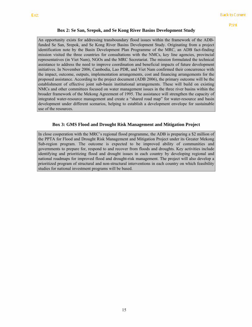
Box 2: Se San, Srepok, and Se Kong River Basins Development Study
An opportunity exists for addressing transboundary flood issues within the framework of the ADB-funded Se San, Srepok, and Se Kong River Basins Development Study. Originating from a project identification note by the Basin Development Plan Programme of the MRC, an ADB fact-finding mission visited the three countries for consultations with the NMCs, key line agencies, provincial representatives (in Viet Nam), NGOs and the MRC Secretariat. The mission formulated the technical assistance to address the need to improve coordination and beneficial impacts of future development initiatives. In November 2006, Cambodia, Lao PDR, and Viet Nam confirmed their concurrence with the impact, outcome, outputs, implementation arrangements, cost and financing arrangements for the proposed assistance. According to the project document (ADB 2006), the primary outcome will be the establishment of effective joint sub-basin institutional arrangements. These will build on existing NMCs and other committees focused on water management issues in the three river basins within the broader framework of the Mekong Agreement of 1995. The assistance will strengthen the capacity of integrated water-resource management and create a “shared road map” for water-resource and basin development under different scenarios, helping to establish a development envelope for sustainable use of the resources.
Box 3: GMS Flood and Drought Risk Management and Mitigation Project
In close cooperation with the MRC’s regional flood programme, the ADB is preparing a $2 million of the PPTA for Flood and Drought Risk Management and Mitigation Project under its Greater Mekong Sub-region program. The outcome is expected to be improved ability of communities and governments to prepare for, respond to and recover from floods and droughts. Key activities include identifying and prioritizing flood and drought issues in each country by developing regional and national roadmaps for improved flood and drought-risk management. The project will also develop a prioritized program of structural and non-structural interventions in each country on which feasibility studies for national investment programs will be based.

16
4 Follow-up activities and next steps proposed The identification of transboundary flood issues responds to the request from the MRC member States and is a first step towards implementing Component 3 of the FMMP. The six groups of issues of regional concern represent a broad area and require specific response strategies and actions. They would be addressed through enhanced cooperation and be based on technical and administrative priority capacity and support needs.
Transboundary issues represent prime areas of cooperation and MRC support to member States. They must be managed in a coordinated manner, promoting inter-governmental and inter-agency cooperation based on integrated water resource management (IWRM) principles. Adequate and effective mechanisms for cooperation will build on existing bilateral and multi-lateral arrangements and be supported or facilitated by the MRC Secretariat in general and the flood programme in particular.
Adding value to existing bilateral and multilateral mechanisms is an important challenge for the programme and the MRC as a whole. Enhanced transboundary cooperation implies that Component 3 takes adequate actions to develop capacity. Such actions need to take into account the identified impact areas and focus on people’s livelihood and structures exposed to flood risks. They also need to recognize the main hydro-ecological zones, sub-areas and river reaches including boundaries within the massive floodwaters connected to the Mekong mainstream. Close communications with government agencies including foreign ministries and disaster management committees will have to be ensured.
It is useful to emphasized that, in the field of transboundary cooperation and/or conflict prevention and management, together with the FMMP component 3, various MRC programme, like WUP, BDP and EP, have already made headway and have produced sets of information, have strengthened stakeholder capacities, and have developed procedures and tools, while new developments are ongoing. Particularly relevant presently is the USAID supported Joint Programme of Cooperation on MRC Trans-boundary Conflict Management Initiative through ECO-Asia, which will also involve all MRC programme. This initiative will provide orientation and guidance for the individual programme in dealing with transboundary issues like Component 3 of FMMP. It will also be instrumental in sharing information about past experiences and ongoing activities, so overlaps and duplication of efforts can be prevented or minimized. The design of Component 3 for each of the underlying activities of the three outputs incorporates assessments of the materials and tools developed under other MRC programme, which will be identified and screened for applicability under this component, while products of FMMP will be shared with other programme. More information on the design, activities and outputs of the other MRC programme related to transboundary implications can be found in the annex 7
In addition to the important opportunities for cooperation exist within MRC programmes, the regional initiatives leaded the ADB and the World Bank will also create significant additional supports and opportunities for enhancing cooperation and strengthening capacity of the MRC in addressing the transboundary issues.

17
References
ADB (2006). Se San, Srepok, and Se Kong River Basins Development Study in Kingdom of Cambodia, Lao People’s Democratic Republic, and Socialist Republic of Viet Nam. Asian Development Bank
BDP (2002) Regional sector overview: Hydropower. Basin Development Plan Program, Mekong River Commission, Phnom Penh, Cambodia. November 2002; (BDP 012-4)
Buxton, M., Kelly, M. and Jennifer Martin (2003). Environmental conflicts in the Mekong River Basin: prevention and resolution. Report to the Environment Programme, Mekong River Commission.
Joy, C.(2006): Framework for the development of best practice IFRM guidelines. Vol. 2. Background information (draft). Mekong River Commission, April 2006.
Miller F (2002) “Meeting water needs and avoiding conflict: the challenge of cooperation in water resources management in the Mekong Delta”, River symposium 2002, Scarcity of Water, 3-6 September; cited in Buxton et. al. 2003.
MOWRAM (2003) National Sector Review. Water Supply: Domestic Water and Sanitation: Industrial Water Use. BDP
MRC (2005). Overview of the Hydrology of the Mekong Basin’, Water Utilization Programme Start-Up Project. Mekong River Commission, September 2005.
FMMP (2007). On the legal aspects of the mandate of the 1995 Mekong Agreement: For enhancing cooperation in addressing transboundary flood and related issues. Draft working paper. Flood Management and Mitigation Programme. Component 3: Enhancing Cooperation in Addressing Trans-boundary Flood Issues
Robbins, M., Williams, T.O. (2005). Land Management and its benefits. The challenge, and the rationale, for sustainable management of drylands. Draft working paper for STAP workshop on SLM, March 2005)

18
Annex 1: A comparative analysis of National Flood Issue Study Reports
Aspects CNMC LNMC TNMC VNMC
Geography and climate
Southwest Monsoon (wet season) starts from June to October/November
Northeast Monsoon (dry season from November to April-May)
Changes in rainfall amount and pattern have very strong implication for hydrology and water resources, including the flood or drought situation
Southwest monsoon: mid May to mid October, heavy and frequent rainfall and high humidity, wind, warm and wet.
Northeast monsoon: November-Mid March, the atmospheric pressure is high, low temperature and humidity, cool dry air.
Rainfall: 1,300-3,700 mm,
Temperature: 15°C to 40°C
Viet Nam is located within the monsoon and tropical climate area; dry season from November to April receives less than 10% of annual rainfall while the rainy season from May to November receives the remaining 90%.
The Cuu Long Delta (CLD) is the most southern part of Viet Nam. It covers thirteen cities and provinces, with a total area of approximately 3.9 million hectares and a population in 2005 of nearly 18 million
Average elevation is from 0.7 – 1.2m above mean sea level, except the band located along boundary with Cambodia has the elevation of about 2.0 – 4.0 m
Country socio-economic development
Cambodia remains one of the poorest nations in the world with income of about US$384 per annum (2005): over 36% live below poverty line;
Socio-economic development dependent on agriculture; (37% of GDP);
GDP has grown at the average of 6.2 percent a year, an increase of 0.3 percent over the period from 1996 to 2000;
To reach ambitious years 2020 targets, it is vital to attract foreign investments and encourage domestic
Thailand is a middle-income country that has seen remarkable progress in human development in the last twenty years. The poverty has been reduced from 27% in 1990 to 9.8% in 2002;
From 1990 to 2004, Vietnam’s GDP nearly tripled; At present, Viet Nam is implementing its Socio-economic Development 2001-2010 Strategy, which is aimed to life the country from its under-developed status;

19
Aspects CNMC LNMC TNMC VNMC
75% of labour force; about 80% of poverty remains in this sector;
80% of cultivated areas are subsistence rain fed rice with very low yield levels
stakeholders to built water storage infrastructures system for expanding irrigated agriculture aiming at boosting rice production to reach 3.3 million tones as targeted in year 2010
CLD It contributes nearly 50% of the total rice and aquaculture production
Average population density in the CLD: 423 people/km2
Flood characteristics Downstream of Kratie, flood discharge is regulated through extended floodplains, and outflow into three main channels – Lower Mekong and Bassac rivers, and Tonle Sap River and Great Lake
Dominant influence on the incidence and severity of flooding in the Cambodian floodplain and the delta in Vietnam from left bank tributaries downstream of Vientiane (Nam Ngum and Nam Theun, and the Se Kong, Se San and Sre Pok Rivers entering the Mekong mainstream at Stung Treng)
Reversal flow of the Tonle Sap forms a key feature for Cambodia’s floodplain hydrology
The flow patterns is also determined by downstream hydraulic conditions, tidal influences and backwater effects particularly upstream
Last 37 years ( 1966-2002 ) 27 floods
Among of 27 historic floods, 6 were large floods: 1966, 1971, 1978, 1995, 1996 and 2002,
Agriculture in the Mekong river flood plain is particularly prone to flood damage not only due to over bank flows inundation from the mainstream, but also from the back water effects in the tributaries when the mainstream is full;
1995 flood (Storm Lois) caused tributary backwater effects and inundation of 103,000 ha of the Vientiane Plain; with the depth of between 0.5 to 0.8 m for period up to 2 months.
Year 2002 of Vongfong-14 storm from Southeast Monsoon affected in 12 provinces; 43 Districts; 1,000 villages; 30,000 families;
Flood is considered as one of the most dangerous disaster for human life and socio-economic development
The Mekong flow is naturally regulated by the Great Lake in Cambodia before entering to the CLD; floods are governed by flat topography, the regime of the flow from up stream, the regulation of Great Lake, regimes of East and West tide, local rainfall and hydraulic infrastructure (control) system
Low flow season from December to June with average discharge of about 3000 m3/sec; the flood season from July to November with average discharge of about 25,400 m3/sec.
Annually, an area of 1.2 - 1.9 million hectares of the CLD are inundated for from 2 - 5 months and water depth from 0.5 m to 4.0 m and more;

20
Aspects CNMC LNMC TNMC VNMC flow 8,556 household damages and
03 person died; Standard of Hydro-Meteorology Department. Water level at Tan Chau: lower 3.83 m: small flood; from 3.83 – 4.33 m average; higher than 4.33m: large flood.
Definitions Transboundary flood impacts occur in relation to both between different administrative boundary within the same political boundary, and between two or more countries.
The economic, social and environmental loss due to transboundary flood can result from both:
• reduction in their benefits as a result to of delayed and reduced high flow, sediment yields and associated siltation/destruction of key fish habitats;
• abnormal flooding as a result of flow release or flow back-up due to structure operations.
Trans-boundary issues are potential socio-economic conflicts that concern two or more countries that share common borders;
“Enhancing Cooperation in order to solve the problem affected from the Trans-boundary Flood Issues concerning Prevision and Mitigation Disasters, directly and indirectly, result from any construction which may be affected to the other side”
Flood occur on international rivers and impacts to riparian countries is called trans-boundary flood;
Activities from riparian countries (particular in the countries that share the common boundary) cause disadvantage changes to flood’s characteristics and results to negative impacts on social-economic and environmental conditions
Transboundary flood issues
Impacts from hydrological changes on Cambodian floodplains due to upper Mekong development
Bank erosion, water quality deterioration, fisheries, flooding, dam construction and etc.
Global issues: more frequent floods due to climate changes, risks of dam failure resulting from earthquakes

21
Aspects CNMC LNMC TNMC VNMC particularly dam and weir construction for hydroelectric power in upper parts of the MRB, likely result in remarkable changes in water levels and timing, and changes in morphological processes.
Impacts from cascade dam development along the Se San, Sre Pok and Se Kong.
Likely impacts from the construction of flood control system along the Vietnam and Cambodia border, along the Vinh Te - Vinh An - Tan Thanh - Lo Gach canals as well as the “closed” areas with the year-round flood control embankment on increasing inundation depth and duration in the Cambodia side;
Impact from flow fluctuations by dams & diversion on siltation of deep pool fish habitats, and spawning areas along key stretches of the Mekong mainstream and tributaries in Cambodia;
Increasing risk of more severe flooding through loss of flood plain storage capacity particularly in areas of the Mekong flood plains both in and from outside of Cambodia, being developed for higher
Priority transboundary issue: Severe bank erosion along the left embankment side of the Mekong River partly due to:
bank protection works mainly on the other side;
port protection on both sides but more significantly on the Thai side
sand and gravel exploitation (42 sites along both sides of Mekong River)
Bank erosion and disruption of fisheries due to unexpected dam releases from the Pak Mun Dam, Thailand (dam is generally opening the spillway gate two times per year, before rainy and flood season, without timely warning)
Upstream issues:
Hydropower development in upstream countries increase risk for dam failure
Deforestation in upstream countries increases flooding, inundation and sedimentation process for downstream countries
Sand excavations changes flood flows and increases pollution risk
Urbanization and industrialization
Developing infrastructure, particular transportation road net, dyke and embankment system, will narrow flood flow, change its direction, increase flood velocity and result in riverbank erosion
Developing infrastructure, roads, navigation alters flood flows and increases pollution risk
Agricultural development plans including flood protection especially in Cambodia would alter flood regime

22
Aspects CNMC LNMC TNMC VNMC value uses.
Flash flood/sudden flood due to abrupt and sudden water release from dam or dam break.
Issues in the CLD (affects on upstream countries originating in the CLD)
Increase flood water level along border part of Cambodia, cause by flood control system in the Long Xuyen Quadrangular and the Plain of Reeds
Vulnerability of affected groups
Most densely settled part of Cambodia is on the floodplain of the Mekong, Tonle Sap, Bassac and Tonle Sap Lake, and Cambodia experiences flooding every year in July-November.
4 main ethnic groups: Kinh,
Khmer, China, Cham, of which Kinh is majority (83%)
Population living in provinces located in downstream areas (Can Tho, Tien Giang, Ben Tre)
Legislation and addressing transboundary flood issues
Article 59 and 61 of the National Constitution
Law on Water Resources Management (May 2007)
Mandates the Ministry of Water Resources and Meteorology (MOWRAM) to undertake appropriate measures to ensure effective water resources management including international and national measures for addressing flood and drought
Law on water and water resources (Presidential Decree No.126/PR on November 2, 1996.
Decree on the Agreement and Endorsement of the National Strategy on Environment to the years 2020 and Action Plan for the years 2006-2010 which was signed by Prime Minister No.120/PM on August 27, 2004.
National Strategy on Prevention and Management of impact to the river bank
Constitution of the Kingdom of Thailand B.E. 2540 (A.D. 1997): preservation, maintenance and balanced exploitation of natural resources and biological diversity
Civil Defense Act of 1979; Civil Defense Plan 2005 (revision of the Civil Defense Plan 2002);
Bureaucrat Reform Act 2002,
Treasury Act of 2003 defines the mechanisms for allocating
Government Decree No.86/2003/ND-CP dated 18th July 2003 on functions, tasks, authorities and organizational structure of Ministry of Agriculture and Rural Development (MARD), main responsible body for hydraulic system management; prevention, control and management of drought, inundation, salinity intrusion
Law on Water Resource (May 1998): Article 43: Preventing, combating and overcoming

23
Aspects CNMC LNMC TNMC VNMC erosion and ecosystem in the Mekong River and Nam Heung, and Action Plan for each Fives years as: 2006-2010, 2011-2015, 2016-2020 and 2021-2025 which was signed by Minister of Ministry of Communication Transport Post and Construction No.055/MCTPC on January 9, 2007
disaster relief assistance
the consequence of drought; Article 44: Prevention and fight against salinity infiltration, rising and spill of sea water
Land Law 1993
Law on Forest Protection and Development
Law on Environmental Protection 2003
Main Agencies The Cambodia National Mekong Committee (CNMC) is mandated by the RGC to coordinating flood trans-boundary at national and regional level.
National Committee for Disaster Management (NCDM);
Ministry of Water Resources and Meteorology (MOWRAM);
Ministry of Agriculture, Forestry and Fisheries (MAFF),
Ministry of Environment (MOE),
Ministry of Industry, Mine and Energy (MIME),
National Disaster Management Committee (NDMC) as an inter-ministerial policy making and coordination body (since 1999); organized from central vial provincial, district to village levels;
National Land Management Authority
MAF (Ministry of Agriculture and Forestry)
Department of Agriculture and Extension (DAE)
Department of Forestry (DF)
National Agriculture and Forestry Research Institute (NAFRI)
Department of Meteorology
The National Civil Defense Committee (NCDC) is the main policy making body; NCDC is responsible for coordinating all activities relevant to civil defense and disaster management;
Membership comprises representatives from all of national government agencies concerned
12 Regional Disaster Prevention and Mitigation Centers;
Numerous local Civil Defense Committees at provincial, district and local levels
In 2002, the Department of Disaster Prevention and Mitigation (DDPM), has come into existence under the
National Water Resources Council
Ministry of Agriculture and Rural development (MARD)
Department of dyke management, flood and storm control (DDMFC)
At Province level: numerous departs with specific flood management tasks assigned
People’s Committee of District
People’s Committee, Farmers, Water user brigades

24
Aspects CNMC LNMC TNMC VNMC
Ministry of Public Works and Transport (MPWT),
Ministry of Rural Development (MRD);
Municipality of Phnom Penh
and Hydrology (DMH)
MFA (Ministry of Foreign Affairs)
MND (Ministry of National Defense)
MF (Ministry of Finance)
MCTPC (Ministry of Communication, Transport, Post and Construction).
Department of Roads (DOR)
Waterway Administration (WAD)
Ministry of Industry and Handicraft (MIH);
Department of Electricity (Dam Operation)
Electricite Du Laos (EDL)
Lao Flood Management Committee
Department of Electricity (Dam Operation)
umbrella of Ministry of Interior;
Department of Water Resources (DWR), established the Water Crisis Prevention Center in 2003 for an effective remedy of water crisis; master plan for water crisis prevention and mitigation
Royal Irrigation Department (RID); responsibilities for water regulation, provision, storage, maintenance, distribution and allocation for agriculture, energy, domestic consumption, industry and also including prevention of damage causing by water, and inland navigation within irrigation area
Land Development Department, Ministry of Agriculture and Cooperatives
Office of Natural Resources and Environmental Policy and Planning, Minister of Natural Resources and Environment
Altogether nearly 40 organizations involved in flood management

25
Aspects CNMC LNMC TNMC VNMC
Existing policies and strategic frameworks
2004 National Water Resources Policy for the Kingdom of Cambodia
Promote flood protection structure (embankment, polders) and drainage;
Apply effective and efficient non-structural methods of flood management
Respond quickly and timely to the drought, flood or other water related events;
Encourage active participation in flood mitigation and management measures, and adaptive management;
Participate actively in regional and international efforts to manage and mitigate water related hazards.
Numerous decisions, ordinances, degrees, orders
Strategy for natural calamity management, control and alleviation (NCCA) in the CLD; (NCCA calls for the combination between internal force promotion and external cooperation strengthening
Protect people’s lives.
Minimize property damages.
Sustainable socio-economic development
Integrate regionally and internationally
Also Continue to complete irrigation structure systems
Lining ring dyke system and embankments protecting banks of key areas
Priorities areas for support
Participants of the National Workshop identified 4 out of the 7 issues identified as the most complicated situation of high uncertainty and with high risk of dispute;
Complex underlying factors that would need to involve the development of knowledge and
Bank erosion in the Mekong River is seen as a serious matter and arrives at alarming stage, especially during flood season
Data collection capacity at national levels
Enhance cooperation for
Criteria about flood levels and agreement on trans-boundary flood issues, and need to share information about developing plans which are able to change flood characters and cause influence to other countries
Watershed planning for development of the whole

26
Aspects CNMC LNMC TNMC VNMC its acceptance and involvement of various stakeholders in the deliberation together with the policy-makers and basin management.
Key intervention areas:
Methodologies/frameworks for assessing changes and impacts
Damage assessment & resources economics
Rules & policy harmonization
solving that (bank erosion) problem soon
Analysis of floods along the river (both sides), in order to reduce the affect of flow direction change along the Mekong river
Impact of Pak Mun Hydropower Dam hydropower should be joint studied (reconnaissance in order to collect the existing data for analysis)
Lao PDR-Cambodia-Thailand cooperation for Trans-boundary Flood Issues should consider fishery
basin
Forecasting and warning
Coherence of legal and policy framework, administrative boundaries and responsibilities
Technical abilities of a part of the full-time staff of the Storm and Flood Control units.
Mechanisms for addressing TB flood issues
A number of bilateral arrangements (Cambodia-Laos; Cambodia-Vietnam; or Cambodia-Thailand) to be supported by FMMP/MRC;
Basin-wide framework for searching joint counter measures for preventing and addressing transboundary flood issues involving more than 2 countries (e.g. for Se Kong Se San and Sre Pok Sub Basin);
Broader regional cooperation involving all Mekong Basin countries
Lao-Thai Cooperation (5 bilateral mechanisms):
Lao-Thai Joint Cooperation Committee (JC),
Lao-Thai General Border Committee (GBC),
Lao-Thai Association for Friendship,
Lao-Thai Governors Border Committee, and
Lao –Thai Joint Border Committee
Principle approach:
equal, friendly and respect for the interest of each others
all conflicts must be solved through negotiation
Building on successes of bilateral cooperation manly with Cambodia
MRC coordinates with the sponsors selection of “hot” regions; proposed provinces: Long An, Dong Thap and An Giang

27
Aspects CNMC LNMC TNMC VNMC
Triangular growth cooperation between Laos, Cambodia and Vietnam
Bilateral Technical Committee to address issue of Se San management, and for flood management due to roads and dikes in Vietnam Mekong Delta
Joint Water Resources Development and Management between Cambodia and Vietnam in the Mekong Delta
Inter-provincial committees
National Border Committees
Committee for Prevention and Management of impact to the river bank erosion and ecosystem in the Mekong River and Nam Heung’
The basic role of this committee is coordinating/ studying/ seeking of budget to whole the organization concern as inside country and abroad, in order to implement on the bank erosion protection along the Mekong River between Lao and Thai borderline/set up the strategy work plan for short term as 5 years, medium term is 10 years and long term is 20 years, and cooperation with Thailand such as “Committee for Lao-Thai Cooperation in order to manage on business activities along the Mekong River and Nam Heung”
Regulation Rule for sand and gravel exploitation along the Mekong river
Technical Infrastructure Standard
28
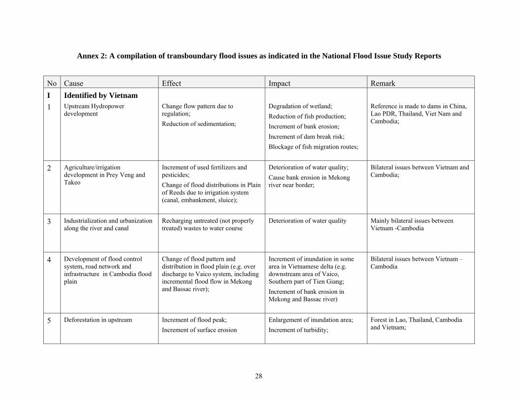
Annex 2: A compilation of transboundary flood issues as indicated in the National Flood Issue Study Reports
No Cause Effect Impact Remark I Identified by Vietnam 1 Upstream Hydropower
development Change flow pattern due to regulation; Reduction of sedimentation;
Degradation of wetland; Reduction of fish production; Increment of bank erosion; Increment of dam break risk; Blockage of fish migration routes;
Reference is made to dams in China, Lao PDR, Thailand, Viet Nam and Cambodia;
2 Agriculture/irrigation development in Prey Veng and Takeo
Increment of used fertilizers and pesticides; Change of flood distributions in Plain of Reeds due to irrigation system (canal, embankment, sluice);
Deterioration of water quality; Cause bank erosion in Mekong river near border;
Bilateral issues between Vietnam and Cambodia;
3 Industrialization and urbanization along the river and canal
Recharging untreated (not properly treated) wastes to water course
Deterioration of water quality Mainly bilateral issues between Vietnam -Cambodia
4 Development of flood control system, road network and infrastructure in Cambodia flood plain
Change of flood pattern and distribution in flood plain (e.g. over discharge to Vaico system, including incremental flood flow in Mekong and Bassac river);
Increment of inundation in some area in Vietnamese delta (e.g. downstream area of Vaico, Southern part of Tien Giang; Increment of bank erosion in Mekong and Bassac river)
Bilateral issues between Vietnam –Cambodia
5 Deforestation in upstream Increment of flood peak; Increment of surface erosion
Enlargement of inundation area; Increment of turbidity;
Forest in Lao, Thailand, Cambodia and Vietnam;

29
No Cause Effect Impact Remark 6 Exploitation of sand Change flow pattern in river channel Increment of bank erosion; Mainly bilateral issues between Viet
Nam – CambodiaF
10F
II Identified by Cambodia
1 The construction of flood control system along Viet Nam - Cambodia border (e.g. the Vinh Te - Vinh An - Tan Thanh - Lo Gach canals)
Decrement of cross-border discharge capacity of the flood plain
Increment of inundation depth and time in Cambodia; Change of flood distribution in Cambodia
Bilateral issues between Vietnam and Cambodia
2 The construction of resident protection areas along Viet Nam - Cambodia
Decrement of discharge capacity of the flood plain Obstacles of fish migration;
3 Hydropower development in Se Kong-Se San and Srepok system
Change of flow pattern in river; Severe damage of property and human life; increment of dam break risk;
Dams in Lao and Vietnam
4 Construction of Hydraulic works (especially Hydropower dams) in main tributary
Change of water levels; Reduction in nutrient levels;
Reduction of fish product in Cambodia Change of ecosystem along Mekong river; Obstacle fish migration; Filling up of deep pool fish habitats, and spawning areas in the Mekong mainstream and tributaries in Cambodia; increment of dam break risk;
Works in Lao, Vietnam, Thailand
5 Encroachments of floodplains (e.g. building more flood protected area)
Change of water level, inundation area and time
Reduction storage and regulation capacity of flood plain;
Bilateral issues between Vietnam and Cambodia;
10 The Cambodia delegation expressed that the sand exploitation problem also occurs in other reaches of the Mekong River which was confirmed by the Laos and Thai delegations.

30
No Cause Effect Impact Remark III Identified by Thailand No significant transboundary
flood from the Thailand has been reported in the literature/hydrological records Only sub-basin 2T (Kok) and 9T (Tonle Sap) are classified as transboundary tributaries
IV Identified by Lao PDR Port and bank protection
construction;
Deviation of hydraulic condition of the water flow (change direction and intensity of velocity);
Bank erosion at such locations seems to have worsen lately;
Until 2004 Thailand has completed over 89 km of river bank protection while in Lao PDR only around 14 km in 2006; 16 small port development on the Lao side; Many ports on the Thai side; particularly 2 larger ones in Xiengsaen and Xiengkhong; The correlation between bank protection and bank erosion needs further studies or surveys
Sand and gravel exploitation in both countries;
Deviation of hydraulic condition of the water flow (change direction and intensity of velocity);
Bank Erosion 42 points of sand and gravel exploitation in both countries; The correlation between sand excavation and bank erosion needs further studies or surveys
Operational of Pak Nam Mun dam (generally opening the spillway gate two times per year without warning to downstream)
Strong current from Nam Mun river mouth during raining season due to Pak Moun Dam released of flood water
Bank erosion with loss of cultivated land, houses and boats, and in the long run the disappearance of islands.
The correlation between operation of Pak Mun and bank erosion needs further studies or surveys

31
Annex 3: Preferred mechanisms; role and contributions of the MRCS as expressed at the 1st regional meeting, June 22nd, 2007
Issues Preferred mechanisms for
addressing transboundary flood issues?
Preferred roles of MRCS in the addressing differences process?
What could MRCS do to successfully fulfil this role?
Group I. Issues related to Floodplain developments within the Mekong Delta
(C) Bilateral Viet Nam - Cambodia; regional;
(V) Bilateral at different scales; regional when needed
(C) Assessment tools, mediation and facilitation support
(V) technical, administrative (financial) support; facilitate process including development of methods/approach
(C) mandate, capacity, process and procedure
(V) Improve capacity, tools, info and data sharing; development guidelines for EIA
Group 2: Issues related to Impacts of LMB upstream developments on the Mekong Delta
(C) MRC
(V) Bilateral and Regional mechanism (in frame of MRC)
(C) Assessment tools, mediation and facilitation support;
(V) Facilitate to maintain the regional linkage; Technical support (expertise, technology); facilitate the process
(C) Implement mandate, maintain capacity of MRCS, dev. process and procedure;
(V) Capacity building for technical staff of MRC; Improve tools; Improve information and data sharing communication; Develop guidelines to assess impacts of development interventions
Group 3: Issues related to Impacts of upstream hydropower development in the Upper Mekong Basin on the LMB
(C) MRC and dialogue with partners
(L) MRC and dialogue; JCC Lao – China;
(C) Assessment tools, collaborative of investigate; regional exchange information;
(L) Mediator/ facilitator, data exchange and sharing; exchange visit
(C) mandate, capacity, process and procedure
(L) Technical /financial support; inviting China to dialogue meeting, Capacity building
Group 4: Issues related to Hydropower development and operation in the Se San, Srepok, and Se Kong river basins
(C) Bilateral Viet Nam - Cambodia; Bilateral Lao-Cambodia (if possible)
(C) Assessment tools, mediation and facilitation support
(C) mandate, capacity, process and procedure

32
Group 5: Issues related to bank protection and port development; sand excavation; dam-operation communications in upper reaches of the Mekong mainstream
(L) Existing bilateral Lao – Thai; (L) Mediator/facilitator to existing mechanism;
(L) Technical /financial support for joint study meeting
Issue 6: Issues related to increased floods on tributaries in northwest Cambodia
(C) Bilateral Thai-Cambodia
C) Assessment tools, mediation and facilitation support;
(C) mandate, capacity, process and procedure
Legend:
C: CNMC
L: LNMC
T. TNMC
V: VNMC

33
Annex 4: Summary information on nature, main effects and impact of transboundary flood issues
Issues Main causes Main effects on floods Main impacts Nature of issues
Group I. Issues related to Floodplain developments within the Mekong Delta
• Expansion of Agriculture /irrigation systems
• Development and operation of flood protection and control systems, road network
• Industrialization and urbanization along the river and canal;
• Sand exploitation from main rivers;
• Change hydraulic and hydrological conditions of flow and water level in flood plain and channel system;
• Change of inundation area and duration;
• Change of water quality especially sedimentation, nitrate and pesticide loads
•
• Increased risks for loss of lives and damage to property affecting millions of people
• Reduction of fish production;
• Degradation of water quality;
• Increment of bank erosion of Mekong and Bassac
• Bilateral issues between Cambodia – Viet Nam
Group 2: Issues related to Impacts of LMB upstream developments on the Mekong Delta
• Construction, management and operation of hydropower projects on tributaries (mainly in Laos and Viet Nam)
• Deforestation in upstream
• Change of flow pattern due to regulation;
• Change of water quality; • Reduction of
sedimentation;
• Increased risks for loss of lives and damage to property
• Reduction of fish production
• Increment of dam break risk
• Potential bi- and multilateral issue between Riparian States
Group 3: Issues related to Impacts of upstream hydropower development in the Upper Mekong Basin on the LMB
• Construction, management and operation of hydropower plants Upper part of MRB (mainly in the Lancang river)
• Transition from wet to dry season flows
• Reduced flood volume and duration;
• Reduction of sedimentation;
• Blockage of fish migration routes;
• Potential impact on floodplain along the mainstream, Tonle Sap and Mekong Delta
• Multi-lateral between MRC member States and Dialogue partners
• Apparent effects
Group 4: Issues related to Hydropower development and operation in the Se San, Srepok, and Se Kong river basins
• Construction, management and operation of hydropower projects
• Change of flow pattern in river and water levels
• Damage of property and human life
• Increment of dam break risk
• Bilateral issues between Cambodia – Viet Nam and Cambodia – Lao PDR;

34
Issues Main causes Main effects on floods Main impacts Nature of issues
Group 5: Issues related to bank protection and port development; sand excavation; dam-operation communications in upper reaches of the Mekong mainstream
• Bank protection and port development
• Sand excavation • Communication of dam
operations;
• Change of flow pattern and water levels (uncertain cause-effect relations)
• Enhanced turbidity
• Bank erosion and loss of land
• Disruption of fisheries
• Bilateral (pending) issues between Lao PDR and Thailand
Issue 6: Issues related to increased floods on tributaries in northwest Cambodia
• Flash floods with uncertain cause-impact relations
• Bilateral (pending) issues between Cambodia and Thailand

35
Annex 5: Floods in the Mekong
Floods form a natural feature of the Mekong River’s annual flow regime. They can be described as a sudden rise of the water level generated by a number of reasons. According to Joy (2006), the peoples of the Lower Mekong Basin living in flood-prone areas are exposed to the hazards and risks of the following 7 types of flood: mainstream floods (MF); tributary floods (TF); local floods (LF); dam release floods DRF); dam break floods (DBF); storm surge floods (SSF); and tsunami floods (TF).
Accordingly, mainstream floods discharging from the upstream reaches are dominated by the Yunnan hydrological component, which contributes some 16% to the overall annual discharge of the Mekong River. Downstream of Vientiane / Nong Khai, floods move steadily down the river and arrive in Phnom Penh some 5-6 days after reaching a peak in Vientiane (Joy 2006). Mainstream floods appear to be dominated by floods from the tributaries from both left and right bank side and in combination with heavy rainfall in the basin. F
11F
Ecologically, floods of the Mekong River are an important source for the abundance of fish and agricultural productivity in the basin. About 700 fish species have been described in the basin and 65 fish families more than in the Amazon basin. The Mekong River is third in the world in the diversity of fish species with 1000 to 1,600 species. The wetlands also provide habitat for a numerous bird species, mammals, plants and large numbers of amphibian, reptile, insects and other species.
However, the flat topography of the lower Mekong floodplain combined with the high population density, especially within the Cuu Long Delta of Viet Nam, make floods a recurrent threat. High incidents of poverty in the flood-prone areas make the population extremely vulnerable to flood risks. Loss of life and property, damage to agriculture and rural infrastructure and disruption of the socio-economic activities of people living in flood-prone areas are frequently experienced.
There is a growing recognition that the magnitude of severe flooding in the Lower Mekong Basin is increasing in part as a result of human interventions. Factors include climate change, deforestation and land use changes in upland areas of the basin and structural developments further downstream. All such changes cause an increased flood risk in the form of increased peak flows and water levels resulting in prolonged and expanded inundation.
One of the most striking lessons from the Mekong’s flood history has resulted in a major paradigm change in the region by taking a 'living with floods' approach12
F. For example, in Viet
11 Major tributary systems only begin to develop in the Lower Basin and these can be separated between those which contribute the major wet season flows and those that drain low relief regions of lower rainfall. The former are the left bank tributaries that drain the high rainfall regions of Laos and the Central Highlands region in Vietnam and eastern Cambodia, and the latter those on the right bank, most notably the Mun and Chi Rivers that drain NE Thailand (MRC 2005)
12 Story from BBC HNEWS: http://news.bbc.co.uk/go/pr/fr/-/2/hi/science/nature/2869659.stmH; published: 2003/03/21

36
Nam this has resulted in a shift from year-round high to partial flood control on agricultural land in the Mekong Delta. Partial control implies that land is open to flooding during most of the flooding season. Farmers are advised to clear their summer/autumn rice crop well before the floods arrive. It is now widely recognized that floods carry important functions, which enhance the natural resource base and thereby contribute to more sustainable conditions. Important benefits associated with the flood can be summarized as follows13
• Nutrient supply. Disposal of nutrient-rich sediments. In the border provinces of the Vietnamese delta, the depth of sediments being disposed by floods varies between 3 and 5 cm, depending on the duration of inundation.
• Soil acidity leaching and buffering effects. Sediments disposed by floods also buffer against the natural acidity of the acid sulphate soils. Leaching and chemical buffer reactions help to maintain the pH milieu in balance.
• Soils structural improvement effects. While maintaining a favorable balance between acidity and alkalinity, floods indirectly maintain the soil structure and stability, factors which contribute to improved availability of soil moisture to crops.
• Soil hygienic effects. Another important benefit of floods is the control of plant pathogens either in the forms of larvae, or spores and other soil-borne forms of parasites.
13 More details on the benefits of floods for agriculture are given in the National transboundary flood issue report of Viet Nam, 2007

37
Annex 6: Validity check of transboundary flood issues
The agreed working definition was subjected to a validity test. Accordingly for a given transboundary issue three key questions were asked:
1 Does the issue relate to a substantial adverse impact on the natural, economic or social environment of a Riparian State?
a. If the answer to the question is “no”, then the issue is not of transboundary dimension,
b. If the answer to the question is “unclear”, then the issue is pending and requires further analysis;
c. If the answer to the question is “yes”, then the next question will be asked, which is:
2 Does the substantial adverse impact result from a change of the water conditions during the occurrence of floods; and/or during the flood season of the Mekong River system?
a. If the answer to the question is “no”, then the issue is not of transboundary dimension,
b. If the answer to the question is “unclear”, then the issue is pending and requires further analysis;
c. If the answer to the question is “yes”, then the next question will be asked, which is:
3 Are changes caused by a human activity within area(s) of (an)other Riparian State(s)?
a. If the answer to the question is “no”, then the issue is not of transboundary dimension,
b. If the answer to the question is “unclear”, then the issue is pending and requires further analysis;
c. If the answer to the question is “yes”, then the issue is clearly of transboundary dimension.
The outcome of the validity test permitted a categorization of transboundary issues into the following three groups:
• transboundary flood issues,
• not transboundary flood issues, and
• pending transboundary flood issues.
Those issue that were categorized as ‘pending’ required further analysis. This was to identify both differences in perspective and the needs for enhanced cooperation. The following additional questions intended to further clarify their nature.
1. If the answer to question 3 (causes) is “unclear”, then:
a. What is the nature of the main human activities (causes)
• Physical & structural

38
• Management and operation of hydraulic systems
• Land and water use practices
• Other
b. What is their (main causes) relative importance for the TB flood issue?
• High
• Medium
• Low
c. What are the key areas for enhanced cooperation?
• Fact-finding and evidence
• Complexity reduction
• Interest, values and trade-off discussion
• Other
2. If the answer to question 2 (primary effect) is “unclear”, then:
a. What are the key needs for enhanced cooperation and support in order to clarify the matter?
• as above under 1.c
3. If the answer to question 1 (substantial adverse effect) is “unclear”, then
a. What are the key needs for enhanced cooperation and support in order to clarify the matter?
• as above under 1.c and 2.a.

39
Annex 7: Opportunities for the MRC to make a useful contribution
This section provides an assessment of main linkages for the DMP in relation to other MRC programmes. They reflect discussions and views that were expressed in consultations with key MRCS programme staff members.
Flood Management and Mitigation Programme (FMMPU)
Important linkages and synergies exist within the Flood Management and Mitigation Programme (FMMP).
Component 1 supports the establishment of the Regional Flood Management and Mitigation Centre. This component is involved with the production of improved monitoring, operational forecasting and warning, risk assessment and mapping.
Component 2 —Structural Measures and Flood Proofing. Activities of this Component include among others social surveys and related analyses, community participation, environmental studies, flood management, hydrology and river hydraulics, mapping and geographic information systems, economic and financial analyses, and training.
Component 3 - Enhancing cooperation in addressing transboundary flood issues - is involved in the generation of information, raising awareness and knowledge and building skills and development of toolbox. The component will lead to strengthening cooperation and enhancing capacity of the MRC in addressing and resolving differences and differences in trans-boundary flood issues
Component 4 —flood emergency management strengthening. The Component provides builds capacity in planning, and implementation of flood preparedness focusing on border provinces and districts in Viet Nam and Cambodia.
Component 5 is concerned with land management issues. It is currently implemented with funding from BMZ/GTZ, Germany. The main product of the land management component is flood probability information in the form of electronic maps at a scale of 1:10,000. In order to make effective use of these maps, staff of the relevant line agencies will have to be trained in using them during their land use planning exercises. Presumably, this component's lessons-learned will benefit the formulation of drought risk reduction strategies and their implementation at the organization and institutional levels.
Closely linked to the FMMP are the two hydro-meteorological projects: i) Appropriate Hydrological Network Improvement Project (AHNIP) and ii) Mekong HYCOS. Both projects aim to improve the river flow monitoring capacity and hence, provide data and information on the river hydrology independently of national levels. Hence information must be regarded as crucial for mediation purposes of transboundary dimension.
MRCS and USAID Joint Programme of Cooperation on MRC Trans-boundary Conflict Management Initiative: The MRCS and USAID are cooperating on the MRC Trans-boundary Conflict Management Initiative, a multi-year effort to support implementation of Goal 2 of the Strategic Plan in the three focus areas identified by the NMCs and MRCS: (1) situational analysis; (2) institutional strengthening; and (3)

40
capacity building. ECO-Asia will work across the full range of MRC programmes that are actively engaged or planning activities in conflict management, including International Cooperation and Communication Section (ICCS), EP, and FMMP.
Basin Development Plan (BDP)
The MRC’s Basin Development Plan (BDP) database contains presently a total of 415 projects of which 69 are classified as joint projects. Many are multi-purpose projects addressing flood related issues including irrigation, watershed and environmental management projects. During its phase one, the BDP programme conducted numerous ‘sub-area transboundary’ meetings in which development interests, benefits, as well as negative impacts on another member country were examined. In these meetings common areas of transboundary concern were identified and management strategies identified. A guideline for sub-area transboundary meeting has also been developed for water and water related resources planning.
Agriculture, Irrigation and Forestry Programme (AIFP) - Watershed Management Project
Important linkages and complementarities exist between the MRC’s Agriculture, Irrigation and Forestry Programme (AIFP) and the Component 3 of FMMP. The AIFP Watershed Management Project is concerned with the assessment of ´land use changes and their effect on the water resource systems at the level of catchments. Independently where interventions in watershed management are successfully implemented, their impact will always be local and at the same time add up to a cumulative trans-boundary impact. A fundamental assumption of the project is a better understanding of cause-impact chains, which would enable the development of management strategies and policy recommendations for maintaining a healthy state of the river systems and mitigate their adverse impacts accordingly.
In this context, transboundary flood issues are a key problem and the project's envisaged approach is to develop and use the tools and systems that permit an up-scaling of watershed level experiences to policy level recommendations at a higher provincial or national level.
The AIFP water use efficiency component is currently formulating a project on improving the efficiency in rice irrigation systems. In collaboration with the FAO Regional Office for Southeast Asia, Bangkok, this project proposes a pilot performance study on irrigation modernization. Pilots include flood protected irrigation systems in the Mekong Delta, of both types year-round and partial control. Findings of this project could provide generic recommendation concerning the adoption of irrigation system design standards on the floodplains.
Fisheries Programme (FP)
All Mekong fisheries are driven by the flood regime of the river and its tributaries. There is a well established relationship between fish productivity and the area inundated. Fish production is largely dependent on the availability of sufficient water and hydraulic head in order to inundate flood plains and lowlands within the Basin.

41
Fish ecologies react to changes water conditions of the floodplains in various ways depending on type, species and management systems. To describe those fisheries strategies is obviously beyond the scope of this report. However, the most important impact of structural changes is a substantial reduction of migration, which results in substantially reduced productivity.
Important linkages and complementarities exist to all FP components. Component 1 opens access to the FP network of partner organizations, and Component2 fisheries ecology, valuation and mitigation, develops mitigation and management strategies, which are potentially important elements for the development of drought management and mitigation strategies. Component 3 relates to the institutional arrangements of riparian fish line agencies and Component 4, looks into specific aspects related to aquaculture systems for species that are indigenous to the Mekong river system.
Water Utilization Programme (WUP)
Important linkage to trans-boundary environmental impact assessments carried out earlier under WUP Working Group 2 and the present work under the IBFM activities.
The opportunity for Component 3 is to apply the Integrated Basin Flow Management Assessment Framework, an expert-based impact assessment tools, which objective scientific knowledge on primary and secondary ecological and socio-economic impacts of floodplain ecosystems.
In this connection it should be mentioned that World Bank-initiated Mekong Region Water Resources Assistance Strategy (MWRAS) is presently promoting three regional studies which are relevant from a transboundary flood impact perspective. These include the following:
Options for joint water resources development and management between Lao PDR and Thailand in the Mekong Basin (Lao/Thai options study) – supported by the World Bank;
Options for joint water resources development and management between Cambodia and Viet Nam in the Mekong Delta – supported by the World Bank; and
Identifying opportunities for collaboration in the Se Kong, Se San and Sre Pok Basins in Cambodia, Lao DPR and Viet Nam (3-Ss study) – supported by the ADB.
Besides, under the WUP, the MRC strengthened its capacity to study the complex hydrological and hydraulic behaviour of the Mekong River including floods. The Decision Support Framework comprises a set of hydrological and hydrodynamic models and flood analysis procedures. The model is seen as work in progress and which would imply a continuous need and widening scope for more advanced analytical tools addressing a range of water quality and ecosystem models and assessing environmental and social impacts under various flow regimes. Once the WUP and BDP phase II are full operational, the Component 3 of FMMP could benefit from a much improved modeling capability and procedures to be used as a tools within the context of transboundary flood issue cooperation.
42
Environment Programme (EP)
There are specific interests and linkages related to impacts within the MRC Environment Programme activities. Particularly, the Environment Programme has been leading the implementation of IBFM focussing on improving the understanding of the biophysical impacts of changes in flow. Within this framework, Transboundary Environmental Impact Assessment (TBEIA) has been tested as a planning tool for structural water resource development projects. Unlike environmental Impact Assessment (EIA), which is compulsory for most significant donor-funded projects, TBEIA would be of added value to a range of water resource related projects.
TBEIA guides the conduct EIA in a transboundary context including how to address/settle any dispute if they arise. In addition, the TBEIA would assist the four MRC member States to cooperate on technical matters and administrative arrangement defined under the scope of TBEIA. Technically, the assessment involves a number of broad transboundary impact oriented diagnostic steps, including the conduct of joint studies, risk assessment, and Strategic Environmental Impact Assessment for the Basin Development Plan, etc. Practically, it is envisaged that the procedures would be given into the hands of consulting firms, once they successfully completed TBEIA training. For them the attraction would be in a substantially raised service provision profile.
IKMP: The programme has three main objectives: i) Provision of fundamental data and information services; ii) Provision of integrated information and knowledge products and services; iii) Improvement of IKMP systems and tools. It is noted that the IKMP has a strong focus on the information generation, information sharing and modeling, impact assessment tools development and application. The information and tools to be developed and maintained by the IKMP are particularly valuable for the process of addressing differences and disputes in which fact-finding and problem analysis are most relevant areas for MRCS to be involve in.

Mekong River Commission
P.O. Box 6101, 184 Fa Ngoum Road, Unit 18, Ban Sithane Neua,Sikhottabong District, Vientiane, Lao PDR
Telephone: (856 21) 263 263 Facsimile: (856 21) 263 264E-mail: [email protected]: www.mrcmekong.org


![Flood Mitigation Planning for the Upper Wapsipinicon River ......Regulation Checklist that are important for flood mitigation planning [1]. There is a section for each flood mitigation](https://static.fdocuments.us/doc/165x107/5f23df6e5f50b45b8f2214fc/flood-mitigation-planning-for-the-upper-wapsipinicon-river-regulation-checklist.jpg)