FLETCHER'S PAINT WORK &S STORAGE SUPERFUND SITE · 2018-05-06 · Fletcher's Pain Sitt e include:...
40
SDMS DocID 7834 FLETCHER'S PAINT WORKS & STORAGE SUPERFUND SITE REMEDIAL INVESTIGATION MEETING Hampshire Hills Sports & Fitness Center August 17,1994 6:00 p.m.
Transcript of FLETCHER'S PAINT WORK &S STORAGE SUPERFUND SITE · 2018-05-06 · Fletcher's Pain Sitt e include:...

SDMS DocID 7834
FLETCHER'S PAINT WORKS & STORAGE SUPERFUND SITE
REMEDIAL INVESTIGATION MEETING
Hampshire Hills Sports & Fitness Center August 17,1994
6:00 p.m.

Sup^rfund Process
The Superfund Process
Removal Action (as needed)
Site NPL Ranking/ Remedial Feasibility Negotiations Discovery Listing Investigation Study
Public Remedial Long-Term Clean-up Plan Negotiations Comments Design Cleanup
OH-29


Site History
Historical uses in the Site Area:
farm
carriage painting
town burning dump
car dealership
armory
Fletcher's Paint Works
tannery
grain elevator/grist mill

Site Description •-N
Elm Street Site Area:
Fletcher's Elm Street Property (formerly Fletcher's Paint Works)
Mill Street Site Area:
Fletcher's Mill Street Property
Drainage Ditch
Keyes Field

EPA Activities At the Fletcher'sJPaint Site
1984 Contamination Of Keyes Municipal Well
1984 EPA performed a Preliminary Assessment and several Site Investigations of the Site
1988 EPA performed drum removal action at Fletcher's Paint \
Works
1989 Fletcher!s Paint Site was listed on the National Priorities List
1991 EPA performs removal action to fence Elm Street Site
1991- EPA performs Remedial Investigations into the
1994 nature and contamination at the site
1993 EPA performs removal action to take down storage shed

EPA Removal Actions
1988 removed 863 drums of hazardous materials and 12 bags of asbestos
EPA covered the Elm Street property and the Mill Street Property with a cap
1991 fenced a portion of the Elm Street property, and removed several small containers from inside the building
1993 removed 512 drums and 99 boxes of hazardous materials stored in Mill Street Shed and Elm Street Building
repaired the fence and added gravel to stabilize the cap on Elm Street
demolished and disposed of the former Mill Street Storage Shed; capped and this area

Summary of Major Findings
• High levels of contamination found in soils at Elm Street and Mill Street properties
• High levels of contamination found in groundwater moving from the Mill Street Site north to Elm Street Site and Souhegan River
• Low levels of contamination found in soils under the lawns and in dirt driveways of residential houses directly across from Mill Street Site.
• Low levels of contamination found in the soils along the upper portion of the Keyes Drive, adjacent to Elm Street Site
• Low levels of contamination found in sediments and soils in and along the drainage ditch, and in a former residential garden located adjacent to the ditch
• Low levels of contamination found in sediment and surface waters in Souhegan River near the Elm Street property; the riverbank soils directly beneath the Elm Street site had moderately higher contamination levels

What's Next Fletcher's Paint Works & Storage Superfund Site-
Elm & Mill St. locations
Informal Meeting - Fall - cleanup options/impacts
Proposed Cleanup Plan - Winter f
Public Comment Period on Proposed Cleanup Plan
Final Cleanup Plan

Field Investigation

Field Investigation Objectives
The objectives of the Remedial Investigation/Feasibility Study (RI/FS) field investigation are to determine the:
Nature and Extent of Contamination
Transport and Fate Mechanisms •
and to provide information in support of: .>'
Risk Assessment
Feasibility Study

Phase 1A Field Investigation
As part of the RI/FS several different surveys were conducted in and around the site between October 1991 and February 1992.
Field Reconnaissance Survey
Location and Elevation- Survey
Ground Penetrating Radar Survey 4
s
• Seismic Refraction and Very Low Frequency Survey
• Subsurface Soil Exploration
Ground Water Monitoring

Phase 1A Field Investigation (continued)
Surface Water and Sediment Sampling
Surface Soil Sampling .
Catch Basin and Outfall Sampling
Building Surface Sampling
Hydraulic Survey
Biota and Ecosystems Survey
Demographics Survey
cr: ESS EM ESS sss E:r3 KM 8E3 L~J EE3 BE;-: EIE era ESS u SID ..~~i ,—i

Phase 1B Field Investigation
To address data gaps remaining from the Phase IA field investigation, we conducted some additional surveys in and around the site between October 1993 and January 1994.
Location and Elevation Survey Seismic Refraction Survey Subsurface Soil Exploration Ground Water Monitoring </ Hydraulic Survey
• Small Diameter Well Survey • Surface Water and Sediment Sampling • Surface Soil Sampling

Geology - Key Results
Bedrock
Massabesic Gneiss and Milford Granite at depths ranging from 20 to 70 feet below grade in the study area. Some relatively high angle (vertical) fractures. Bedrock high at Mill Street.
•
Overlying Unconsolidated Sediments J
Surface fill at Mill Street (boulders) and Elm Street (old municipal burn dump and resinous materials). Glacial Outwash Deposits (sands, gravel). Glacial Till (Sand).

MILL S" "'EET
F'
270 270
B&M RR EB-19 MILL ST.
260 EB-13 260 BACKFILL MW-08
FINE TO MEDIUM SAND AND GRAVEL
•\' •••-•• . - • • • • T -.' ••' • ' rr-: .... ...-*-—i v • • . • • • • • • A . - • • • • • - . •:':7r7r:^ -^ . - - • •:^_u^j'^ *•'•:'
I.": .' ••-... .V. . ; • . • • ^>>^ • •' •:•'•'.' • • «^>^
Cn
] B A
250 250
MEDIUM TO COARSE SAND AND GRAVEL
240 240
\/ \ \7/ ^ I I \ / \ 'x /
230 230
VIEW LOOKING WEST 220 220
HORIZONTAL SCALE
0 25 FT.
210 210

ELM STREET
A'
SOUHEGAN RIVER
VIEW LOOKING NORTHWEST

Ground Water
The Milford-Souhegan Aquifer extends approximately three miles from East Wilton, NH to the Milford Town Center. The Keyes Municipal Supply Well and the Fletcher's Paint Site are located near the eastern end.
Ground water flow is generally toward the Souhegan River and flows in a north-northwest direction across the Elm Street Site and the Keyes Field. Ground water discharges into the Souhegan River.

Rl MONrrORMQ WELLS
LEGEND
WBLLS WTTH DETECTED OONTAMNATON N EXCESS OF DRNKMa WATER OTANDAnDS (MCU)
/4
WBLS WITH DETECTED CONTAMNATION BBjOW DRNONQ WATER 8TAN)An>3 (MCU)
DEEP WELL
SHALLOW WELL
C BEDROCK WELL
toot terra Cisj- CETJ ?rra

Around water samples from "n and around the Fletcher's Paint Site include:
• -Halogenated Organic Contaminants (HOCs)
- Trichlorethylene (TCE)
Benzene, Toluene, Ethylbenzene, Xylenes (BTEX)
Polychlorinated Biphenyls (RGBs)
• Trichlorobenzene (TCB) /»
Metals (lead)
LI IV-/ I I

Souhegan River Results
Chemicals of concern were found at elevated concentrations, particularly in sediments adjacent to the Elm Street site and then decreased downstream. Chemicals include:
• RGBs •
Metals (lead and chromium)
,>' Xylenes
• PAHs

Risk Assessment

Sup fund Process
The Superfund Process
Removal Action (as needed)
;t'"l^*Vv^ "*v lU U MujH_|Bani Auj i,
Site Discovery
NPL Ranking/ Listing Negotiations Remedial
Investigation Feasibility
Study
Public Comments
Clean-up Plan Negotiations Remedial Design
Long-Term Cleanup
OH-29

OVERVIEW OF SUPERFUND HUMAN HEALTH RISK ASSESSMENT ••-N
FOR THE ' ' N.
FLETCHER'S PAINT .SUPERFUND SITE
AUGUST 17, 1994
Ann-Marie Burke Toxicologist USEPA/ Region 1

RISK DEFINED What is risk? - probability of loss or injury
What is human health risk at Superfund sites? - Probability that people living, working, or playing at or near a Superfund site may experience health problems as a result of their exposure to chemicals at the site."

[BASELINE HUMAN HEALTHRISK ASSESSMENT
DEFINITION
The assessment of potential adverse human health effects (current and future) resulting from exposure to hazardous substances at a site in the absence of any cleanup.
PURPOSE
Identify-risks and their primary causes at site.
Support the need for clean-up.
BASELINE HUMAN HEALTH RISK ASSESSMENT IS NOT:
Study of current health of exposed population.
Prediction of health outcomes from past site exposures.
V ;i i fcj

COMPONENTS OF THE ASSESSMENT PROCESS
Data Collection and
Evaluation
Exposure Toxicity Assessment Assessment
Risk Characterization
3-5

HAZARD IDENTIFICATION '~ t] BASIS FOR SELECTION Q£ CONTAMINANTS
OF CONCERN (COC) 1
Occurrence and distribution
Fate, mobility, persistence in environment p
Concentration, toxicity f
1
E

CHEMICALS Ul'1 CGMCIiKN FOR FLKLCllLR'S PAir-Ti' SITE
Chemical ;•; .• ^?:?8i jj$ :f$ *-'± Surface • ' : ; • . .-?. ':',:. Subsurface * ..:.,}/•: ' '- Surface Walef S;?: Ground Water* :
: ' : i : V . : : ; ' Soil : :: Soil : •"! :'SouhcganRlveii'(i) W Souhe^ariRlver:W Drainage DltcHs! Drainage Dlich Vola Ulo Organic Compounds \ 1,2-Dlchloroethane * ^-^X' ' ' 3enzone Elhylboiuene
•;? .;.r.KM*.*>?...*.^*lx..#..?s^.
Felrnchlofoethene Toluene
;SlliSll ilil |l f4&M fr$m:%&'
Frlchloroethene Kylenas (total) Sonilvolnlllo Organic Compounds 1,2,4-Trichlorobenzene \cenaphthylona 3enzo (a) anthracene 3enzo (a) pyrene 3enzo (b) Huoranthene 3enzo (k) fluoranlhene 3enzo(g,h,l)pefylene Ghrysone Dlbaiuo (a,h) anthracene indono (1,2,3-c,d)pyrene Naphthalene 3honanthrene PestlcldeSPCBa
ilpha-Chlordane Voclor-1221 iVroclor-1242 ^oclor-1248 i\roclor-1254 Dleldrin Hopiachlor Epoxlde Inorganics
Arsenic Catlmlum Chromium Lead Manganese Mercury Nickej Vanadium

EXPOSURE ASSESSMENT PURPOSE n
'• -N.
To evaluate the potential for human exposure to hazardous chemicals identified in site media (i.e. sediment, surface water, fish, groundwater).
METHODS
Consider;
Source - from which chemicals released to .- i
-
environment • fs
&
Route contaminants transported thenvironmental medium
..rough
P ~ y
Exposure - human or ecological receptor «
Source + Route + Exposure = Completed Exposure Pathway
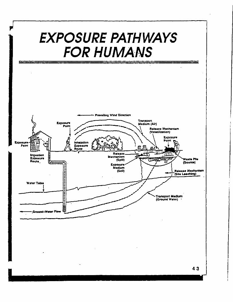
EXPOSURE PATHWAYS FOR HUMANS
Prevailing Wind Direction
Transport Medium (Air)
R«l«a*« Mcchanicrn (Volatilization)
Inhalation Exposure Route
V
R«1««M Machantetn
Transport Mcdhmr (Ground Water) •

FLETCHER'S PAINT SITE EXPOSURE PATHWAYS IDENTIFIED
'•'£ EXPOSURE/OWE; ',£XpO^p& ^^^ 1 EXPOS' URE?^ $$». ,p^?J&£$*&
;
Groundwater Ingestion Future - , Adult 1 '•-N.
Surface Water Souhegan River Ingestion Present= Future Swimmer: Young Child
0fci
SwimmerAdult Dermal SwimmerYoung child B
SwimmerAdult Drainage Ditch Dermal WaderYoung child n
WaderAdult ti Sediment n Souhegan River Ingestion Present= Future Swimmer: Young child
SwimmerAdult Dermal " Swimmer- Young Child R
SwimmerAdult H Drainage Ditch Ingestion Wader: Young Child
WaderAdult Dermal Wader: Young Child
WaderAdult ^
Surface Soils • •A Mill & Elm Street Area Ingestion Present= Future Young child
Adult MbDermal Present= Future Young child Adult ess,
Drainage Ditch Ingestion Present= Future Young Child Bs . Adult Dermal Young Child
Adult { -p?{ Ingestion of Crops Adult
Subsurface Soils Mill & Elm Street Area Ingestion Future Young Child
Adult P Dermal Young Child iJ
Adult
Fish Present= Future I Souhegan River - Ingestion Adults (semi-quant.)
a

ASSESS EXPOSURE
Five Basic Variables Used to Estimate Intake
Exposure Point Concentrations: 9
Contact Rate: o Calendar o
« u T w T F »
Exposure Frequency/Duration: 9
Body Weight: 9
Exposure Averaging Time: 9

r
QUANTIFY EXPOSURE PUTTING IT ALL TOGETHER
Land Use
Potential Pathway-Specific Exposure Exposure Intakes Pathways For Each Chemical
Models
Reasonable Maximum Exposure (RME)
4-7

ASSESS EXPOSURE
Reasonable Maximum Exposure (RME)
Definition: Highest exposure" that is reasonably expected to occur at a s|ite, considering
• land use • intake variables • pathway combinations
ntent is to estimate a conservative exposure case that is still within the range of possible exposures.

J -<
TOXICITY ASSESSMENT r r
• Identifies adverse bealth effects - cancer, systemic, other.
• Characterizes quality and i strength of evidence for adverse i health effects i to develop a dose-response § relationship/value.,
• Based on available human studies and/or animal studies.
Q 0

TOXICITY ASSESSMENT '•*v
\
CARCINOGENS
• any agent that produces neoplasms (cancer)
• includes: organic and inorganic chemicals, viruses, ionizing radiation
• diff. properties, diff. mechanisms of action
• no threshold (no dose is risk free)
NONCARCINOQENS
adverse health effect other than cancer
protective mechanisms must be overcome before adverse effect occurs
threshold above which adverse effect occurs

RISK CHARACTERIZATION r> •"••••••. ^^^^mmmmmml ^mmmm^«^_mmmmm^_••m~mm—I
RISK = EXPOSURE X TOXlplTY ^ » »
CARCINOGENS |
Risk expressed as a probability S
Extrapolate - high dose to low dose ® animal to human |
Superfund - cancer risk less than 10-4 | generally 'does not warrant action.
>. .1 NONCARCINOGENS 1
f Exposure level compared to'Yeference " dose" (no effect below the reference dose)
Exposure dose = hazard quotient RfD
Summation of hazard quotients - hazard index (HI)
His greater than 1 are a sign to the RPM to look closely at possibe need for remedial action.

FLETCHER'S PAINT SUPERFUND SITE EXPOSURE PATHWAYS WHICH EXCEED EPA'S TARGET RISK RANGE
MEDIUM AREA EXPOSURE ROUTES
(Cancer Risks)
Surface Soils Mill & Elm Street Ingestion, dermal contact Drainage Ditch Ingestion, dermal contact, crop ingestion
Subsurface Soils Mill & Elm Street Ingestion, dermal contact
Groundwater Site Ingestion
(Noncancer Risks)
^urface Soils Drainage Ditch Ingestion, dermal contact, crop ingestion
Groundwater Site Ingestion
?Fish Souhegan River Ingestion
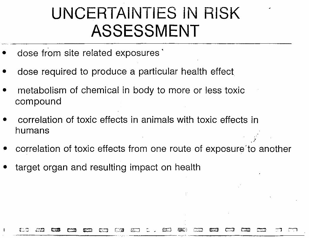
UNCERTAINTIES IN RISK ASSESSMENT
dose from site related exposures'
dose required to produce a particular health effect
metabolism of chemical in body to more or less toxic compound
correlation of toxic effects in animals with toxic effects in humans
.>' correlation of toxic effects from one route of exposure'to another
target organ and resulting impact on health