FIVE-YEAR REVIEW REPORT FOR THE SHARKEY … · FIVE-YEAR REVIEW REPORT FOR ... PARSIPPANY-TROY...
28
FIVE-YEAR REVIEW REPORT FOR SHARKEY LANDFILL SUPERFUND SITE PARSIPPANY-TROY HILLS, MORRIS COUNTY, NEW JERSEY Prepared by U.S. Environmental Protection Agency Region 2 Walter E. Mugdan Superfund Division Director U.S. EPA, Region 2 New York, New York Date: 282489
Transcript of FIVE-YEAR REVIEW REPORT FOR THE SHARKEY … · FIVE-YEAR REVIEW REPORT FOR ... PARSIPPANY-TROY...

FIVE-YEAR REVIEW REPORT FOR SHARKEY LANDFILL SUPERFUND SITE
PARSIPPANY-TROY HILLS, MORRIS COUNTY, NEW JERSEY
Prepared by
U.S. Environmental Protection Agency Region 2
Walter E. Mugdan Superfund Division Director U.S. EPA, Region 2
New York, New York
Date:
282489

i
Table of Contents
Introduction ..................................................................................................................................... 1�
Site Chronology .............................................................................................................................. 1�
Background ..................................................................................................................................... 1�
Physical Characteristics ................................................................................................... 1�Site Geology/Hydrogeology .............................................................................................. 2�Land and Resource Use .................................................................................................... 2�History of Contamination ................................................................................................. 2�Initial Response ................................................................................................................ 2�Basis For Taking Action ................................................................................................... 2�
Remedial Actions ............................................................................................................................ 3�
Remedy Selection .............................................................................................................. 3�Remedy Implementation ................................................................................................... 4�System Operations/Operations and Maintenance (O&M) ............................................... 5�
Progress Since Last Five-Year Review ........................................................................................... 6�
Five-Year Review Process .............................................................................................................. 9�
Administrative Components .............................................................................................. 9�Community Involvement ................................................................................................... 9�Document Review ........................................................................................................... 10�Data Review and Evaluation .......................................................................................... 10�Site Inspection ................................................................................................................ 11�Interviews/Meetings ........................................................................................................ 11�Institutional Controls Verification ................................................................................. 11�
Technical Assessment ................................................................................................................... 11�
Question A:� Is the remedy functioning as intended by the decision documents? ....... 11�Question B:� Are the exposure assumptions, toxicity data, cleanup levels, and remedial action objectives used at the time of the remedy still valid? .......................................... 12�Table A ........................................................................................................................... 12�Questions C:� Has any other information come to light that could call into question the protectiveness of the remedy? ........................................................................................ 13�
Issues, Recommendations and Follow-up Actions ....................................................................... 13�
Protectiveness Statement .............................................................................................................. 13�
Next Five-Year Review ................................................................................................................ 14�
Site Map ........................................................................................................................................ 15�

ii
Table 1 – Site Chronology ............................................................................................................ 16�
Table 2 - Documents, Data, and Information Reviewed in Completing the Five-Year Review .. 19�
Table 3 .......................................................................................................................................... 20�
Table 4 - Recommendations and Follow-Up Actions................................................................... 21�

iii
Executive Summary This is the second five-year review (FYR) for the Sharkey Landfill Superfund site located in Parsippany-Troy Hills, Morris County, New Jersey. The purpose of this FYR is to review information to determine if the remedy is and will continue to be protective of human health and the environment. This statutory review is triggered by the signature of the previous FYR that was issued in May 2009. The remedy at the site includes capping of the landfill, surface water controls, a gas venting system, extraction and treatment of shallow groundwater, securing fencing, and environmental monitoring. The remedy has been constructed and is currently in the operation and maintenance phase. The second FYR found that the implemented remedy currently protects human health and the environment because all exposure pathways have been addressed by the engineered remedy. However, in order to be protective in the long term, deed notices restricting future use of the property need to be put in place and the effects of turning off the treatment system need to be evaluated.
iv
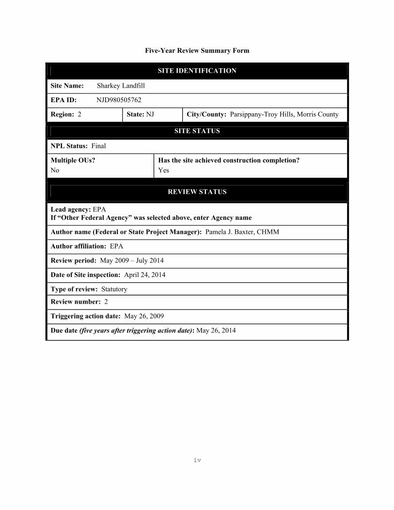
Five-Year Review Summary Form
SITE IDENTIFICATION
Site Name: Sharkey Landfill
EPA ID: NJD980505762
Region: 2 State: NJ City/County: Parsippany-Troy Hills, Morris County
SITE STATUS
NPL Status: Final
Multiple OUs? No
Has the site achieved construction completion? Yes
REVIEW STATUS
Lead agency: EPA If “Other Federal Agency” was selected above, enter Agency name
Author name (Federal or State Project Manager): Pamela J. Baxter, CHMM
Author affiliation: EPA
Review period: May 2009 – July 2014
Date of Site inspection: April 24, 2014
Type of review: Statutory Review number: 2
Triggering action date: May 26, 2009
Due date (five years after triggering action date): May 26, 2014

v
Five-Year Review Summary Form (continued)
Issues/Recommendations
OU(s) without Issues/Recommendations Identified in the Five-Year Review:
Issues and Recommendations Identified in the Five-Year Review:
OU(s): OU1 Issue Category: Institutional Controls
Issue: The Northwest-North fill area appears to have potential for commercial use.
Recommendation: Deed notices need to be established to limit potential development options. An advisement of existing soil cover and potential underlying waste material should be noted.
Affect Current Protectiveness
Affect Future Protectiveness
Implementing Party
Oversight Party Milestone Date
No Yes PRP EPA September 2015
OU(s): OU1 Issue Category: Institutional Controls
Issue: The Southwest and Northwest-South fill areas are within or adjacent to property that is considered preserved open space.
Recommendation: Deed notices need to be established to limit potential development options. An advisement of existing soil cover and potential underlying waste material should be noted.
Affect Current Protectiveness
Affect Future Protectiveness
Implementing Party
Oversight Party Milestone Date
No Yes PRP EPA September 2015
OU(s): OU1 Issue Category: Remedy Performance
Issue: Aquifer samples are not being collected in shallow aquifer immediately downgradient of large Fills area.
Recommendation: Collect data and evaluate the need to restart extraction system.
Affect Current Protectiveness
Affect Future Protectiveness
Implementing Party
Oversight Party Milestone Date
No Yes PRP EPA September 2015

vi
Protectiveness Statement(s)
Include each individual OU protectiveness determination and statement. If you need to add more protectiveness determinations and statements for additional OUs, copy and paste the table below as many times as necessary to complete for each OU evaluated in the FYR report.
Operable Unit: OU1
Protectiveness Determination: Short-term Protective
Addendum Due Date (if applicable):
Protectiveness Statement: The OU1 remedy currently protects human health and the environment because all exposure pathways have been addressed by the engineered remedy. However, in order to be protective in the long term, deed notices restricting future use of the property need to be put in place and the effects of turning off the treatment system need to be evaluated.
Sitewide Protectiveness Statement (if applicable)
For sites that have achieved construction completion, enter a sitewide protectiveness determination and statement.
Protectiveness Determination: Short-term Protective
Addendum Due Date (if applicable):
Protectiveness Statement: The implemented remedy currently protects human health and the environment because all exposure pathways have been addressed by the engineered remedy. However, in order to be protective in the long term, deed notices restricting future use of the property need to be put in place and the effects of turning off the treatment system need to be evaluated.

1
Introduction The purpose of a five-year review (FYR) is to evaluate the implementation and performance of a remedy in order to determine if the remedy is and will continue to be protective of human health and the environment and is functioning as intended by the decision documents. The methods, findings, and conclusions of reviews are documented in the FYR. In addition, FYR reports identify issues found during the review, if any, and document recommendations to address them. This is the second FYR for the Sharkey Landfill site, located in Parsippany-Troy Hills, Morris County, New Jersey. This FYR was conducted by the United States Environmental Protection Agency (EPA) Remedial Project Manager (RPM) Pamela J. Baxter, CHMM. The review was conducted pursuant to Section 121(c) of the Comprehensive Environmental Response, Compensation, and Liability Act (CERCLA), as amended, 42 U.S.C. §9601 et seq. and 40 CFR 300.430(f)(4)(ii), and in accordance with the Comprehensive Five-Year Review Guidance, OSWER Directive 9355.7-03B-P (June 2001). This report will become part of the site file. The triggering action for this statutory review is the completion date of the previous FYR. A FYR is required at this site due to the fact that the remedial action will not leave hazardous substances, pollutants or contaminants on site above levels that allow for unlimited use and unrestricted exposure, but requires five or more years to complete. The site consists of one operable unit, which is the subject of this FYR. Site Chronology See Table 1 for the site chronology. Background Physical Characteristics The Sharkey Landfill site is located in the Townships of Parsippany-Troy Hills and East Hanover, in Morris County, New Jersey. The site is bounded by Route 46, New Road, and the Rockaway River and extends south beyond Interstate Route 280 between Troy Meadows and the Hatfield Swamp. The site is approximately 90 acres in size, is one operable unit, and is divided into five separate landfill areas: North Fill, South Fill, Northwest-North Fill, Northwest-South Fill, and the Southwest Fill. The North Fill is an approximately 26-acre island in the Rockaway River and is located at the northern end of Sharkey Road in Parsippany-Troy Hills. The South Fill is an approximately 32-acre area adjacent to the Rockaway and Whippany Rivers and the Parsippany-Troy Hills wastewater treatment plant. The Northwest-North and Northwest-South Fills are about 11 and 15 acres in size, respectively, and were originally one fill area. The two Fill areas were separated as a result of the construction of Interstate 280. The Southwest Fill is an approximately 9-acre area located along the Whippany River southeast of Ridgedale Avenue in East Hanover, which received fill material excavated during the construction of Interstate 280. See attached site map.

2
Site Geology/Hydrogeology The site is located in the Piedmont Physiological Province. It is characterized by a swampy low land with a few surrounding ridges and isolated hills rising above the plain. Most of the area lies between the elevations of 170 to 440 feet above mean sea level. Rocks underlying Pleistocene era and younger unconsolidated deposits in this area are predominately of the Brunswick Formation consisting of red shale and sandstone. Also present in this area, and forming the topographic relief of the Watchung Mountains, are Triassic-age basalt flows. Land and Resource Use The general area in which the landfills are located can be described as residential and light industrial to the north and west of the Whippany River, and considerable swamp land to the east and south. Approximately eight miles downstream, the Passaic River is used as a source of drinking water by the Passaic Valley Water Commission. History of Contamination During the 1930s, the site was used as a pig farm. In 1945, landfill operations began and the site accepted municipal waste material until September 1972. During that time, the landfill also accepted commercial, industrial, and hazardous waste materials. Records indicate that various organic compounds were disposed of at the site, including toluene, benzene, chloroform, dichloroethylene, and methylene chloride, as well as other "liquid and/or chemical wastes" described as cesspool-type wastes. Although there have been allegations of waste disposal after 1972, the site is believed to have been generally inactive after that date. Some excavation and on-site relocation of some fill material occurred during the expansion of the Parsippany-Troy Hills wastewater treatment plant. Initial Response In September 1983, the Sharkey Landfill site was included on the National Priorities List (NPL). The New Jersey Department of Environmental Protection Agency (NJDEP) was the lead agency at the site from December 1983 to April 1994. A remedial investigation and feasibility study (RI/FS) was conducted by the NJDEP from December 1983 to September 1986, to determine the nature and extent of contamination and to develop alternatives for remediation. NJDEP initiated the remedial design (RD) in March 1987 and ceased conducting the RD in April 1994 when EPA took the lead for the site. Basis For Taking Action The results of the RI/FS indicated the presence of low concentrations of organic compounds, pesticides, and inorganic compounds in soils, and low levels of organic, including benzene and trichloroethene (TCE), and inorganic compounds in the shallow groundwater beneath the site. The shallow water-bearing zone beneath the site is isolated from the deeper groundwater aquifer systems. The site is underlain by a continuous varved clay layer which functions as a naturally
3
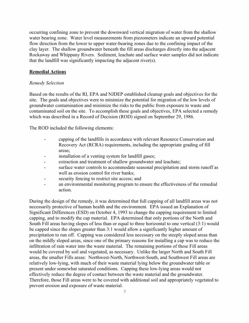
occurring confining zone to prevent the downward vertical migration of water from the shallow water bearing zone. Water level measurements from piezometers indicate an upward potential flow direction from the lower to upper water-bearing zones due to the confining impact of the clay layer. The shallow groundwater beneath the fill areas discharges directly into the adjacent Rockaway and Whippany Rivers. Sediment, leachate and surface water samples did not indicate that the landfill was significantly impacting the adjacent river(s). Remedial Actions
Remedy Selection Based on the results of the RI, EPA and NJDEP established cleanup goals and objectives for the site. The goals and objectives were to minimize the potential for migration of the low levels of groundwater contamination and minimize the risks to the public from exposure to waste and contaminated soil on the site. To accomplish these goals and objectives, EPA selected a remedy which was described in a Record of Decision (ROD) signed on September 29, 1986. The ROD included the following elements:
- capping of the landfills in accordance with relevant Resource Conservation and Recovery Act (RCRA) requirements, including the appropriate grading of fill areas;
- installation of a venting system for landfill gases; - extraction and treatment of shallow groundwater and leachate; - surface water controls to accommodate seasonal precipitation and storm runoff as
well as erosion control for river banks; - security fencing to restrict site access; and - an environmental monitoring program to ensure the effectiveness of the remedial
action. During the design of the remedy, it was determined that full capping of all landfill areas was not necessarily protective of human health and the environment. EPA issued an Explanation of Significant Differences (ESD) on October 4, 1993 to change the capping requirement to limited capping, and to modify the cap material. EPA determined that only portions of the North and South Fill areas having slopes of less than or equal to three horizontal to one vertical (3:1) would be capped since the slopes greater than 3:1 would allow a significantly higher amount of precipitation to run off. Capping was considered less necessary on the steeply sloped areas than on the mildly sloped areas, since one of the primary reasons for installing a cap was to reduce the infiltration of rain water into the waste material. The remaining portions of these Fill areas would be covered by soil and vegetated, as necessary. Unlike the larger North and South Fill areas, the smaller Fills areas: Northwest-North, Northwest-South, and Southwest Fill areas are relatively low-lying, with much of their waste material lying below the groundwater table or present under somewhat saturated conditions. Capping these low-lying areas would not effectively reduce the degree of contact between the waste material and the groundwater. Therefore, those Fill areas were to be covered with additional soil and appropriately vegetated to prevent erosion and exposure of waste material.

4
The 1993 ESD also modified the liner material. As an alternative to using a two-foot clay layer to meet the performance requirements of RCRA, a synthetic liner was determined to be appropriate. Since the steep slopes were not to be capped under the modified remedy, the use of a synthetic liner was determined to be appropriate on the North and South Fill areas. The ESD also called for a groundwater monitoring program to be implemented for all five Fill areas in addition to a surface water monitoring program for the Rockaway and Whippany Rivers. The purposes of the monitoring programs include assessing and monitoring groundwater and surface water quality, determining the need for operation of groundwater extraction systems, and evaluating the effectiveness of operating extraction systems in establishing and maintaining hydraulic control of landfill leachate. Provision for a groundwater extraction system was made in each of the five Fill areas to provide hydraulic control containment and prevent migration of contaminants out of each Fill area when operating at design capacity. As designed, the North Fill and South Fill systems were to be installed and operated continuously for a period of five years, regardless of the results of the groundwater and surface water monitoring programs. The extraction systems at the other three Fill areas were only to be operated if monitoring results indicated such a need. After the initial five-year period, the need to operate the North Fill and South Fill extraction systems will also be based on the results of the groundwater and surface water monitoring programs. Remedy Implementation After lengthy negotiations, EPA reached a settlement with a group of potentially responsible parties (PRPs), in which the PRPs agreed to perform the RD and the remedial action (RA). A Consent Decree was entered in federal district court on December 4, 1994. The PRP group (the Group) completed the RD on May 9, 2000. On June 5, 2000, the Group solicited bids for construction. The following construction activities were completed by contractors hired by the PRPs: clearing and grubbing, site grading, surveying, capping of the South Fill and North Fill areas, placing soil cover and cap soil cover on the Northwest-South, and Southwest Fill areas, conducting erosion control, hydroseeding, removing tires from the Rockaway and Whippany Rivers, photographing site activities, installing groundwater monitoring and extraction wells, installing various riverbank erosion protection measures, installing channels and basins, installing site security fencing, constructing access roads, and performing various other site-related activities. In addition, piping was installed to convey extracted groundwater to the Parsippany-Troy Hills wastewater treatment plant.

5
A PRP separate from the Group, HMAT Services, is responsible for the Northwest-North Fill area. According to the 1994 Consent Decree, HMAT’s responsibilities included site management planning, as well as the installation of soil cover, drainage controls, erosion protection, and other related work at the Northwest-North Fill area. HMAT began remedial action activities at the Northwest-North Fill area in May 2002 and awarded a construction contract to American Environmental Assessment Corporation. A pre-construction meeting was held on August 28, 2002, and construction activities commenced on September 3, 2002. EPA inspected the site and observed that remediation activities were substantially completed on October 4, 2002. System Operations/Operations and Maintenance (O&M) The Township of Parsippany-Troy Hills is responsible for inspection of the landfill area; operations of the groundwater extraction system; and maintenance of the cap cover, access road, surface water management system, river bank erosion protection, passive gas vents and groundwater extraction and monitoring system. The Group is responsible for monitoring the piezometer levels, groundwater monitoring and well sampling, surface water sampling, and analytical testing and reporting. According to the 1994 Consent Decree, the groundwater extraction system at each Fill Area and comprehensive groundwater monitoring plan was to be designed and constructed to meet the following objectives, among others:
1) to withdraw shallow water-bearing zone beneath each Fill Area and transport that groundwater to the Parsippany-Troy Hills Sewer Treatment Plant for treatment and disposal;
2) to prevent any groundwater containing any Well Chemicals (see Table A) from migrating out of any fill areas at concentrations exceeding the Well Trigger;
3) to ensure that every groundwater monitoring well at each Fill Area is located within the capture zone of one or more groundwater extraction wells;
4) to prevent all waters in the shallow water-bearing zone beneath every Fill Area from migrating out of the Fill Area;
5) to allow selective operation of every groundwater extraction well at a Fill Area while some of the remaining groundwater extraction wells remain inactive;
6) to allow all of the groundwater extraction wells at every Fill area to pump and extract groundwater at their peak design capacity within an EPA-approved timeframe after a decision is made to activate the system; and
7) to prevent any groundwater containing any Well Chemicals from migrating out of any Fill Area at a concentration greater than or equal to two times of the respective Trigger Level, measured in any groundwater monitoring well.
Groundwater (hydrogeological) monitoring, groundwater (analytical) sampling, surface water sampling, analytical testing, and reporting is required by the Remedial Action Performance Monitoring Field Sampling and Quality Assurance Plan. Sampling and analysis, and validation
6
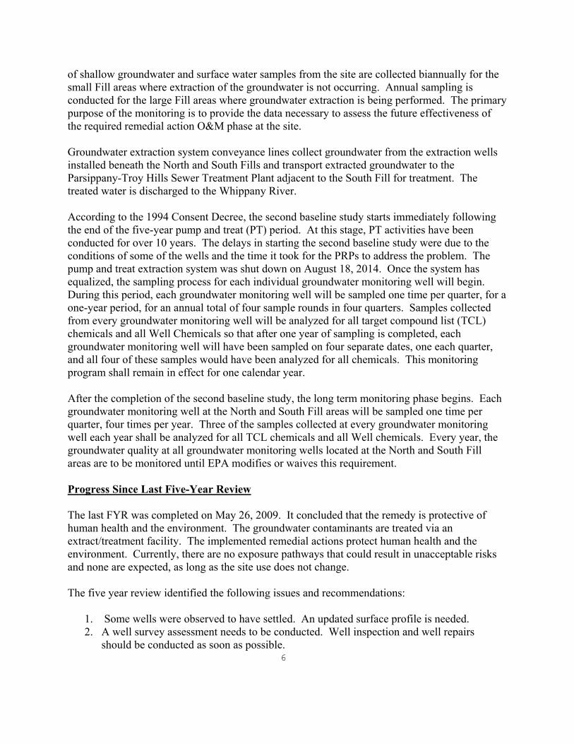
of shallow groundwater and surface water samples from the site are collected biannually for the small Fill areas where extraction of the groundwater is not occurring. Annual sampling is conducted for the large Fill areas where groundwater extraction is being performed. The primary purpose of the monitoring is to provide the data necessary to assess the future effectiveness of the required remedial action O&M phase at the site. Groundwater extraction system conveyance lines collect groundwater from the extraction wells installed beneath the North and South Fills and transport extracted groundwater to the Parsippany-Troy Hills Sewer Treatment Plant adjacent to the South Fill for treatment. The treated water is discharged to the Whippany River. According to the 1994 Consent Decree, the second baseline study starts immediately following the end of the five-year pump and treat (PT) period. At this stage, PT activities have been conducted for over 10 years. The delays in starting the second baseline study were due to the conditions of some of the wells and the time it took for the PRPs to address the problem. The pump and treat extraction system was shut down on August 18, 2014. Once the system has equalized, the sampling process for each individual groundwater monitoring well will begin. During this period, each groundwater monitoring well will be sampled one time per quarter, for a one-year period, for an annual total of four sample rounds in four quarters. Samples collected from every groundwater monitoring well will be analyzed for all target compound list (TCL) chemicals and all Well Chemicals so that after one year of sampling is completed, each groundwater monitoring well will have been sampled on four separate dates, one each quarter, and all four of these samples would have been analyzed for all chemicals. This monitoring program shall remain in effect for one calendar year. After the completion of the second baseline study, the long term monitoring phase begins. Each groundwater monitoring well at the North and South Fill areas will be sampled one time per quarter, four times per year. Three of the samples collected at every groundwater monitoring well each year shall be analyzed for all TCL chemicals and all Well chemicals. Every year, the groundwater quality at all groundwater monitoring wells located at the North and South Fill areas are to be monitored until EPA modifies or waives this requirement. Progress Since Last Five-Year Review The last FYR was completed on May 26, 2009. It concluded that the remedy is protective of human health and the environment. The groundwater contaminants are treated via an extract/treatment facility. The implemented remedial actions protect human health and the environment. Currently, there are no exposure pathways that could result in unacceptable risks and none are expected, as long as the site use does not change. The five year review identified the following issues and recommendations:
1. Some wells were observed to have settled. An updated surface profile is needed. 2. A well survey assessment needs to be conducted. Well inspection and well repairs
should be conducted as soon as possible.

7
3. The Northwest-North Fill area appears to have potential for commercial use. Deed notices need to be established to limit potential development options. An advisement of the existing soil cover and potential underlying waste material should be noted.
4. The Southwest Fill and Northwest-South Fill areas are within or adjacent to property that is considered preserved open space. This should be confirmed and a similar deed restriction may be advisable.
5. The majority of the water level data for the North and South Fill areas are not submitted to EPA in a usable or verifiable format. Water level data needs to be submitted in a usable verifiable format.
The status of these issues and recommendations are discussed below. Issue 1 – Update surface profile Surface water sampling were collected from each of the six surface water stations (W1(U), W2(U), W3(D), W4(U), W5(U/D), W6(D)), in the Whippany River. The samples were analyzed for the TCL, including the River Chemicals list, see Table 3. Samples were collected starting with the farthest downstream location in an effort to minimize potential impact and disturbance to the other sampling locations. Samples were collected using a sampling vessel as the Whippany River had a noticeable flow and was too deep at surface water station W6 (D), which made wading into the river not possible at the time of sample location. In addition, due to extensive flooding of the area, W1(U) was collected at the most accessible upstream location determined feasible in the field. The report provides a summary of detected compounds for the Biennial Event for Year Eleven of the Long-Term Phase for the small Fills. Issue #2 – Monitoring Well Inspection and Repair As per EPA’s request, the U.S. Army Corps of Engineers (USACE) conducted a site visit on October 16, 2012 in order to inspect the condition of the monitoring wells and to determine which wells needed to be replaced or repaired. The results of that inspection were summarized in a memorandum dated December 7, 2012 to EPA, and eventually forwarded to the Group, in a letter dated December 19, 2012. The memorandum outlined four main areas of concern that needed to be addressed by the Group, specifically Parsippany-Troy Hills Township, as follows: 1. The turbidity levels of monitoring well M-12 during the redevelopment activities remained elevated throughout the redevelopment process. Concern was raised that this well could not yield a representative sample and may have to be replaced. 2. Monitoring well M-2 had similar turbidity concerns as M-12 and may need to be replaced. In addition, an elevation difference of 1.02 feet in the old well elevation and the current well elevation raised settlement concerns, resulting in the condition of the well construction. 3. In the Northwest-North Fill area, monitoring well M-17 was damaged during mowing activities by the site owner and the well needs to be replaced.
8
4. Also in the Northwest-North Fill area, monitoring well M-18 was not able to be inspected at the time due to the overgrowth of vegetation. The well needed to be inspected for its functionality. In addition, the memorandum indicated that to address the turbidity issues in monitoring wells M-2 and M-12, low-flow sampling methods could be performed to determine if these wells could stabilize under low-flow conditions. If so, then these wells would not have to be replaced. In response to items 1 and 2, a representative of Engineering and Environmental Services, Inc. (EES) conducted low flow sampling of monitoring wells M-2 and M-12 in April 2013. Low flow turbidity was found to be acceptable and it was determined that these two wells would not be replaced. Concerning the elevation difference encountered with M-2, field records on file were checked in order to ascertain the elevation difference. In response to item 3, on August 16, 2014, the installation of new well M-17A and the sealing of the old well M-17 were both completed. For item number 4, the vegetation was cleared and monitoring well M-18 has been inspected several times by representatives of EES. It is found to be in good working order and will continue to be monitored. The most recent annual monitoring event conducted by Golder Associates, on behalf of the Group, found the monitoring wells to be in acceptable sampling condition. The pump and treat system was shut down on August 18, 2014, with shutting down the system to be conducted in September 2014. Northwest-North Fill Area – deed restriction and changed land use There appears to be signs on the fence advertising the site to be leased for storage space. Deed notices need to be established to limit potential intrusive development on the site. Southwest Fill and Northwest-South Fill Area – deed restriction and change land use These small Fills appear to be adjacent to property that is considered preserved open space. A deed restriction may be advisable. Since the last FYR, Public Service Enterprise Group (PSE&G) identified the Northwest-South Fill area to be used as a material staging/fly yard for helicopter construction activities for the installation of transmission lines in Troy Meadows. On October 4, 2012, NJDEP approved the Troy Hills CDMG landfill fly yard site map. The PSE&G temporary fly yard plan and soils erosion and sediment control plan was approved by the Morris County SCD on August 28, 2013. In 2013, construction activities began on the PSE&G Susquehanna-Roseland transmission line project (the Project) to upgrade the electric service of the region through the construction of a new Roseland-Bushkill Transmission Line. Approximately 1.6 miles of the Project goes through

9
the Troy Meadows wetlands in East Hanover and Parsippany and traverses the site. The Project proposed installing a temporary access road within the Project right-of-way (ROW) through the entire length of the Troy Meadows wetland for construction of the Project. Project activities commenced in June 2013 with site preparation work which included mowing the area. In August 2013, hay bales were installed to delineate the limits of disturbance. In September 2013, Mirafi RS380i fabric and 6 to 8 inches of compacted dense graded aggregate were installed. From October 2013 to May 2014, the site was used as a helicopter yard for the construction activities for PSE&G. Site restoration activities began in July 2014 with the installation of 12 inches of vegetative cover soil. An access road and gate were installed for access to the existing on-site monitoring wells. In August 2014, site grading adjustments were made and the final topography was surveyed to ensure that 12 inches of cover soil was installed. On September 10-11, 2014, soil amendments were incorporated into the soil and the site was seeded. The site will be mowed in late fall or early spring to promote the growth of vegetation. Monitoring Data – Format The monitoring and sampling data is being submitted in a usable verifiable format on a regular basis. Five-Year Review Process Administrative Components The five-year review team included Pamela J. Baxter, CHMM, (EPA-RPM), Rob Alvey (EPA-Hydrologist), Rebecca Ofrane (EPA-Human Health Risk Assessor), Mike Clemetson (EPA-Ecological Risk Assessor) and Pat Sepp (EPA-Community Involvement Coordinator). This is a PRP lead site. Community Involvement EPA’s Community Involvement Coordinator for the Sharkey Landfill Superfund site is Ms. Pat Seppi. EPA is required to notify the community and others about the upcoming review for the site. EPA coordinated with Parsippany-Troy Hills Township regarding this FYR. On May 15, 2014, a notice was posted to the Regional EPA webpage to notify the community of site activities and a copy of the notice was mailed to the Parsippany-Troy Hills clerk for posting to the community website. The notice indicated that upon completion of the FYR, the document will be available to the public at the Parsippany-Troy Hills Public Library located at 449 Halsey Road, Parsippany, New Jersey, 07054. In addition, the notice included the RPM’s name, address and telephone number for questions related to the FYR process of the Sharkey Landfill site in general.
10
Document Review The documents, data, and information which were reviewed in completing this FYR are summarized in Table 2 (attached). Data Review and Evaluation Small Fills: A total of ten groundwater monitoring wells were sampled during the review period (3 at the Northwest-North Fill, 4 at the Northwest-South Fill, and 3 at the Southwest Fill). According to the July 2013 O&M Report, annual surface water and groundwater sampling at the Small Fills was not performed as sampling was reduced to sampling every other year, and they were last sampled in 2012. Groundwater data collected and evaluated over the past five years indicated that there were low level detections of volatile organic compounds (VOCs), including chlorobenzene and cis-1,2-dichloroethene in the Northwest-North and Northwest-South Fills, with most wells showing a general decline in total VOC concentrations, except for well M-18 in the Northwest-North which increased from 12 microgram per liter (ug/L) to 18 ug/L from 2010 to 2012, mostly due to chlorobenzene. The concentrations were all well below the groundwater trigger level of 1,000 ug/L for total VOCs. Levels of metals in groundwater are consistent at low levels, with arsenic around 10 ug/L in wells M-21 and M-22 (trigger level is 50 ug/L), barium in nearly all wells ranging from 300-900 ug/L (trigger level is 1,000 ug/L), and lead also in most wells, with a max of 15 ug/L in M-17 (trigger level is 50 ug/L). Surface Water: There were six surface water locations sampled throughout the review period, except for in 2013 as mentioned above. Surface water sampling generally showed low levels of metals, none exceeding river trigger levels. Large Fills: The North and South Fills (comprising the Large Fills) are sampled by composite samples, as per the Consent Decree and Statement of Work. A composite sample is collected from each Fill area from the groundwater extraction system and analyzed for the full TCL. For both Fills, there was a general rise and fall in most contaminant concentrations from 2009 to 2013. For example, chromium in the North Fill ranged from 8.7 ug/L in 2009 to a maximum concentration of 48.9 in 2012, and decreased to 18.4 ug/L in 2013 (the trigger level is 50 ug/L). Total VOCs also followed a similar pattern, and have remained similar to concentrations found during the last review period. In 2013, Total VOCs in the North Fill were 164.6 ug/L, and in the South Fill were 130.6 ug/L, both well under the trigger level of 1,000 ug/L. The most common VOCs in both Fills are 1,4-dioxane, benzene, chlorobenzene and xylenes.

11
Site Inspection A site inspection was conducted on April 24, 2014. In attendance were Ms. Pamela J. Baxter, CHMM, EPA RPM; Mr. Steven Mizerek, EES, Township Engineer; and Mr. John Rolfe, de maximus, Inc., the Group representative. Various site-related issues were discussed pertaining to operations and maintenance schedules and sampling activities. The site is secured by fencing. The Northwest-North and Northwest-South Fill areas were again inspected on July 17, 2014. An area to replace the damaged well at the Northwest-North Fill area was located. The fence was in good repair. Interviews/Meetings Mrs. Paula Cozzarelli, Director of Parsippany-Troy Hills Township submits a monthly progress report of site-related activities. Periodic site visits are conducted by Ms. Pamela J. Baxter, CHMM, EPA RPM. No interviews were conducted to support this FYR. Institutional Controls Verification Institutional controls (ICs) were not included as part of the selected remedy. Fencing has been installed around each landfill area. In the event that it is determined that groundwater is being impacted by site-related contaminants, EPA and NJDEP will evaluate the need to include ICs in the remedy. In addition, the Northwest-North Fill area appears to have potential for commercial usage, it was observed that signs were posted on the fence for advisement as a storage space. The Southwest Fill area and Northwest-South Fill areas are within or adjacent to property that is considered preserved open space. Technical Assessment Question A: Is the remedy functioning as intended by the decision documents? Remedial Action Performance: The goals for the remedy were to minimize the potential for migration of groundwater contamination, and minimize the risk to the public from exposure to waste and contaminated soil. Contaminant is consistent at low levels at each Fill area. Water levels indicate containment is achieved while the system is operating. Groundwater: The groundwater and composite data collected indicates that groundwater contamination is relatively consistent at low levels at both the small and large Fill areas. The pump and treat system is effectively treating groundwater at the large Fills areas and containment is being achieved. However, this will be verified when the second baseline study is completed. All
12
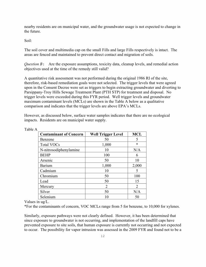
nearby residents are on municipal water, and the groundwater usage is not expected to change in the future. Soil: The soil cover and multimedia cap on the small Fills and large Fills respectively is intact. The areas are fenced and maintained to prevent direct contact and migration of soils. Question B: Are the exposure assumptions, toxicity data, cleanup levels, and remedial action objectives used at the time of the remedy still valid? A quantitative risk assessment was not performed during the original 1986 RI of the site, therefore, risk-based remediation goals were not selected. The trigger levels that were agreed upon in the Consent Decree were set as triggers to begin extracting groundwater and diverting to Parsippany-Troy Hills Sewage Treatment Plant (PTH STP) for treatment and disposal. No trigger levels were exceeded during this FYR period. Well trigger levels and groundwater maximum contaminant levels (MCLs) are shown in the Table A below as a qualitative comparison and indicates that the trigger levels are above EPA’s MCLs. However, as discussed below, surface water samples indicates that there are no ecological impacts. Residents are on municipal water supply. Table A
Contaminant of Concern Well Trigger Level MCL Benzene 50 5 Total VOCs 1,000 * N-nitrosodiphenylamine 10 N/A BEHP 100 6 Arsenic 50 10 Barium 1,000 2,000 Cadmium 10 5 Chromium 50 100 Lead 50 15 Mercury 2 2 Silver 50 N/A Selenium 10 50
Values in ug/L. *For the contaminants of concern, VOC MCLs range from 5 for benzene, to 10,000 for xylenes. Similarly, exposure pathways were not clearly defined. However, it has been determined that since exposure to groundwater is not occurring, and implementation of the landfill caps have prevented exposure to site soils, that human exposure is currently not occurring and not expected to occur. The possibility for vapor intrusion was assessed in the 2009 FYR and found not to be a
13
concern. The low levels of VOCs and the lack of habitable structures on the site indicate that vapor intrusion is still an incomplete pathway and is expected to remain so unless site conditions or use change dramatically. Although the ecological risk assessment screening and toxicity values used to support the 1986 ROD may not necessarily reflect the current values, the landfill cap will eliminate any potential risk from surface soil contaminants to terrestrial receptors. Further, the surface water concentrations from the 2012 sampling data are all below the river trigger levels. Consequently, the exposure assumptions remain appropriate and thus the remedy remains protective of ecological resources. Based on the review of the April 2014 surface water data (Year Eleven Annual Operations and Maintenance Report, July 2014) from the Whippany River, it appears that there was one exceedance from sampling location W3. The mercury concentration from sample location W3 was 0.92 ug/L which is in between the NJDEP surface water ecological screening acute (1.4 ug/L) and chronic (0.77 ug/L) criteria. However, nothing was reported for mercury in the field duplicate sample so there may be some uncertainty with the reported value. Consequently, the surface water monitoring should be continued to evaluate this potential exceedance in the future. There is no indication of change of land use, however, the institutional controls recommended in this FYR states that intrusive activities will not be allowed to affect the protectiveness of the remedy. Questions C: Has any other information come to light that could call into question the protectiveness of the remedy? The PRPs submitted a letter dated January 28, 2014, requesting to discontinue the groundwater extraction system at the Large Fills until such time a well trigger level is exceeded. In order to conduct the second baseline study, in accordance with the Consent Decree, the extraction system of the large Fill areas was shut down on August 18, 2014. The system will equalize and then quarterly sampling of the monitoring wells will be conducted to determine if the contaminants have exceeded the well trigger levels. Issues, Recommendations and Follow-up Actions See Table 4. Protectiveness Statement The implemented remedy currently protects human health and the environment because all exposure pathways have been addressed by the engineered remedy. However, in order to be protective in the long term, deed notices restricting future use of the property need to be put in place and the effects of turning off the treatment system need to be evaluated.

14
Next Five-Year Review The next FYR report for Sharkey Landfill Superfund site is required five years from the completion date of this review.

15
Site Map

16
Table 1 – Site Chronology
Event Date(s)
The Sharkey Farm Landfill site (site) was used as a pig farm 1930s
Landfilling operations began 1945
The landfill began accepting hazardous waste from the Ciba-Geigy Company
1962 – 1969
Approximately 25,700 tons of non-chemical wastes and approximately 1,160 tons of liquid and/or chemical wastes were deposited at the site.
April 13, 1972 – May 10, 1972
The site ceased landfill operations September 9, 1972
It was reported that about three million gallons of wastewater of unknown composition were taken to Sharkey Disposal-Pine Brook
1972 – 1974
The site remained inactive until excavation began for the expansion of the Parsippany-Troy Hills Sewer Treatment Plant
1979
The expansion project was completed 1981
The site was included on the National Priorities List September 1983
A remedial investigation and feasibility study was conducted by various contractors for the New Jersey Department of Environmental Protection (NJDEP)
December 1983 - September 1986
EPA selected a remedy which was described in a ROD
September 29, 1986
NJDEP initiated the Remedial Design in March 1987 March 1987 – April 1994
EPA issued an Explanation of Significant Differences to change the capping requirement to limited capping and to modify the cap material
October 4, 1993
EPA became the lead agency for the site April 1994
A consent decree was issued to the Potential Responsible Parties (PRP aka the Group)
December 4, 1994
EPA approved the Revised Final 100% Design Report
May 9, 2000
The Group solicited bids to hire a construction company June 5, 2000
The Haseley Construction Company, Inc. was awarded the contract June 29, 2000
EPA approved the remedial action work plan July 21, 2000
Site mobilization activities began August 7, 2000

17
Event Date(s)
A pre-construction meeting was held August 9, 2000
Construction activities began September 5, 2000
The Haseley’s contract was terminated by the Group because of financial difficulties and poor work performance
August 27, 2001
HMAT Services, PRP responsible for the Northwest-North Fill area, started remedial action activities
May 2002
Sevenson Environmental Services was hired as an interim contractor to complete construction activities at the site
May 29, 2002
EPA approved the technical specifications and revised grading plans, referred to as the Remedial Design for the Northwest-North Fill Area
August 15, 2002
A pre-construction meeting was held and HMAT awarded a construction contract to American Environmental Assessment for the Northwest-North Fill Area
August 28, 2002
The Group performed baseline groundwater sampling August and September 2002
Construction activities commenced at the NWN Fill area September 3, 2002
EPA and the Group conducted a site inspection September 27, 2002 EPA inspected the Northwest-North Fill area and observed that remediation activities were substantially completed
October 4, 2002
Substantial completion of remediation activities appeared to have been achieved
October 24, 2002
Proposal for Classification Exception Area Equivalency submittal for the site
January 14, 2003
EPA requested a corrective action plan, since it was determined that substantial repair work would be required to restablize some of the slopes and drainage channels
January 29, 2003
EPA conducted a second pre-final site inspection following a rainstorm event
September 19, 2003
A site visit confirmed that the cap repairs appeared to be effective. Remedial construction activities at the site were substantially completed
December 29, 2003
EPA issued the Preliminary Close Report March 9, 2004 The Remedial Action Certification Report was approved September 29, 2005 Commencement of five-year review October 2008 FYR Site Visit April 24, 2014 Northwest-S and Northwest-North site visit July 17, 2014

18
Event Date(s) Installation of M-17A to replace M-17 at Northwest-N Fill area August 16, 2014 Shut down of extraction system for second baseline study August 18, 2014
Table 2 - Documents, Data, and Information Reviewed in Completing the Five-Year Review Annual Operations and Maintenance Reports, Golder Associates Consent Decree, EPA, December 2, 1994 Five-Year Review Report for Sharkey Landfill Superfund Site, May 26, 2009 Groundwater Monitoring Report Second Quarter 2008 Monthly Progress Reports, Parsippany-Troy Hills Operations and Maintenance Plan Record of Decision, EPA, September 29, 1986

Table 3

Table 4 - Recommendations and Follow-Up Actions
Issue Recommendations and Follow-up Actions
Party Responsible
Oversight Agency
Milestone Date
Affects Protectiveness (Y/N)
Current Future The Northwest-North Fill area appears to have potential for commercial use.
Deed notices need to be established to limit potential development options. An advisement of existing soil cover and potential underlying waste material should be noted.
EPA 9/2015 No Yes
The Southwest Fill and Northwest-South Fill areas are within or adjacent to property that is considered preserved open space.
This should be confirmed and a similar deed restriction may be advisable.
EPA 9/2015 No Yes
Aquifer samples are not being collected in shallow aquifer immediately downgradient of large Fills area.
Collect data and evaluate the need to restart extraction system and verify that Well Trigger levels are not in exceedance.
PRP
EPA
12/2015
No
Yes