Final Technical Teport ONR Grant N00014-03-1-0564 ... · California Coastal Venrick, SIO 28 SIO...
12
Final Technical Teport ONR Grant N00014-03-1-0564 Satellite Communication to Research Vessels at Sea: High-Seas ROADNet. Introduction Oceanographic research vessels are the laboratories of the ocean sciences playing, an essential role in unraveling the physical, chemical and biological feedback loops that relate oceanic pro- cesses to Earth and climate systems. While new remote sensing techniques, smart floating plat- forms, and autonomous underwater vehicles represent the cutting edge of ocean technology the U.S. academic research fleet (Table 1) is the primary tool by which oceanic knowledge has been and will be obtained. This fleet will continue to be central to the development of understanding whether directly, by facilitating shipboard oceanic research, or indirectly, by deploying autono- mous vehicles, servicing moorings or calibrating remote observations. 160T 135*W 90*Yw 45*W 0. 45"E WE 135"E ISO' STN ST3N A•ON 2rI " -' _____A Mb SON 40N' 40 N '• 1 rJ 1r "? ,~ 40"S Stri7 ___ 20"o 2 6S 1 4 63 13120iS _ _S 7_ SA3 1- a 4 4s FiurLeqetso Sj 4 . ~ 6 sl. "I V gos" rs' 5o' 13w o s' OE •a• • Figre . Rquets orUNOLS ship use during the period 1998-2003. The numbers mn red give the number of requests for ship time in each of these major ocean regions. The solid red lines show the limits of coverage of the existing HiSeasNet Teleport. The dashed green and the solid blue line show approximately the expanded coverage provided by the additional Teleport equipment proposed herein. 1 050 16 20014 050I
Transcript of Final Technical Teport ONR Grant N00014-03-1-0564 ... · California Coastal Venrick, SIO 28 SIO...

Final Technical TeportONR Grant N00014-03-1-0564Satellite Communication to ResearchVessels at Sea: High-Seas ROADNet.Introduction
Oceanographic research vessels are the laboratories of the ocean sciences playing, an essentialrole in unraveling the physical, chemical and biological feedback loops that relate oceanic pro-cesses to Earth and climate systems. While new remote sensing techniques, smart floating plat-forms, and autonomous underwater vehicles represent the cutting edge of ocean technology theU.S. academic research fleet (Table 1) is the primary tool by which oceanic knowledge has beenand will be obtained. This fleet will continue to be central to the development of understandingwhether directly, by facilitating shipboard oceanic research, or indirectly, by deploying autono-mous vehicles, servicing moorings or calibrating remote observations.
160T 135*W 90*Yw 45*W 0. 45"E WE 135"E ISO'STN ST3N
A•ON 2rI " -'_____A Mb
SON
40N' 40 N
'• 1 rJ 1r "? ,~
40"S Stri7 ___ 20"o
2 6S 1 4 63 13120iS
_ _S 7_ SA3 1- a 4 4s
FiurLeqetso Sj 4. ~ 6 sl. "I V
gos" rs' 5o' 13w o s' OE •a• •
Figre . Rquets orUNOLS ship use during the period 1998-2003. The numbers mn red give thenumber of requests for ship time in each of these major ocean regions. The solid red lines show thelimits of coverage of the existing HiSeasNet Teleport. The dashed green and the solid blue line showapproximately the expanded coverage provided by the additional Teleport equipment proposed herein.
1 050
16 20014 050I

This grant supported the acquisition of satellite communications systems, now call HiSeasNet (www.hiseasnet.net), to provide continuous Internet connectivity for oceanographic research ships andplatforms. In the same way access to the Internet is an integral part of nearly every research lab andoffice on land, extending this access to oceanographic ships - our seagoing laboratories, will havethe broadest impact on all seagoing research activities. For the ships, HiSeasNet impacts all aspectsof seagoing research activities including:
"* Transmission of "hot" data in real-time to shore-side collaborators;
"* Providing basic communications between the research vessel's scientists, engineers andcrew - both email, voice and video teleconferencing;
"* Provide valuable and exciting tools for real-time educational interactions between ship-board scientists and teachers and the classroom.
Specifically, this grant provided funds for a major enhancement of the fledgling HiSeasNetdesigned to provide continuous shipboard connectivity to the global Internet for the academicresearch ships of the University-National Oceanographic Laboratory System (UNOLS, ht: ILIunols.org/. See Table 1). The UNOLS fleet, operated by some 20 academic institutions in theUS, is used to conduct almost all of the seagoing oceanographic research done by US academicresearchers, as well as being used widely by US Government scientists.
Until recently communications between ship and shore were limited to radio voice communicationsand quite limited, low-speed and expensive email systems. For example, the widely used INMAR-SAT satellite terminals are relatively inexpensive to buy, but the tariffs are high when calculated ona $ / MB basis. While it can provide sustained throughputs up to 8 kBytes / s for file transfer type ap-plications at a cost of about $25/ MB, more typical Internet usage costs are about 4 times this amount- nearly $100/MB.
Recent advances in antenna and modem technology coupled with decreasing costs for communi-cations circuits has now made it practical to use continuous intermediate-speed (>64 kbps) duplexcommunications to provide Internet services to oceanographic ships at sea for delivery of dataashore and communications with scientists and engineers on the ship.
With funding from the NSF, and the State of California, we implemented the first stages of HiSeas-Net. In early 2002 we installed a satellite terminal on the R/V Roger Revelle, and leased service froma commercial teleport to provide a 64 kbps full-period connectivity between the ship and the publicInternet. Funds from this grant supported the installation of a 7m Teleport or hub antenna at theSan Diego Supercomputer Center, with coverage over much of the Pacific Ocean (see Figure 1) andships' systems for a second SIO ship, the RIVMelville, and the R/V Thomas Thompson operated by theUniversity of Washington.
As an example of typical research use of large oceanographic research vessels, we summarizebelow the cruises and scientific parties who benefited directly and immediately from HiSeas-Net during the first year of operation of the system on the R/V Roger Revelle. Comments frommany of these individuals are included in section C.
2

Student RaIg MacDonald, 3 UCSB scientists, 10 UCSB undergrads, 7 UCSB grad students,UCSB 1 sci. each from SDSU, U. of So. Carolina and OSU, 3 foreign
observers (1 UABC, 2 CICESE), 2 UABC grad students, 3 SIOtechnicians, 1 SDSU technician.
Multi-Diciplinary (2- Wheeler, OSU OSU - 7 scientists, 11 technicians, 3 grad students. 1 WHOIship) ________________ scientist, 2 WHOI technicians, 2 SIO technicians.
'Show-and-Tell CAL- Goericke, SIO Various politicos, scientists and techs to who-and-tell, etc. - incl.COFI __,__________,__ Kennel, Knox ......
California Coastal Venrick, SIO 28 SIO scientists, 3 SIO techs, 1 scientist Point Reyes Bird Ob-Currents servatory, 1 USC grad student, 1 observer, 1 K-12 teacher
ATV Testing Zumberge, UCSD 4 SIO scientists, 7 SIO techs, 3 Oceaneeering Technology techs.
Naval Hydromechanics Terrill, SIO 2 SIO scientists, 7 SIO technicians, 3 UCSD undergraduates, 2Caltech scientists, 1 Univ. of NH scientist, 3 Kongsberg-Simrad
______________________________technicians, 1 Viosense tech.
HawaiianOcean Mix- Luther, UH 2 UH scientists, 1 UH tech, 4 UH grad students, 2 UH under-ing Experiment grads, 1 OSU scientist, I OSU tech., 2 SIO techs
Hydrographic and Karl, UH 10 UH scientists, 2 SIO techs.Biogeodienulcal ___________________
Ocean Acoustics Porter, SAIC 3 SAIC, 1 SIO, 2 UW, 2 UDel, 1 NUWC, 3 UNH, 2 SPAWAR.Technicians -4 SIO, 2 UW, 1 SSI, 1 RESON, 1 SPAWAR, 1
__.... . _ _ UDel. Grad students - 1 SIO, 1 UDEL
Biocomplexity Michaels, USC 1SIO, 3 UH, 5 UMd, 6 USC, 1 WHOI, 4 SFSU, 1 Ga.Tech.,2 UConcepcion, 1 UCLA. Grad students - 1 UMd, 1 UGa, 1UCLA, 5 USC, 1 Princeton, 1 SFSU, 1 UCSB. Techs - 1 SFSU, 4
___.............. __ _ USC, 3 SIO
Marine Geophysics Chadwell, SIO 5 SIO scientists, 3 SIO grad students, 2 observers, 3 volunteers,2 SIO techs.
Multibeam Seismsics Lonsdale, SIO 2 SIO scientists, 1 SIO grad student, 7 SIO techs., 3 Mex. ob-servers, 1 Japanese observer, 1 SIO observer
Mooring Servicing & Weller, WHOT I WHOI, 1 NOAA/ETL, 2 UColo. Technicians- 4 WHOI,"Teacher at Sealcruise 3 SHOA (Chile), 2 NOAA/PMEL, 1 SAIC, 1 NOAA/ETL, 1
NOAA/OGP, 1 Ecuador Navy, 3 SIO. 1 TAMU grad student. 3_ __ foreign observers, 1 US observer (teacher at sea)
Plate Dynamics & Chadwell, SIO 4 SIO scientists, 3 SIO grad students, 3 SIO techs., 1 foreignAcoustic . observer.
B. Description of HiSeasNet.
The use of satellite services for Internet traffic between the oceanographic fleet and shore canbe distinguished from other applications by the asymmetry of its traffic pattern. The systemrequirement is primarily to carry data from the ship to shore, rather than to provide IP ser-vices to the ship. This is in contrast to systems designed primarily to deliver data services to
3

the ship. This fundamental design criterion leads to considerable cost differentials, because itis much more expensive to send information from shore to the high seas than it is to send datafrom the high-seas to shore with systems of practical design.
There are a number of companies that offer "turn-key" Internet service to ships. A typicalcustomer is a cruise ship line that wants to offer a variety of services to its clientele such as:web access, email, electronic banking and ATM machines, electronic newspaper delivery andvideo streaming. The basic idea for these customers is to bring "shore to the ship," in contrastto the oceanographic research community which wants to bring the "ship to the shore". In thecruise-ship environment, each vessel receives a broadband outbound multi-cast. Such systemsprovide high-speed broadcast data delivery, currently up to 2 Mbps per broadcast. The net-work architecture allows a base station to transmit a large bandwidth carrier to a single ship orto a group of vessels. Each ship receives the entire volume of traffic destined specifically for allthe vessels in a particular group. The ship's router selectively filters the information addressedto a particular network, dropping all other traffic. Typical recurring costs for these turn-keysystems are about $10k/month for each ship in the network.
The architecture of the HiSeasNet satellite communication system, in contrast, is designed toaccommodate multiple ships and oceanographic platforms whose principal traffic patterns willbe inbound to the shore. It is based on a "star" configuration, with each ship having a directsatellite connection to the HiSeasNet Teleport facility. Communications between each ship andthe Teleport is carried on dedicated duplex satellite circuits that can be sized according to re-quirements or needs of the particular ship's research operation.
In order to provide coverage over the open oceans we have chosen to utilize the global beamsof the Intelsat system satellites. This fleet provides coverage of the entire globe at latitudes lessthan about 74'. For coverage of coastal waters, extending out to Hawaii and over considerableportions of the North Atlantic, we plan to use a single domestic Ku-band satellite.
The use of a single land-based "hub" facility as the center of communications allows the in-vestment in and management of this facility to be shared among all of the ships. Under normaloperations, channels will be at least 96 kbps from ship-to-shore and share a 64 kbps (point-to-multipoint) channel from shore-to-ship. The reason for this lack of symmetry has to do withthe ship's antenna size relative to the Teleport antenna size - the architecture is designed tomake maximum use of leased satellite resources.
For the larger ships, a 2.4 meter radial offset antenna with a 3-axis servo controlled stabiliza-tion system is housed in a 3.7 meter diameter radome (Figure B.1). For the smaller regionaland coastal ships, the antenna is only 1.2 meters housed in a proportionally smaller radome.The antenna beam direction is locked onto the signal transmitted from the satellite by the 3-axis servo to a precision of better than 0.2 degrees under the following conditions.
"* Tangential acceleration < 0.5G in 6 seconds"* Roll stabilization amplitude < ± 25 degrees"• Pitch stabilization amplitude < ± 15 degrees"* Rate (all axes) <90 degrees/s"* Acceleration (all axes) <60 degrees/s2
The Teleport (Figure B.2) houses the modems and central router with a direct fiber connectionto the main UCSD Internet switch. This router, and related software systems, allow the man-
4

Soff ... Figure B.1 The leftpanel shows theSeaTel Antennawith the radomehalf completed. Theright panel showsthe C-Band antennalocated starboardside aft above thebridge of the RIVRoger Revelle.
agement and control of the shared circuit out to the ships.This allows prioritization of certain applications (FTP orVoIP) over other less critical applications (web traffic), aswell as insuring that the bandwidth is distributed equitablyand efficiently among the ships. This router also can be usedto provide necessary security.
Due to the smaller antenna on the ships, the link from theshore to the ships is the most expensive in terms of transpon-der power and operating costs. A common shared carrierat a data rate between 64 kbps and 128 kbps is envisionedto support a set of two to four ships. The ships would shareseveral carriers from the central facility, and local routers oneach ship would extract their relevant data packets from thereceived stream.
The modems we are using, Comtech CDM- 550, are low-cost units designed for single channel-per-carrier circuits.They support data rates between 2.4 kbps and 2048 kbps in1 bps steps insuring that we can tailor our circuit speeds to
network, the HiSeasNet Teleport, is maximize utilization of leased bandwidth. They implement
located on the roof of the San Diego a recently developed forward error correction techniqueSupercomputer Center. It consists of called Turbo Product Coding (TPC) to decrease significantlya 7m antenna, controllers, modems the resources required to run the network. This reduces theand routers connected directly to the most expensive part of the system, the transponder leasemain UCSD Internet switch, provid- costs. TPC, theoretically derived in the early 1990s, and nowing direct connection to the Internet commercially available, allows satellite data transmissionbackbone. By using a single, shared7m class Earth station at the Teleport, using 30% less transponder power than the previously used2.4m antennae can be used on the Reed-Solomon/Viterbi decoding, and 60% less power thanships. This minimization of ship- Viterbi decoding alone. This is particularly important for useboard antenna size is critical due to with small antennae where flux density issues are important.the more difficult physical environ- This power savings directly translates into reduced monthlyment, requiring specialized motor-ization and tracking equipment. operating costs for the satellite transponder, as well as re-
duced antenna size requirements. A special feature of thesemodems is the ability to monitor and control the distant endof the satellite circuit.
5

The modularity of the network design allows for easy expansion of services, in terms of appli-cations, data rates, and number of ships supported. By using IP as the basic protocol, any ap-plication based on IP can be added to the services. Increasing the data rates supporting thoseservices can be easily done by simply procuring additional satellite transponder capacity andre configuring the existing equipment. Additional ships can be brought online through thesimple addition of another satellite modem at the central facility. Overall, this network allowsfor flexible adaptation and scalability with regard to services, capabilities, and users.
The current Teleport antenna covers the area shown in the left panel of Figure B.3 (See alsoFigure A.1).
Figure B.3. The coverage offered by INTELSAT 701 at longitude 1800 (left panel) and 703 atlongitude 53* W (right panel). The dashed white circle indicates the loci of positions with a 100elevation angle, the practical minimum for good, continuous coverage.
I | II m m m m6
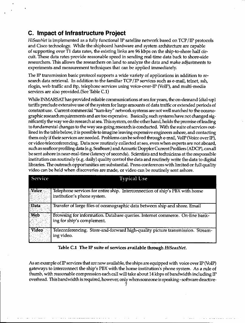
C. Impact of Infrastructure ProjectHiSeasNet is implemented as a fully functional IP satellite network based on TCP/IP protocolsand Cisco technology. While the shipboard hardware and system architecture are capableof supporting over Ti data rates, the existing links are 96 kbps on the ship-to-shore half cir-cuit. These data rates provide reasonable speed in sending real-time data back to shore-sideresearchers. This allows the researchers on land to analyze the data and make adjustments toexperiments and measurement techniques that can be applied immediately.
The IP transmission basic protocol supports a wide variety of applications in addition to re-search data retrieval. In addition to the familiar TCP/IP services such as e-mail, telnet, ssh,rlogin, web traffic and ftp, telephone services using voice-over-IP (VoIP), and multi-mediaservices are also provided.(See Table C.1)
While INMARSAT has provided reliable communications at sea for years, the on-demand (dial-up)tariffs preclude extensive use of the system for large amounts of data traffic or extended periods ofconstant use. Current commercial "turn-key" network systems are not well matched to the oceano-graphic research requirements and are too expensive. Basically, such systems have not changed sig-nificantly the way we do research at sea. This system, on the other hand, holds the promise of leadingto fundamental changes to the way sea-going research is conducted. With the suite of services out-lined in the table below, it is possible to imagine leaving expensive engineers ashore, and contactingthem only if their services are needed. Problems can be solved through e-mail, VoIP (Voice over IP),or video teleconferencing. Data now routinely collected at sea, even when experts are not aboard,such as seafloor profiling data (e.g. SeaBeam) and Acoustic Doppler Current Profilers (ADCP), can allbe sent ashore in near-real-time (latency of seconds). Scientists and technicians at the responsibleinstitution can routinely (e.g. daily) quality control the data and routinely write the data to digitallibraries. The outreach opportunities are substantial. Press conferences with limited or full qualityvideo can be held when discoveries are made, or video can be routinely sent ashore.inttto' phn ystem.Data Transfer of large files of oceanographic data between ship and shore. Email
-Web Browsing for information. Database queries. Internet commerce. On-line bank-mng for ship's complement.
Video Teleconferencing. Store-and-forward high-quality picture transmission. Stream-ing video.
Table C.1 The IP suite of services available through HiSeasNet.
As an example of IP services that are now available, the ships are equipped with voice over IP (VoIP)gateways to interconnect the ship's PBX with the home institution's phone system. As a rule ofthumb, with reasonable compression each call will take about 14 kbps of bandwidth including IPoverhead. This bandwidth is required, however, only when someone is speaking - software deactive-
7

ates the circuit for the 60% of the time there is no conversation. So in reality an average of less than 6kbps are used.
The savings afforded by the VoIP phone calls that would otherwise have to use INMARSATare significant. During a recent one week period on the R/V Roger Revelle, the system logged205 calls for a total of 8 hours for a savings of nearly $1500 over the INMARSAT voice rate of$3/min.The systems and techniques developed for HiSeasNet will be directly applicable the goals ofthe Ocean Observatories Initiative, a NSF Major Research Equipment and Facilities Construc-tion (MREFC) program, part of the ORION (Ocean Research Interactive Observatory Net-work) program to provide ocean observing capabilities to the research community throughlong-term platform in (and under) the oceans. With the deployment of a fleet of unmanneddeep-sea platforms intended for long term deployments, the system proposed herein will givethe land-based researchers full access to their instruments (all IP addressable) on these plat-forms and on the sea floor.
The goal of the proposed system is to provide basic Internet connectivity to the academicresearch fleet over the entire Atlantic and Pacific Oceans. While the impact on scientific workaboard ships is likely to be fundamental, the potential uses of HiSeasNet for education and out-reach activities are substantial.
A good example of such use for integration of research and education is a recent partici-pation of two middle school teachers in the NOAA Teacher at Sea program (See hitW:L/www.tas.noaa.gov/ and http:Ilwww.ogp.noaa.govlootas/index.html) aboard the RIV Roger Revelle.
Now in its 12th year, the program has enabled more than 360 teachers to gain first-hand expe-rience of science at sea. Teachers can enrich their classroom curricula with a depth of under-standing made possible by living and working side-by-side, day and night, with those whocontribute to the world's body of scientific knowledge. The enthusiasm for learning generatedbetween teachers and students is the biggest payoff of NOAA's Teacher at Sea program, whereteachers from elementary school through college go to sea aboard NOAA research and surveyships to work under the tutelage of scientists and crew.
Ms. Debra Brice is a middle school science teacher at San Marcos Middle School in San Diegoand Ms. Viviana Zamorano is a middle school science teacher at Escuela America in Arica,Chile. Debra and Viviana embarked on the Revelle from Ecuador on November 10, 2003 andtraveled for three weeks to Arica, Chile.
While onboard, Debra and Viviana maintained daily logs, took photographs, interviewed sci-entists, and answered students e-mail. The highlight was a live teleconference between Debraand her class in San Marcos using HiSeasNet.
Below are some of her post-cruise comments:
"As a K-12 educator, being able to bring science as it happens into my classroom is a trulyexciting teaching tool. My students were really excited at the idea that they could see meand talk to me in another hemisphere in the middle of the ocean (I was only 800 miles offthe coast of Chile, but that is the middle of the ocean to them). They had never thought ofactually going out in the middle of the ocean to study it, collect data and do experimentsand they found it fascinating. They had questions about what it was like to be on the ship,
8

what we ate, where we slept, out daily work schedules. Everything was different and inter-esting and sparked their imaginations.
Using HiSeasNet to share the excitement of doing science, real time data and the value ofcollecting data at sea could be an invaluable tool in inspiring an interest in ocean science intoday's youngsters.
As a teacher, the ability to use examples of ongoing research in my teaching makes it pos-sible to give value to the skills and concepts I am teaching. HiSeasNet could be used tobroadcast interviews with scientists, live broadcasts of experiments as they happen (watch-ing a CTD cast or the results of a plankton tow for example) and even something as simpleas giving a lecture on techniques of oceanography in my class could be augmented by avirtual tour of an oceanographic vessel by using the stationary cameras. My students areaccustomed to watching Discover Channel videos about hydrothermal vent communities,but the difference between a video and actually seeing science as it happens is immense.
I am not sure if you wanted even more concrete ideas of how the HiSeasNet could be used?I am working on a website now that I will use as I try some broadcasts on an upcoming legof the Melville. I am working on a virtual classroom in my classes. Interviews with scien-tists and tours of facilities that can be experienced in my classroom are examples of poten-tial educational outreach by scientists that can be easily available to all schools and easy toaccess for the scientists also.
Please let me know if you need something more specific or detailed. Again, I really hopethis helps with the acquisition of additional equipment. Ultimately my dream would bethat through HiSeasNet my students and many others could watch as we go to the bot-tom of the Marianas trench. Imagine how exciting that would be, as exciting as when wewatched men walk on the moon for the first time ( only better reception:). Oceanography isreally that exciting and HiSeasNet could bring that excitement to a lot of students."
Some additional comments from Chief Scientists, Engineers and Ship's Captain give an idea ofthe impact of this system and are included below.
I was very pleased with the system, especially since I had the pleasure of using the system on its maiden voyage. I'm gladto hear the system was moved, not only from the signal acquisition standpoint, but from a real estate standpoint since itdid take up quite a bit of upper deck space.With no insight on costs to operate the system, my views are only from the perspective of the utility of the connection(with no cost-analysis to bias those views).
* With the prevalent use of email to speak With program managers/funding agencies as well as coordination of multi-inves-
tigator experiments - the email connection allowed rapid response to fires on shore.* We used the system for trouble-shooting equipment and to speak with a shore-side engineer who assisted in fabricating
equipment. A video conference was also set up that allowed discussion of some of the measurement efforts.* Connection on the home-front made it easier to be away.
I'm sure the proposers have covered their bases in all the various benefits such a system would have to the science commu-nity at large. One immediate application would be the utility of downloading satellite remote sensing data and/or exchang-ing data with other ships in adaptive sampling efforts.
9

Would the upgrades/expansion they have proposed be viable under the 2002 Shipboard Scientific Support Equipmentproposal? If all $'s dried up to support the system, I would support the use of Revelle or UC marine funds to support thecontinued operation as I believe when properly advertised to the broader marine community, it could be a money maker.
Having used the system now for a month, I can say that this is a clear advantage for seagoing work. Aside from the conve-nience of real-time email for all, which is wonderful, some obvious uses were employed on my cruise.1) When repairing the broken load cell in the stbd crane, we tested it with a tester that read in tons, but did not state whichtype of tons. With web access, we tracked the tester to the mfg in Israel and determined that the unit measured metric tonsin an hour or so. knowing the wire tension was critical to our effort, and being able to find this information when the mfg.was closed (middle of the night in israel) let us proceed with confidence.2) We had several people working at sea on another project, bottom fish habitat in the Pacific Northwest. They were therebecause the collapse of rockfish fisheries brought about imminent closures of the continental shelves on the west coast thatare being implemented as I write. The closure boundaries are based on our work, and we were able to produce the GISfiles needed and ftp them off the ship in real time as we worked toward tight deadlines.3) When we lost some coring gear, and needed to initiate immediate replacement, we were able to communicate thatand discuss it with shore folks in real time, so that building of new gear, and shipping of some spare parts to us (held atMBARI in case we needed them) began hours after the gear was lost. Because of this, other cruises slated to use this gearimmediately after ours, were not impacted by the significant loss we sustained.
I think this system should be implemented on all UNOLS ships ASAP. We used it for some utilitarian sorts of things, andit really helped In the future I can envision much wider use for education, real-time science with investigators not on theship. Perhaps near-time data processing ashore of some type and transmission of results to the ships.
Overall, the bandwidth provided by the ROADNet system has been a positive experience. As with any information chan-nel it requires some discipline to use it effectively. Primarily the benefits have been administrative -- permitting us tocontinue to stay-in-the-loop and contribute directly to activities ashore (planning, proposal writing, etc) and operational --grabbing update s/w from shore-based web-sites and checking upon remote data collection. So far, we have not envisioneda direct scientific benefit to our current operations, but that's because we've designed it to be self-contained and I suspectideas on exploiting this new capability will begin to surface.7/24 coverage is still a goal, not yet a reality. Moving the antenna/dome to atop the chart house has helped (As you areaware I was aboard during a Hawaii leg and the first trip following the SD port stop when the dome was moved from 02forward to atop the chart house). Even after the move, depending upon the heading the signal was blocked enough by themain mast to disrupt service. On the one hand, this is not really a problem -- everyone just has to wait a bit for email etc-- , but it does create an additional operational interaction in that it can prompt requests to the bridge to adjust the heading10-20 degrees to regain the signal. I would suspect this might become tiring for the mates after some time. It appears thatthere is not much that can be done about the main mast interference so if continuous coverage is the goal it will requiresome additional effort or gear (two radomes?).There should probably be some thought put into a set of protocols/procedures for the web-cams -- perhaps only on-linewhen the Chief Scientist and Capt. determine that something is worthwhile for the public. I guess the best way to say thisis that when at sea the lab becomes your office. Even ashore in your office you cannot have all the activity and transac-tions being broadcast. Additionally, the Capt. expressed some concerns -- not sure of the nature -- about 24/7 web-cam ofthe after-deck.In addition to the 7/4 coverage it would be best for SIO if wide spatial coverage was possible -- to avoid the negativereaction of ship users when moving out of the coverage area. It did appear that the ROADNet was a morale booster forthe crew. Not sure how helpful these comments are in regards to a proposal submission, but our cruise's productivity andeffectiveness was been improved by this capability.
The satellite communications upgrade was a major improvement to our student cruise. In the future I can see expandingthe effectiveness of my seagoing course significantly using this system. In addition to the 20 undergraduate and graduatestudents I was able to bring out to sea for hands on experience for 5 days, we could have a larger group of students backat campus deriving at least some of the lessons to be learned by going to sea. I think this will be a very powerful outreachand educational tool esperially for undergnraduate and K-12 education-
10

4,
Thank you for your note on proposed improvements to the Satellite Internet System. These days it's not hard to explain toanyone the value of an Internet connection on land. At sea the value is vastly greater since other means of communicationsare often much less practical. Of course I don't know the costs relative to other proposed investments, but I can say that theSatellite Internet System was of tremendous value during our recent Kauai Experiment. I expect that anyone that has sailedon a ship with that capability would sorely miss it on another vessel that lacked it. Extending coverage to the Kilo Moana
finding it far less reliable than Revelle's link.On a more personal level, we were on Knorr in the Black Sea during the Iraq war and couldn't get even minimal newsbecause WHOI had cut off their previous new service to save money. Everyone in my group was wishing they were on
Revelle.aGeologists aboard The RVn Revelle asked the shore based Gefr hco ing Anaelyst forthme advice in processing their fo
channel seismic reflection data. 73MB of data were transferred from the ship to a shore based computer so that the analyst
could examine the problem dataset. The 2.75 hours of seismic data took had to hus to transfer.The analyst noticed that one of the seismic traces was inverted in polarity and that the stack (addition) including theinverted trace was significantly inferior. As a result of this interaction between ship and shore based personnel, the seismicimage produced on the ship was significantly improved.
[Note: At this time the ship to shore circuit speed was 64 kbps or 8 kbytes/sec. So 2 hours for transfer of a 73 Mbyte filempsnn- thnt in nractice the crjuT~jj wgs rg~chillp itq thenripjtienj ra wlitv I
Having this system in place is very good for crew moral. Being able to communicate via e-mail and telephone is a bigboost. We have used the system to down load chart corrections. Using the system to obtain up to date weather, not other-wise available aboard.- Crew are using the system to "pay bills" on line- Engineers have used the system to find spare parts on line- I have used the internet to research products for the ship.- Down loading information not other wise available from Ships Scheduling ("its on the web")We are still learning what is available. Am certain there will be more uses of the system as we become more familiar withit.
Perhaps I can add a few more SCG uses of the system. Off-the-cuff, these are a few things I have already done from seasince the system became available. This does not include the list of things I have seen scientists do.- Update embedded code on shore side equipment from sea (the VoIP box in particular when we were setting it up)- Download latest patches, drivers, etc.- Automatic update for online virus checking cleaning- Install complex software on the ship while on shore- Reboot, reset, or reconfigure shore side services from sea- Troubleshoot mail/other issues immediately from ship (especially over weekends)- Backup and restore important configuration or source files between ship and shore in real time- Exchange configurations, settings, code, binary files in real time, solving problems in hours, not days.- Send multibeam data from transit legs to scientists leaving the ship.- Send larger photos to shore to explain ship resources (a picture is worth 1000 words sometimes)-Track packages due at the next port stop-Troubleshoot equipment with tech support (over VoIP)- Update/review shore-based documentation in realtime (via our trouble ticket system)- Test network routing and service issues from shore side without the need for someone on shore to be available.
11

j IForm ApprovedREPORT DOCUMENTATION PAGE OMB No. 0704-0188
Public reporting burden tor this collection ot intormation is estimated to average 1 hour per response, including the time tor reviewing instructions, searching existing data sources,gathering and maintaining the data needed, and completing and reviewing the collection of information. Send comments regarding this burden estimate, or any other aspect of this
collection of information, including suggestions for reducing this burden, to Washington Headquarters Services Directorate for Information Operations and Reports, 1215 JeffersonDavis Highway, Suite 1 Z04, Arlington VA ZZZO?-430Z, and to the Utice ot Management and Budget Paperwork Reduction Project (C/14-01 88), Washington, DC ZObUs.
1. AGENCY USE ONLY (Leave blank) 2. REPORT DATE |3. REPORT TYPE AND DATES COVERED
I 9/24/05 IFinal- 03/01/03 - 12/31/044. TITLE AND SUBTITLE 5. FUNDING NUMBERS
Satellite Communication to Research Vessels at Sea: HiSeas ROADNet N00014-03-1-0564
6. AUTHOR(S)
Orcutt, John and Jonathan Berger
7. PERFORMING ORGANIZATION NAME(S) AND ADDRESS(ES) 8. PERFORMING ORGANIZATION
REPORT NUMBER
University of California, San DiegoScripps Institution of Oceanography9500 Gilman DriveLa Jolla, CA 92093-0225
9. SPONSORING/MONITORING AGENCY NAME(S) AND ADDRESS(ES) 10. SPONSORING/MONITORINGAGENCY REPORT NUMBER
Office of Naval ResearchFinal
11. SUPPLEMENTARY NOTES
12a. DISTRIBUTION/AVAILABILITY STATEMENT 12b. DISTRIBUTION CODE
publically available
13. ABSTRACT (Maximum 200 words)Oceanographic research vessels are the laboratories of the ocean sciences playing, an essential role in unraveling the physical, chemicaland biological feedback loops that relate oceanic processes to Earth and climate systems. While new remote sensing techniques, smartfloating platforms, and autonomous underwater vehicles represent the cutting edge of ocean technology, the U.S. academic researchfleet (Table 1) is the primary tool by which oceanic knowledge has been and will be obtained. This fleet will continue to be central to the
development of understanding whether directly, by facilitating shipboard oceanic research, or indirectly, by deploying autonomousvehicles, servicing moorings or calibrating remote observations.
14. SUBJECT TERMS 15. NUMBER OF PAGES
11
16. PRICE CODE
17. SECURITY CLASSIFICATION 18. SECURITY CLASSIFICATION 19. SECURITY CLASSFICATION 20. LIMITATION OF ABSTRACT
OF REPORT OF THIS PAGE OF ABSTRACT
N3N ,( b4U'-U1-LtsU-bbUU ::Stancaro 1or-o z5 Kev. L-5jPrescribed by ANS Std. 239-18
DISTRIBUTION STATEMENTAApproved for Public Release
Distribution Unlimited