Faria Beede-fm-002-0050b-MarineDiagnose & Repair With Faria Beede EntelNet™, your technicians can...
36
Boat Tracking, Monitoring, Diagnostic and Remote Switching Systems RUGGED. REMOTE. RELIABLE.
Transcript of Faria Beede-fm-002-0050b-MarineDiagnose & Repair With Faria Beede EntelNet™, your technicians can...

Boat Tracking, Monitoring,Diagnostic and Remote Switching Systems
RUGGED. REMOTE. RELIABLE.

Monitor & Track
EntelNet™ watches your boats while you are away by monitoring your engines and on-board critical systems. This includes bilge levels, low batteries, power interruption, and engine diagnostics - all while tracking the precise location of your boat.
Secure & Protect
The EntelNet™ system will notify you immediately via e-mail or SMS of any alarm condition or unauthorized movement of your asset. You are instantly notified of detected intrusions and can set up boundary alarms based on GPS coordinates.
Faria Beede EntelNet™ Telematics system is a cellular, wi-fi and satellite-based boat location tracking, monitoring, diagnostic, emergency notification and communication system. Faria Beede’s communication networks includes an extensive network of low-earth-orbit satellites and cellular carriers to provide worldwide coverage and ensure that your connections are not only reliable, but affordable too.
ADVANCED TELEMATICS SOLUTIONS

Diagnose & Repair
With Faria Beede EntelNet™, your technicians can diagnose problems in near real-time. This allows you to find conditions before they become a problem.
Communicate
EntelNet™ systems provides alert notifications, to designated responders, for emergency situations and alerts anywhere in the world.Iridium® satellite e-mail services are available on the WD750 Satellite models. Stay in contact even when you’re away from cell phone service.

Don’t lose connection to your boat
when you leave the dock.
Stay Connected with
Telematics systems from Faria Beede
Wherever you are - 24 Hours / 365 Days a Year

M2M Cloud
Thousands of boats, worldwide,
are connected today with
Marine Link
A cloud based application, no need for internal servers or IT Management, all that’s needed is an Internet connection and staff can access boats in real-time, across town or across a continent.
99.99% service level

Monitor Critical On-board Systems
Bilge Pump
Shore Power
High Water Alarm
Battery Voltage Engine Hours
I/O
Security Alarm
Inside Temperature
GPS Tracks / Routes
Anchor Alarm
Geo Fencing
Weather
Control Lighting, AC/Heater and more with switchable IO.
Telemetry

Get Real-Time alerts from your engine.
Engine Monitoringand Diagnostic AlertsProvides real-time Engine Monitoring that changes the “service paradigm” by eliminating the first service call, reducing warranty cost and improving customer satisfaction.
SMS Notificationse-mail
ON
MONITORINGSmoke Alarm
MONITORINGHigh Water
Icon Legend [ OK][ Warning][ Alert][ AWOL]
701 RPM
60.54 PSI
1.3 Gal/hr
2186.7 Hrs
702 RPM
62.64 PSI
187 ˚F 187 ˚F
1.4 Gal/hr
2186.7 Hrs
Thur July 21, 2016 15:18:24 Thur July 21, 2016 15:18:24Last PositionThur July 21, 2016 15:18:2441˚ 29’ 42.77”, -71˚ 21’ 56.05”0 Knots Heading 0 Deg
Boat
AT&T LTE 2:03 PM
ONEngine Alerts
701 RPMEngine RPM
60.54 PSIOil Pressure
1.3 Gal/hrFuel Rate
2186.7 HrsEngine Hours
OKEngine Alerts
702 RPMEngine RPM
62.64 PSIOil Pressure
187 ˚F Coolant Temp
187 ˚FCoolant Temp
1.4 Gal/hrFuel Rate
n/aEngine Load
n/aEngine Load
2186.7 HrsEngine Hours
Reported: 07/21/16 15:18:24 Reported: 07/21/16 15:18:24
Engine MonitoringPORT STARBOARD
The data is then logged for later review.
When a DM1 code is detected, the alert message is transmitted real-time via e-mail, SMS and by Smart phone notifications to the boat owner’s designated contact.

Telemetry
Current GPS position, engine and
environmental monitoring data is
sent to the cloud servers.
GSM services
provided by,
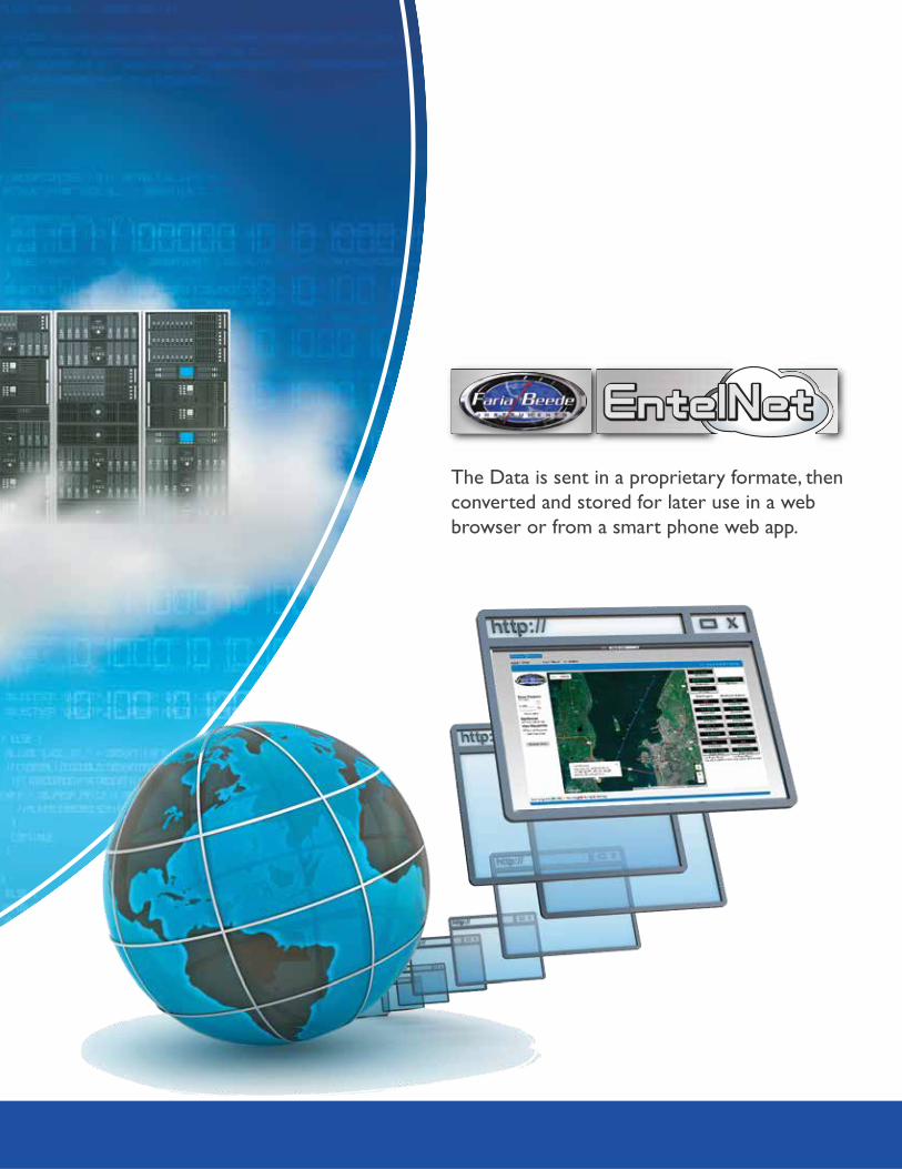
The Data is sent in a proprietary formate, then
converted and stored for later use in a web
browser or from a smart phone web app.

WD100
WD300
WD750
Connected directly to the CAN Bus, Real-World data is sent by the EntelNet™ Wi-Fi module.
The data, GPS speed, Map position, Instrument data and CAN error code information is displayed in an easy to read application built for the Android® operating system and can be view by any Internet capable device i.e. Smart Phone, Tablet or Computer. No wires needed.
With the FB-Sentry installed boat owners can connect directly to their boat from any smart phones or Internet connected device. FB-Sentry web app is included and can be accessed anywhere there is Internet connectivity.
The Faria Beede MTU system provides reliable and cost-effective marine cellular and/or satellite tracking and communications anywhere in the world, including the northern A-4 waters, and has met the demanding requirements of the commercial fishing industry.
WD310, WD315
Monitor your assets location and ambient temperature even without power. This small self contained device monitors your assets location with GPS and supports location with Cellular Tri-location using cellular tower information when GPS signal is not available. WD310 - The rechargeable 5000 mAh lithium battery provides for long term reporting even over long lengths of time, up to 24 months.WD315 - Adds a connection to power and 3 analog inputs.
WD500
The WD500 has all of the same great features of the WD300 and adds Engine monitoring in a water proof enclosure.
An EntelNet™ for any need

Compare
* Can be viewed locally on Internet capable device.
WD100 WD300 WD310 WD315 WD500 WD750
If on CAN network • • •
• •
Ambient Ambient
•
• • •
• •
•
Direct* w/MG3000 Direct
If on CAN network • •
If on CAN network • •
If on CAN network • •
If on CAN network • •
If on CAN network • •
If on CAN network• •
• •
• •
• •3 IO
(200 ma)2 - Gnd sense1- Volt sense
4 IO (500 ma)
•
• •
•
•
•
•
•
Available
•
Direct
•
•
•
•
•
•
•
•
•3 IO
(200 ma)
•
GPS
NMEA2000
SAE J-1939
SmartCraft
MonitorsEngine Monitoring
Bilge Pumps
Battery Voltage
Shore Power
Environmental Temp.
Engine Parameters
Engine Hours
Service Reminders
Logs Daily Boat Data
GPS Tracks and Routes
Inputs/Outputs
Communication
WiFi
Cellular
Iridium Satellite
Yamaha
•Modbus

WD100
Standard Features• No additional costs• Send the engine and other critical data
anywhere in the world to be diagnosed.• Helps reduce warranty costs and can
help lessen repair time. • Data can be viewed on a secure website
for remote systems diagnostics.
Remote Dashboard App
Step 1(Connect to EntelNet™[web browser])
Step 2(Send e-mail)
Step 3(Response)
Made for
Android™
Connected directly to the CAN Bus, Real-Time data is sent by the EntelNet™ wireless module via Wi-Fi™.
The data (GPS speed, Map position, Instrument data and CAN error codes) is displayed in an easy to read website by web browser or can be displayed on an Android™ device i.e. Smart Phone, Tablet using the Faria Beede app.The engine information can then be sent to a repair facility, via e-mail, giving your repair technician a heads up that you’re having problems.
TM
Faria Beede app built for Android™
WD100
• Standard and Secondary instruments • Tank monitoring and control• Fuel Management• Error Codes
iOSComing Soon!

L: 5.93” (151 mm) W: .46” (12 mm)H: 2.02” (51.3 mm) Wg 3 oz. (85 g.)
Dimensions and WeightSpecifications
Voltage: 12 ready (11.5 - 16 vDC) Maximum Draw: Transmitting: 325 mA Receiving: 225 mAReverse Polarity Protection: StandardLoad Dump: Meets SAE J1113, 3 positive 80V transients one minute intervalsOver Voltage: Withstands 18V continuously for one hour Operating Temperature: – 40 C to + 85 CStorage Temperature: – 40 C to + 85 C 50% RHHumidity: 95% @ 110˚F (43˚C) non-condensingSalt Spray: Front is Corrosion resistant per ASTM B117-73Shock (Non-Operating): 50 +/- 2 G and a half sine duration of 11 +/- 2ms. per MIL-STD-202, Method 213Vibration (Non-Operating): 4 G peak, 10 to 200Hz SAE J1455 Appendix A
Environmental
Communication Wi-FiCoverage area Local
Activation ConfiguredWiring Harness NMEA 2000, J1939 or Wire lead
Mechanical Sealed IP 67 compliant
WD100
Built from the ground up to bea touch-based user interface. Each screenis optimized to maximize the touchscreen. Large target areas ensure smoothoperations even in the harshest environments.
Customizable User Interface

WD310
Battery Life based on reporting cycles
FB-Sentry and the WD310 is a complete web based tracking package for your non-powered assets.
Monitor your assets location and ambient temperature even without power. This small self contained device monitors your assets location with GPS and supports location with Cellular Tri-location using cellular tower information when GPS signal is not available. The rechargeable 5000 mAh lithium battery provides for long term reporting even over long lengths of time, up to 24 months. This device, once activated, can not be tampered with and turned off mechanically. However, the owner has complete control using over the air technologies, preventing disabling. View your assets location and get directions to your asset on the FB-SentryGPS.com website. The secure website is password protected and can view all activated assets on a single page. Drill down and get individual asset information.
Benefits:Non-Powered Asset Tracking Solutions • Magnetically, Temporary or Permanent mounted
for easy placement - Can be mounted inside or outside• IP67 rated for Water and Dust resistance• Built in GPS and Cellular antennas• Magnetic Trigger Activation• GPS and Cellular Geo-Location & Tracking• Rated for temperature down to -50˚C (-58˚F)• Built-in thermistor measures and reports temperature at the device• Internally powered device with up to 1 year of daily reporting
• 10 months reporting twice/day• 12 months reporting daily• 18 months reporting every other day• 24 months reporting weekly• Up to 1500 reports within first six months• Up to 750 reports within first year
GPS
only 4.56” x 2.25” x 1.125”

WD310
Power:• 5000 mAh lithium rechargeable battery, 3.6 volts• <50 uA sleep• <150 mA avg. active
• Operating temp. -20°C to 60°C (-4°F to 140°F) (Continued operation at temperature extremes may reduce battery performance)• Storage temp. -40°C to 80°C (-40°F to 176°F)
Ingress Protection Rating: IP67• Totally protected against dust• Protected against the effect of immersion up to one meter deep
L: 4.56” (115 mm) W: 2.25” (57 mm)H: 1.125” (28.6 mm) 6.5 oz. (185 g.)
12 Channel-157 dBm sensitivity< 2m (CEP50)
Dimensions and Weight
GPS
GSM/UMTS, HSDPA/EDGE/GPRSPacket data, TCP
Communication Modes
FCCPTCRBCellular Carriers
Certifications
Environmental
Specifications
How it Works
WD310
SMSe-mail
Alert Notifications
Mapping
Database
*24x7x365 Uptime
Storage
Cluster
Hot
Backup
Cluster
Content
Archive
M2M CloudM2M Cloud
Cellular Tri-location:• If GPS signal is unavailable (for instance if asset is in metal
building), the Faria Beede WD310 will use cellular tower information for a low-precision location. Accuracy is not possible, but reliable, general location information is available. Precision within ½ mile is about average at this time, but location within 50-300 yards is possible.
USB charger:• Works with any 5v cellphone charger with micro-USB connector o Works with portable “battery pack” chargers o Internal charging occurs at maximum of 1amp (fast
charging not available)• Optional charger is 5W (1A)
GSM services
provided by,

WD315
Back-Up Battery Life based on reporting cycles
FB-Sentry and the WD315 is a complete web based GPS tracking package.
Monitor your assets location and ambient temperature with or without power. This small self contained device monitors your assets location with GPS and supports location with Cellular Tri-location using cellular tower information when a GPS signal is not available. Designed to be connected to 12 or 24 vDC power. When disconnected, the 5000 mAh lithium back-up battery provides for long term reporting even over long lengths of time, up to 24 months. This device, once activated, can not be tampered with and turned off mechanically. However, the owner has complete control using over the air technologies, preventing disabling. View your assets location and get directions to your asset on the FB-SentryGPS.com website. The secure website is password protected and can view all activated assets on a single page. Drill down and get individual asset information.
Benefits:Powered Asset Tracking Solutions
• Magnetically, Temporary or Permanent mounted for easy placement - Can be mounted inside or outside• IP67 rated for Water and Dust resistance• Built in GPS and Cellular antennas• Magnetic Trigger Activation• GPS and Cellular Geo-Location & Tracking• Rated for temperature down to -50˚C (-58˚F)• Built-in thermistor measures and reports temperature at the device• Internally powered back-up battery with up to 1 year of daily reporting
• 10 months reporting twice/day• 12 months reporting daily• 18 months reporting every other day• 24 months reporting weekly• Up to 1500 reports within first six months• Up to 750 reports within first year
GPSonly 4.56” x 2.25” x 1.125”

WD315
Power:• 12 or 24 vDC• 5000 mAh lithium rechargeable back-up battery, 3.6 volts• <50 uA sleep• <150 mA avg. active
• Operating temp. -20°C to 60°C (-4°F to 140°F) (Continued operation at temperature extremes may reduce battery performance)• Storage temp. -40°C to 80°C (-40°F to 176°F)
Ingress Protection Rating: IP67• Totally protected against dust• Protected against the effect of immersion up to one meter deep
L: 4.56” (115 mm) W: 2.25” (57 mm)H: 1.125” (28.6 mm) 6.5 oz. (185 g.)
12 Channel-157 dBm sensitivity< 2m (CEP50)
Dimensions and Weight
GPS
GSM/UMTS, HSDPA/EDGE/GPRSPacket data, TCP
Communication Modes
FCCPTCRBCellular Carriers
Certifications
Environmental
Specifications
How it Works
SMSe-mail
Alert Notifications
Mapping
Database
*24x7x365 Uptime
Storage
Cluster
Hot
Backup
Cluster
Content
Archive
M2M CloudM2M Cloud
Cellular Tri-location:• If GPS signal is unavailable (for instance if asset is in metal
building), the Faria Beede WD310 will use cellular tower information for a low-precision location. Accuracy is not possible, but reliable, general location information is available. Precision within ½ mile is about average at this time, but location within 50-300 yards is possible.
• Continuously connected power • Recharges the 5000 mAh back-up battery
• Three (3) Analog Inputs • 2 - Ground Sensing • 1 - Voltage Sensing
GSM services
provided by,
WD315

Boat Tracking and
Monitoring System
Shore Power SensorTemperature SensorsMagnetic Door SwitchControl Relay (12 and 24 Volt DC)
WD300
FB-Sentry and the WD300 is a complete tracking and remote monitoring package for your boat. FB-Sentry allows you to view all of your boat’s vital systems directly in the palm of your hand.
Who watches your boat when you are not there? FB-Sentry is a low cost boat monitoring system that won’t cost you lots of money but will give you great peace of mind. With the FB-Sentry installed boat owners can connect directly to their boat from any smart phones or Internet connected device. FB-Sentry is a free web app that can be accessed anywhere there is Internet connectivity. From the web app the boat owner can monitor their boat’s vital systems in real time, set up alerts for unusual activity and even control desired functions like lighting, refrigeration, or air conditioning. All of this for just a small monthly monitoring fee.
Mounts directly under the dash with easy to connect flying leads.
Optional Sensors
Keep Them On the Water™
Benefits:Boat Monitoring Solutions
E-mail and text messages (SMS) alertsUnlimited Users
Maintenance• Monitors Engine hours• Service Reminders• Logs daily Boat data
Easy to install.
Measures Only
4.5” x 3.94” x 1.5”
Easy to Install.
Monitor• Bilge Pump (2)• Battery Voltage (2)• Shore Power• Inside Temperature• Engine ParametersReal-Time engine
monitoring available via RS232 with optional Digital Tachometer or EntelNet™ module.
Weather• Provides weather at your boat’s location.
Alerts• Security Alerts (2)• Dock/Anchor Alarms• High Water Alarm• Engine Alerts
Control Switch outputs (3)
• Lighting• AC/Heater• Generators• Gyros
Map• GPS tracks and routes• Geo-Fencing

The FB-Sentry module (WD300) is a compact, ruggedize, feature-rich and cost effective web-based GPS/Cellular Boat Tracking and Monitoring System. Combined with the monitoring web app you are never out of touch with your boat.
Low Power Draw <20ma
When you are away from Cellular service the system can store up to 20,000 reports and downloads when back in range.
Reports position every 7 minutes when in motion with comprehensive GPS Tracking and Routes.
Engine reports every 15 minutes
Always on reporting

Voltage: 12 & 24V ready (9-30 vDC) < 20 mA during 12V sleep < 70 mA average while activeOperating Temperature: – 30 C to + 75 CStorage Temperature: – 40 C to + 85 C
L: 4.56” (115 mm) W: 3.94” (100 mm)H: 1.5” (38.1 mm) 3 oz. (85 g.)
50 Channel-162 dBm sensitivity< 2m (CEP50)(Circular Error Probability)
Dimensions and Weight
GPS
GSM/UMTS, HSDPA/EDGE/GPRSPacket data, UDP
Communication Modes
CEFCCPTCRBCellular Carriers
Certifications
Environmental
Specifications Communication Wireless; 2G/3G CellularCoverage area Worldwide Cellular CoverageTelemetry Address IP; Dynamic (static optional)Configuration States Multiple; Primary; Conditional or Contingency Event/ Alert DrivenBattery Voltage Monitor 2 ExternalActivation Connect to VoltageWiring Harness 15 22 AWG leads, 2 20 AWG power leads (Wiring diagram available)Harness Connection 20-pin Molex typeGeo-Location & Tracking GPSAntennas Internal; GPS and CellularLogs Permanent time stamped logs of shore power, bilge activity, battery voltage (2), GPS location, temperature, security events, engine/generator hours.Alerts Independent alerts for logged activities and events.I/O functionality 5 Digital Inputs 3 Digital Outputs (200mA) 2 Analog Inputs 1-Bit Bus (Serial) 1- RS232
WD300

Monitor• Bilge Pump• Battery Voltage• Shore Power• Inside Temperature• Engine (Built-in) Directly integrates with
your engine ECU including NMEA 2000®, SAE J1939, Yamaha and ready for SmartCraft®
• Improve engine performance & fuel usage.
Map• GPS tracks and routes
Shore Power SensorTemperature SensorsMagnetic Door SwitchMotion SensorControl Relay (12 and 24 Volt DC)
WD500
FB-Sentry and the WD500 is a complete tracking and remote monitoring package for your boat. FB-Sentry allows you to view all of the vessel’s vital systems directly in the palm of your hand.
Who watches your boat when you are not there? FB-Sentry is a low cost boat monitoring system that won’t cost you lots of money but will give you great peace of mind.
With the FB-Sentry installed boat owners can connect directly to their boat from any smart phones or internet connected device. FB-Sentry is a free web app that can be accessed anywhere there is internet connectivity.
From the web app the boat owner can monitor their boat’s vital systems in real time, set up alerts for unusual activity and even control desired functions like lighting, refrigeration, or air conditioning. All of this for just a small monthly monitoring fee.
Mounts directly under the dash with easy to connect Deutsch connectors. Enclosure is rated IP66 for Moisture and Dust control.
Optional Sensors
Keep Them On the Water™
Benefits:Vessel Tracking and Monitoring SolutionsWeather• Provides weather at
your boat’s location.Alerts• Security Alerts• Anchor Alarms• High Water Alarm• Engine AlertsControl• Lighting• AC/Heater
Maintenance• Monitors Engine hours• Service Reminders• Logs daily Boat data
No hassle installation

Voltage: 12 & 24V ready (9-30 vDC) < 20 mA during 12V sleep < 70 mA average while activeOperating Temperature: – 30 C to + 75 CStorage Temperature: – 40 C to + 85 C
L: 9” (229 mm) W: 4 5/8” (118 mm)H: 1.5” (38.1 mm) 1.5 lbs (715 g.)
50 Channel-162 dBm sensitivity< 2m (CEP50)(Circular Error Probability)
Dimensions and Weight
GPS
GSM/UMTS, HSDPA/EDGE/GPRSPacket data, UDP
Communication Modes
CEFCCPTCRBCellular Carriers
Certifications
Environmental
Specifications
How it Works
SMSe-mail
Alert Notifications
Mapping
Database
*24x7x365 Uptime
Storage
Cluster
Hot
Backup
Cluster
Content
Archive
M2M CloudM2M Cloud
Communication Wireless; 2G/3G CellularCoverage area Worldwide Cellular CoverageTelemetry Address IP; Dynamic (static optional)Configuration States Multiple; Primary; Conditional or Contingency Event/ Alert DrivenBattery Voltage Monitor 2 ExternalActivation Connect to VoltageWiring Harness 15 18 AWG leads, 2 18 AWG power leads (Wiring diagram available)Harness Connection Deutsch (Key located)fb-sentry.com
Geo-Location & Tracking GPSAntennas Internal; GPS and CellularLogs Permanent time stamped logs of shore power, bilge activity, battery voltage (2), GPS location, temperature, security events, engine/generator hours.Alerts Independent alerts for logged activities and events.I/O functionality 5 Digital Inputs 3 Digital Outputs (200mA) 2 Analog Inputs 1-Bit Bus (Serial) 1- RS232
WD500
fb-sentry.com
WD500
3 Digital Outputs (200mA)
World Wide CoverageWorld Wide Coverage
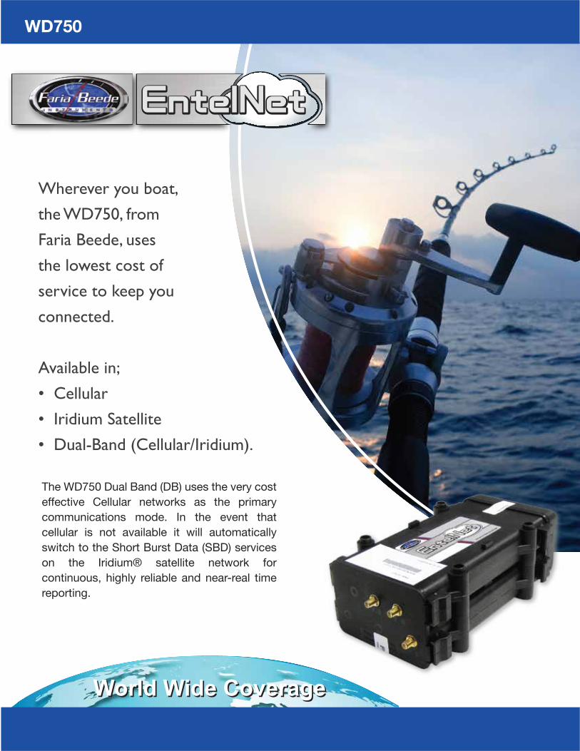
The WD750 Dual Band (DB) uses the very cost effective Cellular networks as the primary communications mode. In the event that cellular is not available it will automatically switch to the Short Burst Data (SBD) services on the Iridium® satellite network for continuous, highly reliable and near-real time reporting.
Wherever you boat,
the WD750, from
Faria Beede, uses
the lowest cost of
service to keep you
connected.
Available in;
• Cellular
• Iridium Satellite
• Dual-Band (Cellular/Iridium).
WD750

• Dual or single band Iridium® satellite and/or Cellular communicator, with integrated GPS.
• Directly integrates with select engine brands including Caterpillar®, Mercury® and Cummins® - speeding repairs by supporting remote diagnostics.
• Dual CANbus interfaces, for multi-engine boats
• Custom website access for owners• Google® maps display, to track your
yacht• View engine performance data **• Monitor fuel and bilge levels **• Remote-control digital switching (lights,
alarm system, air-conditioning etc) **** Available features vary by package
Our Iridium® Satellite and GSM based solutions keep you connected at all times, anywhere in the world.* Also available as Cellular or Satellite only systems. Offering a wide variety of cost effective systems to fit your monitoring needs. Packages are available to track your yacht in real-time via GPS, receive security alerts from the alarm system, set geofences (i.e. to manage charterers or other users), and remote-control switching equipment (lights etc.)Direct engine integration allows your dealer to remotely diagnose engine issues, saving you time and money.
WD750 DBA powerful dual mode Iridium® Satellite and GSM MTU (Mobile Transmitting Unit).
Available Customized Web Portal and Smart phone app.

U-blox 50 Channel GPS for highly accurate positioning
Dimensions and Weight
GPS
CEFCCPTCRBCellular Carriers
Certifications
Environmental
Specifications Communication Wireless; Cellular, Iridium SatelliteCoverage area Worldwide Cellular CoverageTelemetry Address IP; Dynamic (static optional)Configuration States Multiple; Primary; Conditional or Contingency Event/ Alert DrivenBattery Voltage Monitor 2 ExternalActivation Connect to VoltageWiring Harness 15 22 AWG leads, 2 20 AWG power leads (Wiring diagram available)Harness Connection Harnessing meets ABYC standards, IMO and Iridium requirements and features marine industry Deutsch® “plug and play” water proof connectorsGeo-Location & Tracking GPSAntennas External; GPS, Cellular and SatelliteLogs Permanent time stamped logs of shore power, bilge activity, battery voltage (2), GPS location, temperature, security events, engine/generator hours.Alerts Independent alerts for logged activities and events.I/O functionality • On-board J1708 and J1939 CAN and wired OBDII interfaces to provide vehicle data and reporting of diagnostic codes • RS232, RS422 and RS485 interfaces • 2MB of compact flash RAM for data logging that can be requested over the air or downloaded locally • Four factory configured I/O'sExtremely Low power draw
WD750
On-board power conditioning, and reverse polarity protection with internally re-settable fuses.Voltage: 12 & 24V ready (9.5-36vDC power)Operating Temperature: – 20C to +85CStorage Temperature: –40C to +85CWater and Weather Resistance: IP64Humidity: 90% RH at 29˚C for 24 hoursShock Resistant: MIL-STD-202, 50GVibration Resistant: SAE J1455Corrosion Resistant: ASTM-B117-73, 48 Hr
L: 9” (229 mm) W: 4 5/8” (118 mm)H: 3” (76 mm) 3 lbs. (1430 gr.)
All of our hardware is built on ISO-9001 certified production lines and tested for use in the harshest C&I, Mining, Oil&Gas and Maritime environments. From the North Slopes of Alaska, to Work boats in the North Sea, you can be confident that your Faria Beede EntelNet™ solution will continue to perform.
™

The Anatomy of a Connected Boat
Digital Switching
Smoke Alarm
Intrusion Detection
Generator Monitoring
Fuel, Water, Tank Levels
Shore Power Monitor
Battery Voltage
High Water / Float Switch
GPS Position & Tracking
Live Engine Run Data
Real Time Fault Codes
Complete Engine Data History
Faria Beede Telematics integrates Iridium Satellite, GPS, Cellular, Wi-Fi, CAN Technologies, Digital Switching Systems, on-boat sender/sensors & the Internet to provide real-time information about the status and location of boats, sensors and on-board systems.
The “Connected" boat has become a reality. Today we live in an environment where we’re connected to the Internet at all times.
** Not available with all systems.
™

Remote Monitoring Shore Power
Battery MonitoringTank Monitoring
Am I still connected?
Do I need to have someone charge the battery, before I get there?
Do I need fuel?
Know before
you go!

Digital Switching
Spin up the Gyro
Turn on the Refrigerator
Did I turn off the AC?
See it in action!1) Scan the code.2) Log in User name: @Demo1 Password: test
Live Demowww.entelboat.com
www.entelboat.net
Be up and
running before
you get there!

EntelNet™ M2M Cloud
*24x7x365 Uptime
Infinitely ScalableRedundancy Up and Down
the Rack
Storage
Cluster
Hot
Backup
Cluster
Content
Archive
Mapping
Database
GIS Map
ON
MONITORINGSmoke Alarm
MONITORINGHigh Water
Icon Legend [ OK][ Warning][ Alert][ AWOL]
701 RPM
60.54 PSI
1.3 Gal/hr
2186.7 Hrs
702 RPM
62.64 PSI
187 ˚F 187 ˚F
1.4 Gal/hr
2186.7 Hrs
Thur July 21, 2016 15:18:24 Thur July 21, 2016 15:18:24Last PositionThur July 21, 2016 15:18:2441˚ 29’ 42.77”, -71˚ 21’ 56.05”0 Knots Heading 0 Deg
Feature Rich Web-Based System
• The system provides a secured log-in and is password protected and provides for different user access/levels.
• E-mail, SMS and telephone notification mechanisms.
• A graphical view of all data, featuring the ability to visualize assets and data on “Google Earth” maps or GIS Maps with satellite imagery overlays.
• The ability to download tabular data in standard formats (such as .xls or .csv files).
• An interface to the telemetry hardware on the vehicle/asset to create a relationship between the MTU serial number, the on-board Iridium Satellite Modem (IMEI#), and vehicle VIN number/or ID number via secure login.
• Web 2.0 technologies that include a scripting language and a data access layer.
• A WSDL/SOAP or JSON/TCP interface enabling you to pull down all asset information to be used for other applications.
Faria Beede supplies an easy-to-use, secure (https) web-based application
that requires no software to install or manage.
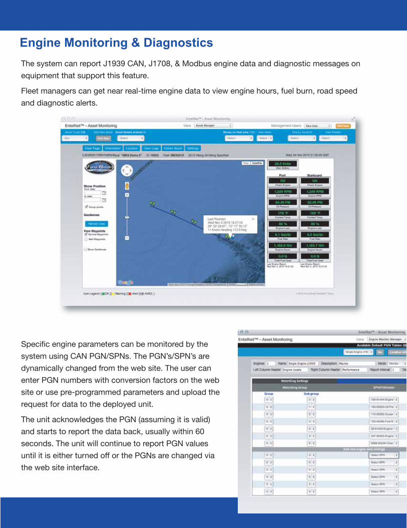
Engine Monitoring & DiagnosticsThe system can report J1939 CAN, J1708, & Modbus engine data and diagnostic messages on equipment that support this feature.
Fleet managers can get near real-time engine data to view engine hours, fuel burn, road speed and diagnostic alerts.
Specific engine parameters can be monitored by the system using CAN PGN/SPNs. The PGN’s/SPN’s are dynamically changed from the web site. The user can enter PGN numbers with conversion factors on the web site or use pre-programmed parameters and upload the request for data to the deployed unit.
The unit acknowledges the PGN (assuming it is valid) and starts to report the data back, usually within 60 seconds. The unit will continue to report PGN values until it is either turned off or the PGNs are changed via the web site interface.

This real time Satellite Engine Monitoring and Tracking System changes the “service paradigm” by eliminating the first service call, reducing warranty cost and improving customer satisfaction.
Custom Reports Designed For Customer Specific Requirements
• The EntelNet™ system enables fleet mangers to
- Report the location and status of assets
- View J1939 CAN Engine Data & Diagnostics
• Alert for excess idling, rpm’s & fuel burn
• Directly integrates with select engine brands including Caterpillar® and Cummins® - to generate engine performance & fuel usage reports
• Extensive Alert, Notification and Reporting functions, to comply with conditions of charter, and to provide proof-of-performance for service/deliveries to your clients.
• Establish service intervals
- Reduce operating costs
• Data integration with your in-house ERP or Scheduling System **
** Available features vary by package

Tested Tough - Proven Reliable
Faria Beede is a leading data and communications service provider, which is focused on extending the 'Internet of Things’ into the Power Generation, Mining, Maritime, Oil & Gas and Rail sectors, via ruggedized Iridium Satellite, Cellular & Wi-Fi solutions, which are coupled with a Software-as-a-Service (SaaS) business model, that can be customized for any client’s monitoring, control and data management needs.
Customized Website Telemetry Communications
M2M Cloud Hardware Installation
Our proprietary ruggedized hardware solution is fitted on-board each asset - where it interfaces to engine management systems, data entry tablets (for operators), data-loggers (“black-boxes”), GPS, on-board systems, other sensors/senders (i.e. fuel level) and remotely can turn on/off devises.
Intelligence on-board selects and prioritizes the
information of most importance to the customer, which is transferred wireless over satellite and cellular networks to the web-tier—allowing Faria Beede to provide a seamless Software-as-a-Service (SaaS) offering tailored to each customer.
About Faria Beede EntelNet™ Telematics

Putting the Internet of Things to work for you!
Enhance operational efficiency Reduce warranty and operating costsIncrease time on the water and asset utilization Comply with environmental and regulatory mandatesSchedule preventative maintenanceImprove safety
The Machine-to-Machine (M2M), EntelNet, technology is used to monitor mobile assets including Oil & Gas Assets, Work Boats, Fishing Vessels, Mining Equipment, Trains and Individual Workers in high-risk areas. M2M is an integral part of Internet of Things,
one of the fastest growing areas of the technology. The information gathered by Faria Beede M2M systems is transformed into actionable intelligence—via sophisticated reports and alerts.
The 750VMS MTU is type certified by the US National Marine Fishery Service, Forum Fishery Agency, the IMO (International Maritime Association) for LRIT and 50 government agencies around the world.
Today we are tracking and monitoring thousands of vessels worldwide.
Faria Beede pioneered the use of Iridium Satellite’s SBD (Short Burst Data) for vessel tracking, monitoring & communications. Today Faria Beede 750 MTU systems are transferring millions of position reports and messages monthly.

Chesapeake Black SS
Essex Contour
Chesapeake White SS
Kronos Heavy Duty - Black Heavy Duty - Silver
Coral Dress White
Euro Beige SSEuro
Spun SilverProfessional Red
Platinum
Euro White
Digital Black Fade
The choice of more than 300 boat manufacturers worldwide.
Faria Beede Instruments, Inc. has been manufacturing gauges and instruments in Connecticut for more than 60 years. The company offers a full compliment of analog and digital engine monitoring and telematic solutions for a wide range of global marine, military, industrial and performance industries.One of the few remaining vertically integrated U.S. manufacturers of SAE J1939 and NMEA 2000
instrumentation, Faria Beede provides some of the best turnaround times and responsive support in the industry. This is only possible by having total control of all aspects of design, engineering and manufacturing.Whether your needs are for the simplest or the more advanced computerized engines, Faria Beede has the instrumentation solution that is right for you.

Features & Benefits
Features & Benefits
• Available in multiple speed ranges in MPH, KPH, and KNOTs
• Premium LED back-lit.• Available with and without LCD displays showing
Compass Rose heading and actual heading (COG)• Fast satellite acquisition time (TTFF) 1 second from Hot Start• Speed accuracy of +/- 1 MPH• Heading accuracy of +/- 1 degree• Digital stepper motor driven pointers• Perfect for slow moving vessels where pitot tubes
just don’t work• Ideal replacement for speed sensing devices (pitot
tube and paddle wheel) that can fail over time
The GPS Speedometer is a drop-in replacement for your current speedometer. The GPS antenna is built-in to the instruments and does not require an external antenna. No additional hardware is required. The Faria Beede GPS Speedometer uses a highly accurate 48 channel GPS receiver. You can be sure that the GPS Speedometer is giving you the most accurate GPS information available on the market today. Speed data is shown by an analog pointer. This pointer is driven by a digital stepper motor for increased accuracy and minimized pointer bounce.
GPS Speedometer
MG3000
Antenna built in. No additional parts needed.
The MG3000 Tachometer features large lighted buttons with tactile feedback, LED back lighted dial, fog-resistant polycarbonate lens and plug and play connectorized cases. The daylight readable LCD is visible even in direct sunlight. A user-friendly, intuitive design makes navigating the menu interface easy to use. Customize the MG3000 with user definable screens and alarms. The MG3000 Tachometer connects to the CAN bus and communicates directly with the engine ECU. Engine data, fault codes and alarms are displayed on the Tachometer’s LCD display*.The MG3000 Tachometer is so much more than just a digital repeater. There are 3 analog inputs which can be used for Air Temperature, Trim, Fuel Level and Water Pressure and a NMEA 0183 input for a GPS antenna for Lat/Long, Heading, COG and clock. The MG1000 Speedometer connects directly to the MG3000 Tachometer. Like the Tachometer, the Speedometer has the look and function of an analog gauge, but the pointer is driven with a digital stepper motor for increased accuracy. Speed data can be displayed from the CAN bus, GPS antenna or connected paddle wheel. *Note: Some proprietary engine manufacturer alarms may not display or may be displayed incorrectly.
• Fuel Management built in.• Seasonal and Trip Data.• Pop-Up screens for quick information display and warnings.• Alarm codes with suggested actions.• Data log for fault codes.• A single Gateway instrument can monitor up to 5 tanks or other analog signals.• Calibrate Fuel Level and Speed in gauge.• Initialization mode to assist in gauge set-up.• Superior Sunlight readable display.• Units can be displayed in US standard or Metric• Gear position indicators

S a t e l l i t e , C e l l u l a r a n d W i - F iA s s e t M o n i t o r i n g S o l u t i o n s
fm-002-0050 rev B 04/2017
For more information contact
Tel: 860.848.9271Web: www.FariaBeede.com