
Exploring Physical Geography, 2e (Reynolds) Chapter 1 The ...
Exploring the Geography of West Asia
Unit 3 - Lesson 1
Content Expectations 7 – G1.1.1: Explain and use a variety of maps, globes, and web based geography technology to study the world, including global, interregional, regional, and local scales. 7 – G1.3.1: Use the fundamental themes of geography (location, place, human environment interaction, movement, region) to describe regions or places on earth. See also 6 – G1.3.1 7 – G2.1.1: Describe the landform features and the climate of the region (within the Western or Eastern Hemispheres) under study. 7 – G5.2.1: Describe the effects that a change in the physical environment could have on human activities and the choices people would have to make in adjusting to the change (e.g., drought in Africa, pollution from volcanic eruptions in Indonesia, earthquakes in Turkey, and flooding in Bangladesh).

Exploring the Geography of West Asia
GRAPHIC
ORGANIZER

Exploring the Geography of West Asia
BIG IDEAS OF THE LESSON:
1. The five themes of geography include location, place, region, movement, and human/environment interaction.
2. The five themes of geography are a structure for studying the people, places, and cultures of the world.
3. Regions are a way to organize geographic information about the world
4. Regions can be based on physical, historical, or cultural characteristics.
5. The geography of a region can be studied from the global, interregional, regional and local scales.
6. West Asia is one region in this part of the world.
7. Human/environment interaction happens when people adapt to and change the environment when drought, earthquakes, flooding and other natural disasters occur.

Exploring the Geography of West Asia Learning Targets: 1. I can describe the five themes of geography including location,
place, region, movement, and human/environment interaction.
2. I can explain that the five themes of geography are a structure for studying the people, places, and cultures of the world.
3. I can explain that regions are a way to organize geographic information about the world
4. I can interpret that regions can be based on physical, historical, or cultural characteristics.
5. I can identify that the geography of a region can be studied from the global, interregional, regional and local scales.
6. I can predict that West Asia is one region in this part of the world.
7. I can relate that Human/environment interaction happens when people adapt to and change the environment when drought, earthquakes, flooding and other natural disasters occur.

Exploring the Geography of West Asia
VOCABULARY

Exploring the Geography of West Asia # 1
Review the concept of region as it applies to the study of geography:
• Regions are human ideas based on the area’s common geographical characteristics.
• These characteristics include physical, historical, and cultural geography.
• The concept of region helps people to organize and make sense of the world.

Exploring the Geography of West Asia # 1
Copy and distribute the three outline maps located in the Supplemental Materials (Unit 3, Lesson 1).
The first is a world map, the second is of West Asia, and the third is a map of India.
1. Use your atlases and textbooks to list and draw on the maps at least three different ways that the area on the map could be divided into regions.
2. The regions do not have to include all of the area on each map. For example, you could draw in the mountainous regions of the world, or the coastal region of India.
3. Regions include time zones, language, continents, landforms, religions, climate, etc.

Exploring the Geography of West Asia
GLOBAL

Exploring the Geography of West Asia
Interregional and Regional

Exploring the Geography of West Asia
Regional and Local

Exploring the Geography of West Asia # 2
• Once you have completed the three regions on each map, share your ideas with a partner.
• At this time you can discuss other ideas and add a fourth region to each map.
• Volunteers will point to and trace various regions on a large wall map.
• Write at the top of the page: – “Global” on the world map, – “Interregional and Regional” on the map of West Asia, – and “Regional and Local” on the map of India.
• Discuss the meaning of these terms and how they help us to better understand the extent and impact of events.
• Are there are any regions that you have on all three maps? • Using Google Earth or Google Maps (www.maps.google.com ) in the
various views (satellite, terrain, maps), – zoom in and out from a global view to India as a regional view
• DISCUSS: What changes can be identified when zooming in and out from a global to local scale?

Exploring the Geography of West Asia # 3
Using the map of West Asia as a guide –
outline and label this region on their world maps with a new color.
Have heard other names for this region? *Guide them to the term Middle East, asking how many have heard this name?
“East of what?”

Exploring the Geography of West Asia # 3
F.Y.I. • In the 1800s European geographers used the terms Near
East, Middle East, and Far East for lands farther and farther east of Western Europe.
• Middle East is the only one still widely used. No other term means quite the same thing.
• It is the region around the eastern Mediterranean and the Persian Gulf. Often it includes Egypt as well.
• West Asia is the region that YOU will be studying, but much of the information, especially current events, will be found under the old name for the region, the Middle East.
• The largest portion of Russia is located in Asia.
You will not be studying Russia in this unit or the next one on East Asia. Russia is covered in Units 5 and 6 of the sixth grade curriculum.

Exploring the Geography of West Asia

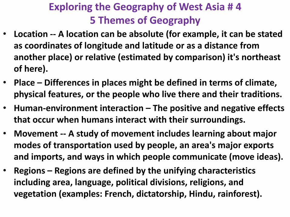
Exploring the Geography of West Asia # 4
Using a copy of the “Graphic Organizer” at the beginning of the Supplemental Materials (Unit 3, Lesson 1), conduct a quick review of the five themes of geography.
These include:
• Location -- A location can be absolute (for example, it can be stated as coordinates of longitude and latitude or as a distance from another place) or relative (estimated by comparison) it's northeast of here).

Exploring the Geography of West Asia
• Place – Differences in places might be defined in terms of climate, physical features, or the people who live there and their traditions.
• Human-Environment Interaction – The positive and negative effects that occur when humans interact with their surroundings.

Exploring the Geography of West Asia # 4
• Movement -- A study of movement includes learning about major modes of transportation used by people, an area's major exports and imports, and ways in which people communicate (move ideas).
• Regions – Regions are defined by the unifying characteristics including area, language, political divisions, religions, and vegetation (examples: French, dictatorship, Hindu, rainforest).
Exploring the Geography of West Asia # 4 5 Themes of Geography
• Location -- A location can be absolute (for example, it can be stated as coordinates of longitude and latitude or as a distance from another place) or relative (estimated by comparison) it's northeast of here).
• Place – Differences in places might be defined in terms of climate, physical features, or the people who live there and their traditions.
• Human-environment interaction – The positive and negative effects that occur when humans interact with their surroundings.
• Movement -- A study of movement includes learning about major modes of transportation used by people, an area's major exports and imports, and ways in which people communicate (move ideas).
• Regions – Regions are defined by the unifying characteristics including area, language, political divisions, religions, and vegetation (examples: French, dictatorship, Hindu, rainforest).

Exploring the Geography of West Asia # 5
Copy the five pages of the “Five Themes of Geography” located in the Supplemental Materials (Unit 3, Lesson 1).
• Tape these to the board or glue them to five sheets of construction paper and place them on the wall or bulletin board.
• Check that the students are clear on the differences between the themes and how we use them to organize geographic information.

Exploring the Geography of West Asia

Exploring the Geography of West Asia

Exploring the Geography of West Asia

Exploring the Geography of West Asia

Exploring the Geography of West Asia

Exploring the Geography of West Asia # 6 Copy the page “Five Themes of Geography Activity” sheet located in the Supplemental Materials (Unit 3,
Lesson 1) - and cut apart the countries of Asia, - putting one for each student in an envelope or box. - Do the same with the Five Themes section.
1. Have the students draw out slips, one with a country name and one with a theme.
2. Give each student one Post-it note and have them glue the country name and the theme on the Post-it note.
3. Allow the students about ten minutes to research their country and theme to find an example that typifies that theme of geography.
4. Students write the information on the Post-it note and think about how they can answer the question under the theme on the poster.
For example, if a student draws the country of Bangladesh and the theme of Human/Environment Interaction, they might write “flooding” on their Post-it and research how the heavily populated region that floods is built over the flood plain at the mouths of four rivers, emptying out into the Bay of Bengal. The land is fertile and thus good for agriculture, so the people continue to farm there.

Exploring the Geography of West Asia

Exploring the Geography of West Asia # 7
• The students place their Post-it notes on the appropriate larger theme page that has been put on the board or wall in step 5.
• As they do so they tell what they found out from their research about this country and its theme.
• Other students may also contribute by helping to answer the question that is under the theme on the large sheet.
• Leave the posters in place for later reference.

Exploring the Geography of West Asia # 8
As a quick review activity, copy two sets of the pages for the “I Have… Who Has…?” game located in the Supplemental Materials (Unit 3, Lesson 1). • Cut one set into strips and save another set as your answer key. • Keep the first strip for yourself to start (and end) the game. • Distribute the slips to the students. • Give out all of the strips in any order. • Have students team up if there are not enough or give some students extras
depending on class size. • All strips need to be used for this “chain of answers” to be complete. • Students may use books and maps during the game. • Begin the game by asking the question on your slip of paper. • The student with the answer will respond by saying, “I have…” • The student then reads their question, starting with “Who has…?”. • This continues until the last question is asked for which you will have the answer. • It is fun to time the class and see how quickly they can complete the answers. • Then collect the slips and pass them out again for a review, timing the class
responses again. • Students may want to make up questions and answers to create their own
version of this game.

Exploring the Geography of West Asia
I have monotheism. Who has an island country off the southeast coast of India? I have Sri Lanka. Who has the two longest rivers in India? I have the Brahmaputra River and the Indus River. Who has the famous mosque in Istanbul Turkey? I have the Hagia Sophia. Who has the capital of Syria, one of the oldest continuously inhabited cities? I have Damascus. Who has the country with the Tigris and Euphrates Rivers? I have Iraq. Who has the country where nearly 90% of the people are Shia Muslims?
“I have… Who has…?” game Cut the strips apart and distribute one to each student. Keep one for yourself. To start the game, read the
question on your paper, “Who has…?” Whoever has the correct answer responds and then reads their
question. This continues until all the questions have been read. (Notes: The answers follow the questions
on the next slip, so keep an uncut copy as an answer key to check the students’ answers. Suggest to the
students that they research the “I have…” part of their slip to be ready to answer their question.)

Exploring the Geography of West Asia I have Iran.
Who has a landlocked country east of Iran?
I have Afghanistan. Who has the Uzbekistan’s major cash crop?
I have cotton. Who has the country with Mt. Everest, the mountain in the world?
I have Nepal. Who has the sea south of Iran and Pakistan?
I have I have the Arabian Sea. Who has the seasonal winds of India and South Asia?
I have monsoons. Who has the beautiful tomb built for a beloved wife in Agra, India?
I have the Taj Mahal. Who has the word for a large landmass that is part of a continent? India is often called this.
I have subcontinent. Who has the name for a local marketplace in Southwest Asia?
I have bazaar. Who has an Islamic house of worship?

Exploring the Geography of West Asia I have a mosque.
Who has a storm with high winds and heavy rains?
I have a cyclone. Who has a nomadic desert people of Southwest Asia who follow a traditional way of life?
I have Bedouin. Who has a farm product grown for export?
I have cash crop. Who has the term for a country that has limited industry, where agriculture is important and incomes are generally low?
I have developing country. Who has the large inland sea that was drying up due to irrigation in the 1960s?
I have the Aral Sea. Who has the rich mineral deposits in Kazakhstan that are used to make fertilizers?
I have phosphates. Who has the largest lake north of Ian in West Asia that is called a sea?
I have the Caspian Sea. Who has the lowest point in this region, at 1,312 feet below sea level located in Israel and Jordan?
I have the Dead Sea. Who has the energy resource that has made many countries in this region rich?

Exploring the Geography of West Asia
I have petroleum. Who has the city often called the ‘Old City’ that has important holy sites of Jews, Christians, and Muslims?
I have Jerusalem. Who has the capital city that is located in both Asia and Europe? It was once called Constantinople. I have Istanbul. Who has the narrow gap between mountains in the Hindu Kush mountain range? I have the Khyber Pass. Who has the practice that has reduced the number of sturgeon in the Caspian Sea? I have poaching. Who has the ancient name of Iraq? I have Mesopotamia. Who has the name for the form of religion that means belief in one God? Judaism, Christianity, and Islam are all this type of religion.

Exploring the Geography of West Asia # 8 THE GAME:
Keep the first strip for yourself to start (and end) the game.
• Distribute the slips to the students. • Give out all of the strips in any order. • Have students team up if there are not enough or give some
students extras depending on class size. • All strips need to be used for this “chain of answers” to be
complete. • Students may use books and maps during the game. • Begin the game by asking the question on your slip of paper. • The student with the answer will respond by saying, “I have…” • The student then reads their question, starting with “Who has…?”. • This continues until the last question is asked for which you will
have the answer. • It is fun to time the class and see how quickly they can complete the
answers. COLLECT THE STRIPS

Exploring the Geography of West Asia # 9
The lesson ends with a focus on the theme of Human/Environment Interaction.
• Ask the students to suggest any natural disasters that were mentioned in the two previous activities.
• They can include something that might cause a natural disaster such as the monsoon or a cyclone which are part of the matching game in the previous step.
• Using the Internet, textbooks, and other research material, have students search for pictures that show how people change and adapt to the environment in such situations.
• For example, when an earthquake hit Pakistan people had to adapt to the destruction of their homes by living in tents or moving to other locations.
• Wrap up the lesson by making connections to the other themes of geography.

Exploring the Geography of West Asia
Assessment
The students demonstrate their understanding of the five themes of geography and the concept of geographical scales (from global, interregional, regional and local) by citing examples and discussing how they help us better organize and understand geographic information.

Exploring the Geography of West Asia

Exploring the Geography of West Asia

Exploring the Geography of West Asia

Exploring the Geography of West Asia
Exploring the Geography of West Asia


![CHAPTERS Exploring Geography I ;ill Population and Culture I Climate and Vegetation ... Geography_1_2_3.pdf · 2017-02-03 · 30 CHAPTERS ~ . ] Exploring Geography I ;ill Population](https://static.fdocuments.us/doc/165x107/5b3202487f8b9a2c0b8c2565/chapters-exploring-geography-i-ill-population-and-culture-i-climate-and-vegetation.jpg)
