
Evolution of the Toruń Basin in the Late Weichseliangeoinfo.amu.edu.pl/sgp/LA/LA14/LA14_07.pdf ·...
28
Landform Analysis, Vol. 14: 57–84 Evolution of the Toruń Basin in the Late Weichselian Piotr Weckwerth Nicolaus Copernicus University, Institute of Geography, Gagarina 9, PL-87-100 Toruń, Poland; [email protected] Abstract: The Toruń Basin is the eastern fragment of the Noteć-Warta ice-marginal streamway. Genesis of the Toruń Basin firstly demonstrates processes of erosion and accumulation of meltwaters and the Vistula waters which occur on the back- ground of changes in the height of erosion base and tectonic movements. In the formation of the Toruń Basin one cannot ex- clude its older, glacial and interglacial assumptions either, as through its location the form is related to the course of the fos- sil valleys. The article presents functional stages and reorganizational mechanisms of water discharge directions in the Toruń Basin, stimulated by the tectonic activity of the older bed. In the Toruń Basin the following terrace sets can be distinguished: a) the outwash levels formed not so far away from the ice-sheet front, i.e. during the Wąbrzeźno Subphase, b) the distal sections of the outwash (XI, X), c) the Vistula ice-marginal streamway terraces (the transitional terrace and IX), d) the Vistula ice-mar- ginal streamway terraces (VIII-VI) from the period of this river bifurcation at Fordon, and e) lower terraces of the Vistula valley. In the upper part of the Late Weichselian waters formed a system of sandbed braided rivers with changeable flow re- gime, which initially had higher energy, then reduced energy and high again. This resulted from the ice-sheet front retreat, intensity of its ablation and the inflow of the Vistula waters from the south. Introduction The Toruń Basin is the initial eastern fragment of the Noteć-Warta ice-marginal streamway, and be- longs to its biggest widenings used by the valley of the lower Vistula, within the extent of the last glaciation (Galon 1934, 1953, Kozarski 1962, Niewiarowski 1968). The lower sections of the river valleys and meltwaters discharge tracks are concentrated within the valley. Hence, its genesis firstly demonstrates processes of erosion and accumulation of meltwaters and the Vistula waters which occur on the back- ground of changes in the height of erosion base and tectonic movements of the older bed (Mojski 1980, Wiśniewski 1987, Starkel 2001, Weckwerth 2006, 2007c). In the formation of the Toruń Basin one can- not exclude its older, glacial and interglacial assump- tions either, as through its location the form is re- lated to the course of the late age fossil valleys (Weckwerth 2007c). Investigations into the geomorphological devel- opment of the Toruń Basin were initialised by the works of German researchers who claimed the exis- tence of an ice-dammed lake in the basin (Keilhack 1904, Jentzsch 1919, Sonntag 1916, 1919, Maas 1904, Woldsted 1932, Ost 1935). Its shallowing and the lat- ter activity of the River Vistula were assumed to re- sult in the development of terraces in the Toruń Ba- sin. According to Lencewicz (1922, 1923), the ice-dammed lake was to be formed due to the break- ing of a glacial lake near Włocławek. Its vanishing made it possible to join two basins in the line of the Vistula valley. Samsonowicz (1924) and Galon (1929) rejected the idea of an ice-dammed lake in the Toruń Basin. They differentiated three terraces (upper, central and lower), though. The subsequent developments of opinions on the evolution of the basin relief were based upon the results of Galon (1929, 1934). Galon (1953) transferred the results of the investigations into the evolution of the valley and the Brda outwash onto the entire system of the Toruń-Eberswald ice-marginal streamway, defining the stages of the Late Weichselian hydrographic network of the Pol- The article originates from Piotr Weckwerth Ph.d. thesis “Morphogenesis of the selected areas of the Toruń Basin and their part in hydrographic network during Upper Plenivistulian” defended in 2004 and awarded in the contest for the best doc- toral thesis in geomorphology.
Transcript of Evolution of the Toruń Basin in the Late Weichseliangeoinfo.amu.edu.pl/sgp/LA/LA14/LA14_07.pdf ·...

Landform Analysis, Vol. 14: 57–84
Evolution of the Toruń Basin in the Late Weichselian
Piotr Weckwerth
Nicolaus Copernicus University, Institute of Geography, Gagarina 9, PL-87-100 Toruń, Poland; [email protected]
Abstract: The Toruń Basin is the eastern fragment of the Noteć-Warta ice-marginal streamway. Genesis of the Toruń Basinfirstly demonstrates processes of erosion and accumulation of meltwaters and the Vistula waters which occur on the back-ground of changes in the height of erosion base and tectonic movements. In the formation of the Toruń Basin one cannot ex-clude its older, glacial and interglacial assumptions either, as through its location the form is related to the course of the fos-sil valleys.The article presents functional stages and reorganizational mechanisms of water discharge directions in the Toruń Basin,stimulated by the tectonic activity of the older bed. In the Toruń Basin the following terrace sets can be distinguished: a) theoutwash levels formed not so far away from the ice-sheet front, i.e. during the Wąbrzeźno Subphase, b) the distal sections ofthe outwash (XI, X), c) the Vistula ice-marginal streamway terraces (the transitional terrace and IX), d) the Vistula ice-mar-ginal streamway terraces (VIII-VI) from the period of this river bifurcation at Fordon, and e) lower terraces of the Vistulavalley. In the upper part of the Late Weichselian waters formed a system of sandbed braided rivers with changeable flow re-gime, which initially had higher energy, then reduced energy and high again. This resulted from the ice-sheet front retreat,intensity of its ablation and the inflow of the Vistula waters from the south.
Introduction
The Toruń Basin is the initial eastern fragment ofthe Noteć-Warta ice-marginal streamway, and be-longs to its biggest widenings used by the valley of thelower Vistula, within the extent of the last glaciation(Galon 1934, 1953, Kozarski 1962, Niewiarowski1968). The lower sections of the river valleys andmeltwaters discharge tracks are concentrated withinthe valley. Hence, its genesis firstly demonstratesprocesses of erosion and accumulation of meltwatersand the Vistula waters which occur on the back-ground of changes in the height of erosion base andtectonic movements of the older bed (Mojski 1980,Wiśniewski 1987, Starkel 2001, Weckwerth 2006,2007c). In the formation of the Toruń Basin one can-not exclude its older, glacial and interglacial assump-tions either, as through its location the form is re-lated to the course of the late age fossil valleys(Weckwerth 2007c).
Investigations into the geomorphological devel-opment of the Toruń Basin were initialised by the
works of German researchers who claimed the exis-tence of an ice-dammed lake in the basin (Keilhack1904, Jentzsch 1919, Sonntag 1916, 1919, Maas 1904,Woldsted 1932, Ost 1935). Its shallowing and the lat-ter activity of the River Vistula were assumed to re-sult in the development of terraces in the Toruń Ba-sin. According to Lencewicz (1922, 1923), theice-dammed lake was to be formed due to the break-ing of a glacial lake near Włocławek. Its vanishingmade it possible to join two basins in the line of theVistula valley.
Samsonowicz (1924) and Galon (1929) rejectedthe idea of an ice-dammed lake in the Toruń Basin.They differentiated three terraces (upper, centraland lower), though. The subsequent developmentsof opinions on the evolution of the basin relief werebased upon the results of Galon (1929, 1934). Galon(1953) transferred the results of the investigationsinto the evolution of the valley and the Brda outwashonto the entire system of the Toruń-Eberswaldice-marginal streamway, defining the stages of theLate Weichselian hydrographic network of the Pol-
The article originates from Piotr Weckwerth Ph.d. thesis “Morphogenesis of the selected areas of the Toruń Basin and theirpart in hydrographic network during Upper Plenivistulian” defended in 2004 and awarded in the contest for the best doc-toral thesis in geomorphology.

ish Lowland (Galon 1961, 1968). He distinguishedeleven terraces in the basin out of which the oldest(terrace XI) was related to the discharge of watersduring the Pomerania Phase (Galon 1968).Whereas, within the level of the terrace Vc (IX) thebifurcation of the Vistula waters started, i.e. somewaters directed westwards through the Noteć-Wartaice-marginal streamway, and some waters ran north-wards. According to Galon (1961, 1968), the abovechange of the Vistula flow into the northern direc-tion at Fordon was initiated in the Oldest Dryas, andwas to occur at the levels of the terraces from IX toVI. According to Galon, the direction of the Vistulaexclusively northwards occurred as of the Alleröd,according to Roszko (1968) as of the Older Dryas, oras Augustowski claims (1982) as of the Bölling (onthe grounds of the investigations conducted by Droz-dowski 1974). Similarly, the incision of the Vistulawaters into the level of the terrace VI is dated byTomczak (1987) at the turn of the Oldest Dryas andBölling. Niewiarowski (1987) claims this may haveoccurred 14,000 years ago. This author believes thetiming problem of directing the Vistula waters to thenorth is still open and requires further research. Bi-furcation of the Vistula in the vicinity of Fordon isquestioned by Wiśniewski (1990). He claims thenorthward direction of the Vistula waters occurredin the level of the terrace VI. Weckwerth (2006) alsoreferred to the issue of the Vistula bifurcation in thevicinity of Fordon, proving a shorter duration of thisflow than was assumed by Galon (1961, 1968) due tothe exclusion of the terrace IX.
The research into the evolution of the relief of theToruń Basin was also conducted by Tomczak (1987),who distinguished five terraces within the Toruń Ba-sin, and claimed the evolution of the terrace IX as aresult of water surface wash on the frozen bed (per-mafrost). Moreover, Tomczak (1971, 1982, 1987)recognized the geological structure and the evolu-tion of fluvial forms within the upper flood terracesand the Vistula flood plain. Problems of evolutionand the age of forms and deposits of the Vistulaflood plain in the Toruń Basin were dwelt upon inthe works by, among others: Wiśniewski (1976,1987), Niewiarowski & Noryśkiewicz (1983),Andrzejewski (1994, 1995), Kordowski (1997), andSzmańda (2000, 2002).
Main properties of the Toruń Basinrelief
The activity of waters is responsible for the evolu-tion of the present relief of the Toruń Basin. Thesewaters formed a hydrologic node joining the valleysof the Vistula, Noteć, Drwęca and Brda with theNoteć-Warta ice-marginal streamway during theWeichselian ice sheet recession (Galon 1934, 1953,
1961, Niewiarowski 1968, 1969, Wiśniewski 1976,1990). Hence, the basic relief forms of the Toruń Ba-sin include outwash levels and terraces (Galon1968). Moreover, some fragments of a morainic pla-teau are preserved in the Toruń Basin. The biggest ofthem, located in the central part of the basin, nearChrośna and Leszyce, reaches between 90 and 75 ma.s.l. Smaller morainic remnants are found in the vi-cinity of Nowe Dąbie (to the north of Łabiszyn) andnear Aleksandrów Kujawski (Fig. 1).
Despite the dominance of fluvial forms, the To-ruń Basin is characterised by a considerably diverseland relief. Its average altitude amounts to 67.93 ma.s.l., the areas located below 55 m a.s.l. (the Vistulavalley, below the terrace VI) make up 30 % of its en-tire area, and the area located between 67 and 70 ma.s.l. take approximately 22% (terrace IX). Approxi-mately 28% of the Toruń Basin is located above 70 ma.s.l. The Vistula flood plain is located lowest in theToruń Basin, at 32–43 m a.s.l. At its contact pointswith morainic plateaux there are considerable deni-velations, reaching up to 60 m. The highest eleva-tions within the Toruń Basin constitute culminationsof dunes located on the higher terrace levels. Theirheights often exceed 100 m a.s.l. (Szwedzka Góra115.9 m a.s.l., Dębie Góry 110–114 m a.s.l.), whichmakes up the maximum difference of height for theentire Toruń Basin of nearly 84 m. Height differ-ences between the subsequent terraces of the ToruńBasin are minor, as they amount to 3–7 m. Consider-ably bigger denivelations, of approximately 27–38 m,occur only when, for instance the Vistula flood plainborders with the terraces located higher. Significantrelative heights are found within the dunes locatedon the terraces of the Toruń Basin (10–25 m, maxi-mum 40–45 m).
The outwash levels and terraces show consider-able differences in the slope of their areas. Theseslopes are biggest for the outwash levels(0.217‰–0.36‰), and nearly three times as smallfor the terraces XI and X and for the transitional ter-race (0.090‰–0.096‰). The gradient of the slopesof the terraces from IX to VI rise again, and amountto: the terrace IX – 0.120‰, the terrace VIII –0.105‰, the terrace VII – 0.194‰, and the terraceVI – 0.115‰. With respect to the value of the incli-nations of the terraces in the entire Noteć-Wartaice-marginal streamway quoted by Galon (1961),they are smaller by 50–70% for the terraces IX andX, and by 38% for the terrace IX, and by up to 84%for the terrace VIII. The terrace VII is characterisedby a similar inclination both in the Toruń Basin andin the entire Noteć-Warta ice-marginal streamway.Perhaps this smaller gradient of the slope of the ter-races in the Toruń Basin may be related to a biggerlateral activity of flowing waters here than in theNoteć-Warta ice-marginal streamway (Leopoldet al. 1964, Schumm 1977, Knighton 1984).
58
Piotr Weckwerth

59
Evolution of the Toruñ Basin in the Late Weichselian
Fig
.1.G
eom
orph
olog
ical
map
ofth
eT
oruń
Bas
in1
–m
orai
nic
plat
eau,
2–
mor
aini
chu
mm
ocks
and
hills
,3–
kam
e,4
–su
bgla
cial
chan
nels
,5–
mel
twat
erer
osio
nalp
lain
,6–
kett
les,
7–
outw
ash
and
outw
ash
leve
ls,8
–te
rrac
eX
I,9
–te
rrac
eX
,10
–tr
ansi
tiona
lter
race
(X/I
X),
11–
terr
ace
IX,1
2–
terr
ace
VII
I,13
–te
rrac
eV
II,1
4–
terr
ace
VI(
VIa
),15
–te
rrac
eV
I(lo
wer
leve
lVIb
),16
–te
rrac
eV
,17
–te
rrac
eIV
,18
–te
rrac
eII
I,19
–te
rrac
eII
,20
–te
rrac
eI
(in
the
Brd
ava
lley)
,21
–flo
odpl
ains
,22
–te
rrac
esof
othe
rva
lleys
,23
–bo
ttom
sof
smal
lval
leys
,24
–sl
opes
and
denu
dativ
efo
rms,
25–
allu
vial
fans
,26
–bi
ogen
etic
plai
ns,2
7–
terr
aces
num
beri
ngaf
ter
Gal
on(1
953,
1968
)

The hitherto prevailing investigations of the evo-lution of the Toruń Basin relief show that the terracelevels within the Toruń Basin formed at differenttimes, starting from the deglaciation of this form. Ini-tially, during the Krajna-Wąbrzeżno Subphase, theToruń Basin was a track for meltwater discharge(Niewiarowski 1969). The rudimentary fragments ofoutwash levels located mainly in its southern partdate from that period (Weckwerth 2005). The majorevolution of the basin occurred with the start of thePomerania Phase of the last glaciation. The basinwas formed as an eastern extension of the No-teć-Warta ice-marginal streamway, as a result of theactivity of meltwaters and waters from the extra-glacial area (Galon 1961, Kozarski 1962, Niewia-rowski 1968, 1969, Wiśniewski 1990, Weckwerth2004, 2005). The flow of these waters at lowerheights resulted in the formation of the terraces fromXI to VI. Further evolution of the lowest group ofthe terraces was mainly related to the activity of theVistula after its incision into the terrace VI and itschange of flow direction to the north at Fordon(Galon 1953, 1961). According to Tomczak (1987)and Niewiarowski & Weckwerth (2006), the outwashlevels found in the basin and related to theKrajna-Wąbrzeźno Subphase, developed at around17 ka BP, whereas the terraces XI–IX at the end ofthe Weichselian from approximately 16 to 14–13.5ka BP, the terraces VIII–III in the Oldest Dryas(from 14–13 ka BP to 12.4 ka BP) and in the Bölling(from 12.4 to 12.1 ka BP), and the terrace II in theOlder Dryas (12.1–11.8 ka BP) and at the beginningof the Alleröd (11.8–11.5 ka BP), and the flood plainin the Holocene.
Geological structure of the Cenozoicbed
The formations of the Cenozoic bed of the ToruńBasin belong to major structural and tectonic unitsfound in Poland (Fig. 2). These are: a marginaltrough changing into a Precambrian platform (East-ern European platform) in the eastern part of the ba-sin and the Central Polish Anticlinorium located inits central and western parts (Marek & Znosko1972a, b). Their conventional border is determinedby a zone of 2 to 7-kilometre width, which runs be-tween the deposits of the Upper and Lower Creta-ceous, in the line Fordon (Bydgoszcz)–To-ruń–Czernikowo–Nieszawa–Włocławek (Marek &Znosko 1972a, Dadlez & Marek 1974, Marek &Znosko 1983).
A fragment of the marginal trough comprisingthe eastern part of the basin belongs to its Warsawsection (Płock section, Dadlez & Marek 1974). Thismarginal trough is a relatively young tectonic struc-ture, as its southwest limit at the contact points with
the Kujawy anticline formed during its uplift, be-tween the end of the Cretaceous and the beginningof the Cenozoic (Dadlez & Marek 1983). The dis-cussed eastern fragment of the Toruń Basin is lo-cated within the inclination of the Kujawy-Pome-rania Anticlinorium and the northern part of thePłońsk section of the marginal trough (Dadlez &Marek 1983). Situated within the marginal trough,the Zechstein basin is a trough of WNW-ESE axis(Pożaryski et al. 1983). The top of the Cretaceous de-posits bends northwards here (from 8 m b.s.l. to20–23 m b.s.l.). Starting from southwest limits of themarginal trough, the bed of the Cenozoic deposits inthe vicinity of Toruń make up the face of the bedfrom the Upper Albian and Cenomanian (inclina-tion of the Kujawy Anticlinorium) to the Maastrich-tian (Fig. 2). These are marine facies and lie rela-tively shallow along the Vistula valley, at the depthfrom 50 to 120 m, where they occur in the Quater-nary bed to the south of Toruń (Fig. 3). They aremainly represented by marl, limestone, marly lime-stone, and marly gaizes (Cenomanian, Turonian,Coniacian and Santonian) and marls and marlygaizes belonging to the Maastrichtian with richmicrofauna (Niewiarowski & Wilczyński 1979).
The central and western part of the Toruń Basinstays within the Middle-Polish Anticlinorium (Fig.2), which is intersected with a dislocation zone in theZechstein bed of a nearly parallel orientation (Ły-czewska 1975, Dadlez 1980a, 1980b). As for itscourse, the zone relates to the Noteć valley and isconsidered a tectonic border between the PomeraniaAnticlinorium in the north and the Kujawy Anti-clinorium in the south (Dadlez & Dembowska 1965,Dadlez 1980a, Marek & Znosko 1972a). It also di-vides the Nakło region from the Gniewkowo regionwith a different degree of evolution of salt tectonicsstructures. These structures in the southern direc-tion are significantly more visible, which is related toa considerable increase in the Zechstein thickness onthe Kujawy swell as compared to the marginal trough(Marek & Znosko 1972a, Dadlez & Marek 1974).The swell, pillows and salt banks of the Gniewkoworegion located within the basin occur in the vicinityof Ciechocinek and Nakło (Łobżenica/Więcbork),Chrośna, Toporzyska and Szubin (Fig. 2).
Relief of t the sub-Quaternary deposits
The relief of the sub-Quaternary surface withinthe Toruń Basin and its closest neighbourhood ischaracterised by a series of declines mainly related tothe Quaternary processes of fluvial and glacial ero-sion (Fig. 3). The surface of the sub-Quaternary sur-face reaches the smallest height in Bydgoszcz (120.0and 110.2 m b.s.l.), whereas its culminations arefound in the vicinity of Toruń (65.5–66.8 m a.s.l.),
60
Piotr Weckwerth

and to the west of Łabiszyn (72 m a.s.l.), and inBydgoszcz (67.6–70.0 m a.s.l.). Thus, the height dif-ference in the sub-Quaternary surface reaches thevalue of 192 m (Fig. 2). The average height of thesub-Quaternary surface amounts to approximately15 m a.s.l. Approximately 26% of its area is locatedbelow the sea level (from 0 to 120.0 m b.s.l.), 44%stays in the height range of 0–24 m a.s.l., whereas30% is over 24 m a.s.l.
The culminations of the surface of the sub-Qua-ternary surface within the Toruń Basin consist of thePliocene deposits, while alongside the increase in itsdepth in the depressions, the Miocene and Oligo-cene formations, as well as the Cretaceous and Ju-rassic formations are found (Fig. 3). The oldest Me-sozoic deposits lying below the Quaternaryformations of the Toruń Basin comprise deposits ofthe Lower Jurassic in the southwest limit of the ba-sin, to the south of Szubin, and of the Upper Jurassicin the vicinity of Aleksandrów Kujawski andCiechocinek, which, thus, belong to the Ciechocinekelevation (Łyczewska 1975, Niewiarowski & Wil-czyński 1979). According to Kucharski (1966) andŁyczewska (1975), their high position is related toparticularly intensive erosion processes at the end ofthe Pliocene. Moreover, the face of the Jurassic andLower Cretaceous bed rocks are found further to thewest towards the culmination of the Kujawy Anti-clinorium, at the bottom of the fossil valley in the vi-
cinity of Aleksandrów Kujawski and Nowa WieśWielka (Łyczewska 1975, Niewiarowski & Wilczyń-ski 1979, Wrotek 1993, Jeziorski 1995a). The LowerCretaceous deposits were also found in Bydgoszcz,at the bottom of exarational or tectonic troughs sur-rounded by a system of faults (Kozłowska & Koz-łowski 1992).
Systems of valley forms, which run parallel andmeridionally, play a major role in the diversifiedsub-Quaternary surface. The first system repre-sented by a series of declines running accordingly tothe axis of the Toruń Basin, along its southern slopes(Fig. 3). Their bottoms merge into a major wide val-ley form. They are located at 1–3 m b.s.l. and 14 mb.s.l. in the eastern part of the valley (in the vicinity ofToruń and Suchatówka) and 28–41.5 m b.s.l. inNowa Wieś Wielka, where they reach the Cenozoicbed (Lower Cretaceous). Between Tur and Jarużynit goes down to 41.4–58.0 m b.s.l., while in Nakłoupon the Noteć down to 36.8 m b.s.l. (the Nakło tec-tonic trench). The mentioned main valley form de-veloped in the Pleistocene bed in the eastern part ofthe Toruń Basin has a broadly concave character. Itis located within the range of the Kujawy-Pomeraniaswell and lateral synclinorium and shows consider-ably smaller denivelations than those recorded fa-ther to the west. Within this area, to the east ofAleksandrów Kujawski and Suchatówka, the face ofthe Oligocene, at places the Miocene formations
61
Evolution of the Toruñ Basin in the Late Weichselian
Fig. 2. Geological and structural map without Cainozoic formations (parly after: Marek & Znosko 1972, Dadlez & Marek1974, Pożaryski 1974, Dadlez et al. 2000)
Upper Cretaceous: 1 – Maastrichtian, 2 – Campanian, 3 – Coniaciab and Santonian, 4 – Turonian, 5 – Upper Albian andCenomanian, 6 – Lower Cretaceous, 7 – Upper Jurassic, 8 – Middle Jurassic, 9 – Lower Jurassic, 10 – Zechstein, 11 – bor-der between the Kujawy antyclinorium and the Pomeranian antyclinorium, 12 – salt banks, pillows and swells, 13 – saltdomes, 14 – border between zone of salt domes and salt banks, pillows and swells, 15 – antyclines axes, 16 – synclines axes,17 – detected dislocations zones in the substratum of the Zechstain sediments, 18 – probable dislocations zones in thesubstratum of Zechstain sediments, 19 – morainic plateaux extent

dominate at the bottom of the analysed depression.Whereas, in the deepenings below the sea level,there are the Jurassic and Cretaceous deposits whichbelong to the Mesozoic elevation of Ciechocinek
In the western direction the bottom of the paral-lel running major fossil valley to the south of Chro-śna narrows down and deepens to 28–31 m b.s.l. Ittakes a character of a narrow section developed inthe southern limit of the Chrośna anticline. This de-cline stretches farther to the west along tectonic de-pressions of the Kujawy Anticlinorium (the Gniew-kowo and Łabiszyn depressions), and then changesinto the Eopleistocene valley of the proto-Noteć(Dyjor 1987), and intersects the Nakło anticline inthe northern limit of the Szubin structure (Figs 2 and3). The slanting course of the described form as com-pared to the salt structures of the Middle-PolishAnticlinorium, and locally within their extent, re-sulted in complete erosion of the Paleogene andNeogene deposits. Hence, the bottom of the fossilvalley in these places is made of the Cretaceous andUpper Jurassic deposits.
The predominant part of the above major fossilvalley, located in the west and southwest part of theToruń Basin evolved before the Great (Masovian)Interglacial (Figs 4, 5, 6). Within the area of theToruń Basin an interglacial river running at that timeflowed to the west along the Noteć valley (Niewia-rowski & Wilczyński 1979, Uniejewska et al. 1979,Włodek 1980, Mojski 1984, Dyjor 1991, Brykczyński1986 and others). Galon (1981), Włodek (1980),Brykczyński (1986) and Dyjor (1991) believed there
had been an adjoining decline from the east, whichhad run parallel to the river in the southern part ofthe Toruń Basin. The analysis of the geological bore-holes showed this form had been destroyed due tothe activities of waters during the Eemian Intergla-cial. Its farther eastern extension can probably befound in the vicinity of Toruń, where the deposits ofthat dating occur in the fossil bottoms of the pro-to-Drwęca and the valley running in the line Lulko-wo-Wrzosy-Stawki (Wilczyński 1973, Niewiarowski& Wilczyński 1979, Niewiarowski 1968). The dis-charge of waters within their area occurred from thenortheast towards the southwest.
From the north and south other depressions con-tact with the large concaveness of the surface of thesub-Quaternary surface of the eastern part of theToruń Basin. In the area located between Przyłubie,Chrośna, Suchatówka and Cierpice, the concavenessmerges with a 10–15-kilometre wide fossil river val-ley from the Eemian Interglacial, whose deposits arefound in the form of three cycles of sedimentation(Makowska 1979, 1980). Its limits, of a nearly meridi-onal course, stretch onto the eastern environs ofSolec Kujawski. The extent of this valley is deter-mined by the sub-Quaternary surface datum of 20 ma.s.l. The considerable depth of this form with its bot-tom located at the altitude of 4.0–12.5 m b.s.l. provessignificant intersection of the river which caused theelimination of the Pliocene and partially Miocenedeposits. The erosion base of the Eemian river net-work used to be located close to the Baltic depres-sion, which resulted in the reorganisation of the
62
Piotr Weckwerth
Fig. 3. Solid geological map of the sub-Quaternary surface1 – stratigraphy (Pl – Pliocene, M – Miocene, Ol – Oligocene, Cr3 – Upper Cretaceous, Cr1 – Lower Cretaceous, J3 – Up-per Jurassic, J2 – Middle Jurassic, J1 – Lower Jurassic), 2 – geological borders, 3 – fault (after various authors), 4 – lines ofgeological sections, 5 – morainic plateaux extent

drainage system, which then began to look similarlyto the present one (Fig. 3). The location of theEemian fossil valley in the east and southeast part ofthe Toruń Basin almost matches the extent of thepresent valley of the River Vistula (Łyczewska 1975,Wiśniewski 1976, Niewiarowski & Wilczyński 1979).The major Eemian valley also comes into contactwith more narrow fossil valleys located in the vicinityof Toruń and Gniewkowo (Fig. 6).
Another Eemian fossil side valley in the southpart of the Toruń Basin is located to the southwestand west of Bydgoszcz (the environs of Łabiszyn andNakło upon the Noteć). Its course in the westernlimit of the basin covers the fossil valley of the Great
Interglacial (Fig. 6). The Eemian deposits do no ex-ceed the datum of 50–60 m a.s.l., and lie lower withrespect to the height of the layer of the lodgement tillfrom the Central Polish Glaciations. Moreover, theEemian valleys in the vicinity of Bydgoszcz probablyrun parallel to the present channel of the Vistula inFordon and along the Vistula bend between Otoro-wo and Łęgnowo, and they relate to the presentflood plain of the Vistula and the Brda valley.
Other forms of fossil valleys in the sub-Quaternarysurface are located in the vicinity of Ślesin andMinikowo (to the east of Nakło) and in the line of thepresent Brda valley. The decline running along theline Brda-Noteć in the Toruń Basin stretches near the
63
Evolution of the Toruñ Basin in the Late Weichselian
Fig. 4. Geological sections A–B and C–D1 – peat and gyttja 2 – eaolian sands, 3 – gravels and sands, 4 – sands, 5 – silts and clays, 6 – tils, Pliocene: 7 – clays, silts andsands, Miocene: 8 – brown coal, 9 – sands, 10 – mudstones, sandy silts, silts, cllay silts, clays, Oligocene: 11 – sands, 12 –clays, claystones, clay silts, silts, 13 – Upper Cretaceous (marls and gaize), 14 – Lower Cretaceous (claystones, slates,sandy-clay slates, marly mudstones, marls, gaize, limestones,sandstones), 15 – Upper Jurassic (claystones, mudstones,slates, limestones, dolostones), 16 – Middle Jurassic (claystones, clay-sandy slates, marly mudstones, limestones, marls,sandstones), 17 – Lower Jurassic (mudstones, claystones, slates, clay-sandy slates, sandstones), 18 – glaciotectonic defor-mations, 19 – hypothetical age of the Pleistocene deposits: W – Weichselian, E – Eemian Interglacial, S – Middle-Polishglaciation, M – Masovian (Great) Interglacial, P – South-Polish glaciation

village of Drzewce and comes into contact with thevalley running parallel in the vicinity of KruszynKrajeński. To the east of the Brda valley, in the north-ern part of Bydgoszcz, there is a depression describedby Żurawski (1959). It is found in the bed of the Qua-ternary deposits with the bottom in the Miocene de-posits at the height of 0–20 m b.s.l. The discussed sys-tem of fossil valleys in the western part of the ToruńBasin intersects the layer of the height of 30–40 ma.s.l., whose composition is dominated by the Plio-cene silts and clays. Only in the area of Łochowo,Białe Błota and Myślęcinek do the culminations ofthis layer of the height of 50–55 m a.s.l. occur (Fig. 3).
The valley stretching from the environs of Ła-biszyn towards Nowa Wieś Wielka belongs to the de-pressions in the sub-Quaternary surface located inthe south part of the Toruń Basin. The valley bottomdeepens to the north from approximately 0–10 mb.s.l. (1.5 m b.s.l. in Załachów) to below 30 m b.s.l.,where it reaches the Jurassic deposits. A fossil valleylocated near Gniewkowo is another form (Fig. 3). Itsbottom is cut into the Oligocene deposits (16 mb.s.l.) and is diversified with secondary deepeningswith the face of Cretaceous bed (25.0 m b.s.l. and 54m b.s.l.). In these places the fossil valley is deepest(72–79.8 m) as compared to the planar beds with theface of the Pliocene bed.
In the southeast part of the Toruń Basin, the al-most planar sub-Quaternary surface with the face ofbed of the Pliocene clays and silts is intersected byseveral deepenings directed from the south to thenorth. The deepest of these forms covers the presentvalley of the Tążyna. The bottom of this fossil valleywas drilled at the level of 4 m b.s.l. (Fig. 3).
The relief of the sub-Quaternary surface in the vi-cinity of Bydgoszcz shows particularly interestingdeep depressions of a tectonic character or related toglacial and fluvial erosion (Jankowski 1975, Koz-łowska & Kozłowski 1992). They diversify this al-most planar sub-Quaternary surface in this part ofthe basin, located at the height of 30–40 m a.s.l. andmade of the Pliocene and Miocene deposits (Fig. 2).At their bottoms, ranging from 120.0 m b.s.l. do 16 ma.s.l. there are the Oligocene and Miocene deposits.The Cretaceous deposits are found at the depth of105.0–120.0 m b.s.l. Some of these depressions aresurrounded by a system of faults (Kozłowska & Koz-łowski 1992). They may be genetically related to thedislocations of the Nakło anticline. The breccias ofthe Cretaceous rocks and the Miocene and Plioceneclays, recognised by Kozłowska & Kozłowski (1992),may indicate that these are fissures of a tectonic andkarstic origin, developed in the line of profound dis-locations (Baraniecka 1980).
64
Piotr Weckwerth
Fig. 5. Geological sections E–F and G–Hexplanations like in the Fig. 4

Outwash levels – meltwater dischargephase
After deglaciation the Toruń Basin became atransit area for meltwaters, which created outwashlevels within it. Their minor fragments are preservedat the contact place with the southern slope of theToruń Basin (Fig. 1). They can be found to the westof the Tążyna valley (80–81 m a.s.l. and 79–78 ma.s.l.), in the vicinity of Łabiszyn (87–86 m a.s.l.), andnear the village of Chrośna (80–81 m a.s.l.) in thecentral part of the basin. The Struga Toruńska out-wash enters the basin at a similar height, to the northof Toruń (Niewiarowski & Tomczak 1969, Weck-werth 2004).
The evolution of the outwash levels in the south-west part of the Toruń Basin, in the vicinity of Ła-biszyn, occurred in the line of a glacial depression.They formed at the back of the morainic forms trans-gressed by an ice sheet. They are currently located atthe extent limit or within the present Toruń Basin
(Weckwerth 2007b). The mentioned outwash levelsare found to the west of Łabiszyn, at 86–87.5 m a.s.l.(Fig. 1). Their geological structure is dominated bylithofacies of poorly graded coarse sands with gravelof a planar cross-bedding (GSS = –0.33 phi). Thethickness of their sets oscillates from 22 to 47 cm(Fig. 7). The secondary lithofacies include coarsesands with gravel of a trough cross-bedding. The as-sociation of the above lithofacies (SGp, SGt) was de-posited in a sand-bed braided river of a changeablebed relief. The bed was dominated by sandy-gravelytransverse bars (SGp), intersected at places by sec-ondary interbar channels (SGt) due to the increasein the energy of depositional environment. They ranto the northwest (VM=309°), towards the northernlimit of the Żnin channel. According to the results ofthe investigations conducted by Niewiarowski (1992,1993), their discharge could not go farther to thesouth, along the Żnin channel or the Noteć valley(Fig. 1). These waters flowed along the River Gąsaw-ka at 82–83 m a.s.l., towards the later Noteć-Wartaice-marginal streamway. They flowed through thedepression with its bottom located at 80 m a.s.l. be-tween Pińsko and Szczepice (to the south of Nakło).Kozarski (1962) determines the outwash track oc-curring here on the geomorphologic map but he doesnot characterise its structure or genesis. At theWieszki site, located on the slope of the plateau tothe south of Nakło, this level is composed of thicker,3-metre, gravely-sandy deposits (Fig. 7). The lowestand the top of bed location are covered with grave-ly-sandy series (GSm, GSp, Gm). They are made ofthe lithofacies of poorly graded massive gravels of acompact grain matrix (the mean grain diameter from0.28 to –1.40 phi). These sediments were depositedduring high water regime, at the bottom of a gra-vel-bed braided river in the form of longitudinalbars. These bars gained distal growth (GSp) along-side the decreasing velocity of water discharge (GSKskewnig positively). Additionally, these forms wereintersected with gravel sheet (Gm) which locally for-med erosion surfaces. These are overlain by thinbeds of medium grained sands with minor gravels(SGm), deposited during short-term falls of flow en-ergy during the declining high water regime (Zie-liński 1993, 1995).
The preserved sedimentation structures of thedeposits at the Wieszki site indicate the northern di-rection of the palaeocurrent. It is related to thecourse of the slope of the morainic plateau, which to-gether with the exposure location of approx. 350 maway from the ridge of the morainic plateau, ex-cludes the possibility of deposition of these forma-tions at the bed of the river which runs from the eastto the west, and thus, from the Toruń Basin to theNoteć-Warta ice-marginal streamway. It may, there-fore, be assumed that meltwaters, which flowed tothe northwest of Łabiszyn at the level of 86–87.5 m
65
Evolution of the Toruñ Basin in the Late Weichselian
Fig. 6. Sketch of the main fossil valleys route in the ToruńBasin
A – from the Masovian (Great) interglacial, B – fromthe Eemian interglacial, C – before the Poznań phaseof the last glaciation, 1 – bottoms of the fossil valleysand hypothetical direction of water flows, 2 – pres-ent-day morainic plateaux (A, B based upon the worksby: Jankowski 1975, Makowska 1979, Uniejewska et al.1979, Niewiarowski & Wilczyński 1979, Włodek 1980,Galon 1981, Brykczyński 1986, Jeziorski 1991, 1995a,1995b, Mojski 1982, 1984a, 1984b, Kozłowska &Kozłowski 1992, Wrotek 1990, 1993, Uniejewska &Nosek 1992, Weckwerth 2007c, Wysota 2002)

a.s.l., turned farther to the north, towards Paterekand Nakło, causing the intersection of the northeastextent of the Gniezno Plateau (Fig. 14A). Hence,this flow connected to the ice sheet retreat from the
line of north-Łabiszyn moraines was of a marginalcharacter in the southwest part of the Toruń Basin.
Other outwash levels in the Toruń Basin are pre-served to the west of Aleksandrów Kujawski, be-
66
Piotr Weckwerth
Fig. 7. Geological structure of outwash levels in the western part of the Toruń BasinGSS – average grain diameter (Mean), GSO – standard deviation, GSK – skewness, GSP – kurtosis, explanations to therose diagrams: N – population, VM – vector mean (°), CI – confidence interval, SD – standard deviation, R – clustereddata ratio (%)

67
Evolution of the Toruñ Basin in the Late Weichselian
tween the Tążyna valley and Suchatówka (Fig. 1).They are found at 80–81 m a.s.l. in the vicinity of thevillages Warzyn and Stare Grabie, and at 77.5–79 ma.s.l. near the villages of Popioły, Brzeczka and Gra-bie. Galon (1961, 1968) treated them as the terracesXI and X and claimed they were related to the flowof waters to the west. However, lithofacial examina-tions conducted there dismiss the above statements(Weckwerth 2005, 2007a). The outwash level of theheight of 80–81 m a.s.l. (the Warzyn and Stare Gra-bie sites to the east of Suchatówka) is composed oflithofacial association St(Sh), deposited in a sand--bed braided river channel with folded megaripplesof a stable dynamics of depositional environment(Fig. 8). The bed of the outwash series is made of gla-cial till (the Stare Grabie site), and the flow of waterswent in the eastern direction (VM=101°). Further-more, locally at the top of the outwash series thereare sandy silts, silty sands and sands that constitute alithofacial associotion Sh, Sr, SFh (Sp). It developedwithin a secondary, low-energy and shallow channelof the sand-bed braided river with a periodically van-ishing flow in the edge part of the channel, at thecontact place with the slope of the Toruń Basin. Itscharacteristic property is the cyclicity of the occur-rence of small scale lithofacies Sp with lithofacies Sr,Sm and Sh. Water flow directed to the east(VM=71°). The above analysis of the geologicalstructure and the southeast gradient of the slope ofthe outwash level of the height of 80–81 m a.s.l. bothprove the flow of meltwaters in the southeast direc-tion at this height, along the slope of the Toruń Basin(Fig. 14B). In the analysed exposures there havebeen no facts confirming Kostrzewa’s opinions (1981)on the flow of waters in this level towards the west.
The fragments of the lower outwash level (78–79m a.s.l.), located to the west of the Tążyna valley,slope towards the south. Minor differences with re-spect to the height between this surface and theabove described upper outwash level (80–81 m a.s.l.)seem to indicate they evolved at a similar period oftime, as water and glacial sediments in the StareGrabie site were deposited by waters flowing slowlyin the lateral part of the braided river channel.
The deposits making up an outwash level of theheight of 78–79 m a.s.l. belong to the lithofacial asso-ciation SGp, GSp, SGt (Sp, Sm, Gm) (the Popiołysite, Fig. 8). In their lower part there are medium-and finely-grained sands of a planar cross-bedding(Sp), with built-on massive medium- and fine-ly-grained sands (Sm). This is the deposit with amean diameter of grains GSS ranging from 1.05 to2.96 phi and poor and moderate graded. Sedimenta-tion structures register the mean orientation of thepalaeocurrent VM=121°. These are overlain by me-dium-scale lithofacies SGt, which consist of poorlygraded medium- and coarsely-grained sands of a dis-turbed grain structure (GSS from –0.50 to –0.08 phi).
The sedimentation structures of this deposit indicatethe SWW flow of water (VM=109°). Deposition oc-curred in the channels with considerable velocity ofwater discharge and the bed covered with mega-ripples of folded ridges. Above the Popioły section,there are lithofacies SGp and GSp made ofcoarse-grained sands with gravel (gravely sands), of aplanar cross-bedding (SGp). The thickness of theseassotiations fluctuates from 25 to 60 cm. Further upthey change to gravels with coarse-grained sands of amedium-scale tabular cross-bedding (GSp) and mas-sive gravels with coarse-grained sand (GSm). Theyreach the thickness from 0.4 to 1.1 m. The deposits ofthe lithofacies SGp, GSp and GSm show a coarseningupward cycle, which indicates constantly increasingenergetics of the depositional environment. At theirbottoms there are massive coarse gravels with boul-ders (Gm). Initially, water discharge occurred to thesoutheast (VM=126°) and southwest (VM=203°),then to the south (VM=193°).
The southern direction of glaciofluvial flow(VM=211°) is confirmed by the lithofacies Sp whichconstitute a level in the village of Brzeczka at 77.5 ma.s.l. The sediments of fine sands and silts depositedby waters flowing to the south were found at a similarheight, approximately 2 km farther to the south inthe Grabie site (Fig. 8). Here, the outwash series isnearly 9 m thick. Two lithofacial associations weredistinguished within: a low-energy channel of asand-bed braided river Sp, SGp, Sr (Sm, Sh, SGm,Fm), and a secondary channel with a low water re-gime or proximal flood plain (Sp, Sr, Src (Sh, Sm, Sw,Fm, SGm). The river bed used to be dominated byripples, although there was sporadic intensificationof flow which concentrated in the channels of1.6-metre depth and 10-metre width. This flow oc-curred in the southwest direction (VM=141°). Theoutwash series in the Grabie site shows considerablylower energetics of waters flowing southwards alongthe Tążyna valley than at the Popioły site. This mayhave been only a part of waters whose flow is regis-tered by deposits in the Toruń Basin and others mayhave followed to the southeast, towards the presentvalley of the Vistula (Fig. 14B).
Until recently the above described outwash levelsin the southeast part of the Toruń Basin, located atthe contact place with the Parchanie valley, havebeen treated as terraces XI and X (Galon 19611968), which, due to their geological structure anddirection of surface solpe, is now hard to accept(Weckwerth 2005, 2007a). The slope of the loweroutwash levels equals 0.36‰. This inclination stayswithin the range of 0.16‰–1.34‰, which deter-mines the gradient of water table transport in a chan-nel for the deposits of the Popioły site, and is close toa gradient of the water table determined for the toppart of the glaciofluvial series at this stand (the meanvalue J1t=0,46‰). Taking into consideration the

above values and the palaeocurrent direction, it maybe assumed that this level and its corresponding bot-tom of the Parchanie valley were formed by the riverbefore the Pomerania Phase, most probably duringthe Wąbrzeźno Subphase of the last glaciation.
The geological structure of the outwash levels inthe southeast part of the Toruń Basin (80–81 and77.5–79 m a.s.l.) running along its slopes, the south-ward inclination of the outwash level 77.5–79 m a.s.l.,and the gradient of the water table determined on
68
Piotr Weckwerth
Fig. 8. Geological structure of outwash levels in the eastern part of the Toruń Basin (after Weckwerth, 2007a)

the grounds of the texture analysis of the depositscomposing it, all indicate that these levels may havedeveloped due to the activity of meltwaters flowingfrom the stagnating ice-sheet in the line of the southWąbrzeźno moraines (Fig. 14B). The braided riverflowing in the Toruń Basin at that time showed con-siderable discharge energy, so characteristic of theinitial outwash sections. The discharge of waters inthe vicinity of Toruń may have occurred at 84–85 ma.s.l. Perhaps, as a result of it, flattenings distin-guished by Churska (1969) on the slope of the Dob-rzyń Plateau near Obrowo and, located farther to thesouth in the Toruń Basin, the level of the Miena Val-ley at the mouth of the basin distinguished by Wiś-niewski (1976) may have developed.
Distal sections of the outwash –the terraces XI and Xof the ice-marginal streamway
Only the fragments of the terraces XI and X arestill present among the highest ice-marginal stream-way outwash terraces in the Toruń Basin. A smallfragment of the terrace XI is located in the vicinity ofTrzciniec to the south of Bydgoszcz (Fig. 1). This ter-race is 76–77 m a.s.l. here. The thickness of its com-posing sandy-gravely deposits ranges from 7.5 m do10.2 m. They overlie glacial till or sands with inser-tions of silts and clayey silts (Fig. 9).
The area of the terrace XI near Trzciniec is diver-sified with dunes whose relative heights increasefrom the west to the east, from 2 to 6.5 m (Fig. 1).
This terrace is also composed of eolian cover sandswhich are 1–1.5 m thick. Underlying terrace sandsform two lithofacial associations. The first lithofacialassociation Sp, St, Sr, Sh (Src, SFm) is dominated bySp sets with the thickness from 50 cm to 75 cm. Theseare fairly well graded silty sands (GSS=2.87 phi,GSO=0.53 phi). Water discharge responsible fortheir deposition occurred in the northwest direction(VM=307°). The medium scale lithofacies St consistof medium-grained sands with laminated coar-se-grained sands. This is a fairly well and well gradeddeposit with the mean grain diameter GSS from 1.70to 2.59 phi. The analysed lithofacies were depositedby waters flowing to the northwest (VM from 322° to343°) and to the west (VM=276°).
The lithofacies Sr, Sh (Src(A)) are composed ofsilty sands and sandy silts which were deposited froma homogenous and fractional suspension due to lowflow energy of the palaeocurrent. The low waterstages of the sand-bed braided river, in gradually leftchannels of water discharge in the northwest direc-tion (VM from 300° to 334°), were accompanied bytemporary disappearance of the water flow, the for-mation of a ripple, locally changing into a planar bedin shallow waters.
The other of the distinguished lithofacial associa-tions is composed of the lithofacies FSm, Sr (Sh,S(d)). They consist of silts, sandy slits and silty sands.Their mean grain diameter GSS fluctuates from 3.23to 4.87. The deposits are both fairly well and poorlygraded. These deposits represent the sub-environ-ment of the sand-bed braided river flood plain lo-cated at the limit of its proximal and distal parts,
69
Evolution of the Toruñ Basin in the Late Weichselian
Fig. 9. Geological structure of the terrace XI in Trzciniec (to the south of Bydgoszcz)

where finely grained deposition was interrupted bythe inflow of waters during a flood-wave culmina-tion.
The sequence of the lithofacies Sp�St�Sr�FSmis a characteristic property of sandy and silty forma-tions deposited by waters flowing in the level of theterrace XI. These lithofacies correspond to the sand-bed channel of the braided river with transverse barsseparated by inter-bar channels. The disappearanceof water discharge and low water stages in the chan-nel were accompanied by the formation of transversebars and shallow and low-energy flow in the lowerpart of the lower flow regime. Within the flood plainneighbouring the channel, water stagnation was in-terrupted by water inflow during flood-wave culmi-nations.
The terrace X seems most probably to have beenthe last level of meltwater discharge in the Toruń Ba-sin. Its narrow strips (up to 500 m wide) adjoin to theedges of the Chełmno Plateau in the northern part ofToruń (Niewiarowski & Tomczak 1969, Weckwerth2004). They stretch from Lubicz to the west towardsthe district Grębocin-Bielawy. They can be found inthe northern limits of the Papowo Forest and Łyso-mice Forest in the direction of Olek (Fig. 1). Thegeological structure of the terrace X strips is domi-nated by medium- and course-grained sands whichare from 1.1 m do 3.5 m thick underlain by the layerof gravels deposited on the glacial till or ice-dammedlake clay (the depth of 1.6–3.4 m). Furthermore, theisolated fragment of the terrace X can be found inToruń, where it is 76–77 m a.s.l. This terrace is com-posed of 11-metre thick sands, deposited on gravelsor sands with gravels of up to 4 m thickness. Due tothe lack of well-defined pavement it is difficult tostate whether the entire series of deposits formed inthe conditions of this terrace functioning. The bed ofthe above deposits includes glacial till or silts andsandy silts, as well as fine sands. Another fragment ofthe terrace X located to the west of Suchatówka con-sists of finely-grained sands changing into silts, whichsuggests its erosive and accumulative character.
The other fragments of the terrace X in the To-ruń Basin are located in its central and southernparts. In the vicinity of Chrośna this terrace (75–76 ma.s.l.), intersects the surface of the morainic plateauremnant. The thickness of its medium- and fine-ly-grained sands amounts to 1.5–2 m on average andup to 4 m maximum within the declines. Some ofthem are filled with peats and gytija of up to 4.7-metremaximum thickness. The erosive character of theterrace X in the vicinity of Chrośna can also beproven by the glacial till noticeable on its surface,and covered by a thicker (10–20 cm) layer of massivesands with gravel.
The narrow strips of the terrace X (approx. 350 mwide) adjoin the slope of the plateau located to thenorth of Godzięba and Dąbie (to the north of
Gniewkowo) and in the vicinity of Rojewo (Fig. 1).The terrace deposits are covered with a layer ofeolian massive silty sands that are 0.9 m thick. Theglaciofluvial deposits of the terrace X mainly includefinely-grained sands (7.5 m thick), which make up alithofacial association Sp, Sr (FSh, Sh, Sm). The ori-entation of the structures of the lithofacies Sp indi-cates the direction of the palaeocurrent from NE toSW (VM from 205° to 210°). These formations weredeposited in the conditions of the low-energysand-bed braided river, away from major water dis-charge channels in the braided river forming an ero-sive terrace near Chrośna.
The analysis of the geological structure of the ter-race X indicates that it was formed by meltwaters,which flowed through a multi-arm braided river of abar sedimentation style, similarly to the terrace XI,characteristic of the distal parts of the outwash (Fig.14C). The fragments of the terrace in the basin showconsiderable width of the flood plain of the thenriver, reaching up to 20 km.
In the levels of the terrace XI and X meltwatersinflowing into the Torun Basin joined the waters ofthe Noteć in the western part of the basin. Thismeans that only in this fragment the northwest andwest directed water discharge was of an ice-marginalstreamway character.
Terraces of the ice-marginalstreamway– the phase of the Vistulawaters discharge
The terrace levels located below the terrace X de-veloped as a result of the Vistula waters discharge.For the first time it occurred in the level of the transi-tional terrace located between the terraces X and IX(Weckwerth 2004). The surface of the transitionalterrace declines from the east to the west, from75–76 m a.s.l. near Aleksandrów Kujawski to 68–70m a.s.l. to the southwest of Bydgoszcz, where its 2–3metre slope divides it from the terrace IX and gradu-ally disappears (Fig. 1). This terrace in the vicinity ofSuchatówka was classified as the terrace X or XI(Mrózek 1958, Galon 1961, 1968). To the east ofSuchatówka, the terrace is composed of sandy-gra-vely deposits of planar cross- and trough-cross bed-ding from 2 to 3 m thick (Fig. 10). They are repre-sented by the lithofacial association SGt, SGm (Sp),which consists of coarse-grained sands with admix-ture of medium-grained sands. At the top theychange to the llithofacies SGt of poorly gradedcoarse-grained sands with minor gravels. The de-scribed sediments were deposited in the form ofsandy-gravely transverse bars (Sp) in the initial dis-charge phase of the Vistula waters. The traces of thisdischarge in the form of oriented and elongated de-pressions can be found on the surface of the transi-
70
Piotr Weckwerth

tional terrace in the vicinity of Aleksandrów Kujaw-ski. However, more intensive discharge of waters inthe sand-bed braided river took place through theinterbar channels (SGt), which in the southeast partof the basin was accompanied by the change of waterdischarge direction to the NW. The sequence of thelithofacies Sp�SGt�GSm and the analysis of theirgraining indicators prove an increase in the dynamicsof depositional environment in stages.
Due to the height of the transitional terrace in theToruń Basin, near Suchatówka, i.e. 75–76 m a.s.l.and the registered palaeocurrent directions in its de-posits, this terrace cannot be classified as the terraceIX. Neither can it be classified as the terrace X,which would have to be at least 78–79 m a.s.l. to theeast of Suchatówka. Perhaps, the waters of late-gla-cial lakes patrticipated in the merging process of theVistula waters discharge and meltwaters discharge,which resulted in the formation of the transitionalterrace (75–76 m a.s.l.) in the Toruń Basin. Theselakes were located in the mouth section of the Mie-nia valley and their waters may have run towards theTorun Basin. Andrzejewski (1994) distinguished twolate-Weichselian evolution phases of these lakes inthe mouth section of the Mienia valley at the contactwith the Toruń Basin.
In the western part of the Toruń Basin the surfaceof the transitional terrace declines down to 68–71ma.s.l. In many places it is separated from the lowerterrace IX by a distinctive slope, which is 2–3.5 mhigh. The geological structure of the transitional ter-race IX is dominated by sands and gravels. The area
located between Białe Błota and the village of Muro-waniec and to the north of Tur is an exception as onthe surface there are: glacial till, sands and gravelsoverlying glacial till and silts. Their occurrence is aresult of organic accumulation of terrace deposits onolder glacial and glaciofluvial deposits, which quali-fies this section of the transitional terrace as an ero-sive terrace (Fig. 1). There are also kettles here,which contributed to a local decline of the terracesurface by 2.5–4 m and increasing denivelation of itssurface up to 10 m. Moreover, this zone shows south-ern endings of the series of kettles oriented from thenorth towards the south, which may indicate thecourse of former subglacial channels. The biggest ofthese runs to the north of Białe Błota (Fig. 1). Pre-sumably, the fossil channel found to the west of theabove described channel, filled with sands and grav-els of the total thickness of 22.5 m is also of thetrough origin. In its southern extension on the sur-face of the transitional terrace to the west of BiałeBłota there are meridionally running kettles filledwith peat which are 0.5 m thick in the northern partand up to 3.0 m thick in the south.
The surface of the transitional terrace betweenBiałe Błota and Murowaniec is composed of russetglacial till, which can be seen on the surface togetherwith irregular kettle, where the thickness reaches11.3 m. The geological structure of the surroundingand bed of the kettles where glacial till and loamysands are may prove the relation of these deposits tothe meltout of morainic material coming from bur-ied blocks of dead ice over which discharge of waters
71
Evolution of the Toruñ Basin in the Late Weichselian
Fig. 10. Geological structure of the transsitional terrace in the south-eastern part of the Toruń Basin (AleksandrówKujawski site)

occurred (Thomas et al. 1985, Olszewski & Weck-werth 1999).
In the western part of the Toruń Basin the transi-tional terrace consists of sands and gravels (GSt,SGt, (GSh)). Recognised in the Gorzeń sitelarge-scale sets of a trough cross-bedded gravels ofsandy matrix and gravely sands, separated by con-spicuous gravely adjoining surfaces, were formed inthe depositional environment of the sand-bedbraided river of significant energy (Fig. 11). The ana-lysed deposits formed in the deeper part of the chan-nel of the sand-bed braided river. Gradual decline ofdepositional energetics, preceded by decreasingdepth of outflow resulted in the development ofsmaller (lower) megaripples. The above interpreta-tion is illustrated by the sequence of the lithofaciesGSt�GSh�SGt.
Sands of up to 3–4 m thickness dominate in thecomposition of the deposits of the transitional terracein the southern direction within the western fragmentof the Toruń Basin (Fig. 11). The lithofacies Sp pre-vail at the Olek site near Tur. At the bottom they
change into well and poorly graded sands of thelithofacies St, SGm (Sr) (GSS from 0.10 to 2.55 phi).The lithofacies SGm, whose bottom defines thecourse of an extensive erosive surface may be inden-tified with a gravely bed of the main discharge channelin the sand-bed braided river. The lithofacies St (Sr)developed as a result of megaripples migration at thechannel bed of the sand-bed braided river. Locally,between large-scale sets of trough cross-beddingsthere are fine climbing ripple laminated sands, whosedeposition may have been related to backflow eddyon the lee side of the megaripple.
The terrace XI is one of the best preserved levelsof water discharge in the basin. Its large area declin-ing westwards from 70–72 m a.s.l. in the vicinity ofToruń to 67–68 m a.s.l. to the west of Łochowo indi-cates that the flood plain of the braided river reachedthe width of 21 km at least. It was formed by the wa-ters inflowing to the basin through the Brda valleyfrom the north, through the Drwęca valley from thenortheast, and by the waters of the Vistula and Notećfrom the south.
72
Piotr Weckwerth
Fig. 11. Geological structure of the transsitional terrace in the western part of the Toruń Basin
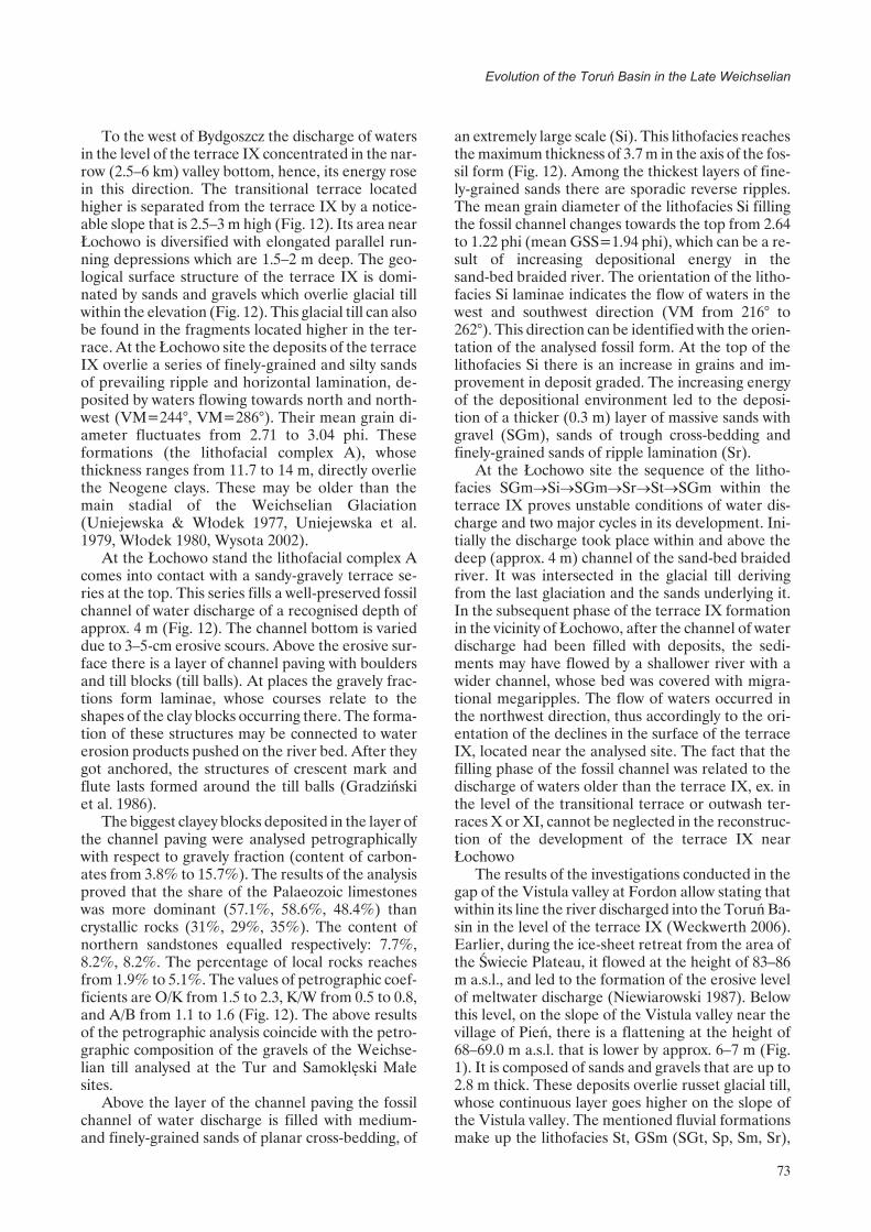
To the west of Bydgoszcz the discharge of watersin the level of the terrace IX concentrated in the nar-row (2.5–6 km) valley bottom, hence, its energy rosein this direction. The transitional terrace locatedhigher is separated from the terrace IX by a notice-able slope that is 2.5–3 m high (Fig. 12). Its area nearŁochowo is diversified with elongated parallel run-ning depressions which are 1.5–2 m deep. The geo-logical surface structure of the terrace IX is domi-nated by sands and gravels which overlie glacial tillwithin the elevation (Fig. 12). This glacial till can alsobe found in the fragments located higher in the ter-race. At the Łochowo site the deposits of the terraceIX overlie a series of finely-grained and silty sandsof prevailing ripple and horizontal lamination, de-posited by waters flowing towards north and north-west (VM=244°, VM=286°). Their mean grain di-ameter fluctuates from 2.71 to 3.04 phi. Theseformations (the lithofacial complex A), whosethickness ranges from 11.7 to 14 m, directly overliethe Neogene clays. These may be older than themain stadial of the Weichselian Glaciation(Uniejewska & Włodek 1977, Uniejewska et al.1979, Włodek 1980, Wysota 2002).
At the Łochowo stand the lithofacial complex Acomes into contact with a sandy-gravely terrace se-ries at the top. This series fills a well-preserved fossilchannel of water discharge of a recognised depth ofapprox. 4 m (Fig. 12). The channel bottom is varieddue to 3–5-cm erosive scours. Above the erosive sur-face there is a layer of channel paving with bouldersand till blocks (till balls). At places the gravely frac-tions form laminae, whose courses relate to theshapes of the clay blocks occurring there. The forma-tion of these structures may be connected to watererosion products pushed on the river bed. After theygot anchored, the structures of crescent mark andflute lasts formed around the till balls (Gradzińskiet al. 1986).
The biggest clayey blocks deposited in the layer ofthe channel paving were analysed petrographicallywith respect to gravely fraction (content of carbon-ates from 3.8% to 15.7%). The results of the analysisproved that the share of the Palaeozoic limestoneswas more dominant (57.1%, 58.6%, 48.4%) thancrystallic rocks (31%, 29%, 35%). The content ofnorthern sandstones equalled respectively: 7.7%,8.2%, 8.2%. The percentage of local rocks reachesfrom 1.9% to 5.1%. The values of petrographic coef-ficients are O/K from 1.5 to 2.3, K/W from 0.5 to 0.8,and A/B from 1.1 to 1.6 (Fig. 12). The above resultsof the petrographic analysis coincide with the petro-graphic composition of the gravels of the Weichse-lian till analysed at the Tur and Samoklęski Małesites.
Above the layer of the channel paving the fossilchannel of water discharge is filled with medium-and finely-grained sands of planar cross-bedding, of
an extremely large scale (Si). This lithofacies reachesthe maximum thickness of 3.7 m in the axis of the fos-sil form (Fig. 12). Among the thickest layers of fine-ly-grained sands there are sporadic reverse ripples.The mean grain diameter of the lithofacies Si fillingthe fossil channel changes towards the top from 2.64to 1.22 phi (mean GSS=1.94 phi), which can be a re-sult of increasing depositional energy in thesand-bed braided river. The orientation of the litho-facies Si laminae indicates the flow of waters in thewest and southwest direction (VM from 216° to262°). This direction can be identified with the orien-tation of the analysed fossil form. At the top of thelithofacies Si there is an increase in grains and im-provement in deposit graded. The increasing energyof the depositional environment led to the deposi-tion of a thicker (0.3 m) layer of massive sands withgravel (SGm), sands of trough cross-bedding andfinely-grained sands of ripple lamination (Sr).
At the Łochowo site the sequence of the litho-facies SGm�Si�SGm�Sr�St�SGm within theterrace IX proves unstable conditions of water dis-charge and two major cycles in its development. Ini-tially the discharge took place within and above thedeep (approx. 4 m) channel of the sand-bed braidedriver. It was intersected in the glacial till derivingfrom the last glaciation and the sands underlying it.In the subsequent phase of the terrace IX formationin the vicinity of Łochowo, after the channel of waterdischarge had been filled with deposits, the sedi-ments may have flowed by a shallower river with awider channel, whose bed was covered with migra-tional megaripples. The flow of waters occurred inthe northwest direction, thus accordingly to the ori-entation of the declines in the surface of the terraceIX, located near the analysed site. The fact that thefilling phase of the fossil channel was related to thedischarge of waters older than the terrace IX, ex. inthe level of the transitional terrace or outwash ter-races X or XI, cannot be neglected in the reconstruc-tion of the development of the terrace IX nearŁochowo
The results of the investigations conducted in thegap of the Vistula valley at Fordon allow stating thatwithin its line the river discharged into the Toruń Ba-sin in the level of the terrace IX (Weckwerth 2006).Earlier, during the ice-sheet retreat from the area ofthe Świecie Plateau, it flowed at the height of 83–86m a.s.l., and led to the formation of the erosive levelof meltwater discharge (Niewiarowski 1987). Belowthis level, on the slope of the Vistula valley near thevillage of Pień, there is a flattening at the height of68–69.0 m a.s.l. that is lower by approx. 6–7 m (Fig.1). It is composed of sands and gravels that are up to2.8 m thick. These deposits overlie russet glacial till,whose continuous layer goes higher on the slope ofthe Vistula valley. The mentioned fluvial formationsmake up the lithofacies St, GSm (SGt, Sp, Sm, Sr),
73
Evolution of the Toruñ Basin in the Late Weichselian

74
Piotr Weckwerth
Fig. 12. Geological structure of the terrace IX in Łochowo (66–67 m a.s.l.), to the west of Bydgoszczblack arrow – till ball, blue arrow – lamination around the till ball, red arrow – secondary erosive scour

whose mean diameter of grains equals 0.22–2.18 phi(Fig. 13). They are of worse graded towards the top.The analysis of graining indicates moderate and sta-ble energy of depositional environment. Moreover,there are interbeddings of massive finely-grainedsands and sands of planar cross-bedding and ripplelamination (Fig. 13). The dominating lithofacies (St,SGt) developed in the deeper part of the sandbedbraided river channel. Initially, gravely bed coversformed in the channel (GSm), on which the litho-facies of sinuous megaripples (St, SGt) were depos-ited. Weakening dynamics of sedimentation envi-ronment was accompanied by the formation ofindividual transverse bars (Sp) during the descent ofa high water stage. These bars formed during themoderate but unstable dynamics of depositional en-vironment. The directions of the palaeocurrents ofcross-bedding structures point to the southern direc-tion of water discharge (VM=177°).
The structural and texture properties of the de-posits constituting the described terrace strip on theVistula gap at Fordon prove the existence of waterdischarge in the level of 68.0–69.0 m a.s.l. directed tothe south, towards the Toruń Basin (Fig. 14D).These waters may have gone in the northern part ofthe basin, at the level of the terrace IX, which isapprox. 67.5 m a.s.l. The results of the investigationsappear to shorten the duration of bifurcation phaseof the Vistula at Fordon as proposed by R. Galon(1961 1968), as they exclude the terrace IX. The sub-sequent redirection to the north in this place may bepredisposed because of the waning of the dead iceburied in glacial deposits (Niewiarowski 1987) andbecause of the existence of the subglacial channel inthe line of the Vistula valley, as indicated by Galon(1934) and Mojski (1980). The initial discharge ofwaters to the north in the Fordon gap can be seen inthe narrow terrace strip, of the height of 58–60 ma.s.l. Such a direction of water discharge is illustratedby the preserved planar cross-beddings developed insands which were deposited in the low-energy envi-ronment (Fig. 13B). The activity of other water-courses flowing from the neighbouring morainic pla-teau cannot be neglected in the formation process ofthis terrace. These watercourses may have been theVistula’s tributaries. Normal faults found in the de-posits of the described terrace prove the existence ofwater discharge above the blocks of glacial dead ice,which were buried in the line of the present Vistulavalley at Fordon (Weckwerth 2006).
The sudden increase in the amount of flowing wa-ters in the Toruń Basin starting from the transitionalterrace found its reflection in the thicker fraction ofthe terrace deposits, which indicates higher energyof the depositional environment. Only after the gla-cial till had been removed from the bed of thebraided river channel did deep erosion mark itselfclearly, which was noticeable starting from the ter-
race VIII to a greater degree. The change ofhydrological conditions caused a faster reaction ofthe sedimentation in the channel of the braidedriver. The sandbed braided river, of dominantlybar-style sedimentation, changed into a higher-en-ergy flow, in which the share of lithofacies of troughcross-bedding (St) rose. Deeper braided river chan-nels dominated in which sinuous dunes migrated andformed sandy-gravely bed covers. Sandy transversebars were rare. The material transport at the riverbed occurred mainly on the traction way or devel-oped from the fractional near-bed suspension.Higher energy water flow concentrated in the nar-rower bed zone of the valley, starting from the ter-race IX, and particularly from the terrace VIII (Fig.1). In the eastern part of the basin, this terracereaches 65 m a.s.l., and in the central part 63 m a.s.l.,and 62 m a.s.l. to the east of Bydgoszcz. The strips ofthe terrace VII occur sporadically in the Toruń Ba-sin. Their minor fragments of 63–60 m a.s.l. can bedistinguished at the mouth of the Drwęca and to thesouth of Toruń.
The terrace VI is the lowest level, in which flow-ing waters directed to the west through the No-teć–Warta ice-marginal streamway (Galon 1953,1968, Kozarski 1962). This terrace is 57–60 m a.s.l. tothe south of Toruń, 56 m a.s.l. near Cierpice, and 54m a.s.l. in Bydgoszcz. In the vicinity of Ostromeckoand Fordon it is developed in two levels (VIa andVIb) separated by a distinctive slope of 4–5-metreheight (Fig. 1). The surface of the higher level of theterrace VI is composed of sands and gravels that areup to 2.2 m thick. They overlie medium- or fine-ly-grained cover sands and sands of parabolic orrampart dunes. The terrace VIa reaches the heightof 54–55 m a.s.l. in Bydgoszcz. Their deposits overliethe Neogene clays (Galon 1934, Weckwerth 2006).The bottom part of the terrace series is made of me-dium-grained sands with coarse-grained sands of aplanar cross-bedding (Sp). Their accumulation oc-curred in the form of sandy transverse bars in thesand-bed braided river (Fig. 15A). The increase inthe energy of the depositional environment contrib-uted to the accumulation of trough cross-beddedsands (St), which formed due to migration of sinuousdunes in the deeper part of the channel. The dis-charge of waters occurred in the southwest direction,therefore, the terrace VI (VIa) developed still at thetime of the Noteć-Warta ice-marginal streamway.
The top of the fluvial series of the lower level ofthe terrace VI (VIb) in Fordon is located at thedepth of approximately 3–3.5 m. Under the bed ofeolian cover sands (Fig. 15B) there is a real fossil ter-race surface which is 50 m a.s.l. This height relates tothe lower level of the terrace VIb to the south ofOstromecko (Fig. 1). To the west of Bydgoszcz, theheight of the Noteć-Warta ice-marginal streamwaybottom corresponds to the higher level of this ter-
75
Evolution of the Toruñ Basin in the Late Weichselian

76
Piotr Weckwerth
Fig. 13. Geological structure of the terraces in the northern part of of Vistula river gap at Fordon (after Weckwerth 2006)A – terrace 68–69 m a.s.l. (Pień site), B – terrace 58–60 m a.s.l. (Mozgowina site)1 – brown till with red layers, 2 – grey-brown till, 3 – boulders, 4 – massive fine-grained sand, 5 – gravel with boulder andcoarse-grained sand, 6 – trough cross-bedded medium- and fine-grained sand, 7 – trough cross-bedded medium-grainedsand with gravel, 8 – trough cross-bedded coarse-grained sand with gravel, 9 – ripple cross-laminated fine-grained sand,10 – planar cross-bedded medium-grained sand, 11 – massive medium-grained sand

race. Therefore, the terrace VIb in Fordon with thesurface covered with eolian cover sands is the level,where the Brda initially flowing to the south, beganto run to the east towards the Vistula valley.
The deposits of the lower level of the terrace VI(VIb) in Bydgoszcz mainly include finely-and me-dium-grained sands (Fig. 15B). At the bottom theychange into sands with gravel, and they directly over-lie the Miocene clayey and silty deposits. The totalthickness of the terrace deposits equals 1.6 m. Thedominant lithofacies include trough cross-beddedsands (St). The size of the mean grain of this depositis 1.93–1.96 phi. The secondary lithofacies containthe layer of channel paving, represented by massivesandy gravels with locally occurring boulders or grav-els of a sandy matrix with individual boulders or finesands and silts of horizontal lamination. The de-scribed sediments constituting the lower level of theterrace VI were deposited within the channel of thesandbed braided river, in which channel flows weremarked with the formation of sandy foresets (Sp)during the fall of a high water stage. In the deeperpart of the channel the more energetic discharge wasrelated to the deposition of fast transported materialin the inter-bar channels (St, SGt). The high energycharacter of this subenvironment is emphasised bynumerous inserts of the blue-russet Neogenic clayswhich are found along the bordering sets of troughbedding (Weckwerth 2006). The analysis of the pa-laeocurrent directions showed the mean orientationof the mean vector VM=184°. Initially, watersflowed in the channel in the southeast direction(VM=129°), then the discharge went in the inter-barchannels to the southwest (VM=228°). The abovechangeability of palaeocurrent directions may haveresulted from the attraction of the Brda waters in theterrace level VIb towards the gap section of theVistula valley at Fordon.
Evolution of the fluvial relief withrespect to the tectonic structuresof the Cenozoic bed
The evolution of the river network in the PolishLowland was closely related to the tectonic activity ofthe structures of the older bed. Changes in the valleynetwork system near the Bydgoszcz-Toruń hydro-graphical node and the growth of the Toruń Basin inthe northern direction due to the marginal erosion ofthe Vistula, as well as the reduction of the Quater-nary formations within the flood plain and the modi-fication of the surface relief of their bed, all may havebeen discussed in literature as the effects of thesemovements (Weckwerth 2006, 2007c).
The Toruń Basin is mainly located in the zone ofbanks, pillows and salt swells of the Cenozoic bed.There are noticeable relations between the location
77
Evolution of the Toruñ Basin in the Late Weichselian
Fig. 14. Reconstruction of discharge directions of watersin the Toruń Basin up to the time of the PomeraniaPhase of the last glaciation
A – meltwater discharge during the deglaciation of theToruń Basin; B – meltwater discharge during theWąbrzeźno Subphase; C–D – meltwater discharge dur-ing the Pomerania Phase1 – ice sheet, 2 – the extent of the ice sheet front duringits retreat in the Chodzież Subphase, 3 – hypotheticalextent of the ice sheet front in the Toruń Basin, 4 –course of subglacial channels, 5 – probable course ofsubglacial channels, 6 – older outwash tracks; 7 – youn-ger outwash courses of meltwater discharge; 8 – fromthe time of ice sheet stoppage in the line of thesouth-Wąbrzeźno moraines, 9 – from the time of icesheet stoppage in the line of the central Wąbrzeźnomoraines, 10 – in the level of the terrace XI, 11 – in thelevel of the terrace X, discharge of the Vistula ice-mar-ginal streamway waters in the levels: 12 – of the transi-tional terrace, 13 – of the terrace IX, 14 – larger blocks(lobes) of the dead ice, 15 – morainic plateaux, 16 – in-active, older courses of water discharge, directions ofwater outflow: 17 – older, 18 – younger, probable direc-tions of water discharge: 19 – older, 20 – younger, 21 –present extent of the Toruń Basin, 22 – presenthydrographical network (an outline)

78
Piotr Weckwerth
Fig. 15. Geological structure of the terrace VI in Bydgoszcz-Fordon (A – higher level VIa, B – lower level VIb, after Weck-werth 2006)
1 – clayed silt (Pliocene – outcrops A, Miocene – outcrops B), 2 – gravel with boulders, 3 – massive silt with fine-grainedsand layers, 4 – medium-grained planar cross-bedded sand, 5 – trough cross-bedded medium-grained sand and sand withgravel, 6 – coarse-grained planar cross-bedded sand with gravel, 7 – massive medium- and coarse-grained sand, 8 – mas-sive fine-grained sand, 9 – horizonatally bedded medium- and fine-grained sand (aeolian cover sands), arrow o thephotograf indicates bedding surfaces of cross-bedded sand with a thin layers of Neogene clay

of these structures and the effects of the activity ofthe fluvial processes in the Pleistocene. A good illus-tration of these can be the similarities in the locationof the elevations of the Quaternary surfaces to theMesozoic elevations, particularly noticeable in thesouthern part of the Torun Basin. The bottom of thefossil valley incised into the Pleistocene bed to thesouth of Toruń relates to the Mesozoic Ciechocinekanticline (Fig. 2). Partially this area corresponds tothe outwash levels and ice-marginal streamway ter-races located high in the basin (Fig. 1). Another ex-ample is the location of the remnant of the morainicplateau in the central part of the Toruń Basin withthe outwash levels adjoining it from the north. Theremnant lies higher than the neighbouring ice-mar-ginal streamway terraces and is located within thetop culmination of the sub-Quaternary surface andthe sub-Cenozoic Chrośna anticline. Similar rela-tions may be found in the analysis of the location ofthe Zalesie anticline in the west and southwest extentand the surrounding of the Toruń Basin
The present evolution of the relief of the ToruńBasin may have been influenced by changeable loadof the ice-sheet which triggered glacial and post-glacial isostatic movements (Liszkowski 1975, 1993,Piotrowski 1991). Moreover, activation of older dis-locations and intensification of geothermal heat flowmay have been of much importance (Petelski & Sa-durski 1987, Dyjor 1991, Liszkowski 1993). Theseprocesses, in the final stage of relief evolution(ice-sheet retreat), may have resulted in the develop-ment of forms of glacial genesis, located within theactivated salt structures. The examples of such formsmay be: the morainic plateau in the vicinity of Szubin(within the Szubin anticline), the fragment of a mo-rainic plateau in the central part of the Toruń Basin(the Chrośna anticline), the southeast part of the ba-sin between Aleksandrów Kujawski and Suchatówka(the Ciechocinek anticline), and the glaciotectoni-
cally deformed morainic hummocks in the vicinity ofŁabiszyn, which relate to the northern extent of theZalesie anticline. In the cyclical evolution of theinterglacial valleys in the area of the ice-marginalstreamway, starting from the Eopleistocene, onecannot either exclude the ascent of deep “warm” wa-ters squeezed from the Mesozoic formations in thelines of intersecting those tectonic dislocations (Pe-telski & Sadurski 1987).
The present location of the bottom of the Vistulavalley in the east and northeast parts of the ToruńBasin has clear foundations in the fossil valleys of theEemian Interglacial. Therefore, we cannot excludethe evolution of the river valley within the basin atthe time of the retreat of the Warta ice-sheet. Along-side the ongoing deglaciation of the basin, the valley(ice-marginal streamway?) of a parallel orientationdeveloped. It discharged meltwaters of the Vistulawaters to the west accordingly to the valley layout ofthe Great Interglacial. In the later period a separateEemian valley of the proto-Vistula evolved to thewest of Toruń, and was directed towards the north tothe Eemian Sea.
The analogical scheme of the river network de-velopment occurred at the end of the WeichselianGlaciation. After the deglaciation of the southwestpart of the Torun Basin, meltwaters directed initiallyto the west, at the back of the Łabiszyn moraines(within the Toruń Basin), i.e. in the south and south-west surroundings of the Szubin anticline (Figs 1, 14,16). These processes initiated incorporation of theTorun Basin to the Noteć-Warta ice-marginalstreamway. The main development phase of the No-teć-Warta ice-marginal streamway, starting from thePomerania phase of the last glaciation to the LateGlacial, marked itself by the formation of several ter-race levels (Fig. 16). Waters directing to the west ofBydgoszcz created a significantly narrower valley ofthe width of 2.5–6 km in the vicinity of Nakło upon
79
Evolution of the Toruñ Basin in the Late Weichselian
Fig. 16. Main development phases of the fluvial system of the Toruń Basin in the Late Weichselian (channel pattern and ageof terraces in Late Glacial after Tomczak 1982, 1987)

the Noteć. This section is located in the northern lim-its of the Szubin anticline and with its course it corre-sponds to the Eopleistocene valley of the proto-No-teć and the fossil valleys of the Great and EemianInterglacials (Figs 2, 3). The location of the de-scribed narrow fragment of the Noteć ice-marginalstreamway to the north of the Szubin Mesozoic ele-vation makes it possible to classify it as a valley of theantecedent gap character (Weckwerth 2007c). Its de-velopment can be related to the relaxational uplift-ing movements of the Kujawy-PomeraniaAnticlinorium (about 2,5 mm/year in time 17 to 13ka, Weckwerth 2009) within the zone of banks andsalt swells. The tectonic activation of the Szubin ele-vations may have also occurred after the glaciationperiods and prior to the Weichselian Glaciation.
Another example of the influence of the tectonicmovements of the Central Polish Anticlinoriumupon the evolution of the fluvial relief in the ToruńBasin can be seen in the change of the Vistula chan-nel to the northeast (Mojski 1980). As a result of thisprocess, the discharge of waters through the ice-mar-ginal streamway concentrated in the narrow belt ofits bottom to the west of Bydgoszcz (the terracesVIII–VI), near the gap of the Vistula at Fordon (Figs1, 16). This gap began to function most probably inthe level of the terrace VIII or lower, and thus, theVistula did not flow through the entire width of theToruń Basin but only in its northern part. With re-spect to their course the southern limits of the ter-races VIII–VI in the Toruń Basin relate to the north-west limit of the Kujawy-Pomerania Anticlinorium(Figs 1, 2, 16).
Conclusion
The development of the river network in the To-ruń Basin was largely influenced by uplifting tectonicmovements after the deglaciation period of the ba-sin. Climatic changes were of high importance.Therefore, it may be assumed that the similar to theLate Weichselian Glaciation reorganizational mech-anisms of water discharge directions, stimulated bythe tectonic activity of the older bed together withpossible bifurcation of rivers, may have taken placein the Toruń Basin at the start of the Eemian Inter-glacial.
At the end of the Weichselian Glaciation theToruń Basin was a hydrographical node merging wa-ters which flowed from various directions. With ref-erence to Galon’s investigations (1961, 1968) and theauthor’s research we can distinguish the followingterrace sets in the Toruń Basin: a) the outwash levelsformed not so far away from the ice-sheet front, i.e.during the Wąbrzeźno Subphase; b) the distal sec-tions of the outwash, i.e. the ice-marginal streamwayterraces (XI, X); c) the Vistula ice-marginal stream-
way terraces (the transitional terrace and IX); d) theVistula ice-marginal streamway terraces (VIII–VI)from the period of this river bifurcation at Fordon;and e) lower terraces of the Vistula valley (V–II). Inthe upper part of the Middle Weichselian watersflowing through the Toruń Basin formed a system ofsandbed braided rivers whose changeable flow re-gime registered in the deposits of various outwashlevels and terraces initially had higher energy, thenreduced energy and high again (Fig. 16). This re-sulted from the ice-sheet front retreat, intensity of itsablation and the inflow of the Vistula waters fromthe south. The sudden increase in the transport po-wer of flowing waters in the Toruń Basin occurred af-ter the penetration of the Vistula from the Płock Ba-sin into the Toruń Basin, and was related to thedeclining width of the river valley bottom startingfrom the discharge in the level of the terrace VIII.The limited amount of bar deposition was accompa-nied by a bigger share of deeper channel discharge ofa bed formed predominantly by sandy megaripples.The magnitude of deep erosion of the Vistula, whichlasted at the turn of the Middle Weichselian was con-ditioned by the energy and lithology of the channelbed. Deep erosion was obstructed by the glacial tillof the main stadial of the Weichselian and clays.
The rising values of the hydraulic transport gradi-ent of the water table distinguished for the depositsof the terraces younger than the outwash ones reflectthe rising share of deep erosion. That may have beencaused by tectonic uplifting (glaciostatic, Fig. 16).With respect to the present terrace slope, the biggervalues of the transport gradient of the water tablemay prove a later neotectonic depression of theirarea in the eastern part of the Toruń Basin.
Acknowledgement
The article comprises main arguments and con-clusions presented in the author’s doctoral thesis.The thesis was written under the supervision of Prof.dr habil. E. Wiśniewski, whom I would like to thankfor scientific guidance during my research. Someproblems discussed in the article contain the resultsof the investigations conducted within the grant No.N N306 3538 33 obtained from the Ministry of Sci-ence and Higher Education.
References
Andrzejewski L., 1994. Ewolucja systemu fluwialne-go doliny dolnej Wisły w późnym vistulianie i holo-cenie na podstawie wybranych dolin jej dopływów.Rozprawy UMK, Toruń: 113 pp.
Andrzejewski L., 1995. Genesis of the fluvial systemof the Lower Vistula river based on the selected
80
Piotr Weckwerth

side valleys. In: Starkel L. (ed.) Evolution of theVistula river valey during the last 15 000 yers. 5 (8),IGiPZ PAN: 139–156.
Augustowski B., 1982. Charakterystyka geomorfolo-giczna. In: Augustowski B. (ed.) Dolina dolnejWisły. Wydawnicwo PAN, Wrocław: 61–79.
Baraniecka M.D., 1980. Geneza elementów wklęs-łych powierzchni podłoża czwartorzędu na obsza-rze wału kujawskiego i niecki warszawskiej. Biul.Inst. Geol., 322, Z badań czwartorzędu w Polsce 24:31–64.
Brykczyński M., 1986. O głównych kierunkach roz-woju sieci rzecznej Niżu Polskiego w czwartorzę-dzie. Przegl. Geogr. 58 (3): 411–440.
Churska Z., 1969. Włocławek, Ciechocinek, Toruń.In: Przewodnik XLI Zjazdu P. T. Geol., Konin,21–23 września: 191–193.
Dadlez R., 1980a. Fault pattern in Polish Lowlandsand its bearing on the Permian-Mesozoic evolu-tion of the area. Przegl. Geol. 5: 278–286.
Dadlez R., 1980b. Tektonika wału pomorskiego.Kwartalnik Geol. 24 (4): 741–767.
Dadlez R. & Marek S., 1974. Polska północno-za-chodnia i środkowa. In: Budowa geologiczna Polski,IV, Tektonika, 1, Wyd. Geol., Warszawa: 239–255.
Dadlez R., Marek S. & Pokorski J. (eds.), 2000.Mapa geologiczna Polski bez utworów kenozoiku1:1 000 000, PIG, Warszawa.
Dadlez R. & Marek S., 1983. Kompleks cechsztyń-sko-mezozoiczny. In: Marek S. (ed.) Budowa geo-logiczna niecki warszawskiej (płockiej) i jej pod-łoża. Prace Inst. Geol. 103: 216–220.
Dadlez R. & Dembowska J., 1965. Budowa geolo-giczna parantyklinorium pomorskiego. Prace Inst.Geol. 40: 279 pp.
Dyjor S., 1987. Systemy kopalnych dolin Polski za-chodniej i fazy ich rozwoju w młodszym neogenie ieoplejstocenie. In: Jahn A. & Dyjor S. (eds.) Pro-blemy młodszego neogenu i eoplejstocenu w Polsce.Ossolineum, Wrocław: 85–101.
Dyjor S., 1991. Wpływ ewolucji paleogeograficznejna rozwój zlodowaceń w Polsce Zachodniej. In:Kostrzewski A. (ed.) Geneza, litologia i stratygrafiautworów czwartorzędowych, Geografia 50: 419–433.
Galon R., 1929. Kujawy „Białe” i „Czarne”. Bad.Geogr. Nad Polską Półn.-Zach.. 4–5: 48–76.
Galon R., 1934. Dolina dolnej Wisły, jej kształt i roz-wój na tle budowy dolnego Powiśla. Bad. Geogr.nad Pol. Płn.-Zach. 12–13: 111 pp.
Galon R. 1953. Morfologia doliny i zandru Brdy.Stud. Soc. Sci. Torun. 1 (6): 53 pp.
Galon R., 1961. Morphology of the Noteć-Warta (orToruń-Eberswalde) ice marginal streamway. Pr.Geogr. IGiPZ PAN 29: 129 pp.
Galon R., 1968. New facts and problems pertainingto the origin of the Noteć Warta Pradolina and thevalleys linked with it. Prz. Geogr. 40 (2): 307–315.
Galon R., 1981. Zagadnienie serii glacjalnej na przy-kładzie plejstocenu nad dolną Wisłą i dolnąDrwęcą. Biul. Inst. Geol. 321, Z badań czwartorzę-du w Polsce 23: 63–82.
Gradziński R., Kostecka A., Radomski A., Unrug R.,1986. Zarys sedymentologii. Wyd. Geol. Warszawa:628 pp.
Jankowski A.T., 1975. Stosunki hydrograficzne byd-goskiego węzła wodnego i ich zmiany spowodowa-ne działalnością człowieka. Stud. Soc. Scient. To-run., VII, PWN, Warszawa–Poznań–Toruń: 116pp.
Jentzsch A., 1919. Geologischer Führer durch dieUmgegend Thorns. Thorn: 56 pp.
Jeziorski J.W., 1991a. Kopalne osady aluwialne rzekiroztokowej z okresu interglacjału lubelskiego mię-dzy Włocławkiem a Ciechocinkiem. Przegl. Geol.39 (5–6): 284–292.
Jeziorski J. W., 1991b. Litostratygrafia osadów neo-plejstocenu we wschodniej części Równiny Ino-wrocławskiej. In: Kostrzewski A. (ed.) Geneza, lito-logia i stratygrafia utworów czwartorzędowych,Geografia 50: 449–456.
Jeziorski J.W., 1995a. Objaśnienia do SzczegółowejMapy Geologicznej Polski w skali 1:50 000 ark.Aleksandrów Kujawski. PIG, Warszawa: 33 pp.
Jeziorski J.W., 1995b. Objaśnienia do SzczegółowejMapy Geologicznej Polski w skali 1:50 000 ark.Gniewkowo. PIG, Warszawa: 29 pp.
Keilhack K., 1904. Die grosse baltische Endmoräneund das Thorn- Eberswalder Haupttal. Zeitschr. D.Deutsch. Geol. Gesll., Berlin: 132–141.
Knighton D., 1984. Fluvial forms and Processes. E.Arnold, London, New York, Melbourne, Auck-land: 218 pp.
Kordowski J., 1997. Morfologia i budowa geologicznarówniny zalewowej Wisły na odcinku Solec Kujaw-ski-Strzelce Dolne. IGiPZ PAN, Toruń: 27 pp.
Kostrzewa J., 1981. Morfogeneza doliny Tążyny.Przegl. Geogr. 53 (4): 803–818.
Kozarski S., 1962. Recesja ostatniego lądolodu zpółnocnej części Wysoczyzny Gnieźnieńskiej akształtowanie się pradoliny Noteci-Warty. PraceKom. Geogr.-Geol., II (3): 154 pp.
Kozłowska M. & Kozłowski, I., 1992. Objaśnienia doSzczegółowej Mapy Geologicznej Polski w skali1:50 000 ark. Bydgoszcz Wschód. PIG, Warszawa:38 pp.
Kucharski M., 1966. Geomorfologia i czwartorzęddoliny Wisły w okolicach Ciechocinka. Zesz. Nauk.UMK, Geografia 5: 37–59.
Lencewicz S., 1922. O wieku środkowego Powiśla.Posiedz. Nauk. PIG 3: 21–24.
Lencewicz S., 1923. O t. z. Zastoisku toruńskim.Przegl. Geogr. 4: 99–114.
81
Evolution of the Toruñ Basin in the Late Weichselian

Leopold L.B., Wolman M.G., Miller J.P., 1964. Flu-vial processes in geomorphology. W. H. Freemanand Company, San Francisco and London: 522 pp.
Liszkowski J., 1975. Wpływ obciążenia lądolodem naplejstoceńską i współczesną dynamikę litosfery naobszarze Polski. In: Współczesne i neotektoniczneruchy skorupy ziemskiej w Polsce 1: 256–277.
Liszkowski J., 1993. The effects of Pleistoceneice-sheets loading – deloading cycles on the be-drockstructureof Poland, Wybrane zagadnienianeotektoniki Polski. Folia Quaternaria 64: 7–23.
Łyczewska J., 1975. Objaśnienia do Szczegółowej Ma-py Geologicznej Polski w skali 1:50 000, ark. Cie-chocinek. PIG, Warszawa: 62 pp.
Maas G., 1904. Das Thorn-Eberswalder Haupttalund seine Endmoränen, Ein Schlusswort amHernn K. Keilhack. Zeitsch. D. Deutsch. Geol. Ge-sll. 56, Brifl. Mitt: 159–164.
Makowska A., 1979. Interglacjał eemski w DolinieDolnej Wisły. Studia Geolog. Polonica LXIII: 90 pp.
Makowska A., 1980. Late Eemian with preglacialand glacial part of Vistulian Glaciation in LowerVistula Region. Quaternary Studies In Poland 2(1): 37–56.
Marek S. & Znosko J., 1972a. Tektonika Kujaw.Kwartalnik Geol. 16 (1): 1–18.
Marek S. & Znosko J., 1972b. Historia rozwoju geo-logicznego Kujaw. Kwartalnik Geol. 16 (2): 23–248.
Marek S. & Znosko J., 1983. Pozycja geotektonicznai granice niecki warszawskiej (płockiej). In: MarekS. (ed.) Budowa geologiczna niecki warszawskiej(płockiej) i jej podłoża. Prace Inst. Geol. 103:13–20.
Mojski J.E., 1980. Budowa geologiczna i tendencjerozwoju doliny Wisły. Przegl. Geol. 6: 332–334.
Mojski J.E., 1982. Geologiczne warunki powstania irozwoju doliny dolnej Wisły. In: Augustowski B.(ed.) Dolina dolnej Wisły. Wydawnictwo PAN:19–60.
Mojski J.E., 1984a. Niż Polski i wyżyny środkowopol-skie. In: Budowa geologiczna Polski, Czwartorzęd,Wyd. Geol., Warszawa: 82–113.
Mojski J.E., 1984b. Zlodowacenie północnopolskie.In: Budowa geologiczna Polski, Czwartorzęd, Wyd.Geol., Warszawa: 218–255.
Mrózek W., 1958. Wydmy Kotliny Toruńsko-Bydgo-skiej. In: Wydmy śródlądowe Polski. 2: 7–59.
Niewiarowski W., 1968. Morfologia i rozwój pradoli-ny i doliny dolnej Drwęcy. Stud. Soc. Sci. Torun. 6(6): 132 pp.
Niewiarowski W., 1969. The relation of the Drwęcavalley to the Noteć-Warta (Toruń-Eberswalde)Pradolina and its role in the glacial and lateglacialdrainage system. Geogr. Polonica 17: 173–188.
Niewiarowski W., 1987. Evolution of the lowerVistula valley in the Unisław Basin and at the rivergap to the north of Bydgoszcz-Fordon. In: Starkel
L. (ed.) Evolution of the Vistula river valey duringthe last 15 000 years. part II, Geographical Studies,Special Issue 4, IGiPZ PAN: 233–252.
Niewiarowski W., 1992. Morphogenesis of the Żninchannel as an example of a subglacial channel ofcomplex origin in the Polish Lowland. Quaest.Geogr., Special Issue 3: 131–142.
Niewiarowski W., 1993. Geneza i ewolucja rynnyżnińskiej w okresie pełnego i późnego vistulianu.Acta Univ. Nicolai Copernici, Geografia 25: 3–30.
Niewiarowski W. & Noryśkiewicz B., 1983. Someproblems concerning the development of theVistula and Drwęca valley flors in the Toruń re-gion. Peterm. Mitteil. Ergänzungsheft 282, Haack,Gotha: 144–154.
Niewiarowski W. & Tomczak A., 1969. Morfologia irozwój rzeźby obszaru miasta Torunia i jego oko-lic. Zesz. Nauk. UMK., Geografia 6: s. 39–89.
Niewiarowski W. & Weckwerth P., 2006. Geneza irozwój rzeźby terenu. In: Andrzejewski L., Weck-werth P., Burak Sz. (eds.) Toruń i jego okolice, mo-nografia przyrodnicza. Wyd. UMK, Toruń: 65–98.
Niewiarowski W. & Wilczyński A., 1979. Objaśnieniado Mapy Geologicznej Polski w skali 1:200 000, ark.Toruń. Wyd. Geol. Warszawa.
Olszewski A. & Weckwerth P., 1999. The deforma-tional structures of the deposits on the Höfdabrek-kujökull forefield. Landform Analysis 2: 63–80.
Ost H.G., 1935. Neue Anschanungen zur Entwiclun-gsgechichte eines norddeutschen Urstromtales.Zeit. F. Gletsch. 22: 96–108.
Petelski K. & Sadurski A., 1987. Geneza pradolinyRedy-Łeby w świetle teorii transportu masy iciepła. Czasop. Geogr. 58 (4): 439–456.
Piotrowski A., 1991. The influence of sub_Quater-nary basemant on the development of Lower OdraValley in Pleistocene and Holocene. Kwart. Geol.35 (2): 221–234.
Pożaryski W., 1974. Podział obszaru Polski na jed-nostki tektoniczne. In: Budowa geologiczna Polski.Tektonika 1. Wyd. Geol. Warszawa: 24–34.
Pożaryski W., Tomczyk H. & Brochwicz-LewińskiW., 1983. Paleozoik przedpermski i jego podłoże.In: Marek S. (ed.) Budowa geologiczna niecki war-szawskiej (płockiej) i jej podłoża. Prace Inst. Geol.103: 206–215.
Raczyńska A., 1971. Zarys stratygrafii dolnej kredy wniecce mogileńskiej. Kwart. Geol. 15 (1): 106–121.
Roszko L., 1968. Z historii rozwoju doliny dolnejWisły. Folia Quater. 29: 97–108.
Samsonowicz A., 1924. Zastoiska lodowcowe nadgórna i środkową Wisłą (Lacs endigués glaciares-sur la Haute et Moyenne Vistule). Posiedz. Nauk.PIG 1, Warszawa: 8–9.
Schumm S.A., 1977. The fluvial system. John Wiley &Sons, New York-London-Sydney-Toronto: 338 pp.
82
Piotr Weckwerth

Sonntag P., 1916. Altes und Neues vom diluvialenThorner Stausee. Schriften NaturforschendenGesellschaft in Danzig, 14 (2): 66–86.
Sonntag P., 1919. Geologie von Westpreuâen, Verlagvon Gebrüder Borntraeger: 240 pp.
Starkel L. 2001. Historia doliny Wisły od ostatniegozlodowacenia do dziś. Monografie 2, WydawnictwoPAN, Warszawa: 263 pp.
Szmańda J.B., 2000. Litodynamiczny zapis powodziw aluwiach pozakorytowych Wisły. In: MolewskiP., Wysota W. (eds.) Dawne i współczesne systemymorfogenetyczne środkowej części polski Północnej,Przewodnik wycieczek terenowych, V Zjazd Geo-morfologów Polskich 11–14 września 2000, Toruń:221–231.
Szmańda J.B., 2002. Litofacjalny zapis powodzi wwybranych fragmentach równin zalewowych Wisły,Drwęcy i Tażyny, maszynopis rozprawy doktor-skiej w Inst. Geogr. UMK Toruń.
Thomas G.S.P., Connaughton M. & DackombeR.V., 1985. Facies variation in a Late pleistocenesupraglacial outwash sandur from the Isle of Man.Geolog. Journal 20: 193–213.
Tomczak A., 1971. Kępa Bazarowa na Wiśle w Toru-niu w świetle badań geomorfologicznych oraz ar-chiwalnych materiałów kartograficznych. Stud.Soc. Sci. Torun. 7 (6): 111 pp.
Tomczak A., 1982. The evolution of the Vistula rivervalley between Toruń and Solec Kujawski duringthe Late Glacial and Holocene. In: Starkel L. (ed.)Evolution of the Vistula river valley during the last15 000 years. part I, Geographical Studies, SpecialIssue 1, IGiPZ PAN: 109–130.
Tomczak A., 1987. Evolution of the Vistula valley inthe Torun Basin in the Late Glacial and Holocene.In: Starkel L. (ed.) Evolution of the Vistula rivervalley during the last 15 000 years, part II, Geo-graphical Studies, Special Issue 4, IGiPZ PAN:207–232.
Uniejewska M. & Nosek M., 1992. Objaśnienia doSzczegółowej Mapy Geologicznej Polski w skali1:50 000 ark. Łabiszyn. Wyd. Państw. Inst. Geol.Warszawa: 98 pp.
Uniejewska M., Nosek M. & Włodek M., 1979. Objaś-nienia do Mapy Geologicznej Polski w skali1:200 000, ark. Nakło. Wyd. Geol. Warszawa: 74 pp.
Uniejewska M. & Włodek M., 1977. Zagadnieniastratygrafii plejstocenu okolic Nakła. Kwart. Geol.21 (4): 919–920.
Weckwerth P., Unpublished, Morfogeneza wybra-nych obszarów Kotliny Toruńskiej a problem jejroli w układzie hydrograficznym podczas górnegoplenivistulianu. Ph.D. thesis, UMK, Toruń.
Weckwerth P., 2005. Poziomy sandrowe i ich rozwójw Kotlinie Toruńskiej w górnej części plenivistulia-nu. In: Kotarba A., Krzemień K. & Święchowicz J.(eds.) VII Zjazd Geomorfologów Polskich, Kraków
19–22 września 2005, Współczesna ewolucja rzeźbyPolski: 507–512.
Weckwerth P., 2006. Problem bifurkacji Wisły podFordonem (Bydgoszcz) na tle ewolucji Kotliny To-ruńskiej pod koniec plenivistulianu. Przegl. Geogr.78 (1): 47–68.
Weckwerth P., 2007a. Kształtowanie się odpływuwód roztopowych w północnej części Kujaw w cza-sie recesji ostatniego lądolodu. In: Molewski, P.,Wysota W. & Weckwerth P. (eds.) Plejstocen Ku-jaw i dynamika lobu Wisły w czasie ostatniego zlodo-wacenia, XIV Konferencja Stratygrafia PlejstocenuPolski, Ciechocinek, 3–7 września 2007. PIG, War-szawa: 163–169.
Weckwerth P., 2007b. Morfologia i mechanizm for-mowania moren łabiszyńskich. In: Molewski P.,Wysota W. & Weckwerth P. (eds.) Plejstocen Ku-jaw i dynamika lobu Wisły w czasie ostatniego zlodo-wacenia, XIV Konferencja Stratygrafia PlejstocenuPolski, Ciechocinek, 3–7 września 2007. PIG, War-szawa: 147–155.
Weckwerth P., 2007c. Późnovistuliański rozwój siecirzecznej w rejonie Kotliny Toruńskiej na tle struk-tur starszego podłoża. In: Florek W. (ed.) Morfo-twórcza rola lodowców i lądolodów plejstoceń-skich i współczesnych, Słupskie Prace Geograficzne4, Akademia Pedagogiczna w Słupsku: 143–156.
Weckwerth P., 2009. Warunki depozycji osadów ple-nivistuliańskiej rzeki roztopowej w Kotlinie Toru-ńskiej. In: Żarski M., Lisicki S. (eds.) XVI Konfe-rencja Stratygrafia Plejstocenu Polski, Strefamarginalna lądolodu zlodowacenia warty i pojezie-rza plejstoceńskie na południowym Podlasiu, Zim-na Woda k. Łukowa, 31.08–4.09.2009: 135–138.
Wilczyński A., 1973. Budowa geologiczna okolic To-runia. Acta UNC, Geografia 10 (32): 13–39.
Wiśniewski E., 1976. Rozwój geomorfologiczny doli-ny Wisły pomiędzy Kotliną Płocką a Kotliną Toru-ńską. Stud. Soc. Scient. Tor. 8 (4–6): 124 pp.
Wiśniewski E., 1987. The evolution of the Vistulariver valley between Warsaw and Płock Basins dur-ing the last 15 000 years. In: Starkel L. (ed.) Evolu-tion of the Vistula river valey during the last 15 000years, part II, Geographical Studies, Special Issue4, IGiPZ PAN: 171–187.
Wiśniewski E., 1990. Evolution of the Vistula Valley.In: Starkel L. (ed.) Evolution of the Vistula rivervalley during the last 15 000 years, part III, Geo-graphical Studies, Special Issue 5, IGiPZ PAN:141–146.
Włodek M., 1980. Młodszy plejstocen w rejonie Na-kła nad Notecią. Przegl. Geol. 8: 453–456.
Woldstedt, P., 1932. Über Randlagen der letztenVereisung in Ostdeutschland und Polen und überdie Herausbildung des Netzte-Warte Urstromta-les. Jb. Preuss. Geol. Landesanst. 52.
83
Evolution of the Toruñ Basin in the Late Weichselian

Wrotek K., 1990. Objaśnienia do Szczegółowej MapyGeologicznej Polski w skali 1:50 000 ark. Rzęcz-kowo. Wyd. Państw. Inst. Geol., Warszawa: 66 pp.
Wrotek K., 1993. Objaśnienia do Szczegółowej MapyGeologicznej Polski w skali 1:50 000 ark. ZłotnikiKujawskie. Wyd. Państw. Inst. Geol., Warszawa:33 pp.
Wysota W. 2002. Stratygrafia i środowiska sedymenta-cji zlodowacenia wisły w południowej części dolnegoPowiśla. UMK, Toruń: 144 pp.
Zieliński T., 1993. Sandry Polski północno-wschod-niej – osady i warunki sedymentacji. Prace Nauk.Uniw. Śl. 1398: 97 pp.
Zieliński T., 1995. Kod litofacjalny i litogenetyczny –konstrukcja i zastosowanie. In: E. Mycielska-Dow-giałło E. & Rutkowski J. (eds.) Badania osadówczwartorzędowych, wybrane metody i interpretacjawyników. Warszawa: 221–234.
Żurawski M., 1959. Dolina kopalna w rejonie Byd-goszczy. Zeszyty Nauk. UAM, Geografia 2:131–132.
84
Piotr Weckwerth


