Evaluation of the Existing CORS Network Infrastructure in ...
13
TS03G - GNSS CORS Networks Case Studies (Flash) Victor H.S. Khoo, Hua Seng Tan and Mohd Rashid Md Noor Evaluation of the Existing CORS Network Infrastructure in Singapore to Meet User Demand FIG Working Week 2011 Bridging the Gap between Cultures Marrakech, Morocco, 18-22 May 2011 1/13 Evaluation of the Existing CORS Network Infrastructure in Singapore to Meet User Demand Victor H.S. KHOO, Hua Seng TAN and Mohd Rashid MD NOOR, Singapore Key words: Global Positioning System (GPS), GNSS, CORS, Differential GPS (DGPS), Real-Time Kinematic (RTK), VRS SUMMARY The Singapore Land Authority (SLA) has implemented the Singapore Satellite Positioning Reference Network (known as SiReNT) infrastructure, in 2006 to support nation-wide differential GPS positioning. SiReNT is one of the major technical components of Singapore’s National Spatial Data Infrastructure (NSDI). It allows homogeneous positioning throughout the country and underpins surveying, mapping, GIS data collection and many other positioning activities. The number of users for SiReNT has tripled in 2008 to more than 100. Since its implementation a total of 128,000 hours of GPS data has been provided through the 3 basic services. The Continuously Operating Reference Station (CORS) infrastructure has been in operation for more than 4 years. It takes advantage of the Trimble GPSNet VRS system at the control centre with the Trimble NetRS receivers that only observe GPS satellites. The advancement of GNSS technology has been enormous in the last 5 years with the introduction of new GPS signals and new satellite systems. Hence, evaluation and assessment of the existing SiReNT infrastructure is necessary to ensure that the infrastructure remains relevant, meet user demand and is able to be support all types of positioning users. This paper examines and reviews the existing SiReNT system, hardware and software, integration, processes and business plan; recommend necessary upgrading and changes to meet current and future needs of positioning users.
Transcript of Evaluation of the Existing CORS Network Infrastructure in ...

TS03G - GNSS CORS Networks Case Studies (Flash)
Victor H.S. Khoo, Hua Seng Tan and Mohd Rashid Md Noor
Evaluation of the Existing CORS Network Infrastructure in Singapore to Meet User Demand
FIG Working Week 2011
Bridging the Gap between Cultures
Marrakech, Morocco, 18-22 May 2011
1/13
Evaluation of the Existing CORS Network Infrastructure in
Singapore to Meet User Demand
Victor H.S. KHOO, Hua Seng TAN and Mohd Rashid MD NOOR, Singapore
Key words: Global Positioning System (GPS), GNSS, CORS, Differential GPS (DGPS),
Real-Time Kinematic (RTK), VRS
SUMMARY
The Singapore Land Authority (SLA) has implemented the Singapore Satellite Positioning
Reference Network (known as SiReNT) infrastructure, in 2006 to support nation-wide
differential GPS positioning. SiReNT is one of the major technical components of
Singapore’s National Spatial Data Infrastructure (NSDI). It allows homogeneous positioning
throughout the country and underpins surveying, mapping, GIS data collection and many
other positioning activities. The number of users for SiReNT has tripled in 2008 to more than
100. Since its implementation a total of 128,000 hours of GPS data has been provided through
the 3 basic services. The Continuously Operating Reference Station (CORS) infrastructure
has been in operation for more than 4 years. It takes advantage of the Trimble GPSNet VRS
system at the control centre with the Trimble NetRS receivers that only observe GPS
satellites. The advancement of GNSS technology has been enormous in the last 5 years with
the introduction of new GPS signals and new satellite systems. Hence, evaluation and
assessment of the existing SiReNT infrastructure is necessary to ensure that the infrastructure
remains relevant, meet user demand and is able to be support all types of positioning users.
This paper examines and reviews the existing SiReNT system, hardware and software,
integration, processes and business plan; recommend necessary upgrading and changes to
meet current and future needs of positioning users.
TS03G - GNSS CORS Networks Case Studies (Flash)
Victor H.S. Khoo, Hua Seng Tan and Mohd Rashid Md Noor
Evaluation of the Existing CORS Network Infrastructure in Singapore to Meet User Demand
FIG Working Week 2011
Bridging the Gap between Cultures
Marrakech, Morocco, 18-22 May 2011
2/13
Evaluation of the Existing CORS Network Infrastructure in
Singapore to Meet User Demand
Victor H.S. KHOO, Hua Seng TAN and Mohd Rashid MD NOOR, Singapore
1. INTRODUCTION
Permanent GNSS reference station infrastructures are being increasingly established by many
countries all over the world. It is a global trend that these permanent reference stations are
developed in a network environment and operated continuously. These GNSS infrastructure is
technically known as the Continuously Operating Reference Station (or in short CORS).
Traditionally, the CORS is mainly used to support two main categories of applications - the
geodetic and the Differential GPS (DGPS) applications. Nevertheless, the infrastructure is
now routinely used to support an increasing number of diverse applications.
The Singapore Land Authority (SLA) implemented the Singapore national permanent GPS
reference station network infrastructure in September 2006. The infrastructure known as the
Singapore Satellite Positioning Reference Network (or SiReNT in short), is a nation-wide
DGPS infrastructure developed to support various DGPS positioning businesses and
industries. The primary objective of SiReNT is to support the coordinated cadastral survey
system in Singapore. Fundamentally, SiReNT system ensures a homogeneous geographical
reference frame for all kinds of land surveying, mapping and positioning activities in
Singapore.
Beside surveying and mapping applications, SiReNT is developed as an infrastructure with
the fundamental design for the integration with applications that take advantage of DGPS
technology. Applications such as vehicle tracking, navigation, deformation monitoring etc.
can be developed to leverage on the SiReNT infrastructure.
Currently SiReNT consists of 6 GPS reference stations connected to a Data Control Centre
(DCC) which is located at the Singapore Government Data Centre. This is to ensure that we
can achieve high system availability and high data integrity. SiReNT adopts leading-edge
technology of Network-DGPS both for Real-Time Kinematic (RTK) and Code-based DGPS
(CDGPS) techniques. It supports the Network-RTK technique known as the Virtual Reference
Station (VRS™) technique.
SiReNT utilised the Trimble GPSNet™ software at the DCC to control and manage the GPS
reference stations within the infrastructure network and to generate DGPS corrections. In
VRS mode, GPSNet software provides all GPS data interpolated to match the position of the
rover, which may be at any location within the reference station network. Matching the rover's
position provides a very short baseline, which reduces systematic errors for RTK
considerably. See (Vollath, 2000) for information about VRS. Figure 1 show the SiReNT
network consists of 6 permanent GPS reference stations.

TS03G - GNSS CORS Networks Case Studies (Flash)
Victor H.S. Khoo, Hua Seng Tan and Mohd Rashid Md Noor
Evaluation of the Existing CORS Network Infrastructure in Singapore to Meet User Demand
FIG Working Week 2011
Bridging the Gap between Cultures
Marrakech, Morocco, 18-22 May 2011
3/13
Figure 1: The Singapore Satellite Positioning Reference Network, SiReNT
A few improvements were carried out in the last 4 years since the implementation of SiReNT
system. An additional reference station was established in collaboration with the Tropical
Marine Science Institute (TMSI) of National University of Singapore (NUS). The station is
owned by TMSI and is sharing its data with SiReNT. An integrity monitoring system was also
added to the System. Real-time alarm is configured to alert operator of any irregularity within
the system. Periodic reports are generated for the integrity monitoring of the network
infrastructure.
Today, we have in place a national infrastructure which is operational and meets the basic
needs of positioning users. The system is easily accessible by both public and private entities.
An effective business plan is adopted to ensure that the signing up process is simple and
straight forward. The availability of the system is on average 99.95% computed on a monthly
basis.
However, the advancement of technologies (both in GNSS and IT) and the increase demand
from diverse applications of DGPS has driven us to examine and review the current system.
We also want the infrastructure to stay relevant and be able to meet the current and future
demands of geospatial users in government, industry and the community.
This paper examines and reviews the existing SiReNT CORS system implemented in 2006
based on 3 main areas, the technology, the system and the policy governing the system. This
review will consider the impact and use of technology; the capacity and effectiveness of the
existing system; and the relevance of existing business model and policy to meet the current

TS03G - GNSS CORS Networks Case Studies (Flash)
Victor H.S. Khoo, Hua Seng Tan and Mohd Rashid Md Noor
Evaluation of the Existing CORS Network Infrastructure in Singapore to Meet User Demand
FIG Working Week 2011
Bridging the Gap between Cultures
Marrakech, Morocco, 18-22 May 2011
4/13
and future needs of users. Ultimately, objective of this strategic review will provide us with a
basis to decide on the required enhancement to the system and the vision to move forward.
2. APPLICATIONS AND USAGE OF SiReNT
The key objective in the establishment of SiReNT system was to support the Singapore
national coordinated cadastre system. SiReNT infrastructure is key component in the new
SVY21 cadastral survey system, implemented in August 2004. Under the new survey system,
surveyors use the SiReNT reference station data for the establishment of the Integrated
Survey Network (ISN) control marks. The ISN control points are used as the survey control in
all cadastral survey carried out under the SVY21 system.
In geodetic perspective, SiReNT serves as the national geodetic reference frame (national
datum) for surveying and positioning activities. It is regarded as the “Zero” order geodetic
control of Singapore which is the reference frame for all mapping, positioning and surveying
applications. SiReNT has been widely used in surveying and mapping activities in Singapore
and is essential in supporting the NSDI in Singapore.
The need for accurate positioning is not limited to surveying and mapping. Today, a variety of
industries are finding a need for accurate positioning i.e.
− Telematics – navigation, tracking, road-pricing etc.;
− Monitoring – deformation monitoring and atmospheric monitoring;
− Satellite remote sensing;
− Geospatial data acquisition to support SDI; and
− Geodetic applications – tectonic plate movement etc.
SiReNT is currently supporting users in the following area of applications:
1. Geodetic and Geodynamics;
2. Surveying and Mapping;
3. Vehicle Tracking and Navigation; and
4. Research.
However, with the SiReNT infrastructure already in place providing agencies with actual
scale test bed which has a national coverage and proof-of-concept scheme to facilitate
applications development, many agencies have started to adopt Differential GPS positioning
in their daily operations as well as building new services utilising the DGPS technology.
These agencies have benefited from the SiReNT infrastructure as they are able to prototype
their applications before full implementation. Some examples of potential and impending
applications suggested by public agencies in Singapore are:
− Satellite-based Electronic Road Pricing (ERP)
− Emergency Response
− National Parks Mapping
− Utilities Asset and Inventory Management

TS03G - GNSS CORS Networks Case Studies (Flash)
Victor H.S. Khoo, Hua Seng Tan and Mohd Rashid Md Noor
Evaluation of the Existing CORS Network Infrastructure in Singapore to Meet User Demand
FIG Working Week 2011
Bridging the Gap between Cultures
Marrakech, Morocco, 18-22 May 2011
5/13
− Container Port Management
− GNSS Aircraft Landing System
− Coastline protection and coastal subsidence monitoring
− Road Inventory Management and Mapping
− Automated Parking Enforcement
− Environmental Mapping
Currently, the SiReNT system is capable of supporting up to 2000 concurrent users, taking
into consideration of the capacity of bandwidth and server used in the system. In anticipation
of the various impending applications, we need to assess if the current system and
infrastructure is in fact able to support these applications. Several factors need to be
considered: the number of concurrent users supported, the GNSS system supported, the
bandwidth, the data dissemination approach, the correction latency, etc.
The usage of SiReNT has increase over the years. Figure 2 shows the number of transactions
for real-time data which include both code-based DGPS and RTK products. In total, 56400
real-time transactions were recorded since October 2006. We have seen the increase of 370%
for the full year of 2010 as compared to 2008. In 2009, SiReNT recorded a higher than normal
transactions of about 20000. This is due to a mapping project carried out by one customer.
The number of transaction recorded for the first 2 months of this year already surplus the total
transactions of 2008. We will see a record high of real-time usage this year as a few new
telematics users have started to use the system. Each login connection to the system is
recorded as a transaction. This is a good measure of the usage of the system.
0
5000
10000
15000
20000
25000
2006 (Oct,
Nov, Dec)
2007 2008 2009 2010 2011 (Jan,
Feb)
No. of Transactions
Year
No. of Transactions Per Year
Figure 2: No. of Real-time Transactions of SiReNT
Figure 3 shows the total usage of SiReNT data (in hour) and the number of users over the last

TS03G - GNSS CORS Networks Case Studies (Flash)
Victor H.S. Khoo, Hua Seng Tan and Mohd Rashid Md Noor
Evaluation of the Existing CORS Network Infrastructure in Singapore to Meet User Demand
FIG Working Week 2011
Bridging the Gap between Cultures
Marrakech, Morocco, 18-22 May 2011
6/13
5 years. A total of 128,000 hour of GPS data has been consumed since the implementation of
the system. The usage has been increasing overall over the last five years in conjunction with
a general increase in the number of users. With initiatives in new customer segments
upcoming, it is projected that the next 5 years will see a continued increase in both these
statistics.
56
48
77
93
112
91
0
20
40
60
80
100
120
0
5000
10000
15000
20000
25000
30000
35000
40000
45000
2006 2007 2008 2009 2010 2011
Number of Users
Hours
Year
Total Usage and Number of Users
Usage Duration
Number of Users
Figure 3: Total usage and the number of users of SiReNT from 2006 to 2011
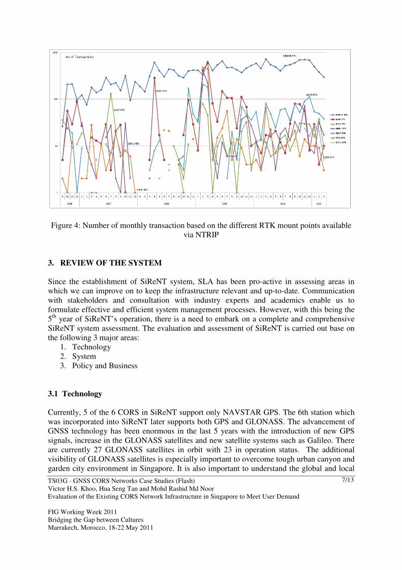
Figure 4 below shows the number of monthly transactions based on different RTK mount
points of the NTRIP (Networked Transport of RTCM via Internet Protocol) server. SIRENT-
RTK which is the mount point streaming Network RTK correction recorded the highest
transaction over the years. The statistic shows that the usage of Network-RTK is higher than
the single-based RTK. This information enables us to understand the users’ preference.
We are expecting exponential increase of users in the next 5 years. Transaction is expected to
grow in tandem with the growth in the number of new users as potential customers in various
segments are beginning to realise the need for high accuracy GPS positioning and tracking to
enhance their workflow or to achieve their objectives. From analysing the current system and
its operation, it helps us to strategically plan for enhancement of the system to meet users
needs.
TS03G - GNSS CORS Networks Case Studies (Flash)
Victor H.S. Khoo, Hua Seng Tan and Mohd Rashid Md Noor
Evaluation of the Existing CORS Network Infrastructure in Singapore to Meet User Demand
FIG Working Week 2011
Bridging the Gap between Cultures
Marrakech, Morocco, 18-22 May 2011
7/13
Figure 4: Number of monthly transaction based on the different RTK mount points available
via NTRIP
3. REVIEW OF THE SYSTEM
Since the establishment of SiReNT system, SLA has been pro-active in assessing areas in
which we can improve on to keep the infrastructure relevant and up-to-date. Communication
with stakeholders and consultation with industry experts and academics enable us to
formulate effective and efficient system management processes. However, with this being the
5th
year of SiReNT’s operation, there is a need to embark on a complete and comprehensive
SiReNT system assessment. The evaluation and assessment of SiReNT is carried out base on
the following 3 major areas:
1. Technology
2. System
3. Policy and Business
3.1 Technology
Currently, 5 of the 6 CORS in SiReNT support only NAVSTAR GPS. The 6th station which
was incorporated into SiReNT later supports both GPS and GLONASS. The advancement of
GNSS technology has been enormous in the last 5 years with the introduction of new GPS
signals, increase in the GLONASS satellites and new satellite systems such as Galileo. There
are currently 27 GLONASS satellites in orbit with 23 in operation status. The additional
visibility of GLONASS satellites is especially important to overcome tough urban canyon and
garden city environment in Singapore. It is also important to understand the global and local

TS03G - GNSS CORS Networks Case Studies (Flash)
Victor H.S. Khoo, Hua Seng Tan and Mohd Rashid Md Noor
Evaluation of the Existing CORS Network Infrastructure in Singapore to Meet User Demand
FIG Working Week 2011
Bridging the Gap between Cultures
Marrakech, Morocco, 18-22 May 2011
8/13
GNSS receiver market trend as well as the users’ choice of equipment. Most of the survey
grade GNSS receivers available today are already GPS+GLONASS. Hence, it would be
prudent to consider upgrading all the SiReNT CORS to support both GPS and GLONASS.
The addition of GLONASS capability can significantly improve (about 10 percent
improvements observed) the number of position solutions with redundancy available in the
urban canyon. With increasing GLONASS satellite availability, the benefits of using
GLONASS will even be greater. Figure 5 below shows the increase visibility of satellites if
GLONASS is tracked. The cut-off angle is set at 20 degree to simulate the urban environment.
Figure 5: GPS only compared to GPS+GLONASS visibility for 20 degree cut-off angle in
Singapore
Besides the GNSS technology, there is a need to review the communication link between the
reference station and the control centre. The main consideration is to choose a communication
link that presents very little or no downtime and yet able to provide the bandwidth for the
streaming of SiReNT data. A potential increase in the SiReNT data streams will be taken into
consideration. In addition, redundancy in the communication link will be considered with the
possibility of using two different types of communication links for the entire infrastructure.
3.2 System
SiReNT is a real-time system that operates continuously 24 by 7 automatically with minimum
human interventions. The system heavily involved the usage of GNSS Technology,
Information Technology and Communication Technology. Besides that the system also
depends on good management and maintenance procedures to ensure high availability and
reliability. The 4 major components of SiReNT CORS system are:
− GNSS hardware and equipment;
− GNSS software and database;
− Reference station infrastructure; and
GPS only GPS + GLONASS
TS03G - GNSS CORS Networks Case Studies (Flash)
Victor H.S. Khoo, Hua Seng Tan and Mohd Rashid Md Noor
Evaluation of the Existing CORS Network Infrastructure in Singapore to Meet User Demand
FIG Working Week 2011
Bridging the Gap between Cultures
Marrakech, Morocco, 18-22 May 2011
9/13
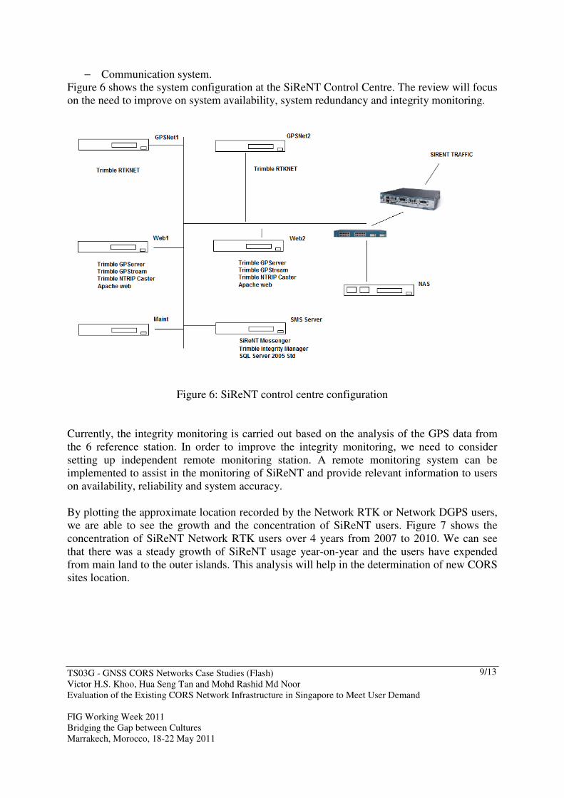
− Communication system.
Figure 6 shows the system configuration at the SiReNT Control Centre. The review will focus
on the need to improve on system availability, system redundancy and integrity monitoring.
Figure 6: SiReNT control centre configuration
Currently, the integrity monitoring is carried out based on the analysis of the GPS data from
the 6 reference station. In order to improve the integrity monitoring, we need to consider
setting up independent remote monitoring station. A remote monitoring system can be
implemented to assist in the monitoring of SiReNT and provide relevant information to users
on availability, reliability and system accuracy.
By plotting the approximate location recorded by the Network RTK or Network DGPS users,
we are able to see the growth and the concentration of SiReNT users. Figure 7 shows the
concentration of SiReNT Network RTK users over 4 years from 2007 to 2010. We can see
that there was a steady growth of SiReNT usage year-on-year and the users have expended
from main land to the outer islands. This analysis will help in the determination of new CORS
sites location.

TS03G - GNSS CORS Networks Case Studies (Flash)
Victor H.S. Khoo, Hua Seng Tan and Mohd Rashid Md Noor
Evaluation of the Existing CORS Network Infrastructure in Singapore to Meet User Demand
FIG Working Week 2011
Bridging the Gap between Cultures
Marrakech, Morocco, 18-22 May 2011
10/13
Figure 7: Concentration of SiReNT Network RTK users from 2007 to 2010
The system evaluation and assessment should further break down to include the following
components and areas:
1. Hardware
2. Software
3. CORS site location (including tendency agreements)
4. Data Flow
5. Network Connectivity
6. Power Management
7. Housing of the Equipment (Protection)
8. System Performance which is a factor of System Redundancy and Availability
9. System Integrity and Reliability
10. Periodic Maintenance Plan

TS03G - GNSS CORS Networks Case Studies (Flash)
Victor H.S. Khoo, Hua Seng Tan and Mohd Rashid Md Noor
Evaluation of the Existing CORS Network Infrastructure in Singapore to Meet User Demand
FIG Working Week 2011
Bridging the Gap between Cultures
Marrakech, Morocco, 18-22 May 2011
11/13
3.3 Business and Policy
SiReNT provides basic standard services primarily to cater for the general applications in
surveying and mapping. It offers the following 3 standard services:
− Post-processing (PP) service;
− Real-time Kinematic (RTK) service (include both conventional single-base RTK and
Network RTK services); and
− Real-time Code Differential GPS (DGPS) service (include both conventional single-
base DGPS and Network DGPS services).
The real-time services of SiReNT are provided via NTRIP mount-points and the post-process
services are provided through SiReNT website where RINEX files can be generated on
demand. A subscriber can subscribe to any of the 3 services or all of them depending on their
needs. Each subscriber will have to register an account with SiReNT and the charging is on
monthly basis. The fundamental changing principle of SiReNT is based on the amount of data
used and is computed based on the time period. However, the real-time code DGPS service is
provided based on annual fee with unlimited usage. The SiReNT website and the online
services provided have been very reliable, consistent and simple to use. The user interface
was designed to cater for is particularly was
SiReNT is designed to be able to support diverse applications in Singapore. In order to
promote the usage of high accuracy DGPS applications in sectors outside surveying and
mapping, the SiReNT Proof-of-Concept (POC) scheme was introduced. The scheme allows
and supports developers in the development of DGPS system in telematics, tracking and
monitoring applications. SiReNT focus on enabling public agencies in Singapore with the
capability of Differential GPS. The SiReNT team collaborates with GPS equipment vendors
and distributors to ensure that equipment available in the market are compatible with SiReNT.
The vendors are encouraged to carry out equipment test using SiReNT DGPS and provide
documentations for their successful connection to SiReNT. The SiReNT team proactively
engage in stakeholders:
− Government agencies, private sectors & end users;
− System integrators;
− Equipments vendors & manufacturers; and
− Research / Universities.
Going forward, in order to stay relevant and to be able to support wider applications, reviews
are needed in:
− Business model;
− Type of Services;
− Promotion Scheme; and
− Terms and conditions.
TS03G - GNSS CORS Networks Case Studies (Flash)
Victor H.S. Khoo, Hua Seng Tan and Mohd Rashid Md Noor
Evaluation of the Existing CORS Network Infrastructure in Singapore to Meet User Demand
FIG Working Week 2011
Bridging the Gap between Cultures
Marrakech, Morocco, 18-22 May 2011
12/13
4. CONCLUDING REMARKS
SiReNT played an important role in the building of National Spatial Data Infrastructure
(NSDI) and provided the most needed satellite positioning services in Singapore for the past 5
years. The next decade will see many changes in the GNSS technology. These changes are
critical and required in the improvement of CORS infrastructure. It is expected that many new
users will demand for high satellite availability, high system reliability and availability and
flexible data dissemination technique.
The L2C and L5 signals that are part of GPS modernization will provide users with
opportunities for more robust satellite tracking. The additional signals also demonstrate a
commitment by the US Department of Defense to support the many civilian GPS users
worldwide. The Russian GLONASS system has a renewed commitment by the Russian
government; with additional satellites provide beneficial augmentation to GPS in difficult
environments.
Hence, GNSS CORS like SiReNT needs to constantly evolve and keep up with the
development of GNSS and relevant technologies in the industry in order to function
effectively and efficiently as a positioning, tracking and monitoring infrastructure. SiReNT
needs to be administered under the best policy and a robust business plan to be put in place to
meet the needs of users with great demand for positioning, tracking and monitoring accuracy.
We hope that with a comprehensive review and evaluation of the current system, we will be
able to put up a strategic plan to improve the national CORS network and build a robust
system to meet users’ need in the next 5 to 10 years. The enhanced system should meet user
expectations, should be flexible to accommodate continuous improvements in positioning
accuracy as well as provide easy and reliable access to all applications require to take
advantage of DGPS.
ACKNOWLEDGEMENTS
The authors would like to thank Mr. Gerry Ong and his team members from GPS Lands Pte
Ltd for preparing the SiReNT data, charts and helping in the usage analysis of the SiReNT
system.

TS03G - GNSS CORS Networks Case Studies (Flash)
Victor H.S. Khoo, Hua Seng Tan and Mohd Rashid Md Noor
Evaluation of the Existing CORS Network Infrastructure in Singapore to Meet User Demand
FIG Working Week 2011
Bridging the Gap between Cultures
Marrakech, Morocco, 18-22 May 2011
13/13
REFERENCES
Vollath, U., Buecherl, A.,Landau, H., Pagels, C. and Wagner, B. (2000), “Multi-Base RTK
Positioning using Virtual Reference Stations”, Proceedings of the Institute of
Navigation (ION GPS-2000), Salt Lake City, Utah, USA, pp. 123-131.
BIOGRAPHICAL NOTES
Victor Khoo is a Senior Principal Surveyor with the Land Survey Division of Singapore
Land Authority (SLA). He received his Ph.D. and Master of Engineering from the Nanyang
Technological University (NTU), Singapore and his Bachelor degree in Land Surveying from
the University Technology of Malaysia (UTM). Victor is a Registered Surveyor; a
professional surveyor registered under the purview of Singapore’s Land Surveyors Act. He
works in diverse geospatial related subjects that encompass the collection, management and
dissemination of geospatial data. His specific areas of interest include Differential GPS,
Cadastral Surveying and Spatial Data Infrastructure.
Tan Hua Seng Jimmy is a Senior Land Survey Executive with the Singapore Land Authority
(SLA). He holds a Bsc (HONS) from Oxford Brookes University and has won numerous
innovation awards. His areas of work involve managing Singapore’s CORS, SiReNT and the
promoting of GNSS innovations and uses in Singapore.
Mohd Rashid Noor is a Principal Technical Executive with the Land Survey Division of
Singapore Land Authority (SLA). He received his Diploma in Land Surveying from the
Singapore Polytechnic. His areas of work involve managing the CORS, SiReNT and
promoting the usages of GNSS in Singapore.
CONTACTS
Dr. Victor H.S. Khoo
Singapore Land Authority
55 Newton Road, #12-01 Revenue House
Singapore 307987
SINGAPORE
Tel. +65 6478 3603
Fax +65 6323 9937
Email: [email protected]
Web site: www.sla.gov.sg