European Sub-regionsGEO 121: World Regional Geography Learning Unit 2: Handout Page 1 of 16 European...
16
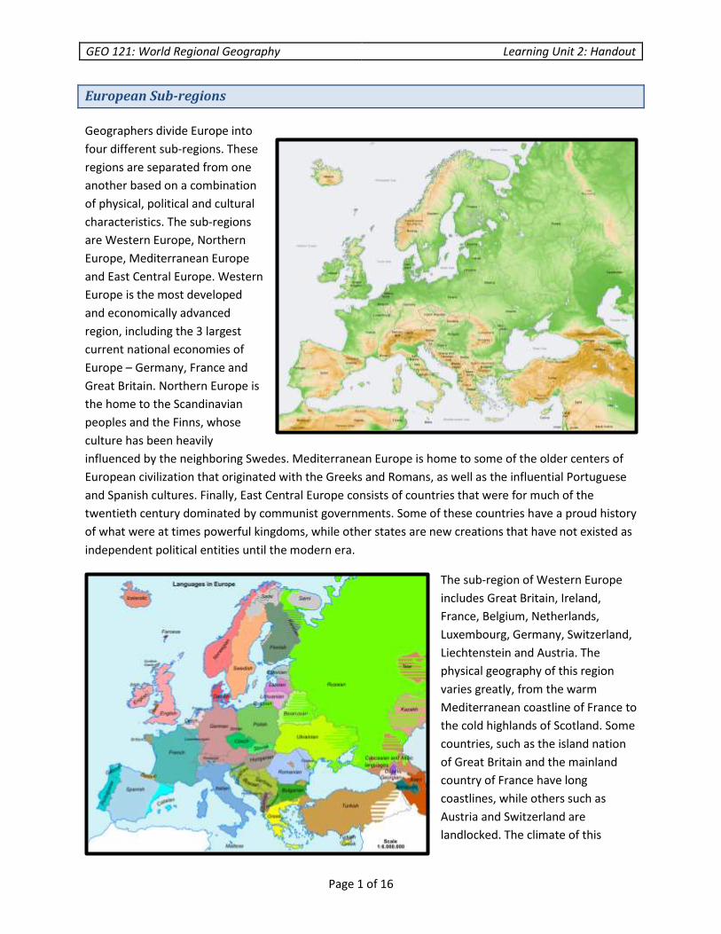
GEO 121: World Regional Geography Learning Unit 2: Handout Page 1 of 16 European Sub-regions Geographers divide Europe into four different sub-regions. These regions are separated from one another based on a combination of physical, political and cultural characteristics. The sub-regions are Western Europe, Northern Europe, Mediterranean Europe and East Central Europe. Western Europe is the most developed and economically advanced region, including the 3 largest current national economies of Europe – Germany, France and Great Britain. Northern Europe is the home to the Scandinavian peoples and the Finns, whose culture has been heavily influenced by the neighboring Swedes. Mediterranean Europe is home to some of the older centers of European civilization that originated with the Greeks and Romans, as well as the influential Portuguese and Spanish cultures. Finally, East Central Europe consists of countries that were for much of the twentieth century dominated by communist governments. Some of these countries have a proud history of what were at times powerful kingdoms, while other states are new creations that have not existed as independent political entities until the modern era. The sub-region of Western Europe includes Great Britain, Ireland, France, Belgium, Netherlands, Luxembourg, Germany, Switzerland, Liechtenstein and Austria. The physical geography of this region varies greatly, from the warm Mediterranean coastline of France to the cold highlands of Scotland. Some countries, such as the island nation of Great Britain and the mainland country of France have long coastlines, while others such as Austria and Switzerland are landlocked. The climate of this
Transcript of European Sub-regionsGEO 121: World Regional Geography Learning Unit 2: Handout Page 1 of 16 European...
GEO 121: World Regional Geography Learning Unit 2: Handout
Page 1 of 16
European Sub-regions
Geographers divide Europe into
four different sub-regions. These
regions are separated from one
another based on a combination
of physical, political and cultural
characteristics. The sub-regions
are Western Europe, Northern
Europe, Mediterranean Europe
and East Central Europe. Western
Europe is the most developed
and economically advanced
region, including the 3 largest
current national economies of
Europe – Germany, France and
Great Britain. Northern Europe is
the home to the Scandinavian
peoples and the Finns, whose
culture has been heavily
influenced by the neighboring Swedes. Mediterranean Europe is home to some of the older centers of
European civilization that originated with the Greeks and Romans, as well as the influential Portuguese
and Spanish cultures. Finally, East Central Europe consists of countries that were for much of the
twentieth century dominated by communist governments. Some of these countries have a proud history
of what were at times powerful kingdoms, while other states are new creations that have not existed as
independent political entities until the modern era.
The sub-region of Western Europe
includes Great Britain, Ireland,
France, Belgium, Netherlands,
Luxembourg, Germany, Switzerland,
Liechtenstein and Austria. The
physical geography of this region
varies greatly, from the warm
Mediterranean coastline of France to
the cold highlands of Scotland. Some
countries, such as the island nation
of Great Britain and the mainland
country of France have long
coastlines, while others such as
Austria and Switzerland are
landlocked. The climate of this

GEO 121: World Regional Geography Learning Unit 2: Handout
Page 2 of 16
region is heavily influenced by the North Atlantic Drift, a continuation of the warm waters of the Gulf
Stream which helps some areas of Western Europe to maintain a Middle Latitude West Coast Climate.
The climate of northern and central Germany is also influenced by the warm ocean and sea currents, but
the eastern and southern interior of Germany experiences much more of a middle latitude continental
climate. The climate of the landlocked states such as Austria and Switzerland are much more continental
in nature, and are also influenced by the relatively high elevations that exist in these countries.
The destinies of
European peoples, like
people around the world,
have been shaped to
some extent by the
physical geography of
their surroundings.
Europe is one giant
peninsula sticking out
from the Eurasian
continent, with many
smaller peninsulas jutting
out from this large one.
Many European states
thus have extensive
coastlines, especially
island and peninsular
states, influencing the
orientation of the
people toward economic
activity on the water. Fishing,
trade and commerce are an important element of almost every major European state. Some countries
have also benefited from having a significant natural resource base upon which development could
occur. For instance, the Industrial Revolution began in England at least in part because the English were
dependent upon coal as a source of energy.
The North Atlantic Drift (Gulfstream)
GEO 121: World Regional Geography Learning Unit 2: Handout
Page 3 of 16
Western Europe is a highly
developed and overall
prosperous region.
Germany and France, as a
result of their economic
power within the EU, and
historical importance of
these two large states,
heavily influence the
current direction of the
European Union. Germans
produce the largest economic
output in Europe, and the
German GDP is number four
in the world. France is not
that far behind Germany however at number five in the world and the United Kingdom of Great Britain
is number seven. Germany is one of the most heavily industrialized and technologically highly advanced
systems in the world. France also has a very advanced economic system, but a significant percentage of
the French economy is also based on the productive French agricultural sector. For much of the 19th
century Great Britain had the largest economy in the world, however the British industrial system has
aged and declined for most of the twentieth century.
Germany has many major
urban industrial zones as
well as several other very
large urban centers.
Hamburg in the north,
Frankfurt in west central
Germany, Stuttgart in the
southeast and Munich in
the southern province of
Bavaria are all important
highly urbanized industrial
regions. However, the
largest metropolitan area
and a very heavily
industrialized region is the
area of Rhine-Ruhr along
the Rhine River. This area
includes the large cities of
Dusseldorf, Cologne and Bonn.
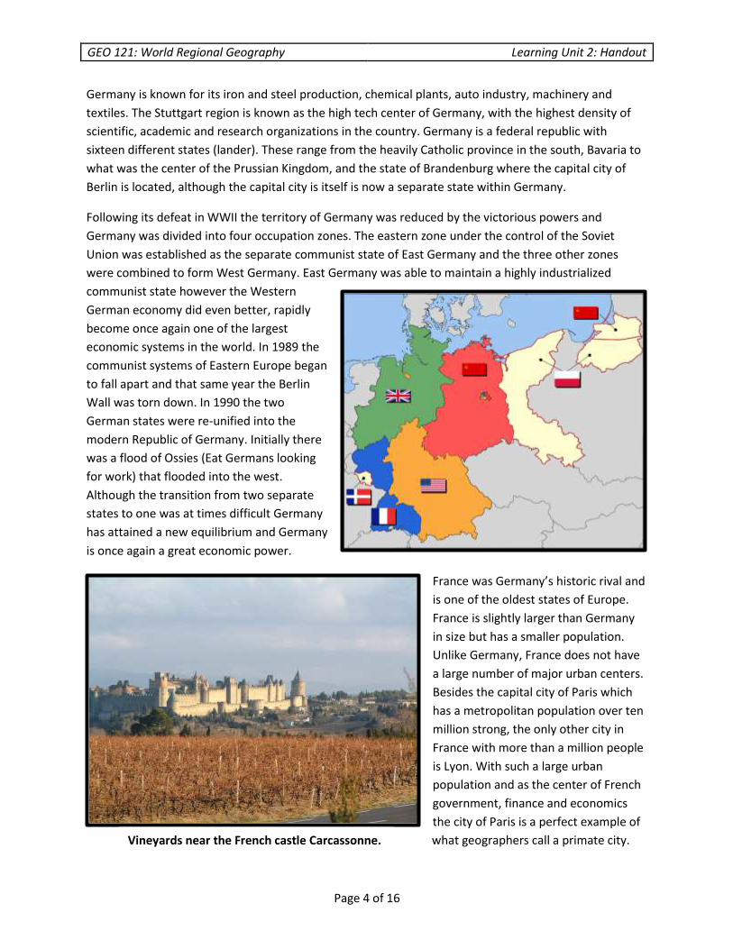
A young "drawer" pulling a coal tub along a mine gallery. The
British passed laws in 1842 and 1844 that improved working
conditions in mines.
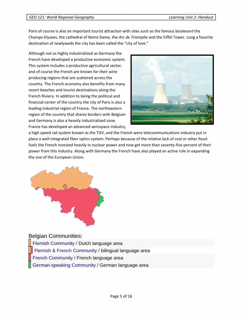
Hamburg
GEO 121: World Regional Geography Learning Unit 2: Handout
Page 4 of 16
Germany is known for its iron and steel production, chemical plants, auto industry, machinery and
textiles. The Stuttgart region is known as the high tech center of Germany, with the highest density of
scientific, academic and research organizations in the country. Germany is a federal republic with
sixteen different states (lander). These range from the heavily Catholic province in the south, Bavaria to
what was the center of the Prussian Kingdom, and the state of Brandenburg where the capital city of
Berlin is located, although the capital city is itself is now a separate state within Germany.
Following its defeat in WWII the territory of Germany was reduced by the victorious powers and
Germany was divided into four occupation zones. The eastern zone under the control of the Soviet
Union was established as the separate communist state of East Germany and the three other zones
were combined to form West Germany. East Germany was able to maintain a highly industrialized
communist state however the Western
German economy did even better, rapidly
become once again one of the largest
economic systems in the world. In 1989 the
communist systems of Eastern Europe began
to fall apart and that same year the Berlin
Wall was torn down. In 1990 the two
German states were re-unified into the
modern Republic of Germany. Initially there
was a flood of Ossies (Eat Germans looking
for work) that flooded into the west.
Although the transition from two separate
states to one was at times difficult Germany
has attained a new equilibrium and Germany
is once again a great economic power.
France was Germany’s historic rival and
is one of the oldest states of Europe.
France is slightly larger than Germany
in size but has a smaller population.
Unlike Germany, France does not have
a large number of major urban centers.
Besides the capital city of Paris which
has a metropolitan population over ten
million strong, the only other city in
France with more than a million people
is Lyon. With such a large urban
population and as the center of French
government, finance and economics
the city of Paris is a perfect example of
what geographers call a primate city. Vineyards near the French castle Carcassonne.
GEO 121: World Regional Geography Learning Unit 2: Handout
Page 5 of 16
Paris of course is also an important tourist attraction with sites such as the famous boulevard the
Champs-Elysees, the cathedral of Notre Dame, the Arc de Triomphe and the Eiffel Tower. Long a favorite
destination of newlyweds the city has been called the “city of love.”
Although not as highly industrialized as Germany the
French have developed a productive economic system.
This system includes a productive agricultural sector,
and of course the French are known for their wine
producing regions that are scattered across the
country. The French economy also benefits from many
resort beaches and tourist destinations along the
French Riviera. In addition to being the political and
financial center of the country the city of Paris is also a
leading industrial region of France. The northeastern
region of the country that shares borders with Belgium
and Germany is also a heavily industrialized zone.
France has developed an advanced aerospace industry,
a high speed rail system known as the TGV, and the French were telecommunications industry put in
place a well-integrated fiber optics system. Perhaps because of the relative lack of coal or other fossil
fuels the French invested heavily in nuclear power and now get more than seventy-five percent of their
power from this industry. Along with Germany the French have also played an active role in expanding
the size of the European Union.
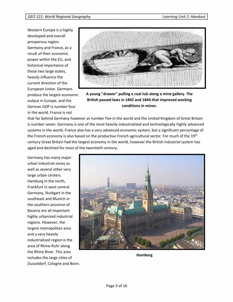
Belgian Communities:
Flemish Community / Dutch language area
Flemish & French Community / bilingual language area
French Community / French language area
German-speaking Community / German language area
GEO 121: World Regional Geography Learning Unit 2: Handout
Page 6 of 16
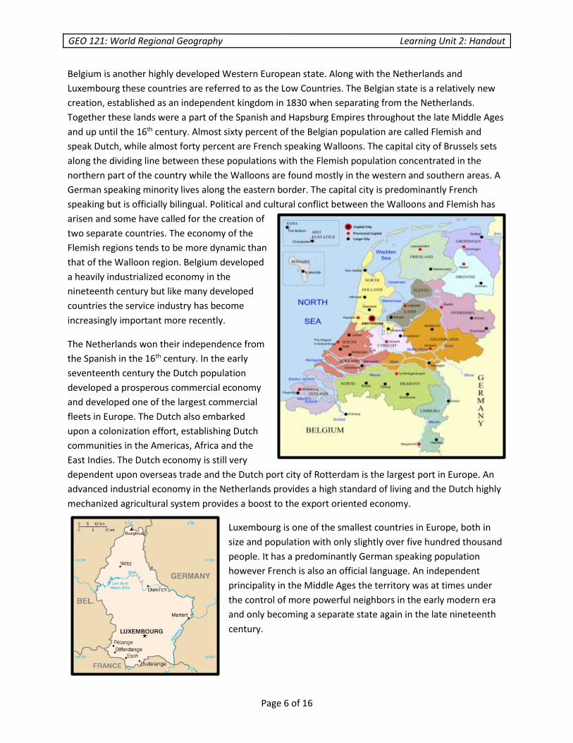
Belgium is another highly developed Western European state. Along with the Netherlands and
Luxembourg these countries are referred to as the Low Countries. The Belgian state is a relatively new
creation, established as an independent kingdom in 1830 when separating from the Netherlands.
Together these lands were a part of the Spanish and Hapsburg Empires throughout the late Middle Ages
and up until the 16th century. Almost sixty percent of the Belgian population are called Flemish and
speak Dutch, while almost forty percent are French speaking Walloons. The capital city of Brussels sets
along the dividing line between these populations with the Flemish population concentrated in the
northern part of the country while the Walloons are found mostly in the western and southern areas. A
German speaking minority lives along the eastern border. The capital city is predominantly French
speaking but is officially bilingual. Political and cultural conflict between the Walloons and Flemish has
arisen and some have called for the creation of
two separate countries. The economy of the
Flemish regions tends to be more dynamic than
that of the Walloon region. Belgium developed
a heavily industrialized economy in the
nineteenth century but like many developed
countries the service industry has become
increasingly important more recently.
The Netherlands won their independence from
the Spanish in the 16th century. In the early
seventeenth century the Dutch population
developed a prosperous commercial economy
and developed one of the largest commercial
fleets in Europe. The Dutch also embarked
upon a colonization effort, establishing Dutch
communities in the Americas, Africa and the
East Indies. The Dutch economy is still very
dependent upon overseas trade and the Dutch port city of Rotterdam is the largest port in Europe. An
advanced industrial economy in the Netherlands provides a high standard of living and the Dutch highly
mechanized agricultural system provides a boost to the export oriented economy.
Luxembourg is one of the smallest countries in Europe, both in
size and population with only slightly over five hundred thousand
people. It has a predominantly German speaking population
however French is also an official language. An independent
principality in the Middle Ages the territory was at times under
the control of more powerful neighbors in the early modern era
and only becoming a separate state again in the late nineteenth
century.
GEO 121: World Regional Geography Learning Unit 2: Handout
Page 7 of 16
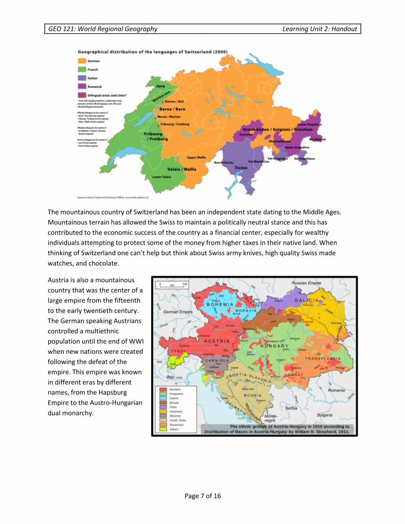
The mountainous country of Switzerland has been an independent state dating to the Middle Ages.
Mountainous terrain has allowed the Swiss to maintain a politically neutral stance and this has
contributed to the economic success of the country as a financial center, especially for wealthy
individuals attempting to protect some of the money from higher taxes in their native land. When
thinking of Switzerland one can’t help but think about Swiss army knives, high quality Swiss made
watches, and chocolate.
Austria is also a mountainous
country that was the center of a
large empire from the fifteenth
to the early twentieth century.
The German speaking Austrians
controlled a multiethnic
population until the end of WWI
when new nations were created
following the defeat of the
empire. This empire was known
in different eras by different
names, from the Hapsburg
Empire to the Austro-Hungarian
dual monarchy.

GEO 121: World Regional Geography Learning Unit 2: Handout
Page 8 of 16
The sub-region of Northern Europe
includes the countries of Finland,
Norway, Sweden, Iceland and
Denmark, as well as the former
Danish colonies of Greenland and the
Faroe Islands. With the exception of
the Finns the people of these
countries trace their heritage to the
spread of the Germanic speaking
cultures across Europe. This is the
land of the Vikings from the Middle
Ages, who used their long boats to
pillage and plunder the coastlines
and rivers of Europe. The population
of Finland speaks a Finno-Ugric language, related to Estonian and more distantly related to Hungarian
but related to the Indo-European languages of Europe. Today the political and economic systems of
Northern Europe have been heavily influenced by socialism. The Norwegians enjoy one of the most
prosperous economies in Europe, based at least in part on the wealth generated by their North Sea oil
reserves. Sweden was a once powerful kingdom in Scandinavia, however more recently Sweden has
pursued a more neutral stance in world affairs. The people of Sweden also benefit from one of
prosperous economic system and their socialist values contribute to a system where the wealth is
shared more equally, with fewer millionaires but also very few extremely impoverished people as well.
In general taxes are high in Northern Europe relative to some developed countries like the United
States; however the social
safety net is much more
supportive with relatively
free healthcare and
education systems. Iceland,
Norway and Denmark are
NATO member states, while
Sweden and Finland
continue to maintain a
politically neutral stance.
Mediterranean Europe
consists of the nations of
Portugal, Spain, Italy,
Greece, Malta, San Mareno,
Monaco, Andorra and
Vatican City. Many of these
countries struggled to develop or maintain democratic political systems in the twentieth century when
most of Western Europe was democratic. Mediterranean Europe also never quite achieved the overall

GEO 121: World Regional Geography Learning Unit 2: Handout
Page 9 of 16
level of economic development enjoyed throughout most of Western Europe, although some regions
within these countries developed more successfully than other regions. Although benefitting from
pleasant Mediterranean climates, the soils of this region are mostly poor in quality and there is an
overall lack of natural resources compared to the states of Western Europe. Recently many of these
states have experienced tremendous economic challenges with hyper-inflation, unstable financial
systems and very high levels of unemployment. Greece and Spain in particular have come close to
defaulting on their debts, which would likely lead to almost total economic collapse of their systems. So
far these states have been able to restructure their debt, in part with assistance from the EU, but
extreme financial and economic challenges remain.
East Central Europe includes the countries of
Estonia, Latvia, Lithuania, Poland, Czech
Republic, Slovakia, Hungary, Romania,
Slovenia, Croatia, Serbia, Bosnia, Montenegro,
Kosovo, Macedonia, Albania and Bulgaria.
From 1940 to 1991 Estonia, Latvia and
Lithuania were all republics within the Soviet
Union. These nations had also been part of the
Russian Empire before WWI. For most of
recorded history Latvians and Estonians have
been subject people of one kingdom or
another. It was not until the 19th century with
the spread of the modern concept of
nationalism that they began to envision a
future of self-government, which was finally
achieved for the first time following the
Bolshevik Revolution in Russia in 1917.
Lithuanians however had a long history as a
powerful Catholic kingdom in the Middle Ages, at
one time controlling much of what is now Poland,
Ukraine and Belarus. The spread of nationalistic
ideology also influenced other peoples of Eastern
and Southeastern Europe. Up through the early
twentieth centuries many of the smaller countries
that exist today had not experienced political independence,
while others had at times attained self-governance that did not always last very long.
The black line represents the Iron Curtain
separating Warsaw Pact countries shaded in
red from NATO members shaded blue,
militarily neutral countries are shaded grey.
GEO 121: World Regional Geography Learning Unit 2: Handout
Page 10 of 16
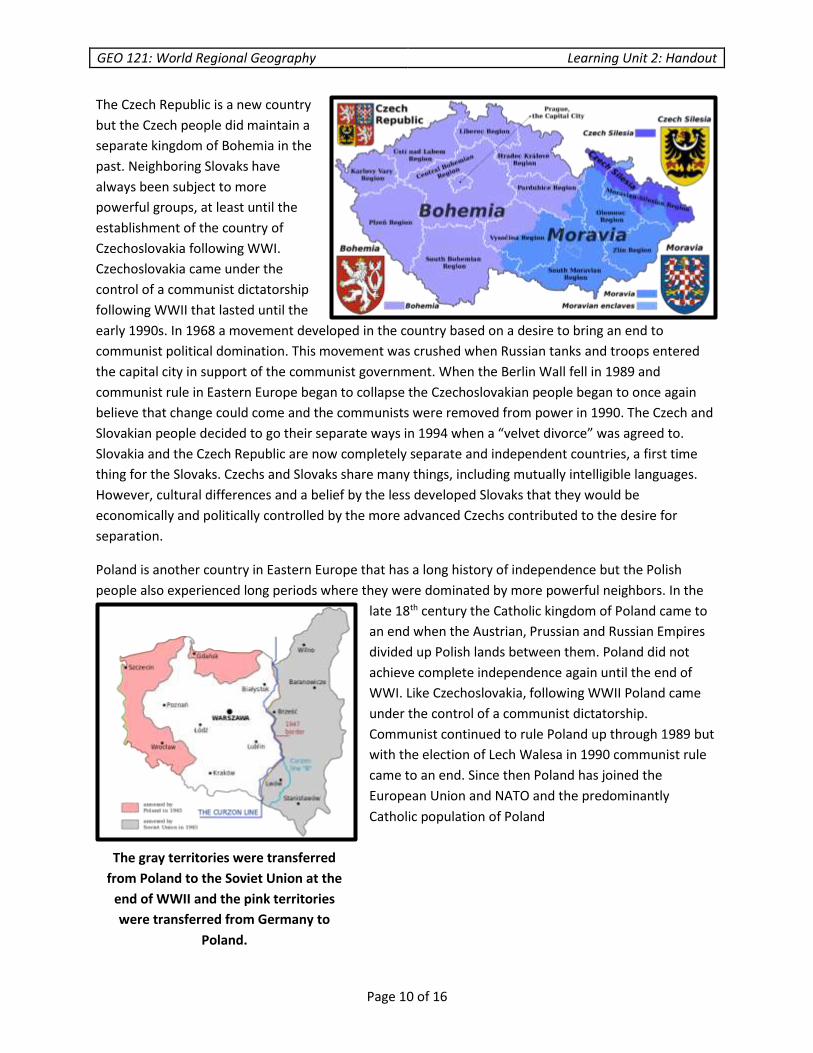
The Czech Republic is a new country
but the Czech people did maintain a
separate kingdom of Bohemia in the
past. Neighboring Slovaks have
always been subject to more
powerful groups, at least until the
establishment of the country of
Czechoslovakia following WWI.
Czechoslovakia came under the
control of a communist dictatorship
following WWII that lasted until the
early 1990s. In 1968 a movement developed in the country based on a desire to bring an end to
communist political domination. This movement was crushed when Russian tanks and troops entered
the capital city in support of the communist government. When the Berlin Wall fell in 1989 and
communist rule in Eastern Europe began to collapse the Czechoslovakian people began to once again
believe that change could come and the communists were removed from power in 1990. The Czech and
Slovakian people decided to go their separate ways in 1994 when a “velvet divorce” was agreed to.
Slovakia and the Czech Republic are now completely separate and independent countries, a first time
thing for the Slovaks. Czechs and Slovaks share many things, including mutually intelligible languages.
However, cultural differences and a belief by the less developed Slovaks that they would be
economically and politically controlled by the more advanced Czechs contributed to the desire for
separation.
Poland is another country in Eastern Europe that has a long history of independence but the Polish
people also experienced long periods where they were dominated by more powerful neighbors. In the
late 18th century the Catholic kingdom of Poland came to
an end when the Austrian, Prussian and Russian Empires
divided up Polish lands between them. Poland did not
achieve complete independence again until the end of
WWI. Like Czechoslovakia, following WWII Poland came
under the control of a communist dictatorship.
Communist continued to rule Poland up through 1989 but
with the election of Lech Walesa in 1990 communist rule
came to an end. Since then Poland has joined the
European Union and NATO and the predominantly
Catholic population of Poland
The gray territories were transferred
from Poland to the Soviet Union at the
end of WWII and the pink territories
were transferred from Germany to
Poland.
GEO 121: World Regional Geography Learning Unit 2: Handout
Page 11 of 16
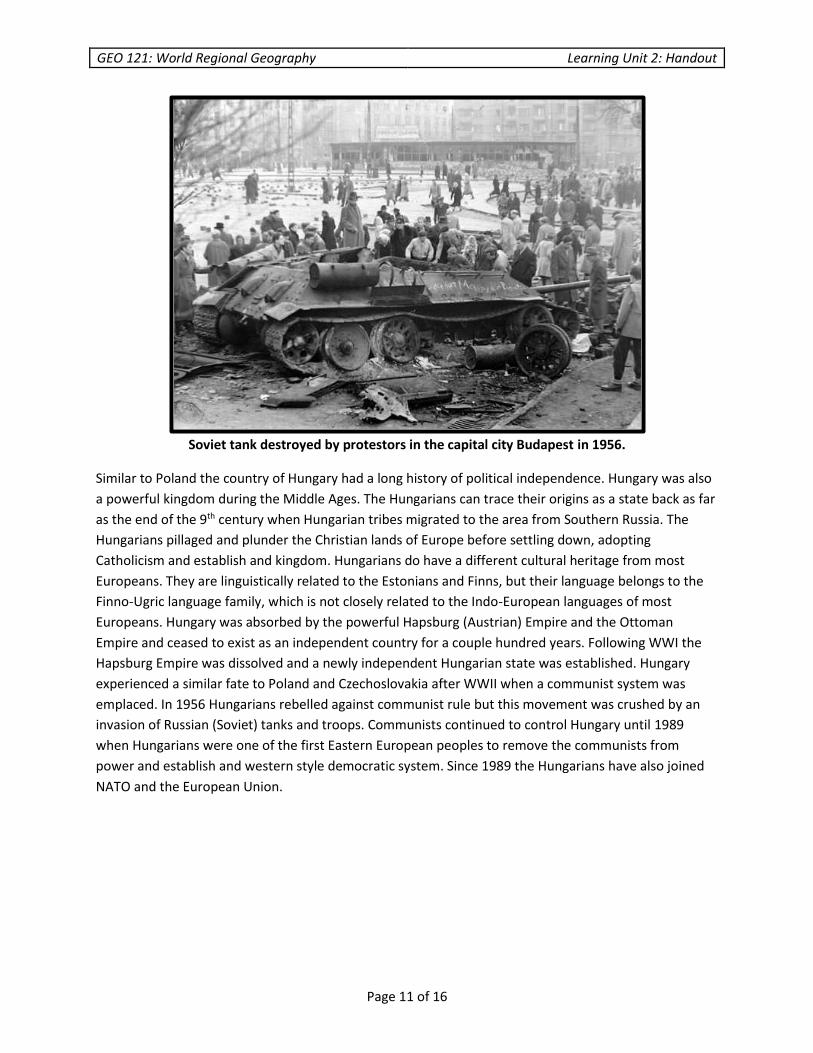
Soviet tank destroyed by protestors in the capital city Budapest in 1956.
Similar to Poland the country of Hungary had a long history of political independence. Hungary was also
a powerful kingdom during the Middle Ages. The Hungarians can trace their origins as a state back as far
as the end of the 9th century when Hungarian tribes migrated to the area from Southern Russia. The
Hungarians pillaged and plunder the Christian lands of Europe before settling down, adopting
Catholicism and establish and kingdom. Hungarians do have a different cultural heritage from most
Europeans. They are linguistically related to the Estonians and Finns, but their language belongs to the
Finno-Ugric language family, which is not closely related to the Indo-European languages of most
Europeans. Hungary was absorbed by the powerful Hapsburg (Austrian) Empire and the Ottoman
Empire and ceased to exist as an independent country for a couple hundred years. Following WWI the
Hapsburg Empire was dissolved and a newly independent Hungarian state was established. Hungary
experienced a similar fate to Poland and Czechoslovakia after WWII when a communist system was
emplaced. In 1956 Hungarians rebelled against communist rule but this movement was crushed by an
invasion of Russian (Soviet) tanks and troops. Communists continued to control Hungary until 1989
when Hungarians were one of the first Eastern European peoples to remove the communists from
power and establish and western style democratic system. Since 1989 the Hungarians have also joined
NATO and the European Union.
GEO 121: World Regional Geography Learning Unit 2: Handout
Page 12 of 16
Romania is also
an ancient
country.
Romanians trace
their heritage
back to the
mingling the
ancient Dacians
and their Roman
conquerors, and
the later arrival of
Slavic peoples.
Thus, Romanian is
a Romance
language
based on Latin.
However,
unlike most Latin
speaking countries which
are predominantly
Catholic, Romanians were converted to Orthodox Christianity. At times parts of Romania were separate
and independent kingdoms, but at times all or part of Romania has been ruled over by Russians, Turks,
Hungarians and Austrian Hapsburgs. An independent Romanian state was established in the late 19th
century and following WWII Romania also came under the control of a communist political party.
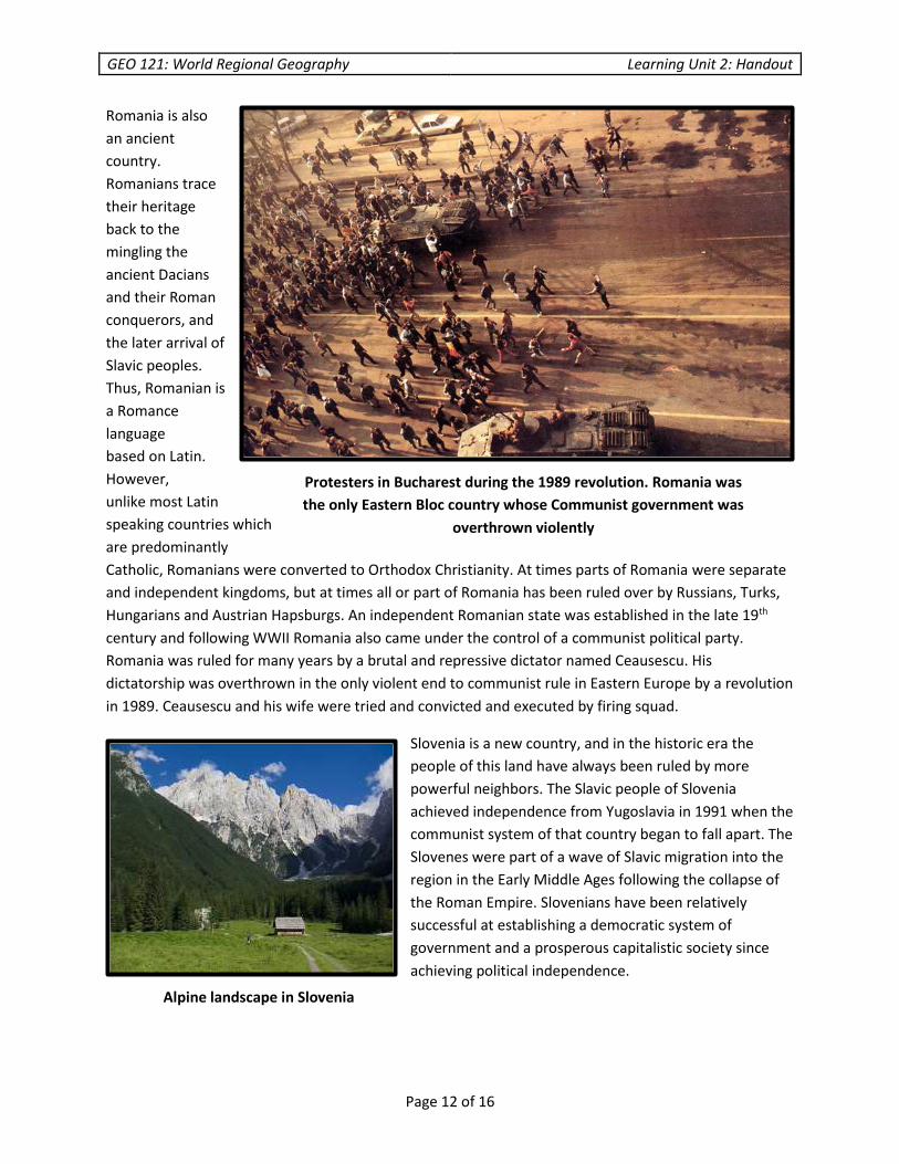
Romania was ruled for many years by a brutal and repressive dictator named Ceausescu. His
dictatorship was overthrown in the only violent end to communist rule in Eastern Europe by a revolution
in 1989. Ceausescu and his wife were tried and convicted and executed by firing squad.
Slovenia is a new country, and in the historic era the
people of this land have always been ruled by more
powerful neighbors. The Slavic people of Slovenia
achieved independence from Yugoslavia in 1991 when the
communist system of that country began to fall apart. The
Slovenes were part of a wave of Slavic migration into the
region in the Early Middle Ages following the collapse of
the Roman Empire. Slovenians have been relatively
successful at establishing a democratic system of
government and a prosperous capitalistic society since
achieving political independence.
Protesters in Bucharest during the 1989 revolution. Romania was
the only Eastern Bloc country whose Communist government was
overthrown violently
Alpine landscape in Slovenia

GEO 121: World Regional Geography Learning Unit 2: Handout
Page 13 of 16
Following the separation of Slovenia from
Yugoslavia the people of neighboring
Croatia also declared their independence.
However, the Serbian population of
Yugoslavia rejected this effort to further
dissolve the Yugoslav state. War broke out
and after four years of struggle the
Croatians were finally able to achieve
independence. Along with the Slovenians
and other Slavic tribes, the Serbo-Croatians
arrived in Southeastern Europe in the
seventh century. Although Serbs and
Croatians are today considered to be two
separate national ethnic groups, they share
a common cultural heritage. In fact the Serbian
and Croatian languages are essentially the same when spoken, or at least so similar that the differences
are somewhat cosmetic. However, in the Middle Ages the Croatian population was converted to
Catholicism while the Serbian population was converted to Orthodox Christianity. As a result the
Croatians adopted the Latin alphabet to write their version of the Serbo-Croatian language while the
Serbians adopted the Cyrillic alphabet. The Croatians and Serbians also established separate small
kingdoms in the area. The Croatians and Serbians were also at various times
The Serbians were the dominant ethnic group of
the multi-ethnic Yugoslavian state. This was a state
that did not exist before WWI. A separate Serbian
kingdom was re-established in the 19th century
however not all Serbians lived in this kingdom. A
large number of ethnic Serbians lived in the Austro-
Hungarian Empire. Serbian nationalists, in their
desire to create a larger country that included all
lands where Serbians were the majority actually
precipitated the outbreak of WWI, which ultimately
led to the collapse of the Austro-Hungarian Empire
and allowed the Southern Slavic people of this
region to form the new country of Yugoslavia.
Following the collapse of communism in Yugoslavia
the Serbs tried to keep the country together,
sometimes by force. Under the leadership of
Slobodan Milosevic war broke out with Croatia and
in Bosnia. Ethnic Serbs engaged in genocide,
genocidal rape and ethnic cleansing, particularly in Bosnia against the Muslim population that lived
there.
Croatia

GEO 121: World Regional Geography Learning Unit 2: Handout
Page 14 of 16
A significant population of ethnic Serbians live in the new state of Bosnia. The Serbian population of
Bosnia, with support from the government of Serbia, engaged in the previously mentioned atrocities
against the Muslim population and against the Croatian population of Bosnia as well. The arrival of
NATO troops helped bring an end to the violence and
a new state was created, with separate governing
bodies for the Serbian territories and the Bosnia-
Croatian territory. Peace keeping troops are still
present in the country, although the numbers are
significantly lower than they were. As the states of
what was once Yugoslavia join NATO and the EU the
odds of this unstable political situation leading to
another civil war are lessened. Montenegro is a small
country in southeastern Europe that has a short
coastline on the Adriatic Sea. From the end of WWI
until the early 1990s Montenegro was a province in
the state of Yugoslavia. In 2006 the population voted
in a referendum for independence from Serbia
(Yugoslavia), and the government declared
independence later that year. Montenegro has
applied for admission to the European Union and
NATO, but has not yet been admitted.
Kosovo was a province in Yugoslavia for most of the
twentieth century. This newly created state has a
population that is predominantly Albanian in heritage
and Muslim in faith, although significant minorities
exist as well. In the late 1990s the ethnic Serbs of
Kosovo engaged in ethnic cleansing, attempting to
force some of the Albanians to leave the country. The
United States and NATO allies used an air campaign to
prevent the Serbian military from engaging in even
more atrocities as peace keeping troops were sent in to
separate the two sides. The people of Kosovo have
since declared an independent state, which has been
recognized by more than one hundred other countries.
The Serbian government refuses to recognize the
independence of Kosovo.
Montenegro
Kosovo

GEO 121: World Regional Geography Learning Unit 2: Handout
Page 15 of 16
Macedonia was also a province in Yugoslavia
before 1991, when an independent state was
declared. This small land-locked country shares
the same name as a province in Greece, and a
connection to the Macedonian kingdom of
Alexander the Great from the period of the fourth
century BC. Macedonians are a Slavic speaking
people who form the majority of the population
however there is a significant Albanian minority in
the country as well. A dispute with neighboring
Greece over naming the country Macedonia has
played a role in stalling the admission of the
country in NATO and the EU.
Albania is a mountainous land with a long
coastline on the Adriatic Sea. A communist
dictatorship controlled Albania from the 1940s up
to 1992. Following the collapse of the communist
system and economic crisis ensued and a large
number of
Albanians were
affected by Ponzi
schemes. This
contributed to a
mass exodus of
people out of the
country.
Neighboring
states like Italy
and Greece were
impacted by
arrival of
“undocumented”
immigrants. Some
Albanians were
successful in
immigrating to
other countries,
with some even
migrating to the
United States. The majority of the population of Albania is ethnic Albanian, but a significant minority
Greek population is also present. A majority of the population practice Islam, but Greek Orthodox and
Macedonia
Albanian countryside
GEO 121: World Regional Geography Learning Unit 2: Handout
Page 16 of 16
Catholic Christians make up almost
twenty percent of the population. Albania
was accepted as a member of NATO in
2009 and has also applied for admission
to the EU.
Bulgaria was a kingdom in southeastern
Europe in the Middle Ages, was
conquered by the Ottoman Turks in the
late fourteenth century. Bulgaria attained
independence again in the late
nineteenth century. Following WWII a
communist dictatorship was established
which lasted until 1989 when democratic
elections were held. In the eighth century
a mixture of Turkish tribes known as the
Bulgars settled in the area. Around that same
time Slavic peoples were also migrating into southeastern Europe. Gradually the Bulgars and Slavs
intermixed forming today’s Slavic speaking population. It is a member of the EU and NATO.
© Bruce Dickerson and Indian Hills Community College
The European Union