European Community Directive 92/43/EEC on the …jncc.defra.gov.uk/pdf/HDir_Rpt.pdf · Ministry of...
112
01/10/01 European Community Directive 92/43/EEC on the Conservation of Natural Habitats and of Wild Fauna and Flora First report by the United Kingdom under Article 17 on implementation of the Directive from June 1994 to December 2000 Department of the Environment, Food and Rural Affairs* Trevor Salmon Zone 1/07 Temple Quay House 2 The Square Temple Quay Bristol BS1 6EB Telephone: + 44 117 372 8567 Fax: + 44 117 372 8119 E-mail: [email protected] * In June 2001, the UK Department of the Environment Transport and the Regions (DETR) and the Ministry of Agriculture, Fisheries and Food were reorganised to form the Department of the Environment, Food and Rural Affairs (DEFRA). Reference is made within this document to all three organisations as appropriate to the time at which reported actions occurred.
Transcript of European Community Directive 92/43/EEC on the …jncc.defra.gov.uk/pdf/HDir_Rpt.pdf · Ministry of...

01/10/01
European Community Directive 92/43/EECon the Conservation of Natural Habitats and of Wild Fauna and Flora
First report by the United Kingdom under Article 17 on implementation of the Directivefrom June 1994 to December 2000
Department of the Environment, Food and Rural Affairs*
Trevor SalmonZone 1/07Temple Quay House2 The SquareTemple QuayBristolBS1 6EB
Telephone: + 44 117 372 8567
Fax: + 44 117 372 8119
E-mail: [email protected]
* In June 2001, the UK Department of the Environment Transport and the Regions (DETR) and theMinistry of Agriculture, Fisheries and Food were reorganised to form the Department of theEnvironment, Food and Rural Affairs (DEFRA). Reference is made within this document to all threeorganisations as appropriate to the time at which reported actions occurred.

01/10/01
3
Contents
Executive summary ...............................................................................................................................................5
1. Conservation of Annex I habitats and the habitats of Annex II species within Natura sites..........71.a.i Selection of UK candidate Special Areas of Conservation (cSACs).......................................................7
Transposition of the Directive into UK Legislation ................................................................................7Nature conservation sites in the UK........................................................................................................7Occurrence of Annex I habitats and Annex II species in the UK............................................................8Collation of data to support the identification of candidate SACs ..........................................................8Overview of the site selection process ....................................................................................................9Problems encountered in applying SAC selection criteria in the UK....................................................15Special Protection Area (SPA) network review ....................................................................................17
1.a.ii Process adopted for SAC selection and constraints encountered ..........................................................17Stage 1 of the selection process ............................................................................................................17Submission of sites to the EC................................................................................................................19Post-moderation amendments to the UK SAC list ................................................................................19Consultation ..........................................................................................................................................20
1.a.iii Assessment of implementation in the UK .............................................................................................221.b.i Status of conservation measures for cSACs ..........................................................................................24
Development of management plans and agreements.............................................................................25Monitoring of management plans..........................................................................................................28
1.b.ii Measures to avoid deterioration of, and disturbance on, candidate SACs ............................................28Action to change activities where damage identified ............................................................................28Incentive-led management agreements rather than reactive compensatory agreements ........................30Habitat maintenance, restoration and recreation ...................................................................................31
1.b.iii Planning policy and Environmental Impact Assessment considerations for SACs ...............................31Planning policy in the UK.....................................................................................................................31Environmental impact assessment.........................................................................................................34
1.c.i Assessment of the cost of implementing the Directive in the UK .........................................................351.c.ii National sources of finance involved in implementing the Directive....................................................361.c.iii Community financing used to support UK implementation of the Directive ........................................371.d.i Development of tools and methodologies for monitoring.....................................................................391.d.ii Status of monitoring programmes for SACs and the wider countryside................................................42
Common standards for monitoring designated sites..............................................................................42The wider countryside...........................................................................................................................43
2. Conservation of Annex IV and Annex V species within the UK .....................................................492.a.i Assessment of measures to protect Annex IV species...........................................................................492.a.ii Measures to monitor accidental capture and killing of species .............................................................492.b.i Monitoring the taking of Annex V species............................................................................................512.b.ii Provisions to prohibit non-selective methods of capture and killing.....................................................522.b.iii Derogations report ................................................................................................................................52
3. Other measures and additional provisions to implement the Directive..........................................543.a.i Research undertaken for habitats and species in the UK.......................................................................543.a.ii International collaboration on habitat and species research ..................................................................543.b.i Introductions of Annex IV species........................................................................................................55
Native species .......................................................................................................................................55Non-native species ................................................................................................................................56
3.b.ii Evaluation of introduction programmes................................................................................................573.c.i Environmental education and awareness raising programmes ..............................................................58

4
4. Final comments on implementation of the Directive........................................................................624.i Sectoral policies to integrate conservation of habitats and species .......................................................62
UK Biodiversity Action Plan ................................................................................................................62CAP reform...........................................................................................................................................62Agri-environment schemes....................................................................................................................62Common Fisheries Policy .....................................................................................................................65Other policy interests ............................................................................................................................65Planning and Development Policy ........................................................................................................65Landscape designations.........................................................................................................................66
4.ii Human resources available for implementation of the Directive ..........................................................674.iii Other aspects of applying the Directive ................................................................................................67
Extending the geographical scope of the UK’s transposition of the Directive......................................67Law enforcement...................................................................................................................................67Air pollution..........................................................................................................................................68Wildlife corridors..................................................................................................................................68Favourable conservation status .............................................................................................................68
Appendices...........................................................................................................................................................69Appendix 1: Organisations involved in the compilation of this report ......................................................69Appendix 2: Organisations which contributed to, or were consulted on, proposals for site selection .......74Appendix 3: Number of UK sites put forward as candidate SACs for habitats .........................................76Appendix 4: Number of UK sites put forward as candidate SACs for species ..........................................80Appendix 5: Relationship between Annex I habitats and UK Biodiversity Action Plan priority habitats .82Appendix 6: Examples of community financing used to support UK implementation of the Directive ....87Appendix 7: Examples of research on species and habitats listed in Annexes I, II, IV and V...................92Appendix 8: Examples of cSAC conservation management and habitat restoration .................................96Appendix 9: Abbreviations and acronyms...............................................................................................104Appendix 10: References...........................................................................................................................108Appendix 11: WWW Addresses................................................................................................................112
List of boxes1 Gibraltar 222 National nature reserve audit system in Wales 283 International Designations Database (IDD) 394 System for Evaluating Rivers for Conservation (SERCON) 395 Mermaid Database 406 Countryside Information System (CIS) 407 Common standards for monitoring designated sites 418 National Biodiversity Network (NBN) 429 Recorder 2000 4210 Countryside Survey 2000 – audit of the UK countryside 4311 Environmental Change Network 4412 A better quality of life 4513 UK National Marine Monitoring Programme (NMMP) 4614 Sampling Framework 4715 Threatened Plants Database project 4716 Monitoring of Chiroptera listed on Annex II 4817 Measures taken to monitor incidental capture of cetaceans 5018 Species derogations database 5219 BAP research needs 5420 Large blue butterfly Maculinea arion 5521 Lady’s-slipper orchid Cypripedium calceolus 5622 European beaver Castor fibe 57

5
Executive summary
This report summarises the UK’s experience in implementing the European Community Directive92/43/EEC on the Conservation of Natural Habitats and of Wild Fauna and Flora (the HabitatsDirective) from 1994 to December 2000.
The Directive has been implemented in Great Britain (England, Scotland and Wales) through theConservation (Natural Habitat, &c.) Regulations 1994 (which came into force on 30 October 1994).The Conservation (Natural Habitat, etc.) Regulations (Northern Ireland) 1995 (which came into forceon 13 November 1995) replicate the provisions in force in the GB Regulations by applying them tothe separate legal system which exists in Northern Ireland. Directive 92/43/EEC was transposed intothe laws of Gibraltar on 25 August 1995 by the Nature Protection Ordinance (Amendment)Regulations 1995.
On the basis of current knowledge, 76 Annex I habitats (including 22 priority types) are considered toexist within the UK. 51 Annex II species have been recorded in the UK. Ten of these species are,however, now extinct or have only been recorded as non-natives or vagrants; these species have beenexcluded from the site selection process. The number of candidate Special Areas of Conservation(cSACs) put forward for each habitat and species are listed in appendices 3 and 4.
The work to select cSACs in the UK has involved many organisations, including government,statutory conservation organisations and non-governmental organisations. Selection of sites has beenan iterative process, with widespread consultation at each stage. To facilitate the submission ofinformation, sites have been formally submitted to the Commission in a series of tranches. As oftranche 17 (8 June 2001), the total number of cSACs submitted by the UK stands at 555 sitescovering 2,227,078 hectares.
As a matter of policy for planning and all other consent regimes, the UK Government and thedevolved administrations already treat candidate SACs as if they were fully designated. CandidateSACs in England have been afforded additional protection in law by virtue of an amendment in theConservation (Natural Habitats &c.) Regulations 1994 such that candidate sites are legally protectedfrom the date that they are notified to the European Commission.
A number of measures are used to ensure that sites are kept in good condition, including thepreparation and implementation of management plans. Production of management plans andstatements for all cSACs is seen as a priority by the statutory conservation bodies in the UK. Inaddition, a review is taking place of the existing permissions for undertaking work (such as waterabstraction) on areas which have been put forward as cSACs. If necessary these permissions will beamended or revoked to ensure that the nature conservation interest(s) of the sites are not damaged.
The report concludes by considering a broad suite of policies which integrate site-based and broadercountryside conservation. The UK considers that the wider countryside aspects of theimplementation of the Directive are imperative if it is to deliver effective conservation of habitats andspecies of Community interest. There are many challenges ahead, not least working towards moresustainable implementation of the Common Agricultural and Fisheries Policies. Looking forward tothe next report in 2006, it would be helpful if EC-level discussions were held and decisions madesoon on the requirements for the provision of monitoring information and the interpretation of theconcept of favourable conservation status.
The Natura 2000 network includes the Special Protection Areas (SPAs) classified under the Directiveon the Conservation of Wild Birds (79/409/EEC) (the Birds Directive). This report should thereforebe read in conjunction with the sixth triennial report by the United Kingdom on that Directive whichcovered the period 1996–1998. Since this report, further work reviewing the UK SPA series has been

6
undertaken. In addition, separate reports have been provided to the Commission on the UK’simplementation of the derogation provisions of both the Habitats and Birds Directives.

1.a.i Selection of UK candidate Special Areas of Conservation (cSACs)
7
1. Conservation of Annex I habitats and the habitats of Annex II species withinNatura sites
1.a.i Selection of UK candidate Special Areas of Conservation (cSACs)
Transposition of the Directive into UK Legislation
The Directive has been implemented in Great Britain (England, Scotland and Wales) through theConservation (Natural Habitat, &c.) Regulations 1994 (which came into force on 30 October 1994). TheConservation (Natural Habitat, etc.) Regulations (Northern Ireland) 1995 (which came into force on 13November 1995) replicate the provisions in force in the GB Regulations by applying them to the separatelegal system which exists in Northern Ireland. Directive 92/43/EEC was transposed into the laws ofGibraltar on 25 August 1995 by the Nature Protection Ordinance (Amendment) Regulations 1995.
Article 6 of the Habitats Directive requires Member States to take appropriate steps to avoid, in SpecialAreas of Conservation, the deterioration of natural habitats and the habitats of species and disturbance ofspecies for which sites have been designated. As a matter of policy, the UK Government has ensured thathabitat and species within candidate Special Areas of Conservation are afforded the protection fromdeterioration envisaged by the Directive in respect of new plans or projects.
Nature conservation sites in the UK
The United Kingdom (UK) has a long history of documenting and protecting nature. Sites which meetrelevant qualifying criteria may be designated under domestic legislation and as a result of a series ofinternational obligations, including the Ramsar Convention and the Birds and Habitats Directives; theWildlife and Countryside Act 1981 (as amended 1985); the Conservation (Natural Habitats &c.)Regulations 1994 (as amended);1 Statutory Rule for Northern Ireland 380 (1995); the Conservation (NaturalHabitats, etc.) Regulations (Northern Ireland) 1995. Lists of sites considered to be ‘important’ at nationaland international scale are maintained by the statutory nature conservation agencies: English Nature (EN),Countryside Council for Wales (CCW), Scottish Natural Heritage (SNH), Environment and HeritageService (EHS) (an Agency within the Department of Environment, Northern Ireland) and the Joint NatureConservation Committee (JNCC). Particularly important sites may be designated under several of theseobligations, so most sites are designated under both domestic and international legislation. As a result ofdifferences in the selection criteria required to fulfil international obligations, however, the boundaries ofthe designations on a single site may not always be contiguous.
Selection of SSSIs
Under the Wildlife and Countryside Act 1981 the primary site designation used in the UK is the Site ofSpecial Scientific Interest (SSSI). In Northern Ireland the equivalent designation is Area of SpecialScientific Interest (ASSI). Neither SSSIs nor ASSIs extend into subtidal areas. The mechanism forprotection of subtidal areas is the Marine Nature Reserve (MNR); this is equivalent to National NatureReserve (NNRs) on land. The biological SSSI series forms a national network of areas representingsufficient examples, in terms of type, number and extent, to conserve the total national ‘special interest’ ofthe range of variation in habitats and their associated plants and animals.
1 On 28 February 2000, the Government extended the provisions of the Regulations to candidate Special Areas of Conservation(cSACs) in England. The amendment came into being as the Conservation (Natural Habitats &c.) (Amendment) (England)Regulations 2000 (SI 2000/192). The changes create an obligation on all competent authorities to bring forward the timetable andprocess for reviewing extant consents on cSACs. This puts candidate SACs in England on a par with Special Protection Areas(under the Birds Directive). Wales and Northern Ireland have indicated they will make parallel changes in due course.

1.a.i Selection of UK candidate Special Areas of Conservation (cSACs)
8
At a UK scale the JNCC has published and maintains Guidelines for the selection of biological SSSIs (NCC1989; JNCC 1994, 1996). The guidelines help statutory nature conservation staff employ a consistentrationale for the evaluation and selection of biological sites which are of ‘special interest’ and also providea public statement of the selection process for all interested individuals and organisations. Further guidance(EHS 1999) has been published to aid local interpretation in Northern Ireland; it is intended that equivalentstandards be maintained across the UK.
The SSSI selection guidelines provide for the selection of sites within broad habitat groupings (coastal,woodland, lowland grasslands, lowland heathland, non-montane rock habitats, freshwater habitats, fens,bogs, upland habitats, artificial habitats, intertidal and lagoons) and broad species groupings (vascularplants, non-vascular plants, mammals, birds, reptiles and amphibians, freshwater and estuarine fish,invertebrates, butterflies and dragonflies). The criteria for site evaluation are subdivided into primarycriteria (size, diversity, naturalness, rarity, fragility and typicalness) and secondary criteria (recordedhistory, position in an ecological and/or geographical unit, potential value and intrinsic appeal). Theguidelines also include additional information to assist with the application of the criteria, includingguidance on how to define acceptable levels of quality.
Occurrence of Annex I habitats and Annex II species in the UK
Annex I of the Habitats Directive lists 169 habitat types. A list of habitats present in the UK has beendrawn up by reference to the descriptions in the Interpretation manual of European Union habitats(European Commission 1996, 1999), supplemented by the phytosociological literature and discussion withspecialists in other Member States. This task has not been straightforward due to inherent weaknesses inthe Annex I classification used to form the basis for Annex I habitats, which has caused considerable debateabout the occurrence of several habitats in the UK. On the basis of current knowledge, 76 Annex I habitatsare considered to occur in the UK, including 22 priority types. A list of these, together with the number ofUK candidate SACs for each, is given in Appendix 3.
Annex II of the Directive lists 623 species, of which 51 have been recorded from the UK in recent times.Ten of these species are, however, now extinct in the UK or have been recorded only as non-native orvagrants; these species were excluded from the site selection process. The remaining 41 species are listedin Appendix 4, together with the number of cSACs put forward for each. Only one priority species(Western rustwort Marsupella profunda) is known to occur in the UK.
Collation of data to support the identification of candidate SACs
The process of identifying cSACs for the 76 Annex I habitats and 41 Annex II species has been underpinnedby the collation of information on their distribution and abundance, both on individual sites and across theUK.
At a national scale, data on the distribution and extent of Annex I habitats have been summarised from avariety of sources, in particular information collected during the development of the National VegetationClassification (NVC) (Rodwell 1991 et seq.); the Marine Biotope Classification for Britain and Ireland(Connor et al. 1997 a,b); and a range of habitat databases and inventories, mostly held by JNCC or thecountry agencies. At the site level, information sources range from detailed habitat surveys to local expertknowledge. Data have been difficult to obtain for some habitats, either because they have been poorlystudied in the UK or because of problems in relating Annex I categories to standard UK vegetationclassifications.
Good distribution data are available for the majority of Annex II species in the UK, as this country has along history of biological recording. National data were obtained from the Biological Records Centre(BRC) at the Centre for Ecology and Hydrology (CEH). Information on population size is generally muchharder to obtain, especially at a national scale, but reliable population counts are available for some specieson some sites. UK data on the distribution and extent of Annex I habitats and the range and population sizeof Annex II species was published in a JNCC report Handbook on the UK status of EC Habitats Directiveinterest features (Jackson and McLeod 2000).

1.a.i Selection of UK candidate Special Areas of Conservation (cSACs)
9
Considerable care was taken to ensure that site selection was based on the best available information, but(as in other Member States) it must be recognised that the distribution and abundance of certain habitats andspecies in the UK are imperfectly known. In some cases, where current knowledge was clearly inadequateto propose sites, additional surveys were commissioned by the statutory nature conservation agencies.
Overview of the site selection process
The selection of Special Areas of Conservation (SACs) in the UK is described in detail in the JNCC reportThe Habitats Directive: selection of Special Areas of Conservation in the UK (Brown et al. 1998).
Article 4 and Annex III of the Habitats Directive describe a two-stage process for identifying SACs.Stage 1 requires each Member State to evaluate sites holding Annex I habitats and Annex II species andsubmit a list of candidate sites to the EC. Criteria for evaluating sites during stage 1 are given in Annex IIIof the Directive (and summarised below in Table 1).
Table 1. Summary of Annex III criteria for identifying possible SAC sites
Annex I habitats Annex II species
i Representativity v Population sizeii Area of habitat vi Conservation of the habitat features
important for the survival of the speciesiii Conservation of habitat structure and
functionvii Isolation of the population
iv Global assessment (based on i–iii above) viii Global assessment (based on i–iii above)
During stage 2 (commonly referred to as ‘moderation’) a Community-level assessment of the national sitelists is carried out. Particular attention is paid to the total area of each site, the diversity of Annex I and IIfeatures present, and the global value of each site within the context of the appropriate biogeographicalregion and the European Union (EU) as a whole.
Application of the stage 1 criteria was discussed at a meeting of the EC and Member States with territorywithin the Atlantic Biogeographical Region held in Edinburgh in October 1994. Agreement was reached onthe interpretation of all the stage 1 criteria. It was also agreed that during the preparation of national lists ofcandidate sites it was necessary to consider certain of the stage 2 criteria, and to take into account variousother site selection requirements mentioned elsewhere in the Directive. These conclusions weresubsequently endorsed by the EC Habitats Committee.

1.a.i Selection of UK candidate Special Areas of Conservation (cSACs)
10
Identification of candidate SACs in the UK has therefore relied on an assessment of 13 factors (Table 2).
Table 2. Summary of site selection principles in the UK (McLeod et al. in prep.)
Main factors Reference
Habitats
i. Representativity Annex III Stage 1A; Conclusions of AtlanticBiogeographical Region Meeting (para. d);Article 1e
ii. Relative surface area of habitat Annex III Stage 1A; Article 1e
iii. Conservation of structure and function Annex III Stage 1A; Article 1e
iv. Global assessment Annex III Stage 1A; Article 1e
Species
v. Proportion of UK population Annex III Stage 1B; Article 1i
vi. Conservation of features important forspecies survival
Annex III Stage 1B; Article 1i
vii. Isolation of species populations Annex III Stage 1B; Conclusions of AtlanticBiogeographical Region Meeting (para. g)
viii. Global assessment Annex III Stage 1B
General
ix. Priority/non-priority status Article 1(d); Conclusions of AtlanticBiogeographical Region Meeting (para. c)
x. Rarity Conclusions of Atlantic BiogeographicalRegion Meeting (para. e)
xi. Geographical range Article 1e; Article 1i
xii. Special UK responsibilities Article 3.2; Conclusions of AtlanticBiogeographical Region (para. f)
xiii. Multiple interest Annex III Stage 2; Conclusions of AtlanticBiogeographical Region Meeting (para. b)
The application of each selection criterion in the UK is discussed below.
Representativity
Representativity has been assessed by reference to the Interpretation manual of European Union habitats(European Commission 1996), which is the standard reference source for defining Annex I habitats. Forterrestrial habitats, this process has been aided by relating the Annex I types to categories described in theNational Vegetation Classification, which is now established as the standard classification system forBritish vegetation (Rodwell 1991a and b, 1992, 1995, 2000). For marine habitats, the UK marine biotopeclassification (Connor et al. 1997a, 1997b) was used as an aid to assessing representativity of the verybroadly defined marine Annex I habitats. However, several marine Annex I types are poorly described instandard UK systems of habitat classification.
Site selection has aimed to cover the range of variation within each habitat type and has not merely soughtto represent ‘typical’ forms. Some Annex I habitats (e.g. mountain hay meadows) have a very limited range

1.a.i Selection of UK candidate Special Areas of Conservation (cSACs)
11
of variation, whereas others (e.g. European dry heaths) show complex patterns of variation influenced byvarious climatic and edaphic factors. This has been reflected in the selection of sites.
Area of habitat
In general, preference has been given to selecting the largest examples of each Annex I type. Particularattention has been paid to the selection of sites which hold a significant proportion of the total habitatresource in the UK (e.g. Dungeness, which supports approximately 50% of the total UK extent of perennialvegetation of stony banks). Smaller sites have been included to represent habitats which are only found infragmentary form (e.g. inland salt meadows) or to provide coverage of important facets of the ecological orgeographical range of a habitat.
Conservation of habitat structure and function
Structure and function provide a broad indication of habitat quality. Evaluation of structural features (e.g.vegetation architecture and ground morphology) has been particularly important in the identification ofhigh-quality sites for certain habitats, such as limestone pavement and woodland types, but has been oflimited use for others. Functional criteria have usually been difficult to evaluate directly, as themaintenance of habitat function is dependent on a wide range of biotic and abiotic factors, such ashydrology, biogeochemical cycles, and management practices. In general, habitat function has thereforebeen assessed indirectly, for example by the presence or absence of characteristic taxa.
Site selection has focused on identifying sites with good conservation of structure and function. However,possibilities for habitat restoration have not been ignored, and on many candidate SACs parts of the sitemay require management adjustments to improve the quality of Annex I habitats. In exceptional cases, sitesrequiring significant restoration management have been selected, most notably to represent degraded raisedbogs.
Proportion of UK population
The largest populations of each Annex II species have been prioritised for selection, and especially any sitesholding over 10% of the total UK population of any species. Wherever possible, quantitative data onpopulation size have been used to inform site selection, but for some species this information is notavailable. In some cases relatively small populations have been selected in order to ensure that the fullgeographical range of the species is represented within the site series. In the case of widely-distributedspecies with few major population concentrations (e.g. otter Lutra lutra) most candidate SACs contain onlya very small proportion of the total UK population.
Conservation of habitat features important for species survival
Site selection has favoured areas which are known to have the habitat features necessary to ensure thesurvival of the species, e.g. when identifying sites for lamprey species (Lampetra spp. and Petromyzonmarinus) preference has been given to extensive river systems with clear water and suitable spawning areas.However, little is known about the habitat preferences of some Annex II species (e.g. Slender green feathermoss Drepanocladus vernicosus), and in these cases it has been assumed that the presence of apparentlyviable populations indicates that habitat conditions are favourable.
Isolation of species populations
Due attention has been paid to including isolated populations of Annex II species within the site series,especially where they are large or display distinctive genetic or ecological features. However, this factordoes not apply for most Annex II species in the UK.
1.a.i Selection of UK candidate Special Areas of Conservation (cSACs)
12
Priority/non-priority status
Member States are required to give special attention to habitats and species which are of priority status inthe EU. In the UK, site selection has therefore been weighted in favour of priority features in terms of boththe number and overall extent of sites selected.
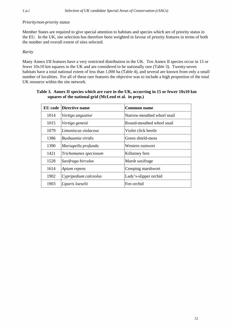
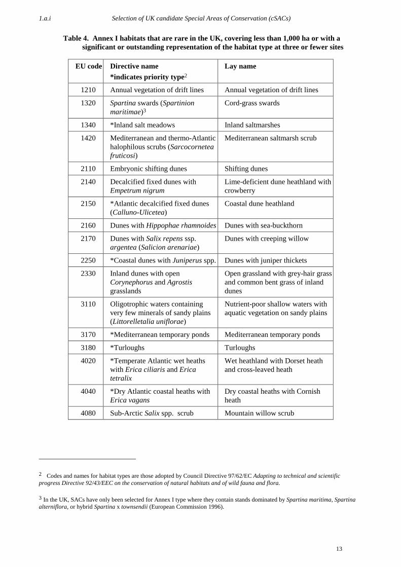
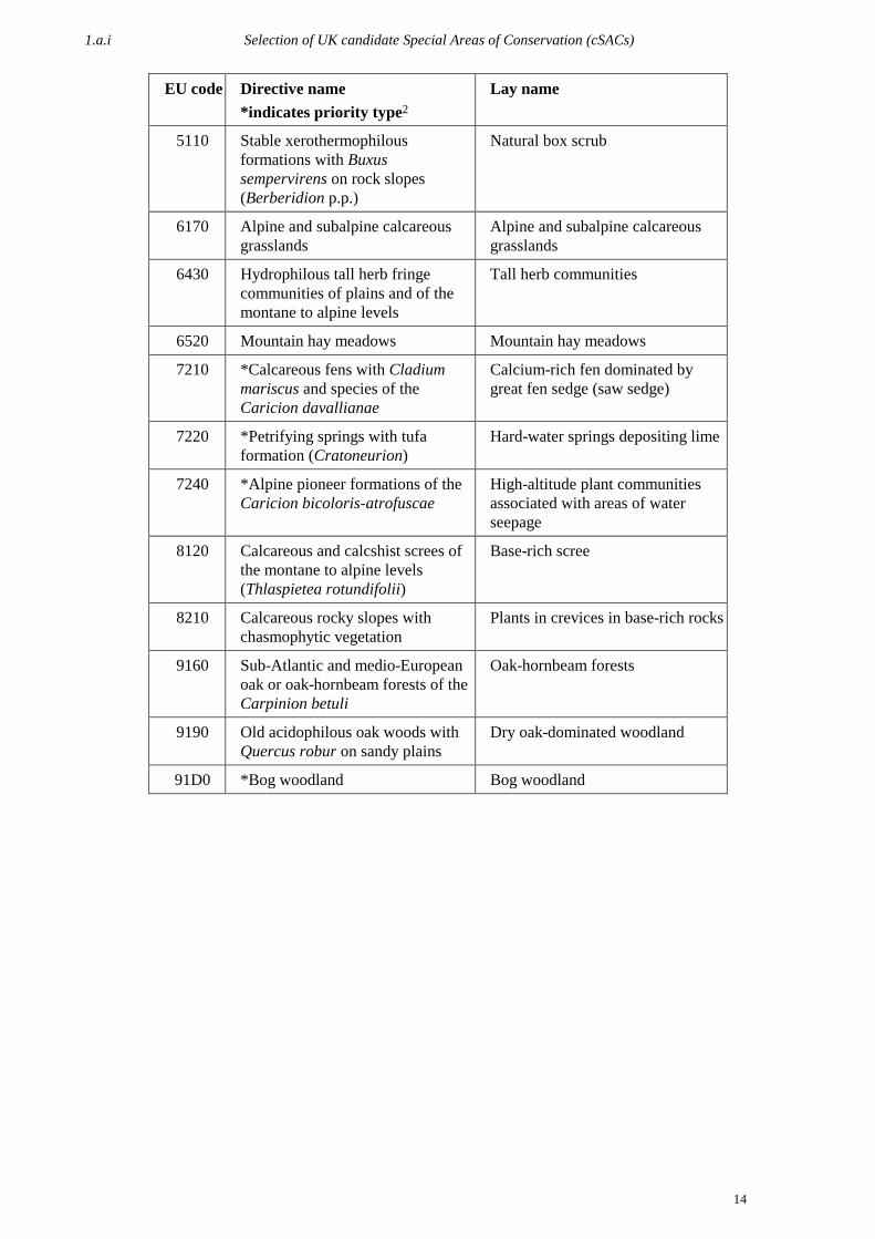
Rarity
Many Annex I/II features have a very restricted distribution in the UK. Ten Annex II species occur in 15 orfewer 10x10 km squares in the UK and are considered to be nationally rare (Table 3). Twenty-sevenhabitats have a total national extent of less than 1,000 ha (Table 4), and several are known from only a smallnumber of localities. For all of these rare features the objective was to include a high proportion of the totalUK resource within the site network.
Table 3. Annex II species which are rare in the UK, occurring in 15 or fewer 10x10 kmsquares of the national grid (McLeod et al. in prep.)
EU code Directive name Common name
1014 Vertigo angustior Narrow-mouthed whorl snail
1015 Vertigo genesii Round-mouthed whorl snail
1079 Limoniscus violaceus Violet click beetle
1386 Buxbaumia viridis Green shield-moss
1390 Marsupella profunda Western rustwort
1421 Trichomanes speciosum Killarney fern
1528 Saxifraga hirculus Marsh saxifrage
1614 Apium repens Creeping marshwort
1902 Cypripedium calceolus Lady’s-slipper orchid
1903 Liparis loeselii Fen orchid
1.a.i Selection of UK candidate Special Areas of Conservation (cSACs)
13
Table 4. Annex I habitats that are rare in the UK, covering less than 1,000 ha or with asignificant or outstanding representation of the habitat type at three or fewer sites
EU code Directive name*indicates priority type2
Lay name
1210 Annual vegetation of drift lines Annual vegetation of drift lines
1320 Spartina swards (Spartinionmaritimae)3
Cord-grass swards
1340 *Inland salt meadows Inland saltmarshes
1420 Mediterranean and thermo-Atlantichalophilous scrubs (Sarcocorneteafruticosi)
Mediterranean saltmarsh scrub
2110 Embryonic shifting dunes Shifting dunes
2140 Decalcified fixed dunes withEmpetrum nigrum
Lime-deficient dune heathland withcrowberry
2150 *Atlantic decalcified fixed dunes(Calluno-Ulicetea)
Coastal dune heathland
2160 Dunes with Hippophae rhamnoides Dunes with sea-buckthorn
2170 Dunes with Salix repens ssp.argentea (Salicion arenariae)
Dunes with creeping willow
2250 *Coastal dunes with Juniperus spp. Dunes with juniper thickets
2330 Inland dunes with openCorynephorus and Agrostisgrasslands
Open grassland with grey-hair grassand common bent grass of inlanddunes
3110 Oligotrophic waters containingvery few minerals of sandy plains(Littorelletalia uniflorae)
Nutrient-poor shallow waters withaquatic vegetation on sandy plains
3170 *Mediterranean temporary ponds Mediterranean temporary ponds
3180 *Turloughs Turloughs
4020 *Temperate Atlantic wet heathswith Erica ciliaris and Ericatetralix
Wet heathland with Dorset heathand cross-leaved heath
4040 *Dry Atlantic coastal heaths withErica vagans
Dry coastal heaths with Cornishheath
4080 Sub-Arctic Salix spp. scrub Mountain willow scrub
2 Codes and names for habitat types are those adopted by Council Directive 97/62/EC Adapting to technical and scientificprogress Directive 92/43/EEC on the conservation of natural habitats and of wild fauna and flora.
3 In the UK, SACs have only been selected for Annex I type where they contain stands dominated by Spartina maritima, Spartinaalterniflora, or hybrid Spartina x townsendii (European Commission 1996).
1.a.i Selection of UK candidate Special Areas of Conservation (cSACs)
14
EU code Directive name*indicates priority type2
Lay name
5110 Stable xerothermophilousformations with Buxussempervirens on rock slopes(Berberidion p.p.)
Natural box scrub
6170 Alpine and subalpine calcareousgrasslands
Alpine and subalpine calcareousgrasslands
6430 Hydrophilous tall herb fringecommunities of plains and of themontane to alpine levels
Tall herb communities
6520 Mountain hay meadows Mountain hay meadows
7210 *Calcareous fens with Cladiummariscus and species of theCaricion davallianae
Calcium-rich fen dominated bygreat fen sedge (saw sedge)
7220 *Petrifying springs with tufaformation (Cratoneurion)
Hard-water springs depositing lime
7240 *Alpine pioneer formations of theCaricion bicoloris-atrofuscae
High-altitude plant communitiesassociated with areas of waterseepage
8120 Calcareous and calcshist screes ofthe montane to alpine levels(Thlaspietea rotundifolii)
Base-rich scree
8210 Calcareous rocky slopes withchasmophytic vegetation
Plants in crevices in base-rich rocks
9160 Sub-Atlantic and medio-Europeanoak or oak-hornbeam forests of theCarpinion betuli
Oak-hornbeam forests
9190 Old acidophilous oak woods withQuercus robur on sandy plains
Dry oak-dominated woodland
91D0 *Bog woodland Bog woodland

1.a.i Selection of UK candidate Special Areas of Conservation (cSACs)
15
Geographical range
The selection of candidate SACs has taken into account the distribution of each interest feature in the UK,as attainment of favourable conservation status for a habitat or species is dependent on maintaining thegeographical range. Some habitats and species have a very localised distribution, whereas others (e.g.European dry heaths; otter Lutra lutra) are found more-or-less throughout the UK. The selected sites reflectthese differing distribution patterns.
Special UK responsibilities
Certain habitats and species listed on the Annexes of the Directive are more common in the UK than inother EU Member States. A very small number (e.g. Caledonian forest) are endemic to the British Isles,while for others (e.g. blanket bog; grey seal Halichoerus grypus) the UK holds the majority of the totalEuropean resource. The UK clearly has particular responsibilities for conserving these habitats and species,and consequently the number and area of sites selected for these features is generally greater than for otherhabitats and species.
Multiple interest
Sites holding a range of different habitats and species are generally of high biodiversity value. Specialemphasis has therefore been given to selecting sites in which several high-quality interests form anecologically functional unit. Such sites are most prevalent in upland and coastal areas, where the mostextensive areas of natural or semi-natural habitat in the UK are found.
Many lowland habitats and species (e.g. active raised bog; great crested newt Triturus cristatus) typicallyoccur within intensively-managed landscapes and are often not associated with other features ofconservation interest. Protection of these features within the SAC series has therefore necessitated theidentification of many single-interest sites.
Other factors
Identification of candidate SACs has relied solely on assessment of the scientific criteria listed above, andhas not been constrained by consideration of socio-economic factors. Site selection was also not restrictedto localities with existing statutory conservation designations. The UK site list contains a significantnumber of sites or parts of sites which were not notified as SSSI/ASSI at the time they were identified aspossible SACs. In all but a few cases SSSI/ASSI notification has been undertaken to support the SACdesignation. The notification process in England and Wales has been strengthened by the Countryside andRights of Way Act (CRoW), which gained royal assent in November 2000.
Problems encountered in applying SAC selection criteria in the UK
The SAC selection criteria are broadly similar to those which have previously been used in the UK to selectnational site networks, such as SSSIs/ASSIs. Nevertheless, interpretation of certain criteria has provedchallenging.
Annex I definitions
One of the major challenges posed by the selection of SACs in the UK has been the interpretation of habitattypes listed on Annex I of the Directive. Wherever possible, Annex I habitats were interpreted in terms ofstandard UK vegetation classifications, such as the NVC, but in many cases there is no straightforwardcorrespondence between Annex I categories and habitat types which have been recognised in the UK. Theheterogeneous nature of the Annex I list has also caused difficulties. Some habitats are very narrowlycircumscribed and have a limited range of variation (e.g. mountain hay meadows), while others are broadlandscape units, which are best regarded as habitat-complexes (e.g. estuaries).

1.a.i Selection of UK candidate Special Areas of Conservation (cSACs)
16
The definitions contained in the Interpretation manual of European Union habitats (European Commission1996) have been adhered to closely, and where necessary reference has also been made to the CORINE (Co-ordination of Information on the Environment) biotope classification (CEC 1991). However, theInterpretation manual contains only a general account of each type, and does not provide details of everylocal facet of variation. Consequently there have been lengthy debates about the interpretation of certainhabitats, and in some cases definitions have been modified following discussions by the EC HabitatsCommittee and its Scientific Working Group. For example, in 1997 amendments were made to the originalDirective and the definition of turloughs was expanded to include examples in Northern Ireland and Wales.
Diverse distribution patterns
Site selection has been complicated by the diverse nature of habitats and species listed on Annexes I and IIof the Directive. Some features are restricted to a very small number of sites in the UK whereas others arewidely distributed and may be locally abundant in parts of their range. This diversity means that it isimpossible to apply selection criteria in exactly the same way for each interest feature. The particularcharacteristics of each habitat and species have therefore been taken into account when identifying sites.
Widespread species and extensive habitats
Identification of candidate SACs for widespread species has been problematic, especially for animals suchas otter Lutra lutra that are thinly distributed over a wide geographical range and have few markedpopulation concentrations. For such species, available data have been used to identify localities holdingespecially large populations, and site selection has endeavoured to reflect the range of geographical areasand ecological conditions in which the species is found. Inevitably, for some species the site series containsa relatively small proportion of the total UK population.
Similar difficulties have been encountered when identifying SACs for certain habitats, in particular thosewhich are extensive components of upland landscapes in the north and west of Britain, such as Europeandry heaths and blanket bog.
Wide-ranging aquatic animals, e.g. Harbour porpoise Phocoena phocoena, pose particular difficulties, asacknowledged in Article 4(1) of the Directive. The site selection rationale for harbour porpoise is stillbeing discussed by the EC and Member States, and the UK is currently considering whether it can identifysites which fulfil the criteria outlined in Article 4(1).
Paucity of data to support the selection process
In several cases there is limited information on the distribution and extent of habitats and the range andpopulation size of species, both across the UK and on individual sites. This is particularly the case withinconspicuous plant and animal species (e.g. certain bryophytes and molluscs), and habitats that have beenpoorly studied in the UK (e.g. chasmophytic types). Every effort was made to collate all available data tosupport the site selection process, and in some cases survey was undertaken to obtain essential information,e.g. a coastal lagoon survey of Scotland (Covey et al. 1998; Thorpe 1998; Thorpe et al. 1998). However,it is likely that future advances in knowledge will reveal additional high-quality sites for some habitats andspecies.
The use of expert opinion
Some of the Annex III criteria (e.g. habitat extent) can be quantified relatively easily, but others arequalitative, and their evaluation relies heavily on the use of best scientific judgement. Although the use ofartificial scoring systems or other rule-based approaches to identify conservation sites has receivedconsiderable attention in the scientific literature over the past decade, these methods inevitably involvesubjective assessments (e.g. to weight criteria or to evaluate qualitative attributes). There is no consensus asto how these problems should be overcome. For these reasons, informed expert opinion has necessarilyplayed a key role in identifying the ‘best’ sites for each habitat and species.

1.a.ii Process adopted for SAC selection and constraints encountered
17
Special Protection Area (SPA) network review
The UK’s Natura 2000 network will include, as required by Article 3(1) of the Habitats Directive, bothSACs (selected as described above) and the network of Special Protection Areas (SPAs) designated underthe Directive on the conservation of wild birds (Council Directive 79/409/EEC). In parallel with the workto create a network of candidate SACs in the UK, work has also been taking place to continueimplementation of the Birds Directive in both terrestrial and marine environments. The UK’s sixth triennialreport covered work undertaken from 1996–1998. Further detail on the work summarised below will beincluded in the next UK Birds Directive report.
JNCC is currently co-ordinating a major review of the UK network of Special Protection Areas (SPAs).The early phase of this work resulted in agreement (by the statutory agencies and Government Departments,following consultation with non-governmental organisations) of guidelines for the selection of terrestrialSPAs (JNCC 1999). The guidelines have been applied to data on sites of importance for birds in the UK, inthe context of species-specific conservation needs for each Annex I and/or migratory bird species thatregularly occurs within the UK. This has led to the development of a series of species-related SPA sites thatare considered to comprise the most-suitable sites in the context of Article 4 of the Directive. Theaggregation of these separate species suites forms the UK SPA network. The list of sites forming themajority of the UK SPA network was published by government departments in March 2000 and commentswere invited from non-governmental organisations (NGOs) and others. JNCC is now in the process ofdocumenting the UK site network.
For site selection purposes marine SPAs are defined as those with no dry land at any state of the tide. Threecategories of marine SPAs may be envisaged:
a) extensions of existing SPAs at bird colonies to encompass nearshore resting and feeding areasb) regular occurring concentrations of waterbirds in nearshore areasc) offshore concentrations of birds
Information to define the boundaries of all marine SPAs is relatively scarce compared with landward sites.However, enough information exists covering the first two categories to enable proposals to be put forwardrelatively soon for a number of sites. Further survey work to define areas in category (b) is underway.Category (c) is more problematical, as predictable concentrations can only be found at a large scale. Forinstance, a large part of the north-western North Sea is known to hold internationally importantconcentrations of birds in the early autumn, but the precise location of these birds within this area can varywidely between years.
1.a.ii Process adopted for SAC selection and constraints encountered
A list of key dates in the site selection and submission process is presented in Table 5. Figure 1 summarisesthe UK’s SAC selection process.
Stage 1 of the selection process
As soon as the Habitats Directive was adopted in 1992, the UK statutory conservation agencies (CCW,EHS, EN, SNH and JNCC) began to prepare a UK list of candidate SACs. This has been a lengthy anditerative process. The rationale for site selection and the proposals for possible SACs have evolved overseveral years following internal peer review, the acquisition of new knowledge from survey work, publicconsultation, and the ‘moderation process’. Site selection has been based solely on consideration ofscientific criteria, and has relied heavily on the specialist knowledge of staff within the conservationagencies, with input from other organisations. In order to maintain the integrity of the UK site list, theagencies have collaborated closely throughout the SAC selection process, and have also maintained regularliaison with government departments and administrations.

1.a.ii Process adopted for SAC selection and constraints encountered
18
Table 5. Key dates in the selection of candidate SACs in the UK
13–14 October 1994 Atlantic Biogeographical Region meeting, Edinburgh (discussion ofselection criteria and distribution of habitats and species)
24 March 1995 Initial list of possible SACs formally advised to Government
31 March 1995 First public consultation started
15 June 1995 First tranche of 136 candidate SACs submitted to the EC
1 October 1997 Second public consultation started
5 June 1998 Atlantic Biogeographical Region meeting, Paris (discussion of nationalreference lists of Annex I and II features)
4 June 1999 Eleventh tranche of candidate SACs submitted to the EC
6-8 September 1999 Atlantic Biogeographical Region meeting, Kilkee, Ireland(‘moderation’ of national site lists)
14 November 1999 Supplementary Atlantic Biogeographical Region meeting, Paris(conclusion of ‘moderation’ discussions)
6 April 2000 Revised UK site list formally advised to Government
31 October 2000 First post-moderation tranche of candidate SACs (Tranche 12)submitted to the EC
By 20 July 2001 A further six tranches (13–18) will have been submitted to the EC
Figure 1. Summary of the UK cSAC selection process
Revised UK SAC list
Identify Potential SACs(CAs, JNCC)
Information on the UK status ofAnnex I habitats and Annex II
species (CAs, JNCC)
Guidance on interpretation of Annex I habitats(EC, ETC/NPB, JNCC)
Guidance on SAC selectioncriteria (EC, JNCC)
cSAC list
Assess Sufficiency (AtlanticBiogeographic Region)
(Govt, JNCC)
Identifychanges
(CAs)
Ensure UKconsistency
(JNCC)
ECMember States
Guidance onchanges required
(JNCC)
NGOs ETC/NPB
pSAC lis t
Consult w idely(CAs , Govt)
Submit to EC(JNCC via DEFRA)
Owners / Occupiers
Other parties
Advise Government(JNCC)
Advise Government(JNCC)
Stage 1
Stage 2
AbbreviationsCAs Country AgenciesDEFRA Department of the Environment, Food
and Rural AffairsEC European CommissionETC/NPB European Topic Centre on Nature
Protection and Biodivers ityNGOs Non Governmental OrganisationsJNCC Joint Nature Conservation Committee
pSAC poss ible Special Area of ConservationcSAC candidate Special Area of Conservation
Amended p&c SAC list
Consult w idely(CAs , Govt)
Submit to EC(JNCC via DEFRA)
Owners / Occupiers
Other parties
1.a.ii Process adopted for SAC selection and constraints encountered
19
A range of professional groups and statutory committees have critically reviewed the list of sites at variousstages in the selection process:
a) At an early stage, seven inter-agency working groups were established to provide specialist adviceon woodlands, coastal habitats, marine habitats and species, freshwaters, lowlandgrasslands/heaths/mires, uplands/peatlands, and species. These specialist groups drew up initiallists of high-quality sites, and provided quality assurance for subsequent amendments to the list, e.g.ensuring that a consistent UK-wide approach was maintained.
b) Local staff within the conservation agencies assessed proposals to ensure that proposed sites wereof sufficient quality and represented the best examples of the selected features within eachgeographical area.
c) Conservation agency management/project boards reviewed site lists within each country to ensureadequate representation of each interest feature.
d) Conservation agency governing bodies formally approved proposals within each country.e) The Joint Nature Conservation Committee (JNCC) endorsed UK site proposals before providing
formal advice to Government, on behalf of the country agencies. At this stage the sites are knownas possible SACs (pSACs).
f) Government departments and administrations have scrutinised the selection process and theproposed site lists to ensure that the requirements of the Habitats Directive were adhered to.
An initial list of possible SACs was formally advised to Government on 24 March 1995. Following furtherwork by the conservation agencies, various amendments to this list, including a significant number ofadditional sites, were advised at various dates over the next four years.
Submission of sites to the EC
Because the preparation of the UK SAC list took several years, sites were submitted to the EC in a series oftranches. Once consultation has been completed satisfactorily, sites are submitted to the EC, at which stagethey are known as candidate SACs (cSACs). The first tranche of 136 candidate SACs was submitted inJune 1995. Eleven subsequent tranches were submitted over the next four years, culminating in June 1999.
Summary data on each possible and candidate SAC are held on an electronic database at JNCC (theinternational designations database (IDD)). This database was used to produce Natura 2000 standard dataforms for each site, following the guidance provided by DG Environment. To date, only obligatory datafields have been supplied to the EC. The data forms, together with digital maps showing the boundaries ofeach site, have been submitted to the EC in electronic format and as hard copy.
Post-moderation amendments to the UK SAC list
Stage 2 of the selection process
By June 1999 the UK had submitted details of 340 candidate SACs to the EC, thus completing stage 1 ofthe site selection process. These sites had been selected in accordance with the criteria outlined in AnnexIII of the Directive, and were intended to represent a complete national list, with the exception of two sites:the Severn Estuary, which was delayed, and Cernydd Carmel which qualified through a late EC redefinitionof the criteria for turloughs. The list was considered to constitute a proper interpretation of therequirements of the Directive for those habitats and species found in the UK, subject to any changes whichmight be required as a result of the moderation process.
Within the Atlantic Biogeographical Region, stage 2 of the site selection process was initiated at a meetingheld in Kilkee, Ireland on 6–8 September 1999. Due to lack of time it was not possible to concludediscussions on all Annex II species at Kilkee, and consequently a supplementary meeting of the AtlanticRegion was held in Paris on 14 November 1999.

1.a.ii Process adopted for SAC selection and constraints encountered
20
The two meetings consisted of detailed discussions of the lists of candidate SACs submitted by MemberStates, with the aim of identifying those Annex I habitats and Annex II species for which national proposalswere considered to be insufficient. There was general agreement that the UK had approached the selectionof SACs in a logical and scientifically robust manner, and had done a good job in identifying the best sitesfor each interest feature. However, the UK list was judged to provide insufficient representation of arelatively large number of habitats and species.
Three key issues were raised in relation to the UK list of candidate SACs:
i) The proposed sites were judged to provide inadequate coverage of the geographical range orecological variation shown by some habitats and species.
ii) For some interest features the proportion of the total national resource contained within the siteseries was considered to be too low.
iii) The UK had only listed selected habitats and species (i.e. those considered to be of outstandingEuropean importance) as SAC interest features. The EC requires every Annex I habitat andAnnex II species occurring on a site to be listed.
The UK Government and devolved administrations accepted the conclusions of the Atlantic Regionseminars. Immediately following the Kilkee meeting the statutory conservation agencies commenced athorough review of the cSAC series.
The process for handling the moderation work differed in certain respects from that which had been usedpreviously to draw up the original list of 340 sites. This largely reflected changes in responsibilitiesfollowing devolution. At the start of the moderation process, JNCC provided general guidance on the typeand scale of changes required. EN, SNH, CCW and EHS were then responsible for drawing up revised sitelists within their respective countries. This work involved both listing supplementary interest features onexisting sites and identifying new sites for under-represented features.
Provisional site lists were submitted to JNCC in January 2000. JNCC then carried out a UK assessment ofthe proposals to check that (a) a consistent approach towards site selection had been adopted across the UK,and (b) the revised lists satisfactorily addressed the issues raised at the Kilkee and Paris meetings. Thisstage of the work relied heavily on input from the inter-agency specialist working groups. Followingdiscussion and resolution of any outstanding issues final amendments were made to the UK site list, and thiswas formally advised to the Department of Environment, Transport and the Regions (DETR) and devolvedadministrations on 6 April 2000. Since then, various minor amendments have been made to the UK list andthese have also been advised to the Government.
The Government publicly announced details of the revised proposals in June and July 2000. Consultationwith site owner and/or occupiers and other interested parties was initiated. As consultation was completed,sites were submitted formally to the EC in a series of tranches. Post-moderation tranches should be sent byMarch 2001. Details of any outstanding new or amended sites must be submitted to the EC by 8 June 2001(Tranche 17) before the next Atlantic Biogeographical Region meeting (currently scheduled for December2001) as new or amended data for later submissions will not be taken into account.
Consultation
The UK Government has always been committed to full public consultation on SAC proposals, and inparticular to discussion with site owners and/or occupiers and other interested parties. For some sites thishas been a protracted process, and has led to delays in submitting site proposals to the EC. However,consultation at an early stage is likely to lead to long-term conservation benefits, as it facilitates siteprotection and the implementation of positive management measures.
The first public consultation on the UK list of possible SACs was initiated in March 1995. For each site,owners and/or occupiers were contacted by the conservation agencies and notified of the location andboundaries of the site, the reasons for its recommendation as a possible SAC, and a summary of the
1.a.ii Process adopted for SAC selection and constraints encountered
21
Directive and its implications. In general, consultees were given a period of six weeks in which to respond;for marine sites the consultation period was extended to 12 weeks.
At the same time, comments were also sought from a wide range of organisations, including governmentdepartments and agencies, local planning authorities, NGOs, and industrial and/or commercial bodies. Aswell as organisations with a wide conservation remit, such as the World Wide Fund for Nature (WWF),specialist societies were also consulted. Many responses were received as a result of this consultationexercise. These were assessed by the conservation agencies, and, where appropriate, changes were made tothe list of possible sites. For example, several sites were added to the UK list at this stage as a result ofrepresentations by NGOs.
After 1995 further consultation with owner/occupiers was carried out, as amendments to the UK site listwere formally advised to the Government. A second major public consultation exercise commenced inOctober 1997. Once again comments were received from a variety of organisations and considered by theconservation agencies.
In Wales, until October 2000, the Countryside Council for Wales (CCW) consulted with all interestedparties individually. However, due to the timescales imposed by the moderation process, CCW carried outa six-week consultation on the designation of new sites and amendments to existing sites by public notice inthe press, directing people to the CCW area offices for further information. The relevant authorities wereconsulted in writing with a six-week consultation period. Full consultation with all landowners andoccupiers and interested parties will be undertaken when the underpinning SSSI designation is put in place.
A list of organisations consulted or who made representations as part of the consultation process is given inAppendix 2.
1.a.iii Assessment of implementation in the UK
22
Box 1. Gibraltar
The Nature Protection Ordinance of 1991 provides the legislative equivalent to the UK Wildlife andCountryside Act. Nature conservation is dealt with in Gibraltar by the Gibraltar Government’sEnvironment Ministry with the assistance of member organisations such as the GibraltarOrnithological and Natural History Society (GONHS).
Directive 92/43/EEC was transposed into the laws of Gibraltar on 25 August 1995 by the NatureProtection Ordinance (Amendment) Regulations 1995. Proposals for cSACs were formulated by theGovernment of Gibraltar after having sought advice from environmental and planning experts asnecessary. Many of the sites, however, include land owned by the Ministry of Defence and this hasled to some delay in the designation of sites to the Commission. It has also taken some time todevelop the administrative and practical structures necessary to provide information on theprotection of habitats and species and therefore measures for the protection and management of theNatura 2000 sites have not yet been prepared. Nonetheless GONHS have carried out somemonitoring e.g. of Chiroptera and Cetaceans, with the assistance of the Government of Gibraltar.GONHS also act as a general environmental watchdog in Gibraltar.
Some of the Annex I habitats and Annex II species sites occurring in Gibraltar are very small andconcepts such as ‘percentage of habitat’ and ‘percentage of the national territory’ need to beconsidered in perspective. Rather than propose a patchwork, the individual small sites have beenlinked into a terrestrial site and a marine site. The Nature Protection Ordinance (1991) reverse-listsplants, listing only those that may be picked.
The Nature Reserve Regulations prohibit uprooting all species within the Upper Rock NatureReserve. The Ordinance prohibits the taking of all wild animals except rats and mice feral cats anddogs and pigeons. All wild amphibians, reptiles, birds and mammals (including cetaceans) aretherefore protected against intentional killing. Under the legal protection of the Nature ProtectionOrdinance, the Nature Conservancy Council are engaged in a number of projects including captivebreeding and release of lesser kestrel Falco naumanni.
As in the rest of the UK, site selection has used the best available information, adapting thedefinitions contained in the Interpretation anual of European Union abitats to the specialisedcommunities of Gibraltar, some of which have only just been described (Galan de Mera et al.2000).
In Gibraltar, surveillance initiatives have been led by the Nature Conservancy Council under theauspices of the Ministry of the Environment. GONHS, on behalf of the Council, have carried outinventories of a great deal of Gibraltars biological resources, including vascular plants, Mollusca,Lepidoptera, reptiles, birds, mammals and many marine groups. All monitoring is carried out asvoluntary work by members of GONHS.
1.a.iii Assessment of implementation in the UK
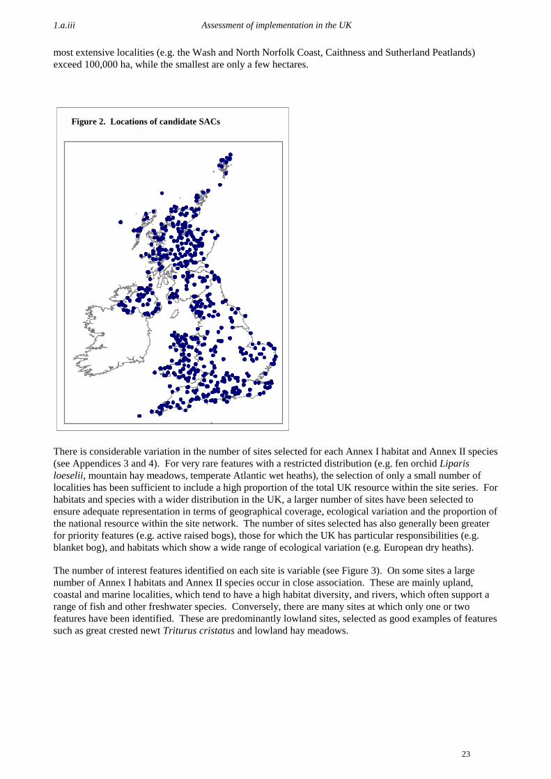
As of Tranche 17 (8 June 2001) the total number of candidate SACs submitted by the UK will stand at 555sites, covering 2,227,078 ha. Nine of the cSACs may be resubmitted with amendments if changes to theirboundaries or features are confirmed. In addition, 22 possible SACs which have been formally advised tothe Government will still be subject to consultation. If all the changes are confirmed, the total list of SACsin the UK will stand at 577 sites totalling over 2,341,600 ha. It is then proposed that a further tranche willbe submitted on 20 July, containing several of the new and amended sites. The cSACs already submittedrepresent 96% of the sites advised to the Government by the JNCC.
Sites are distributed throughout the UK (see Figure 2). Concentrations of sites in certain parts of the UK(e.g. Scottish Highlands, north-west England, north Wales) reflect the presence of more extensive areas ofsemi-natural habitat and associated species in these regions. Individual sites vary considerably in size. The
1.a.iii Assessment of implementation in the UK
23
most extensive localities (e.g. the Wash and North Norfolk Coast, Caithness and Sutherland Peatlands)exceed 100,000 ha, while the smallest are only a few hectares.
There is considerable variation in the number of sites selected for each Annex I habitat and Annex II species(see Appendices 3 and 4). For very rare features with a restricted distribution (e.g. fen orchid Liparisloeselii, mountain hay meadows, temperate Atlantic wet heaths), the selection of only a small number oflocalities has been sufficient to include a high proportion of the total UK resource within the site series. Forhabitats and species with a wider distribution in the UK, a larger number of sites have been selected toensure adequate representation in terms of geographical coverage, ecological variation and the proportion ofthe national resource within the site network. The number of sites selected has also generally been greaterfor priority features (e.g. active raised bogs), those for which the UK has particular responsibilities (e.g.blanket bog), and habitats which show a wide range of ecological variation (e.g. European dry heaths).
The number of interest features identified on each site is variable (see Figure 3). On some sites a largenumber of Annex I habitats and Annex II species occur in close association. These are mainly upland,coastal and marine localities, which tend to have a high habitat diversity, and rivers, which often support arange of fish and other freshwater species. Conversely, there are many sites at which only one or twofeatures have been identified. These are predominantly lowland sites, selected as good examples of featuressuch as great crested newt Triturus cristatus and lowland hay meadows.
Figure 2. Locations of candidate SACs

1.b.i Status of conservation measures for cSACs
24
Figure 3. Number of features on cSACs
0
50
100
150
200
250
0 1 2 3 4 5 6 7 8 9 10 11 12 13 14 15 16 17 18 19 20 21
Features
Site
s
a, b, or c graded featuresnon-qualifying features
1.b.i Status of conservation measures for cSACs
Government departments and the statutory nature conservation agencies have a primary responsibility forthe implementation of the UK legislation which transposes international obligations for nature conservationinto UK law. This includes the designation of sites as cSACs under the Habitats Directive.
A number of measures are used to accomplish this:• the development of conservation objectives and management plans for sites;• the development of legal agreements with owners and occupiers to help finance appropriate
management;• agri-environment schemes which encourage farming in a manner which is sympathetic to the nature
conservation interest of land;• collaborative working and consensus-building with public and private organisations and individuals
to ensure that a balance is struck between the potentially disparate interests each may have for anarea of land;
• marine management schemes.
A number of case studies and examples are given below to provide a flavour of the ways in which this workis carried forward within the UK. These focus on the development and implementation of managementplans. Information on UK agri-environment schemes is given in Section 4 of the report.

1.b.i Status of conservation measures for cSACs
25
Development of management plans and agreements
A wide range of organisations are responsible for the preparation and implementation of management plansfor Natura 2000 sites in the UK. These are principally:
• Statutory nature conservation agencies (CCW, EHS, EN and SNH).• Other Government Departments and agencies, for example the Ministry of Defence (MoD) and
Forestry Commission (FC).• Non-Governmental Organisations (NGOs). Those with the most significant site holdings are the Royal
Society for the Protection of Birds (RSPB), National Trust (NT), National Trust for Scotland (NTS)and country/regional Wildlife Trusts. Where NGOs own or manage land within a Natura 2000 sitemanagement plans are developed and implemented in close co-operation with the relevant natureconservation agency.
• For many marine sites, the local authorities (councils) have been heavily involved, and they were thelead authority in drafting management plans for some sites (e.g. Sound of Arisaig, Berwickshire andNorth Northumberland coast). There has also been a lot of local government involvement on terrestrialsites, in the preparation and implementation of management plans.
The use of management agreements to safeguard and enhance the management of sites is an importantmechanism to secure their favourable condition. The conservation agencies have responsibility forpreparing and ensuring implementation of management plans on NNRs that they manage. If the reserve ismanaged by an approved body the responsibility of management planning usually lies with them but theconservation agencies will take an overview.
The conservation agencies are also responsible for preparing short management statements or managementbriefs on those sites which are designated as SSSIs or ASSIs, including Natura 2000 sites. Thesedocuments are designed to set out management objectives for each site in layman’s terms for discussionwith owners and occupiers. They provide a practical and effective means of influencing the actions of allowners and occupiers and others with a direct interest in the designated land. Where relevant, the Natura2000 interests figure prominently in each statement. Management plans or statements are reviewedregularly. The review process considers effectiveness against the achievement of objectives and how toensure the participation of all partners in their implementation.
In addition to more formal management plans, fora which allow issues relevant to the management andprotection of sites to be aired have been created in a number of instances, often at a local level. Althoughthe setting up of a forum may be an obligation under a management agreement, the individuals on eachforum mainly take part on a voluntary basis. Experience to date is that these fora are welcomed andperform a useful function, although progress is slow until group cohesion is achieved.
Terrestrial sites
SNH has completed SSSI Management Statements (brief management plans) for all Scottish SSSIs. Forsome cSACs (e.g. Rum and other sites owned or managed by SNH), full management plans have beenproduced.
The process of developing site management statements (SMS) within England is substantially complete.EN have an ongoing programme to review and update these documents with individual owners and/oroccupiers, and about 2,000 are processed each year. Complete management plans exist for all NNRs. ENuse three categories of management agreement:
i) compensatory, made in the light of restrictions on the land;ii) positive, for achieving wildlife gain; andiii) wildlife enhancement agreements – standard agreements which support conservation
management.
1.b.i Status of conservation measures for cSACs
26
English Nature’s Wildlife Enhancement Scheme (WES) supports positive site management on SSSIs byusing simple agreements and standard payments for annual management and capital works. An integral partof the scheme is to promote active partnerships by linking the local knowledge and practical skills ofowners and occupiers with EN’s expertise.
In addition, English Nature have an initiative called Lifescapes. This project was stimulated by work onhabitat fragmentation and wildlife corridors, linked to national and local targets for biodiversity. Thelandscape-scale conservation that has developed now includes socio-economic aspects. The products of thisproject to date include map-based indices to inform and influence habitat restoration and the targeting ofresources.
Nearly a third of all candidate SACs in Wales have draft management plans and work has started on theplans for most of the remaining sites. The CCW management planning approach includes objectives foreach conservation feature and integrates activities and interests on sites, including community involvement,access, amenity, education and interpretation.
Conservation objectives are being drafted by EHS for all existing and proposed Natura 2000 sites inNorthern Ireland. These will form the basis of consultation with other interested parties regarding themanagement of sites.
The role of the Forestry Commission (FC) for SACs breaks down into three main parts:
i) Management of Forestry Commission sites managed by Forest Enterprise (FE – an Agency withinthe Forestry Commission). The total area of SAC sites covered by FE management agreementswith nature conservation agencies is 38,866 ha. This is spread over 30 different sites, of which21,156 ha is in the New Forest.
ii) Payment of grants under the terms of Woodland Grant Schemes agreed between landowner/occupiers and the FC.
iii) Regulatory functions under various Acts, including felling licensing and the power to requireenvironmental assessments in respect of potential forestry developments, including tree plantingand road building.
The MoD has an interest in 77 SACs, affecting 105 MoD sites. Integrated Land Management Plans(ILMPs) are being introduced across the Army Training Estate. The 14 major army-training areas will allhave ILMPs by December 2001. Conservation Management Plans are being developed, with the statutoryconservation agencies, on smaller MoD training areas. These are currently complete or in preparation for58 SACs on military land.
It is MoD policy that conservation groups or focal points must be in place on a designated site owned by theMoD land. All SSSI sites and all cSACs in which the MoD have an interest are monitored by establishedMoD conservation groups. The MoD liaises with the statutory conservation agencies through regularmeetings with the individual groups and the annual MoD Liaison Committee on Environmental Matters.
Marine sites
Under the UK’s transposition legislation for the Habitats Directive, responsibility for SACs in the marineenvironment is held jointly by all competent authorities with relevant functions. Unlike terrestrial sites witha history of SSSIs and their management agreements, most marine SACs have to develop management plansfrom scratch and this has been a major new undertaking for the UK.

1.b.i Status of conservation measures for cSACs
27
In order to protect and manage marine cSACs, the UK Regulations require relevant authorities (publicbodies with a regulatory role) to ensure that management activities are compatible with the Natura 2000interests of the sites. The statutory conservation agencies4 have a duty to advise these authorities as to:
• Conservation objectives• Operations which may cause damage or disturbance
Candidate SACs in the marine environment, unlike their terrestrial counterparts, do not have targetedpositive incentive measures that complement existing arrangements. This advice is underpinned byRegulation 33 (Regulation 28 in Northern Ireland). There are now 23 packages and consultationprogrammes under Regulation 33 covering 38 European marine sites, with an established programme for afurther 15 packages covering 21 sites.
One of the first management committees in the UK to advise on marine nature conservation was theStrangford Lough Management Committee. Established in 1992, it comprises representatives of EHS, thelocal community, Lough user groups and specialist interests. The Committee played an influential role inStrangford Lough’s designation as a Marine Nature Reserve in 1995. Today it is guiding the preparation ofa management scheme for the Natura 2000 site (which is both an SPA and a cSAC). The Regulation 28(NI) package for Strangford Lough marine cSAC will form part of the Management Scheme document forthe site.
The development of management plans for marine candidate SACs in Wales is divided into two stages:firstly, the provision of conservation advice by CCW to the relevant authorities, and secondly, thedevelopment of a management plan by those authorities based on this advice. Regulation 33 advice hasbeen published for two marine SACs in Wales, supported by the EC LIFE-Nature programme (CardiganBay and Pen Llyn a’r Sarnau). On most marine candidate SACs in Wales, management committees havebeen established by the relevant authorities to draw up management plans. Draft management plans arenow in preparation for most of the marine cSACs. A final plan has been completed for Cardigan BaycSAC, and for Pen Llyn a’r Sarnau, a draft plan was published in summer 2000, with a final versionexpected in summer 2001.
Within Scotland the marine cSACs that have progressed the furthest in developing management schemesare those with LIFE-funded Project Officers. For all five sites with such officers, draft managementschemes have been developed in consultation with the relevant authorities, including Local Authorities andlocal management groups. Drafts of Regulation 33 packages for the LIFE and cross-border sites (theSolway Firth and Berwickshire and North Northumberland coast), have been developed in parallel with themanagement schemes and have been put out to public consultation. The Solway Firth and Berwickshirepackage was signed off in November 1999 and the North Northumberland coast package was signed off inMay 2000.
For Papa Stour, Sound of Arisaig and Loch nam Madadh cSACs, the Regulation 33 packages are beingdeveloped separately from the management schemes. Along with the other non-LIFE marine cSACs thedevelopment of the Regulation 33 packages follows on from the completion of the conservation objectives.The conservation objectives for these sites will be developed by Scottish Natural Heritage.
English Nature has finalised the production of 13 Regulation 33 packages and established a consultationprogramme for 15 sites. Considerable progress has also been made in establishing management schemes ateach of the 16 sites in the programme, with management groups being established for all 16 sites, advisorygroups established at 12, and informal consultation schemes produced for six.
4 In Northern Ireland this is the responsibility of the Secretary of State for Northern Ireland under Regulation 28 of theNorthern Ireland Regulations.

1.b.ii Measures to avoid deterioration of, and disturbance on, candidate SACs
28
Monitoring of management plans
Management plans are reviewed on a cycle varying between one and five years. The length of the cycledepends both on the type of plan and the reason why it was created. With all forms of management plan,where new issues or proposals arise they will be the subject of assessment and if acceptable included in arevised plan. The following information about CCW’s approach is an example of management plan review.
Box 2. National nature reserve audit system in Wales
CCW operates a system of formal audit of its National Nature Reserves (NNRs). This procedurechecks that management plans are properly written, and that other reserve documentation is in place.It also checks that the management plan is properly implemented on the ground. The NNRs areaudited on a three-year cycle. many cSACs are also NNRs, a number have already been through theaudit process. However, it should be borne in mind that some NNRs do not cover the entire cSAC.
Sites which have been audited recently include:
• Berwyn a Mynyddoedd de Clwyd/Berwynand South Clwyd Mountains
• Twyni Bae Caerfyrddin/Carmarthen BayDunes
• Coed y Cerrig• Coedydd a Cheunant Rheidol/Rheidol
Woods and Gorge• Cors Caron• Cors Fochno
• Corsydd Môn/Anglesey Fens• Arfordir Calchfaen de Orllewin
Cymru/Limestone Coast of South WestWales
• Morfa Harlech a Morfa Dyffryn• Rhinog• Rhos Goch• Rhos Llawr-cwrt• Y Twyni o Abermenai i Aberffraw/
Abermenai to Aberffraw Dunes
1.b.ii Measures to avoid deterioration of, and disturbance on, candidate SACs
Action to change activities where damage identified
Action by the UK to avoid deterioration of habitats and disturbance to species on cSACs takes two forms:changes in management and a review of notifications/consents for SSSIs.
Changes in management are generally brought about by means of management agreements, either case-specific or under a management scheme, but voluntary schemes or codes of conduct are also relevant. Thestatutory conservation agencies are also able to review and amend SSSI citations and lists of operationslikely to damage the features of interest. Having developed guidelines for the review and amendment ofnotifications, this work has begun for SSSIs associated with cSACs. In addition to work to avoiddeterioration and disturbance on sites, substantial effort has also gone into work to maintain, improve orrecreate habitats.
All the country agencies are required to review existing notices and consents given under Section 28 of theWildlife and Countryside Act to ensure that they are compatible with the nature conservation objectives forEuropean sites (see Regulation 21). Planning authorities and other competent authorities also have to carryout reviews.
Throughout the UK, the environmental agencies are working closely together to determine the significanceof existing permissions and their potential impact. The statutory conservation agencies provide informationon the interest features and conservation status of sites to EA and SEPA. Decisions on whether permissionscan continue or must be modified or revoked will depend upon SEPA’s and EA’s assessment of their impactin consultation with EN, CCW and SNH.
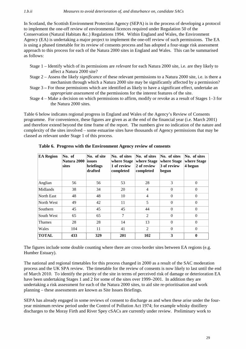
1.b.ii Measures to avoid deterioration of, and disturbance on, candidate SACs
29
In Scotland, the Scottish Environment Protection Agency (SEPA) is in the process of developing a protocolto implement the one-off review of environmental licences required under Regulation 50 of theConservation (Natural Habitats &c.) Regulations 1994. Within England and Wales, the EnvironmentAgency (EA) is undertaking a major project to implement the one-off review of such permissions. The EAis using a phased timetable for its review of consents process and has adopted a four-stage risk assessmentapproach to this process for each of the Natura 2000 sites in England and Wales. This can be summarisedas follows:
Stage 1 – Identify which of its permissions are relevant for each Natura 2000 site, i.e. are they likely toaffect a Natura 2000 site?
Stage 2 – Assess the likely significance of these relevant permissions to a Natura 2000 site, i.e. is there amechanism through which a Natura 2000 site may be significantly affected by a permission?
Stage 3 – For those permissions which are identified as likely to have a significant effect, undertake anappropriate assessment of the permissions for the interest features of the site.
Stage 4 – Make a decision on which permissions to affirm, modify or revoke as a result of Stages 1–3 forthe Natura 2000 sites.
Table 6 below indicates regional progress in England and Wales of the Agency’s Review of Consentsprogramme. For convenience, these figures are given as at the end of the financial year (i.e. March 2001)and therefore extend beyond the time frame of the report. The numbers give no indication of the nature andcomplexity of the sites involved – some estuarine sites have thousands of Agency permissions that may beclassed as relevant under Stage 1 of this process.
Table 6. Progress with the Environment Agency review of consents
EA Region No. ofNatura 2000sites
No. of siteissuesbriefingsdrafted
No. of siteswhere Stage1 of reviewcompleted
No. of siteswhere Stage2 of reviewcompleted
No. of siteswhere Stage3 of reviewbegun
No. of siteswhere Stage4 begun
Anglian 56 56 53 28 3 0Midlands 38 34 20 4 0 0North East 48 48 10 4 0 0North West 49 42 11 5 0 0Southern 45 45 45 44 0 0South West 65 65 7 2 0 0Thames 28 28 14 13 0 0Wales 104 11 41 2 0 0TOTAL 433 329 201 102 3 0
The figures include some double counting where there are cross-border sites between EA regions (e.g.Humber Estuary).
The national and regional timetables for this process changed in 2000 as a result of the SAC moderationprocess and the UK SPA review. The timetable for the review of consents is now likely to last until the endof March 2010. To identify the priority of the site in terms of perceived risk of damage or deterioration EAhave been undertaking Stages 1 and 2 for some of the sites over 1999–2001. In addition they areundertaking a risk assessment for each of the Natura 2000 sites, to aid site re-prioritisation and workplanning – these assessments are known as Site Issues Briefings.
SEPA has already engaged in some reviews of consent to discharge as and when these arise under the four-year minimum review period under the Control of Pollution Act 1974; for example whisky distillerydischarges to the Moray Firth and River Spey cSACs are currently under review. Preliminary work to

1.b.ii Measures to avoid deterioration of, and disturbance on, candidate SACs
30
identify the potential problems associated with existing Water Act consents has been completed in NorthernIreland.
In addition to the review of consents explained above, in April 1998 the Minister of Agriculture, Fisheriesand Food and the Secretary of State for Wales established an independent group to review all aspects ofexisting policies and legislation on salmon Salmo salar and freshwater fisheries in England and Wales.This group invited all interested parties to submit evidence for consideration. CCW and EN produced eightcollaborative papers and provided additional oral evidence drawing attention to the relationships betweenfisheries management and riverine SACs environments. Policy and legislation related to salmon and shadwere also considered. The recommendations of the group, including the use of Environmental ImpactAssessments in relation to fish stocking, were published by MAFF and the National Assembly for Wales(NAW) in the Salmon and Freshwater Fisheries Review in March 2000 (MAFF, NAW, 2000). In 1997 the Government initiated a thorough review of the water abstraction licensing system in Englandand Wales and a consultation document setting out proposed changes was published in 1998. Some of theproposals will require amendment to the primary legislation (the Water Resources Act 1991). This reviewacknowledges the importance of sites identified for their conservation interest, and the key role whichfreshwater resources can play, particularly in wetland habitats, in conserving prime sites and supporting keyfeatures.
Incentive-led management agreements rather than reactive compensatory agreements
English Nature, Countryside Council for Wales and Scottish Natural Heritage have in recent years beensuccessful in negotiating change from compensatory agreements to positive or wildlife enhancementagreements, even where these agreements have arisen from a formal notice of intent to carry out a damagingoperation on an SSSI, as shown by Table 7. Payments are for measures such as scrub control, changes ingrazing patterns and associated fencing, introduction of different grazing animals, water level control, orburning. Relatively few payments compensate land managers for loss of profits for not carrying outdamaging activities. It is difficult to disentangle wholly positive agreements from those which have anelement of compensation. The proposed revision of the financial guidelines for management agreements inWales will reinforce this trend and the guidelines are due to be published shortly.
Table 7. New Management agreements on Natura 2000 sites
2000/01 England Scotland Wales
Number 1005 48 14
% Positive(at least in part)
100 98 86
% Compensatory 0 2 14
It should be noted that for the purposes of putting these data together, Natura Management Agreements havebeen defined as those where there is at least some part of the agreement area that is a potential or actualNatura site (SPA or cSAC). Management agreements have been prepared for these sites as SSSIagreements. Whilst it is not therefore possible to guarantee that the management agreement is aimed at theNatura interest of the site, it is anticipated that over the next few years these agreements will be reviewed.If additional management requirements are identified as necessary to protect the SAC features; theagreement(s) will be renegotiated.
5 Figure an estimate based on the total number of management agreements.

1.b.iii Planning policy and Environmental Impact Assessment considerations for SACs
31
Habitat maintenance, restoration and recreation
Some examples of habitat maintenance, restoration and recreation initiatives being carried out in the UK aredetailed in Appendix 8. Several of the LIFE projects described in Appendix 6 also relate to habitatrestoration, particularly the Oakwoods Restoration, Wet Woods, Conservation of Blanket Bogs andSafeguarding River projects.
1.b.iii Planning policy and Environmental Impact Assessment considerations for SACs
Within the UK, policy on planning and development matters is created by UK Government and thedevolved administrations. Planning authorities (principally local government, but also national parkauthorities within the areas covered by their remit) implement the policy. The statutory nature conservationagencies are statutory consultees on development matters which affect cSACs.
Planning policy in the UK
In May 1998, the UK Government issued an outline position statement on the Birds and Habitats Directives.It sets government policy and practice with regard to site selection, the review of extant permissions and thetest of imperative reasons of overriding public interest.
As a matter of policy for planning and all other consent regimes, the UK Government and the devolvedadministrations already treat candidate SACs as if they were fully designated. Since the implementation ofthe Directive in UK law candidate sites have been treated as if they were already adopted by theCommission. Candidate SACs in England have been afforded protection in law by virtue of an amendmentin the Conservation (Natural Habitats &c.) Regulations 1994 (see footnote 1, section 1.a.i.), such thatcandidate sites are legally protected from the date that they are notified to the European Commission.
The UK Government’s high-level objective in the land-use and planning context is to create a fair andefficient land-use planning system that represents regional differences and promotes high-qualitysustainable development. This objective mirrors the main aim of the Habitats Directive to promote themaintenance of biodiversity, taking account of economic, social, cultural and regional requirements; theshared objective is sustainable development.
The promotion of biodiversity – encouraging sound stewardship of species and natural habitats – is not atask for Government alone. It also depends on the decisions made by local planning authorities, landownersand others that influence the development and use of land. The UK Government’s objectives are to ensurethat its policies contribute to the conservation of the abundance and diversity of wildlife and its habitats, orminimise the adverse effects on wildlife where conflict of interest is unavoidable. In order to deliver theseobjectives it is essential for the Government to ensure that local competent authorities together with allpublic agencies concerned with the use of land and natural resources are aware of the policies and principlesthat underpin nature conservation interests. Whilst the conservation of nature is important, a balance mustbe struck by all involved in the development process to ensure that there is adequate provision forsustainable development whilst safeguarding the effective conservation of species and natural habitats. Inorder to aid the integration of nature conservation policies with sustainable development, guidance from theGovernment sets out principles and priorities that are to be observed in land use planning in a natureconservation context.
In England, the main guidance on nature conservation in a land use and planning context is contained inPlanning Policy Guidance Note No. 9 (PPG9). PPG9 provides guidance on the implementation of the teststo be applied to new plans and projects and the review of extant permissions in meeting governmentobligations under the Directive. Whilst PPG9, in common with all other Planning Policy Guidance Notes,does not have the force of law, local planning authorities in England must take its contents into account inpreparing their development plans. Additionally, the guidance in PPG9 may also be material to decisionson individual planning applications and appeals.

1.b.iii Planning policy and Environmental Impact Assessment considerations for SACs
32
PPG9 is currently being updated. The revision will be available in late 2001. This will:
• provide guidance on the Government’s objectives for nature conservation, and the framework forsafeguarding our natural heritage under domestic and international law;
• describe the key role of planning authorities and English Nature;• emphasise the importance of both designated sites and undesignated areas for nature conservation;• advise on the treatment of nature conservation issues in development plans;• state development control criteria, particularly for SSSIs and sites with additional national and
international designations;• contribute to the implementation of the EC Habitats Directive;• elaborate on mineral development and nature conservation and on the development control
implications of species protection.
Further detailed guidance is available to competent authorities by means of the Habitats RegulationsGuidance Notes (HRGN) published by English Nature. To date, four notes have been produced, onAppropriate Assessments; Review of extant permissions and other consents; Determination of ‘LikelySignificant Effect’; and the consideration of ‘Alone and in combination’. Further notes are due to be issuedon: ‘Directly connected with or necessary to the management of the site’; ‘Permitted development rights’,and ‘Adverse effect on site integrity’.
In Scotland, National Planning Policy Guideline 14: Natural Heritage (NPPG14) gives guidance on how theScottish Executive’s policies for the conservation and enhancement of Scotland’s natural heritage should bereflected in land use planning. Natural heritage embraces the combination and interrelationship oflandform, habitat, wildlife and landscape and their capacity to provide enjoyment and inspiration. Ittherefore encompasses both physical attributes and aesthetic values and, given the long interaction betweenhuman communities and the land in Scotland, has important cultural and economic dimensions. In thiscontext, Scotland’s natural heritage includes its plants and animals, its landforms and geology, and itsnatural beauty and amenity. The principles and policies set out in the Guideline apply to urban as well asrural areas. Several key elements of the evolving national policy framework, notably the future of NationalScenic Areas and the SSSI system, are currently under review, and the number and character of NationalParks are being considered. Planning Advice Note 60 Planning for Natural Heritage (PAN60), issued inAugust 2000, provides good planning advice in relation to Natural Heritage.
NPPG 14:• sets out national planning policy considerations in relation to Scotland’s natural heritage;• summarises the main statutory obligations in relation to the conservation of natural heritage;• explains, as part of a wider framework for conservation and development, how natural heritage
objectives should be reflected in development plans;• describes the role of the planning system in safeguarding statutory designations of national and
international importance;• provides guidance on the approach to be adopted in relation to local and non-statutory designations;• introduces the importance of safeguarding and enhancing natural heritage beyond the confines of
designated areas.
In Wales, Planning Guidance (Wales) Planning Policy and Technical Advice Note 5 ‘Nature Conservationand Planning’ sets out technical guidance on how the conservation and enhancement of Wales’s naturalheritage should be reflected in land use planning. In February 2001, the National Assembly for Wales willbegin consultation on a revised ‘Planning Policy Wales’ document, which sets out the Assembly’s proposalsfor planning policy in Wales. The document has been informed by the work of the Land Use PlanningForum, made up of representatives from the public, private business, academic and voluntary sectors. Ittakes account of, and supports, all the strategies of the Assembly which relate to the use and sustainabledevelopment of land. It contributes to economic development, to the conservation of Wales’s natural assetsand to the health, well-being and quality of life of individuals and communities.

1.b.iii Planning policy and Environmental Impact Assessment considerations for SACs
33
The consultation draft of ‘Planning Policy Wales’ moves significantly towards integration of naturalheritage policies with other sectoral policy areas. New and enhanced policy guidance is provided on:
• sustainable development;• the definition and use of previously developed land (brownfield);• climate change and planning;• spatial planning and a commitment to prepare a National Spatial Planning Framework for Wales;• integration of natural heritage with enhanced guidance on biodiversity and provision of NAW’s
objectives for the countryside which stresses the need for fully integrated policies;• Unitary Development Plans to set out an integrated rural development strategy for new development
based on sustainable development principles.
The National Assembly for Wales has a statutory duty (Government of Wales Act 1998 S121) to prepare ascheme for sustainable development and to promote sustainable development in the exercise of itsfunctions. Sustainable development, as set out in Learning to Live Differently (the scheme for sustainabledevelopment) (National Assembly for Wales, November 2000) and in Better Wales (the Assembly’sStrategic Plan, January 2000) provides the overarching framework within which the Assembly will developany new strategies, policies, programmes and grant schemes, and review its existing ones.
The Government’s commitment to sustainable development, land-use planning policies and conserving thediversity of Northern Ireland’s habitats and wildlife is published in Planning Policy Statement 2 (PPS2),Planning and Nature Conservation (1997). In working to conserve the natural heritage of Northern Ireland,the Natural Heritage Directorate of Environment and Heritage Service is concerned both with wildlifespecies and their habitats, and also with rural landscapes on a broader scale. Activities include thedevelopment of biodiversity action plans, a programme for protecting habitats and species, protection ofrare and endangered species, protecting landscapes, monitoring areas designated for their scientific interestand providing advice to other statutory authorities. This latter role includes advice to the Planning Serviceon specific planning applications and the development of area plans, and also to the Department ofAgriculture and Rural Development who are responsible for fisheries licenses and fisheries legislation.Advice is also given to other Directorates within EHS, for example to Environmental Protection regardingthe issuing of FEPA and Water Act Consents. Environmental Protection are also responsible for enactingthe Water Framework Directive.
The policy for extraction of peat is contained in Minerals Planning Guidance Note 13 for England, inMinerals Planning Policy Wales in Wales and in National Planning Policy Guideline 4: Land for mineralworking in Scotland. MPG14 Environment Act 1995: Review of mineral planning permissions providesguidance to mineral planning authorities and the minerals industry on the statutory procedures to befollowed and the approach to be adopted in the preparation and consideration of updated planning consentsin the review process introduced by the Environment Act 1995. This is relevant to all forms of mineralworking, including peat. These documents contain advice relevant to the formulation of policies indevelopment plans, the consideration of individual planning applications, and review of planning conditionsattached to old mineral planning permissions. The guidance aims to protect areas of peat bogs which havenature conservation value and to limit current and future extraction to areas which had lost their natureconservation value due to earlier extraction or to other land uses such as commercial forestry. In 1997DETR reconvened its Peat Working Group to consider the current position on peat extraction and the usesof alternatives. Recommendations for action were published in November 1999 (DETR 1999a).
Each of the nature conservation agencies works closely with their sponsoring territorial department toprovide advice on planning guidance and implementation of planning policy. In addition, they also workclosely with, and provide advice to, the planning authorities on policies to be included in emergingdevelopment plans at all levels. Guidance notes on the implementation of the Directive have beendeveloped for internal staff, and training courses and seminars have been run for a range of professionalsoutside the agencies, including the staff of Local Authority Planning and Roads Departments, ForestryCommission, Water Authorities, etc.
EA incorporates conservation issues and actions in each of its Local Environment Agency Plans (LEAPs).In December 1999, the Agency completed its programme of 160 LEAP consultation reports, covering the

1.b.iii Planning policy and Environmental Impact Assessment considerations for SACs
34
whole of England and Wales. The action plans and annual reviews associated with these consultationreports are continuing to be compiled and will be completed over the next two years. As part of theAgency’s drive to encourage better public consultation and involvement in its work, a research anddevelopment project has been established with University College London. The project, known as LocalOutreach, will work with the Agency and local planning authorities to pilot improved use of resources toaddress community and environmental issues. The Agency works with DEFRA and others to draw up andimplement Water Level Management Plans (WLMPs), Coastal Zone Management Plans (CZMPs) andShoreline Management Plans (SMPs). EA and SEPA provide advice to local authority planningdepartments on individual development control activities and on Structure and Local Plans.
SEPA has developed a ‘Natura 2000 protocol’ for ensuring that the ‘appropriate assessment’ requirementsof the Regulations (47 to 49) are implemented when relevant and in a consistent and auditable manner. Theprotocol, currently in a working draft version, is in wide use by pollution and scientific staff throughoutSEPA. It is SEPA’s intention to review its use, to make any improvements required and then to seek toinclude the protocol in accredited procedures (e.g. International Standards Organisation (ISO) accreditedlicensing procedures). EA have produced a similar protocol and drafted guidance for its staff, which hasbeen jointly agreed with EN and CCW.
In April 1999 SEPA launched a Natural Heritage Handbook to assist its staff with casework involvingNatura 2000 interests, biodiversity priorities, other natural heritage and wildlife issues and habitatenhancement guidance. In addition, a guidance section was produced for each Annex I habitat type (orgroups of habitat types) and all Annex II species for which there will be SACs in Scotland.
DEFRA set high-level targets for the flood and coastal defence operating authorities, including thecompletion of Water Level Management Plans for all wetland cSACs by 31 March 2000, and to have inplace an implementation programme by 1 April 2002. All Shoreline Management Plans (SMPs) forEngland are now complete. A programme for strategy plans necessary for the implementation of SMPs willbe completed by December 2001. In parallel, SMPs will be updated in accordance with revised guidance.
At the local level the Forestry Commission (FC) liaises closely with EA and SEPA, nature conservationagencies and local authorities on forestry planning. In particular, the FC helps planning authorities toprepare Indicative Forestry Strategies (IFS), which guide the location and nature of forestry developmentsin a region. Each IFS takes account of nature conservation needs. Forestry developments are regulated bythe Forestry Commission as set out in the UK Forestry Standard (FC 1998). Proposed new woodlandsnormally come under the Woodland Grant Scheme or the plans of Forest Enterprise. Both involveconsultation with planning authorities and other stakeholder interests to ensure that adverse impacts areminimised and opportunities for nature conservation gain are identified and taken where practicable.Exceptionally, new private woodlands are planted without WGS aid. In these cases the FC can still requiredevelopers to prepare an Environmental Impact Assessment, and it can stop planting work or requirereinstatement work after the event.
In Gibraltar, planning is co-ordinated through the Development and Planning Commission which includes arepresentative from the Gibraltar Ornithological and Natural History Society (GONHS). This usuallyensures that conservation of habitats and species is well integrated into the formal planning procedures.
Environmental impact assessment
The environmental sensitivity of nature conservation sites is recognised in the UK’s implementation of theEnvironmental Impact Assessment (EIA) Directive (85/337/EEC, as amended by Council Directive97/11/EC). Alongside the implementing regulations the Government has issued formal guidance toplanning authorities that the environmental effects of any proposed development either in or close to aNatura 2000 site should be subject to the most rigorous examination. Projects listed in Schedule 1 to theimplementing regulations will always require an EIA. While each Schedule 2 development will beconsidered on its own merits, in practice their likely environmental effects will often be such as to requirean EIA wherever a Natura 2000 site could be affected.

1.c.i Assessment of the cost of implementing the Directive in the UK
35
DEFRA has recognised that flood and coastal defence activities may be necessary to maintain coastal andwetland cSACs, but also have the potential to cause significant effects. In collaboration with othergovernment departments and agencies, it has developed a policy for identifying the necessary works andensuring the conservation of sites in the future. The policy requires the preparation of Coastal HabitatManagement Plans (CHaMPs), which will identify the work to be undertaken over the next 30–100 years,including any new habitat that may need to be created. MAFF (now DEFRA) published guidance (April2000, Flood and Coastal Defence Project Appraisal Guidance– Environmental Appraisal, MAFF) onenvironmental appraisal for flood and coastal defence proposals, which includes guidance on CHaMPs andthe implications of SACs for relevant operating authorities.
Strategic environmental appraisal for the Defence Estate was launched by the Secretary of State for Defencein June 2000 to fulfil one of the commitments of the Strategic Defence Review. The policy statementissued by the Secretary of State for Defence also includes a commitment to carry out environmental policyappraisals of all new or revised policies and equipment acquisition programmes, and environmental impactassessments of all new projects and training activities throughout the MoD. The target is to introducestrategic environmental appraisal procedures by 2001 across the Defence Estate.
Although the Ministry of Defence (MoD) manages the Defence Estate primarily for military use, decision-makers within the MoD take account of the Government’s wider strategy for sustainable development. Ahigh priority is given to the conservation of biological diversity. Over the last 100 years, MoD landacquisition has focused on the purchase of marginal agricultural land. As a result, the MoD owns much ofthe UK’s remaining heathland habitat with its associated endangered fauna. The conservation of someAnnex IV species has been secured through the fostering of positive partnerships with voluntaryconservation agencies and the local community.
1.c.i Assessment of the cost of implementing the Directive in the UK
This has been an extremely difficult section of the report to compile. The costs given in Table 8 relate toexpenditure by government departments and agencies. The totals given are almost certainly anunderestimate for a number of reasons:
• It has been very difficult to separate the costs which should be applied to Natura rather than anyother part of the conservation work undertaken by relevant bodies.
• Costs for implementing the Directive have been incurred by a number of bodies within Governmentand its agencies who were not able to provide a detailed breakdown; their costs have not beenincluded in the totals in Table 8.
• The significant contribution by NGOs and local government is not reflected in the costs.
• Different sites vary enormously in the type and amount of conservation work carried out.
• Costs for site management have only been counted once the sites were formally identified. Therewill have been costs prior to that time but these would not be directly attributed to Natura.
• Costs for surveillance and monitoring only come into play once the sites are formally identified tothe EC and established as cSACs. Additionally, the costs for surveillance and monitoring are aconsiderable underestimate as much of the spend on these activities is part of much broaderprogrammes of work.
It is expected that monitoring costs will rise as specific monitoring requirements for SACs are established.

1.c.ii National sources of finance involved in implementing the Directive
36
Table 8. Breakdown of costs incurred by the UK Government and its agencies inimplementing Natura 2000 for years 1994–2000
FinancialYear
Identification,acquisition,consultation,research andsurvey of site
Site managementand protection
Surveillance andmonitoring
Total*
’94/95 £2,740,000 £7,411,000 £582,000 £10,733,000
’95/96 £3,045,000 £7,917,000 £104,000 £11,066,000
’96/97 £4,215,000 £9,237,000 £64,000 £13,516,000
’97/98 £4,617,000 £9,521,000 £158,000 £14,296,000
’98/99 £6,279,000 £11,278,000 £268,000 £17,825,000
’99/00 £4,855,000 £13,322,000 £374,000 £18,551,000
Total* £25,751,000 £58,686,000 £1,550,000 £85,987,000
*Figures have been rounded up to the nearest £1000: this adds about £10,000 to the overall total.
1.c.ii National sources of finance involved in implementing the Directive
The UK Government, devolved administrations and agencies have annual budget allocations which are usedto support the conservation of biodiversity. A few example figures may help to give an idea of the range ofsources of finance and the scale of spending in the UK.
• In July 1997 the Government commenced a Comprehensive Spending Review across alldepartments. The results of the review, made available in July 1998, provided an additional £98million to DETR for improving the environment, enhancing rural communities and the countryside.The total budget for countryside programmes stands at £146 million for 1999/2000.
• With respect to payments made under the Woodland Grant Scheme, the Forestry Commissionestimate that £15 million is spent on conservation through the Woodland Grant Scheme andmanagement of the FC estate.
• In 1999/2000 MAFF, SERAD and CCW spent approximately £38 million on agri-environmentschemes (e.g. Environmentally Sensitive Areas, the Countryside Stewardship Scheme, CountrysidePremium Scheme and Tir Cymen). Total MAFF payments to farmers in 1999/2000 were just over£43 million. In addition, the research budget for MAFF’s Biodiversity and ConservationManagement Programme, which covers research supporting ESAs and CSS, the UKBAP and thewider countryside, was £2.2 million in 1999/2000. For 2001/02 the total spend on CSS and ESAs inEngland is expected to be around £90 million.
• EA’s budget for pollution control and regulating water resources is approximately £130 million.Together with environmentally-friendly flood and sea defence works, it is estimated that £20 millionof the Agency’s total annual budget of £550 million directly benefits conservation. In 2000/01 theAgency spent approximately £2 million directly on work to implement the requirements of theHabitats Directive. In 2001/02 this figure will rise to around £4 million and is likely to rise insubsequent years. It is raised through a combination of (a) charges and levies on permissions whichit regulates and (b) grant-in-aid from DEFRA and NAW.
• A significant proportion of the nature conservation agencies’ resources contributes to habitat andspecies protection, species recovery programmes, land management, habitat restoration, survey andmonitoring programmes, encouraging access and recreation, and public awareness.

1.c.iii Community financing used to support UK implementation of the Directive
37
Table 9. 2000/01 country agency contribution to habitat and species protection
AgencyGrant in Aid for
2000/01 (£/millions)Grant in Aid for
2001/02 (£/millions)
CCW 33.45 40.16
EHS 4.60 6.90
EN 49.60 58.01
SNH 42.10 51.10
Total 129.75 156.22
This money is spent in a variety of ways, including: employing staff, grants (e.g. to NGOs, land managersand local bodies for projects which will benefit the environment), training, survey, research, monitoring,publications and direct management of land.
• Conservation is integrated into land management budgets by the MoD, as it is considered part of bestpractice in estate management. It is estimated that, on the Army Training Estate alone, £2 million isallocated to nature conservation, much of which is spent on management of sites designated ascSACs or SPAs.
• The spend by English and Welsh National Park Authorities on conservation activity in 1998/99totalled £3.2 million (figures supplied by the Countryside Agency and National Assembly of Wales).
• SEPA spend approximately £210,000 on the SEPA Habitat Enhancement Initiative, the cost ofwhich includes four full-time or full-time equivalent staff and the cost of the initiative itself.
• Significant other resources are spent by local authorities on land managed by them or ascontributions (often in partnership with the statutory conservation agencies and non-governmentalbodies) to environmental projects undertaken within their geographical remit.
• Part-funding for environmental projects is also available from the National Lottery, for examplethrough the Heritage Lottery Fund. The Heritage Lottery Fund is able to help finance projects whichpreserve and enhance natural habitats and countryside of local, regional or national importance. TheMillennium Lottery ‘good cause’ is now closed, but has provided funds raised by the lottery to anumber of environmental projects.
1.c.iii Community financing used to support UK implementation of the Directive
Under the Structural Funds Programmes there have been a number of funding measures which relate toactivities in implementing the Habitats Directive. A number of projects on habitats and speciesconservation works at Natura 2000 sites forwarded by the UK Government have received match-fundingfrom the LIFE (L’Instrument Financier pour l’Environnement) (Nature) Regulation. UK projects are oftencross-sectoral, based on joint proposals for conservation activities. DEFRA actively encourage applicantsby holding annual LIFE-funding seminars to raise awareness amongst relevant UK organisations.
LIFE dates back to 1992. The first phase was completed in 1992–1995, the second covered the period1996–1999 and the third phase (LIFE III – Regulation 1655/2000) was approved in July 2000 and will endon 31 December 2004. The following list of LIFE projects6 involving the UK indicates the breadth ofinvolvement in research and action for conserving habitats and species in conjunction with Europeanfunding and partners.
6 Information on individual LIFE projects including project descriptions and budgets can be found on the EU LIFE –Environment and the EU LIFE – Nature databases on: http://europa.eu.int/comm/life/cgi/life_frame.pl?prog=ENV andhttp://europa.eu.int/comm/life/cgi/life_frame.pl?prog=NAT
1.c.iii Community financing used to support UK implementation of the Directive
38
1992• Management and protection of the Breckland (LIFE92 NAT/UK/013200)• Protection and management of lowland heathland in Dorset (LIFE92 NAT/UK/013300)• Conservation of Scottish lowland raised bogs (LIFE92 NAT/UK/013400)• Marine coastal management: identification, description and mapping of biotopes (LIFE 92-1/IRL/001)
(see Appendix 6 for description of Biomar)
1993• Restoration of Redgrave and South Lopham Fen (LIFE93 NAT/UK/010100)• Preparation of action plans for the recovery of globally threatened bird species in Europe and
implementation of protection measures for corncrake Crex crex in France, Ireland and the UK (LIFE93NAT/UK/011700)
1994• Scotland's Caledonian forest (LIFE94 NAT/UK/000580)• Conservation of active blanket bog in Scotland and Northern Ireland (LIFE94 NAT/UK/000802)• Conservation of Orford Ness – a 16 km long vegetated shingle spit with saltmarsh, lagoons and
grasslands (LIFE94 NAT/UK/000850)
1995• A Conservation Strategy for the Sand Dunes of the Sefton Coast, North West England (LIFE95
NAT/UK/000818)• Integrating monitoring with management planning: a demonstration of good practice on Natura 2000
sites in Wales (LIFE95 NAT/UK/000821)• South Pennine Moors – An Integrated Management Strategy and Conservation Action Programme
(LIFE95 NAT/UK/000824)• Conservation management of priority upland habitats through grazing: guidance on management of
upland Natura 2000 sites (LIFE95 NAT/UK/000826)• Conservation and re-establishment of Southern Atlantic wet heaths with Erica ciliaris and Erica
tetralix and dry coastal heaths with Erica vagans and Ulex maritimus in SW England and NW France.(LIFE95 NAT/UK/000832)
1996• To establish management schemes on selected UK marine SACs (LIFE project number B4
3200/96/550)• Urgent action for the bittern Botaurus stellaris in the UK (LIFE96 NAT/UK/003057)
1997• Securing Natura 2000 objectives in the New Forest (LIFE97 NAT/UK/004242)• Restoration of Atlantic Oakwoods (LIFE97 NAT/UK/004244)• Wild Ness: the conservation of Orford Ness, Phase 2 (LIFE97 NAT/UK/004245)
1998• Wet Woods Restoration Project (LIFE98 NAT/UK/005431)• The Border Mires - Active Blanket Bog Rehabilitation Project (LIFE98 NAT/UK/005432)
1999• Living with the sea: managing Natura 2000 sites on dynamic coastlines (LIFE99 NAT/UK/006081)• Conserving saline lagoons and their birds on ten Natura 2000 sites in England (LIFE99
NAT/UK/006086)• Safeguarding Natura 2000 Rivers in the UK (LIFE99 NAT/UK/006088)• The Lowland Limestone Pavement Rehabilitation Project (LIFE99 NAT/UK/006094)

1.d.i Development of tools and methodologies for monitoring
39
1.d.i Development of tools and methodologies for monitoring
Databases to hold protected area information
Each of the UK statutory conservation agencies has a dedicated corporate information system which it usesto hold data on protected areas within their area of operation. In addition, a variety of databases andspreadsheets are used within the UK to collect and collate information about aspects of the naturalenvironment. Details of a number of relevant systems follow:
Box 3. International Designations Database (IDD)
The International Designations Database (IDD) holds definitive information on sites designatedSACs, SPAs and Ramsar in the UK. The database is maintained by JNCC and draws on informationfrom a variety of sources including the information systems operated by EN, EHS, SNH and CCW.Details stored include: site safeguard, habitat and species status, GIS-derived digital boundary data,and designation status data. The IDD supports the process for completing Natura 2000 data forms andother reporting requirements for designated sites.
Box 4. System for Evaluating Rivers for Conservation (SERCON)
Since 1995 SNH has led a consortium of the statutory conservation and environment agencies indeveloping a rigorous and repeatable method for river conservation evaluation. Assessments usingthe System for Evaluating Rivers for Conservation (SERCON) are made by subjecting data on a widerange of riverine features to a weighted scoring system, thereby composing a picture of river stretches interms of generally accepted conservation criteria, such as ‘naturalness’, ‘physical diversity’ and ‘rarity’.The system has been designed principally for use on computer, although it can also be used withreference to a printed manual.
During 1998/99, the Scotland and Northern Ireland Forum for Environmental Research (SNIFFER)carried out a full review of SERCON, aimed at improving the system and promoting its potentialapplications. Work is now under way to upgrade SERCON to version 2, including the developmentof new and more flexible computer software. SERCON has several potential applications, includingstrategic conservation evaluation, environmental impact assessment, and reporting under theforthcoming Water Framework Directive. Its main value with respect to the Habitats Directive is inhelping to set in a broader context SAC rivers containing one or more of the listed habitats or species.
1.d.i Development of tools and methodologies for monitoring
40
Box 5. Mermaid Database
JNCC maintains a database of marine data that comprises bibliographic information, sample data, thenational marine biotope classification dictionary and the national marine species checklist. There aredata for over 35,200 stations from over 17,100 sites from all around the UK. JNCC have undertaken aseries of data capture exercises to import data from other government agencies, universities andcommercial organisations. JNCC distributes this database to the conservation agencies together witha number of non-governmental organisations; the data are also available on the internet via the JNCCwebsite. This database supported the Habitats Directive selection process, and will provide thecontextual information to interpret the results of future monitoring activities. JNCC are currentlytransferring the system to a contemporary format to comply with the NBN data model and expandingits functionality to support future SAC monitoring activities. The system will have a pivotal role inthe implementation of the Common Standards for Monitoring programme for marine SACs.
Box 6. Countryside Information System (CIS)
CIS is a Microsoft Windows-based system that enables joint analysis of administrative andenvironmental information at national and regional scales, based upon 1 km cells of the national grid.It holds sample-based information deriving from the Countryside Surveys of 1978, 1984, 1990 and1999, and will be one of the main means of delivering the results of CS2000 to policy advisors,planners and researchers in government departments and agencies. CIS provides a relatively simplesystem for the integration of a broad range of environmental data, and is an easy way of linking theseto Countryside Survey results. Users can quickly define and combine the environmentalcharacteristics of different areas or the geographical patterns exhibited by one or more environmentalparameters.
CIS has application in informing policy development in many strategic environmental andcountryside issues. The Centre for Ecology and Hydrology has produced four case studiesinvestigating the application of CIS in (i) informing woodland policy, (ii) comparing alternativelandscape classifications, (iii) the strategic ecological assessment of control of major accident hazardsites, and (iv) the strategic ecological assessment of road development. The case studies are availableon the CIS website www.cis-web.org.uk .
1.d.i Development of tools and methodologies for monitoring
41
Box 7. Common standards for monitoring designated sites
SSSIs/ASSIs and international sites are designated because of the interest features present at the timeof notification. Many sites have a complex mix of species, habitats and earth science features.Interest features can however all be identified, monitored and reported separately. In June 1997 theUK statutory conservation agencies agreed a joint statement describing a structured programme ofsite quality monitoring (JNCC 1998). In 1998 the statutory conservation agencies began a pilot of theCommon Standards Monitoring (CSM) scheme to determine costs, feasibility, and its likelycontribution towards fulfilling the UK Government’s reporting obligations under the EU Directives,prior to implementation in 1999 (see also Appendix 6). Practical guidance is being developed toensure that common standards operate across the UK through collaboration between JNCC, EHS,EN, SNH and CCW on the development and implementation of agreed methodologies.
The common standards do not specify uniform methods of monitoring; these will vary considerablyfor different types of habitats, for different species groups, and different earth science features. Whatthe standards do, is to require that the main characteristics of features be identified and their state,when in favourable condition, defined. These characteristics are then monitored on the ground andcompared to what would have been expected were the feature in favourable condition. Similarcharacteristics for features of the same type are used throughout the United Kingdom to ensure thecompatibility of the results of monitoring. The common standards facilitate credible and justifiableaggregation of results without removing the very beneficial flexibility in methods of assessment.
The common standards agreed are:
1. Nature conservation targets for each interest feature on each site that define when the conditionof an interest feature is favourable.a) Targets should include characteristics (attributes) for assessment of the interest feature
against the target. Characteristics will either directly describe the interest feature or be goodindicators of its condition.
b) The characteristics (attributes) should set a level to define favourable condition and thedegree of change accepted.
c) The targets set should be comparable across all the designated sites in the UK where thatinterest feature is found.
d) The links between characteristics (attributes), targets and condition must be scientificallylogical and valid.
2. The characteristics of the interest feature will be compared to the levels that define favourablecondition to place the feature in one of three condition categories (each of which has sub-categories relating to the change in condition since the previous assessment):a) favourable: maintained, recovered;b) unfavourable: recovering, no-change, declining;c) destroyed: partially, completely.
3. The intention is to:a) Assess all features on all sites at least once every six years.b) Assess all parts of a feature on an individual site within three years.
4. In parallel with the assessment of status, activities on or near sites, and management measuresundertaken will be recorded.
Reports will be presented on the condition of all interest features (not on the status of sites) at leastonce in each six year cycle. Guidance on setting and assessing targets will be published. Thisguidance will include the selection and validity of the characteristics (attributes) and the levels andrange of acceptable natural change necessary to define favourable condition.
1.d.ii Status of monitoring programmes for SACs and the wider countryside
42
Box 8. National Biodiversity Network (NBN)
In 1995, the UK Biodiversity Steering Group recommended the development of a nationalbiodiversity database to improve access to, and management of, biological data within the UK. TheNational Biodiversity Network (NBN) was established in 1997 as a voluntary consortium of non-governmental organisations and government agencies. In March 1999 it became a company limitedby guarantee (the National Biodiversity Network Trust) and has obtained charitable status.
The NBN aims to make information accessible so that it can be brought together to meet a widerange of conservation, research, education and public participation needs. To do this the NBN isbuilding a partnership of local and national data-holding organisations (custodians) and developingan internet-based network connecting their information in order to streamline exchange and access.This involves agreeing codes of practice and standards for the purpose of sharing, integrating andusing the wealth of biodiversity information provided by survey, monitoring and recording.Information will be made available as local, national and taxonomic collations with the facility todevelop customised products and to encourage data collection in under-represented areas.
Box 9. Recorder 2000
Recorder 2000 is a powerful indows-based biological recording software package developed byJNCC on behalf of the country conservation agencies as a mechanism to collect and collate biologicaldata.
Recorder 2000 has been designed for people who do field surveys (on land, in freshwater or at sea) toallow their observations to be entered efficiently in an electronic format that is ready for widespreadexchange and use. The software is built on a number of standards and system supplied data. Theseinclude the National Biodiversity Network (NBN) ‘data model which shows how biological data canbe managed within relational databases, a transfer format, and NBN dictionaries for species, habitatsand administrative areas. Digital maps are used to help with accurately locating observations, butRecorder is not a full-blown geographical information system. Rather, it is designed so thatgeographical information systems widely in use by small to medium-sized organisations (such asMapInfo, ArcView, and Maps in Action) can access the data within Recorder. These packages canthen relate Recorder 2000 data to maps and be used for spatial analysis. The exchange format usedby Recorder 2000 is a powerful way of exchanging data based on text files and a language whichdescribes data (extended mark-up language (XML)).
The use of standards within Recorder, their promotion by the NBN partners and adoption by thebiological recording community will, over time, enable the UK conservation community to integratethe wealth of species and habitat information available within the UK. This is one of the mechanismsby which the UK expects to put the status of species and habitats within the Natura site series into thecontext of the wider UK countryside.
1.d.ii Status of monitoring programmes for SACs and the wider countryside
The UK is fortunate to have available a wide variety of information both on designated sites and on speciesand habitats in the wider countryside. An overview of the programmes of work relevant to the UK’simplementation of the Habitats Directive is presented below.
Common standards for monitoring designated sites
As described in Box 7, a system for setting and assessing targets for designated sites has been developed inthe UK. It is as yet too early for results to be available, but the information collection cycle that has begunshould produce information to enable reporting on the status of features on Natura sites when the nextHabitats Directive report is due (2006).

1.d.ii Status of monitoring programmes for SACs and the wider countryside
43
The wider countryside
Information to help assess the status of the wider countryside is forthcoming from:
• countryside surveys (e.g. CS2000, Box 10) and trends in the wider environment (e.g. EnvironmentalChange Network (see Box 11), National Marine Monitoring Programme(see Box 13));
• site condition monitoring (see Box 7);• species surveys (e.g. birds – as shown by the DETR Quality of Life headline indicator (see Box 12),
bats (Box 16) and biological recording);• policy monitoring (e.g. agri-environment schemes).
Land-cover change
Changes in land-cover in the UK are identified and monitored in a number of ways and at different scales.At the UK level, a programme for long-term monitoring of land cover and ecological changes in the widercountryside has been established by DEFRA, EHS and NERC (see Box 10 below).
Box 10. Countryside Survey 2000 – audit of the UK countryside
In November 2000, the UK Government published results from a major national audit of the habitats,plants, landscape features and land types of the British countryside to mark the end of the Millennium(DETR 2000). Countryside Survey 2000 (CS2000), undertaken in 1998, repeated and extendedprevious surveys undertaken in 1978, 1984 and 1990. It provides measures of the current state of thecountryside and indicators describing the changes which have taken place. The survey was apartnership between DETR; Natural Environment Research Council; Ministry of Agriculture,Fisheries and Food; Environment Agency; National Assembly for Wales; Countryside Council forWales; Scottish Executive; and Scottish Natural Heritage, in the form of a jointly funded researchprogramme.
CS2000 combined observations from space with field survey of habitats. The latest techniques foranalysis of satellite imagery were employed, and the data obtained were used to complete a landcover census for Great Britain and Northern Ireland. Detailed field observations (collected in tandemwith the satellite imagery), were made in a random sample of 1 km grid squares across Great Britain.Collection of data on habitat types, hedgerows, plant species and freshwater invertebratescomplemented the satellite imagery and enabled a deeper level of ecological understanding. Many ofthe sample sites were first visited in 1978 and subsequently in 1984 and 1990, providing a time seriesof changes in the countryside. Together, these two strands of data provide a comprehensive audit ofthe British countryside.
CS2000 will provide information necessary for reporting on biodiversity in the wider countryside,measuring progress towards sustainable development and detecting the impacts of human activitiesand global environmental change.
In Northern Ireland this work has been complemented by the Northern Ireland Countryside Survey(Cooper and McCann 2000), a series of landscape ecology studies for Northern Ireland. This projecthas created a baseline for monitoring and comparing land use change and ecological landscapeimpacts. This has been based on two earlier studies in 1992 and 1997 (Murray et al. 1992 andCooper et al. 1997). Comparison with Great Britain data is possible through the development of theCountryside Information System to include Northern Ireland and through the land cover definitionsproject (Bunce 1999).
1.d.ii Status of monitoring programmes for SACs and the wider countryside
44
Within Scotland, two other studies of countryside change have recently been undertaken:
i) The National Countryside Monitoring Scheme (NCMS) is a sample survey undertaken by SNH of467 sites extending across 7.5% of the land area of Scotland. Based on an interpretation of airphotography, it provides estimates of land cover change between the late 1940s, the early 1970s andthe late 1980s (Mackey et al. 1998). The NCMS classified Scottish land cover into 31 categoriesand five linear features, with a mapping resolution down to 0.1 ha. It has been estimated that semi-natural habitats in Scotland were reduced in extent by some 17% from c.1947 to c.1988. A largeproportion of this was due to the alteration of Annex I habitats, such as raised and blanket bog, wetand dry heaths.
ii) The Land Cover of Scotland 1988 survey (MLURI 1993) represents a medium-scale census(1:25,000) of land cover for the whole of Scotland in the late 1980s. Interpretation of aerialphotographs was based on 126 land cover classes with a variable minimum mapping unit ofbetween 2 and 10 hectares, depending on the land cover feature. Below the minimum mappingresolution, mixtures of features were clumped together as ‘mosaics’, according to the dominant(primary) and next most abundant (secondary) features present.
Box 11. Environmental Change Network
The Environmental Change Network – a small number of intensively monitored sites – has beenestablished by the National Environmental Research Council (NERC) and other partners to determinethe dimensions of environmental change in the UK. An intensive integrated monitoring programmebegan in 1993, in which a wide range of detailed measurements are taken of climate, atmosphericchemistry, soils, water quality, land use, fauna and flora to detect and interpret environmental change.The information produced by the network will provide broad-scale ecological change data which canbe used to put more geographically localised information into a UK context.
1.d.ii Status of monitoring programmes for SACs and the wider countryside
45
Indicators of sustainable development
Box 12. A better quality of life
Sustainable development requires that environmental, social and economic concerns are consideredinteractively. In May 1999 the Government published A better quality of life – a strategy forsustainable development for the United Kingdom (DETR 1999b), which identified a core set of about150 indicators for sustainable development. A later publication in December 1999, Quality of lifecounts – Indicators for a strategy for sustainable development for the United Kingdom: a baselineassessment, gave a full account of the work undertaken on indicators for sustainable development andpublished the indicators with analyses of the trends and cross-cutting issues identified by theindicators.
The sustainable development strategy includes 15 headline indicators and about 150 core indicators.The headline indicators provide a suite of information products that address the key objectives forsustainable development in the UK. Together they provide a broad overview of the UK’sachievements in sustainable development that can be updated and published regularly. Trends inbreeding birds categorised by broad habitat types was selected as the headline indicator for wildlife.The 150 core indicators have been selected to support and further interpret the headline indicators.
For wildlife and landscape they include:• Net loss of soils to development• Concentration of organic matter in agricultural topsoils• Trends in plant diversity• Biodiversity Action Plans• Landscape features – hedges, stone walls and ponds• Extent and management of SSSIs• Countryside quality• Access to the countryside, native species at risk• Area of woodland in the UK• Area of ancient semi-natural woodland in Great Britain• Sustainable management of woodland• Number of counties with national forest programmes• Amount of secondary/recycled aggregates used compared with virgin aggregates• Land covered by restoration and aftercare conditions
The main messages from the wildlife indicators are:• There has been a decline in some highly valued species, habitats and landscapes, especially in
farmland, over the last 30 years.• Although the rate has slowed since 1987, soils are continuing to be lost to development, at a
rate of about 6,500 ha per year between 1990 and 1994.• The overall area of woodland has been increasing since the 1920s, but we still need to
consider the better management of our existing woodland.• There has been an increase in the use of recycled minerals.
1.d.ii Status of monitoring programmes for SACs and the wider countryside
46
Marine monitoring
Box 13. UK National Marine Monitoring Programme (NMMP)
The UK National Marine Monitoring Programme (NMMP) was devised in response to the 1986House of Lords Select Committee on Marine Science and Technology, wh recommended that acommon approach to monitoring should be established. This programme is intended to provide allthe information required to comply with the full range of national and international commitments(including the OSPAR Convention and EC Directives).
Sampling is undertaken annually by the Environment Agency and the Centre for Environment,Fisheries and Aquaculture Science in England and Wales, the Scottish Environment ProtectionAgency and the Fisheries Research Service in Scotland, and the Department of Agriculture and RuralDevelopment and the Environment and Heritage Service in Northern Ireland. It focuses on stabledepositional sediment sites and records data on sediment chemistry, biological communities,bioaccumulation of mercury, cadmium and lead, and their ecological effects. Samples are collectedat each of approximately 115 stations around the UK: there are approximately 40 estuarine sites, 45intermediate (coastal) sites and 30 offshore sites. The programme has become biology-led becausethe prevailing biological assemblage is considered to integrate and reflect the effects of the widerange of physical and chemical conditions occurring at each site.
A National Marine Biology Analytical Quality Control cheme (NMBAQC) was established in 1992to establish quality assurance standards for the biological aspects of the NMMP. Similar schemesexist for chemical monitoring (NMCAQC) and ecotoxicological monitoring (NMEAQC). Theseschemes provide a potential model for establishing quality assurance measures in SAC monitoring.In addition, a central database was established to store all NMMP data. It is located at the NationalCentre for Environmental Data and Surveillance of the Environment Agency in Bath. JNCC, via theMarLIN programme, have made some of these data available through the NBN Gateway project.
Data from the NMMP will make a direct contribution to monitoring of the subtidal sediment habitatsin SACs in where its stations lie within a SAC. NMMP data will also make a contribution to thesurveillance of the status of the wider marine environment, and provide a valuable context to aid theinterpretation of the results of SAC condition monitoring activities. Furthermore, it is anticipatedthat the NMMP will make a substantial contribution to the monitoring requirements of the WaterFramework Directive.
Biological recording
Most data collected in the UK take the form of biological records which, in their simplest form, are lists ofspecies and the locations at which they were observed. Species distribution data have been collated througha number of national recording schemes and by amateur recorders. The data are generally held at a scale of10x10 km squares and provide information on the geographic distributions of some Annex II species.Despite the interpretation difficulties caused by considerable variations in observational effort, geographicand taxonomic coverage, biological records have great value due to the:
• huge volume of records;• extensive taxonomic coverage;• focus on rare species and semi-natural habitats;• ability to look back to previous centuries;• wide geographic coverage of the UK.
A number of Annex IV species are monitored as part of the regular assessment of the status and distributionof British fauna and flora carried out by volunteers within national recording schemes, and by specialist
1.d.ii Status of monitoring programmes for SACs and the wider countryside
47
societies. These volunteers are co-ordinated by the Biological Records Centre (BRC), funded jointly byJNCC and the Natural Environment Research Council (NERC).
Biological recording is available at a UK level for non-avian terrestrial species through collation,management and interpretation services that have been provided by the Biological Records Centre, hostedby CEH at Monks Wood. Since 1973, the Nature Conservancy Council (NCC) (and subsequently JNCC)and CEH have jointly financed the centre. Land bird data are collated by the British Trust for Ornithology(also part-funded by JNCC), seabird data are collated in a scheme managed by JNCC, and marine seabeddata are collated in the Marine Nature Conservation Review (MNCR) database (also managed by JNCC).(See Box 13 on the National Marine Monitoring Programme and Box 5 on the Mermaid Database.)
In the future, more systematic recording of species distributions may be achieved through a proposal by theJNCC to develop a ‘Sampling Framework’, and related improvements to biological recording, both locallyand nationally, within the NBN. In addition, each of the agencies dealing with the environment has in placeprogrammes of work including research and survey which will help to provide the information they need toundertake their business. For example, small teams may be set up to implement monitoring on cSACswhere these are not covered by broader surveillance schemes, or (in the case of difficult taxa) specialcontracts may be used.
Box 14. Sampling Framework
To establish a coherent and efficient mechanism for collecting and using information for the purposeof measuring the state of nature, it must be possible to routinely access, integrate and analyse data.The UK Sampling Framework is intended to provide the co-ordination umbrella that focuses datacollection activities on information requirements, so providing a wider countryside complement tothe monitoring system for designated areas. The Sampling Framework aims to co-ordinate anddevelop a system of nationwide biodiversity monitoring in the UK by selecting a series of habitat andspecies groups which are likely to be representative of UK biodiversity as a whole, and ensuring thatthese features are regularly monitored. This system will build on, and seek to integrate, existingmonitoring activities and fill a number of critical gaps in current monitoring. The identification ofecological associations between components of UK biodiversity will facilitate the use of monitoredelements of biodiversity as indicators of overall biodiversity status. Initial work has focused onmammals and threatened plants.
Box 15. Threatened Plants Database project
The Threatened Plants Database project established by JNCC, the country agencies (CCW, EN andSNH), Plantlife, and the Botanical Society of the British Isles (BSBI) is an example of an approachthat will increase the frequency and accuracy of surveillance of threatened vascular plants throughoutBritain. For the rarest and most threatened species detailed monitoring of the known populations willenable any future changes in status to be detected quickly and accurately. Reporting will bringtogether local data into a comprehensive national context to reveal overall trends where these occurin British plant populations.
1.d.ii Status of monitoring programmes for SACs and the wider countryside
48
Box 16. Monitoring of Chiroptera listed on Annex II
The Bat Conservation Trusts’ National Bat Monitoring Programme (NBMP) began in February 1996with five years funding from DEFRA. The aim of the first five-years of the programme was toproduce baseline population data for eight species of bat (including the Annex II species greater andlesser horseshoe bats Rhinolophus ferrumequinum and R. hipposideros). The programme hasproduced some important results for each species, including: the design of efficient surveillancemethods; costings for ongoing surveillance; recommendations for survey frequency; improveddistribution maps; and the identification of methods suitable for the surveillance of other species.The programme is ongoing with core funding provided by the JNCC. The NBMP is developingproposals for surveying all other British bats including: Bechstein’s bat Myotis bechsteinii andBarbastelle Barbastella barbastellus, both of which are listed on Annex II.
Schreiber’s bat Miniopterus schreibersii is one of the four bat species present in Gibraltar and ismonitored by the Gibraltar Ornithological and Natural History Society.
Monitoring of agri-environment schemes
Environmentally Sensitive Areas, Countryside Stewardship and the Habitat Scheme have all been subject todetailed monitoring of both their uptake and their biological outcome. When the Environmentally SensitiveAreas (ESA) scheme was launched in 1987, the Ministry of Agriculture, Fisheries and Food (MAFF)recognised a need to ensure that the scheme was delivering the desired environmental benefits. A nationalmonitoring strategy was developed and a monitoring programme has been established in each ESA,covering landscape, wildlife and historical interests. The monitoring surveys undertaken in each ESA aretailored to its characteristics and environmental objectives within the national framework of the monitoringprogramme. The general approach has been to monitor the ESA by establishing a baseline record of theconditions when the ESA was launched. This baseline provides a description of the ESA resource andprovides a benchmark by which to monitor change through re-surveys. Where appropriate and practicable,comparisons are also made between land that has entered the scheme (agreement land) and land which hasnot (non-agreement land). Each ESA is reviewed by DEFRA on a five-year cycle to assess the performanceof the scheme. A substantial body of data now exists, stretching back in some cases to the mid-1980s,showing the effect that the schemes have had on plant and animal communities.
Three-year environmental monitoring of the Countryside Stewardship and ecological evaluation of theArable Stewardship Schemes have been commissioned from external consultants. The CountrysideStewardship study is due to produce its final report shortly and the Arable Stewardship study is due toreport in 2001. In addition, an economic evaluation of Countryside Stewardship has been prepared and asimilar economic evaluation of Arable Stewardship will be commissioned shortly.
The design of these monitoring studies was aimed at examining the performance of schemes against theiroriginal objectives, most of which pre-dated implementation of the Habitats Directive in the UK. DEFRA iscurrently undertaking a major review of the agri-environment monitoring programme. The review willensure that existing data can be adapted and new data can be gathered in ways that will allow full reportingof the contributions made by agri-environment schemes to the aims of the Habitats Directive and to otherEU and national programmes (including the UK Biodiversity Action Plan). The review should allow morecomprehensive reporting of the contribution of agri-environment schemes to the aims of the HabitatsDirective in the 2006 Habitats Directive report.

2.a.i Assessment of measures to protect Annex IV species
49
2. Conservation of Annex IV and Annex V species within the UK
2.a.i Assessment of measures to protect Annex IV species
The Conservation (Natural Habitats, &c.) Regulations 1994 were introduced to implement the HabitatsDirective in Great Britain. Protected wild animals and plants are listed on Schedules 2 and 4 of theRegulations respectively, and each of these Schedules has specific provisions to guard against particularthreats or activities. Article 12 of the Directive requires Member States to protect animal species listed inAnnex IV(a). It is transposed into UK law by Regulations 38–41 of the Conservation (Natural Habitats,&c.) Regulations 1994 and by Regulation 34 of the Conservation (Natural Habitats, etc.) Regulations 1995for Northern Ireland. Article 13 requires the protection of wild plants listed in Annex IV(b) of the Directiveand is translated into UK law by Regulations 42–43 of the Conservation (Natural Habitats, &c.) Regulations1994 (Regulations 37–38 of the Conservation (Natural Habitats, etc.) Regulations 1995 for NorthernIreland).
Species are also protected in the UK by the Wildlife and Countryside Act 1981 (for Great Britain) and theWildlife (Northern Ireland) Order 1985. Wild animals in Great Britain and Northern Ireland are protectedunder Section 9 of the Wildlife and Countryside Act 1981 and Article 10 of the Wildlife (Northern Ireland)Order 1985 respectively. This protection is given against intentional killing, injuring or taking of wildanimals, possession or control of any live or dead wild animal (or anything derived from such an animal) solisted on Schedule 5. Additionally, under the Act, structures or places used by protected wild animals aregiven protection, and animals occupying such structures or places are protected against disturbance. Wildplants are protected by law under Section 13 of the Wildlife and Countryside Act 1981 and Article 14 of theWildlife (Northern Ireland) Order 1985. Protection is given against picking, uprooting or destruction andagainst the sale or barter of protected wild plants or their derivatives listed on Schedule 8, unless a licencehas been granted in advance.
The status and distribution of some Annex IV species has been assessed in detail as part of the UK responseto the Convention on Biological Diversity (CBD); the UK Biodiversity Action Plan (UKBAP). The SpeciesAction Plans (SAPs) for priority UK species identify targets and actions necessary for the conservation andrecovery of flora and fauna. These are linked to Habitat Action Plans (HAPs) that perform the equivalentfunctions for special habitats of high conservation value. Detailed surveys and ecological research supportthe SAPs and HAPs, which will be delivered through management and restoration of those areas withexisting populations of target species, or which have the potential for their establishment and recovery.
2.a.ii Measures to monitor accidental capture and killing of species
The functions of the statutory conservation agencies are outlined in Sections 132 and 133 of theEnvironmental Protection Act 1990. They include the management of national nature reserves, theprovision of advice to Government on the development and implementation of policies, the establishment ofcommon standards for the monitoring of nature conservation and the commissioning and undertaking ofresearch. Detailed consideration of these functions, when read with Regulation 3(2) of the 1994Regulations, makes it clear that they place obligations on the agencies that can only be carried out throughsurveillance of the conservation status of habitats and species as well as the monitoring of the widercountryside. This includes the monitoring of the incidental capture or killing of species wherever it isfeasible or relevant. The duty to be aware of a species’ conservation status in the wider countrysiderequires a knowledge of all elements of that animal’s life cycle including all means by which it is removedfrom the wild. The situation is similar in Northern Ireland and Gibraltar. For example, the bycatch ofcetaceans, especially in bottom set gillnets, but also in other fisheries is the subject of a number ofGovernment research projects.
Local conservation agency staff sometimes receive information from the public reporting road-kills orunusual sightings. Records received in this way are passed to appropriate local records centres, speciesspecialists or recording schemes, so that information on the scale of occurrence can be developed and,where necessary, cases for the prevention of such accidents can be built up. The EA has also fundedresearch to analyse the distribution of dead otters Lutra lutra. This information is used as the basis ofadvice to local authority highways departments and DEFRA on creating, for example, otter-friendly

2.a.ii Measures to monitor accidental capture and killing of species
50
passages under roads, fencing or distraction lights. Occasionally, animals killed on roads may be collectedby local staff, frozen and sent for analysis of contaminants.
Box 17. Measures taken to monitor incidental capture of cetaceans
Starting in 1990, DETR (now DEFRA) has funded the collection of information on all strandedcetaceans on the UK shoreline, and the necropsy of any specimens that could be secured. TheDETR-funded scheme has enabled the necropsy of around 150–200 cetaceans per year, from a totalof about 300–350 strandings recorded per year in the 1990s. Work by the Institute of Zoology inLondon and the Scottish Agricultural College in Inverness has enabled veterinarians to identify whenbycatch is a cause of death in stranded animals. This has enabled the identification of areas of thecoastline where bycatch of cetaceans may be most significant. It has also become clear that a largeproportion of common dolphins and harbour porpoises that are found stranded have died in fishingoperations.
In 1992 the European Commission funded the Sea Mammal Research Unit (SMRU) and partners toexamine the extent of marine mammal bycatch in gillnet fisheries in the Celtic Sea (Study Contract92/3503). Using independent observers on board UK vessels it was estimated that UK gillnet boatsin the 15m+ sector were taking around 740 harbour porpoises per year in 1992–1994.
In 1995, MAFF contracted SMRU to examine the extent of cetacean bycatch in the UK tuna driftnetfishery by deploying independent observers on UK vessels. It was estimated that UK vessels caught104 striped dolphins and 61 common dolphin over 222 hauls in the 1995 season.
The same year, and in response to concerns expressed by the First Meeting of Parties of theAgreement on the Conservation of Small Cetaceans of the Baltic and North Seas (ASCOBANS) in1994, MAFF contracted the SMRU to establish an independent monitoring scheme on UK gill andtangle net vessels throughout the North Sea. In 1997 this programme was extended to cover Scottishvessels fishing on the Scottish west coast. SMRU is currently monitoring cetacean bycatch in gilland tangle net fisheries on the British south and west coasts as well as in UK pelagic trawl fisheries.
SMRU have estimated the total numbers of harbour porpoises likely to have been taken by UKgillnet fisheries in ICES Division IV and VIa, based on observed bycatch rates and annual estimatesof total fishing effort. The estimates for the years 1995–1999 are in Table 10 below.
Table 10. Estimates of harbour porpoise bycatch in UK bottom set gill and tanglenet fisheries in the North Sea and West of Scotland, 1995–1999
North Sea 95%confidence
interval
West ofScotland
95%confidence
interval
1995 818 674–1233 165 82–365
1996 624 500–959 156 74–349
1997 627 513–957 209 95–475
1998 490 383–769 45 34–83
1999 436 351–684 22 14–39
Efforts to monitor cetacean bycatch continue with funding from DEFRA. To date a wide range ofgill and tangle net fisheries have been sampled, targeting at least 12 different fish species, as well aspelagic trawl fisheries for herring, mackerel and bass.
2.b.i Monitoring the taking of Annex V species
51
The use of any fishing net in areas frequented by cetaceans or marine turtles carries with it a risk ofentanglement and bycatch of those species. In most cases such entanglement is fatal. In addition, turtlesmay get caught in hook-and-line fisheries as well as in creel ropes. Some fishing methods carry more riskthan others. In UK waters, bottom-set gillnets entangle disproportionately large numbers of harbourporpoises Phocoena phocoena (see Box 17), while drift and pelagic trawl nets pose the greater threat todolphin species and turtles.
A report by JNCC on occurrence and bycatch of turtles in UK waters was commissioned in 1999 and willbe published shortly. A total of 154 turtles (94% leatherback Dermpochelys coriacea) have been caughtsince records began; of these, 83 were since 1980 (38% were released alive). Due to poor reporting in thepast, no trend can be deduced from these figures. Post-mortems of cetaceans are carried out by the Instituteof Zoology (funded by DEFRA).
2.b.i Monitoring the taking of Annex V species
Annex V species are monitored as part of the regular assessment of the status and distribution of Britishfauna and flora, carried out by volunteers within national recording schemes and by specialist societies.These volunteers are co-ordinated by the Biological Records Centre (BRC), funded jointly by JNCC and theNatural Environment Research Council (NERC).
Taking of Annex V species in the UK is limited to a very few taxa:
• A general licence is issued by DEFRA to allow trade in adult common frog Rana temporaria outsidethe breeding season (only for specimens taken outside the breeding season). Considering thewidespread and locally abundant distribution of the common frog in Great Britain, aspects of itsbiology (notably fecundity, dispersal and colonisation ability), and the lack of a major take from thewild, strict measures for the control of taking of wild specimens are not thought necessary tomaintain the species at a favourable conservation status.
• The allis shad Alosa alosa is protected against killing, injuring and taking, while the twaite shadAlosa fallax has its place of shelter (which includes spawning areas) protected against damage ordestruction. These two fish have such low populations in British waters that only small numbers aretaken incidentally when other fish are being caught.
• Two invertebrates listed on Annex V have been given full legal protection in the UK because of theirdecline to low numbers. They are the freshwater pearl mussel Margaritifera margaritifera, which isalso included in Schedule 7 (Animals which may not be sold alive or dead at any time) of theWildlife (Northern Ireland) Order 1985, and the medicinal leech Hirudo medicinalis. Both specieshave been the subject of detailed surveys to assess their distribution and population status followingtheir historical declines due to habitat changes and losses, exacerbated by commercial exploitation insome areas. Their populations will continue to be assessed carefully and conservation measures arebeing taken to speed their recovery. It is likely to be some considerable time before these twospecies will have recovered sufficiently to allow them to be taken for any purposes other than forconservation re-establishment.
• The white clawed (or Atlantic stream) crayfish Austropotamobius pallipes has been given partiallegal protection against taking and sale because of the substantial decline in its range following theestablishment and spread of the non-native signal crayfish Pacifastacus leniusculus. The signalcrayfish carries the crayfish plague disease that has had a severe impact on the white clawed crayfishin many British river catchments. The remaining population of the white clawed crayfish is now toodepleted to allow exploitation for any purposes.
• Wild plants that are collected for horticultural or other purposes are kept under review. Currently noAnnex V species are considered to be under threat in Britain, except for two Cladonia lichens(Cladonia convoluta and C. stricta), which are fully protected due to their scarcity.
• Salmon Salmo salar are taken through both rod and net fisheries in a number of rivers in the UK.The total declared catch for England and Wales was 17,109 (rod) and 25,179 (net). It is believed that

2.b.ii Provisions to prohibit non-selective methods of capture and killing
52
these returns record more than 90% of all migratory salmonids caught, but the catch data representdeclared catches only and hence will not be an entirely accurate record of the total numbers of fishlanded. Furthermore, the relationship between catch and stock size is not always straightforward,regardless of the accuracy of the catch data. Great care therefore must be taken in interpreting thesedata. The total declared catch of salmon in Scotland in 1998 was 59,691 (rod) and 31,739 (net). Thetotal by all methods was 91,430 which was an increase of 5.3% over the reported catch in 1997, butstill the second lowest on record.. Salmon stock assessment data, including provisional catches,counter run estimates and some juvenile data are now published in an annual assessment for theInternational Council for the Exploitation of the Sea (ICES).
2.b.ii Provisions to prohibit non-selective methods of capture and killing
Article 15 of the Directive requires Member States to prohibit use of indiscriminate means of capture orkilling which are capable of causing local disappearance of, or serious disturbance to, populations of specieslisted on Annex IV(a) and Annex V(a). This is transposed by Regulation 41 (Regulation 36 for NorthernIreland) and supplemented by Section 11 of the Wildlife and Countryside Act 1981 and by Article 12 of theWildlife (Northern Ireland) Order 1985. All the methods of taking or killing listed in Annex VI to theDirective are prohibited for species listed in Schedules 2 and 3 (which list the Annex IV(a) and Annex V(a)species whose natural range includes any part of Great Britain).
2.b.iii Derogations report
Article 16(2) of the Directive requires Member States to submit derogation reports on implementation ofArticle 16(1) every two years. In fulfilment of this requirement, the UK has submitted biennial derogationreports to the Commission covering 1995–96 and 1997–98.
Box 18. Species derogations database
The UK Government, through JNCC, has continued to provide support to the EC by developing aninformation system to manage derogation information from Member States. The system has beendeveloped to report derogations under both the Birds Directive (Article 9) and the Habitats Directive(Article 16). The system is available in all official European Union languages and is supported by aguidance manual. The derogation information system is now in its third year and is operational innearly all Member States. It records information in a standard electronic template, and provides aneffective and simple mechanism for the collation of derogation reporting to the EC. The systemenables derogation data for birds to be compared directly with the BirdLife International and ORNISpopulation databases (which are incorporated within the software). Standardisation of reporting hasfacilitated analyses in line with the provisions of the Directives.
Article 16 of the Habitats Directive sets out the conditions under which Member States may derogate fromthe provisions of the Directive. This is transposed by Regulation 44 (Regulation 38 in Northern Ireland). Inaccordance with Article 16(1) of the Directive, a derogation licence cannot be issued unless there is nosatisfactory alternative and the action authorised by the licence ‘will not be detrimental to the maintenanceof the population of the species concerned at a favourable conservation status in their natural range’(Regulation 44(3)).
The 1994 Regulations stipulate the licensing authority depending on the relevant derogation. The licensingauthority may be either the statutory nature conservation agency or MAFF (as of June 2001, DEFRA), theSecretary of State for Environment or their equivalents in the devolved administrations. All applications toderogate from the provisions of the Directive are referred to the statutory conservation agencies for adviceon the conservation aspects. This ensures the proper balance of interests, drawing on expert advice on

2.b.iii Derogations report
53
maintenance of species at favourable conservation status and having regard to policy judgements made atthe highest level.
All applications are made by means of a detailed application form. Licences are issued, by the countryagencies, for one of the following purposes: conservation, science, education, and ringing or marking. Thisincludes protecting any zoological or botanical collection. The Government is responsible for issuingseparate licences for preserving public health or public safety or other imperative reasons for overridingpublic interest, preventing the spread of disease or preventing serious damage to livestock, foodstuffs forlivestock, crops, vegetables, fruit, growing timber or any other form of property, or to fisheries (Section44(2)(e)–(g) of (Natural Habitats &c.) Regulations 1994). Each licensing authority monitors the numbers oflicences it issues and reports to the UK Government on an annual basis.

3.a.i Research undertaken for habitats and species in the UK
54
3. Other measures and additional provisions to implement the Directive
3.a.i Research undertaken for habitats and species in the UK
Extensive research is carried out in the UK that is relevant to the conservation of threatened and protectedspecies, including those listed on Annexes of the Habitats Directive. This research ranges from extensivenational surveys of land cover, countryside use and habitat condition, through to detailed investigations ofthe ecology of individual species. The former surveys provide a backdrop against which changes in thedistribution and status of plants and animal species can be interpreted and new lines of inquiry formulated.Some examples of relevant research are listed in Appendix 7.
Box 19. BAP research needs
The UK Biodiversity Action Plan (BAP) is a cornerstone of nature conservation policy in the UK. Theplan contains ambitious targets for the conservation and enhancement of priority species and habitats.Biodiversity research needs in support of the BAP are varied, and many are very specific to the speciesor habitat in question. These are being addressed by the Lead Partners for individual Species or HabitatAction Plans, but other research needs are more generic in nature; cross-cutting many of the individualplans.
The Department of the Environment, Transport and the Regions, on behalf of the Biodiversity ResearchWorking Group (BRWG), commissioned work that aimed to identify and prioritise cross-cutting andstrategic research needs arising from the UK BAP. These fell between the major strategic researchprogrammes funded by the research councils and the more practical work commissioned by theconservation agencies and NGOs. One of the ways in which the work progressed was through theorganisation of five technical workshops on the following themes:
• Biodiversity and agriculture: with a focus on pastoral systems• Introductions, translocations and genetic conservation• Coastal and marine: with a focus on processes and protected areas• Landscape ecology, habitat fragmentation and land use change scenarios• Biodiversity monitoring and indicators
Each workshop aimed to:• Identify research requirements and priorities in relation to current gaps and opportunities;• Consider requirements for conservation of biodiversity with reference to both the wider
environment and priority habitats and species;• Consider funding mechanisms, development of links with international organisations and
collaboration between different institutions having an interest in biodiversity policy and/orresearch.
The conclusions of each of these workshops can be viewed online on the UK BAP website at:http://www.ukbap.org.uk/Library/library_2.htm
3.a.ii International collaboration on habitat and species research
UK researchers have collaborated in, helped and been helped with many projects. A list of LIFE projects isgiven in section 1.c.iii. Three other brief examples are given below:
• The possible reintroduction of European beaver Castor fiber in Scotland has been greatly facilitatedby advice and information from European countries in which the animals are found, particularlyNorway, Sweden, France and the Netherlands (see Box 22).

3.b.i Introductions of Annex IV species
55
• Following the detailed survey work and establishment of a methodology for assessing populations offreshwater pearl mussel Margaritifera margaritifera in Scotland, full details of the methods and resultswere supplied to colleagues in the Republic of Ireland to help them with their own work.
• A number of international groups have been provided with facilities to study issues on cSACs. Oneexample is the Darwin Peatland Biodiversity Programme, where delegates from Eastern Europe(including several EU accession countries) were provided with opportunities to visit selected IrishcSACs and provided with a wide range of research and management material, as part of a three-weektraining course.
3.b.i Introductions of Annex IV species
Native species
Two example species are considered in this section. The large blue butterfly Maculinea arion (Annex IVa)and the lady’s-slipper orchid Cypripedium calceolus (Annexes IIb and IVb) have benefited from intensiveconservation programmes, which have involved reintroductions to former sites. Both these species havebeen technically difficult to conserve (for different reasons) and their conservation in the UK has demandeda combination of detailed research and complex conservation management. Such work is costly and time-consuming, and requires dedicated and diligent attention over many years to achieve success.
Box 20. Large blue butterfly Maculinea arion
The large blue is a spectacular butterfly, with an unusual and complex life history, and it is threatenedthroughout its European range. In the nineteenth century it occurred in colonies in the Midlands andsouth-west England, occasionally in abundance. After a long period of decline, the large blue becameextinct as a British species in 1979 (Thomas 1989).
This was despite an extensive research project, which finally revealed that the large blue wasdependent upon a single ant species, Myrmica sabuleti, for completing its larval development. InBritain, this ant requires a hot microclimate amongst short turf, and the combination of high numbersof Myrmica sabuleti nests with abundant wild thyme Thymus praecox is hard to sustain. Thyme isthe host plant for the larvae, prior to their entry into a Myrmica sabuleti nest where they completetheir development by feeding on ant brood. Other Myrmica species cannot support the butterfly, andprior to the association with Myrmica sabuleti being established it was a mystery when the large bluedisappeared from sites with abundant thyme and Myrmica – it was simply not realised that the‘wrong’ ants were present.
In 1983, after further careful research and preparation, large blue eggs were obtained with the co-operation of the Swedish authorities, and the butterfly was introduced to a former site whereintensive management had created suitable habitat. Since then, the large blue has been introduced toa total of seven sites. Funding and other support has been provided by government, voluntary andcommercial organisations. The large blue is now present on the majority of the introduction sites andadditional sites are being managed and assessed for possible future introductions. This has been atruly collaborative effort, with success resulting from hard work and dedication by many individualsand organisations.

3.b.i Introductions of Annex IV species
56
Box 21. Lady’s-slipper orchid Cypripedium calceolus
The lady’s-slipper orchid is a spectacularly beautiful plant, which in the past was greatly prized bycollectors. It was formerly widespread but local in parts of northern England, where it grew on steeplimestone slopes within open woods. It is a perennial plant, producing a distinctive flower in Juneafter several years vegetative growth. The plant develops symbiotically in association withmycorrhizal fungi and is believed to be pollinated by bees of the genus Andrena. It declinedthroughout the nineteenth century, largely due to collecting for gardens and herbaria, so that in 1917the lady’s-slipper was declared extinct in Britain (Farrell 1999). However, in 1930 a single plant,generally thought to be of native origin, was discovered in a remote location. This site has been putforward within the UK’s cSAC list.
A substantial conservation project, involving statutory and voluntary organisations, has resulted insuccessful propagation from the last clone, with a resulting increase in the size of the colony. Plantsderived from micro-propagation have been introduced to a further 12 sites, where their survival andgrowth are carefully recorded. Due to difficulties in propagation, variable survival in the wild andthe long time to first flowering (perhaps ten years in the wild), recovery of populations of lady’s-slipper orchid requires long-term sustained effort by all those involved. Currently, there areencouraging signs of success, with increasing numbers of plants at the last known site, as well assome successful establishments elsewhere.
Non-native species
The UK Government recognises the potentially damaging effects non-native species can have on theconservation of biodiversity in the UK. The Government recently announced a comprehensive review to beundertaken of the current policies that deal with the control of these species. This review will be carried outin co-operation with the conservation agencies and other stakeholders. The review will put forwardpractical and proportionate costed proposals for improving measures to limit the ecological and economicimpact of non-native species in Great Britain and recommend measures to limit the impact of theintroduction of native species beyond their natural range. The review should be completed by June 2002.
Deliberate or accidental introductions of non-native species can be damaging to native characteristicbiodiversity, particularly where these species are invasive and displace indigenous flora and fauna. In somecases distinctive assemblages of species are altered considerably, in other situations species may bethreatened by the arrival of invasive, non-native species. Invasive non-native species have been implicatedin the loss of biodiversity globally (IUCN 1997). The introduction of non-native animal species isprohibited by Section 14 of the Wildlife and Countryside Act 1981, in Great Britain, and Section 15 of theWildlife (Northern Ireland) Order 1985. These sections make it an offence to release or allow to escape anyanimal which is not ordinarily resident or a regular visitor to the UK in a wild state. The prohibition isextended to a number of animals that have been established in the UK, but are considered detrimental tonative fauna and flora. A similar provision exists for established plants.
In Britain, although the problems have been less severe than in many other countries, there have beenadverse effects upon native species due to the introduction of several non-native species. There have alsobeen major economic impacts arising from the translocations of species outside their native range, withweeds and animal pests causing damage to agriculture, forestry, aquaculture and other sectors (Williamson1996).
The statutory conservation agencies recognise that the effects of invasive non-native species are significantfactors in the conservation of biodiversity in Britain, and via an inter-agency working group prepared a draftpolicy on biological translocations for consultation in 2000. This draft policy contains recommendationsaimed at reducing the impact of invasive non-native species, as well as addressing other issues resultingfrom species and habitat translocations within Britain. EHS are involved with two CASE studentships that
3.b.ii Evaluation of introduction programmes
57
are separately considering the effects of the introduced species Sargassum muticum and Spartina anglica inStrangford Loch cSAC.
Research into new ways of suppressing or eradicating non-native species is funded by a range ofgovernment agencies according to the impacts of the species concerned. The Environment Agency isinvestigating techniques for dealing with invasive aquatic plants, DEFRA funds research into rabbitOrcytolagus cuniculus control, and the Forestry Commission, JNCC and the commercial forestry sector arecollaborating to fund research into grey squirrel Sciurus carolinensis immuno-contraception.
While invasive non-native plants are unlikely to be eradicated (unless detected immediately afterestablishment), some invasive animals may be more susceptible to eradication or control. Two non-nativemammals were eradicated by MAFF programmes in Britain (muskrat Ondantra zibethicus and coypuMyocastor coypus), and populations of the Colorado beetle Leptinotarsa decemlineata (a serious pest ofpotatoes) have been successfully eradicated following each of its introductions. More recently, EnglishNature have been working to remove a population of the North American bullfrog Rana catesbeiana, whichhas become established in southern England, because of the impact of this species on native wildlife. Arather more hidden problem is the impact of non-native fish introduced to ‘improve’ angling. In the OuterHebrides and Orkneys, releases of hedgehogs have led to concerns about their impact on nesting birds.
3.b.ii Evaluation of introduction programmes
As seen in Boxes 20 and 21 above, introduction programmes for the large blue butterfly Maculinea arionand the lady’s-slipper orchid Cypripedium calceolus are achieving significant gains for these species, whichare threatened in much of their world range as well as in Britain. Although they should be considered assuccessful so far, a sustained, long-term approach to conserving such species will be necessary to achievesuccess.
Reduction in the number of invasive non-native species becoming established in Britain, and more effectivecontrol of those species that are already established and damaging native characteristic biodiversity, arehigh priorities for the statutory conservation agencies in Britain. These priorities are currently beingaddressed by a combination of fundamental and applied research, policy development and practicaloperational management to ameliorate the effects of non-native, problem species. Improved sharing of theexperience gained with other European countries will be mutually beneficial in tackling these oftenintractable and expensive problems.
Box 22. European beaver Castor fiber
The European beaver (Annex IV) became extinct in Britain around the sixteenth century. Initial workby SNH has demonstrated that it is ecologically feasible to reintroduce the species to Scotland. Thedesirability of reintroducing the species has also been assessed, and a widespread consultationexercise took place in 1998. The results showed public support for reintroduction although certaininterest groups raised specific concerns. A Steering Committee, comprising representatives offishery, forestry, landowner, agriculture and conservation organisations, was therefore established in1999 to assist with the development of a trial reintroduction project.
In March 2000 a decision was taken by the SNH Board to proceed with a trial reintroduction whichwill, amongst other things, examine how the European beaver survives in the Scottish environmentand test various issues which were put forward as arguments against bringing the beaver back, suchas monitoring their effect on woodland. SNH has identified Knapdale in mid-Argyll as a suitablelocation for the trial. A local consultation has been recently completed and results will be publishedin February 2001. The Government has yet to decide whether the trial should go ahead.

3.c.i Environmental education and awareness raising programmes
58
3.c.i Environmental education and awareness raising programmes
The statutory conservation agencies and the non-governmental sector are active in promoting formal andinformal environmental education at all levels of learning. A number of educational strategies andinitiatives relate to the environment. However, there are many practical measures for communicating thebiodiversity message more informally, such as field centres, museums, botanical and zoological gardens.
A wide series of publications, booklets and advice notes has been produced, aimed at a broad range of targetaudiences including the general public, land managers and regulatory authorities. These include:
♦ Reports to disseminate information about nature conservation, current initiatives and issues. Examplesinclude:
• advice notes, produced by SNH, on freshwater pearl mussel Margaritifera margaritifera
• booklet on otter Lutra lutra
• Educating for life, launched by the Council for Environmental Education (CEE), followingresearch funded by the DETR
• information leaflets on Scottish marine SACs: Papa Stour, Sound of Arisaig, Loch namMadadh, Firth of Lorn, Lochs Duichs, Long and Alsh, Dornoch Firth, Sanday, Loch ofStenness
• booklets on cetaceans and the Dolphin Space Programme
• Respecting the environment: conservation on the Defence Estate and the role of the MoDConservation Office.
• Defending biodiversity. Biodiversity conservation on the Defence Estate
• CCW Habitat Series booklets
• Marine monitoring handbook produced by JNCC on behalf of the UK Marine SACsproject
• European Marine Sites: Guidance on nature conservation objectives and operations whichcause deterioration or disturbance (EN 1998)
• European Marine Sites: Introduction to management (SNH 1997)
• Natura 2000: Conservation through management
• GONHS education activities include:
− publication on bats (and swifts) in buildings (FCO funded)
− publication of Gibraltar Nature News
♦ Other media may be used to raise awareness of biodiversity and conservation, for example:
• websites (Appendix 11) such as for marine candidate SACs (e.g. Cardigan Bay,Morecambe Bay, Papa Stour, Moray Firth)
• talks and field activities for schools
• videos of Loch nam Madadh, Papa Stour, Lochs Duich, Long and Alsh marine cSACs
• posters explaining the SAC and the management scheme prepared for Morecambe Bay andSolway Firth SACs
• interpretative boards placed at prominent locations in some SACs (e.g. in the interpretativecentre on Lundy Island)

3.c.i Environmental education and awareness raising programmes
59
♦ Programmes of the statutory conservation agencies:
• In 1996 CCW entered into an agreement with Merched y Wawr (Women’s Institute ofWales) to increase environmental awareness by its members and develop activities toincrease participation.
• Llangorse Lake SAC was the subject of a public symposium organised by CCW inassociation with Brecon Beacons National Park and the Environment Agency. A series ofseven papers arising from this meeting were published in the scientific journal AquaticConservation: Marine and Freshwater Ecosystems.
• EN have introduced a scheme promoting fieldwork projects by college students. Thescheme (CEL: College–English Nature Links) provides a directory of possible fieldworkprojects, training on scientific techniques and grants. Projects initiated include: assessingthe impact of grazing on the Yorkshire Dales, visitor management in the Derbyshire DalesNational Nature Reserves, and analysis of pollution effects molluscs on the North KentMarshes.
• EHS has led the way in tackling the issue of peatland awareness through the creation of itsPeatlands Park. Located near Belfast, the aim of the Park is to combine an educationalmessage on the conservation of bogs with access and enjoyment.
• In partnership with WWF, SNH has produced a series of datasheets and supportinginformation aimed at teachers and curriculum developers in Scotland. The datasheets,which include material on freshwater, biodiversity, soils and land-cover change inScotland, provide information about the issues and principles for interpretation. Theinformation is also available on CD-ROM, with updates available from the WWF website.
• SNH has been instrumental in setting up a liaison group to raise awareness of dolphinvulnerability, particularly amongst boat operators, and in producing a code of practice.
• Open days, incorporating the use of glass-bottomed boats, have been held by SNH as partof the process of developing Marine Management Schemes at Papa Stour and Loch namMadadh.
• SNH have distributed ‘Environmental Community Chests’ to community educationworkers throughout Scotland. The chests were stocked with resource materials to promotea better understanding of Scotland’s natural heritage. SNH supported the initiative byhosting a series of workshops to inform education trainers. Following the success of theinitial chests, others in a similar vein have been produced, including 100 ‘Davy Jones’Locker’ school grounds resource boxes and the Tree Trunk (produced in partnership withthe Forestry Commission and the Central Scotland Countryside Trust).
♦ The collaborative programmes of the UK Biodiversity Action Plan:
• Implementation of national Habitat Action Plans (HAPs) and Species Action Plans (SAPs).
• Developing regional and Local Biodiversity Action Plans (LBAPs) is the principalmechanism for developing a programme of biodiversity conservation at the local level.The plans are usually developed at the county or district level, between conservationgroups, land owners and local authorities. The plans mirror the national BAP process inbeing partnership-based, but they may also address a range of locally important habitatsand species as well as those identified as national priorities. National targets can beimplemented at the local level through these plans. There are currently around 160 localBAP initiatives underway across the UK covering all of Scotland, Wales, and the majorityof England.
• ‘Biodiversity Champions’ for individual Species Action Plans, an idea promoted by the UKBiodiversity Group. This concept encourages private sector companies or individuals to bedirectly associated with a particular Species Action Plan through the provision of funds or
3.c.i Environmental education and awareness raising programmes
60
‘in kind’ support. One Annex II species, otter Lutra lutra, is sponsored by a corporatechampion to implement the Species Action Plan. In addition, RMC are supporting theLimestone Pavement Habitat Action Plan.
• Another initiative aimed at the private sector was the production of the guide Business andbiodiversity in 1998 (Earthwatch 1998). This aims to provide businesses with a simplestep-by-step approach to the integration of biodiversity into environmental managementsystems. The guide was produced by Earthwatch on behalf of the UK Round Table onSustainable Development with support from Glaxo Wellcome.
♦ Programmes, initiatives and events undertaken to raise awareness of biodiversity and conservation ingeneral. Examples include:
• EA have produced an Education Resource Pack for teachers which provides them withmaterial that can be used to introduce pupils to a whole range of environmental issues.The pack aims to complement and support certain areas of the National Curriculum. TheAgency has also developed Riverside explorer, an interactive CD-ROM based on its RiverHabitat Survey database for key stages 2 and 3 in the National Curriculum, introducing theconcept of integrated river basin management. SEPA provides educational information onwater which is available on their website and from the Scottish Environmental EducationCouncil.
• The FC emphasises the promotion of conservation as part of their broader awarenessliterature and as part of interpretative and education programmes delivered locally byforest rangers to visitors of all ages.
• Sanctuary Magazine, the annual conservation magazine of the MoD, does much toadvertise the vast amount of work done to achieve EU environmental legislative targets.This and other publications, such as the Respecting the environment and Biodiversity onthe Defence Estates brochures, aim to increase public awareness of cSACs and the workthat is carried out on the estate.
• The Countryside Agency, in partnership with the Heritage Lottery Fund, has recentlylaunched the Local Heritage Initiative. This has similarities to the preceding Rural ActionProgramme. It is a national grant scheme that helps local groups to investigate, explainand care for their local landscape, landmarks, traditions and culture. It was launched inFebruary 2000 and will run for ten years. There are plans to develop similar schemes inScotland, Wales and Northern Ireland. Wildlife conservation projects are expected tofeature strongly.
• In Gibraltar, education and information management is by the Ministry of the Environmentin conjunction with the Environment Agency and other NGOs as necessary using themedia. Local conservation issues are incorporated into the school national curriculum,including field visits, etc.
• The Marine Life Information Network (MarLIN) was established by the Marine BiologicalAssociation of the UK in collaboration with the JNCC and major holders and users ofmarine biological data and information in Britain and Ireland. Its aims are: to provide astructure for linking available data on marine life around Britain and Ireland; to improvethe access, display and interpretation of information in support of environmentalmanagement, protection and education; and to be the most comprehensive and easily usedsource of information about marine habitats, communities and species around Britain andIreland and their sensitivity to natural events and human activities.
• The Marine Pollution Monitoring and Management Group (MPMMG) of DEFRA arereviewing the UK’s approach to marine environmental monitoring with the intention ofconsolidating existing programmes to meet likely national and international reportingrequirements. Moving towards a regular State of the Seas/Oceans Report will help todemonstrate that the UK is achieving its strategic objectives. The MPMMG are

3.c.i Environmental education and awareness raising programmes
61
developing appropriate indicators to contribute to the UK’s strategy for sustainabledevelopment that will give a broad overview of our progress towards key objectives. Thestatus of marine protected areas (probably marine SACs) is being considered as one indexof the state of the marine environment.
• Government Ministers have participated in national events; for example, ‘The Great StagHunt’, a project co-ordinated by the People’s Trust for Endangered Species that involvedextensive public participation to locate populations of the stag beetle Lucanus cervus, waslaunched by Michael Meacher (Minister for the Environment). The event and projectgenerated considerable media interest, increased awareness of the need to conserve stagbeetles and their fragile dead-wood habitat, and resulted in many new records of thisspecies. This increased awareness and improved knowledge will be used to conservepopulations of the stag beetle throughout its range in Britain.
• Marine SACs – Partnerships in Action conference, Edinburgh, November 2000 (organisedby the UK Marine SACs project).
4.i Sectoral policies to integrate conservation of habitats and species
62
4. Final comments on implementation of the Directive
4.i Sectoral policies to integrate conservation of habitats and species
UK Biodiversity Action Plan
The UK Biodiversity Action Plan (BAP) was prepared in response to the Convention on BiologicalDiversity and published in 1994 (DoE 1994). Subsequent to publication, the UK BAP was implemented inpart through the preparation of specific action plans for habitat types and species which were particularlyimportant for biodiversity conservation in the UK. The listing of a habitat type or species on Annex I or IIof the Habitats Directive was an important factor in deciding whether an action plan should be prepared.Appendix 5 gives a correlation between Annex I habitat types and BAP priority habitat types for whichHabitat Action Plans have been prepared. Appendix 4 lists the number of sites that have been put forwardas cSACs with species interest features found in the UK. It also shows for which of these Annex II speciesAction Plans have been prepared.
The individual Action Plans identify measures that should be taken to conserve the habitats and speciesacross the UK as a whole, and the targets that should be achieved. The measures include the conservationof the features where they occur in SACs, in accordance with the provisions of the Directive. But they alsoinclude steps which the UK Government and its partners in the UK BAP believe should be taken morebroadly to provide more comprehensive maintenance, restoration and enhancement of habitat extent andquality and of species populations.
The UK biodiversity process, through the Action Plan and the Steering Group Report, places great emphasison the importance of a good foundation of well-managed information to set priorities and targets and toreport on progress and outcome. This is being achieved through the development of information systemsand survey strategies for threatened species and the establishment of inventories that provide information onthe extent and location of BAP priority habitats and broad habitats. These mechanisms will provide afundamental basis for understanding the status of many of the habitat types and species listed in Annexes Iand II occurring in the UK.
CAP reform
The Department for Environment, Food and Rural Affairs (DEFRA) makes an important contribution to theconservation of habitats and species by taking the lead on further reform of the Common Agricultural Policy(CAP) away from support for production and towards support for rural development and environmentallyfriendly farming practices, particularly through agri-environment schemes.
In England, the Government has already used to good effect the Agenda 2000 CAP reforms to increasesignificantly the role of agri-environment schemes through the application of the seven-year England RuralDevelopment Programme (ERDP) which was approved by the European Commission in October 2000. £1billion of the total £1.6 billion allocated to the RDP over seven years is budgeted to go on the expansion ofthe Environmentally Sensitive Area, Countryside Stewardship and Organic Farming schemes.
Further work is being done in response to the numerous suggestions of additional environmental conditionswhich might be attached to agricultural support payments, following the consultation last year on theEuropean Commission’s Agenda 2000 reforms. Complementing this is work being undertaken for DEFRAby the Institute for European Environmental Policy (IEEP). IEEP have been commissioned to review,update and extend its previous study (Baldock & Mitchell 1995) on environmental cross-compliance withinthe CAP and to report on current policy intentions and developments in EU Member States.
Agri-environment schemes
Agri-environment schemes are payments made by the Government to landowners for undertakingenvironmentally sensitive land management. Agri-environment schemes are the main mechanism availableto the Government to encourage the positive management of habitats and species of European importance in
4.i Sectoral policies to integrate conservation of habitats and species
63
the wider countryside (i.e. outside designated sites), which Member States are encouraged to implementunder Article 10 of the Habitats Directive. The schemes contribute also to the objectives of the UKSustainable Development strategy and to the conservation priorities of the UK BAP Habitat and SpeciesAction Plans.
DEFRA operates a number of agri-environment schemes in England, including the EnvironmentallySensitive Area (ESA) scheme, the Countryside Stewardship Scheme (CSS) and the Habitat Scheme (nowclosed). Details of each are given below. Countryside Stewardship and ESAs are making a majorcontribution to securing the management of cSACs. The contribution of the Habitats Scheme is muchsmaller in area terms, but is a habitat re-creation scheme. There will be a substantial increase in the fundingfor agri-environment schemes under the Rural Development Regulation created as part of the CommonAgricultural Policy (CAP) Agenda 2000 reforms.
The Environmentally Sensitive Areas Scheme was introduced in 1987 with the purpose of protecting thelandscape, wildlife and historic interest of specific areas which are of national environmental significance,where changes in farming methods posed a threat to the environment and where conservation depends onadopting, maintaining or extending particular farming practices. In ESAs farmers manage some of the UK’smost important landscapes (upland, wetland, moor, downland, coastal marsh, river valleys) which offerprotection to some of our rarest plants and provide a suitable environment for the recovery of native species.
There are now 22 ESAs in England covering around 500,000 ha. The Scottish Executive Rural AffairsDepartment (SERAD) administer ten ESA schemes throughout Scotland. Under these schemes, farmers andland managers are able to enter ten-year management agreements (with an option of termination after fiveyears). Annual payments are made on each hectare of land entered into the scheme and are set in the lightof income forgone. Payments may include incentives to encourage positive management approaches. Adetailed monitoring programme is in place to examine the environmental effects of the scheme.
The Countryside Stewardship Scheme was introduced in 1991 to encourage farmers and landowners, bymeans of incentive payments (over a ten-year period), to manage their land in an environmentally beneficialway. The scheme operates throughout England and aims to sustain landscape beauty and diversity, protectand extend wildlife habitats, conserve archaeological sites and historic features, restore neglected land orfeatures, create new habitats and landscapes and improve opportunities for people to enjoy the countryside.The eligible areas and features include chalk and limestone grassland, waterside land, lowland heath, thecoast, the uplands, old meadows and pastures, historic landscapes, old orchards, field boundaries, fieldmargins and countryside around towns. Detailed objectives for each area are agreed through a process ofconsultation and targeting at county and regional level.
The Habitats Scheme was launched in England in 1994 to create or improve a range of important wildlifehabitats (waterside habitats alongside designated watercourses or lakes, valuable habitats created under thefive-year set-aside scheme and saltmarsh on suitable coastal land). Farmers with land containing the targethabitats were invited to enter into long-term (mainly twenty-year) agreements to manage it in anenvironmentally beneficial way. The scheme was closed to new applicants in December 1999 andincorporated into the Countryside Stewardship in January 2000.
The Moorland Scheme aims to protect and improve the moorland environment by encouraging uplandfarmers outside ESAs to graze fewer sheep where this will improve the condition of heather and othermoorland vegetation. Though the scheme is now closed to new applications, upland options were includedin the Countryside Stewardship Scheme in 1999.
The Arable Stewardship Scheme was introduced as a three-year pilot scheme in two areas (East Anglia andWest Midlands) in January 1998. Farmers were offered five- or six-year agreements. The aim of thescheme was to test the effectiveness of a range of options that have been devised to maintain and enhancewildlife in arable areas. The options include cropped arable fields being left as stubble over the winterfollowing harvest, over-wintered stubble fields being sown in spring with cereals, grass field marginsaround arable fields, and sowing of wildlife seed mixtures within arable fields. This scheme is now closedto new applications but arable options are to be incorporated into Countryside Stewardship from 2002.

4.i Sectoral policies to integrate conservation of habitats and species
64
Since October 2000, many agri-environment schemes have come under the umbrella of the England RuralDevelopment Programme (ERDP). The ERDP – based on the EC Rural Development Regulation –provides a framework for the operation of ten integrated schemes which aim to protect the environment andsupport the rural economy and communities. The schemes are:
• Countryside Stewardship Scheme• Rural Enterprise Scheme (new)• Vocational Training Scheme (new)• Energy Crops Scheme (new)• Processing and Marketing Grants (new)• Environmentally Sensitive Areas Schemes• Organic Farming Scheme• Woodland Grant Scheme• Farm Woodland Premium Scheme• Hill Farm Allowance Scheme
The Woodland Grant Scheme (WGS) is run by the Forestry Commission (FC) in England, Scotland andWales to encourage land owners and occupiers to plant and manage woodlands to yield public benefits. Tobe approved under the scheme woodlands must have agreed five-year plans. These must meet therequirements of the various environmental guidelines, summarised in the UK Forestry Standard (ForestryCommission 1998). Consultation with environmental interest groups and with the relevant statutory natureconservation agency may also be required, according to the sensitivities of the site.
Specific grants are payable to offset the costs of work undertaken to improve or maintain the conservationvalue of woodlands, and also for planting new woodlands in a biodiversity-friendly manner. Grants areincreasingly being targeted to achieve the most cost-effective public benefits, including targeting to achievelandscape-scale ecological aims relevant to the Habitats Directive, such as stepping stones and linkage ofhabitat patches. The Woodland Grant Scheme is also targeted at assisting biodiversity priorities. Forexample, specific grants to restore privately owned native oak Quercus spp. and pine Pinus spp.woodlands in several regions have run since 1996/97.
There are currently four Challenge Funds operating with a specific conservation remit:
• Native woodlands in the Cairngorms• Semi-natural oakwoods in Argyll and Bute• Native woodland in National Parks (operates in all national parks in England and Wales)• JIGSAW Challenge in eight areas within each of the FC Conservancies in England (NW,
Northumbria, Yorkshire, Midlands, Severn Wye & Avon, East England, West Country, SEEngland)
In Scotland, the Countryside Premium Scheme (CPS) was launched in 1997 to provide financial incentivesfor the management and creation of habitats of conservation interest on agricultural land outside the tendesignated ESAs. As with ESA schemes, farmers can choose from a number of management options.Examples include the creation and management of wetlands, the creation of grass margins, extended hedgesor beetle banks, the management of grassland flood plains and the retention of extensive cropping.
The Scottish Office (SO) issued a consultation paper in 1998 seeking views on proposals to merge existingschemes to form an all-Scotland conservation scheme for agricultural land. The merged scheme (known asthe Rural Stewardship Scheme) was launched in late 2000. The new scheme incorporates the best elementsof the existing schemes as well as introducing new incentives.
In Wales, CCW launched Tir Cymen, a countryside stewardship scheme, in 1992. The scheme aimed tocombine good farming practice with the conservation of existing semi-natural habitats, including wherepossible habitat improvement, expansion and landscape conservation. Between 1992 and 1999 a total of82,377 ha of land on 898 farms were covered by ten-year Tir Cymen management agreements, withmonitoring at 140 farms to assess the effects on landscape and wildlife. In March 1999 Tir Cymen and
4.i Sectoral policies to integrate conservation of habitats and species
65
other Welsh agri-environment schemes including ESAs and the Moorland and Countryside Access Schemeswere replaced by a new single agri-environment scheme, Tir Gofal.
Tir Gofal offers ten-year whole-farm agreements, comprising four elements:
• land management of specific habitats;• creating new access routes into the countryside;• capital works payments to protect and manage habitats and features and to support new access
provision;• training for farmers on the management of specific habitats.
A total of 1,380 valid applications were received during the first tranche of applications. Some 600agreements covering about 60,000 ha were concluded by the end of September 2000.
The Department of Agriculture and Rural Development (DARD, formerly the Department of Agriculture forNorthern Ireland (DANI)) has introduced the Countryside Management Scheme. This is an agri-environment scheme, administered by DARD and designed to encourage landowners to adopt, or continuewith, environmentally sensitive farming practices. Through this approach, the scheme aims to address:
• Biodiversity – maintaining species diversity by the positive management of wildlife habitats;• Water quality of rivers and lakes – by nutrient management planning and Codes of Good Practice;• The management of landscape and heritage features by their integration into the everyday workings
of farms.
A number of case-studies are presented within Appendix 8, illustrating examples where agri-environmentschemes and practical management have made major contributions to securing the necessary conservationmanagement of cSACs. It is worth pointing out that in some other cases, notably wetland and upland areas,agri-environment schemes have so far not been able to deliver complete solutions to some deep-rootedconservation management problems. Typically in these areas, agri-environment schemes have helped tostop further deterioration of the conservation interest, but have not yet managed to restore habitats that haveoften suffered damage over a long period.
Common Fisheries Policy
The UK’s fisheries policy is controlled by the EU Common Fisheries Policy (CFP). The objectives of theframework CFP Regulation are conservation of fish stocks and promotion of sustainable fishing, whichincludes the need to protect and conserve the marine ecosystem. Recent noteworthy successes in this areaare a decision by the Fisheries Council to bring to an end the tuna drift-net fishery after 31 December 2001and the decision reached in December 2000 to close an area stretching from mid-Northumberland to theMoray Firth coast to protect the food supply for nesting seabirds by banning the sand-eel fishery betweenApril and August.
Other policy interests
Other policy instruments include environmental protection measures such as the regulation of farm waste,heather burning, controls in Nitrate Vulnerable Zones, and pesticide approvals, storage and use. DEFRAadministers licensing controls on deposits at sea and measures to conserve and protect freshwater fisheries.DEFRA also funds programmes to provide farmers with free conservation advice, focusing especially onpriority BAP species and habitats.
Planning and Development Policy
Local authorities in the UK have been asked by DEFRA and the devolved administrations through planningpolicy guidance, development plans and Local Biodiversity Action Plans (LBAPs) to safeguard and enhancewider nature conservation interests beyond the confines of Natura 2000 designated areas and other natureconservation sites. For example, Planning Policy Wales sets out guidance on the relationship between
4.i Sectoral policies to integrate conservation of habitats and species
66
LBAPs and Unitary Development Plans (UDPs). Principles and targets from locally prepared Habitats andSpecies Action Plans can also inform development plan policies.
The land use planning system has a key role to play in integrating the three broad arms of sustainability –economic, social and environmental wellbeing – in order to meet the development needs of this generationwhile safeguarding those of the future. Detailed information on the UK’s development planning policy andthe way it is implemented is given in section 1.b.iii.
Landscape designations
There is a close relationship between scenic beauty and nature conservation values and a consequentconcentration of Natura 2000 sites within protected landscapes. Efforts to conserve and enhance protectedlandscapes will help achieve the purposes of the Habitats Directive. The finest scenic areas in England andWales have been designated as National Parks and Areas of Outstanding Natural Beauty (AONBs). Thereare also AONBs in Northern Ireland. National Scenic Areas (NSAs) are the Scottish equivalent to AONBs.The designations are recognised as Category V Protected Landscapes under the IUCN classification.
Areas of Outstanding Natural Beauty
The 41 Areas of Outstanding Natural Beauty in England and Wales have no planning authority of their own,and are administered by the relevant local authorities in partnership for the purpose of conserving andenhancing their natural beauty. Management practice varies from place to place, in that some AONBofficers are local authority employees while in other areas they report to an independent board. ThoughAONBs do not carry a statutory duty for open-air recreation, they are widely used for outdoor leisure andneed special care accordingly. The Countryside and Rights of Way Act 2001 included several measures toimprove AONB management, including the potential for new AONB Conservation Boards which will havethe additional purpose of increasing the understanding and enjoyment of their AONB by the public. Thereis also a requirement to produce a management plan for each area.
National Scenic Areas
National planning guidance in Scotland promotes NSAs as Scotland’s premier landscape designation.There are 40 National Scenic Areas in Scotland covering approximately 12.7% of land (1 million ha).NSAs are primarily regulated through planning controls. Local authorities are required to take the views ofSNH into account when considering the impacts of certain developments on the landscape. Although manyof the land use changes which can affect scenic beauty, such as agricultural practices and forestry, are notdirectly controlled through the NSA designation; provision exists for local authorities and SNH to enter intomanagement agreements to help maintain landscape quality. SNH are currently reviewing the NSA suiteand the arrangements for protecting them.
National Parks
National Parks are designated by the Countryside Agency and CCW, with the purposes of conserving andenhancing the natural beauty, wildlife and cultural heritage of the areas, and promoting opportunities for theunderstanding and enjoyment of their special qualities by the public. There are currently 11 National Parksin England and Wales, and work is underway towards designation of a further two – the New Forest and theSouth Downs in England. National Parks are administered by National Park Authorities (NPAs) with theirown planning powers. NPA boards draw their membership from constituent local authorities, with parishcouncil and national appointees approved by the Secretary of State for the Environment.
The National Parks (Scotland) Act 2000 sets out the framework for the establishment of National Parks inScotland. In September 2000 Scottish Ministers published formal proposals for the establishment ofNational Parks. At the same time, Scottish Natural Heritage (SNH) were asked to consult on proposals forScotland's first National Parks.
4.ii Human resources available for implementation of the Directive
67
The first consultation, on the proposed Loch Lomond and Trossachs National Park, was launched inNovember 2000 and concludes on 9 February 2001. SNH are required to report back their findings to theScottish Ministers by 19 March. The Scottish Executive will initiate a further consultation on a draftDesignation Order for Loch Lomond and the Trossachs early in May 2001.
The second consultation, on the proposed Cairngorms National Park, was launched in December 2000. Thisconsultation concludes on 13 April 2001 and SNH are required to report back their findings to the ScottishMinisters by 9 July 2001.With regard to the draft Designation Order for the Cairngorms, the ScottishExecutive plan to initiate consultation by late September 2001.
Although the operation of National Parks will give full consideration to Natura designations, the presence orotherwise of Natura sites has not influenced the selection of parks or boundary considerations.
Heritage Coasts
Heritage Coasts represent the finest stretches of undeveloped coastline in England. Though not a statutorydesignation, they overlap with and add value to many National Parks and AONBs, and are often managedby the same authorities.
4.ii Human resources available for implementation of the Directive
The number will obviously vary over time, but at least 12,900 people are employed by the organisationswhich have contributed to this report. Many of these will work on Natura 2000 issues as part of their work;for some this will be a full-time involvement, for others a very minor part of their day-to-day work. Inaddition, many volunteers and staff of non-governmental organisations are involved in Natura work,including for example day-to-day management of protected sites.
Existing reporting structures for LIFE projects will provide information to the Commission on resourceinputs for those projects.
4.iii Other aspects of applying the Directive
Extending the geographical scope of the UK’s transposition of the Directive
In a 1999 judicial review, instigated by Greenpeace, in relation to oil and gas exploration activities, thejudge ruled that the Habitats Directive applies to all waters to the limits of the areas over which the UKexercises sovereign rights (i.e. 200 nautical miles from the baseline from which the territorial sea ismeasured). In November 1999 the Government announced that it would prepare legislation to extend thegeographical scope of the UK transposition of the Habitats Directive in accordance with the ruling.
The ruling applied only to the Habitats Directive but as there are significant similarities between that andthe Birds Directive the Government decided to include also transposition of that Directive in the legislation.
In parallel with the process of preparing the legislation the Government commissioned JNCC to identifypotential SACs and SPAs in the 12–200 nautical mile zone.
Law enforcement
Within the UK, a network of police wildlife liaison officers (PWLOs) has been created. Coverage isnationwide with a liaison officer in almost all police forces. Many officers have undergone some training inwildlife law, and regular conferences are held with staff from the statutory conservation agencies. Closeliaison with licensing staff and locally based colleagues ensures that tip-offs, for example with respect topriority species, can be swiftly followed up and routine inspections undertaken efficiently.
4.iii Other aspects of applying the Directive
68
Air pollution
The statutory conservation agencies in Great Britain (CCW,EN, SNH) have been heavily involved in theassessment and quantification of acidification and eutrophication impacts. The work includes:
• providing input into the second sulphur protocol;• assessing the impacts of nitrogen and grazing in the uplands;• evaluation of power station contribution to critical load exceedence on SSSIs.
Despite an overall decrease in sulphur dioxide (SO²) emissions of 70% since 1970, benefits in reduceddeposition have not been uniform. Close to major sources (e.g. the Midlands) reductions in depositedsulphate have been much smaller. Nitrogen deposition has changed little and is dominated by reducedforms of nitrogen such as ammonia; the potential acidification of ecosystems/soils/freshwaters fromnitrogen deposition now substantially exceeds that of sulphur. Significant areas of UK habitats will remainin areas of critical load/level exceedance. Many of these are internationally and nationally protected sites(e.g. SSSIs, SACs, SPAs and Ramsar sites). Many of the sites impacted by acidification and eutrophicationare afforded the highest possible degree of environmental protection (e.g. Natura 2000 sites). Even with allthe proposed emission cuts, a number of internationally protected habitats will still be receiving depositionin excess of their critical loads for acidification and eutrophication.
Wildlife corridors
Article 10 of the Habitats Directive requires Member States, where they consider it necessary, to encouragethe appropriate management of features of the landscape that are important for wild flora and fauna, with aview to improving the ecological coherence of the Natura 2000 network. The features concerned are thosethat function as ‘stepping stones’ or ‘wildlife corridors’, and which are essential for the migration, dispersalor genetic exchange of plant and animal species. Beyond the specific measures of Article 10, thedevelopment of networks of statutory and non-statutory sites, and the landscape features which providelinks from one habitat to another, can make an important contribution to the conservation and enhancementof biodiversity and the quality of the local environment. This is reflected in the Conservation Regulationsand all Planning Authorities have to make such provision in local and structure plans. The UK’s LocalBiodiversity Action Plans (LBAPs) are valuable tools for actively involving local communities in thedevelopment and management of habitat networks.
Favourable conservation status
The overall aim of the Habitats Directive, as outlined in Article 2, is to ‘maintain or to restore, at favourableconservation status, natural habitats and species of wild fauna and flora of Community interest’. Theprincipal mechanism for delivering this objective is the designation of SACs and the implementation ofappropriate conservation measures on these sites. These measures are described in Article 6 of theDirective, and guidance on their interpretation has been provided by the EC (European Commission 2000).
Article 6 is concerned solely with the protection and management of Natura 2000 sites. For habitats andspecies with a very restricted distribution, almost all examples will be included within the SAC series, andsite-based measures are therefore likely to be sufficient to achieve favourable conservation status.However, for more widely distributed habitats and species, only a proportion of the total national orCommunity resource will be protected within SACs. Examples of such habitats and species in the UKinclude European dry heaths, otter Lutra lutra and stag beetle Lucanus cervus. For these features,maintenance or achievement of favourable conservation status requires site-based measures to becomplemented by conservation action across the wider environment. The importance of this approach isincreasingly being realised in the UK, and is fundamental to the successful implementation of the UK BAP.One of the key challenges facing national governments and the EC over the next decade is the developmentof effective wide-scale measures to protect habitats and species of European importance, by integratingbiodiversity concerns into other areas of policy.

Appendix 1: Organisations involved in the compilation of this report
69
Appendices
Appendix 1: Organisations involved in the compilation of this report
Countryside Agency (CA)
http://www.countryside.gov.uk
The Countryside Agency, created in April 1999 from the merger of the Countryside Commission and theRural Development Commission, operates in England with a remit to build a better countryside for all thepeople of England – those who live in the cities as well as those who live in rural areas. It is concerned withpromoting sustainable development in rural areas and has three main aims:
• to conserve and enhance England's countryside;• to spread social and economic opportunity for the people who live there;• to help everyone, wherever they live and whatever their background, to enjoy the countryside and
share in this priceless national asset.
The Countryside Agency does not have a specific responsibility for implementing the Habitats Directive,but much of its research, demonstration, advisory and promotional work should assist in achieving theobjectives of the Directive.
Countryside Council for Wales (CCW)
http://www.ccw.gov.uk
The Countryside Council for Wales is the statutory adviser to the Government on sustaining natural beauty,wildlife and the opportunity for outdoor enjoyment throughout Wales and its inshore waters. The Councilis charged with carrying out statutory responsibilities for promoting the conservation of the natural worldand the enhancement of natural beauty together with recreation and enjoyment of the countryside of Wales,together with advising the National Assembly for Wales on all matters relating to countryside and natureconservation issues.
Department for Environment, Food and Rural Affairs (DEFRA) (formerly DETR)
http://www.defra.gov.uk
The Department for Environment, Food and Rural Affairs is a new Department with sustainable ruraldevelopment at its heart, bringing environment, rural affairs, food and farming under one roof. DEFRA hasspecific responsibility for these areas in England. DEFRA works constructively with the devolvedadministrations in Scotland, Wales and Northern Ireland for the UK common interest in the formulation,negotiation, implementation and enforcement of EU policies and rules.
DEFRA has a major role in promoting sustainable development, whether in the UK or internationally;enhancing the quality of life through the promotion of:
• a better environment;• thriving rural economies and communities;• diversity and abundance of wildlife resources;• a countryside for all to enjoy;• sustainable and diverse farming and food industries that work together to meet the needs of
consumers.
Department for Transport, Local Government and the Regions (DTLR) (formerly DETR)
http://www.dtlr.gov.uk
The Department for Transport, Local Government and the Regions (DTLR) is the government departmentwith specific responsibility for better transport, and thriving, prosperous, safe communities. With a role in

Appendix 1: Organisations involved in the compilation of this report
70
encouraging high quality public services through elected local and regional government DTLR plays apivotal role in delivering nature conservation objectives through an efficient planning system that promotesa sustainable pattern of land use.
DTLR's principal objectives supporting its aim are:• Reliable, safe and integrated transport for everyone, which respects the environment• A sustainable pattern of land use, promoted by an efficient planning system• A high quality of life for all in our towns and cities• The renewal of our most deprived communities• A decent home for everyone• Effective community leadership and high quality public services through elected local government• Successful regions which develop a strategic vision for the future• Improved health and safety by reducing risks from work activity, buildings and fire• Improved transport safety and crime prevention.
English Nature (EN)
http://www.english-nature.org.uk
English Nature is the statutory advisor to Government on nature conservation in England and promotes theconservation of England’s wildlife and natural features. The work includes:
• advising Government, other agencies, local authorities, interest groups, business, communities, andindividuals on nature conservation;
• regulating activities affecting the special nature conservation sites in England;• enabling others to manage land for nature conservation, through grants, projects and information;• advocating nature conservation for all biodiversity as a key test of sustainable development.
English Nature also has a statutory responsibility for nationally important nature conservation sites, Sites ofSpecial Scientific Interest (SSSIs), the most important of which are managed as National Nature Reserves.
Environment Agency (EA)
http://www.environment-agency.gov.uk
The EA is the principal environmental regulation body for England and Wales, controlling emissions to air,water and land. It is responsible for protection of people and property against flooding through its flooddefence duties. It has duties to maintain, improve, and develop fisheries and has conservation, recreationand navigation responsibilities. It has legal duties to improve the environment and contributes tosustainable development through all of its work.
With respect to the Habitats Directive, the EA is a competent authority; for marine European sites, it is aRelevant Authority under the (Natural Habitats &c.) Regulations 1994. The EA has a major role to play inensuring that new and existing permissions and activities that it regulates and carries out are undertaken insuch a way that the integrity of Natura 2000 sites are not adversely affected. The EA has developed aprotocol and guidance to ensure that its staff understand and incorporate the requirements of the Directiveand Regulations into all relevant aspects of their work.
Environment and Heritage Service (EHS)
http://www.ehsni.gov.uk
EHS takes the lead for implementing the Government’s environment policy in Northern Ireland. Itcontributes to policy development by providing expert advice to the Department of the EnvironmentEnvironmental Policy Division and has entered into service level agreements with other departmentalagencies to ensure that consideration of the environment is also an integral part of their aims.

Appendix 1: Organisations involved in the compilation of this report
71
EHS carries out a range of activities to promote Government’s work in the areas of sustainabledevelopment, biodiversity and climate change whilst also achieving our overall aims to protect and conserveNorthern Ireland’s natural and man-made environment and to promote its appreciation for the benefit ofpresent and future generations.
Forestry Commission (FC)
http://www.forestry.gov.uk
The Forestry Commision is the UK government department responsible for Woodlands and trees. The FC’sremit covers social, economic and environmental aspects of forests and woodlands. The FC aims toconserve and enhance biological diversity associated with woodland in ways which contribute towards theconservation and enhancement of biological diversity in the UK as a whole. The FC carries outprogrammes which contribute to the favourable conservation status of habitats and species and to meetingthe targets in the UK Biodiversity Action Plan (UK BAP). FC are the lead agency for the native woodlandhabitat action plans. Forest Enterprise (FE) and Forestry Reseach are agencies of the Forest Commission.FE carry out work on restoration and regeneration of native woodlands on FC land. Over the last few yearsthe main focus has been on the Caledonian pinewoods and native broad-leaved woodlands of northernScotland, but increasing effort is now going to other regions. FE have also helped to carry out pilot projectson restoring bog habitats, notably at Kielder Forest, Northumberland.
Gibraltar Ornithological and Natural History Society (GONHS)
http://www.gibnet.gi/~gonhs
The Gibraltar Ornithological and Natural History Society is an NGO dedicated to research into theconservation of nature. GONHS holds several government wildlife management contracts in Gibraltar andprovides much of the conservation expertise available in Gibraltar. Much of this (including all the work onthe Habitats Directive and the Nature Protection Ordinance) is provided on a voluntary (unpaid) basis.
Joint Nature Conservation Committee (JNCC)
http://www.jncc.gov.uk
The Joint Nature Conservation Committee (JNCC) is the forum through which the three countryconservation agencies – the Countryside Council for Wales (CCW), English Nature (EN) and ScottishNatural Heritage (SNH) – deliver their statutory responsibilities for Great Britain as a whole andinternationally. These responsibilities contribute to sustaining and enriching biological diversity, enhancinggeological features and sustaining natural systems. The work includes:
• Advising ministers on the development of policies for, or affecting, nature conservation in GreatBritain and internationally;
• Provision of advice and knowledge to anyone on nature conservation issues affecting Great Britainand internationally;
• Establishment of common standards throughout Great Britain for monitoring nature conservationand for research into nature conservation and the analysis of results;
• Commissioning or supporting research which JNCC deems relevant.
Ministry of Defence (MoD)
http://www.defence-estates.mod.uk
The Ministry of Defence has a Memorandum of Understanding with the Department for the Environment,Food and Rural Affairs (DEFRA) regarding conservation on European sites. It is recognised that the MODholds land for the purposes of training and in the interests of national security, but that it also has aresponsibility to the conservation of natural resources. The Memorandum commits the MOD to positiveconservation management on designated sites through the development of management plans and to the

Appendix 1: Organisations involved in the compilation of this report
72
process of appropriate assessment for new plans and projects, including any significant increase in theintensity of military activity.
National Assembly for Wales (NAW)
http://www.assembly.wales.gov.uk
The National Assembly for Wales was established by the Government of Wales Act 1998 to take on thepowers and responsibilities of the Secretary of State for Wales, following the referendum of 18 September1997. The essential structures and procedures for the Assembly are laid down in the Government of WalesAct 1998. The more detailed processes are set out in the Assembly Standing Orders.
Since 1 July 1999, the Assembly has had the power and responsibility to develop and implement policy andmake vital decisions in a range of areas. The National Assembly decides on its priorities and allocates thefunds made available to Wales from the Treasury.
The Assembly develops and implements policies which reflect the particular needs of the people of Wales.Decisions about local issues are made by politicians who are accountable, through the ballot box, to votersin Wales.
Scottish Environment Protection Agency (SEPA)
http://www.sepa.org.uk
The Scottish Environment Protection Agency (SEPA) is the principal environmental regulatory body forScotland, controlling emissions to water, air and land. SEPA is charged by the Government with ensuringthe delivery of an integrated environmental protection system that will both improve the environment andcontribute to sustainable development. With respect to the Habitats Directive, SEPA is a CompetentAuthority, and for marine European Sites, a Relevant Authority under the terms of the Conservation(Natural Habitats &c.) Regulations 1994. SEPA’s main role in respect of the Directive is in ensuring thatthe granting of consents and authorisations for releases to the environment in Scotland is undertaken in sucha way that the integrity of Natura 2000 sites is not significantly affected. SEPA has developed a protocol toensure that the requirements of the Conservation Regulations are incorporated into its routine environmentalprotection work.
Scottish Executive (SE)
http://www.scotland.gov.uk
The Scottish Executive is the new devolved administration in Scotland following the assumption of powersby the Scottish Parliament on 1 July 1999. The Scottish Parliament assumed legislative responsibility for awide range of devolved matters, including agriculture, economic development, education, environment,fisheries, food standards, forestry, health, housing, local government, planning, social work, some aspects oftransport and tourism.
Scottish Natural Heritage (SNH)
http://www.snh.org.uk
Scottish Natural Heritage is a government agency funded by the Scottish Executive. Its main aims are toconserve and enhance Scotland’s natural heritage of wildlife, habitats and landscapes. To this end it alsoaims to help people enjoy Scotland’s natural heritage responsibly, understand it more fully and use it wiselyso that it can be sustained for future generations. Specific roles in the implementation of the HabitatsDirective include:
• Advice to the Government on site selection;• Consultation on behalf of Government with landowners and interested parties over proposed sites;• Subsequent overview of the management and monitoring of these sites.

Appendix 1: Organisations involved in the compilation of this report
73
SNH has developed Management Schemes for some of its cSACs, aimed at securing favourablemanagement by engaging the voluntary co-operation of other government agencies and by working withowners, occupiers and land managers. Management Schemes aim to maximise the use of existing incentiveand regulatory mechanisms in such a way that recourse to individually-negotiated Management Agreementsis strictly limited. Schemes include the peatland management schemes in Caithness and Sutherland and inLewis, and the Solway Merse Scheme.

Appendix 2: Organisations which contributed to, or were consulted on, proposals for site selection
74
Appendix 2: Organisations which contributed to, or were consulted on, proposals for siteselection
In addition to the organisations listed in Appendix 1, a very wide variety of organisations contributed toproposals for site selection, or were consulted on proposals. It has not unfortunately been possible to collatea completely comprehensive list, and apologies are extended to any organisation which should be listed butis not. This list does, however, give a fair idea of the range of organisations involved. It has beenconsidered inappropriate to identify individual contributions, but a number of personal representations weremade, for example at a local level.
Association for the Protection of Rural Scotland
Association of Deer Management
Association of Salmon Fishery Boards
Association of Scottish Shellfish Growers
Atlantic Salmon Conservation Trust
Biological Records Centre
British Association for Shooting & Conservation
British Gas
British Geological Survey
British Herpetological Society
British Trout Association
British Trust for Ornithology
British Waterways Board
British Wind Energy Association
BT Notice Handling Centre
Butterfly Conservation
Cairngorms Partnership
Central Scotland Countryside Trust
Civil Aviation Authority
Convention of Scottish Local Authorities
Council for Nature Conservation and theCountryside (CNCC) Northern Ireland
Crofters Commission
Crown Estate
Deer Commission for Scotland
Department of Trade and Industry
Dwr Cymru/Welsh Water
East of Scotland Water Authority
Elan Valley Trust
Farming and Wildlife Advisory Group
Friends of the Earth
Froglife
Game Conservancy Trust
Herpetofauna Groups of Britain and Ireland
Herpetological Conservation Trust
Highlands & Islands Enterprise
Historic Scotland
Institute of Terrestrial Ecology
John Muir Trust
Macaulay Land Use Research Institute
Marine Conservation Society
Mountaineering Council of Scotland
National Farmers Union of Scotland
National Trust for Scotland
Natural Environment Research Council
Natural History Museum
North of Scotland Water Authority
Northern Lighthouse Board
Plantlife
Railtrack
Ramblers Association
Royal Botanic Garden
Royal Scottish Geographical Society
Royal Society for the Protection of Birds
Salmon & Trout Association (Scotland)
Salmon Net Fishing Association for Scotland
Scottish & Southern Energy
Scottish Agricultural Science Agency
Scottish Agriculture College
Scottish Anglers National Association
Scottish Association for Marine Science
Scottish Coal
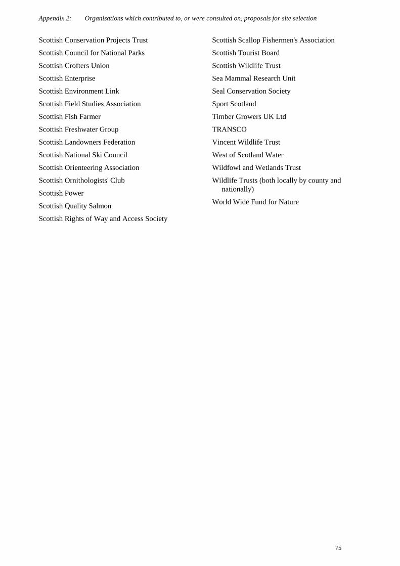
Appendix 2: Organisations which contributed to, or were consulted on, proposals for site selection
75
Scottish Conservation Projects Trust
Scottish Council for National Parks
Scottish Crofters Union
Scottish Enterprise
Scottish Environment Link
Scottish Field Studies Association
Scottish Fish Farmer
Scottish Freshwater Group
Scottish Landowners Federation
Scottish National Ski Council
Scottish Orienteering Association
Scottish Ornithologists' Club
Scottish Power
Scottish Quality Salmon
Scottish Rights of Way and Access Society
Scottish Scallop Fishermen's Association
Scottish Tourist Board
Scottish Wildlife Trust
Sea Mammal Research Unit
Seal Conservation Society
Sport Scotland
Timber Growers UK Ltd
TRANSCO
Vincent Wildlife Trust
West of Scotland Water
Wildfowl and Wetlands Trust
Wildlife Trusts (both locally by county andnationally)
World Wide Fund for Nature

Appendix 3: Number of UK sites put forward as candidate SACs for habitats
76
Appendix 3: Number of UK sites put forward as candidate SACs for habitats
Notes: 1. * indicates priority habitats. 2. Non-significant presence are not included in the figures.
EU code Name Lay nameNo. of
SACs as atJuly 2001
1110 Sandbanks which are slightly covered bysea water all the time
Subtidal sandbanks 24
1130 Estuaries Estuaries 17
1140 Mudflats and sandflats not covered byseawater at low tide
Intertidal mudflats and sandflats 28
1150 *Coastal lagoons Lagoons 20
1160 Large shallow inlets and bays Shallow inlets and bays 13
1170 Reefs Reefs 33
1210 Annual vegetation of drift lines Annual vegetation of drift lines 13
1220 Perennial vegetation of stony banks Coastal shingle vegetation outside thereach of waves
12
1230 Vegetated sea cliffs of the Atlantic andBaltic coasts
Vegetated sea cliffs 39
1310 Salicornia and other annuals colonisingmud and sand
Glasswort and other annuals colonisingmud and sand
12
1320 Spartina swards (Spartinion maritimae) Cord-grass swards 2
1330 Atlantic salt meadows (Glauco-Puccinellietalia maritimae)
Atlantic salt meadows 27
1340 *Inland salt meadows Inland saltmarshes 1
1420 Mediterranean and thermo-Atlantichalophilous scrubs (Sarcocorneteafruticosi)
Mediterranean saltmarsh scrub 4
2110 Embryonic shifting dunes Shifting dunes 24
2120 Shifting dunes along the shoreline withAmmophila arenaria (‘white dunes’)
Shifting dunes with marram 34
2130 *Fixed dunes with herbaceous vegetation(‘grey dunes’)
Dune grassland 32
2140 Decalcified fixed dunes with Empetrumnigrum
Lime-deficient dune heathland withcrowberry
2
2150 *Atlantic decalcified fixed dunes(Calluno-Ulicetea)
Coastal dune heathland 10
2160 Dunes with Hippophae rhamnoides Dunes with sea-buckthorn 1
2170 Dunes with Salix repens ssp. argentea(Salicion arenariae)
Dunes with creeping willow 14
2190 Humid dune slacks Humid dune slacks 26
21A0 Machairs Machair 6
2250 *Coastal dunes with Juniperus spp. Dunes with juniper thickets 2

Appendix 3: Number of UK sites put forward as candidate SACs for habitats
77
EU code Name Lay nameNo. of
SACs as atJuly 2001
2330 Inland dunes with open Corynephorusand Agrostis grasslands
Open grassland with grey-hair grassand common bent grass of inland dunes
1
3110 Oligotrophic waters containing very fewminerals of sandy plains (Littorelletaliauniflorae)
Nutrient-poor shallow waters withaquatic vegetation on sandy plains
4
3130 Oligotrophic to mesotrophic standingwaters with vegetation of theLittorelletea uniflorae and/or theIsoëto-Nanojuncetea
Clear-water lakes or lochs with aquaticvegetation and poor to moderatenutrient levels
44
3140 Hard oligo-mesotrophic waters withbenthic vegetation of Chara spp.
Calcium-rich nutrient-poor lakes, lochsand pools
15
3150 Natural eutrophic lakes withMagnopotamion or Hydrocharition-type vegetation
Naturally nutrient-rich lakes or lochswhich are often dominated bypondweed
16
3160 Natural dystrophic lakes and ponds Acid peat-stained lakes and ponds 22
3170 *Mediterranean temporary ponds Mediterranean temporary ponds 1
3180 *Turloughs. Turloughs 2
3260 Water courses of plain to montane levelswith Ranunculion fluitantis andCallitricho-Batrachion vegetation
Rivers with floating vegetation oftendominated by water-crowfoot
21
4010 Northern Atlantic wet heaths with Ericatetralix
Wet heathland with cross-leaved heath 69
4020 *Temperate Atlantic wet heaths withErica ciliaris and Erica tetralix
Wet heathland with Dorset heath andcross-leaved heath
4
4030 European dry heaths Dry heaths 108
4040 *Dry Atlantic coastal heaths with Ericavagans
Dry coastal heaths with Cornish heath 1
4060 Alpine and Boreal heaths Alpine and subalpine heaths 31
4080 Sub-Arctic Salix spp. scrub Mountain willow scrub 15
5110 Stable xerothermophilous formationswith Buxus sempervirens on rockslopes (Berberidion p.p.)
Natural box scrub 1
5130 Juniperus communis formations onheaths or calcareous grasslands
Juniper on heaths or calcareousgrasslands
17
6130 Calaminarian grasslands of the Violetaliacalaminariae
Grasslands on soils rich in heavy metals 20
6150 Siliceous alpine and boreal grasslands Montane acid grasslands 27
6170 Alpine and subalpine calcareousgrasslands
Alpine and subalpine calcareousgrasslands
15
6210 Semi-natural dry grasslands andscrubland facies on calcareoussubstrates (Festuco-Brometalia)
Dry grasslands and scrublands on chalkor limestone
45
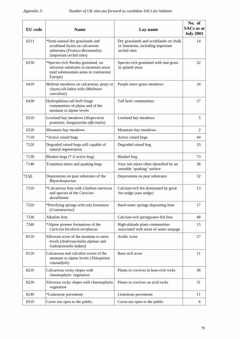
Appendix 3: Number of UK sites put forward as candidate SACs for habitats
78
EU code Name Lay nameNo. of
SACs as atJuly 2001
6211 *Semi-natural dry grasslands andscrubland facies on calcareoussubstrates (Festuco-Brometalia)(important orchid sites)
Dry grasslands and scrublands on chalkor limestone, including importantorchid sites
14
6230 *Species-rich Nardus grassland, onsiliceous substrates in mountain areas(and submountain areas in continentalEurope)
Species-rich grassland with mat-grassin upland areas
22
6410 Molinia meadows on calcareous, peaty orclayey-silt-laden soils (Molinioncaeruleae)
Purple moor-grass meadows 34
6430 Hydrophilous tall herb fringecommunities of plains and of themontane to alpine levels
Tall herb communities 27
6510 Lowland hay meadows (Alopecuruspratensis, Sanguisorba officinalis)
Lowland hay meadows 5
6520 Mountain hay meadows Mountain hay meadows 2
7110 *Active raised bogs Active raised bogs 44
7120 Degraded raised bogs still capable ofnatural regeneration
Degraded raised bog 33
7130 Blanket bogs (* if active bog) Blanket bog 73
7140 Transition mires and quaking bogs Very wet mires often identified by anunstable ‘quaking’ surface
38
7150 Depressions on peat substrates of theRhynchosporion
Depressions on peat substrates 32
7210 *Calcareous fens with Cladium mariscusand species of the Cariciondavallianae
Calcium-rich fen dominated by greatfen sedge (saw sedge)
13
7220 *Petrifying springs with tufa formation(Cratoneurion)
Hard-water springs depositing lime 17
7230 Alkaline fens Calcium-rich springwater-fed fens 48
7240 *Alpine pioneer formations of theCaricion bicoloris-atrofuscae
High-altitude plant communitiesassociated with areas of water seepage
15
8110 Siliceous scree of the montane to snowlevels (Androsacetalia alpinae andGaleopsietalia ladani)
Acidic scree 27
8120 Calcareous and calcshist screes of themontane to alpine levels (Thlaspietearotundifolii)
Base-rich scree 11
8210 Calcareous rocky slopes withchasmophytic vegetation
Plants in crevices in base-rich rocks 36
8220 Siliceous rocky slopes with chasmophyticvegetation
Plants in crevices on acid rocks 31
8240 *Limestone pavements Limestone pavements 11
8310 Caves not open to the public. Caves not open to the public 6
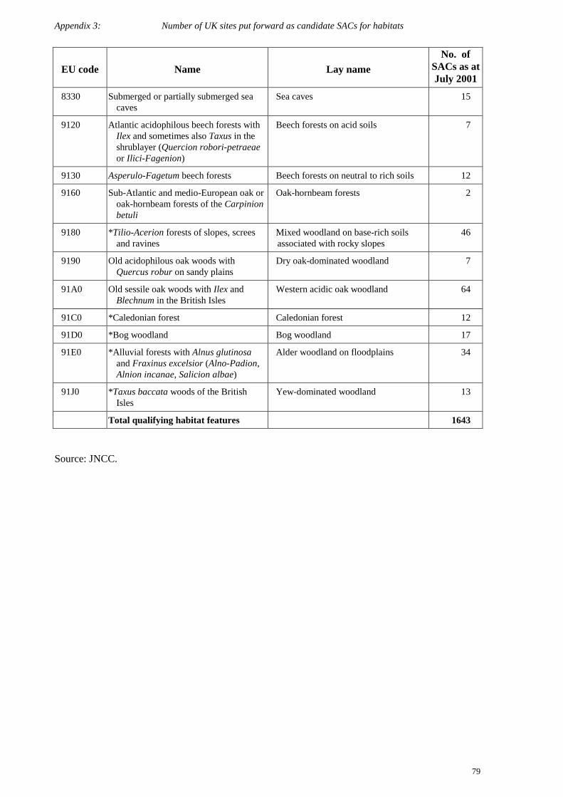
Appendix 3: Number of UK sites put forward as candidate SACs for habitats
79
EU code Name Lay nameNo. of
SACs as atJuly 2001
8330 Submerged or partially submerged seacaves
Sea caves 15
9120 Atlantic acidophilous beech forests withIlex and sometimes also Taxus in theshrublayer (Quercion robori-petraeaeor Ilici-Fagenion)
Beech forests on acid soils 7
9130 Asperulo-Fagetum beech forests Beech forests on neutral to rich soils 12
9160 Sub-Atlantic and medio-European oak oroak-hornbeam forests of the Carpinionbetuli
Oak-hornbeam forests 2
9180 *Tilio-Acerion forests of slopes, screesand ravines
Mixed woodland on base-rich soilsassociated with rocky slopes
46
9190 Old acidophilous oak woods withQuercus robur on sandy plains
Dry oak-dominated woodland 7
91A0 Old sessile oak woods with Ilex andBlechnum in the British Isles
Western acidic oak woodland 64
91C0 *Caledonian forest Caledonian forest 12
91D0 *Bog woodland Bog woodland 17
91E0 *Alluvial forests with Alnus glutinosaand Fraxinus excelsior (Alno-Padion,Alnion incanae, Salicion albae)
Alder woodland on floodplains 34
91J0 *Taxus baccata woods of the BritishIsles
Yew-dominated woodland 13
Total qualifying habitat features 1643
Source: JNCC.
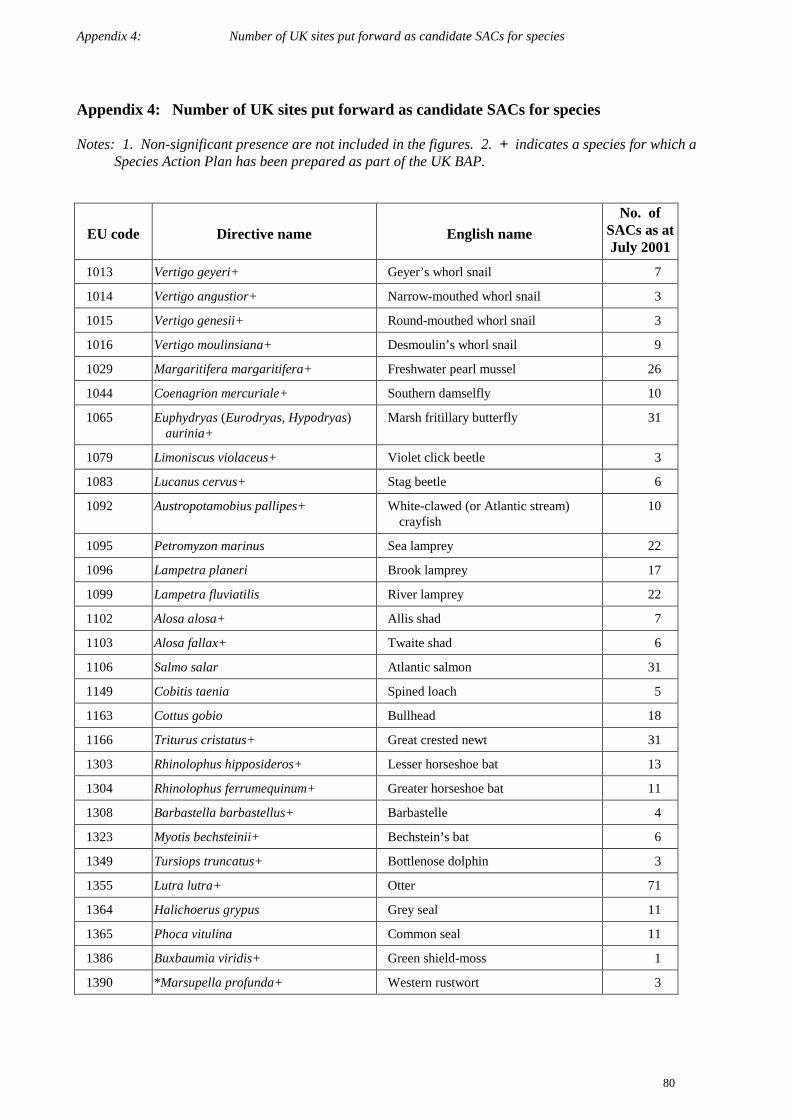
Appendix 4: Number of UK sites put forward as candidate SACs for species
80
Appendix 4: Number of UK sites put forward as candidate SACs for species
Notes: 1. Non-significant presence are not included in the figures. 2. + indicates a species for which aSpecies Action Plan has been prepared as part of the UK BAP.
EU code Directive name English nameNo. of
SACs as atJuly 2001
1013 Vertigo geyeri+ Geyer’s whorl snail 7
1014 Vertigo angustior+ Narrow-mouthed whorl snail 3
1015 Vertigo genesii+ Round-mouthed whorl snail 3
1016 Vertigo moulinsiana+ Desmoulin’s whorl snail 9
1029 Margaritifera margaritifera+ Freshwater pearl mussel 26
1044 Coenagrion mercuriale+ Southern damselfly 10
1065 Euphydryas (Eurodryas, Hypodryas)aurinia+
Marsh fritillary butterfly 31
1079 Limoniscus violaceus+ Violet click beetle 3
1083 Lucanus cervus+ Stag beetle 6
1092 Austropotamobius pallipes+ White-clawed (or Atlantic stream)crayfish
10
1095 Petromyzon marinus Sea lamprey 22
1096 Lampetra planeri Brook lamprey 17
1099 Lampetra fluviatilis River lamprey 22
1102 Alosa alosa+ Allis shad 7
1103 Alosa fallax+ Twaite shad 6
1106 Salmo salar Atlantic salmon 31
1149 Cobitis taenia Spined loach 5
1163 Cottus gobio Bullhead 18
1166 Triturus cristatus+ Great crested newt 31
1303 Rhinolophus hipposideros+ Lesser horseshoe bat 13
1304 Rhinolophus ferrumequinum+ Greater horseshoe bat 11
1308 Barbastella barbastellus+ Barbastelle 4
1323 Myotis bechsteinii+ Bechstein’s bat 6
1349 Tursiops truncatus+ Bottlenose dolphin 3
1355 Lutra lutra+ Otter 71
1364 Halichoerus grypus Grey seal 11
1365 Phoca vitulina Common seal 11
1386 Buxbaumia viridis+ Green shield-moss 1
1390 *Marsupella profunda+ Western rustwort 3

Appendix 4: Number of UK sites put forward as candidate SACs for species
81
EU code Directive name English nameNo. of
SACs as atJuly 2001
1393 Drepanocladus (Hamatocaulis)vernicosus+
Slender green feather-moss 9
1395 Petalophyllum ralfsii+ Petalwort 14
1421 Trichomanes speciosum Killarney fern 4
1441 Rumex rupestris+ Shore dock 9
1528 Saxifraga hirculus+ Marsh saxifrage 5
1614 Apium repens+ Creeping marshwort 1
1654 Gentianella anglica+ Early gentian 13
1831 Luronium natans+ Floating water-plantain 14
1833 Najas flexilis+ Slender naiad 5
1902 Cypripedium calceolus+ Lady’s-slipper orchid 1
1903 Liparis loeselii+ Fen orchid 3
Total qualifying species features 479
Source: JNCC.
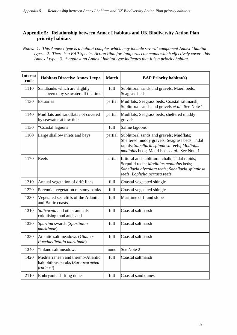
Appendix 5: Relationship between Annex I habitats and UK Biodiversity Action Plan priority habitats
82
Appendix 5: Relationship between Annex I habitats and UK Biodiversity Action Planpriority habitats
Notes: 1. This Annex I type is a habitat complex which may include several component Annex I habitattypes. 2. There is a BAP Species Action Plan for Juniperus communis which effectively covers thisAnnex I type. 3. * against an Annex I habitat type indicates that it is a priority habitat.
Interestcode Habitats Directive Annex I type Match BAP Priority habitat(s)
1110 Sandbanks which are slightlycovered by seawater all the time
full Sublittoral sands and gravels; Maerl beds;Seagrass beds
1130 Estuaries partial Mudflats; Seagrass beds; Coastal saltmarsh;Sublittoral sands and gravels et al. See Note 1
1140 Mudflats and sandflats not coveredby seawater at low tide
partial Mudflats; Seagrass beds; sheltered muddygravels
1150 *Coastal lagoons full Saline lagoons
1160 Large shallow inlets and bays partial Sublittoral sands and gravels; Mudflats;Sheltered muddy gravels; Seagrass beds; Tidalrapids; Sabellaria spinulosa reefs; Modiolusmodiolus beds; Maerl beds et al. See Note 1
1170 Reefs partial Littoral and sublittoral chalk; Tidal rapids;Serpulid reefs; Modiolus modiolus beds;Sabellaria alveolata reefs; Sabellaria spinulosareefs; Lophelia pertusa reefs
1210 Annual vegetation of drift lines full Coastal vegetated shingle
1220 Perennial vegetation of stony banks full Coastal vegetated shingle
1230 Vegetated sea cliffs of the Atlanticand Baltic coasts
full Maritime cliff and slope
1310 Salicornia and other annualscolonising mud and sand
full Coastal saltmarsh
1320 Spartina swards (Spartinionmaritimae)
full Coastal saltmarsh
1330 Atlantic salt meadows (Glauco-Puccinellietalia maritimae)
full Coastal saltmarsh
1340 *Inland salt meadows none See Note 2
1420 Mediterranean and thermo-Atlantichalophilous scrubs (Sarcocorneteafruticosi)
full Coastal saltmarsh
2110 Embryonic shifting dunes full Coastal sand dunes

Appendix 5: Relationship between Annex I habitats and UK Biodiversity Action Plan priority habitats
83
Interestcode Habitats Directive Annex I type Match BAP Priority habitat(s)
2120 Shifting dunes along the shorelinewith Ammophila arenaria (whitedunes)
full Coastal sand dunes
2130 *Fixed dunes with herbaceousvegetation (grey dunes)
full Coastal sand dunes
2140 *Decalcified fixed dunes withEmpetrum nigrum
full Coastal sand dunes
2150 *Atlantic decalcified fixed dunes(Calluno-Ulicetea)
full Coastal sand dunes
2160 Dunes with Hippophae rhamnoides full Coastal sand dunes
2170 Dunes with Salix repens ssp.argentea (Salicion arenariae)
full Coastal sand dunes
2190 Humid dune slacks full Coastal sand dunes
21A0 Machairs full Machair
2250 *Coastal dunes with Juniperus spp. full Coastal sand dunes
2330 Inland dunes with openCorynephorus and Agrostisgrassland
full Lowland dry acid grassland
3110 Oligotrophic waters containing veryfew minerals of sandy plains(Littorelletalia uniflorae)
none
3130 Oligotrophic to mesotrophicstanding waters with vegetation ofthe Littorelletea uniflorae and/or ofthe Isoeto-Nanojuncetea
partial Mesotrophic lakes
3140 Hard oligo-mesotrophic waters withbenthic vegetation of Chara spp.
partial Mesotrophic lakes
3150 Natural eutrophic lakes withMagnopotamion or Hydrocharition-type vegetation
full Eutrophic standing waters
3160 Natural dystrophic lakes and ponds partial Blanket bog; Lowland raised bog
3170 *Mediterranean temporary ponds none
3180 *Turloughs full Aquifer fed naturally fluctuating water bodies
3260 Water courses of plain to montanelevels with the Ranunculionfluitantis and Callitricho-Batrachionvegetation
partial Chalk rivers
4010 Northern Atlantic wet heaths withErica tetralix
full Upland heathland; Lowland heathland
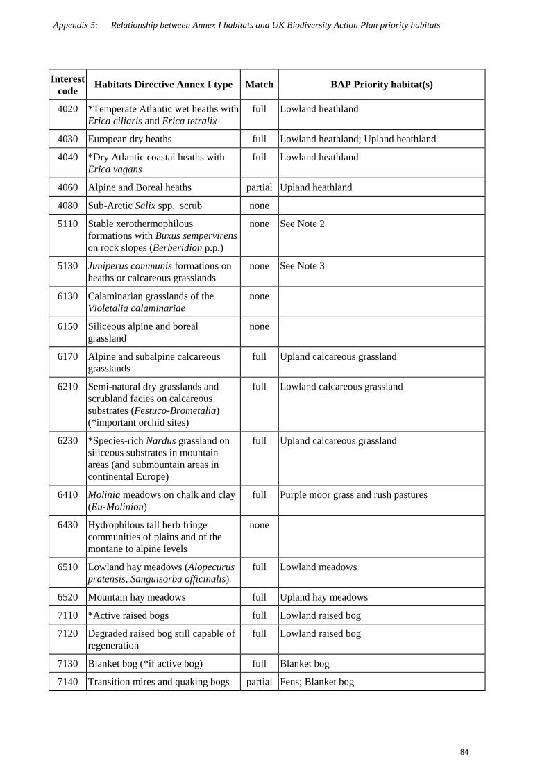
Appendix 5: Relationship between Annex I habitats and UK Biodiversity Action Plan priority habitats
84
Interestcode Habitats Directive Annex I type Match BAP Priority habitat(s)
4020 *Temperate Atlantic wet heaths withErica ciliaris and Erica tetralix
full Lowland heathland
4030 European dry heaths full Lowland heathland; Upland heathland
4040 *Dry Atlantic coastal heaths withErica vagans
full Lowland heathland
4060 Alpine and Boreal heaths partial Upland heathland
4080 Sub-Arctic Salix spp. scrub none
5110 Stable xerothermophilousformations with Buxus sempervirenson rock slopes (Berberidion p.p.)
none See Note 2
5130 Juniperus communis formations onheaths or calcareous grasslands
none See Note 3
6130 Calaminarian grasslands of theVioletalia calaminariae
none
6150 Siliceous alpine and borealgrassland
none
6170 Alpine and subalpine calcareousgrasslands
full Upland calcareous grassland
6210 Semi-natural dry grasslands andscrubland facies on calcareoussubstrates (Festuco-Brometalia)(*important orchid sites)
full Lowland calcareous grassland
6230 *Species-rich Nardus grassland onsiliceous substrates in mountainareas (and submountain areas incontinental Europe)
full Upland calcareous grassland
6410 Molinia meadows on chalk and clay(Eu-Molinion)
full Purple moor grass and rush pastures
6430 Hydrophilous tall herb fringecommunities of plains and of themontane to alpine levels
none
6510 Lowland hay meadows (Alopecuruspratensis, Sanguisorba officinalis)
full Lowland meadows
6520 Mountain hay meadows full Upland hay meadows
7110 *Active raised bogs full Lowland raised bog
7120 Degraded raised bog still capable ofregeneration
full Lowland raised bog
7130 Blanket bog (*if active bog) full Blanket bog
7140 Transition mires and quaking bogs partial Fens; Blanket bog
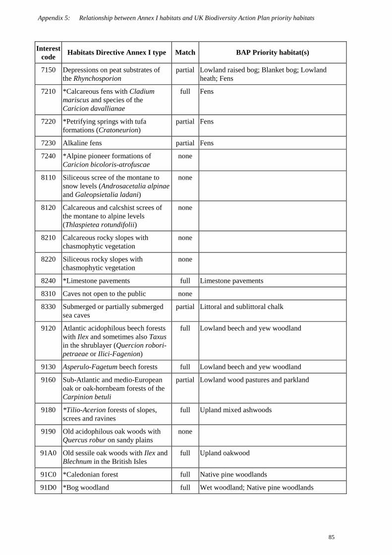
Appendix 5: Relationship between Annex I habitats and UK Biodiversity Action Plan priority habitats
85
Interestcode Habitats Directive Annex I type Match BAP Priority habitat(s)
7150 Depressions on peat substrates ofthe Rhynchosporion
partial Lowland raised bog; Blanket bog; Lowlandheath; Fens
7210 *Calcareous fens with Cladiummariscus and species of theCaricion davallianae
full Fens
7220 *Petrifying springs with tufaformations (Cratoneurion)
partial Fens
7230 Alkaline fens partial Fens
7240 *Alpine pioneer formations ofCaricion bicoloris-atrofuscae
none
8110 Siliceous scree of the montane tosnow levels (Androsacetalia alpinaeand Galeopsietalia ladani)
none
8120 Calcareous and calcshist screes ofthe montane to alpine levels(Thlaspietea rotundifolii)
none
8210 Calcareous rocky slopes withchasmophytic vegetation
none
8220 Siliceous rocky slopes withchasmophytic vegetation
none
8240 *Limestone pavements full Limestone pavements
8310 Caves not open to the public none
8330 Submerged or partially submergedsea caves
partial Littoral and sublittoral chalk
9120 Atlantic acidophilous beech forestswith Ilex and sometimes also Taxusin the shrublayer (Quercion robori-petraeae or Ilici-Fagenion)
full Lowland beech and yew woodland
9130 Asperulo-Fagetum beech forests full Lowland beech and yew woodland
9160 Sub-Atlantic and medio-Europeanoak or oak-hornbeam forests of theCarpinion betuli
partial Lowland wood pastures and parkland
9180 *Tilio-Acerion forests of slopes,screes and ravines
full Upland mixed ashwoods
9190 Old acidophilous oak woods withQuercus robur on sandy plains
none
91A0 Old sessile oak woods with Ilex andBlechnum in the British Isles
full Upland oakwood
91C0 *Caledonian forest full Native pine woodlands
91D0 *Bog woodland full Wet woodland; Native pine woodlands

Appendix 5: Relationship between Annex I habitats and UK Biodiversity Action Plan priority habitats
86
Interestcode Habitats Directive Annex I type Match BAP Priority habitat(s)
91E0 *Alluvial forest with Alnusglutinosa and Fraxinus excelsior(Alno-Padion, Alnion incanae,Salicion albae)
full Wet woodland
91J0 *Taxus baccata woods of the BritishIsles
full Lowland beech and yew woodland; Uplandmixed ashwoods
Source: JNCC.
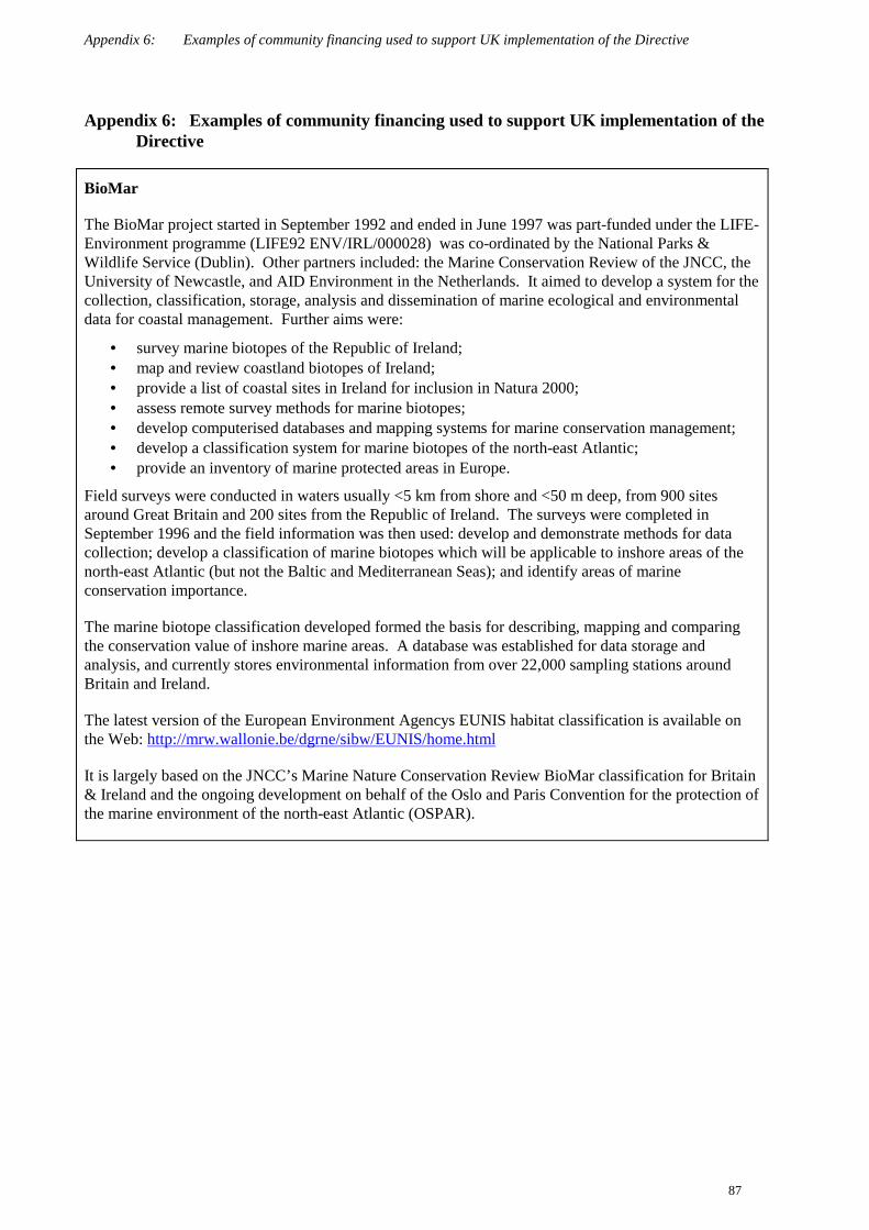
Appendix 6: Examples of community financing used to support UK implementation of the Directive
87
Appendix 6: Examples of community financing used to support UK implementation of theDirective
BioMar
The BioMar project started in September 1992 and ended in June 1997 was part-funded under the LIFE-Environment programme (LIFE92 ENV/IRL/000028) was co-ordinated by the National Parks &Wildlife Service (Dublin). Other partners included: the Marine Conservation Review of the JNCC, theUniversity of Newcastle, and AID Environment in the Netherlands. It aimed to develop a system for thecollection, classification, storage, analysis and dissemination of marine ecological and environmentaldata for coastal management. Further aims were:
• survey marine biotopes of the Republic of Ireland;• map and review coastland biotopes of Ireland;• provide a list of coastal sites in Ireland for inclusion in Natura 2000;• assess remote survey methods for marine biotopes;• develop computerised databases and mapping systems for marine conservation management;• develop a classification system for marine biotopes of the north-east Atlantic;• provide an inventory of marine protected areas in Europe.
Field surveys were conducted in waters usually <5 km from shore and <50 m deep, from 900 sitesaround Great Britain and 200 sites from the Republic of Ireland. The surveys were completed inSeptember 1996 and the field information was then used: develop and demonstrate methods for datacollection; develop a classification of marine biotopes which will be applicable to inshore areas of thenorth-east Atlantic (but not the Baltic and Mediterranean Seas); and identify areas of marineconservation importance.
The marine biotope classification developed formed the basis for describing, mapping and comparingthe conservation value of inshore marine areas. A database was established for data storage andanalysis, and currently stores environmental information from over 22,000 sampling stations aroundBritain and Ireland.
The latest version of the European Environment Agencys EUNIS habitat classification is available onthe Web: http://mrw.wallonie.be/dgrne/sibw/EUNIS/home.html
It is largely based on the JNCC’s Marine Nature Conservation Review BioMar classification for Britain& Ireland and the ongoing development on behalf of the Oslo and Paris Convention for the protection ofthe marine environment of the north-east Atlantic (OSPAR).

Appendix 6: Examples of community financing used to support UK implementation of the Directive
88
Management planning and monitoring on SACs in Wales
Between 1995 and 1999 CCW ran a project 50% funded by the EC LIFE-Nature programme with thefollowing aims:
• establish management plans and example habitat monitoring projects for 19 cSACs acrossWales. These were selected to cover all priority Annex I habitats and at least one example ofeach non-priority Annex I habitat occurring on cSACs in Wales;
• provide case-studies of the development of management plans and monitoring projects (Hurfordand Perry 2000);
• draft a technical guide to the scientific underpinning of the monitoring approach (Hurford andJones 2000);
• draft a field manual suitable for training fieldworkers (Brown 2000).
The approach to monitoring is founded on the general methods developed by the UK statutoryconservation agencies (see Box 7 on common standards for monitoring). The project is now complete,and the outputs have been submitted to Europe.
Lake District lowland limestone habitat rehabilitation
The project in northern England brought together a number of partners, including the ForestryCommission, English Nature, Lake District National Park Authority, the Dallam Tower Estate andanother local landowner. The project focused on a series of limestone pavements and other limestonehabitats, including yew Taxus baccata woods and upland mixed ash Fraxinus excelsior ravine forests,surrounding Morecambe Bay – an area of 1,103 ha. Within the native woodland areas there wasgrowing concern about the impact of commercial plantations containing non-native tree species.
The needle-fall and shade of the closing canopy of commercial plantations was leading to significantdeterioration of native woodland habitat. The loss of traditional woodland management practices alsoled to a gradual decline in the conservation interest. The project is carrying out:
• removal of non-native conifers, broadleaves and scrub using low-impact specialist techniques;• re-establishment of traditional coppice management;• implementation of a carefully managed low-intensity grazing regime;• a programme of deer management by fencing and culling to prevent the destruction of coppice
regrowth and tree regeneration;• measures to safeguard and increase populations of the narrow-mouthed whorl snail Vertigo
angustior by scrub and deer control.
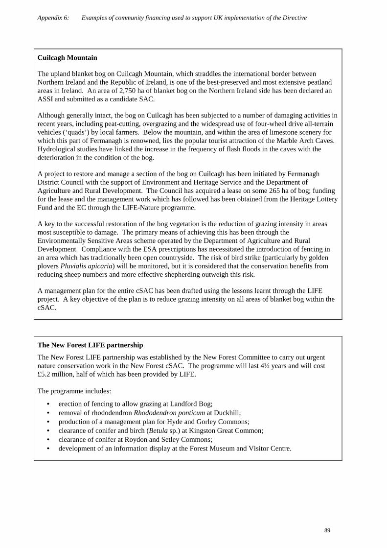
Appendix 6: Examples of community financing used to support UK implementation of the Directive
89
Cuilcagh Mountain
The upland blanket bog on Cuilcagh Mountain, which straddles the international border betweenNorthern Ireland and the Republic of Ireland, is one of the best-preserved and most extensive peatlandareas in Ireland. An area of 2,750 ha of blanket bog on the Northern Ireland side has been declared anASSI and submitted as a candidate SAC.
Although generally intact, the bog on Cuilcagh has been subjected to a number of damaging activities inrecent years, including peat-cutting, overgrazing and the widespread use of four-wheel drive all-terrainvehicles (‘quads’) by local farmers. Below the mountain, and within the area of limestone scenery forwhich this part of Fermanagh is renowned, lies the popular tourist attraction of the Marble Arch Caves.Hydrological studies have linked the increase in the frequency of flash floods in the caves with thedeterioration in the condition of the bog.
A project to restore and manage a section of the bog on Cuilcagh has been initiated by FermanaghDistrict Council with the support of Environment and Heritage Service and the Department ofAgriculture and Rural Development. The Council has acquired a lease on some 265 ha of bog; fundingfor the lease and the management work which has followed has been obtained from the Heritage LotteryFund and the EC through the LIFE-Nature programme.
A key to the successful restoration of the bog vegetation is the reduction of grazing intensity in areasmost susceptible to damage. The primary means of achieving this has been through theEnvironmentally Sensitive Areas scheme operated by the Department of Agriculture and RuralDevelopment. Compliance with the ESA prescriptions has necessitated the introduction of fencing inan area which has traditionally been open countryside. The risk of bird strike (particularly by goldenplovers Pluvialis apicaria) will be monitored, but it is considered that the conservation benefits fromreducing sheep numbers and more effective shepherding outweigh this risk.
A management plan for the entire cSAC has been drafted using the lessons learnt through the LIFEproject. A key objective of the plan is to reduce grazing intensity on all areas of blanket bog within thecSAC.
The New Forest LIFE partnership
The New Forest LIFE partnership was established by the New Forest Committee to carry out urgentnature conservation work in the New Forest cSAC. The programme will last 4½ years and will cost£5.2 million, half of which has been provided by LIFE.
The programme includes:
• erection of fencing to allow grazing at Landford Bog;• removal of rhododendron Rhododendron ponticum at Duckhill;• production of a management plan for Hyde and Gorley Commons;• clearance of conifer and birch (Betula sp.) at Kingston Great Common;• clearance of conifer at Roydon and Setley Commons;• development of an information display at the Forest Museum and Visitor Centre.

Appendix 6: Examples of community financing used to support UK implementation of the Directive
90
Safeguarding Natura 2000 rivers in the UK – The UK Rivers Project
This 4-year project runs to December 2003 and is looking at ways of conserving rivers protected asSACs under the Directive.
The work is financially supported by the European Commission via the LIFE-Nature fund (LIFE99 NAT/UK/6088). It covers five major areas of work:
• determining the requirements of each species and the habitat;• refining techniques for monitoring SAC rivers;• developing techniques to address key conservation issues;• producing SAC river conservation strategies;• raising awareness and disseminating results.
The UK Marine SACs project
The UK Marine SACs project was established in 1996 and will finish on October 31 2001. It is funded(approx. £4 million) by LIFE-Nature. Its primary role is to establish management schemes on 12cSACs around the UK coast. Each scheme has been developed through joint partnerships between therelevant nature conservation organisations and local authorities. This has ensured an integratedapproach to conserving all of the qualifying marine features. As a suite, these sites include examples ofall the special marine features identified in the Habitats Directive and submitted by the UK. They alsoencompass the range of management issues occurring on marine SACs throughout the UK.
The project will:
• identify factors affecting the condition of the conservation features for which the sites have beenselected;
• describe the natural variability of these features;• consider the sensitivity of features to various activities;• document measures for minimising particularly damaging impacts;• develop practical techniques for monitoring the status of the conservation features.
The project also aims to tackle the integration of estuary plans and SAC management plans to ensurethat they are consistent and complementary. Whereas the SAC scheme focuses on the qualifying marineinterests, an estuary plan is often broader – encompassing a range of nature conservation features in asocio-economic framework. However, an estuary plan can often discharge the statutory requirements ofan SAC management scheme through existing mechanisms, as for example in the Solway FirthPartnership.
Management groups comprising the relevant authorities and local organisations were established for the12 demonstration marine sites in the UK marine SACs project. This ‘model’ was very successful andwill be an important recommendation of the project for other marine sites.

Appendix 6: Examples of community financing used to support UK implementation of the Directive
91
Restoration of Atlantic oakwoods
The project aims to restore, enhance and extend Atlantic oakwoods in seven candidate SACs withinScotland, England and Wales. Work is being carried out on land in both public and private ownership(over 40 private owners are involved), as well as NGOs such as the National Trust, RSPB, WoodlandTrust, and the North Wales Wildlife Trust. In the private sector, habitat restoration is 5% fundedthrough the woodland grant scheme, with the remaining 45% of costs paid by EU LIFE-Nature.
Key outputs include:
• restoration/improvement of over 8,000 ha of oakwood habitat within seven candidate SACs inEngland, Scotland and Wales by removal of invasive rhododendron Rhododendron ponticum;
• controlling grazing and removing non-native conifers;• appointment of several local community liaison officers;• training and employment of local contractors.
Wet Woods Restoration
The project is a partnership of Scottish Natural Heritage, Forest Enterprise, the Forestry Commission,RSPB and Highland Birchwoods which received funding in 1998 from the EU LIFE-Nature Programmeto undertake a series of conservation initiatives on two priority habitats known as 'wet woods’.
Overall, the tree-felling phase of the restoration programme (specified in the original contract as 220 ha)has now been completed. However, the project has identified an additional 95 ha – mostly within theoriginal contract areas – the restoration of which is considered essential for the hydrological integrity ofthe relevant sites. Thus, the project has set itself a new tree-felling target of 315 ha; to date,approximately 253 ha has been completed.
The drain-blocking phase of the restoration programme is also nearing its target 368 ha as specified inthe original contract. To date, an estimated 341 ha (93%) has been completed. Again, however, theproject has identified additional areas which are being (or will be) affected by the hydrologicalreinstatement work. Thus, the project has set itself a new hydrological reinstatement target of 426 ha.
Other key outputs include:
• hydrological condition surveys of all bog woodland project sites;• classification of bog woodland types in north Scotland (ongoing);• historical survey of the Lower River Conon;• research into age structure, regeneration pattern and tree cover/site factor relationships
(ongoing).
Appendix 7: Examples of research on species and habitats listed in Annexes I, II, IV and V
92
Appendix 7: Examples of research on species and habitats listed in Annexes I, II, IV and V
Restoration of diversity to agriculturally improved upland hay meadows
In May 1999 the Ministry of Agriculture, Food and Fisheries (now DEFRA) completed a £95,000project addressing the restoration of diversity to agriculturally improved upland hay meadows. Fieldtrials showed that the greatest increase in species diversity was associated with the combined effect of aJuly cutting date, grazing in the autumn with cattle and grazing with sheep in the spring, and theaddition of seed mixtures containing target species from traditional meadows. Grazing by cattle wasconsidered to provide regeneration niches for the seeds, thereby facilitating the spread of target species.This research will be further developed over the next five years to increase understanding of themechanisms responsible for the observed vegetation responses.
River and lakes surveys in Wales
Lake and river surveys have been carried out on several candidate SACs in Wales. This information hasbeen used to identify or confirm the status of sites with respect to the habitats included in the Directive.Results have included the identification of large populations of river and brook lampreys Lampetrafluviatilis and L. planeri in the Usk. A comprehensive review of the ecological status of allis andtwaite shad Alosa alosa and A. fallax in Britain and Ireland has been completed as a collaborativeproject under the Biodiversity Action Plan initiative. Requirements for the conservation andmanagement of these two species have been identified and are being pursued. Palaeolimnology hasbeen used to reconstruct the recent environmental histories of lake SACs in Wales and to identify thedegree of acidification or enrichment which may have taken place to help define priorities formanagement. Further surveys will be undertaken for new sites proposed and further palaeolimnologystudies are also required on new lake SACs.
Appendix 7: Examples of research on species and habitats listed in Annexes I, II, IV and V
93
EN Species Recovery Project
Three examples of success for species of European importance.
Shore dock Rumex rupestris: English Nature and Plantlife have undertaken an extensive survey ofsouth-west England over the past six years. Historically known sites for this scarce species have beensubmitted as SACs. The survey work has revealed nine new localities for the species and rediscoveredit at several sites where it was thought to be extinct. The current state of knowledge about shore docksuggests that the site populations are cyclic and may vary to the point of temporary local extinction, butthat there is a viable south-west England meta-population. Of the current known sites 48% are withindesignated areas.
White-clawed crayfish Austropotamobius pallipes: Yorkshire is a stronghold for this species. Since1994, research has identified the non-native signal crayfish as the biggest single threat to the species.English Nature and the Environment Agency, in partnership have worked to identify means ofcontrolling this threat; for example, experimental work at West Tanfield, North Yorkshire in 1999 wasaimed at preventing crayfish migrating into the River Ure from a trout Salmo trutta hatchery. Positiveaction for the conservation of the species has been developed through local Species Action Planssupported by English Nature, such as the North Yorkshire Moors Crayfish Action Plan in 1999.
Marsh fritillary butterfly Euphydryas aurinia: In partnership with Butterfly Conservation, EnglishNature has surveyed the country to identify strongholds and monitor populations of the species. Jointautecological research has identified the habitat requirements of the species in its strongholds andmanagement changes have been made. For example, at Gait Barrows National Nature Reserve inLancashire, mobile stables and pens are being used to ensure that an appropriate grazing regime can bemaintained.
SNH Species Action Programme
In July 1995, SNH launched its Species Action Programme to provide a co-ordinated approach tospecies conservation and to maintain or restore viable populations of Scotland’s most threatenedwildlife. At the time of the launch approximately 20 species, or groups of species, were included withinthe Programme, including some listed on the Directive (e.g. vendace Coregonus albula, medicinal leechHirudo medicinalis, and marine turtles, especially leatherback turtle Dermpochelys coriacea). Actionplans for these species were produced, agreed with key partners and implemented. Additional tranchesof species were added to the Programme at later stages.
More recently the UK BAP has developed Species Action Plans (SAPs) with UK-wide targets. TheSNH Species Action Programme has therefore become a component of the overall UK plans, and workin Scotland contributes to the UK targets. There are published UK BAP Species Action Plans for allDirective Annex II species which occur naturally in Scotland (occasional vagrant species excepted) plusa large proportion of those from Annex IV and V.

Appendix 7: Examples of research on species and habitats listed in Annexes I, II, IV and V
94
Compact Airborne Spectral Imager (CASI) survey of the Solent
The project, joint-funded by EA, EN and the National Centre for Environmental Data and Surveillance,used satellite image to survey intertidal vegetation and other coastal-habitats in the Solent. This studyaims to complete the identification and description of intertidal and other habitat types in the Solent,thereby informing management decisions for European marine sites and assisting in statutory casework.
Autecology of the whorl snails Vertigo angustior and Vertigo geyeri in Wales
CCW and the National Museum of Wales have co-funded a PhD to investigate the ecology of both ofthese Annex II Vertigo species in Wales. Information on habitat requirements and population dynamicswas required in order to ensure appropriate conservation management is in place and to facilitatemonitoring.
Studies on the narrow-mouthed whorl snail Vertigo angustior focused on the dune-saltmarsh transitionzone at Whiteford Burrows NNR, where one of the most important populations in Europe occurs. Thehighest densities of V. angustior (up to 2000 individuals per square metre) were found in areas ofyellow flag iris Iris pseudacorus with forbs. The distribution of V. angustior at this site was extremelypatchy. Adults and juveniles were found in all months of sampling, suggesting that the breeding seasonis not restricted. However, changes in the balance of adults and juveniles, and the size-classdistributions of the juveniles, indicate that there is a peak of recruitment in the summer.
Geyers whorl snail Vertigo geyeri was studied on flushed calcareous grassland on Anglesey. The snailis restricted to that part of the fen in which black bog-rush Schoenus nigricans occurs, but within thatzone it is not confined to areas with Schoenus present. Both adult and juvenile abundance was low atthe beginning of the field studies, suggesting high mortality through the winter. It is thought that egglaying occurs through the summer from June onwards.
Fen orchid Liparis loeselii
The dune coastlines of south Wales supports the largest British populations of this Annex II species.Lack of grazing coupled to sediment starvation has resulted in the ‘fossilisation’ of much of the sanddune resource, to the detriment of species such as fen orchid Liparis loeselii which requiresuccessionally young and open habitats. A small-scale experimental programme of mowing andshallow turf-stripping was undertaken during 1994 within Kenfig cSAC in an attempt to create suitableopen conditions for seedling establishment and growth at locations otherwise dominated by rankvegetation. This project succeeded in encouraging an increase in the number of flowering plants andclearly has value as a means of encouraging localised population recovery over short- to medium-termtime-scales. However, in the long term, the conservation of this species can only be supportedeffectively through an integrated programme of measures to (i) restore appropriate grazing regimes, and(ii) increase the extent to which new suitable habitats are created by a mobile and dynamically changingsand dune landscape.

Appendix 7: Examples of research on species and habitats listed in Annexes I, II, IV and V
95
Freshwater pearl mussel Margaritifera margaritifera
A national survey of rivers with historical records of this species was undertaken between 1996 and1997. Forty-seven ‘functional’ populations (that is those with evidence of recruitment) were identifiedfrom the 152 sites surveyed. This information has been made available to relevant authorities to ensurethat planning and development proposals take account of the pearl mussel.
Destructive pearl-fishing was judged to be a major cause of the decline and so the pearl mussel wasgiven full protection in 1998 as part of the Quinquennial Review of the Wildlife and Countryside Act1981. ‘Operation Necklace’, an education and awareness campaign aimed at illegal pearl fishing andinvolving SNH, the police and river managers, was launched in 1997. SNH has also funded researchinto the ecology of the species at Aberdeen University, and captive rearing techniques are beingdeveloped, with the intention that these will eventually be used in restoring the species into rivers whereit has become extinct.
Within Northern Ireland, in addition to past pearl fishing, widespread river modification in the middlepart of the last century was also a major factor in its decline. The pearl mussel is currently listed underSchedule 7 of the Wildlife (NI) Order, which prohibits sale of the species or the sale of its pearls. It isproposed to include the species on Schedule 5 of the Wildlife (NI) Order which will afford the speciesand its habitat further protection at all times. Current efforts to reintroduce this species into a numberof historical sites has included its successful cultivation in captivity as part of a project funded bySNIFFER (Scotland & Northern Ireland Forum for Environmental Research) .
Relationships between vegetation, soils and topography at Great Orme’s Head cSAC
Great Orme’s Head is a 3 km-long limestone promontory forming the tip of the Creuddyn peninsula onthe north coast of Wales. It is managed as a Country Park and Local Nature Reserve by Conwy CountyBorough Council. It is the most extensive and important site for limestone grassland and heathvegetation in north Wales, and is selected as a cSAC for both semi-natural dry grasslands andscrublands on calcareous substrates (Festuca-Brometalia) and European dry heaths. In particular, itsupports outstanding zonations from open hoary rock-rose Helianthemum canum communities throughclosed calcicolous grassland swards and short calcicolous heath, to taller calcicolous and acidic heath.
The main aim of the research project was to characterise the soil conditions associated with thesecommunities as an aid to understanding more fully their management requirements. A detailedvegetation survey was carried out by CCW in 1994; a vegetation map was produced at 1:5,000 scale anddigitised to facilitate spatial analysis; and 200 quadrats were recorded for statistical analysis. Soilstudies were undertaken during 1995, both along transects through the vegetation sequences and morewidely; a range of variables related to soil reaction, nutrient status and physical properties wererecorded. Spatial analyses revealed a strong association between vegetation types, slope and aspect,with the H. canum communities on steep south-facing slopes, and acidic heath mainly on the headlandplateau. There was also a strong association between vegetation type and soil base-status, the limestoneheaths occurring on shallow deposits of wind-blown silt (loess) with pH and calcium carbonate levelsintermediate between those of the limestone grassland and acidic heath.
Appendix 8: Examples of cSAC conservation management and habitat restoration
96
Appendix 8: Examples of cSAC conservation management and habitat restoration
Peatland Management Schemes
Caithness and Sutherland
In 1992, SNH launched the Peatland Management Scheme as a means to further protect the peatlandsof Caithness and Sutherland. The scheme is open to anyone managing peatland in Caithness andSutherland which has been confirmed as a peatland Site of Special Scientific Interest. Agreementscover acceptable levels and practices for management of grazings and grazing animals, muirburn,domestic peat-cutting and use of all-terrain vehicles. At the end of December 2000, 122 PeatlandManagement Scheme (PMS) agreements were in place covering an area of 118,525 ha at a total costof £164,082 to Scottish Natural Heritage. Approximately 83% of the Caithness and SutherlandPeatlands candidate SAC (143,572 ha) is currently managed within the scheme.
Lewis In January 2000, SNH launched the Lewis Peatland Management Scheme as a means of underpinningthe Lewis Peatlands candidate SAC and SPA without SSSI notification. Agreements will cover thesame management practices as the mainland Scheme with the addition of conditions for themanagement of water and general land management, which are covered by SSSI procedures inCaithness and Sutherland. The Lewis scheme is open to any of the 70 Common Grazings or 12landlords actively managing peatland within the candidate SAC (30,000 ha) and SPA (60,000 ha).To date agreements are in place covering an area of 24,741 ha at a total cost of £49,612 to ScottishNatural Heritage.
Peatland Policy in Northern Ireland
The policy document, Conserving peatland in Northern Ireland – A statement of policy (EnvironmentService 1993), sets out the Government’s policies for protecting and conserving peatland in NorthernIreland. The measures which are already in place or which are proposed for early implementationwill ensure that representative sites of raised and blanket bogs and other peatland habitats areprotected for the benefit of future generations.
A new direction for sea defences: environment given priority
The Environment Agency (EA), local authorities and Internal Drainage Boards are awarded grant-aidfor capital works that are technically sound, economically worthwhile and environmentallyacceptable. These arrangements have been adjusted since July 1998 to accommodate funding ofmeasures necessary to protect internationally important conservation sites. In January 2000 MAFFawarded nearly £1 million to EA for flood defences at Wells and Burnham Overy to protect aninternationally important conservation site, used by several varieties of geese, wintering birds and theavocet Recurvirostra avosetta. MAFF provided EA’s Norfolk and Suffolk Local Flood DefenceCommittee with the highest rate of support available, which is 75%.
The defences at Wells and Burnham Overy protect 880 ha of low-lying land, including 52 residentialand commercial properties, a large caravan site and infrastructure as well as the internationallyimportant habitats. Emergency works were undertaken on the Wells west embankment in 1995following serious storm damage. Further works required included strengthening tidal embankmentsand a short length of gabion revetment to help stabilise dunes. This will afford protection againstflooding to parts of the North Norfolk SPA, the North Norfolk Coast candidate SAC, and a large partof the Holkham National Nature Reserve.

Appendix 8: Examples of cSAC conservation management and habitat restoration
97
Breckland ESA and cSAC
The Breckland is an area of dry, sandy soils in eastern England with a comparatively continentalclimate. Until the early years of the 20 century most of the area supported dry grassland or heath,which was grazed by rabbits Oryctolagus cuniculus and sheep, and subject to shifting cultivation.These dry grasslands and heaths, known collectively as ‘Breckland heath’, supported large numbersof characteristic lichens, bryophytes, higher plants, invertebrates and birds with restricteddistributions in the United Kingdom.
During the early part of the 20 century large parts of the Breckland were afforested, and much of theremaining land converted to intensive arable cultivation, first using drought-resistant crops such aslucerne, and subsequently making extensive use of irrigation. From the 1950s onwards efforts weremade to conserve the remaining areas of the natural vegetation, and by the early 1980s almost all thesurviving areas of Breckland heath had been notified as SSSI. These surviving areas now make upthe Breckland cSAC which is listed for a range of habitats, including its inland dunes with openCorynephorus and Agrostis grasslands, natural eutrophic lakes with Magnopotamion orHydrocharition-type vegetation, European dry heaths, semi-natural dry grasslands and scrublandfacies. .
SSSI notification succeeded in preventing further conversion to arable or forestry, but outside a smallnumber of nature reserves, the interest of these areas continued to decline, as the agricultural systemof which they were a part had ceased to function. Without close grazing by rabbits and sheep, rankgrasses became dominant and scrub and self-sown Scots pine Pinus sylvestris invaded. Thesechanges led to further losses of characteristic flora and fauna.
The designation of the Breckland Environmentally Sensitive Area (ESA) in 1988 has allowed thisproblem to be tackled, and the ESA is central to the provision of the management needed to maintainthe lowland heath and calcareous grassland interests of the cSAC. The ESA provides farmers andlandowners with help to meet the cost of otherwise uneconomic grazing management. The schemealso allows for payment to carry out a management plan, tailored to the individual needs of the site.This option has been used in the Breckland to encourage the phased removal of invasive scrub andconifers, where it is ecologically beneficial to do this.
Breckland cSAC comprises 20 SSSIs with a total area of 7,600 ha, the vast majority of which isBreckland heath. Within this area, 13 sites with a total area of some 2,950 ha are subject to ESAagreements. Four of the remaining sites are in non-agricultural use, e.g. golf course, airfield, andpublic open space. A further site is covered by a Countryside Stewardship agreement, and one site issubject to a management agreement with EN.

Appendix 8: Examples of cSAC conservation management and habitat restoration
98
Habitats Scheme (saltmarsh option) and Essex Estuaries cSAC
Essex Estuaries cSAC includes the intertidal and subtidal areas of a complex of estuaries on the eastcoast of England, centred on the Blackwater estuary. It has been included in the UK’s national listfor a range of features, including sandbanks which are slightly covered by sea water all the time;estuaries; mudflats and sandflats not covered by seawater at low tide intertidal mud and sand;Atlantic salt-meadows Glauco-Puccinellietalia maritimae; Mediterranean and thermo-Atlantichalophilous scrubs Sarcocornetea fruticosi; Salicornia and other annuals colonising mud and sand;and Spartina swards Spartinion maritimae.
The Essex Estuaries are on a section of the English coast which has been experiencing long-termrelative sea-level rise as a result of isostatic depression. As a result shorelines are eroding and theseaward edges of both saltmarsh and intertidal flats are moving landward. The effects of isostaticdepression may now be supplemented by sea level rise and increased storminess resulting fromclimate change. Under natural conditions coastal habitats can adjust well to such changes. However,in Essex the process of adjustment is prevented by artificial sea defences, built across the intertidalzone during earlier periods of accretion to allow land to be claimed for agriculture. Saltmarshes andmudflats are trapped between eroding shorelines and fixed defences and experience ‘coastalsqueeze’. This represents the biggest challenge to the long-term conservation of estuarine habitats insouthern and eastern England. Current saltmarsh loss rates in Essex are in the order of 40 ha peryear. Mudflat loss rates are probably higher.
The best long-term solution to this problem is to remove or to set back the artificial sea defences toallow the intertidal habitats the room they need to respond to changing conditions while retaining theintegrity of the defence network as a whole. This requires the active co-operation of the landownersdirectly affected. The saltmarsh option of the Habitats Scheme has played an important part infacilitating the first large-scale project to set back tidal defences over a 2 km stretch of the southshore of the Blackwater Estuary at a location known as Orplands within the Essex Estuaries cSAC.
Prior to the scheme 14.6 ha of the site was arable farmland, and the remainder (14.7 ha) lowland wetgrassland. Following preliminary management works including the creation of wave breaks andcreeks, the sea wall was breached in two places in 1995. The scheme was monitored in 1996 and1997 by Agricultural Development Advisory Service (ADAS) staff. By 1997 the scheme hadresulted in the creation of the following areas of Annex I habitats:
• Intertidal mud and sandflat: 15 ha• Glasswort and other annuals colonising mud and sand: 11 ha• Atlantic salt-meadows Glauco-Puccinellietalia maritimae (developing): 3 ha
The area of developing Atlantic salt meadow is of particular interest because, although small, it addsto the very small number of sections of shorelines in Essex where halophyte communities can gradeinto terrestrial vegetation. Thus it also adds considerably to the fringing habitat interest of theestuary feature of the cSAC.
An issue raised by this case is the need for a mechanism to adjust the boundaries of SACs containingnaturally dynamic habitats, since the greater proportion of new habitat created by this project liesoutside the current boundary of the SAC. This and other issues are currently being addressed throughthe EU co-funded ‘Living with the Sea’ LIFE-Nature project.

Appendix 8: Examples of cSAC conservation management and habitat restoration
99
TIBRE and ENACT
In Scotland, the Targeted Inputs for a Better Rural Environment (TIBRE) project, established bySNH in 1993, is designed to enable farmers to contribute both to the environmental sustainability ofScottish agriculture, and to its agricultural sustainability through the uptake of new technology. Theproject aims to reduce environmental impacts on productive areas of farms and to minimise theimpact on adjacent wildlife habitats; to encourage commercial companies to speed up thedevelopment of new technology with improved environmental performance and to influence policy tofoster appropriate technological innovation.
The English Nature Practical Application of Conservation Techniques (ENPACT) project was set upin 1995 to identify and address national wildlife conservation land management problems. Theproject spread to involve the staff and sites of other conservation organisations in the UK, resulting inthe formation of the Forum for the Application of Conservation Techniques (FACT). Thepartnerships that have developed between land managers, conservationists and manufacturers haveresulted in a network providing a greater choice of options and promotion of new ideas inmanagement. This has included the development of machinery, tools, equipment and techniqueswhich have been adopted to address particular land management problems. A forum has also beenestablished to provide help for grazing managers in developing and maintaining grazing schemes forthe management of wildlife sites. Communication is the key to achieving the exchange and flow ofinformation. This is achieved through the English Nature quarterly magazine ENACT which providesdetails and assessments of land management techniques and machinery. A bi-monthly magazine Eco-Ads has also been established which provides an opportunity for exchange and sale of goods andservices to help the environmentally sensitive and sustainable management of land.
Cors Erddreiniog
Cors Erddreiniog NNR is a component site of the Corsydd Môn/Anglesey Fens cSAC and supportssignificant stands of calcareous fen and alkaline fen habitat. It is also an example of a hard-waterlake with benthic stonewort (Chara) vegetation. In common with many lowland fens, the site hassuffered from long-term and periodically intensive drainage coupled to agricultural intensificationboth around and within the site. Dereliction, principally lack of grazing, has also been an importantelement of the post-war history of the site. Burning was also commonly practised.
Management of the site has focused on three main themes:
• hydrological restoration;• the introduction of an appropriate grazing regime using Welsh mountain ponies and Welsh
black cattle;• acquisition of management control over land both within the site itself and in its immediate
hydrological catchment.
The programme of hydrological restoration has focused on restoring a high and seasonally stablewater table through the construction of a major weir on the main outflow, coupled to ditch-blockingand re-routing to restore linkages between calcareous springs and their dependent vegetation types(notably alkaline fen). A programme of progressive land purchase by CCW means that a substantialproportion of this site is now under dedicated conservation management. Elsewhere, managementagreements with owners and occupiers are being used to encourage less intensive agriculturalmanagement.

Appendix 8: Examples of cSAC conservation management and habitat restoration
100
Restoring the Caledonian Forest
Restoring the Caledonian Pine Forest LIFE Project began in January 1995 and ran for two years. Theproject operated through the Caledonian Partnership, (a partnership with members from HighlandBirchwoods, Scottish Natural Heritage, Royal Society for the Protection of Birds, Forest Enterprise,Forest Authority and Highland Council). The project cost a total of £710,000. £460,000 wasprovided through LIFE funding.
The project area of 600 ha, in the ownership of Forest Enterprise and private landowners, includedparts of Strathglass Complex and the Cairngorms candidate SAC. The project worked on thefollowing aspects of Caledonian Forest conservation:
• strategy created for the long-term restoration and management of Caledonian Forest• restoration of 300 ha of Caledonian Forest in Strathglass Complex;• baseline inventory created of all woods which can be classified as Caledonian Forest ;• seventy hectares of new seed sources established;• national standardised framework for appropriate survey techniques developed;• research carried out to better understand forest degradation on Cairngorm SAC/SPA;• local voluntary deer management groups established.
Ballynahone Bog
Ballynahone Bog was amongst the lowland raised bogs that were surveyed by the Department of theEnvironment for Northern Ireland during the mid-1980s prior to declaring the top-ranked bogs asASSIs. Ballynahone Bog was a prime candidate for declaration but before the process of declarationhad begun a planning application was submitted to remove peat for horticultural purposes. Thisapplication was approved in 1988 following a public inquiry. Pressure continued to be exerted on the Department to declare the site an ASSI and, following theintroduction of the Habitats Directive, for submitting it as a candidate SAC. During the interveningperiod an extensive network of drains had been dug across the bog but otherwise the site remainedunimpacted. On confirming that the bog remained of high conservation value, the Government took the decisionin 1994 to declare it an ASSI and include it in the UK list of candidate SACs. The following year theplanning permission was revoked and the land owned by the peat company was acquired by EHS.The drains were subsequently blocked and the site was designated a National Nature Reserve inSeptember 2000.

Appendix 8: Examples of cSAC conservation management and habitat restoration
101
Restoration of the vegetation of the Great Grand Slopes of Gibraltar
The Great Grand Slopes cover an area of approximately 45 ha along the base of the eastern cliff ofthe Rock of Gibraltar. The construction of water catchments in the early 20th century destroyedaround 69% of the vegetation on these slopes. Since then, the remaining 14 ha of dune grasslandvegetation has become a limited habitat for sand-loving plant species such as yellow restharrowOnonis natrix, silvery paronychia Paronychia argentea and slender oat Avena barbata.
Malcolmietalia dune grassland is listed in Annex I of the Habitats Directive. It provides a habitat forthe three-toed skink Chalcides chalcides and Bedriaga’s skink Chalcides bedriagai, both of which areAnnex IV species.
Since the 1980s, the majority of Gibraltar’s water supply has come from desalination and is no longerprovided by water catchments. In 1993, the water company Lyonnaise des Eaux (Gibraltar) Ltdformally handed the non-operational catchments back to the Government of Gibraltar to bedecommissioned. GONHS persuaded the GoG to agree to vegetate the slopes in order to stabilise theexposed sand once the iron sheeting was removed. GONHS then proposed a programme to seed theslopes and restore the original Malcolmietalia vegetation as much as possible.
The seeding took place from May–September 1996. By April 1999, the overall cover of the slopeswas 60% and 38 species were recorded. One of these, cotton-weed Otanthus maritimus, has not beenrecorded in Gibraltar since 1914 and therefore can be considered a reintroduction.
New Forest
The New Forest LIFE Project, which began in 1997 and will last for four years, is concerned withrehabilitating some 29,500 ha of some of Europe’s rarest wildlife habitats, including ancientwoodlands, lowland valley mires and heaths within the New Forest SAC. The total cost of theproject over four years will be £5 million, mainly funded through EU-LIFE. The area encompassesEurope’s largest surviving area of ancient pasture woodland together with Britain’s best example ofalder Alnus glutinosa woodlands. A partnership was established at an early stage consisting ofEnglish Nature, the Forestry Commission, the New Forest Verderers, the Ninth Century Trust,Hampshire Wildlife Trust, Hampshire County Council, Wiltshire Wildlife Trust and the RSPB. Theproject partners employed a project officer at an early stage to co-ordinate and publicise the project.
The main threats to the New Forest identified were: lack of integrated management, disturbance anderosion caused by recreational pressure, loss of important habitats enclosed within plantations,habitat-degradation due to fluctuating water levels, loss of habitat due to neglect and the spread ofnon-native species. The overall aims of the LIFE Project were to produce a management plan for thecSAC, restore over 4,000 ha of habitat to favourable condition and increase the amount of landowned and managed for nature conservation. The project has:
• established guidelines for the management of grazing animals in the forest;• restored 92 ha of beech Fagus sylvatica forests and 124 ha of oak Quercus sp.-dominated
forest by the removal of rhododendron Rhododendron ponticum and non-native tree species;• restored 90 ha of beech forest and 210 ha of oak woodland by reintroducing traditional
management;• enhanced the habitat at ten sites for southern damselfly Coenagrion mercuriale;• broadened awareness of the ecological requirements of stag beetle Lucanus cervus;• disseminated results from the project to a wide audience.

Appendix 8: Examples of cSAC conservation management and habitat restoration
102
Lowland heathland
The Tomorrows Heathland Heritage Programme aims to increase the coverage of lowland heathlandin the UK and allow more people to appreciate and enjoy its natural beauty and interesting wildlife.The UK supports a significant proportion of the European lowland heathland resource and 20% of theworld total. Since 1800, more than 80% of lowland heathlands have been lost, largely due to theimpacts of agricultural reclamation, afforestation and building development. To help reverse thistrend, the Heritage Lottery Fund (HLF) has allocated £14 million to the programme matched byfunding from the private and public sectors. The programme will make a major contribution to aBiodiversity Action Plan target to restore and manage 58,000 ha of degraded heathland and 6,000 haof lost heathland by the year 2005. Rare species such as the silver-studded blue butterfly Plebejusargus, sand lizard Lacerta agilis and woodlark Lullula arborea found on heathland will also benefit.
To date 25 projects in five tranches have been funded including Putting back the wild heart ofCornwall, Pembrokeshire's Living Heathland and Hardy's Egdon Heath return of the native Dorsetheathland. There are currently 15 projects in the programme which between them will restore 30,000ha and recreate 2,000 ha of heath.
A specific example of a local heathland restoration project is the St David’s Airfield project,Pembrokeshire. Phase IV, undertaken in autumn 1998, comprised heathland re-creation on 3 ha ofland on the northern edge of the airfield, adjacent to the St David’s Airfield Heaths SSSI. Most ofthe SSSI is owned by the National Trust is part of NorthWest Pembrokeshire Commons CominsGogledd Orllewin Sir BenfrocSAC and is registered common land. The National Park Authorityacquired a small part of the SSSI as a result of the purchase of approximately two-thirds of theairfield from the MoD (the remainder was returned to private ownership). Two techniques were usedto restore the heathland to two ‘sites’: transplanting of turves taken from the SSSI to speciallyprepared ‘receptor’ areas, and the spreading of brash cut from mature stands of heather on theadjacent heathland. The areas were previously stripped of topsoil and rubble, down to the clay-basedsubsoil. The work was made difficult by atrocious weather conditions and a poor year for seed-set.The turf transplants went smoothly, and there are high expectations of success. The heather brashingwill probably have to be repeated. The airfield project as a whole has been funded by the WalesDevelopment Agency, and substantial technical input has been made by CCW. The heathlandrestoration work was made possible by the willingness of the National Trust to allow the turves to becut out from its heathland adjacent to the airfield site.
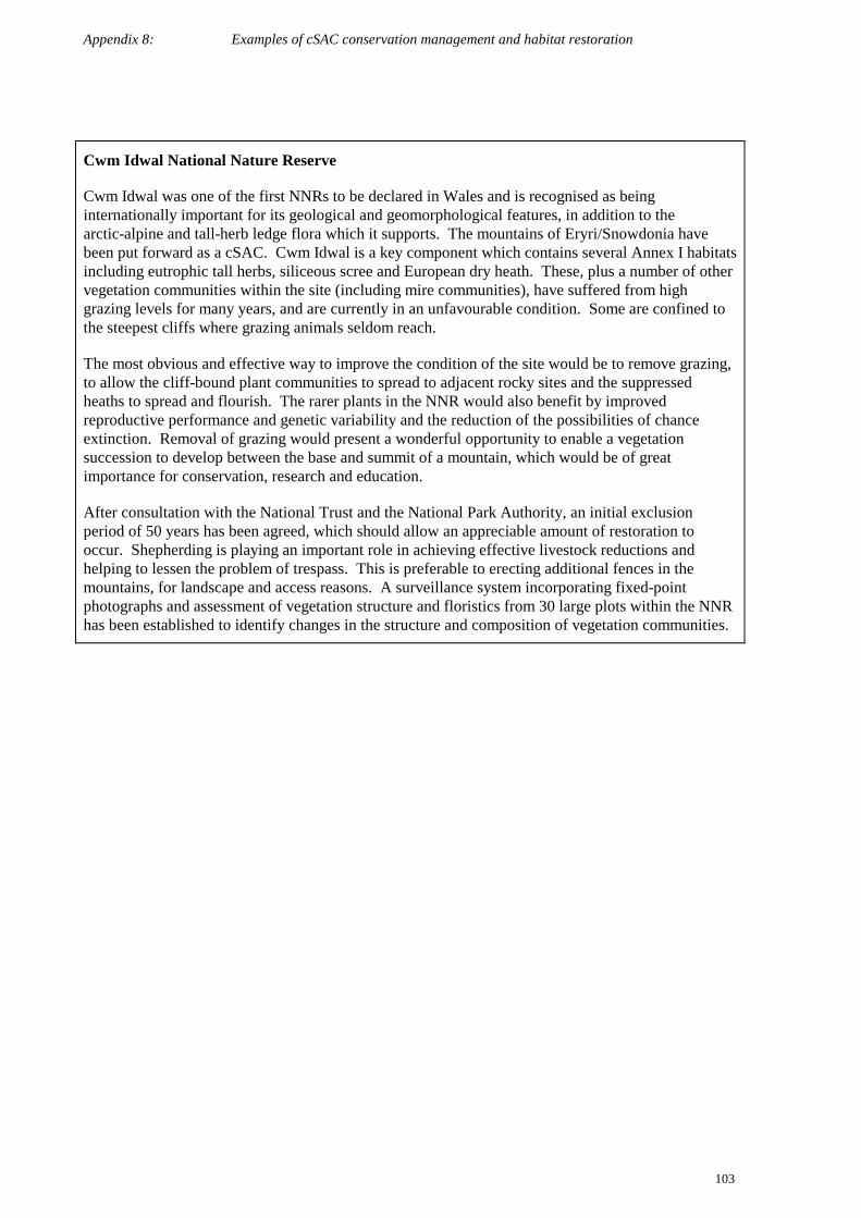
Appendix 8: Examples of cSAC conservation management and habitat restoration
103
Cwm Idwal National Nature Reserve
Cwm Idwal was one of the first NNRs to be declared in Wales and is recognised as beinginternationally important for its geological and geomorphological features, in addition to thearctic-alpine and tall-herb ledge flora which it supports. The mountains of Eryri/Snowdonia havebeen put forward as a cSAC. Cwm Idwal is a key component which contains several Annex I habitatsincluding eutrophic tall herbs, siliceous scree and European dry heath. These, plus a number of othervegetation communities within the site (including mire communities), have suffered from highgrazing levels for many years, and are currently in an unfavourable condition. Some are confined tothe steepest cliffs where grazing animals seldom reach.
The most obvious and effective way to improve the condition of the site would be to remove grazing,to allow the cliff-bound plant communities to spread to adjacent rocky sites and the suppressedheaths to spread and flourish. The rarer plants in the NNR would also benefit by improvedreproductive performance and genetic variability and the reduction of the possibilities of chanceextinction. Removal of grazing would present a wonderful opportunity to enable a vegetationsuccession to develop between the base and summit of a mountain, which would be of greatimportance for conservation, research and education.
After consultation with the National Trust and the National Park Authority, an initial exclusionperiod of 50 years has been agreed, which should allow an appreciable amount of restoration tooccur. Shepherding is playing an important role in achieving effective livestock reductions andhelping to lessen the problem of trespass. This is preferable to erecting additional fences in themountains, for landscape and access reasons. A surveillance system incorporating fixed-pointphotographs and assessment of vegetation structure and floristics from 30 large plots within the NNRhas been established to identify changes in the structure and composition of vegetation communities.

Appendix 9: Abbreviations and acronyms
104
Appendix 9: Abbreviations and acronyms
ADAS Agricultural Development Advisory Service
AONB Area of Outstanding Natural Beauty
ASSI Area of Special Scientific Interest
BAP Biodiversity Action Plan
BRC Biological Records Centre
BRWG Biodiversity Research Working Group
BSBI Botanical Society of the British Isles
CA Country Agencies (CCW, EN, EHS, SNH)
CAP Common Agricultural Policy
CBD Convention on Biological Diversity
CCW Countryside Council for Wales
CEE Council for Environmental Education
CEFAS Centre for Environment, Fisheries and Aquatic Science
CEH Centre for Ecology and Hydrology
CEL College–English Nature Links
ChaMP Coastal Habitat Management Plan
CIS Countryside Information System
CMP Conservation Management Plan
CMS Countryside Management Scheme
CORINE Co-ordination of Information on the Environment
CPS Countryside Premium Scheme
cSAC candidate Special Area for Conservation
CSM Common Standards Monitoring
CSS Countryside Stewardship Scheme
CRoW Countryside and Rights of Way Act 2000
CZMP Coastal Zone Management Plan
DANI Department of Agriculture for Northern Ireland (now DARD)
DARD Department of Agriculture and Rural Development (formerly DANI)
DEFRA Department of Environment, Food and Rural Affairs (formerly DETR andMAFF)
DETR Department of Environment, Transport and the Regions (now DEFRA andDTLR)
DTLR Department of Transport, Local Government Regions (formerly DETR)
DoE(NI) Department of Environment in Northern Ireland
EA Environment Agency

Appendix 9: Abbreviations and acronyms
105
EC European Commission
EHS Environment and Heritage Service
EIA Environmental Impact Assessment
EN English Nature
ENPACT English Nature Practical Application of Conservation Techniques
ENSIS English Nature Site Information System
ERDP England Rural Development Programme
ESA Environmentally Sensitive Area
EU European Union
FACT Forum for the Application of Conservation Techniques
FC Forestry Commission
FCS Favourable Conservation Status
FE Forest Enterprise
GB Great Britain (i.e. England, Scotland and Wales only)
GIS Geographical Information System
GQA General Quality Assessment Scheme
GoG Government of Gibraltar
GONHS Gibraltar Ornithological and Natural History Society
HAP Habitat Action Plan
HIE Highlands and Islands Enterprise
HLF Heritage Lottery Fund
ICES International Council for the Exploitation of the Seas
IDD International Designations Database
IFS Indicative Forestry Strategies
ILMP Integrated Land Management Plan
ISIS Integrated Sites Information System
ISO International Standards Organisation
ITE Institute of Terrestrial Ecology
IUCN World Conservation Union
JNCC Joint Nature Conservation Committee
LBAP Local Biodiversity Action Plan
LEAP Local Environment Agency Plans
LIFE L’Instrument Financier pour l’Environnement
MAFF Ministry of Agriculture, Fisheries and Food (now DEFRA)
MarLIN Marine Life Information Network
MIDAS Monitoring Information for Designated Areas in Scotland
MNCR Marine Nature Conservation Review

Appendix 9: Abbreviations and acronyms
106
MNR Marine Nature Reserve
MoD Ministry of Defence
NAW National Assembly for Wales
NBMP National Bat Monitoring Programme
NBN National Biodiversity Network
NCC Nature Conservancy Council
NCMS National Countryside Monitoring Scheme
NERC Natural Environment Research Council
NGO Non-Governmental Organisation
NI Northern Ireland
NMMP National Marine Monitoring Programme
NNR National Nature Reserve
NPPG National Planning Policy Guidance
NSA National Scenic Area
NT National Trust
NTS National Trust for Scotland
NVC National Vegetation Classification
PMS Peatland Management Scheme
PPG Planning Policy Guidance
PPS Planning Policy Statement
RSPB Royal Society for the Protection of Birds
SAC Scottish Agricultural College
SAC Special Area of Conservation
SAP Species Action Plan
SCI Site of Community Importance
SDR Strategic Defence Review
SE Scottish Executive
SEEC Scottish Environmental Education CouncilSEPA Scottish Environment Protection Agency
SERAD Scottish Executive Rural Affairs Department
SERCON System for Evaluating Rivers for Conservation
SMP Shoreline Management Plan
SMRU Sea Mammal Research Unit
SMS Site Management Statement
SNH Scottish Natural Heritage
SNIFFER Scotland and Northern Ireland Forum for Environmental Research
SO Scottish Office
SPA Special Protection Area
Appendix 9: Abbreviations and acronyms
107
SSSI Site of Special Scientific Interest
STRP Scientific and Technical Review Panel
TIBRE Targeted Inputs for a Better Rural Environment
TWT The Wildlife Trusts
UDP Unitary Development Plan
UK United Kingdom (i.e. England, Scotland, Wales and Northern Ireland)
UK BAP United Kingdom’s Biodiversity Action Plan
VMP Visitor Management Plan
WES Wildlife Enhancement Scheme
WGS Woodland Grant Scheme
WLMP Water Level Management Plan
WWF World Wide Fund for Nature–UK
WWT Wildfowl & Wetlands Trust
WWW World Wide Web

Appendix 10: References
108
Appendix 10: References
Baldock, D and Mitchell K (1995) Cross Complience within the CAP. A review of options for landscapeand nature conservation. IEEP London.
Barr, C J, Bunce, R G H, Clarke, R T, Fuller, R M, Furse, M T, Gillespie, M K, Groom, G B, Hallam, C J,Hornung, M, Howard, D C, & Ness, M J (1993) Countryside Survey 1990. Main report. Departmentof the Environment, London (Countryside 1990 Series)
Bennion, H, Allott, T E H, Appleby, P G, Hunt, M, Oliver, E and Patrick S T (1997) A study of recentenvironmental change with selected standing waters proposed as Special Areas of Conservation inWales Phase II. Countryside Council for Wales Research Report, No. 187. Countryside Councilfor Wales, Bangor
Brown, A (2000) Habitat Monitoring for Conservation Management and Reporting, Volume 3: TechnicalGuide. Countryside Council for Wales, Bangor
Brown, A E, Burn, A J, Hopkins, J J and Way, S F (eds) (1998) The Habitats Directive: selection ofSpecial Areas of Conservation in the UK. JNCC Report No. 270. JNCC, Peterborough
Commission of the European Communities (CEC) (1991) CORINE biotopes manual: Habitats of theEuropean Community. Luxemburg, Office for Publication of the European Communities.
Connor, D W, Brazier, D P, Hill, T O and Northern, K O (1997a) Marine Nature Conservation Review:marine biotope classification for Britain and Ireland. Vol. 1. Littoral biotopes. Version 97.06.JNCC Report, No. 229
Connor, D W, Dalkin, M J, Hill, T O, Holt, R H F and Sanderson, W G (1997b) Marine NatureConservation Review: marine biotope classification for Britain and Ireland. Vol. 2. Sublittoralbiotopes. Version 97.06. JNCC Report, No. 230
Cooper, A, Murray, R and McCann, T (1997) The Northern Ireland Countryside Survey: summary reportand application to rural decision making. Environment and Heritage Service, Belfast
Cooper, A and McCann, T (2000) The Northern Ireland Countryside Survey: Summary Report on BroadHabitats. Environment and Heritage Service, Belfast
Cortes, J E (2000) The restoration of the vegetation on the east slopes of the rock of Gibraltar: backgroundand first steps. Almoraima, 23, pp.65–86
Countryside Council for Wales and Forestry Commission (1999) The living environment of Wales.Countryside Council for Wales, Bangor
Department of the Environment (1994) Biodiversity: The UK Action Plan. London, HMSO
Department of the Environment (1996) Indicators of Sustainable Development for the United Kingdom.London, HMSO
DETR (1999a) Peatland Issues – report of the working group on Peat extraction and related matters.DETR, London
DETR (1999b) A better quality of life – a strategy for sustainable development for the United Kingdom.DETR, London
DETR (2000) Accounting for nature: assessing habitats in the UK countryside. London, HMSO
Earthwatch (1998) Business and Biodiversity – A UK business guide for understanding and integratingnature conservation and biodiversity into environmental management systems. Earthwatch UK
Environment and Heritage Service (1999) Guidelines for the selection of Biological ASSIs in NorthernIreland. Environment and Heritage Service, Belfast
European Commission (2000) Managing Natura 2000 sites: the provisions of Article 6 of the ‘Habitats’Directive 92/43/EEC. Brussels, European Commission
Appendix 10: References
109
European Commission, DGXI (1996) Interpretation manual of European Union habitats EUR 15 (October1996). Brussels, European Commission
Farrell, L (1999) Cypripedium calceolus L. (Orchidaceae), in British Red Data Books 1 Vascular Plants,3rd edition (ed. M. Wiggington), p. 113. Joint Nature Conservation Committee, Peterborough
Forestry Commission (1998) The UK Forestry Standard: the Government’s approach to sustainableforestry. Edinburgh, HMSO
Forestry Authority (1994) Forestry Practice Guides: The management of semi-natural woodlands.Edinburgh, Forestry Authority
Galán de Mera, A, Cortés, J E and Sánchez García I (2000) La Vegetación del Peñón de Gibraltar, ActaBotnaic Malacitana 25, pp. 107–130
Gibraltar Ornithological & Natural History Society (1994) The Habitats Directive and Gibraltar –implementation in Gibraltar of Council Directive on the Conservation of Natural Habitats and ofwild Flora and Fauna. Unpublished report by GONHS
Government Response to the UK Steering Group Report on Biodiversity (1996). Cm 3260. London,HMSO
Haines-Young, R H, Barr, C J, Black, H I J, Briggs, D J, Bunce, R G H, Clarke, R T, Cooper, A, Dawson, FH, Firbank, L G, Fuller, R M, Furse, M T, Gillespie, M K, Hill, R, Hornung, M, Howard, D C,McCann, T, Morecroft, M D, Petit, S, Sier, A R J, Smart, S M, Smith, G M, Stott, A P, Stuart, R C& Watkins, J W (2000) Accounting for nature: assessing habitats in the countryside. Department ofthe Environment, Transport & the Regions, London.http://www.defra.gov.uk/wildlife-countryside/cs2000/index.htm
Hurford, C and Perry, K (2000) Habitat Monitoring for Conservation Management and Reporting. Volume1: Case Studies. Countryside Council for Wales, Bangor
Hurford, C, Jones, M R and Brown, A (2000) Habitat Monitoring for Conservation Management andReporting. Volume 2: Field Methods. Countryside Council for Wales, Bangor
Institute of Terrestrial Ecology (1998) Countryside Survey 2000 News. Institute for Terrestrial Ecology,Merlewood
IUCN (via IUCN/SSC Invasive Species Specialist Group) (1997) Draft IUCN Guidelines for thePrevention of Biodiversity Loss due to Biological Invasion. Invasive Species Specialist Group,Auckland
Jackson, D L and Mcleod, C R (eds) (2000) Handbook on the UK status of EC Habitats Directive interestfeatures: provisional data on the UK distribution and extent of Annex I habitats and the UKdistribution and population size of Annex II species, Version 1. JNCC Report, No. 312
JNCC (1999) The Birds Directive: Selection guidelines for Special Protection Areas. JNCC, Peterborough
JNCC (1994) Guidelines for selection of biological SSSIs: bogs. JNCC, Peterborough
JNCC (1996). Guidelines for selection of biological SSSIs: inter-tidal habitats. JNCC, Peterborough
King, M, Hepburn, I and Gubbay, S (1999) A review of the operation of species legislation in GreatBritain. JNCC and Wildlife & Countryside Link, unpublished contract report
Land cover of Scotland 1988 (17) Macaulay Land Use Research Institute (1993) The land cover ofScotland 1988: Final Report. Aberdeen, MLURI
Mackey, E C, Shewry, M C and Tudor, G J (1998) Land cover change: Scotland from the 1940s to the1980s. Edinburgh, Stationery Office
Minerals Planning Guidance Note 13 (MPG13) (1995) Guidelines for Peat Provision in England, includingthe place of alternative materials. DETR.
Minerals Planning Guidance Note 14 (MPG14). Environment Act 1995: Review of Mineral PlanningPermissions. DETR.
Appendix 10: References
110
Ministry of Agriculture, Fisheries and Food (1998) Conservation Grants for Farmers. London, Ministry ofAgriculture, Fisheries and Food
Ministry of Agriculture, Fisheries and Food (2000) Salmon and Freshwater Fisheries Review
Murray, R, McCann, T and Cooper, A (1992) A Land Classification and Landscape Ecological Study ofNorthern Ireland. Report to the Countryside and Wildlife Branch (DoE (NI)). University of Ulster
Nature Conservancy Council (1989) Guidelines for selection of biological SSSIs. Peterborough, NatureConservancy Council
Nature Protection Ordinance (1991) First Supplement to the Gibraltar Gazette, No. 2,608, 9 May 1991.Gibraltar Chronicle Limited, Gibraltar
Planning Policy Guidance Note 9 (PPG9): Nature Conservation. (HMSO, 1994).
Planning Policy Statement 2 (PPS2) Planning and Nature Conservation. Department of the Environmentfor Northern Ireland
Rodwell, J S (ed.) (1991) British plant communities. Volume 1. Woodlands and scrub. Cambridge,Cambridge University Press
Rodwell, J S (ed.) (1991) British plant communities. Volume 2. Mires and heaths. Cambridge, CambridgeUniversity Press
Rodwell, J S (ed.) (1992) British plant communities. Volume 3. Grasslands and montane communities.Cambridge, Cambridge University Press
Rodwell, J S (ed.) (1995) British plant communities. Volume 4. Aquatic communities, swamp and tall-herb fens. Cambridge, Cambridge University Press
Rodwell, J S (ed.) (2000) British plant communities. Volume 5. Maritime communities and vegetation ofopen habitats. Cambridge, Cambridge University Press
SAC (2001) SAC to Extend Investigation of Stranded Whales, Dolphins, and Porpoises. ScottishAgricultural College, Press Release 01NO1. Accessed 8 January 2001 on Public Notice BoardForum at http://www.sac.ac.uk/press
Scottish Environment Protection Agency (1999) Scotland’s Water: The state of Scotland’s WaterEnvironment
Scottish Natural Heritage (1994) National Countryside Monitoring Scheme Scotland: Main report offindings. Edinburgh, Scottish Natural Heritage
Scottish Natural Heritage (1996) TIBRE: agriculture, environment and industry growing together.Edinburgh, Scottish Natural Heritage
Statutory Instrument 171 (N.I. 2)(1985) Wildlife (Northern Ireland) Order 1985. HMSO, London
Statutory Instrument 2716 (1994) Conservation (Natural Habitats, &c.) Regulations 1994. HMSO, London
Thomas, J A (1989) The return of the Large Blue butterfly. British Wildlife 1(1): pp. 2–13.
UK Biodiversity Group. UK Biodiversity Group Tranche 2 Action Plans: Volume 1 – Vertebrates andVascular Plants. Peterborough, English Nature
UK Biodiversity Group. UK Biodiversity Group Tranche 2 Action Plans: Volume 2 – Terrestrial andFreshwater Habitats. Peterborough, English Nature
UK Biodiversity Group. UK Biodiversity Group Tranche 2 Action Plans: Volume 3 – Plants and Fungi.Peterborough, English Nature
UK Biodiversity Group. UK Biodiversity Group Tranche 2 Action Plans: Volume 4 –Invertebrates.Peterborough, English Nature
UK Biodiversity Group. UK Biodiversity Group Tranche 2 Action Plans: Volume 5 – Maritime Species andHabitats. Peterborough, English Nature

Appendix 10: References
111
UK Biodiversity Group. UK Biodiversity Group Tranche 2 Action Plans: Volume 6 – Terrestrial andFreshwater Species and Habitats. Peterborough, English Nature
UK Biodiversity Group (2001) Sustaining the variety of life – 5 years of the UK Biodiversity Action Plan.London, DETR
UK Biodiversity Steering Group (1995a) Biodiversity: The UK Steering Group Report. Volume 1: Meetingthe Rio Challenge. London, HMSO
UK Biodiversity Steering Group (1995b) Biodiversity: The UK Steering Group Report. Volume 2: ActionPlans. London, HMSO
UK Marine SACs Project (1998) Marine life. Peterborough, English Nature
Wildlife and Countryside Act 1981. HMSO, London
Williamson, M (1996) Biological Invasions. Chapman and Hall, London

Appendix 11: WWW Addresses
112
Appendix 11: WWW AddressesThe WWW sites listed below each contain information relevant to the implementation of the HabitatsDirective and the conservation of habitats and species in the UK generally.
CA Countryside Agency http://www.countryside.gov.uk
CCW Countryside Council for Wales http://www.ccw.gov.uk
CEH Centre for Ecology and Hydrology http://www.ceh.ac.uk
CHM Clearing House Mechanism http://www.chm.org.uk
CIS Countryside Information System http://www.cis-web.org.uk
DARD Department of Agriculture and RuralDevelopment (Northern Ireland)
http://www.dani.gov.uk
DEFRA Department of the Environment, Food and RuralAffairs
http://www.defra.gov.uk
DoENI Department of Environment in Northern Ireland http://www.doeni.gov.uk
EA Environment Agency http://www.environment-agency.gov.uk
EHS Environment and Heritage Service http://www.ehsni.gov.uk
EN English Nature http://www.english-nature.org.uk
EUROPA European Union Online http://europa.eu.int
FC Forestry Commission http://www.forestry.gov.uk
FoE Friends of the Earth http://www.foe.co.uk
JNCC Joint Nature Conservation Committee http://www.jncc.gov.uk
MCS Marine Conservation Society http://www.mcsuk.org
MarLIN Marine Life Information Network for Britain andIreland
http://www.marlin.ac.uk
NAW National Assembly for Wales http://www.assembly.wales.gov.uk
NBN National Biodiversity Network http://www.nbn.org.uk
NERC Natural Environment Research Council http://www.nerc.ac.uk
RSPB Royal Society for the Protection of Birds http://www.rspb.org.uk
SAC Scottish Agricultural College http://www.sac.ac.uk
SEPA Scottish Environment Protection Agency http://www.sepa.org.uk
SNH Scottish Natural Heritage http://www.snh.gov.uk
TWT The Wildlife Trusts http://www.wildlifetrust.org.uk
UK BAP UK Biodiversity Action Plan http://www.ukbap.org.uk
WCL Wildlife and Countryside Link http://www.greenchannel.com/wcl
WCMC World Conservation Monitoring Centre http://www.wcmc.org.uk
WWF World Wide Fund for Nature–UK http://www.wwf-uk.org
WWT Wildfowl & Wetlands Trust http://www.greenchannel.com/wwt