ESA Earth Observation -...
46
ESA UNCLASSIFIED - For Official Use ESA Earth Observation Missions and Programmes f or measuring the state of the Crysophere CTC 2018 Yves - Louis DESNOS Head of Data Applications Division Directorate of Earth Observation Programmes
Transcript of ESA Earth Observation -...

ESA UNCLASSIFIED - For Official Use
ESA Earth ObservationMissions and Programmesfor measuring the state of the Crysophere
CTC 2018
Yves-Louis DESNOS
Head of Data Applications Division
Directorate of Earth Observation Programmes
Slide 2
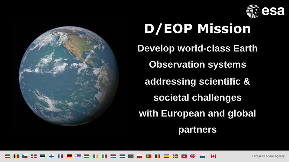
Develop world-class Earth
Observation systems
addressing scientific &
societal challenges
with European and global
partners
D/EOP Mission
Slide 3
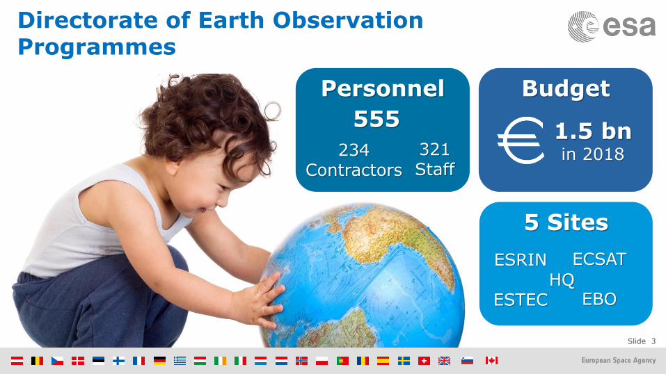
5 Sites
BudgetPersonnel
1.5 bnin 2018
555
321Staff
234Contractors
ESRIN
ESTEC
ECSAT
EBOHQ
Directorate of Earth Observation Programmes

Slide 4

Slide 5
New Generations of Systems coming up
Meteorological Missions
< Current Systems
< Post-2020 Systems

Slide 6
Science: Earth Explorers
GOCE 2009 – 2013
SMOS 2009 – Present
Cryosat 2010 – Present
SWARM 2013 – Present
Aeolus 2018
EarthCARE 2019
Biomass 2021
FLEX 2022
Slide 7
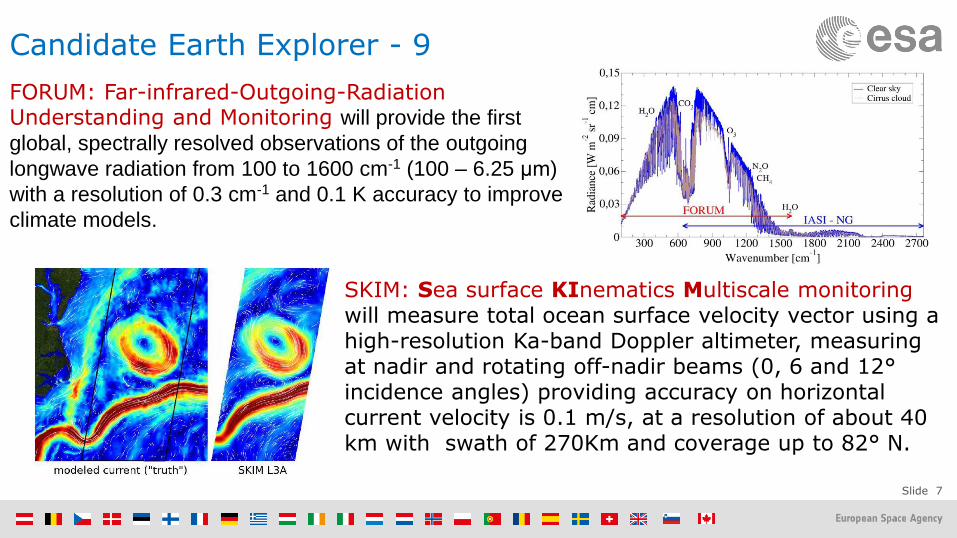
Candidate Earth Explorer - 9
FORUM: Far-infrared-Outgoing-Radiation Understanding and Monitoring will provide the first
global, spectrally resolved observations of the outgoing
longwave radiation from 100 to 1600 cm-1 (100 – 6.25 μm)
with a resolution of 0.3 cm-1 and 0.1 K accuracy to improve
climate models.
SKIM: Sea surface KInematics Multiscale monitoring will measure total ocean surface velocity vector using a high-resolution Ka-band Doppler altimeter, measuring at nadir and rotating off-nadir beams (0, 6 and 12°incidence angles) providing accuracy on horizontal current velocity is 0.1 m/s, at a resolution of about 40 km with swath of 270Km and coverage up to 82° N.

Slide 8
S-1
Radar
A
3 Apr. 2014
B
25 Apr. 2016
S-2
High Resolution
Optical
A
23 Jun. 2015
B
6 Mar. 2017
S-3
Medium Resolution Optical & Altimetry
A
16 Feb. 2016
S-4
Atmospheric Chemistry
(GEO)
A
2021
B
2027
S-5P
Atmospheric Chemistry
(LEO)
A
13 Oct. 2017
S-5
Atmospheric Chemistry
(LEO)
A
2021
B
2027
S-6
Altimetry
A
2020
B
2025
Sentinel Launches
C2022/23
C2022/23
D> 2022/23
C2023
D> 2023
C> 2027
D> 2022/23
B
27 Apr. 2018
Slide 9
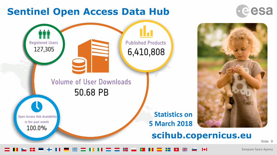
Sentinel Open Access Data Hub
Statistics on5 March 2018
scihub.copernicus.eu

| Slide 10ESA UNCLASSIFIED - For Official Use
Next-Gen. missions will replace current & expansion missions
Current Sentinels
Sentinel Expansion
2014
Sentinel Next Generation
Copernicus for Security
Copernicus Space Component Evolution

| Slide 11ESA UNCLASSIFIED - For Official Use
Sentinel Expansion – Candidate Missions
• Anthropogenic CO2 Monitoring Mission to analyse through the use of CO2 satellite imagers the man-made CO2 emissions and overall CO2 budget at country and regional/megacity scales.
• Polar Ice and Snow Topographic Mission (building on Cryosat experience) to provide enhanced land ice elevation and sea ice thickness measurements implementing higher spatial resolution for improved lead detection and additional capability to determine snow loading on sea ice
• Passive Microwave Imaging Mission to provide improved continuity of sea ice concentration monitoring missions, in particular in terms of spatial resolution (15 km), temporal resolution (sub-daily) and accuracy (in particular near the ice edges).
• L band SAR Mission responding to the of both the Land Monitoring and the Emergency Management services. Its target applications are: soil moisture, crop type discrimination, forest type/forest cover (in support to biomass estimation), food security and precision farming. In addition the mission will contribute to the monitoring of ice extent in the polar region.
• HyperSpectral Imaging Mission to complement Copernicus observations with an imaging spectroscopy observational capability for products, applications and services supporting the management of natural resources and related policies
• High Spatio-Temporal Resolution Land Surface Temperature Mission providing high spatio-temporal resolution Thermal Infrared observations over land and coastal regions

ESA UNCLASSIFIED - For Official Use
#EO4Society
Slide 13
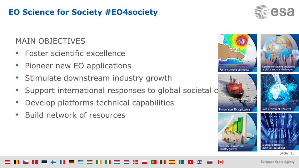
EO Science for Society #EO4society
MAIN OBJECTIVES
• Foster scientific excellence
• Pioneer new EO applications
• Stimulate downstream industry growth
• Support international responses to global societal challenges
• Develop platforms technical capabilities
• Build network of resources

Slide 14
#EO4society – Components
ScientificExploitation
EO for Sustainable Development
Industry GrowthNew Partners
New: Some 10% of the total budget will be assigned via open calls to support industry/users initiatives.
EO Exploitation Platforms
Public Sector Applications
Federated Collaborative Platforms

Slide 15
• Permanently open call
• Framework to rapidly
respond to new innovative
ideas from bidders.
• Submission deadline for the
fourth batch of proposals:
1st September 2018
• Applications:
http://emits.sso.esa.int/
Opportunities – Open call
EO Science for Society Open call for proposalsEOEP-5 Block 4
Slide 16
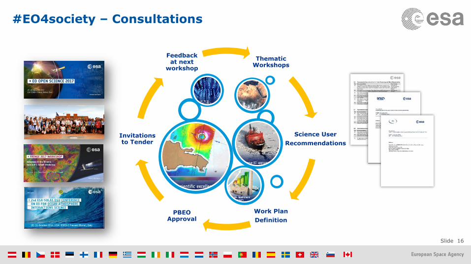
#EO4society – Consultations
Thematic Workshops
Science User
Recommendations
Work Plan
Definition
PBEO Approval
Invitations to Tender
Feedback at next
workshop

Slide 17

Slide 18
> 640.000 pageviews > 22.500 h spent on page
September 2017 > 6.800 registered users
Statistics partially based on Browser
language
1st SAR MOOC “Echoes from space:
Introduction to Radar Remote Sensing”
• Next: Re-run of the SAR MOOC with CSA focused on applications in the Northern Hemisphere (Water/Ice)
• Potential/future project proposal: EO Mobile MOOC (Suitable for developing world)

Slide 19

Slide 20
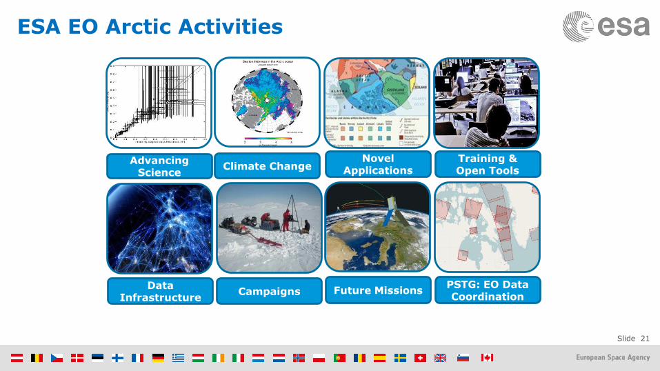
Arctic & Polar Science: Ensuring coherence
Slide 21
ESA EO Arctic Activities
Advancing Science
Climate ChangeNovel
Applications
DataInfrastructure
Future MissionsCampaigns
Training & Open Tools
PSTG: EO Data Coordination
Issue/Revision: 0.0
Reference:
Status:
ESA UNCLASSIFIED - For Official Use
#EO4Society Results

Slide 23
Advancing Science: Some achievements
SMOS very thing sea ice measurements (<0.5m) complementing Cryosat
measurements
Novel merged Cryosat+SMOS product
covering the full thickness range (dots are NASA Icebridge airborne
measurements
Novel pan-Arctic frozen soil estimates rom SMOS
Novel pan-Arctic growing stock volume from
hyper-temporal SAR (ASAR) processing
Slide 24
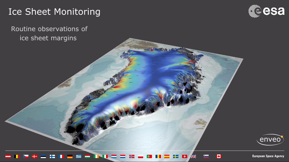
Ice Sheet Monitoring
Routine observations of
ice sheet margins

Slide 25
CryoSat: Sea Ice Thickness & Volume
• Autumn 2010 - 2013, reduction in Arctic sea ice volume consistent with change in extent
• Replenishment in ice volume from 2013 –2014 indicating resilience but large multi-year oscillation
• Recent decline from 2014 – 2016 with anomalously low cumulative growth in autumn 2016

Slide 26
Cryosat Swath processing: High-res view on Greenland

Slide 27

Slide 28
ESA/NASA IMBIE (1992-2012)
In 2012 a group of 47 scientist from both sides of the Atlantic supported by ESA and NASA published the first reconcile estimate of the contribution from Greenland and Antarctica to sea level rise…
The initiative aimed at reconcile for the first time the different results obtained from 3 different EO-based methods… gravimetry, altimetry and Input-Output technique….
Results showed that melting of the Antarctic and Greenland ice sheets has added 11.1 mm to global sea levels from 1992 to 2012. This amounts to about 20% of all sea-level rise over the survey period…..
While the rate of ice loss from Greenland has increased almost five-fold since the mid-1990s, in Antarctica the overall balance has remained fairly constant….

Slide 29
ESA/NASA IMBIE-2 (1992-2017)
• A new assessment has been completed over Antarctica covering the period 1992-2017…
• 87 scientists has contributed to the exercise
• For the first time Cryosat-2 and Sentinel-1 data are included in the assessment;
• The teams have been supported by ESA’s Climate Change Initiative and the Scientific Exploitation element of the EOEP
• Results will be published by Nature the next 14th June.

Slide 30
#EO Exploitation Platforms

Slide 31
The EO Ecosystem:

Slide 32
ovl.oceandatalab.com

Slide 33
Polar TEP Overview
Create a a virtual research platform for Polar communities
Provide polar-relevant data, tools, and processing in the cloud
Bring users’ algorithms to the data
To be governed by a Board representing the operational and scientific communities
Collaborate with various user groups and data providers
https://portal.polar-tep.eo.esa.int/

Slide 34
#EO4Society Outlook

Slide 35
EO for SDGs
2030 Agenda for Sustainable Development: 17 goals, 169 targets, 230 Indicators New norms to integrate the principles of sustainable development into country policies and programs

Slide 36
EO importance for the SDG’s
Analysis performed by the GEO EO4SDGs initiative
Earth Observations potential contribution to the SDG Targets and Indicators
SDGs with most opportunities for EO data and services
1.5
2.3 2.4 2.c 2.4.1
3.3 3.4 3.9 3.d 3.9.1
5.9.1
6.3 6.4 6.5 6.6 6.a 6.b 6.3.2 6.4.2 6.5.1 6.6.1
7.2 7.3 7.a 7.b 7.1.1
8.4
9.1 9.4 9.5 9.a 9.1.1
11.3 11.4 11.5 11.6 11.7 11.b 11.c 11.3.1 11.6.2 11.7.1
12.2 12.a 12.b
13.1 13.3 13.b 13.1.1
14.1 14.2 14.3 14.4 14.6 14.7 14.a 14.3.1
15.1 15.2 15.3 15.4 15.5 15.7 15.8 15.9 15.1.1 15.2.1 15.3.1 15.4.1 15.4.2
17.6 17.7 17.9 17.16 17.17
Contribute to progress on the Target yet not the Indicator per se Direct measure or indirect support
Target IndicatorGoal

Slide 37
WHAT: European Press News Survey the Last Few Months
Slide 38
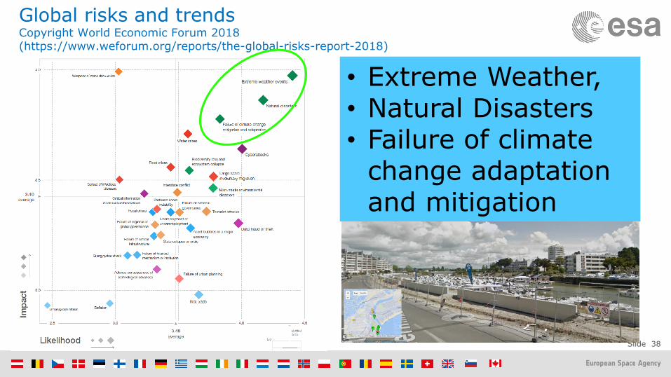
Global risks and trendsCopyright World Economic Forum 2018(https://www.weforum.org/reports/the-global-risks-report-2018)
• Extreme Weather,• Natural Disasters • Failure of climate
change adaptation and mitigation

Slide 39
GCOS and satellite data in climate adaptation and risk management (by S. Briggs GCOS S.C. chair)

Slide 40
EO Supporting Global Policies
Adaptation & Disaster Risk
Reduction
Sustainable Development
Climate Action
Sendai FrameworkUN SDGs Paris Agreement
Supporting Resilient
Infrastructure
Measuring Status& Progress
Monitoring & Understanding
Slide 41
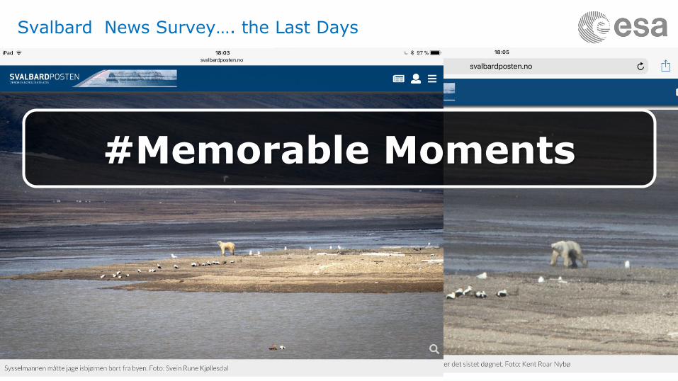
Svalbard News Survey…. the Last Days
#Memorable Moments

Slide 42
Recent memorable EO moments
The British Antarctic Survey’s Halley Research Station was moved due to the progressing Halloween crack (discovered on 31 October 2016) on the Brunt Ice Shelf.
Crack clearly visible in SAR imagery.Both Sentinel-1 and -2 data were used in the decision making process of the move.
©BAS-Sam Burrell

Slide 43
Recent memorable EO moments
The rift in the Larsen C ice shelf in Antarctica began to lengthen drastically from January to July 2017.
On 12 July, Sentinel-1 captured one of the largest icebergs on record (iceberg A68) calving off the ice shelf.
©BAS
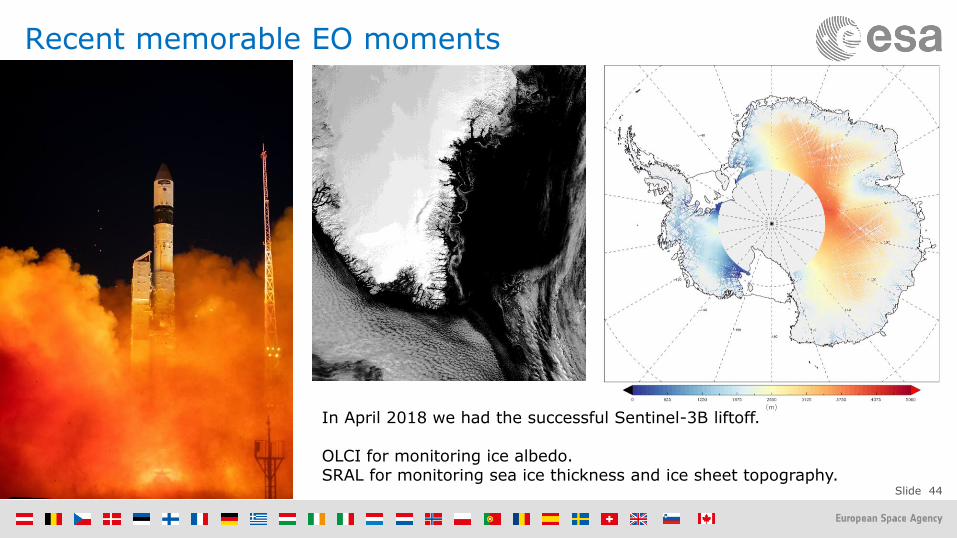
Slide 44
Recent memorable EO moments
In April 2018 we had the successful Sentinel-3B liftoff.
OLCI for monitoring ice albedo.SRAL for monitoring sea ice thickness and ice sheet topography.
Slide 45
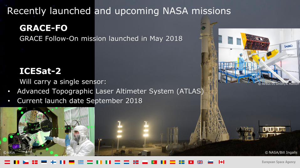
Recently launched and upcoming NASA missions
© Airbus DS GmbH/A. Ruttloff
GRACE-FOGRACE Follow-On mission launched in May 2018
ICESat-2Will carry a single sensor:
• Advanced Topographic Laser Altimeter System (ATLAS)
• Current launch date September 2018
© NASA © NASA/Bill Ingalls/Spacex

ESA UNCLASSIFIED - For Official Use
Wish you a good week in Svalbard
Thank you for your attention!
www.esa.int