Environmental impact assessment as a step to sustainable ...
11
Environmental impact assessment as a step to sustainable tourism development N. Raschke Environmental Resources Management ERM GmbH, Germany Abstract ERM GmbH conducted an Environmental Impact Assessment (EIA) for the Urban and Tourism Development of Ulcinj, Montenegro on behalf of Deutsche Investitions- und Entwicklungsgesellschaft (DEG). The Project was designed to support the Municipality of Ulcinj in the preparation and implementation of an Urban Development Plan prepared by the architects Albert Speer & Partner. Ulcinj is located at the Montenegrin Mediterranean coast west of the border to Albania. Along the coastal stretch “Velika Plaza”, south–east of Ulcinj town, the staged establishment of accommodation (hotels, resorts) and leisure facilities as well as related infrastructure is envisaged. Main ecological features of the area to be protected are endemic oaks, halophyte (salt-tolerant) vegetation and Important Bird Areas in the vicinity. Phase 1 EIA consisted of a strategic oriented Environmental Assessment plan aimed to evaluate the principal suitability of tourism development of Velika Plaza from an environmental perspective. As a result, the western part of Velika Plaza was identified as being suitable for development. The eastern part however with extended marshland area, natural forest vegetation and halophyte vegetation was found to be of high conservation value in particular due the different habitats for bird life. The determination of these areas in the first phase was a very important step for sound and sustainable tourism development. Phase 2 provided a detailed analysis of the environmental impacts likely to occur when implementing the architects’ concept. Mitigation measures were outlined, design recommendations, construction and operation patterns were provided and an Environmental Management Plan was organised to provide guidance to the developers of the Tourism project. Keywords: Environmental Impact Assessment EIA, sustainable tourism, tourism development, Montenegro, Adriatic Coast. © 2005 WIT Press WIT Transactions on Ecology and the Environment, Vol 84, www.witpress.com, ISSN 1743-3541 (on-line) Sustainable Development and Planning II, Vol. 1 303
Transcript of Environmental impact assessment as a step to sustainable ...

Environmental impact assessment as a step to sustainable tourism development
N. Raschke Environmental Resources Management ERM GmbH, Germany
Abstract
ERM GmbH conducted an Environmental Impact Assessment (EIA) for the Urban and Tourism Development of Ulcinj, Montenegro on behalf of Deutsche Investitions- und Entwicklungsgesellschaft (DEG). The Project was designed to support the Municipality of Ulcinj in the preparation and implementation of an Urban Development Plan prepared by the architects Albert Speer & Partner. Ulcinj is located at the Montenegrin Mediterranean coast west of the border to Albania. Along the coastal stretch “Velika Plaza”, south–east of Ulcinj town, the staged establishment of accommodation (hotels, resorts) and leisure facilities as well as related infrastructure is envisaged. Main ecological features of the area to be protected are endemic oaks, halophyte (salt-tolerant) vegetation and Important Bird Areas in the vicinity. Phase 1 EIA consisted of a strategic oriented Environmental Assessment plan aimed to evaluate the principal suitability of tourism development of Velika Plaza from an environmental perspective. As a result, the western part of Velika Plaza was identified as being suitable for development. The eastern part however with extended marshland area, natural forest vegetation and halophyte vegetation was found to be of high conservation value in particular due the different habitats for bird life. The determination of these areas in the first phase was a very important step for sound and sustainable tourism development. Phase 2 provided a detailed analysis of the environmental impacts likely to occur when implementing the architects’ concept. Mitigation measures were outlined, design recommendations, construction and operation patterns were provided and an Environmental Management Plan was organised to provide guidance to the developers of the Tourism project. Keywords: Environmental Impact Assessment EIA, sustainable tourism, tourism development, Montenegro, Adriatic Coast.
© 2005 WIT Press WIT Transactions on Ecology and the Environment, Vol 84, www.witpress.com, ISSN 1743-3541 (on-line)
Sustainable Development and Planning II, Vol. 1 303

1 Introduction
An Environmental Assessment of the proposed Urban and Tourism Development of Ulcinj, Montenegro was prepared. The Tourism Development project at Ulcinj is one of the model projects identified by the Tourism Master Plan for Croatia and Montenegro, which was prepared on behalf of DEG (Deutsche Investitions- und Entwicklungsgesellschaft) in 2000/01. ERM GmbH, Germany who closely worked with the Montenegrin Company MonteCEP was commissioned by DEG to conduct the Project, which was designed to support the Municipality of Ulcinj in the preparation and implementation of an Urban Development Plan prepared by Albert Speer & Partner in Germany. The study was divided into two phases. The purpose of the first phase was an “Environmental Screening and Initial Assessment”, to identify ecological sensitive areas to enable the project developer to consider environmental constraints and enhancement opportunities from the start of the development. In the later Project Phase 2, a detailed EIA was conducted for a selected sub-area.
2 Description of the environment
2.1 Project area
Ulcinj is located at the southeastern part of the Montenegrin Mediterranean coast west of the border to Albania. The study area is located east of Ulcinj town and the Porta Milena channel. It covers the coastal stretch to the border, and has a length of approx. 13 kilometres and a width of approx. 2 kilometres (area approx. 2,600 hectares). The regional road R 17 Ulcinj - Port Milena - Ada Bojana passes along the northern edge of the study area, by which the region is connected to Ulcinj. The main road M 2.4 (E752) connects the region of Velika Plaža with other settlements on the coast and the capital of Montenegro, Podgorica. Along the coastal stretch south–east of Ulcinj town, the stepwise establishment of accommodation (hotels, resorts) and leisure facilities as well as related infrastructure is envisaged with a final capacity of up to 35.000 beds as a maximum option. Presently, the project is in a conception stage, i.e. planning is preliminary and only key features are defined. These include tourism infrastructure including hotel buildings, internal access roads, other auxiliary and ancillary facilities (roads, paths, water/energy supply and distribution, wastewater/waste collection and disposal), parks and green spaces. The possibility of the establishment of a golf course and the construction of a marina is also an option. The investigation area is limited by the sea, port Milena, the road R-17 and the eastern branch of Bojana River, and by this also including Ada Island. The project area is characterized by decreasing human utilization from West to East. From Port Milena towards the East some residential areas exist as well as a larger hotel complex.
© 2005 WIT Press WIT Transactions on Ecology and the Environment, Vol 84, www.witpress.com, ISSN 1743-3541 (on-line)
304 Sustainable Development and Planning II, Vol. 1
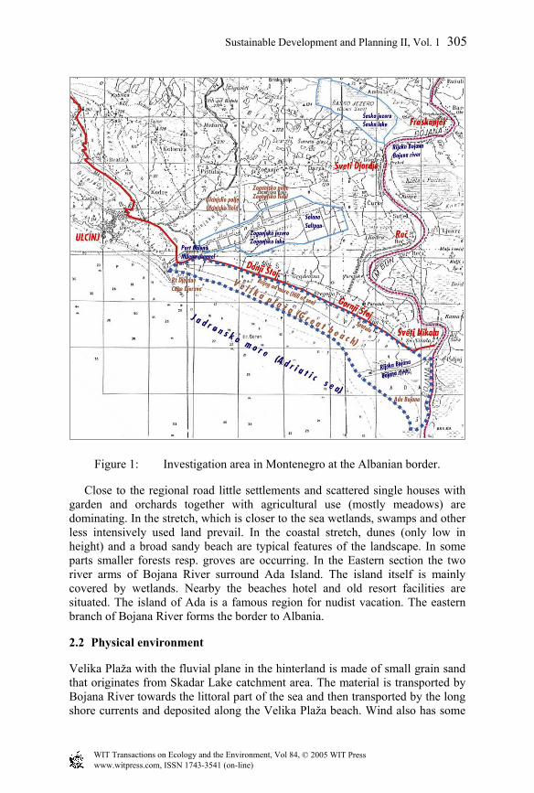
Figure 1: Investigation area in Montenegro at the Albanian border.
Close to the regional road little settlements and scattered single houses with garden and orchards together with agricultural use (mostly meadows) are dominating. In the stretch, which is closer to the sea wetlands, swamps and other less intensively used land prevail. In the coastal stretch, dunes (only low in height) and a broad sandy beach are typical features of the landscape. In some parts smaller forests resp. groves are occurring. In the Eastern section the two river arms of Bojana River surround Ada Island. The island itself is mainly covered by wetlands. Nearby the beaches hotel and old resort facilities are situated. The island of Ada is a famous region for nudist vacation. The eastern branch of Bojana River forms the border to Albania.
2.2 Physical environment
Velika Plaža with the fluvial plane in the hinterland is made of small grain sand that originates from Skadar Lake catchment area. The material is transported by Bojana River towards the littoral part of the sea and then transported by the long shore currents and deposited along the Velika Plaža beach. Wind also has some
© 2005 WIT Press WIT Transactions on Ecology and the Environment, Vol 84, www.witpress.com, ISSN 1743-3541 (on-line)
Sustainable Development and Planning II, Vol. 1 305

influence on erosion and transportation of sand. In the coastal stretch, dunes (only low in height) and a broad sandy beach are typical features of the landscape. The river transports and deposits large amounts of sediment at the delta. Currents deposit the sediments on the Great Beach.
Figure 2: Bojana River mouth with reed vegetation.
Montenegro’s coasts enjoy a Mediterranean climate, having dry summers and mild, rainy winters. The average monthly air temperature for Ulcinj is 15.8°C with an average maximum of 27°C in July/August and an average minimum of about 5°C in January. The average yearly rainfall amounts to 1,109 l/m2. There are 108 days/year of summer days in Ulcinj. Bojana River is partly navigable and forms the natural border between Albania and Montenegro. The river enters the Adriatic Sea via a delta with sandy Ada Island that divides the mouth of the river into two branches. The flow is slow and with small gradient. Due to the large water volumes in the southern Adriatic Sea the water temperature does not decrease below 12°C during wintertime. At the end of summer surface layers reaches temperatures of up to 27°C or more.
2.3 Ecological resources
In the Ulcinj area a particular autochthonous flora is developed due to the special ecological conditions such as maritime impacts of the Adriatic Sea, Mediterranean climate and regular seasonal flooding. Different types of habitats
© 2005 WIT Press WIT Transactions on Ecology and the Environment, Vol 84, www.witpress.com, ISSN 1743-3541 (on-line)
306 Sustainable Development and Planning II, Vol. 1

are present in the investigation area (salted and brackish inland and wetland habitats, dry pastures, natural and semi-natural forests, arable land and orchards). The biotope types with the highest ecological sensitivity and the highest conservation value are the salt-tolerant halophyte vegetation and the natural forest vegetation. Important plant species are the endemic Skadar Oak (Quercus robur ssp. scutariensis) and the highly endangered Sand Lily (Pancratium maritimum.).
Figure 3: Sand Lily (Pancratium maritimum). In Velika Plaža area important aquatic ecosystems such as marshes and permanent water-bearing ponds are located. Important areas for amphibians and reptiles are e.g. both sides of Bojana River (important reproduction areas of several endemic species). West of Bojana River are important nesting areas for protected bird species. The Bojana River is an important habitat for fish and has a specific importance as migration route to the sea for several fish species. The marine part in front of Bojana River mouth is an important feeding area for migratory birds (important fish spawning area). Ada Island is important nesting and feeding area for Pygmy Cormorant and other protected bird species. The Bojana River delta (its right stream) is very important for the feeding and resting of birds during winter and migration. Sasko Lake and Ulcinjska solana are important areas in the vicinity. The area east of the investigated area with a very high ecological value and a high conservation value is proposed as a potential conservation area.
3 Evaluation of environmental suitability and restrictions
3.1 Sensitive areas
In order to provide guidance recommendations about areas, which should be excluded from development, and which areas are regarded suitable for development from environmental view, the ecologically sensitive areas with high conservation value have been identified and are depicted in Table 1. It can be summarised that most of the ecological sensitive areas are located east of the investigation area. Whereas less sensitive areas, with the exception of single locations and the Skadar Oaks are situated in the West.
© 2005 WIT Press WIT Transactions on Ecology and the Environment, Vol 84, www.witpress.com, ISSN 1743-3541 (on-line)
Sustainable Development and Planning II, Vol. 1 307

Table 1: Ecological sensitive areas.
Important areas for birds West of Bojana River - important nesting area for protected bird species
Marine part in front of Bojana River mouth is important feeding area for migratory birds (important fish spawning area)
Ada Island is important nesting and feeding area for Pygmy Cormorant and other protected bird species
The undeveloped open beach, dunes and landscapes and temporary wetlands/marshlands behind the dunes are bird habitats
Important areas for Amphibia/ Reptiles Both sides of Bojana River are important reproduction areas of several endemic species
Area East of existing hotel complex is important reproduction area for lizards and newts
Dunes with halophyte vegetation are habitat for lizards
Important floristic areas Coastal stretch with protected halophyte vegetation
In the Eastern part and on Ada Island occurs natural forest with Skadar Oak, Alder etc.
Small grove in the western part with Skadar Oak
Natural forests in the western part with Skadar Oak, Ash, Poplar, affected by human activities
3.2 Recommendations for area development
It is recommended to restrict future development in the western part. The area in the eastern part of the investigation area with a very high ecological value and a high conservation value is recommended to be protected as a Conservation Area. Development should be clearly restricted, the area should be strictly protected and impacts and damages should be avoided. A golf course which is also a planning option could be integrated into the existing landscape and could act as a buffer zone between more intensively used recreational areas and areas with high ecological value in the East of the investigation area. Single locations in the western part with a high conservation value, such as the Skadar Oak grove should be protected and integrated into the planning as far as feasible, e.g. they could be developed as visiting points for nature interested tourists; cutting of single Skadar Oaks should be avoided as this species is endemic and total abundance in this region is limited. In particular, large and old specimen of Skadar Oak should be conserved. The planned green spaces between the development fields should be designed to protect the natural vegetation of the wetlands, pastures and woodland to preserve the present habitat functions for birds, amphibia and reptiles.
© 2005 WIT Press WIT Transactions on Ecology and the Environment, Vol 84, www.witpress.com, ISSN 1743-3541 (on-line)
308 Sustainable Development and Planning II, Vol. 1

The natural forest with Skadar Oak, Field Ash and White Poplar also has a high conservation value, but at its present state is already affected by human activities. If cutting of this natural forest vegetation cannot be avoided, compensation is regarded feasible. Other smaller single areas with ecological value should be preserved, but if this is not feasible, appropriate compensation measures will be possible. Any measures for conservation compensation, protection or supervision/ management require to be made conditional for the future developers.
3.3 Options for protection, mitigation and enhancement
The further planning in environmental context should be based on the general understanding of a planning policy, which aims at:
• Maintaining and enhancing biodiversity and natural landscapes of the area
• Minimising pollution of soil, air and water and the sea • Minimising the consumption of resources, particularly water and non-
renewable resources • Increasing tourist’s awareness of the importance of these objectives for
sustainable use of the area for recreation. The general concept should be to protect the eastern part of the investigation area and to allow an environmental sound development in the western part of Velika Plaža. The former requires adequate regulatory and institutional setup and monitoring, the latter requires careful planning integrating the existing ecological sensitive areas and protecting habitats of important species. Any habitat damage by visitor pressure should be avoided and kept to a minimum by establishing respective buffer zones around sensitive areas and by guidance of tourists. The effectiveness of the proposed mitigation measures should be monitored and an appropriate institutional setup established. Following main considerations are recommended for protection, avoidance, mitigation and enhancement. Forest vegetation Cutting of Skadar Oak should be avoided to the maximum extent possible. Compensation planting of Skadar Oak should be established if any would be cut on locations designated for future construction. A compensation factor of 1 on 3 is proposed. The area of Spatula (in the East) is an appropriate area for compensation planting. It can be additionally improved if a conservation area would be created in the area of Spatula as mentioned above. It is recommended that important habitats are connected in order to prevent habitat fragmentation. Halophyte vegetation For the access areas to the beach it is recommended to construct boardwalks to bridge the halophyte vegetation. Wooden footpaths are appropriate for that construction. Boardwalks are protection measures at sandy beaches to protect vegetation against destruction by trampling. Examples of these protection
© 2005 WIT Press WIT Transactions on Ecology and the Environment, Vol 84, www.witpress.com, ISSN 1743-3541 (on-line)
Sustainable Development and Planning II, Vol. 1 309

measures can be found at many European beaches. If properly maintained they are well accepted, as boardwalks also facilitate walking in the sandy area. The boardwalks in the access areas should be interconnected to provide a footwalk communication system. Cleaning and maintenance of the beach should be carefully undertaken in order not to damage halophyte vegetation. Use of bulldozers and similar heavy equipment should be limited to the beach area without vegetation at Velika Plaža. Birds The parts of the Velika Plaža near the Bojana River, as well as greater part of Ada Island are a valuable ornithological reserve and should be protected. In these areas the vehicle traffic should be restricted, and tourists, visitors and other pedestrians should only have limited access through guided paths. This area is suitable for controlled bird watching activities. The erection of bird watching towers and appropriate information panels and other information material should be provided. Herpetofauna It is recommended to maintain and protect the wetland areas in the Velika Plaža - Ada Bojana region, especially small ponds and sand-excavation holes. In the forests and groves, overgrazing by domestic animals should be reduced. Some of the existing ponds are polluted by waste. Cleaning of these sites is recommended. In cases where it will not be possible to exclude important ponds and wetlands from the development of tourist complexes, important species (e.g. newt) should be transferred to nearby existing habitats under expert control. The creation of new habitats for loss should be considered (e.g. sand excavation). Furthermore habitat improvement by cleaning (i.e. removing of solid waste) should be considered where appropriate. Landscape In order to minimize impacts on landscape and visual environment due to the erection of buildings and facilities it is recommended to restrict the number of storeys. Planting of green screens and roadside trees are appropriate mitigation measures. Transport and traffic The construction phase will require attention regarding nuisances for the residential areas along main access roads. For operation it is expected that increase in road traffic will lead to additional air pollution and increased ambient noise levels near road sections, which serve as access to the tourist development area. Also traffic communication from the development area to Ulcinj town may increase and result in traffic congestion. The development should include attractive public transport to minimise adverse impacts.
© 2005 WIT Press WIT Transactions on Ecology and the Environment, Vol 84, www.witpress.com, ISSN 1743-3541 (on-line)
310 Sustainable Development and Planning II, Vol. 1

Waste and water Presently it is not clear whether the new tourist resort development will be connected to a possible future municipal wastewater treatment plant. It is recommended to construct appropriate wastewater treatment facilities for Ulcinj, which can also effectively treat the effluents from the tourism complex. Any additional discharge of untreated sewage water is environmentally unacceptable and will be no sound perspective for tourism development. In this context the existing high transparency of the seawater should be highlighted as a valuable asset (also attractive for scuba-diving). It is recommended to develop a waste management concept which can be an effective tool to reduce waste amounts resp. enhancing the use of more environmental friendly products and encourage recycling of residues in the tourist as well as in Ulcinj municipality. Use of resources In general, drinking water resources should be responsibly managed. Presently, the pipe distribution system network in the Uljincj service area has losses due to leakage up to 60%, this should clearly be improved. Tourist development will increase water demand in summer peak months. The project should implement modern water saving techniques to reduce consumption, e.g. rainwater collection from roofs and underground storage, separate grey water pipes for e.g. toilet flushing etc. The new development should demonstrate saving on non-renewable energy by implementing solar heating (hot water etc.), photovoltaic etc. Golf course In case the planning pursues to establish a golf course, excessive use of ground water for irrigation should be avoided by respective techniques. It is recommended that a separate detailed environmental assessment including green space concept with the intention to make the golf course function as an ecological buffer zone between the intensively used western area and the areas proposed for protection in the east should be undertaken. Marina The establishment of a marina is part of the development planning discussion at the present project stage. It is recommended that in case of building of a marina, clear priority should be given to a location within the Port Milena. A construction at the river mouth of Bojana should be avoided for ecological as well as hydraulic reasons. It is important to understand that any construction within this site would significantly disturb or stop further feeding of the beach and cause erosion of the beach at Velika Plaža.
4 Results
Phase 1 EIA consisted of a strategic oriented plan Environmental Assessment aiming at evaluating the principal suitability of tourism development of Velika
© 2005 WIT Press WIT Transactions on Ecology and the Environment, Vol 84, www.witpress.com, ISSN 1743-3541 (on-line)
Sustainable Development and Planning II, Vol. 1 311

Plaza from an environmental perspective. As a result, the western part of Velika Plaza was identified as being suitable for development, with infrastructure already installed and significantly influenced by present land use. The eastern part however, with extended marshland area, natural forest vegetation and halophyte vegetation was found to be of high conservation value, in particular due the function of the different habitats for bird life. In general, it was found that the ecological value and sensitivity of Velika Plaza increases from West to East. These findings were adopted by the development concept of the Masterplan. As a consequence only the western half of the Velika Plaza was envisaged for development, which is intended to be realised stepwise from west to east with a total of six development modules alternating with green corridors. To account for habitat sensitivities, the eastern development modules were set back further away from the beach in order not to adversely impact habitats in particular the halophytic vegetation and the marshlands behind the dunes, which constitute important bird habitats. A major recommendation of the Phase 1 EIA study is that a nature conservation area should be established in the eastern part of Velika Plaza. The Phase 2 EIA Study, on the example of the development module No. 2 was selected as the prototype for the urban design planning in the Masterplan, demonstrated how environmental impact assessment and environmental planning should be integrated into the planning layout of the single development modules. The area envisaged is located in the western part of the investigation area and by this complies with the general recommendations given above. The study focused on the actual area selected for development and investigated also impacts during the construction phase. The location of single Skadar Oak trees, esp. tall and old trees worth to be preserved, was surveyed. The actual status of the halophyte vegetation including existing impairments was investigated. Both results provided planning guide for placements of buildings and structures, roads etc. Appropriate measures have been developed to mitigate adverse impacts. An Environmental Management Plan was developed to ascertain compliance with agreed environmental protection standards and environmental good practices for construction and operation of the planned hotel facilities including mitigation measures and monitoring.
References
[1] Busković, V. and Ražnatović, V.; Environmental Management in Montenegro. Public Document. Ministry of Environmental Protection. Podgorica, 1997.
[2] ERM Lahmeyer International; Environmental Assessment of Urban and Tourism Development Plan Ulcinj, Montenegro. Phase 1, Environmental Screening and Initial Assessment. 2002.
[3] ERM Lahmeyer International; Environmental Assessment of Urban and Tourism Development Plan Ulcinj, Montenegro. Phase 2, Environmental Study of Urban Design Plan for Development of Module No. 2 - Environmental Impact Assessment. 2002.
© 2005 WIT Press WIT Transactions on Ecology and the Environment, Vol 84, www.witpress.com, ISSN 1743-3541 (on-line)
312 Sustainable Development and Planning II, Vol. 1

[4] Karajovic, S. (eds); Stvorene vrijednosti (Manmade resources). Basic study for the Coastal Area Spatial Plan. RZUP, Podgorica and MonteCEP, Kotor, 1999.
[5] Pulevic, V.; Bibliografija o flori i vegetaciji Crne Gore. CANU, Bibliografija 1, 1-235, Titograd, 1980.
[6] Puzovic, S., Grubac, B.; Federal Republic of Yugoslavia. pp. 725-745 in M.F. Heath and M.I. Evans, eds. Important Bird Areas in Europe: Priority sites for conservation.2: Southern Europe. Cambridge, UK: BirdLife.
[7] Schneider-Jacoby, M.; Euronatur, Short international assessment of the ecological importance of the Ulcinj area including the Bojana estuary and the Velipoja Lagoon/AL (internal paper). 2002.
[8] Shoqata, M.; Buna Bojana; Tirana, 2000. [9] SR Montenegro; Act on Protection of Rare, Endangered and Threatened
Animal and Plant Species (Rjesenje o stavljanju pod zastitu rijetkih, prorijedjenih, endemicnih i ugrozenih biljnih i zivotinjskih vrsta). Official Gazette of SR Montenegro, Nr.36/82, Podgorica, 1982.
© 2005 WIT Press WIT Transactions on Ecology and the Environment, Vol 84, www.witpress.com, ISSN 1743-3541 (on-line)
Sustainable Development and Planning II, Vol. 1 313