EnvironmEntal changEs and human mudanças ambiEntais E ... · 203 Modelo de gestão e circulação...
25
MUDANçAS AMBIENTAIS E INTERAçãO HUMANA NA FACHADA ATLâNTICA OCIDENTAL ENVIRONMENTAL CHANGES AND HUMAN INTERACTION ALONG THE WESTERN ATLANTIC EDGE A. Campar Almeida • Ana M. S. Bettencourt • D. Moura Sérgio Monteiro-Rodrigues • Maria Isabel Caetano Alves
Transcript of EnvironmEntal changEs and human mudanças ambiEntais E ... · 203 Modelo de gestão e circulação...

Mudanças aMbientais e interação huMana na fachada atlântica ocidental
environMental changes and huMan interaction along the western atlantic edge
Centro de CiênCias da terra
A. Campar Almeida • Ana M. S. Bettencourt • D. Moura Sérgio Monteiro-Rodrigues • Maria Isabel Caetano Alves
En
vir
on
mE
nt
al
ch
an
gE
s a
nd
hu
ma
n in
tE
ra
ct
ion
alo
ng
th
E w
Est
Er
n a
tl
an
tic
Ed
gE
mu
da
nç
as
am
biE
nt
ais
E i
nt
Era
çã
o h
um
an
a n
a f
ac
ha
da
at
lân
tic
a o
cid
Ent
al
ISBN: 978-989-97140-1-4
9 789899 714014

IMPRINT / FICHA TÉCNICA
Title: ENVIRONMENTAL CHANGES AND HUMAN INTERACTION ALONG THE WESTERN ATLANTIC EDGEMUDANÇAS AMBIENTAIS E INTERAÇÃO HUMANA NA FACHADA ATLÂNTICA OCIDENTAL
Eds. A. Campar Almeida, Ana M. S. Bettencourt, D. Moura, Sérgio Monteiro-Rodrigues and Maria Isabel Caetano Alves
Editors: APEQ - Associação Portuguesa para o Estudo do QuaternárioCITCEM - Centro de Investigação Transdisciplinar “Cultura, Espaço e Memória”, financiado por Fundos Nacionais, através da FCT – Fundação para a Ciência e Tecnologia, no âmbito do projeto PEstOE/HIST/UI4059/2011.CEGOT - Centro de Estudos de Geografia e Ordenamento do TerritórioCGUP - Centro de Geologia da Universidade do PortoCCT - Centro de Ciências da Terra da Universidade do Minho
Editorial advisory committee:António Monge Soares, Fernando da Silva Rebelo, Helena Granja, Isabel Figueiral, João Luís Cardoso, João Pais, Lúcio Cunha, Maria da Conceição Freitas, Nuno Bicho, Pedro Proença e Cunha, Philippa Ascough, Ramon Fábregas Valcarce.
Cover image: Digital terrain model of the Armação de Pêra, Algarve, Portugal (by Leandro Infantini)
Composition, printer and bound by Sersilito-Empresa Gráfica, Lda.
Edition: 500 Exemplares
Legal deposit: 350801/12
ISBN: 978-989-97140-1-4
Coimbra, October 2012
Centro de CiênCias da terra

Mudanças ambientais e interação humana na fachada atlântica ocidental
Environmental changes and human interaction along the western atlantic edge
A. Campar Almeida, Ana M. S. Bettencourt, D. Moura Sérgio Monteiro-Rodrigues, Maria Isabel Caetano Alves (eds.)
2012

ContentsÍndice
7 Foreword
IMethodologyMetodologia
13 Marine reservoir effects: problems and prospects for radiocarbon datingPhilippa L. Ascough
27 Radiocarbon dating of aeolianite formationA. M. Monge Soares, A. Ramos Pereira, J. M. Matos Martins & P. J. Portela
43 Diatomáceas como potencial ferramenta para reconstituições paleoecológicasA. Gomes, T. Boski & D. Moura
IIPalaeoenvironmental Changes and Human Activity Mudanças Paleoambientais e Actividade Humana
51 Reconstructing Holocene evolution in the archaelogical site of Campo Lameiro (NW Spain): an interdisciplinary approach to geoarchaeologyManuela Costa ‑Casais, Antonio Martínez Cortizas, Joeri Kaal, Maria Isabel Caetano Alves & Felipe Criado ‑Boado
71 Sedimentological analysis of relict slope deposits from Serra da Estrela (Portugal): first resultsAlexandre Trindade, G. Vieira & C. Schaefer
79 Environmental changes in the westernmost Cantabrian range during the postglacial period: the Pena Velosa (Muniellos, Asturias) pollen recordC. Muñoz Sobrino, F. J. Suárez Pérez, H. S. Nava Fernández, M.A. Fernández Casado, L. Gómez ‑Orellana, M. A. Rodríguez ‑Guitián, J. A. Fernández Prieto & P. Ramil ‑Rego
95 Refúgios para árvores temperadas caducifólias na área litoral do Noroeste Ibérico durante o último período glaciar Luis Gómez ‑Orellana, Pablo Ramil Rego & Castor Muñoz Sobrino
107 História do fogo durante o holocénico na serra da Estrela, Portugal: resultados preliminares João Araújo, Simon E. Connor, Jacqueline F. N. van Leeuwen & Willem O. van der Knaap
115 Firewood and timber exploitation during the 3rd and 2nd millennia BC in the Western façade of the Iberian northwest: wooden resources, territories and chaîne opératoireMaría Martín ‑Seijo, Ana M. S. Bettencourt, Emilio Abad ‑Vidal & Juan C. López García

IIIFauna and Human Activity Fauna e Actividade Humana
139 O povoamento humano do paleo -estuário do Sado (Portugal): problemáticas em torno da ocupação dos concheiros mesolíticosMariana Diniz & Pablo Arias
159 Preliminary analysis of the spatial relationships between faunal and lithic remains on the Mesolithic shelmidden of Cabeço da Amoreira (Muge, Portugal) Rita Dupont de Sousa Dias, João Cascalheira, Célia Gonçalves, Cleia Detry & Nuno Bicho
165 Burial practices in Muge shell middens (Portugal): state of the artOlívia Figueiredo
171 Acerca da influência ambiental e humana nos moluscos do Monte Molião (Lagos, Portugal)Cleia Detry & Ana Margarida Arruda
IVMinning and Environmental Impact Mineração e Impacto Ambiental
187 Impacto ambiental da primeira mineração e da metalurgia especializada no Sudoeste da Península IbéricaNuno Inácio, Francisco Nocete, José Miguel Nieto, Moisés R. Bayona, Joaquín Delgado, T. Boski & Daniel Abril
203 Modelo de gestão e circulação de sílex há 5000 BP na faixa litoral entre Nazaré e Peniche (Estremadura portuguesa) Patrícia Jordão & Nuno Pimentel
VEvolution of Coastal Land Evolução do Litoral
219 Mean sea level and coastline -Late QuaternaryD. Moura, A. Gomes, S. Gabriel & J. Horta
227 Utilização de ferramentas SIG para o estudo da morfologia submersa da bacía de Armação de Pêra (Algarve) Leandro Infantini, D. Moura & Nuno Bicho
243 Guidoiro Areoso. Megalithic cemetry and prehistoric settlement in the Ría de Arousa (Galicia, NW Spain) José Manuel Rey García & Xosé Ignacio Vilaseco Vázquez
259 Evolução recente (décadas de 1950-2010) da morfologia dos deltas do Catumbela e Cavaco (Benguela, Angola) Pedro A. Dinis, Luís S. Silva, João Huvi, Jorge M. Dinis & Pedro P. Cunha
265 Land use evolution of the coast Blanc Cap to Cantin Cap (Moroccan Atlantic coast): cartography by aerial photography analysisKhalid el khalidi, Abdenaim Minoubi, Bendahhou Zourarah & Ahmed Aajjane

51
RECONSTRUCTING HOLOCENE EVOLUTION IN THE ARCHAEOLOGICAL SITE OF CAMPO LAMEIRO
(NW SPAIN): AN INTERDISCIPLINARY APPROACH TO GEOARCHAEOLOGY
Manuela Costa -Casais1, Antonio Martínez Cortizas2, Joeri Kaal1, Maria Isabel Caetano Alves3 & Felipe Criado -Boado1
Abstract: The objective of this research was to evaluate the potential of sedimentary deposits to be used for the reconstruction of Holocene environmental changes in the Campo Lameiro area (NW Spain). We focused on the evolution of landforms as a key factor in the configuration of alluvial and colluvial sequences. The geomorphological and sedimentological studies indicate that the distribution of landforms is a main factor to understand the formation of colluvial soils. Granitic macroforms dominate the present landscape, constituted by alveolar depressions surrounded by crests and slabs. The thickest sedimentary deposits were found in the depressions. We identified two main stratigraphic units: a basal inorganic layer represented by alluvio -colluvial sediments, formed in a highly energetic environment, probably dating to the Younger Dryas (>11000 years BP), and a younger unit of thick sandy, blackish, organic matter rich, colluvium. The oldest radiocarbon age obtained for this unit indicates that it may have started to form by 11240 -11130 cal. BP. The Holocene colluvial soils show discontinuities in grain size, soil reaction, elemental composition of the inorganic phase and molecular composition of the soil organic matter. These features are evidence of the occurrence of several phases of erosion/sedimentation (i.e. landscape instability), some of which were coeval with known periods of Holocene abrupt climate change – the 8.2 ka event, the beginning of the Neoglaciation (ca. 6 ka BP) or the 2.8 ka wet/cold event. But some of the most intense phases coincided with increased human pressure on landscape during the Neolithic, Bronze Age, Roman Period, and the Middle Ages. Charcoal layers, burnt soil layers and the highly aromatic nature of the soil organic matter point to frequent fire episodes. Pollen studies also indicated a sharp decrease in forest cover beginning by ca. 6000 cal BP, which seems to have been accompanied by a progressive soil acidification with time. Our research suggests that both climate and human activities played an important role in the formation of colluvial deposits in the area, confirming that they are valuable geoarchives of Holocene environmental change from a geoarchaeological approach.
Key ‑words: Geoarchaeology; Geoarchives; Palaeoenvironmental reconstruction; Holocene.
Resumo: Neste trabalho estudaram -se os depósitos sedimentares na área da estação arqueológica de Campo Lameiro (NW Espanha), com o objetivo de avaliar o seu potencial para a reconstrução
1 Institute of Heritage Sciences (Incipit). Spanish National Research Council (CSIC), San Roque, 2. 15704 Santiago de Compostela, A Coruña, España, manuela.costa [email protected], [email protected], felipe.criado [email protected];2 Department of Soil Science and Agricultural Chemistry, Faculty of Biology, Campus Sur, University of Santiago de Compostela (USC), 15782 Santiago de Compostela, A Coruña, España, antonio.martí[email protected] Geology Centre of the University of Porto and Earth Sciences Centre of the University of Minho, Univer-sity of Minho, Campus de Gualtar, 4710 -057 Braga, Portugal, [email protected]

52
Manuela Costa -Casais, Antonio Martínez Cortizas, Joeri Kaal, Maria Isabel Caetano Alves & Felipe Criado -Boado
das mudanças ambientais holocénicas, no que diz respeito à evolução do relevo como um fator determinante na configuração das sequências aluviais e coluviais. Os estudos geomorfológicos e sedimentológicos indicam que a distribuição das geoformas é um fator principal para compreender a formação dos solos coluviais. Na paisagem atual da área de estudo dominam as macroformas gra-níticas, constituídas por depressões alveolares rodeadas por cristas e lajes. Os depósitos sedimentares mais espessos ocorrem nas depressões. Identificaram -se duas unidades estratigráficas principais: uma camada basal inorgânica, representada por sedimentos aluvio -coluvionares, formados em ambiente altamente energético, provavelmente datados do Dryas recente (> 11000 anos BP) e uma unidade mais recente, arenosa, escura, rica em matéria orgânica, de solos coluviais. A datação mais antiga, obtida por radiocarbono para esta unidade, indica que ela pode ter começado a formar -se há 11240 -11130 cal. BP. Os solos holocénicos coluviais apresentam descontinuidades na dimensão das partículas, na reação do solo, na composição da fase inorgânica e na composição molecular da matéria orgânica do solo. Estas características comprovam a ocorrência de diversas fases de erosão / sedimentação (ou seja, de instabilidade da paisagem), algumas das quais são contemporâneas dos períodos de mudança climática abrupta conhecidos no Holocénico – o evento a 8,2 ka, no início da Neoglaciação (ca. 6 ka BP) ou o evento húmido e frio a 2,8 ka. Mas, algumas das fases mais intensas coincidiram com o aumento da pressão humana sobre a paisagem durante o Neolítico, a Idade do Bronze, o Período Romano e na Idade Média. A ocorrência de camadas de carvão, de solos queimados e a natureza distintamente aromática da matéria orgânica do solo apontam para episódios de incêndios frequentes. Os estudos polínicos também indicaram uma diminuição acentuada da cobertura florestal, com início a ca. 6500 cal BP, que parece ter sido acompanhada por uma progressiva acidificação do solo ao longo do tempo. O trabalho de investigação realizado, sugere que as mudanças climáticas e as atividades humanas desempenharam ambos um papel importante na formação dos depósitos coluviais na área. De acordo com estudos anteriores, isto indica que os referidos depósitos são geoarquivos valiosos para reconstruir as mudanças ambientais holocénicas, a partir de uma abordagem geoarqueológica.
Palavras ‑chave: Geoarqueologia; Geoarquivos; Reconstrução paleoambiental; Holocénico.
1. INTRODUCTION
Geoarchaeology applies techniques and methods of the Human Sciences and Geosciences to reconstruct landscape evolution at different geographical scales. Huckleberry (2000), slightly modifying the perspective offered by Gifford & Rapp (1985), defines geoarchaeology -as “the application of Earth Science method and theory to understanding the human past”, a definition broad enough to include experts from a range of scientific backgrounds to contribute towards the comprehension of human prehistory. The recent application of Earth Science techniques for the analysis of soils and sediments at archaeological sites has generated new levels of understanding of human activities and use of the landscape. Soils and sediments are composed of similar components, and form a continuum over the landscape. Their study can reveal how humans in prehistory used it and defined space through their activities. However, the techniques do not fully address several persistent problems associated with making inferences about past human activity from soils. The presence or absence of elements alone may be inadequate to effectively understand the relationship between soil properties and pedogenic, diagenetic and/or anthropogenic processes. As a result, multi -method approaches are becoming standard practice in pedoarchaeology (Walkington 2010).

53
Reconstructing holocene evolution in the archaeological site of Campo Lameiro (NW Spain): an interdisciplinary approach to geoarchaeology
Soil is an archive that can be used to interpreted archaeological deposits (Mandel & Bettis 2001). Soil processes can contribute to an understanding of archaeological sites because the soil can act as an archive in a variety of ways (Walkington 2010): (a) soils represent process -response systems through the unique interaction of the soil forming factors at a particular site; (b) soils reflect soil processes occurring both vertically and laterally; (c) soils can store palaeoecological indicators such as pollen, phytoliths, bones, etc, and are thus archives of environmental change (Lowe & Walker 2006); (d) soils are geoarchives, even when transport has occurred, the resulting colluvial soils can still store environmental information (Leopold & Völkel 2007); and (e) soils can record human use and management of a landscape.
A pedogeomorphological approach at a landscape scale (Gerrad 1992) linked to multiproxy indicators for dating and climate reconstruction can help to track past processes in detail. Surface formations contain information inherent in their geomorphological evolution. Climate and human activities played an important role in the formation of the alluvial - colluvial deposits. The geomorphological data together with other palaeoenvironmental proxies define them as useful geoarchives for the reconstruction of Holocene environmental change (Costa -Casais et al. 2008). Colluvial soils, given their wide distribution and the time expand covered by them, may also be crucial to decipher and understand human responses to climate change and the impact of anthropogenic activities on the environment at the local and regional scales (Leopold & Völkel 2007).
This work is part of an interdisciplinary study made in the area of the Rock Art Park of Campo Lameiro (Galicia, NW Spain). In this survey the Earth Science´s disciplines played a major role in complementing the archaeological research. Our paper focuses on the evolution of landforms – rocky substrate, sediments and soils – as a key factor for geoarchaeological analysis, with the objective to evaluate the potential of sedimentary deposits to be used for the reconstruction of Holocene environmental changes. This approach is particularly important in the studied area because of the scarcity of available archaeological remains. Granite landforms, soils and sediments are unique archives that have recorded transformations in the landscape linked to cultural evolution (Costa -Casais et al. 2009).
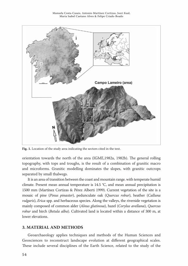
2. REGIONAL SETTING
The study area is located within Rock Art Park of Campo Lameiro (Pontevedra--Galicia, NW Spain), on the upper part of the Monte Paradela hill (330 m a.s.l.) and 25 km E of the Atlantic Ocean, in the Eurosiberian (Atlantic) phytogeographic region (Fig. 1). The area appears as an almost isolated hill, at the centre of the watershed, defined by the river network, and surrounded by fractures running from N -S and E -W as well as by numerous joints that break the substrate running N -S, EW, NW -SE and NE -SW. The lithology is homogenous throughout the park. It is comprised of two mica granitic rocks with megacrystals of K -feldspars, with minerals showing a certain degree of
54
Manuela Costa -Casais, Antonio Martínez Cortizas, Joeri Kaal, Maria Isabel Caetano Alves & Felipe Criado -Boado
orientation towards the north of the area (IGME,1982a, 1982b). The general rolling topography, with tops and troughs, is the result of a combination of granitic macro and microforms. Granitic modelling dominates the slopes, with granitic outcrops separated by small thalwegs.
It is an area of transition between the coast and mountain range, with temperate humid climate. Present mean annual temperature is 14.5 °C, and mean annual precipitation is 1500 mm (Martínez Cortizas & Pérez Alberti 1999). Current vegetation of the site is a mosaic of pine (Pinus pinaster), pedunculate oak (Quercus robur), heather (Calluna vulgaris), Erica spp. and herbaceous species. Along the valleys, the riverside vegetation is mainly composed of common alder (Alnus glutinosa), hazel (Corylus avellana), Quercus robur and birch (Betula alba). Cultivated land is located within a distance of 300 m, at lower elevations.
3. MATERIAL AND METHODS
Geoarchaeology applies techniques and methods of the Human Sciences and Geosciences to reconstruct landscape evolution at different geographical scales. These include several disciplines of the Earth Science, related to the study of the
Fig. 1. Location of the study area indicating the sectors cited in the text.

55
Reconstructing holocene evolution in the archaeological site of Campo Lameiro (NW Spain): an interdisciplinary approach to geoarchaeology
fossil – plant and animal – record and those dedicated to the study of the material remains of cultures. The study on past environmental changes in the Rock Art Park of Campo Lameiro has been carried out using the colluvial formations to reconstruct changes in the landscape. The disciplines involved in the study were: (a) disciplines of Earth Sciences: geomorphology, sedimentology, pedology, geochemistry, mineralogy, as well as computer techniques applied to geographic studies and geographic information systems; (b) disciplines that are responsible for studying the fossil or subfossil record: palynology and anthracology; (c) disciplines that deal with the study of material culture remains: archaeology and prehistory. The archives showed information about past soil erosion and landscape change. The signals are geomorphological features, morphological soil features, physico--chemical properties, changes in elemental and mineral composition, information
Fig. 2. Steps followed in the multi -archive, multi -proxy, approach to palaeoenvironmental reconstruc-tion in NW Iberia. Modified from Martínez Cortizas (2000).

56
Manuela Costa -Casais, Antonio Martínez Cortizas, Joeri Kaal, Maria Isabel Caetano Alves & Felipe Criado -Boado
on past vegetation, etc. Methodological point of view, the study was divided into four phases, following the guidelines suggested by Martínez Cortizas (2000) (Fig. 2).
The first phase implied an inventory of all available information about the area (maps, climatic data, geology, hydrography, previous studies, etc.), which aided to the current understanding of the peculiarities of the landscape under study. This phase was the basis for setting the strategies to follow in the planning the work.
In a second phase, fieldwork was carried out in order to differentiate landforms. The work started with the interpretation of aerial photographs, to define relief units
Fig. 3. Georeferenced trenches, soil profiles and rock art pannels were incorporated into a digital terrain model to conform a GIS database. Modified from Costa -Casais et al. (2009).

57
Reconstructing holocene evolution in the archaeological site of Campo Lameiro (NW Spain): an interdisciplinary approach to geoarchaeology
and how they are related to the regional geomorphologic context. This information was used for designing and subsequent opening of 43 ditches in ten sectors, with a total length of 2.5 km. Two main criteria were followed: (a) the variety of morphological units, their location in sectors prone to sediment/soil accumulation, in erosive/accumulative or erosive areas, and (b) their proximity to the rock carvings. Systematic descriptions of the sedimentary facies were made in order to define the vertical and lateral stratigraphic changes. More detailed descriptions were performed for a small number of sedimentary sequences in each ditch, which generally coincided with the deepest ones and showing the greatest diversity of facies. The location of the trenches, the sedimentary sequences and the rock art panels were incorporated into a digital terrain model, then combined with the information obtained from the other disciplines involved – geomorphology, archaeology and pedology – to conform a GIS database (Costa -Casais et al. 2009) (Fig. 3).
In the third phase, eleven pedo -sedimentary sequences (with depths between 1.5 and 3 m) were selected for high -resolution sampling of soils and sediments. Of these, five were studied in more detail. Sampling was systematic and took into account the variability of each sediment layer or soil cycle.
The fourth phase concerned the analytical procedures. These included abiotic (physico -chemical properties: soil reaction, elemental composition of the inorganic phase, mineralogy, etc.) and biotic (pollen record, charcoal, molecular composition of the organic matter, etc.) proxies. In a relatively small area several colluvial formations were analysed and supported by extensive radiocarbon dating.
4. RESULTS AND DISCUSSION
4.1. Geomorphological context: granite landscape
The landscape of the study area is dominated by granite outcrops separated by small thalwegs. The tops are organized following a polygonal pattern resulting from long -term granite weathering that is controlled by a joint system running from N -S and E -W directions. This tectonic pattern defines an alignment with a series of tops and granitic slabs interspersed with small low -lying areas known as alveolar depressions or alveoli (Fig. 4). The lithological, structural and geomorphological variety corresponds to that of granitic landforms, classified into two groups, depending on their size. The megaforms or large -scale forms are divided into convex – castle -kopje, tor, block – located in a high topographic position, and concave forms – alveoli or weathering basins – at lower topographic positions. The microforms or smaller forms, consist of: (a) microforms without any evident relationship to the rock structure – linear forms (gutters) and pointed forms (gnammas, tafone); and (b) microforms with an evident relationship with the rock structure – linear forms (polygonal cracking, nerviate forms), and flat forms (broken blocks) (Godard 1977; Twidale 1986, 1989). At an intermediate topographic position are the granitic slabs, minor forms that are related

58
Manuela Costa -Casais, Antonio Martínez Cortizas, Joeri Kaal, Maria Isabel Caetano Alves & Felipe Criado -Boado
to the structure of the rock (mainly joints), flat in shape and slightly tilted down. Granitic macroforms dominate the landscape, constituted by alveolar depressions surrounded by crests and granitic slabs. The rock art panels of Os Carballos and Os Cogoludos are good examples, carved on slabs, in which the joints, narrow channels and other linear features are observed (Costa -Casais et al. 2009).
Granite morphogenesis is the result of the interaction of a number of factors: rock type, tectonics, climatic changes, human activities and the associated morphogenetic systems, which acted either directly or indirectly on the granitic substrate to form
Fig. 4. The tops are organized following a polygonal pattern resulting from long -term granite wea-thering that was controlled by a joint system running from N -S and E -W directions. Modified from Costa -Casais et al. (2009).

59
Reconstructing holocene evolution in the archaeological site of Campo Lameiro (NW Spain): an interdisciplinary approach to geoarchaeology
the present landforms seen in Campo Lameiro. Alveolar depressions are the most representative major landforms. Their formation, as already mentioned, has been controlled by the joint system that channelled both the upwards and downwards alteration processes (hydrothermal/thermal), and the downwards weathering and pedogenetical processes (Vidal Romaní 1989). Their final shape is also linked to fluvial and alluvial processes that gradually uncovered the megaforms. These alveoli are covered by alluvial -colluvial deposits and colluvial soils. They played a decisive role in the preservation of sedimentary sequences in Campo Lameiro.
4.2. Sedimentary sequences: alluvial deposits and colluvial soils
The thickest sedimentary deposits are located in the alveolar depressions, where sedimentation was favoured over erosion. The alveoli shape types have conditioned the evolution of the surface formation. Depending on where they are located, superficial formations can be classified into four main groups: (a) erosive ‑cumulative alveoli: situated in high potential energy areas prone to both erosion and sedimentation in comparable intensities; (b) coalescing alveoli: located in low energy areas where accumulation dominated, such as the channelled depressions; (c) asymmetric alveoli: formations that cover alveoli found at intermediate positions, located next to the base of a granite slab and with their external border eroded; and (d) type alveoli: covered alveoli floors (Costa -Casais et al. 2008) (Fig. 5). The sedimentary sequences show two types of stratigraphic units: a basal inorganic sedimentary layer, covering the granitic substrate or the deeply weathered saprolite, with varying thickness (50 to 100 cm) and a younger, thicker (up to 250 cm) layer represented by colluvial, polycyclic soils, rich in organic matter.
The basal inorganic sedimentary unit is the result of the erosion and transport of the strongly weathered saprolite mantle, generating a large amount of material. The mineralogical composition, shape of the clasts, degree of weathering and the type of fine matrix refers to a morphogenetic system controlled by water. The sedimentary facies are quite varied. There are heterogeneous and chaotic layers: cross -bed, linear structures and lenticular sand layers, related to alluvial transport, which are only preserved in alveoli bottoms (Costa -Casais et al. 2009) (Fig. 6). They were formed under an alluvial morphogenetic system, probably as small alluvial fans, with three main channels following the natural thalwegs in the area (Fig. 7). Fans are dynamic systems that can temporarily store sediments (Gómez Villar 1996) as a result of a sporadic yet continuous supply, in geological terms, in a highly energetic environment. Alluvial fans depend equally on torrential rainfall and its ability to produce large amounts of sediment. At PRD -I (Fig. 6) this basal unit is fossilized by a palaeosol that provided a radiocarbon age of 8480 -8320 cal BP (Costa -Casais et al. 2009) and in PRD -IV (Fig. 6) it is covered by a soil cycle dating back to ca. 11260 -10905 cal BP (Kaal et al. 2011), indicating that the fans are at least late Pleistocene or early Holocene in age. Their formation in the study area may be associated with the Younger Dryas

60
Manuela Costa -Casais, Antonio Martínez Cortizas, Joeri Kaal, Maria Isabel Caetano Alves & Felipe Criado -Boado
(11000 -10000 BP), a severe coold spell with rainy conditions, as represented in sedimentary levels by important alluvial -colluvial accumulations that are well defined in the northwestern Iberian Peninsula (Martínez Cortizas & Moares Domínguez 1995; Valcárcel Díaz 1998). This is consistent with recent research on fluvial activity in Spain that suggests increased activity by 11170 -10230 BP and 9630 -8785 BP (Thorndycraft & Benito 2006).
Fig. 5. Different types of small depressions (alveoli) identified in the Campo Lameiro Rock Art Park area. The eroded soil from the slopes was accumulated in these reduced areas named “alveoli”, where sedimentation was favoured. Modified from Costa -Casais et al. (2008).

61
Reconstructing holocene evolution in the archaeological site of Campo Lameiro (NW Spain): an interdisciplinary approach to geoarchaeology
The younger unit is represented by colluvial layers that show an apparently homogeneous morphology: black to dark brown A horizons (mineral soil rich in organic matter), loamy sand to sandy loam texture, with abundant quartz and muscovite, acidic and with high C/N ratios. Nonetheless these soils exhibit significant vertical changes in grain size, charcoal layers, burnt soil layers, pH, elemental composition of inorganic phase (Ti, Zr, Fe, Al). Also, the highly aromatic nature of the soil organic matter, originating from pyrogenic material formed during palaeofires points towards recurrent fire episodes (Kaal et al. 2008). Sedimentary and geochemical features, supported by extensive radiocarbon dating, are evidence of the occurrence of several phases of erosion/sedimentation (i.e. landscape instability), some of which were coeval with known periods of Holocene abrupt climate change – the 8.2 ka event, the beginning of the Neoglaciation (ca. 5500 ka BP) and the 2.8 ka wet/cold event (Costa -Casais et al. 2009). But some of the most intense phases coincided with increased human pressure on the landscape during the Neolithic, Bronze Age, Roman Period, and the Middle Ages.
Fig. 6. Three examples of sedimentary sequences in the Campo Lameiro Rock Art Park area. Sedimen-tological and stratigraphic schemes and legend of PRD -I, PRD -IV, PRD -IVa alluvial and colluvial soils.

62
Manuela Costa -Casais, Antonio Martínez Cortizas, Joeri Kaal, Maria Isabel Caetano Alves & Felipe Criado -Boado
4.3. Landscape change vs induced environmental changes
Colluvial soil dynamicsMartínez Cortizas et al. (2009a, 2012) analyzed changes in soil accumulation/
erosion rates in the Rock Art Park of Campo Lameiro – in a relatively small area (less than 1 km2) – using several colluvial formations and based on high -resolution sampling of soils and sediments and extensive radiocarbon dating. The record of average soil accumulation rates revealed sixteen erosion/accumulation periods, eight of them
Fig. 7. The location of the granite outcrops and the alveolar depressions defines three main flow paths within the area that channelized the transport of water and sediments to the valleys. Modified from Costa -Casais et al. (2009).

63
Reconstructing holocene evolution in the archaeological site of Campo Lameiro (NW Spain): an interdisciplinary approach to geoarchaeology
with an equivalent accumulation rate greater than 10 tm ha -1 a1 (Fig. 8). The estimated duration of these phases was between 410 and 130 years, except the oldest one, which may have lasted for 500 years. The length of these phases seems to have decreased substantially in two steps: one around 6500 cal BP and other one around 2700 cal BP. The average duration prior to 6500 cal BP was 600 years, between 6500 and 2700 cal BP was 310 years and after 2700 cal BP it was 160 years (Fig. 8). As a result of increased erosion the transport of soil and sediments caused a progressive accretion and infilling of the alveolar depressions. It was possibly at this time, around 6000 cal BP (the Neolithic), when the granite outcrops started to become exhumed together with the upper part of the slabs. Studies on landscape evolution in NW Spain indicate
Fig. 8. Holocene changes in soil accumulation/erosion rates, vegetation change, charcoal content in colluvial soils and soil reaction in Campo Lameiro, Pontevedra (Martínez Cortizas et al. 2009a).

64
Manuela Costa -Casais, Antonio Martínez Cortizas, Joeri Kaal, Maria Isabel Caetano Alves & Felipe Criado -Boado
that soil erosion began to be a widespread phenomenon at least from 6000 -5500 cal BP. Most of these phases were also detected by synchronous erosion episodes in other areas of NW Spain (Benito et al. 1991; Martínez Cortizas & Moares Domínguez 1995; Martínez Cortizas et al. 1999, 2000).
The role of climate changes in the formation of colluvial soils was also addressed by Leopold and Völkel (2007), particularly related with extreme rainfall events. In Campo Lameiro some of the erosion phases correlate with wet periods during the last 6000 years, but there is not a direct relationship between the change in rainfall and the intensity of erosion. The erosive effect of rainfall may overlap with human -induced transformations. The oldest erosion phases coincided with abrupt climate changes (Younger Dryas – >10000 cal BP or the 9000 -8000 cal BP period, including the 8.2 ka event; Mayewski et al. 2004). These events occurred in periods of weak environmental repercussions of human activities. Other phases (Neoglaciation 5500 -5000 cal BP, the 4200 -3800 or 2750--2450 cal BP event; Magny et al. 2006; van Geel et al. 2000; Lal et al. 2007), characterized by wetter and cooler conditions, occurred in periods of higher human impact, which probably led to higher landscape sensitivity. The results suggest that since 6800 -6500 cal BP, human activities seem to have been coupled to climate changes and in that period became a relevant force that accelerated landscape evolution. The same chronology has been found in other areas of NW Spain (Martínez Cortizas et al. 2009b).
Forest dynamics and fire useThe anthracological study of the macroscopic charcoal (>2 mm, obtained by wet
sieving) in five colluvial soils from the Campo Lameiro area linked the fire history to vegetation change and slope processes (Fig. 8) (Kaal et al. 2011). Fires often cause accelerated soil erosion through elimination of the protective vegetation cover and litter. The direct result is the exposure of the mineral soil to wind and water erosion. Soils located in the upper part of the slopes (i.e. geomorphologically active areas) can be completely eroded. The black colour of the resulting colluvial soils seems to be, at least partially, associated with the abundance of vegetation fire residues (“black carbon”) not only as macroscopic charcoal fragments but also as fine -grained material incorporated into the soils’ microgranular fabric (Kaal & Van Mourik 2008). The formation of black -coloured soils rich in organic matter is often the consequence of pyrogenic material accumulation from long -term fire regimes: chernozemic soils of the lower Rhine basin (Gerlach et al. 2006), Australia (Skjemstad et al. 1996), and Terra Preta soils in South America (Glaser & Amelung 2003).
The early phases of the Holocene in Campo Lameiro (10000 -7000 BP) were characterized by the expansion of forest vegetation, dominated by deciduous Quercus (Martínez Cortizas et al. 2009b; Kaal et al. 2011) which remained dominant up until ca. 6000 cal BP, when it started to be gradually replaced by shrub communities. Pollen studies have found a sharp decrease in forest cover beginning by ca. 6500 cal BP. The effect of fire on the forest in this area is clear since ca. 6000 cal BP, and the charcoal record shows a decline in the contribution of oak and an increase in shrub species

65
Reconstructing holocene evolution in the archaeological site of Campo Lameiro (NW Spain): an interdisciplinary approach to geoarchaeology
(Erica sp.) that seems to be a good indicator of fire -induced environmental degradation (Fig. 8) (Kaal et al. 2011). The episodes of accelerated deforestation (ca. 5500 -5000 cal BP and ca. 2000 -1500 cal BP) coincided with periods of increased human pressure and cultural changes reflected in many areas of Europe (6000 BP Neolithic expansion of agriculture and pastoralism, 3000 BP Bronze Age/Iron Age transition and the 1700--1500 BP Roman/Germanic shift; Tinner et al. 1999; Mighall et al. 2006) and climate deterioration (especially the Neolithic that coincides with the Neoglaciation; Martínez Cortizas et al. 2009b).
Charcoal layers identified in colluvial soils are often covered by high accumulation rates which confirm that fire was an important agent in the geomorphological evolution of Campo Lameiro landscape. Pedo -anthracological analyses by Kaal et al. (2011) showed that: i) the deforestation initiated on the upper part of the Monte Paradela hill and probably had a local character; ii) the low degree of chronological precision, which is inherent in fire history reconstructions from colluvial soils, made it impossible to distinguish climatic from human -induced fires, but the abundance of synanthropic pollen indicators (e.g. Plantago lanceolata and Urtica dioica) since at least ca. 6000 cal BP strongly suggests that humans used fire to generate and maintain pasture; and iii) in NW Spain, macroscopic charcoal records in colluvial soils seem to provide an excellent proxy for local fire -induced vegetation change.
These colluvial soils, traditionally referred to as Atlantic Rankers (Carballas et al. 1967), should therefore be added to the list of black -coloured soils probably formed upon frequent anthropogenic fire starting in the Neolithic period (Martínez Cortizas et al. 2009a)
Soil acidificationAnother possible effect of human activities since prehistoric times was soil
acidification. The results of the study of the Campo Lameiro colluvial soils reflected that pH started to decrease ca. 6000 -5000 cal. BP (Fig. 8), an acidification trend that would continue for several Millennia. It is only in the last 1000 years that pH seems to have stabilized at its lowest values (Martínez Cortizas et al. 2009a).
The beginning of acidification was synchronous with one of the most critical phases of forest decline, an increase in shrubs in the charcoal record, and an abrupt increase in total charcoal content in the colluvial soils. In soil layers generated during periods of high accumulation rates, pH values tend to be slightly higher than in layers formed in periods of low accumulation rate. The substitution of the forest by a more acidophilous vegetation, the disruption of the biocycling of nutrients and increased leaching may have been the processes leading this forced acidification of soils (Martínez Cortizas et al. 2009a, 2012).
A decline in forest cover and the first appearance of cereal pollen indicated by palynological studies (Ramil 1993; Martínez Cortizas et al. 2005), the erosive discontinuities, stone and charcoal lines in colluvial soils, as well as the start of a progressive soil acidification point to human activities as the main trigger. By 3000

66
Manuela Costa -Casais, Antonio Martínez Cortizas, Joeri Kaal, Maria Isabel Caetano Alves & Felipe Criado -Boado
BP, a critical threshold must have been crossed in NW Spain because many indicators show an acceleration of environmental degradation (Costa -Casais et al. 1996, 2009).
5. CONCLUDING REMARKS
Our research suggests that both climate and human activities played an important role in the formation of colluvial deposits of the study area. The geomorphological and sedimentological analyses indicate that the distribution of present landforms is a primordial factor to understand the formation of the colluvial deposits. In agreement with previous studies, this indicates that they are valuable geoarchives to reconstruct Holocene environmental change from a geoarchaeological approach. Given their wide distribution and the time expand covered by them, they may also be crucial to decipher and understand human responses to climate change and the impact of anthropogenic activities on the environment at the local and regional scales. The lack of archaeological remains for the studied area makes colluvial deposits an important archive that allows to trace the chronology of human activity. In this sense, we can briefly summarize palaeoenvironmental information provided by these archives as follows:
Climatic changes dominated the environmental evolution until ca. 7000 years ago. After this date human modifications became an important driving force.
Increasing landscape instability phases since the mid -Holocene. Some of which were coeval with known periods of Holocene abrupt climate change – the 8.2 ka event, the beginning of the Neoglaciaton (ca. 5500 ka BP) or the 2.8 ka wet/cold events. But some of the most intense phases are coincident with increased human pressure on landscape during Neolithic, Bronze Age, Roman Period and Middle Ages.
Features such as charcoal layers, burnt soil layers and the highly aromatic nature of the soil organic matter point to frequent fire episodes; pollen studies indicate a sharp decrease in forest cover beginning by ca. 6500 cal. BP, that was accompanied by a progressive soil acidification.
Therefore, the geomorphological evolution is controlled by climatic and anthropogenic causes. The anthropogenic processes manifested as an acceleration of an existing pedogeomorphological process. Direct effects of the geomorphological change in the landscape are: slope processes (erosion/sedimentation, i.e. landscape instability), fire use accelerated soil erosion, modification of the vegetation cover and redistribution of soil resources and preferential concentration of soil in the alveoli megaforms.
ACKNOWLEDGEMENTS: Manuela Costa -Casais is supported by a Research Program “Isidro Parga Pondal 2007” – Xunta Galicia. This research was partly funded by the Project “Paleopaisaje y prehis-toria del Futuro Parque de Arte Rupestre de Campo Lameiro, Pontevedra” (PGIDT02CCP60601) and the Project 09SEC015606PR (2009 -2012) “Xeoarqueoloxía e reconstrución paleoambiental. Metodo-loxía aplicada a contextos arqueolóxico -culturais” (Consellería de Economía e Industria. Xunta de

67
Reconstructing holocene evolution in the archaeological site of Campo Lameiro (NW Spain): an interdisciplinary approach to geoarchaeology
Galicia) and by Portuguese National Funds through the FCT (Fundação para a Ciência e a Tecnolo-gia) under the project “PEst -OE/CTE/UI0039/2011”.The authors are deeply grateful to the reviewers for their helpful comments and contributions on the manuscript.
REFERENCES
Benito E., Soto B. & Díaz ‑Fierros F. 1991. Soil erosion studies in NW Spain. In: M. Sala, J.L. Rubio, J.M. García -Ruíz (eds.) Soil erosion studies in Spain. Geoforma Ediciones: 55 -74.Carballas T., Duchaufour P. & Jacquin F. 1967. Évolution de la matière organique des rankers. Bulletin de l’École nationale supérieure d’agronomie 9: 20 -28.Costa Casais M., Moares Domínguez C. & Martínez Cortizas A. 1996. Caracterización f ísico--química do depósito litoral de Mougás (Pontevedra): implicaciones morfoxenéticas. In: A. Pérez Alberti, P. Martini, W. Chesworth & A. Martínez Cortizas (eds.) Dinámica y evolución de medios cuternarios. Xunta de Galicia. Santiago de Compostela: 431 -440. Costa ‑Casais M., Martínez ‑Cortizas A., Kaal J., Ferro ‑Vázquez C. & Criado ‑Boado F. 2008. Depósitos coluviales holocenos del NO peninsular: geoarchivos para la reconstrucción de la dinámica geomorfológica. In: J. Benavente & F.J. Gracia (eds.) Trabajos de Geomorfología en España 2006 ‑2008. SEG, X Reunión Nacional de Geomorfología, Cádiz: 83 -86.Costa ‑Casais M., Martínez ‑Cortizas A., Pontevedra ‑Pombal X. & Criado ‑Boado F. 2009. Analysis of landforms in geoarchaeology: Campo Lameiro, NW Iberian Peninsula. Mem. Descr. Carta Geol. D’it. LXXXVII: 39 -52.Gerlach R., Naumewerd ‑Schmidt H., Van der Borg K., Eckmeier E. & Schmidt M.W.I. 2006. Prehistoric alteration of soil in the Lower Rhine Basin, northwest Germany -archaeological, 14C and geochemical evidence. Geoderma 136: 38 -50.Gerrad J. 1992. Soil geomorphology: an integration of pedology and geomorphology. Chapman Hall, London, 292 p. Gifford J.A. & Rapp G. (1985). Chapter 1. History, philosophy and perspectives. In: G.J. Rapp & J.A. Gifford (eds.) Archaeological geology. New Haven: Yale University Press, 435 p. Glaser B. & Amelung W. 2003. Pyrogenic carbon in native grassland soils along a climosequencein North America. Global Biogeochemical Cycles 17, art. nº 1064, 8 p. Godard A. 1977. Pays et paysages du granite. Presses Universitaires de France. Vêndome, 232 p.Gómez Villar A. 1996. Conos aluviales en pequeñas cuencas torrenciales de montaña. Monograf ías científicas, no 6. Geoforma. Ediciones. Logroño, 192 p.Huckleberry G. 2000. Interdisciplinary and specialized geoarchaeology: A pos -Cold War perspective. Geoarchaeology. An International Journal 15 (6): 523 -536.IGME 1982a. Mapa geológico de España: Cerdedo 153 05 ‑09. Escala 1:50.000. Madrid: Servicio de Publicaciones. Ministerio de Industria y Energía. IGME 1982b. Mapa geológico de España: Vilagarcía de Arousa 152 04 ‑09. Escala 1:50.000. Madrid: Servicio de Publicaciones. Ministerio de Industria y Energía. Kaal J. & Van Mourik J.M. 2008. Micromorphological evidence of black carbon in colluvial soils from NW Spain. European Journal of Soil Science 59: 1133 -1140.Kaal J., Martínez Cortizas A., Eckmeier E., Costa Casais M., Santos Estévez M. & Criado Boado F. 2008. Holocene fire history of black colluvial soils revealed by pyrolisis -GC/MS: a case study from Campo Lameiro (NW Spain). Journal of Archaeological Science 35: 2133 -2143.Kaal J., Carrión Marco J., Asouti E., Martín Seijo M., Martínez Cortizas A., Costa Casais M. & Criado Boado F. 2011. Long -term deforestation in NW Spain: linking the Holocene fire history to vegetation chnge and human activities. Quaternary Sciences Reviews 30:161 -175.

68
Manuela Costa -Casais, Antonio Martínez Cortizas, Joeri Kaal, Maria Isabel Caetano Alves & Felipe Criado -Boado
Lal D., Largem W.G. & Walker S.G. (2007). Climate forcing before, during, and after the 8.2 kyr BP global cooling event. Journal of Earth System Science 116: 171 -177.Leopold M. & Völkel J. 2007. Colluvium: definition, differentiation and possible suitability for reconstructing Holocene climate data. Quaternary International 162 -163: 133 -140.Lowe J.J. & Walker M.J.C. 2006. Reconstructing Quaternary Environments (Third Edition). London: Pearson Education Ltd., 389 p.Mandel R.D. & Bettis E.A. 2001. Use and analysis of soils by archaeologists and geoscientists. In: P. Golderberg, V.T. Holliday & C.R. Ferring (eds.) Earth Sciences and Archaeology. New York: Kluwer Academic/Plenum: 173 -204.Magny M., Leuzinger U., Bortenschlager S. & Haas J.N. 2006. Tripartite climate reversal in Central Europe 5600 -5300 years ago. Quaternary Research 65: 3 -19.Martínez Cortizas A. 2000. La reconstrucción de paleoambientes cuaternarios: ideas, ejemplos y una síntesis de la evolución del Holoceno en el NW de la Península Ibérica. Estudos do Quaternário 3: 31 -41. Martínez Cortizas A. & Moares Domínguez C. 1995. Edafología y arqueología. Estudio de yacimientos arqueológicos al aire libre en Galicia. Santiago de Compostela: Xunta de Galicia: 199 p.Martínez Cortizas A. & Pérez Alberti A. 1999. Atlas Climático de Galicia. Santiago de Compostela: Consellería de Medio Ambiente: Xunta de Galicia, 207 p.Martínez Cortizas A., Pérez Alberti A., Franco Maside S. & García ‑Rodeja E. 1999. Landscape evolution during the Holocene in Galicia (NW Spain). In: F. Díaz del Olmo, D. Faust & A.I. Porras (eds.) Environmental changes during the Holocene. Sevilla: Comission on the Holocene. Universidad de Sevilla: 61 -64.Martínez Cortizas A., Fábregas Valcarce R. & Franco Maside S. 2000. Evolución del paisaje y actividad humana en el área de Monte Penide (Redondela, Pontevedra): una aproximación metodológica. Trabajos de Prehistoria 57: 173 -184.Martínez Cortizas A., Mighall T., Pontevedra Pombal X., Nóvoa Muñoz J.C., Peiteado Varela E. & Piñeiro Rebolo R. 2005. Linking changes in atmospheric dust deposition, vegetation change and human activities in northwest Spain during the last 5300 years. The Holocene 15 (5): 698 -706.Martínez Cortizas A., Kaal J., Costa Casais M. & Chesworth W. 2009a. Human activities and Holocene environmental change in NW Spain. In: J. Sánchez Díaz & S. Asíns (eds.) Control de la Degradación de los Suelos y Cambio Global. Centro de Investigaciones sobre Desertificacion (CSIC, Universitat de València, Generalitat Valenciana): 193 -208.Martínez Cortizas A., Costa Casais M. & López Sáez J.A. 2009b. Environmental change in NW Iberia between 7000 and 500 cal. BC. Quaternary International 200: 77 -89.Martínez Cortizas A., Costa ‑Casais M., Kaal J., Ferro ‑Vázquez C., Pontevedra ‑Pombmal X. & Viveen W. 2012. Entre la geoquímica y el paisaje: composición elemental de los suelos. In: F. Criado -Boado & A. Martínez Cortizas (eds.) Arte rupestre, paleoambiente y paisaje. Miradas interdisciplinares sobre Campo Lameiro. Santiago de Compostela: Instituto de Ciencias del Patrimonio, CSIC. In press.Mayewski P.A., Rohling E.E., Stager J.C., Karlén W., Maasch K.A., Meeker L.D., Meyerson E.A., Gasse F., Van Kreveld S., Holmgren K., Lee ‑Thorp J., Rosqvist G., Rack F., Staubwasser M., Schneider R.R. & Steig, E.J. 2004. Holocene climate variability. Quaternary Research 62: 243 -255.Mighall T., Martínez Cortizas A., Biester B. & Turner S.E. 2006. Proxy climate and vegetation changes during the last five milenia in NW Iberia: pollen and non -pollen palynomorph data from two ombrotrophic peat bogs in the North Western Iberian Peninsula. Review of Paleobotany and Palynology 141: 202 -223.Ramil Rego P. 2003. Evolución climática e historia de la vegeatación durante el Pleistoceno Superior y el Holoceno en las regiones montañosas del Noroeste Ibérico. In: Pérez Alberti A., Guitián Rivera L.&

69
Reconstructing holocene evolution in the archaeological site of Campo Lameiro (NW Spain): an interdisciplinary approach to geoarchaeology
Ramil Rego P. (eds.) La evolución del paisaje en las montañas del entorno de los Caminos Jacobeos. Xunta de Galicia: 25 -60.Skjemstad J.O., Clarke P., Taylor J.A., Oades J.M. & McClure S.G. 1996. The chemistry and nature of protected carbon in soil. Australian Journal of Soil Research 34: 251 -271. Thorndycraft V.R. & Benito G. 2006. The Holocene chronology of Spain: evidence from a newly compiled radiocarbon database. Quaternary Science Reviews 25: 223 -234.Tinner W., Hubschmid P., Wehrli M., Ammann B. & Conedera M. 1999. Long -term forest fire ecology and dynamics in southern Switzerland. Journal of Ecology 87: 273 -289.Twidale C.R. 1986. Granite landforms evolution: features and implications. Geol. Runds 75 (3): 769--779.Twidale C.R.1989. La iniciación subsuperficial de las formas graníticas y sus implicaciones en las teorías generales de evolución del paisaje. Cuadenos Laboratorio Xeolóxico de Laxe 13: 49 -69.Valcárcel Díaz M. 1998. Evolución geomorfológica y dinámica de las vertientes en el noroeste de Galicia: Importancia de los procesos de origen frío en un sector de las montañas lucenses. Tesis doctoral. Departamento de Xeograf ía. Universidad de Santiago de Compostela. Inédita, 496 p.Van Geel B., Heusser C.J., Rensen H. & Schuurmans C.J.E. 2000. Climatic change in Chile at around 2700 BP and global evidence for solar forcing: a hypothesis. The Holocene 10: 659 -664. Vidal Romaní J.R. 1989. Geomorfología granítica en Galicia (NW España). Cuadenos Laboratorio Xeolóxico de Laxe 13: 89 -163.Walkington H. 2010. Soil science applications in archaeological contexts: A review of key challenges. Earth ‑Science Reviews 103:122 -134.

Mudanças aMbientais e interação huMana na fachada atlântica ocidental
environMental changes and huMan interaction along the western atlantic edge
Centro de CiênCias da terra
A. Campar Almeida • Ana M. S. Bettencourt • D. Moura Sérgio Monteiro-Rodrigues • Maria Isabel Caetano Alves
En
vir
on
mE
nt
al
ch
an
gE
s a
nd
hu
ma
n in
tE
ra
ct
ion
alo
ng
th
E w
Est
Er
n a
tl
an
tic
Ed
gE
mu
da
nç
as
am
biE
nt
ais
E i
nt
Era
çã
o h
um
an
a n
a f
ac
ha
da
at
lân
tic
a o
cid
Ent
al
ISBN: 978-989-97140-1-4
9 789899 714014