Environmental Assessment for Limestone Natural Gas …...B. Government Approvals, Funding, or...
39
Environmental Assessment For Limestone Natural Gas Storage Field Lease Allegany State Park Town of Red House Cattaraugus County, NY Prepared by: Karen B. Terbush Environmental Analyst 2 NYS Office of Parks, Recreation and Historic Preservation Albany, NY April 29, 2015
Transcript of Environmental Assessment for Limestone Natural Gas …...B. Government Approvals, Funding, or...
Environmental Assessment
For
Limestone Natural Gas Storage Field Lease
Allegany State Park
Town of Red House
Cattaraugus County, NY
Prepared by:
Karen B. Terbush
Environmental Analyst 2
NYS Office of Parks, Recreation and Historic Preservation
Albany, NY
April 29, 2015

Page 1 of 13
Full Environmental Assessment Form Part 1 - Project and Setting
Instructions for Completing Part 1
Part 1 is to be completed by the applicant or project sponsor. Responses become part of the application for approval or funding, are subject to public review, and may be subject to further verification.
Complete Part 1 based on information currently available. If additional research or investigation would be needed to fully respond to any item, please answer as thoroughly as possible based on current information; indicate whether missing information does not exist, or is not reasonably available to the sponsor; and, when possible, generally describe work or studies which would be necessary to update or fully develop that information.
Applicants/sponsors must complete all items in Sections A & B. In Sections C, D & E, most items contain an initial question that must be answered either “Yes” or “No”. If the answer to the initial question is “Yes”, complete the sub-questions that follow. If the answer to the initial question is “No”, proceed to the next question. Section F allows the project sponsor to identify and attach any additional information. Section G requires the name and signature of the project sponsor to verify that the information contained in Part 1is accurate and complete.
A. Project and Sponsor Information.
Name of Action or Project:
Project Location (describe, and attach a general location map):
Brief Description of Proposed Action (include purpose or need):
Name of Applicant/Sponsor: Telephone:
E-Mail:
Address:
City/PO: State: Zip Code:
Project Contact (if not same as sponsor; give name and title/role): Telephone:
E-Mail:
Address:
City/PO: State: Zip Code:
Property Owner (if not same as sponsor): Telephone: E-Mail:
Address:
City/PO: State: Zip Code:
Page 2 of 13
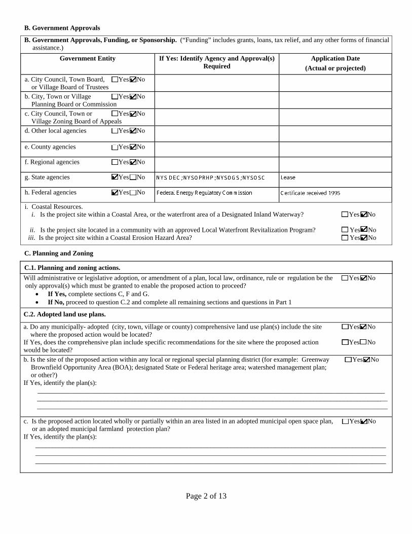
B. Government Approvals
B. Government Approvals, Funding, or Sponsorship. (“Funding” includes grants, loans, tax relief, and any other forms of financial assistance.)
Government Entity If Yes: Identify Agency and Approval(s) Required
Application Date (Actual or projected)
a. City Council, Town Board, 9 Yes 9 Noor Village Board of Trustees
b. City, Town or Village 9 Yes 9 No Planning Board or Commission
c. City Council, Town or 9 Yes 9 No Village Zoning Board of Appeals
d. Other local agencies 9 Yes 9 No
e. County agencies 9 Yes 9 No
f. Regional agencies 9 Yes 9 No
g. State agencies 9 Yes 9 No
h. Federal agencies 9 Yes 9 No
i. Coastal Resources.i. Is the project site within a Coastal Area, or the waterfront area of a Designated Inland Waterway? 9 Yes 9 No
ii. Is the project site located in a community with an approved Local Waterfront Revitalization Program? 9 Yes 9 No iii. Is the project site within a Coastal Erosion Hazard Area? 9 Yes 9 No
C. Planning and Zoning
C.1. Planning and zoning actions. Will administrative or legislative adoption, or amendment of a plan, local law, ordinance, rule or regulation be the 9 Yes 9 No only approval(s) which must be granted to enable the proposed action to proceed?
• If Yes, complete sections C, F and G.• If No, proceed to question C.2 and complete all remaining sections and questions in Part 1
C.2. Adopted land use plans.
a. Do any municipally- adopted (city, town, village or county) comprehensive land use plan(s) include the site 9 Yes 9 No where the proposed action would be located?
If Yes, does the comprehensive plan include specific recommendations for the site where the proposed action 9 Yes 9 No would be located? b. Is the site of the proposed action within any local or regional special planning district (for example: Greenway 9 Yes 9 No
Brownfield Opportunity Area (BOA); designated State or Federal heritage area; watershed management plan;or other?)
If Yes, identify the plan(s): _______________________________________________________________________________________________________
________________________________________________________________________________________________________ ________________________________________________________________________________________________________
c. Is the proposed action located wholly or partially within an area listed in an adopted municipal open space plan, 9 Yes 9 Noor an adopted municipal farmland protection plan?
If Yes, identify the plan(s): ________________________________________________________________________________________________________ ________________________________________________________________________________________________________ ________________________________________________________________________________________________________

Page 3 of 13
C.3. Zoning
a. Is the site of the proposed action located in a municipality with an adopted zoning law or ordinance. 9 Yes 9 NoIf Yes, what is the zoning classification(s) including any applicable overlay district?
__________________________________________________________________________________________________________________________________________________________________________________________________________________
b. Is the use permitted or allowed by a special or conditional use permit? 9 Yes 9 No
c. Is a zoning change requested as part of the proposed action? 9 Yes 9 No If Yes,
i. What is the proposed new zoning for the site? ___________________________________________________________________
C.4. Existing community services.
a. In what school district is the project site located? ________________________________________________________________
b. What police or other public protection forces serve the project site? _________________________________________________________________________________________________________
c. Which fire protection and emergency medical services serve the project site?__________________________________________________________________________________________________________
d. What parks serve the project site?____________________________________________________________________________________________________________________________________________________________________________________________________________________
D. Project Details
D.1. Proposed and Potential Development
a. What is the general nature of the proposed action (e.g., residential, industrial, commercial, recreational; if mixed, include allcomponents)?_________________________________________________________________________________________________________
b. a. Total acreage of the site of the proposed action? _____________ acres b. Total acreage to be physically disturbed? _____________ acres c. Total acreage (project site and any contiguous properties) owned
or controlled by the applicant or project sponsor? _____________ acres
c. Is the proposed action an expansion of an existing project or use? 9 Yes 9 No i. If Yes, what is the approximate percentage of the proposed expansion and identify the units (e.g., acres, miles, housing units,
square feet)? % ____________________ Units: ____________________d. Is the proposed action a subdivision, or does it include a subdivision? 9 Yes 9 No If Yes,
i. Purpose or type of subdivision? (e.g., residential, industrial, commercial; if mixed, specify types) ________________________________________________________________________________________________________
ii. Is a cluster/conservation layout proposed? 9 Yes 9 No iii. Number of lots proposed? ________iv. Minimum and maximum proposed lot sizes? Minimum __________ Maximum __________
e. Will proposed action be constructed in multiple phases? 9 Yes 9 No i. If No, anticipated period of construction: _____ months
ii. If Yes:• Total number of phases anticipated _____ • Anticipated commencement date of phase 1 (including demolition) _____ month _____ year • Anticipated completion date of final phase _____ month _____year • Generally describe connections or relationships among phases, including any contingencies where progress of one phase may
determine timing or duration of future phases: _______________________________________________________________ ____________________________________________________________________________________________________ ____________________________________________________________________________________________________
Page 4 of 13
f. Does the project include new residential uses? 9 Yes 9 No If Yes, show numbers of units proposed.
One Family Two Family Three Family Multiple Family (four or more)
Initial Phase ___________ ___________ ____________ ________________________ At completion of all phases ___________ ___________ ____________ ________________________
g. Does the proposed action include new non-residential construction (including expansions)? 9 Yes 9 No If Yes,
i. Total number of structures ___________ii. Dimensions (in feet) of largest proposed structure: ________height; ________width; and _______ length
iii. Approximate extent of building space to be heated or cooled: ______________________ square feet
h. Does the proposed action include construction or other activities that will result in the impoundment of any 9 Yes 9 No liquids, such as creation of a water supply, reservoir, pond, lake, waste lagoon or other storage?
If Yes, i. Purpose of the impoundment: ________________________________________________________________________________
ii. If a water impoundment, the principal source of the water: 9 Ground water 9 Surface water streams 9 Other specify:_________________________________________________________________________________________________________
iii. If other than water, identify the type of impounded/contained liquids and their source._________________________________________________________________________________________________________
iv. Approximate size of the proposed impoundment. Volume: ____________ million gallons; surface area: ____________ acres v. Dimensions of the proposed dam or impounding structure: ________ height; _______ length
vi. Construction method/materials for the proposed dam or impounding structure (e.g., earth fill, rock, wood, concrete):________________________________________________________________________________________________________
D.2. Project Operations a. Does the proposed action include any excavation, mining, or dredging, during construction, operations, or both? 9 Yes 9 No
(Not including general site preparation, grading or installation of utilities or foundations where all excavatedmaterials will remain onsite)
If Yes: i .What is the purpose of the excavation or dredging? _______________________________________________________________ ii. How much material (including rock, earth, sediments, etc.) is proposed to be removed from the site?
• Volume (specify tons or cubic yards): ____________________________________________• Over what duration of time? ____________________________________________________
iii. Describe nature and characteristics of materials to be excavated or dredged, and plans to use, manage or dispose of them. ________________________________________________________________________________________________________ ________________________________________________________________________________________________________
iv. Will there be onsite dewatering or processing of excavated materials? 9 Yes 9 No If yes, describe. ___________________________________________________________________________________________ ________________________________________________________________________________________________________
v. What is the total area to be dredged or excavated? _____________________________________acresvi. What is the maximum area to be worked at any one time? _______________________________ acres
vii. What would be the maximum depth of excavation or dredging? __________________________ feetviii. Will the excavation require blasting? 9 Yes 9 No ix. Summarize site reclamation goals and plan: _____________________________________________________________________
________________________________________________________________________________________________________ ________________________________________________________________________________________________________
b. Would the proposed action cause or result in alteration of, increase or decrease in size of, or encroachment 9 Yes 9 No into any existing wetland, waterbody, shoreline, beach or adjacent area?
If Yes: i. Identify the wetland or waterbody which would be affected (by name, water index number, wetland map number or geographic
description): _______________________________________________________________________________________________________________________________________________________________________________________________________

Page 5 of 13
ii. Describe how the proposed action would affect that waterbody or wetland, e.g. excavation, fill, placement of structures, oralteration of channels, banks and shorelines. Indicate extent of activities, alterations and additions in square feet or acres:____________________________________________________________________________________________________________________________________________________________________________________________________________________________________________________________________________________________________________________________________________________________________________________________________________________________________
iii. Will proposed action cause or result in disturbance to bottom sediments? 9 Yes 9 NoIf Yes, describe: __________________________________________________________________________________________
iv. Will proposed action cause or result in the destruction or removal of aquatic vegetation? 9 Yes 9 No If Yes:• acres of aquatic vegetation proposed to be removed: ___________________________________________________________• expected acreage of aquatic vegetation remaining after project completion:________________________________________• purpose of proposed removal (e.g. beach clearing, invasive species control, boat access): ____________________________
____________________________________________________________________________________________________• proposed method of plant removal: ________________________________________________________________________• if chemical/herbicide treatment will be used, specify product(s): _________________________________________________
v. Describe any proposed reclamation/mitigation following disturbance: __________________________________________________________________________________________________________________________________________________________
c. Will the proposed action use, or create a new demand for water? 9 Yes 9 No If Yes:
i. Total anticipated water usage/demand per day: __________________________ gallons/dayii. Will the proposed action obtain water from an existing public water supply? 9 Yes 9 No
If Yes: • Name of district or service area: _________________________________________________________________________• Does the existing public water supply have capacity to serve the proposal? 9 Yes 9 No • Is the project site in the existing district? 9 Yes 9 No • Is expansion of the district needed? 9 Yes 9 No • Do existing lines serve the project site? 9 Yes 9 No
iii. Will line extension within an existing district be necessary to supply the project? 9 Yes 9 No If Yes:
• Describe extensions or capacity expansions proposed to serve this project: ____________________________________________________________________________________________________________________________________________
• Source(s) of supply for the district: ________________________________________________________________________iv. Is a new water supply district or service area proposed to be formed to serve the project site? 9 Yes 9 No
If, Yes: • Applicant/sponsor for new district: ________________________________________________________________________• Date application submitted or anticipated: __________________________________________________________________• Proposed source(s) of supply for new district: _______________________________________________________________
v. If a public water supply will not be used, describe plans to provide water supply for the project: ____________________________________________________________________________________________________________________________________
vi. If water supply will be from wells (public or private), maximum pumping capacity: _______ gallons/minute.
d. Will the proposed action generate liquid wastes? 9 Yes 9 No If Yes:
i. Total anticipated liquid waste generation per day: _______________ gallons/dayii. Nature of liquid wastes to be generated (e.g., sanitary wastewater, industrial; if combination, describe all components and
approximate volumes or proportions of each): ____________________________________________________________________________________________________________________________________________________________________________________________________________________________________________________________________________________
iii. Will the proposed action use any existing public wastewater treatment facilities? 9 Yes 9 No If Yes:• Name of wastewater treatment plant to be used: _____________________________________________________________• Name of district: ______________________________________________________________________________________• Does the existing wastewater treatment plant have capacity to serve the project? 9 Yes 9 No • Is the project site in the existing district? 9 Yes 9 No • Is expansion of the district needed? 9 Yes 9 No

Page 6 of 13
• Do existing sewer lines serve the project site? 9 Yes 9 No • Will line extension within an existing district be necessary to serve the project? 9 Yes 9 No
If Yes: • Describe extensions or capacity expansions proposed to serve this project: ____________________________________
____________________________________________________________________________________________________ ____________________________________________________________________________________________________
iv. Will a new wastewater (sewage) treatment district be formed to serve the project site? 9 Yes 9 No If Yes:• Applicant/sponsor for new district: ____________________________________________________________________• Date application submitted or anticipated: _______________________________________________________________• What is the receiving water for the wastewater discharge? __________________________________________________
v. If public facilities will not be used, describe plans to provide wastewater treatment for the project, including specifying proposed receiving water (name and classification if surface discharge, or describe subsurface disposal plans): ________________________________________________________________________________________________________ ________________________________________________________________________________________________________
vi. Describe any plans or designs to capture, recycle or reuse liquid waste: _______________________________________________ ________________________________________________________________________________________________________ ________________________________________________________________________________________________________
e. Will the proposed action disturb more than one acre and create stormwater runoff, either from new point 9 Yes 9 No sources (i.e. ditches, pipes, swales, curbs, gutters or other concentrated flows of stormwater) or non-point
source (i.e. sheet flow) during construction or post construction? If Yes:
i. How much impervious surface will the project create in relation to total size of project parcel? _____ Square feet or _____ acres (impervious surface) _____ Square feet or _____ acres (parcel size)
ii. Describe types of new point sources. ___________________________________________________________________________________________________________________________________________________________________________________
iii. Where will the stormwater runoff be directed (i.e. on-site stormwater management facility/structures, adjacent properties,groundwater, on-site surface water or off-site surface waters)?
________________________________________________________________________________________________________ ________________________________________________________________________________________________________ • If to surface waters, identify receiving water bodies or wetlands: ________________________________________________
________________________________________________________________________________________________________________________________________________________________________________________________________
• Will stormwater runoff flow to adjacent properties? 9 Yes 9 No iv. Does proposed plan minimize impervious surfaces, use pervious materials or collect and re-use stormwater? 9 Yes 9 No f. Does the proposed action include, or will it use on-site, one or more sources of air emissions, including fuel 9 Yes 9 No
combustion, waste incineration, or other processes or operations?If Yes, identify:
i. Mobile sources during project operations (e.g., heavy equipment, fleet or delivery vehicles)_________________________________________________________________________________________________________
ii. Stationary sources during construction (e.g., power generation, structural heating, batch plant, crushers)________________________________________________________________________________________________________
iii. Stationary sources during operations (e.g., process emissions, large boilers, electric generation)________________________________________________________________________________________________________
g. Will any air emission sources named in D.2.f (above), require a NY State Air Registration, Air Facility Permit, 9 Yes 9 No or Federal Clean Air Act Title IV or Title V Permit?
If Yes: i. Is the project site located in an Air quality non-attainment area? (Area routinely or periodically fails to meet 9 Yes 9 No
ambient air quality standards for all or some parts of the year)ii. In addition to emissions as calculated in the application, the project will generate:
• ___________Tons/year (short tons) of Carbon Dioxide (CO2)• ___________Tons/year (short tons) of Nitrous Oxide (N2O)• ___________Tons/year (short tons) of Perfluorocarbons (PFCs)• ___________Tons/year (short tons) of Sulfur Hexafluoride (SF6)• ___________Tons/year (short tons) of Carbon Dioxide equivalent of Hydroflourocarbons (HFCs)• ___________Tons/year (short tons) of Hazardous Air Pollutants (HAPs)
Page 7 of 13
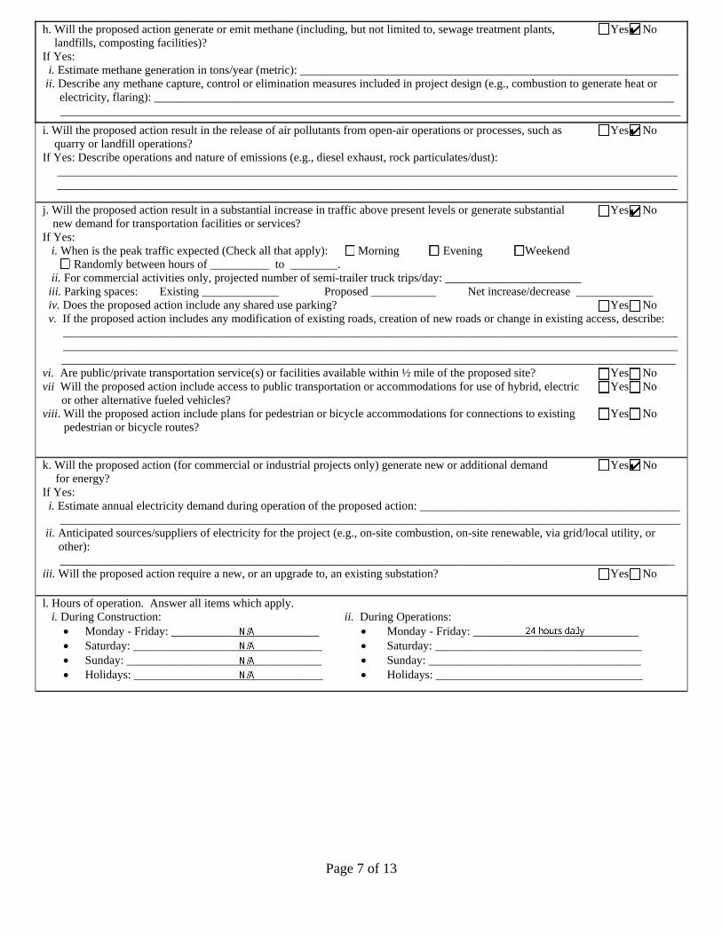
h. Will the proposed action generate or emit methane (including, but not limited to, sewage treatment plants, 9 Yes 9 No landfills, composting facilities)?
If Yes: i. Estimate methane generation in tons/year (metric): ________________________________________________________________
ii. Describe any methane capture, control or elimination measures included in project design (e.g., combustion to generate heat orelectricity, flaring): _________________________________________________________________________________________________________________________________________________________________________________________________
i. Will the proposed action result in the release of air pollutants from open-air operations or processes, such as 9 Yes 9 No quarry or landfill operations?
If Yes: Describe operations and nature of emissions (e.g., diesel exhaust, rock particulates/dust): _________________________________________________________________________________________________________ _________________________________________________________________________________________________________
j. Will the proposed action result in a substantial increase in traffic above present levels or generate substantial 9 Yes 9 No new demand for transportation facilities or services?
If Yes: i. When is the peak traffic expected (Check all that apply): Morning Evening Weekend
Randomly between hours of __________ to ________.ii. For commercial activities only, projected number of semi-trailer truck trips/day: _______________________
iii. Parking spaces: Existing _____________ Proposed ___________ Net increase/decrease _____________ iv. Does the proposed action include any shared use parking? 9 Yes 9 No v. If the proposed action includes any modification of existing roads, creation of new roads or change in existing access, describe:
________________________________________________________________________________________________________________________________________________________________________________________________________________________________________________________________________________________________________________________
vi. Are public/private transportation service(s) or facilities available within ½ mile of the proposed site? 9 Yes 9 No vii Will the proposed action include access to public transportation or accommodations for use of hybrid, electric 9 Yes 9 No
or other alternative fueled vehicles? viii. Will the proposed action include plans for pedestrian or bicycle accommodations for connections to existing 9 Yes 9 No
pedestrian or bicycle routes?
k. Will the proposed action (for commercial or industrial projects only) generate new or additional demand 9 Yes 9 No for energy?
If Yes: i. Estimate annual electricity demand during operation of the proposed action: ____________________________________________
_________________________________________________________________________________________________________ii. Anticipated sources/suppliers of electricity for the project (e.g., on-site combustion, on-site renewable, via grid/local utility, or
other):________________________________________________________________________________________________________
iii. Will the proposed action require a new, or an upgrade to, an existing substation? 9 Yes 9 No
l. Hours of operation. Answer all items which apply.i. During Construction: ii. During Operations:• Monday - Friday: _________________________ • Monday - Friday: ____________________________• Saturday: ________________________________ • Saturday: ___________________________________• Sunday: _________________________________ • Sunday: ____________________________________• Holidays: ________________________________ • Holidays: ___________________________________
Page 8 of 13
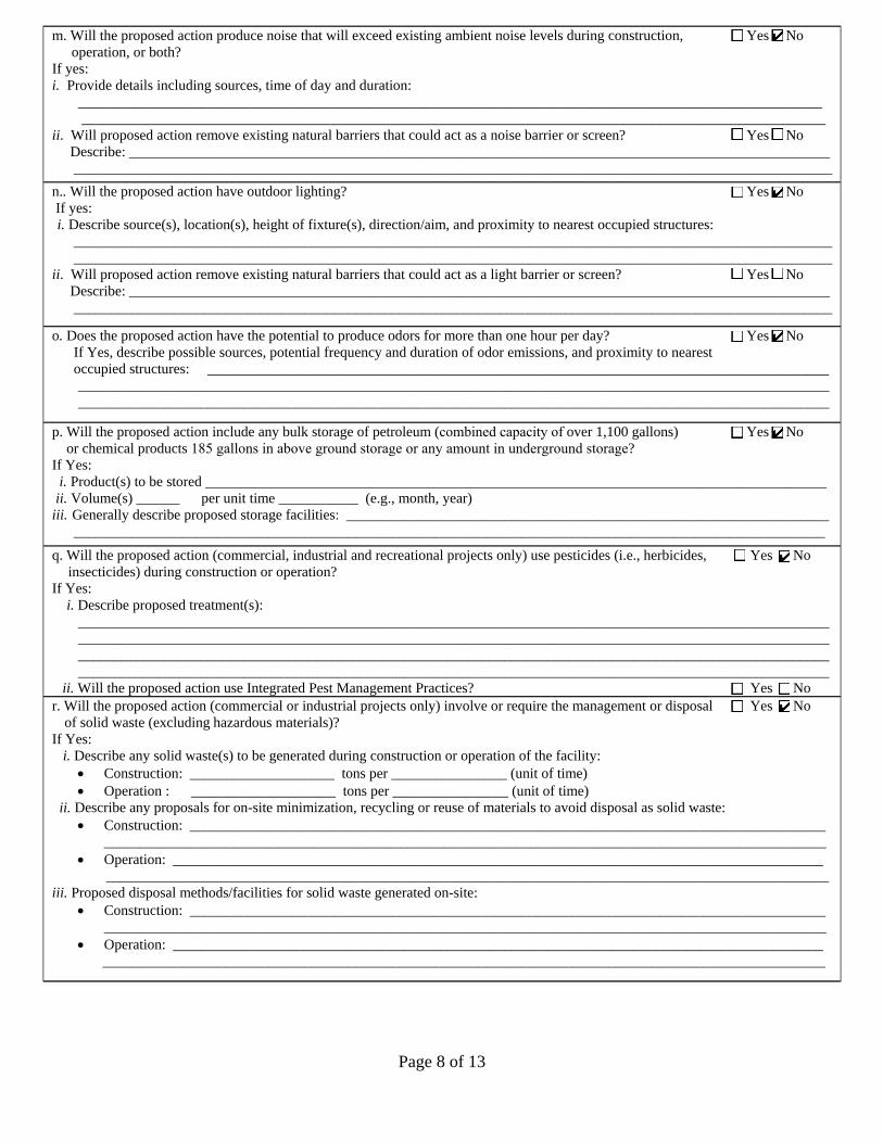
m. Will the proposed action produce noise that will exceed existing ambient noise levels during construction, 9 Yes 9 No operation, or both?
If yes: i. Provide details including sources, time of day and duration:
_______________________________________________________________________________________________________ _______________________________________________________________________________________________________
ii. Will proposed action remove existing natural barriers that could act as a noise barrier or screen? 9 Yes 9 No Describe: _________________________________________________________________________________________________ _________________________________________________________________________________________________________
n.. Will the proposed action have outdoor lighting? 9 Yes 9 No If yes: i. Describe source(s), location(s), height of fixture(s), direction/aim, and proximity to nearest occupied structures:
_________________________________________________________________________________________________________ _________________________________________________________________________________________________________
ii. Will proposed action remove existing natural barriers that could act as a light barrier or screen? 9 Yes 9 No Describe: _________________________________________________________________________________________________ _________________________________________________________________________________________________________
o. Does the proposed action have the potential to produce odors for more than one hour per day? 9 Yes 9 No If Yes, describe possible sources, potential frequency and duration of odor emissions, and proximity to nearest occupied structures: ______________________________________________________________________________________
________________________________________________________________________________________________________ ________________________________________________________________________________________________________
p. 9 Yes 9 No Will the proposed action include any bulk storage of petroleum (combined capacity of over 1,100 gallons) or chemical products 185 gallons in above ground storage or any amount in underground storage?
If Yes: i. Product(s) to be stored ______________________________________________________________________________________
ii. Volume(s) ______ per unit time ___________ (e.g., month, year)iii. Generally describe proposed storage facilities: ___________________________________________________________________
________________________________________________________________________________________________________
q. Will the proposed action (commercial, industrial and recreational projects only) use pesticides (i.e., herbicides, 9 Yes 9 No insecticides) during construction or operation?
If Yes: i. Describe proposed treatment(s):
________________________________________________________________________________________________________________________________________________________________________________________________________________________________________________________________________________________________________________________________________________________________________________________________________________________________
ii. Will the proposed action use Integrated Pest Management Practices? 9 Yes 9 No r. Will the proposed action (commercial or industrial projects only) involve or require the management or disposal 9 Yes 9 No
of solid waste (excluding hazardous materials)?If Yes:
i. Describe any solid waste(s) to be generated during construction or operation of the facility:• Construction: ____________________ tons per ________________ (unit of time)• Operation : ____________________ tons per ________________ (unit of time)
ii. Describe any proposals for on-site minimization, recycling or reuse of materials to avoid disposal as solid waste:• Construction: ________________________________________________________________________________________
____________________________________________________________________________________________________• Operation: __________________________________________________________________________________________
____________________________________________________________________________________________________iii. Proposed disposal methods/facilities for solid waste generated on-site:
• Construction: ____________________________________________________________________________________________________________________________________________________________________________________________
• Operation: ______________________________________________________________________________________________________________________________________________________________________________________________

Page 9 of 13
s. Does the proposed action include construction or modification of a solid waste management facility? 9 Yes 9 No If Yes:
i. Type of management or handling of waste proposed for the site (e.g., recycling or transfer station, composting, landfill, orother disposal activities): ___________________________________________________________________________________
ii. Anticipated rate of disposal/processing:• ________ Tons/month, if transfer or other non-combustion/thermal treatment, or• ________ Tons/hour, if combustion or thermal treatment
iii. If landfill, anticipated site life: ________________________________ years
t. Will proposed action at the site involve the commercial generation, treatment, storage, or disposal of hazardous 9 Yes 9 No waste?
If Yes: i. Name(s) of all hazardous wastes or constituents to be generated, handled or managed at facility: ___________________________
__________________________________________________________________________________________________________________________________________________________________________________________________________________
ii. Generally describe processes or activities involving hazardous wastes or constituents: ____________________________________________________________________________________________________________________________________________________________________________________________________________________________________________________
iii. Specify amount to be handled or generated _____ tons/monthiv. Describe any proposals for on-site minimization, recycling or reuse of hazardous constituents: ____________________________
________________________________________________________________________________________________________________________________________________________________________________________________________________
v. Will any hazardous wastes be disposed at an existing offsite hazardous waste facility? 9 Yes 9 No If Yes: provide name and location of facility: _______________________________________________________________________ ________________________________________________________________________________________________________ If No: describe proposed management of any hazardous wastes which will not be sent to a hazardous waste facility:
________________________________________________________________________________________________________ ________________________________________________________________________________________________________
E. Site and Setting of Proposed Action
E.1. Land uses on and surrounding the project site
a. Existing land uses.i. Check all uses that occur on, adjoining and near the project site.
9 Urban 9 Industrial 9 Commercial 9 Residential (suburban) 9 Rural (non-farm) 9 Forest 9 Agriculture 9 Aquatic 9 Other (specify): ____________________________________
ii. If mix of uses, generally describe:__________________________________________________________________________________________________________ __________________________________________________________________________________________________________
b. Land uses and covertypes on the project site.Land use or Covertype
Current Acreage
Acreage After Project Completion
Change (Acres +/-)
• Roads, buildings, and other paved or impervioussurfaces
• Forested• Meadows, grasslands or brushlands (non-
agricultural, including abandoned agricultural)• Agricultural
(includes active orchards, field, greenhouse etc.) • Surface water features
(lakes, ponds, streams, rivers, etc.) • Wetlands (freshwater or tidal)• Non-vegetated (bare rock, earth or fill)
• OtherDescribe: _______________________________ ________________________________________

Page 10 of 13
c. Is the project site presently used by members of the community for public recreation? 9 Yes 9 No i. If Yes: explain: __________________________________________________________________________________________
d. Are there any facilities serving children, the elderly, people with disabilities (e.g., schools, hospitals, licensed 9 Yes 9 No day care centers, or group homes) within 1500 feet of the project site?
If Yes, i. Identify Facilities:
________________________________________________________________________________________________________________________________________________________________________________________________________________
e. Does the project site contain an existing dam? 9 Yes 9 No If Yes:
i. Dimensions of the dam and impoundment:• Dam height: _________________________________ feet • Dam length: _________________________________ feet • Surface area: _________________________________ acres • Volume impounded: _______________________________ gallons OR acre-feet
ii. Dam=s existing hazard classification: _________________________________________________________________________iii. Provide date and summarize results of last inspection:
_______________________________________________________________________________________________________ _______________________________________________________________________________________________________
f. Has the project site ever been used as a municipal, commercial or industrial solid waste management facility, 9 Yes 9 No or does the project site adjoin property which is now, or was at one time, used as a solid waste management facility?
If Yes: i. Has the facility been formally closed? 9 Yes 9 No • If yes, cite sources/documentation: _______________________________________________________________________
ii. Describe the location of the project site relative to the boundaries of the solid waste management facility:______________________________________________________________________________________________________________________________________________________________________________________________________________
iii. Describe any development constraints due to the prior solid waste activities: _________________________________________________________________________________________________________________________________________________
g. Have hazardous wastes been generated, treated and/or disposed of at the site, or does the project site adjoin 9 Yes 9 No property which is now or was at one time used to commercially treat, store and/or dispose of hazardous waste?
If Yes: i. Describe waste(s) handled and waste management activities, including approximate time when activities occurred:
_______________________________________________________________________________________________________ _______________________________________________________________________________________________________
h. Potential contamination history. Has there been a reported spill at the proposed project site, or have any 9 Yes 9 No remedial actions been conducted at or adjacent to the proposed site?
If Yes: i. Is any portion of the site listed on the NYSDEC Spills Incidents database or Environmental Site 9 Yes 9 No
Remediation database? Check all that apply:9 Yes – Spills Incidents database Provide DEC ID number(s): ________________________________ 9 Yes – Environmental Site Remediation database Provide DEC ID number(s): ________________________________ 9 Neither database
ii. If site has been subject of RCRA corrective activities, describe control measures:_______________________________________________________________________________________________________________________________________________________________________________________________________________________________________________________
iii. Is the project within 2000 feet of any site in the NYSDEC Environmental Site Remediation database? 9 Yes 9 No If yes, provide DEC ID number(s): ______________________________________________________________________________ iv. If yes to (i), (ii) or (iii) above, describe current status of site(s):
_______________________________________________________________________________________________________ _______________________________________________________________________________________________________

Page 11 of 13
v. Is the project site subject to an institutional control limiting property uses? 9 Yes 9 No • If yes, DEC site ID number: ____________________________________________________________________________• Describe the type of institutional control (e.g., deed restriction or easement): ____________________________________• Describe any use limitations: ___________________________________________________________________________• Describe any engineering controls: _______________________________________________________________________• Will the project affect the institutional or engineering controls in place? 9 Yes 9 No • Explain: ____________________________________________________________________________________________
___________________________________________________________________________________________________ ___________________________________________________________________________________________________
E.2. Natural Resources On or Near Project Site a. What is the average depth to bedrock on the project site? ________________ feet
b. Are there bedrock outcroppings on the project site? 9 Yes 9 No If Yes, what proportion of the site is comprised of bedrock outcroppings? __________________%
c. Predominant soil type(s) present on project site: ___________________________ __________% ___________________________ __________% ____________________________ __________%
d. What is the average depth to the water table on the project site? Average: _________ feet
e. Drainage status of project site soils: 9 Well Drained: _____% of site 9 Moderately Well Drained: _____% of site 9 Poorly Drained _____% of site
f. Approximate proportion of proposed action site with slopes: 9 0-10%: _____% of site 9 10-15%: _____% of site 9 15% or greater: _____% of site
g. Are there any unique geologic features on the project site? 9 Yes 9 No If Yes, describe: _____________________________________________________________________________________________
________________________________________________________________________________________________________
h. Surface water features.i. Does any portion of the project site contain wetlands or other waterbodies (including streams, rivers, 9 Yes 9 No
ponds or lakes)?ii. Do any wetlands or other waterbodies adjoin the project site? 9 Yes 9 No
If Yes to either i or ii, continue. If No, skip to E.2.i. iii. Are any of the wetlands or waterbodies within or adjoining the project site regulated by any federal, 9 Yes 9 No
state or local agency? iv. For each identified regulated wetland and waterbody on the project site, provide the following information:
• Streams: Name ____________________________________________ Classification _______________________ • Lakes or Ponds: Name ____________________________________________ Classification _______________________• Wetlands: Name ____________________________________________ Approximate Size ___________________ • Wetland No. (if regulated by DEC) _____________________________
v. Are any of the above water bodies listed in the most recent compilation of NYS water quality-impaired 9 Yes 9 No waterbodies?
If yes, name of impaired water body/bodies and basis for listing as impaired: _____________________________________________ ___________________________________________________________________________________________________________
i. Is the project site in a designated Floodway? 9 Yes 9 No
j. Is the project site in the 100 year Floodplain? 9 Yes 9 No
k. Is the project site in the 500 year Floodplain? 9 Yes 9 No
l. Is the project site located over, or immediately adjoining, a primary, principal or sole source aquifer? 9 Yes 9 No If Yes:
i. Name of aquifer: _________________________________________________________________________________________
dxrebecc
Sticky Note
Marked set by dxrebecc
Page 12 of 13
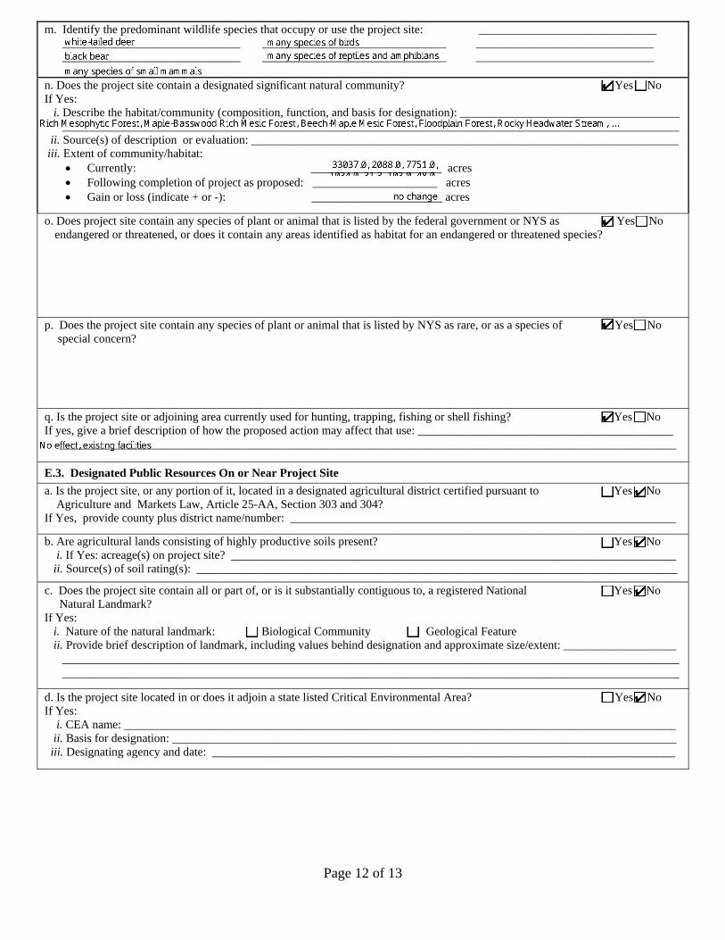
m. Identify the predominant wildlife species that occupy or use the project site: ______________________________ ______________________________ _______________________________ ______________________________ ______________________________ _______________________________ ______________________________
n. Does the project site contain a designated significant natural community? 9 Yes 9 No If Yes:
i. Describe the habitat/community (composition, function, and basis for designation): _____________________________________ ________________________________________________________________________________________________________
ii. Source(s) of description or evaluation: ________________________________________________________________________iii. Extent of community/habitat:
• Currently: ______________________ acres • Following completion of project as proposed: _____________________ acres• Gain or loss (indicate + or -): ______________________ acres
o. Does project site contain any species of plant or animal that is listed by the federal government or NYS as 9 Yes 9 No endangered or threatened, or does it contain any areas identified as habitat for an endangered or threatened species?
p. Does the project site contain any species of plant or animal that is listed by NYS as rare, or as a species of 9 Yes 9 No
special concern?
q. Is the project site or adjoining area currently used for hunting, trapping, fishing or shell fishing? 9 Yes 9 No If yes, give a brief description of how the proposed action may affect that use: ___________________________________________
________________________________________________________________________________________________________
E.3. Designated Public Resources On or Near Project Site a. Is the project site, or any portion of it, located in a designated agricultural district certified pursuant to 9 Yes 9 No
Agriculture and Markets Law, Article 25-AA, Section 303 and 304?If Yes, provide county plus district name/number: _________________________________________________________________
b. Are agricultural lands consisting of highly productive soils present? 9 Yes 9 No i. If Yes: acreage(s) on project site? ___________________________________________________________________________
ii. Source(s) of soil rating(s): _________________________________________________________________________________
c. Does the project site contain all or part of, or is it substantially contiguous to, a registered National 9 Yes 9 No Natural Landmark?
If Yes: i. Nature of the natural landmark: 9 Biological Community 9 Geological Featureii. Provide brief description of landmark, including values behind designation and approximate size/extent: ___________________
________________________________________________________________________________________________________ ________________________________________________________________________________________________________
d. Is the project site located in or does it adjoin a state listed Critical Environmental Area? 9 Yes 9 No If Yes:
i. CEA name: _____________________________________________________________________________________________ii. Basis for designation: _____________________________________________________________________________________
iii. Designating agency and date: ______________________________________________________________________________


NFG New Gas Storage Lease – Part 1 EAF Project Description
Description of Action:
The action involves issuance of a lease by the State of New York (through the Office of General Services
on behalf of the Office of Parks, Recreation and Historic Preservation) authorizing the National Fuel Gas
Supply Corporation (National Fuel) to continue to operate an existing subsurface natural gas storage
facility within Allegany State Park, known as the Limestone Storage Field. The proposed new lease will
authorize National Fuel to maintain and operate existing wells, roads and pipelines associated with the
storage field for the sole purpose of storing natural gas in the underlying geological formation known as
the Oriskany Sandstone, located at a depth of approximately 4,200 feet below the surface. The
Limestone Storage Field has been operated in the park since 1964 under a lease, originally issued by
New York State to the Felmont Oil Company and acquired by National Fuel in 1990. The storage field
currently contains 14 wells, 9.7 miles of pipeline, other equipment, and a system of gravel access roads
and rights of way (collectively, the Facilities) in the park (Figure 1). This field is a key part of existing
infrastructure that provides natural gas service to several western New York counties. The original 50-
year lease expired in June, 2014. At that time, OPRHP and National Fuel entered into a one-year
extension, to provide time for the parties to negotiate a new long-term lease. The proposed new lease
defines the Limestone Storage Field to include 8,429 acres, which is a reduction of 1,606 acres from the
existing lease. The proposed new 15-year lease limits National Fuel’ activities on the surface of Allegany
State Park to the footprint of existing wells and facilities (the footprint of current cleared areas and
roads totals approximately 50 acres configured in linear corridors).

EAF Mapper Summary Report Friday, February 27, 2015 8:52 AM
Disclaimer: The EAF Mapper is a screening tool intended to assist project sponsors and reviewing agencies in preparing an environmental assessment form (EAF). Not all questions asked in the EAF are answered by the EAF Mapper. Additional information on any EAF question can be obtained by consulting the EAF Workbooks. Although the EAF Mapper provides the most up-to-date digital data available to DEC, you may also need to contact local or other data sources in order to obtain data not provided by the Mapper. Digital data is not a substitute for agency determinations.
B.i.i [Coastal or Waterfront Area] No
B.i.ii [Local Waterfront Revitalization Area] No
C.2.b. [Special Planning District] Digital mapping data are not available or are incomplete. Refer to EAF Workbook.
E.1.h [DEC Spills or Remediation Site - Potential Contamination History]
Digital mapping data are not available or are incomplete. Refer to EAF Workbook.
E.1.h.i [DEC Spills or Remediation Site - Listed]
Digital mapping data are not available or are incomplete. Refer to EAF Workbook.
E.1.h.i [DEC Spills or Remediation Site - Environmental Site Remediation Database]
Digital mapping data are not available or are incomplete. Refer to EAF Workbook.
E.1.h.iii [Within 2,000' of DEC Remediation Site]
No
E.2.g [Unique Geologic Features] No
E.2.h.i [Surface Water Features] Yes
E.2.h.ii [Surface Water Features] Yes
E.2.h.iii [Surface Water Features] Yes - Digital mapping information on local and federal wetlands and waterbodies is known to be incomplete. Refer to EAF Workbook.
E.2.h.iv [Surface Water Features - Stream Name]
802-103, 802-104, 802-63, 802-94, 802-82, 802-88, 802-97, 802-210, 802-86, 802-106, 802-105, 802-83, 802-89, 802-98, 802-208, 802-64, 802-95
E.2.h.iv [Surface Water Features - Stream Classification]
B, B(T)
E.2.h.iv [Surface Water Features - Lake/Pond Name]
802-106
E.2.h.iv [Surface Water Features - Lake/Pond Classification]
B
E.2.h.iv [Surface Water Features - Wetlands Name]
Federal Waters
E.2.h.v [Impaired Water Bodies] No
1Full Environmental Assessment Form - EAF Mapper Summary Report

E.2.i. [Floodway] Digital mapping data are not available or are incomplete. Refer to EAF Workbook.
E.2.j. [100 Year Floodplain] Digital mapping data are not available or are incomplete. Refer to EAF Workbook.
E.2.k. [500 Year Floodplain] Digital mapping data are not available or are incomplete. Refer to EAF Workbook.
E.2.l. [Aquifers] Yes
E.2.l. [Aquifer Names] Primary Aquifer, Principal Aquifer
E.2.n. [Natural Communities] Yes
E.2.n.i [Natural Communities - Name] Rich Mesophytic Forest, Maple-Basswood Rich Mesic Forest, Beech-Maple Mesic Forest, Floodplain Forest, Rocky Headwater Stream, Allegheny Oak Forest, Intermittent Stream, Hemlock-Northern Hardwood Forest
E.2.n.i [Natural Communities - Acres] 33037.0, 2088.0, 7751.0, 1034.0, 31.3, 103.0, 48.0, 55.2, 0.9, 16916.0, 1501.0, 914.0, 68.9, 3554.0, 1574.0
E.2.o. [Endangered or Threatened Species] Yes
E.2.p. [Rare Plants or Animals] Yes
E.3.a. [Agricultural District] No
E.3.c. [National Natural Landmark] No
E.3.d [Critical Environmental Area] No
E.3.e. [National Register of Historic Places] Digital mapping data are not available or are incomplete. Refer to EAF Workbook.
E.3.f. [Archeological Sites] Yes
E.3.i. [Designated River Corridor] No
2Full Environmental Assessment Form - EAF Mapper Summary Report

Source: Esri, DigitalGlobe, GeoEye, Earthstar Geographics, CNES/Airbus DS, USDA, USGS, AEX, Getmapping, Aerogrid, IGN, IGP, swisstopo, and the GIS User Community
TM
STATEYORKNEW
Preservationand HistoricParks, Recreation
All
eg
an
y S
tate
Pa
rk -
Na
tio
na
l F
ue
l G
as
Le
as
e
Map p
roduc
ed by
NYS
OPRH
P GI
S Bure
au, M
arch 0
9, 20
15.
LegendNFG Reduced Lease Areastate park boundary
0 2 4Miles
³

Page 1 of 10
Full Environmental Assessment Form Part 2 - Identification of Potential Project Impacts
Part 2 is to be completed by the lead agency. Part 2 is designed to help the lead agency inventory all potential resources that could be affected by a proposed project or action. We recognize that the lead agency=s reviewer(s) will not necessarily be environmental professionals. So, the questions are designed to walk a reviewer through the assessment process by providing a series of questions that can be answered using the information found in Part 1. To further assist the lead agency in completing Part 2, the form identifies the most relevant questions in Part 1 that will provide the information needed to answer the Part 2 question. When Part 2 is completed, the lead agency will have identified the relevant environmental areas that may be impacted by the proposed activity.
If the lead agency is a state agency and the action is in any Coastal Area, complete the Coastal Assessment Form before proceeding with this assessment. Tips for completing Part 2:
• Review all of the information provided in Part 1.• Review any application, maps, supporting materials and the Full EAF Workbook.• Answer each of the 18 questions in Part 2.• If you answer “Yes” to a numbered question, please complete all the questions that follow in that section.• If you answer “No” to a numbered question, move on to the next numbered question.• Check appropriate column to indicate the anticipated size of the impact.• Proposed projects that would exceed a numeric threshold contained in a question should result in the reviewing agency
checking the box “Moderate to large impact may occur.”• The reviewer is not expected to be an expert in environmental analysis.• If you are not sure or undecided about the size of an impact, it may help to review the sub-questions for the general
question and consult the workbook.• When answering a question consider all components of the proposed activity, that is, the Awhole action@.• Consider the possibility for long-term and cumulative impacts as well as direct impacts.• Answer the question in a reasonable manner considering the scale and context of the project.
1. Impact on LandProposed action may involve construction on, or physical alteration of, NO YES the land surface of the proposed site. (See Part 1. D.1)If “Yes”, answer questions a - j. If “No”, move on to Section 2.
Relevant Part I
Question(s)
No, or small
impact may occur
Moderate to large
impact may occur
a. The proposed action may involve construction on land where depth to water table isless than 3 feet.
E2d 9 9
b. The proposed action may involve construction on slopes of 15% or greater. E2f 9 9
c. The proposed action may involve construction on land where bedrock is exposed, orgenerally within 5 feet of existing ground surface.
E2a 9 9
d. The proposed action may involve the excavation and removal of more than 1,000 tonsof natural material.
D2a 9 9
e. The proposed action may involve construction that continues for more than one yearor in multiple phases.
D1e 9 9
f. The proposed action may result in increased erosion, whether from physicaldisturbance or vegetation removal (including from treatment by herbicides).
D2e, D2q 9 9
g. The proposed action is, or may be, located within a Coastal Erosion hazard area. B1i 9 9
h. Other impacts: __________________________________________________________________________________________________________________________
9 9
Agency Use Only [If applicable]Project :
Date :
Page 2 of 10
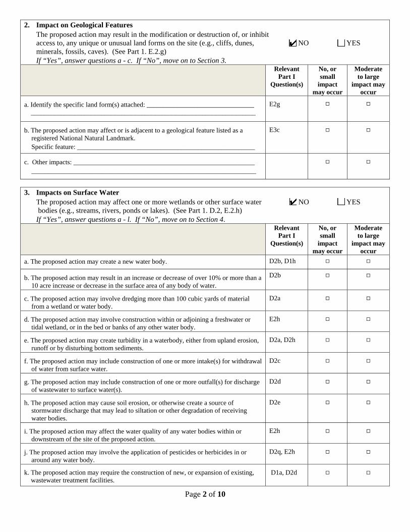
2. Impact on Geological Features
The proposed action may result in the modification or destruction of, or inhibit access to, any unique or unusual land forms on the site (e.g., cliffs, dunes, NO YES minerals, fossils, caves). (See Part 1. E.2.g) If “Yes”, answer questions a - c. If “No”, move on to Section 3.
Relevant Part I
Question(s)
No, or small
impact may occur
Moderate to large
impact may occur
a. Identify the specific land form(s) attached: ________________________________ ___________________________________________________________________
E2g 9 9
b. The proposed action may affect or is adjacent to a geological feature listed as a
registered National Natural Landmark. Specific feature: _____________________________________________________
E3c 9 9
c. Other impacts: ______________________________________________________
___________________________________________________________________
9 9
3. Impacts on Surface Water
The proposed action may affect one or more wetlands or other surface water NO YES bodies (e.g., streams, rivers, ponds or lakes). (See Part 1. D.2, E.2.h)
If “Yes”, answer questions a - l. If “No”, move on to Section 4.
Relevant Part I
Question(s)
No, or small
impact may occur
Moderate to large
impact may occur
a. The proposed action may create a new water body. D2b, D1h 9 9 b. The proposed action may result in an increase or decrease of over 10% or more than a
10 acre increase or decrease in the surface area of any body of water. D2b 9 9
c. The proposed action may involve dredging more than 100 cubic yards of material
from a wetland or water body. D2a
9 9
d. The proposed action may involve construction within or adjoining a freshwater or
tidal wetland, or in the bed or banks of any other water body. E2h
9 9
e. The proposed action may create turbidity in a waterbody, either from upland erosion,
runoff or by disturbing bottom sediments. D2a, D2h
9 9
f. The proposed action may include construction of one or more intake(s) for withdrawal
of water from surface water. D2c
9 9
g. The proposed action may include construction of one or more outfall(s) for discharge
of wastewater to surface water(s). D2d
9 9
h. The proposed action may cause soil erosion, or otherwise create a source of
stormwater discharge that may lead to siltation or other degradation of receiving water bodies.
D2e 9 9
i. The proposed action may affect the water quality of any water bodies within or
downstream of the site of the proposed action. E2h
9 9
j. The proposed action may involve the application of pesticides or herbicides in or
around any water body. D2q, E2h
9 9
k. The proposed action may require the construction of new, or expansion of existing, wastewater treatment facilities.
D1a, D2d 9 9

Page 3 of 10
l. Other impacts: __________________________________________________________________________________________________________________________
9 9
4. Impact on groundwaterThe proposed action may result in new or additional use of ground water, or NO YES may have the potential to introduce contaminants to ground water or an aquifer. (See Part 1. D.2.a, D.2.c, D.2.d, D.2.p, D.2.q, D.2.t) If “Yes”, answer questions a - h. If “No”, move on to Section 5.
Relevant Part I
Question(s)
No, or small
impact may occur
Moderate to large
impact may occur
a. The proposed action may require new water supply wells, or create additional demandon supplies from existing water supply wells.
D2c 9 9
b. Water supply demand from the proposed action may exceed safe and sustainablewithdrawal capacity rate of the local supply or aquifer.Cite Source: ________________________________________________________
D2c 9 9
c. The proposed action may allow or result in residential uses in areas without water andsewer services.
D1a, D2c 9 9
d. The proposed action may include or require wastewater discharged to groundwater. D2d, E2l 9 9
e. The proposed action may result in the construction of water supply wells in locationswhere groundwater is, or is suspected to be, contaminated.
D2c, E1f, E1g, E1h
9 9
f. The proposed action may require the bulk storage of petroleum or chemical productsover ground water or an aquifer.
D2p, E2l 9 9
g. The proposed action may involve the commercial application of pesticides within 100feet of potable drinking water or irrigation sources.
E2h, D2q, E2l, D2c
9 9
h. Other impacts: ________________________________________________________________________________________________________________________
9 9
5. Impact on FloodingThe proposed action may result in development on lands subject to flooding. NO YES (See Part 1. E.2)If “Yes”, answer questions a - g. If “No”, move on to Section 6.
Relevant Part I
Question(s)
No, or small
impact may occur
Moderate to large
impact may occur
a. The proposed action may result in development in a designated floodway. E2i 9 9
b. The proposed action may result in development within a 100 year floodplain. E2j 9 9
c. The proposed action may result in development within a 500 year floodplain. E2k 9 9
d. The proposed action may result in, or require, modification of existing drainagepatterns.
D2b, D2e 9 9
e. The proposed action may change flood water flows that contribute to flooding. D2b, E2i, E2j, E2k
9 9
f. If there is a dam located on the site of the proposed action, is the dam in need of repair,or upgrade?
E1e 9 9
Page 4 of 10
g. Other impacts: _________________________________________________________________________________________________________________________
9 9
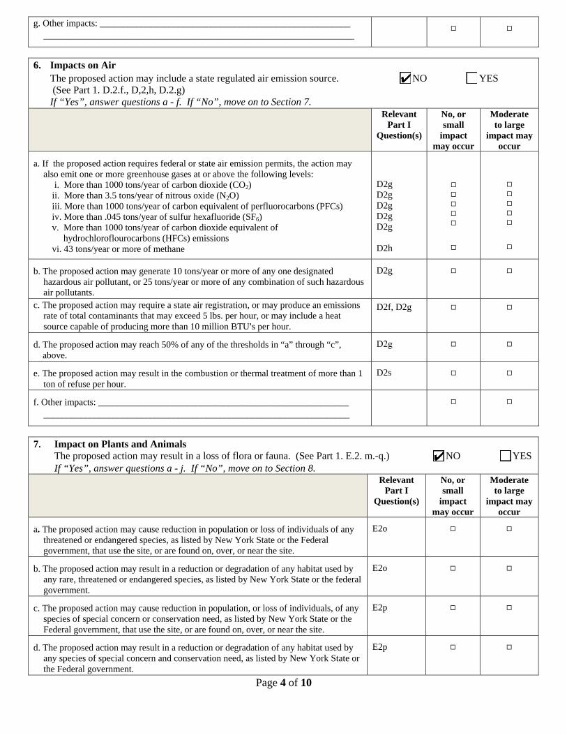
6. Impacts on AirThe proposed action may include a state regulated air emission source. NO YES (See Part 1. D.2.f., D,2,h, D.2.g) If “Yes”, answer questions a - f. If “No”, move on to Section 7.
Relevant Part I
Question(s)
No, or small
impact may occur
Moderate to large
impact may occur
a. If the proposed action requires federal or state air emission permits, the action mayalso emit one or more greenhouse gases at or above the following levels:
i. More than 1000 tons/year of carbon dioxide (CO2)ii. More than 3.5 tons/year of nitrous oxide (N2O)iii. More than 1000 tons/year of carbon equivalent of perfluorocarbons (PFCs)iv. More than .045 tons/year of sulfur hexafluoride (SF6)v. More than 1000 tons/year of carbon dioxide equivalent of
hydrochloroflourocarbons (HFCs) emissionsvi. 43 tons/year or more of methane
D2g D2g D2g D2g D2g
D2h
99999
9
99999
9
b. The proposed action may generate 10 tons/year or more of any one designatedhazardous air pollutant, or 25 tons/year or more of any combination of such hazardousair pollutants.
D2g 9 9
c. The proposed action may require a state air registration, or may produce an emissionsrate of total contaminants that may exceed 5 lbs. per hour, or may include a heatsource capable of producing more than 10 million BTU=s per hour.
D2f, D2g 9 9
d. The proposed action may reach 50% of any of the thresholds in “a” through “c”, above.
D2g 9 9
e. The proposed action may result in the combustion or thermal treatment of more than 1ton of refuse per hour.
D2s 9 9
f. Other impacts: ________________________________________________________________________________________________________________________
9 9
7. Impact on Plants and AnimalsThe proposed action may result in a loss of flora or fauna. (See Part 1. E.2. m.-q.) NO YES
If “Yes”, answer questions a - j. If “No”, move on to Section 8. Relevant
Part I Question(s)
No, or small
impact may occur
Moderate to large
impact may occur
a. The proposed action may cause reduction in population or loss of individuals of anythreatened or endangered species, as listed by New York State or the Federalgovernment, that use the site, or are found on, over, or near the site.
E2o 9 9
b. The proposed action may result in a reduction or degradation of any habitat used byany rare, threatened or endangered species, as listed by New York State or the federalgovernment.
E2o 9 9
c. The proposed action may cause reduction in population, or loss of individuals, of anyspecies of special concern or conservation need, as listed by New York State or theFederal government, that use the site, or are found on, over, or near the site.
E2p 9 9
d. The proposed action may result in a reduction or degradation of any habitat used byany species of special concern and conservation need, as listed by New York State orthe Federal government.
E2p 9 9

Page 5 of 10
e. The proposed action may diminish the capacity of a registered National Natural
Landmark to support the biological community it was established to protect. E3c
9 9
f. The proposed action may result in the removal of, or ground disturbance in, any
portion of a designated significant natural community. Source: ____________________________________________________________
E2n 9 9
g. The proposed action may substantially interfere with nesting/breeding, foraging, or over-wintering habitat for the predominant species that occupy or use the project site. E2m
9 9
h. The proposed action requires the conversion of more than 10 acres of forest,
grassland or any other regionally or locally important habitat. Habitat type & information source: ______________________________________ __________________________________________________________________
E1b
9 9
i. Proposed action (commercial, industrial or recreational projects, only) involves use of
herbicides or pesticides. D2q
9 9
j. Other impacts: ______________________________________________________
__________________________________________________________________
9 9
8. Impact on Agricultural Resources The proposed action may impact agricultural resources. (See Part 1. E.3.a. and b.) NO YES If “Yes”, answer questions a - h. If “No”, move on to Section 9. Relevant
Part I Question(s)
No, or small
impact may occur
Moderate to large
impact may occur
a. The proposed action may impact soil classified within soil group 1 through 4 of the NYS Land Classification System.
E2c, E3b 9 9
b. The proposed action may sever, cross or otherwise limit access to agricultural land
(includes cropland, hayfields, pasture, vineyard, orchard, etc). E1a, Elb
9 9
c. The proposed action may result in the excavation or compaction of the soil profile of
active agricultural land. E3b
9 9
d. The proposed action may irreversibly convert agricultural land to non-agricultural
uses, either more than 2.5 acres if located in an Agricultural District, or more than 10 acres if not within an Agricultural District.
E1b, E3a 9 9
e. The proposed action may disrupt or prevent installation of an agricultural land
management system. El a, E1b
9 9
f. The proposed action may result, directly or indirectly, in increased development
potential or pressure on farmland. C2c, C3, D2c, D2d
9 9
g. The proposed project is not consistent with the adopted municipal Farmland
Protection Plan. C2c
9 9
h. Other impacts: ________________________________________________________
9 9
Page 6 of 10
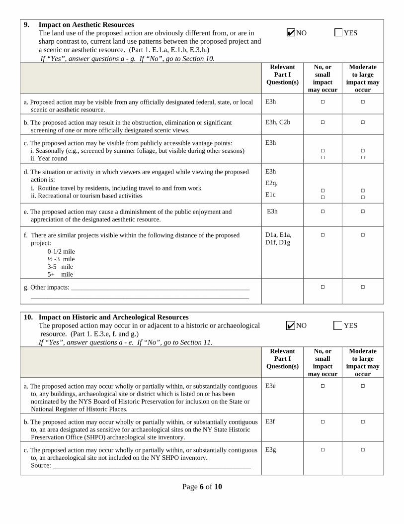
9. Impact on Aesthetic Resources The land use of the proposed action are obviously different from, or are in NO YES sharp contrast to, current land use patterns between the proposed project and a scenic or aesthetic resource. (Part 1. E.1.a, E.1.b, E.3.h.) If “Yes”, answer questions a - g. If “No”, go to Section 10. Relevant
Part I Question(s)
No, or small
impact may occur
Moderate to large
impact may occur
a. Proposed action may be visible from any officially designated federal, state, or local
scenic or aesthetic resource. E3h
9 9
b. The proposed action may result in the obstruction, elimination or significant
screening of one or more officially designated scenic views. E3h, C2b
9 9
c. The proposed action may be visible from publicly accessible vantage points: i. Seasonally (e.g., screened by summer foliage, but visible during other seasons) ii. Year round
E3h
9 9
9 9
d. The situation or activity in which viewers are engaged while viewing the proposed
action is: i. Routine travel by residents, including travel to and from work ii. Recreational or tourism based activities
E3h
E2q,
E1c
9 9
9 9
e. The proposed action may cause a diminishment of the public enjoyment and
appreciation of the designated aesthetic resource. E3h
9 9
f. There are similar projects visible within the following distance of the proposed
project: 0-1/2 mile ½ -3 mile 3-5 mile 5+ mile
D1a, E1a, D1f, D1g
9 9
g. Other impacts: ______________________________________________________
__________________________________________________________________
9 9
10. Impact on Historic and Archeological Resources The proposed action may occur in or adjacent to a historic or archaeological NO YES resource. (Part 1. E.3.e, f. and g.) If “Yes”, answer questions a - e. If “No”, go to Section 11.
Relevant Part I
Question(s)
No, or small
impact may occur
Moderate to large
impact may occur
a. The proposed action may occur wholly or partially within, or substantially contiguous
to, any buildings, archaeological site or district which is listed on or has been nominated by the NYS Board of Historic Preservation for inclusion on the State or National Register of Historic Places.
E3e 9 9
b. The proposed action may occur wholly or partially within, or substantially contiguous
to, an area designated as sensitive for archaeological sites on the NY State Historic Preservation Office (SHPO) archaeological site inventory.
E3f 9 9
c. The proposed action may occur wholly or partially within, or substantially contiguous
to, an archaeological site not included on the NY SHPO inventory. Source: ____________________________________________________________
E3g 9 9

Page 7 of 10
d. Other impacts: ________________________________________________________________________________________________________________________
9 9
e. If any of the above (a-d) are answered “Yes”, continue with the following questionsto help support conclusions in Part 3:
i. The proposed action may result in the destruction or alteration of all or partof the site or property.
ii. The proposed action may result in the alteration of the property’s setting orintegrity.
iii. The proposed action may result in the introduction of visual elements whichare out of character with the site or property, or may alter its setting.
E3e, E3g, E3f
E3e, E3f, E3g, E1a, E1b E3e, E3f, E3g, E3h, C2, C3
9
9
9
9
9
9
11. Impact on Open Space and RecreationThe proposed action may result in a loss of recreational opportunities or a NO YES reduction of an open space resource as designated in any adoptedmunicipal open space plan.(See Part 1. C.2.c, E.1.c., E.2.q.)If “Yes”, answer questions a - e. If “No”, go to Section 12.
Relevant Part I
Question(s)
No, or small
impact may occur
Moderate to large
impact may occur
a. The proposed action may result in an impairment of natural functions, or “ecosystemservices”, provided by an undeveloped area, including but not limited to stormwaterstorage, nutrient cycling, wildlife habitat.
D2e, E1b E2h, E2m, E2o, E2n, E2p
9 9
b. The proposed action may result in the loss of a current or future recreational resource. C2a, E1c, C2c, E2q
9 9
c. The proposed action may eliminate open space or recreational resource in an areawith few such resources.
C2a, C2c E1c, E2q
9 9
d. The proposed action may result in loss of an area now used informally by thecommunity as an open space resource.
C2c, E1c 9 9
e. Other impacts: ______________________________________________________________________________________________________________________
9 9
12. Impact on Critical Environmental AreasThe proposed action may be located within or adjacent to a critical NO YES environmental area (CEA). (See Part 1. E.3.d)If “Yes”, answer questions a - c. If “No”, go to Section 13.
Relevant Part I
Question(s)
No, or small
impact may occur
Moderate to large
impact may occur
a. The proposed action may result in a reduction in the quantity of the resource orcharacteristic which was the basis for designation of the CEA.
E3d 9 9
b. The proposed action may result in a reduction in the quality of the resource orcharacteristic which was the basis for designation of the CEA.
E3d 9 9
c. Other impacts: ________________________________________________________________________________________________________________________
9 9

Page 8 of 10
13. Impact on TransportationThe proposed action may result in a change to existing transportation systems. NO YES (See Part 1. D.2.j)If “Yes”, answer questions a - g. If “No”, go to Section 14.
Relevant Part I
Question(s)
No, or small
impact may occur
Moderate to large
impact may occur
a. Projected traffic increase may exceed capacity of existing road network. D2j 9 9
b. The proposed action may result in the construction of paved parking area for 500 ormore vehicles.
D2j 9 9
c. The proposed action will degrade existing transit access. D2j 9 9
d. The proposed action will degrade existing pedestrian or bicycle accommodations. D2j 9 9
e. The proposed action may alter the present pattern of movement of people or goods. D2j 9 9
f. Other impacts: ________________________________________________________________________________________________________________________
9 9
14. Impact on EnergyThe proposed action may cause an increase in the use of any form of energy. NO YES (See Part 1. D.2.k)If “Yes”, answer questions a - e. If “No”, go to Section 15.
Relevant Part I
Question(s)
No, or small
impact may occur
Moderate to large
impact may occur
a. The proposed action will require a new, or an upgrade to an existing, substation. D2k 9 9
b. The proposed action will require the creation or extension of an energy transmissionor supply system to serve more than 50 single or two-family residences or to serve acommercial or industrial use.
D1f, D1q, D2k
9 9
c. The proposed action may utilize more than 2,500 MWhrs per year of electricity. D2k 9 9
d. The proposed action may involve heating and/or cooling of more than 100,000 squarefeet of building area when completed.
D1g 9 9
e. Other Impacts: ____________________________________________________________________________________________________________________________
15. Impact on Noise, Odor, and LightThe proposed action may result in an increase in noise, odors, or outdoor lighting. NO YES (See Part 1. D.2.m., n., and o.)If “Yes”, answer questions a - f. If “No”, go to Section 16.
Relevant Part I
Question(s)
No, or small
impact may occur
Moderate to large
impact may occur
a. The proposed action may produce sound above noise levels established by localregulation.
D2m 9 9
b. The proposed action may result in blasting within 1,500 feet of any residence,hospital, school, licensed day care center, or nursing home.
D2m, E1d 9 9
c. The proposed action may result in routine odors for more than one hour per day. D2o 9 9

Page 9 of 10
d. The proposed action may result in light shining onto adjoining properties. D2n 9 9
e. The proposed action may result in lighting creating sky-glow brighter than existingarea conditions.
D2n, E1a 9 9
f. Other impacts: ________________________________________________________________________________________________________________________
9 9
16. Impact on Human HealthThe proposed action may have an impact on human health from exposure NO YES to new or existing sources of contaminants. (See Part 1.D.2.q., E.1. d. f. g. and h.)If “Yes”, answer questions a - m. If “No”, go to Section 17.
Relevant Part I
Question(s)
No,or small
impact may cccur
Moderate to large
impact may occur
a. The proposed action is located within 1500 feet of a school, hospital, licensed daycare center, group home, nursing home or retirement community.
E1d 9 9
b. The site of the proposed action is currently undergoing remediation. E1g, E1h 9 9
c. There is a completed emergency spill remediation, or a completed environmental siteremediation on, or adjacent to, the site of the proposed action.
E1g, E1h 9 9
d. The site of the action is subject to an institutional control limiting the use of the property (e.g., easement or deed restriction).
E1g, E1h 9 9
e. The proposed action may affect institutional control measures that were put in placeto ensure that the site remains protective of the environment and human health.
E1g, E1h 9 9
f. The proposed action has adequate control measures in place to ensure that futuregeneration, treatment and/or disposal of hazardous wastes will be protective of theenvironment and human health.
D2t 9 9
g. The proposed action involves construction or modification of a solid wastemanagement facility.
D2q, E1f 9 9
h. The proposed action may result in the unearthing of solid or hazardous waste. D2q, E1f 9 9
i. The proposed action may result in an increase in the rate of disposal, or processing, ofsolid waste.
D2r, D2s 9 9
j. The proposed action may result in excavation or other disturbance within 2000 feet ofa site used for the disposal of solid or hazardous waste.
E1f, E1g E1h
9 9
k. The proposed action may result in the migration of explosive gases from a landfillsite to adjacent off site structures.
E1f, E1g 9 9
l. The proposed action may result in the release of contaminated leachate from theproject site.
D2s, E1f, D2r
9 9
m. Other impacts: ________________________________________________________________________________________________________________________

Page 10 of 10
17. Consistency with Community Plans The proposed action is not consistent with adopted land use plans. NO YES (See Part 1. C.1, C.2. and C.3.) If “Yes”, answer questions a - h. If “No”, go to Section 18.
Relevant Part I
Question(s)
No, or small
impact may occur
Moderate to large
impact may occur
a. The proposed action’s land use components may be different from, or in sharp contrast to, current surrounding land use pattern(s).
C2, C3, D1a E1a, E1b
9 9
b. The proposed action will cause the permanent population of the city, town or village in which the project is located to grow by more than 5%.
C2 9 9
c. The proposed action is inconsistent with local land use plans or zoning regulations. C2, C2, C3 9 9
d. The proposed action is inconsistent with any County plans, or other regional land use plans.
C2, C2 9 9
e. The proposed action may cause a change in the density of development that is not supported by existing infrastructure or is distant from existing infrastructure.
C3, D1c, D1d, D1f, D1d, Elb
9 9
f. The proposed action is located in an area characterized by low density development that will require new or expanded public infrastructure.
C4, D2c, D2d D2j
9 9
g. The proposed action may induce secondary development impacts (e.g., residential or commercial development not included in the proposed action)
C2a 9 9
h. Other: _____________________________________________________________ __________________________________________________________________
9 9
18. Consistency with Community Character The proposed project is inconsistent with the existing community character. NO YES (See Part 1. C.2, C.3, D.2, E.3) If “Yes”, answer questions a - g. If “No”, proceed to Part 3.
Relevant Part I
Question(s)
No, or small
impact may occur
Moderate to large
impact may occur
a. The proposed action may replace or eliminate existing facilities, structures, or areas of historic importance to the community.
E3e, E3f, E3g 9 9
b. The proposed action may create a demand for additional community services (e.g. schools, police and fire)
C4 9 9
c. The proposed action may displace affordable or low-income housing in an area where there is a shortage of such housing.
C2, C3, D1f D1g, E1a
9 9
d. The proposed action may interfere with the use or enjoyment of officially recognized or designated public resources.
C2, E3 9 9
e. The proposed action is inconsistent with the predominant architectural scale and character.
C2, C3 9 9
f. Proposed action is inconsistent with the character of the existing natural landscape. C2, C3 E1a, E1b E2g, E2h
9 9
g. Other impacts: ______________________________________________________ __________________________________________________________________
9 9
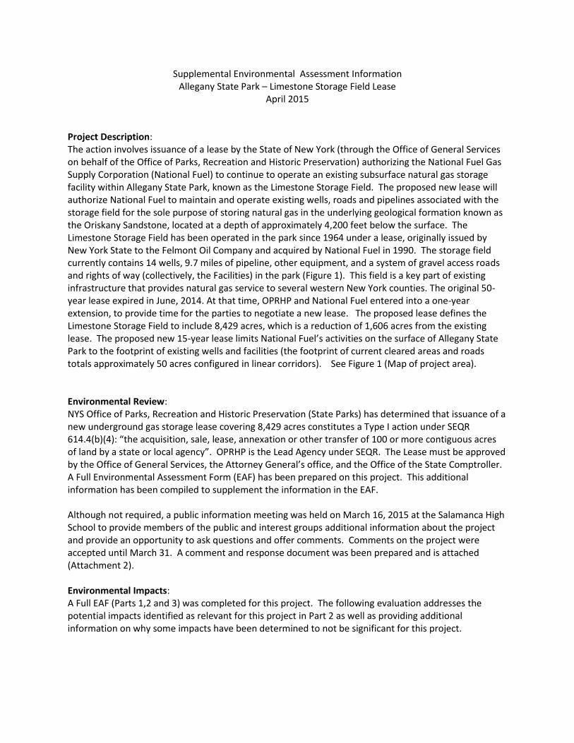
Supplemental Environmental Assessment Information Allegany State Park – Limestone Storage Field Lease
April 2015
Project Description: The action involves issuance of a lease by the State of New York (through the Office of General Services on behalf of the Office of Parks, Recreation and Historic Preservation) authorizing the National Fuel Gas Supply Corporation (National Fuel) to continue to operate an existing subsurface natural gas storage facility within Allegany State Park, known as the Limestone Storage Field. The proposed new lease will authorize National Fuel to maintain and operate existing wells, roads and pipelines associated with the storage field for the sole purpose of storing natural gas in the underlying geological formation known as the Oriskany Sandstone, located at a depth of approximately 4,200 feet below the surface. The Limestone Storage Field has been operated in the park since 1964 under a lease, originally issued by New York State to the Felmont Oil Company and acquired by National Fuel in 1990. The storage field currently contains 14 wells, 9.7 miles of pipeline, other equipment, and a system of gravel access roads and rights of way (collectively, the Facilities) in the park (Figure 1). This field is a key part of existing infrastructure that provides natural gas service to several western New York counties. The original 50-year lease expired in June, 2014. At that time, OPRHP and National Fuel entered into a one-year extension, to provide time for the parties to negotiate a new lease. The proposed lease defines the Limestone Storage Field to include 8,429 acres, which is a reduction of 1,606 acres from the existing lease. The proposed new 15-year lease limits National Fuel’s activities on the surface of Allegany State Park to the footprint of existing wells and facilities (the footprint of current cleared areas and roads totals approximately 50 acres configured in linear corridors). See Figure 1 (Map of project area). Environmental Review: NYS Office of Parks, Recreation and Historic Preservation (State Parks) has determined that issuance of a new underground gas storage lease covering 8,429 acres constitutes a Type I action under SEQR 614.4(b)(4): “the acquisition, sale, lease, annexation or other transfer of 100 or more contiguous acres of land by a state or local agency”. OPRHP is the Lead Agency under SEQR. The Lease must be approved by the Office of General Services, the Attorney General’s office, and the Office of the State Comptroller. A Full Environmental Assessment Form (EAF) has been prepared on this project. This additional information has been compiled to supplement the information in the EAF. Although not required, a public information meeting was held on March 16, 2015 at the Salamanca High School to provide members of the public and interest groups additional information about the project and provide an opportunity to ask questions and offer comments. Comments on the project were accepted until March 31. A comment and response document was been prepared and is attached (Attachment 2). Environmental Impacts: A Full EAF (Parts 1,2 and 3) was completed for this project. The following evaluation addresses the potential impacts identified as relevant for this project in Part 2 as well as providing additional information on why some impacts have been determined to not be significant for this project.

Impact on Land – Part 2 was answered “NO” for this question because the terms of the lease require that there be no new development in the leased area during the 15 year lease period. No new construction or excavation is permitted. Routine maintenance activities that have occurred in the leased area for the past 50 years will continue including: Mowing of the well heads areas as needed during the summer using a hand held weed whacker; mowing pipeline ROW’s – once/year; regrading roadways each spring based on the extent of winter damage; and painting of above ground facilities as needed (every 8-12 years). Impacts of these ongoing routine maintenance activities are not significant. Impacts on Surface Water – Part 2 was answered “NO” for this question because the terms of the lease do not allow any new development in the leased area. During maintenance activities such as road grading, proper erosion controls will be used near streams and wetlands if there is potential for sediments and runoff to reach these waterbodies. Impact on groundwater – Part 2 of the EAF was answered “NO” for this question as the project will not result in any new or additional use of groundwater. Also, National Fuel has an underground gas storage permit from NYSDEC under Title 13 of the Environmental Conservation Law Article 23 and a Certificate of Public Convenience and Necessity from the Federal Energy Regulatory Commission (FERC) to operate the Limestone Storage Field. The processes that were required to receive these permits and certificates assure that groundwater resources are protected during gas storage operations. Impact on Air – As above, Part 2 was answered “NO” as there will be no state regulated emission sources from this project. Impact on Plants and Animals – Part 2 of the EAF was answered “NO” for this question as the project is not expected to have any impacts on flora or fauna. A check of the Natural Heritage Program GIS Database (New York Natural Heritage Program 2015) indicated that 2 rare insects, a rare fish species and a rare plant species have been identified within the lease area. In addition, the entire leased area is identified as significant ecological communities. These are high quality and diverse examples of more common community types including Maple-Basswood Rich Mesic Forest, Maple-Basswood Rich Mesic Forest Old Growth, Hemlock-Northern Hardwood Forest, Hemlock-Northern Hardwood Forest Old Growth, Rich Mesophytic Forest, and Rich Mesophytic Forest Old Growth. As discussed above, the project is not expected to result in any significant adverse impacts to any of these elements because the lease prohibits the creation of any new wells or injection points; construction of any new or expansion of any access roads; cutting or clearing of any vegetation; and introduction of any new pipelines or infrastructure in the park. Any road grading or culvert maintenance work proposed on the existing road near France Brook or Red House Brook will use appropriate erosion control measures to protect the rare fish species. In addition, National Fuel will be asked to adhere to the Agency’s Best Management Practices for Preventing the Introduction and Spread of Invasive Species when performing maintenance work. In particular, all equipment should be clean and free of any dirt/soil, mud, seeds or other plant material prior to performing work or moving from one work area to another within State Park lands. This action will help protect these very significant lands from the introduction of invasive species. Impact on Aesthetic Resources – Part 2 of the EAF was answered “NO” for this question because there will be no visual changes from the existing situation that has occurred for the past 50 years.

Impact on Historic and Archeological Resources – This section of Part 2 was answered “NO” because the new lease does not call for any new structures or ground disturbance. The project was reviewed by OPRHP’s Division for Historic Preservation and they determined that it will have No Adverse Impact upon cultural resources in or eligible for inclusion in the State or National Register of Historic Places. Impact on Open Space and Recreation – Part 2 was checked “NO” for this question as there will be no change from the existing conditions. The lease contains a clause indicating that the Lessor acknowledges that the Limestone Storage Field exists within a New York State Park which is open to the public and is available for all forms of outdoor recreation during all seasons of the year. The entire leased area will remain open to the public for recreational use. Impact on Noise, Odor, and Light – This question in Part 2 of the EAF was also checked “NO” because the new Lease will not result in any increase in noise, odors, or outdoor lighting in the leased area. Consistency with Community Plans – This question was checked as “NO” as well. The Master Plan/FEIS for Allegany State Park, adopted in 2010 indicated that the Lease existed and that State Parks would continue to work with NFG to protect surface resources in the leased area; that renegotiation of the lease would be addressed separately following the lease expiration in 2014; and that the NFG surface infrastructure was not included within the Park Preservation Area for the Park (OPRHP 2010). Since the new lease does not allow any new drilling or development within the leased area, it is considered consistent with the Park Master Plan. Consistency with Community Character – The statement provided for evaluation in the EAF Part 2 is: “The proposed project is inconsistent with the existing community character”. This question was answered “NO” because there will be no change from the existing character of that area of the park. Summary of Environmental Effects Based on the above evaluation, the environmental impacts of a new 15-year underground natural gas storage lease with the strict terms being included within the lease are not expected to be significantly adverse. State Parks has issued a negative declaration under SEQR for this project – See Part 3 of the EAF. Sources Consulted/References: Lundgren, J.A. and K.J. Smith. (in prep) “Rare Species and Ecological Communities of Allegany State Park: revision” (an update to the 2004 Natural Heritage report) Miga, Richard 2015. National Fuel. Personal communication, 4/15. NYS DEC 2015. Underground Gas Storage Summary-NYS Department of Environmental Conservation Webpage: http://www.dec.ny.gov/energy/35817.html Accessed 4/21/15. New York Natural Heritage Program 2015. Element Occurrence Dataset. New York Natural Heritage Program. State University of New York College of Environmental Science and Foresty. Albany, NY. Accessed 3/2015.

NYS OPRHP 2010. Final Master Plan/Final Environmental Impact Statement for Allegany State Park. Albany, NY.

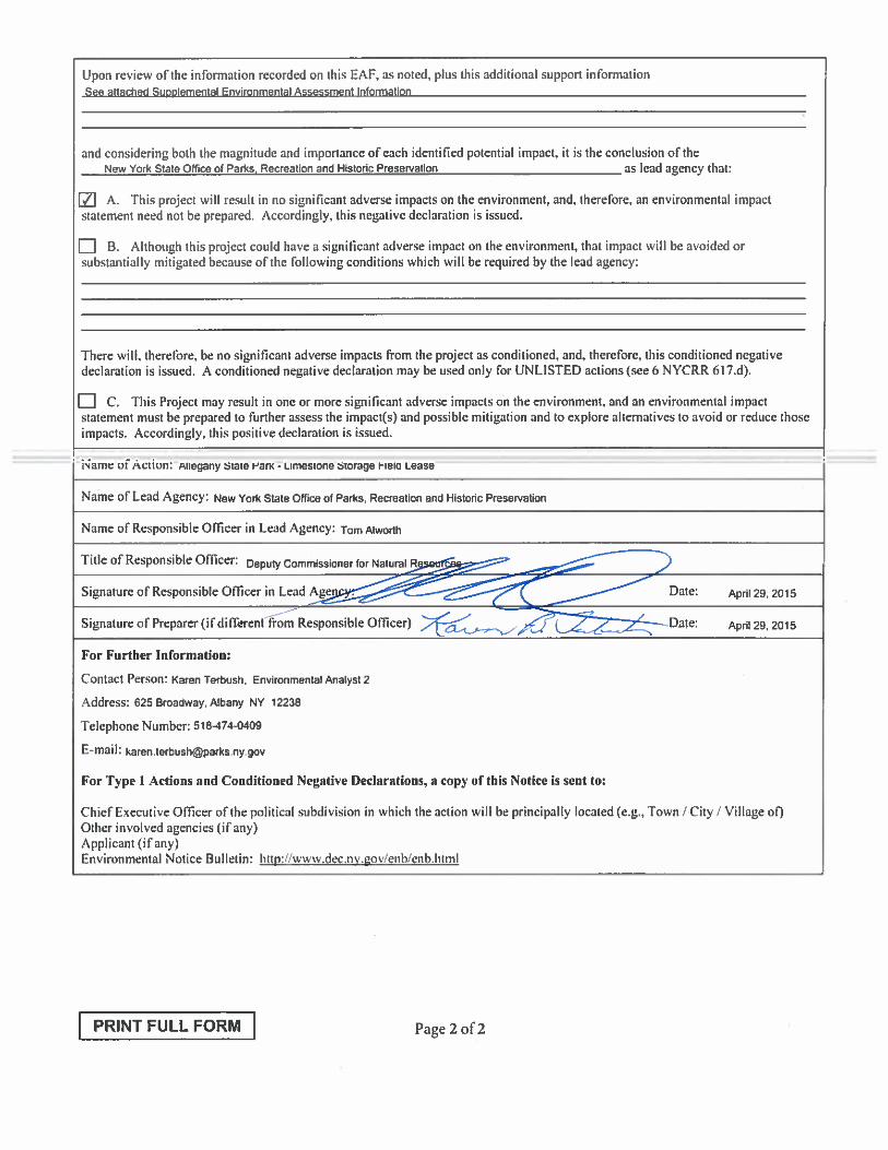
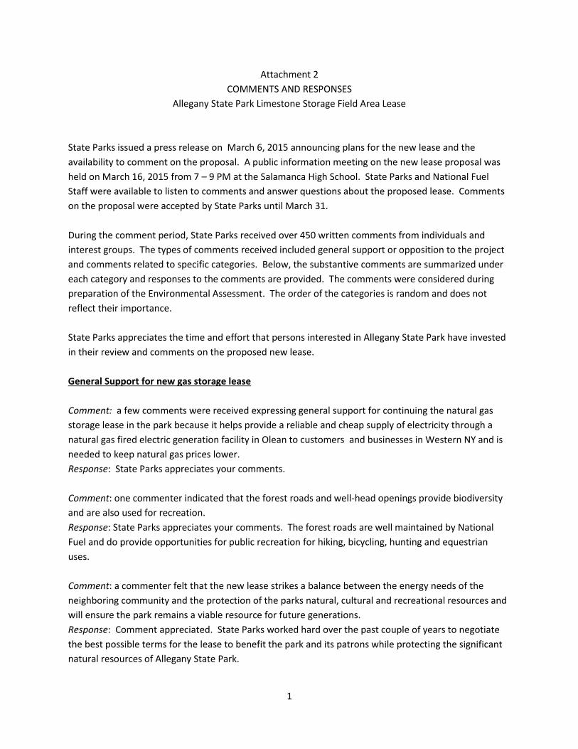
1
Attachment 2
COMMENTS AND RESPONSES
Allegany State Park Limestone Storage Field Area Lease
State Parks issued a press release on March 6, 2015 announcing plans for the new lease and the
availability to comment on the proposal. A public information meeting on the new lease proposal was
held on March 16, 2015 from 7 – 9 PM at the Salamanca High School. State Parks and National Fuel
Staff were available to listen to comments and answer questions about the proposed lease. Comments
on the proposal were accepted by State Parks until March 31.
During the comment period, State Parks received over 450 written comments from individuals and
interest groups. The types of comments received included general support or opposition to the project
and comments related to specific categories. Below, the substantive comments are summarized under
each category and responses to the comments are provided. The comments were considered during
preparation of the Environmental Assessment. The order of the categories is random and does not
reflect their importance.
State Parks appreciates the time and effort that persons interested in Allegany State Park have invested
in their review and comments on the proposed new lease.
General Support for new gas storage lease
Comment: a few comments were received expressing general support for continuing the natural gas
storage lease in the park because it helps provide a reliable and cheap supply of electricity through a
natural gas fired electric generation facility in Olean to customers and businesses in Western NY and is
needed to keep natural gas prices lower.
Response: State Parks appreciates your comments.
Comment: one commenter indicated that the forest roads and well-head openings provide biodiversity
and are also used for recreation.
Response: State Parks appreciates your comments. The forest roads are well maintained by National
Fuel and do provide opportunities for public recreation for hiking, bicycling, hunting and equestrian
uses.
Comment: a commenter felt that the new lease strikes a balance between the energy needs of the
neighboring community and the protection of the parks natural, cultural and recreational resources and
will ensure the park remains a viable resource for future generations.
Response: Comment appreciated. State Parks worked hard over the past couple of years to negotiate
the best possible terms for the lease to benefit the park and its patrons while protecting the significant
natural resources of Allegany State Park.

2
Comment: a commenter was pleased to see in increase in the annual payments to State Parks as well as
additional free gas for use by the park.
Response: Comment appreciated. State Parks worked hard over the past couple of years to negotiate
the best possible terms for the lease to benefit the park and its patrons while protecting the significant
natural resources of Allegany State Park.
General Opposition to new gas storage lease
Comment: Many comments were received expressing general opposition to a new lease and indicating
that National Fuel should vacate the park now and remove all of its facilities.
General Response: In 1964 the State of New York entered into a long-term lease with Felmont Oil
company (now National Fuel) to operate a sub-surface natural gas storage field beneath approximately
9,500 acres of Allegany State Park. This natural gas storage field is a naturally occurring and self-
contained stratigraphic trap located in the Oriskany Sandstone geologic formation over 4,000 feet
beneath the surface of the park. During the summer months, when demand for natural gas is relatively
low, National Fuel actively pumps natural gas from a pipeline that traverses the park, through a series of
existing underground distribution lines and wells, into the sandstone formation. During winter months
when natural gas demand increases for home heating and other purposes, National Fuel extracts the
natural gas, returning it to the pipeline to increase its supply and help costs to customers remain more
stable.
There are 26 natural gas storage facilities in New York concentrated in central and western NY, mostly
using depleted gas reservoirs and located near gas production fields and gas transmission facilities. The
one in Allegany State Park is one of the largest in western NY. Over the past 50 years of the original
lease, a number of businesses and communities have come to rely on this dependable source of natural
gas for their heating and operational needs. Ending the gas storage operations abruptly would result in
significant adverse economic impacts to several Southern Tier businesses and communities that rely on
the steady supply of gas that is provided year round through the storage operation.
Although the leased area is large, as is required by NYS DEC regulations (Article 23, Title 13), the actual
footprint of the infrastructure on the ground in Allegany State Park is less than 50 acres and is
comprised of a series of roads and 14 well head areas. In order to obtain a natural gas storage permit,
NYS DEC regulations require that the entire known reservoir plus a buffer zone to protect the reservoir
be leased. Monitoring by National Fuel in the 1990’s indicated that the northeast portion of the original
leased area was not part of the underground gas storage formation or the required buffer area. State
Parks negotiated with National Fuel to remove 1,606 acres from the leased area for the new lease. In
addition, State Parks worked hard in negotiations on the language within the new lease to assure that
the lease prohibits the creation of any new wells or injection points; construction of any new or
expansion of any access roads; cutting or clearing of any vegetation; and introduction of any new
pipelines or infrastructure in the park.
3
Comment: Several persons commented that commercial and industrial uses are incompatible with the
purposes of the park and the gas storage lease is an inappropriate use of the park.
Response: See general response. As discussed, the actual facilities on the ground are minimal,
encompassing less than 50 acres. NY State Park’s Policy on the Development of oil and gas resources in
State Parks and Historic Sites prohibits the development, extraction or offer for leasing of state-owned
oil and gas resources within state parks and historic sites. The policy, however, provides a specific
exception to this prohibition for the existing gas storage lease in Allegany State Park and indicates that it
is acceptable to maintain and, if deemed appropriate in the future, renew the existing lease.
Comment: Several persons commented that Parks are some of New York State’s most valuable
resources that need to be protected and preserved for future generations. Comments noted that Parks
are a public trust that belong to the people of the state and Allegany should be returned to the people in
its entirety.
Response: See General Response.
Climate Change
Comment: Several commenters expressed concerns with the impacts of fossil fuel use on climate
change and indicated that New York State should be a leader in moving towards a clean renewable
energy future. Some commenters indicated that they understood the current need for the new lease as
we transition from fossil fuels to renewable energy sources in order to continue to meet the needs of
the Southern Tier and businesses that rely on those sources.
Response: New York State Parks is a leader in renewable energy generation. State Parks has installed 10
solar arrays in the past 2 years in our Long Island, Saratoga, Finger Lakes, Genesee and Niagara
Regions. We expect to install six more arrays this year. State Parks will have the first energy neutral
park in the nation at Robert Moses State Park this year. By the end of 2015 State Parks will have
installed over a megawatt of solar power throughout the state. This number will grow dramatically over
the next two years. State Parks success with renewable energy comes from training our employees as
certified solar installers. We are the only state agency in New York State to have NYSERDA certified
solar installers on staff. This means that our trained in-house staff can complete installation without
having to contract out for services. As a result our solar installations cost about half that of a contractor
installation. Renewable energy is a critical piece of the State Parks energy future and a key component
in our fight against climate change. The Allegany Region is scheduled for an energy audit this year.
Following the audit, it is likely that solar projects will be proposed there as well.
Need
Comment: Several commenters felt that new pipelines currently being planned and existing ones in the
area should be able to supply the homes and businesses that are currently supplied by the Limestone

4
Storage Field by the end of the new 15-year lease and the storage field should be obsolete and no longer
needed.
Response: State Parks acknowledges that the natural gas industry is constantly in flux and that the
future need for underground gas storage is unknown. This need would certainly be a consideration in
any future negotiations regarding the future of the lease in Allegany State Park.
Length of Lease
Comment: Many commenters applauded the State for limiting the term of the new lease to 15 years and
many also commented that the new lease should be for as short a time as possible with no provisions
for any renewal. A large number of people commented that the lease should include terms requiring
National Fuel to phase out the use of the storage facility by the end of the 15 year lease and remove all
facilities and infrastructure. Others asked that the lease include a specific end date.
Response: The fifteen year term of the lease is a compromise to allow for the State to revisit the need
or propriety of this use within Allegany State Park in a relatively short period of time, while allowing NFG
to continue to serve the local business and residential community without working an abrupt change in
supply of natural gas. There is no provision within the proposed fifteen year lease for renewal or
extension of the lease term past the fifteen years, but there is a firm end date of June 30, 2030.
Size of Leased Area
Comment: a large number of persons applauded the reduction in size of the area being leased by
National Fuel.
Response: See general response.
Expansion Potential
Comment: Many commenters expressed their satisfaction with State Parks rejection of an expansion
proposal by National Fuel. Many comments were received expressing support for provisions in the lease
limiting National Fuel to its existing footprint and prohibiting any new development or expansion.
Response: State Parks appreciates these comments. The Master Plan for Allegany State Park, adopted
in 2010, recognized the significance of the park and designated the entire park as a Bird Conservation
Area and a Natural Heritage Area and most of the park as Park Preservation Areas in order to provide
additional protection. While the well heads and roads in the NFG storage area were excluded from the
Park Preservation areas, this includes only a small area around each well and road. State Parks worked
hard in negotiations on the language within the new lease to assure that the lease prohibits the creation
of any new wells or injection points; construction of any new or expansion of any access roads; cutting
or clearing of any vegetation; and introduction of any new pipelines or infrastructure in the park.
Old Growth Forest
Comment: Many commenters were concerned that half of the park’s significant old growth forest is
within the leased area and could be impacted in the future.
Response: See General Response and response above. State Parks is very aware of the significance of
the old growth forest in Allegany State Park and it is one of the reasons the Master Plan, adopted in
2010, included the designations discussed above. Based on the terms of the lease, no old growth forest

5
will be impacted during the next 15 years. Following that time, this significant forest will be further
protected by the designations and by State Parks Policy on the development of oil and gas resources in
State Parks and Historic Sites. Any proposal in the future for any new wells, roads or pipelines would
require a thorough and detailed environmental review process and the agency would take a very hard
look at impacts because of the significance of these areas.
Comment: Commenters were also concerned about the 50 acres of roads and openings breaking up a
large, otherwise intact forest area that has been allowed to recover from previous logging and
development.
Response: In addition to the approximately 50 acres of roads and well head openings in the leased area,
the area of the Lease is intersected by a large number of recreational trails, two major park roads and
France Brook road. No additional fragmentation will occur in this area as a result of this project. Despite
the disturbances in that section of the park, Allegany State Park still contains 2 of the three largest
blocks (> 10,000 acres) of high quality, unfragmented forests in central and western NY. The Master
Plan for the Park assures that those blocks will continue to remain unfragmented.
Procedural
Comment: Concern was expressed about the minimal opportunity provided for public input into this
decision, the short notice of the public meeting, its location far from the primary park users in Buffalo,
and disappointment with the manner in which the meeting was run.
Response: The public information meeting held at Salamanca, NY on March 16, 2015, though not
required by any statute or regulation, was held by State Parks to allow for comment on the lease
renewal by members of the public, especially those who utilize the many recreational opportunities
available at Allegany State Park. For this reason, it was felt that by holding the public meeting at a
sufficiently large facility as close to the Park as possible, the broadest selection of park users would be
able to attend, hear the speakers, view the exhibits and ask questions of, and offer their comments to,
State Parks and NFG representatives one-on-one. It was felt that the format of the public meeting gave
the public the best opportunity to do this.