Environment, Health and Safety (EHS) Gap Assessment ... · Environment, Health and Safety (EHS) Gap...
32
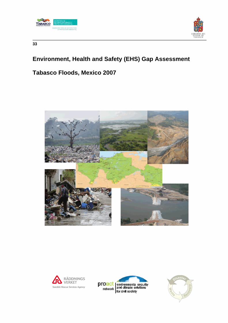
[SUBSECRETARIA DE GESTIÓN PARA LA PROTECCIÓN AMBIENTAL] 33 Environment, Health and Safety (EHS) Gap Assessment Tabasco Floods, Mexico 2007
Transcript of Environment, Health and Safety (EHS) Gap Assessment ... · Environment, Health and Safety (EHS) Gap...
[SUBSECRETARIA DE GESTIÓN PARA LA PROTECCIÓN AMBIENTAL]
[SUBSECRETARIA DE GESTIÓN PARA LA PROTECCIÓN AMBIENTAL]
33 Environment, Health and Safety (EHS) Gap Assessment Tabasco Floods, Mexico 2007

Tabasco Floods Environmental Health and Safety Gap Assessment Draft
Page 2 of 32
Table of Contents
TABASCO: ENVIRONMENTAL HEALTH AND SAFETY GAP ASSESSMENT 4
List of Abbreviations 4
1.0 Executive Summary 5
2.0 Introduction 5
2.0 Methodology 6
3.0 State Characteristics 7 3.1 Geography 7 3.2 Hydrology and Geology 7 3.3 State Disaster Profile 9 3.4 Environmental Regulations 11
4.0 Disaster Characteristics 14 4.1 Disaster Chronology 14 4.2 Disaster Characteristics: Campeche Sound Oil Accident and Spill 15 4.3 Disaster Characteristics: Chiapas Landslide 16 4.4 Disaster Characteristics: Tabasco Floods 17 4.5 Contributory Factors 20 4.6 National and International Response 21
5.0 Environmental Characteristics 21 5.1 Environmental Risk Mapping 21 5.2 Floodwater 22 5.3 Disaster Waste Management 22 5.4 Carcass Disposal 23 5.5 Drinking Water System 23 5.6 Sewage System 24 5.7 Flood Control System 24 5.8 Sediment 25 5.9 Storage Tanks 25 5.10 Vector Control 25
6.0 Disaster Mitigation Programmes 26 6.1 Early Warning Systems 26 6.2 Emergency Response 26 6.2 Environmental Emergency Procedures 28 6.3 Flood Risk Assessment and Control Programmes 28 6.4 Environmental Recovery and Disaster Risk Reduction (DRR) Programmes 28
7.0 Concluding Remarks 29
Disclaimer
“This report has been prepared with the financial assistance of the Swedish International Development Cooperation Agency (SIDA), and managed by SRSA/DWR/PROACT. The views expressed herein are those of SRSA/DWR/PROACT and therefore in no way reflect the official opinion of the SIDA”

Tabasco Floods Environmental Health and Safety Gap Assessment Draft
Page 3 of 32
TABLES
Table 1: Seismic Events in Tabasco (2007)
Table 2: Summary of Mexican Environmental Legislation Enforcement Authorities
FIGURES
Figure 1: Precipitation Rates, Federal Republic of Mexico Figure 2: Flood Risk, Federal Republic of Mexico Figure 3: Hurricane Risk, Federal Republic of Mexico Figure 4: Seismic Risk Map, Federal Republic of Mexico (1845 – 1985) Figure 5: Villahermosa Emergency Infrastructure Figure 6: Preliminary Impact Map of Villahermosa Indicating Extent of Housing
Damage
APPENDICES
Appendix A: Request Letter from Governor, State of Tabasco Appendix B: ProAct Network Flood Environmental Health and Safety (EHS)
Assessment Flow Diagram Appendix C: Flood Risk Assessment Programme Outline
Tabasco Floods Environmental Health and Safety Gap Assessment Draft
Page 4 of 32
BASCO: ENVIRONMENTAL HEALTH AND SAFETY GAP ASSESSMENT
List of Abbreviations APELL Awareness and Preparedness for Emergencies at Local Level
CENAPRED National Centre for Disaster Prevention
CENAVECE National Epidemiological Centre
CFE Federal Electricity Commission
CONAGUA National Water Commission
CP The State Office for Civil Protection
CRED Centre for Research on the Epidemiology of Disaster
DDR Disaster Risk Reduction
DWR Disaster Waste Recovery
EIA Environmental Impact Assessment
EHS Environmental Health and Safety
GIS Geographic Information System
IDP Internally Displaced Person
MM Ministry of Marine Services
NGO Non Governmental Organisation
OCHA United Nations Office for the Coordination of Humanitarian Affairs
PCB Polychlorinated Biphenyls
PEMEX Mexico’s state-owned petroleum company
PROFEPA Federal Administration of Environmental Protection Agency
SEMARNAT Ministry of Environment and Natural Resources
SERNAPAM Tabasco State Ministry of Environment
Sida Swedish Development Cooperation Agency
SRSA Swedish Rescue Service Agency
UST Underground Storage Tank
Tabasco Floods Environmental Health and Safety Gap Assessment Draft
Page 5 of 32
1.0 Executive Summary This Environmental Health and Safety (EHS) Gap Assessment report documents the national and international response to the environmental health and safety challenges from the Autumn 2007 floods in Tabasco, Mexico and provides recommendations on future work related to environmental preparedness and disaster risk reduction. Climate change and deforestation have dramatically increased the vulnerability of the low-lying Mexican State of Tabasco to flood events and a recent landslide has highlighted the potential for catastrophic dam failure in the neighboring state of Chiapas, which would cause significant damage to urban and rural communities in Tabasco. The EHS Gap Assessment has assessed the response to two principal risks: one realised (a storm that caused extensive flooding, landslide and an oil rig accident) and one “near miss” (potential catastrophic failure of the hydropower dams). The assessment reveals a competent response by the State authorities, especially by the Health Department, to the flooding event. However, the newly formed Environmental Department lacks human, financial and technical resources including equipment such as field test kits, water quality monitors, etc., effective enforcement of environmental legislation, such as urban planning, and, in particular, the ability to promote the use of natural resources as a disaster risk reduction technique, such as the use of wetlands as a flood control mechanism. In addition, the lack of a disaster management command structure linking Departments, States (Tabasco and Chiapas) and the Federal Government means that there is a lack of early warning and preparedness planning and a potential conflict of interest between financial asset protection (power supply, dams and hydro-power equipment) and damage limitation in flood prone downstream communities. Based on the key findings, the report presents recommendations for future work including the following:
• Environmental risk mapping of the State including hazards (flood, seismic, storm surge, landslides) and vulnerable receptors (hospitals, schools, critical infrastructure, water abstraction points, etc.),
• Improved analytical capacity for surface waters (portable monitoring equipment and mobile laboratories) and soils/sediments,
• Disaster waste planning and preparedness including improved public information, • Guidance on the disposal of livestock during flood events • Upgrading and protecting drinking and wastewater treatment plants, • Development of complementary flood control techniques using environmental
services such as the use of wetlands and washways, • Development of early warning centre that includes remote sensing, forecasting, river
and reservoir level gauges linked to neighbouring State of Chiapas and relevant federal agencies
• Development of an emergency response plan by the State environmental authority.
2.0 Introduction This report has been prepared in response to a request by the Governor of Tabasco for international assistance in disaster waste and environmental management in relation to the
Tabasco Floods Environmental Health and Safety Gap Assessment Draft
Page 6 of 32
flooding events that impacted the State of Tabasco, Mexico in late October and November 2007. The request letter is included in Appendix A. In response to the request, the Swedish Rescue Service Agency (SRSA), received funding from the Swedish Development Cooperation Agency (Sida) and went into partnership with Disaster Waste Recovery (DWR) and the ProAct Network to provide environmental advice and support to the State authorities. These support services included assisting with a disaster waste assessment and workshop and an environmental response gap assessment of the national and international response to the disaster. Although this report presents an overview of the environmental issues related to the disaster, it does not represent a comprehensive environmental assessment. Its aim is to identify gaps in environmental response and recovery and, hence, identify critical areas that have not been addressed, as well as to assist the State environmental authority in Tabasco (Secretaria de Recursos Natruales Y Proteccion Ambinetal – SERNAPAM) with preparedness planning and disaster risk reduction. The storm that struck the Mexican States of Tabasco and Chiapas in late 2007 caused three disastersi:
• an oil platform accident and spillages in the Gulf of Mexico; • a landslide in the neighbouring State of Chiapas; and • extensive flooding in the State of Tabasco.
ProAct Network has developed an environmental response gap assessment methodology for floods that reflects the entire disaster management cycle – relief, recovery, preparedness and mitigation (risk reduction). A list of information criteria is provided in the Flood Environmental Health and Safety (EHS) Assessment flow diagram provided in Appendix B.
2.0 Methodology The project funded by Sida included four activities:
• Disaster Waste Assessment and Recommendations, • Environmental, Health and Safety Gap Assessment, • Disaster waste and EHS Training Workshops, and • Disaster Waste and Environmental Support during the Recovery Phase.
This report focuses on the environmental, health and safety (EHS) gap assessment and recommendations. On 2 January 2008 two disaster waste experts from DWR commenced the disaster waste assessment in Tabasco and were joined by a waste specialist from SRSA on 8 January 2008 and an environmental specialist (from ProAct Network) on 9 January 2008. The environmental response gap assessment comprised interviews with State authorities and site visits including flood impacted areas in the City of Villahermosa, waste management facilities (open dumps, transfer stations and an engineered landfill), the coastal zone and a helicopter flight over the impacted areas of Tabasco and Chiapas. i Centre for Research on the Epidemiology of Disaster (CRED). Classified as a disaster, based on the following threshold criteria: 10 or more people reported killed; 100 people or more reported affected; declaration of a state of emergency and/or Call for international assistance
Tabasco Floods Environmental Health and Safety Gap Assessment Draft
Page 7 of 32
3.0 State Characteristics
3.1 Geography The State of Tabasco occupies an area of 25,338 square kilometres (km²) with Villahermosa as the State capital. Surface elevation varies between minus 4 metres (m) below sea level in some coastal areas to approximately 900m above sea level in the Sierra Madrigal. The State is bordered to the north by the Gulf of Campeche, to the east by the Peten Department of Guatemala, to the north-east by the State of Campeche, and to the south and west by the state of Chiapas and Veracruz, respectively. Tabasco is predominantly a low lying floodplain, once densely forested, with numerous rivers, swamps and lagoons. Tabasco has approximately 1.9 million inhabitants (2005), of which almost 559,000 live in Centro municipality and 336,000 in the state capital of Villahermosaii. The main economic sectors in Tabasco comprise oil and gas production and processing, mining, agriculture (including fruit production, forestry and fisheries), processed food, textile and paper industries. The coastal wetlands and mangrove forest, as well as open water bodies and marshland comprise in excess of 20 per cent (%) of the State’s area and land-use in Tabasco is predominately agricultural, with a mixture of arable land, permanent crops, permanent pastures, forest and woodland. Agricultural crops are primarily corn, beans, yucca and rice for local consumption, and cocoa, sugar cane, bananas, and coconuts for export. In addition, the raising of livestock animals – cattle, pigs, sheep and goats – is an important source of income.
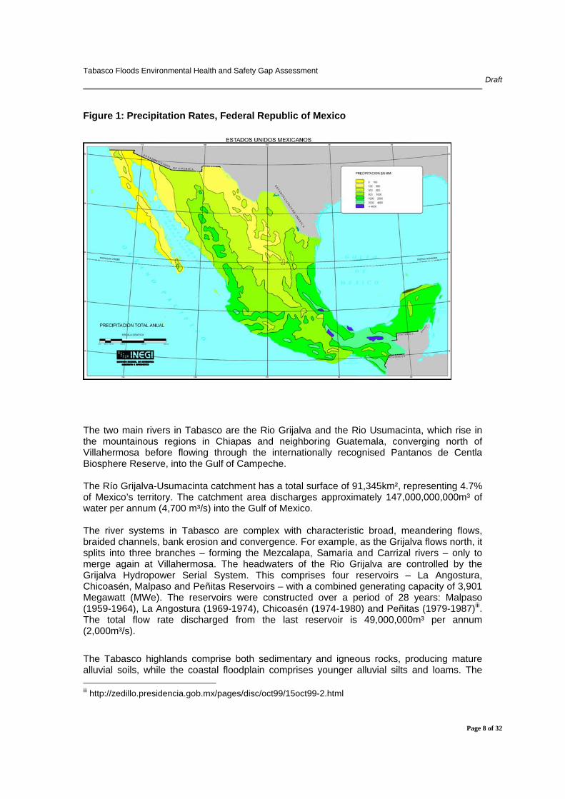
3.2 Hydrology and Geology Tabasco has a humid tropical climate with oceanic influences in the northern and central parts of the region. Temperatures during spring and summer reach 40°C and humidity during the same period is around 90%. During the short winter season, temperatures fall to around 15°C. Tabasco is the wettest state in Mexico with an average rainfall of 2100mm per annum, 2.6 times the national average. In the Sierra de Chiapas and the Sierra de la Lacandonia, rainfall exceeds 4000mm annually, and may even reach 5000mm, whereas the coastal zone receives some 2000mm- 2700m annually. In spring the climate is relatively dry, with heavier rainfall being concentrated in summer, autumn and winter. Long and torrential rainfalls occur in summer and autumn due to cold northern winds colliding with tropical humid air. Rivers and lakes reach their maximum water levels between September and November each year.
ii 2005 census by Instituto Nacional de Estadística, Geografía e Informática (National Institute of Statistics, Geography and Informatics) http://www.inegi.gob.mx/est/contenidos/espanol/sistemas/conteo2005/localidad/iter/default.asp?s=est&c=10395
Tabasco Floods Environmental Health and Safety Gap Assessment Draft
Page 8 of 32
Figure 1: Precipitation Rates, Federal Republic of Mexico
The two main rivers in Tabasco are the Rio Grijalva and the Rio Usumacinta, which rise in the mountainous regions in Chiapas and neighboring Guatemala, converging north of Villahermosa before flowing through the internationally recognised Pantanos de Centla Biosphere Reserve, into the Gulf of Campeche. The Río Grijalva-Usumacinta catchment has a total surface of 91,345km², representing 4.7% of Mexico’s territory. The catchment area discharges approximately 147,000,000,000m³ of water per annum (4,700 m³/s) into the Gulf of Mexico. The river systems in Tabasco are complex with characteristic broad, meandering flows, braided channels, bank erosion and convergence. For example, as the Grijalva flows north, it splits into three branches – forming the Mezcalapa, Samaria and Carrizal rivers – only to merge again at Villahermosa. The headwaters of the Rio Grijalva are controlled by the Grijalva Hydropower Serial System. This comprises four reservoirs – La Angostura, Chicoasén, Malpaso and Peñitas Reservoirs – with a combined generating capacity of 3,901 Megawatt (MWe). The reservoirs were constructed over a period of 28 years: Malpaso (1959-1964), La Angostura (1969-1974), Chicoasén (1974-1980) and Peñitas (1979-1987)iii. The total flow rate discharged from the last reservoir is 49,000,000m³ per annum (2,000m³/s). The Tabasco highlands comprise both sedimentary and igneous rocks, producing mature alluvial soils, while the coastal floodplain comprises younger alluvial silts and loams. The iii http://zedillo.presidencia.gob.mx/pages/disc/oct99/15oct99-2.html

Tabasco Floods Environmental Health and Safety Gap Assessment Draft
Page 9 of 32
neighbouring State of Chiapas experiences extreme soil loss due to erosion (up to 50,000 tonnes/km²/annum) due to deforestation, which causes frequent landslides and accumulation of sediment in reservoirs and in rivers, inhibiting water flow and causing blockages. The lithology of these river beds, the alluvial soils, abundant meanders and high sediment loads combine to make the coastal lowlands highly vulnerable to both flooding and erosion.
3.3 State Disaster Profile
The State of Tabasco is vulnerable to a number of natural and man-made hazards which include floods, hurricanes, earthquakes and industrial accidents (primarily associated with the oil and gas industry).
The State is at high risk from impact by flooding, especially in the urbanised areas northeast of Villahermosa and the surrounding sub-region of Centro of Tabasco. The flood risk is based on high precipitation rates, deforestation in the upper catchment, shallow topographical gradients and poor flood management and early warning systems.
Figure 2: Flood Risk, Federal Republic of Mexico
The State has a general low risk of direct impact by tsunamis and hurricanes but not from the impact of heavy rainfall associated with hurricanes and cold fronts from northerly directions.

Tabasco Floods Environmental Health and Safety Gap Assessment Draft
Page 10 of 32
Figure 3: Hurricane Risk, Federal Republic of Mexico
The risk of direct damage from seismic activity is deemed low to moderate in the State of Tabasco. The latest information, provided by the National Centre for Disaster Prevention (CENAPRED), indicates that 7 earthquakes have been recorded with magnitudes of between 4.0 and 4.5 (Mercalli Scale) in some areas of the State during 2007. Between January 1968 and December 2007, 29 earthquakes were recorded in the State of Tabasco, with a maximum magnitude of 4.7. In addition, two earthquakes occurred in the neighbouring State of Chiapas (magnitude of 5.0 at epicenter) on 11 February 2008 and Oaxaca on 12 February 2008 (magnitude of 6.4 at epicenter), the latter causing noticeable tremours throughout the State of Tabasco.
Table 1: Seismic Events in Tabasco (2007)
Tabasco: Municipalities Cases Magnitude Comalcalco 1 4.4Cunduacán 2 4.5 / 4.4Huimanguillo 1 4.0Macuspana 1 4.4 Paraíso 1 4.5Tenosique 1 4.3
Tabasco Floods Environmental Health and Safety Gap Assessment Draft
Page 11 of 32
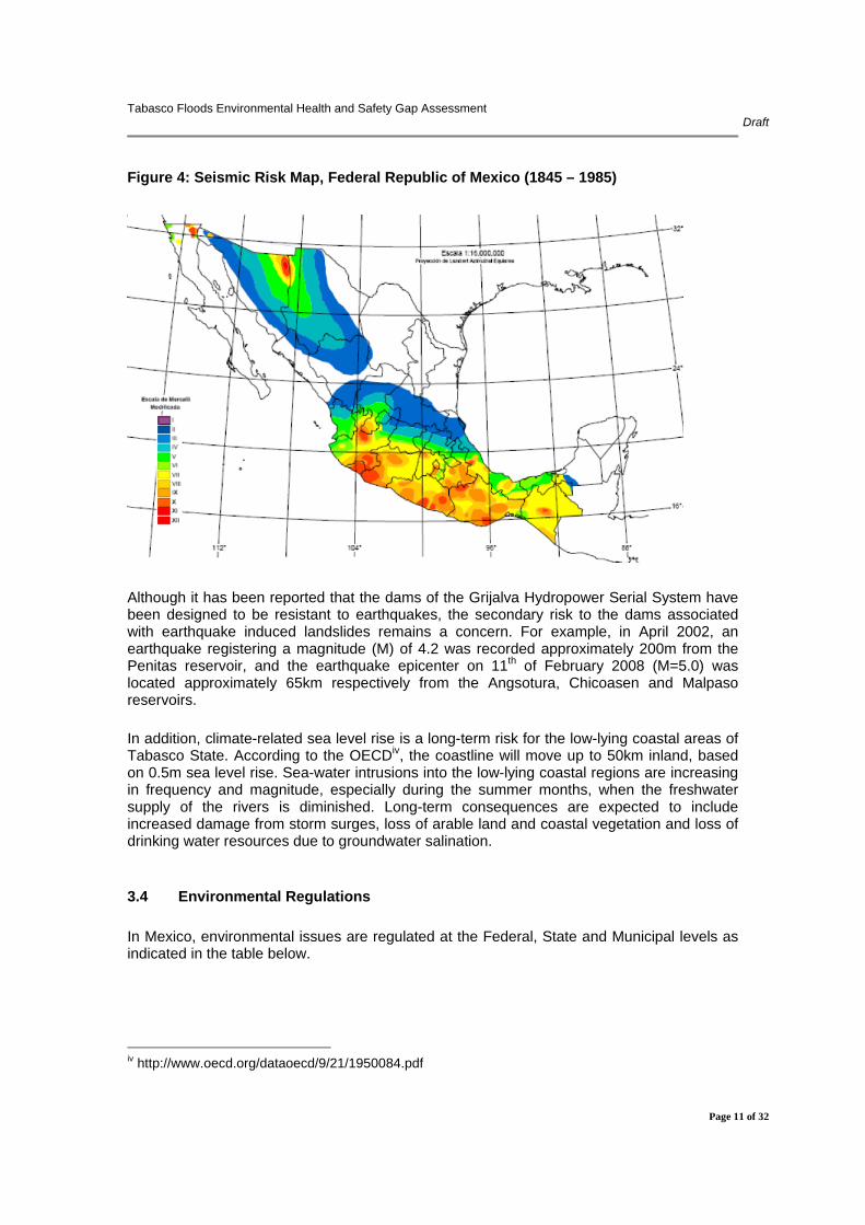
Figure 4: Seismic Risk Map, Federal Republic of Mexico (1845 – 1985)
Although it has been reported that the dams of the Grijalva Hydropower Serial System have been designed to be resistant to earthquakes, the secondary risk to the dams associated with earthquake induced landslides remains a concern. For example, in April 2002, an earthquake registering a magnitude (M) of 4.2 was recorded approximately 200m from the Penitas reservoir, and the earthquake epicenter on 11th of February 2008 (M=5.0) was located approximately 65km respectively from the Angsotura, Chicoasen and Malpaso reservoirs. In addition, climate-related sea level rise is a long-term risk for the low-lying coastal areas of Tabasco State. According to the OECDiv, the coastline will move up to 50km inland, based on 0.5m sea level rise. Sea-water intrusions into the low-lying coastal regions are increasing in frequency and magnitude, especially during the summer months, when the freshwater supply of the rivers is diminished. Long-term consequences are expected to include increased damage from storm surges, loss of arable land and coastal vegetation and loss of drinking water resources due to groundwater salination.
3.4 Environmental Regulations In Mexico, environmental issues are regulated at the Federal, State and Municipal levels as indicated in the table below.
iv http://www.oecd.org/dataoecd/9/21/1950084.pdf

Tabasco Floods Environmental Health and Safety Gap Assessment Draft
Page 12 of 32
Table 2: Summary of Mexican Environmental Legislation Enforcement Authorities
Federal State
Municipal
Regulations/ Legislation
Federal Constitution General Laws Rulings Official Norms
State Constitution Laws Rulings Environmental Norms
General Policies Rulings
Responsible Office
SEMARNAT PROFEPA
SERNAPAM
Municipalities
At a Federal level the environmental legislation comprises:
• General Law for the Integrated Prevention and Handling of Wastes and its regulation (Ley General parala prevención y gestión integral de los residuos y su reglamento)
• General Law about the Ecological Equilibrium and Environmental Protection (Ley General del equilibrio ecológico y la protección al ambiente)
• Official Mexican Norm 052-SEMARNAT-2005 (Norma Oficial Mexicana-052- SEMARNAT-2005)
• Official Mexican Norm 083-SEMARNAT-2003 (Norma Oficial Mexicana-083- SEMARNAT-2003)
• Various Mexican Norms (Normas Mexicanas – NMX)
The responsible Federal body is the Ministry of Environment and Natural Resources (Secretaría de Medio Ambiente y Recursos Naturales – SEMARNAT) with its Federal Administration of Environmental Protection Agency (Procuraduría Federal de Protección al Ambiente – PROFEPA). At State level the environmental legislation comprises:
• Environmental Protection Law of the State of Tabasco (Ley de protección ambiental del estado de Tabasco)
• Law regarding the municipal organs of the State of Tabasco (Ley orgánica de los municipios de Tabasco)
The Tabasco State Ministry of Environment (Secretaría de Recursos Naturales y la Protección del Medio Ambiente – SERNAPAM) is responsible for the following:
• formulate, norm, instrumentalise, supervise, execute, promote and evaluate the State’s environmental policies and programmes in participation of the public administration and the municipal governments;
• elaborate and emit regulations and norms, as well as issue authorisation’s and permits under the State law;
• promote and operate the State Environmental Information System, including atmospheric, soil and water monitoring systems;

Tabasco Floods Environmental Health and Safety Gap Assessment Draft
Page 13 of 32
• Promote, coordinate and participate in protection, reforestation, and conservation of natural resources of the state;
• collaborate with the municipalities in construction, conservation, maintenance, supervision and operation of the installations and services for handling, treatment and recycling of solid waste, industrial wastes, clean-up of contaminated sites and wastewater;
• develop in coordination with federal, national and municipal authorities, a census of forest and silvopastoral areas and their products, as well as enhance, organise, maintain and update maps and inventories of natural resources; and,
• develop the state’s environmental education programme. At a municipal level there are only a few environment related regulations and they include:
• Act on the Municipal Policy and Government (Bando de Policía y Gobierno de los Municipios)
• Municipal Regulations: only three municipalities (Centro, Macuspana y Comalcalco) have environmental regulations.
According to the Environmental protection Law of Tabasco State (Ley De Protección Ambiental Del Estado De Tabasco), the municipalities are responsible for the following:
• formulation, execution and evaluation of the municipal environment policies according to the federal and state policies;
• operation of or contracting of third parties for waste collection, transport, handling, treatment and disposal systems and facilities for municipal solid waste (MSW), as well as the prevention of waste dumping and clean-up of illegal waste deposits;
• waste reduction measures, separation, reuse, recycling, co-processing, biological/chemical/chemical/physical/thermal treatment, storage, transport and final deposition of MSW, and the appropriate manner of compliance with environmental, technical and health regulations;
• authorisation of the provision of integrated waste management services and their adaptation to state and national regulations;
• declaration, administration and custody of natural reserves and ecosystems in the municipal territories and their territory;
• application of the law with respect to prevention and control of contaminated water from sewer systems and populated areas;
• development and coordination of activities with other municipalities with regard to relevant aspects affecting the ecological balance in their territory;
• participation in the prevention and control of emergencies and environmental contingencies within the civil protection programmes;
• implementation of environmental education, conservation and development projects to promote environmental conscience; and,
• implementation of corrective measures and sanctions for violation of the Tabasco State environmental law.
Tabasco Floods Environmental Health and Safety Gap Assessment Draft
Page 14 of 32
4.0 Disaster Characteristics
4.1 Disaster Chronology Although the State authorities and general public in Tabasco are well aware of the dangers of flooding, the floods of late 2007 were reported to be the worst in 50 years. The Mexican President went further, stating that it was “one of the worst natural disasters in the history of the country”v. n October 1999, torrential rains resulted in flooding and landslides that killed 425 people. At the time, authorities were forced to open a floodgate on the Penitas dam in Chiapas, which resulted in high water levels in the Mezcalapa, Samaria and Carrizal rivers with 75% of the houses in Villahermosa were flooded.vi A summary of the chronology of events that impacted the State of Tabasco late 2007 is provided below:
• 23 October: An accident occurs during storm conditions in the Bay of Campeche requiring the evacuation of a PEMEX oil exploration platform. In the rescue operation, 23 workers died. A few days later, a major oil slick arrived on the beaches of Campeche and Tabasco vii.
• 28 October: A low pressure meteorological system causes steady, heavy rain in south-eastern Mexico for several days.
• 30 October: The Río Grijalva and some of its tributaries began to burst their banks. Flood alerts were broadcast over local TV and radio. Authorities began an evacuation of communities deemed most at risk. The Federal Secretariat of the Interior issued a Declaration of Emergency for the State of Tabasco viii.
• 31 October: Tabasco Governor, Andrés Granier, announces that 70 per cent of the State is under water and that 300,000 people affected. Damage is also reported in the neighbouring State of Chiapas, along with the first reports of missing peopleix.
• 1 November: Tabasco’s Governor stated that "80 per cent of the State is probably flooded" and provided a figure of 400,000 people affected. President Felipe Calderón toured the impacted area and appeared on national televisionx.
• 2 November: In the early morning, the Rio Grijalva broke through the emergency bunds protecting Villahermosa and orders were issued for the evacuation of the city's central district. One million people's homes were reported as being under water in Tabasco. A 250mm diameter natural gas main was reported to have ruptured on account of floodwaters washing away surrounding soilsxi.
• 5 November: Landslide struck the Rio Grijalva causing a small tsunami which washed away 50 houses in the village of Juan del Grijalva on the Tabasco-Chiapas border: 70 people were reported missingxii.
v http://news.bbc.co.uk/2/hi/americas/7074271.stm vi http://www.dartmouth.edu/~floods/Archives/1999sum.htm vii Http://www.washingtonpost.com/wp-dyn/content/article/2007/11/18/AR2007111800962.html&action=edit viii http://www.eluniversal.com.mx/estados/66412.html ix http://www.eluniversal.com.mx/primera/29843.html x http://www.eluniversal.com.mx/primera/29850.html xi http://www.eluniversal.com.mx/primera/29854.html xii http://www.eluniversal.com.mx/notas/459446.html
Tabasco Floods Environmental Health and Safety Gap Assessment Draft
Page 15 of 32
• 6 November: Water levels in both the Grijalva and the Carrizal fell significantly overnight. Pumping began to drain the city of Villahermosaxiii.
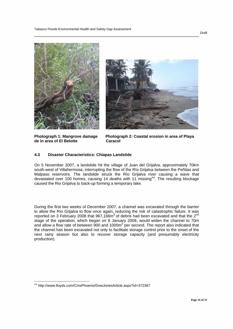
4.2 Disaster Characteristics: Campeche Sound Oil Accident and Spill On 23 October 2007 a cold front induced storm caused northern cold air to collide with tropical air, causing winds up to 130km/h and 6–8m waves. Structural damage (and subsequent fire and oil spills) was recorded when the Usumacinta platform struck the valve shaft of the Kab-101 well, approximately 30km offshore of Dos Bocas, Tabasco. Although eighty-six workers were evacuated from the platform, 21 were killed during the rescue operationsxiv. On 31 October 2007, PEMEX announced that it would resume crude oil production in the Campeche Sound after a temporary shutdown of wells on account of the storm. It was reported that the leaks from the damaged facilities were not repaired until 3 December 2007xv, after spilling approximately 422 barrels per day for a total of 44 days (approximately 3,000m³). The oil spill was partially confined with mechanical recovery, absorbent barriers, the use of 5.9m³ of absorbents and mechanical dispersion. During this operation, approximately 100m³ (~3%) of crude oil was recovered with the remainder evaporating, dispersing or reaching the coast. It was reported that the oil spill contaminated 10-12km of beach on the coast of Tabasco and that between 300-400 tonnes of oil-contaminated sand was recovered during the subsequent clean-up operations. Although no information was made available on the spill characteristics and the clean-up operations, a subsequent site visit did not reveal significant hydrocarbon impact to the beaches. However, damage to mangrove forests, principally for use as fuel, was identified in a coastal area outside of El Belotte, which may reduce the capacity of the mangroves to act as natural buffer to storm surge. In addition, the area of Playa de Caracol is suffering from significant beach erosion.
xiii http://www.eluniversal.com.mx/notas/459565.html xiv http://www.secinfo.com/dRY7g.u1z8.htm xv http://66.221.114.11/news/article.asp?a_id=54085
Tabasco Floods Environmental Health and Safety Gap Assessment Draft
Page 16 of 32
Photograph 1: Mangrove damage Photograph 2: Coastal erosion in area of Playa de in area of El Belotte Caracol
4.3 Disaster Characteristics: Chiapas Landslide On 5 November 2007, a landslide hit the village of Juan del Grijalva, approximately 70km south-west of Villahermosa, interrupting the flow of the Río Grijalva between the Peñitas and Malpaso reservoirs. The landslide struck the Río Grijalva river causing a wave that devastated over 100 homes, causing 14 deaths with 11 missingxvi. The resulting blockage caused the Rio Grijalva to back-up forming a temporary lake. During the first two weeks of December 2007, a channel was excavated through the barrier to allow the Río Grijalva to flow once again, reducing the risk of catastrophic failure. It was reported on 3 February 2008 that 967,166m3 of debris had been excavated and that the 2nd stage of the operation, which began on 8 January 2008, would widen the channel to 70m and allow a flow rate of between 900 and 1000m3 per second. The report also indicated that the channel has been excavated not only to facilitate storage control prior to the onset of the next rainy season but also to recover storage capacity (and presumably electricity production).
xvi http://www.lloyds.com/CmsPhoenix/DowJonesArticle.aspx?id=372367

Tabasco Floods Environmental Health and Safety Gap Assessment Draft
Page 17 of 32
Photographs 3- 5: Rio Grijalva Landslide, Chiapas
Visual evidence indicates that the landslide occurred on a relatively shallow, sloping hillside, hence, the combination of sensitive receptor (reservoir) and unstable slopes combined with the likelihood of increased frequency and severity of climate change induced hydrometeorological events highlights the importance of assessing and managing the risk of catastrophic reservoir failure. It remains unclear whether the reservoirs in the Grijalva Hydropower Serial System have been impacted by enhanced sedimentation due to soil erosion and if this has a further risk implication.
4.4 Disaster Characteristics: Tabasco Floods Starting on 23 October 2007, torrential rains in Tabasco, as a result of a cold front and the remnants of Hurricane Noel, resulted in rainfall levels of 150-250mm in the Rio Grijalva catchment. On 1 November 2007, the National Water Commission (CONAGUA) stated that the rainfall in Tabasco was 82 per cent above the average October rainfall level, and five times as high as the historical average over a period of 24 hours, causing the most significant rise in Tabasco rivers in the last 50 years. The role of the Federal Electricity Commission (CFE) has been the source of criticism and controversy, with public concern arising over the possibility that water was released from the Penitas reservoir in order to minimise damage to the hydro-equipment rather than for safety concerns. On 29 October 2007, CFE informed Tabasco State authorities that the water levels in the Peñitas reservoir, on the State Border, would be reduced, as the reservoir was

Tabasco Floods Environmental Health and Safety Gap Assessment Draft
Page 18 of 32
unable to compensate for the incoming watersxvii. On 2 November 2007, water levels in this reservoir were reported as being 2.78m above their critical level, while the Malpaso reservoir had also exceeded its retaining levelxviii. In addition, it was reported by CFE, that the flow rate into the La Angostura reservoir was 21,000m³/s and that the release of such a flow would have a significant impact on the State of Tabasco and its capital city of Villahermosaxix. Although it was originally stated that 669 m³/s of water would be released from the reservoir, the Environmental Department of Centro/Villahermosa Municipality was later informed, that up to 4,500m³/s of water was released from the reservoirs at peak periods, which is approximately the same amount as the whole catchment area releases into the Gulf of Campeche. It was reported that this contributed to an additional 1m rise in flood levels in the Río Grijalva and the Tabasco lowlands. However, this impact is contradicted by a study by the Colegio de Ingenieros Civiles de México which estimated that due to water release from the Peñitas reservoir some 600 million m³ of water were delivered to the Tabasco lowlands. Compared to the approximately 20,000 million m³ of rainwater in the Tabasco area (20,000km² x 1000mm precipitation), the water release from the reservoir contributed only about 3% of the water to the floodsxx.
By 3 November 2007, approximately 25 per cent of Tabasco State was flooded. By 12 November 2007, in excess of 60 per cent of the State and over 80 per cent of Villahermosa had been flooded with flows of upto 8,000 m³/second being recorded. It was reported by the Public Health Department that a total of 1,486,849 people were affected by the floods, with 79,212 internally displaced people (IDPs) housed in 543 camps. By 15 January 2008, however, only one IDP camp remained open. A copy of a map prepared by the Public Health Department that indicates the locations of the temporary shelters, potable water treatment units and health clinics, etc. is provided in Figure 8.
xvii http://www.radiotrece.com.mx/2007/10/29/abre-cfe-compuertas-de-presa-penitas-en-chiapas xviii http://www.reliefweb.int/rw/rwb.nsf/db900sid/KHII-78P32G?OpenDocument xix http://www.teorema.com.mx/articulos.php?id_sec=42&id_art=308&id_ejemplar=55 xx http://www.cicm.org.mx/prensa.php

Tabasco Floods Environmental Health and Safety Gap Assessment Draft
Page 19 of 32
Figure 5: Villahermosa Emergency Infrastructure
EE
Económicos
Áreas de riesgo
Educativos
Religiosos
Recreativos
Unidades de Salud
Otros
Clasificación de los Centros:
ALBERGUES
ÁREAS AFECTADAS POR INUNDACIÓN
100 - 499500 Y MÁS
ALBERGUES POR CAPACIDAD
PLANTAS POTABILIZADORAS INSTALADAS POR CONAGUA
Espejo
Catedral (1)
Piedra Angular (1)
Petrolera (1)
Espejo
Unidad deportiva (6)
EE
Económicos
Áreas de riesgo
Educativos
Religiosos
Recreativos
Unidades de Salud
Otros
Clasificación de los Centros:
ALBERGUES
ÁREAS AFECTADAS POR INUNDACIÓNÁREAS AFECTADAS POR INUNDACIÓN
100 - 499500 Y MÁS
ALBERGUES POR CAPACIDAD
100 - 499500 Y MÁS
ALBERGUES POR CAPACIDAD
PLANTAS POTABILIZADORAS INSTALADAS POR CONAGUA
Espejo
Catedral (1)
Piedra Angular (1)
Petrolera (1)
Espejo
Unidad deportiva (6)
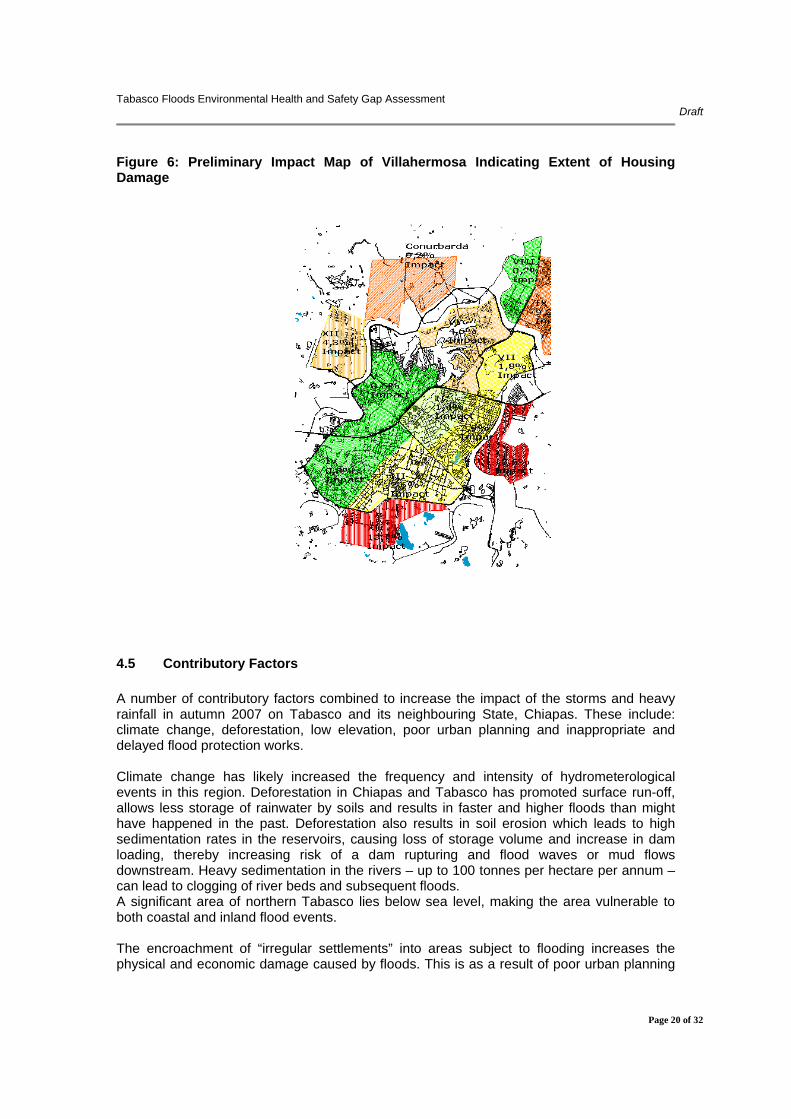
The impact and damage caused by the flooding in rural areas has been much lower than in urban areas, primarily due to low population densities and higher awareness of the dangers of flooding in rural communities. The most impacted areas comprise “irregular” settlements that have been constructed in wetland areas without appropriate planning consent. A preliminary flood impact map for Villahermosa indicates a strong correlation between impact and elevation, with those areas with elevations equal or below mean sea level (marked in red) exhibiting the highest impact.
Tabasco Floods Environmental Health and Safety Gap Assessment Draft
Page 20 of 32
Figure 6: Preliminary Impact Map of Villahermosa Indicating Extent of Housing Damage
4.5 Contributory Factors A number of contributory factors combined to increase the impact of the storms and heavy rainfall in autumn 2007 on Tabasco and its neighbouring State, Chiapas. These include: climate change, deforestation, low elevation, poor urban planning and inappropriate and delayed flood protection works. Climate change has likely increased the frequency and intensity of hydrometerological events in this region. Deforestation in Chiapas and Tabasco has promoted surface run-off, allows less storage of rainwater by soils and results in faster and higher floods than might have happened in the past. Deforestation also results in soil erosion which leads to high sedimentation rates in the reservoirs, causing loss of storage volume and increase in dam loading, thereby increasing risk of a dam rupturing and flood waves or mud flows downstream. Heavy sedimentation in the rivers – up to 100 tonnes per hectare per annum – can lead to clogging of river beds and subsequent floods. A significant area of northern Tabasco lies below sea level, making the area vulnerable to both coastal and inland flood events. The encroachment of “irregular settlements” into areas subject to flooding increases the physical and economic damage caused by floods. This is as a result of poor urban planning
Tabasco Floods Environmental Health and Safety Gap Assessment Draft
Page 21 of 32
and/ or weak regulatory enforcement. In addition, the current embankment construction and emergency works (sandbag embankments) in the area of Villahermosa may cause increased vulnerabilities with the potential for catastrophic failure during the next rainy season.
4.6 National and International Response State authorities implemented a number of flood response actions, including a comprehensive public health programme (vector control, water monitoring, etc.), shelter establishment for IDPs and waste clearance projects. According to OCHAxxi, 36 international organisations donated approximately US$ 9.7million to support to the State of Tabasco in flood response, including this Sida-funded project. Donations included goods, technical services and financial assistance. For example, approximately 300 tonnes of food, water, baby articles, cleaning products, medicines, clothes and shoes, sleeping bags, tents, camp beds, water filtration systems, inflatable boats, and electricity generators were distributed through a co-ordination body set up by the National Defence Ministry, the Civil Protection Unit of the Tabasco Government, the National Water Commission, the Navy Ministry, and the Governor’s Office. Technical support, through the provision of engineers, technicians, doctors and nurses from the Governments of Sweden, Cuba, Honduras, France, United Kingdom and Israel, as well as the United Nations, was co-ordinated by the National Epidemiological Centre (CENAVECE) of the Health Ministry, the National Water Commission and the Navy Ministry.
5.0 Environmental Characteristics
5.1 Environmental Risk Mapping It was reported that SERNAPAM had not undertaken a formal environmental risk mapping exercise prior to the flood. This could have identified priority areas such as industrial and waste facilities, power stations, drinking water intake points, oil production and pipeline facilities, landfills, temporary waste disposal areas, schools, hospitals, areas of biodiversity, vulnerable communities (low lying residential housing), etc. It was reported, however, that SERNPAM had contacted a number of local industries (including PEMEX, bakery, abattoir and a beverage plant) but no damage was reported.
Recommendation: Financial and technical resources should be made available to the Environment Department (SERNAPAM) to facilitate the development of environmental risk maps of the State. The mapping exercise should include a contact database and risk prioritisation to support future response and preparedness planning. It is recommended that the mapping exercise includes risk profiles for the following natural hazards: tornadoes, hurricanes, earthquakes, volcanoes, tsunami, coastal and alluvial flooding, landslides and erosion. In addition, risk profiles should be developed for the following man-made hazards: industrial facilities (production, manufacturing and storage areas, including PEMEX), waste management facilities and infrastructure (pipelines, bridges and dams). In addition, potentially vulnerable receptors should also be identified including: hospitals, schools, administrative buildings (including disaster coordination centres), residential areas, water xxi http://ocha.unog.ch/fts/reports/XLS/OCHA_R10_E15381.XLS.
Tabasco Floods Environmental Health and Safety Gap Assessment Draft
Page 22 of 32
treatment and supply networks, energy supply and distribution networks, sewage treatment facilities, emergency facilities (shelters, warehouses, laboratories, fire brigade, army barracks), waste treatment, storage and disposal facilities and pipelines. In addition, it is recommended that a geographic information system (GIS) is installed to enable SERNAPAM to analyse data (see above) and evaluate (potential) disaster consequences and prevention measures.
5.2 Floodwater It was reported by the SERNAPAM that they were unable to sample the flood waters until 25 days after the onset of the flooding event with the delay being caused by a lack of available transport and trained staff at the laboratory facility. However, despite requests no analytical data was available for review. In addition, it was stated that the environmental laboratory is able to undertake physical and microbiological analyses but is currently unable to analyse heavy metals, hydrocarbons, organic species such as solvents, dioxins and PCBs. Hence, SERNAPAM was unable to determine the toxicity of the flood water. Recommendation: Financial and technical resources should be made available to the SERNAPAM to facilitate the rapid testing and analysis of surfacewaters (including multi-parameter water monitors and field test kits), the development of laboratory contingency plans (including the potential for using Federal laboratories or neighbouring State facilities) and the potential for procuring a mobile laboratory (shared with the State Health Department).
5.3 Disaster Waste Management Detailed findings from a parallel disaster waste assessment and subsequent waste management workshop are reported in the Post Disaster Waste Management Assessment. However, the main findings indicate that the majority of the wastes generated by the floods were removed from the urban areas to uncontrolled temporary storage areas (open dumps) since the new modern landfill was not operational until mid-November 2007. The wastes comprised bulky household items such as furniture, white goods (fridges, freezers, etc.), mixed with personal possessions, domestic waste, waste from the temporary internally displaced persons (IDP) camps and spoiled food/pharmaceutical products. It has been estimated that 50,000 tonnes of waste was generated by the flood event and during the first 60 days of disaster recovery. In addition, a further one million tonnes of debris maybe generated during the demolition of homes located in flood risk areas during the proposed relocation programme.

Tabasco Floods Environmental Health and Safety Gap Assessment Draft
Page 23 of 32
Photographs 6 and 7: Open dumps to the north-east of Villahermosa Recommendations: There is an opportunity to include disaster waste management as a component in the proposed new civil protection regulations. It is recommended that a new disaster waste working group is established to develop policies and draft regulations including the need to prepare a disaster waste preparedness and management plan. In addition, the data held on hazardous waste producers (including PEMEX) at a Federal level should be made available at the State level and the SERNAPAM should include this information in the proposed environmental risk maps (see above). The SERNAPAM should undertake a capacity review to assess current logistical capacity (trucks, collection vehicles, etc.) and disposal facilities. Existing recycling capacities (private and public service provider, companies, NGOs) should be assessed and temporary disaster waste storage areas, which facilitates segregation and recycling at a later stage, identified and assessed. Improved public information – linked to specialist waste collection rounds – could facilitate better recycling and segregation of hazardous wastes.
5.4 Carcass Disposal It was reported by SERNAPAM that no mass burials of victims was required. However, it one municipality (Municipio del Centro) recorded the collection and disposal of 1670 animals (birds, dogs, cats, horses, pigs, cattle, etc) in the open dump at Lomo de Caballo. In addition, it was reported that a large (but unknown) number of livestock drowned in other municipalities during the flood but the locations of the burials pits and disinfection procedures are not known. Recommendations: The SERNAPAM should prepare, in consultation with Ministry of Agriculture and Health, technical guidance on the disposal of animal carcasses to minimise the potential for groundwater contamination. In addition, burial pits excavated during the 2007 flooding event should be mapped and vulnerable surface and groundwater abstraction points (wells) assessed and remediated/protected.
5.5 Drinking Water System Commisión Nacional del Agua (CONAGUA), a subdivision of the Ministry of Environment (SEMARNAT), is responsible for the supply of drinking water in Mexico. By 2004, 29 drinking
Tabasco Floods Environmental Health and Safety Gap Assessment Draft
Page 24 of 32
water treatment plants had been installed in Tabasco with in excess of 90 per cent of supplies being sourced from rivers. Drinking water for Villahermosa is sourced from two intake points on the Rio Grijalva and Rio Carrizal and there is only basic water treatment processes utilised (sedimentation and chlorination). The Director of the Tabasco State Laboratory indicated that regular sampling and analyses is not undertaken from the distribution system and, hence, the water quality cannot be confirmed. During the autumn 2007 flooding event, the central water treatment plant in Villahermosa did not operate for a total of 10 days, with several national and international organisations (Spain, France, Czech Republic, Canada) providing mobile treatment plants for safe drinking water supplies. Five plants were installed in Villahermosa, operated by CONAGUA. The State Health Department also undertook water quality monitoring based on residual chlorine concentrations. However, the Health Department acknowledged that it lacked mobile laboratory facilities and rapid field testing equipment. Recommendations: Financial and technical resources should be made available to assess the vulnerabilities of the drinking water plants, upgrade drinking water treatment to satisfactory technical and hygiene standards, identify critical infrastructure and develop a mitigation plan (emergency generators, raising electrical equipment or keeping spares, etc.).
5.6 Sewage System By the end of 2004, the State of Tabasco had 35 municipal wastewater treatment plants that were treating 18 per cent of the wastewater generated by almost two million people living in 17 municipalities. It was reported that CONAQUA planned to install 36 new treatment plants during the period 2005 – 2006. Hence, currently, the majority of wastewater generated in the State is directly discharged to the river without treatment. A site visit was undertaken to the main Villahermosa treatment plant at Gaviotas where the plant manager indicated that the facility did not work for one month after the flooding event due to electrical equipment failure. It was reported that the facility suffered no structural damage and that the tanks were not inundated. However, the laboratory was not working at the time of the site visit. The State Health Authority reported that excreta from IDP shelters was taken to the sewage treatment plant for disposal. In addition it was noted that direct discharge outlets into the rivers in Villahermosa did not have backflow preventers (flap valves) that could minimise risks associated with sewage flowing back into properties. Recommendations: Financial and technical resources should be made available to the sewage treatment plant to assess critical infrastructure and develop a mitigation plan (raising electrical equipment or keeping spares). It is recommended, as an interim measure, that prior to the construction of the new sewage treatment plants direct discharge outlets are fitted with flap valves.
5.7 Flood Control System Following the 1999 flood event, which caused an estimated damage of US$375 million, a flood prevention programme of US$190 million was initiated with a proposed completion date of 2006. However, the completion date for the Integral Project Against Flooding, which
Tabasco Floods Environmental Health and Safety Gap Assessment Draft
Page 25 of 32
proposed the construction of 177km of embankments and 193km of drainage canals along the Grijalva, Carrizal and Samaria rivers has been postponed until 2012. The flood prevention plan for Tabasco has yet to be published. Building and Planning Permission codes requires that all residential buildings are located a minimum distance of 20m from a river bank. However, visual observations indicated that many “irregular” housing constructions do not meet this requirement. Recommendations: Although the primary flood control mechanism in urban areas is the construction of embankments, the dredging of sediment from the base of the rivers would improve flow while the installation of weirs and spill-ways could allow floodwater to be diverted into controlled flooding areas.
5.8 Sediment Although visual evidence indicated that the receding floodwaters deposited a fine silt layer on the ground surface no samples were recovered for analysis. There is a potential for the sediment to be contaminated with sewage and industrial/agricultural chemicals. Recommendations: Financial and technical resources are made available to the SERNAPAM to allow soils and sediments, with high probability of contamination, to be sampled and analysed for a variety of physical, chemical and biological parameters.
5.9 Storage Tanks There have been no reported spillages or leaks from storage tanks as a result of the 2007 flooding; however, representatives from SERNAPAM did note an oily sheen on the water in certain areas of Villahermosa. It was stated that industrial facilities and fuel retailers have a duty to perform annual underground storage tank (UST) integrity testing and report any suspected leaks to the SERNAPAM. Flood events can result in tank buoyancy in unfilled/part-filled tanks, with connecting pipework and support failing. Recommendations: It is recommended that UST owners undertake integrity testing immediately following a flood event rather than awaiting an annual test. In addition, regulations for the installation of UST’s should be revised to include anti-buoyancy measures.
5.10 Vector Control The Public Health Department (Secretaria de Salud) implemented a comprehensive vector control programme which included fumigation by plane and manually (using permethrin) and the widespread application of larvicide (abate) to surfacewaters. Both of these chemicals have been used in disaster response situations and have relatively low human toxicity. It was reported that access to wide expanses of water resulted in a successful vector control programme, with fewer dengue cases being recorded after the flooding event than before. Although official data have yet to be released, the Public Health Department indicated that there had been two deaths directly attributable to the flooding event, one drowning and one additional death due to leptosporisis (Weils Disease). There was also an increase in skin
Tabasco Floods Environmental Health and Safety Gap Assessment Draft
Page 26 of 32
diseases associated with exposure to the floodwaters. In addition, approximately 600 tonnes of lime was applied to waste stockpiles to reduce disease vectors and odours. A number of participating delegates at the Disaster Waste Management Workshop expressed concern that lime deposits remained uncollected around houses and some schools. The Public Health Department also kept detailed health records – cases (suspected and confirmed), immunisation and fumigation programmes, shelter locations, damage to hospitals, health clinics and pharmacies, with information being provided to the Federal Government on a regular basis. Recommendations: Although the addition of lime to waste will reduce odours and disease vectors and will rapidly neutralise on contact with water it is recommended that the public are informed of its uses, hazards and long-term environmental fate.
6.0 Disaster Mitigation Programmes
6.1 Early Warning Systems It was reported by the State Office for Civil Protection (CP) that there are currently no flood early warning systems in place. The CP would like to develop two kinds of early warning systems: industrial accidents (including oil spillages) and hydro-meteorological warnings (such as rain and water level gauges). In addition, it was reported that, although the dams of the Grijalva Hydropower Serial System were designed to be earthquake resistant and that failure scenario modelling had been undertaken, the Grijalva Hydropower Serial System is under Federal Government control. Thus, although scenario modelling had been undertaken, the CP may not have access to all of the dam safety information. Recommendation: Financial and technical resources are made available to CP to facilitate the development of early warning control centre that includes remote sensing, satellite-based meteorological forecasting, gauges for rainwater, river level and telemetric links with Chiapas (rainfall, river and reservoir level gauge, dam spillway volumes, etc.). In addition, dam failure due to hydraulic loading, landslide and/or earthquake would cause catastrophic flooding in Tabasco and, hence, the CP should liaise with Federal authorities to ensure early warning systems, flood modelling, including stability monitoring, slope stability monitoring, evacuation routes/timings and public communication systems are developed and shared between the Chiapas and Tabasco CP offices. There is a potential that Awareness and Preparedness for Emergencies at Local Level (APELL) training maybe appropriate.
6.2 Emergency Response The CP provides a coordination role during any emergency/disaster in the State of Tabasco. It has developed an inventory of resources (human, technical and financial) held by the various agencies and departments are available in the event of an emergency. There is also an emergency roster scheme in place (with someone on call in the government office and in all relevant agencies, e.g. the SERNAPAM has their own emergency response unit with 24/7 stand-by for emergencies).
Tabasco Floods Environmental Health and Safety Gap Assessment Draft
Page 27 of 32
A master plan is now being developed for response actions during disasters and is due to be finished until the end of March 2008. The master plan includes analysis of disaster risks that may impact the State of Tabasco over a range of physical, geo-hydrological, sanitary, chemical, social and meteorological conditions. The process has included consultations with a wide range of stakeholders including institutions, civil organisations, academia, government, industries and the public. The objective is for the plan to be able to define responsibilities and facilitate a more efficient response in the future. The plan is divided into three different phases: pre-, during and post-disaster. Experiences from the 2007 flooding event are being incorporated into the new CP plan which will be published on a web site and will be reviewed and updated on a regular basis. The first phase of the planning process is to assess non-flood related disasters; identify good (and bad) examples in order to avoid mistakes and introduce efficient procedures. Operational plans are also being developed, based on long-term hydraulic predictions. The University of Tabasco and CONAGUA were reported to be undertaking research to find new techniques that provide sustainable, long-term solutions to prevent flooding. The CP office has been developing a worst case flooding scenarios based on a flow rate of 23,000m3/s which would result in approximately 80 per cent of the State being flooded and the need to evacuate approximately 300,000 residents. In comparison, the average flow rate in the 2007 flood event was about 5,000m3/s and resulted in 60 per cent of the State being flooded. In addition, it was reported that prior to the 2007 flooding event that the fire brigade services was not included in the CP response mechanism but in the new strategy they will also be under the CP coordination. It should be noted that the fire brigade services did not participate in the response work following the flood and lack training and equipment. It was also reported that neither the CP nor the fire brigade service keep records of those industrial facilities which store hazardous chemicals or wastes. It was reported by SERNAPAM that the responsibility for marine oil spill response is shared between the Ministry of Marine Services (MM), the police and PEMEX. If an oil slick reaches land the responsibility for response is shared between the CP and PEMEX. Oil spill contingency plans have been developed by MM and the State Authorities. The oil spill that impacted the beaches of Tabasco in 2007 was cleaned-up by a joint CP and PEMEX team. It was reported that PEMEX has approximately 5,000 installations across Mexico and are responsible for managing 8,000km of pipeline in the State of Tabasco alone. PEMEX has an emergency response unit responsible for all PEMEX installations, linked to the CP and they conduct regular (monthly) co-ordination meetings. The PEMEX emergency response units are well trained and equipped including pumps, booms, mobile units for safe drinking water (10), boats, vehicles, etc. Recommendations: It was recognised that the CP and PEMEX are adequately resourced to handle oils spills in the State. However, for non-oil related accidents the State lacks adequately trained and equipped personnel. In addition there is a need to co-ordinate with other states regarding emergency response and prevention including training exercises and information sharing. It is clear that despite intensive oil spill control works, oil still reached the beaches of Tabasco, hence, a review of the oil spill contingency plan should be undertaken.

Tabasco Floods Environmental Health and Safety Gap Assessment Draft
Page 28 of 32
6.2 Environmental Emergency Procedures In addition, to the reported delays in the recovery of samples and analysis of flood waters by the SERNAPAM it was also reported that the Department had not developed an emergency response plan or procedures, including the identification of sensitive environmental receptors. Recommendations: Financial and technical resources should be made available to the SERNAPAM for the rapid testing and analysis of floodwaters. The SERNAPAM should also develop appropriate an emergency response plan with sampling and analytical procedures, duty roster, communications and equipment.
6.3 Flood Risk Assessment and Control Programmes It was reported by SERNAPAM that CONAGUA and the Tabasco State University have initiated a flood risk assessment programme; however, details of the programme were not available for review and have not been shared with the SERNAPAM. There is visual evidence of new flood defences being constructed across the State including:
• earth bunds in the area of Gaviotas • new spillway designed to divert floodwater away from Villahermosa; and • emergency sandbag embankments (approximately 3 million sand-bags placed up to
4m high) along river banks in Villahermosa and Central district. According to information from SERNAPAM, it is planned that the sandbag embankments will remain in place in preparation of the next rain season. However, since these embankments are not maintained, they have been subject to dismantling for use in construction. Recommendations: SERNAPAM should review the proposed flood risk assessment programme. For reference, a basic outline of risk assessment programme is provided in Appendix C. The emergency sandbag embankments should be replaced, prior to the next rainy season since failure could result in significant damage to property and safety risks in the centre of the city. 6.4 Environmental Recovery and Disaster Risk Reduction (DRR) Programmes It was reported by SERNAPAM that the only environmental recovery programme currently being considered is a proposed PEMEX and the Inter-American Development Bank reforestation programme in Tabasco and Chiapas, however, no details of the project were available for review. Recommendations: The project team suggested that traditional flood protection schemes such as embankments and spillways could be supplemented with the use of wetlands as flood control mechanism. The team proposed the creation of a blue ring or “anillo azul” around Villahermosa which would comprise of a chain of linked wetlands that could be used to divert floodwater, at least during the initial phases of flood event, to protected wetland areas around the city. In addition, the strengthening of the environmental impact assessment

Tabasco Floods Environmental Health and Safety Gap Assessment Draft
Page 29 of 32
(EIA) process and urban planning could assist with preventing “irregular” housing construction in areas vulnerable to flooding.
7.0 Concluding Remarks The storm and heavy rains that stuck the Mexican States of Tabasco and Chiapas in October and November 2007 caused 3 disasters: oil rig accident, landslide in Chiapas and extensive flooding in Tabasco. The competent and professional response to the environmental, health and safety challenges posed by these disasters reflects the well developed disaster response mechanisms in Mexico. However, the newly formed environmental department (SERNAPAM) lacks equipment, training and a track-record in disaster response. In particular, it should attempt to strengthen its position as a newly founded ministry within the established ministries and Civil Protection structure, raise awareness and promote the role of environmental systems in disaster risk reduction such as the development of a “blue ring” of interlinked wetlands (Anillo Azul) around Villahermosa as a complementary flood defence, urban planning to avoid settlement in flood-prone areas and the role of forests in reducing soil erosion and the risk of landslide. The flooding event also highlighted the importance of inter-State disaster coordination since flood conditions in Tabasco are directly impacted by environmental (rainfall, soil erosion, deforestation, landslides) and hydropower (opening of spillways) conditions in the neighbouring State of Chiapas. Federal intervention will be required to ensure short-term financial benefits of maintaining power supplies are not outweighed by the economic and human costs of floods. There is also a need for improved inter-state cooperation to develop a more effective early warning system. The landslide that struck a valley close to the Penitas reservoir in Chiapas represents a significant “near-miss” that reveals the extreme vulnerability of reservoirs constructed in upland regions subject to deforestation that will likely experience more frequent and intense hydrometeorlogical events due to climate change in the future.

Tabasco Floods Environmental Health and Safety Gap Assessment Draft
Page 30 of 32
Appendix A: Request Letter from the Governor, State of Tabasco
Tabasco Floods Environmental Health and Safety Gap Assessment Draft
Page 31 of 32
Appendix B: ProAct Network Flood Environmental Health and Safety (EHS)
Assessment Flow Diagram

Tabasco Floods Environmental Health and Safety Gap Assessment Draft
Page 32 of 32
Appendix C: Flood Risk Assessment Programme Outline