

Enterprise class deployment for GeoServer and GeoWebcache Optimizing performances and robustness
85
Enterprise class deployment for GeoServer and GeoWebcache Optimizing performances and robustness Ing. Mauro Bartolomeoli, GeoSolutions Ing. Andrea Aime, GeoSolutions Ing. Simone Giannecchini, GeoSolutions FOSS4G-EU 2015, Como 14 th July 2015
-
Upload
osgeo -
Category
Technology
-
view
618 -
download
5
Transcript of Enterprise class deployment for GeoServer and GeoWebcache Optimizing performances and robustness

Enterprise class deployment for GeoServer and GeoWebcache Optimizing performances and robustness
Ing. Mauro Bartolomeoli, GeoSolutions
Ing. Andrea Aime, GeoSolutions Ing. Simone Giannecchini, GeoSolutions
FOSS4G-EU 2015, Como 14th July 2015

GeoSolutions
Italian SME
Expertise • Image Processing, GeoSpatial Data Fusion
• Java, Java Enterprise, C++, Python
• JPEG2000, JPIP, Advanced 2D visualization
Supporting/Developing FOSS4G
MapStore, GeoServer
GeoNetwork, GeoCollect
Clients
Public Agencies
Private Companies
http://www.geo-solutions.it
FOSS4G-EU 2015, Como 14th July 2015

Outline
Intro to GeoServer (Optional)
Benchmarking with JMeter
Preparing raster and vector data
Optimizing styling
Output tuning
Tiling and caching
Configuring for Robustness
Deploy configurations
FOSS4G-EU 2015, Como 14th July 2015
GeoServer
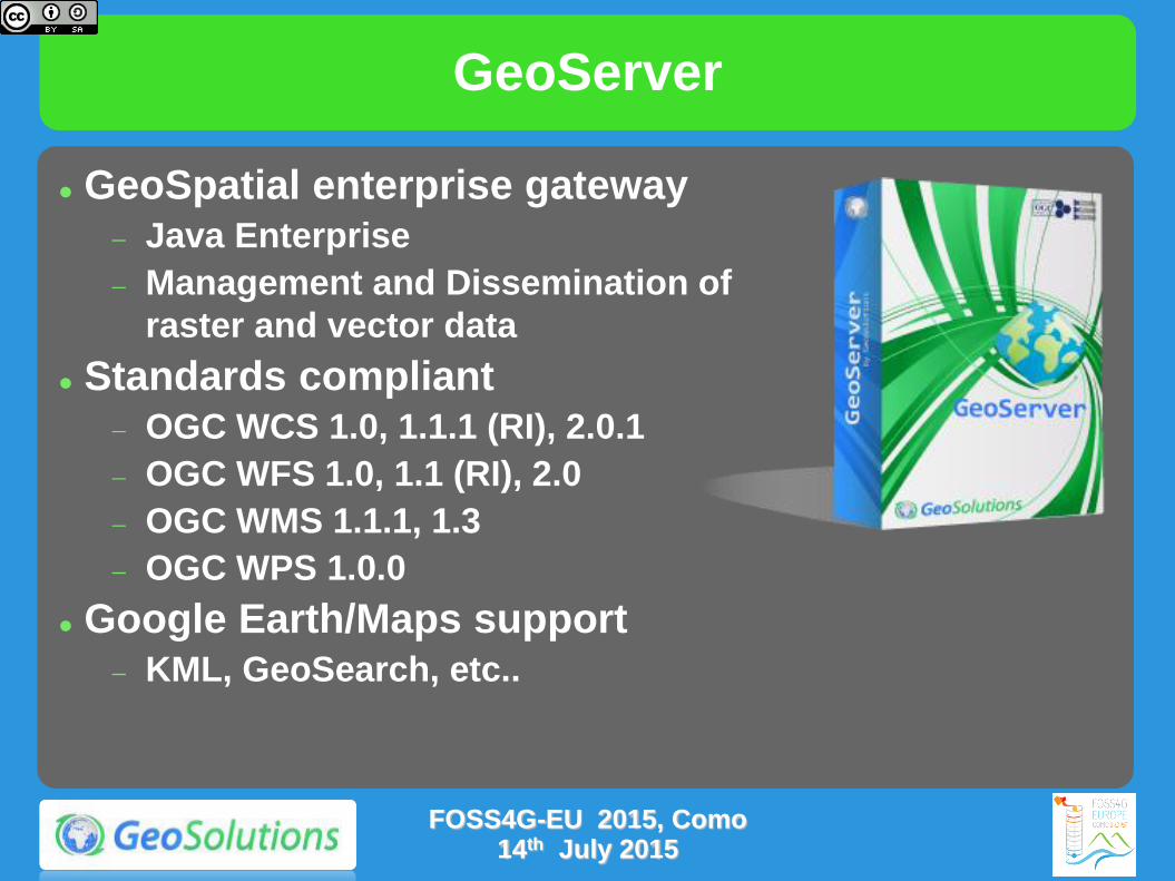
GeoServer
GeoSpatial enterprise gateway Java Enterprise
Management and Dissemination of
raster and vector data
Standards compliant OGC WCS 1.0, 1.1.1 (RI), 2.0.1
OGC WFS 1.0, 1.1 (RI), 2.0
OGC WMS 1.1.1, 1.3
OGC WPS 1.0.0
Google Earth/Maps support
KML, GeoSearch, etc..
FOSS4G-EU 2015, Como 14th July 2015
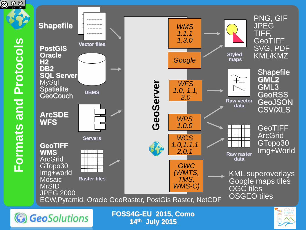
Fo
rmats
an
d P
roto
co
ls
Ge
oS
erv
er
WFS 1.0, 1.1,
2.0
WMS 1.1.1 1.3.0
PostGIS Oracle H2 DB2 SQL Server MySql Spatialite GeoCouch
Shapefile
---------- ---------- --------- ----------
---------- ---------- --------- ----------
---------- ---------- --------- ----------
ArcSDE WFS
PNG, GIF JPEG TIFF, GeoTIFF SVG, PDF KML/KMZ
Shapefile GML2 GML3 GeoRSS GeoJSON CSV/XLS
Raw vector data
Servers
Styled maps
DBMS
Vector files
WCS 1.0,1.1.1
2.0.1 GeoTIFF WMS ArcGrid GTopo30 Img+world Mosaic MrSID JPEG 2000 ECW,Pyramid, Oracle GeoRaster, PostGis Raster, NetCDF
Raster files
Raw raster data
GeoTIFF ArcGrid GTopo30 Img+World
GWC (WMTS,
TMS, WMS-C)
KML superoverlays Google maps tiles OGC tiles OSGEO tiles
WPS 1.0.0
FOSS4G-EU 2015, Como 14th July 2015
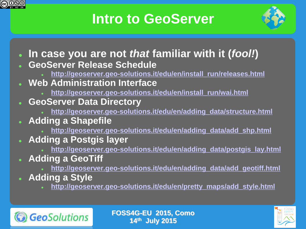
Intro to GeoServer
In case you are not that familiar with it (fool!) GeoServer Release Schedule
http://geoserver.geo-solutions.it/edu/en/install_run/releases.html
Web Administration Interface http://geoserver.geo-solutions.it/edu/en/install_run/wai.html
GeoServer Data Directory http://geoserver.geo-solutions.it/edu/en/adding_data/structure.html
Adding a Shapefile http://geoserver.geo-solutions.it/edu/en/adding_data/add_shp.html
Adding a Postgis layer http://geoserver.geo-solutions.it/edu/en/adding_data/postgis_lay.html
Adding a GeoTiff http://geoserver.geo-solutions.it/edu/en/adding_data/add_geotiff.html
Adding a Style http://geoserver.geo-solutions.it/edu/en/pretty_maps/add_style.html
FOSS4G-EU 2015, Como 14th July 2015

Benchmarking with JMeter
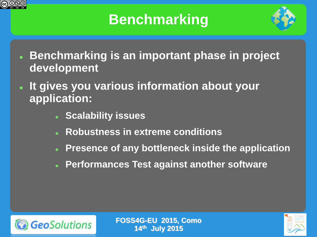
Benchmarking
Benchmarking is an important phase in project development
It gives you various information about your application:
Scalability issues
Robustness in extreme conditions
Presence of any bottleneck inside the application
Performances Test against another software
FOSS4G-EU 2015, Como 14th July 2015
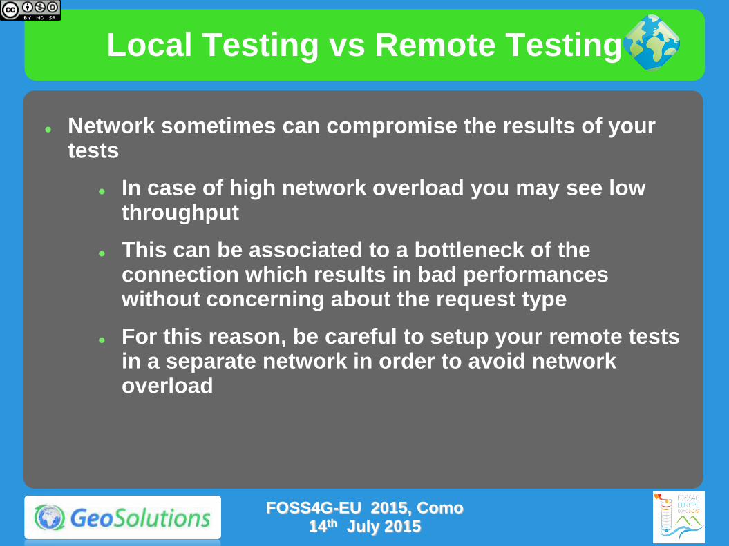
Local Testing vs Remote Testing
Network sometimes can compromise the results of your tests
In case of high network overload you may see low throughput
This can be associated to a bottleneck of the connection which results in bad performances without concerning about the request type
For this reason, be careful to setup your remote tests in a separate network in order to avoid network overload
FOSS4G-EU 2015, Como
14th July 2015

Lookout for the bottleneck
Typical bottlenecks:
CPU: at high load all the CPUs are pegged
Disk: CPUs are not hot, the server is reading a lot from the disk during the benchmark
Network (data sources): CPUs are not hot, but the local network (maybe towards the DB) is at full capacity
Network (output): all local resources are midly used, but the outbound connection is at full capacity
Code scalability: none of the above, every resource seems to be in light use and usage is not going up despire higher client load
FOSS4G-EU 2015, Como 14th July 2015
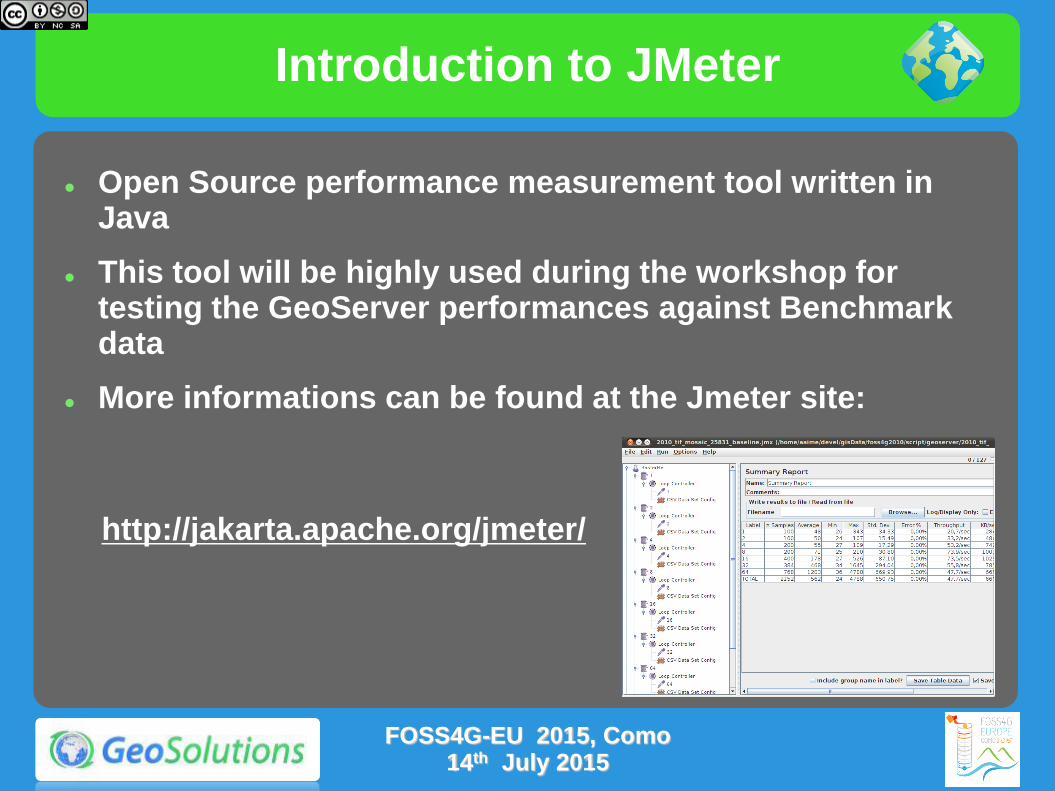
Introduction to JMeter
Open Source performance measurement tool written in Java
This tool will be highly used during the workshop for testing the GeoServer performances against Benchmark data
More informations can be found at the Jmeter site:
http://jakarta.apache.org/jmeter/
FOSS4G-EU 2015, Como 14th July 2015

Introduction to JMeter
Easy-to-use UI
Allows to setup multiple thread groups, different parallelism and request count, to ramp up the load
Can use CSV files to generate semi-randomized requests
Can execute parameterized tests
Reports results in a simple table
Uses Assertions for checking test results
Can be executed in batch
FOSS4G-EU 2015, Como 14th July 2015
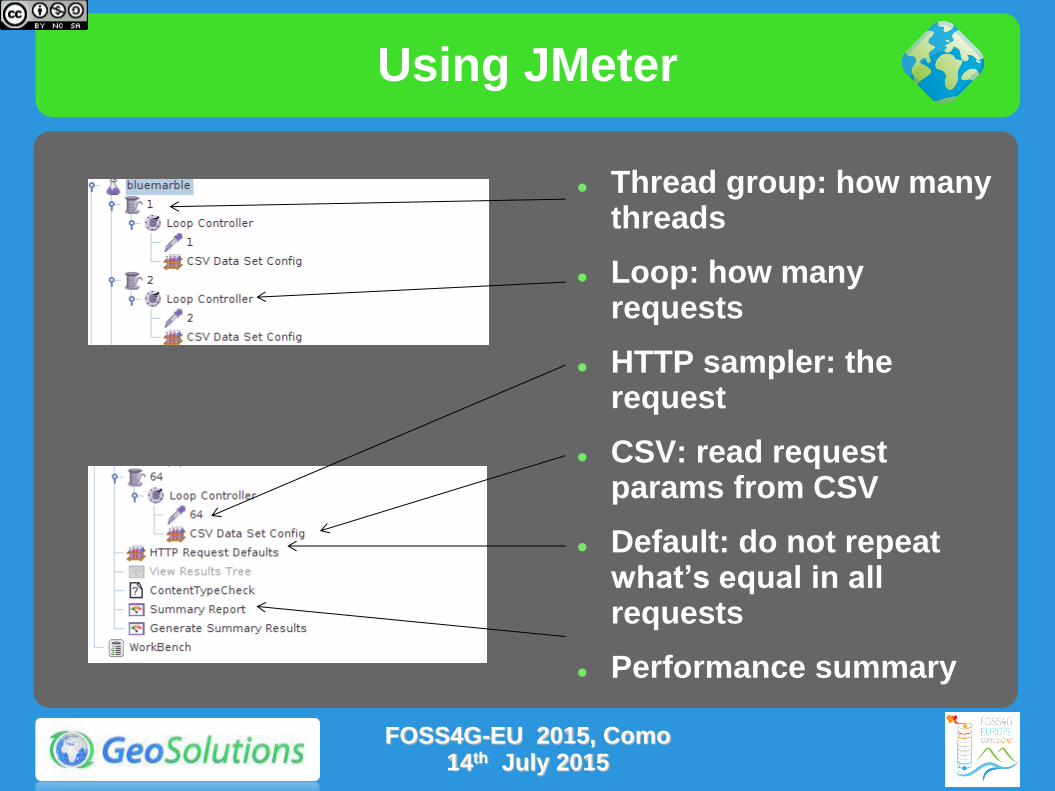
Using JMeter
Thread group: how many threads
Loop: how many requests
HTTP sampler: the request
CSV: read request params from CSV
Default: do not repeat what’s equal in all requests
Performance summary
FOSS4G-EU 2015, Como 14th July 2015
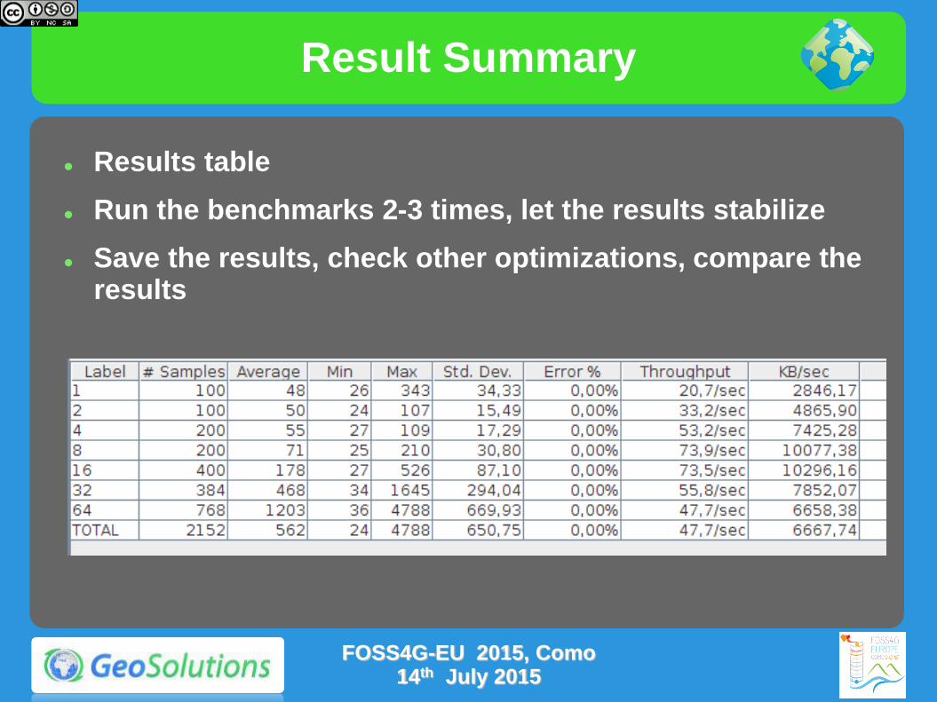
Result Summary
Results table
Run the benchmarks 2-3 times, let the results stabilize
Save the results, check other optimizations, compare the results
FOSS4G-EU 2015, Como 14th July 2015

Exercise
Let's start with practice!!!
Follow the instructions on the link below
http://geoserver.geo-solutions.it/educational/en/adv_gsconfig/jmeter/jmeter_simple.html
You should be able to reproduce the test using the GeoServer Training instance installed in your PC
This simple exercise will show you how to use JMeter with a basic configuration for testing GeoServer performances
FOSS4G-EU 2015, Como 14th July 2015
Randomized Multiscale Testing
In the example before, we ran a test on a layer always setting the same bounding box and image size
Now we should setup a more complicated test asking for different bounding boxes and resolutions, aka Multiscale testing
Multiscale testing is useful because it stresses GeoServer requesting new data each time, mimicking real usage conditions and providing better testing for your SLD scale dependencies
With JMeter we can execute the test by passing a CSV file containing multiple bounding boxes and image dimensions
FOSS4G-EU 2015, Como 14th July 2015
Exercise
Multiscale test created using wms_request.py on a mosaic layer
Follow the instructions on the link below
http://geoserver.geo-solutions.it/educational/en/adv_gsconfig/jmeter/jmeter_multiscale.html
This exercise will show you how to use create a CSV file containing requests at multiple resolutions and how to run JMeter with it
FOSS4G-EU 2015, Como 14th July 2015

Preparing Raster Inputs

Intro to GDAL Utilities
Online Material http://geoserver.geo-
solutions.it/edu/en/raster_data/processing.html
http://www.gdal.org/gdal_utilities.html
FOSS4G-EU 2015, Como 14th July 2015

Raster Data CheckList
Objectives
Fast extraction of a subset of the data
Fast extraction of the desired resolution
Check-list
Avoid having to open a large number of files per request
Avoid parsing of complex structures and slow compressions
Get to know your bottlenecks
CPU vs Disk Access Time vs Memory
Experiment with
Format, compression, different color models, tile size, overviews, GeoServer configuration
FOSS4G-EU 2015, Como 14th July 2015
Peculiar Formats
PNG/JPEG direct serving (as data sources)
Bad formats (especially in Java)
No tiling (or rarely supported)
Chew a lot of memory and CPU for decompression
Mitigate with external overviews
Any input ASCII format (GML grid, ASCII grid)
JPEG2000
Extensible and rich, not (always) fast, can be difficult to tune for performance (might require specific encoding options)
MrSID (can work, needs tuning)
ECW (licensing issues)
FOSS4G-EU 2015, Como 14th July 2015

GeoTiff for the win
To remember: GeoTiff is a swiss knife
But you don’t want to cut a tree with it!
Tremendously flexible, good for for most (not all) use cases
BigTiff pushes the GeoTiff limits farther
Use GeoTiff when
Overviews and Tiling stay within 4GB
No additional dimensions
Consider BigTiff for very large file (> 4 GB)
Support for tiling
Support for Overviews
Can be inefficient with very large files + small tiling
FOSS4G-EU 2015, Como 14th July 2015

GeoTiff preparation
(Optional) Use gdal_warp to transform the data in the most used output reference system (mind, any reprojection ruins the data a bit)
Use gdal_translate to add inner tiling and fix eventual issues with coordinate reference system
Add compression options if you disks are small/slow/not local (consider JPEG compression with YCBCR color interpretation for photos, LZW/Deflate for scientific data)
Use gdaladdo to add internal overviews (remember to replicate compression here)
FOSS4G-EU 2015, Como 14th July 2015

Possible structures
Single GeoTiff with internal tiling and overviews (GeoTiff < 2GB, BigTiff < 20-50GB)
Mosaic of GeoTiff, each one with internal tiling and overviews (< 500GB, not too many files)
Image pyramid, each level has lower resolution than the previous, each level has tiles with inner tiling but no overviews (also possible to mix, less levels and use internal overviews) > 500GB
FOSS4G-EU 2015, Como 14th July 2015
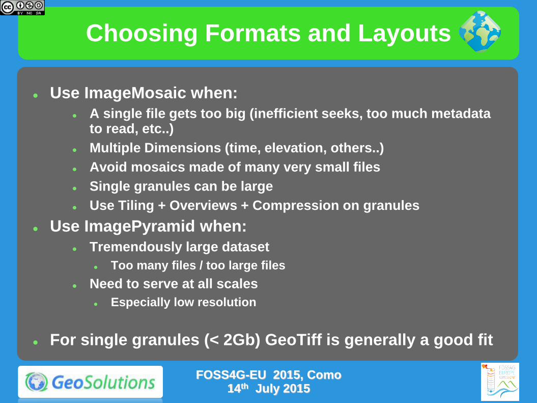
Choosing Formats and Layouts
Use ImageMosaic when:
A single file gets too big (inefficient seeks, too much metadata to read, etc..)
Multiple Dimensions (time, elevation, others..)
Avoid mosaics made of many very small files
Single granules can be large
Use Tiling + Overviews + Compression on granules
Use ImagePyramid when:
Tremendously large dataset
Too many files / too large files
Need to serve at all scales
Especially low resolution
For single granules (< 2Gb) GeoTiff is generally a good fit
FOSS4G-EU 2015, Como 14th July 2015
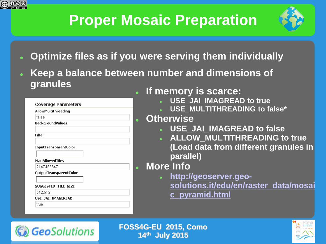
Proper Mosaic Preparation
Optimize files as if you were serving them individually
Keep a balance between number and dimensions of granules
If memory is scarce: USE_JAI_IMAGREAD to true USE_MULTITHREADING to false*
Otherwise USE_JAI_IMAGREAD to false ALLOW_MULTITHREADING to true
(Load data from different granules in parallel)
More Info http://geoserver.geo-
solutions.it/edu/en/raster_data/mosaic_pyramid.html
FOSS4G-EU 2015, Como 14th July 2015
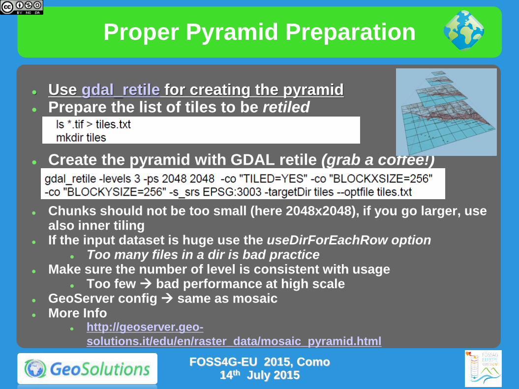
Proper Pyramid Preparation
Use gdal_retile for creating the pyramid Prepare the list of tiles to be retiled
Create the pyramid with GDAL retile (grab a coffee!)
Chunks should not be too small (here 2048x2048), if you go larger, use also inner tiling
If the input dataset is huge use the useDirForEachRow option Too many files in a dir is bad practice
Make sure the number of level is consistent with usage Too few bad performance at high scale
GeoServer config same as mosaic More Info
http://geoserver.geo-
solutions.it/edu/en/raster_data/mosaic_pyramid.html
FOSS4G-EU 2015, Como 14th July 2015
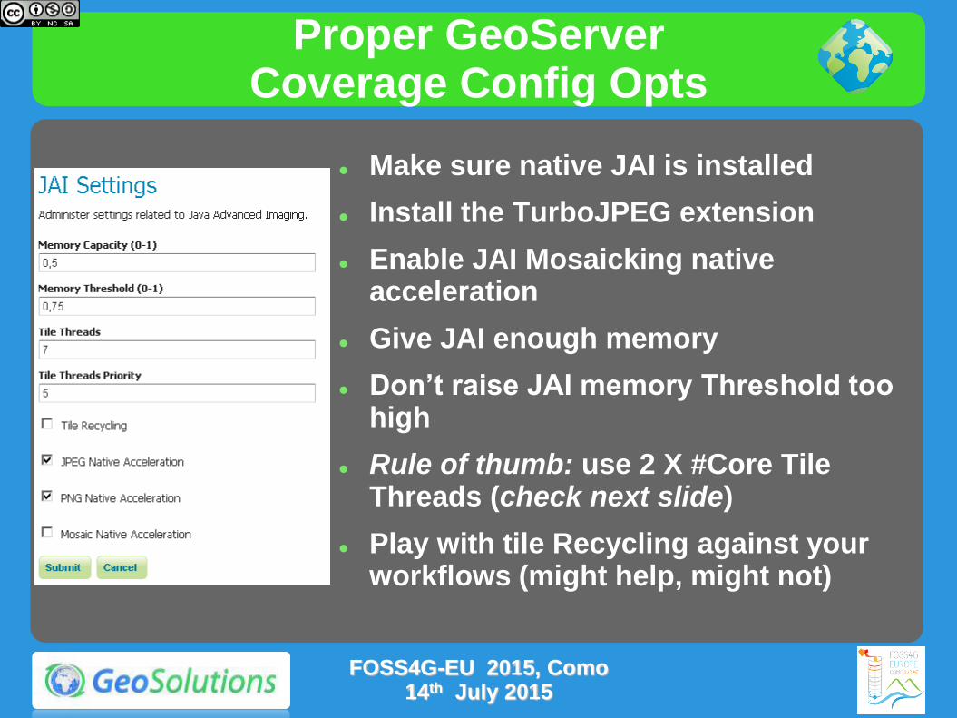
Proper GeoServer Coverage Config Opts
Make sure native JAI is installed
Install the TurboJPEG extension
Enable JAI Mosaicking native acceleration
Give JAI enough memory
Don’t raise JAI memory Threshold too high
Rule of thumb: use 2 X #Core Tile Threads (check next slide)
Play with tile Recycling against your workflows (might help, might not)
FOSS4G-EU 2015, Como 14th July 2015
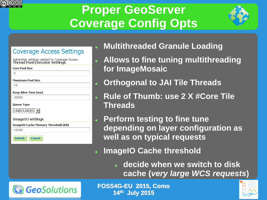
Proper GeoServer Coverage Config Opts
Multithreaded Granule Loading
Allows to fine tuning multithreading for ImageMosaic
Orthogonal to JAI Tile Threads
Rule of Thumb: use 2 X #Core Tile Threads
Perform testing to fine tune depending on layer configuration as well as on typical requests
ImageIO Cache threshold
decide when we switch to disk cache (very large WCS requests)
FOSS4G-EU 2015, Como 14th July 2015
Exercise
Let's check the effect of optimization in GeoServer
Follow the instructions on the links below
http://geoserver.geo-solutions.it/educational/en/adv_gsconfig/jmeter/jmeter_mosaic.html
This test uses JMeter for testing GeoServer performances before and after the optimization of a Mosaic Layer.
FOSS4G-EU 2015, Como 14th July 2015
Additional Material & Exercises
Using ImageMosaic with Footprint
http://geoserver.geo-solutions.it/edu/en/raster_data/imagemosaic_footprint.html
Advanced Processing With GDAL Utilities
http://geoserver.geo-solutions.it/edu/en/raster_data/advanced_gdal/index.html
FOSS4G-EU 2015, Como 14th July 2015

Preparing vector inputs
Vector data checklist
What do we want from vector data:
Binary data
No complex parsing of data structures
Fast extraction of a geographic subset
Fast filtering on the most commonly used attributes
FOSS4G-EU 2015, Como 14th July 2015

Choosing a format
Slow formats
WFS
GML
DXF
Good formats, local and index-able
Shapefile
Directory of shapefiles
SDE
Spatial databases: PostGIS, Oracle Spatial, DB2, MySQL*, SQL server*
Swiss Knife SQL Views
FOSS4G-EU 2015, Como 14th July 2015

DBMS Checklist
Rich support for complex native filters
Use connection pooling
Validate connections (with proper pooling)
Table Clustering
Spatial Indexing
Spatial Indexing
Spatial Indexing
Alphanumeric Indexing
Alphanumeric Indexing
Alphanumeric Indexing
Did we mention indexes?
FOSS4G-EU 2015, Como 14th July 2015
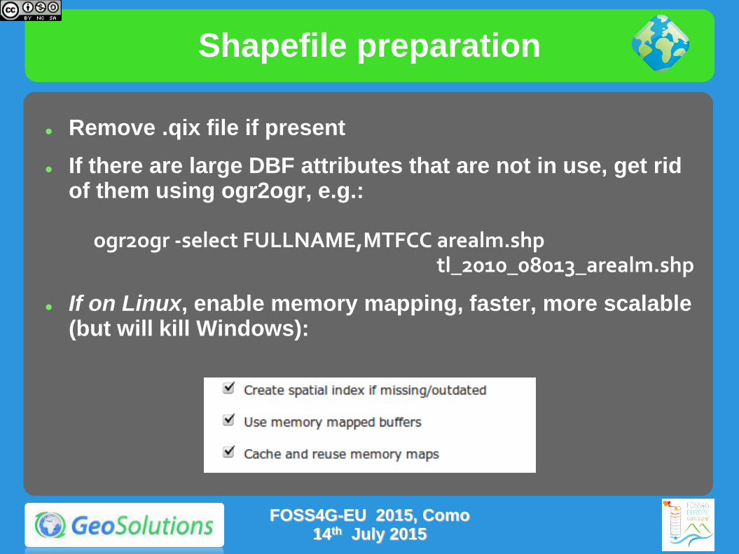
Shapefile preparation
Remove .qix file if present
If there are large DBF attributes that are not in use, get rid of them using ogr2ogr, e.g.: ogr2ogr -select FULLNAME,MTFCC arealm.shp tl_2010_08013_arealm.shp
If on Linux, enable memory mapping, faster, more scalable (but will kill Windows):
FOSS4G-EU 2015, Como 14th July 2015
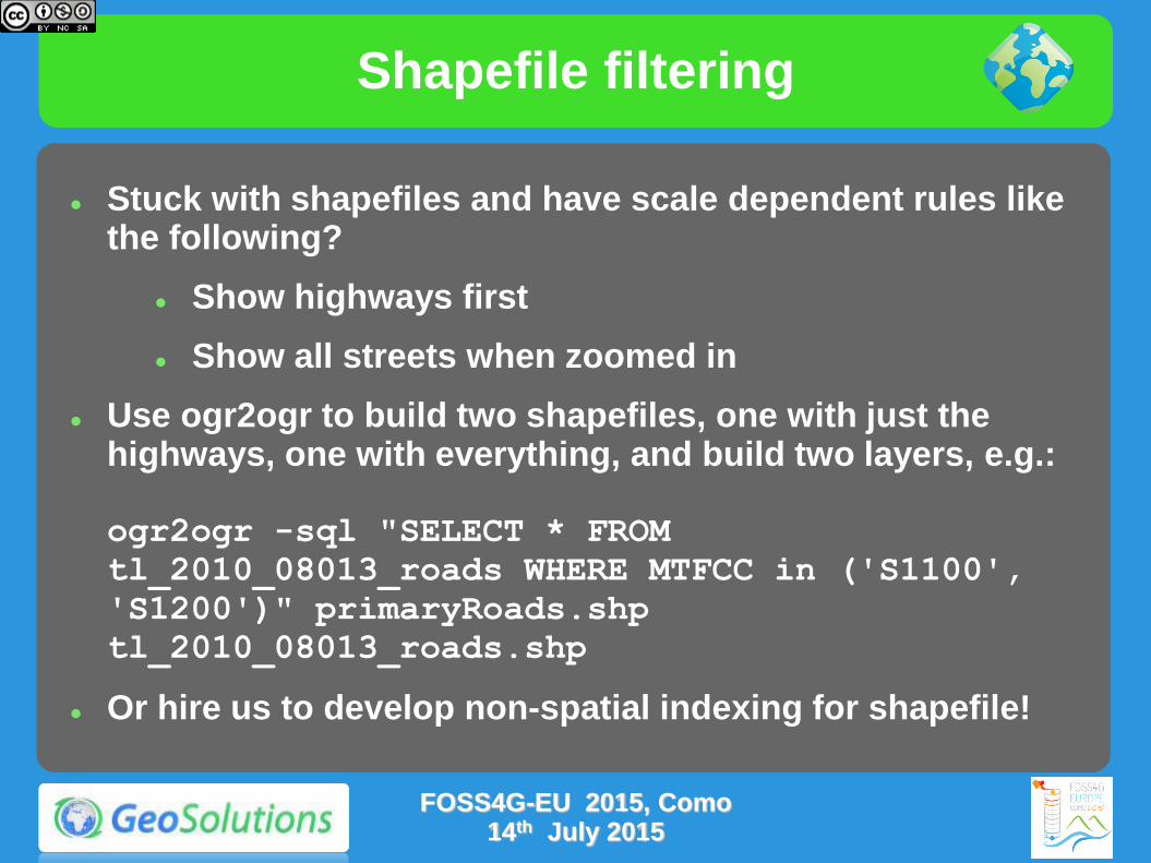
Shapefile filtering
Stuck with shapefiles and have scale dependent rules like the following?
Show highways first
Show all streets when zoomed in
Use ogr2ogr to build two shapefiles, one with just the highways, one with everything, and build two layers, e.g.: ogr2ogr -sql "SELECT * FROM
tl_2010_08013_roads WHERE MTFCC in ('S1100',
'S1200')" primaryRoads.shp
tl_2010_08013_roads.shp
Or hire us to develop non-spatial indexing for shapefile!
FOSS4G-EU 2015, Como 14th July 2015
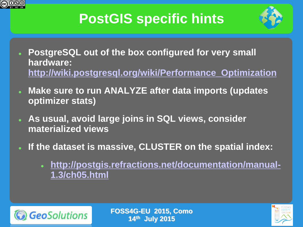
PostGIS specific hints
PostgreSQL out of the box configured for very small hardware: http://wiki.postgresql.org/wiki/Performance_Optimization
Make sure to run ANALYZE after data imports (updates optimizer stats)
As usual, avoid large joins in SQL views, consider materialized views
If the dataset is massive, CLUSTER on the spatial index:
http://postgis.refractions.net/documentation/manual-1.3/ch05.html
FOSS4G-EU 2015, Como 14th July 2015

PostGIS specific hints
Careful with prepared statements (bad performances)
USE CASE: the layer’s style allows to display the whole layer in a single shot (no scale dependencies) prepared statements will slow down execution
EXPLANATION: Postgis will choose to use the spatial index in all cases, this makes retrieving the full data set 2-4 times slower than when using a sequential scan
COUNTERMEASURE: Not using prepared statement allows postgis to figure out a suitable plan based on the request bbox instead (assuming someone run "vacuum analyze" on the database to update the index statistics, and of course, provided there is a spatial index to start with)
FOSS4G-EU 2015, Como 14th July 2015

SQL Server specific hints
Switch to PostgreSQL/PostGIS!
FOSS4G-EU 2015, Como 14th July 2015

Oracle specific hints
Switch to PostgreSQL/PostGIS!
FOSS4G-EU 2015, Como 14th July 2015

SQL Views Support
Vector Data Swiss Knife
http://geoserver.geo-solutions.it/edu/en/adding_data/add_sqllayers.html
FOSS4G-EU 2015, Como 14th July 2015
Exercise
Let's compare Shapefile and PostGIS in GeoServer
Follow the instructions on the links below
http://geoserver.geo-solutions.it/educational/en/adv_gsconfig/jmeter/jmeter_vector.html
This test uses Jmeter for comparing GeoServer performances using a Shapefile or an optimized PostGIS database containing the same data
FOSS4G-EU 2015, Como 14th July 2015

Optimize styling
Use scale dependencies
Never show too much data
the map should be readable, not a graphic blob. Rule of thumb: 1000 features max in the display, have labels show up when zoomed in
Show details as you zoom in
Eagerly add MinScaleDenominator to your SLD rules
Add more expensive rendering when there are less features
Key to get both a good looking and fast map
FOSS4G-EU 2015, Como 14th July 2015
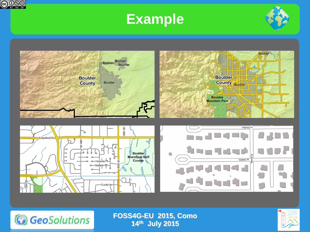
Example
FOSS4G-EU 2015, Como 14th July 2015
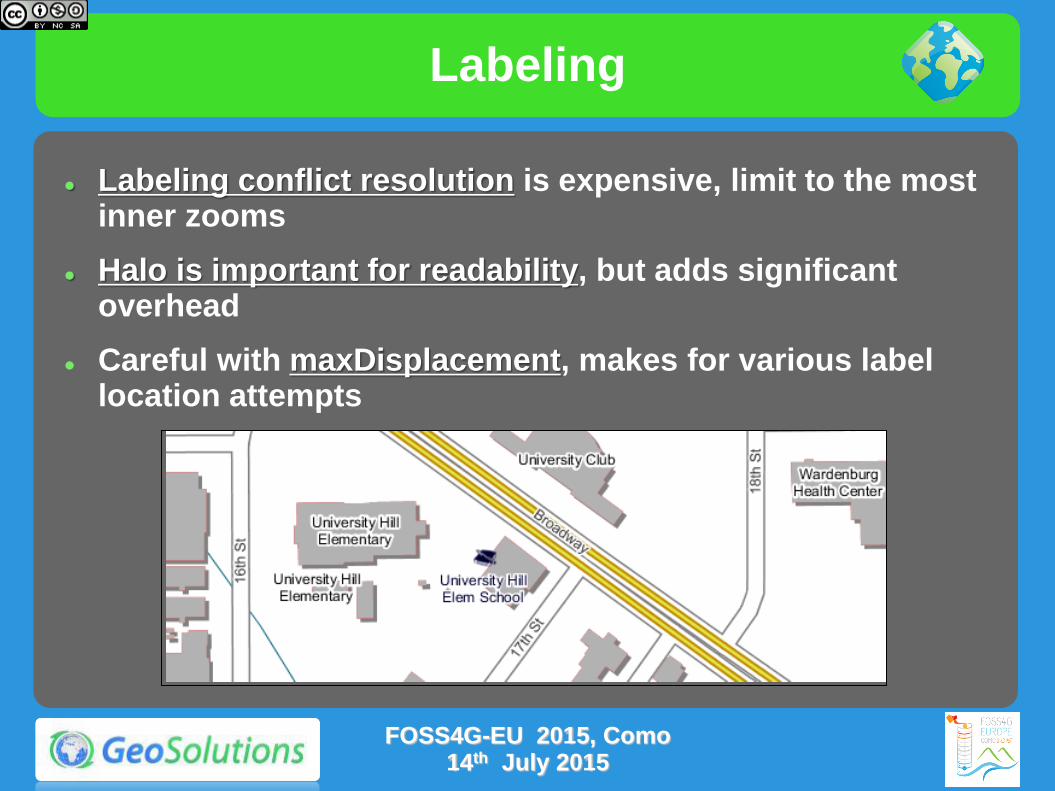
Labeling
Labeling conflict resolution is expensive, limit to the most inner zooms
Halo is important for readability, but adds significant overhead
Careful with maxDisplacement, makes for various label location attempts
FOSS4G-EU 2015, Como 14th July 2015

FeatureTypeStyle
GeoServer uses SLD FeatureTypeStyle objects as Z layers for painting
Each one allocates its own rendering surface (which can use a lot of memory), use as few as possible
FOSS4G-EU 2015, Como 14th July 2015
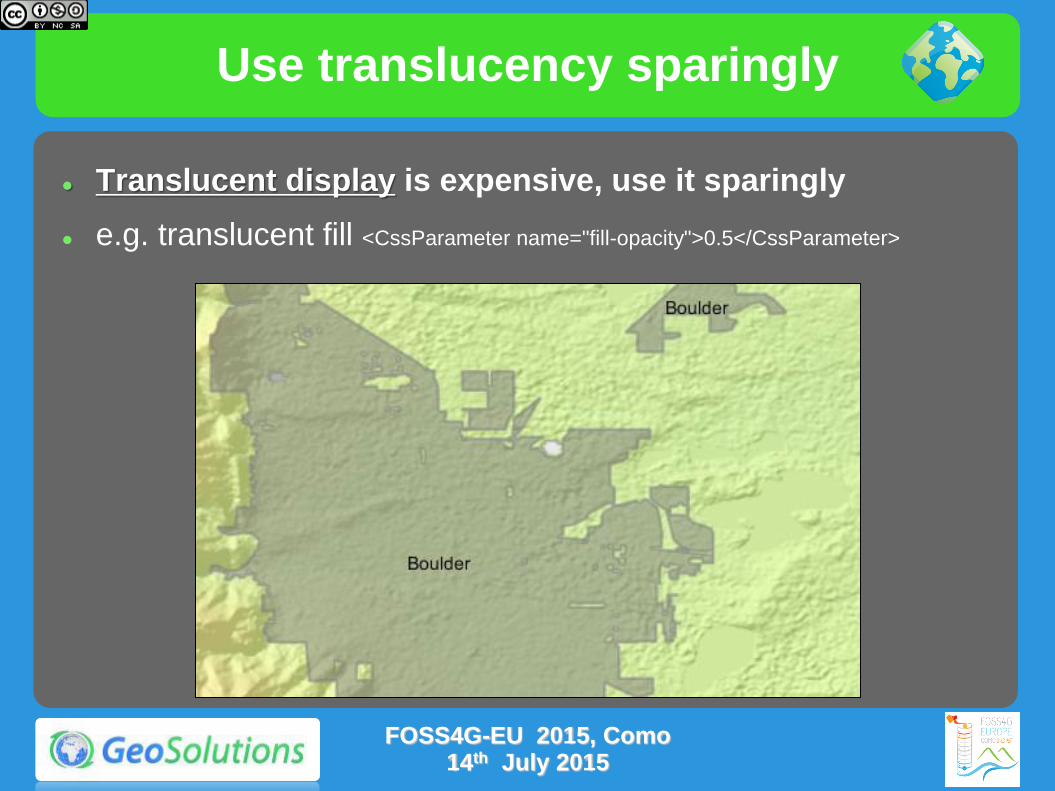
Use translucency sparingly
Translucent display is expensive, use it sparingly
e.g. translucent fill <CssParameter name="fill-opacity">0.5</CssParameter>
FOSS4G-EU 2015, Como 14th July 2015
Exercise
Let's compare bad styles with properly setup ones
Follow the instructions on the links below
http://geoserver.geo-solutions.it/educational/en/adv_gsconfig/jmeter/jmeter_styles.html
This test uses JMeter to compare a style without scale dependencies, showing too much data and too many labels, with a one with proper scale dependencies and providing a better looking output at the same output
FOSS4G-EU 2015, Como 14th July 2015

Tiling & Caching
Tile caching with GeoWebCache
Tile oriented maps, fixed zoom levels and fixed grid
Useful for stable layers, backgrounds
Protocols: WMTS, TMS, WMS-C, Google Maps/Earth, VE
Speedup compared to dynamic WMS: 10 to 100 times, assuming tiles are already cached (whole layer pre-seeded)
Suitable for:
Mostly static layer
No/few dynamic parameters (CQL filters, SLD params, SQL query params, time/elevation, format options)
FOSS4G-EU 2015, Como 14th July 2015
Embedded GWC advantage
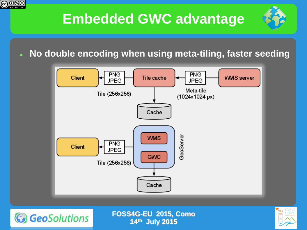
No double encoding when using meta-tiling, faster seeding
FOSS4G-EU 2015, Como 14th July 2015
Space considerations
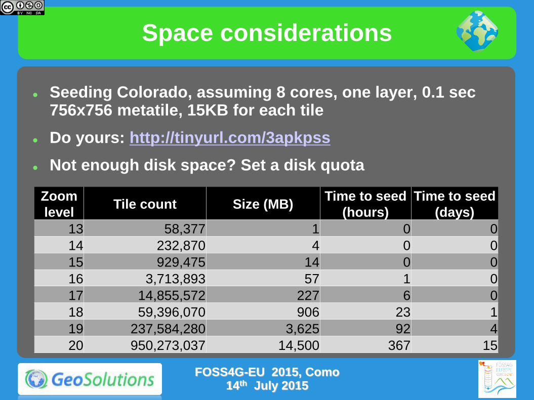
Seeding Colorado, assuming 8 cores, one layer, 0.1 sec 756x756 metatile, 15KB for each tile
Do yours: http://tinyurl.com/3apkpss
Not enough disk space? Set a disk quota
Zoom
level Tile count Size (MB)
Time to seed
(hours)
Time to seed
(days)
13 58,377 1 0 0
14 232,870 4 0 0
15 929,475 14 0 0
16 3,713,893 57 1 0
17 14,855,572 227 6 0
18 59,396,070 906 23 1
19 237,584,280 3,625 92 4
20 950,273,037 14,500 367 15
FOSS4G-EU 2015, Como 14th July 2015
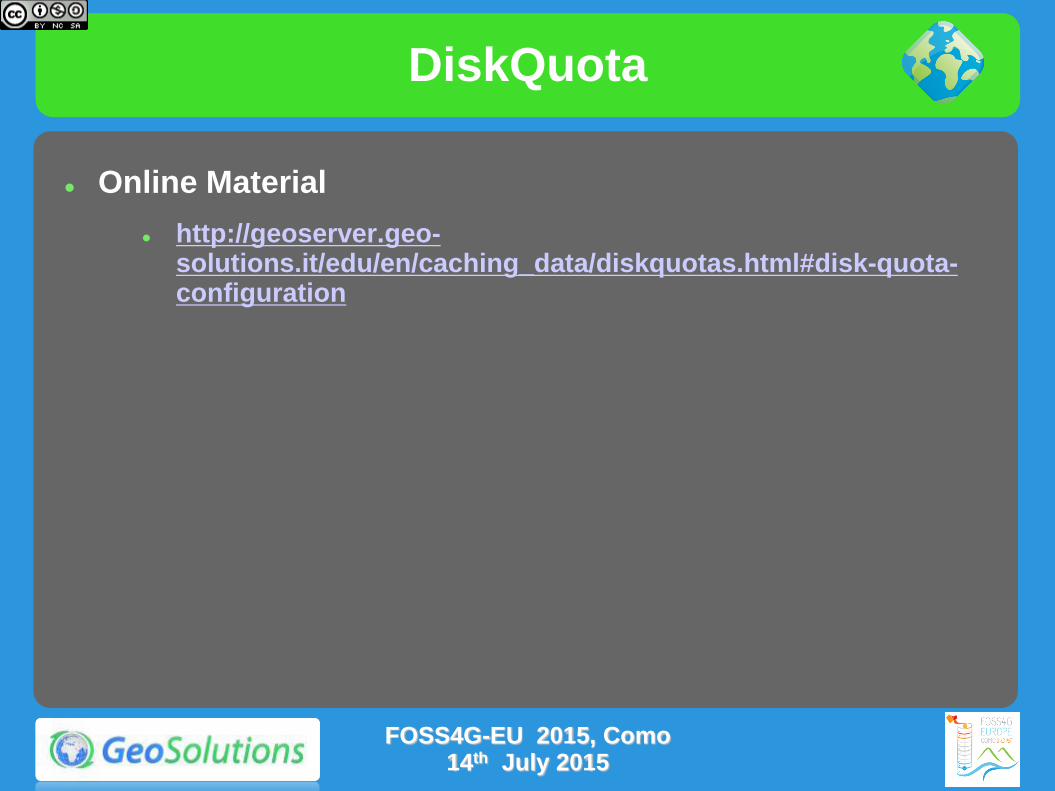
DiskQuota
Online Material
http://geoserver.geo-solutions.it/edu/en/caching_data/diskquotas.html#disk-quota-configuration
FOSS4G-EU 2015, Como 14th July 2015
More Tweaks
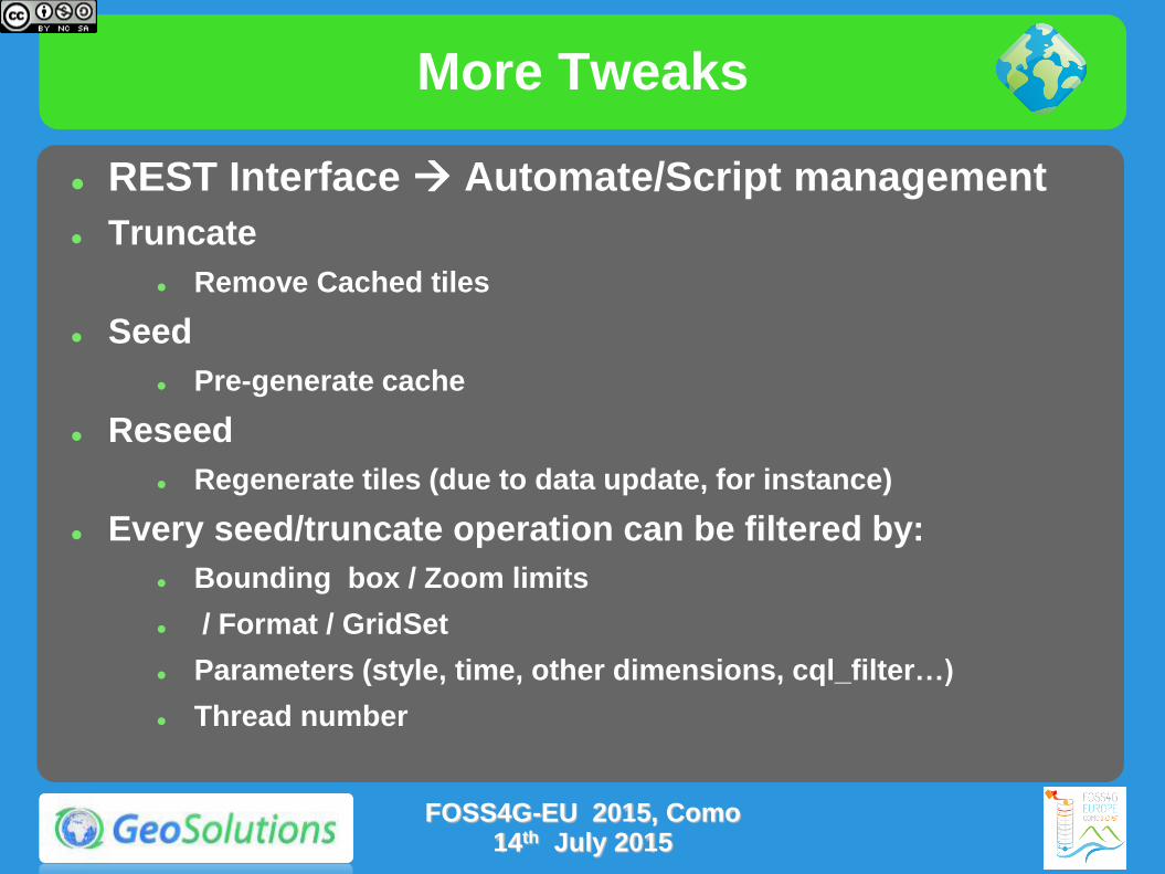
REST Interface Automate/Script management
Truncate
Remove Cached tiles
Seed
Pre-generate cache
Reseed
Regenerate tiles (due to data update, for instance)
Every seed/truncate operation can be filtered by:
Bounding box / Zoom limits
/ Format / GridSet
Parameters (style, time, other dimensions, cql_filter…)
Thread number
FOSS4G-EU 2015, Como 14th July 2015
More Tweaks
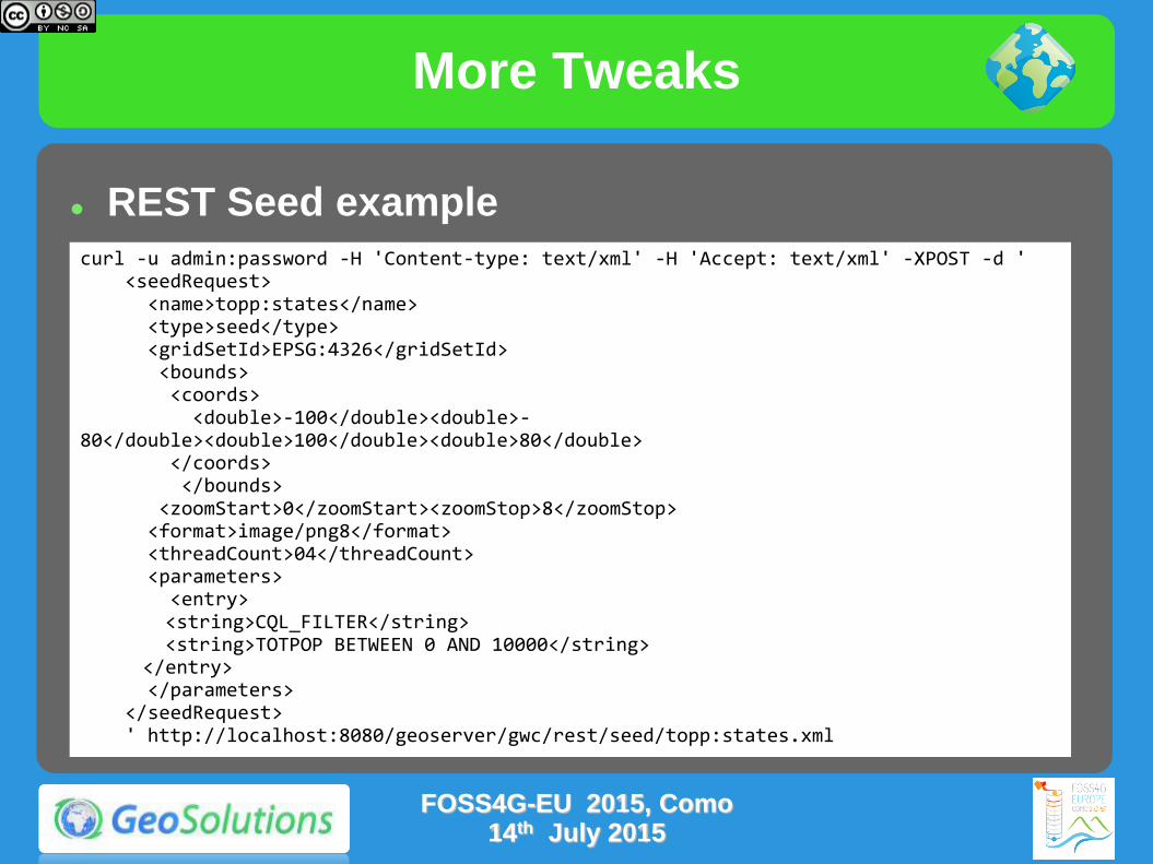
REST Seed example
FOSS4G-EU 2015, Como 14th July 2015
curl -u admin:password -H 'Content-type: text/xml' -H 'Accept: text/xml' -XPOST -d ' <seedRequest> <name>topp:states</name> <type>seed</type> <gridSetId>EPSG:4326</gridSetId> <bounds> <coords> <double>-100</double><double>-80</double><double>100</double><double>80</double> </coords> </bounds> <zoomStart>0</zoomStart><zoomStop>8</zoomStop> <format>image/png8</format> <threadCount>04</threadCount> <parameters> <entry> <string>CQL_FILTER</string> <string>TOTPOP BETWEEN 0 AND 10000</string> </entry> </parameters> </seedRequest> ' http://localhost:8080/geoserver/gwc/rest/seed/topp:states.xml

More Tweaks
Online Resources for GWC REST API
Documentation
http://geowebcache.org/docs/current/rest/seed.html
http://docs.geoserver.org/stable/en/user/geowebcache/rest/seed.html
Bash script for seed/reseed/truncate/mass truncate operations
https://github.com/geosolutions-it/scripts/blob/master/geowebcache/gwc.sh
Sample script for clean cache in geoserver cluster
https://github.com/geosolutions-it/scripts/blob/master/geowebcache/cleancache.sh
FOSS4G-EU 2015, Como 14th July 2015

More Tweaks
Clustering Single Shared Cache
Large, shared disk with fast R/W access
Perfect for bkg layers
Problematic set up in public cloud
Clustering Multiple Indipendent Caches
Exploit local, small, instance-based caches
Good for short lived caches
Duplication hit rsynch can help
Real-World Use Case
Dedicated Instances with shared cache for Bkg Layers
Indipendent Caches for other layers
FOSS4G-EU 2015, Como 14th July 2015
More Tweaks
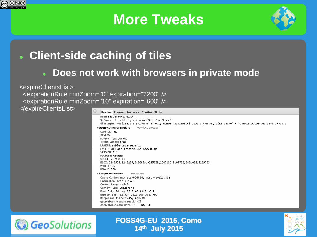
Client-side caching of tiles
Does not work with browsers in private mode
<expireClientsList> <expirationRule minZoom="0" expiration="7200" /> <expirationRule minZoom="10" expiration="600" /> </expireClientsList>
FOSS4G-EU 2015, Como 14th July 2015
More Tweaks
Use the right formats
JPEG for background data (e.g. ortos)
PNG8 + precomputed palette for background data (e.g. ortos)
PNG8 full for overlays with transparency
The format impacts also the disk space needed! (as well as the generation time)
Check this blog post
FOSS4G-EU 2015, Como 14th July 2015
Exercise
Let's compare GeoServer WMS with GeoWebCache fullWMS.
Follow the instructions on the links below
http://geoserver.geo-solutions.it/educational/en/adv_gsconfig/jmeter/jmeter_gwc.html
This test uses JMeter for comparing GeoServer WMS performances against those of GeoWebCache fullWMS
Mind, this is not the same as comparing WMS with pure tile caching, GWC has to read the tiles from disk, decompress, assemble the output image, and compress it again in PNG (some speedup still, but not 10 times)
FOSS4G-EU 2015, Como 14th July 2015
Advanced GeoServer Configuration

Resource Limits
Limit the amount of resources dedicated to an individual request
Improve fairness between requests, by preventing individual requests from hijacking the server and/or running for a very long time
EXTREMELY IMPORTANT in production environment
WHEN TO TWEAK THEM?
Frequent OOM Errors despite plenty of RAM
Requests that keep running for a long time (e.g. CPU usage peaks even if no requests are being sent)
DB Connection being killed by the DBMS while in usage (ok, you might also need to talk to the DBA..)
FOSS4G-EU 2015, Como 14th July 2015

WMS request limits
Max memory per request: avoid large requests, allows to size the server memory (max concurrent request * max memory)
Max time per request: avoid requests taking too much time (e.g., using a custom style provided with dynamic SLD in the request)
Max errors: best effort renderer, but handling errors takes time
FOSS4G-EU 2015, Como 14th July 2015

WFS request limits
Max feature returned, configured as a global limit
Return feature bbox: reduce amount of generated GML
Per layer max feature count
FOSS4G-EU 2015, Como 14th July 2015

WCS request limits
FOSS4G-EU 2015, Como 14th July 2015
Exercise
Let's show how resource limits can be used to avoid issues with slow requests
Follow the instructions on the links below
http://geoserver.geo-solutions.it/educational/en/adv_gsconfig/jmeter/jmeter_wmslimits.html
This test artificially limits the database resources to quickly generate a starvation situation in which the limits kick-in
FOSS4G-EU 2015, Como 14th July 2015
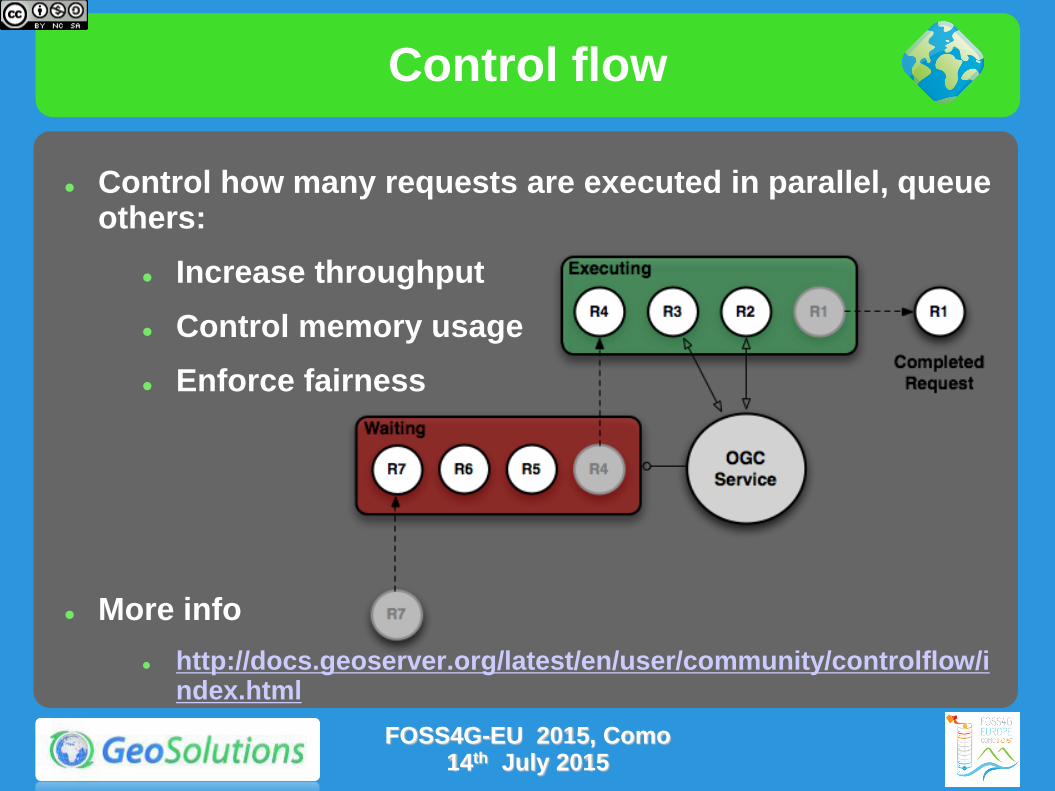
Control flow
Control how many requests are executed in parallel, queue others:
Increase throughput
Control memory usage
Enforce fairness
More info
http://docs.geoserver.org/latest/en/user/community/controlflow/index.html
FOSS4G-EU 2015, Como 14th July 2015
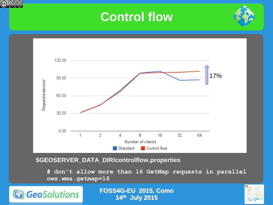
$GEOSERVER_DATA_DIR/controlflow.properties
# don't allow more than 16 GetMap requests in parallel
ows.wms.getmap=16
Control flow
17%
FOSS4G-EU 2015, Como 14th July 2015

Resource Limits
They need to be tweaked together with Control- Flow
Limiting individual requests Resource Limits
Limiting amount of parallel request Control Flow
When time is involved make sure you keep into account all pieces of the response chain
E.G. Limited rendering time for WMS on data coming from WMS, items to take into account are
LifeTime of DB Connection (usually long)
WaitTime for a new connection (we don’t want to queue requests at the connection pool when they area already eating memory!)
FOSS4G-EU 2015, Como
14th July 2015

Connection Pooling Tricks
Connection pool size should be proportional to the number of concurrent requests you want to serve (obvious no?)
Activate connection validation
Mind networking tools that might cut connections sitting idle (yes, your server is not always busy), they might cut the connection in “bad” ways (10 minutes timeout before the pool realizes the TCP connection attempt gives up)
Read more at
http://geoserver.geo-solutions.it/edu/en/adv_gsconfig/db_pooling.html
https://docs.google.com/document/d/1O02PeDRYKt2xLWG21k6BmcaRPzVRvXb4SQcrcZf4bHQ/edit?usp=sharing
FOSS4G-EU 2015, Como 14th July 2015

Exercise
Let's show how control-flow works in GeoServer
Follow the instructions on the links below
http://geoserver.geo-solutions.it/educational/en/adv_gsconfig/jmeter/jmeter_controlflow.html
This test uses JMeter for testing GeoServer performances before and after configuring the control-flow plugin.
FOSS4G-EU 2015, Como 14th July 2015

JVM and deploy configuration
Premise
The options discussed here are not going to help visibly if you did not prepare the data and the styles
They are finishing touches that can get performance up once the major data bottlenecks have been dealt with
Check “Running in production” instructions here
FOSS4G-EU 2015, Como 14th July 2015
JVM settings
--server: enables the server JIT compiler
--Xms2048m -Xmx2048m: sets the JVM use two gigabytes of memory
--XX:+UseParallelOldGC -XX:+UserParallelGC: enables multi-threaded garbage collections, useful if you have more than two cores
--XX:NewRatio=2: informs the JVM there will be a high number of short lived objects
--XX:+AggressiveOpt: enable experimental optimizations that will be defaults in future versions of the JVM
FOSS4G-EU 2015, Como 14th July 2015
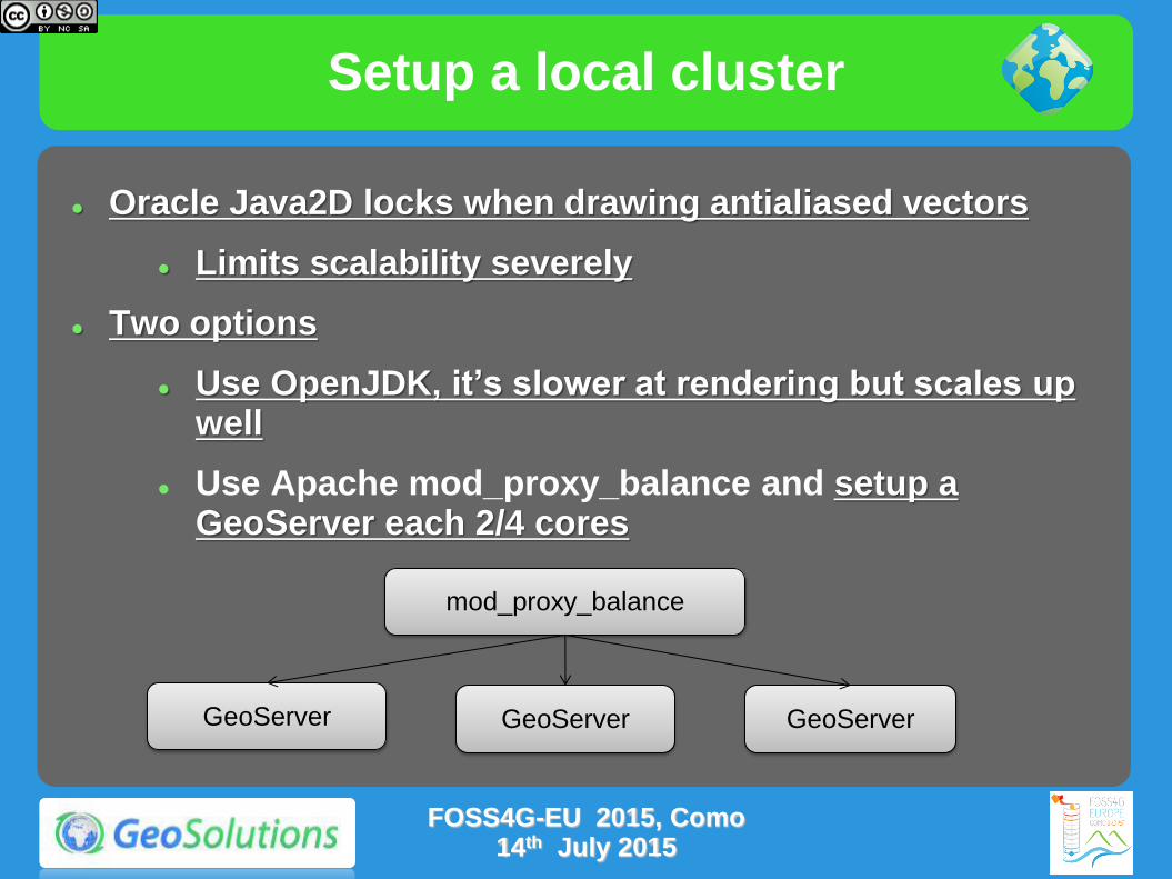
Setup a local cluster
Oracle Java2D locks when drawing antialiased vectors
Limits scalability severely
Two options
Use OpenJDK, it’s slower at rendering but scales up well
Use Apache mod_proxy_balance and setup a GeoServer each 2/4 cores
mod_proxy_balance
GeoServer GeoServer GeoServer
FOSS4G-EU 2015, Como 14th July 2015
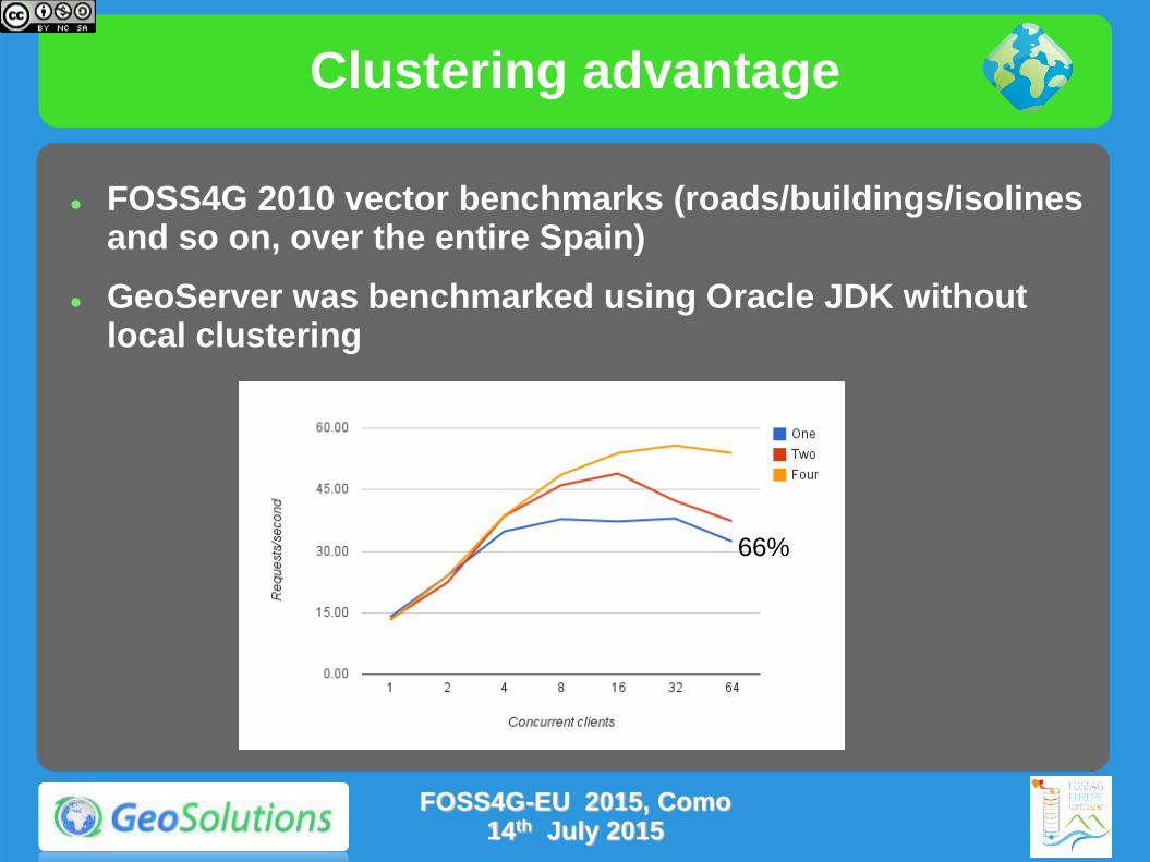
Clustering advantage
66%
FOSS4G 2010 vector benchmarks (roads/buildings/isolines and so on, over the entire Spain)
GeoServer was benchmarked using Oracle JDK without local clustering
FOSS4G-EU 2015, Como 14th July 2015
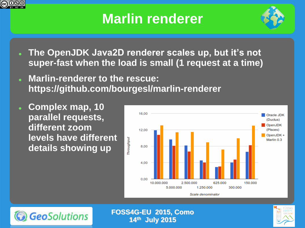
Marlin renderer
The OpenJDK Java2D renderer scales up, but it’s not super-fast when the load is small (1 request at a time)
Marlin-renderer to the rescue: https://github.com/bourgesl/marlin-renderer
Complex map, 10 parallel requests, different zoom levels have different details showing up
FOSS4G-EU 2015, Como 14th July 2015
Upgrade!
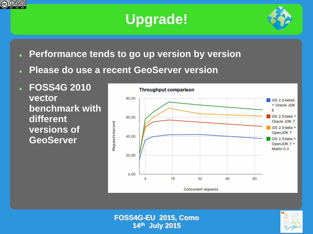
Performance tends to go up version by version
Please do use a recent GeoServer version
FOSS4G 2010 vector benchmark with different versions of GeoServer
FOSS4G-EU 2015, Como 14th July 2015

Exercise
Let's show how Marlin renderer can speed up map rendering under Windows, using GeoServer 2.5.x
Follow the instructions on the links below
http://geoserver.geo-solutions.it/educational/en/adv_gsconfig/jmeter/jmeter_marlin.html
This test uses JMeter for testing GeoServer performances before and after setting up Marlin renderer
FOSS4G-EU 2015, Como 14th July 2015

Clustering

Clustering with GeoServer
Online Material
http://geoserver.geo-solutions.it/edu/en/clustering/index.html
FOSS4G-EU 2015, Como 14th July 2015