Geoserver introduction, GeoBusiness 2015
35
GeoServer The Open Source Solution for the interoperable management of geospatial data Ing. Andrea Aime, GeoSolutions Ing. Simone Giannecchini, GeoSolutions Dott. Mauro Bartolomeoli, GeoSolutions
Transcript of Geoserver introduction, GeoBusiness 2015

GeoServerThe Open Source Solution
for the interoperable management of geospatial data
Ing. Andrea Aime, GeoSolutionsIng. Simone Giannecchini, GeoSolutionsDott. Mauro Bartolomeoli, GeoSolutions

Outline
Quick intro to GeoServer
What’s new in the 2.6.x and 2.7.x series
What’s cooking for the future

GeoServer quick intro

GeoServer
GeoSpatial enterprise gateway Java Enterprise Management and Dissemination of
raster and vector data Standards compliant
OGC WCS 1.0, 1.1.1 (RI), 2.0.1 OGC WFS 1.0, 1.1 (RI), 2.0 OGC WMS 1.1.1, 1.3 OGC WPS 1.0.0
Google Earth/Maps support KML, GeoSearch, etc..

Fo
rmat
s an
d P
roto
cols
Ge
oS
erv
er WFS
1.0, 1.1, 2.0
WMS1.1.11.3.0
PostGISOracleH2DB2SQL ServerMySqlSpatialiteGeoCouch
Shapefile
---------------------------------------
---------------------------------------
---------------------------------------
ArcSDEWFS
PNG, GIFJPEGTIFF, GeoTIFFSVG, PDFKML/KMZ
ShapefileGML2GML3GeoRSSGeoJSONCSV/XLS
Raw vectordata
Servers
Styled maps
DBMS
Vector files
WCS 1.0,1.1.1
2.0.1GeoTIFFWMSArcGridGTopo30Img+worldMosaicMrSIDJPEG 2000ECW,Pyramid, Oracle GeoRaster, PostGis Raster, NetCDF
Raster files
Raw rasterdata
GeoTIFFArcGridGTopo30Img+World
GWC(WMTS,
TMS,WMS-C)
KML superoverlaysGoogle maps tilesOGC tilesOSGEO tiles
WPS1.0.0

Virtual services
Expose different OGC services per workspace Styles and layer groups per workspace
Have different administrators per workspace multi-tenancy

WMS
Dissemination of Maps Fusing raster and vector data seamlessly
Rule/scale driven rendering
WMS 1.1.1 and 1.3 support SLD
Basic support for SLD 1.1 and SE 1.1
Full support for SLD 1.0
CSS extension for compact styling (now in Pure Java)
Many rendering extensions available

Rendering
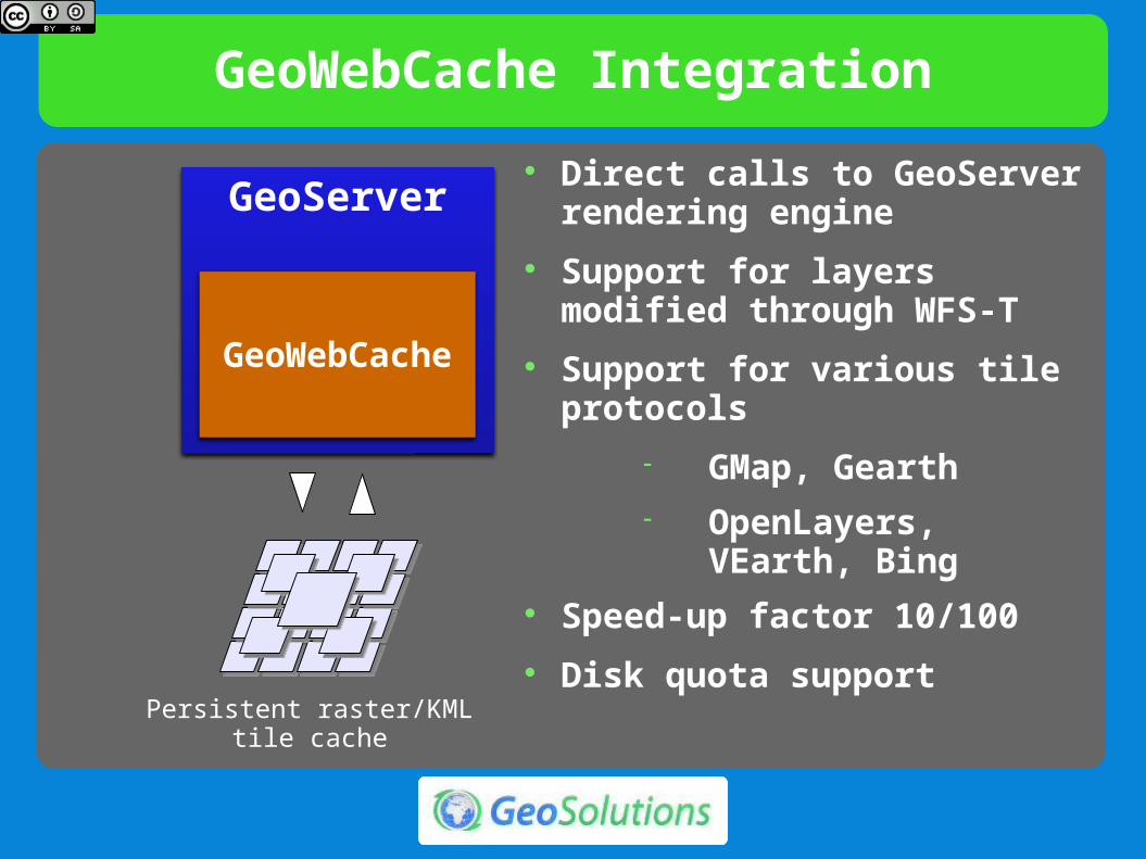
GeoWebCache Integration
GeoServer
GeoWebCache
Persistent raster/KMLtile cache
Direct calls to GeoServer rendering engine
Support for layers modified through WFS-T
Support for various tile protocols
GMap, Gearth OpenLayers, VEarth,
Bing Speed-up factor 10/100
Disk quota support

KML/KMZ
TEMPORAL SERIES
KML EXTRUDE KML SUPEROVERLAY

WFS
Dissemination and filtering of vector data WFS 1.0, 1.1 and 2.0 Transaction and paging available in all versions Simplified filtering via CQL Formats:
GML 2, 3.1 and 3.2 CSV, Excel spreadsheet, GeoRSS, GeoJSON Shapefile (zipped) KML (since 2.4.0) Any other format supported by ogr2ogr (configurable)

Complex Feature*
Application/community schemas
Complex Features
Attributes as sub-features
Attributes as list of features
Tree-like structure
Mixing in a single tree heterogeneous data sources

WCS
Raster data dissemination Raw raster data useful for analysis, no maps!
Support for TIME, ELEVATION and custom dimensions
WCS 1.0, 1.1.1 and 2.0 Output formats
GeoTiff, ArcGrid, NetCDF
Extensions ELEVATION as band management

WPS
WPS 1.0
Official Extension
Raster and Vector data support
High performance processes (raster/vector statistics, raster/vector format conversions and more)
Integrated WPS
Direct access to data sources
Automatic publishing of results as new layers
Embedding processes into SLD styles (rendering transformation, since 2.2.0)
Write processes in scripting languages (Jython, Javascript, Groovy, Scala, …)

Administration GUI

RESTful Configuration
Programmatic configuration of layers via REST calls
Workspaces, Data stores / coverage stores Layers and Styles, Service configurations Freemarker templates (incoming)
Exposing internal configuration to remote clients Ajax - JavaScript friendly
Various client libraries available in different languages (Java, Python, Ruby, …).
Example, geoserver-manager: https://github.com/geosolutions-it/geoserver-manager

Security: Authentication
Pluggable user sources, available out of the box: LDAP, DBMS
Pluggable authentication mechanisms, available out of the box:
BASIC/DIGEST HTTP, CAS Possible to integrate with other mechanisms and
in-house solutions Available since 2.2.0, before only basic HTTP auth
+ simple text file for users

WMS: TIME and ELEVATION
TIME = 20100512T0000000ZELEVATION = 0.0
FeatureType Editor
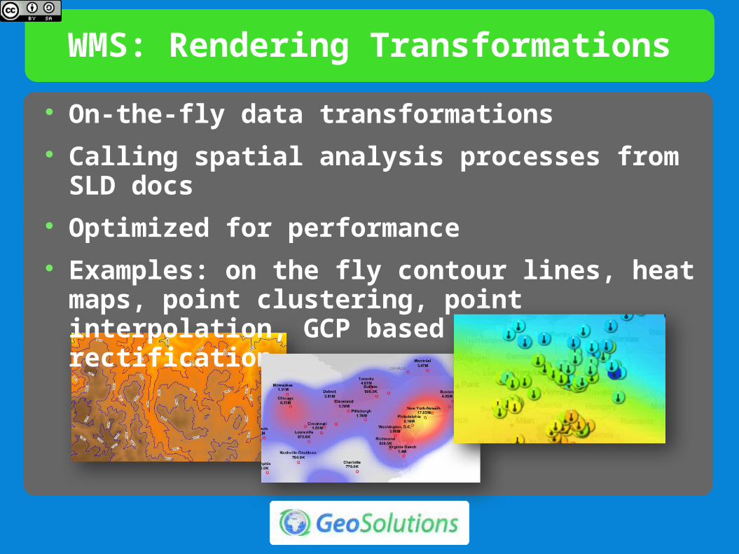
WMS: Rendering Transformations
On-the-fly data transformations Calling spatial analysis processes from SLD docs Optimized for performance Examples: on the fly contour lines, heat maps,
point clustering, point interpolation, GCP based image rectification

CSS styling
CSS inspiredstyling language
Styling for humans
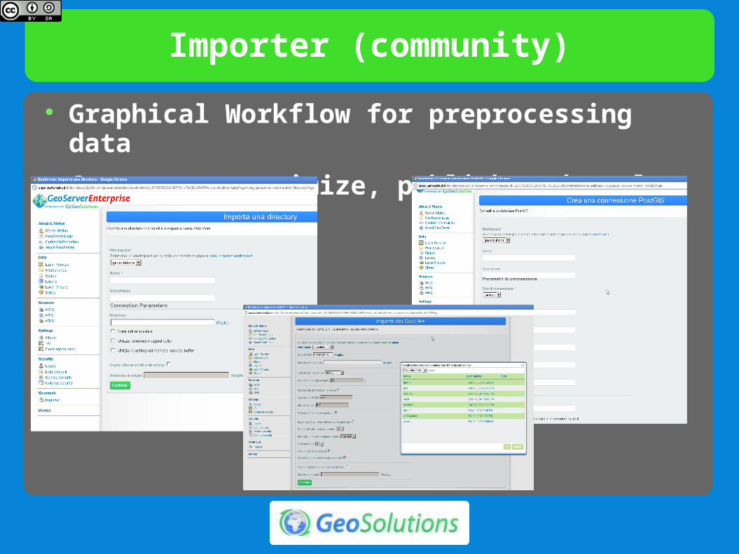
Importer (community)
Graphical Workflow for preprocessing data Copy over, optimize, publish and style

Scripting Processing (WPS)
http://elogeo.nottingham.ac.uk/xmlui/handle/url/199 (Processing with WPS and SQL Views)

Improved Printing

Improved Printing

Improved Printing

What’s new in 2.6.x

What’s new in 2.6.x
Advanced Raster Projection

What’s new in 2.6.x
Vector Footprints for ImageMosaic

What’s new in 2.6.x
Raster Views Like SQLViews for Coverages
Wind Barbs

What’s new in 2.7.x

What’s new in 2.7.x
Color composition and blending

What’s new in 2.7.x
WPS Clustering Security Limits Dismiss
CSS module refresh SOLR DataStore

In the Pipeline
Advanced Authorization Subsystem integration (GeoFence)
Distributed Scripting Processes Faster Raster Processing
More Robust NoData handling JAI Replacement
REST API for access control

The End

The End
Other Questions?Come to our booth at N20