ent and Evalua a Field Mobili ty Data Captur e
101
De evelopm Sy U Fa ment and ystem f Cours Bac University aculty of E d Evalua for Con A dis Fi In fulfilm se ENG41 To chelor of Sub y of South Engineer ation of dition A ssertation iona Jane ment of the 11 & ENG owards the f Enginee bmitted: Oc hern Que ring and S f a Field Assessm submitted e Nielson requireme G4112 Res e degree of ering (Ag ctober, 201 eensland Surveying d Mobili ment of by n ents of earch Pro f gricultura 12 g ity Data f Assets oject al) a Captur s re
Transcript of ent and Evalua a Field Mobili ty Data Captur e

De
evelopm
Sy
U
Fa
ment and
ystem f
Cours
Bac
University
aculty of E
d Evalua
for Con
A dis
Fi
In fulfilm
se ENG41
To
chelor of
Sub
y of South
Engineer
ation of
dition A
ssertation
iona Jane
ment of the
11 & ENG
owards the
f Enginee
bmitted: Oc
hern Que
ring and S
f a Field
Assessm
submitted
e Nielson
requireme
G4112 Res
e degree of
ering (Ag
ctober, 201
eensland
Surveying
d Mobili
ment of
by
n
ents of
earch Pro
f
gricultura
12
g
ity Data
f Assets
oject
al)
a Captur
s
re

DISSERTATION DEVELOPMENT AND EVALUATION OF A FIELD MOBILITY DATA CAPTURE SYSTEM FOR CONDITION ASSESSMENT OF ASSETS
USQ Dissertation Fiona Nielson May 20130050041245 Commercial In Confidence Page i
ABSTRACT
The principle aim of the research was to determine if a mobile data capture system
could be suitably applied to the condition assessment of assets within SunWater.
The study involved research into the current condition assessment process within the
Irrigation & Drainage department of SunWater. Assets considered in this project
involved those specific to the Barratta Section of the Burdekin Haughton Water Supply
Scheme (BHWSS). This research involved the engineers and technical officers of the
Asset Management, Irrigation & Drainage department within SunWater.
Established during this research was the current condition assessment process,
possible mobile data capture solutions to this process and a trial of a mobile data
capture system within the Barratta Section of the BHWSS. The associated costs of the
current process and mobile solutions were then analysed making use of the outcomes
of the trial. From this analysis, conclusions were able to be drawn as to the relative
merits of mobile data capture systems and their usefulness to SunWater.
The physical output of the research included a trial application for the completion of
asset condition assessments and a recommendation on the economic viability for
implementing a mobile data capture system within SunWater.
The results of this study will help to determine if SunWater can incorporate mobile data
capture systems into its condition assessment processes and thereby support its
productivity initiative of ‘Smarter, Lighter, Faster.’
DISSERTATION DEVELOPMENT AND EVALUATION OF A FIELD MOBILITY DATA CAPTURE SYSTEM FOR CONDITION ASSESSMENT OF ASSETS
USQ Dissertation Fiona Nielson May 20130050041245 Commercial In Confidence Page ii
University of Southern Queensland
Faculty of Health, Engineering and Sciences
ENG4111/ENG4112 Research Project
Limitations of Use
The Council of the University of Southern Queensland, its Faculty of Health,
Engineering & Sciences, and the staff of the University of Southern Queensland, do not
accept any responsibility for the truth, accuracy or completeness of material contained
within or associated with this dissertation.
Persons using all or any part of this material do so at their own risk, and not at the risk
of the Council of the University of Southern Queensland, its Faculty of Health,
Engineering & Sciences or the staff of the University of Southern Queensland.
This dissertation reports an educational exercise and has no purpose or validity beyond
this exercise. The sole purpose of the course pair entitled “Research Project” is to
contribute to the overall education within the student’s chosen degree program. This
document, the associated hardware, software, drawings, and other material set out in
the associated appendices should not be used for any other purpose: if they are so
used, it is entirely at the risk of the user.

DISSERTATION DEVELOPMENT AND EVALUATION OF A FIELD MOBILITY DATA CAPTURE SYSTEM FOR CONDITION ASSESSMENT OF ASSETS
USQ Dissertation Fiona Nielson May 20130050041245 Commercial In Confidence Page iii
CERTIFICATION OF DISSERTATION
I certify that the ideas, designs and experimental work, results, analyses and
conclusions set out in this dissertation are entirely my own effort, except where
otherwise indicated and acknowledged.
I further certify that the work is original and has not been previously submitted for
assessment in any other course or institution, except where specifically stated.
Fiona Jane Nielson
0050041245
________________________ Signature
________________________ Date

DISSERTATION DEVELOPMENT AND EVALUATION OF A FIELD MOBILITY DATA CAPTURE SYSTEM FOR CONDITION ASSESSMENT OF ASSETS
USQ Dissertation Fiona Nielson May 20130050041245 Commercial In Confidence Page iv
ACKNOWLEDGEMENTS
This research was carried out under the principal supervision of Dr Alexander Kist of the
University of Southern Queensland and Mr Peter Marshall of SunWater. Thanks and
appreciation is extended to both for their help and understanding during this project.
Appreciation is also due to the staff of the Irrigation and Drainage department of
SunWater for their help and support during the research, trial and final stages of this
project.
Finally I would like to thank my partner Heath and my son Hugh for their patience and
support throughout not only this research project but my academic career.

DISSERTATION DEVELOPMENT AND EVALUATION OF A FIELD MOBILITY DATA CAPTURE SYSTEM FOR CONDITION ASSESSMENT OF ASSETS
USQ Dissertation Fiona Nielson May 20130050041245 Commercial In Confidence Page v
TABLE OF CONTENTS
ABSTRACT ...................................................................................................................... I
CERTIFICATION OF DISSERTATION .......................................................................... III
ACKNOWLEDGEMENTS ..............................................................................................IV
LIST OF FIGURES ........................................................................................................VII
LIST OF TABLES ........................................................................................................ VIII
LIST OF APPENDICES ............................................................................................... VIII
ABBREVIATIONS ..........................................................................................................IX
1.0 INTRODUCTION .................................................................................................. 1
1.1 OUTLINE OF THE STUDY ........................................................................................... 1
1.2 INTRODUCTION .......................................................................................................... 1
1.2.1 SunWater Ltd ......................................................................................................................... 1
1.2.2 Asset Management ................................................................................................................ 3
1.2.3 Condition Assessment ............................................................................................................ 3
1.3 THE PROBLEM ............................................................................................................ 3
1.4 RESEARCH OBJECTIVES .......................................................................................... 5
1.5 SUMMARY ................................................................................................................... 7
2.0 BACKGROUND INFORMATION ......................................................................... 8
2.1 RESOURCE PLANNING .............................................................................................. 8
2.2 THE CONDITION ASSESSMENT PROCESS ............................................................. 8
2.2.1 Select Location ....................................................................................................................... 9
2.2.2 Evaluate Assets ...................................................................................................................... 9
2.2.3 Print Scheme Maps and Condition Assessment Forms ....................................................... 10
2.2.4 Upload Locations to Handheld GPS .................................................................................... 12
2.2.5 Field Condition Assessment ................................................................................................. 12
2.2.6 Upload of Condition Assessment ......................................................................................... 13
2.3 WHAT DOES SUNWATER REQUIRE ....................................................................... 15
2.3.1 Requirements Analysis ......................................................................................................... 15
2.3.2 Hardware Ranking ................................................................................................................ 16
2.3.3 Software Ranking ................................................................................................................. 20
3.0 CONDITION ASSESSMENT AND DATA CAPTURE ........................................ 22
3.1 MANUAL CONDITION ASSESSMENT AND DATA CAPTURE ................................ 22
3.2 MOBILE CONDITION ASSESSMENT AND DATA CAPTURE .................................. 23
3.2.1 The Device ........................................................................................................................... 23
DISSERTATION DEVELOPMENT AND EVALUATION OF A FIELD MOBILITY DATA CAPTURE SYSTEM FOR CONDITION ASSESSMENT OF ASSETS
USQ Dissertation Fiona Nielson May 20130050041245 Commercial In Confidence Page vi
3.2.2 The Software ........................................................................................................................ 29
3.3 ASSET MANAGEMENT ............................................................................................. 32
3.4 SUMMARY ................................................................................................................. 33
4.0 DEVELOPING THE MOBILE DATA CAPTURE TRIAL SYSTEM ..................... 34
4.1 THE DEVICE .............................................................................................................. 34
4.2 THE SOFTWARE ....................................................................................................... 35
4.3 DATA DEVELOPMENT AND QUALITY CONTROL .................................................. 36
4.4 ARCMAP – SETTING DOMAINS AND SUBTYPES .................................................. 38
4.5 THE COLLECTOR APP ............................................................................................. 39
4.6 CUSTOMISATION ...................................................................................................... 40
4.7 THE TRIAL ................................................................................................................. 41
4.7.1 PREPARATION .................................................................................................................... 42
4.7.2 CONDITION ASSESSMENT ............................................................................................... 43
4.7.3 POST PROCESSING ........................................................................................................... 43
4.8 COSTING OF EXISTING PROCESSES .................................................................... 43
5.0 RESULTS AND RECOMMENDATIONS ............................................................ 45
5.1 QUANTITATIVE RESULTS ........................................................................................ 45
5.2 DEVICE PERFORMANCE TRIAL RESULTS ............................................................ 48
5.3 SOFTWARE PERFORMANCE TRIAL RESULTS ..................................................... 49
5.4 HARDWARE RANKING RESULTS ............................................................................ 50
5.5 SOFTWARE RANKING RESULTS ............................................................................ 51
6.0 CONCLUSIONS ................................................................................................. 53
6.1 INTRODUCTION ........................................................................................................ 53
6.2 CONSEQUENTIAL EFFECTS ................................................................................... 53
6.3 CONCLUSIONS ......................................................................................................... 54
6.3.1 Is Mobile Data Capture a Possibility? .................................................................................. 54
6.3.2 Is the Prototype System Acceptable? .................................................................................. 55
6.4 FURTHER WORK ...................................................................................................... 55
7.0 REFERENCES ................................................................................................... 57

DISSERTATION DEVELOPMENT AND EVALUATION OF A FIELD MOBILITY DATA CAPTURE SYSTEM FOR CONDITION ASSESSMENT OF ASSETS
USQ Dissertation Fiona Nielson May 20130050041245 Commercial In Confidence Page vii
LIST OF FIGURES
Figure 1.1 - SunWater Operations and Infrastructure (SunWater 2012) ......................... 2
Figure 1.2 - Asset Management Organisational Hierarchy (SunWater 2013) .................. 5
Figure 2.1 - Manual Condition Assessment Process ....................................................... 9
Figure 2.2 - Example Condition Assessment Form from SAP (SunWater 2013) ........... 11
Figure 2.3 - Criteria Scoring Number Line ..................................................................... 17
Figure 3.1 - Top 8 Mobile Operating Systems in Australia from Feb 2012 - Feb 2013 (Source StatCounter Global Stats) ........................................................... 24
Figure 3.2 - Apple iPhone 5 Smartphone (Apple 2013) ................................................. 25
Figure 3.3 - Samsung Galaxy S4 Smartphone (Samsung 2013) ................................... 25
Figure 3.4 - Apple iPad Tablet (Apple 2013) ................................................................. 26
Figure 3.5 - Microsoft Surface Tablet (Microsoft 2013) ................................................. 26
Figure 3.6 - Samsung Galaxy Note Tablet (Samsung 2013) ......................................... 26
Figure 3.7 - Trimble Yuma Rugged Tablet (Trimble 2013) ............................................ 27
Figure 3.8 - Motorola MC67 Mobile Computer (Motorola Solutions 2013) .................... 27
Figure 3.9 - Dell Inspiron 17 Laptop (Dell 2013) ............................................................ 28
Figure 3.10 - Panasonic Toughbook Rugged Laptop (Toughbook 2013) ...................... 28
Figure 3.11 - Telstra Network Coverage in Queensland (Telstra 2013) ........................ 31
Figure 4.1 - Customised Pop-Up Window in Collector App ........................................... 41
Figure 4.2 - The Mobile Data Capture Process ............................................................. 42
Figure 5.1 – Percentage Task Distribution .................................................................... 45
Figure 5.2 - Average Minutes per Structure Assessment .............................................. 47

DISSERTATION DEVELOPMENT AND EVALUATION OF A FIELD MOBILITY DATA CAPTURE SYSTEM FOR CONDITION ASSESSMENT OF ASSETS
USQ Dissertation Fiona Nielson May 20130050041245 Commercial In Confidence Page viii
LIST OF TABLES
Table 2.1 - Condition Assessment Cost Breakdown per Scheme ................................. 14
Table 2.2 - Hardware Criteria Breakdown and Scoring ................................................. 19
Table 2.3 - Software Criteria Breakdown and Scoring ................................................... 21
Table 5.1 - Percentage Breakdown of Condition Assessment Tasks ............................ 46
Table 5.2 - Hardware Ranking Results .......................................................................... 50
Table 5.3 - Software Ranking Results ........................................................................... 51
LIST OF APPENDICES
APPENDIX A ................................................................................................................... 1
APPENDIX B ................................................................................................................... 2
APPENDIX C ................................................................................................................... 3
APPENDIX D ................................................................................................................... 4
APPENDIX E ................................................................................................................... 5
APPENDIX F ................................................................................................................... 6
APPENDIX G .................................................................................................................. 7
APPENDIX H ................................................................................................................... 8
APPENDIX I…………. ..................................................................................................... 9
APPENDIX J …………………………………………………………………………………..10
APPENDIX K ................................................................................................................. 11

DISSERTATION DEVELOPMENT AND EVALUATION OF A FIELD MOBILITY DATA CAPTURE SYSTEM FOR CONDITION ASSESSMENT OF ASSETS
USQ Dissertation Fiona Nielson May 20130050041245 Commercial In Confidence Page ix
ABBREVIATIONS
The following abbreviations have been used throughout the text:
BHWSS - Burdekin Haughton Water Supply Scheme
GOC - Government Owned Corporation
GIS - Geographical Information System
SAP - Systems, Applications and Products
ESRI - Environmental Systems Research Institute
ARMS - Asset Register and Management System
OS - Operating System
IP - Ingress Protection
DISSERTATION DEVELOPMENT AND EVALUATION OF A FIELD MOBILITY DATA CAPTURE SYSTEM FOR CONDITION ASSESSMENT OF ASSETS
USQ Dissertation Fiona Nielson May 20130050041245 Commercial In Confidence Page 1
1.0 INTRODUCTION
1.1 OUTLINE OF THE STUDY
This study investigates the development and evaluation of a field mobility data capture
system for condition assessment of assets within the water industry. It looks at the
current condition assessment process and how this can be improved through the use of
mobile data capture systems. This includes investigation into types of mobile devices
and software platforms.
The main focus of the study is to develop and trial a mobile data capture system in the
BHWSS to determine the benefits, of implementing such a system. The purpose of the
study is to report on the outcomes of the trial, and analyse the results to provide a
recommendation to pursue or otherwise mobile data capture of asset condition within
SunWater.
1.2 INTRODUCTION
1.2.1 SunWater Ltd
SunWater Ltd is a Queensland based Government-Owned Corporation (GOC) which
was formed in 2001. SunWater’s extensive network of water supply infrastructure
supports mining, power generation, industry, urban development and irrigated
agriculture throughout Queensland (SunWater 2013).
SunWater owns and manages around $7 billion in water infrastructure assets and
supplies approximately 40% of all water used commercially in Queensland (SunWater
2013).
SunWater has an extensive infrastructure base including (SunWater 2012):
19 dams, 68 weirs and barrages, 85 major pumping stations and over 2500km of open
channel and pipeline (Figure 1.1).

DISSERTATION DEVELOPMENT AND EVALUATION OF A FIELD MOBILITY DATA CAPTURE SYSTEM FOR CONDITION ASSESSMENT OF ASSETS
USQ Dissertation Fiona Nielson May 20130050041245 Commercial In Confidence Page 2
Figure 1.1 - SunWater Operations and Infrastructure (SunWater 2012)
DISSERTATION DEVELOPMENT AND EVALUATION OF A FIELD MOBILITY DATA CAPTURE SYSTEM FOR CONDITION ASSESSMENT OF ASSETS
USQ Dissertation Fiona Nielson May 20130050041245 Commercial In Confidence Page 3
1.2.2 Asset Management
The extensive array of infrastructure present under SunWater ownership requires
thorough asset management. SunWater’s aim is “To manage our assets in a
sustainable manner to meet SunWater’s business objectives of safeguarding asset
integrity and ensuring asset serviceability.” (Asset Management Policy AM01_P1 2013).
In order to achieve this SunWater must carry out certain tasks, one of which is
performing condition assessments of all assets and recording these assessments in
SunWater’s corporate system.
1.2.3 Condition Assessment
Condition Assessment is the process by which an asset’s condition is objectively
reviewed against a defined criteria set and the results recorded for later review and
analysis. In the SunWater’s case, the data is stored within an SAP database.
Its purpose is ‘to establish a consistent, informed and auditable process for prioritising
expenditure on asset refurbishment based on the assessment and management of
asset condition.’ (Asset Refurbishment Planning: Methodology for Condition
Assessments of Assets 2012).
1.3 THE PROBLEM
Since the development of the first irrigation areas in the 1950’s, SunWater’s
infrastructure base has continued to expand through growth in the agriculture sector,
but also more recently the boom in the Queensland mining/industrial sector. As a result,
extensive pipeline and pump station assets have been added to the asset portfolio.
In 2000 SunWater upgraded its Asset Register and Management System (ARMS) to
SAP PM (Systems, Applications and Products Plant Maintenance). With the
implementation of this new management system, it was decided that a whole of
SunWater asset condition assessment would be necessary to ensure the asset data in
the new system was accurate and up to date. A large number of the assets owned by

DISSERTATION DEVELOPMENT AND EVALUATION OF A FIELD MOBILITY DATA CAPTURE SYSTEM FOR CONDITION ASSESSMENT OF ASSETS
USQ Dissertation Fiona Nielson May 20130050041245 Commercial In Confidence Page 4
SunWater require condition assessments every 10 to 15 years. This means that these
assets will now be due for assessment or will be nearing assessment in 2015. Due to
this large number of assets, a more economical solution could provide significant cost
benefits over the earlier efforts.
In order to uphold the required standard of asset management across such a broad
asset base, it is important that alternative methods of data collection are investigated
and thereby allow SunWater to achieve a productivity improvement (‘Smarter, Lighter,
Faster’).
At present, the condition assessment process is distributed between sub-departments
of the Asset Management Group (Figure 1.2). The group is broken down into asset
specific departments, these being:
Dam Safety – Ensure that SunWater complies with the necessary regulatory
requirements.
Asset Information Policy and Standards – Develop and maintain the Asset Management
Policy and Standards framework and ensure compliance across all groups.
Pumps and Pipelines – Manage the pump stations and pipeline assets (i.e. Industrial
pipelines and all pumpstations)
Irrigation and Drainage – Manage the irrigation and drainage assets (i.e. Channels and
associated infrastructure)
Headworks – Manage the water storage assets (i.e. Dams and weirs)
The last three asset groups are all required to perform condition assessments of their
relevant assets. For the purposes of this thesis, the focus will be on the methods and

DISSERTATION DEVELOPMENT AND EVALUATION OF A FIELD MOBILITY DATA CAPTURE SYSTEM FOR CONDITION ASSESSMENT OF ASSETS
USQ Dissertation Fiona Nielson May 20130050041245 Commercial In Confidence Page 5
processes utilised by the Irrigation and Drainage group. It is expected that the
outcomes of this report will be considered by SunWater as part of its continual
improvement initiatives.
Figure 1.2 - Asset Management Organisational Hierarchy (SunWater 2013)
The current condition assessment methods that are employed by SunWater are eligible
for efficiency improvements and are the catalyst for this thesis as discussed in Section
0.
1.4 RESEARCH OBJECTIVES
The principle aim of this research is to develop and trial an application that will enable
electronic recording of asset condition assessments in the field. This trial will aid in
determining whether there are benefits in advancing with such a system within
SunWater.
There are nine objectives associated with this aim (as per the specification, APPENDIX
A):
Manager
Asset Management
Principal Engineer,
Dam Safety
Senior Technical Officer
(A) Principal Engineer, Asset
Information Policy & Standards
Systems
Administrator
Senior Project Manager
Systems
Administrator
Systems
Administrator
Systems
CoordinatorTechnical Officer
Senior Engineer,
Pumps and Pipelines
Electrical EngineerEngineer
(Graduate Program)
Senior Technical Officer (Civil)
Senior Technical Officer (Civil)
Technical Officer (Mechanical)
Engineer (Graduate Program)
Senior Mechanical Engineer
Senior Electrical Engineer
Engineer (Graduate Program)
Senior Engineer,
Irrigation & Drainage
Engineer Engineer
Technical Officer
(Mechanical)Senior Engineer
EngineerTechnical Officer
(Civil)
Engineer
Senior Engineer,
Headworks
Senior Technical Officer
Senior Technical Officer
Asset Engineer Engineer
Senior Engineer Engineer
Senior Technical Officer
Engineer (Graduate Program)

DISSERTATION DEVELOPMENT AND EVALUATION OF A FIELD MOBILITY DATA CAPTURE SYSTEM FOR CONDITION ASSESSMENT OF ASSETS
USQ Dissertation Fiona Nielson May 20130050041245 Commercial In Confidence Page 6
1) Undertake a basic requirements analysis, identify use cases and develop a
platform functional specification:
2) Undertake a comprehensive literature review covering but not limited to the
following aspects:
The range of commercially available field mobility solutions:
Industry user types, market requirements and directions;
Types of software available, trends and support prospects;
Types of hardware (i.e. tablet, phone. other), functionality and design
obsolescence; and
Advantages/Disadvantages of software/hardware/field data capture packages.
3) Develop an optimised prototype system incorporating a software
solution/hardware package that satisfies SunWater’s functional requirements.
Engage the services of a third party to develop software/hardware solutions as
required.
4) Develop and implement a test plan for developed software and hardware
component. Undertake field trials and review performance against functional
requirements;
5) Prepare an academic dissertation of the research project;
As time permits
6) Analyse and evaluate business processes in relation to the developed system.
7) Undertake cost/benefit analysis of implementing the field mobility solution in the
context of asset data capture and analysis;

DISSERTATION DEVELOPMENT AND EVALUATION OF A FIELD MOBILITY DATA CAPTURE SYSTEM FOR CONDITION ASSESSMENT OF ASSETS
USQ Dissertation Fiona Nielson May 20130050041245 Commercial In Confidence Page 7
8) Subject to positive outcome of point 7), prepare a draft business case for the
Implementation of the system within SunWater asset management; and
9) Provide recommendations on the implementation of the system and the final
functional and technical specifications.
By meeting each of these objectives a suitable outcome can be reached to enable
SunWater to make an informed decision on the use of mobile data capture systems to
aid or replace current manual processes.
A timeline was also produced for this research project with appropriate target dates to
aid in successful completion of the above objectives. This can be seen in APPENDIX
K.
1.5 SUMMARY
SunWater’s business of operating and maintaining assets requires effective and
efficient processes and procedures. An element of these processes and procedures
involves the condition assessment of assets. This process helps to document valuable
asset information however can be at a considerable financial and resource cost to
SunWater.
To date SunWater has utilised only small components of mobile data capture within the
organisation without a huge emphasis on progressing in this area. It is therefore the
aim of this study to develop and trial one of these systems to determine if this is an area
of growth for SunWater.

DISSERTATION DEVELOPMENT AND EVALUATION OF A FIELD MOBILITY DATA CAPTURE SYSTEM FOR CONDITION ASSESSMENT OF ASSETS
USQ Dissertation Fiona Nielson May 20130050041245 Commercial In Confidence Page 8
2.0 BACKGROUND INFORMATION
2.1 RESOURCE PLANNING
The successful completion of this project will require a number of resources. For the
purposes of this project it has been decided to utilise hardware and software that is
already available within SunWater in order to complete the trial.
The hardware that will be utilised is a personal apple iPad tablet. This device was
manufactured in 2011 and is suitable to the outdoor conditions that will be faced during
the field condition assessments. This device is currently accessible and will be available
for the duration of the study.
SunWater utilises ESRI’s GIS packages which include ArcMap and GIS Server
packages. This also includes the licensing for ArcGIS Online and the Collector App
which is the software that will be utilised for the trial. As the iPad is iOS based the two
complement each other and will be suitable for the trial.
As an employee of SunWater since 2005 I have had extensive exposure to ESRI’s GIS
systems and will be capable of creating maps and mapping interfaces suitable for
condition assessment of assets within the BHWSS. Due to my current role as technical
officer I have access to the appropriate licences and computer to complete the required
tasks.
The trial data capture system will be utilising hardware and software that is already
available to SunWater so the study will not be imposing any extra costs to SunWater.
2.2 THE CONDITION ASSESSMENT PROCESS
As mentioned previously (Section 1.3) this study will be analysing the condition
assessment process adopted by the Asset Management, Irrigation & Drainage Group.
Figure 2.1 and subsequent sections show and explain the processes which are
currently utilised by Irrigation and Drainage.

DISSEDEVESYST
USQ Fiona 00500
Figur
2.2.1
The
Irriga
com
thes
asse
2.2.2
Once
asse
days
them
1 – H
ERTATION ELOPMENT ATEM FOR CON
Nielson 041245
re 2.1 - Manua
1 Select
first step
ation & Dra
pletes con
e assessm
essments (
2 Evalua
e the sche
ets need to
s with the
m on a num
Has the as
AND EVALUATNDITION ASS
al Condition A
t Location
in carrying
ainage Gro
ndition ass
ments is d
(i.e. flood e
ate Assets
eme is sel
o be asse
aim of ass
mber of crit
sset ever b
TION OF A FIESESSMENT O
C
Assessment
n
g out a con
oup servic
sessments
dependent
events).
s
ected an e
ssed. Typ
sessing 50
eria:
een asses
ELD MOBILITOF ASSETS
Dissert
Commercial In
Process
ndition ass
es all wate
in each s
t upon shu
evaluation
pically field
0 assets pe
ssed.
TY DATA CAP
tation
n Confidence
sessment i
er supply s
scheme ye
utdowns,
process i
d condition
er day. Th
PTURE
s to determ
schemes w
arly. The
staff availa
s carried o
n assessm
he assets a
mine the lo
within SunW
location a
ability and
out to dete
ments will l
are selecte
May 2Pag
ocation. T
Water and
and timing
d emergen
ermine wh
last for thr
ed by sort
013ge 9
The
so
of
ncy
ich
ree
ing

DISSERTATION DEVELOPMENT AND EVALUATION OF A FIELD MOBILITY DATA CAPTURE SYSTEM FOR CONDITION ASSESSMENT OF ASSETS
USQ Dissertation Fiona Nielson May 20130050041245 Commercial In Confidence Page 10
2 – Is the asset due to be assessed.
3 – Has an assessment been requested.
Our corporate data system enables us to sort on these criteria and select a suitable
range of assets to assess.
2.2.3 Print Scheme Maps and Condition Assessment Forms
Condition Assessment Forms for each asset are then printed, hole punched and placed
in folders for transportation in the field (Figure 2.2).

DISSERTATION DEVELOPMENT AND EVALUATION OF A FIELD MOBILITY DATA CAPTURE SYSTEM FOR CONDITION ASSESSMENT OF ASSETS
USQ Dissertation Fiona Nielson May 20130050041245 Commercial In Confidence Page 11
Figure 2.2 - Example Condition Assessment Form from SAP (SunWater 2013)

DISSERTATION DEVELOPMENT AND EVALUATION OF A FIELD MOBILITY DATA CAPTURE SYSTEM FOR CONDITION ASSESSMENT OF ASSETS
USQ Dissertation Fiona Nielson May 20130050041245 Commercial In Confidence Page 12
The next step is to locate the relevant scheme maps and if necessary update to include
selected assets and print (APPENDIX B).
2.2.4 Upload Locations to Handheld GPS
The assets also need to be uploaded to handheld GPS to enable easier location in the
field. The GPS must be cleared of all existing data and new data uploaded. This
process can take a considerable amount of time due to the inconsistencies between our
corporate GIS system and our corporate data system. Any assets that aren’t currently
included in SunWater’s GIS system are located using tools within ArcMap and added to
the GPS.
2.2.5 Field Condition Assessment
Once the above processes are complete staff are able to travel to site to assess each
asset. This involves:
Location of specific asset utilising A3 scheme maps (APPENDIX B) and handheld GPS.
This form of navigation requires more than one person and so all condition
assessments are completed with two staff members. This is also a safety precaution
due to the remote locations of some assets.
Once the asset is located the condition assessment on the asset is carried out by
manually filling out the condition assessment forms on site (Figure 2.2). Each criteria
on the condition assessment form is given a rating from 1 to 6. These criteria and
examples of ratings are provided in the ‘Condition Assessment of Civil Assets’ manual
which is to be referred to before making an assessment. Refer to APPENDIX H for an
example excerpt from this manual.
A photo of the asset is then taken with a handheld camera and the photo number
recorded on the condition assessment form. A GPS location is also taken with a
handheld GPS and the waypoint recorded on the condition assessment form. This
process is continued for all assets.

DISSERTATION DEVELOPMENT AND EVALUATION OF A FIELD MOBILITY DATA CAPTURE SYSTEM FOR CONDITION ASSESSMENT OF ASSETS
USQ Dissertation Fiona Nielson May 20130050041245 Commercial In Confidence Page 13
2.2.6 Upload of Condition Assessment
Once back in the office the condition assessments must be recorded on our corporate
systems. This is a considerable process and must be completed manually.
To begin with, each of the condition assessment forms need to be manually transcribed
into a pre-formatted spreadsheet (APPENDIX C). This process must be carried out for
all 150 assets.
The next process is to rename each photo (150 photos or more) with the asset’s
specific object number and description. The object number is a unique identification
number that helps to identify an asset.
Finally the GPS locations of each asset are uploaded and manually renamed for
inclusion in our corporate GIS system.
Once complete the result is an asset that is linked to an up to date condition
assessment with photo and accurate GPS location.
The entire process is a manual one with transcription of data occurring numerous times.
This double handling and intense manual interaction leaves room for human error and
results in a time consuming process.
It’s worth noting that the entire process is carried out by technical officers and engineers
with no assistance from administration resulting in quite a costly procedure for
SunWater.
A tabulated breakdown of the processes involved and the time to complete these
condition assessments can be seen in Table 2.1 below.

DISSEDEVESYST
USQ Fiona 00500
Table
This
Drai
sche
2012
sche
asse
It is
asse
once
Sect
ERTATION ELOPMENT ATEM FOR CON
Nielson 041245
e 2.1 - Conditi
financial
nage wou
emes per
2/2013 co
emes per y
essed this
predicted t
essments w
e a compl
tion 4.0.
AND EVALUATNDITION ASS
ion Assessm
breakdow
uld be spe
year. Wh
ondition as
year (APP
equates to
that the im
would resu
ete trial h
TION OF A FIESESSMENT O
C
ent Cost Bre
wn is for o
ending a w
hen inclus
ssessment
ENDIX D)
o approxim
plementat
ult in consid
has been c
ELD MOBILITOF ASSETS
Dissert
Commercial In
eakdown per S
one water
week long
sion of tr
ts estimat
). When y
mately $109
ion of a mo
derable sa
carried ou
TY DATA CAP
tation
n Confidence
Scheme
r supply s
condition
avel costs
tes this fi
you extrapo
9.00 per as
obile devic
avings for S
ut following
PTURE
scheme. T
n assessm
s is cons
gure to b
olate this d
sset.
ce for recor
SunWater.
g the meth
Typically Ir
ment at se
sidered da
be $90,00
data acros
rding of the
This will
hodology
May 2Page
rrigation a
ven differe
ata from t
0 for sev
ss the asse
ese condit
be evaluat
discussed
013e 14
and
ent
the
ven
ets
ion
ted
in
DISSERTATION DEVELOPMENT AND EVALUATION OF A FIELD MOBILITY DATA CAPTURE SYSTEM FOR CONDITION ASSESSMENT OF ASSETS
USQ Dissertation Fiona Nielson May 20130050041245 Commercial In Confidence Page 15
2.3 WHAT DOES SUNWATER REQUIRE
As previously mentioned the purpose of this thesis is to investigate improvements of the
above described condition assessment process through the implementation of a mobile
data capture system. In order to do this it is imperative that SunWater’s requirements
are considered in a bid to enable productive investigation.
2.3.1 Requirements Analysis
The successful implementation and uptake of this system requires examination of the
needs of not only SunWater but also the end user.
The first point to consider is the type of device and software that would be most suitable
for the process.
The device will be used outdoors in dusty and wet environments with the possibility of
drops onto hard surfaces so it’s evident that some form of rugged device is necessary.
It also needs to be visible in the sun and hence requires some form of anti-glare
measure.
In terms of software SunWater currently utilises SAP for its asset data information and
ESRI’s ArcMap for capture and storage of geospatial information. It would be ideal to
have a software package that incorporated both of these systems so there was a
seamless update of data across the board.
The user interface needs to appeal to the end user but also needs to easily perform its
function of recording condition assessments and associated capture such as
photographs and GPS locations. It is essential that all three of these actions are
included in the one system to ensure efficiency improvements.
Section 3.2.1 provides a breakdown of points for consideration before implementation of
such a system. These points will be considered throughout the investigation in a bid to
produce a fit for purpose system for SunWater. In short these points suggest the
system needs to be able to work offline and re-synch when coverage returns, ensure

DISSERTATION DEVELOPMENT AND EVALUATION OF A FIELD MOBILITY DATA CAPTURE SYSTEM FOR CONDITION ASSESSMENT OF ASSETS
USQ Dissertation Fiona Nielson May 20130050041245 Commercial In Confidence Page 16
that no data loss occurs through device failure etc, ensure that the software is platform
independent and can work on any operating system and that overall the system is better
than pen and paper.
The system needs to be more efficient than the current process however these
efficiencies need to positively outweigh any costs associated with the implementation
and support of the proposed system.
SunWater’s budget will be the final deciding factor on many of these points. For the
purposes of the trial system a personal mobile device and pre-existing software will be
utilised.
APPENDIX E and APPENDIX F show a matrix of the criteria that the hardware and
software solutions were rated against. In order to make an information decision about
which software and hardware is suitable these criteria have been given a rating system
that will provide an overall scoring for each hardware and software solution effectively
ranking them and providing a clear picture of which solutions are most beneficial for
SunWater.
2.3.2 Hardware Ranking
When investigating the hardware solutions available for SunWater the following criteria
were specified:
Rugged Enclosure Required; Operating System; Water Resistant; Multipurpose; Shock
Resistant; Gorilla Glass; Touchscreen/Stylus; Screen Size; Sunlight Visibility; Ingress
Protection (IP) Rating; GPS; Camera; Megapixels; Battery Life; Network; Storage Size;
Cost per Unit.
Each of these criteria were relevant to SunWater requirements however there are
certain criteria which are more desirable than others and these were ranked
accordingly. The ranking was established so that each criteria was related to a score
and these scores could then be accrued to establish a final score or ranking for
comparison. It was decided that 0 would be the base neutral score with negative

DISSEDEVESYST
USQ Fiona 00500
crite
of 1
Figu
Figur
A brin
ERTATION ELOPMENT ATEM FOR CON
Nielson 041245
ria outcom
or more. R
ure 2.3 below
4
No
re 2.3 - Criteri
reakdown
AND EVALUATNDITION ASS
mes resultin
Refer
w for a visu
-3
ot Beneficia
ia Scoring Nu
and explan
TION OF A FIESESSMENT O
C
ng in negat
ual represe
-2 -
al
umber Line
nation of e
ELD MOBILITOF ASSETS
Dissert
Commercial In
tive values
entation of
-1 0
Ne
each criteria
TY DATA CAP
tation
n Confidence
s and posit
f this scorin
1
utral
a along wit
PTURE
ive outcom
ng metric.
2
B
th its scori
mes resultin
3
Beneficial
ng metric c
May 2Page
ng in a sco
4
can be see
013e 17
ore
en
DISSERTATION DEVELOPMENT AND EVALUATION OF A FIELD MOBILITY DATA CAPTURE SYSTEM FOR CONDITION ASSESSMENT OF ASSETS
USQ Dissertation Fiona Nielson May 20130050041245 Commercial In Confidence Page 18
Table 2.2.
Final outcomes for each of the hardware devices researched and their final ranking
scores will be discussed in the results in Section 5.4

DISSERTATION DEVELOPMENT AND EVALUATION OF A FIELD MOBILITY DATA CAPTURE SYSTEM FOR CONDITION ASSESSMENT OF ASSETS
USQ Dissertation Fiona Nielson May 20130050041245 Commercial In Confidence Page 19
Table 2.2 - Hardware Criteria Breakdown and Scoring
Criteria Explanation SunWater's Preference Outcome Score
Rugged Enclosure Required
Is a separate rugged enclosure required or does the device already encompass a built-in ruggedised eclosure as part of the device?
This criteria would depend on the cost of the enclosure. SunWater does require some form of enclosure if none is supplied with the device. It is however not necessarily more beneficial for this enclosure to be built into the hardware as this often leads to a more expensive outcome overall.
YesNo
01
Enclosure/Cost ($)If the device does require a separate enclosure what is the cost of this?
Research of current adequate enclosures shows a price range of approximately $80 to $150.
Cost < $100$100 < Cost < $200 Cost > $200
21
-1
Operating SystemWhat operating system does the device use?
This criteria has no real bearing on the outcome of the hardware. If a software decision was made and that software could only support certain operating systems then this criteria would have a large bearing on the hardware selection.
Operating System N/A
Water Resistant Is the device water resistant?SunWater requires field hardware to be water resistant and this may be through either the use of an enclosure or the actual device may be resistant.
YesNo
1-1
MultipurposeCan the device be used for functions other than just field data collection?
It's beneficial for SunWater to have a device that can be used for other business functions as well as for condition assessments. Condition assessments consume approximately 20% of the year for Irrigation and Drainage its therefore beneficial for SunWater is this device can be utilised in other business areas.
YesNo
2-1
Shock Resistant Is the device shock resistant?As this hardware will be used in the field it needs to be shock resistant and this may be through either the use of an enclosure or the actual device may be resistant to shock.
YesNo
2-1
Toughened Glass
Does the device have a form of toughened glass either built in to the device or in the device enclosure?
It would be desireable to have a device that had some form of toughened glass as this would provide protection from cracking and perhaps device failure.
YesNo
10
Touchsreen/StylusDoes the device offer the use of a touchscreen/stylus or both?
This depends on the end user and the size of the device. If the device is large enough that touchscreen is easily utilised then this would be the preference. It would be beneficial however if the device supported both options to allow the user the choice. Trials with stylus devices currently owned by SunWater have proven to be awkward and not ideal in the field.
TouchscreenStylusBoth
102
Screen Size(inch)
Is the screen of the device of adequate size?
It would be desirable for the screen size of the device to be at least 7 inch however smaller screens could be acceptable.
Size < 7 inchSize > 7 inch
01
High Visibilityin Sunlight
Does the device have adequate visibility in sunlight to enable uninhibited use outdoors?
This is a requirement for SunWater as all condition assessments will be carried out in the field. There are ways to avoid this issue however high visibility will be scored as a benefit it it's available.
YesNo
2-1
Ingress ProtectionRating
Does the device have a suitable IP rating?
For the purposes of use within SunWater field operations it would be beneficial if the device had an IP rating of at least 65.
YesNo
1-1
GPSDoes the device have an adequate GPS?
Accuracy for condition assessment can be within metres of the asset. High accuracy locations are not a requirement for condition assessments. This means that all mainstream GPS capabilities would be suitable.
YesNo
1-1
Camera(Mega Pixel)
Does the device have a camera and if so how many megapixels?
It's essential that the device has a built in camera and the greater the megapixel of this camera the more positive the score.
1 < Megapixel < 55 < Megapixel < 88 < MegapixelNo
012
-1
Battery Life(hours)
What is the battery life of the device?
10 hours battery life would be an ideal amount for SunWater as this would accommodate a full day of condition assessment without the need to charge.
1 < Battery Life < 44 < Battery Life < 66 < Battery Life < 1010 < Battery Life
-1012
NetworkDoes the device support the appropriate network connections?
It's essential that the device supports cellular networks as the location of SunWaters Water Supply Schemes do not allow for wi-fi connections.
CellularWi-FiBothNone
102
-2
Storage Size(GB)
What is the available storage of the device?
It's beneficial to have a storage base on the device that can support the storage of at least 150 photographs. This storage size will change depending on the camera megapixels but at least 16GB would be desireable.
<16GB>16GB
10
Unit Price(AUD $)
What does the device cost?The cheaper the device the more beneficial for SunWater however this value will be assessed against the overall hardware score to produce an adequate solution.
0$ - $500$501 - $1000$1001 - $2000$2000 >
210
-1
DISSERTATION DEVELOPMENT AND EVALUATION OF A FIELD MOBILITY DATA CAPTURE SYSTEM FOR CONDITION ASSESSMENT OF ASSETS
USQ Dissertation Fiona Nielson May 20130050041245 Commercial In Confidence Page 20
2.3.3 Software Ranking
When investigating the software solutions available for SunWater the following criteria
were specified:
Handheld Device; GOS; Camera; SAP Integration; ESRI Integration; SAP/ESRI
Integration; Multiple OS Systems; Offline Data Recording; Navigation.
As with the hardware criteria each of those listed above are relevant to SunWater
requirements however some criteria are more desirable than others. An identical
scoring system to that of the Hardware Ranking in Section 2.3.2 was applied.
A breakdown and explanation of each criteria along with its scoring metric can be seen
in Table 2.3.
Final outcomes for each of the hardware devices researched and their final ranking
scores will be discussed in the results in Section 5.5.

DISSERTATION DEVELOPMENT AND EVALUATION OF A FIELD MOBILITY DATA CAPTURE SYSTEM FOR CONDITION ASSESSMENT OF ASSETS
USQ Dissertation Fiona Nielson May 20130050041245 Commercial In Confidence Page 21
Table 2.3 - Software Criteria Breakdown and Scoring
Criteria Explanation SunWater's Preference Outcome Score
Handheld DeviceDoes the software support handheld devices?
This is essential.YesNo
1The software cannot
be considered.
GPSDoes the software support the use of GPS?
This is highly desirable as one of the aims of the project eliminate the use of multiple forms of hardware.
YesNo
1-1
CameraDoes the software support the use of a camera?
This is highly desirable as one of the aims of the project eliminate the use of multiple forms of hardware.
YesNo
1-1
SAP IntegrationDoes the software integrate with SAP.
This is a desirable criteria as this would allow instant updating of asset information within SAP and would allow for the expansion of condition assessments to include on the spot creation of planning items for future works.
YesNo
10
ESRI IntegrationDoes the software integrate with SAP.
This is a desirable criteria as this would allow seamless updating of asset information in SunWater's Corporate GIS Systems
YesNo
10
Both SAP/ESRI IntegrationDoes the software integrate with both ESRI and SAP.
This would be the most desirable outcome for a software package.
YesNo
30
Multiple Operating SystemsDoes the software support multiple operating systems?
This is a benefit to SunWater as it means multiple devices are able to be used and the software coulb perhaps be adopted to hardware already owned by SunWater
YesNo
2-1
Operating SystemWhat operating system does the software support?
This is an important factor in terms of which hardware can be selected.
Operating System N/A
Offline Data RecordingDoes the software support offline data recording?
This is an essential criteria for SunWater as many of our Water Supply Schemes have little or no network coverage.
YesNo
1-1
NavigationDoes the software support navigation?
This is a desirable criteria as condition assessments are often carried out in unfamiliar locations. This will also eliminate the need for hardcopy mapping.
YesNo
2-1

DISSERTATION DEVELOPMENT AND EVALUATION OF A FIELD MOBILITY DATA CAPTURE SYSTEM FOR CONDITION ASSESSMENT OF ASSETS
USQ Dissertation Fiona Nielson May 20130050041245 Commercial In Confidence Page 22
3.0 CONDITION ASSESSMENT AND DATA CAPTURE
The following section looks at past articles that have been written relating to the process
of mobile data capture development and implementation. In particular the review
focuses on the varying mobile data capture systems in terms of mobile device, platform
and software. The articles considered cover a range of industries, not just the water
industry. Some of the research discussed below is from case study presentations that
were carried out at the Field Service Management Summit 2013 which is an annual
summit showcasing presentations relating to workforce mobility from leading Australian
companies and utilities. The summit was particularly relevant as there were many utility
companies describing their methods of mobile data capture integration, software,
device, learnings and outcomes. The summit also featured leading data capture
software companies and state of the art mobile devices which was particularly relevant
to this thesis.
3.1 MANUAL CONDITION ASSESSMENT AND DATA CAPTURE
As described in Section 2.1 condition assessments within SunWater are currently
carried out using a paper based, manual transcription approach which was initiated in
the 1990s. “Although the usage of mobile technologies for IT management and
improvement of business processes is far behind expectations, still little research has
been done in analyzing critical success factors for mobile technology acceptance and
usage when replacing a former paper-based process within the IT-Service domain.”
(Thurnher 2007). This will be a challenging factor for SunWater but it is hoped the
implementation and examination of a trial system will help with these issues.
With the current advancements in technology and usability of mobile devices, Brisker
states: “People are demanding the same social, intelligent technology that they enjoy in
their personal lives make them more productive in their professional lives.” This
expectation is a driver for investigation into improvements and further development in
the mobile field for SunWater.

DISSERTATION DEVELOPMENT AND EVALUATION OF A FIELD MOBILITY DATA CAPTURE SYSTEM FOR CONDITION ASSESSMENT OF ASSETS
USQ Dissertation Fiona Nielson May 20130050041245 Commercial In Confidence Page 23
3.2 MOBILE CONDITION ASSESSMENT AND DATA CAPTURE
Implementing a mobile data capture system to replace a manual process is not a
straightforward task. The speed at which technology is moving makes it almost
impossible to keep systems up to date or even predict where the technology will be
heading in the future. With so much technology available, Wang (2005) discusses that
the challenge for companies is not necessarily network integration or device
management but how to instantiate available mobile technologies and form a business
solution that is suitable to the organizational environment.
Energex (Stevens, D. 2013) found this to be the case when they implemented their own
system. This company engaged a consultant to write software for a specific mobile
device. At the time this system served its purpose and they were able to continue
without any changes for 4 years. They have however come to a point where the device
they have been using is out of date and no longer manufactured. Their devices are
slowly failing and they are having to share between multiple people. This now means
that a blanket system upgrade of software and device will be required.
3.2.1 The Device
One of the main points to consider when implementing a mobile data capture system is
the type of device that will be used. This can be dependent of any number of factors.
Will the device be used for indoor or outdoor inspections, is it likely to get wet or dirty, is
it large enough for all users to read easily, can it be read in the sun, is it shock proof,
does it need to be handheld or vehicle mounted etc.
Statistics from StatCounter Global Stats (Figure 3.1) show that between February 2012
– February 2013 over 60% of mobile operating systems in Australia were iOS (Apple).
The latter portion of 2012 and commencement of 2013 shows a slight decline in the
numbers for iOS systems and a slight increase in the Android operating system
however it is clear that Apple are still a dominant force in the Australian mobile industry.

DISSEDEVESYST
USQ Fiona 00500
Fig
This
with
mob
inves
requ
Ther
impo
com
devic
The
Sma
hand
ERTATION ELOPMENT ATEM FOR CON
Nielson 041245
gure 3.1 - Top
could be a
which to c
bile phone
stigation h
uired or wh
re are suc
ossible to
es to mob
ces and se
basic rang
artphones
dheld devic
AND EVALUATNDITION ASS
p 8 Mobile Op
a possible
carry out m
es and ta
however t
ether rugg
ch a multit
select a d
bile data c
elect the on
ge of devic
– More a
ces for bus
TION OF A FIESESSMENT O
C
perating Syst
influencing
mobile data
ablets so
here is of
gedized/wa
tude of de
evice that
capture. F
ne that wo
ces that are
and more p
siness and
ELD MOBILITOF ASSETS
Dissert
Commercial In
tems in Austr
Global S
g factor fo
a capture.
the ques
f course t
aterproof e
evices in t
is widely
For most c
orks best an
e present i
people are
d personal
TY DATA CAP
tation
n Confidence
ralia from Feb
Stats)
r SunWate
At presen
stion of w
the issue
nclosures
the market
used and
companies
nd is most
n the mark
e adopting
use (TOA
PTURE
b 2012 - Feb 2
er when ch
nt SunWate
which devi
of whethe
would suff
t at the m
accepted
it’s a cas
cost effec
ket today a
smartpho
Technolog
2013 (Source
hoosing a m
er is utilisin
ice may
er a rugge
fice.
moment tha
in the ind
se of trial
ctive.
are:
ones, table
gies 2012)
May 2Page
e StatCounter
mobile dev
ng Apple iO
require lit
ed device
at it’s almo
ustry when
a number
ets and oth
.
013e 24
r
ice
OS
ttle
is
ost
n it
r of
her

DISSERTATION DEVELOPMENT AND EVALUATION OF A FIELD MOBILITY DATA CAPTURE SYSTEM FOR CONDITION ASSESSMENT OF ASSETS
USQ Dissertation Fiona Nielson May 20130050041245 Commercial In Confidence Page 25
Figure 3.2 - Apple iPhone 5 Smartphone (Apple 2013)
Figure 3.3 - Samsung Galaxy S4 Smartphone (Samsung 2013)
Tablets – These devices are handheld touchscreen computers similar to iPad’s,
Samsung tablets, Windows Surface.

DISSERTATION DEVELOPMENT AND EVALUATION OF A FIELD MOBILITY DATA CAPTURE SYSTEM FOR CONDITION ASSESSMENT OF ASSETS
USQ Dissertation Fiona Nielson May 20130050041245 Commercial In Confidence Page 26
Figure 3.4 - Apple iPad Tablet (Apple 2013)
Figure 3.5 - Microsoft Surface Tablet (Microsoft 2013)
Figure 3.6 - Samsung Galaxy Note Tablet (Samsung 2013)

DISSERTATION DEVELOPMENT AND EVALUATION OF A FIELD MOBILITY DATA CAPTURE SYSTEM FOR CONDITION ASSESSMENT OF ASSETS
USQ Dissertation Fiona Nielson May 20130050041245 Commercial In Confidence Page 27
Rugged Tablets/Handhelds – These are rugged versions of tablets/handheld devices often with waterproof and dustproof enclosures and gorilla glass fronts to resist any sort of shock or rough treatment.
Figure 3.7 - Trimble Yuma Rugged Tablet (Trimble 2013)
Figure 3.8 - Motorola MC67 Mobile Computer (Motorola Solutions 2013)

DISSERTATION DEVELOPMENT AND EVALUATION OF A FIELD MOBILITY DATA CAPTURE SYSTEM FOR CONDITION ASSESSMENT OF ASSETS
USQ Dissertation Fiona Nielson May 20130050041245 Commercial In Confidence Page 28
Laptops – These have been around since the early 1980’s and were the beginning of
the mobile workforce.
Figure 3.9 - Dell Inspiron 17 Laptop (Dell 2013)
Rugged Laptops – Again these are just a rugged version of the laptop with sturdier
enclosure and glass and are often mounted in vehicles.
Figure 3.10 - Panasonic Toughbook Rugged Laptop (Toughbook 2013)

DISSERTATION DEVELOPMENT AND EVALUATION OF A FIELD MOBILITY DATA CAPTURE SYSTEM FOR CONDITION ASSESSMENT OF ASSETS
USQ Dissertation Fiona Nielson May 20130050041245 Commercial In Confidence Page 29
Device Casing – Shock and waterproof cases can also be purchased for devices more
susceptible to the elements making them more suitable for use in the field. Anti-glare
screen guards can also be utilised for outdoor work.
For the specific role of carrying out condition assessments in SunWater it is likely that a
mainstream mobile phone or tablet with ruggedized enclosure would be appropriate.
The staff who carry out these condition assessments would be actively using these
devices in the field for approximately 20% of the year. This would suggest that the
larger capital outlay for a specifically ruggedized device would be unnecessary. The
mainstream devices can also be used to remotely connect to SunWater’s network
enabling alternate business use such as checking emails, working on documents etc.
This multi-use advantage makes the purchase of a ruggedized device solely for
condition assessments unrealistic. A ruggedized device is also likely to be a bulky and
cumbersome apparatus to carry in the field. As discussed by (Risk, K. Dalkia 2012)
‘Ruggedized devices had been trialled in the past but tended to remain in the car or in
the tool box - not always at hand.’ Its hoped to avoid this scenario by selecting a device
that staff will enjoy using.
APPENDIX E provides a comparison chart of the types of mobile devices that were
investigated as part of this thesis. This provides a basis for the selection of a mobile
device. Since the creation of this matrix however several of the devices have since
been upgraded. This continual hardware upgrade is a point for consideration for
organisations when looking towards a mobile data capture system. This matrix is also a
guide and it’s recommended that devices be trialled in the field before a decision is
made on the final product. As discussed in Section 4.1 initial impressions of a device
can change when it comes to actually using the device.
3.2.2 The Software
It has become evident from listening to and researching numerous case studies (see
References) that there are a number of points for consideration before implementing a
mobile data system.

DISSERTATION DEVELOPMENT AND EVALUATION OF A FIELD MOBILITY DATA CAPTURE SYSTEM FOR CONDITION ASSESSMENT OF ASSETS
USQ Dissertation Fiona Nielson May 20130050041245 Commercial In Confidence Page 30
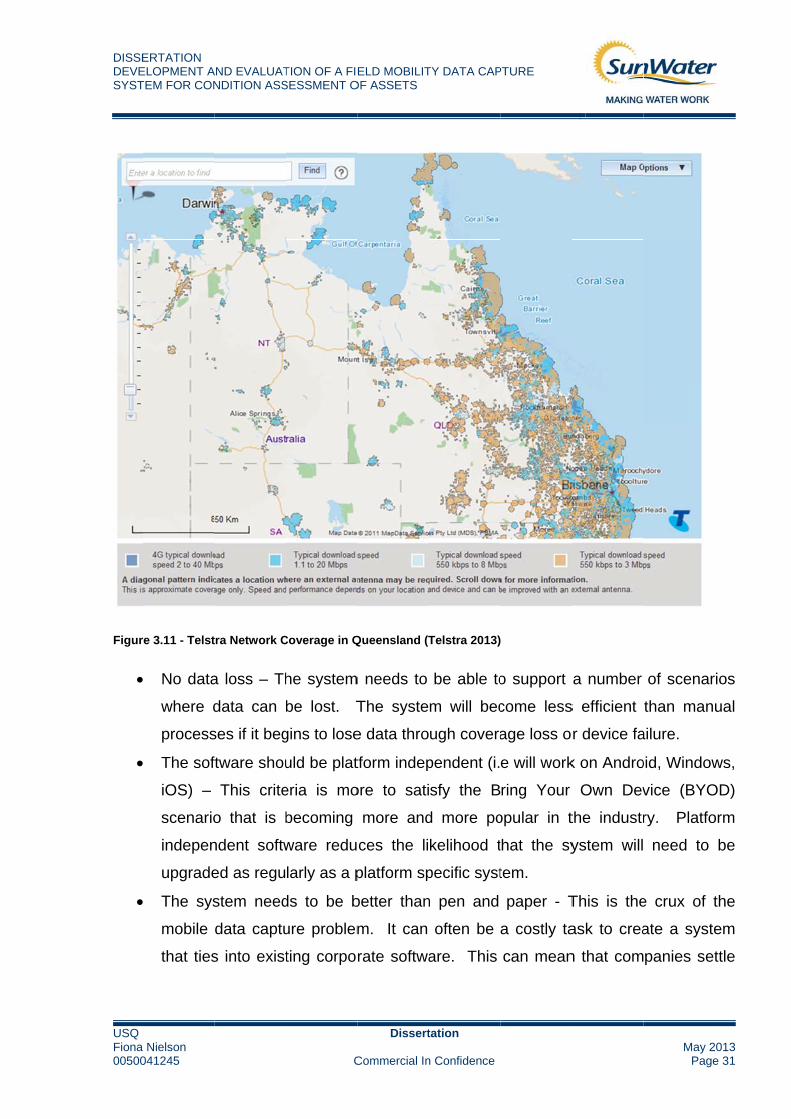
The system needs to be able to work offline – It’s evident from the Telstra Network
Coverage map (Figure 3.11) that ubiquitous network coverage across Queensland is
unrealistic at this point in time. For this very reason the mobile system needs to be able
to work offline and re-sync when re-entering an area with network coverage. (Huff. K et
al., 2000) discusses, “In mobile environments, constant connectivity is too strict a
requirement. It is desirable to support a client-side activity execution mechanism for
mobile workers to perform work activities in a disconnected mode.” Even at this time it
was evident that disconnected editing was essential for mobile workforce success.
Telstra states “Like any other mobile network, coverage on the Telstra Mobile Network
depends on where you are, the mobile handset, tablet or broadband device you're using
and whether it has an external antenna attached.” There is the possibility of the
inclusion of vehicle based antennae for these mobile devices however it is hoped that
the inclusion of disconnected editing within the data collection software would negate
the need for this extra expense.
DISSEDEVESYST
USQ Fiona 00500
Figur
ERTATION ELOPMENT ATEM FOR CON
Nielson 041245
re 3.11 - Telst
No data
where d
process
The sof
iOS) –
scenario
indepen
upgrade
The sys
mobile
that ties
AND EVALUATNDITION ASS
tra Network C
a loss – Th
data can
ses if it beg
ftware shou
This crite
o that is b
ndent softw
ed as regu
stem need
data captu
s into exist
TION OF A FIESESSMENT O
C
Coverage in Q
he system
be lost. T
gins to lose
uld be plat
eria is mo
becoming
ware redu
larly as a p
ds to be b
ure problem
ting corpor
ELD MOBILITOF ASSETS
Dissert
Commercial In
Queensland (T
m needs to
The syste
e data thro
tform indep
ore to sati
more and
ces the li
platform sp
better than
m. It can
rate softwa
TY DATA CAP
tation
n Confidence
Telstra 2013)
be able to
m will bec
ugh covera
pendent (i.
sfy the B
d more po
kelihood t
pecific syst
n pen and
often be
are. This
PTURE
o support
come less
age loss o
e will work
ring Your
opular in t
that the sy
tem.
paper - T
a costly ta
can mean
a number
s efficient
r device fa
k on Andro
Own Dev
the industr
ystem will
This is the
ask to crea
n that com
May 2Page
of scenar
than manu
ailure.
oid, Window
vice (BYO
ry. Platfo
need to
e crux of t
ate a syste
panies set
013e 31
rios
ual
ws,
OD)
orm
be
the
em
ttle

DISSERTATION DEVELOPMENT AND EVALUATION OF A FIELD MOBILITY DATA CAPTURE SYSTEM FOR CONDITION ASSESSMENT OF ASSETS
USQ Dissertation Fiona Nielson May 20130050041245 Commercial In Confidence Page 32
for an application that is merely a replacement of pen and paper. For example
the staff go into the field, record data on their device and then manually upload
and sort the data in the office.
Currently both SAP and ESRI have off the shelf mobile applications that could possibly
be suitable to carry out the tasks required for the condition assessment. As they stand
neither solutions satisfy integration between the two software packages without
expensive customisation. “Many advances have been observed in both fields but no
direct integration was accomplished due to the complexity involved in handling each
system.” (Abou-Ghanem, M. et al., 2008). The best option for SunWater in terms of
trialling a mobile device is to utilise the ESRI application, ArcGIS mobile, as this
provides integration into our corporate GIS systems and provides an easy upload
solution into SAP. At this point in time the SAP applications do not appropriately
communicate with the ESRI software.
3.3 ASSET MANAGEMENT
Asset Management is a necessary role in the business of managing assets and can be
further described as Infrastructure Asset Management. Austroads 2009 describe
Infrastructure Asset Management as:
"A systematic process of effectively maintaining, upgrading and operating assets,
combining engineering principles with sound business practice and economic rationale,
and providing the tools to facilitate a more organised and flexible approach to making
decisions necessary to achieve the public's expectations."
This asset management function divests into asset management plans which in the
case of SunWater involves the implementation of maintenance which is in turn
scheduled on the basis of condition assessment of assets.
Geraerds (1985) defined maintenance as “all activities aimed at keeping an item in, or
restoring it to, the physical state considered necessary for the fulfilment of its product
DISSERTATION DEVELOPMENT AND EVALUATION OF A FIELD MOBILITY DATA CAPTURE SYSTEM FOR CONDITION ASSESSMENT OF ASSETS
USQ Dissertation Fiona Nielson May 20130050041245 Commercial In Confidence Page 33
function.”
Maintenance Engineering Society of Australia (MESA) recognises this same function
as, “the engineering decisions and associated actions necessary and sufficient for the
optimization of specified capability.”
These engineering decisions and activities aimed at keeping an item fit for purpose are
achieved by SunWater, in-part, through the use of condition assessments. Whilst these
condition assessments and the process to undertake them currently fulfil their purpose,
Jardine and Tsang (2006) state “the business imperative for organisations seeking to
achieve performance excellence demand that these organisations continuously
enhance their capability to create value for customers and improve the cost-
effectiveness of their operations.”
This supports the view that performance is achieved through the enhancement of
processes and therefore encourages the possible implementation or investigation of a
mobile data capture system in an effort to enhance and improve the cost effectiveness
of operations.
3.4 SUMMARY
In order to provide a tactical and strategic direction for maintenance of SunWater’s
extensive infrastructure base asset management is necessary. If condition
assessments are suitably completed as part of this asset management, scheduling and
effective planning of asset maintenance can occur. This maintenance in turn will
provide optimal asset performance and business operations for SunWater.
DISSERTATION DEVELOPMENT AND EVALUATION OF A FIELD MOBILITY DATA CAPTURE SYSTEM FOR CONDITION ASSESSMENT OF ASSETS
USQ Dissertation Fiona Nielson May 20130050041245 Commercial In Confidence Page 34
4.0 DEVELOPING THE MOBILE DATA CAPTURE TRIAL SYSTEM
Following the research discussed in Section 0 and utilising the project objectives to
frame the methodology the following processes were carried out to develop the mobile
data capture trial system.
4.1 THE DEVICE
Initially it was decided that the Trimble Yuma rugged tablet currently owned by
SunWater would be used to carry out the trial as it was a Windows based device and
would complement ArcGIS Mobile which is designed to run in a Windows operating
environment.
After obtaining the Trimble device and attempting to carry out basic tasks within the
office it became obvious that this was not the ideal solution for mobile data capture,
even for a trial.
The device, which is now three to four years old, runs a Windows 7 operating
environment on a seven inch screen with stylus. The difficulty that arose with this
device was that selecting buttons and performing actions on such a small screen was
quite difficult, even in an office based environment. The stylus is quite small with a very
fine end which helps with the fine motor skills required however this type of delicate
operation is not at all ideal in the field.
The decision to not proceed with the Trimble device was a difficult one as the selected
software, ArcGIS Mobile, is windows based. Discussions with an ESRI employee about
the situation revealed an alternative solution. This solution allowed for the use of mobile
devices and tablets that were either Android or iOS based. As a result it was decided
that a personal iPad would be utilised for the purposes of the trial.
The decision to use a mainstream mobile device has ensured that the trial will provide
the user with an intuitive and easy to use interface with ample screen real estate. A

DISSERTATION DEVELOPMENT AND EVALUATION OF A FIELD MOBILITY DATA CAPTURE SYSTEM FOR CONDITION ASSESSMENT OF ASSETS
USQ Dissertation Fiona Nielson May 20130050041245 Commercial In Confidence Page 35
comparison between this device and other mobile capture instruments can be seen in
APPENDIX E.
4.2 THE SOFTWARE
As discussed in Section 4.1 the decision to move away from utilising ESRI’s ArcGIS
Mobile software was due to the change in device. As a Windows based device was no
longer being utilised and alternative software was required.
As mentioned previously discussions with an ESRI employee revealed another
arrangement that could be utilised for the trial. This alternative is the Collector App.
The Collector App can operate on an iOS or Android system and provides an adequate
solution for the trial.
When comparing the Collector App to the other software that was investigated it is
apparent that the current version doesn’t meet all the criteria that are desirable (See
APPENDIX F). At present the application does not support disconnected editing, it
does not have a standalone iPad version (however the iPhone App can be used on the
iPad) and it does not integrate with SAP. ESRI however are due to release in late
October 2013, the Collector App v10.2. This upgrade will include a standalone iPad
version of the application (ArcGIS Resources 2013). Despite the limitations of the
current application it has provided adequate basis for completion of a trial mobile data
capture system.
The Collector App works through an ArcGIS Online account. Organizations with
desktop licenses of ESRI ArcMap are automatically assigned ArcGIS logins for each
license they have purchased. Unfortunately for the purposes of this trial the ArcGIS
Online subscriptions have not yet been released for SunWater so a 30 day trial account
was utilised. This trial account provided the full functionality of a registered ArcGIS
Online login.

DISSERTATION DEVELOPMENT AND EVALUATION OF A FIELD MOBILITY DATA CAPTURE SYSTEM FOR CONDITION ASSESSMENT OF ASSETS
USQ Dissertation Fiona Nielson May 20130050041245 Commercial In Confidence Page 36
4.3 DATA DEVELOPMENT AND QUALITY CONTROL
In the initial stages of the project it was realised that there was a need for data
correlation between our SAP asset register and our Corporate GIS systems. For the
purposes of the trial a data dump was taken from SAP that listed every asset relevant to
Irrigation and Drainage in the Burdekin Haughton Water Supply Scheme (BHWSS).
This formed the point of truth for the number of assets required for assessment.
In order to successfully incorporate this data with the Collector App, each asset needed
a geographical location. SunWater already houses a comprehensive database of
geospatial information related to its assets however due to the age of this data and
SunWater’s ever evolving asset base, approximately 60% of the assets have linked
geographical locations.
In order to rectify this situation an overhaul of the Corporate GIS data was required for
the BHWSS. This involved exporting the attributes from our BHWSS_Assets
featureclass in ESRI to create an excel spreadsheet that was linkable with the asset
data dump from SAP.
The unique identifier between both GIS and SAP was the asset’s Object Number. This
is always the point of truth for linkages between separate asset data sources.
SunWater’s assets have additional naming conventions that often evolve and are
upgraded however fortunately the Object Number always remains the point of truth.
As mentioned previously this link provided about a 60% success rate leaving 40% of the
assets without a geographical location. This failure to link or missing data can also be
due to the structure and sub-structure of assets within SAP.
SunWater’s assets are broken down into a tiered type arrangement where there is a
header, a structure and then sub-components of that structure. Each of these tiers
have Object Numbers. For example a regulator gate may be broken down as shown:
Regulator Gate – HEADER

DISSERTATION DEVELOPMENT AND EVALUATION OF A FIELD MOBILITY DATA CAPTURE SYSTEM FOR CONDITION ASSESSMENT OF ASSETS
USQ Dissertation Fiona Nielson May 20130050041245 Commercial In Confidence Page 37
Concrete Structure – STRUCTURE
Safety Screen – SUB COMPONENT
Depending on how this asset was initially located in GIS its likely that only one
component of the regulator gate was recorded. This is problematic as each component
of that structure needs to be assessed and often each component will have different
assessment intervals. For example the metal safety screen will need to be assessed at
more regular intervals than the concrete structure.
When condition assessing is carried out it is desirable that each component has a
geographical location. If only the header has a location this leads to a very time
consuming process to search through each asset, determine its header and hence
determine its geographical location. This is one of the reasons that providing
geographical locations for condition assessments at present is so time consuming.
In order to rectify this in the BHWSS data a visual inspection of the spread sheet data
could quickly be made to determine which assets could be linked together to share the
same coordinates. This process meant that approximately 80% of the assets had
geographical locations.
Finally the distance data provided in SAP allowed for a geoprocessing solution in
ArcMap to locate the remaining assets. This meant that a specific tool in ArcMap,
namely ‘Locate Route Events’ could be used to locate these missing assets along
SunWater channel centrelines using the distances recorded in SAP as locators. This
process resulted in 90% of the assets having geographical locations. The remaining
10% were unable to be located due to missing data in SAP and would require individual
research and exploration of design drawings to determine their location. This would be
a time consuming process and was not necessary for this trial.
Evidently while this project has been in progress an upgrade of the condition
assessment methodology of assets in SAP (the BILL project) has been carried out.
This change has impacted the BHWSS data significantly and would need to be rectified
DISSERTATION DEVELOPMENT AND EVALUATION OF A FIELD MOBILITY DATA CAPTURE SYSTEM FOR CONDITION ASSESSMENT OF ASSETS
USQ Dissertation Fiona Nielson May 20130050041245 Commercial In Confidence Page 38
if SunWater decided to proceed with a mobile data capture system. For the purposes of
the trial however the data will remain as is.
4.4 ARCMAP – SETTING DOMAINS AND SUBTYPES
With the development of a strong asset database in the BHWSS it was possible to start
experimenting with the Collector App and determining how it would be arranged to carry
out these assessments. Despite utilisation of existing software much research was
carried out to determine the best practice methods of data arrangement and upload.
The main documents utilised for this research were Collector for iOS ArcGIS Help 10.2
within ArcGIS Resources.
Figure 2.2 shows an example of the condition assessment form that is currently used to
record assessments. This form needed to be available electronically on the iOS device.
This is where the Collector App would be utilised.
Each asset is grouped into a condition assessment (CAP) type which determines what
sort of condition assessment form the asset requires. These forms have specific criteria
that relate to particular assets. As a result the application needed to be able to interpret
the CAP Type for the asset and return the specific criteria required for that asset.
ESRI’s ArcMap provided a solution for this. ArcMap enables the user to create
Domains and Subtypes within the attribute data of a point. At this stage what was
available was a point featureclass containing 90% of the Irrigation and Drainage assets
in the BHWSS. These points are linked with the data that was extracted from SAP.
Within this SAP data is the CAP Type for each asset.
The first step was to create a subtype that included every CAP Type present in the
BHWSS data. This numbered 34 different options (see APPENDIX H). The second
step was to create links that would represent the different assessment categories for
each asset. For each asset there are six different categories, this resulted in over 200
linkages. These links needed to be automatically recalled so that they defaulted to the
correct criteria when a certain CAP Type was selected.
DISSERTATION DEVELOPMENT AND EVALUATION OF A FIELD MOBILITY DATA CAPTURE SYSTEM FOR CONDITION ASSESSMENT OF ASSETS
USQ Dissertation Fiona Nielson May 20130050041245 Commercial In Confidence Page 39
In order to achieve this a process was used that was similar in concept to the IF
statement in excel. For example if the CAP Type ‘XDRN’ is selected then the six
categories appropriate to ‘XDRN’ would appear. The default values for each CAP Type
were defined in ArcMap and tested.
The next process was to create a domain to enable a drop down list to select a rating
for each criteria. The ratings available range from 1 to 6 and each of these ratings
incorporate a specific description to help the user determine which is appropriate. As
there are over 200 criteria and there are a possible 6 ratings that can be chosen for
each criteria this resulted in over 1200 unique ratings that were required, an example of
which you can see in APPENDIX H. Each set of six ratings were programmed so that
they defaulted to their correct criteria.
Finally a comments field was incorporated for each criteria to allow for extra notes.
Discussions with staff within Irrigation and Drainage have noted that it could be helpful
to include a list of standard comments that the user could choose from. This will be
considered and staff will be asked for their input in this area.
This was a time consuming and complex process however now that the framework is
established this will be able to be transferred to different water supply scheme data.
4.5 THE COLLECTOR APP
Now that the framework and behaviour of the featureclass has been established in
ArcMap it is possible to publish this service to ArcGIS Online and ultimately the
Collector App. This can be simply done by logging into your ArcGIS Online account
within ArcMap and publishing a feature service to ArcGIS Online. Once this process
has been carried out the user can log in to ArcGIS Online on a desktop and view the
map and data that was published enabling for any further editing or customisation that is
required. ArcGIS Online is also the place where privacy settings for maps and data are
recorded.
DISSERTATION DEVELOPMENT AND EVALUATION OF A FIELD MOBILITY DATA CAPTURE SYSTEM FOR CONDITION ASSESSMENT OF ASSETS
USQ Dissertation Fiona Nielson May 20130050041245 Commercial In Confidence Page 40
Maps created for ArcGIS Online can be kept private, shared within an organisation (i.e.
SunWater) or shared with the public. Permissions can also be set on the map to enable
or disable editing capabilities.
In order to view this information on the iPad the Collector App must first be installed.
This is a simple process of going through the App Store on the iPad and downloading
the free Collector App application. When this is performed on an iOS device an Apple
ID is required for download. It is expected that each user of the mobile device would
have their own work related Apple ID. Similarly a Google Play account is required for
an Android device.
4.6 CUSTOMISATION
Further customisation of the app is available once the data has been published to
ArcGIS Online. Pop-up windows are available and are the resource through which
users complete the condition assessments. These pop-up windows can be configured
so that only certain data is available and can be edited. For the purposes of the trial the
popup was customised so that only certain informational attribute fields such as ‘Object
Number’, ‘Asset Description’, ‘Object Type’ and ‘Channel Name/Distance’ were able to
be viewed. The window was also customised so that fields related to the condition
assessment process could be seen and edited. This customisation cut down on
superfluous data being shown and confusing the assessor. Only information relative to
the condition assessment process and the identification of assets was present. Figure
4.1 below shows a screen shot of this pop-up and the information present.

DISSERTATION DEVELOPMENT AND EVALUATION OF A FIELD MOBILITY DATA CAPTURE SYSTEM FOR CONDITION ASSESSMENT OF ASSETS
USQ Dissertation Fiona Nielson May 20130050041245 Commercial In Confidence Page 41
Figure 4.1 - Customised Pop-Up Window in Collector App
This window is scrollable and houses all six categories relevant to the selected asset.
4.7 THE TRIAL
In September 2013 a trial of the prototype system was carried out in the Barratta
Section of the BHWSS. The trial was completed over a half day and due to time
constraints was unable to extend beyond this. APPENDIX I shows a map of the site
and the assets which were selected for assessment.
The trial involved the new mobile data capture process and followed the procedures as
shown in Figure 4.2.

DISSEDEVESYST
USQ Fiona 00500
Figur
The
Cond
the c
4.7.1
A lis
in Se
thes
upda
linke
cent
it is
incid
ERTATION ELOPMENT ATEM FOR CON
Nielson 041245
re 4.2 - The M
trial was e
dition Asse
condition a
1 PREPA
st of assets
ection 2.2
e are not
ated GIS d
ed hence th
trelines. T
assumed
dences whe
AND EVALUATNDITION ASS
obile Data Ca
essential b
essment a
assessmen
ARATION
s was sele
.2. It was
oriously d
data. Ther
hese were
This will be
d that eve
ere assets
TION OF A FIESESSMENT O
C
apture Proces
broken dow
and Post P
nt process
cted from
decided t
ifficult to
re were 5
located w
a typical s
n with an
s will need
ELD MOBILITOF ASSETS
Dissert
Commercial In
ss
wn into thr
Processing
and make
SAP for as
to target th
locate. T
sites out o
within ArcM
stumbling
n upgrade
to be man
TY DATA CAP
tation
n Confidence
ree compo
. These a
analysis o
ssessment
he drainag
This list of
of 150 that
ap utilising
block with
in the da
ually locat
PTURE
onents, the
are the thre
of data mor
t based on
ge assets i
f assets w
were una
g structure
SunWater
ata there
ed for uplo
ese being:
ee core co
re conveni
n the criter
in the Bar
was then l
able to be a
distances
r’s GIS info
will be ca
oad.
May 2Page
Preparatio
omponents
ent.
ria mention
ratta area
linked to t
automatica
and chan
ormation a
ase by ca
013e 42
on,
s of
ned
as
the
ally
nel
and
ase

DISSERTATION DEVELOPMENT AND EVALUATION OF A FIELD MOBILITY DATA CAPTURE SYSTEM FOR CONDITION ASSESSMENT OF ASSETS
USQ Dissertation Fiona Nielson May 20130050041245 Commercial In Confidence Page 43
4.7.2 CONDITION ASSESSMENT
Before the trial a risk assessment was carried out in order to mitigate the risk involved in
completing a field trial condition assessment. The risk assessment format adopted
follows the standard SunWater Safe Work Method Statement (SWMS) and can be seen
in APPENDIX J.
The location of the assets was relatively close to the SunWater office and travel time
was negligible. Navigation to the first site for assessment was carried out using the
Collector App’s navigation resources. Once the site was located an assessment was
carried out by a colleague utilising the appropriate condition assessment manual. This
assessment was then recorded via the collector app against the correct asset. This
assessment was then saved and sent back to the ArcGIS Online server. Navigation to
and assessment of a further 19 sites was carried out.
4.7.3 POST PROCESSING
Once back in the office the condition assessment data was downloaded from the
ArcGIS Online server and loaded into ArcMap. This updated assessment data was
then extracted from ArcMap and copied into the upload spread sheet for upload to SAP.
The data however was not uploaded into SAP due to the nature of the trial.
4.8 COSTING OF EXISTING PROCESSES
In order to accurately compare the manual and mobile processes performed in the
condition assessment process, information must be obtained relating to the current
condition assessments. The staff of the Irrigation and Drainage Department within
SunWater charge the time for their condition assessments to a set of codes appropriate
to each water supply scheme. Any time spent in preparation, condition assessment and
post processing is charged to these codes. For the purposes of this thesis it was
decided to focus on the time charged to the condition assessments performed in 2013.
This ensures the current condition assessment processes are being examined. This
data was obtained prior to the trial and updated as more information became available.

DISSERTATION DEVELOPMENT AND EVALUATION OF A FIELD MOBILITY DATA CAPTURE SYSTEM FOR CONDITION ASSESSMENT OF ASSETS
USQ Dissertation Fiona Nielson May 20130050041245 Commercial In Confidence Page 44
This information helped to provide a benchmark during the trial and give an indication
on the performance of the system.

DISSEDEVESYST
USQ Fiona 00500
5.0
Ther
data
any
5.1
As m
Prep
In or
cond
from
Figur
It ca
Proc
PER
CEN
TAGE
ERTATION ELOPMENT ATEM FOR CON
Nielson 041245
RESU
re are a nu
a capture s
of these re
QUAN
mentioned
paration of
rder to dete
dition asse
m this year’s
re 5.1 – Perce
an be seen
cessing ta
0%
10%
20%
30%
40%
50%
60%
70%
80%
90%
100%
AND EVALUATNDITION ASS
ULTS AN
umber of r
system. T
elevant res
NTITATIVE
previousl
the data, t
ermine how
essment pr
s condition
entage Task D
n in the as
ake up a
PER
TION OF A FIESESSMENT O
C
ND RECO
results tha
The followin
sults.
E RESULTS
y the trial
the Condit
w the trial p
rocesses,
n assessme
Distribution
ssessment
considera
CONDITION
RCENTAG
ELD MOBILITOF ASSETS
Dissert
Commercial In
OMMEND
at are impo
ng section
S
was com
tion Assess
processes
Figure 5.1
ents and th
ts other th
able perc
N ASSESSMEN
GE TASK
TY DATA CAP
tation
n Confidence
DATIONS
ortant to re
n will discu
mpleted in
sment and
fared in co
depicts a
he trial.
han the tria
centage of
NT
K DISTR
PTURE
eview when
uss the out
three sec
d the Post P
omparison
a percentag
al that the
f the time
IBUTION
n consider
tcomes of
ctions. Th
Processing
n to SunWa
ge breakd
e Preparati
e spent o
N
TRAVEL
PREPARATION
POST PROCES
CONDITION A
May 2Page
ring a mob
the trial a
here was t
g of the da
ater’s man
own of tas
ion and Po
on condit
N
SSING
ASSESSMENT
013e 45
bile
and
the
ata.
ual
sks
ost
ion
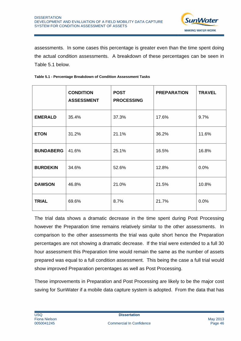
DISSERTATION DEVELOPMENT AND EVALUATION OF A FIELD MOBILITY DATA CAPTURE SYSTEM FOR CONDITION ASSESSMENT OF ASSETS
USQ Dissertation Fiona Nielson May 20130050041245 Commercial In Confidence Page 46
assessments. In some cases this percentage is greater even than the time spent doing
the actual condition assessments. A breakdown of these percentages can be seen in
Table 5.1 below.
Table 5.1 - Percentage Breakdown of Condition Assessment Tasks
CONDITION
ASSESSMENT
POST
PROCESSING
PREPARATION TRAVEL
EMERALD 35.4% 37.3% 17.6% 9.7%
ETON 31.2% 21.1% 36.2% 11.6%
BUNDABERG 41.6% 25.1% 16.5% 16.8%
BURDEKIN 34.6% 52.6% 12.8% 0.0%
DAWSON 46.8% 21.0% 21.5% 10.8%
TRIAL 69.6% 8.7% 21.7% 0.0%
The trial data shows a dramatic decrease in the time spent during Post Processing
however the Preparation time remains relatively similar to the other assessments. In
comparison to the other assessments the trial was quite short hence the Preparation
percentages are not showing a dramatic decrease. If the trial were extended to a full 30
hour assessment this Preparation time would remain the same as the number of assets
prepared was equal to a full condition assessment. This being the case a full trial would
show improved Preparation percentages as well as Post Processing.
These improvements in Preparation and Post Processing are likely to be the major cost
saving for SunWater if a mobile data capture system is adopted. From the data that has

DISSERTATION DEVELOPMENT AND EVALUATION OF A FIELD MOBILITY DATA CAPTURE SYSTEM FOR CONDITION ASSESSMENT OF ASSETS
USQ Dissertation Fiona Nielson May 20130050041245 Commercial In Confidence Page 47
been collated a possible 30% decrease could be expected with the adopted of the trial
system.
One of the other areas it was hoped that the mobile data capture system would also
improve was navigation. Quite often assets are assessed within SunWater that are
difficult to locate. Many of our assessments are also carried out in unfamiliar locations
hence navigation is more difficult in some areas than others.
From the trial it was found that the usually difficult to find assets such as Protection
Works on drains were able to be quickly and easily located using the iPad in conjunction
with Collector App. This was a positive result and it’s expected that some of the more
difficult areas will have improved navigation times.
Figure 5.2 below shows the average minutes per asset assessment from this year’s
condition assessments and the trial. Irrigation and Drainage generally plan their
assessments using a 12 minute per structure assessment time which is approximately
50 asset assessments per day.
Figure 5.2 - Average Minutes per Structure Assessment
8
10
17
1211
12TARGET TIME
EMERALD ETON BUNDABERG BURDEKIN DAWSON TRIALASSESSMENT
0
2
4
6
8
10
12
14
16
18
20
AVERAGE MINUTES PER STRUCTURE ASSESSMENT

DISSERTATION DEVELOPMENT AND EVALUATION OF A FIELD MOBILITY DATA CAPTURE SYSTEM FOR CONDITION ASSESSMENT OF ASSETS
USQ Dissertation Fiona Nielson May 20130050041245 Commercial In Confidence Page 48
As you can see from the graph the trial assessment was equivalent to the current
assessment target of 12 minutes per asset assessment. It can be seen that both
Emerald and Eton are well under the 12 minute target. This is possibly due to the type
of assets that were assessed. In some cases only the assets that can be easily found
will take preference over those that are more difficult hence cutting navigation and
assessment times to a minimum. The size and age of the scheme also play a large part
in the ease of navigation. This time difference could also be due to the use of different
assessors for different areas.
From this graph it is evident that there are unlikely to be any real time savings in
navigation except perhaps in the Bundaberg region which was quite a bit slower than
the other areas. Unfortunately there is not yet data available for the Mareeba region
however it is expected that the navigation improvements of the Collector App would be
of use in this area due to the age of the system, the type of assets which need to be
assessed and the ease of access/location of the structures (i.e. inhibition from long
grass).
5.2 DEVICE PERFORMANCE TRIAL RESULTS
Aside from the improvements in assessment and processing times it is necessary to
review the performance of the device that was used during the trial. The Apple iPad.
Use of the device within an office environment is quite efficient, intuitive and easy to
navigate. Some issues did however arise when this device was used in the field.
Initially during the trial the iPad was taken outside of the vehicle to perform the condition
assessments. It became apparent however that this method of assessment was not
going to be appropriate with the iPad as the screen visibility was almost zero in sunlight.
As a result of this finding it was decided that one person would perform the condition
assessment outside the vehicle and one would remain inside the vehicle with the iPad
recording the assessment. This process worked well and is essentially what already
happens during the current condition assessment process.
DISSERTATION DEVELOPMENT AND EVALUATION OF A FIELD MOBILITY DATA CAPTURE SYSTEM FOR CONDITION ASSESSMENT OF ASSETS
USQ Dissertation Fiona Nielson May 20130050041245 Commercial In Confidence Page 49
Another issue that occurred during the assessment process was that the iPad froze
during recording. This was easily solved by turning the iPad on and off and may have
been attributed to the hot conditions on the day. This did however bring to light the
issue that should the iPad fail in the field there are no other methods of continuing to
record assessments. One possible safeguard would be if the two assessors both had
either apple or android smartphones as their designated work phones. This would
mean assessments would be able to continue to be made on alternate devices.
During the trial the iPad that was used did not have any form of ruggedized casing.
This is an element that would need to be included on any device that is selected to
perform mobile data capture in the field. The dusty and also wet conditions that are
present make it imperative. General wear and tear would also be reduced with one of
these cases.
5.3 SOFTWARE PERFORMANCE TRIAL RESULTS
As has been discussed ESRI’s Collector App was utilised for performing the trial
condition assessment. Overall this application performed quite effectively.
Preparation of GIS data within ArcMap and then transfer to the ArcGIS Online account
is quite efficient. The process utilises software that SunWater staff are already familiar
with hence no extra training is required. The upload and download of data are efficient
and the time for download of condition assessments doesn’t differ in terms of asset
number. This is because all asset information is downloaded regardless of whether an
assessment was performed or not. Therefore a download for one assessment would
take a similar amount of time to that of 50 assessments. This is where the time savings
are made.
The Collector App interface is generally easy to navigate. There are few screens and
options making processes quite simple and easy to follow. The navigation feature of
the application is adequate however does not perform as well as navigation alternatives
such as Google Earth.
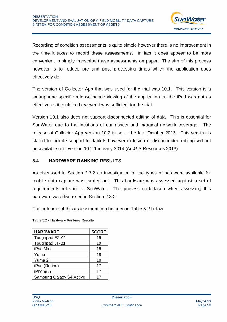
DISSERTATION DEVELOPMENT AND EVALUATION OF A FIELD MOBILITY DATA CAPTURE SYSTEM FOR CONDITION ASSESSMENT OF ASSETS
USQ Dissertation Fiona Nielson May 20130050041245 Commercial In Confidence Page 50
Recording of condition assessments is quite simple however there is no improvement in
the time it takes to record these assessments. In fact it does appear to be more
convenient to simply transcribe these assessments on paper. The aim of this process
however is to reduce pre and post processing times which the application does
effectively do.
The version of Collector App that was used for the trial was 10.1. This version is a
smartphone specific release hence viewing of the application on the iPad was not as
effective as it could be however it was sufficient for the trial.
Version 10.1 also does not support disconnected editing of data. This is essential for
SunWater due to the locations of our assets and marginal network coverage. The
release of Collector App version 10.2 is set to be late October 2013. This version is
stated to include support for tablets however inclusion of disconnected editing will not
be available until version 10.2.1 in early 2014 (ArcGIS Resources 2013).
5.4 HARDWARE RANKING RESULTS
As discussed in Section 2.3.2 an investigation of the types of hardware available for
mobile data capture was carried out. This hardware was assessed against a set of
requirements relevant to SunWater. The process undertaken when assessing this
hardware was discussed in Section 2.3.2.
The outcome of this assessment can be seen in Table 5.2 below.
Table 5.2 - Hardware Ranking Results
HARDWARE SCOREToughpad FZ-A1 19 Toughpad JT-B1 19 iPad Mini 18 Yuma 18 Yuma 2 18 iPad (Retina) 17 iPhone 5 17 Samsung Galaxy S4 Active 17

DISSERTATION DEVELOPMENT AND EVALUATION OF A FIELD MOBILITY DATA CAPTURE SYSTEM FOR CONDITION ASSESSMENT OF ASSETS
USQ Dissertation Fiona Nielson May 20130050041245 Commercial In Confidence Page 51
BlackBerry Z10 14 Toughpad FZ-G1 14 HTC One 13 MC67 13 Samsung Galaxy Tab 3 10 ET1 10 Windows Surface 6
As you can see according to the ranking system that was developed, the Panasonic
Toughpads have been evaluated as being most suitable for the function of performing
mobile condition assessments in the field. An interesting result is that the two Trimble
Yuma tablets have resulted in quite a high ranking also. As discussed in Section 4.1 it
was noted that the Trimble Yuma tablet would not be suitable for use in the field due to
its small screen and difficulties navigating with the stylus. It is difficult to evaluate
criteria based on ease of use of the hardware without trialling the actual device first.
Therefore it is recommended that selection of any hardware be ratified by first trialling
the device and determining its suitability for use in the field.
5.5 SOFTWARE RANKING RESULTS
As with the hardware a software evaluation was also carried out and the process is
discussed in Section Software Ranking2.3.3.
The outcome of the assessment can be seen in Table 5.3.
Table 5.3 - Software Ranking Results
SOFTWARE SCORECollector App V10.2.1 10 Collector App V10.1 7 ArcGIS Mobile 10 4 Celstra In-field Inspections 4 Data Collection Application 3 Trimble Field Inspector 1 Sap Work Manager Mobile 1 SAP Rounds Manager -3
DISSERTATION DEVELOPMENT AND EVALUATION OF A FIELD MOBILITY DATA CAPTURE SYSTEM FOR CONDITION ASSESSMENT OF ASSETS
USQ Dissertation Fiona Nielson May 20130050041245 Commercial In Confidence Page 52
The evaluation process shows an overwhelming outcome for the Collector App V10.2.1.
This result is evident of the features that the Collector App V10.2.1 supports. The
software that was utilised for the trial was the Collector App V10.1. At present this
version of the app does not support disconnected editing hence the result of a lower
score than the Collector App V10.2.1.
Although the evaluation process ranks this software on criteria that are suitable for
SunWater, as with the hardware results it is difficult to make a final decision on the
product without first performing a trial. It is recommended that before any software is
selected for mobile data capture a trial of this software is carried out to ascertain its
suitability and ease of use.
DISSERTATION DEVELOPMENT AND EVALUATION OF A FIELD MOBILITY DATA CAPTURE SYSTEM FOR CONDITION ASSESSMENT OF ASSETS
USQ Dissertation Fiona Nielson May 20130050041245 Commercial In Confidence Page 53
6.0 CONCLUSIONS
6.1 INTRODUCTION
SunWater do and will continue to perform condition assessments on the assets that it
owns and maintains. While this need exists so remains the issue of finding an efficient
means of completing these assessments.
6.2 CONSEQUENTIAL EFFECTS
The desired outcome of this project is that a decision will be reached as to whether or
not SunWater should pursue the implementation of a mobile data capture system for
condition assessment of assets.
A positive outcome from this dissertation may result in SunWater’s adoption of the
system used within the trial to commercially conduct condition assessments not only
within the Irrigation and Drainage Group but across all departments in SunWater. This
will result in numerous benefits for SunWater.
Environmentally this will mean the elimination of paper waste when carrying out
condition assessments which will be quite a significant environmental milestone. At
present there are usually around 6 condition assessments carried out during a year with
approximately 1000 assets or more to assess. Currently each of these assets needs a
paper form and a set of maps per scheme. When this is extrapolated across all
departments of SunWater this has a considerable environmental impact.
Should the use of this system improve field capture efficiency then SunWater will be
reducing the amount of fuel used per asset to assess so could potentially cover more
assets in a shorter time or simply conduct smaller condition assessments. The
assessment of more assets will ensure SunWater’s data systems are kept up to date
and accurate information is available for use in asset management and design.

DISSERTATION DEVELOPMENT AND EVALUATION OF A FIELD MOBILITY DATA CAPTURE SYSTEM FOR CONDITION ASSESSMENT OF ASSETS
USQ Dissertation Fiona Nielson May 20130050041245 Commercial In Confidence Page 54
A positive outcome will ultimately result in time and money savings, environmental
benefits, staff efficiency improvements and will help to achieve improved productivity
across the board.
A possible fallback to the successful adoption of a data capture system is that electronic
devices are not likely to last long periods of time and are outdated almost every year.
This could possibly lead to increased hardware wastage however it is expected that
SunWater would adopt appropriate recycling strategies and would continue to comply
with their 3 year upgrade of technological hardware policy.
Ethically this is a project that aims to improve the efficiency of a company and improve
the accuracy of its data. It has environmental benefits and could be a significant
improvement to SunWater’s processes.
6.3 CONCLUSIONS
The purpose of this research paper was to determine two things: Whether the
implementation of a mobile data capture system was an avenue of possible pursuit for
SunWater; and whether the prototype system that was developed could be utilised by
SunWater and if not what are the alternatives?
6.3.1 Is Mobile Data Capture a Possibility?
In terms of the research undertaken and trial performed as part of this thesis it seems
evident that mobile data capture is an avenue worth pursuing for SunWater. The sheer
number of assets that SunWater is required to assess is basis alone for investigating
mobile data capture and the efficiencies it provides.
Recent developments relating to recommendations from the Queensland Government
may result in SunWater owning only its headworks and associated infrastructure. This
eventuality will mean there is a significant decrease in the amount of condition
assessments SunWater is required to undertake. This may or may not negate the need
for mobile data capture. At present however SunWater still maintains ownership of its

DISSERTATION DEVELOPMENT AND EVALUATION OF A FIELD MOBILITY DATA CAPTURE SYSTEM FOR CONDITION ASSESSMENT OF ASSETS
USQ Dissertation Fiona Nielson May 20130050041245 Commercial In Confidence Page 55
irrigation, drainage, pump and pipeline assets and based on current asset numbers
would benefit from mobile data capture.
6.3.2 Is the Prototype System Acceptable?
The prototype system performed well in the field and in terms of the software is a logical
choice for SunWater. This system utilises software that SunWater currently owns and
staff are familiar with. Results from the software evaluation show that the Collector App
V10.1 is a suitable solution for SunWater (Refer Table 5.3). The software performed
well in the field and adequately performed the tasks required.
The device performed well also however anti-glare measures need to be investigated if
this device is to be used in the field. In comparison to the other hardware that was
evaluated (Refer Table 5.2) the Apple iPad was ranked relatively well. It was discussed
in the results that the Trimble Yuma devices were not suitable hence ranking the iPad
as equal second. There are alternative iOS and Android devices available that may
provide a more appropriate field solution. If an iOS or Android solution can’t be
determined then alternative software may have to be considered to enable assessments
to be performed on Windows or alternative operating systems.
Overall there is the possibility for a 30% reduction in post processing times using the
prototype system. There is also the possibility of improved navigation times in the
Bundaberg and Mareeba areas based off the results presented in Figure 5.2. These
positive outcomes result in a positive outlook for mobile data capture within SunWater.
6.4 FURTHER WORK
To provide sufficient evidence and build a business case supporting the use of mobile
data capture within SunWater an extensive trial of the prototype system needs to be
performed.
At present there is not enough trial data to confidently recommend mobile data capture
as an effective solution to SunWater management. It is recommended that a three day

DISSERTATION DEVELOPMENT AND EVALUATION OF A FIELD MOBILITY DATA CAPTURE SYSTEM FOR CONDITION ASSESSMENT OF ASSETS
USQ Dissertation Fiona Nielson May 20130050041245 Commercial In Confidence Page 56
condition assessment be performed with the trial system and that perhaps alternative
hardware should be investigated and compared during this trial.

DISSERTATION DEVELOPMENT AND EVALUATION OF A FIELD MOBILITY DATA CAPTURE SYSTEM FOR CONDITION ASSESSMENT OF ASSETS
USQ Dissertation Fiona Nielson May 20130050041245 Commercial In Confidence Page 57
7.0 REFERENCES
AM01_P1_Asset Management Policy 2013, SunWater Brisbane, viewed 31 May 2013,
<http://simon.sunwater.com.au/policies-and-forms/asset-
management/standards/AM01_P1_Asset_Management_Policy.pdf>
AM21_Asset Refurbishment Planning Methodology for Condition Assessment of Assets 2012, SunWater
Brisbane, viewed 31 May 2013, <http://simon.sunwater.com.au/policies-and-forms/asset-
management/asset-condition-and-risk-
assessment/AM21_Asset_Refurbishment_Planning_Methodology_for_Condition_Assessments_of_Asset
s.pdf>
SunWater Infrastructure Map with Regions 2013, SunWater Brisbane, viewed 14 July 2013,
<http://simon.sunwater.com.au/my-zone/my-sunwater/sunwater-locations/SunWater-infrastructure-map-
with-regions.pdf>
Infrastructure Management Asset Management 2013, SunWater Brisbane, viewed 31 May 2013,
<http://simon.sunwater.com.au/my-zone/my-profile/organisational-charts/infrastructure-management-
im/Infrastructure_Management_Asset_Management.pdf>
Assets Keymap Burdekin Haughton 2013, SunWater Brisbane, viewed 14 July 2013,
<http://bnegis02/Sunwater/dfs/WebData/GIS_Assets/Burdekin_Haughton_WSS/Assets_Keymap_Burdeki
n_Haughton.pdf>
Sheet 004 Burdekin Haughton 2013, SunWater Brisbane, viewed 14 July 2013,
http://bnegis02/Sunwater/dfs/WebData/GIS_Assets/Burdekin_Haughton_WSS/1-
10000_Asset_Plans/Sheet_004_Burdekin_Haughton.pdf
Stevens, D. 2013, ‘Utilising FSM as an Integrated Mobile Enterprise Application’, Field Service
Management Summit 2013.
Austroads 2009, What is Asset Management?, viewed 18 September 2013,
<http://www.austroads.com.au/asset/whatisasset.html>
Geraerds W.M.J. 1985, The cost of downtime for maintenance: Preliminary considerations, Maintenance
Management International
Jardine A & Tsang A 2006, Maintenance, Replacement, and Reliability; Theory and Applications, CRC /
Taylor & Francis, Portland Oregan

DISSERTATION DEVELOPMENT AND EVALUATION OF A FIELD MOBILITY DATA CAPTURE SYSTEM FOR CONDITION ASSESSMENT OF ASSETS
USQ Dissertation Fiona Nielson May 20130050041245 Commercial In Confidence Page 58
Huff, K. ; Hurwitz, B. ; Sinha, H. ; Robinson, B. ; Feblowitz, M. 2000, ‘WHAM: Supporting Mobile
Workforce and Applications in Workflow Environments’, Research Issues in Data Engineering, 2000.
Proceedings Tenth International Workshop on Research Issues in Data Engineering.
Viehland, D. ; Chongyun, Y. 2007, ‘Bringing the Mobile Workforce to Business: A Case Study in a Field
Service Organization’, Sixth International Conference on the Management of Mobile Business (ICMB
2007).
Wang, Y. ; van de Kar, E. ; Meijer, G. ; Hunteler, M. 2005, ‘Improving business processes with mobile
workforce solutions’, International Conference on Mobile Business, 2005.
Chiu, D.K.W. ; Cheung, S.C. ; Ho-fung Leung 2005, ‘A Multi-Agent Infrastructure for Mobile Workforce
Management in a Service Oriented Enterprise’, Proceedings of the 38th Annual Hawaii International
Conference on System Sciences, 2005.
Liu, S. 2010, ‘Supporting A Mobile Workforce’, US National Agricultural Library, vol. 12, no. 3, pp. 4-5.
Chou, W. 2008, ‘Considerations for an Efficient Mobile Workforce’, IT Professional, vol. 10, no. 5, pp. 29-
33.
Thurnher, B. 2007, ‘The Impact of Mobile Technology on Business Processes: Results from 5 Case
Studies’, International Workshop on Business-Driven IT Management, 2007, pp. 108-109.
Nguyen, L 2013, ‘Mobility – Rethinking Productivity in the Enterprise’, Consumer Communications and
Networking Conference 2013, pp. 879-880.
Lehmann, H. ; Kuhn, J. ; Lehner, F. 2004, ‘The Future of Mobile Technology: Findings from a European
Delphi Study’, Proceedings of the 37th Annual Hawaii International Conference on System Sciences,
2004.
A Business Whitepaper TOA Technologies 2012, ‘Four Freedoms for Mobile Workforce Management’
Abou-Ghanem, M. ; Arfaj, K. 2008, ‘SAP/GIS Integration Case Studies & Techniques’
Shaner, J 2013, ESRI, USA, viewed 22 September 2013,
<http://blogs.esri.com/esri/arcgis/2013/10/10/collector-v10-2-is-coming-soon/>
ESRI 2013, ESRI, USA, viewed 20 September 2013,
<http://resources.arcgis.com/en/help/main/10.2/index.html#/Exercise_3_Creating_subtypes_and_attribute
_domains/003n0000000p000000/>

DISSERTATION DEVELOPMENT AND EVALUATION OF A FIELD MOBILITY DATA CAPTURE SYSTEM FOR CONDITION ASSESSMENT OF ASSETS
USQ Dissertation Fiona Nielson May 20130050041245 Commercial In Confidence Page 59
ESRI 2013, ESRI, USA, viewed 20 September 2013, <http://resources.arcgis.com/en/help/collector-ios/>
SunWater 2013, SunWater, Brisbane, viewed 5 May 2013, <http://www.sunwater.com.au/about-
sunwater>
Telstra 2013, Telstra, Australia, viewed 2 May 2013, <http://www.telstra.com.au/mobile-phones/coverage-
networks/our-coverage/>

APPENDIX A
PROJECT SPECIFICATION

University of Southern Queensland
FACULTY OF ENGINEERING AND SURVEYING
ENG4111/4112 Research Project
PROJECT SPECIFICATION
FOR: Fiona Nielson
TOPIC: Development and Evaluation of Field Mobility Data Capture System for Asset Condition Assessment
SUPERVISORS: Dr Alexander Kist, University of Southern Queensland
Peter Marshall, Senior Engineer Irrigation and Drainage, SunWater
ENROLMENT: ENG4111 – S1, 2013
ENG4112 – S2, 2013
SPONSERSHIP: SunWater
PROJECT AIM: This project will investigate and design a prototype field mobility system with the intention of increasing asset data capture and analysis efficiency in the field. As time permits, the recommended platform will be subject to rigorous cost benefit analysis and potentially the development of a business case.
PROGRAMME: Issue C, 18 April 2013
1) Undertake a basic requirements analysis, identify use cases and develop a platform functional specification:
2) Undertake a comprehensive literature review covering but not limited to the following aspects:
The range of commercially available field mobility solutions:
Industry user types, market requirements and directions;
Types of software available, trends and support prospects;
Types of hardware (i.e. tablet, phone. other), functionality and design obsolescence; and
Advantages/Disadvantages of software/hardware/field data capture packages.
3) Develop an optimised prototype system incorporating a software solution/hardware package that satisfies SunWater’s functional requirements. Engage the services of a third party to develop software/hardware solutions as required.
4) Develop and implement a test plan for developed software and hardware component. Undertake field trials and review performance against functional requirements;
5) Prepare and an academic dissertation of the research project;
As time permits

6) Analyse and evaluate business processes in relation to the developed system.
7) Undertake cost/benefit analysis of implementing the field mobility solution in the context of asset data capture and analysis;
8) Subject to positive outcome of point 7), prepare a draft business case for the implementation of the system within SunWater asset management; and
9) Provide recommendations on the implementation of the system and the final functional and technical specifications.

APPENDIX B
SCHEME KEY MAP AND EXAMPLE SHEET MAP FOR BHWSS

5
8
2
7
6
1
9
4
3
55
96
76
52
88
58
56
46
50
86
44
80
12
74
69
6323
45
57
51
31
3727
28
15
83
89
77 94
92
98
20
25
54
48
41
29
35
32
38
24 34
40
93
99
21
36
42
30
67
61
73
64
70
43
49
97
91
19
82
18
13
14
26
22
16
84
90
10
78 95
17
33
39
75
81
59
87
65
66
60
72
71
53
62
68
47
85
79
11
118
116
121108
124
131
129
103
120
101
114
115
109
127
128
110
102
106
105
125
130
117
112
107
113
119
126
104
100
123
122
111
HODDER ROAD
480000
480000
490000
490000
500000
500000
510000
510000
520000
520000
530000
530000
540000
540000
550000
550000
560000
560000
570000
570000
580000
580000
7760000
7760000
7770000
7770000
7780000
7780000
7790000
7790000
7800000
7800000
7810000
7810000
7820000
7820000
7830000
7830000
7840000
7840000 5
LEGENDBurdekin Irrigation Area
Asset Location PlanSheet Number
SunWater InfrastructureEarth ChannelConcrete Lined ChannelPlastic Lined ChannelPipeline / SiphonEarth DrainLevee / Embankment
JULY 2003
ASSET LOCATION PLANKEYMAP
BURDEKIN HAUGHTONWATER SUPPLY SCHEME
0 3 6 9 12 151.5km
Scale 1:350,000 (before reduction A3)
IDH
Drawing Number
Revision Date RemarksPrepared Checked Approved
A3-??????
Docu
ment:
G:\G
IS_D
ata\c
orpo
rate_
data\
burd
ekin\
draw
ings\a
rcinfo
\sche
me-a
sset
s-key
map.m
xdPr
inted
: Satu
rday
, July
19 2
003
12:35
:44 P
M©
Copy
right.
Sun
Wate
r 200
3.
Map
Prod
uced
By:
SunW
ater,
Engin
eerin
g Ser
vices
PMB
5013
, Ayr,
QLD
. 480
7Ph
. 478
3055
5, F
ax 47
8363
72
Whil
e eve
ry ca
re is
take
n to e
nsur
e the
acc
urac
y of th
is pr
oduc
t, Sun
Wate
r mak
es no
repr
esen
tation
s or w
arra
nties
abou
t its a
ccur
acy,
relia
bility
, com
pleten
ess o
rsu
itabil
ity fo
r any
par
ticula
r pur
pose
and d
isclai
ms a
ll res
pons
ibility
and
all li
abilit
y(in
cludin
g with
out li
mita
tion,
liabil
ity in
negli
genc
e) fo
r all e
xpen
ses,
losse
s, da
mage
s(in
cludin
g ind
irect
or co
nseq
uenti
al da
mage
) and
costs
whic
h you
migh
t incu
r as a
resu
lt of th
e pro
duct
being
inac
cura
te or
inco
mplet
e in a
ny w
ay a
nd fo
r any
reas
on.
PR
ELIM
INA
RY
PLA
NSu
nWat
er In
tern
al D
ocum
ent
Engineering Serviceswww.sunwater.com.au
C Copyright. SunWater 2003
MAP INFORMATIONBlack tics indicate 10,000m intervals of the Universal Transverse
Mercator Grid, Zone 55 (Mapping Grid of Australia, MGA94).Coordinate System: Geocentric Datum of Australia (GDA94).
NOTES1. Digital Cadastral Database(DCDB) information current at May 2003.

H
Ä
{
à
±
Ø
H
Ø
±
à
G
à
H
H
H
±
à
H
àà
±
Ä
G
à
H
¿
à
à
H ¿
H
¿
à
¿
H
à
à
Ä
H¿
Ä
Ø
à
Ä
G
±
Ä
à
Ø
à
à
à
G
H
H
à
à
¿
¿
à
±
H
H
H
H
H¿
>
¿
H
H
H
H
Ø
±
H
G
ÄH
HHH
H
HH
¿
H
+
à
¿
H
±
H
à
H
Ä
Ä
H
Ä
H
HH H
H
H
H
H
HH H
HHH
H
>
ÄG
Ä
Ä
Ä
Ä
Ä
Ä
Ä
ÄÄ
+ SI01
AI01
AI02
AI03
AI04
AI05
AI06
AI07
AI08
AI09
CO01FMTR
IV01
M001
M002M003
M004
M005M006
M007
M008
M009
M010
M011
M012M013
M014
MO23
AI08
MO06
AI02
AI03
MO27
AC01
MO14
CK04
MO23
DI01
AC02
SI04
MO24
DI01
M015M016
M017
M018M019M020
MO15
AI09
CF04
MO31
DC04
BF03
MO07
MO02
MO02
MO28
DI03
DI01
MO16
MO60
MO32
MO03
MO25
CK05
AC03
DI04
DI06
AC14
AC01
MO04
MO72
AC05
AC01
BA01
BF02
AC01
AI01
R022
PF01
AI10
AC01
BF05
AI04DI02
MO01
AI05
AC04
AC02
MO29
DI07
AC10
DI03
MO21
DI04MO33
AC01
AC07
DI05
MO30
AC02
DR01
AI06
CR01
AC06
BA02
MO34
AC04
DC01
MO05
MO22
MO13
AC01
CO01
AC03
CR02
BF06
MO26
BF01
DC03
AC08SO01
AI07
MO01
CA1-VPSCHOOL ROAD
AYR
DALB
EG R
OAD
CUSSEN ROAD
GEORGE ROAD
DUNNE ROAD
GRANSHAW ROAD
WALSH ROAD
TILLER ROAD
GEOR
GE S
TREE
T
NELS
ON STR
EET
LARKIN STREET
LANE
GEOR
GE R
OAD
107GS270
109GS251
111GS266
108GS251
89SP107460
92SP138973
38GS230
140GS1043
39GS230
40GS230
41GS230
36GS229
35GS229
34GS229
94GS276
110GS251
165GS659
155GS814665
91GS251
106GS270
90SP123161
97GS774
95GS277
186RP855268
185GS600
93GS276
88GS250
181GS628
159GS432
158GS432
157GS432
160GS432
42GS230
134GS278
141GS657
105GS270
152GS628
172GS454
7GS360
48GS428
354GS229
306GS1043
2GS360
337GS600
351GS230
122GS848
112GS266
1C20217
6GS360
14GS360
361GS251
278GS1082
4GS360
192GS847
355GS787
5GS360
393GS448
11GS360364
GS270
98GS278
EMTGS507
234GS886
12SP138973
362SP123161
14SP117906
316GS886
313GS853
301GS1082
DRAIN 1/2
CHANNEL A2
CHANNEL A1
DRAIN 1
MAIN
CHA
NNEL
A
DRAIN 2
DRAIN 1/4
DRAIN 2/1
DRAIN 1/4/1/1
CHANNEL B6/2
DRAIN 2/1/1
BARR
ATTA
MAI
N CH
ANNE
L
DRAIN 2/1/2
DRAIN 1/4/1
DRAIN 1/2/1
DRAIN 2
DRAIN 1/2/2
DRAIN 1/2/3
CLAR
E MA
IN C
HANN
EL A
DUP
LICA
TION
DRAI
N 2/3
N EL A4/ 4
522000
522000
523000
523000
524000
524000
7812
000
7812
000
7813
000
7813
000
7814
000
7814
000
SHEET 97 OF 131
5
AYR
HOME HILL
BRANDON
OVERVIEW MAP
Map P
rodu
ced B
y:Su
nWate
r, En
ginee
ring S
ervic
esPM
B 50
13, A
yr, Q
LD. 4
807
Ph. 4
7830
555,
Fax
4783
6372
Whil
e ev
ery c
are i
s tak
en to
ensu
re th
e acc
urac
y of th
is pr
oduc
t, Sun
Wate
r mak
es no
repr
esen
tation
s or w
arra
nties
abou
t its a
ccur
acy,
relia
bility
, com
plete
ness
orsu
itabil
ity fo
r any
partic
ular p
urpo
se a
nd d
isclai
ms al
l res
pons
ibility
and a
ll liab
ility
(inclu
ding w
ithou
t limi
tatio
n, lia
bility
in ne
glige
nce)
for a
ll exp
ense
s, los
ses,
dam
ages
(inclu
ding i
ndire
ct or
cons
eque
ntial
dama
ge) a
nd co
sts w
hich y
ou m
ight in
cur a
s are
sult o
f the
pro
duct
being
inac
cura
te or
inco
mplet
e in a
ny w
ay a
nd fo
r any
reas
on.
LEGENDLEGENDLEGENDLEGEND= Pump Station
SunWater Infrastructureà Access CrossingÄ Air Vent / ValveG Channel Structure± Check Structure / Regulator$ Cross Drainage Culvert¿
Drainage InletÄ Flowmeter
Ø Foot Bridge> Isolating Valve!( Manhole
H Meter OutletG Rock Drop / Drain Protection
{ Scour Outlet
+ SiphonSunWater Infrastructure
Earth ChannelConcrete Lined ChannelPlastic Lined ChannelPipelines / SiphonRising MainEarth DrainLevee / Embankment
IDH
Drawing Number
Revision Date RemarksPrepared Checked Approved
A3-??????
SCALE 1:10 000 (Before Reduction A3)0 100 200 300 400 50050
m
BURDEKIN HAUGHTONWATER SUPPLY SCHEME
ASSET LOCATION PLANJULY 2003Su
nW
ater
Inte
rnal
Doc
umen
tP
REL
IMIN
AR
Y P
LAN
Engineering Serviceswww.sunwater.com.au
C Copyright. SunWater 2003
Docu
ment:
G:\G
IS_D
ata\co
rpor
ate_
data\
burd
ekin\
draw
ings\a
rcinf
o\sch
eme-
asse
ts.mx
dPr
inted
: Satu
rday
, July
19 2
003
02:31
:16 P
M©
Copy
right.
Sun
Wate
r 200
3.
NOTES1. Digital Cadastral Database(DCDB) information current at May 2003.2. Asset positions have been determined using a distance field stored in SunWater's Asset Register.
MAP INFORMATIONBlack tics indicate 500m intervals of the Universal TransverseMercator Grid, Zone 55 (Mapping Grid of Australia, MGA94).Coordinate System: Geocentric Datum of Australia (GDA94).
APPENDIX C
SAP UPLOAD FORMAT FOR CONDITION ASSESSMENT DATA

Condition Assessment Upload
Copy from Condition and Risk Analysis Report (ZRMS_CAR3)Mandatory Fields
Object No Equip No Functional Location Description Default CAP Type CA Type Assess Type Assessor Date (dd/mm/yyyy) CA Score Rem Life Crit 1 Crit 2 Crit 3 Crit 4 Crit 5 Crit 6 Notes Environ Notes WH&S Notes Maint Notes Comments 1 Comments 2 Comments 3 Comments 4 Comments 5 Comments 6IE000000000010000044 10000044 AWC-PSTNA-PUN1-MTOR MOTOR 11KV MTOR MTOR Field Andrew Boath 9/12/2009 4 10 4 4 4 4 4 4IF?0100000000000050240 AWC-PSTNA-PUN1-LFP LINE FILLING PUMP PUMP PUMP Field Andrew Boath 9/12/2009 2 8 2 2 2 2 2 2

APPENDIX D
CONDITION ASSESSMENT COST BREAKDOWN

Sum of Total Cost (Fiscal Year) Column LabelsRow Labels CONDITION ASSESSMENT POST PROCESSING PREPARATION TRAVEL GRAND TOTAL EMERALD - ASSET COND INSPECTIONS AM I&D $6,141.80 $6,464.60 $3,048.00 $1,685.40 $17,339.80 ETON - ASSET COND INSPECTIONS AM I&D $3,556.80 $2,404.80 $4,127.30 $1,322.18 $11,411.08BUNDABERG -ASSET COND INSPECTIONS AM I&D $5,606.00 $3,383.60 $2,219.40 $2,266.36 $13,475.36BURDEKIN - ASSET COND INSPECTIONS AM I&D $4,002.20 $6,078.80 $1,474.00 $0.00 $11,555.00DAWSON - ASSET COND INSPECTIONS AM I&D $6,115.80 $2,749.00 $2,806.80 $1,409.33 $13,080.93LOWER MARY-ASSET COND INSPECTIONS AM I&D $3,500.00 $2,500.00 $2,000.00 $2,000.00 $10,000.00MAREEBA - ASSET COND INSPECTIONS AM I&D $2,667.10 $2,702.10 $245.10 $2,000.00 $7,614.30ST GEORGE -ASSET COND INSPECTIONS AM I&D $3,518.00 $1,927.60 $919.00 $2,000.00 $8,364.60Grand Total $35,107.70 $28,210.50 $16,839.60 $12,683.27 $92,841.07
APPENDIX E
HARDWARE COMPARISON

Field Mobility Hardware Evaluation
Product iPad (Retina) iPad Mini iPhone 5 Samsung Galaxy Tab 3Supplier/Manufacturer Apple Apple Apple Samsung
Description of Hardware Tablet computer. Tablet computer. Mobile phone. Tablet computer.
Websitehttp://www.apple.com/au/ipad/o
verview/
http://www.apple.com/au/ipad‐
mini/overview/
http://www.apple.com/au/iphone
/
Year of ReleaseHandheld Device Tablet Tablet Mobile Phone Tablet
Rugged Enclosure Required Yes Yes Yes Yes
SCORE 0 0 0 0Enclosure/Cost ($) $130 $100 $80 $50
SCORE 1 2 2 2Operating System iOS iOS iOS Android Jelly Bean 4.1
Water Resistant Yes Yes Yes No
SCORE 1 1 1 ‐1Multipurpose Yes Yes Yes Yes
SCORE 2 2 2 2Shock Resistant Yes Yes Yes Yes
SCORE 2 2 2 2Toughened Glass No No No No
SCORE 0 0 0 0Touchsreen/Stylus Both Both Both Both
SCORE 2 2 2 2Screen Size (inch) 9.7 7.9 4 7
SCORE 1 1 0 1Visibility in Sunlight No No No No
SCORE ‐1 ‐1 ‐1 ‐1Ingress Protection Rating 68 68 68 0
SCORE 1 1 1 ‐1GPS Yes Yes Yes Yes
SCORE 1 1 1 1Camera (Mega Pixel) 5 5 8 3
SCORE 1 1 2 0Battery Life (hours) 10 10 8 8
SCORE 2 2 1 1Network Wi‐Fi/Cellular Wi‐Fi/Cellular Wi‐Fi/Cellular Wi‐Fi
SCORE 2 2 2 ‐1Storage Size (GB) 16/32/64/128 16/32/64 16/32/64 16
SCORE 1 1 1 1Unit Price (AUD $) 679/789/899/1009 509/619/729 799/899/999 230
SCORE 1 1 1 2TOTAL SCORE 17 18 17 10

Field Mobility Hardware E
ProductSupplier/ManufacturerDescription of Hardware
Website
Year of ReleaseHandheld Device
Rugged Enclosure RequiredSCORE
Enclosure/Cost ($)SCORE
Operating SystemWater Resistant
SCOREMultipurpose
SCOREShock Resistant
SCOREToughened Glass
SCORETouchsreen/Stylus
SCOREScreen Size (inch)
SCOREVisibility in Sunlight
SCOREIngress Protection Rating
SCOREGPS
SCORECamera (Mega Pixel)
SCOREBattery Life (hours)
SCORENetworkSCORE
Storage Size (GB)SCORE
Unit Price (AUD $)SCORE
TOTAL SCORE
Samsung Galaxy S4 Active BlackBerry Z10 Windows Surface HTC One YumaSamsung BlackBerry Windows HTC Trimble
Mobile phone. Mobile phone. Tablet computer. Mobile phone. Rugged tablet computer.
http://www.samsung.com/uk/con
sumer/mobile‐
devices/smartphones/android/GT‐
I9295ZAABTU‐spec
http://us.blackberry.com/smartph
ones/blackberry‐z10.html
http://www.microsoft.com/surfac
e/en‐ca
http://www.gsmarena.com/htc_o
ne‐5313.php
http://www.trimble.com/Outdoor‐
Rugged‐
Computers/yuma.aspx?dtID=featu
res
Mobile Phone Mobile Phone Tablet Mobile Phone Rugged Tablet
Yes Yes Yes Yes No
0 0 0 0 1$80 $80 0 $35 0
2 2 0 2 0Android 4.2.2 (Jelly Bean) BlackBerry Windows RT Android v4.1.2 (Jelly Bean) Windows 7
Yes No No No Yes
1 ‐1 ‐1 ‐1 1Yes Yes Yes Yes Yes
2 2 2 2 2Yes Yes No Yes Yes
2 2 ‐1 2 2No No No No Yes
0 0 0 0 1Both Both Both Both Both
2 2 2 2 25 4.2 10.6 4.7 7
0 0 1 0 1No No No No Yes
‐1 ‐1 ‐1 ‐1 268 0 0 0 67
1 ‐1 ‐1 ‐1 1GPS/GLONASS Internal GPS + GLONASS No Internal GPS + GLONASS Internal GPS SiRFStarIII
1 1 ‐1 1 18 8 1 UltraPixel (13+) 2
2 2 0 2 08 10 8 18 8
1 2 1 2 1Wi‐Fi/Cellular Wi‐Fi/Cellular Wi‐Fi/Cellular Cellular Wi‐Fi/Cellular
2 2 2 1 264 16 32/64 32/64 32/80
1 1 1 1 1600 588 350 600 Pre‐purchased
1 1 2 117 14 6 13 18

Field Mobility Hardware E
ProductSupplier/ManufacturerDescription of Hardware
Website
Year of ReleaseHandheld Device
Rugged Enclosure RequiredSCORE
Enclosure/Cost ($)SCORE
Operating SystemWater Resistant
SCOREMultipurpose
SCOREShock Resistant
SCOREToughened Glass
SCORETouchsreen/Stylus
SCOREScreen Size (inch)
SCOREVisibility in Sunlight
SCOREIngress Protection Rating
SCOREGPS
SCORECamera (Mega Pixel)
SCOREBattery Life (hours)
SCORENetworkSCORE
Storage Size (GB)SCORE
Unit Price (AUD $)SCORE
TOTAL SCORE
Yuma 2 ET1 MC67 Toughpad FZ‐A1 Toughpad JT‐B1 Toughpad FZ‐G1Trimble Motorola Motorola Panasonic Panasonic Panasonic
Rugged tablet computer. Rugged tablet computer. Rugged handheld computer. Rugged tablet computer. Rugged tablet computer. Rugged tablet computer.
http://www.trimble.com/Outdoor‐
Rugged‐
Computers/Yuma2.aspx?dtID=feat
ures
http://www.motorolasolutions.co
m/XA‐
EN/Business+Product+and+Servic
es/Tablets/ET1+Enterprise+Tablet
#
http://www.motorolasolutions.co
m/XA‐
EN/Business+Product+and+Servic
es/Mobile+Computers/Handheld+
Computers/MC67
http://www.panasonic.com/busin
ess/toughpad/us/best‐android‐
rugged‐tablet‐overview.asp
http://www.panasonic.com/busin
ess/toughpad/us/rugged‐b1‐
android‐tablet‐overview.asp
http://www.panasonic.com/busin
ess/toughpad/us/windows‐tablet‐
fz‐g1.asp
Rugged Tablet Rugged Tablet Rugged Handheld Rugged Tablet Rugged Tablet Rugged Tablet
No No No No No No
1 1 1 1 1 10 0 0 0 0 0
0 0 0 0 0 0Windows 7 Android 2.3.4 Microsoft Embedded Handheld 6.5 P Android 4.0 Android 4.0 Windows 8 Pro
Yes Yes Yes Yes Yes Yes
1 1 1 1 1 1Yes No No Yes Yes Yes
2 ‐1 ‐1 2 2 2Yes Yes Yes Yes Yes Yes
2 2 2 2 2 2Yes Yes No No No No
1 1 0 0 0 0Both Touchscreen Keypad Both Both Touchscreen
2 1 0 2 2 17 7 3.5 10.1 7 10.1
1 1 0 1 1 1Yes No Yes Yes Yes Yes
2 ‐1 2 2 2 265 54 65 65 65 65
1 ‐1 1 1 1 1Internal GPS SBAS Yes Internal GPS (A‐GPS) SUPL 1.0 Dedicated GPS Dedicated GPS Option
1 1 1 1 1 15 8 8 5 13 3
1 2 2 1 2 08 5 8 10 8 8
1 0 1 2 1 1Wi‐Fi/Cellular Wi‐Fi/Cellular Wi‐Fi/Cellular Wi‐Fi/Cellular Wi‐Fi/Cellular Cellular
2 2 2 2 2 164/128 32 32 16 16 128/256
1 1 1 1 1 13500 1400 2000 1600 1300 3500
‐1 0 0 0 0 ‐118 10 13 19 19 14

APPENDIX F
SOFTWARE COMPARISON

Field Mobility Software Evaluation
Product ArcGIS Mobile 10 Collector App V10.1 Collector App V10.2.1 Celstra In‐field InspectionsOwner ESRI ESRI ESRI Celstra Infocom Private Limited/SAP
Description of SolutionA windows based ESRI application that allows users
to carry out mapping, spatial query, sketching, GPS
integration and GIS editing.
Collector for ArcGIS improves your productivity with
intuitive data collection. It's designed specifically for
iPhone and Android smartphones.
Collector for ArcGIS improves your productivity with
intuitive data collection. It's designed specifically for
iPhone and Android smartphones.
Website http://www.esri.com/software/arcgis/arcgismobilehttp://www.esri.com/software/arcgis/smartphones/c
ollector‐app
http://blogs.esri.com/esri/arcgis/2013/10/10/collect
or‐v10‐2‐is‐coming‐soon/
https://store.sap.com/sap/cpa/ui/resources/store/ht
ml/SolutionDetails.html?pid=0000009230&pcnty=US
Operating System Windows Android v2.3 +, iOS
Handheld Device Yes Yes Yes Yes
SCORE 1 1 1 1GPS Yes Yes Yes Yes
SCORE 1 1 1 1Camera Yes Yes Yes Yes
SCORE 1 1 1 1SAP Integration No No No Yes
SCORE 0 0 0 1ESRI Integration Yes Yes Yes No
SCORE 1 1 1 0SAP & ESRI Integration No No No No
SCORE 0 0 0 0Multiple Operating Systems No Yes Yes No
SCORE ‐1 2 2 ‐1Offline Data Recording Yes No Yes Yes
SCORE 2 ‐1 2 2Navigation No Yes Yes No
SCORE ‐1 2 2 ‐1TOTAL SCORE 4 7 10 4

Field Mobility Software Evaluatio
ProductOwner
Description of Solution
Website
Operating SystemHandheld Device
SCOREGPS
SCORECameraSCORE
SAP IntegrationSCORE
ESRI IntegrationSCORE
SAP & ESRI IntegrationSCORE
Multiple Operating SystemsSCORE
Offline Data RecordingSCORE
NavigationSCORE
TOTAL SCORE
SAP Rounds Manager Trimble Field Inspector Sap Work Manager Mobile Data Collection ApplicationSyclo Trimble Click Software
A mobile application that allows users to enter
measurement readings, generate notifications,
automatically calculate readings, trend readings etc
with SAP integration.
Trimble Field Inspector software for handhelds
operates on specific Trimble handheld computers and
allows field workers to use simple yet powerful forms
to capture data in the field and transfer it
automatically back to the office.
Empower your workforce with everything they need
to efficiently install, inspect, maintain, and repair
assets in the field. The SAP Work Manager mobile
app also mitigates the risk of injury by helping
workers complete safety checks and follow safe work
practices
The Data Collection App provides easily configurable
fields and forms which allow companies to efficiently
gather data. Integration to back office data sources
for analysis and processing returns value through the
agility to respond to the field, and/or the market in
hours and days instead of weeks and months.
https://store.sap.com/sap/cpa/ui/resources/store/ht
ml/SolutionDetails.html?pid=0000009251&catID=MO
B&pcntry=AU&sap‐language=EN&_cp_id=id‐
1375237986138‐0
http://www.trimble.com/fieldinspector.shtmlhttp://www54.sap.com/pc/tech/mobile/software/lo
b‐apps/work‐manager‐app/index.html
http://www.clicksoftware.com/mobility‐solutions‐
apps‐data‐collection.htm
Android, iOS and Windows Windows
Yes Yes Yes Yes
1 1 1 1No Yes No Yes
‐1 1 ‐1 1No Yes Yes Yes
‐1 1 1 1Yes No Yes No
1 0 0 0No Yes Yes No
0 1 0 0No No Yes No
0 0 3 0No No No No
‐1 ‐1 ‐1 ‐1No No No Yes
‐1 ‐1 ‐1 2No No No No
‐1 ‐1 ‐1 ‐1‐3 1 1 3
APPENDIX G
SUB TYPES
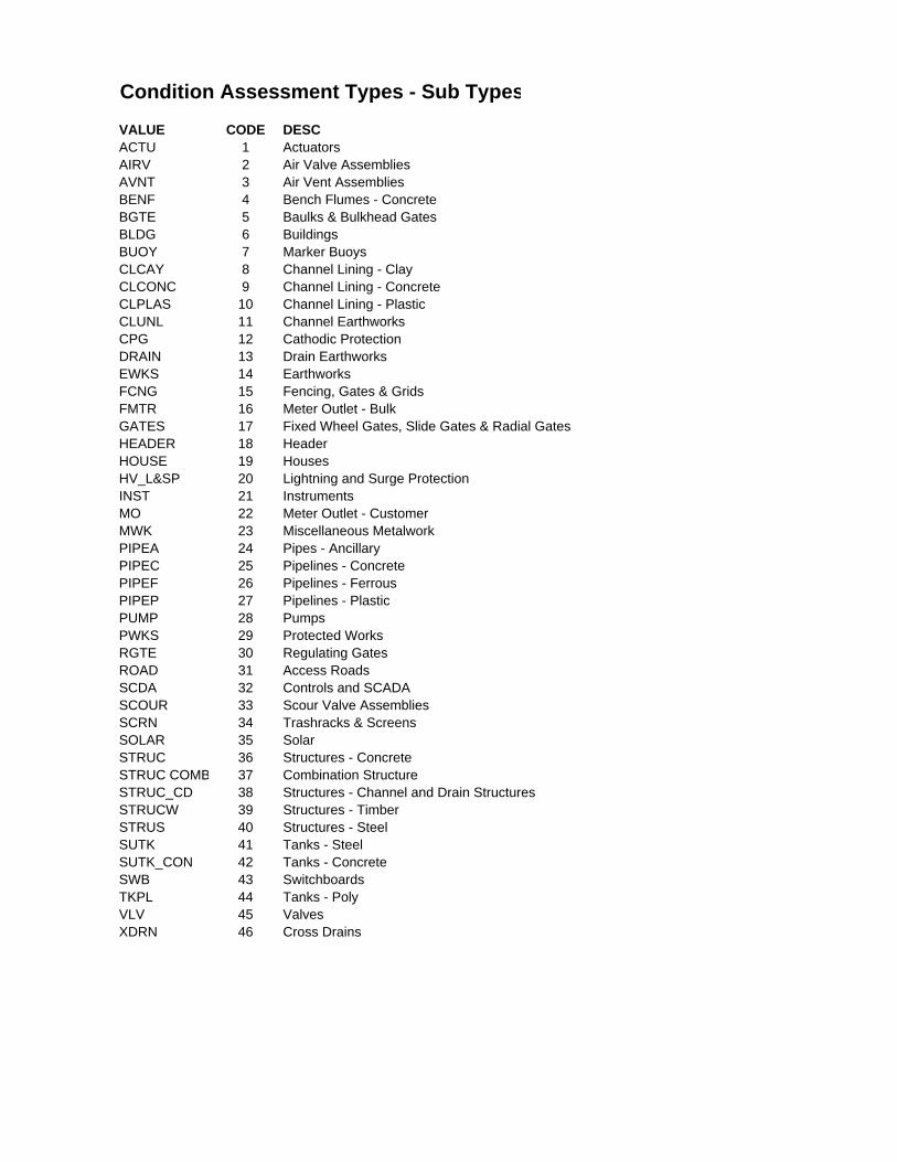
Condition Assessment Types - Sub Types
VALUE CODE DESCACTU 1 ActuatorsAIRV 2 Air Valve AssembliesAVNT 3 Air Vent AssembliesBENF 4 Bench Flumes - ConcreteBGTE 5 Baulks & Bulkhead GatesBLDG 6 BuildingsBUOY 7 Marker BuoysCLCAY 8 Channel Lining - ClayCLCONC 9 Channel Lining - ConcreteCLPLAS 10 Channel Lining - PlasticCLUNL 11 Channel EarthworksCPG 12 Cathodic ProtectionDRAIN 13 Drain EarthworksEWKS 14 EarthworksFCNG 15 Fencing, Gates & GridsFMTR 16 Meter Outlet - BulkGATES 17 Fixed Wheel Gates, Slide Gates & Radial GatesHEADER 18 HeaderHOUSE 19 HousesHV_L&SP 20 Lightning and Surge ProtectionINST 21 InstrumentsMO 22 Meter Outlet - CustomerMWK 23 Miscellaneous MetalworkPIPEA 24 Pipes - AncillaryPIPEC 25 Pipelines - ConcretePIPEF 26 Pipelines - FerrousPIPEP 27 Pipelines - PlasticPUMP 28 PumpsPWKS 29 Protected WorksRGTE 30 Regulating GatesROAD 31 Access RoadsSCDA 32 Controls and SCADASCOUR 33 Scour Valve AssembliesSCRN 34 Trashracks & ScreensSOLAR 35 SolarSTRUC 36 Structures - ConcreteSTRUC COMB 37 Combination StructureSTRUC_CD 38 Structures - Channel and Drain StructuresSTRUCW 39 Structures - TimberSTRUS 40 Structures - SteelSUTK 41 Tanks - SteelSUTK_CON 42 Tanks - ConcreteSWB 43 SwitchboardsTKPL 44 Tanks - PolyVLV 45 ValvesXDRN 46 Cross Drains

APPENDIX H
RATINGS

Assessment Criteria For Assessing Civil Assets
AM21_G3 Revision: 6 Revision Date: SEPT 2012 Approved by: M AM Owner: MAIPS
SunWater Quality Management System Uncontrolled Copy
Validate Currency when Printed Page 43 of 78
C1: STRUC
Structures - Concrete:
Includes all concrete structures not in-line (in the waterway) of channels and drains i.e. Pump wells, miscellaneous pits (swabbing, valve, instrumentation), concrete tanks.
Aspect Assessment Parameter
Rating
1
Rating
2
Rating
3
Rating
4
Rating
5
Rating
6
Structural Integrity
Cracking / Spalling /
Reinforcing Steel
Corrosion
Structure sound - no cracking evident
Some minor cracking evident that has little
impact on the structures strength
Cracking becoming more evident however still little
impact on structural integrity, minor or no corrosion of
reinforcement
Cracking/spalling evident that has impacted on the assets structural
integrity, reo exposed and corroding.
Significant cracking evident that presents a high probability of the structures collapse, spalling and
heavy corrosion of reo
Structure has effectively failed.
Structural Movement
Stability / Functional
Impacts
No movement evident
Some minor movement evident
that has little impact on the structures
strength or function
Asset has moved significantly however
structural integrity and function are retained
Movement has impacted on the assets structural integrity or
function
Movement has severe impact on structural integrity or function with
a high likelihood of failure
Structure has effectively failed and requires renewal to restore service delivery.
Foundations Undermining/ Stability / Erosion
No erosion/undermining
evident
Some minor erosion/undermining that has little impact on structure stability
Asset has significant erosion to foundations, little
undermining and structure stability is not immediately
threatened
Asset has significant erosion and some undermining to foundations,
structural stability is threatened with high probability of partial
failure
Asset has severe erosion and/or undermining to foundations with
high probability of full failure
Structure has effectively failed and requires renewal to restore service delivery.
Function Performance Deterioration /
Increased Operational
Costs
Asset able to perform its intended
function
Some minor elements of the
assets function are not able to be
provided
Minor operational difficulties or costs being presented by
the loss of function
Significant operational difficulties or costs presented by the loss of
function.
Asset provides very little of its intended function and requires
enhancement to correct.
Asset no longer able to perform its intended
function
Metalwork/ Coating
Cracking / Flaking / Corrosion
Coating as new, no defects.
Coating showing signs of aging, no
visible defects.
Coating loss / deterioration exposing steel. Steel surface
corroding / rusting.
Coating loss / deterioration exposing steel. Steel corroding /
rusting with surface delamination / flaking.
Steel heavily corroded / rusting with large areas of surface
delamination / flaking.
No coating or coating ineffective. Steel corroded / rusted
through.
Structural Integrity
Cracking / Spalling /
Reinforcing Steel
Corrosion
Structure sound - no cracking evident
Some minor cracking evident that has little
impact on the structures strength
Cracking becoming more evident however still little
impact on structural integrity, minor or no corrosion of
reinforcement
Cracking/spalling evident that has impacted on the assets structural
integrity, reo exposed and corroding.
Significant cracking evident that presents a high probability of the structures collapse, spalling and
heavy corrosion of reo
Structure has effectively failed.
Notes: 1. Status - Failure is a life limiting or failure mode criteria, Other is a deterioration indication criteria that requires another mechanism to cause failure
NielsonF
Rectangle
NielsonF
Text Box
CATEGORIES
NielsonF
Rectangle
NielsonF
Text Box
CAP TYPE (subtype)
NielsonF
Rectangle
NielsonF
Text Box
RATINGS AND DESCRIPTIONS

APPENDIX I
MAP OF TRIAL AREA

Projected Coordinate System: Mapping Grid of Australia(MGA94), Zone 55.
0 1,000 2,000 3,000 4,000 5,000m 1:100,000
SCALES (A3 SIZE)
MAP INFORMATION BURDEKIN HAUGHTON WATER SUPPLY SCHEME
BARRATTA SYSTEMMOBILE DATA CAPTURETRIAL DATA LOCATIONAPPENDIX I
Document: T:\Water Services\Drafting\Project_Files\ENG4111 - Research Project\Drawings\ArcMap\Basemap - BHWSS.mxdPrinted: Thursday, 17/10/2013 03:25:09 PM
LEGEND
Roads
SUNWATER INFRASTRUCTURE
Concrete Lined Channel
Plastic Lined Channel
Earth Channels
Pipelines
Earth Drains
Bank/Storage

APPENDIX J
SUNWATER SAFE WORK METHOD STATEMENT

SunWater ABN 17 020 276 523
Safe Work Method Statement - Template
Form No: WHS10 F1 Revision: 11 Revision Date: NOV 2011
SunWater Quality Management System Page 1 of 5
Job Name: Condition Assessment (Job Location and Description):
Work Order Number:N/A
Name of the person in control on site: Fiona Nielson Work Commencement Date: To Be Determined
A. Is there adequate evidence that SunWater staff and contractors are trained and competent to carry out this task safely? Yes No (if no stop work)
B. If contractors are engaged and have produced a Safe Work Method Statement (JSAE), is it suitable and authorised by SunWater?
Yes No (if no stop work)
NOTE: a) If Contractors are involved in any of the planned work within this safe work method statement it must be thoroughly discussed and communicated with all
parties. b) Following the consultation all parties must sign (on the last page) to indicate that adequate consultation has been undertaken and all risk controls will be
followed.
USE THIS CHECKLIST TO HELP IDENTIFY HAZARDS. Then consider these in the below Safe Work Method Statement.
POTENTIAL HAZARDS IN THIS JOB? Tick and include in the safe work method statement
Air Contaminants Mobile Plant Risks Chemical spills Noise Tools (Poor, Home
made)
Stored Energy Eye Irritation/Injury Decanting chemicals Overhead Wires Traffic Management
Plan
Asbestos Falling Hazards Driving Fatigue PPE Required Underground Service
Check (DBYD) Hazardous Chemicals Fire Risks Cranes and lifting Remote Area Work Wildlife Risks
Confined Spaces Bites/Stings Hazardous Manual
Handling Restricted Access Vehicles / Pedestrians
Trenches Fatigue Management Sun Exposure Slips, Trips, Falls Water/Drowning
Electrical Hazards Explosion Moving Parts
(machinery) Permits Required Weather Conditions
Site Security Boat Safety Working Heights

SunWater ABN 17 020 276 523
Safe Work Method Statement - Template
Form No: WHS10 F1 Revision: 11 Revision Date: NOV 2011
SunWater Quality Management System Page 2 of 5
USE THIS CHECKLIST TO HELP IDENTIFY REQUIRED PERSONAL PROTECTION EQUIPMENT (PPE). Then consider these in the Safe Work Method Statement below.
POSSIBLE PPE REQUIRED FOR THE JOB? Tick and include in the safe work method statement
Barricades & warning signs Mechanical lifting
aids First aid kit Hard hat and chin strap Rubber boots
Broad brim hat Overalls Fire extinguisher Hi visibility vest Torch and batteries
Carry bag for tools Overalls for
chemical use Fire blanket Lighting system Drinking water
Communications equipment life jacket or life ring Knee pads Safety footwear Wasp/ant spray
Dusk mask /vapour mask Personal isolation
locks Gas detector Safety harness and lines Face shield
Ear muffs/plugs Rescue kit (for
height work) Gloves - chemical Burns kit Portable toilet
Eye protection (clear or tinted)
Breathing Apparatus (kit)
Gloves - cotton/ Leather
Sunscreen Shade protection
STEPS IN COMPLETING THE SAFE WORK METHOD STATEMENT
a) DOCUMENT EACH JOB STEP AND THEN POTENTIAL HAZARDS ASSOCIATED WITH EACH JOB STEP. You must then assess the risks and document the Initial Risk Rating before any risk controls are considered.
b) Document the controls or methods you plan to use to lower the risk. c) Assign who will be responsible for making sure the controls are undertaken. d) Conduct the residual risk rating. e) Do not proceed with the work if the risk rating, after the controls are in place, remains
at HIGH or EXTREME. f) Remember this Safe Work Method Statement may need to be amended or added to, if a new or
unforseen risk arises. This means STOP work and repeat the above steps
Likelihood
Consequence
Minor (3)
Moderate (8)
Signifi- cant (18)
Major (40)
Critical (100)
Catast-rophic (235)
Almost Certain (235)
M 705
H 1880
E 4230
E 9400
E 23500
E 55225
Likely (100) M 300
H 800
H 1800
E 4000
E 10000
E 23500
Possible (45) L 135
M 360
H 810
H 1800
E 4500
E 10575
Unlikely (20) L 60
L 160
M 360
H 800
H 2000
E 4700
Rare (10) L 30
L 80
M 180
M 400
H 1000
H 2350
Very Rare (3) L 9
L 24
L 54
L 120
M 300
M 705
Extremely Rare (1)
L 3
L 8
L 18
L 40
L 100
M 235
SunWater ABN 17 020 276 523
Safe Work Method Statement - Template
Form No: WHS10 F1 Revision: 11 Revision Date: NOV 2011
SunWater Quality Management System Page 3 of 5
Step No
List the job steps in order. i.e. planning, packing ute, setting up site, inductions, steps to do job, reinstating site. (limited example only)
Potential Hazards in each job step without controls in place (WH&S, Environment, Other)
Initial Risk
Rating
Risk Control Actions
Responsibility for the Risk
Control Action
Residual Risk
Rating
1 Preparations in Office Nil L Nil Nil L
2 Travelling to/from Site Fatigue
Vehicle Incident
Locomotives
M Ensure adequate rest before and during long driving periods. Alternate drivers when necessary. Drive to the conditions. Be aware of other vehicles on the roads and around structures (i.e. tractors, haulouts, other plant). Be aware of locomotives when condition assessing during the crushing/harvesting periods.
Fiona Nielson L
3 Carry out condition assessment Wasp stings, heat stroke, dehydration, sunburn, snake bite, contact with other wildlife, falling in channel.
H Carry wasp spray, inspect structure from a distance before approaching. Wear appropriate PPE (i.e wide brimmed hat, sunglasses, sunscreen). Carry adequate water supply. Carry snake bite kit in vehicle, PPE (i.e. Boots, long pants). Avoid long grass where possible. Be wary of other wildlife and keep away when present. Ensure you do not ascend structures that do not have adequate guard railing, avoid the sides of open channels.
Fiona Nielson L
4 Travelling between sites Weed spread, grass fire M Where necessary use wash down bays to avoid the spread of noxious weeds. Be aware off the hazards of using petrol vehicles in areas with dry, long grass. Use diesel vehicles in these areas where possible.
Fiona Nielson L
5

SunWater ABN 17 020 276 523
Safe Work Method Statement - Template
Form No: WHS10 F1 Revision: 11 Revision Date: NOV 2011
SunWater Quality Management System Page 4 of 5
6
7
8
List any additional hazards identified during the job. Follow the process to achieve a low to medium risk rating.
Reviewed and endorsed by Site Supervisor or person in control:
Name: Fiona Nielson Signature: Date:
SIGN OFF FOR ALL PERSONS INVOLVED IN ANY OF THE ABOVE TASKS (to be done prior to starting the job)
Name of the person who ensured that this Safe Work Method Statement was communicated to all employees and contractors involved in the tasks.
Name: Fiona Nielson
I have reviewed the contents of this Safe Work Method Statement and agree to follow all directions documented.
If any further risks are identified, work must STOP until risks are documented and controlled to an acceptable level of low or medium.

SunWater ABN 17 020 276 523
Safe Work Method Statement - Template
Form No: WHS10 F1 Revision: 11 Revision Date: NOV 2011
SunWater Quality Management System Page 5 of 5
All persons on site undertaking work (including contractors)
Name Organisation Signature Date
Fiona Nielson SunWater

APPENDIX K
TIMELINE

Project Timeline
This project is to be completed by the due date of the dissertation as determined by the Engineering and Surveying Faculty at the University of Southern Queensland.
Intermediate milestones before final completion are as follows:
Complete preliminary report – Wednesday 19th
May
Load Collector App on to iPad – Early June
Begin creation of base maps for mobile device – Early June
Create feature templates for each different asset type – Mid to End June
Create domains and subtypes for asset data – June to July
Trial mobile device in office to ensure program works – End of July
Complete verification of BHWSS data (comparison btwn SAP and GIS) – Early August
Office trial of data and form inputs – August
Field trial of condition assessments in BHWSS – September
Write up results of trial and submit draft dissertation – September
Complete presentation in Toowoomba – Late September
Submit final dissertation – October