EIA For Natural Gas Natural Gas Transmission Pipeline...
40
EIA For Natural Gas Natural Gas Transmission Pipeline Crossing Ulhas River North side of theBridge NearKatai Naka, Dombivali By Mahanagar Gas Limited Environmental Impact Assessment For CRZ Clearance Of Natural Gas Transmission Pipeline Crossing Ulhas River North side of theBridge NearKatai Naka, Dombivali Prepared by Enviro Analysts & Engineers Pvt. Ltd. QCI NABET LIST for the Construction Project/ Area Development Project/Township: S.No. 45 of list of consultant with provisional accreditation. (Rev.15/ December 5, 2013) 1 Prepared by Enviro Analysts & Engineers Pvt. Ltd.
Transcript of EIA For Natural Gas Natural Gas Transmission Pipeline...
EIA For Natural Gas Natural Gas Transmission Pipeline Crossing Ulhas River North side of theBridge NearKatai Naka, Dombivali By Mahanagar Gas Limited
Environmental Impact Assessment
For
CRZ Clearance
Of Natural Gas Transmission Pipeline Crossing Ulhas River
North side of theBridge NearKatai Naka, Dombivali
Prepared by
Enviro Analysts & Engineers Pvt. Ltd. QCI NABET LIST for the Construction Project/ Area Development
Project/Township: S.No. 45 of list of consultant with provisional accreditation. (Rev.15/ December 5,
2013)
1 Prepared by Enviro Analysts & Engineers Pvt. Ltd.
EIA For Natural Gas Natural Gas Transmission Pipeline Crossing Ulhas River North side of theBridge NearKatai Naka, Dombivali By Mahanagar Gas Limited
Contents 1 Executive summary: ............................................................................................................................................... 5
1.1 Project background: ....................................................................................................................................... 5
1.2 Infrastructure proposed: ................................................................................................................................. 5
2 Introduction/ background: ...................................................................................................................................... 6
2.1 Identification of project & project proponent: ............................................................................................... 6
2.2 Brief description of nature of project: ............................................................................................................ 6
2.3 Infrastructure proposed: ................................................................................................................................. 6
2.4 Need for the project: ...................................................................................................................................... 7
3 Project description: ................................................................................................................................................ 8
3.1 Type of project (including interlinked & interdependent projects): .............................................................. 8
3.2 Location: ........................................................................................................................................................ 8
3.3 Details of alternate sites considered and selection criteria:............................................................................ 9
3.4 Project description with process details: ...................................................................................................... 10
3.5 Raw materials required and quantum: ......................................................................................................... 10
3.6 Resource optimization/ recycling: ............................................................................................................... 10
(a) Availability of water & source: ...................................................................................................................... 11
(b) Energy/ power requirement & source: ........................................................................................................... 11
3.7 Quantity of wastes: ...................................................................................................................................... 11
4 Site analysis: ........................................................................................................................................................ 12
4.1 Connectivity: ................................................................................................................................................ 12
4.2 Land Form/ land use/ land ownership: ......................................................................................................... 12
4.3 Topography: ................................................................................................................................................. 12
4.4 Existing land use pattern: ............................................................................................................................. 12
4.5 Existing infrastructure: ................................................................................................................................. 12
4.6 Soil classification: ........................................................................................................................................ 12
4.7 Temperature & relative humidity: ................................................................................................................ 12
4.8 Rainfall:........................................................................................................................................................ 13
4.9 Winds & tides: ............................................................................................................................................. 13
4.10 Visibility: ..................................................................................................................................................... 13
2 Prepared by Enviro Analysts & Engineers Pvt. Ltd.
EIA For Natural Gas Natural Gas Transmission Pipeline Crossing Ulhas River North side of theBridge NearKatai Naka, Dombivali By Mahanagar Gas Limited 5 Planning brief: ...................................................................................................................................................... 14
5.1 Planning concept: ......................................................................................................................................... 14
5.2 Minimizing Ecological Risk ........................................................................................................................ 14
5.3 Understanding Site Conditions .................................................................................................................... 14
5.4 Detailed Design Requirements ..................................................................................................................... 15
6 Proposed infrastructure: ....................................................................................................................................... 17
6.1 Industrial area (processing area): ................................................................................................................. 17
6.2 Residential area: ........................................................................................................................................... 17
6.3 Green belt: .................................................................................................................................................... 17
6.4 Connectivity: ................................................................................................................................................ 17
6.5 Solid waste management:............................................................................................................................. 17
7 Rehabilitation & resettlement (R & R) plan: ....................................................................................................... 18
7.1 Policy to be adopted (Central/ State): .......................................................................................................... 18
8 Environmental Impact Assessment study ............................................................................................................ 19
8.1 Baseline Factors for EIA .................................................................................................................................... 19
8.1.1 Hydrometeorology ............................................................................................................................... 19
8.1.2 Physiography: ...................................................................................................................................... 19
8.1.3 Soil Strata: ............................................................................................................................................ 19
8.2 Study area & period: .................................................................................................................................... 19
9 Environmental Aspects & Impacts identification ................................................................................................ 22
9.1 Baseline Environmental Studies .................................................................................................................. 22
9.1.1 Water Quality Analysis ........................................................................................................................ 22
10 ENVIRONMENT MANAGEMENT PLAN ............................................................................................................. 30
10.1 Construction Phase: ..................................................................................................................................... 30
10.2 SAFETY MEASURES TAKEN DURING DRILLING AND REAMING OPERATION TO ENSURE SOIL STABILITY.... 32
10.2.1 SIGNIFICANCE OF BENTONITE/ DRILLING MUD IN HDD OPERATIONS ................................................ 32
10.2.2 PRECAUTIONS TAKEN IN CASE OF EVENTUALITY OF WATER ENTERING INTO CARRIER PIPE BORE ... 33
10.3 Control, management and mitigation measures ......................................................................................... 33
10.3.1 DISPOSAL CONSIDERATIONS: ............................................................................................................... 34
10.3.2 TRANSPORT INFORMATION: ................................................................................................................ 34
10.3.3 HANDLING AND STORAGE: .................................................................................................................. 35
3 Prepared by Enviro Analysts & Engineers Pvt. Ltd.
EIA For Natural Gas Natural Gas Transmission Pipeline Crossing Ulhas River North side of theBridge NearKatai Naka, Dombivali By Mahanagar Gas Limited
10.3.4 Storage: Store in a dry covered area.................................................................................................... 35
10.3.5 ACCIDENTAL RELEASE MEASURES: ...................................................................................................... 35
11 Environmental Monitoring ............................................................................................................................... 40
4 Prepared by Enviro Analysts & Engineers Pvt. Ltd.
EIA For Natural Gas Natural Gas Transmission Pipeline Crossing Ulhas River North side of theBridge NearKatai Naka, Dombivali By Mahanagar Gas Limited
1 Executive summary:
1.1 Project background: Mahanagar Gas Limited (MGL) is one of India’s leading natural gas distribution companies. Established in 1995, MGL is a joint venture between GAIL (India) Ltd and the BG Group, (U.K.). MGL has to its credit the distinction of pioneering the natural gas distribution network in Mumbai and its neighboring areas. MGL today is an ISO 9001:2008, ISO-14001 and OHSAS 18001 certified organization. Today, MGL has already connected above 7 lakh households and over 2300 small commercial and industrial establishments. MGL also supplies CNG to more than 3.7 lakh vehicles which include above 1.7 lakh rickshaws and over 57,000 taxis & about 1.3 lakh cars in Mumbai, Thane, Mira-Bhayander, Navi Mumbai and beyond. Besides, about 3400 BEST/TMT/MSRTC/NMMT buses, above 5000 LCVs/Tempos/Trucks/Private buses are plying on CNG supplied through its wide distribution network of about 390 kms of steel and over 3850 kms of MDPE pipeline system and over 170 CNG filling stations having more than 920 dispensing points. Safe and uninterrupted supply of gas to the customers is the priority of the company. To ensure safety, MGL has put in place robust systems and processes which match with the best in the world. MGL has adopted a Health, Safety, Security & Environment (HSS&E) Management system which provides a framework for continual improvement in its performance. An Emergency control room with a toll free number 1800 22 99 44 is available 24 hrs a day, 365 days a year. Besides this 'Dial-before-Dig' and continuous pipeline surveillance also contribute to the safety of the system. MGL has all the resources and competencies required from concept to commissioning of gas distribution networks available in-house. The entire business in MGL has been integrated through ERP-SAP system. MGL has got a track record of almost 100% reliability in its gas supply. During the devastating floods of Mumbai in July 2005, when most other utilities failed, MGL’s gas supply continued uninterrupted. In the interest of Customer’s convenience, the company has taken several customer-friendly initiatives such as multiple bill payment options and multiple customer contact channels.
1.2 Infrastructure proposed: Energy Demand is increasing rapidly in India & use of Natural Gas is increasing gradually. To fulfill the demand of Industrial, Commercial and Domestic Customers in Khidkali, Shilphata, Mumbra&Kausa area MGL is proposing to lay a Pipeline by Crossing Ulhas River North Side of the Bridge near Katai Naka. As an Endeavour to ensure Security & Continuity in supply of Gas it is proposed to interconnect all the existing City Gate Stations, i.e. Ambernath, Wadala, Mahape & Taloja. As a part of this project gas connectivity willbe established between Dombivali to CGS Mahape.
5 Prepared by Enviro Analysts & Engineers Pvt. Ltd.
EIA For Natural Gas Natural Gas Transmission Pipeline Crossing Ulhas River North side of theBridge NearKatai Naka, Dombivali By Mahanagar Gas Limited
2 Introduction/ background:
2.1 Identification of project & project proponent: Mahanagar Gas Limited (MGL) is one of India’s leading natural gas distribution companies. Established in 1995, MGL is a joint venture between GAIL (India) Ltd and the BG Group, (U.K.). MGL has to its credit the distinction of pioneering the natural gas distribution network in Mumbai and its neighboring areas. MGL today is an ISO 9001:2008, ISO-14001 and OHSAS 18001 certified organization. Today, MGL has already connected above 7 lakh households and over 2300 small commercial and industrial establishments. MGL also supplies CNG to more than 3.7 lakh vehicles which include above 1.7 lakh rickshaws and over 57,000 taxis & about 1.3 lakh cars in Mumbai, Thane, Mira-Bhayander, Navi Mumbai and beyond. Besides, about 3400 BEST/TMT/MSRTC/NMMT buses, above 5000 LCVs/Tempos/Trucks/Private buses are plying on CNG supplied through its wide distribution network of about 390 kms of steel and over 3850 kms of MDPE pipeline system and over 170 CNG filling stations having more than 920 dispensing points. Safe and uninterrupted supply of gas to the customers is the priority of the company. To ensure safety, MGL has put in place robust systems and processes which match with the best in the world. MGL has adopted a Health, Safety, Security & Environment (HSS&E) Management system which provides a framework for continual improvement in its performance. An Emergency control room with a toll free number 1800 22 99 44 is available 24 hrs a day, 365 days a year. Besides this 'Dial-before-Dig' and continuous pipeline surveillance also contribute to the safety of the system. MGL has all the resources and competencies required from concept to commissioning of gas distribution networks available in-house. The entire business in MGL has been integrated through ERP-SAP system. MGL has got a track record of almost 100% reliability in its gas supply. During the devastating floods of Mumbai in July 2005, when most other utilities failed, MGL’s gas supply continued uninterrupted. In the interest of Customer’s convenience, the company has taken several customer-friendly initiatives such as multiple bill payment options and multiple customer contact channels.
2.2 Brief description of nature of project:
Natural Gas Transmission Pipeline (Mahape-Dombivali Looping) from MGL’s City Gate Station Mahape to Manpada junction in Dombivali MIDC along Kalyan–Shilphata road Crossing Ulhas River north side of the bridge near Katai Naka by using Horizontal Directional Drilling (HDD).
2.3 Infrastructure proposed: The proposal is for laying of Natural Gas Pipeline. A portion of pipeline (500 mts) shall pass through the CRZ area of Ulhas River.
6 Prepared by Enviro Analysts & Engineers Pvt. Ltd.
EIA For Natural Gas Natural Gas Transmission Pipeline Crossing Ulhas River North side of theBridge NearKatai Naka, Dombivali By Mahanagar Gas Limited
2.4 Need for the project: Energy Demand is increasing rapidly in India & use of Natural Gas is increasing gradually. To fulfill the demand of Industrial, Commercial and Domestic Customers in Khidkali, Shilphata, Mumbra&Kausa area MGL is proposing to Lay a Pipeline by Crossing Ulhas River North Side of the Bridge near Katai Naka. As an Endeavour to ensure Security & Continuity in supply of Gas it is proposed to interconnect all the existing City Gate Stations, i.e. Ambernath, Wadala, Mahape & Taloja. As a part of this project connectivity will be established between Dombivali to CGS Mahape.
7 Prepared by Enviro Analysts & Engineers Pvt. Ltd.
EIA For Natural Gas Natural Gas Transmission Pipeline Crossing Ulhas River North side of theBridge NearKatai Naka, Dombivali By Mahanagar Gas Limited
3 Project description:
3.1 Type of project (including interlinked & interdependent projects): The proposal is for laying of Gas pipeline through a narrow portion in CRZ area of Ulhas river. The project is to strengthen the existing network of pipelines and serve the newly developing residential and commercial areas at Shilphata, khidkali, Ambernath, etc. The project is expected to cater to energy demands in the region for domestic as well as commercial purpose.
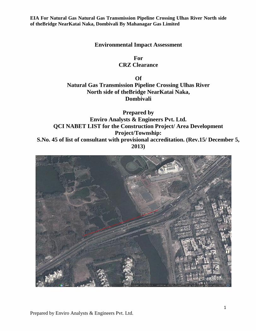
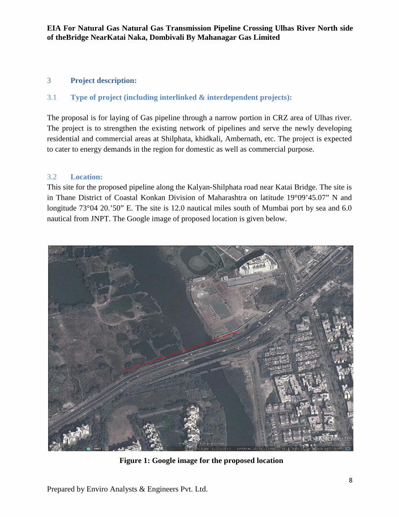
3.2 Location: This site for the proposed pipeline along the Kalyan-Shilphata road near Katai Bridge. The site is in Thane District of Coastal Konkan Division of Maharashtra on latitude 19°09’45.07” N and longitude 73°04 20.’50” E. The site is 12.0 nautical miles south of Mumbai port by sea and 6.0 nautical from JNPT. The Google image of proposed location is given below.
Figure 1: Google image for the proposed location
8 Prepared by Enviro Analysts & Engineers Pvt. Ltd.
EIA For Natural Gas Natural Gas Transmission Pipeline Crossing Ulhas River North side of theBridge NearKatai Naka, Dombivali By Mahanagar Gas Limited
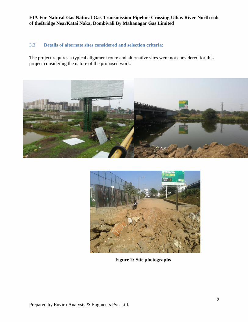
3.3 Details of alternate sites considered and selection criteria: The project requires a typical alignment route and alternative sites were not considered for this project considering the nature of the proposed work.
Figure 2: Site photographs
9 Prepared by Enviro Analysts & Engineers Pvt. Ltd.
EIA For Natural Gas Natural Gas Transmission Pipeline Crossing Ulhas River North side of theBridge NearKatai Naka, Dombivali By Mahanagar Gas Limited
3.4 Project description with process details: The project is for laying of a Gas pipeline with open trenching. However, for the Portion passing through the CRZ will be done by Horizontal Directional Drilling Method (HDD) to reduce the environmental impacts to minimum. The usual approach to pipeline installation is to dig an open trench, place the pipeline and then bury it. Proposed pipeline passing through CRZ area shall be laid by:
1. Horizontal Directional Drilling (HDD) method for pipeline passing through Ulhas River. 2. Open cut method for remaining portion of pipeline.
• Horizontal Directional Drilling (HDD) is a Trench-less methodology that provides an installation alternative that can offer a number of benefits over traditional open-cut method.
• In a sensitive wetland environment such as a river/creek crossing, wildlife habitats would be destroyed and extensive mitigation efforts would be required while pipe laying by open cut method. As a result, trenchless or "no-dig" technology has been usedextensively worldwide.
• HDD can be implemented with very little disruption to surface activities, requires less working space, and may be performed more quickly than open-cut methods.
• 12” NB, 9.5 mm thick & 4” NB with 6.4 mm thick ERW Carbon Steel Pipelines Crossing River &laid together by HDD methodology across river and 12” NB & 125 mm MDPE across remaining length of CRZ portion by Open Cut Method. Open Cut Method
• The usual approach to pipeline installation is to dig an open trench, place the pipeline and then bury it.
• MGL is using 9.5mm thick, Hydro testing test pressure shall be 76.5 Bar-g, 3 layer PE coated steel pipes of diameter 12” NB for the transportation of its natural gas to its pressure regulating stations
3.5 Raw materials required and quantum: The proposed project being a non-construction activity involving only laying of a pipeline, there is no requirement of raw material. Specification of the pipeline has been described above.
3.6 Resource optimization/ recycling: There are no resources required for the achieved by reducing the operation time judiciously.
Project. The resource optimization shall primarily and using the construction automated machinery
10 Prepared by Enviro Analysts & Engineers Pvt. Ltd.
EIA For Natural Gas Natural Gas Transmission Pipeline Crossing Ulhas River North side of theBridge NearKatai Naka, Dombivali By Mahanagar Gas Limited
(a) Availability of water & source: The water requirement for the construction purpose shall be fulfilled through water tankers as it is not a regular requirement.
(b) Energy/ power requirement & source: Power shall be made available for HDD through 25 KVA DG sets.
3.7 Quantity of wastes: The only waste that will be coming out of the process is Bentonite slurry due to HDD. About 70% slurry is expected to be recovered and remaining 30% will be sent to TSDF at Taloja through authorized transporters.
11 Prepared by Enviro Analysts & Engineers Pvt. Ltd.
EIA For Natural Gas Natural Gas Transmission Pipeline Crossing Ulhas River North side of theBridge NearKatai Naka, Dombivali By Mahanagar Gas Limited
4 Site analysis:
4.1 Connectivity: The site is easily accessible by a two lane road connecting Shilphata and Kalyan. The nearest railway station on Central Railway is (Harbour Line) Nilaje at 3.00 kms.
4.2 Land Form/ land use/ land ownership: The land required for the project is a vacant land along the road and bridge.Approximately 230 mts of Creek Crossing Length.
4.3 Topography: The land is at an elevation of about 4.50m above chart datum and is fairly levelled land on land side and sloping towards water end.
4.4 Existing land use pattern: The existing land is barren without any cultivation or other use.
4.5 Existing infrastructure: The land is abutting the Shilphata-kalyan Road and the region is fairly developed with basic infrastructure.
4.6 Soil classification: The riverbed is having coastal alluvial soil which is mainly clayee.
4.7 Temperature & relative humidity: The region experiences moderate temperature variations, the mean day bulb temperature in the hottest (May) and in coldest (Jan) months being 30.30OC and 23.60OC. The mean annual daily maximum and minimum temperatures are 31OC and 23.60OC. In recent years this region has experienced high temperature up to 36 degrees centigrade and low up to 22 degrees centigrade. The relative humidity is moderate to high and
12 Prepared by Enviro Analysts & Engineers Pvt. Ltd.
EIA For Natural Gas Natural Gas Transmission Pipeline Crossing Ulhas River North side of theBridge NearKatai Naka, Dombivali By Mahanagar Gas Limited varies between 62% and 85%.
4.8 Rainfall: Rainfalls mainly occur in this area during the south-west monsoon in the months June-September. The mean annual rainfall in whole rainy season is around 2,800 mm. In view of the area prone to heavy rains and floods during the monsoon, the construction activities will have to be planned giving due considerations to these factors. Similarly, during operation stage, the monsoon activities and targets have to specially planned taking into account possible disruptions.
4.9 Winds & tides: Wind speeds of 45 km/hour are known to accompany the monsoon waves offshore, but inshore winds are thought to be lower than this. Wind conditions recorded by the offshore anemometer, during a field measurement exercise carried out in 1994 by NIO, were upto 40 Km/hour in September, which suggests that this speed can be taken as an approximate upper limit during non-monsoon operations. CWPRS had conducted some study earlier for wind speed in Konkan area and reported wind speed upto 60 km/hour. The typical wind rose diagram based on the observations of the Indian Meteorological Department and Marine climatologically department give following information. The predominant wind direction is N and NE during fair weather season and W and SW during monsoon season.
4.10 Visibility: From November to March smog hangs over the land around Mumbai. This happens only for short periods, most often shortly after sunrise but occasionally in the evening. Visibility is generally good for most part of the year as the number of days on which visibility is poor being negligible.
13 Prepared by Enviro Analysts & Engineers Pvt. Ltd.
EIA For Natural Gas Natural Gas Transmission Pipeline Crossing Ulhas River North side of theBridge NearKatai Naka, Dombivali By Mahanagar Gas Limited
5 Planning brief:
5.1 Planning concept: Horizontal Directional Drilling (HDD) is intended to be a less intrusive construction method than the traditional open cut for crossing a watercourse or wetland with a pipe, cable or other underground service. However, there is a possibility of surface (water, riparian, wetland) disturbance if a ‘frac-out’ (inadvertent release of drilling fluid or a release of sediment laden groundwater into the wetland or watercourse. There is also the potential for sediment laden water or other deleterious substances to enter a surface water feature as the result of grading, drilling excavations, equipment washing, or other construction related activities during directional boring. Frac-out releases are typically caused by the pressurization of the drill hole beyond the containment capability of the near surface geologic materials (soil and/or rock). Therefore the type and depth of these materials, as well as the drilling pressure, are key factors in preventing and managing frac-outs. TRCA aims to minimize ecological risk, which is accomplished by effective siting of the project, collection of detailed information to understand environmental constraints/sensitivities, proactive mitigation of potential ecological impacts, environmental monitoring during HDD construction, and detailed contingency measures.
5.2 Minimizing Ecological Risk The preferred order for dealing with potential releases of drilling fluid is first to prevent them from occurring, second to contain them if such an incident occurs, and third is site restoration/remediation. Sediment entering a surface water feature may result in a temporary increase in turbidity or siltation that can negatively impact aquatic life, by covering spawning/feeding areas and clogging fish gills.
5.3 Understanding Site Conditions When designing HDD projects in or around natural areas, such as watercourses and wetlands, it is important to clearly understand the ecological sensitivities and the potential risk of inadvertent releases of sediment or sediment-laden water during HDD operations. A geotechnical report should support the selection of HDD as the technology chosen to install underground servicing through natural heritage features. Similarly, the design details for the HDD should reflect the findings and recommendations in the geotechnical report. The information obtained in the geotechnical report, in terms of stratigraphy, soil material best suited for the bore path, and groundwater levels, are all critical elements in designing a successful project and
14 Prepared by Enviro Analysts & Engineers Pvt. Ltd.
EIA For Natural Gas Natural Gas Transmission Pipeline Crossing Ulhas River North side of theBridge NearKatai Naka, Dombivali By Mahanagar Gas Limited limiting the risks to the environment. The geotechnical report should also identify any hydrogeologic or surface water constraints the contractor should be aware of during the drilling process, such as artesian groundwater pressure, ground conditions that may limit construction, etc. One key point to consider when obtaining any geotechnical data, is the location of investigative test pits or boreholes in relation to the bore path. Test pits and boreholes should not be located directly on, or extend through, the proposed alignment, as these weak points may serve as conduits where inadvertent fluid returns or frac outs occur.
5.4 Detailed Design Requirements Once the route has been determined, the following information will be required on the detailed site plans:
• The Proposed HDD Alignment In Both Plan And Profile Views; • Borehole Data Including The Stratigraphy In Relation To The Proposed Bore Path, And
The Elevation Of Groundwater Resources; • The Exact Location Of All Watercourses, Including Accurate Surveys Of Creeks,
Clearly Identifying The Location Of Banks, And Bed Invert Elevations; • The Exact Location Of All Wetlands, Including Accurate Surveys Of Wetland
Boundaries As Determined By Either The Mnr Or Trca, Wetland Invert Elevations, The Location Of Standing Water, And Water Elevations;
• An Accurate Cross-Section Of The Watercourse/Wetland At The Crossing Location In Relation To The Hdd Trajectory;
• All Tree/Vegetation Removals, Access Points, Entry And Exit Points, Erosion And Sediment Controls, Dewatering/Depressurization Requirements, Details For Working In The Dry, And Site Restoration;
• Confirmation Of Adequate Treatment Of Any Dewatering From The Work Area Prior To Release Of This Water To The Environment. Treatment Methods Should Ensure That Only Clean Water Be Released To The Environment, And That Adequate Dissipation Methods Be Employed To Minimize Erosion At The Outlet. Contingency Methods Of Treating Sediment Laden Water And Details On Monitoring The Effluent Should Be Provided, In The Event That Treatment Is Ineffective At Removing Suspended Clays And Silts From The Water Column. Please Note That Filterbags Are Not Effective At Removing Silts And Clays.
• All Existing/Proposed Ditches Should Be Clearly Identified, So That Water Conveyance (During Rain Events, And Dewatering) In And Around The Work Site Is Clearly Understood;
• Fisheries Timing Windows Must Be Identified On The Plans; • Contingency/Mitigation Methods For Frac Outs, Or Inadvertent Returns Of Drilling
Fluids
15 Prepared by Enviro Analysts & Engineers Pvt. Ltd.
EIA For Natural Gas Natural Gas Transmission Pipeline Crossing Ulhas River North side of theBridge NearKatai Naka, Dombivali By Mahanagar Gas Limited
• Notes Outlining Environmental Monitoring And Reporting.
16 Prepared by Enviro Analysts & Engineers Pvt. Ltd.
EIA For Natural Gas Natural Gas Transmission Pipeline Crossing Ulhas River North side of theBridge NearKatai Naka, Dombivali By Mahanagar Gas Limited
6 Proposed infrastructure:
6.1 Industrial area (processing area): The proposed project is for laying of Gas pipeline and shall occupied a narrow strip of about 5 mts across a length of 500 mts during the construction phase.
6.2 Residential area: This point is not applicable for the project.
6.3 Green belt: This is not applicable for the project. The project does not involve clearing of any vegetation; hence compensatory afforestation is also not applicable to this project.
6.4 Connectivity: The proposed site is well connected by a four lane road from Shil phaata to kalyan. (katai bridge)
6.5 Solid waste management: There are no solid wastes generated in operations phase of this project.During construction, bentonite slurry of approximately 35 MT/Weekshall be generated. 70% of it shall be reutilized in the project and about 30% shall be sent to TSDF. The consent for the same has been taken by the MGL.
17 Prepared by Enviro Analysts & Engineers Pvt. Ltd.
EIA For Natural Gas Natural Gas Transmission Pipeline Crossing Ulhas River North side of theBridge NearKatai Naka, Dombivali By Mahanagar Gas Limited
7 Rehabilitation & resettlement (R & R) plan:
7.1 Policy to be adopted (Central/ State): As there is no rehabilitation or settlement of people, there is no need for any plan for rehabilitation & resettlement under central or state policy.
18 Prepared by Enviro Analysts & Engineers Pvt. Ltd.
EIA For Natural Gas Natural Gas Transmission Pipeline Crossing Ulhas River North side of theBridge NearKatai Naka, Dombivali By Mahanagar Gas Limited
8 Environmental Impact Assessment study
8.1 Baseline Factors for EIA
8.1.1 Hydrometeorology The climate of the region is tropical with high relative humidity throughout the year. The general climatic condition is fair since seasonal fluctuations of temperature are not very high. The moderating effects of the adjoining sea and the fairly high amount of relative humidity in the atmosphere have restricted the unevenness. January is the coldest month and May the warmest. With the onset of monsoon in early June the temperature decreases and remains more or less steady. Again the temperature rises in October and falls gradually till January. The maximum day temperature ranges in between 28˚C to 37˚C while the minimum temperature ranges in between 17˚C to 27˚ C. The average relative humidity varies from lowest in the month of December to the highest of 85% during July. The relative humidity remains 44% to 76% throughout the year. The monsoon generally sets in around the second week of June and continues till late September. July and August are the wettest months all over the region. Maximum rainfall is recorded mostly in the month of July. The study area falls in the High Rainfall Zone of Northern Konkan.
8.1.2 Physiography: The Maharashtra coast is characterized by pocket beaches flanked by rocky cliffs of Deccan basalt as we go from North to south, estuaries and the patches of the mangroves along the estuaries. Beaches of the Maharashtra coast are small, crescent shaped and flanked by promontories. They are termed as pocket beaches as they are pocketed between headlands. Mudflats are found mainly along the estuaries and bay. They are broad at the mouth and gradually taper down. They are observed near Thane creek, Ulhas River, and Vasai creek. Mangroves are mainly observed along the intertidal region of estuaries and creeks. Large patches of mangroves are observed along the Ulhas River, Vasai creek, Thane creek and Dharamtar creek. For Ulhas River, the Kalundri is a major stream, there are a few others which are short and very much seasonal in their flow.
8.1.3 Soil Strata: The subsurface profile consists of fill material overlying marine clay for a depth of 3.00m below ground level.
8.2 Study area & period: The study was carried out between April 2014 to December 2014. The studyarea covered the Project site as Core area and a buffer area of 2 kms around the site. The scope was determined based on location of the project and magnitude of operations that would be incremental in the already developed area. Activities considered for Impact:
19 Prepared by Enviro Analysts & Engineers Pvt. Ltd.
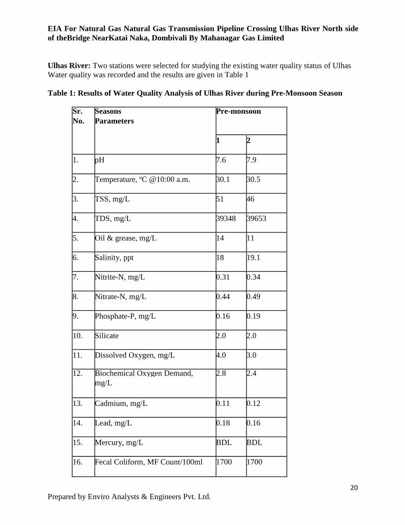
EIA For Natural Gas Natural Gas Transmission Pipeline Crossing Ulhas River North side of theBridge NearKatai Naka, Dombivali By Mahanagar Gas Limited Ulhas River: Two stations were selected for studying the existing water quality status of Ulhas Water quality was recorded and the results are given in Table 1 Table 1: Results of Water Quality Analysis of Ulhas River during Pre-Monsoon Season
Sr. Seasons Pre-monsoon No. Parameters 1 2 1. pH 7.6 7.9 2. Temperature, ºC @10:00 a.m. 30.1 30.5 3. TSS, mg/L 51 46 4. TDS, mg/L 39348 39653 5. Oil & grease, mg/L 14 11 6. Salinity, ppt 18 19.1 7. Nitrite-N, mg/L 0.31 0.34 8. Nitrate-N, mg/L 0.44 0.49 9. Phosphate-P, mg/L 0.16 0.19 10. Silicate 2.0 2.0 11. Dissolved Oxygen, mg/L 4.0 3.0 12. Biochemical Oxygen Demand, 2.8 2.4 mg/L 13. Cadmium, mg/L 0.11 0.12 14. Lead, mg/L 0.18 0.16 15. Mercury, mg/L BDL BDL 16. Fecal Coliform, MF Count/100ml 1700 1700
20 Prepared by Enviro Analysts & Engineers Pvt. Ltd.
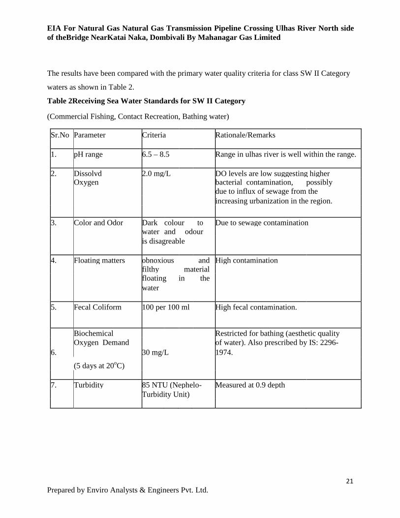
EIA For Natural Gas Natural Gas Transmission Pipeline Crossing Ulhas River North side of theBridge NearKatai Naka, Dombivali By Mahanagar Gas Limited The results have been compared with the primary water quality criteria for class SW II Category
waters as shown in Table 2.
Table 2Receiving Sea Water Standards for SW II Category (Commercial Fishing, Contact Recreation, Bathing water) Sr.No Parameter Criteria Rationale/Remarks 1. pH range 6.5 – 8.5 Range in ulhas river is well within the range. 2. Dissolvd 2.0 mg/L DO levels are low suggesting higher Oxygen bacterial contamination, possibly due to influx of sewage from the increasing urbanization in the region. 3. Color and Odor Dark colour to Due to sewage contamination water and odour is disagreable 4. Floating matters obnoxious and High contamination filthy material floating in the water 5. Fecal Coliform 100 per 100 ml High fecal contamination.
Biochemical Restricted for bathing (aesthetic quality
6. Oxygen Demand
30 mg/L of water). Also prescribed by IS: 2296-
(5 days at 20oC)
1974.
7. Turbidity 85 NTU (Nephelo- Measured at 0.9 depth Turbidity Unit)
21 Prepared by Enviro Analysts & Engineers Pvt. Ltd.
EIA For Natural Gas Natural Gas Transmission Pipeline Crossing Ulhas River North side of theBridge NearKatai Naka, Dombivali By Mahanagar Gas Limited 9 Environmental Aspects & Impacts identification
9.1 Baseline Environmental Studies
9.1.1 Water Quality Analysis Detailed description of the individual water quality parameters and range of values obtained
during the monitoring period for the samples collected from Ulhas River are given below:
9.1.1.1 Marine Water PH: pH of sea water varies between pH 7.5 and 8.4. For aquatic life to survive, the pH should lie
within 6.5-9.0 (as per CPCB standards for Class IV Waters). The value of pH of marine water of
Ulhas River was 7.4 & 7.8 during the pre monsoon season. The horizontal gradient was not much
predominant at all the stations. The range of the pH values in Ulhas River was found to lie within
the limits prescribed by CPCB for receiving water quality standards SWII category. The observed
pH values are favorable to maintain a healthy aquatic community in the harbour waters.
Temperature: This is one of the most important parameters for the aquatic environment, because almost all the
physical, chemical and biological properties are governed by it. Temperature limits the saturation
values of solids and gases that are dissolved in it. The rate of chemical reaction and other
biological activity such as corrosion or incrustation, BOD, photosynthesis, growth and death of
micro-organisms are all dependent on temperature. At all stations, the variation in average
temperature were in accordance with ambient air temperature and time of the day. The value of temperature of marine water of Ulhas River was in the range of 30.10 – 30.50C during the pre-monsoon season. Total Suspended Solids (TSS): Suspended particulate matter in the sea water originate from organic and inorganic particles
naturally present in water due to vertical mixing action in sediments by tidal currents and through
suspended solids brought in by wastewater flows from domestic and industrial areas. Suspended
solids cause turbidity which in turn reduces the light penetrating capacity and ultimately results in
becoming an obstacle for the photosynthesis. High concentration of TSS in sea water also affects
22 Prepared by Enviro Analysts & Engineers Pvt. Ltd.
EIA For Natural Gas Natural Gas Transmission Pipeline Crossing Ulhas River North side of theBridge NearKatai Naka, Dombivali By Mahanagar Gas Limited its aesthetic value. The value of TSS of marine water of Ulhas River was in the range of 46– 51 mg/L during the pre-
monsoon season.
Total Dissolved Solids (TDS): Total dissolved solid (TDS) is a measure of the total amount of all the materials that are dissolved
in water. These materials, both natural and anthropogenic (made by humans), are mainly
inorganic solids, with a minor amount of organic material. Depending on the type of water, TDS
can vary greatly from a few milligrams per liter to percent levels (tens of thousands of milligrams
per liter). Seawater contains 3.5% (35,000 mg/L) TDS.
The value of TDS of marine water of Ulhas River was in the range of 39348 -39653 mg/L pre
monsoon season.
Oil and Grease: Oil pollution at sea essentially takes place in two ways, either as large quantities during a short
period owing to accidents like sinking of oil ships, collision of vessels or as small but continued
amounts over a longer period through pumping from oil barges or vessels at liquid cargo jetty.
Discharge of oil contaminated bilge water from fishing launches, passenger launches etc. also
contributes oil concentration in coastal water. Discharge of sewage into sea water contributes
grease concentration in inland water. The value of oil and grease of marine water of Ulhas River was in the range of 11-14 mg/L during
pre-monsoon season. The effluents from the adjoining development at Nilaje mainly contributes
to this.
Salinity: The total amount of inorganic material dissolved in sea water is termed as salinity and is usually
about 1.8 % or 1 8 ppt. The value of salinity of water of Ulhas River was in the range of 35.3– 35.9 ppt in pre monsoon season. Nitrite: Nitrite in water poisons the fish by binding to the hemoglobin in the blood preventing oxygen
carrying capacity, in effect suffocating the fish .The gills of fish dying as a result of nitrite
23 Prepared by Enviro Analysts & Engineers Pvt. Ltd.
EIA For Natural Gas Natural Gas Transmission Pipeline Crossing Ulhas River North side of theBridge NearKatai Naka, Dombivali By Mahanagar Gas Limited poisoning are characteristic brown color. The nitrite concentration of marine water of Ulhas River was in the range of 0.31 - 0.34 mg/L
during pre-monsoon season.
Nitrate N: Nitrate -N is a nutrient produced in natural water by decomposition of nitrogenous organic
compounds. High level of nitrate represents the presence of more nitrogenous compounds and
resulting in to excessive growth of algae and other aquatic vegetation leading to eutrophication.
The nitrate concentration of marine water of Ulhas River was in the range of 0.41 - 0.49 mg/L pre
monsoon season.
Phosphate-P: Phosphate-P is a nutrient that acts as a fertilizer. High level of this nutrient causes excessive plant
and algal growth in aquatic ecosystem. Eutrophication of the water body is also caused by the
presence of excess amount of Phosphate-P along with other nutrients in the water. The phosphate concentration of marine water of Ulhas River was in the range of 0.16 – 0.19 mg/L
during pre-monsoon season.
Silicate: The requirement of silicon by Diatoms is not, however entirely limited to skeletal formation and
has particular importance potentially in coastal upwelling region where Diatoms form a dominant
part the phytoplankton. It appears as oxide in sand and silts. In natural water, it is found as silicate
(SiO2). The silicate concentration of marine water of Ulhas River was in the range of 2.0 mg/L during
pre-monsoon season.
Dissolved Oxygen (DO): Dissolved oxygen is essential for the respiration of aquatic organisms, and its concentration in sea is a major determinant of the species composition of biota in the water and underlying sediments. Moreover, the dissolved oxygen in sea has a profound effect on the biochemical reactions that occur in water and sediments, which in turn affect numerous aspects of water quality, including the solubility of many toxic elements and aesthetic qualities of odor and taste. For these reasons, dissolved oxygen historically has been one of the most frequently measured indicators of water quality. The value of dissolved oxygen in the Ulhas River was in the range of 2 -2.5mg/L the pre monsoon
24 Prepared by Enviro Analysts & Engineers Pvt. Ltd.
EIA For Natural Gas Natural Gas Transmission Pipeline Crossing Ulhas River North side of theBridge NearKatai Naka, Dombivali By Mahanagar Gas Limited season.
Biochemical Oxygen Demand BOD test shows the amount of molecular oxygen required by bacteria to reduce the carbonaceous matter. It is also defined as the measure of the oxygen consumed by living organisms while utilizing the organic matter. It is a good indicator of pollution. The value of BOD of marine water of the Ulhas River was in the range of 30 mg/L in the pre monsoon season. CPCB standard for BOD of sea water (Class II Waters) is 3 mg/L. BOD values were slightly below the standard at both stations during the monitoring period. This could be due to inflow of wastewater from nearby villages and Ulawe. Cadmium Cadmium accumulates in the oceans from sources such as atmospheric fallout, rivers and direct dumping of waste into the sea. Many types of marine life, including shellfish, fish, plankton and birds, are known to concentrate this element which, besides posing an increasing threat to marine life, may also affect man. The value of cadmium in the Ulhas River was in the range of 0.11 - 0.12mg/L in the pre monsoon
season.
Lead Anthropogenic lead (Pb) is considered to be one of the most severe contaminants for the
environments. Although Pb is used for a variety of purposes in industries, automobile exhaust is a
predominant source of Pb emission due to the use of leaded gasoline. Since anthropogenic Pb is
easily transported via atmosphere, sea surface water is polluted by Pb mainly through
precipitation and deposition of aerosols.
The concentration of lead in the Ulhas River was in the range of 0.16 - 0.18 mg/L in the pre
monsoon season.
Mercury Mercury is considered to be a pollutant of the global environment because of its volatility, long-
range atmospheric transport, its transformation to more toxic compounds and the bio-
accumulation of the latter. Sources of mercury pollution in the environment Coal-burning electric
plants are the largest cause of avoidable mercury emissions includes the disposal of batteries,
thermometers, and gas meters. Mercury is dangerous to humans. High levels of mercury in a
25 Prepared by Enviro Analysts & Engineers Pvt. Ltd.
EIA For Natural Gas Natural Gas Transmission Pipeline Crossing Ulhas River North side of theBridge NearKatai Naka, Dombivali By Mahanagar Gas Limited human can affect the nervous system and is especially harmful to unborn children in the womb.
The most common way a person is exposed to mercury pollution is through eating fish. The
mercury is absorbed into the fatty tissues of fish, which pass that mercury on when the fish is
eaten.
The concentration of mercury in the Ulhas River was below detectable limits of the instruments used. Fecal Coliform Fecal coliform is measured in terms of Most Probable Number (MPN). MPN is an index of the
number of coliform bacteria that, more probably than any other number, would give the coliform
density, since coliform group density is an important criterion of the degree of fecal pollution.
The major risk from fecal contamination is from contaminated sea food. Coliform bacteria enter
coastal waters through sewage discharge.
Total Marine Water Quality All physico-chemical parameters monitored during the entire study period show that all of them
having range of values within their prescribed standards except for BOD, DO and nutrients. The
nutrients values were slightly above the recommended range for Arabian Sea. This could be due
to inflow of sewage from village and urban area. The presence of fecal coliform i n Ulhas River
indicates contamination of marine water with sanitary waste.
Acquatic Ecosystem Acquatic Ecosystem is represented by the river Ulhas River. In order to assess the water quality
based on the phytoplankton, zooplankton and benthos samples were collected from the above
mentioned water bodies within the study area.
Phytoplankton The total no. of 9 species was found in the pre-monsoon season. Rhizosolenia species
&Skeletonema species were the commonest. The results can be seen in the table depicted below
26 Prepared by Enviro Analysts & Engineers Pvt. Ltd.
EIA For Natural Gas Natural Gas Transmission Pipeline Crossing Ulhas River North side of theBridge NearKatai Naka, Dombivali By Mahanagar Gas Limited Table 3 Phytoplankton Species Encountered in Water Ulhas River during Pre-Monsoon Season
Sr. no. Species
1 Rhizosoleniasps
2 Skeletonemasps.
3 Pleurosigmasps.
4 Fragillariasps.
5 Ceratulina pelagic
6 Biddulphiasps.
7 Coscinodiscus excentricus
8 Licmophorasps. 9 Haplosphaera viridis
Total Number of Species = 9 Zooplankton The zooplankton species found at various locations in Ulhas River are given in Tables 4. The
zooplankton collected showed a total number of 14 types of organisms during the pre- monsoon
season. Table 4 Species Composition of Zooplankton from Various Stations during Pre- Monsoon Season Sr. No. Species 1 Calanussps.
27 Prepared by Enviro Analysts & Engineers Pvt. Ltd.
EIA For Natural Gas Natural Gas Transmission Pipeline Crossing Ulhas River North side of theBridge NearKatai Naka, Dombivali By Mahanagar Gas Limited
2 Eucalanus elongates
3 Pseudocalanus elongates
4 Phialidium 5 Candaciasps. 6 Comb jelly 7 Hemimysis 8 Shrimps 9 Sirellasps. 10 Oithionasps. 11 Nereissps 12 Sagitta 13 Zoea
14 Other larval forms
Total No. Of Species 14 Benthos The sediment samples collected at various locations along Ulhas River were analyzed for benthic
forms during the pre-monsoon season and results are given in Tables 5. The results showed a total
of 6 varieties of sedimentary organisms.
Table 4 Benthic Forms Encountered in the Sediments Collected at Various Stations along Ulhas River during Pre Monsoon Season
Sr. Benthic
28 Prepared by Enviro Analysts & Engineers Pvt. Ltd.
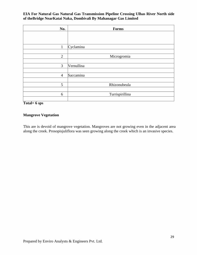
EIA For Natural Gas Natural Gas Transmission Pipeline Crossing Ulhas River North side of theBridge NearKatai Naka, Dombivali By Mahanagar Gas Limited
No. Forms
1 Cyclamina
2 Microgromia
3 Vernullina
4 Saccamina
5 Rhizonubeula
6 Turrispirillina
Total= 6 sps Mangrove Vegetation This are is devoid of mangrove vegetation. Mangroves are not growing even in the adjacent area along the creek. Prosopisjuliflora was seen growing along the creek which is an invasive species.
29 Prepared by Enviro Analysts & Engineers Pvt. Ltd.
EIA For Natural Gas Natural Gas Transmission Pipeline Crossing Ulhas River North side of theBridge NearKatai Naka, Dombivali By Mahanagar Gas Limited 10 ENVIRONMENT MANAGEMENT PLAN
10.1 Construction Phase: The Operations phase of the project will be dormant phase and besides the DMP prepared by MGL, no active environmental management is required. For construction phase, Environmental Management is required Solid waste such as empty bags, packing material, insulating plastic, metal pieces etc. will be properly segregated and sent to authorized recycler/ brick work and tiles, excavated material will be used as filling material at site.
Hazardous Materials General Use Further Information
Fuels (Diesel and Unleaded
Used to power site-based vehicles and
backup
Emergency Response Manual,
MSDS Register
Oils and lubricants Vehicle & plant maintenance &repairs
Emergency Response Manual,
MSDS Register
Bentonite Chips Directional boring of conduits MSDS Register
Drilling fluids compound
Geotechnical and environmental bore
construction MSDS Register
30 Prepared by Enviro Analysts & Engineers Pvt. Ltd.
EIA For Natural Gas Natural Gas Transmission Pipeline Crossing Ulhas River North side of theBridge NearKatai Naka, Dombivali By Mahanagar Gas Limited
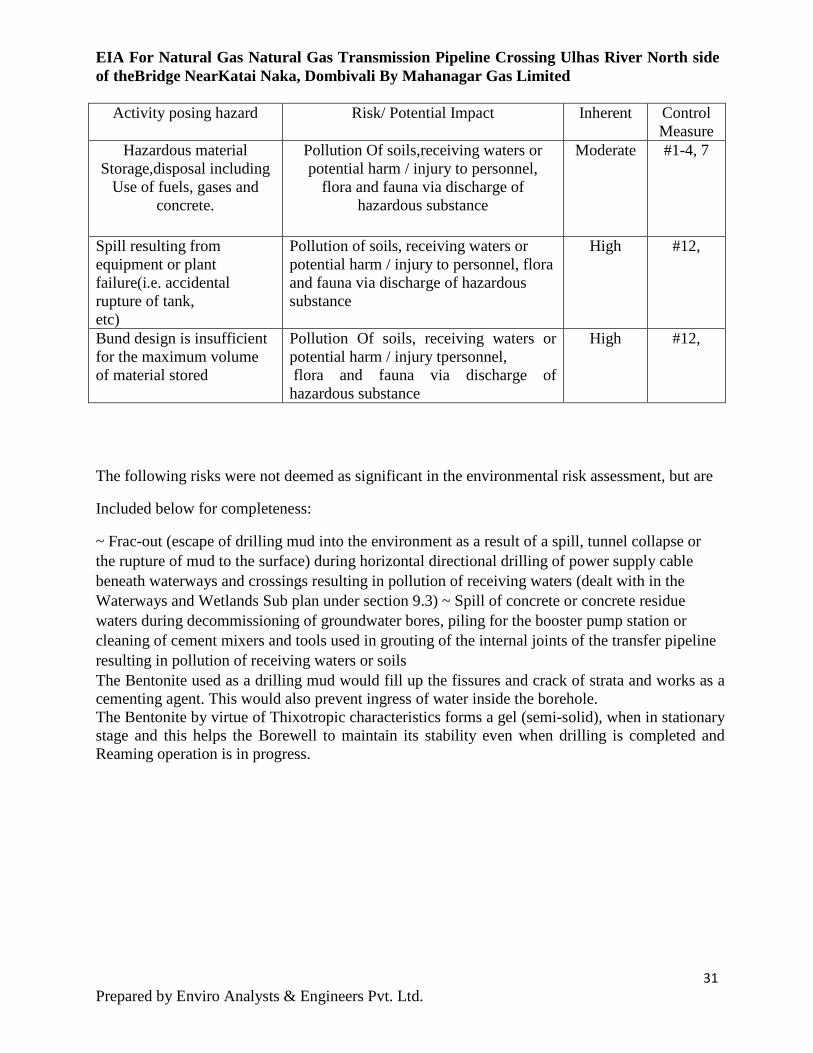
Activity posing hazard Risk/ Potential Impact Inherent Control Measure
Hazardous material Storage,disposal including
Use of fuels, gases and concrete.
Pollution Of soils,receiving waters or potential harm / injury to personnel,
flora and fauna via discharge of hazardous substance
Moderate
#1-4, 7
Spill resulting from equipment or plant failure(i.e. accidental rupture of tank, etc)
Pollution of soils, receiving waters or potential harm / injury to personnel, flora and fauna via discharge of hazardous substance
High #12,
Bund design is insufficient for the maximum volume of material stored
Pollution Of soils, receiving waters or potential harm / injury tpersonnel, flora and fauna via discharge of hazardous substance
High #12,
The following risks were not deemed as significant in the environmental risk assessment, but are Included below for completeness: ~ Frac-out (escape of drilling mud into the environment as a result of a spill, tunnel collapse or the rupture of mud to the surface) during horizontal directional drilling of power supply cable beneath waterways and crossings resulting in pollution of receiving waters (dealt with in the Waterways and Wetlands Sub plan under section 9.3) ~ Spill of concrete or concrete residue waters during decommissioning of groundwater bores, piling for the booster pump station or cleaning of cement mixers and tools used in grouting of the internal joints of the transfer pipeline resulting in pollution of receiving waters or soils The Bentonite used as a drilling mud would fill up the fissures and crack of strata and works as a cementing agent. This would also prevent ingress of water inside the borehole. The Bentonite by virtue of Thixotropic characteristics forms a gel (semi-solid), when in stationary stage and this helps the Borewell to maintain its stability even when drilling is completed and Reaming operation is in progress.
31 Prepared by Enviro Analysts & Engineers Pvt. Ltd.
EIA For Natural Gas Natural Gas Transmission Pipeline Crossing Ulhas River North side of theBridge NearKatai Naka, Dombivali By Mahanagar Gas Limited 10.2 SAFETY MEASURES TAKEN DURING DRILLING AND REAMING OPERATION TO ENSURE SOIL STABILITY
1) The hole will be filled with Pressurized mud (Bentonite slurry) and will be maintained such
throughout the pull back operation. This would not only provide the borehole stability but also
provide lubricating effect on pipe during pull back operation.
2) The theoretical overburden pressure on top of pipe has been evaluated. This overburden has
considered the depth of water in water body (at deepest point) and height of soil/rock strata in
between bed level and pipe level. After comparing the minimum collapse pressure and maximum
overburden pressure (with factor of safety), it is observed that overburden pressure on top of pipe
is within allowable limit.
3) The design of HDD has also considered the critical safety factors (e.g. longitudinal stresses
developed in pipe due to tension and bending, Design pull force required on empty pipe to counter
buoyancy, curvature, variations in alignments, drag force etc.). This would prevent sudden jolts /
torsion on pipeline section and prevent caving of borehole.
10.2.1 SIGNIFICANCE OF BENTONITE/ DRILLING MUD IN HDD OPERATIONS Bentonite is naturally occurring colloidal clay (aluminum silicate) composed essentially of
Montmorillonite, quartz and mica. Bentonite is commonly used as drilling mud, in oil wells and
horizontal direction Drilling jobs. When exposed to water, it swells considerably expand to ten
times its volume when completely hydrated, making it ideal for protecting subterranean
formations by providing a thixotrophic effect.
Drilling mud is a suspension of bentonite in fresh water.
Drilling Mud serves following main purposes in drilling operations
(i) Protects the wall of the drill hole by preventing caving-in
(ii) Acts as a lubricant and coolant for the cutting bits
(iii) Carries away spoils and cut rock fragments
(iv) Imparts rotary motion to the drill bit(cutter) by using hydraulic energy
(v) Provides lubrication to carrier pipe during pull back operation
32 Prepared by Enviro Analysts & Engineers Pvt. Ltd.
EIA For Natural Gas Natural Gas Transmission Pipeline Crossing Ulhas River North side of theBridge NearKatai Naka, Dombivali By Mahanagar Gas Limited 10.2.2 PRECAUTIONS TAKEN IN CASE OF EVENTUALITY OF WATER ENTERING INTO CARRIER
PIPE BORE There are 3 possibilities of entering water inside the borehole,
• Rain / Storm water entry
• Rise of water level due to Tidal waves
• Ingress / seepage of ground water
a) Rain / Storm Water: As per the design requirement, the selection of Entry and Exit points
shall be made taking into account the HFL (Highest Flood Level). However, considering
uncertainty of rainfall in Mumbai region, MGL as a precautionary measure has proposed to
carryout the HDD activity only during non-monsoon period (from October. to May).
b) Tidal Water: The entry and exit points shall be located well above the maximum tide level.
Additionally, as a precautionary measures the entry and exit pits shall be provided with earthen
bunds to prevent sudden ingress of surface water
c) The most significant design aspect considered to prevent the entry of water is that the
borehole is filled up with pressurized mud (high density Bentonite slurry) all the times during
drilling, reaming and pull-back operation. Therefore, due to variation in density of media, the
chance of surface water entering inside the borehole is ruled out.
d) As explained at point no. 1.A (4), the pressurized Bentonite slurry present inside the borehole
acts as cementing agent and fill-up the fissures /cracks in permeable soil/rock formation. This in
turn would prevent the ingress / seepage of ground water inside the borehole.
10.3 Control, management and mitigation measures Table 10 describes a range of mitigation and control measures that will be used to minimize and manage potential hazardous material impacts. The measures in table 10 are designed to address potential impacts from the risks outlined earlier as well as deliver on the objectives, targets and in particular the PRs listed. They include requirements and responsibilities for design, construction, evaluating performance and reporting. The Occupational Health and Safety Regulations and Approved Code of Practice for the Control of Workplace Hazardous Substances specify the requirements for the identification and management of hazardous substances. Substances used during construction that may be classed as hazardous will include all chemicals brought onto site and may come in the form of solids, liquids, gases, fumes and fibres. They include products such as strong acids and alkalis, solvents
33 Prepared by Enviro Analysts & Engineers Pvt. Ltd.
EIA For Natural Gas Natural Gas Transmission Pipeline Crossing Ulhas River North side of theBridge NearKatai Naka, Dombivali By Mahanagar Gas Limited and reactive chemical agents. All environmental incidents will be responded to in accordance with the Utilities Environmental Incident Response Procedure (EIRP). The EIRP provides project specific details for the identification of and response to potential environmental related incidents along the utilities corridor work sites. It provides guidance on strategies to manage Potential and actual incidents, as well as follow-up and reporting requirements. The environmental risk assessment has identified the following circumstances that could occur outside normal operating conditions: Unforeseen water and soil contamination due to a spill resulting from equipment (i.e.
rupture of tank, etc) Accidental spill
Unexpected ignition of flammable and combustible liquids during normal construction
operations Contamination of air, land and water, and human and ecological health, due to the
incorrect separation and segregation of hazardous and dangerous substances
Traffic incident involving the transportation of bulk hazardous materials and dangerous
substances. If these circumstances occur, the contingency measures outlined in Figure 1
will be implemented
10.3.1 DISPOSAL CONSIDERATIONS:
Bentonite and waste from residue can be disposed as non-toxic, non-hazardous and inactive materials in approved landfill sites in accordance with local regulations.
Contaminated packaging can be disposed in approved landfill sites in accordance with local regulations.
10.3.2 TRANSPORT INFORMATION:
Bentonite is not classified as dangerous for transportation. Bentonite may be transported in accordance with the standard local authority regulations.
34 Prepared by Enviro Analysts & Engineers Pvt. Ltd.
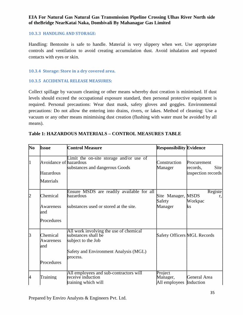
EIA For Natural Gas Natural Gas Transmission Pipeline Crossing Ulhas River North side of theBridge NearKatai Naka, Dombivali By Mahanagar Gas Limited 10.3.3 HANDLING AND STORAGE:
Handling: Bentonite is safe to handle. Material is very slippery when wet. Use appropriate controls and ventilation to avoid creating accumulation dust. Avoid inhalation and repeated contacts with eyes or skin.
10.3.4 Storage: Store in a dry covered area.
10.3.5 ACCIDENTAL RELEASE MEASURES:
Collect spillage by vacuum cleaning or other means whereby dust creation is minimised. If dust levels should exceed the occupational exposure standard, then personal protective equipment is required. Personal precautions: Wear dust mask, safety gloves and goggles. Environmental precautions: Do not allow the entering into drains, rivers, or lakes. Method of cleaning: Use a vacuum or any other means minimising dust creation (flushing with water must be avoided by all means).
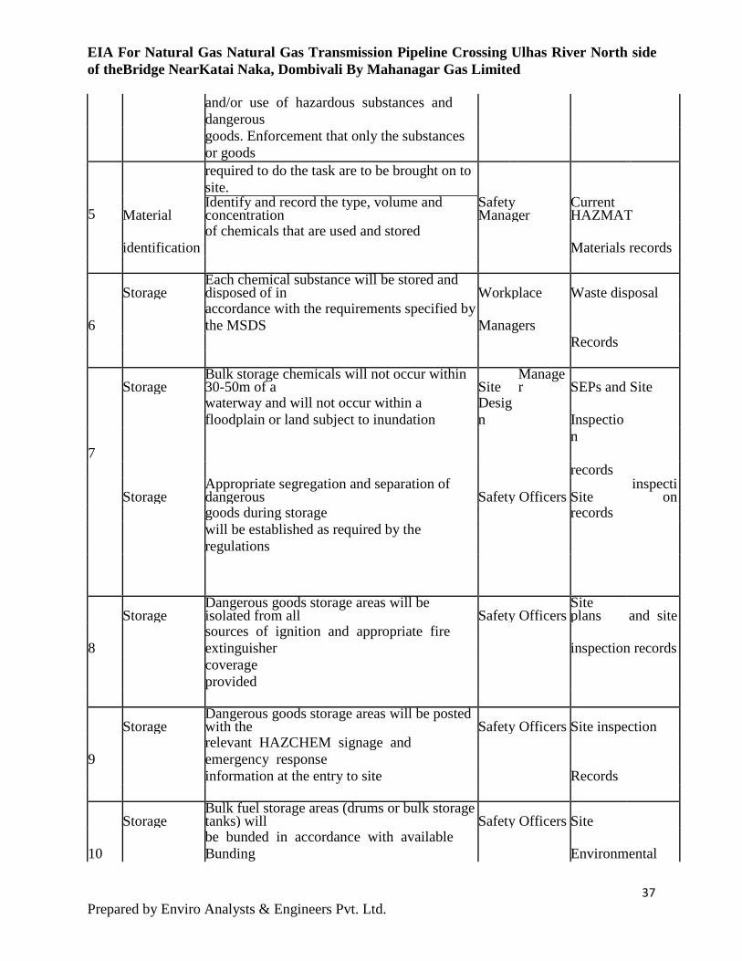
Table 1: HAZARDOUS MATERIALS – CONTROL MEASURES TABLE
No Issue Control Measure Responsibility Evidence
1 Avoidance of Limit the on-site storage and/or use of hazardous Construction Procurement
Hazardous
substances and dangerous Goods Manager records, Site inspection records
Materials
2 Chemical Ensure MSDS are readily available for all hazardous Site Manager, MSDS
Register,
Awareness and
substances used or stored at the site. Safety Manager
Workpacks
Procedures
3 Chemical All work involving the use of chemical substances shall be Safety Officers MGL Records
Awareness and
subject to the Job
Procedures
Safety and Environment Analysis (MGL) process.
4 Training All employees and sub-contractors will receive induction
Project Manager, General Area
training which will All employees Induction
35 Prepared by Enviro Analysts & Engineers Pvt. Ltd.
EIA For Natural Gas Natural Gas Transmission Pipeline Crossing Ulhas River North side of theBridge NearKatai Naka, Dombivali By Mahanagar Gas Limited
include the safe use of hazardous substances being used
Content,
at the workplace.
The training provided shall be commensurate with the Induction
associated risks and will include (but not be limited to)
records
the following (as outlined in the Approved
Code of Practice for Workplace Hazardous Substances):
- The labeling of containers of hazardous substances, the
information that each part of the label provides and why
the information is being provided
- The availability of MSDS for hazardous substances, how
to access
the MSDS and the information that each part of the
MSDS provides
- Information about hazardous substances to which
employees are or may be exposed in the course of their
work (information should include the nature of the
hazards and risks to the environment)
- The assessment process and how the employee can
Contribute
- The work practices and procedures to be followed in the
use, handling, processing, storage, transportation,
cleaning up and disposal of hazardous substances
- The procedures to be followed in case of an emergency
involving hazardous substances, including any special
decontamination procedures to be followed.
- Requirement to limit the on-site and on-vessel storage
36 Prepared by Enviro Analysts & Engineers Pvt. Ltd.
EIA For Natural Gas Natural Gas Transmission Pipeline Crossing Ulhas River North side of theBridge NearKatai Naka, Dombivali By Mahanagar Gas Limited
and/or use of hazardous substances and dangerous
goods. Enforcement that only the substances or goods
required to do the task are to be brought on to site.
5 Material Identify and record the type, volume and concentration
Safety Manager
Current HAZMAT
identification
of chemicals that are used and stored Materials records
Storage Each chemical substance will be stored and disposed of in Workplace Waste disposal
6 accordance with the requirements specified by the MSDS Managers
Records
Storage Bulk storage chemicals will not occur within 30-50m of a Site
Manager SEPs and Site
waterway and will not occur within a floodplain or land subject to inundation
Design Inspectio
n
7
records
Storage Appropriate segregation and separation of dangerous Safety Officers Site
inspection
goods during storage records
will be established as required by the regulations
Storage Dangerous goods storage areas will be isolated from all Safety Officers
Site plans and site
8 sources of ignition and appropriate fire extinguisher inspection records
coverage provided
Storage Dangerous goods storage areas will be posted with the Safety Officers Site inspection
9 relevant HAZCHEM signage and emergency response
Records
information at the entry to site
Storage Bulk fuel storage areas (drums or bulk storage tanks) will Safety Officers Site
10 be bunded in accordance with available Bunding Environmental
37 Prepared by Enviro Analysts & Engineers Pvt. Ltd.
EIA For Natural Gas Natural Gas Transmission Pipeline Crossing Ulhas River North side of theBridge NearKatai Naka, Dombivali By Mahanagar Gas Limited Guidelines
Plans
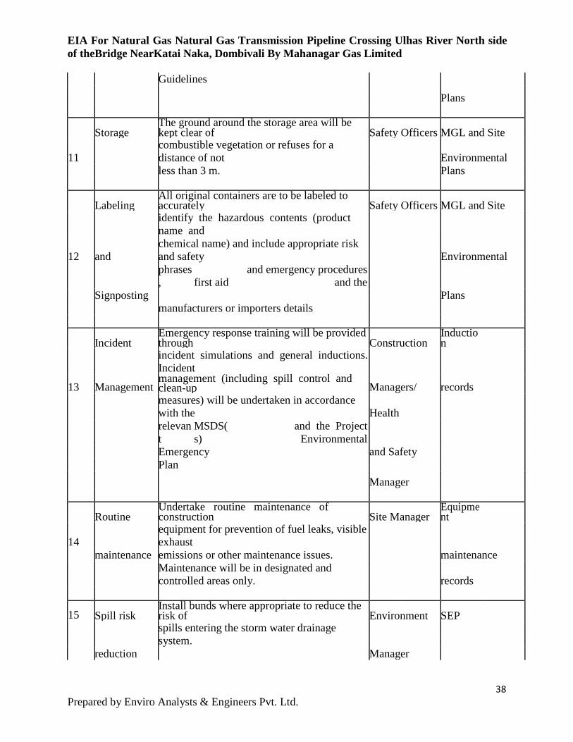
Storage The ground around the storage area will be kept clear of Safety Officers MGL and Site
11 combustible vegetation or refuses for a distance of not Environmental
Plans
less than 3 m.
Labeling All original containers are to be labeled to accurately Safety Officers MGL and Site
and
identify the hazardous contents (product name and
Environmental
12 chemical name) and include appropriate risk and safety
Signposting
phrases, first aid
and emergency procedures and the
Plans
manufacturers or importers details
Incident Emergency response training will be provided through Construction
Induction
Management
incident simulations and general inductions. Incident
Managers/ records
13 management (including spill control and clean-up
measures) will be undertaken in accordance with the Health
relevant
MSDS(s)
and the Project Environmental
and Safety
Emergency Plan
Manager
Routine Undertake routine maintenance of construction Site Manager
Equipment
14 maintenance
equipment for prevention of fuel leaks, visible exhaust
maintenance
emissions or other maintenance issues.
Maintenance will be in designated and controlled areas only. records
15 Spill risk Install bunds where appropriate to reduce the risk of Environment SEP
reduction
spills entering the storm water drainage system.
Manager
38 Prepared by Enviro Analysts & Engineers Pvt. Ltd.
EIA For Natural Gas Natural Gas Transmission Pipeline Crossing Ulhas River North side of theBridge NearKatai Naka, Dombivali By Mahanagar Gas Limited
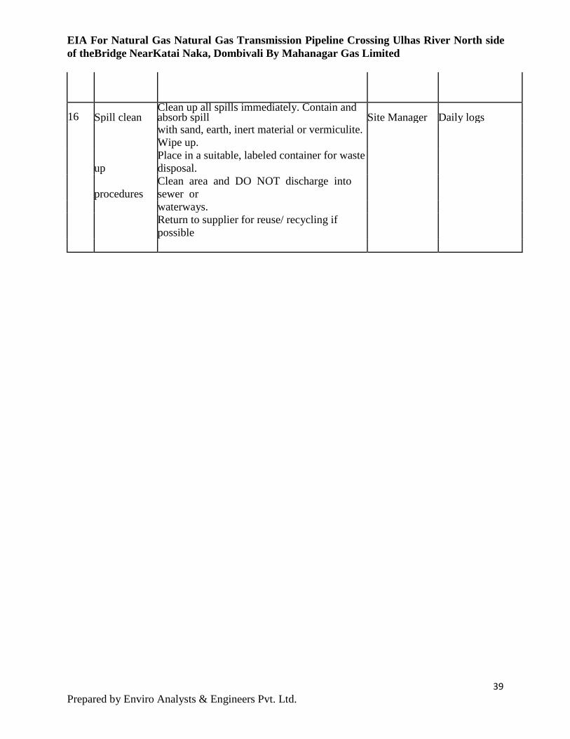
16 Spill clean Clean up all spills immediately. Contain and absorb spill Site Manager Daily logs
up
with sand, earth, inert material or vermiculite. Wipe up.
Place in a suitable, labeled container for waste disposal.
procedures Clean area and DO NOT discharge into sewer or
waterways.
Return to supplier for reuse/ recycling if possible
39 Prepared by Enviro Analysts & Engineers Pvt. Ltd.
EIA For Natural Gas Natural Gas Transmission Pipeline Crossing Ulhas River North side of theBridge NearKatai Naka, Dombivali By Mahanagar Gas Limited
11 Environmental Monitoring An environmental monitor will be required on site during the HDD construction. Notes regarding environmental monitoring need to be provided on the plans. Please note that the environmental monitor should be experienced with an understanding of the ecological objectives and sensitivities of the site, and in identifying/anticipating potential ecological concerns/risks in a proactive manner in an attempt to avoid impacts before they occur. It is our preference that environmental monitors be qualified, in that they have a college or university degree in environmental science or equivalent, and have experience in managing and mitigating environmental issues on construction sites. The environmental monitoring and contingency plan should clearly outline the steps that the contractor is to take in the event of a sediment release or other type of spill. The plan should clearly outline the steps involved to mitigate an inadvertent return or frac out after it occurs, and should not rely solely on the contractor to take all necessary steps to minimize the impacts. Ultimately, the responsibility lies with the proponent. As contingency plan, may include the provision of a vacuum truck, or alternative means of containing or cleaning up a sediment release, at the time of construction in sensitive areas. If vacuum trucks are to be utilized, they should be on-site during construction, and be ready to contain any spill, as it occurs, before it enters a surface water feature. If a sediment spill occurs within the watercourse, adequate isolation of the release should be provided to contain the sediment, and the vacuum truck be ready to remove the drilling fluid and any other frac out soil. Additional measures may include having a supply of products that can be used to stop a frac-out, such as ‘Poly Swell’, or equivalent. All products used on site are to be environmentally safe. Frac mitigation wells may also be considered to relieve drilling pressures. The Contingency Plan should indicate if, and when, HDD activities are to resume. For example, when mitigation measures have been implemented are deemed to be effective at mitigating potential ecological impacts.
40 Prepared by Enviro Analysts & Engineers Pvt. Ltd.