EFFECTS OF THE STRUCTURAL-TECTONIC AND VOLCANIC …...ISA Workshop December 2009 EFFECTS OF THE...
20
ISA Workshop December 2009 EFFECTS OF THE STRUCTURAL-TECTONIC AND VOLCANIC PROCESSES ON FORMATION OF POLYMETALLIC NODULES IN THE CCZ Authors: R. Kotlinski, V. Yubko, and V. Stoyanova
Transcript of EFFECTS OF THE STRUCTURAL-TECTONIC AND VOLCANIC …...ISA Workshop December 2009 EFFECTS OF THE...

ISA Workshop December 2009
EFFECTS OF THE STRUCTURAL-TECTONIC AND VOLCANIC PROCESSES ON FORMATION OF POLYMETALLIC NODULES
IN THE CCZ
Authors: R. Kotlinski, V. Yubko, and V. Stoyanova

OUTLINEOUTLINE
bj ibj i•• Objective:Objective:
–– Estimation of the possible influence of such factors and Estimation of the possible influence of such factors and processes as bottom morphology, water depth,processes as bottom morphology, water depth,processes as bottom morphology, water depth, processes as bottom morphology, water depth, structuralstructural--tectonics setting and sedimentary, volcanic tectonics setting and sedimentary, volcanic and hydrothermal activity on formation of polymetallic and hydrothermal activity on formation of polymetallic nodules in the entire CCZnodules in the entire CCZ
•• Data inputs:Data inputs:–– Structural Setting of the CCZ;Structural Setting of the CCZ;–– Volcanic and Hydrothermal Activity;Volcanic and Hydrothermal Activity;y y;y y;–– Types of sediments;Types of sediments;–– Types of nodules and their distribution;Types of nodules and their distribution;–– Mn/Fe ratiosMn/Fe ratios
•• Establishment of a model of evolution of the CCZ ant its apparent Establishment of a model of evolution of the CCZ ant its apparent relationship to the formation of polymetallic nodules relationship to the formation of polymetallic nodules

Structural Setting of the CCZ
• increasingincreasing ofof thethe waterwater depthdepth fromfrom EastEast toto WestWest:: fromfrom 33,,800800 –– 44,,200200 mm atat115115ºWºW toto 44,,800800--55,,200200 mm atat 130130ºW,ºW, andand 55,,400400 –– 55,,600600 mm atat 145145ºº WW;;
• thethe largestlargest structuralstructural elementselements areare thethe swellswell--typetype volcanicvolcanic--tectonictectonic CooperCooperRise,Rise, CentralCentral RiseRise andand EastEast RiseRise..
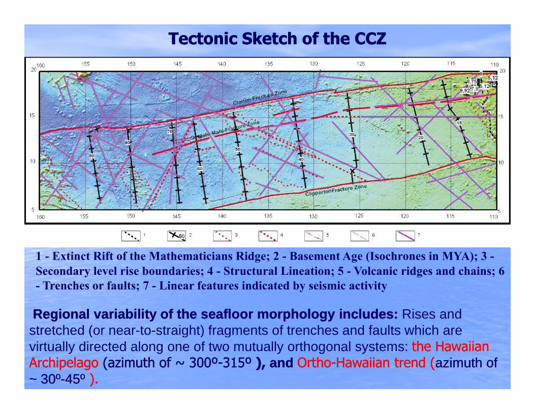
Tectonic Sketch of the CCZ Tectonic Sketch of the CCZ
1 - Extinct Rift of the Mathematicians Ridge; 2 - Basement Age (Isochrones in MYA); 3 -Secondary level rise boundaries; 4 - Structural Lineation; 5 - Volcanic ridges and chains; 6
Trenches or faults; 7 Linear features indicated by seismic activity- Trenches or faults; 7 - Linear features indicated by seismic activity
Regional variability of the seafloor morphology includes: Regional variability of the seafloor morphology includes: Rises and stretched (or near-to-straight) fragments of trenches and faults which are ( g ) gvirtually directed along one of two mutually orthogonal systems: the Hawaiian the Hawaiian Archipelago Archipelago (azimuth of ~ 300º(azimuth of ~ 300º--315º315º ),), and and OrthoOrtho--Hawaiian trend (Hawaiian trend (azimuth of azimuth of ~ 30º~ 30º--45º45º ).).
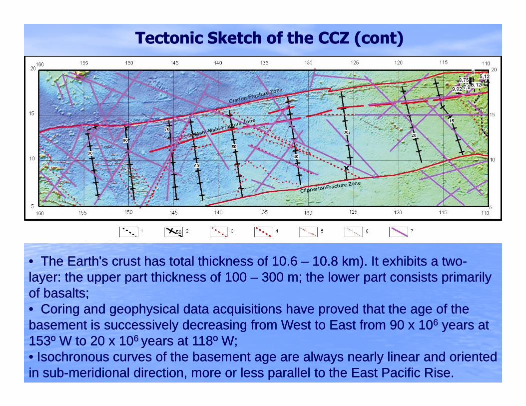
Tectonic Sketch of the CCZ (cont) Tectonic Sketch of the CCZ (cont)
•• The Earth's crust has total thickness of 10.6 The Earth's crust has total thickness of 10.6 –– 10.8 km). It exhibits a two10.8 km). It exhibits a two--layer: the upper part thickness of 100layer: the upper part thickness of 100 –– 300 m; the lower part consists primarily300 m; the lower part consists primarilylayer: the upper part thickness of 100 layer: the upper part thickness of 100 300 m; the lower part consists primarily 300 m; the lower part consists primarily of basalts; of basalts; •• Coring and geophysical data acquisitions have proved that the age of the Coring and geophysical data acquisitions have proved that the age of the basement is successively decreasing from West to East from 90 x 10basement is successively decreasing from West to East from 90 x 1066 years at years at y gy g yy153º W to 20 x 10153º W to 20 x 106 6 years at 118º W;years at 118º W;•• Isochronous curves of the basement age are always nearly linear and oriented Isochronous curves of the basement age are always nearly linear and oriented in subin sub--meridional direction, more or less parallel to the East Pacific Rise.meridional direction, more or less parallel to the East Pacific Rise.

Volcanic and Hydrothermal ActivityVolcanic and Hydrothermal Activity
Recent basaltic flows (1), metalliferous sediments (2), hydrothermal flints (3), and hydrothermal-metasomatic sulfides (4) in the CCZ
•• The direct evidence of the resent intraThe direct evidence of the resent intra--plate volcanism in the CCZ is theplate volcanism in the CCZ is theThe direct evidence of the resent intraThe direct evidence of the resent intra plate volcanism in the CCZ is the plate volcanism in the CCZ is the basalt lava of Shimada Seamount (the crustal age in the area basalt lava of Shimada Seamount (the crustal age in the area ~~ 16 16 -- 17 million 17 million years);years);•• Evidence for potentially local sources of metals are found in metalliferous Evidence for potentially local sources of metals are found in metalliferous p yp ysediment and hydrothermal flints (YMG, SIO);sediment and hydrothermal flints (YMG, SIO);•• Discovered by YMG massive hydrothermalDiscovered by YMG massive hydrothermal-- metasomatic sulphides (14º00'6N, metasomatic sulphides (14º00'6N, 131º11'8 N) 131º11'8 N)
Volcanic and Hydrothermal ActivityVolcanic and Hydrothermal Activity (cont)(cont)
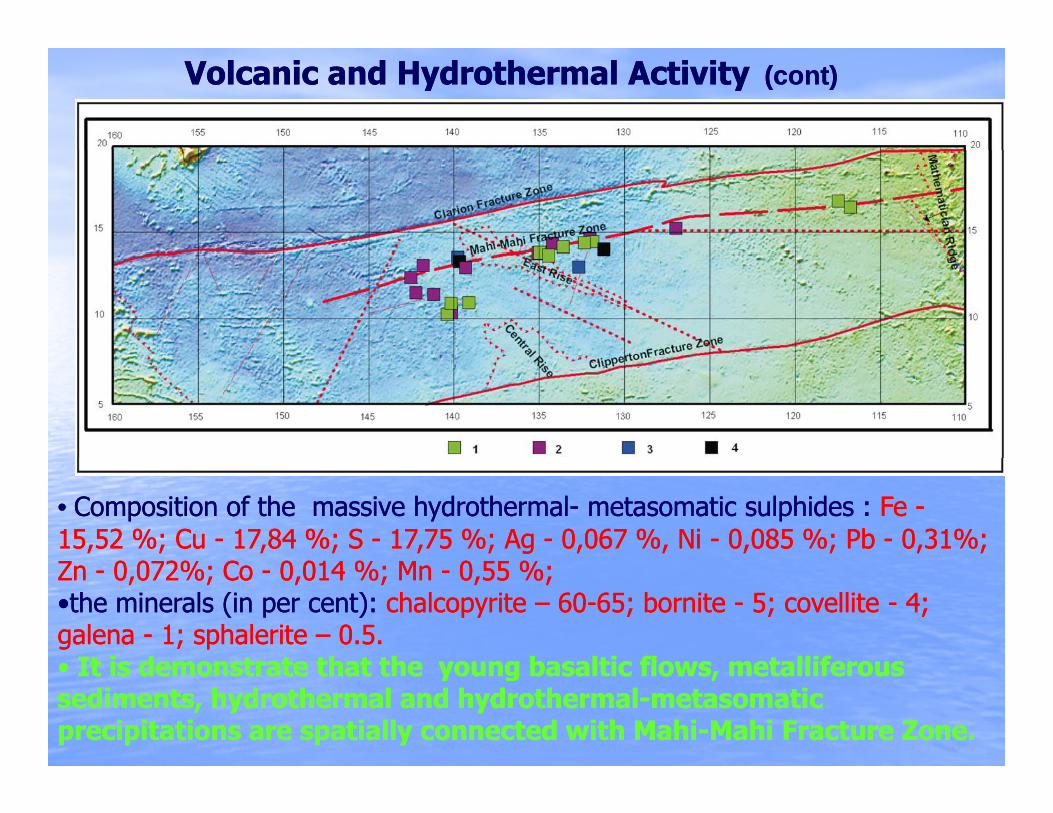
•• Composition of the massive hydrothermalComposition of the massive hydrothermal-- metasomatic sulphides : metasomatic sulphides : Fe Fe --15,52 %; Cu 15,52 %; Cu -- 17,84 %; S 17,84 %; S -- 17,75 %; Ag 17,75 %; Ag -- 0,067 %, Ni 0,067 %, Ni -- 0,085 %; Pb 0,085 %; Pb -- 0,31%; 0,31%;
22Zn Zn -- 0,072%; Co 0,072%; Co -- 0,014 %; Mn 0,014 %; Mn -- 0,55 %;0,55 %;••the minerals (in per cent): the minerals (in per cent): chalcopyrite chalcopyrite –– 6060--65; bornite 65; bornite -- 5; covellite 5; covellite -- 4; 4; galena galena -- 1; sphalerite 1; sphalerite –– 0.5.0.5.•• It is demonstrate that the young basaltic flows metalliferousIt is demonstrate that the young basaltic flows metalliferous•• It is demonstrate that the young basaltic flows, metalliferous It is demonstrate that the young basaltic flows, metalliferous sediments, hydrothermal and hydrothermalsediments, hydrothermal and hydrothermal--metasomatic metasomatic precipitations are spatially connected with Mahiprecipitations are spatially connected with Mahi--Mahi Fracture Zone. Mahi Fracture Zone.
SEDIMENTS SEDIMENTS ••The sedimentary cover consists of: The sedimentary cover consists of: carbonatescarbonates (e.g. carbonate oozes), red (e.g. carbonate oozes), red b l db l d iliili di t ( ili d ilidi t ( ili d ili illillbrown clays, and brown clays, and siliceous siliceous sediments (siliceous oozes, and siliceoussediments (siliceous oozes, and siliceous--argillaceous argillaceous oozes); oozes);
•• Mixtures of these endMixtures of these end--members dominate the seabed in the CCZ and persistmembers dominate the seabed in the CCZ and persist•• Mixtures of these endMixtures of these end--members dominate the seabed in the CCZ and persist members dominate the seabed in the CCZ and persist in nearly every setting, except where high rates of erosion, volcanic activity or in nearly every setting, except where high rates of erosion, volcanic activity or other anomalous conditions occur. other anomalous conditions occur.
•• In general, the sediment lithofacies exhibit a unidirectional gradient trending In general, the sediment lithofacies exhibit a unidirectional gradient trending from predominant carbonate sediments in the southeastern extreme to from predominant carbonate sediments in the southeastern extreme to predominant red brown clays, and siliceouspredominant red brown clays, and siliceous--argillaceous oozes in the westargillaceous oozes in the west--ggnorthwest. northwest.
••ThisThis trendtrend occursoccurs despitedespite thethe largelarge differencesdifferences inin crustalcrustal ageage thatthat occuroccur fromfromdd b l db l d hh ll ff llll ffEastEast toto WestWest andand isis believedbelieved toto thethe culminationculmination ofof twotwo controllingcontrolling factorsfactors::
•• the norththe north--south gradient of primary productivity, decreasing to the south gradient of primary productivity, decreasing to the north (Morgan, 2009), north (Morgan, 2009),
•• and the basic, tectonically controlled increase in water depth and the basic, tectonically controlled increase in water depth with with distance from the EPR (Sclater, Anderson, and Bell distance from the EPR (Sclater, Anderson, and Bell 1971)1971)

SEDIMENTS SEDIMENTS Distribution of the surficial sedimentsDistribution of the surficial sediments By Yubko, Kotliński, 2009
1. Red Clay; 2 - Argillaceous-Siliceous Ooze; 3 - Siliceous-Argillaceous Ooze; 4 - Calcareous Ooze; 5 - Hawaiian ash fall
The eastThe east--west increase in water depth favor the persistence of siliceous west increase in water depth favor the persistence of siliceous sediments, since carbonate minerals become more and more soluble with sediments, since carbonate minerals become more and more soluble with increasing hydrostatic pressure (i.e. increasing water depth). In contrast, the increasing hydrostatic pressure (i.e. increasing water depth). In contrast, the g y p ( g p )g y p ( g p )NorthNorth--South gradient in primary productivity favors higher concentrations of South gradient in primary productivity favors higher concentrations of carbonates, since higher sediment rates can effectively overcome the carbonates, since higher sediment rates can effectively overcome the dissolution rates. dissolution rates.

Scheme of lithostratigraphic units of CCZ
CCD CCD –– the depth and latitude the depth and latitude ppwhere the sediment rate and where the sediment rate and dissolution rate of carbonates dissolution rate of carbonates are equal.are equal.
In this zone facies transition In this zone facies transition from primarily siliceous from primarily siliceous
di t t i ildi t t i ilsediments to primarily sediments to primarily carbonate sedimentcarbonate sediment ;;
In the middle latitudes of theIn the middle latitudes of theIn the middle latitudes of the In the middle latitudes of the CCZ (10CCZ (10°° --12.512.5°° N) this N) this transition occurs transition occurs ~~ 110110°° --115115°° W. Moving westward atW. Moving westward at115115 W. Moving westward at W. Moving westward at this latitude, the transition this latitude, the transition occurs in successively older occurs in successively older sediments, i.e. Miocene at sediments, i.e. Miocene at
based on ISA data, Kotliński, 2009
,,120120°°--125125°° W and Oligocene at W and Oligocene at 135135°°-- 140140°°WW

Structure and lithology of sediment cover
Primers of angular and stratigraphic discontinues bitewing Oligocene and Primers of angular and stratigraphic discontinues bitewing Oligocene and Middle MioceneMiddle Miocene--Quarter sedimentary complexes (EastQuarter sedimentary complexes (East--West acoustic profiles West acoustic profiles near 13º50' N, 131º27' W (upper picture) and 13º41' N, 131º42' W (lowernear 13º50' N, 131º27' W (upper picture) and 13º41' N, 131º42' W (lowernear 13 50 N, 131 27 W (upper picture) and 13 41 N, 131 42 W (lower near 13 50 N, 131 27 W (upper picture) and 13 41 N, 131 42 W (lower picture) ). Yellow line picture) ). Yellow line -- position of Middle Miocene erosion surface. Green position of Middle Miocene erosion surface. Green line line -- position of basement surface. position of basement surface.
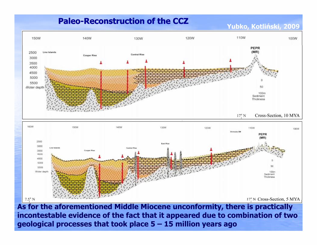
Yubko, Kotliński, 2009PaleoPaleo--ReconstructionReconstruction ofof thethe CCZCCZ
As for the aforementioned Middle Miocene unconformity, there is practically incontestable evidence of the fact that it appeared due to combination of two geological processes that took place 5 – 15 million years ago

POLYMETALLIC NODULESPOLYMETALLIC NODULES
AnalysisAnalysis ofof thethe spatialspatial distributiondistribution ofof nodulenodule abundanceabundance andand metalmetalt tit ti tt i li l lili ff ii b db d th tth t iiconcentrationconcentration suggestssuggests anan axialaxial lineline ofof maximummaximum abundanceabundance thatthat isis
approximatelyapproximately parallelparallel toto andand midwaymidway betweenbetween thethe boundingbounding fracturefracture zoneszones
1 - Northern facies; 2 - Central facies; 3 - Southern facies; 4 - Mahi-Mahi Fracture Zone; 5 - Hydrothermal deposits;Thick black dashed line - Axial line of maximum nodule abundance
The spatial distribution of polymetallic nodules in the CCZ can be classified into three distinct zones.

POLYMETALLIC NODULES (cont.)
Yubko, Kotliński, 2009Mn/ Fe Ratios in the CCZ Mn/ Fe Ratios in the CCZ
The Mn/Fe ratio clearly increases from northThe Mn/Fe ratio clearly increases from north--south, while, less south, while, less distinct decreases from east to westdistinct decreases from east to westdistinct, decreases from east to west.distinct, decreases from east to west.

Classification and characteristics of the types of nodules in CCZClassification and characteristics of the types of nodules in CCZ
LithofaciesPelagic red clay,
Siliceous-Argillaceous ooze
Siliceous-Argillaceous ooze,
Argillaceous- Siliceous
Argillaceous- Siliceous ooze,Siliceous oozeooze ooze Siliceous ooze
Growth type H HD D
Formation Hydrogenetic Mixed type Diagenetic
Exposed on sediment surface
Exposed and partly sunken in semi liquid layer
Partly sunken in surface sedimentOccurrence surface
extremely low sedimentation rates
in semi-liquid layervery low sedimentation rates,
biogenic activity
in surface sedimentlow sedimentation rates,
biogenic activity
Size (cm) < 4 4 – 8 6 – 12<
Surface shape s s + r r
Dominant morphotype S, P E, T, D, I D, E, I, F
Major Mn minerals
δ MnO2 (vernadite)Prevalence of amorphous phase (enriched in Fe,Co)
7Å Manganate (birnessite)>10Å Manganate (todorokite)
Amorphous and crystalline phases
10Å Manganate (todorokite)>7Å Manganate (birnessite)Prevalence of crystalline phase
(enriched in Mn, Cu+Ni)
Mn/Fe < 3 3 – 5 >5
Abundance On average – relatively low On average – relatively higher
Nucleus typeMultinucleat,
more seldom volcanoclasticLithified sediments (clayey zeolitic) fragments of older nodules, Nucleus type more seldom volcanoclastic
debris or bioclasts(clayey-zeolitic),
bioclasts
g ,micronodules
Lamination - prevailing lamina thickness (mm) 0.1-1.0 0.1-2.0 >1.0
Texture columnar dendritic, concentric banding concentric banding, dentritic massivedentritic, massive
Physical properties:-volume density (g/cm3)-porosity (%)-water content (nat.) (%)
1.975931
1.946132
1.93-1.956232
Yubko, Kotliński, 2009Yubko, Kotliński, 2009
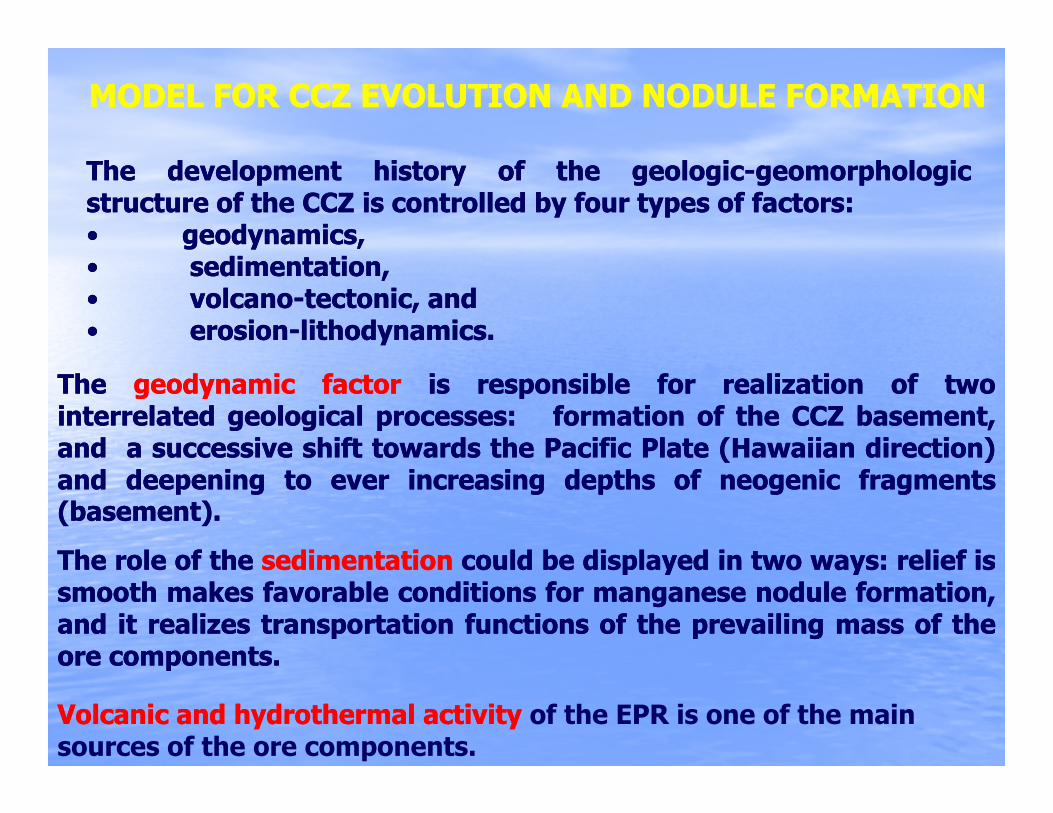
MODEL FOR CCZ EVOLUTION AND NODULE FORMATIONMODEL FOR CCZ EVOLUTION AND NODULE FORMATION
TheThe developmentdevelopment historyhistory ofof thethe geologicgeologic--geomorphologicgeomorphologicstructurestructure ofof thethe CCZCCZ isis controlledcontrolled byby fourfour typestypes ofof factorsfactors::•• geodynamics,geodynamics,•• sedimentation,sedimentation,•• volcanovolcano--tectonic,tectonic, andand•• erosionerosion--lithodynamicslithodynamics..
TheThe geodynamicgeodynamic factorfactor isis responsibleresponsible forfor realizationrealization ofof twotwointerrelatedinterrelated geologicalgeological processesprocesses:: formationformation ofof thethe CCZCCZ basement,basement,andand aa successivesuccessive shiftshift towardstowards thethe PacificPacific PlatePlate (Hawaiian(Hawaiian direction)direction)(( ))andand deepeningdeepening toto everever increasingincreasing depthsdepths ofof neogenicneogenic fragmentsfragments(basement)(basement)..
TheThe rolerole ofof thethe sedimentationsedimentation couldcould bebe displayeddisplayed inin twotwo waysways:: reliefrelief isisTheThe rolerole ofof thethe sedimentationsedimentation couldcould bebe displayeddisplayed inin twotwo waysways:: reliefrelief isissmoothsmooth makesmakes favorablefavorable conditionsconditions forfor manganesemanganese nodulenodule formation,formation,andand itit realizesrealizes transportationtransportation functionsfunctions ofof thethe prevailingprevailing massmass ofof thetheoreore componentscomponents..
Volcanic and hydrothermal activityVolcanic and hydrothermal activity of the EPR is one of the main sources of the ore components.
oreore componentscomponents..
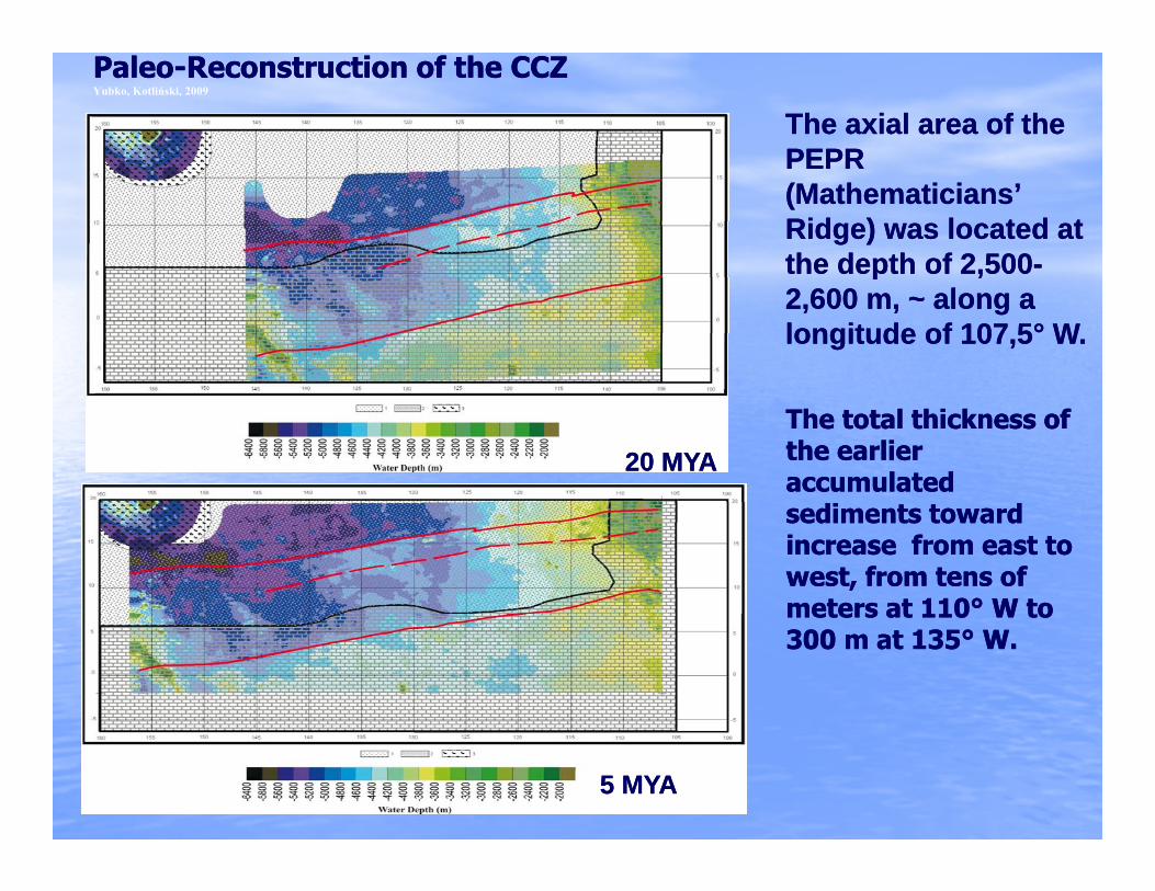
PaleoPaleo--Reconstruction of the CCZReconstruction of the CCZYubko, Kotliński, 2009
The axial area of the The axial area of the PEPRPEPRPEPR PEPR (Mathematicians’ (Mathematicians’ Ridge) was located at Ridge) was located at the depth of 2,500the depth of 2,500--p ,p ,2,600 m, 2,600 m, ~~ along a along a longitude of 107,5longitude of 107,5°° W.W.
20 MYA20 MYAThe total thickness of The total thickness of the earlier the earlier accumulated accumulated sediments toward sediments toward increase from east to increase from east to west, from tens of west, from tens of meters at 110meters at 110°° W toW tometers at 110meters at 110 W to W to 300 m at 135300 m at 135°° W.W.
5 MYA5 MYA

• The most notable feature of the geological situation within the The most notable feature of the geological situation within the CCZ during the period of CCZ during the period of 10 10 –– 15 MYA15 MYA is a sharp increase of is a sharp increase of endogenous and exogenous processes, influencing on the endogenous and exogenous processes, influencing on the formation of the current geologic and geomorphologic structure formation of the current geologic and geomorphologic structure of the CCZ.of the CCZ.of the CCZ. of the CCZ.
•• The major geological events, happened within this period, The major geological events, happened within this period, resulted in a new structural and geomorphologic situation of theresulted in a new structural and geomorphologic situation of theresulted in a new structural and geomorphologic situation of the resulted in a new structural and geomorphologic situation of the seafloor, one of the main elements of which is the seafloor, one of the main elements of which is the Middle Middle MioceneMiocene surface of unconformity. All known major nodule surface of unconformity. All known major nodule bearing areas of the CCZ are hosted by these sediments. bearing areas of the CCZ are hosted by these sediments.
•• TheThe 55 –– 10 MYA10 MYA periods was characterized by the gradualperiods was characterized by the gradualThe The 5 5 10 MYA10 MYA periods was characterized by the gradual periods was characterized by the gradual attenuation of these erosional processes, by the stabilization of attenuation of these erosional processes, by the stabilization of the normal sediment accumulation processes. Since, practically, the normal sediment accumulation processes. Since, practically, the whole CCZ is within the zone of formation of the siliceousthe whole CCZ is within the zone of formation of the siliceousthe whole CCZ is within the zone of formation of the siliceousthe whole CCZ is within the zone of formation of the siliceous--argillaceous sediments the postargillaceous sediments the post--erosion sediments have a erosion sediments have a composition that matches the earlier sediments. composition that matches the earlier sediments.

•• During the last 5 million years the process of burial of the During the last 5 million years the process of burial of the postpost--middlemiddle--Miocene relief has been rather steadyMiocene relief has been rather steady . .
•• At the same time, another redistribution type of sediment At the same time, another redistribution type of sediment material is clearly expressed: sediment particles shift to material is clearly expressed: sediment particles shift to y p py p pdepressed bottom sections, contributing to formation of depressed bottom sections, contributing to formation of increased thicknesses of postincreased thicknesses of post--erosional sediments within the erosional sediments within the area of ancient structural and erosion depressionsarea of ancient structural and erosion depressionsarea of ancient structural and erosion depressions.area of ancient structural and erosion depressions.
•• The intraThe intra--plate volcanoplate volcano--tectonic activity of the CCZ has tectonic activity of the CCZ has i h i d h i l l i i h h i di h i d h i l l i i h h i deither remained at the prior level, or it might have increased . either remained at the prior level, or it might have increased .
The recent volcanism of Shimada Seamount is the most The recent volcanism of Shimada Seamount is the most reliable example of this activity. reliable example of this activity. p yp y
•• Thus, during the last 5 million years, both the sediment Thus, during the last 5 million years, both the sediment facies that favor nodule formation and the activities that mayfacies that favor nodule formation and the activities that mayfacies that favor nodule formation and the activities that may facies that favor nodule formation and the activities that may supply additional sources of metals suggest that the deposits supply additional sources of metals suggest that the deposits are currently actively growing. are currently actively growing.

This presentation prepared for ISA Workshop December 2009, based on following papers:, g p p
Volcanic, tectonic, and sedimentary factors, - V. Yubko and R. Kotliński
Nodule coverage, morphology &distribution in the t CCZ V St d R K tliń kieastern CCZ - V. Stoyanova and R. Kotliński
Sediments in the Eastern CCZ - R. KotlińskiSediments in the Eastern CCZ R. Kotliński
THANK YOUTHANK YOUTHANK YOUTHANK YOU