Editor’s Note: Some of this article is excerpted from ...
16
1 Published quarterly by THE CANAL SOCIETY OF OHIO, INC. Single Copy: $2.50 Address: c/o Towpaths Staff, 550 Copley Road, Akron, OH, 44320-2398 Ron Petrie, Editor; Bill Oeters, Asst. Ed.; Mike Morthorst, Newsletter E-mail address: [email protected] ISSN 0890-7129 Vol. LVI 2018 No. 1 THE SIX-MILE DAM By Terry K. Woods Editor’s Note: Some of this article is excerpted from TWENTY FIVE MILES TO NOWHERE, Terry K. Woods, Roscoe Village Foundation, 1991. Pgs. 27-28. The one crossing of the Wahonding River by the canal of the same name in Ohio was accomplished upon slackwater above a dam constructed for that purpose and to supply the canal with feed water. This dam was located six miles above Roscoe in Coshocton County. When completed it was 304 feet long and 4 ½ feet above the surface of the stream at low water. The dam’s foundation was anchored to solid rock for about half its length, extending from the right bank of the river. The rest of the foundation was composed of successive layers of felled trees laid on the bottom of the river with their tops pointing upstream. Stringers, long
Transcript of Editor’s Note: Some of this article is excerpted from ...

1
Published quarterly by THE CANAL SOCIETY OF OHIO, INC. Single Copy: $2.50
Address: c/o Towpaths Staff, 550 Copley Road, Akron, OH, 44320-2398 Ron Petrie, Editor; Bill Oeters, Asst. Ed.; Mike Morthorst, Newsletter
E-mail address: [email protected] ISSN 0890-7129 Vol. LVI 2018 No. 1
THE SIX-MILE DAM
By Terry K. Woods
Editor’s Note: Some of this article is excerpted from TWENTY FIVE MILES TO NOWHERE, Terry K. Woods,
Roscoe Village Foundation, 1991. Pgs. 27-28.
The one crossing of the Wahonding River by the canal of the same name in Ohio was accomplished upon slackwater above a dam constructed for that purpose and to supply the canal with feed water. This dam was located six miles above Roscoe in Coshocton County. When completed it was 304 feet long and 4 ½ feet above the surface of the stream at low water.
The dam’s foundation was anchored to solid rock for about half its length, extending from the right bank of the river. The rest of the foundation was composed of successive layers of felled trees laid on the bottom of the river with their tops pointing upstream. Stringers, long
2
squared timbers, were then firmly bolted to the rock and tree base, forming an apron for the dam. A twelve-foot-wide crib, built of squared timbers tied together by cross-members every ten feet, was placed on top of the apron. The crib was filled with stone and covered with four-inch planking. This last woodwork formed the breast, or “tumble” of the dam.
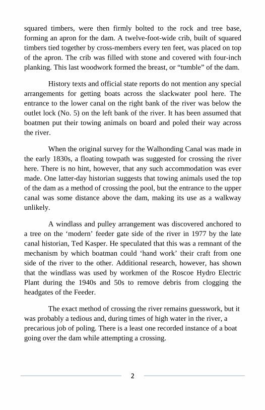
History texts and official state reports do not mention any special arrangements for getting boats across the slackwater pool here. The entrance to the lower canal on the right bank of the river was below the outlet lock (No. 5) on the left bank of the river. It has been assumed that boatmen put their towing animals on board and poled their way across the river.
When the original survey for the Walhonding Canal was made in the early 1830s, a floating towpath was suggested for crossing the river here. There is no hint, however, that any such accommodation was ever made. One latter-day historian suggests that towing animals used the top of the dam as a method of crossing the pool, but the entrance to the upper canal was some distance above the dam, making its use as a walkway unlikely.
A windlass and pulley arrangement was discovered anchored to a tree on the ‘modern’ feeder gate side of the river in 1977 by the late canal historian, Ted Kasper. He speculated that this was a remnant of the mechanism by which boatman could ‘hand work’ their craft from one side of the river to the other. Additional research, however, has shown that the windlass was used by workmen of the Roscoe Hydro Electric Plant during the 1940s and 50s to remove debris from clogging the headgates of the Feeder.
The exact method of crossing the river remains guesswork, but it was probably a tedious and, during times of high water in the river, a precarious job of poling. There is a least one recorded instance of a boat going over the dam while attempting a crossing.
3
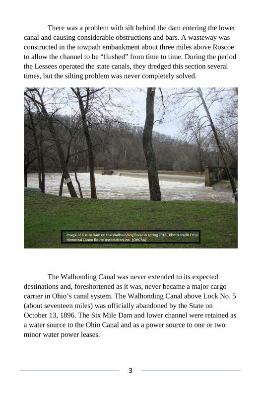
There was a problem with silt behind the dam entering the lower canal and causing considerable obstructions and bars. A wasteway was constructed in the towpath embankment about three miles above Roscoe to allow the channel to be “flushed” from time to time. During the period the Lessees operated the state canals, they dredged this section several times, but the silting problem was never completely solved.
The Walhonding Canal was never extended to its expected destinations and, foreshortened as it was, never became a major cargo carrier in Ohio’s canal system. The Walhonding Canal above Lock No. 5 (about seventeen miles) was officially abandoned by the State on October 13, 1896. The Six Mile Dam and lower channel were retained as a water source to the Ohio Canal and as a power source to one or two minor water power leases.

4
In 1904 the State Legislature made an initial appropriation of $200,000 to refurbish their canal system. Eventually, the Miami & Erie Canal was to be reworked (with repaired structures and a deepened channel) and the Ohio & Erie was to have similar work done from Cleveland to Dresden. The Federal Improvement of the Muskingum River was to be used to allow canal boats to reach the Ohio.
There was, however, a stipulation to the appropriation. The appropriation was only to be activated when the State’s canal water power leases were increased from the 1904 level of approximately $12,000 state-wide, to at least $30,000 per year.
At first, the six-mile remnant of the Walhonding Canal wasn’t to be a part of this massive project. Then, on June 13, 1906, William Himebaugh of Coshocton, entered into a 50-year lease with the State of

5
Ohio at a yearly payment of $2,500 for the first 25 years and $3,000 per year for the last 25. Heimebaugh planned to build a hydro-electric plant to supply electricity for the city of Coshocton.
To satisfy the State’s duties under the new lease, the old canal channel was to be dredged to a minimum depth of five feet with a minimum width of 30 feet. The State was also to insure the ‘permanent’ stability of the Six Mile Dam.
The left dam embankment had been repaired in 1904 and a new rip-rap and cut stone wall erected in front of it in addition to a new crib at that end of the dam. All that remained to put the Six Mile Dam in tip-top shape was to go over the breast and apron woodwork to prevent leaks and insure the dam’s permanence. The State’s Resident Canal Engineer, J.A. Hanlon, took the letter of the lease literally. He decided he had to provide a permanent dam.
That portion of the dam originally constructed on a wooden crib had been undercut by the river over the years and its position had shifted somewhat. Hanlon and his engineering staff feared that a future flood could well cut the dam in half. When Hanlon advertised for bids for the project, he asked for bids for both repairing the old dam and for constructing a new concrete one using the old dam as a base, as well as for dredging the six-mile-long channel.
Four companies responded with proposals before the July 19, 1906 deadline. The J. A. Kissner Company of West Lafayette, Ohio received the contract for the dredging operation on August 19, 1906. Picking a contractor for the dam, or even deciding what should be done to the dam, was more difficult.
By the time the bids were received, Hanlon was just about convinced that an entirely new dam was required. The location he favored was 60 yards above the old dam, at a point where the entire structure could be anchored to solid rock. Bids for the dam were re-
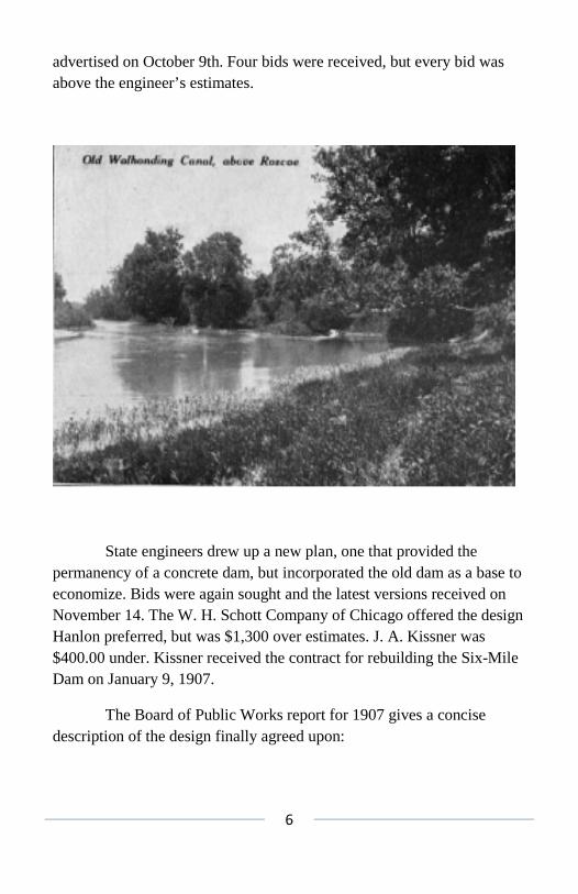
6
advertised on October 9th. Four bids were received, but every bid was above the engineer’s estimates.
State engineers drew up a new plan, one that provided the permanency of a concrete dam, but incorporated the old dam as a base to economize. Bids were again sought and the latest versions received on November 14. The W. H. Schott Company of Chicago offered the design Hanlon preferred, but was $1,300 over estimates. J. A. Kissner was $400.00 under. Kissner received the contract for rebuilding the Six-Mile Dam on January 9, 1907.
The Board of Public Works report for 1907 gives a concise description of the design finally agreed upon:

7
“Plans were prepared in this office after thorough surveys as to the choice of location, and a design adopted which incorporated the old structure as part of the new – the new concrete work being built against, and on the down-stream side and over the top of the old dam, both old and new anchored together as well as anchored to the rock bottom as far as the rock extends within reach and further, by anchoring to a pile foundation. This plan provides for a very substantial and permanent structure with the minimum amount of concrete masonry possible to insure stability and overcome the defects of the old dam.”
High water in March of 1907 washed out the earthen embankment between the river and canal immediately below the dam for nearly 200 feet. Rebuilding this embankment would have required hauling fill over half a mile in wagons. The rebuilt earthen embankment then would have been just as subject to washouts as the original. The decision was made to extend the right concrete dam abutment of the new dam some 300 feet down the river bank to act as a protective wall. This was probably an excellent decision, but added $7,000 to the cost of improving the Walhonding Feeder. A decision was made in July of 1908 to extend the dam 22 feet to its left and add another 12 feet to its right. This made the new Dam 344 feet long.
The improvements to the Walhonding Feeder were accepted on October 1, 1908. The Himebaugh lease went into effect on April 1, 1909. William Himebaugh made his first payment of $1,250, in cash, on May 1, 1909.
The new dam complex had cost the State a total of $39,719, nearly $16,000 over estimate. The entire cost of refurbishing the Walhondiung Feeder cost the State $63,738.78. Himebaugh reimbursed the State $5,000 toward the cost of the new dam and $1,300 toward the cost of dredging the channel, Thus it would take the State 24 years to recoup from the water power lease, alone.

8
And that would be the main income from that stretch of canal the State would ever see. After that, public opinion turned against the canals. No appropriations were made after 1909 and improvements to Ohio’s State Canals were halted. With the exception of the three locks into the Muskingum River at Dresden, which had been contracted in 1905, the modernization of the Ohio Canal was only completed as far south as Lower Trenton (Lock 16) just below modern-day Tuscarawas. This was north of the coal fields where the bulk of canal traffic originated. Long distance commercial traffic never again ran on the Ohio canal.
State canal workers removed the rickety Walhonding Aqueduct in 1912, effectively isolating the Roscoe/Coshocton area from the upper canal. After that, the Walhonding Feeder was needed only to power the Electrical Generating Plant, the Empire Mill at Roscoe, and a mill further down the main canal. Then, in March of 1913, many of the newly rebuilt

9
structures along the upper canal were destroyed in a devastating flood. The Six-Mile Dam was badly damaged in the 1913 flood. Repairs were made to the dam relatively quickly as Ohio Senator William Green fostered a $10,000 State appropriation.
The river had also cut across the old canal channel above Lock 5 and threatened to bypass the dam to the left. That section of canal had been sold by the State in 1898 for $57.50. It was purchased back on March 6, 1916 from Gilbert McKee (that parcel had changed hands twice in the intervening years) for $1,758.17! That same year a long stretch of levee was constructed off to the left, parallel to the line of the dam, for nearly 3/8 of a mile. The canal’s berm bank was cut down to provide fill for this levee. An additional channel for the river was cut from the new break along the levee to enter into the old channel just above the dam to provide additional flow cross-section during times of flooding. As a result, the remains of Lock 5 and ¼ mile of the old canal’s towpath now lie on an island formed by the old and new river channels which both remain water-filled year round.
The lower Walhonding Canal, or feeder, was still needed to provide power for the Hydro-Electric Plant as William Himebaugh had entered into an agreement with the Coshocton Light and Heating Company on June 11, 1910. The latter took over the water power lease from the State and began operating the hydro plant. The Ohio Power Service Company then took over operation of the hydro and the lease around 1922.
A portion of the cribbing near the left (or north) dam abutment was washed out during the winter of 1934-35. It was repaired with sheet piling and clay backfill later that year. It was found necessary to extend the north wing of the dam and construct a concrete spillway in 1941 when the river wanted to continue its wandering to the north. Then, in 1947, another flood tore out sections of the lower feeder’s embankments. The Ohio Service Company operated the hydro, intermittently, until around 1952 when non-local sources of power made it obsolete.
10
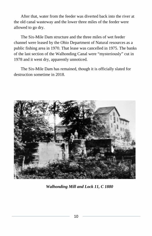
After that, water from the feeder was diverted back into the river at the old canal wasteway and the lower three miles of the feeder were allowed to go dry.
The Six-Mile Dam structure and the three miles of wet feeder channel were leased by the Ohio Department of Natural resources as a public fishing area in 1970. That lease was cancelled in 1975. The banks of the last section of the Walhonding Canal were “mysteriously” cut in 1978 and it went dry, apparently unnoticed.
The Six-Mile Dam has remained, though it is officially slated for destruction sometime in 2018.
Walhonding Mill and Lock 11, C 1880

11
Sawmill at Warsaw, C 1880
Walhonding Mill, C 1900
12
THE ROSCOE HYDRAULIC PLANT
By Terry K. Woods
Editor’s Note: This article first appeared in AMERICAN CANALS, Summer 2001, Pgs. 6&7.
The author acknowledges assistance from the late Ruth Norton, former Historian of the Roscoe Village Foundation.
The easternmost six miles of the Walhonding Canal survived the rest of the Ohio & Erie system by more than 40 years, thanks to the Roscoe Hydraulic Plant. After 1896, when the upper, or western, portion of the Walhonding Canal was abandoned by the state of Ohio, that stretch from the Six-Mile Dam across the Walhonding River to Roscoe Basin acted only as a water feeder to the main canal and as a hydraulic power source to industry at the head of the basin.
As early as 1902 or 1903, William Himebaugh of Coshocton entered into an agreement with the State of Ohio. For $50.00 per year, Himebaugh purchased an unspecified amount of power from the Walhonding Canal. Or perhaps he purchased the rights of future power options – for in 1906, the agreement was altered to a yearly rental for 25 years at an annual payment of $2,500. The agreement was also to extend for an additional 25 years at an annual payment of $3,000. The State’s portion of the agreement was to include the rebuilding of the Six-Mile Feeder Dam in the Walhonding River and dredging the canal channel below. The new dam and deepened channel were completed in 1909. Himebaugh made his first semi-annual payment of $1,250 on May 30, 1910.
13
The Ohio Light and Heating Company, incorporated under the laws of New Jersey in 1888, purchased Himebaugh’s water rights that same year. A new, modern hydro-electric generating plant was constructed a quarter mile above the old Empire Mill at the head of the Roscoe Basin. Powered by water supplied by the rebuilt Six-Mile Dam flowing through the channel of the shortened Walhonding Canal, the “Hydro”, as it became popularly known, began supplying the electrical needs to many citizens in and around Coshocton beginning in 1912. The Company later changed its name to the Ohio Service Company and it was bought out by the Ohio Power Company in 1923.
The power requirements for the area increased rapidly in the 30s and early 40s, but the Hydro’s power generating capacity, which peaked at 22,000Kw of electricity, was still sufficient just prior to the outbreak of the Second World War, to carry the entire city of Coshocton on the midnight shift. After the war the Hydro served only as a voltage regulator, and didn’t generate any electricity of its own.
During its heyday the Hydro normally ran two shifts, eight to four and four to twelve. A normal shift employed four men plus a stand-by, although as many as twelve men were required one winter to chop ice and remove it from the plant’s water intake.
Water from the old canal channel entered a pit that drove an under-shot turbine wheel. The shaft of the turbine wheel alone weighed ten tons. This shaft turned in wooden bearings immersed in oil. The oil was water-cooled, filtered and re-used. These bearings had to be replaced only once in the last ten years of the plant’s life.
Though the State of Ohio, through the Department of Public Works, maintained the Six-Mile Dam and shortened canal channel, the responsibility of ensuring a day-to-day supply of water fell upon the crew of the Hydro. They patrolled the banks of the feeder, cut the grass in the channel, and cleared brush and other floating debris away from the three iron head-gates at the dam. A manually operated winch was

14
attached to a nearby elm tree just above the head- gates. When those gates got clogged and the water supply was threatened, several members of the Hydro crew would go onto the concrete head-gate supports and drop grappling hooks down into the mass clogging the gates. When a hook caught on something, the brush would be winched back, away from the head-gates Then, with the use of pike poles, the men would push the brush away from the feeder gates and back into the river to go over the dam and downstream away from the feeder.
It was also the responsibility of the Hydro crew to ensure the head-gates were closed during times of high water in the river. Once, in 1947, this wasn’t done and the resulting high water in the feeder channel overflowed, tearing out great sections of the embankment. Those embankments were repaired after that incident, but by that time the Hydro was no longer of great importance to the electrical needs of the area. The plant remained in operation a few more years, but when the Hydro was shut down after its normal four to midnight shift on January 10, 1952, it never operated again.
The generating plant itself was razed in 1961 to make way for the rerouting of State Route 36 to Warsaw. The Ohio Power Company donated 14 acres immediately north and west of the Roscoe Basin to the City of Coshocton in the 1960s as part of the Lake Park Expansion.
A scattered pile of broken concrete lying between Highway 36 and the Walhonding River, plus a small section of the concrete tail race jutting out of the highway fill were the only visible remains of the Roscoe Hydraulic Plant by the year 2000.
Water diverted by the Six Mile Dam into the feeder channel was shunted back into the river at Hosfelt’s Wasteway some three miles above the Roscoe Basin. That three-mile section of the old Walhonding Canal between the dam sand the wasteway was administered by the Ohio Board of Public Works through the 1960s. Ohio’s Division of Wildlife, Department of Natural Resources leased the remaining watered portion
15
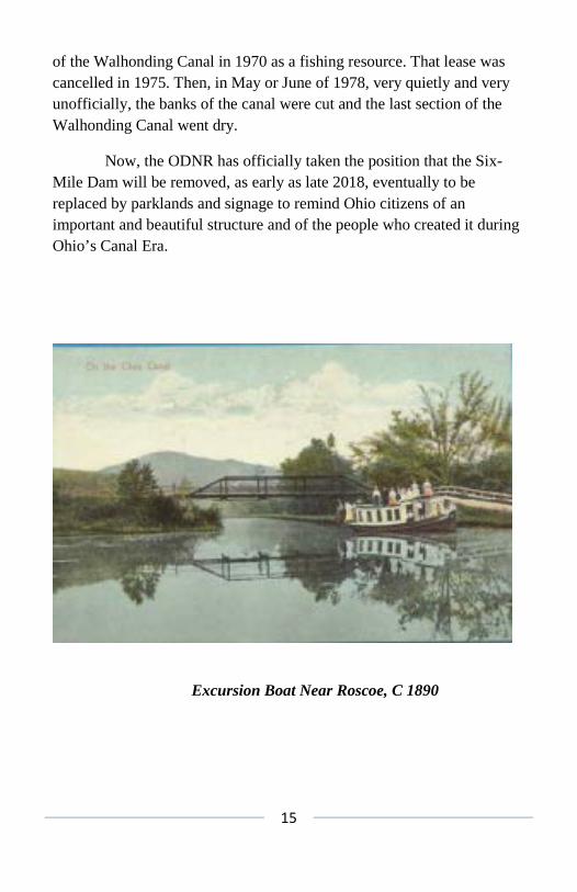
of the Walhonding Canal in 1970 as a fishing resource. That lease was cancelled in 1975. Then, in May or June of 1978, very quietly and very unofficially, the banks of the canal were cut and the last section of the Walhonding Canal went dry.
Now, the ODNR has officially taken the position that the Six-Mile Dam will be removed, as early as late 2018, eventually to be replaced by parklands and signage to remind Ohio citizens of an important and beautiful structure and of the people who created it during Ohio’s Canal Era.
Excursion Boat Near Roscoe, C 1890
16
Towpaths is published quarterly by The Canal Society of Ohio, Inc. Contributions of articles related to Ohio’s canal history are welcome. Please send articles attached as a word processing file to the e-mail address on the title page. Hard copies sent to the address on the title page are also accepted. Provide sources of information and dates of maps, photographs and documents. Membership in The Canal Society of Ohio includes subscription to Towpaths and the quarterly Newsletter. For information write: Corresponding Secretary, Canal Society of Ohio, 550 Copley Road, Akron OH 44320-2398. Single copies of Towpaths may be ordered at $2.50 per issue.