Easy Countryside Trails - West Sussex County Council: Home
36
Easy Countryside Trails in West Sussex Routes suitable for all including wheelchair and pushchair users, families and less mobile people.
Transcript of Easy Countryside Trails - West Sussex County Council: Home

Easy Countryside Trailsin West Sussex
Routes suitable for all including wheelchair and pushchair users, families and less mobile people.

FOREWORD
When I was diagnosed as having multiple sclerosis one of the worst thoughts was that someday I may not be able to go for a good tramp in the country. Consequently I started feverishly walking everywhere I could, here in West Sussex or away on holiday. When Tessa, my Labrador, came into my life, she and I, and my husband at weekends, covered as much ground as possible. The county of West Sussex must be able to claim as many public footpaths as any other, and over such varied landscapes. Gradually however, my walks became less and less until eventually I decided I would have to take to the wheelchair and see what we could achieve.
It is now more than twelve years since
I wrote the introduction for the first
booklet (then titled ‘Wheelchair Walks’),
having helped the County Council publish
it, and we do still continue to enjoy these
walks. However I am also pleased to say
that so much has changed since then to
make the countryside more accessible,
such as removing some barriers such as
stiles, so we now have more choice. I do
hope that others will be as pleased as I
was to find that it is indeed still possible
to reach so many beautiful spots in a
wheelchair and enjoy a real ‘walk in the
country’.
Jenifer Fox
Stansted, Rowlands Castle
© Ja
ne N
oble
/WSC
C

INTRODUCTION
Thanks to the initial inspiration from
John and Jenifer Fox these walks
may be enjoyed by all, including
wheelchair users, families with
pushchairs, those wanting a more
gentle walk and walkers who are
less mobile. It contains most of the
original walks researched by Jenifer
Fox plus three additional new walks.
They are for people who want to get out
into the countryside to enjoy a ‘real’ walk,
not just a short stretch to a lovely view
or a walk along pavements. The routes
in this booklet offer opportunities to get
further away from the car parks into the
woods, downs or coast of West Sussex.
These routes have no barriers, such as
stiles or steps. Some are designated easy
access trails while others use existing
rights of way, and may not be surfaced.
Detailed information on the routes is
provided for each walk - some are more
challenging than others and it is up to the
user to decide what is suitable for them.
Every effort has been made to ensure
the information is correct at the time
of publication, however things change
over time. We welcome feedback on the
booklet/routes; details of how to do this are
at the end of the booklet. We would also
like your suggestions on routes that are
suitable to promote as easy access trails.
These walks are also available to down
load individually from West Sussex
County Council’s website;
www.westsussex.gov.uk
USEFUL INFORMATION
Toilets for the disabled
Toilets for disabled people are often locked, using RADAR keys, to reduce vandalism. RADAR keys are available from District/Borough Councils or directly from RADAR:
RADAR, 12 City Forum, 250 City Road, London, EC1V 8AF
Telephone 020 7250 3222
Fax 020 7250 0212
Minicom 020 7250 4119
Email [email protected]
Website www.radar.org.uk
Public Transport
If you wish to use public transport please visit www.westsussex.gov.uk or contact Traveline on 0871 200 22 33 (7am – 10pm, 7 days/week) for information on bus, train and coach times.
Train stations and bus stops have been identified in the walk information if they are within easy access of the start of the walk.
Cover Image: Graffham © WSCC/PPL

INTRODUCTION
Blue Badges; disabled parking scheme
The Disabled Badge Car Scheme (Blue Badge) provides parking concessions for people with disabilities. For further details contact:
The Blue Badge SectionWest Sussex County Council The Grange, Tower StreetChichester, West Sussex PO19 1QT
Telephone: 01243 777653Email: [email protected]: www.westsussex.gov.uk
See also the Department for Transport web pages: www.dft.gov.uk/transportforyou/access/bluebadge
Countryside Code
Please follow the Countryside Code:
Be safe, plan •ahead and follow any signs
Leave gates and •property as you find them
Protect plants and animals and take •your litter home
Keep dogs under close control•
Consider other people•
Other easy access walks
Other organisations promote easy access routes in West Sussex and in neighbouring counties. Contacts for these can be found at the end of this
booklet.
Gradients
16
12
8
1
1
1
1:16
1:12
1:8
Gradients of slopes have been shown on the maps to help you decide if a route is suitable. Imagine a path with a slope that has a gradient of 1:8. This means that for every 8 units (say metres) along the path, the path will rise or fall by 1 unit (1 metre). A gradient of 1:8 would therefore be steeper than 1:16.
Some people may find it hard to relate to these gradients so we have attempted to describe them below assuming an average wheelchair user with an averagely strong pusher.
1:16Gentle slope. Extra effort may be required over long distances. Gradients less than 1:16 have not been measured as they are considered easy going.
1:16 – 1:13Fairly gentle slope, extra effort will be noticeable over longer distances.
1:12Slope noticeable but not particularly steep, extra effort will be required over medium to long distances.
1:11 – 1:8Steeper slopes, will require extra effort even over short distances. Only short sections of gradients of this steepness are found on any of the routes in this booklet.
> 1:8Steep slope – nothing of this steepness will be encountered on these walks.

INTRODUCTION
Key to maps
Easy Access Trail
Extension to Easy Access Trail
Permissive Path
Parking
Gradient Information1:1335m
Church
Seating or Picnic Area
Caravan Park
Gate
Marshland
Waterway/Water Channel
Urban/Built-up Area
River/Stream/Canal
Refreshments
Parkland/Wooded Area
Public Footpath or Bridleway
Chichester Canal
© W
SCC
/PPL

This is an interesting walk at all times of the year but being tarmac is particularly good for one of those lovely winter days when other paths may be too muddy to enjoy. This circular walk can be done either way, however here the route is described travelling anti-clockwise (along the northern side first).
After leaving the car park and passing through the barrier, there is an accessible bird hide on your right overlooking some fresh water. The path continues along the edge of the marina down to the harbour side passing the boat berths. The route continues around the marina but to explore the Harbour further you could take the path northwards alongside Salterns Copse up to Dell Quay, on part of the Salterns Way Cycleway; this can be a little bumpy in places. For further information contact Chichester Harbour Conservancy, contact details are in the back of this booklet.
To continue on the walk turn left at the path junction and cross the lock; you may have to wait a short while as boats travel through, but it is always interesting
1 CHICHESTER MARINA
Distance 1.9km (1.2 miles) round trip. Extension to Birdham Pool extra 1.3km (0.8 miles) return trip
Terrain Tarmac Maximum gradient: <1:16, level
Start/finish Public car park on the right at the entrance to the Chichester Marina Grid reference: SU 835 010 Post code: PO20 7EJ
Directions Approximately 5 km (3 miles) south of Chichester, the Marina is clearly signposted from the A286 Chichester to Wittering road
O.S. Maps Explorer 120, Landranger 197
Public Transport Bus stop: Chichester Marina (near car park - unmarked)
Points of interest Boats, coastal views
Facilities Bird hide, seats, café (open every day except Christmas Day) with disabled toilet
Chichester Marina
© K
athe
rine
Eels
/WSC
C

to watch. At the far end of the marina, a short way past the lock, there are some seats that overlook the water. This is a delightful place to stop; if you are very lucky you may spot one of the harbour seals nearby on the mud. The path now turns back inland taking you along the side of the Chichester Canal, where a few houseboats are moored.
To make the walk longer, after a short distance cross the canal at Egremont Bridge, follow the path for nearly 200m
and turn right along Lock Lane through to Birdham Pool. Birdham Pool was originally developed in the late 1930’s from one of the last working tidal mill pools in Sussex and was probably the first purpose built marina in England. The old mill building still stands with the lock beside it. Retrace your steps to rejoin the main walk.
Continue along side the canal and you will pass by the Spinnaker Café, from here it is less than 400m back to the car park.
1CHICHESTER MARINA
Chichester Marina
SalternsLock
Chichester Canal (disused)
N
EgremontBridge
(Swing)Spinnaker Café
SalternsCopse
To the A286
Yacht Club
Lock
A286
A286
To Dell Quay
To Birdham Pool
0 250m
Crown
copy
right
. © Al
l righ
ts res
erve
d. W
est S
usse
x Cou
nty C
ounc
il. 10
0023
447.

This route follows a disused railway and is therefore easy to follow and is mostly level. The tarmac surface provides a relatively easy and interesting walk into the countryside. It can be accessed from a number of points although car parking (roadside) can be limited. Some access points can be fairly steep for a relatively short distance. The easiest access point is from the southern end; details above.
The Centurion Way follows the line of the disused Chichester to Midhurst railway line which was opened in 1881 to improve access to London. The railway’s decline started with the withdrawal of passenger services in 1935. The line north of Lavant was closed in 1957, however the section between Lavant and Chichester remained
open and was used to transport sugar beet and gravel until 1991. Two years later the tracks were removed.
The trees and vegetation along the route provide an important corridor for a variety of wildlife and there are a number of sculptures reflecting local history to discover. Several areas are of archaeological importance, such as Brandy Hole Copse and the Devils Ditch, where there is evidence of the Chichester Entrenchments which were Iron Age territorial divisions and/or defences. Brandy Hole Copse is open to the public via a kissing gate (unfortunately not accessible by wheelchairs) from the Centurion Way.
2 CENTURION WAY CHICHESTER TO LAVANT
Distance 4.1km (2.5 miles) one way, 8.2km (5 miles) return trip
Terrain Tarmac. Low level staggered entrance barriers allow access for most wheelchairs Maximum gradient: 1:10 for short section only. The whole route gradually climbs going north. Some entrance points are fairly steep
Start/finish There are a number of entrance points onto the Centurion Way (shown on map). The easiest to use with only minimal gradients is at the southern end off Westgate by Bishop Luffa School, Chichester (limited on-road parking along Westgate). The route can be done in either direction but is described from south (Chichester) to north (Lavant). Parking at the Lavant end is difficult on the residential roads Grid reference: SU 848 047 Post code: PO19 3HR
Directions From the A27 take the A259 (Cathedral Way) signed to Chichester. Pass Tesco and then take the first exit off the roundabout and then the first exit again into Westgate. The entrance on to the Centurion Way is at the back of the lay-by near the end of the road
O.S. Maps Explorer 120, Landranger 197
Public Transport Train station: Chichester 1.5km (0.9 miles) Bus stop: Chichester, Westgate Lavant, Midhurst Road (near St Nicolas Road)
Points of interest Wildlife, views, sculpture and history
Facilities Open area and benches at Hunters Race. The nearest disabled toilets are at Tesco (Cathedral Way), visit Chichester District Council, website www.chichester.gov.uk, for details of others nearby

At the amphitheatre, where the route
meets Hunters Race there is a wide grassy
area which lends itself to a picnic.
This walk ends at Lavant but it is possible
to continue on the Centurion Way up to
West Dean (a further 4.5km/2.8 miles). To
do this head north through the housing estate (it is signed but signs sometimes go missing). The tarmac surface is soon replaced by crushed stone which in places could be difficult to use especially in wet weather. The final section is on a tarmac cycle path which runs parallel to the A286.
2CENTURION WAY CHICHESTER TO LAVANT
1:1310m
B2178Sh
erbo
rne
Rd
Spital�eld Lane
St. Pancras
The Hornet
B2178
A286Hunters Race
Westgate
St Pauls Rd
Broyle Rd
Ring Road A286
A259
A27
A27
A259
Chichester
East LavantMid Lavant
Brandy HoleCopse
Westhampnett
Summersdale
GoodwoodMotor Racing
Circuit
Gravel Pit
Port�eld
5
School
Tesco
College
Cathedral
Hospital
OnStreet
0 1 km
1:104m
1:128m
1:1035m
1:18
1:109m
1:1010m
NTo
WestDean
Crown
copy
right
. © Al
l righ
ts res
erve
d. W
est S
usse
x Cou
nty C
ounc
il. 10
0023
447.

This walk has been made as a circular easy access trail. Even when the Centre is not open it is usually possible to obtain a useful introduction leaflet to Pagham Harbour Local Nature Reserve from a cubby-hole at the Visitor Centre. The area is a wetland of international importance and is of interest in all seasons for flowering plants, butterflies, summer breeding birds and the winter visiting seabirds. It is slightly preferable to do the walk in an anti-clockwise direction,
as described, as it is easier to get through
the gates.
Take the path going south from the car
park. After a short distance there is a
bird hide on the right overlooking the
Ferry Pond. There is good access into this
hide and there is a window at the end
at the right height for wheelchairs. Keen
birdwatchers recognise this as one of the
best spots in Sussex to see birds resting on
their Autumn migration.
3 PAGHAM HARBOUR NATURE RESERVE AND SIDLESHAM QUAY
Distance 3.0km (1.9 miles) return trip (Shorter circuit – 1.1km/0.7 miles)
Terrain Compacted stone, can be bumpy in places Maximum gradient: <1:16, generally level
Start/finish Pagham Harbour Visitor Centre, Selsey Road Grid reference: SZ 856 965 Post code: PO20 7NE
Directions Take the B2145 to Selsey. The turning on the left (if heading south) to Pagham Harbour and Local Nature Reserve car park is approximately 2 km (1.2 miles) south of Sidlesham
O.S. Maps Explorer 120, Landranger 197
Public Transport Bus stop: Pagham Harbour Visitor Centre
Points of interest Wildlife (particularly wintering birds and summer flowers and butterflies), coastal views
Facilities Visitor Centre with displays, information and toilets (disabled access using RADAR key). Bird hides, benches, Crab and Lobster pub (accessible to wheelchairs), Mill Lane, Sidlesham
View over Pagham Harbour©
Kat
herin
e Ee
ls/W
SCC

3PAGHAM HARBOUR NATURE RESERVE AND SIDLESHAM QUAY
Ferry Channel
Ferry Pool
Sels
ey R
oad
(B21
45)
Mill Lane
Information Centre
BirdHide
Nurseries
Nurseries
Nurseries
Ferry Field
BusinessPark
Nurseries
Nurseries
SidleshamQuay
0 250m
N
The next part of this walk follows the track of the old light railway known as the ‘Selsey Tram’, which ran between Chichester and Selsey until 1935. The views are lovely all along the margins of the harbour and on a fine day much time could be spent here, perhaps with a pair of binoculars or just enjoying the atmosphere. There are three well placed seats along the route.
For a short cut take the path to the left which turns inland and back to the car park, otherwise continue straight on, as far as Sidlesham Quay and the attractive
little mill hamlet at the top of Pagham Harbour. The route along to Sidlesham Quay becomes narrow and can be bumpy. It is hard now to imagine that it was once a busy commercial port with what was reputed to be one of the finest mills in the country, with three great water wheels, all sadly now demolished.
From Sidlesham Quay retrace the route, and after about 650m take the surfaced path on the right which returns to the Visitor Centre and car park.
Crown
copy
right
. © Al
l righ
ts res
erve
d. W
est S
usse
x Cou
nty C
ounc
il. 10
0023
447.

Chichester Canal was opened in 1823 to link the Wey and Arun Canal to Portsmouth, giving Chichester a direct link to the sea. It was never commercially viable and in 1906 the last cargo of shingle was carried from Birdham to Chichester. It is now managed by the Chichester Canal Trust and is a considerable local amenity and attraction.
There is a very good surfaced path from the canal basin in Chichester to Hunston which is well used by walkers and cyclists. This walk can be done either way; a favourite is to park in Hunston and walk to Chichester Canal basin for refreshments and a rest before the return journey. It may be of interest for another visit, that there is a boat, ‘The Egremont’, which can take wheelchairs on the round trip from the Chichester Basin to Donnington Bridge, taking 75 minutes.
As you leave the car park the steepest part of the walk is going over the canal bridge before getting on the level tow path. Along the canal are many moorhens, coots, mallards and swans, perhaps an egret and even a kingfisher. Walking towards Chichester there is a wonderful view of Chichester Cathedral with no sign of the city that now surrounds it. It was near here that Turner painted the canal in 1829, little has changed since then.
Pass under the A27, from here it is only 400m to the Canal Basin where you can stop for a rest of refreshments before heading back the way you came.
4 CHICHESTER CANAL
Distance 4.4km (2.7 miles) return trip
Terrain Compacted stone, can be bumpy in places Maximum gradient: 1:12 on the bridge over the canal from Hunston otherwise the route is level
Start/finish Hunston Car Park Grid reference: SU 856 023 Post code: PO20 1NR
Directions The car park is just north of Hunston Village on the B2145
Alternate Start Chichester Canal Basin, adjacent to Police Station limited parking on-street along Canal Wharf Grid reference: SU 858 041 Post code: PO19 8DT
Directions From the A27 take the A286 into Chichester, after 400m turn right into Canal Wharf
O.S. Maps Explorer 120, Landranger 197
Public Transport Train station: Chichester 200m /180 yds to Chichester Canal basin Bus stop: Hunston village, near The Spotted Cow Bus stop: Canal Wharf, Chichester (50m /45 yds to Canal Basin)
Points of interest Canal, wildlife, views of Chichester, boat trips – call 01243 771363 or visit www.chichestercanal.co.uk
Facilities Shop at the Canal Wharf (open 9.30am-5pm in the Summer and 9.30am – 3.30pm in the Winter) with refreshments, disabled toilet and benches. Spotted Cow pub in Hunston 200m from canal

4CHICHESTER CANAL
1:1228m
1:1334m
Ivy Lake
Chichester Canal
CanalBasin
WestTroutLake
East TroutLake
CopseLake
NewLake
RunctonLake
VinnetrowLake
Whyke Lake
LongLake
QuarryLake
PeckhamLake
0 500m
Stockbridge
Apuldram
Hunston
NorthMundhamDonnington
Poyntz Bridge
PoliceStation
Schools
Chichester
A27
Stoc
kbrid
ge Ro
ad
Kingsham Avenue
Basin
Rd
A259
A27
B214
5
A286B2
201
B2166B214
5
N
1:1210m
Chichester Canal
© W
SCC
/PPL
Crown
copy
right
. © Al
l righ
ts res
erve
d. W
est S
usse
x Cou
nty C
ounc
il. 10
0023
447.

This walk is of particular interest in the winter to see some of the migratory birds that visit Pagham Harbour, but is a very pleasant walk on any fine day.
The footpath in the corner of the car park takes you down to the edge of Pagham Harbour. Turn right and there is a very good path towards the beach with the harbour on the left. Continue for 320m; this section of path is tidal and may be impassable at high tide. Here you can enjoy the view across the harbour with Pagham and its church to the east, and Chichester Cathedral and the South Downs to the north. Looking to the south on the left is an area of shingle bank fenced off in the breeding season for the little terns and ringed plover. There are quite a few plants of interest growing in the shingle including large clumps of yellow-horned poppy and sea kale. The path does continue but goes onto a loose shingle bank. Having enjoyed
the views return to the car park where it is well worth visiting St. Wilfrid’s Chapel. This is in fact the chancel of the original medieval building; the rest of the original church was moved in 1864 to Selsey to serve the growing population and became the parish church of Saint Peter. Under ecclesiastical law a church may be removed but not its chancel. As well as early features there are several modern additions, including a beautiful ‘nature window’ depicting animals and birds from the adjoining nature reserve.
The setting of this little chapel can be fully appreciated by continuing to the end of the path, particularly when the tide is high and the harbour alive with the sounds of the sea-birds. Kipling was so inspired by this place in winter that he wrote the delightful poem ‘Eddi’s Service’ (extract below) about a wild winter’s
5 CHURCH NORTON AND ST. WILFRID’S CHAPEL
Distance 1km (0.6 miles) return trip. Additional 200m (220 yards) return trip to the church
Terrain Earth and compacted stone, then onto compacted shingle Maximum gradient: <1:16
Start/finish Car park, Church Norton Grid reference: SZ 871 956 Post code: PO20 9DT
Directions One mile north of Selsey on B2145 road from Chichester, turn left at sign to Church Norton The car park is at the end of the lane
O.S. Maps Explorer 120, Landranger 197
Public Transport Bus stop: Norton Corner
Points of interest Coastal views, wildlife; particularly waders and coastal plants. St Wilfrid’s Chapel (wheelchair accessible)
Facilities Disabled toilet at Pagham Harbour Nature Reserve Visitor Centreand several others in Selsey
Other - Tide This path can be under water at high tide. Tide tables are available from local outlets, book shops and Pagham Harbour Visitor Centre, Selsey Road, Sidlesham. High tide times are displayed outside the Visitor Centre and in bird hides on the reserve Admiralty tide times: http://easytide.ukho.gov.uk

5CHURCH NORTON AND ST. WILFRID’S CHAPEL
Rect
ory L
ane
Chic
hest
er R
oad
Church Norton
Norton
Ringwork Castle
BaileyCottages
Ferry Yard
TheElms
Mud
Mud and Sand
TheSeverals
PigeonhouseFarm
TheLodge
NortonPriory
NortonHouse
St. Wilfrid’s Chapel
To Pagham HarbourVisitor Centre
0 250m
N
night when only ‘an old marsh donkey’ and ‘yoke-weary bullock’ came. Eddinus Stephanus was St. Wilfrid’s chaplain in c.AD 687. The whole peninsula on which Selsey and Pagham lie is called the Manhood Peninsula - hence the reference to ‘Manhood End’.
Extract from EDDI’S SERVICE (AD 687) by Rudyard Kipling
Verses 1, part of 4 and 5, 8 and 11
Eddi, priest of St. Wilfrid In the chapel at Manhood EndOrdered a midnight service For such as cared to attend
The alter-lamps were lighted, And an old marsh donkey came.And a wet, yoke-weary bullock Pushed in through the open door.
And he told the Ox of a Manger And a Stall in Bethlehem.And he spoke to the Ass of a Rider That rode to Jerusalem.
And when the Saxons mocked him, Said Eddi of Manhood End,‘I dare not shut His chapel On such as care to attend’.
Crown
copy
right
. © Al
l righ
ts res
erve
d. W
est S
usse
x Cou
nty C
ounc
il. 10
0023
447.

6 PAGHAM HARBOUR NORTH WALL
Distance 1.4km (0.8 miles) return trip
Terrain Firm earth /compacted stone on harbour wall, can be bumpy. Tarmac on slope and one large kissing gate (suitable for most chairs) Maximum gradient: 1:14 on the slope up to sea wall, the section on the sea wall is generally level
Start/finish End of Church Lane, Pagham Grid reference: SZ 879 975 Post code: PO21 4NX
Directions Follow Pagham Road down to Pagham. At the end by Church Farm Holiday Village turn right into Church Lane. Some parking spaces can be found on the right, past the Church, near the end of the lane
O.S. Maps Explorer 120, Landranger 197
Public Transport Bus stop: Junction Pagham Road/Church Lane (650m, 600yds)
Points of interest Coastal and country views, wildlife, particularly waders
Facilities The nearest disabled toilets are at Sandy Road, Pagham (1.3km/0.8 miles) from the start. There is a bench approximately 380m from the Salt House. Either side of the Salt House there is a bench though these are difficult to access with a wheel/push chair
Pagham Harbour
Pagh
am R
ife
Church Lane
1:1625m
OnStreet
Salt House
KissingGate
OwlCopse
NorthFields
BreachPool
Honer Farm
Pagham
Chichester
SidleshamQuay
SidleshamQuay
St. Thomasa’ Becket
N
0 250m
Crown
copy
right
. © Al
l righ
ts res
erve
d. W
est S
usse
x Cou
nty C
ounc
il. 10
0023
447.

6PAGHAM HARBOUR NORTH WALL
This walk at Pagham Harbour is such a peaceful one with no sounds of traffic. There are splendid country views inland contrasting with the landscape of the harbour.
The walk starts with a right turn at the end of Church Lane onto the footpath marked ‘To Harbour’ along a level unmade earth and stone lane. Shortly, bear left and you will arrive at the harbour by the side of the Salt House. It is thought that this was used 250 years ago as a store house for the salt obtained by the evaporation of sea water.
Straight ahead, just after a large kissing gate, is a short steepish stretch of tarmac path which takes you up onto the sea wall. This is a wide path with a hard firm surface made of compacted stone and earth. It continues for about 1km (0.6 miles) to join another footpath. The path to the left continues further around the harbour to Sidlesham and beyond but the surface gets softer and can be very difficult for wheelchairs.
The area of the harbour here is part of the 700 acres of the inter-tidal saltmarsh, where at various states of the tide some of the resident or migrant birds may be seen. This area is used as a breeding area by little terns which returned to the harbour in 2007 after an absence of more than a decade. Given reasonable weather it can be very rewarding to come here in the winter with a pair of binoculars or just to listen to the sounds and absorb the atmosphere. It is hard to imagine now that in the 13th century Pagham was the ninth largest port in the Kingdom. In 1341 Pagham suffered such severe gales that great areas were devastated by the sea. Huge banks of shingle more or less blocked the harbour and it faded into obscurity.
After enjoying the surroundings retrace the route back to the starting point.
St Thomas a’Becket Church is 450m further up Church Lane. It is fully accessible and well worth visiting.
View from North Wall
© K
athe
rine
Eels
/WSC
C

On a clear day there are wonderful views looking north towards Petworth and the hills around Haslemere along the whole of this walk. The walk is entirely along public footpaths over very quiet private tarmac roads and generally level so is fairly easy going. If the full circuit is a little too far it is worthwhile doing the first part of the road and back for the wide vistas, seen easily from a wheelchair as the hedge is kept in immaculate condition at just the perfect height!
The walk starts at the Graffham gate into the grounds of Seaford College. From here take the footpath along the road and as soon as you pass the lodge on the right wonderful views can be seen on the left looking over the fields of Lavington Stud. If it is a clear enough day you will be able to pick out Petworth House and the town on the right of the horizon. On the other side of the road is a very lush steep bank
7 GRAFFHAM, LAVINGTON PARK AND LAVINGTON STUD
Distance 2.6km (1.6 miles) round trip
Terrain Tarmac Maximum gradient: 1:16, generally level
Start/finish Seaford College gate, Graffham - the road is wide enough to park on the verge just past the church, before the public road comes to an end Grid reference: SU 928 167 Post code: GU28 0NJ
Directions Roads to Graffham are signed from the A286 (2km/1.2 miles south of Midhurst) and the A285 (3.5km/2.2 miles south of Petworth). From the A286 follow the signs for about 6.3km/3.9 miles and turn right in Graffham to the church. From the A285 follow signs for about 4.3km/2.7 miles and turn left in the village to the church
O.S. Maps Explorer 121, Landranger 197
Public Transport Bus stop: Graffham Village, 800m (0.5miles)
Points of interest Beautiful views of the Downs and countryside to the north
Facilities Shop, The White Horse and The Forester Arms pubs in Graffham. The nearest disabled toilets operated by RADAR key are in the Petworth town centre car park (behind Somerfield supermarket)
Graffham
© W
SCC
/PPL

of trees with paths leading up Graffham Down to the South Downs Way. As this road is so little used deer can sometimes be seen venturing out of their cover to feed on the grass.
When approximately level with the buildings of the stud, the route turns left, but if you want to explore further you can continue on along this road as far as the college buildings (approximately 550m) before returning the same way. Having turned left down the drive, pass to the right of the offices and well-kept stables. There are some very fine looking horses grazing in the fields all around. After the cottages, turn left; the walk keeps on this road turning right and then left. Bear left at the buildings of Calloways to come down the lane with a view of the church straight in front. This leads to the village
school where you will find yourself back on the public road close to where your car is parked.
Access into St Giles Church is easy, so a visit is worthwhile. Although the building retains four pillars and connecting arches in the middle of the nave from late Norman times, the outside was redesigned and rebuilt in the 1870’s as a memorial to Bishop Samuel Wilberforce, a son of the famous anti-slave campaigner William Wilberforce.
7GRAFFHAM, LAVINGTON PARK AND LAVINGTON STUD
To Seaford College
Gra�hamVillage
Calloways
LavingtonStud
On Street
St. Giles Church
Bushy Pieces
School
West Lodge
0 250m
N
Crown copyright. © All rights reserved. West Sussex County Council. 100023447.
Graffham
© W
SCC
/PPL
Crown
copy
right
. © Al
l righ
ts res
erve
d. W
est S
usse
x Cou
nty C
ounc
il. 10
0023
447.

This is a lovely route in all seasons through the ever changing woods of Burton and Chingford Ponds Local Nature Reserve which is managed by the Sussex Wildlife Trust. The ponds were built in the 16th century to support the local iron industry.
From the car park the route goes up to the road (the slope up from the car park is the steepest point of the route), along to the right a short way and then left along the footpath through the entrance to Burton Mill Lodge. The path can be muddy here. Go through the timber gate and continue straight on along a semi-surfaced undulating path through woodland. After about 200m (220 yards) turn left off the main path, or for those wishing to explore Burton Park further, continue straight on.
For either extension the first part continues along an undulating path (fairly steep in places), parts of which can be very muddy. On reaching the tarmac path, after approximately 500m, you have a choice; you can go to Chingford Pond, which is about another 450m to the left, the last part of which is steep and along a muddy track. Alternatively, you can continue
8 BURTON POND
Distance 1km (0.6 mile) round trip– possible extensions to Burton Church 1.6km/1 mile return or to Chingford Pond 2.1km/1.3 miles
Terrain Compacted stone, tarmac and earth. Can be muddy and wet in places. Extensions can be very muddy in places Maximum gradient: 1:8 short section on tarmac from car park, otherwise undulating, with a few steeper sections
Start/finish Burton Mill car park, off Burton Park Road Grid reference: SU 978 180 Post code: GU28 0JR
Directions Burton Mill is 4.5km (3 miles) south of Petworth. From the A285 Chichester to Petworth road take the road signed to Burton Mill. After 1.5km (1 mile) the car park is on the left just after a sharp left bend
O.S. Maps Explorer 121, Landranger 197
Public Transport Bus stop: Burton Park Road (0.6km/0.3 miles - unmarked)
Points of interest There are no facilities on site, the nearest disabled toilets are in Petworth town centre car park behind Somerfield supermarket
Facilities Dogs are allowed under close control or on a lead on the footpaths but should not be allowed to run freely through the nature reserve
Burton Pond
© W
SCC

To Burton Church
To Petworth
Burton Mill Pond
Chingford Pond
BlackPond
Burton Park
1:822mNew Piece
The Moor
Farley’sCopse
CrouchFarm
LodgeGreen
NewpieceMoor
Mill
BoatHouse
BoatHouse
Black PondCopse
0 250m
N
straight on to Burton Church (420m), which is one of the smallest in Sussex, and has good brasses. There are some interesting early wall paintings clearly visible, one of which shows a female figure hanging upside down on a cross. It is possible to get into the church, which is usually unlocked, in a wheelchair but the door is difficult and appears at first not to open. For either extension retrace your steps back to where you left the trail.
Continuing on the route having turned left follow the winding path through the trees,
which after a while drops fairly steeply down to the pond’s edge. There is a seat here and it is a lovely peaceful place to stop for a while. Great crested grebe breed here along with varieties of ducks, geese and coots, so a pair of binoculars is useful. Many other species can also be spotted in and around the woods and ponds if you look carefully. Continue along the path which gently climbs to re-join the main path. Turn right and retrace your route back to the car park.
8BURTON POND
Crown
copy
right
. © Al
l righ
ts res
erve
d. W
est S
usse
x Cou
nty C
ounc
il. 10
0023
447.

Thanks to the Arundel Estate who have kindly given their permission to allow a length of their access road to be used for this route.
The Park was laid out in 1787, by the 11th Duke of Norfolk when he started the grandiose reconstruction of the castle, which was to continue for one and a half centuries. To enclose the Park it was necessary to divert three miles of the London Road, so this route would originally have been the main route into Arundel.
This walk is all on tarmac road with little traffic, except for when the Cricket Ground is in use. There are racing stables here so you may encounter horses being exercised.
Near the start of the walk, after passing through the gates of the park and having negotiated the steepest part of the route, there are some interesting lime trees with huge twiggy structures around the trunk.
As you walk on up the hill you will see the Hiorne Tower on the right. This folly is a
9 ARUNDEL PARK
Distance 1.1km (0.7 miles) return trip
Terrain Tarmac, this route has a sustained climb from the disabled parking places up to Hiorne Tower and beyond (height difference between the two is 25m/80ft) Maximum gradient: 1:10
Start/finish Blue Badge holders: car park at the gates to the Park Entrance. Others: On street car parking on the High Street or the pay and display car parks in the town Grid reference: TQ 013 075 Post code: BN18 9AU
Directions From the A284, which runs up the western edge of the town, take the road signed to Arundel. 250m along this road (London Road) is the entrance to Arundel Park. Alternatively, from the town centre follow signs to Pulborough and London. Arundel Park is 250m after the Cathedral. Blue Badge holders can go into Arundel Park and park 200m up the hill, others should seek on-street parking near the school
O.S. Maps Explorer 121, Landranger 197
Public Transport Bus stop: London Road, Arundel (0.5km/0.3 miles)
Points of interest Parkland, downland views, Hiorne Tower
Facilities Various shops and refreshment outlets in Arundel. The nearest disabled toilets are in Crown Yard and Mill Lane (1km/0.6 miles)
Other Dogs are not allowed in the park other than on the signed rights of way, when they should be on a lead. Dogs are not permitted on the section beyond Hiorne Tower
Arundel Park
© Ja
ne N
oble
/WSC
C

SwanbourneLake
Wildfowl &Wetlands
Centre
London Road
A284 Arundel Bypass
London Road
Mill Road
Gallops
HiorneTower
Arundel Park
MillHanger
ArundelCourt
ParkBottom
Stables
Arundel
SawMill
Blue Badge holders only
On Street
School
Castle Park
Cricket Ground
ArundelCastle
1:930m
1:960m
0 250m
To Whiteways
Gate N
rather splendid triangular gothic prospect tower, with attractive chequered flint work walls. Built in 1787, but in the style of the 14th century, it is named after its architect, Francis Hiorne. Just in front of the tower is a Greek ‘altar’ or plinth brought back from the Crimean War by Lord Lyons, the grandfather of the 15th Duke of Norfolk.
During spells of good weather there are plenty of places where the ground is firm enough to get on to the grass for a picnic. The official walk finishes near the tower, from where you retrace your steps back
the way you came. However, if you are able, it is worth taking the footpath on the right just before the tower across the rough grass to enjoy the views across the South Downs. You can also continue for a further 3 km (1.9 miles), initially on tarmac and then on compacted stone, as far as the gate at Whiteways. The higher you climb the more you will be rewarded with views on your return trip, with the Downs to the left, the Arun Valley to the right and the sea in the distance.
9ARUNDEL PARK
Crown
copy
right
. © Al
l righ
ts res
erve
d. W
est S
usse
x Cou
nty C
ounc
il. 10
0023
447.

The Country Park, situated on the site of an old brickworks, was opened in 1985. The site is managed by Horsham District Council.
Nestled in the heart of Southwater Village, this 70 acre Country Park, with its three lakes, species rich grassland, easy access paths and range of facilities is a very appealing spot. Cripplegate Lake is the focal point of the Park. The slightly undulating path follows the perimeter of the lake and can be followed in either direction around the lake. The reed beds, sloping grasslands, pockets of coppice and mature woodland make this busy park a haven for wildlife such as lizards, kingfishers, butterflies and dragonflies. There is seating at various locations around the lake and at the far end there is a large open area of grassland overlooking the lake which is great for a picnic.
10 SOUTHWATER COUNTRY PARK
Distance 1km (0.6 miles) round trip
Terrain Tarmac Maximum gradient: 1:8, undulating with a few steeper sections
Start/finish Visitor Centre car park Grid reference: TQ 160 258 Post code: RH13 9UN
Directions Southwater Country Park is 5.5km/3.4 miles south of Horsham, and is signed from the A24
O.S. Maps Explorer 120, Landranger 197
Public Transport Bus stop: Cripplegate Lane, Horsham
Points of interest Wildlife including birds and butterflies, water activities
Facilities The Park is open every day of the year, 8am to dusk, and is free to enter. The Visitor Centre, which offers information, toilets (including disabled toilet), a café and a play area, is open every weekend and most days during the school holidays, with limited opening times during the winter months
Other Well behaved dogs are welcome at the Park. They must be on a lead from April to September when wildlife is breeding and the Park is at its busiest. Dog bins are provided and poop must be scooped
Southwater Country Park
© Ja
ne N
oble
/WSC
C

NStation Road (South)
Andrews Lane
Crip
pleg
ate
Lane
Abbots Leigh
Turners Close
Great Lime Kilns
A24
Stakers Lane
Lake
side
Driv
e
Downs Link Multi Use Trail
1:1335m
1:1334m
1:1250m
1:1232m
1:832m
SouthwaterCripplegate
Lake
SouthwaterCountry Park
PlayArea
Slipway
BusinessPark
VisitorCentre
0 200m
10SOUTHWATER COUNTRY PARK
Southwater Country Park
© Ja
ne N
oble
/WSC
CCro
wn co
pyrig
ht. ©
All ri
ghts
reser
ved.
Wes
t Sus
sex C
ount
y Cou
ncil.
1000
2344
7.
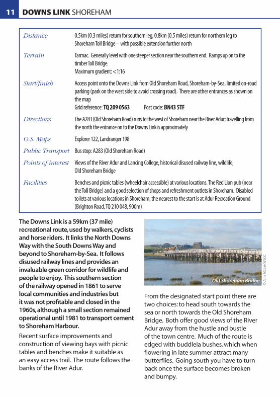
The Downs Link is a 59km (37 mile) recreational route, used by walkers, cyclists and horse riders. It links the North Downs Way with the South Downs Way and beyond to Shoreham-by-Sea. It follows disused railway lines and provides an invaluable green corridor for wildlife and people to enjoy. This southern section of the railway opened in 1861 to serve local communities and industries but it was not profitable and closed in the 1960s, although a small section remained operational until 1981 to transport cement to Shoreham Harbour.
Recent surface improvements and construction of viewing bays with picnic tables and benches make it suitable as an easy access trail. The route follows the banks of the River Adur.
From the designated start point there are two choices: to head south towards the sea or north towards the Old Shoreham Bridge. Both offer good views of the River Adur away from the hustle and bustle of the town centre. Much of the route is edged with buddleia bushes, which when flowering in late summer attract many butterflies. Going south you have to turn back once the surface becomes broken and bumpy.
11 DOWNS LINK SHOREHAM
Distance 0.5km (0.3 miles) return for southern leg, 0.8km (0.5 miles) return for northern leg to Shoreham Toll Bridge – with possible extension further north
Terrain Tarmac. Generally level with one steeper section near the southern end. Ramps up on to the timber Toll Bridge. Maximum gradient: <1:16
Start/finish Access point onto the Downs Link from Old Shoreham Road, Shoreham-by-Sea, limited on-road parking (park on the west side to avoid crossing road). There are other entrances as shown on the map Grid reference: TQ 209 0563 Post code: BN43 5TF
Directions The A283 (Old Shoreham Road) runs to the west of Shoreham near the River Adur; travelling from the north the entrance on to the Downs Link is approximately
O.S. Maps Explorer 122, Landranger 198
Public Transport Bus stop: A283 (Old Shoreham Road)
Points of interest Views of the River Adur and Lancing College, historical disused railway line, wildlife, Old Shoreham Bridge
Facilities Benches and picnic tables (wheelchair accessible) at various locations. The Red Lion pub (near the Toll Bridge) and a good selection of shops and refreshment outlets in Shoreham. Disabled toilets at various locations in Shoreham, the nearest to the start is at Adur Recreation Ground (Brighton Road, TQ 210 048, 900m)
Old Shoreham Bridge
© Ja
ne N
oble
/WSC
C

Heading north you are soon rewarded with views over to the other side of the river with Lancing College Chapel perched above the valley and of the refurbished Shoreham Toll Bridge. You can go onto the bridge for views up and down the tidal river. This is where the route ends and you should retrace your steps to where you joined the trail. It is possible to explore the Downs Link and the Adur Valley further by
continuing north. Some surviving railway tracks can be seen near the bridge. Initially the path is firm compacted stone but beyond the flyover, sections can be muddy and rutted after wet weather.
Most of the Downs Link is relatively flat and easy going and some other sections are suitable for exploring; for further information contact West Sussex County Council – details at end of the booklet.
River Adur
N
Old Shoreham
AirportOld Shoreham Rd
Connaught Avenue
Upper Shoreham RoadOld Shoreham Rd
The Street
Old ShorehamBridge
Red Lion PH
Viaduct
Railway Line
A283
Ste
ynin
g Rd
A27
On Street
0 250m
Crown copyright. © All rights reserved. West Sussex County Council. 100023447.
11DOWNS LINK SHOREHAM
Crown
copy
right
. © Al
l righ
ts res
erve
d. W
est S
usse
x Cou
nty C
ounc
il. 10
0023
447.

The network of hard surfaced paths in Buchan Country Park ensures good access for all in most weather conditions. The Park is largely wooded and also has areas of heathland, meadows and ponds which attract a wide variety of wildlife, and make it an ideal place for walking, birdwatching or enjoying a picnic.
The walk starts outside the Countryside Centre – from here follow the signs into the main park area. There is a short climb on the approach to the road bridge. Just before reaching Douster Pond turn left and take the path to the east side of the pond which gives wonderful views of the pond and the area of heathland to the left. Here there is a wooden sculpture of a wasp. The path continues around the pond.
At the furthest point the route divides, with those doing the shorter route continuing along the path around the edge of the pond. This short section descends to join the main track and may require steadying hands if using a chair or a strong pusher if
going the other way. Continue around the pond and then retrace your tracks back to the car park.
For a longer walk turn left just after the bridge - this section of path is slightly uphill along a picturesque meandering path. There are plenty of seats along the way for a rest or a spot of lunch while admiring the surroundings. This is an area of glades and woodland with beech and oak trees. At the junction with the footpath turn right. The path is reasonably level and passes through a beautiful wooded area; the route continues for some way heading back towards the ponds and the start point.
There are many other paths suitable for exploring the park – a map of the park is available to purchase from the Centre.
12 BUCHAN COUNTRY PARK
Distance Short circuit 2.5km (1.6 miles), long circuit 3.6km (2.3 miles)
Terrain Hard surfaced tracks Maximum gradient: 1:10, one steepish section, otherwise gently undulating
Start/finish Buchan Park Countryside Centre, Crawley Grid reference: TQ 245 346 Post code: RH11 9HQ
Directions Buchan Country Park is on the south west edge of Crawley. It is accessed directly from the west bound section of the A220 between Crawley and Horsham and is signed from major roads locally
O.S. Maps Explorer 134, Landranger 187
Public Transport Bus stop: Breezehurst Drive, Bewbush
Points of interest Woodland, lake, wildlife, wooden sculpture
Facilities Countryside Centre with disabled toilets (RADAR key), information and displays on the park and wider countryside - open at weekends and during the week when staffing permits. Various benches and picnic tables throughout the park. Refreshments are not available, the nearest shops are at Dorsten Square, Bewbush, 0.8km (0.5 miles) from the Centre

To BewbushTo Crawley
To Horsham To Broad�eld
Waterfall
DousterPond
IslandPond
Spruce
Hill
Brook
IslandPond
FishPond
Dog Dip
Target Hill
Subway
Middle Covert
SpruceHill
TargetHill
TargetHill
InformationCentre 1:10
1:13
1:13
1:13
1:14
1:14
1:15
1:15
1:14
1:14
A264
A264
A2220 Horsham Road
0 250m
N
12BUCHAN COUNTRY PARK
Buchan Country Park Buchan Country Park
© R
obin
Edw
ards
/WSC
C
© P
PL/W
SCC
Crown
copy
right
. © Al
l righ
ts res
erve
d. W
est S
usse
x Cou
nty C
ounc
il. 10
0023
447.

This is a lovely walk, with spectacular views across the water for the length of the route. The reservoir and surrounding area provide an important habitat for a variety of wildlife.
The walk starts immediately in front of the disabled parking spaces. It is here that the first steep part is located, which is the drop from the car park to the walk. Construction was started on the reservoir in 1978 and to the left is the valve tower which regulates the release of water into the River Ouse, and circulates water to stop it becoming stagnant. Continuing round to the small copse you can see beech, oak and ash trees; during the 1987 storm many were damaged and these have been left to provide a habitat for fungi, lichens, mosses and insects. In spring and summer there are lots of wild flowers such as primroses, bluebells and common spotted orchids.
Access to the bird hide is through the gate on the left; this path drops down to the hide and requires steadying hands on the way down for those in wheel or pushchairs, and a strong pusher on the return up to the main path. There is good access to the window, the birds are plentiful and there are identification boards - binoculars are recommended.
Continuing along the main trail there is an interesting wood sculpture which was created by a local artist to reflect the local area. For about 75m the path climbs a 1:11 slope; it then slopes down a 1:11 for another 75m until you are past the copse. Here the view widens out across the reservoir and the path continues along the eastern edge of the water where it is relatively flat. There are plenty of seats so you may enjoy the view, have a rest or a spot of lunch before it’s time to return to the car.
13 ARDINGLY RESERVOIR
Distance 2.5km (1.5 miles) return trip
Terrain Compacted sandstone. Can get soft in wet weather Maximum gradient: 1:8
Start/finish Ardingly Reservoir car park (separate car park nearer reservoir for Blue Badge holders – RADAR key required) 4.5km (3 miles) north of Haywards Heath Car park is open 1st October to 31st March 9.00am till 4.00pm, 31st March to 30th September 9.00am till 5.30pm Grid reference: TQ 333 287 Post code: RH17 6SQ
Directions From the village of Ardingly turn south west onto College Road. Just south of main Ardingly College buildings turn right - signposted ‘Reservoir’. Follow the road to the reservoir
O.S. Maps Explorer 135, Landranger 187
Public Transport Bus stop: Ryelands Wood, College Road (unmarked)
Points of interest Wildlife, views (including from the disabled parking bays)
Facilities Several benches and picnic area. Bird hide accessible by wheelchairs. Nearest disabled toilets are Orchards, Haywards Heath (RH16 3TH), and Victoria Park, Haywards Heath (RH16 4LY)

Bridleshaw Wood
ActivityCentre
ArdinglyCollege
Disabled
SlipwayOver�ow
Ardingly Reservoir
BirdHide
Great Hook Shaw
West HammerWood
GardenCottage
Batchelor’sCottages
0 250m
1:925m
1:1325m
1:85m
1:1175m
1:1175m
N
Crown
copy
right
. © Al
l righ
ts res
erve
d. W
est S
usse
x Cou
nty C
ounc
il. 10
0023
447.
13ARDINGLY RESERVOIR
Ardingly Reservoir
© Ja
ne N
oble
/WSC
CCro
wn co
pyrig
ht. ©
All ri
ghts
reser
ved.
Wes
t Sus
sex C
ount
y Cou
ncil.
1000
2344
7.

This is a good walk in all weathers and at all times of the year. Winter has the added attraction of the bird life of the harbour (binoculars advisable). It was created as an easy access trail by Chichester Harbour Conservancy and by the generosity of the landowner. Walks around the harbour have always been a great favourite and this walk provides some of the best views of the harbour.
From the far end of the car park turn right, in front of the disabled toilet block, along the hard surfaced footpath through the dinghy park. The path turns left before arriving on the harbour wall. The walk continues along a good wide surfaced path on top of the sea wall to Cobnor Point – a piece of land jutting
out into the main channel of the harbour which offers a magnificent spot to watch the boating activities and general life afloat. It would be an ideal place for a picnic as there is a seat here.
From this point the path becomes slightly less well made but it is possibly to continue on around the corner. The path weaves through a patch of young trees to another bench, which is where the easy access trail ends as the path heads down some steps to continue at beach level. By the bench you will find some windswept oaks.
When retracing your steps to the car park there are wonderful views up the channel to Bosham, which on a clear day are set against the perfect backdrop of the South Downs.
This route is suitable for Blue Badge Holders only as there is no immediate parking for other users. The nearest public parking is the amenity car park (height restriction) near the entrance to the private road to Cobnor House. It is possible to walk to the start of the easy access trail from here (2.8km/1.7 miles extra return trip) but it uses a field edge footpath and includes a flight of steps down to a narrow footbridge and is therefore not part of the ‘easy access trail’.
14 COBNOR POINT CHIDHAM
Distance 2 km (1.3 miles) return trip
Terrain Tarmac and compacted stone (slightly bumpy) Maximum gradient: <1:16 (mostly level)
Start/finish Car park, Cobnor (Blue Badge holders only) Grid reference: SU 793 025 Post code: PO18 8TE
Directions From the A259 turn south towards Chidham along Chidham Lane. Keep on the road signed to Chidham East. After a mile non Blue Badge holders turn left into the amenity car park. Blue Badge holders should turn left down the private road to Cobnor House. Just before the white gateposts of Cobnor House turn left into the small car park
O.S. Maps Explorer 120, Landranger 197
Public Transport Bus stop: Chidham Lane (by amenity car park)
Points of interest Great views of Chichester Harbour, coastal birds (particularly in winter), sailing activity (mainly in summer)
Facilities Toilet (RADAR key) adjacent to the Blue Badge Car park, benches at Cobnor Point and at end of trail; Old House at Home pub in Chidham

Bosham
Channel
Mean H
igh Water
Cree
k Ri
the
Green Rithe
Blue Badge Parking
Start of EasyAccess Trail
Boat Yard
Public Parking
BoshamQuay
Chidham
ChidmereFarm
CobnorFarm
EastonFarm
LowerhoneFarm
CobnorHouse
CobnorPoint
St. MarysChurch
Pier
SailingClub
Chidmere Pond
To Nutbourne4.3km
0 250m
14COBNOR POINT CHIDHAM
Crown
copy
right
. © Al
l righ
ts res
erve
d. W
est S
usse
x Cou
nty C
ounc
il. 10
0023
447.

OTHER EASY ACCESS TRAILS IN WEST SUSSEX
West Sussex County Council
Pagham Spit - A recycled plastic boardwalk provides access to all across the shingle to the crest of Pagham Spit beach from the car park at the end of Harbour Road, Pagham; Grid reference SZ 884 965. Visitors can enjoy the flowering shingle plants and the views from the beach out to sea. The car park is opening hours 8.30am - 8pm in summer and 8.30am – 5.30pm in winter.
Worth Way – An 11km (7 mile) route shared-use for pedestrians, horse-riders and cyclists from Three Bridges, through semi-urban and open countryside, to East Grinstead in the north east of the county.
WSCC promotes several off-road cycling routes suitable for families, some of which are also generally flat and well surfaced, such as Worthing to Shoreham and Barnham to Bognor (Flansham) routes.
Other Organisations
Chichester Harbour Conservancy routes around Chichester Harbour
01243 512301, www.conservancy.co.uk
South Downs Joint Committee (will be superseded by South Downs National Park Authority from April 2011) routes in the South Downs
01243 558700, www.visitsouthdowns.com
District and County Council Contacts
West Sussex County Council 01243 777620 www.westsussex.gov.uk
Adur District Council 01273 263000 www.adur.gov.uk
Arun District Council 01903 737500 www.arun.gov.uk
Chichester District Council 01243 785116 www.chichester.gov.uk
Crawley Borough Council 01293 438000 www.crawley.gov.uk
Horsham District Council 01403 215100 www.horsham.gov.uk
Mid Sussex District Council 01444 458166 www.midsussex.gov.uk
Worthing Borough Council 01903 239999 www.worthing.gov.uk
Brighton & Hove City Council 01273 290000 www.brighton-hove.gov.uk
East Sussex County Council 0345 60 80 190 www.eastsussex.gov.uk
Hampshire County Council 0845 603 5638 www.hants.gov.uk
The organisations below publish additional information on easy access routes in or near West Sussex.

OTHER USEFUL INFORMATION
West Sussex Association for the Disabled (WSAD)
WSAD is an organisation working to support and empower disabled people in West Sussex.
WSAD, 7 St Johns Parade, Alinora Crescent, Goring By Sea, West Sussex BN12 4HJ
Telephone: 01903 244457 Email: [email protected] Website: www.wsad.org.uk
ICIS
ICIS is a free, confidential and impartial advice service for people with any disability, impairment or care need in West Sussex.
ICIS, 35, Worthing Rd. East Preston, Littlehampton West Sussex BN16 1BQ
Telephone: 0800 859929 (Freephone - voice and text)
Email: [email protected]
Website: www.icis-info4life.org.uk
Feedback
We would welcome your feedback on this publication as a whole or on the individual walks. We would also like to hear from you if you know of other routes that could be promoted as easy access trails. Please contact us:
Public Rights of Way - Easy Countryside Trails feedback West Sussex County Council The Grange, Tower Street Chichester, West Sussex PO19 1RG
Telephone 01243 777620
Email: [email protected]
Website: www.westsussex.gov.uk/prow
Downs Link © Ja
ne N
oble
/WSC
C

1 Chichester Marina 1.9km (1.2 miles)
2 Centurion Way, Chichester to Lavant 8.3km (5.1 miles)
3 Pagham Harbour Nature Reserve & Sidlesham Quay 4.4km (2.7 miles)
4 Chichester Canal 3.0km (1.9 miles)
5 Church Norton and St Wilfrid’s Chapel 1.0km (0.6 miles)
6 Pagham Harbour North Wall 1.4km (0.8 miles)
7 Graffham, Lavington Park and Lavington Stud 2.6km (1.6 miles)
8 Burton Pond 0.9km (0.6 miles)
9 Arundel Park 1.1km (0.7 miles)
10 Southwater Country Park 1.0km (0.6 miles)
11 Downs Link, Shoreham 1.3km (0.8 miles)
12 Buchan Country Park, Crawley 2.5km (1.6 miles)
13 Ardingly Reservoir 2.5km (1.6 miles)
14 Cobnor Point, Chidham (*Blue Badge holders only) 2.0km (1.3 miles)
Note; it is possible to make some of the above longer or shorter; please see walk information for details.
If you would like this booklet in larger print please contact: West Sussex County Council, PROW, County Hall, West Sussex, PO19 1RG. Tel: 01243 777620 e-mail: [email protected]
HAMPSHIRE
SURREY KENTLondon/Guildford
A3(T)Guildford
A281
DorkingA24
ReigateA217
GatwickAirport
LondonM23 Godstone
A22
EastGrinstead
TunbridgeWells A264
UckfieldA22
Horsham
Crawley
Haywards Heath
UckfieldA272
Burgess Hill
Henfield
LewesA27(T)
NewhavenA259
A23
Shoreham-by-Sea/Southwick
Lancing/SomptingWorthingLittlehampton
A280
A283
Pulborough
A24
A28
4A29
A20
37
Bognor Regis
A27(T)
Chichester
Fontwell
A286
A285
A28
6
A29A259Chichester
Harbour
PortsmouthA27(T)
Havant
A3(
M)
WinchesterA272
A272
MidhurstPetworth
A283
A3(T)
A28
6
A28
3
A272 Billingshurst
A24
A264
A29
A264
A281
A29 A272
A23
(T)
M23
Petersfield
A3(
T)
A27(T)
A259
A259A
280
A259
A202
5
Brighton
A281
A27
3A23
(T)
EASTSUSSEX
A2220
A2011
A23
A2220
A264
A28
3
FarnhamA287
DorkingA29
A270
Haslemere
Milford
A27(T)
Westergate
A2300
A27(T)
Arundel
Angmering
A28
4
A2032
A24
London(Victoria)
London(Victoria)
London(Victoria)
Lewes
London(Waterloo)
1
2
3
4
6
87
9
10
11
12
13
14
5
Easy Access Trails
www.westsussex.gov.uk WS485 3.10