Earth Surface Processes and Landforms Modeling alpine...
14
Copyright © 2005 John Wiley & Sons, Ltd. Earth Surface Processes and Landforms Earth Surf. Process. Landforms 30, 1495–1508 (2005) Published online in Wiley InterScience (www.interscience.wiley.com). DOI: 10.1002/esp.1205 Modeling past and future alpine permafrost distribution in the Colorado Front Range Jason R. Janke University of Southern Mississippi, Department of Geography Box 5051, Hattiesburg, MS 39406, USA Abstract Rock glaciers, a feature associated with at least discontinuous permafrost, provide important topoclimatic information. Active and inactive rock glaciers can be used to model current permafrost distribution. Relict rock glacier locations provide paleoclimatic information to infer past conditions. Future warmer climates could cause permafrost zones to shrink and initiate slope instability hazards such as debris flows or rockslides, thus modeling change remains imperative. This research examines potential past and future permafrost distribu- tion in the Colorado Front Range by calibrating an existing permafrost model using a standard adiabatic rate for mountains (0·5 °C per 100 m) for a 4 °C range of cooler and warmer temperatures. According to the model, permafrost currently covers about 12 per cent (326·1 km 2 ) of the entire study area (2721·5 km 2 ). In a 4 °C cooler climate 73·7 per cent (2004·4 km 2 ) of the study area could be covered by permafrost, whereas in a 4°C warmer climate almost no permafrost would be found. Permafrost would be reduced severely by 93·9 per cent (a loss of 306·2 km 2 ) in a 2·0 °C warmer climate; however, permafrost will likely respond slowly to change. Relict rock glacier distribution indicates that mean annual air temperature (MAAT) was once at least some 3·0 to 4·0 °C cooler during the Pleistocene, with permafrost extending some 600–700 m lower than today. The model is effective at identify- ing temperature sensitive areas for future monitoring; however, other feedback mechanisms such as precipitation are neglected. Copyright © 2005 John Wiley & Sons, Ltd. Keywords: permafrost; Front Range; climate change; rock glaciers Introduction Permafrost, or ground that remains at or below 0 °C for at least two consecutive years, serves as an indicator of potential climate change (Harris et al., 2003). Relict landforms, such as sand wedges, patterned ground, pingo scars, or rock glaciers, provide historical information about where permafrost once existed (Frauenfelder et al., 2001). In the future, field monitoring of frozen ground will be vital as the active layer responds to global warming, shifting snow cover patterns, and change in vegetation land cover (Davis, 2001; Ishikawa, 2003). Other landforms related to permafrost occurrence may show a decline in activity as ice is removed or freeze–thaw activity decreases. Permafrost mapping and modeling has been initiated in major mountain regions of the world (Keller, 1992; Hoelzle et al., 1993; Imhof, 1996; Frauenfelder et al., 1998; Etzelmüller et al., 2001; Gruber and Hoelzle, 2001; Lugon and Delaloye, 2001; Tannarro et al., 2001; Heginbottom, 2002; Guglielmin et al., 2003; Frauenfelder et al., 2003). In the Front Range (Figure 1), however, there is little precise information about permafrost distribution. A few studies have examined local distribution on Niwot Ridge (Ives, 1974; Greenstein, 1983). Since these field investigations were restricted in area, an attempt was made to model permafrost distribution using geographic information system (GIS) techniques and digital elevational model (DEM) variables based on rock glacier activity categories: (1) active = probable permafrost, (2) inactive = possible permafrost, and (3) fossil or relict = no current permafrost (Imhof, 1996; Janke, 2004). A multinomial logistic regression was built based on topoclimatic data (elevation and aspect) from rock glaciers to estimate the probability of permafrost occurence. The model showed promising results, correlating well with the −1·0 °C mean annual air temperature (MAAT) isotherm and bottom temperature of winter snow (BTS) measurements less than −3·0 °C (Janke, 2004). The purpose of this research is to investigate potential past and future distribution by calibrating the existing permafrost model for a 4 °C range of temperatures. Received 30 April 2004; Revised 21 October 2004; Accepted 19 November 2004 *Correspondence to: J. R. Janke, Department of Geography Box 5051, University of Southern Mississippi, Hattiesburg, MS 39406, USA. E-mail: [email protected]
Transcript of Earth Surface Processes and Landforms Modeling alpine...

Modeling alpine permafrost distribution 1495
Copyright © 2005 John Wiley & Sons, Ltd. Earth Surf. Process. Landforms 30, 1495–1508 (2005)
Earth Surface Processes and LandformsEarth Surf. Process. Landforms 30, 1495–1508 (2005)Published online in Wiley InterScience (www.interscience.wiley.com). DOI: 10.1002/esp.1205
Modeling past and future alpine permafrostdistribution in the Colorado Front RangeJason R. JankeUniversity of Southern Mississippi, Department of Geography Box 5051, Hattiesburg, MS 39406, USA
AbstractRock glaciers, a feature associated with at least discontinuous permafrost, provide importanttopoclimatic information. Active and inactive rock glaciers can be used to model currentpermafrost distribution. Relict rock glacier locations provide paleoclimatic information toinfer past conditions. Future warmer climates could cause permafrost zones to shrink andinitiate slope instability hazards such as debris flows or rockslides, thus modeling changeremains imperative. This research examines potential past and future permafrost distribu-tion in the Colorado Front Range by calibrating an existing permafrost model using astandard adiabatic rate for mountains (0·5 °C per 100 m) for a 4 °C range of cooler andwarmer temperatures. According to the model, permafrost currently covers about 12 percent (326·1 km2) of the entire study area (2721·5 km2). In a 4 °C cooler climate 73·7 per cent(2004·4 km2) of the study area could be covered by permafrost, whereas in a 4°C warmerclimate almost no permafrost would be found. Permafrost would be reduced severely by 93·9per cent (a loss of 306·2 km2) in a 2·0 °C warmer climate; however, permafrost will likelyrespond slowly to change. Relict rock glacier distribution indicates that mean annual airtemperature (MAAT) was once at least some 3·0 to 4·0 °C cooler during the Pleistocene, withpermafrost extending some 600–700 m lower than today. The model is effective at identify-ing temperature sensitive areas for future monitoring; however, other feedback mechanismssuch as precipitation are neglected. Copyright © 2005 John Wiley & Sons, Ltd.
Keywords: permafrost; Front Range; climate change; rock glaciers
Introduction
Permafrost, or ground that remains at or below 0 °C for at least two consecutive years, serves as an indicator ofpotential climate change (Harris et al., 2003). Relict landforms, such as sand wedges, patterned ground, pingo scars, orrock glaciers, provide historical information about where permafrost once existed (Frauenfelder et al., 2001). In thefuture, field monitoring of frozen ground will be vital as the active layer responds to global warming, shiftingsnow cover patterns, and change in vegetation land cover (Davis, 2001; Ishikawa, 2003). Other landforms related topermafrost occurrence may show a decline in activity as ice is removed or freeze–thaw activity decreases.
Permafrost mapping and modeling has been initiated in major mountain regions of the world (Keller, 1992; Hoelzleet al., 1993; Imhof, 1996; Frauenfelder et al., 1998; Etzelmüller et al., 2001; Gruber and Hoelzle, 2001; Lugon andDelaloye, 2001; Tannarro et al., 2001; Heginbottom, 2002; Guglielmin et al., 2003; Frauenfelder et al., 2003). In theFront Range (Figure 1), however, there is little precise information about permafrost distribution. A few studies haveexamined local distribution on Niwot Ridge (Ives, 1974; Greenstein, 1983). Since these field investigations wererestricted in area, an attempt was made to model permafrost distribution using geographic information system (GIS)techniques and digital elevational model (DEM) variables based on rock glacier activity categories: (1) active = probablepermafrost, (2) inactive = possible permafrost, and (3) fossil or relict = no current permafrost (Imhof, 1996; Janke,2004). A multinomial logistic regression was built based on topoclimatic data (elevation and aspect) from rockglaciers to estimate the probability of permafrost occurence. The model showed promising results, correlating wellwith the −1·0 °C mean annual air temperature (MAAT) isotherm and bottom temperature of winter snow (BTS)measurements less than −3·0 °C (Janke, 2004). The purpose of this research is to investigate potential past and futuredistribution by calibrating the existing permafrost model for a 4 °C range of temperatures.
Received 30 April 2004;Revised 21 October 2004;Accepted 19 November 2004
*Correspondence to:J. R. Janke, Departmentof Geography Box 5051,University of Southern Mississippi,Hattiesburg, MS 39406, USA.E-mail: [email protected]

1496 J. R. Janke
Copyright © 2005 John Wiley & Sons, Ltd. Earth Surf. Process. Landforms 30, 1495–1508 (2005)
Fig
ure
1.Lo
catio
n of
the
stu
dy a
rea
in t
he F
ront
Ran
ge o
f C
olor
ado.

Modeling alpine permafrost distribution 1497
Copyright © 2005 John Wiley & Sons, Ltd. Earth Surf. Process. Landforms 30, 1495–1508 (2005)
Paleoclimatic informationRelict rock glacier distribution has been used to reconstruct previous cooler climates (Frauenfelder and Kääb, 2000).In Arizona and New Mexico, Barsch and Updike (1971) concluded that permafrost once extended as low as 2600 mduring Wisconsin times. In the Tyrolean Alps, Kerschner (1985) found that relict rock glaciers became inactiveapproximately 10 000 yrs B.P., thus permafrost at that time extended 500–600 m lower than today with a 3·0 to 4·0 °Clower mean annual air temperature (MAAT). In a region north of the Alps, Haeberli (1983) inferred that the perma-frost limit was 3000 m lower than today during the extremely dry last glacial maximum in central Europe. In the Err-Julier area, Swiss Alps, Frauenfelder et al. (2001) used relict rock glaciers in conjunction with the PERMAMAPpermafrost model to reconstruction conditions during the Younger Dryas and found that temperatures were once 3·0–4·0 °C cooler, depressing the permafrost limit by 500–600 m. In the southern Carpathian Mountains, Urdea (1998)examined the evolution of permafrost from the Würm III period to the Little Ice Age, which suggested the lower limitof permafrost rose from 1480 to 2265 m over this period. In Greece, relict rock glaciers formed during the last glacialmaximum indicate that MAATs were 8–9 °C cooler, in agreement with paleoclimatic reconstructions (Hughes et al.,2003). Such paleoclimate reconstructions have not taken place in the Front Range using relict rock glacier extent.
Temperature change modelsIn polar regions of continuous and discontinuous permafrost, several attempts have been made to model areal changedue to global warming. Nelson et al. (2002) combined results from a general circulation model (GCM) and digitalpermafrost maps to determine hazardous areas associated with increasing active layer thickness. Barsch (1993) sug-gested that by 2010 the southern limit of polar permafrost could shift some 250–350 km northward from its presentlocation if warming continues. In Canada, the southern limit of permafrost would shift some 100–200 km north witha doubling of CO2 and, if ground warming continues, permafrost in Tibet could disappear in the next 150 years(French, 1996). After combining climatic, soil, permafrost and climate–permafrost interaction data in a GIS, Anisimovand Poliakov (2003) predicted that by 2050 10–17 per cent of artic permafrost would be reduced, with a 10–50 percent deeper seasonal thaw.
Few attempts have been made to predict the extent of mountain permafrost in warmer climates. For the Upper Engadin,Swiss Alps, Hoelzle and Haeberli (1995) ran three temperature scenarios: (1) 0·6 °C cooler, (2) 1·0 °C warmer and (3)3·0 °C warmer. The cooling scenario showed a four per cent increase in permafrost occurrence, but the 3·0 °C warmingshowed a 65 per cent loss. For the Qinghai-Xizang Plateau of China, a DEM, a permafrost base map and a coarse GCMwere used to predict permafrost change. By 2009, 8·0 per cent of permafrost would be lost with 0·46 °C warming; by2049, an 18·5 per cent reduction in permafrost would occur with 0·78 °C warming. At this stage, permafrost would retreatby 5–10 km along the Qinhai-Tibet highway. By 2099, 58·2 per cent of permafrost would be eliminated with 2·53 °Cwarming (Li and Cheng, 1999; Wu et al., 2000). Observations in this area have shown a temperature increase since the1970s (Wang and Jin, 2000). Future increases could cause a variety of slope stability issues (Haeberli and Beniston,1998; Beniston, 2002). Potential effects of a warmer climate have not been examined in the Colorado Front Range.
Study Area
DescriptionThe study area (2721·5 km2) covers a section of Rocky Mountain National Park located in the Front Range of northernColorado (Figure 1). The topography is rugged with over 60 peaks rising above 3350 m and subdued with gentlysloping tundra surfaces found above 3475 m (Figure 2). In the region south of Rocky Mountain National Park (IndianPeaks), interfluves usually extend east to west with Niwot Ridge being one of the most extensive (Ives and Fahey,1971). The treeline is at about 3400 m, and a forest-tundra ecotone extends some 100 to 150 m above treeline. Theclimate resembles arctic conditions with daytime summer temperatures rarely exceeding 15 °C (Elias, 1995). OnNiwot Ridge, a series of long term ecological research (LTER) climatic stations have been established (Figure 2).
Glacial historyThe Rocky Mountains were glaciated during three major events: (1) Pre-Bull Lake, (2) Bull Lake, and (3) Pinedale.The Bull Lake glaciation occurred before the Pinedale events, but the exact timing of the Bull Lake glaciation remainsuncertain (130 000–150 000 yrs B.P.), although two major Bull Lake stades have been identified, ending before

1498 J. R. Janke
Copyright © 2005 John Wiley & Sons, Ltd. Earth Surf. Process. Landforms 30, 1495–1508 (2005)
70 000 yrs B.P. (Madole, 1976; Pierce, 1979; Richmond, 1986; Gosse et al., 1995). After a break of almost 50 000years, the Pinedale glaciation (Wisconsin glaciation) began shortly after the last (Sangamon) interglaciation (110 000 yrsB.P.). On eastern slopes, Pinedale ice advanced by some 14–15 km, whereas glaciers on the western slope extendedsome 33 km (Richmond, 1960).
As far as Pinedale glaciation, events in Rocky Mountain National Park are restricted to just an earlier, moreextensive event and a later Pinedale event (Elias, 1995), although some studies have identified three stades in theFront Range (Ray, 1940; Jones and Quam, 1944; Richmond, 1960). The most recent Pinedale advance started about30 000 yrs B.P. and reached a maximum around 23 000 yrs B.P. when glacial Lake Devlin was dammed (Nelson et al.,1979; Madole, 1986; Caine, 2001). Deglaciation began about 13 000 yrs B.P. (Harbor, 1984; Madole, 1986). However,similarities in radiocarbon dates, soil development, weathering features and altitude for Satanta Peak moraines, TripleLakes moraines and sediments from Sky Pond designate a Younger Dryas event (10 000 to 11 000 yrs B.P.), markingthe last major Pinedale advance (Benedict, 1973a; Davis, 1988; Menounos and Reasoner, 1997).
Outcalt and MacPhail (1965) suggested that Pleistocene glaciers disappeared from the Front Range from 4500 to7500 yrs B.P. during the Altithermal. Since then, neoglaciation has shown three major advances, but the timing remainsinexact: (1) the Temple Lake Stade (2000–4000 yrs B.P.), (2) the Arikaree Stade (950–1850 yrs B.P.) later renamedAudubon Stade, and (3) the Gannett Peak Stade (100–350 yrs B.P.) later renamed Arapaho Peak Stade or the IndianPeaks equivalent to the Little Ice Age (Benedict, 1970; Mahaney, 1972; Benedict, 1973a; Davis, 1988). Glaciers duringthis period advanced from small, sheltered cirques, reaching a maximum around the mid-19th century (Richmond, 1960).
The timing of rock glacier formation within the study area is not known. Galena Creek rock glacier, found in theAbsaroka Range of Wyoming, seems to be consistent with the neoglacial record (Ackert, 1998). If velocities areextrapolated over the entire rock glacier surface, then age ranges from 4000 to 1200 years old (Clark et al., 1996;
Figure 2. An oblique perspective of a section of the Indian Peaks wilderness located south of Rocky Mountain National Park.Locations of Long Term Ecological Research stations (points) on Niwot Ridge and rock glaciers in surrounding valleys (polygons)are shown draped on a digital orthophoto and a DEM.

Modeling alpine permafrost distribution 1499
Copyright © 2005 John Wiley & Sons, Ltd. Earth Surf. Process. Landforms 30, 1495–1508 (2005)
Ackert, 1998; Konrad et al., 1999). However, given the slow rate of terminus movement, a decrease in velocity withdepth, and isotopic composition of the ice-core, older ages may be more realistic (Clark et al., 1996; Cecil et al., 1998;Konrad et al., 1999).
Within the Front Range, neoglacial dates have also been reported. On Arapaho rock glacier, an exposed ice-corerevealed pollen, plant, and insect remains that were dated close to the end of the Audubon stade (955–1000 ± 90–95 yrs B.P.) (Benedict, 1973b). Arapaho rock glacier has a sequence of lobes that are believed to be remnants ofmoraine material deposited from each neoglacial stade (Outcalt and Benedict, 1965; White, 1975; Benedict, 1985). Asa result, most active and inactive rock glaciers are commonly thought to be a product of the late Holocene, whereasfossil rock glaciers formed during the late Pleistocene (Barsch, 1996).
Methods
Using aerial photographs, previous motion studies, and field investigations, rock glaciers were categorized into threetypes. Active rock glaciers were classified as those that are moving, contain ice, have a steep front slope and havepronounced ridges and furrows. Active rock glaciers are commonly thought to be an indicator of probable permafrost(Imhof, 1996). Inactive rock glaciers have ceased moving, may still contain ice, have a gentler frontal slope andsurface topography, and are associated with possible permafrost. Fossil rock glaciers contain no ice, are not moving,and have vegetation on the surface, thus they do not indicate current permafrost presence, but are representative ofpast permafrost distribution (Barsch, 1996; Whalley and Martin, 1992).
In ArcGIS©, USGS DEMs with a 10 m resolution were obtained for the study area. Slope and aspect werecalculated. The rock glacier file was then converted to a grid (10 m resolution), and zonal statistics, a GIS overlaymethod, were processed using the elevation and slope data. To correct for circular data ranging from 0 to 360°, themean aspect for each feature was calculated manually. The orientation measurements were then converted to vectorspace for each rock glacier. A multinomial logistic regression was formulated to predict current permafrost occurrencebased on the aformentioned topoclimatic information for rock glacier activity classes (Figure 3). Analysis of the Waldstatistics suggested that mean elevation, the sine of mean aspect, and the cosine of mean aspect provided sufficientparameters (all p < 0·03) for the regression model.
Front Range rock glaciers present a dilemma when developing a permafrost model because they are transitionallandforms that can be derived from both periglacial and glacial processes (Giardino and Vitek, 1987). Classifying rockglaciers according to activity fails to address the processes operating on rock glaciers. In the Front Range, the initialorigin of rock glaciers is glacial because the area underwent glaciation. Rock glaciers in this region, therefore, may nottruly be representative of permafrost. By definition, however, glacially derived rock glaciers contain ice that remainsat or below 0 °C, and fall within the broad thermal criteria required for permafrost existence.
Using a standard adiabatic rate for mountains (0·5 °C per 100 m), the model was calibrated for temperatures rangingfrom 4 °C cooler to 4 °C warmer (Barry, 1992). For each 0·5 °C scenario, a separate multinomial logistic regressionmodel was developed and processed in ArcGIS©. Lake locations were masked from the analysis since the aspect oflakes is often characterized as flat (−1°) on DEMs, making classification difficult. Variability in precipitation andresulting change in snow cover as well as land cover change were omitted because at this point they are imponderablefor past and future climates. It is likely that change in snow cover will affect active layer thickness; however, themodel is designed to estimate the probability of permafrost occurrence at depth.
Mean rock glacier probability scores were used to evaluate rock glacier sensitivity in different temperature regimes.Rock glacier locations were overlaid with permafrost maps for each 0·5 °C temperature increment to determine meanprobability scores. Rock glaciers were classified as active if they had a mean score greater than 75 per cent, inactiveif they were in the 50 to 75 per cent range and relict if they were below 50 per cent. The number of rock glaciersfalling into each activity class was summarized for each temperature scenario.
Results
Potential permafrost distributions for cooler and warmer climates are shown in Figures 4 and 5, respectively. The arealextent of permafrost scores greater than 50 per cent was summarized for each of the scenarios (Table I). Currently,permafrost covers about 12 per cent (326·1 km2) of the entire study area (2721·5 km2), while in a 4 °C cooler climate74 per cent (2004·4 km2) of the study area could be covered by permafrost, about a 500 per cent increase in extent. Ina 4 °C warmer climate, almost no permafrost would be found (0·1 km2). A temperature increase of even 0·5 °C wouldreduce permafrost extent by 134·7 km2, a loss of 41·3 per cent. In fact, the initial warming scenarios show the most

1500 J. R. Janke
Copyright © 2005 John Wiley & Sons, Ltd. Earth Surf. Process. Landforms 30, 1495–1508 (2005)
Figure 3. Model used to predict past and future permafrost extent in the Front Range.
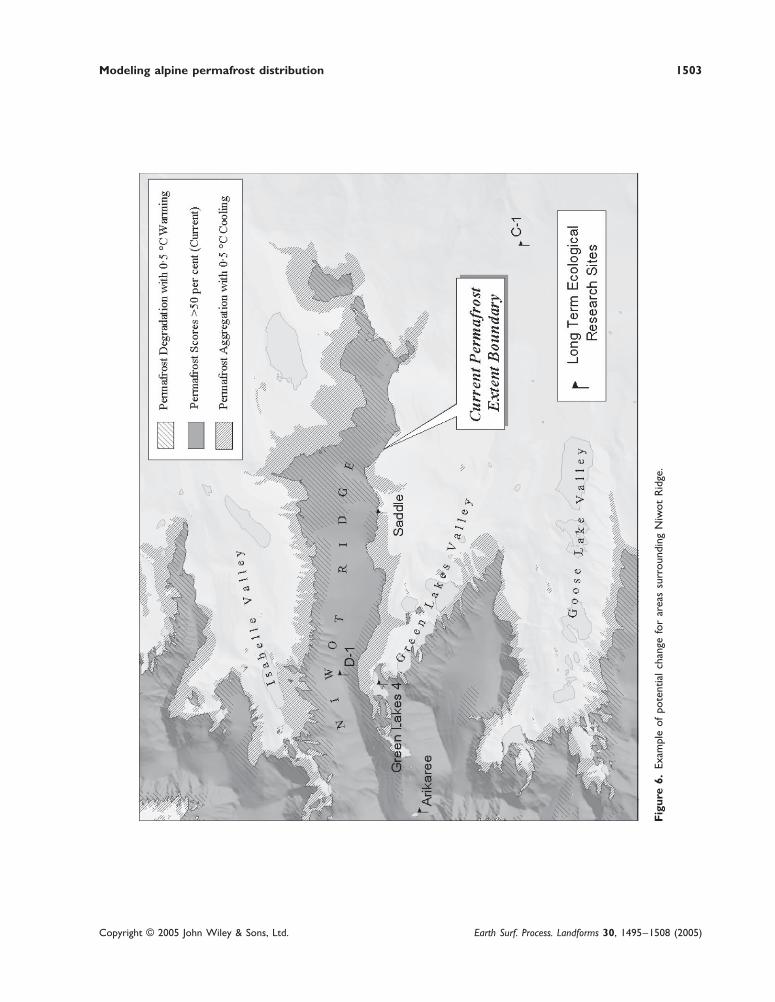
loss between intervals (90·5–134·7 km2). Temperature sensitive areas (±0·5 °C) along Niwot Ridge are illustrated inFigure 6. Even in a 2·0 °C warmer climate, permafrost would be reduced by 93·9 per cent (a loss of 306·2 km2), asevere impact produced by a slight temperature increase. The time needed to thaw, however, would be much greater(French, 1996).
Based on the current predicted extent, 80 per cent of rock glaciers fall within their current activity status (Table II).Nearly all rock glaciers (219 of 220) would lie in a zone of permafrost in a 3·0 to 4·0 °C cooler climate, but iftemperatures were to increase by 2·0 to 2·5 °C, no rock glaciers would be considered active within the area ofprojected permafrost extent (Table II). In a 0·5 °C cooler climate the model estimates that 32 more rock glaciers wouldbecome active, but if temperatures were to warm 13 additional rock glaciers would become inactive.
Discussion
Temperature changeWhen interpreting these results, it should be kept in mind that permafrost and rock glaciers will respond slowly tochanges in temperature, perhaps taking a few hundred years (French, 1996). Since rock glaciers have a coarse layer of

Modeling alpine permafrost distribution 1501
Copyright © 2005 John Wiley & Sons, Ltd. Earth Surf. Process. Landforms 30, 1495–1508 (2005)
Figure 4. Predicted permafrost extent for cooler climates: (A) current conditions, (B) 0·5 °C (C) 1·0 °C, (D) 1·5 °C, (E) 2·0 °C,(F) 2·5 °C (G) 3·0 °C, (H) 3·5 °C and (I) 4·0 °C.

1502 J. R. Janke
Copyright © 2005 John Wiley & Sons, Ltd. Earth Surf. Process. Landforms 30, 1495–1508 (2005)
Figure 5. Predicted permafrost extent for warmer climates: (A) current conditions, (B) 0·5 °C, (C) 1·0 °C, (D) 1·5 °C, (E) 2·0 °C,(F) 2·5 °C, (G) 3·0 °C, (H) 3·5 °C and (I) 4·0 °C.
Modeling alpine permafrost distribution 1503
Copyright © 2005 John Wiley & Sons, Ltd. Earth Surf. Process. Landforms 30, 1495–1508 (2005)
Fig
ure
6.Ex
ampl
e of
pot
entia
l ch
ange
for
are
as s
urro
undi
ng N
iwot
Rid
ge.

1504 J. R. Janke
Copyright © 2005 John Wiley & Sons, Ltd. Earth Surf. Process. Landforms 30, 1495–1508 (2005)
Table I. Potential change for permafrost scores greater than 50 per cent
Areal extent ofpermafrost scores Areal change Areal change Per cent change
greater than Per cent of study from current from last from currentPermafrost condition 50 per cent (km2) area covered extent (km2) interval (km2) extent
4·0 °C cooler 2004·4 74 1678·3 219·5 5153·5 °C cooler 1784·9 66 1458·8 195·5 4473·0 °C cooler 1589·4 58 1263·3 202·0 3872·5 °C cooler 1387·4 51 1061·3 221·5 3252·0 °C cooler 1166·0 43 839·8 227·0 2581·5 °C cooler 939·0 35 612·9 230·3 1881·0 °C cooler 708·6 26 382·5 213·2 1170·5 °C cooler 495·5 18 169·4 169·4 52
Current condition 326·1 12 – – –0·5 °C warmer 191·4 7 −134·7 −134·7 −411·0 °C warmer 100·9 4 −225·2 −90·5 −691·5 °C warmer 47·8 2 −278·3 −53·1 −852·0 °C warmer 19·9 1 −306·2 −27·9 −942·5 °C warmer 6·7 0 −319·4 −13·1 −983·0 °C warmer 1·9 0 −324·2 −4·8 −993·5 °C warmer 0·3 0 −325·8 −1·5 −1004·0 °C warmer 0·1 0 −326·0 −0·3 −100
Table II. Number of active, inactive and fossil rock glaciers within the projected permafrostextent in cooler and warmer climates
Number of active Number of inactive Number of fossilrock glaciers rock glaciers rock glaciers
Permafrost condition (x ≥≥≥≥≥ 75 per cent) (75 ≥≥≥≥≥ x ≥≥≥≥≥ 50 per cent) (x ≤≤≤≤≤ 50 per cent)
4·0 °C cooler 220 0 03·5 °C cooler 219 1 03·0 °C cooler 219 1 02·5 °C cooler 206 9 52·0 °C cooler 186 22 121·5 °C cooler 161 33 261·0 °C cooler 115 52 530·5 °C cooler 64 70 86
Current condition 32 91 970·5 °C warmer 19 72 1291·0 °C warmer 12 25 1831·5 °C warmer 3 14 2032·0 °C warmer 1 2 2172·5 °C warmer 0 1 2193·0 °C warmer 0 0 2203·5 °C warmer 0 0 2204·0 °C warmer 0 0 220
surface debris, the internal ice structure is protected from insolation and is further cooled by ventilation (Haeberli,1985; Delaloye et al., 2003). As a result, a smoothed or lagged response to warming will most likely occur. Thismodeling approach assumes that active rock glaciers are adjusted to current climate, which may be misleading giventhe slow response time. Active rock glaciers may still be responding to Little Ice Age or late-Holocene climatic events.It should also be noted that the predicted extent of permafrost in cooler climates might be extreme since alpineglaciers once filled the valleys, and currently active rock glaciers would have been overridden by ice. Sophisticated
Modeling alpine permafrost distribution 1505
Copyright © 2005 John Wiley & Sons, Ltd. Earth Surf. Process. Landforms 30, 1495–1508 (2005)
glacial and permafrost reconstructions such as those that have been undertaken in the Swiss Alps are currently beingimplemented in the Front Range (Frauenfelder et al., 2001).
Paleoclimatic reconstructions for the Front Range suggest that mean July temperatures were once 10–11 °C colderand that mean January temperatures were some 26–29 °C cooler as late as 14 500 yrs B.P. (Elias, 1986, 1995).According to a mutual climatic range reconstruction from fossil beetles, mean July temperatures were only 3·2–3·6 °Ccooler and mean January temperatures were some 19–20 °C cooler, indicating that deglaciation was occurring, pos-sibly allowing now relict rock glaciers to form. Coupled with lower moisture during the late Pinedale, periglacialactivity was high; thus, relict rock glaciers were probably once active during the Pleistocene (late Pinedale).
The analysis indicates that mean annual temperatures were once some 3·0–4·0 °C cooler, with permafrost extend-ing some 600–700 m lower, than today. These results indicate that permafrost extended to slightly lower elevationsthan previously reported. Legg and Baker (1980) suggested that treeline was 500 m lower during the Pinedale withtemperatures at least 4 °C lower than today. At a nearby site, pollen records indicate the existence of tundra duringmid-Pinedale times, corresponding to a depression of treeline by 500 m and 3·0 °C cooler temperatures (Elias, 2001).A relict rock glacier reconstruction in the Tyrolean and Swiss Alps also indicates similar results during the YoungerDryas (3·0–4·0 °C cooler) with a depressed lower limit of permafrost at 500–600 m (Kerschner, 1985; Frauenfelderet al., 2001).
The analysis also demonstrates the importance of appropriate topoclimates in order for rock glaciers to be active(Morris, 1981; Humlum, 1998; Sloan and Dike, 1998). For example, a 0·5 °C temperature decrease might reactivate32 rock glaciers with a 100 m lower elevation in permafrost limit if ample snowmelt and debris is available to forminternal ice (Whalley and Martin, 1992). A 0·5 °C temperature increase might deactivate 13 rock glaciers. Due to thisvariability, orientation must be an important variable for currently active rock glaciers since elevation of the perma-frost limit has only changed by ±100 m. This sensitivity also exemplifies the close relationship between inactive andactive forms, supporting a late-Holocene formation for most rock glaciers.
Although field measurements are sparse, permafrost in the Alps seems to be responding to warming, albeit moreslowly than temperate glaciers. Compared to the rates in the 1970s, Gruben rock glacier has shown a two to threetimes greater subsidence rate in the warm 1980s to 1990s. Borehole temperature measurements on Murtèl I rockglacier have shown a temporal warming trend with depth (Haeberli, 1994). In the Front Range, a warming trendremains unclear. From 1952 to 1997, elevations above treeline have cooled, which would support permafrost aggradation,reduced active layer thickness, or possibly ice growth in some landforms (Pepin, 2000). If the current trend were toreverse, however, the model has shown that permafrost could eventually be adversely reduced. If the ice-rich bond ofpermafrost is removed, slope stability hazards will become more frequent, thus modeling potential change remainssignificant.
LimitationsOther than temperature, feedback mechanisms are left unchanged. An increase in winter precipitation could destroypermafrost by preventing cold air from reaching the ground. In fact, winter precipitation has increased by about 8 mm/yr from 1980 to 2000, possibly eliminating some permafrost or increasing active layer thickness (Caine, 2002). Anincrease in summer snowfall events, however, could protect underlying permafrost from warm summer temperatures(Ives and Fahey, 1971; Williams and Smith, 1989; Harris and Corte, 1992). Since our understanding of temporal andspatial changes in precipitation remains uncertain, this variable was not incorporated. The lapse rate in the FrontRange is also steepening (Pepin and Losleben, 2002). Since this trend is difficult to predict for past and futureclimates, lapse rates were assumed to be constant. Snowfall change and lapse rates need to be incorporated in process-oriented models to better model change (Hoelzle et al., 2001). Therefore, the model assumptions are unrealistic innature, but it does effectively illustrate temperature sensitive areas (Hoelzle and Haeberli, 1995).
When considering paleoclimatic reconstructions, it is still necessary to date rock glaciers. Photogrammetric, radio-carbon, weathering rind, Schmidt-hammer rebound, lichenometry, and cosmogenic methods have shown recent success(Haeberli et al., 2003; Laustela et al., 2003). Once dates are available for Front Range rock glaciers, a more detailedaccount of landscape evolution could be undertaken, comparable to those that have take place in the Val Murgal,Upper Engadin, Swiss Alps (Maisch et al., 2003).
Conclusions
Relict rock glaciers indicate that MAAT was once at least some 3·0–4·0 °C cooler during the late Pleistocene withpermafrost extending some 600–700 m lower than today. Compared to pollen and tree paleoclimatic reconstructions,

1506 J. R. Janke
Copyright © 2005 John Wiley & Sons, Ltd. Earth Surf. Process. Landforms 30, 1495–1508 (2005)
the estimate presented here indicates a slightly more extensive permafrost zone. In a warmer climate, permafrost maycontinue to exist, but will slowly accumulate thicker active layers (French, 1996). The model has shown that a 2·0–2·5 °C temperature increase could dramatically reduce permafrost extent by about 95 per cent in the Front Range,although feedback mechanisms are neglected. As the ice that currently binds permafrost decays, the frequency ofdebris flows, rockfalls and other catastrophic events could increase.
AcknowledgementsThanks should be given to the following funding agencies that provided these awards: a Doctoral Dissertation Improvement Awardfrom the National Science Foundation (No. #0140132), a Geospatial Information and Technology Association Rocky MountainChapter Fellowship and a Colorado Mountain Club Fellowship. Special thanks to Nel Caine, John Pitlick, Tad Pfeffer, MarkWilliams, Susan Berta, Babs Buttenfield and Jeremy Mennis for their help reviewing and insightful feedback. The manuscript alsogreatly benefited from an anonymous reviewer and Wilfried Haeberli.
References
Ackert RP. 1998. A rock glacier/debris-covered glacier system at Galena Creek, Absaroka mountains, Wyoming. Geografiska Annaler SeriesA-Physical Geography 80A: 267–276.
Anisimov O, Poliakov V. 2003. GIS assessment of climate-change impacts in permafrost regions. In Proceedings of the 8th InternationalConference on Permafrost, Phillips M, Springman S, Arenson L (eds). Balkema: Zurich; 9–14.
Barry RG. 1992. Mountain Weather and Climate. Routledge: New York.Barsch D. 1993. Periglacial geomorphology in the 21st century. Geomorphology 7: 141–163.Barsch D. 1996. Rockglaciers: Indicators for the Present and Former Geoecology in High Mountain Environments. Springer: Berlin.Barsch D, Updike RG. 1971. Late Pleistocene periglacial geomorphology (rock glaciers and blockfields) at Kendrick Peak, Northern
Arizona. Arizona Geological Society Digest 9: 225–243.Benedict JB. 1970. Downslope soil movement in a Colorado alpine region: rates, processes, and climatic significance. Arctic and Alpine
Research 2: 165–226.Benedict JB. 1973a. Chronology of cirque glaciation, Colorado Front Range. Journal of Quaternary Research 3: 584–599.Benedict JB. 1973b. Origin of rock glaciers. Journal of Glaciology 12: 520–522.Benedict JB. 1985. Arapaho Pass: glacial geology and archeoogy at the crest of the Colorado Front Range. Center for Mountain Archeology
Research Report 3: 197.Beniston M. 2002. Climatic change: possible impacts on human health. Swiss Medical Weekly 132: 332–337.Caine N. 2001. Geomorphic systems of Green Lakes Valley. In Structure and Function of an Alpine Ecosystem, Niwot Ridge, Colorado,
Bowman WD, Seastedt TR (eds). Oxford University Press: New York; 45–74.Caine N. 2002. Declining ice thickness on an alpine lake is generated by increased winter precipitation. Climatic Change 54: 463–470.Cecil LD, Green JR, Vogt S, Michel R, Cottrell G. 1998. Isotopic composition of ice cores and meltwater from upper fremont glacier and
Galena Creek rock glacier, Wyoming. Geografiska Annaler Series A-Physical Geography 80A: 287–292.Clark DH, Steig EJ, Potter N, Fitzpatrick JJ, Updike AB, Clark MG. 1996. Old ice in rock glaciers may provide long-term climate records.
EOS, Transactions, American Geophysical Union 77: 217–222.Davis PT. 1988. Holocene glacier fluctuations in the America Cordillera. Quaternary Science Reviews 7: 129–157.Davis TN. 2001. Permafrost: a Guide to Frozen Ground in Transition. University of Alaska Press: Fairbanks.Delaloye R, Reynard E, Lambiel C, Marescot L, Monnet R. 2003. Thermal anomaly in a cold scree slope (Creux du Van, Switzerland).
In Proceedings of the 8th International Conference on Permafrost, Phillips M, Springman S, Arenson L (eds). Balkema: Zurich; 175–180.
Elias SA. 1986. Fossil insect evidence for Late Pleistocene paleoenvironments of the Lamb Spring site, Colorado. Geoarchaeology 1: 381–386.
Elias SA. 1995. The Ice-Age History of National Parks in the Rocky Mountains. Smithsonian Institution Press: Washington, DC.Elias SA. 2001. Paleoecology and Late Quaternary environments of the Colorado Rockies. In Structure and Function of an Alpine Ecosys-
tem, Niwot Ridge, Colorado, Bowman WD, Seastedt TR (eds). Oxford University Press: New York; 285–303.Etzelmüller B, Hoelzle M, Heggem ESF, Isaksen K, Mittaz C, Vonder Mühll D, Ødegård RS, Haeberli W, Sollid J. 2001. Mapping and
modeling the occurrence and distribution of mountain permafrost. Norwegian Journal of Geography 55: 186–194.Frauenfelder R, Allgower B, Haeberli W, Hoelzle M. 1998. Permafrost investigations with GIS – a case study in the Fletschhorn area,
Wallis, Swiss Alps. In Proceedings of the 7th International Conference on Permafrost. Nordicana: Yellowknife, Canada; 551–556.Frauenfelder R, Haeberli W, Hoelzle M. 2003. Rockglacier occurrence and related terrain parameters in a study area of the Eastern Swiss
Alps. In Proceedings of the 8th International Conference on Permafrost, Phillips M, Springman S, Arenson L (eds). Balkema: Zurich;253–258.
Frauenfelder R, Haeberli W, Hoelzle M, Maisch M. 2001. Using relict rockglaciers in GIS-based modeling to reconstruct Younger Dryaspermafrost distribution patterns in the Err-Julier area, Swiss Alps. Norwegian Journal of Geography 55: 195–202.
Frauenfelder R, Kääb A. 2000. Towards a palaeoclimatic model of rockglacier formation in the Swiss Alps. Annals of Glaciology 31: 281–286.

Modeling alpine permafrost distribution 1507
Copyright © 2005 John Wiley & Sons, Ltd. Earth Surf. Process. Landforms 30, 1495–1508 (2005)
French HM. 1996. The Periglacial Environment. Addison Wesley Longman: London, UK.Giardino JR, Vitek JD. 1987. The significance of rock glaciers in the glacial–periglacial landscape continuum. Journal of Quaternary
Science 3: 97–103.Gosse JC, Klein J, Evenson EB, Lawson B, Middleton R. 1995. Beryllium-10 dating of the duration and retreat of the last Pinedale glacial
sequence. Science 268: 1329–1333.Greenstein L. 1983. Alpine permafrost on Niwot Ridge based on indirect locational techniques. Master’s Thesis, University of Colorado,
Boulder.Gruber S, Hoelzle M. 2001. Statistical modeling of mountain permafrost distribution: local calibration and incorporation of remotely sensed
data. Permafrost and Periglacial Processes 12: 69–77.Guglielmin M, Aldighieri B, Testa B. 2003. PERMACLIM: a model for the distribution of mountain permafrost, based on climatic
observations. Geomorphology 51: 245–257.Haeberli W. 1983. Permafrost–glacier relationships in the Swiss Alps – today and in the past. In Proceedings of the 4th International
Conference on Permafrost. National Academy Press: Washington, DC; 415–420.Haeberli W. 1985. Creep of mountain permafrost: Internal structure and flow of alpine rock glaciers. Mitteilungen der Versuchsanstalt für
Wasserbau, Hydrologie und Glaziologie 77: 142.Haeberli W. 1994. Accelerated glacier and permafrost changes in the Alps. In Mountain Environments and Changing Climates, Beniston M
(ed). Routledge: New York; 91–107.Haeberli W, Beniston M. 1998. Climate change and its impacts on glaciers and permafrost in the Alps. Ambio 27: 258–265.Haeberli W, Brandovà D, Burga C, Egli M, Frauenfelder R, Kääb A, Maisch M. 2003. Methods for absolute and relative age dating of rock-
glacier surfaces in alpine permafrost. In Proceedings of the 8th International Conference on Permafrost, Phillips M, Springman S,Arenson L (eds). Balkema: Zurich; 343–348.
Harbor J. 1984. Terrestrial and lacustrine evidence for Holocene climatic/geomorphic change in the Blue Lake and Green Lakes Valleys ofthe Colorado Front Range. Master’s Thesis, University of Colorado, Boulder.
Harris C, Vonder Mühll D, Isaksen K, Haeberli W, Sollid J, King L, Holmlund P, Dramis F, Guglielmin M, Palacios D. 2003. Warmingpermafrost in European mountains. Global and Planetary Change 39: 215–225.
Harris SA, Corte AE. 1992. Interactions and relations between mountain permafrost, glaciers, snow, and water. Permafrost and PeriglacialProcesses 5: 103–110.
Heginbottom JA. 2002. Permafrost mapping: a review. Progress in Physical Geography 26: 623–642.Hoelzle M, Haeberli W. 1995. Simulating the effects of mean annual air-temperature changes on permafrost distribution and glacier size: an
example from the Upper Engadin, Swiss Alps. Annals of Glaciology 21: 399–405.Hoelzle M, Haeberli W, Keller F. 1993. Application of BTS-measurements for modeling mountain permafrost distribution. In Proceedings of
the 6th International Conference on Permafrost, Beijing; 272–277.Hoelzle M, Mittaz C, Etzelmüller B, Haeberli W. 2001. Surface energy fluxes and distribution models relating to permafrost in European
mountain permafrost areas: an overview of current developments. Permafrost and Periglacial Processes 12: 53–68.Hughes P, Gibbard P, Woodward J. 2003. Relict rock glaciers as indicators of Mediterranean paleoclimate during the Last Glacial Maximum
(Late Wurmian) in northwest Greece. Journal of Quaternary Science 18: 431–440.Humlum O. 1998. The climatic significance of rock glaciers. Permafrost and Periglacial Processes 9: 375–395.Imhof M. 1996. Modeling and verification of the permafrost distribution in the Bernese Alps. Permafrost and Periglacial Processes 7: 267–
280.Ishikawa M. 2003. Thermal regimes at the snow–ground interface and their implications for permafrost investigations. Geomorphology 52:
105–120.Ives JD. 1974. Permafrost. In Arctic and Alpine Environments, Ives JD, Barry R (eds). Harper and Row: New York; 159–194.Ives JD, Fahey BD. 1971. Permafrost occurence in the Front Range, Colorado Rocky Mountains, U.S.A. Journal of Glaciology 10: 105–
111.Janke J. 2004. Rock glaciers in the Front Range: an analysis of distribution, topoclimatic variables, permafrost, and flow. Ph.D. Dissertation,
University of Colorado, Boulder.Jones WD, Quam LO. 1944. Glacial landforms in Rocky Mountain National Park, Colorado. Journal of Geology 52: 217–234.Keller F. 1992. Automated mapping of mountain permafrost using the program PERMAKART within the Geographical System ARC/INFO.
Permafrost and Periglacial Processes 3: 133–138.Kerschner H. 1985. Quantitative paleoclimatic inferences from lateglacial snowline, timberline and rock glacier data, Tyrolean Alps, Austria.
Zeitschrift für Gletscherkunde und Glazialgeologie 21: 363–369.Konrad SK, Humphrey NF, Steig EJ, Clark DH, Potter N, Pfeffer WT. 1999. Rock glacier dynamics and paleoclimatic implications. Geology
27: 1131–1134.Laustela M, Egli M, Frauenfelder R, Kääb A, Maisch M, Haeberli W. 2003. Weathering rind measurements and relative age dating of
rockglacier surfaces in crystalline regions of the Eastern Swiss Alps. In Proceedings of the 8th International Conference on Permafrost,Phillips M, Springman S, Arenson L (eds). Balkema: Zurich; 627–632.
Legg T, Baker R. 1980. Palynology of Pinedale sediments, Devlin Park, Boulder County, Colorado. Arctic and Alpine Research 12: 319–333.
Li X, Cheng GD. 1999. A GIS-aided response model of high-altitude permafrost to global change. Science in China Series D-Earth Sciences42: 72–79.
Lugon R, Delaloye R. 2001. Modeling alpine permafrost distribution, Val de Réchy, Valais Alps (Switzerland). Norwegian Journal ofGeography 55: 224–229.

1508 J. R. Janke
Copyright © 2005 John Wiley & Sons, Ltd. Earth Surf. Process. Landforms 30, 1495–1508 (2005)
Madole RF. 1976. Glacial geology of the Colorado Front Range. In Quaternary Stratigraphy of North America, Mahaney WC (ed). Dowden,Hutchinson and Ross: Stroudsburg, PA; 319–351.
Madole RF. 1986. Lake Devlin and the Pinedale glacial history of the Colorado Front Range. Quaternary Research 25: 43–54.Mahaney WC. 1972. Audubon; new name for Colorado Front Range neoglacial deposits formerly called ‘Arikaree’. Arctic and Alpine
Research 4: 355–357.Maisch M, Haeberli W, Frauenfelder R, Kääb A. 2003. Lateglacial and Holocene evolution of glaciers and permafrost in the Val Muragl,
Upper Engadin, Swis Alps. In Proceedings of the 8th International Conference on Permafrost, Phillips M, Springman S, Arenson L (eds).Balkema: Zurich; 717–722.
Menounos B, Reasoner M. 1997. Evidence for cirque glaciation in the Colorado Front Range during the Younger Dryas Chronozone.Quaternary Research 48: 38–47.
Morris SE. 1981. Topoclimatic factors and the development of rock glacier facies, Sangre de Cristo Mountains, Southern Colorado. Arcticand Alpine Research 13: 329–338.
Nelson AR, Millington AC, Andrews JT, Nichols H. 1979. Radiocarbon-dated upper pleistocene glacial sequence, Fraser Valley, ColoradoFront Range. Geology 7: 410–414.
Nelson FE, Anisimov OA, Shiklomanov NI. 2002. Climate change and hazard zonation in the circum-Arctic permafrost regions. NaturalHazards 3: 203–225.
Outcalt SI, Benedict JB. 1965. Photo-interpretation of two types of rock glaciers in the Colorado Front Range, U.S.A. Journal of Glaciology5: 849–856.
Outcalt SI, MacPhail D. 1965. A Survey of Neoglaciation in the Front Range of Colorado. Series in Earth Sciences 4. University ofColorado Studies: Boulder.
Pepin N. 2000. Twentieth-century change in the climate record for the Front Range, Colorado, U.S.A. Arctic, Antarctic, and Alpine Research32: 135–146.
Pepin N, Losleben M. 2002. Climate change in the Colorado Rocky Mountains: free air versus surface temperature trends. InternationalJournal of Climatology 22: 311–329.
Pierce KL. 1979. History and dynamics of glaciation in the northern Yellowstone National Park area. US Geological Survey, ProfessionalPaper 729-E: 90.
Ray L. 1940. Glacial chronology of the southern Rocky Mountains. Geological Society of America Bulletin 51: 1851–1918.Richmond GM. 1960. Glaciation of the east slope of Rocky Mountain National Park, Colorado. Bulletin Geological Society of America 71:
1371–1382.Richmond GM. 1986. Stratigraphy and correlation of glacial deposits of the Rocky Mountains, the Colovado Plateau and the range of the
Great Basin. Quaternary glaciation in the northern hemisphere, Sibrava V, Bowen DQ, Richmond GM (eds). Pergamon Press: New York99–127.
Sloan VF, Dyke LD. 1998. Decadal and millennial velocities of rock glaciers, Selwyn Mountains, Canada. Geografiska Annaler Series A-Physical Geography 80A: 237–249.
Tanarro L, Hoelzle M, García A, Ramos M, Gruber S, Gómez A, Piquer M, Palacios D. 2001. Permafrost distribution modeling in themountains of the Mediterranean: Corral del Veleta, Sierra Nevada, Spain. Norwegian Journal of Geography 55: 253–260.
Urdea P. 1998. Rock glaciers and permafrost reconstruction in the southern Carpathian Mountains, Romania. In Proceedings of the 7thInternational Conference on Permafrost. Nordicana: Yellowknife, Canada; 1063–1069.
Wang S, Jin H. 2000. Permfrost degradation on the Qinghai-Tibet Plateau and its environmental impacts. Permafrost and PeriglacialProcesses 11: 43–53.
Whalley WB, Martin HE. 1992. Rock glaciers: II models and mechanisms. Progress in Physical Geography 16: 127–186.White SE. 1975. Additional data on Arapaho rock glacier in Colorado Front Range, U.S.A. Journal of Glaciology 14: 529–530.Williams PJ, Smith MW. 1989. The Frozen Earth: Fundamentals of Geocryology. Cambridge University Press: New York.Wu QB, Li X, Li WJ. 2000. The prediction of permafrost change along the Qinghai-Tibet Highway, China. Permafrost and Periglacial
Processes 11: 371–376.