DROUGHT IN BRAZIL DURING SUMMER AND FALL 2001 AND...
10
Ano 02, Número 01 1 DROUGHT IN BRAZIL DURING SUMMER AND FALL 2001 AND ASSOCIATED ATMOSPHERIC CIRCULATION FEATURES Iracema F. A Cavalcanti Centro de Previsão de Tempo e Estudos Climáticos - CPTEC Instituto Nacional de Pesquisas Espaciais – INPE, Cachoeira Paulista -SP [email protected] Vernon E. Kousky Climate Prediction Center – CPC National Centers Environmental Prediction – NCEP, Maryland –USA [email protected] ABSTRACT A deficiência de chuvas no verão e outono de 2001 causou uma redução na vazão das bacias da região nordeste, centro-oeste e sudeste do Brasil, que se refletiu na geração de energia elétrica para essas regiões. A situação das hidroelétricas ficou crítica e a população entrou em regime de economia de energia seguindo um programa elaborado pelo governo para evitar uma situação de ausência total de energia. Neste artigo são discutidos os principais aspectos meteorológicos que foram responsáveis pela diminuição das chuvas nas regiões das bacias, principalmente no verão. A ocorrência da estiagem na região Sudeste no verão e outono de 2001 foi associada às influências dos VCAN, que atuaram com maior freqüência e de maneira anômala sobre o continente, às influências de trens de onda associados ao padrão PSA, forçados pela intensa atividade convectiva na região da Indonésia e às Oscilações de Madden and Julian. A partir de maio a situação começou a se normalizar e as condições nas bacias em junho foram estáveis. Na época de inverno as chuvas são geralmente de pequena intensidade na região Sudeste do Brasil, associadas a passagens de sistemas frontais, e os níveis dos reservatórios de água continuaram baixos em JJA 2001. __________________________________________________________________________________ 1. INTRODUCTION Rainfall deficits during summer and fall 2001 resulted in a significant reduction in riverflow throughout Northeast, Central-West and Southeast Brazil, thereby reducing the capacity to produce hydroelectric power in these areas. The large-scale nature of the deficits, affecting nearly the entire country, resulted in an energy crisis that forced the government to impose energy conservation measures in order to avoid total loss of power (blackouts). Climatologically, summer is the peak of the rainy season in the regions of Southeast, Central- West and southern Northeast (Bahia) Brazil. However, beginning in January 2001 large rainfall deficits developed throughout these regions, with drier than normal conditions worsening through the end of summer and into fall. At the same time, southern Brazil registered above-normal precipitation and occasional flooding. The northern half of Northeast Brazil has a relatively short rainy season beginning in February and ending in May. Drier-than-normal conditions also dominated many sections of the northern Northeast, with the exception of extreme northern coastal sections where above-normal precipitation was observed. Some synoptic features that have been linked to rainfall variability over eastern and central Brazil include: 1) the Intertropical Convergence Zone (Northeast), 2) squall lines that form in association with the sea breeze (northern Northeast), 3) upper-level lows (Northeast and Southeast), and 4) Southern Hemisphere cold fronts/ South Atlantic Convergence Zone (Southeast, Northeast and
Transcript of DROUGHT IN BRAZIL DURING SUMMER AND FALL 2001 AND...

Ano 02, Número 01 1
DROUGHT IN BRAZIL DURING SUMMER AND FALL 2001 AND ASSOCIATEDATMOSPHERIC CIRCULATION FEATURES
Iracema F. A CavalcantiCentro de Previsão de Tempo e Estudos Climáticos - CPTEC
Instituto Nacional de Pesquisas Espaciais – INPE, Cachoeira Paulista [email protected]
Vernon E. KouskyClimate Prediction Center – CPC
National Centers Environmental Prediction – NCEP, Maryland –[email protected]
ABSTRACT
A deficiência de chuvas no verão e outono de 2001 causou uma redução na vazão das bacias daregião nordeste, centro-oeste e sudeste do Brasil, que se refletiu na geração de energia elétrica paraessas regiões. A situação das hidroelétricas ficou crítica e a população entrou em regime de economiade energia seguindo um programa elaborado pelo governo para evitar uma situação de ausência totalde energia. Neste artigo são discutidos os principais aspectos meteorológicos que foram responsáveispela diminuição das chuvas nas regiões das bacias, principalmente no verão. A ocorrência daestiagem na região Sudeste no verão e outono de 2001 foi associada às influências dos VCAN, queatuaram com maior freqüência e de maneira anômala sobre o continente, às influências de trens deonda associados ao padrão PSA, forçados pela intensa atividade convectiva na região da Indonésia eàs Oscilações de Madden and Julian. A partir de maio a situação começou a se normalizar e ascondições nas bacias em junho foram estáveis. Na época de inverno as chuvas são geralmente depequena intensidade na região Sudeste do Brasil, associadas a passagens de sistemas frontais, e osníveis dos reservatórios de água continuaram baixos em JJA 2001.__________________________________________________________________________________
1. INTRODUCTION
Rainfall deficits during summer and fall 2001 resulted in a significant reduction in riverflowthroughout Northeast, Central-West and Southeast Brazil, thereby reducing the capacity to producehydroelectric power in these areas. The large-scale nature of the deficits, affecting nearly the entirecountry, resulted in an energy crisis that forced the government to impose energy conservationmeasures in order to avoid total loss of power (blackouts).
Climatologically, summer is the peak of the rainy season in the regions of Southeast, Central-West and southern Northeast (Bahia) Brazil. However, beginning in January 2001 large rainfalldeficits developed throughout these regions, with drier than normal conditions worsening through theend of summer and into fall. At the same time, southern Brazil registered above-normal precipitationand occasional flooding.
The northern half of Northeast Brazil has a relatively short rainy season beginning in Februaryand ending in May. Drier-than-normal conditions also dominated many sections of the northernNortheast, with the exception of extreme northern coastal sections where above-normal precipitationwas observed.
Some synoptic features that have been linked to rainfall variability over eastern and centralBrazil include: 1) the Intertropical Convergence Zone (Northeast), 2) squall lines that form inassociation with the sea breeze (northern Northeast), 3) upper-level lows (Northeast and Southeast),and 4) Southern Hemisphere cold fronts/ South Atlantic Convergence Zone (Southeast, Northeast and

Revista Climanálise
Ano 02, Número 012
Central-West). Intraseasonal and interannual variability in convective activity is modulated by theMadden-Julian (30-60 day) oscillation (MJO) and by the El Niño-Southern Oscillation (ENSO) cycle,respectively, especially over the northeastern third of the country. A description of these circulationfeatures and their impacts on rainfall can be found in Climanálise Especial- Edição Comemorativa de10 anos (1996).
The main objective of this paper is to describe circulation features associated with the large-scale rainfall deficits observed in Brazil during the summer and fall 2000-2001 (December – May).
2. PRECIPITATION AND ATMOSPHERIC CIRCULATION ANOMALIES
Our analysis of precipitation is based on daily observations available on the GlobalTelecommunications System (GTS) and on additional data available in CPTEC’s data bank.Atmospheric circulation data are taken from the Climate Data Assimilation System (CDAS) of theNational Centers for Environmental Prediction (NCEP).
The average precipitation over Brazil and the upper-tropospheric circulation pattern over SouthAmerica for December-February and March-May are shown in Fig. 1. A characteristic feature of theprecipitation pattern during December-February is the northwest-southeast oriented band of maximumprecipitation that extends from the Amazon basin to the Southeast Brazil coast. This band and itsextension over the neighboring Atlantic Ocean, is commonly referred to as the South AtlanticConvergence Zone (SACZ). At upper-tropospheric levels, large-scale anticyclonic flow dominatesmost of Brazil, with the center of circulation near Bolivia. This feature, known as the Bolivian High,represents the dynamical/ thermodynamical response of the atmosphere to intense summertime heatingover the continent. The main axis of precipitation shifts northward and the Bolivian High weakensduring March-May, as the rainy season ends over Southeast and Central-West Brazil.
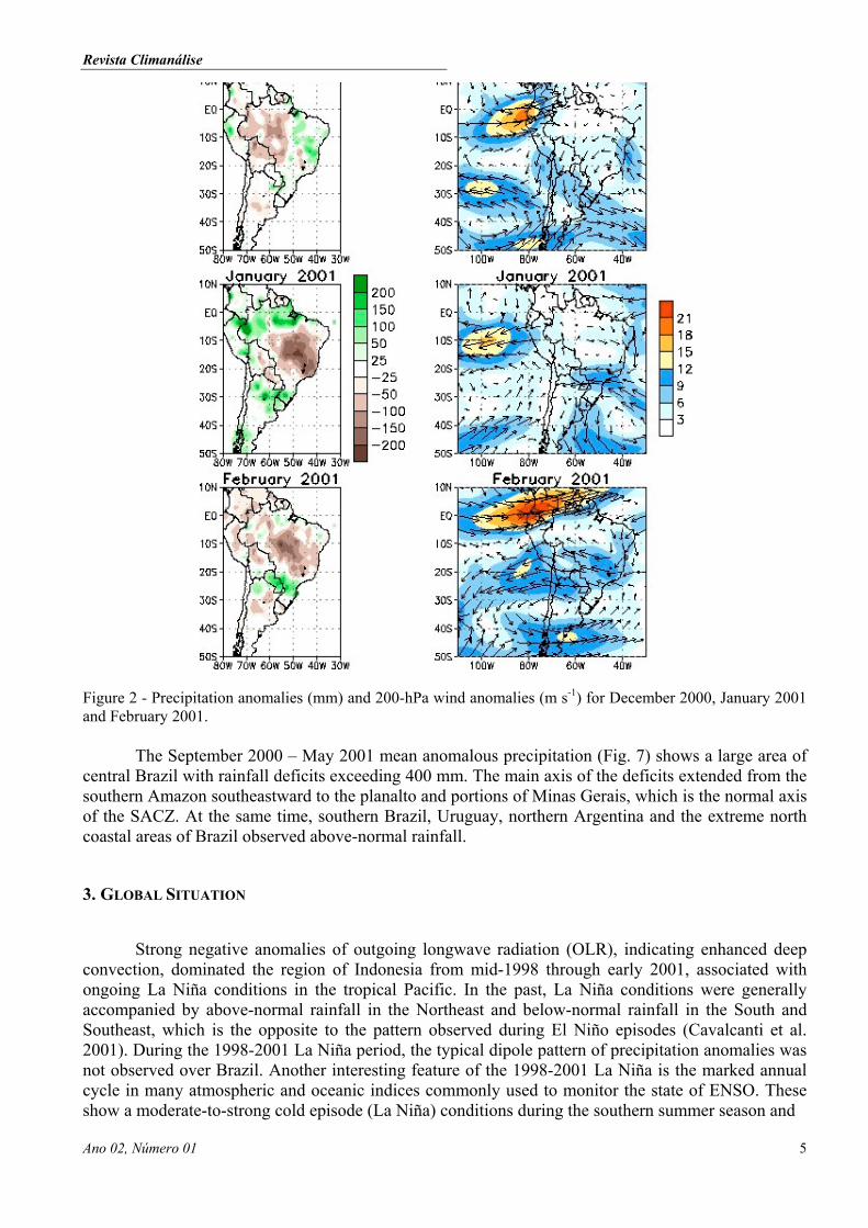
Precipitation deficits were observed throughout Amazonia in December 2000 and over theSoutheast and Central-West in January and February (Fig. 2). Several upper-tropospheric cyclonicvortices (vórtice ciclônico de altos níveis - VCAN) moved westward from the eastern South Atlantic tointerior sections of Brazil during January and February. Since mid-tropospheric sinking motioncharacterizes these systems, they usually tend to suppress deep convection within five degrees oflatitude/ longitude from the center. The greater-than-normal frequency of occurrence and deeperpenetration into the continent of these vortices resulted in large-scale upper-tropospheric cycloniccirculation anomalies over central Brazil (Fig. 2), associated with a weaker than normal Bolivian High.Another contributing factor to the dryness in the region was a lack of significant cold fronts reachingSoutheast Brazil. During January-February 2001 cold fronts managed to reach only as far north assouthern Brazil, where rainfall was above normal.
Normally, VCANs remain close to the east coast of Northeast Brazil. However, in January2001 these vortices moved gradually westward, reaching as far inland as the Brazil-Bolivia border andaffecting the convection over much of Central-West and Southeast Brazil. The daily analyses of theupper-level flow for January (Fig. 3) show that four VCAN affected Brazil during the month. OnJanuary 1-2 it is still possible to identify the anticyclonic circulation associated with the Bolivian Highand a VCAN, which was located along the Northeast coast near 10ºS. The VCAN moved inland on 3January and eventually reached the southern Amazon basin during 6-7 January. On 8 January anotherVCAN began to form in the vicinity of the Southeast coast. This system remained along the coastthrough 13 January and then moved westward during 14-20 January, reaching the Central-West regionof Brazil. On 23 January this system is still identifiable in the analyses, while another VCAN began todevelop near the Northeast coast. This new system also moved westward, reaching the eastern Amazonon 26 January. On January 28 the fourth VCAN of the month formed over the Northeast, andsubsequently drifted slowly southward through 31 January. The VCANs continued to be active during

Revista Climanálise
Ano 02, Número 01 3
February (not shown), as the overall pattern of cyclonic anomalies over central Brazil (Fig. 2) and lackof cold fronts in the Southeast persisted.
The pattern of anomalous upper-tropospheric cyclonic circulation over central Brazil andstrong easterly anomalies over the Southeast was also observed in March, while precipitation deficitswere observed over the eastern Amazon (Fig. 4). These circulation features continued into April beforefinally weakening in May. Rainfall deficits continued to be observed in the Southeast and Central-West during April, which typically marks the end of the wet season in those regions. As noted above,the anomalously dry months were accompanied by anomalous easterlies in the upper troposphere overthe Southeast and by cyclonic circulation anomalies over central Brazil, representing a weaker-than-normal or displaced from normal Bolivian High. By May, normally the beginning of the dry season inthe Southeast and Central-West, circulation features began to return to near normal over Brazil.
(a)
(b)
Figure 1 - Climatological precipitation over Brazil in a) DJF and c) MAM (1961-2000) from INMET dataset,regional centers and automatic stations (PCDs). Climatological wind flow at 200 hPa from NCEP/NCARreanalyses dataset in b) DJF and d) MAM (1979-1997).

Revista Climanálise
Ano 02, Número 014
( c)
(d)Figure 1 – Continued.
The daily precipitation for the region 5º-25ºS, 40º-60ºW for the entire rainy season (September2000 – April 2001) (Fig. 5) shows considerable day-to-day fluctuations in the intensity ofprecipitation. A Comparison of the observed rainfall to the long-term average (1979-1995) shows thepersistent below-normal precipitation during January-April 2001. Also evident are alternating periodsof above- and below-normal rainfall during the period September-December 2000, with maxima andminima occurring at intervals of approximately 45 days. This variability was related to rather vigorousMadden-Julian Oscillation (MJO) activity (Fig. 6), which at times has a strong influence on rainfalland atmospheric circulation in many areas within the tropics and subtropics (e.g., Weickmann, 1983;Weickmann et al., 1985; Casarin e Kousky, 1986; Kousky e Kayano, 1994; Castro e Cavalcanti, 2001).
The MJO weakened during January-February, as La Niña conditions re-intensified in thetropical Pacific, and strengthened during March-April, as conditions in the tropical Pacific returnedtoward normal. During the latter period, MJO modulation of precipitation is again evident in the timeseries, while the mean precipitation for the period remained below normal.
Revista Climanálise
Ano 02, Número 01 5
Figure 2 - Precipitation anomalies (mm) and 200-hPa wind anomalies (m s-1) for December 2000, January 2001and February 2001.
The September 2000 – May 2001 mean anomalous precipitation (Fig. 7) shows a large area ofcentral Brazil with rainfall deficits exceeding 400 mm. The main axis of the deficits extended from thesouthern Amazon southeastward to the planalto and portions of Minas Gerais, which is the normal axisof the SACZ. At the same time, southern Brazil, Uruguay, northern Argentina and the extreme northcoastal areas of Brazil observed above-normal rainfall.
3. GLOBAL SITUATION
Strong negative anomalies of outgoing longwave radiation (OLR), indicating enhanced deepconvection, dominated the region of Indonesia from mid-1998 through early 2001, associated withongoing La Niña conditions in the tropical Pacific. In the past, La Niña conditions were generallyaccompanied by above-normal rainfall in the Northeast and below-normal rainfall in the South andSoutheast, which is the opposite to the pattern observed during El Niño episodes (Cavalcanti et al.2001). During the 1998-2001 La Niña period, the typical dipole pattern of precipitation anomalies wasnot observed over Brazil. Another interesting feature of the 1998-2001 La Niña is the marked annualcycle in many atmospheric and oceanic indices commonly used to monitor the state of ENSO. Theseshow a moderate-to-strong cold episode (La Niña) conditions during the southern summer season and

Revista Climanálise
Ano 02, Número 016
Figure 3 - Daily 200-hPa wind anomalies (m s-1) for January 2001.
weak or near normal conditions during the southern winter (e.g., see the Southern Oscillation Indextime series shown in Fig. 8).
When La Niña conditions re-intensified during January-February 2001, enhanced convectionintensified over Indonesia and positive 200-hPa height anomalies strengthened throughout thesubtropics in both hemispheres (Fig. 9), as the subtropical jet streams shifted to higher latitudes.Significant height anomalies also appeared within the northern and southern mid-latitudes. In theSouthern Hemisphere, a strong teleconnection pattern developed, linking the circulation features in thevicinity of Australia with features throughout the subtropical and extratropical South Pacific/ SouthAmerican region. The observed pattern is quite similar to the Pacific South American (PSA) patterndescribed in previous studies of tropical/ extratropical interactions in the Southern Hemisphere (e.g.,Mo and Higgins, 1998; Cavalcanti, 2000). The persistent nature of the observed anomalous circulationover South America during summer 2000/ 2001 and fall 2001 appears to be linked to the anomalousconvection over Indonesia and a related downstream wave pattern extending from Australia to SouthAmerica.
Other studies have demonstrated the link between mid-latitude wave trains over the easternSouth Pacific and South America and the formation of VCANs near the Northeast coast (e.g., Kousky

Revista Climanálise
Ano 02, Número 01 7
Figure 4 - Precipitation anomalies (mm) and 200-hPa wind anomalies (m s-1) for March, April and May 2001.
and Gan 1981); Chaves and Cavalcanti 2001). In a recent study (Chaves and Cavalcanti 2001) a wavetrain of vorticity anomalies was found to extend from the South Pacific to South America, with acyclonic vorticity center over the Northeast during periods of drought in that region. The high numberand deeper penetration into the continent of VCANs observed during January-February 2001 and thesimilarity of the overall height anomaly pattern to the PSA (Fig. 9) strongly suggests a link betweenthe enhanced convection over Indonesia and the abnormally dry conditions that occurred over manysections of Brazil.
4. CONCLUSION
The summer 2000/ 2001 and fall 2001 drought over much of central Brazil (Central-West,Southeast and southern Northeast) was accompanied by: 1) greater than normal VCAN activity, withsystems penetrating deep within the continent, 2) a PSA-like wave train of geopotential heightanomaly centers extending from enhanced convection over Indonesia/ northern Australia eastward toSouth America, and 3) stronger-than-normal subtropical ridges in both the Northern and SouthernHemispheres, associated with a re-intensification of La Niña conditions in the tropical Pacific. Inaddition, during both spring and fall the Madden Julian Oscillation acted to strongly modulate rainfall

Revista Climanálise
Ano 02, Número 018
on a time scale of about 45 days, which tended to accentuate the drier than normal periods within eachseason.
By May 2001, the atmospheric circulation pattern over tropical and subtropical South Americahad returned to near normal, as the dry season set in over the drought-affected regions. During thesouthern winter, rainfall is generally light in these regions, and little relief from the drought could beexpected prior to the onset of the subsequent rainy season, which on average occurs during September-October.
Figure 5 - Time series of daily precipitation (solid line) and the 1979-1995 daily-average precipitation (dashedline) for the region 5ºS-25ºS, 40ºW-60ºW, during September 2000 - April 2001.
Figure 6 - Time-longitude section (5N-5S) of anomalous 200-hPa velocity potential. Solid (dashed) linesindicate the convectively active (inactive) phase of the Madden-Julian Oscillation. Strong MJO activity isevident during the last half of 2000.

Revista Climanálise
Ano 02, Número 01 9
Figure 7 - Mean anomalous precipitation for September 2000 – May 2001.
Figure 8 - Southern Oscillation Index for the period January 1990-May 2001.
Figure 9 - Anomalous 200-hPa geopotential height and outgoing longwave radiation for January-February 2001.

Revista Climanálise
Ano 02, Número 0110
Figure 9 - Continued.
5. REFERENCES
Casarin, D.P.; V.E. Kousky, 1986. Anomalias de precipitação no Sul do Brasil e variações nacirculação atmosférica. Rev. Bras. Meteor., 2, 83-90.
Castro, C.C.; I.F.A.Cavalcanti, 2001. A Zona de Convergência do Atlântico Sul e padrões deteleconexão. Congresso Argentino de Meteorologia, Buenos Aires, Maio 2001.
Cavalcanti, I.F.A. , 2000. Teleconnection patterns orographically induced in model results and fromobservational data in the austral winter of the Southern Hemisphere. Int. J. Climat., 20:1191-1206.
Cavalcanti, IFA Cavalcanti; A Grimm; V.Barros. Variabilidade Interanual da precipitação sobre aregião sul/sudeste da América do Sul simulada pelo modelo de circulação global da atmosferaCPTEC/COLA. Congresso Argentino de Meteorologia, Maio 2001.
Climanálise, 1996. Edição Comemorativa de 10 anos, CPTEC/INPE.
Kousky, V.E.; M.A. Gan, 1981. Upper tropospheric cyclonic vortices in the tropical South Atlantic.Tellus, 33, 538-551.
Kousky, V.E.; M.T. Kayano, 1994. Principal modes of outgoing longwave radiation and 250-mbcirculation for the South American sector. J. Climate, 7, 1131-1143.
Mo, K.C. ; W.Higgins, 1998. The Pacific-South American modes and tropical convection during theSouthern Hemisphere winter. Mon.Wea.Rev.,126, 1581-1596.
Weickmann, K.M., 1983. Intraseasonal circulation and outgoing longwave radiation modes duringnorthern winter. Mon. Wea. Rev., 111, 1838-1858.
Weickmann, K.M.; G.R. Lussky; J.E. Kutzbach, 1985. A global-scale analysis of intraseasonalfluctuations of outgoing longwave radiation and 250-mb streamfunction during northern winter.Mon. Wea. Rev., 113, 941-961.