DPRTNT F NTNL DVLPNT BR F NRL RR L ND PHNLTH F TRL DPRTNT F NTNL DVLPNT BR F NRL RR L ND PH RRD: 6...
56
COMMONWEALTH OF AUSTRALIA DEPARTMENT OF NATIONAL DEVELOPMENT BUREAU OF MINERAL RESOURCES GEOLOGY AND GEOPHYSICS RECORDS: 1 9 67/1 27 0088G5 REPORT ON MINOR METALLIFEROUS INVESTIGATIONS, TENNANT CREEK AREA, NORTHERN TERRITORY. by B.A. Tapp The information contained in this report has been obtained by the Department of National Development, as part of the policy of the Common- wealth Government, to assist in the exploration and development of mineral resources. It may not be published in any form or used in a company prospectus without the permission in writing of the Director, Bureau of Mineral Resources, Geology and Geophysics.
Transcript of DPRTNT F NTNL DVLPNT BR F NRL RR L ND PHNLTH F TRL DPRTNT F NTNL DVLPNT BR F NRL RR L ND PH RRD: 6...
COMMONWEALTH OF AUSTRALIA
DEPARTMENT OF NATIONAL DEVELOPMENT
BUREAU OF MINERAL RESOURCESGEOLOGY AND GEOPHYSICS
RECORDS:
1 9 67/1 27
0088G5
REPORT ON MINOR METALLIFEROUS INVESTIGATIONS,TENNANT CREEK AREA, NORTHERN TERRITORY.
by
B.A. Tapp
The information contained in this report has been obtained by theDepartment of National Development, as part of the policy of the Common-wealth Government, to assist in the exploration and development of mineralresources. It may not be published in any form or used in a companyprospectus without the permission in writing of the Director, Bureau ofMineral Resources, Geology and Geophysics.

REPORT ON MINOR METALLIFEROUS INVESTIGATIONS,TENNANT CREEK AREA. NORTHERN TERRITORY
by
B.A. Tapp
RECORDS 1967/127
The information contained in this report has been obtained by theDepartment of National Development, as part of the policy of the Common—wealth Government, to assist in the exploration and development of mineralresources. It may not be published in any fom or used in a companyprospectus without the permission in writing of the Director, Bureau ofMineral Resources, Geology and Geophysics.

REPORT ON MINOR METALLIFEROUS INVESTIGATIONS,TENNANT CREEK AREA. NORTHERN TERRITORY
B.A. Tapp
RECORDS 1967/127
CONTENTS
Page
Report on investigations carried out on Blue MoonGold Mine No. 2 Lode 1
Summary 1Introduction 1General Geology 2Drilling Results 2Conclusions 3
Plate 1: Locality Plan" 2: Geological Map, Blue Moon Gold Mine" 3: Detailed plan of No. 2 Lode, Blue Moon Gold Mine" 4: Diagrammatic Sections of No. 2 Lode, Blue Moon
Gold Mine
Report on Geological Investigations at the Hopeful Star Gold Mine 5
Summary 5Introduction 5Geology 6Previous assay results 7Diamond drilling results 7Recommendations 9
Plate 1: Locality" 2: Geological Map, Hopeful Star Gold Mine" 3: Section through diamond drill holes
Hopeful Star Gold Mine
Preliminary Survey, Southern Star Area 10
Summary 10Introduction 10General Geology 11Economic Geology 11Ground Magnetic Survey 12Recommendations 12
'2--

• Plate 1: Locality Plan" 2: Regional Geology, Southern Star Area" 3: Southern Star Area, low-level
Aeromagne tic Contours" 4: Southern Star Area, Results of
Ground Magnetic Survey
Preliminary Geological Report on thePerseverence Mine, Tennant Creek.
Summery 14Introduction 14General Geology 15Economic Geology 15Geophysics 16Conclusions and Recommendations 16
Plate 1: Locality Plan" 2: Magnetic Anomaly, Perseverence Mine" 3: Longitudinal Projection, Perseverence Mine." 4: Magnetic Profiles, Perseverence Mine.
Geological Report on the Bull Pup Mine,Last Hope Area, Tennant Creek.
Summary 17Introduction 17General Geology 18Sub-surface Geology 19Conclusions 19
Plate 1: Locality Plan" 2: Photo-geological interpretation, Last
Hope Area." 3: Plan of workings, Bull Pup Mine." 4: Longitudinal Section, Bull Pup Mine.
Geological Investigation of Amethyst Deposits,Helen Springs Area.
Summary 21Introduction 21General Geology 21 •
Lithology 22Structure 22
Amethyst Deposits 23Conclusions and Recommendations. 23

Plate 1: Locality Plan" 2: Geological Map, Helen Springs,• Amethyst Occurrence" 3: Cross-section, Helen Springs,
Amethyst Occurrence.
Geological Report on the Power-of-Wealth Gold Mine,KUrundi, Gold Field, N.T.
Summary 24Introduction 24Geology 24Production 25Recommendations 26
Plate 1: Locality Plan" 2: Geological Map, Power-of-Wealth Gold Mine." 3: Plan and section of underground workings,
Power of Wealth Gold Mine.
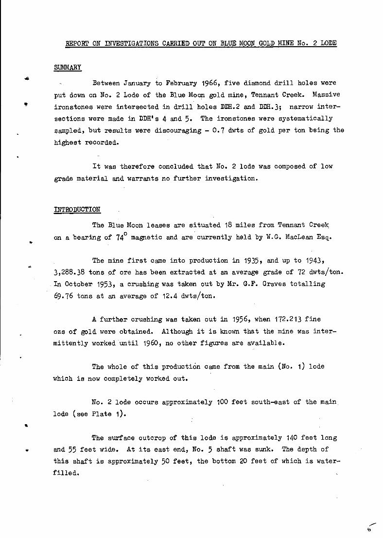
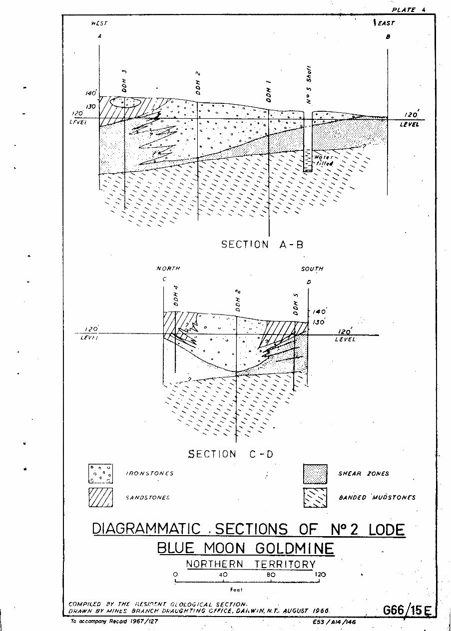
REPORT ON INVESTIGATIONS CARRIED OUT ON BLUE MOON GOLD MINE No. 2 LODE
SUMMARY
Between January to February 1966, five diamond drill holes wereput down on No. 2 Lode of the Blue Moon gold mine, Tennant Creek. Massive
ironstones were intersected in drill holes DDH.2 and DDH.3; narrow inter-
sections were made in DDH's 4 and 5. The ironstones were systematicallysampled, but results were discouraging - 0.7 dwts of gold per ton being the
highest recorded.
It was therefore concluded that No. 2 lode was composed of low
grade material and warrants no further investigation.
INTRODUCTION
The Blue Moon leases are situated 18 miles from Tennant Creek
on a bearing of 740 magnetic and are currently held by W.G. MacLean Esq.
The mine first came into production in 1935, and up to 1943,3,288.38 tons of ore has been extracted at an average grade of 72 dwts/ton.
In October 1953, a crushing was taken out by Mr. G.F. Graves totalling69.76 tons at an average of 12.4 dwts/ton.
A further crushing was taken out in 1956, when 172.213 fineozs of gold were obtained. Although it is known that the mine was inter-
mittently worked until 1960, no other figures are available.
The whole of this productiOn came from the main (No. 1) lode
which is now completely worked out.
No. 2 lode occurs approximately 100 feet south-east of the main
lode (see Plate 1).
The surface outcrop of this lode is approximately 140 feet long
and 55 feet wide. At its east end, No. 5 shaft was sunk. The depth ofthis shaft is approximately 50 feet, the bottom 20 feet of which is water-
filled.

— 2 --
GENERAL GEOLOGY
No. 2 lode is similar to the main No. 1 lode in composition and
consists largely of micaceous, specular hematite intergrown with. quartz.
Minor constituents are limonitic jasper and partly replaced breccia con—
taining angular fragments of sedimentary rocks enclosed by quartz hematite.
Other small hematite lodes are in evidence around No. 2 lode, but
these appear to consist only of narrow lenses filling minor shear zones.
The country rock includes fine to medium grained hematitic
sandstone with subordinate mudstone bands.
DRILLING RESULTS
Five drill holes were put down on this lode. Nos. 1, 2 and 3
were collared within the outcrop area of the lode to investigate its ex—
tension in depth: and Nos. 4 and 5 were sited to investigate its lateral
extension to the north and south.
The following is a summary of the logs of these drill holes:
D.D.H.1
Interval Remarks Assay Results
0'
20'
— 20'
— 35'
Massive hematite
Sheared snad
0' — 10' Nil.10' — 20' 0.7 dwts/ton
Course Vertical
Depth 103 feetbrecciatedsandstone
Nil
25' — 83' Banded mudstone Nil
83' — 103' clayey mudstone
D.D.H.2
Course Vertical 0' — 46' Massive 0' — 10' 0.7 dwts/tonhematite 10 — 20' Nil
Depth 102 feet 20 — 30' Nil30 — 40' Trace40 — 46' Trace

-3-
Interval Remarks D.D.H. 2 (Cont.)
461 - 48 Kaolin andsericite-rich,shear zone
48' - 102' Mudstone
D.D.H. 3
Assay Results
Nil
Course Vertical 0' - 10' Massive heamtite Nil
10' - 18' Sandstone NilDepth 51 feet 18' - 62' Mainly kaolin Nil
and sericite(shear zone)
62' - 86' Sandstone andclaystone
D.D.H. 4
Course Vertical 0' - 20' Sandstone Nil20' - 21'9" Shear zone Nil
Depth 51 feet 21'9"- 25' Massive hematite 20' - 24' Trace24' - 30' "
25' - 51' Kaolin andsericite
' (shear zone)
Nil
D.D.H. 5
Course Vertical 0' - 15' Sandstone Nil
15' - 29' Claystone Nil
29' - 42' Kaolin and Nilsericite(shear zone)
42' - 52 Claystone with 50 - 52' Nilhematite blebs
52' - 551 Claystone Nil
A number of surface samples were also taken along the strike of
the lode. The results however, revealed only low gold values; with a
maximum of 0.4 dwts/ton.
CONCLUSIONS
From the results obtained in the drill holes, the No. 2 lode
appears to be a surface mat of ironstone localised by the intersection of
a crush zone with a mudstone member in the sedimentary sequence.

The dimesnions of the lode are: length 140 feet, width 55 feet,
maximum depth 50 feet. Assay results indicate that the lode ranges from
0.7 dwt/ton to a trace of gold. It is therefore concluded that the lode has
no economic potential at the present time.
REFERENCE
IVANAC, J.F., 1954 - The Geology and Mineral Deposits of the Tennant Creek
Gold Field, N.T. Bur. Min. Resour. Aust., Bull. 22.
o,

PLATE I
ISA
OLD TELEGRA srAT1ON
_BLUE MOON
MINE
as,
TENNANT CREEK
ewmpt■ roam..■••■• •••■
0 2
LOCALITY MAP
BEUE MOON GOLDM INE NORTHERN TERRITORY
r-■
SCALE I /NCH is:22 MILES
To accompany Record 1967/127 E53/A14/143. 066/12E

PLATE 2
Sands-tons
Outcrops
No 2 Lode
Sandstone
Outcrops
Sandstone
Muo'stone
Ironstone
Cherty State
Haematite Shale
Breccia
Open Cut
GEOLOGICAL MAP BLUE MOON GOLDMINE
NORTHERN TERRITORY
NOS Lode0 100 200 300 400
I ; I t tFeet After Ivanac (1954), Plate 33
SECTION DRAWN BY M/NES BRANCH DRAUGHT//IC OFFICE DARWIN. 4UGUST /CV..COMPILED BY RESIDENT GEOLOGICAL
E53/A14/144
/2S
No.5
Sondstone
PLATE 3
,/35
.\21 °C■
C if1
<S) X I41
,(::) 4■■) i
I 130'1
6:,,,d.slone ■ /
1 1
I I
I /Outcrops 1 //
1/I
I 1
A
0;4-diva 2 0Shoft
0...3c/wrsiton"ion 04dwts/ton
120
5
LEGEND
X DRILL SITES:NUMBERS INDICATE ORDER IN WHICH DRILLED,
0 ASSAY SAMPLE LOCATIONS, WITH RESULTS.
C:21 IRONSTONE OUTCROPSA- 8
LINE OF SECTIONC- D
Outcrops
DETAILED PLAN OF No.2 LODE 0
BLUE MOON GOLDM1NE 0')
NORTHERN TERRITORY40 80 120
g To accompany Record /967/127
FeetCOMPILED BY THE RESIDENT GEOLOGICAL SECTION; DRAWN BY MINES BRANCH DRAUGHTING OFFICE, DARWIN. AUGUST 1966.
E55/A/4/145 •
% EAST
aWEST
A
r■4
, 0
• • • - .' • /20
• 0 • . - • 5 •
° • 0 • o 6 00
WC? fir r ...••■'N..
- -• •• •
• N N.. \N
•
N, N.. \' '•-••• •••■
-••••• ' -•• -••••• •••■
• ••••• *••••.
LEVEL'
°
SECTION A - B
NORTH
7
N. N. \ N.. N.
•
N..2
••
•
••<
<
• N.,N. N. N. N.
N. N.N N. N. \ N.
\ NN. • N.
SECTION C -D
' /40'
120' LEVEL
SA NDSTONE:.: BANDED MUOSTO N ES
DIAGRAMMATIC , SECTIONS OF N°2 LODE BLUE MOON GOLDMI NE
NORTHERN TERRITORY0 40 80 120
Feet
COMPILED RY THE RESIP.'7NT GLOLOGICAL SECTION.DRAWN BY 1.41/8/tS BRANCH DPAUGHTING OFFICE, GAIIWIIV, r. AUGUST 1966. G66 15
IRONSTONES SHEAR ZONESL0 °r °
PLATE 4
To accompany Record 1967/127
E53 / 414 /146

REPORT ON GEOLOGICAL INVESTIGATIONS AT THE HOPEFUL STARGOLD MINE
SUMMARY
Up to 1952, the Hopeful Star Goldmine had produced 1,615.42 long
tons of ore which returned 170.5 fine oz of gold by amalgamation, at an
average grade of 2.1 dwts per ton.
The main workings are in sheared, iron-impregnated sedimentary
rocks that strike approximately east, and form part of the northern limb of
alanticlinal fold, the crest of which is exposed in a small costean about
200 feet south of the main workings.
Two 15-fo6t shafts and approximately 200 feet of drives constitute
all the ezploratory and development work done on the lease.
A series of chip samples, channel samples and tailing samples
have been taken at various points around the main workings; of these, one
sample from the bottom of the shaft assayed 4.2 dwts/ton, and one from the
spoil dump of the mine yielded 4.2 dwts/ton.
The drill hole results indicate that the Hopeful Star minerali-
zation is restricted to a 'Pod' which extends to a depth of less than
200 feet below the surface; the available information is insufficient
to enable an estimate to be made of the available ore reserves.
INTRODUCTION
P.G. Dunn carried out a preliminary survey of the Hopeful Star
lease during 1963, and concluded that available evidence dit not favour
drilling. However, he considered that, if drilling was attempted, two holes
be put down, each about 260 feet deep.
Following a further examination by P. Crohn, a programme of
drilling was started in September 1965 under an agreement with the lease-
holder. The first drill hole was collared 200 feet south of the main shaft

6
at an azimuth of 3600 magnetic and a depression of 450, and the second hole
was drilled from a point 200 feet north of the main shaft at an azimuth
of 1800 and a depression of 550 .•
GEOLOGY
The mine is situated on a prominent mesa which rises about 60 feet
above the surrounding plain. The country rock is predominantly slaty, with
some intercalated sandstone and shale bands. The mesa is formed by a
resistant quartz-hematite-jasper lens which lies within the northern limb
of a small anticline and is bounded to the south by a broad shear zone.
Another, smaller shear zone and quartz-jasper-hematite lens occur north-
west of the main mesa.
The sedimentary rocks consist predominantly of dull red finely
jointed slates with intercalations of fine-grained, well sorted snadstone
and shale. All of these rocks are distinctly ferruginous.
The general strike in the area is ea,starly,with dips generally
between 400 and 60° to the north:
A band of dark red to mauve shale, four feet thick occurs in the
core of the anticline, which is exposed in a small costean, 200 feet south
of the mesa.
The southern flank of the mesa is composed of a vertical or steeply
dipping shear zone, up to 40 feet wide, with an approximately easterly strike,
roughly coincident with a major cleavage direction in the surrounding slates.
The shear zone is composed of iron-impregnated kaolinised and sericitised slaty
sediments; and most of the mine workings are found adjacent to this shear zone.
A jasper-quartz-hematite lens forms the northern portion of themesa. The jasper content of this rock varies, but usually occurs in small
blebs, from 2 to 3 inches in diameter. Locally it is associated with abundantquartz veins of variable thickness. Some of the hematite is specular.
7
PREVIOUS ASSAY RESULTS .
Of Seven samples tanken by P. Dunn in August 1963 and analysed
at the Central Government Battery, one gave an assay of 1.9 dwts gold
per ton, but the remainder gave a trace of gold only. Eight assays were
also carried out on chip and channel samples taken from the bottom of the
main shaft; one of these returned 4.2 dwts. gold per ton, but the
remainder ranged from 0:3 to 0.8 dwts only.
In August 1965, nine grab samples were taken from the dump at
the main shaft by Mr. D.L. Williams, of Tennant Creek, with the following
results:
• Sample 893 0.2 dwts/ton
894 trace
895 11
896 1.3 dwts/ton
897 0.3 "
898 trace
899 4.1 dwts/ton
900 0.2 "
19301 trace
DIAMOND DRILLING RESULTS
Drill hole D.D.H. 1 was sited to test the possible downward
extension of the gold-bearing zone at the main shaft; D.D.H.2 was sited
to furnish information on the extent of the associated quartz-hematite-
jasper lens. Sparsely mineralized zones were intersected, but neither
hole encountered a major zone of mineralization. The mineralized zone
at the main shaft therefore appears to be restricted to a surface tpod',
as shown in Plate 3, extending to a depth of not more than 200 feet.

-8
D.D.H. 1 Azimuth 360°(M), depressed at 45°.
Depth 474 feet.Description: 0' - 474'
Assay Results: 309'
316'
320'
321'
326'
332'
338'
359'
364'
369'
376'
380'
447'450'
- 316'
- 320'
- 321'
- 326'
- 332'
- 333'
- 344'
- 360'
- 365'
- 370'
- 378'
- 382'
- 448'
- 451'
trace
nil
1.0 dwt
nil
trace
1.0 dwt
0.3 dwt
nil
nil
nil
nil
nil
nil
nil
Red slate with quartz and jasper
stringers and blebs. Hematite
abundant throughout core length,
occasionally occurring as stringers,
but mainly as blebs.
depressed at 55° .
- 50' Mudstone
- 72' Slate
-121' Sandstone
-173' Mudstone.
-232' Sandstone
-242' Mudstone with hematite blebs
-275' Sandstone with occasional clay bands,
some mudstone and hematite
275' -277' Quartzitic sandstone
277'-278' Brown clay band
278'-314' Mudstone
314' -320' Clay and banded mudstone
320' -365' Mudstone with slaty bands
D.D.H. 2 Azimuth 180°(M),
Depth 365 feet
Description: 0'
50'
72'
121'
173'
232'
242'

PLATE 1
•*.
MT ISA
OLD TELEGRAPH SrATioN
6.2•HOPEFUL STAR MI NE
■
a/0
am. ••••••
woo
410.■■••
TENNANT CREEK
LOCALITY MAP
HOPEFUL STAR GOLDMINENORTHERN TERRITORY
2 I 0
2 4 6 8
SCALE I INCH= 2 MILES
To accompany Record 1967/127 653/.414/136 G66/16 E


9
Hematite found in stringers and blebs throughout core length.
Assay Results: Samples taken every five feet between
230' — 275' and280' — 320' all results nil.
RECOMMENDATIONS
A slight magnetic anomaly occurring at this gold mine (Daly 1957,
Plate 15) is comparable to that which would be caused by a magnetic body
centred at a depth of 220 feet. The two completed drill holes were sited
to pass under the mine workings at a slightly greater depth.
• To investigate the mineralised zone at a shallower depth, and to
penetrate the postulated centre of the anomaly, a third drill hole would
therefore have to be drilled, collared 100 feet south of the main shaft,
drilling on an azimuth of 360°(M) at a depression of 45°. However, in
view of the disappointing results of D.D.H. 1 and 2, no high priority can
be assigned to the drilling of this hole.
REFERENCES
DUNN, P.G. 9 1963 Mines Branch, N.T. Administration. File note
(unpublished).
DALY, J., 1957 - Magnetic Prospecting at Tennant Creek, N.T., 1955-1957.Bur. Min. ResoUr. Aust. Bull. 44.
17

— 10—
PRELIMINARY SURVEY — SOUTHERN STAR AREA
SLEMARY
At the suggestion of J. Ivanac, a survey was carried out in the
Southern Star area.
The relationship between the ironstone lodes and the intrusive
porphyry boy in this area shows many similarities to that in the Peko
region.
The ironstone lodes in the Southern area, are localised within
a folded and sheared belt, just north of a porphyry outcrop, and are
thought to have a westerly pitch.
A ground magnetometer survey in this area indicated the presence
of a feeble magnetic anomaly, and further magnetometer surveys are
recommended to fully delineate this anomaly.
INTRODUCTION
The Southern Star group of prospects lies on the western portion
of a chain of small hills, approximately one and a half miles south—east
of the township of Tennant Creek, and two miles north of Eldorado Mine.
It has been suggested that the mineralized ironstone bodies in
the Tennant Creek field may be related to porphyry intrusives, and there
are many environmental similarities in the occurrence of the mineralized
bodies in the Peko and Southern Star areas, as shown on the Tennant Creek
One—mile Geological map (Crohn and Oldershaw, 1965). At the suggestion of
J. Ivanac, a survey was therefore made of the Southern Star leases, to
investigate possible lode extensions.
Recorded production from this group of prospects up to July 1952,
(Ivanac, 1954) is as follows:
— 1 1 -
Long tons Fine ozs211.ELIga Tailings
Southern Star East 133.89 83.00 12.38 8.0 dwts
Southern Star West 161.72 37.16 4.60 0 . 8 dwts
The prospects have not beet worked since 1952.
GENERAL GEOLOGY
In the Southern Star area a porphyry body outcrops as an east-west
trending lens, and is faulted on its northern side. At the eastern and
western extremities, this porphyry contains a number of slate inclusions,
and it is associated with numerous small east-west quartz stringers, several
of which are auriferous.
Just to the north of the porphyry, a zone of shearing closely
associated with a series of east-west folds, has resulted in brecciation of
the sedimentary rocks. This shear zone may be pre-intrusive, and may have
controlled the localisation of the ironstone bodies, of which there are a
large number within this sheared breccia zone. Near the porphyry contact
many of these ironstone bodies are quartzose and jaspery, and carry only low
gold values, whereas farther north, the ironstones appear to be localised by
the intersections of shears and folds, and are markedly more massive. However,
as at the Pinnacles, the mineralized zones in the Southern Star area are not
typically within the ironstones, but are more often associated with the
brecciated contact zones.
ECONOMIC GEOLOGY
Most of the gold won from the lease appears to have been in the form
of shed gold, from the southern side of a small hill. Systematic loaning by
the original lease-holders indicated the possibility of another gold shoot
300 feet west of this point. The loams were present to a depth of eight
inches beneath the surface (W.A. MacDonald, Imspector of Mines - letter to the
Director of Mines, 6.4.49).
19

-12-
At the eastern end of the lease, where most of the prospecting
work had been done, an adit just intersected the eastern extremity of one
of the ironstone lenses. The position of this intersection suggests a
westerly pitch of the lens.
Samples from the ironstones contained up to 0.8 dwts/ton gold,
and samples from the contact breccia zone contained up to 1.6 dwts/ton gold.
GROUND MAGNETIC SURVEY
In view of the favourable location of the ironstones, and their
proximity to a porphyry intrusive, a magnetometer survey was carried out
on the flat west of the old mine workings in the hope of locating an
extension of the known shoots, in spite of the fact that the area imme—
diately west of the Southern Star mine is characterised by a regional 'low'
on the aeromagnetic map.
A 2100— foot base line was surveyed over the flats just west of
the Southern Star workings; the base station, 00N, 00E, being located at
a point bearing 80° magnetic from Mount Samuel beacon, and 136° magnetic
from the Town beacon. The area was gridded at 100—foot intervals and
readings were taken with an Al8EM model 4 ground magnetometer, but the
survey was not completed as the magnetometer was on loan for a brief period
only.
A low amplitude elongated anomaly of 70 gammas was only partly
outlined, but sufficient information was gained to conclude that the anomaly
may be due to a westerly extension of the main Southern Star quartz—hematite
lodes.
RECOMMENDATIONS
It is recommended that the base line be extended 2000 feet to the
east, and that the magnetometer survey along the base line and along a series
of selected north—south traverses be completed.
1.0

ao
IX, AJAX MINE
TOALICE SPRINGS
G66 36ERESIDENT GEOLOGICAL SECTIONMINES BRANCH DRALIGHTING OFFICE, DARWIN. NOV. 1966.
E53 /414/147To accompany Record 1967/127
PLATE 1
TO DARWIN
TENNANT CREEK
-
\ .5t SOUTHE.RN STAR MINE
LOCALITY MAP
SOUTHERN STAR MINE NORTHERN TERRITORY
0 1000 2000 3000 4000
Approx. Feet

I idt„ .14. I
IX;( titirfi
11MW:11
„ ro PEKO
,REMONA:_ GEOLOGYTENANT CREEK__-'
.SOU—HERN- SCAR AREA.PHOTO GEOLOGICAL COMPILATION
o i000 2000 3000 4000A
Approx. Feet
.......LEGEND
...,PINANCLES
roALICETPRIPIOS
0CI)
ta:,)-.4
s.• • .2,07 • •-;
1
Po hy y/ tongues
. Pit (31)n rtnhg/ed
4 .••
Shoft ...•••'''..\
60'1\co,-
,75- .
1
151 —re 0 °
\ I
ea-.:, .:
\ BASE LINE ■ ... \‘‘,..,‘
•__ \
''''`::i5‘ .:c322) 40° °!Aclit
\ \ ....... ...... ....0:,,,,,
‘ • . •...-
\'''-.. SOUTHERN F-
65( 5.,....',.!50°70:---J-gn..,; ....--- c0 •
I . _ _• -..-'....-.2...- L-trA_!:...: . 1- -L. ' lo ..,......- _-, -J-- : _
....- ........x--
1 . i ,..• • CZ ,‘...cizpz,,471a-l-F,' 3-X •. ,_.....,- - - ...• s , ..o.,..„.
----es:, - ---n---.. - /
IRONSTONES
PORPHYRY
HEMATITE BRECCIA
WARRAMUNGA SEDIMENTS
QUARTZ VEINS
SHEAR ZONES
FAULT LINES
OUTCROP BOUNDARIES
AREA COVERED BY LOWLEVEL AEROMAGNETICCONTOURS—SEE PLATE 3
$rAP.••••••••-r. eiZb
COMPILED BY THE RESIDENT GEOLOGICAL SECTION : DRAWN BY MINE.3 BRANCH DRAUGHTING OFFICE, DARWIN, NT. NOV. 1966.

SOUTHERNSTAR
SOUTHERN STAR AREALOW LEVEL •AZROMAGNET.00 CONTOURS.
CONTOUR INTERVAL 10 GAMMAS
0 1600 2000 3000 40004
Approx. Feet
COMPILED BY RESIDENT GEOLOGICAL SECTION DRAWN PY MINES BRANCH DRAUGHTINC.; OFFICE, DARWIN', NT, NOV. 1966
rn
0
37 -
26
/.76
72"
CEMETERY FENCE
57
78
80 Y
Feet,
TOWN TRIG.316°
—500 'N
—.400 0
'-300 R
— 200 T
— 100 H
53 —00
— 100
200 0
• :300 U
.I 75 76 66.
Q.
(.92 oCt 60 77 74 66 70 . .70 75 72 59 2 • .55 63 .1.1.)
Lii -- — — — 80 aP ii...../
r •■•••
....... .‘ 180 / •71 75...._— -- -- --. —.. \ 84
46.
..........._ -- _.- ..... — ....•
Cew . 55 20I-
56 43.
c 72 49%IW
GI Xct-On . 14./ • 53 .64 - 51
a)0
W I 1 1 I1 I 1 1 ■U3 00 200 400 600 e60 l000 1200 1400 1600 1800 20100 EASTgT1
COMPILED BY THE RESIDENT GEOLOGICAL SECTION DRAWN BY MINES BRANCH DRAUGHTING OFFItE DARWIN, NT. NOV...1466,
SOUTHERN STAR AREA RESULTS OF GROUND MAGNETlliC . SURVEY
BASE LINE TRAVERSE AS INDICATED CN PLATE 2
. 69.
\ 70
62
42 38 38 32 66
62
Mt. SAMUELTRIG. 260°
Disregard high valuesprobably due to interference
from Telegraph Line.
35 47
( 115 I"s-
55 44'
31
200
400 .
—.500.-H
• - —400 T'
600 *
-- 13—
If these additional magnetometer surveys indicate areas of specific
interest, further testing by wagon drilling or diamond drilling may be
warranted.
REFERENCES
IVANAC, J.F., 1954 — The Geology and Mineral Deposits of the Tennant Creek
Goldfield, N.T. Bur. Min. Resour. Aunt. Bull. 22.
CROHN, P.W. and OLDERSHAW, W., 1965 — The Geology of the Tennant Creek
one—mile Sheet area, N.T. Bur. Miner. Resour. Aust. Rep. 83
rel

- 14 -
PRELIMINARY GEOLOGICAL REPORT ON THE PERSEVERANCE MINE,
TENNANT CREEK
SUMMARY
At the request of the Lessees a ground magnetic survey was made
of the Perseverence Mine and part of the surrounding area. Previous
investigations had revealed that bismuth ore occurs in small rich patches,
but that copper and gold values are low.
The ironstone bodies are largely siliceous and jaspery and seem
to be emplaced in the crestal region of a west-pitching fold.
The magnetic survey revealed a 5,000 gamma anomaly, but this may
be partly due to near-surface effects. When interpretation of the results
is complete, recommendations for further work may be made.
INTRODUCTION
At the request of the Lessees Messrs K. Shirley & F. Drew, a
ground magnetic survey was made of the Perseverence Mine and the Perse-
verence Extended Lease.
The mine is situated 20 miles east of Tennant Creek township in
an area known as the Golden Mile. Access to the mine by way of Peko,
Kiaora, Renate and Golden Mile Mines.
The mine has not been worked for a consdierable time. According
to official records listed by Ivanac (1954), 192 ounces of gold were wonfrom the mine up to June, 1952.
Towards the end of the 19501s the mine was worked for bismuth,
but no production records are available.
The mine was sampled for bismuth by J. Barclay (1963) who recorded
values ranging from 0.62% to 5.45% bismuth.

- 1 5 -
The ironstones were also sampled and geochemically investigated
by R.R. Harding and D. Dunnet (1965), who recorded 40 ppm copper and 500 ppm
bismuth in one Sample.
GENERAL GEOLOGY
The quartz-hematite and jasper-hematite lodes outcrop as irre-
gularly shaped bodies in cleaved and folded sedimentary rocks of the
Warramunga Group. These sedimentary rocks are predominantly shale, silt-
stone, mudstone and sandstone, and possess a well defined east-west clea-
vage. The ironstone lodes are mostly elongated parallel to this cleavage
and in places occur in groups, probably aligned parallel to the bedding
of the surrounding sedimentary rocks.
The only outcrops in the immediate vicinity of the mine consist
of quartz hematite bodies with sporadic bismuth mineralization. To the
north of the mine, a sequence of sandstones and mudstones are exposed,
including a bed of hematite shale approximately 10 feet thick.
J. Barclay stated (1963) "In the shaft at a depth of 25 feet
from the surface, a contact between iron impregnated brecciated mudstone
and massive quartz hematite pitches to the west. Relict bedding in the
shaft strikes approximately north-south and dips to the west at 25°".
ECONOMIC GEOLOGY
Up to June, 1932, 192 ounces of gold had been won from the mine.
Later work concentrated upon the mining of bismuth ore, but no production
figures are available.
A description of the Mine given by J. Barclay (1963) is as
follows:- "The walls of the shaft are timbered to a depth of 14 feet below
which are exposures of iron impregnated, brecciated mudstone. At a depth
of 25 feet from the surface and underlying the brecciated mudstone, is a
body of massive quartz hematite. The sharply defined contact strikes at
3300, dipping 25° to the west. The workings at the 25-foot level apparently
were made to test the hanging wall contact zone.

- 16 -
Bismuth ? carbonate in the ironstone is exposed near the bottom
of the shaft and near- the small chamber at the 48—foot level. The bismuth
ore has a.white, spotted appearance in irregular brecciated zones within
the well—jointed massive quartz—hematite.
Four samples of the ore were taken, and assay results showed a
range in values of from 0.62% to 5.45% bismuth and from nil to 0.5 penny—weights of gold per ton".
GEOPHYSICS
A magnetic anomaly of 5000 gamma intensity has been delineated
in an area of ironstone outcrops approximately 1,200 feet west of the mine,
but this may be partly due to near—surface effects.
CONCLUSIONS AND RECOMMENDATIONS
• Previous surveys have shown that patchy high bismuth values
occur in the mine, but the available information is insufficient to estimate
probab]e reserves. If analysis of the magnetic data suggests the presence
of a substantial ironstone body in a position consistent with the postulated
pitch of the lode worked in the existing mine, a diamond drilling programme
may be warranted to test this.
REFERENCES
BARCLAY, J., 1963 - Geological survey and sampling for bismuth at thePerseverence Mine, Tennant Creek. In Minor Metalliferous Investi—
gations, Northern Territory Resident Geological Section. Bur. Min.
Resour. Aust. Rec. 1963/3.
HARDING, R.R. and DUNNET, D., 1965 — Geochemical sampling of the GoldenMile and Jubilee areas, Teenant Creek. Bur. Min. Resour. Aust.
Rec. 1965/143.
IVANAC, J.F., 1954 - The Geology and mineral deposits of the Tennant Creek,Gold Field, N.T. Bur. Min. Resour. Aust. Bull. 22.
Ig

II i I f
I I
I
I.
i / I I
I I \
10; v, \ 'CE . po I,~, I~ I
.... --,./ .... _--, " - _ ..... " \
\
)
: r~ E E V
\ , , \
\ \
(
/
". -I'
------..,..--_.- ,.,.-
\.
\ \ \ \ \
---..
PLATt I
-",-
" \ ",'"
-~ Y: SLUE 81h~
PER SEVER A .:r --------... ....... .............
.....
\ ........ - -,-"" I ........ -~_ ..... ~.,.......-- --
I ...-----------....... ......---_____ ---,--
\1 / .... .-
, I4l' H· K
. \ PUGI,F)
\ \ \ I
I I..J' f\, r . . , L :: S NO 8
~ C ': 1.. L ,r . T '-(,
0F
PERSEVERANCE MfNE t'i CRT ri 1_ f-< '"
o 4 6 .l-_____ .J
•
--It-=---- . --.- --_. -+t"--
lJ r
Et0
-~~~~~~~~~~~~~~~~~~------------~ To accompany Record 1967/127 £53/AI4/151
COMPILE D BY RESIDENT GEOLOGICAL SECTION DRAWN BY MINES BRANCH DRAUGHTIN(;, 0 F
1> ~ rfJ

(.
-......- , .. ~ __ •• ~~, •• _ .............. "" .. "",._ ... '" ,~T'_-" __ ' ~~~"~'--~"""""l".a'_iItJ,"""""~''''~~ ____ .. ~~ __ .~"""-___ ~".~"""""'''''_fl'_'~' __ ~"_, ____ ,_" •• _". _____ ,,-___ . ______ n.~,,,,_~,~. ___ t, _________________________ .:.. ______ .... _______________ ----I' \
PLATE 2 !
! (,87
/)90 } '}!J
/ ,
9.5 .l
.\ 710 I~;;;' . \ I \ i \
i \ ,-\ /
\ 549 /' J:.-. vO ____ '
448
4()'
421
341
(' 18
Scc Tftril c1 r;,i.'(': rQ,o.!
Of J' lJ$.pfr i f,~Otl!t to"".
f . /
:: fr.;t ! In .-.-..-.-~-'- ....... -
... \ \ \ . \ ,
1514
1410
1590 (;)
i '00
, 490
IIl5
/421 1J7J
16J9
I l
(008
'\."'.\, J J 4 ,<
".
\
\'"
'"" 1765
\ ,
I I I ,
I /
156 7 / .,,'" /
,70
, , ,
, i I
I
...
500 "--_ /" . .... ! '..,
795 ....
451
. ,
, '\
\ .'0(19 \.
\
\
1088
790
J :5
797
641
~----. "--..
\ \ ,
4 j7 \
690
6('0
. 5.5 ('
-,fOo " ..
Covrrrd
Small ~ cGlarrd Outcrops
Md.t ·. S.d. 1
SOO W
718 64.J
No OUlCrop
(1
,1 QO W Y'OW 200 W
Sd. t
640
676
589
~ ./. V C..:../
6('5
66.J
638
Scot trn,<1 O"tc raps
01 Mdst • ,<;d$/
..
I ! 1 !
100S
~ 2005
I
(- 300s
Ml Ov·tcrop ..
654
~J6
6J2
57.! T- - •. - ~ -- "T---
100W
MAGNETIC
5?9
516
608
601
226 ~ 1 '
00 ,OOE
ANOMALY
PERSEVERANCE MINE NORTHERN TERRITORY
'. .
,
I i I' 700 S
1 I I
I
I f
Lsoos i
, ' '-~- ~'-----r-' ~---~--J-IOOO , S
200E 300E


-17-
GEOLOGICAL REPORT ON THE BULL PUP MINE, LAST HOPE AREA. TENNANT CREEK
SUMMARY
The Bull Pup Mine lies in an area known as the Last Hope Alluvia's,
approximately 30 miles north-west of Tennant Creek township.
The mine is situated on a small fault close to the crest .of a
small anticline. Development work by the lessee has returned twenty tons
of ore which yielded ounces of gold.
The underground workings of the mine were mapped, and the ironstone
and quartz veins were sampled, but no gold or copper values were recorded.
INTRODUCTION
Qs The Bull Pup Mine is situated approximately 30 miles from Tennant
Creek township on a true bearing of 315°. The lease is reached by travelling
along the bitumen road to the Orlando mine, and thence by bush track for 15
miles in a westerly direction.
The mine lies within an area known as the Last Hope Alluvials
(Moonlight Rock Hole), and is situated half a mile east of the Last Hope
Mine.
At the request of the lessee, Mr. M. Stolges, a rapid geological
survey was made of the mine workings.
Mr. Stolges' interest in this area was first aroused by his finding
an "alluvial" sample containing approximately 20 ounces per ton of gold,
(J. Edwards, Manager, Tennant Creek, Government Battery, pers. comm.). At
the time of writing (November, 1966) the only crushing from the mine consisted
of 20.7 tons of ore which yielded 5 ounces 6 dwts of gold.

-18-
GENERAL GEOLOGY
J. Ivanac (1954, pp. 19-20) states that the Ashburton Sandstone,
(now known as the Tomkinson Creek Beds) conformably overlies the Warramunga
Group sediments, and predates the Tennant Creek mineralization, but Dunnet
and Harding (1965, p. 38) believe that the Tomkinson Creek Beds rest with an
angular unconformity upon the granites and sediments of the Warramunga Group.
The Tomkinson Creek Beds are predominantly arenaceous in character,
consisting of sandstones and quartzites; whereas the Warramunga sediments
are mainly fine grained argillites and phyllites.
Approximately two miles north-west of the Last Hope Mine, a Mines
Branch drill hole on the Explorer 27 prospect passed through a series of
fine grained siliceous phyllites, which W.S. Yeaman (Resident Geologist,
Tennant Creek, 1964/5), regarded as representing a transitional zone between
the Warramunga and Tomkinson Creek Beds.
The Tomkinson Creek Beds strike predominantly east-west, but
towards the western part of the Marion Ross one-mile sheet (in the vicinity
of 123500E, 2566500N) the strike changes to a north-south direction with
gentle westerly dips. Here the contact between the Tomkinson Creek Beds and
the Warramunga sediments, which strike predominantly east-west, is nearly
a right-angle unconformity. Further east the southern margin of the Tomkinson
Creek Beds abuts against different stratigraphic members of the Warramunga
Group, which also suggests that the Warramunga Group/Tomkinson Creek Beds
contact is an unconfommity.
In the Last Hope area, the Tomkinson Creek Beds are folded about
east-west axes which 'plunge gently east.
Just north of the Last Hope mine a fault striking 095° coincides
with the Tomkinson Creek/Warramunga contact. This fault post-dates the
folding.
At the same locality a north-east trending lineament, possibly a
fault, appears to displace the contact by a quarter of a mile.
Si

- 19 -
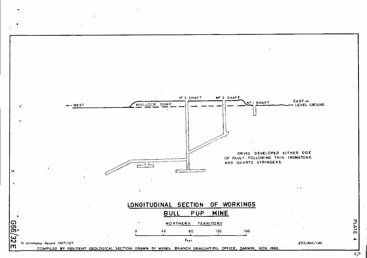
SUBSURFACE GEOLOGY
Plates 3 and 4 dhow details of the underground workings.
The dominant rock types in the mine area are sandstones with
occasional shale horizons, and kaolinised shear zones. The sandstones are
fine to medium grained, often cut by thin quartz veins and show average
dips between 200 and 500 .
Three shafts have been sunk near the trace of a small fault,
close to the crest of a small anticlinal fold, which pitches gently east.
This fault dips steeply to the north, and the sedimentary rocks in the
immediate vicinity have been sheared, kaolinsed and silicified.
Gold is associated with ironstone and quartz stringers between
6 inches and 18 inches thick, which branch off from both sides of the faultzone.
The lessee obtained 20.7 tons of ore, yielding 5i ounces ofgold from a small northerly cross-cut in which the gold was associated
with a quartz leader. The ironstones are crumbly and well weahtered, and
carry only trace values of gold.
CONCLUSIONS
It is thought unlikely that payable quantities of ore will be
found because of the limited width (6 inches to 18 inches) of the ironstone
and quartz leaders, combined with their tendency to die out at a short
distance from the fault zone, and-because sandstone is not usually a favourable
host rock to mineralization in the Tennant Creek field.
If,,however, the lessee intends to continue development work on
the mine, a more detailed geological survey is recommended.

20
REFERENCES
DUNNET, D. and HARDING, R.R., 1965 — The geology of the Mount Woodcock
one—mile Sheet area, Tennant Creek, N.T. Bur. Miner. Resour.
Aust. Rec. 1965/168.
IVANAC, J.F., 1954 - The Geology and. Mineral Deposits of the TennantCreek Gold Field, N.T. Bur. Miner. Resour. Aust. Bull. 22.
foo
LOCALITY MAP
BULL PUP MINE
it Explorer S(Warrego)
0 Red Bluff
TENNANT CREEK
•To Do twin
0 4 8 120 I I I i
Ch MILESCr)..4,..*•■•IVCD
CCAIPILED BY RESIDENT GEOLOGICAL SECT/ON DRAWN BY MINES BRANCH DRAUGHT/NG OFF/CE, DARWIN. NO K 1966rti To A/ice Springs
0441 Sorrwri
To accompany Record 1967/127
E53/A14/139

4
PHO 0 - OC&r, DKERPRE—AIOON LAST HOPE AR EA
1 2 3
C`, r • 5/ 30 E
PLATE 2
. • ..... • •
$2:•
• " -.;
-
LEGEND
TOMKINSON CREEK BEDSQtrites , Cong/..)
WARRAMUNGA BEDS(Si/tstones, tuffoceous set.)
GOSSAN
OUTCROP BOUNDARIES
— FAULTS
s,
%W.
To occom en Record 1967/127. E53/AK/140(
Miles

PM* grained sandstone(Oct. very thin guortzrond
ironstone veinlets / .11.0)
(
„."
• •■ •
)./(.•
LEGEND fault. .Workings.
Short No I - 14adeep
No 2 - 48 deep
No J - 78 deep
\(200 Dip and Strike orbeciding
Quartz vein with dip.
AAJ.. A Ironstone will) dip.
244-ra- -11-
-44"
Q uort vein eth ick
44111"1" # 6 _Alronstone 12. thickIIsele
-0 --1-14' —rte. ---------------
------No 2
2S°
■
PLAN OF WORKINGS -78 FT. LEVEL.BULL PUP MINE
NORTHERN TERRITORY
0). 0 410 80 120 160J
(4 Feet—aiii To accompany Record 1967/127
0 E53 /A14/141
COMPILED BY THE RESIDENT GEOLOGICAL SECTION DRAWN BY MINES BRANCH DRAUGHT ING OFFrCE , DARWIN, T NOV IC/66.
__0‘...MULLOCK DUMP il■••
Ir--
g■IM. 4I•MMII• ■•■•
N° 3 SHAFT N° 2 SHAFTEAST—e-
+--■••••• LEVEL GROUND
DRIVES DEVELOPED EITHER SIDEOF FAULT FOLLOWING THIN IRONSTONEAND QUARTZ STRINGERS.
SHAFT
1
LONGITUDINAL SECTION OF WORKINGS
-.up-- WEST
<-7
(.. BULL PUP MINE 0 . NORTHERN TERRITORYCA0) rz 0 40 80 120 160■......... ■ , I I(A)
" . ToFeet
accompany Record 1967/127 E53/A14 /142rn COMPILED BY RESIDENT GEOLOGICAL SECTION DRAWN BY MINES BRANCH DRAUGHTING OFFICE, DARWIN NOV. 1966.

—21 —
GEOLOGICAL INVESTIGATION OF AMETHYST DEPOSITS, HELEN SPRINGS
AREA. NORTHERN TERRITORY
SUMMARY
The Helen Springs Amethyst occurrence is adjacent to the Helen
Springs turn—off 100 miles north of Tennant Creek. A tape and compass
survey was made of this area, over which an Authority to Prospect has
been applied for by Mr. J. Pollard.
In this area the Helen Springs Volcanics overlie fine—grained
sandstones of the Tomkinson Creek Beds. The Volcanics consist of vuggy,
vesicular basalt and andesite flows. The vugs are infilled with quartz,
including minor amounts of amethyst and smoky quartz.
INTRODUCTION
The Helen Springs amethyst occurrence lies 100 miles north of
Tennant Creek, adjacent to the Helen Springs turn—off from the Stuart
Highway.
At the request of Mr. J. Pollard of Warrabri Native Settlement,
a tape and compass survey was made of the area, and the geology was mapped
in detail.
GENERAL GEOLOGY
The prospect occurs on the northern extension of a low ridge,
which rises forty feet above the level of the Stuart Highway at the Helen
Springs turn—off.
The dominant rocks types are basaltic and andesitic flows which
are part of the Helen Springs volcanic succession. The flows are predomi—
nantly vuggy and amygdaloidal in character, and the vugs are quartz—filled,
often with chlorite encrustations.

- 22 -
The volcanic succession overlies a gently east dipping succession
of fine-grained sandstones, which are part of the Tomkinson Creek Beds.
Lithology: Tomkinson Creek Beds
• The sandstones are coarse-grained, gritty, but poorly consolidated
rocks. They dip eastwards at 20 to 100 and underlie the Helen Springs
Volcanics. Near the contact with the Volcanics, small patches of chalcedony
occur in the joint planes, often associated with small veinlet of hematite.
The sandstones are laminated, the individual laminae averaging
one third of an inch in thickness, with marked colour variations.
Helen Springs Volcanics:
The volcanics consist of gently west dipping flows, mainly basalt
with a capping of andesite.
The andesite varies in thickness from four to ten feet. A sample
sent to Canberra was described as a hydrothermally altered amygdaloidal
?andesite, having a trachytic texture and consisting of micro-laths of
kaolinised and sericitised feldspar (35%) in a groundmass replaced entirely
by red iron oxide (45%). Scattered large and Small amygdules were filled
by quartz (8%) and chlorite (12%).
The basalts are fine-grained melanocratic rocks. Five distinct
flows were distinguished in the sequence, each of which has varying amounts
of amygdaloidal quartz. All the flows have been hydrothermally altered,
especially the upper ones, which contain quartz veins up to 4 feet thick.
Structure:
The area mapped is in the western portion of a shallow basin formed
by the Tomkinson Creek Beds. The central portion of this basin is occupied
by the Helen Springs Volcanic sequence, (Helen Springs four-mile Geological
Map, Preliminary Edition, Bureau of Mineral Resources, Australia, 1966).

PLATE 1
RENNERSPRINGS
LOCALITY MAP
HELEN SPRINGSAMETHYSTS MINE
NORTHERN TERRITORY
soNNEY.....
Om. O w. wm KURUND/WELL
IA "lb 'Springs.
To accompany Record 1967 /127 E53 /A10/3 G66/33ECOMPILED BY RESIDENT GEOLOGICAL SECTION DRAWN BY MINES BRANCH DARWIN NOV. /966.


CROSS SECTION
HELEN SPRINGS AMETHYSTS OCCURRENCE
(East)
-: •
LEGEND
Boso/t f7ows.
Andesite Flow
omknson Creek Beds
0 100 200 300 400t I a I I
' Feet
(//

- 23 -
AMETHYST DEPOSITS
The volcanic rocks are hydrothermally altered, and contain secondary
quartz as amygdaloidal fillings and as veins in the basalt flows. These veins
reach their maximum development (up to four feet thick) just beneath the
andesite capping. Several of these veins show distinct banding with trans-
lucent white euhedral quartz forming the outer layer, and amethyst and
smoky quartz forming the inner layers.
Although the individual crystals are small (up to three quarters of
an inch long), their colouring is suitable for gem quality stones.
CONCLUSIONS AND RECOMMENDATIONS
Although the amethyst-bearing rocks reach their maximum develop-
ment within one zone of the volcanics, they are sporadically distributed
throughout the basalts. Further excavation along the known quartz veins,
and an extension of the search over a wider area within the favrourable
zone are therefore recommended.
At the time of writing, reserves of 40 lbs. of good quality
amethysts had been estabished.
Before any further prospecting is done, the saleability of
Amethysts of this quality should be investigated.
At\
QL

GEOLOGICAL REPORT ON THE POWER OF WEALTH GOLD MINE, KURUNDI GOLD FTFID
NORTHERN TERRITORY
SUMMARY
TheIbwer—of —Wealth goldmine is situated in the Murchison Ranges
55 miles south—south—east of Tennant Creek.Gold occurs in patchy shoots in a major north—westerly trending,
nearly concordant quartz vein in the eastern limb of an anticline of
Proterozoic quartzose sediments of the Hatches Creek Group. This vein
appears to have been cut off by a fault about 60 feet below the surface.
A programme of underground and surface drilling is recommended
to locate the displaced vein, and a search for other ore—shoots is suggested.
INTRODUCTION
The Power—of—Wealth goldmine is situated in the Murchison Ranges,
55 miles south—south—east of Tennant Creek.
Access from Tennant Creek is by the Stuart Highway to Bonney . Well,
thence by the Kurundi track 19 miles eastward.
The surface geology and part of the exposures in the underground
workings were mapped in November 1965. Information on parts of the workings
which are now inaccessible Was obtained from an earlier report by J. Barclay
(1963).
GEOLOGY
The auriferous lode is situated on the eastern limb of a north—
south trending anticline in Proterozoic sediments of the Hatches Creek Group.
The sediments consist of sandstone and quartzite, with rare sandy pebble
conglomerate and shale. Dips are consistently to the north—east at angles
between 22 and 40 degrees. a
Lffb
-2
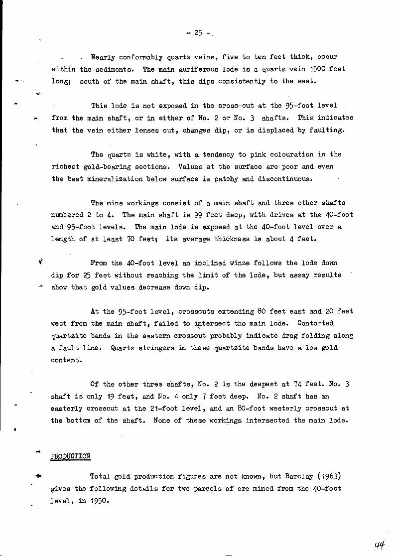
_ Nearly conformably quartz veins, five to ten feet thick, occur _
within the-sediments. The main auriferous lode is a quartz vein 1500 feet
long; south of the main shaft, this dips consistently to the east.
This lode is not exposed in the cross-cut at the 95-foot level
from the main shaft, or in either of No. 2 or No. 3 shafts. This indicates
that the vein either lenses out, changes dip, or is displaced by faulting.
The quartz is white, with a tendency to pink colouration in the
richest gold-bearing sections. Values at the surface are poor and even
the best mineralization below surface is patchy and discontinuous.
The mine workings consist of a main shaft and three other shafts
numbered 2 to 4. The main shaft is 99 feet deep, with drives at the 40-footand 95-foot levels. The main lode is exposed at the 40-foot level over a
length of at least 70 feet; its average thickness is about 4 feet.
From the 40-foot level an inclined winze follows the lode down
dip for 25 feet without reaching the limit of the lode, but assay results
show that gold values decrease down dip.
At the 95-foot level, crosscuts extending 80 feet east and 20 feet
west from the main shaft, failed to intersect the main lode. Contorted
quartzite bands in the eastern crosscut probably indicate drag folding along
a fault line. Quartz stringers in these quartzite bands have a low gold
content.
Of the other three shafts, No. 2 is the deepest at 74 feet. No. 3
shaft is only 19 feet, and No. 4 only 7 feet deep. No. 2 shaft has aneasterly crosscut at the 21-foot level, and an 80-foot westerly crosscut at
the bottom of the shaft. None of these workings intersected the main lode.
PRODUCTION
Total gold production figures are not known, but Barclay (1963)
gives the following details for two parcels of ore mined from the 40-foot
level, in 1950.

— 26 —
Ore treated
Gold won by Tailings Amalgamation
18 tons 5 ozs. 6.5 dwts/ton
21 tons
6 ozs 1.7 dwts/ton
RECUIMENDATIONS
Further work should be directed towards defining the extent of
mineralization in the main lode along strike and down dip, and searching
for extensions of the main lode displaced by faulting.
A programme of underground drilling is therefore recommended as
shown on Plate 3, and a wagon—drilling programme from the surface is
recommended to search for extensions of the known ore shoot along strike.
Any other portions of the main lode showing gold values in sur—
face samples should also be tested by,wagon drilling.
REFERENCES
BARCLAY, J., 1963 — Geological Investigation of the Power of Wealth
Gold Mine, Kurundi Area, N.T. In Minor Metalliferous Investi—
gations, Northern Territory Resident Geological Section.
Bur. Min. Resour. Aust. Rec. 1963/3. (unpubl.)
46,

6z1"POWER a WEALTH-GOLDWAIE
PLATE 1
lb C-------5:o1ro°w °I
TEN/VANT CREEK
LOCALITY MAP
WER OF WEALTH GOLDMINE.NORTHERN TERRITORY.
0 8 10 24
Approx. Miles
MURCHISON _RANG E
8C1NNEY KURUND1
WELL fi) HS
ThAhce Sprtngs
D A VE N PORT
VRANGE s
E53 /A14 /155 6 66 L40 ETo accompany Record 1967/ 127
.:0,,11'11 ED BY RESIDENT GEOLOGICAL SECT/ON DRAWN BY MINES BRANCH DARWIN NOV 1966-