Downtown Carrollton Rail Station Master Plan Phase Two
92
Downtown Carrollton Rail Station Master Plan Phase Two April 2009
Transcript of Downtown Carrollton Rail Station Master Plan Phase Two

Downtown Carrollton Rail Station Master PlanPhase TwoApril 2009

Downtown Carrollton Rail Station Master Plan | Phase Two | April 2009
Credits
City CouncilRonald Branson, MayorTim HaydenJohn MahalikPat MaloneMatthew MarchantLarry WilliamsTerry SimonsHerb Weidinger
Steering CommitteeNancy PutnamJanet MayberryJack StotzCraig SimpkinsDoug HrbacekMark StokesDave Oldfi eldJudy ScamardoDick CalvertJim AbadieJ. Stephen Dean
StaffPeter J. Braster, TOD Sr. ManagerCesar Molina, PE, Director of EngineeringMarc Guy, Assistant City ManagerChris Barton, AICP, Chief PlannerTom Hammons, PE, Transportation Engineering Division ManagerRavi Shah, CBO, Director Urban DevelopmentMarcos Fernandez, PE, Sr. Transportation Engineer
Project TeamJacobsStainback Public / Private Real EstateLTK Engineering
Credits

Table of
Contents
Table of Contents
1. Executive Summary2. Project Overview3. Goals and Objectives4. Project Context5. Passenger and Freight Operations6. Mercer Freight Yard Relocation7. Passenger Station Complex8. Urban Design Plan9. Mixed-Use Development Form10. Land Use / Phasing11. Public Infrastructure and Costs12. Public / Private Partnership Plan13. Funding Resources
Appendices1. Land Use and Phasing Plans / Tabulations2. Master Plan and Related Images3. Urban Design Plan4. Station Complex / Transit Hall Drawings5. Public Space / Streetscape Drawings6. Mercer Freight Yard Plan / Profi le7. Gateway Drawings8. Cost Estimate Summary9. Public / Private Finance Plan10. Railroad Coordination Meeting Notes
Downtown Carrollton Rail Station Master Plan | Phase Two | April 2009

The Downtown Carrollton Rail Station Master Plan is intended to achieve an integrated vision for a transit-oriented community built around a key transit hub serving Carrollton and the Metroplex. The City of Carrollton’s primary goal for the project is to set the design framework for the transit hub integrating multi-modal, multi-agency transit service with a new urban center and gateway to the City of Carrollton. The ultimate success of the project is measured by the ability to meet this goal and individual objectives of a diverse set of stakeholders while also validating the � nancial feasibility of the project.
The future downtown transportation hub will improve local and regional access and strengthen linkages between transportation, land use and economic development. The project is also an opportunity for Carrollton to create the vision for a new symbolic center of the City. This vision will be achieved through a proposed 76 acre “walkable” / pedestrian-friendly development centered on the transit facilities and surrounded by new, high-quality residential and commercial mixed uses. The master plan provides a development and infrastructure framework within the existing downtown context in support of this vision. This framework includes sidewalks, streets, public plazas, open spaces, gateways and related infrastructure designed to “set the stage” for future development. The master plan also addresses development of a signature “Transit Hall” and “Transit Plaza” as the connecting elements between all transit components and the community.
The Master Plan has been developed in two phases. Phase One, covered in a previous report, focused on early development of key issues of overlaying passenger service with the existing freight operations of the Cotton Belt and BNSF corridors and integration of Denton County Transit Authority (DCTA) and Dallas Area Rapid Transit (DART) stations. Phase Two, the subject of this report, includes conceptual project development of the transportation components (passenger corridor alignment, track work and passenger transportation hub referred to as the “station complex”), a framework for civic/open spaces and transit-related, mixed-use development within a general ¼-mile radius of the station.
The Master Plan also addresses the cost of public infrastructure and private development components of the project.Total public infrastructure costs for the ultimate development plan is $63 million.The proposed private development costs are $518 million within three development phases for a total project cost of $581 million in 2008 dollars. The private development budget is based on a building program and phasing plan established by a market study provided by the City.Based on the development plan, a Total Development Budget and Developer Pro Forma will be created for all phases of the development. The Pro Forma illustrates the necessary gap � nancing and funding mechanisms to achieve � nancial feasibility for the entire project. Available local, state and federal funding programs suitable for transit-oriented development are identi� ed to supplement the available Tax Increment Financing (TIF) alternatives already established.
1. EXECUTIVE SUMMARY
1-1

Downtown Carrollton Rail Station Master Plan | Phase Two | April 2009
The Downtown Carrollton Rail Station Master Plan is intended to achieve an integrated vision for a transit-centered community built around a key transit hub for the Metroplex. The future downtown transportation hub will improve local and regional access and strengthen linkages between transportation, land use, and economic development. The project is an opportunity for Carrollton to develop an urban center serving as the symbolic center of the City. The master plan provides a development and infrastructure framework within the existing downtown context to achieve this vision. The master plan also addresses transit facilities, parking and access, infrastructure needs, public/private � nancing, and transit funding strategies.
The transportation components of the Master Plan includes Dallas Area Rapid Transit (DART) Northwest Corridor Light Rail System; Denton County Transportation Authority (DCTA) rail system; Crosstown Rail Service connecting DFW Airport and Plano via the Cotton Belt line; and future Frisco Line rail service connecting Frisco and Irving via the Burlington Northern Santa Fe line.
DART is currently constructing the Green Line, a light rail extension and station in downtown Carrollton with revenue service planned for December 2010. The DART 2030 Draft System Plan also includes provisions for a crosstown station on the Cotton Belt freight line with service planned for the 2020-2030 time frame. In May 2005, The Denton County Transportation Authority (DCTA) adopted a “locally preferred alternative” with rail service
from downtown Denton transferring to DART in downtown Carrollton. In addition, the North Central Texas Council of Governments (NCTCOG) completed a North Texas Regional Rail Corridor Study in December 2005 establishing the need for a regional rail station on the Burlington Northern / Santa Fe Line (BNSF) at the Carrollton junction. This line will connect Frisco with Irving via the Trinity Rail Express (TRE). The juncture of four rail lines in downtown will transform Carrollton into a major destination and transfer point within the Metroplex.
The Master Plan has been developed in two phases. Phase One, covered in a previous report, focused on early development of key issues: overlaying passenger service with the existing freight operations of the Cotton Belt and BNSF corridors; and integration of DCTA and DART passenger operations. Phase One essentially set the operational and geometric constraints or framework
2. PROJECT OVERVIEW
Phase One Study:Existing Conditions & Context�Case Studies�Freight Service Operations Plan�Passenger Service Operations Plan�Mercer Freight Yard Relocation Alternative �AnalysisPassenger Ridership Projections�Access & Parking Analysis/Requirements�Planning Framework�Transit Hub Program�Preliminary Development Review�
2-1

for the freight and passenger transit components of the project, establishing the groundwork for a functional transportation hub. Phase One also identi� ed the need for the relocation of Mercer Freight Yard out of the current downtown Carrollton area and key coordination issues for streets and infrastructure in support of the Master Plan.
Phase Two, the subject of this report, includes conceptual project development of the transportation components (passenger corridor alignment, track work and passenger transportation hub). The transportation hub, referred to as the “station complex” in this report, includes passenger boarding platforms for DART Green Line light rail, DART (Cotton Belt) Crosstown Line, and the Frisco Line (Burlington Northern/Santa Fe), and associated linkages and passenger amenities. The Master Plan also provides a framework for civic/open spaces and transit-related mixed-use development within a general ¼-mile radius of the station. The study area is approximately bounded by Vandergriff Drive to the south, Interstate 35 (IH-35E) to the west, Northside Drive to the north and Jackson Road to the east.
2-2
Project Area

Downtown Carrollton Rail Station Master Plan | Phase Two | April 2009
The primary goal of the project is to set the design framework of a new multimodal station complex for downtown Carrollton integrating multi-modal, multi-agency transit service with a new urban center and gateway to the City of Carrollton. The urban center is to be developed in accordance with the Transit Center District form-based Zoning and Land Use code and community goals for a contextual response to the historic downtown while looking toward the future.It was recognized during Phase One that each of the project stakeholders held goals re� ecting their respective interests in the project. Alignment of these individual goals are addressed in the Phase One report. The alignment of these goals represent the � rst step in creating consensus for the project which became the baseline for initial project development.
Project Objectives
Develop a station layout for the ultimate �con� guration and transit operations based on the project goals.
Develop a mutually supportive freight and �passenger operation plan that maintains freight service and enhances passenger operations.
Develop a phased implementation plan �based on infrastructure improvement and development market milestones
De� ne the relationship and linkages between �private development and the station complex.
De� ne the parking and access requirements �for the station complex and proposed development.
De� ne the scale and architectural character �of the station complex and surrounding development.
3. GOALS AND OBJECTIVES
3-1

4. PROJECT CONTEXT
The Master Plan is developed within the context of existing and on-going related studies and direction provided by stakeholders, the steering committee, and other sources as well as assumptions made during the Master Plan process. The following resources listed below re� ect the project parameters and establish the basis of design for the project.
Transportation and Parking �Study, dated October 2007 under contract to Jacobs Civil Inc. The study includes traf� c volume projections, area parking requirements/facilities, and traf� c network mitigation measures.Tax Increment Re� nance Zone �No. 1 Infrastructure Study (Water & Sewer), dated December 2006 by Birkhoff Hendricks and Conway LLP Consulting Engineers provided the basis of design for water and sewer infrastructure improvements and related costs.TOD Master Drainage Study� ,dated July 2007 by Nathan D. Maier Consulting Engineers provided the basis of design for drainage infrastructure and related costs.Trails Master Plan� , adopted by City Resolution 2986 provided the basis of design for pedestrian and bicycle access and trail connections in the project area.Carrollton Transit-Oriented �Development Plan adopted by the City Resolution No. 3164, developed by Townscape Inc. de� ned the overall station area goals and objectives for development within the project area.
Downtown Carrollton – Market �Analysis and Implementation Strategy by Leland Consulting Inc. provided the basis of the total development area and phasing for private development within the project area.Project Stakeholders� , included DART, DCTA, and Dallas, Garland & Northeastern (DGNO) railroad. Burlington Northern/Santa Fe Railroad (BNSF) is considered a stakeholder in the process; however, BNSF was not involved directly in discussions due to a time frame not being set for the use of the BNSF Corridor.Master Plan Steering Committee� ,provided guidance on community values and expectations with input received at all project milestones.
Existing ConditionsLand Use: The study area includes a mix of retail, light industrial, single and multi-family residential uses and vacant parcels much of which is planned to be redeveloped as part of the Downtown Carrollton DART Station Area Plan. The plan concludes that there are 12 acres of under-utilized land in the station area with development or redevelopment potential. See the Downtown Carrollton Station Area Plan,adopted by City Council Resolution 2580 for additional information.
Access / Circulation: Two major regional thoroughfares provide access to Downtown Carrollton: IH-35E and Belt Line Road. IH-35E is a 6-lane divided freeway with full access control which is oriented diagonally
4-1

Downtown Carrollton Rail Station Master Plan | Phase Two | April 2009
from the southeast to the northwest and borders the west side of the downtown area. Belt Line Road is a six-lane divided major arterial roadway that transects the downtown area in an east-west orientation.
The grade-separated interchange of IH-35E and Belt Line Road is located on the west side of the downtown area. Continuous frontage roads are two-lanes with one-way traf� c operation. The IH-35E frontage roads and Belt Line Road intersect at grade with the network of downtown local streets.The core of downtown local streets form a rectilinear grid network oriented diagonally in a southeast to northwest direction, parallel to the freeway and railroad.
Anticipated changes due to planned and committed roadway improvements include lowering Belt Line Road and closing local streets that currently intersect between Main Street and the southbound IH-35E frontage road. The addition of new access roads to the development area are also recommended in the Transportation and Parking Study as discussed later in this report.
Pedestrian / Bicycle Network: The City of Carrollton Transportation Plan includes designated pedestrian and bicycle trails.Planned Trails in the downtown station area
include a trail running between the BNSF right-of-way and Hutton Branch northeast of the station and a trail paralleling the DART-LRT right-of-way north and south of the station. These trails are indicated as intersecting at the Carrollton Downtown Station. Due to the modi� cations being made by DART to accommodate the Cotton Belt to Union Paci� c (Katy) freight connection, the trails may not be able to intersect exactly as shown in the current Transportation Plan.
Pedestrian facilities provide linkages within the downtown area as well as connectivity with surrounding neighborhoods. In the core area of downtown Carrollton, south of Belt Line Road, the sidewalk network is fairly complete and in good condition. However, with increased pedestrian volumes due to development, additional sidewalk width may be required. Most streets have sidewalks on both sides and the walks are wide, level, and continuous. Crosswalks at intersections are marked with appropriate signage and pavement markings.
North of Belt Line Road, sidewalks are nonexistent or discontinuous with gaps in the network; present in one block, absent in another. Moreover, the railroad lines intersect some major streets and pedestrian pathways. The absence of an integrated sidewalk network and the presence of railroad lines limit pedestrian mobility in this area.
Parking Availability: A limited amount of parking currently exists in the station area. Most of the available parking spaces are in downtown Carrollton. Existing parking primarily consists of on-street parking spaces, primarily intended for short-term use by the shoppers and visitors. A number of off-street surface parking lots associated with individual land uses are present in the downtown area. The City
4-2
Access Improvements

completed the construction of 81 public parking spaces in May of 2006 on City-owned property at Carroll Ave. The need for additional public parking is recommended in the Transportation and Parking Studyincluding the addition of 200 structured parking spaces east of the DART right-of-way in the vicinity of Carroll Ave. and Main Street. Recommendations were also made for additional parking in the downtown core to replace parking to be removed from the downtown square. This will be accomplished by building a new surface parking lot at Elm and Vandergriff Dr.
Policy ContextZoningIn order to encourage new development in the station area, the City of Carrollton adopted a Transit Center Zoning Districtas part of the Comprehensive Zoning Ordinance. The goal of the district is to provide development and land use � exibility within the framework of a form-based development code, encouraging a mix of residential, retail and of� ce uses in a pedestrian-friendly district. The primary intent of the code is as follows:
Provide a comfortable and attractive �environment for pedestrians.Construct buildings close to the sidewalk �and street.Construct continuous building frontage �along block faces.Provide shared parking both on-street �and in the center of blocks.Contribute to the de� nition and use of �public parks and plazas.Design streets and buildings �which contribute to creating a safe environment.Build on the character re� ected in the �Old Downtown area.
Based on recommendations of the Downtown Carrollton DART Station Area Plan, the Transit Center Zoning District code was adopted by the City of Carrollton in April 2005. The code provides four distinct sub-districts; Urban Core, Urban Center, Urban Fringe, and Historic Core. The majority of the study area is located in the Urban Core and Urban Center Districts. The Master Plan is developed in accordance with the requirements of each district. Speci� c district design standards are de� ned in the Transit Center District Zoning Ordinance.
Tax Increment Reinvestment ZoneTax Increment Reinvestment Zone (TIRZ) districts are viewed as a suitable funding tool to help obtain desirable transit-oriented development. The existing conditions of the
4-3
Transit Center DistrictsUrban Core• – Urban high-density area adjacent to the station permitting high density residential, (high-rise apartments, condominiums, and townhomes), retail, of� ce and entertainment uses built around a high degree of accessibility and availability of infrastructure. Urban Center • - Moderate-density residen-tial (high-rise apartments, condominiums, and townhomes), retail and of� ces with a high level of access and infrastructure.Urban Fringe• - Lower density urban transi-tion district, primarily residential in charac-ter. The district is intended to be transitional to existing single family residential neigh-borhoods.Historic Core• - Mixed-use district to be utilized where there is a historic character which is to be preserved or enhanced.

Downtown Carrollton Rail Station Master Plan | Phase Two | April 2009
Downtown Carrollton Station area meet the state’s guidelines for a TIRZ in that the age of the infrastructure, antiquated street and lot layouts, and the lack of parking hinder redevelopment. A TIRZ is one of several � nancing tools that can be used to � nance infrastructure in support of transit-oriented development.
In January 2006, the City established a TaxIncrement Reinvestment Zone as allowed by law. The TIRZ includes the Carrollton Downtown Station Master Plan project area. The City of Carrollton has committed to participate at a 65% rate - that is, 65% of future revenue increases in the zone will be used to fund infrastructure improvements within the zone. Dallas County has agreed to participate. The Dallas County Community College District and local CFBISD public school district have declined to participate.
4-4

Freight OperationsThe primary tasks under Phase One of the study were to identify and mitigate the impacts of freight operations on the downtown development area; develop a plan for future passenger operations for the Crosstown, BNSF, and DCTA lines; and to test the feasibility of relocating the Mercer Freight Yard from its current position adjacent to the station and development area.
Three different freight lines converge in Carrollton, crossing one another at the site of the Downtown Carrollton Station. All three of the lines are now owned by DART, although one forms part of a through route that is still connected to BNSF, the original owner.
The busiest of the lines is the BNSF, having its origins on the Trinity Rail Express (TRE) line in South Irving. This line runs north from that point and curves to the northeast as it passes through Carrollton. The ownership of this line reverts from DART back to BNSF towards the northeastern end of the Carrollton Station site at Mercer Freight Yard. The line then passes through Frisco, Sherman, and Madill leading to Tulsa, Oklahoma. Besides providing over� ow capacity for long distance freight, the segment passing through Carrollton (known as the “Frisco” or Madill Subdivision) is an important source of local freight service.
A second rail line passing through Carrollton is the “Cotton Belt,” originating in Ft. Worth, passing through Carrollton, Addison, and Plano terminating in Wylie,
Texas. The segment from Ft. Worth to Carrollton is operated by the Ft. Worth and Western Railroad. There is a small freight yard (known as Mercer Freight Yard) just east of the Union Paci� c (Katy)/Cotton Belt intersection. Mercer Freight Yard serves as a hub for the Dallas, Garland & Northeastern (DGNO) operations and local service in the northwest part of Dallas County. The DGNO operates construction aggregate trains from Sherman (on the Madill Sub) to Carrollton.
A third rail route, referred to in this report as the Union Paci� c (Katy) (previously part of the Union Paci� c railroad) originates in downtown Dallas, passes west of Love Field Airport and then continues north through Farmers Branch, Carrollton, Lewisville, and Denton.
In order to add passenger operations to these three freight lines, signi� cant track alignment and operational modi� cations are required. Additional freight operations information is included in the Phase One Report.
Proposed New Passenger ServicesThe most immediate freight modi� cations will be required on the Katy (UP) line for DCTA service between Denton and Carrollton. This 21-mile line is in the late stages of � nal design. DCTA service will be shared with local freight. Initially, DCTA service will terminate one mile north of downtown at the Trinity Mills DART station with cross-platform transfers to DART. In the future, when the DART Crosstown service is operational, DCTA plans to extend service to Downtown Carrollton
5-1
5. PASSENGER AND FREIGHT OPERATIONS

Downtown Carrollton Rail Station Master Plan | Phase Two | April 2009
via use of the DART LRT tracks. At that time, transfers to DART and the Crosstown corridor may be made at the Downtown Carrollton DART Station where the freight service would be severed north of the Cotton Belt junction.
The second and third additions will be the BNSF (according to NCTCOG Regional Transportation Plan Mobility 2030) and Crosstown service (according the DART 2030 System Plan). While the timing is somewhat speculative, Crosstown would likely be � rst as part of the DART 2030 service plan. The Crosstown would use the Cotton Belt corridor from Richardson and Plano though Carrollton to DFW International Airport. The BNSF service would use the Madill Sub from Frisco through Carrollton to south Irving. From there, trains can connect to the Trinity Rail Express (TRE) to either Dallas or Fort Worth.
The geometry of the DART aerial structure currently under construction will accommodate the Crosstown, Frisco, and freight track con� guration crossing at grade below. However, the proximity of the tracks to the guideway piers require crash resistant piers adjacent to the right-of-way. DART incorporated this requirement in its design of the aerial structure.
At this point, the responsible agencies have not determined what vehicle equipment technology would be used on the Frisco or Crosstown corridors. It is likely that the BNSF service would be Federal Railroad Administration (FRA) compliant due to the volume of freight on the line and the need to share tracks. DART has de� ned the passenger service on the Crosstown corridor only as “Express Rail” at this time.However, due to frequency of service and member City concerns over commuter rail operations issues, this study assumes that
the service will be “non-compliant” rail service, meaning a separation from freight service will be required. This assumption requires grade separation of the Crosstown tracks over the Cotton Belt line from the east on approach to the station as shown in Figure 1.
Passenger Station OperationsSeveral alternatives for station con� gurations for the Crosstown and Frisco corridors were studied in Phase One. The preferred plan developed in Phase One locates the Crosstown platform in the most northern section of the Cotton Belt/BNSF right-of-way. This platform and alignment con� guration allows the Crosstown service to extend westward without crossing the BNSF/Frisco freight and passenger tracks.The future Frisco platform will occupy a space parallel to the Crosstown platform in the southern portion of the right-of-way.The platform and alignment con� guration allows the Frisco line to continue southward without track crossing con� icts with the Crosstown service or BNSF freight. The track con� guration for both services provides separation of freight and passenger
5-2
Figure 1 - Platform / Track Schematics

service through the station complex area. A schematic diagram of the preferred layout is shown in Figure 1.
The Phase One Report identi� ed several key passenger service issues that must be coordinated during advancement of the design to ensure the success of future freight and passenger operations. These include:
Lowering Belt Line Road needs to �consider the following:- Belt Line Road needs to be low
enough for a long enough distance to accommodate multiple tracks on the BNSF corridor crossing Belt Line.
- The Northbound frontage road of IH-35E needs to be kept low enough to allow for the “cross-over” of the Crosstown corridor bridge.
Through freight movements on the �Madill Subdivision can be designed for 30 MPH.
The run-around operation for �the DGNO rock train can be accommodated in all cases.
The freight track to the two customers �south of downtown Carrollton will have to be removed to accommodate future Crosstown and Frisco services.
The design for widening IH-35E �needs to be coordinated with track alignments to provide pier locations that do not interfere with track layouts, especially the provision of one or more additional tracks on the route to south Irving.
The rearrangement of tracks on the �east end of the station track network will require negotiations with BNSF.
Mercer Freight Yard must be moved �to accommodate the Crosstown and Frisco services.
Additional real estate is required �to provide suf� cient right-of-way for passenger service and freight modi� cations (properties include Cedar Supply, part of the Race Track gas station at Main Street and Belt Line Road, and a small portion of the Wright parcel, west of Broadway and north of the rail right-of-way).
5-3

Downtown Carrollton Rail Station Master Plan | Phase Two | April 2009
6-1
6. Mercer Freight Yard Relocation
Mercer Freight Yard is located in the heart of the property surrounding the station complex and presents a signi� cant inconsistency with and impediment to proposed land use development in the station area. As a practical matter, the yard also presents interference from freight trains blocking the roadway/rail crossings in the area. Realizing this fundamental incompatibility, the City of Carrollton requested the study team examine the potential for moving the yard function elsewhere. The � rst step in evaluating the feasibility of the relocation was gaining an understanding of the freight operations and evaluation of alternative sites that would meet railroad operations needs and provide a more compatible location based on surrounding development. This analysis was addressed in the Phase One Report.During Phase One, � ve potential options for relocating Mercer Freight Yard functions were identi� ed and analyzed and a preferred site was recommended.
Preferred Location:The East Belt Line Industrial Area provided the most advantageous location to both the operating railroad (DGNO) and the City of Carrollton. The advantages of the East Belt Line Industrial Area option included availability of suf� cient property with minimal community impacts, compatible adjoining land uses, few grade crossing impacts, maintenance of existing freight service, and accommodation for future passenger developments on the Crosstown Line. It was determined during Phase One that all requirements of the Mercer Freight Yard operation could be met at the East Belt Line location with land available for possible future expansion.
East Belt Line Yard PlanIn Phase Two, further analysis was completed and a conceptual yard layout was developed to address operational constraints of the site with regard to track pro� le and
Proposed East Belt Line Yard Location
Existing Mercer Freight Yard

yard access. Survey data was also developed to determine grades of the existing tracks, elevations within the yard area and yard boundaries.
The proposed East Belt Line Yard plan replicates the existing Mercer Freight Yard in terms of clear lengths of each track to store cars, number of tracks, and which tracks are double-ended or stub-ended. The yard track layout and related track pro� les are shown in Appendix 1. A summary of the proposed East Belt Line Yard attributes and constraints follows:
An additional track is needed to replace �the Mercer Freight Yard access (RIP) track that is currently on the west side of Broadway.The plan requires the building of a new �through track called “New Yard Lead,” which adds new track (about 3,000 feet) to the overall facility. At the current Mercer Freight Yard, this track is now the main line. To offset this additional footage, track #85 (Mercer Pass replacement) can be eliminated, saving 1900 feet of track construction, requiring usage of the current main line for this function. This results in some additional operational burdens as this long run-around or arrival/departure track is a little further away from the yard and is on the original grade. The yard lead on the east end goes up �a 1.0% grade, which is similar to the existing Mercer Freight Yard layout. The yard lead direction is on the same end as Mercer Freight Yard. The nearest road crossings in both �directions are signi� cantly further away than the current Mercer Freight Yard. The yard geometry � ts the Honors Club �(formerly Columbia Club) parcel except for needing additional right-of-way for the lead tracks.
The yard plan does not disturb active �nearby industry tracks nor need any public road crossing modi� cations. The layout plan provides for track �expansion. Long tracks next to the main line could be installed, and/or some of the stub-tracks could be lengthened. The yard location introduces steeper �grades on the yard approach than exist at Mercer Yard. The grade from downtown Carrollton to East Belt Line is mostly 1.0%, whereas the steepest grade on the Madill Subdivision approaching Mercer Freight Yard is less than 0.5%. If DGNO maintain moderate speeds to get over the Madill Subdivision, they should have suf� cient power to go up the grade at slow speeds.The yard location will require the �relocation of the Honors Club property entrance and purchase of private property from the Honors Club and LTI property to the east.
Yard Drainage MitigationA data search was conducted for the proposed East Belt Line Yard location using available Geographical Information System (GIS) data from the North Central Texas Council of Governments (NCTCOG), Texas Natural Resource Information System(TNRIS), and the Texas Commission on Environmental Quality (TCEQ). A desktop data research project was conducted for the rail yard site for jurisdictional waters of the U.S. In addition, 2006 aerial photography was used in the identi� cation of waters of the U.S.
Data used in the research project consisted of City limit, roadway, � oodplain, andstream data from NCTCOG, USGS topography maps obtained from TNRIS and stream and basin data obtained from TCEQ.
6-2

Downtown Carrollton Rail Station Master Plan | Phase Two | April 2009
6-3
Based on previous mentioned data, the site does not contain any jurisdictional waters of the U.S. All water in the proposed project site is constant with upland drainage ditches associated with the railroad and an upland detention pond associated with drainage from the adjacent businesses. All of the data re� ected the area to be an upland site with the jurisdictional waters located north of the proposed project, outside the area of impact.
East Belt Line Yard Relocation CostsThe estimated cost for the relocation of the Mercer Freight Yard operation to the East Belt Line location is approximately $7.8 million. The detailed cost estimate is shown in Appendix 8. Costs include all trackwork, grading, drainage, retaining walls, yard of�ce and related facilities improvements, but do not include real estate or demolition of the existing facilities. The City of Carrollton is currently negotiating property values and alternative access requirements with the Honors Club, the owner of the primary real estate required for the site.
YARD TRACKWORK $1,490,541AFFILIATED TRACKWORK $1,288,890REHABILITATED TRACKWORK $238,136BUILDINGS $602,000SITE DEVELOPMENT $1,747,590
Subtotal $5,367,157Design Fees (105) 10% $536,716Design Contingency 20% $1,073,431Subtotal $6,977,304Construction Contingency 10% $697,730Geothechical / Maserials Testing 2% $107,343
Total $7,782,378
East Belt Line Yard Costs Summary
Figure 1 - East Belt Line Yard Costs

7-1
7. Passenger Station Complex
Passenger OperationsThe transportation function at the station must be more than passenger exchange between separate transportation modes, parking and pedestrians. Connectivity has to occur between transportation components, services and passenger amenities in order to allow for a convenient and rewarding passenger experience. This connectivity must occur within a high quality, attractive, safe and secure environment to establish the facility as “a place to be” as opposed to “a place to pass through”. The key issues de� ned as the guiding principles for the station area are:
Creation of a place (town center) �Linkage between station platforms�Passenger comfort and safety�Enhanced image of transportation�Integration of the planned DART Station �with the facilityIntegration of retail and parking�Integration with joint development�Linkages to community�
Transportation provider workshops were used as a tool for achieving consensus on passenger operations assumptions to be used for the study. While requirements may change in the course of project implementation, the following operational assumptions were documented as the “working” assumptions of each transportation provider for the purpose of initiating the study.
DARTLRT service to Frankford Road�Aerial alignment/aerial station at �downtown Carrollton10 minute peak headways�
DCTAInitial commuter rail service from �Denton to DART Trinity Mills Station*Future passengers transfer at DART �Downtown Carrollton*At-grade alignment�There will be no direct (interline) �connect between DCTA and the Crosstown (Cotton Belt) Line (Frisco):20 minute peak headways�
Crosstown (Cotton Belt)“Non-compliant” commuter rail or light �rail vehicles At-grade alignment at station (grade �separated from DART Green Line LRT)
BNSF (Frisco Line)“Compliant” commuter rail vehicles�At-grade alignment utilizing freight �tracks, with freight bypass at passenger platforms
Passenger Service Schedule AssumptionsDART LRT revenue service: December �2010DCTA revenue service: 2010 (to Trinity �Mills)DART Crosstown service: 2020 – 2030�BNSF (Frisco Line): not determined�
* DCTA is currently evaluating future service plans to provide transfers between DCTA and DART in downtown Carrollton.Under this scenario DCTA service would be extended to downtown Carrollton using the DART tracks on initiation of the Crosstown service in the 2020-2030 time frame. Exact operational logistics for this transfer are undetermined at this time and will continue to be coordinated with DART.

Downtown Carrollton Rail Station Master Plan | Phase Two | April 2009
7-2
ProgramBased on the project goals and objectives, a preliminary program was developed to document passenger transfer; boarding and alighting functions; parking and circulation; bus requirements; and identify passenger amenities and other related elements required by transportation providers and the City of Carrollton. These elements include enclosed passenger waiting, ticketing, security functions, public restrooms and other amenities.
A detailed program for these elements was developed and documented in the Phase One Report. A summary of the program elements follows:
Program ComponentsDART Green Line LRT Station�Crosstown Corridor passenger platform�Frisco Line (BNSF) passenger platform�Bus boarding�Kiss & ride drop off areas�Passenger waiting / amenities�Passenger circulation (horizontal & �vertical)Security of� ce�Facility administration and support�Civic function/meeting space�Public restrooms�Transit-oriented retail�Historic Carrollton Depot adaptive reuse�Pedestrian/bicycle connections�Transit parking for 275 vehicles�
Boarding Platform RequirementsDART Green Line LRT: 385’ boarding platform and concourseCrosstown: 400’ at-grade platform (100’ expansion) 28’ minimum widthFrisco: 400’ at-grade platform (100’ expansion) 28’ minimum widthDCTA: 400’ at-grade platform 24’ minimum width
Station ComplexThe station complex is de� ned as all passenger transportation components of the project. These components include the DART LRT Station, Crosstown Station, Frisco Line Station and the Transit Hall which serves as the primary assembly and connecting element between the community and the station complex and supporting access modes of transportation. The primary elements of the station complex are described below:
Transit Hall: The Transit Hall serves as the formal entrance into the station complex and the linkage between all transportation modes. The primary function of the facility is to serve as the connecting element between all passenger facilities. The circulation function is served through an
interior and exterior monumental stairway connecting the Transit Hall and Transit Plaza with the upper level transit concourse. The stairway serves as a primary feature of the Transit Plaza and extends into the Transit Hall building. Elevators inside the building provide vertical circulation which may also be enhanced by escalators if required to meet patronage needs. The Transit Hall facility includes a grand community space at the

7-3
Transit Plaza level that may be used for public functions and special events. This level also includes programmed space for a meeting room, administrative of� ces andrestrooms. The second level of the Transit Hall includes a balcony café overlooking
the Transit Hall �oor below, the upper concourse providing access to all stations, retail space, security of� ce and public restrooms for transit patrons.
The Transit Hall is intended to be the “Union Station” for downtown Carrollton, unifying individual transit functions and serving as the public image of the facility.The Transit Hall became the front door to all transit functions allowing each transit component to stand alone and be
constructed at various times by varying agencies. To reinforce the linkage between transit and the community, the Transit Hall facility is placed as the focal terminus of the Oak Street Esplanade. The architectural design of the Transit Hall is intended to contrast with the mixed-use development
surrounding the transit complex in order to reinforce its function as the central focus of the development. The form-based code for the station area development is based on a neo-traditional architectural style intended to be complimentary to downtown. The eventual design of the Transit Hall should contrast with this design theme to provide an image of modern transportation design.The design of the Transit Hall as presented in the Master Plan includes a large volume glass enclosed space with a curved roof.Plans, elevations and images identifying the design intent of the Transit Hall and Station Complex are located in Appendix 4.
DART LRT Station: The DART station is the � rst phase of the station complex planned to be ready for revenue service in December 2010. The station platform is elevated approximately 30 feet above grade. A grade level concourse at the Transit Plaza provides access by stairs and elevators to the platform above. The concourse provides a connection from the Transit Plaza to Broadway Street on the
west with pedestrian crosswalks at Elm Street linking the station to the Depot Plaza and downtown. The boarding platform will be connected to the Transit Hall by the upper level transit concourse at platform level plaza on the north end of the station.Based on the patronage model the primary transfer activity at the DART station is to the Crosstown line driven by connections to DFW area. The DART station is the primary transfer point from all other transit modes.

Downtown Carrollton Rail Station Master Plan | Phase Two | April 2009
7-4
Crosstown Station: The at-grade Crosstown Station platform is located on the north side of the Crosstown (Cotton Belt)/BNSF rail corridor. The station will be constructed and operated by DART. While passenger amenity requirements have not been determined at this time, station plans indicate 460’ platforms with canopies covering one-half of the platform area. Additional passenger amenities will include seating, windscreens, trees for shade and ticket vending. Since freight lines must be crossed to access the station, grade-separated pedestrian access is provided from the Transit Hall. Grade level access is provided from Broadway where gated crossings will control pedestrian and vehicle crossing of the tracks. The patronage model indicates that the primary transfer activity at the Crosstown Station are transfers to the DART Green Line LRT station.
Frisco Line Station: The at-grade Frisco Line station is located on the south side of the Cotton Belt/BNSF rail corridor. The operating entity for passenger service on this line has not been determined at this time so platform requirements and amenities are shown similar to the Crosstown Station.
Grade-separated and at-grade pedestrian access will be provided from the Transit Hall in the same manner as the Crosstown Station. The patronage model indicates that the primary transfer activity at the Frisco station are transfers to the DART Green Line LRT station.
Transit Parking: Based on 2030 NCTCOG patronage model, approximately 275 parking spaces are needed for transit use.The estimated parking need is based on ridership forecasts for passengers boarding and alighting by mode of access. In 2030, parking demand is not anticipated to increase signi�cantly over the current 262 parking spaces already provided by DART due to the majority of the patronage at the station complex being transfers between rail modes and walk-up patrons from the adjacent transit oriented development. Transit parking is proposed to be shared with of� ce and retail parking in a parking structure adjacent to the Transit Plaza.Transit parking is proposed to be located on the second level of the 1,375 space parking structure.
Bus Access: The station complex is served by a bus loop at the Transit Plaza (discussed below) adjacent to the rail stations. Seven bus bays will be provided with sheltered waiting. Bus drop-off at the DART Green Line station is immediately adjacent to DART vertical circulation to the platform.Bus bays adjacent to the Cotton Belt and Frisco stations are provided with vertical circulation to the upper level Transit Hall concourse for direct access to the stations.Additional circulator bus spaces are provided on Broadway immediately west of the DART Green Line station.

8-1
8. Urban Design Plan
The station complex is linked to the planned mixed-use neighborhood and downtown through a series of urban spaces designed to create an active environment and connect people to the Transit Hall. The master plan provides four key public space components linking the station to the surrounding area the Transit Plaza west of the DART LRT station at the Transit Hall entrance; the Oak Street Esplanade extending east from the Transit Plaza; the Belt Line Deck Park over Belt Line Road, and the Depot Plaza east of Broadway Street A detailed layout of the Urban Design Plan indicating the relationships between these elements is shown in Appendix 3.
Transit Plaza: The plaza forms a linkage between Broadway Street and the DART station and the proposed mixed-use development immediately east of the station complex. The plaza includes a bus loop and “kiss & ride” for the station
complex, the entrance to the Transit Hall and a linkage between parking and transit functions. The plaza is also envisioned as an active environment for vendors, concerts and weekend markets. Conceptually, the central feature includes a 90-foot tall tensile structure providing shade and weather protection between the parking garage and the Transit Hall. A fountain and green open space are envisioned to soften and activate the environment.
Oak Street Esplanade: The primary organizational element of the mixed-use development is a three-block-long esplanade extending eastward from the station complex. This pedestrian street terminates at the historic neighborhood to the east of the development. The esplanade is created by widening Oak Street to a two-way divided street with on-street parking, 30-foot wide median with planting, and
Urban Design Plan

Downtown Carrollton Rail Station Master Plan | Phase Two | April 2009
8-2
wide sidewalks on each side of the street to encourage pedestrian activity to and from the station. The street is intended as a “retail” street with lower level retail shops lining the sidewalk. The western end of the street is framed by an of�ce tower and parking garage with lower level retail before terminating at the Transit Hall. A sculpture is envisioned at this location to punctuate the terminus of the esplanade axis. The eastern end of the street is framed by two historic
residential structures, the Gravley House and the Boatwright House. The Boatwright House is proposed to be relocated from its current location at Main Street and Belt Line Road These original Carrollton homes are envisioned as neighborhood retail uses which provide a transition between new development and the existing single family neighborhood.
Depot Plaza: This small plaza provides a western pedestrian linkage to downtown from the station complex and provides an urban space for the location of the historic Carrollton Depot. The depot was a powerful force in the growth of Carrollton through the 1950’s as it sat at the intersection of three rail lines. The depot is currently located at the southeast corner of the Union Paci� c (Katy) and BNSF rail lines and is being relocated by DART as part of the Green Line project. The master plan proposes a second relocation of the Depot building to the Depot Plaza location. In order to provide adequate space
for future passenger operations, the depot building is planned to be leased by DART for adaptive reuse. The building is envisioned as a future restaurant or similar retail use. The plaza includes parking for the depot building, enhanced pedestrian crosswalks at Broadway Street and passenger drop-off on the east side of Broadway adjacent to the DART station. The Depot Plaza anchors the north side of the Belt Line Deck Park.
Oak Street Esplanade
Belt Line Deck Plaza

8-3
Belt Line Deck Park: This urban space over Belt Line Road includes the extension of Broadway Street and Elm Streets across Belt Line Road These grade-separated street crossings frame a plaza deck which provides a pedestrian linkage across Belt Line RoadThe extension of Elm Street across Belt Line Road provides a linkage to the western edge of downtown which does not exist today.The deck plaza serves as the “front door” to Gravley Center which would otherwise become a back door with the loss of access from Belt Line Road once it is lowered. The plaza includes an opening to the new Belt Line Road below allowing for light and ventilation of the roadway.
Downtown Gateway: A secondary but important element to the urban design of the station area are the gateway elements at the intersection of Belt Line Road and Main Street. The Main Street gateway provides a linkage and way�nding element between the mixed-use development north of Belt Line Road and downtown. The gateway is composed of enhanced intersection and crosswalk treatments accented with a vertical monument at the southeast quadrant of the intersection. The gateway is also an important element of the � rst phase of the development plan, providing an new entrance to downtown from Belt Line Road Several concepts for the monument were developed as part of the master plan to establish the scale and character of the monument. The gateway design will be further developed in future phases.
Main Street / Gateway

Downtown Carrollton Rail Station Master Plan | Phase Two | April 2009
9-1
The proposed development plan is based on a framework of streets and public spaces forming the structure of the 76-acre development plan. This network is based on providing pedestrian linkages to downtown and the existing neighborhood to the east while locating the primary automobile access network at the perimeter of the development. The framework is further reinforced by open spaces at the north, south and eastern edges of the development area and the Transit Plaza as described above. The development pattern within this framework is intended to be � exible based on market conditions at the time of various phases of development. The primary form-givers of the Master Plan include the location of the Station Complex; related transit infrastructure; a perimeter circulator roadway (TOD Connector); Belt Line Road, alignment of Main Street as a north/ south connector to downtown; and the east/west alignment of the Oak Street Esplanade.Hutton Branch provides a natural form-giver and is shown to be enhanced as a water feature and open space for the development. A trail system is also planned for the Hutton Branch corridor which connects to the station complex. The enhancement of the private lake in the northeast quadrant of the project area and the addition of a stormwater detention area at the south end of the development area are also key open spaces providing recreational amenities to the development. Pioneer Park, a small park at Main Street and Carroll Avenue, provides a key connection between the development south of Belt Line Road and downtown.
The development patterns and land uses shown in the Master Plan and Land Use Plan are based on a market study performed by Leland Consulting Inc. and is further
described in the Land Use section which follows. The placement of the land uses was driven by assumptions of phasing of the development and compatible uses and scale to the existing downtown and neighborhood uses. For example, the Steering Committee desired the of�ce use be the predominant element in the development and was placed adjacent to the station complex away from lower scaled housing at transition areas of the development. The of� ce use is also the least viable in early phases and is placed at the most logical location for the � nal development phase.
The shared parking garage located adjacent to the Transit Plaza provides parking for the of� ce building, adjacent retail and transit uses. Retail at the ground level of the proposed garage is intended to provide transit-related services and activate the ground � oor level at the perimeter of the garage. The garage may also provide parking on the weekends for events and higher seasonal retail demand. It has been suggested that the garage should be located further away from the station complex to
9. Mixed-Use Development Form
Master Plan

allow higher density adjacent to the station.While this consideration has merit, the direct proximity of the garage to the of� ce is required for the feasibility of the of� ce use. If higher densities can be achieved based on the market, the garage may be placed underground with residential, hotel or of� ce uses above the garage.
The form of the remainder of the development is primarily three-to-four level residential over lower level retail with transition to lower scale development at the fringes of the development. Higher density development is recommended to be placed adjacent the station complex and IH-35E frontage road.
The architectural style of the development will be driven by the City’s form-based code for the Downtown Station area. The current code is intended to provide a neo-traditional style compatible with the existing downtown development. This general style and scale of the development is illustrated in Appendix 2. It must be recognized that architectural styles change over time and the actual character of the development will be determined by the timing of the actual implementation of the project.
9-2

Downtown Carrollton Rail Station Master Plan | Phase Two | April 2009
The proposed uses indicated in the Land Use Plan are based on the Leland Consulting Inc. Market Analysis and Implementation Plan for the identi� ed market area. The market study area is bounded by SH 121 on the north, IH 635 on the south, Denton Tap Road on the west, and Dallas Parkway on the east. To determine the market demand for the downtown station area percentages of the total of each land use within the capture area have been identi� ed for the downtown station. Land use area by phase based on these percentages are shown in Figure 2. Phasing of the total 2020 market was determined by absorption rates provided in the market study. A key element in developing of the phasing plan is linking the market absorption and related phasing to planned infrastructure improvements as development will not advance without the infrastructure being in place. Key infrastructure improvement milestones include introduction of the DART Green Line station (2010), lowering of Belt Line Road (2015), initiation of Crosstown Commuter rail service (2020), introduction of Frisco Line service (2025) and the addition of secondary roadway improvements at various related intervals.See Appendix 1 for detailed phasing plans and tabulation of land use areas as outlined below:
Phase One: 2010 – 2015The initial development phase is intended to correspond to DART LRT revenue service in 2010. At this time the initial infrastructure improvements will be complete including the DART aerial guideway, station and surface parking and the realignment of Main Street and Denton Drive north of Belt Line Road. A recommended location for a catalyst
project is south of Belt Line Road between the “TOD Connector” and the DART right-of-way. This location would initiate the linkage of downtown and the station area.Infrastructure improvements in the � rst phase will include streetscape improvements to Main Street and the addition of the � rst leg of the TOD Connector from the IH-35E Northbound service road to Belt Line Road. The southern-most open space which serves a stormwater detention will also be completed in this phase. Proposed land uses in this phase are primarily multifamily residential with retail/dining frontage at Belt Line Road or possibly retail-only uses fronting Belt Line Road.
10. Land Use and Phasing
10-1
Figure 2 - Land Use by Phase Area
Phase 12010-2015
Phase 22015-2020
Phase 3a2020-2025
Phase 3b2020-2025
All PhasesTotal
ResidentialFor Lease
Units 202 439 99 670 1,410SF @ 1000 SF/Unit 202,447 439,258 98,965 670,143 1,410,813
For SaleUnits 0 297 0 183 480SF @ 1650 SF/Unit 0 472,626 0 189,772 662,398
TownhomesUnits 0 11 14 68 93SF @ 1650 SF/Unit 0 18,150 23,100 112,200 153,450
Retail 22,750 100,433 55,788 0 178,971
Office 0 115,000 315,000 0 430,000
Total (SF) 225,197 1,127,317 469,753 859,915 2,835,632
10 Year Building Program

10-2
Phase Two: 2015 – 2020The second phase initiates development north of Belt Line Road on underutilized industrial and residential property.Required infrastructure for this phase includes the extension of the “TOD Connector” north of Belt Line Road to the Cotton Belt RR right-of-way and the introduction of the Oak Street Esplanade.During this phase, Mercer Freight Yard will be relocated to the East Belt Line Road location to open land for development in Phase 3. Land uses in this phase include multifamily apartments facing Belt Line Road and condominiums with lower level retail at ground level fronting the Oak Street Esplanade. Single-Family Townhomes will be built at the eastern edge of the development adjacent to the existing residential neighborhood. The townhouse area could include the Boatwright and Gravley houses anchoring the area as neighborhood retail uses.
A previously proposed of�ce and hotel complex is located between Broadway Street and the IH-35E service road. It is anticipated that this development will happen in the Phase Two time frame, however the phasing is not dependant on Master Plan-driven infrastructure improvements. During this phase the DART station and related parking remain as implemented in Phase One. The Main-Denton Connector will be relocated, however, to provide space for the introduction of the east/west passenger rail service in Phase 3.
Phase 3A: 2020 – 2025The third phase of development will include the in�ll of the existing DART surface parking lot in anticipation of the completion of the station complex. The DART park & ride lot will be replaced with structured parking, retail and of� ce land uses, and the Transit Hall. In order to accommodate this without eliminating
DART parking, a temporary surface parking lot will be provided one block east of the station at the existing Mercer Freight Yard location. This surface lot will be used by DART patrons until the parking structure is complete. Condominiums with lower level retail will be located along the north side of the Oak Street Esplanade south of the temporary DART parking. Infrastructure improvements during this phase include improvements to the existing private lake at the eastern edge of the development; the addition of the Hutton Branch open space and water feature north of the Cotton Belt/BNSF freight corridor; the integration of the Hutton Branch trail through the open space connecting to the station complex; and the extension of the “TOD Connector” road to Northside Drive. The completion of the Belt Line Road project in this time frame will provide railroad and street bridges and the structure for the Belt Line Deck Plaza. With this infrastructure in place, the Elm Street extension to Broadway Street, Belt Line Deck Park, and Depot Plaza can be completed.
Phase 3B: 2020 - 2025The next phase of development will include the addition of the Crosstown and Frisco passenger stations, Transit Hall and Transit Plaza completing the station complex.The Crosstown and Frisco stations are anticipated to be constructed based on the schedules of the individual operating agencies. Private development in this phase is intended to include the northern most portion of the development. This area includes townhomes along Northside Drive and apartments facing the Hutton Branch open space. During this phase, the transit parking will be relocated to the shared parking structure adjacent to the station complex, freeing the interim parking land for development. The previous Mercer Freight Yard site will be utilized to complete the next phase of the multifamily complex initiated in Phase 3A.

Downtown Carrollton Rail Station Master Plan | Phase Two | April 2009
11-1
Key public infrastructure elements in support of the station complex and development have already been de� ned inearlier sections of this report. These public improvements include:
“TOD Connector”�Oak Street Esplanade and street grid�Main Street improvements south of Belt �Line Road“Main/Denton Connector” relocation�New secondary connecting streets�Stormwater detention and management�Utilities including electricity, water, �sanitary sewer and gasCivic spaces and open spaces�Bicycle and pedestrian trails�
An illustration of the infrastructure elements and associated street cross sections is located in Appendix 5. The intent of this illustration is to show the street framework supporting the development plan. While the framework should remain relatively constant, the development pattern and land uses within the framework are intended to be �exible to respond to market conditions.The infrastructure plan also forms the design basis for the Estimate of Probable Costs for infrastructure.
Estimate of Probable CostsInfrastructure costs for streets were developed based on street right-of-way width and street types as shown in the Infrastructure Plan and streetscape sections in Appendix 5, with linear foot costs established for each street type.Drainage and utilities infrastructure costs were developed based on requirements established in the related infrastructure
studies performed by others. Costs were also developed for proposed civic spaces such as the Transit Plaza, Depot Plaza, Belt Line Deck Park and open spaces.
Infrastructure costs were developed by project phase with corresponding development costs. Total infrastructure costs of the project are $84.5 million with $62.3 million assigned to the City of Carrollton in 2008 dollars. Other public costs include the Transit Hall, Frisco and Crosstown stations, East Belt Line Yard, and public parking. A summary of all public costs is shown in Figure 3. Summaries of each line item are included in Appendix 8.Detailed backup for the cost estimate was submitted under separate cover. Estimates for public infrastructure costs were utilized in the Total Development Budget for the project covered in Section 12.
11. Public Infrastructure
Phase 1 Phase 2 Phase 3A Phase 3B TotalInfrastructure $5,440,623 $17,857,339 $31,374,929 $7,581,069 $62,253,960Transit Hall $9,185,575 $9,185,575Stations (by others) $8,679,933 $0East Belt Line Yard $7,782,378 $7,782,378Public Parking $5,328,000 $5,328,000
Total $5,440,623 $30,967,717 $49,240,437 $7,581,069 $84,549,913
Infrastructure Costs Summary
Figure 3 - Infrastructure Costs

12-1
12. Public Private Partnership Plan
Financial Analysis of Downtown Carrollton Transit-Oriented DevelopmentExecutive SummaryPreparation of a developer pro forma and Public/Private Finance Plans for the Downtown Carrollton Station included analysis of existing market reports and other data to determine a Building Program for the TOD area. Based on this information, SPPRE and Jacobs created a preliminary building program. SPPRE’s analysis centered on determining a � nal building program based on � nal master plans and land-use summaries from this building program. SPPRE prepared a Total Development Budget (TDB) for all phases of development at the TOD site and created an initial mixed-use developer pro forma based on these plans. SPPRE also prepared a public/private � nance diagram that illustrates the necessary gap � nancing and funding mechanisms to achieve � nancial feasibility for the entire project. Also as part of the scope of work, SPPRE analyzed public/private � nance instruments and funding programs for Carrollton. SPPRE’s overview of available local, state and federal funding programs is presented in a separate memorandum.
In summary, the following were the major conclusions from the analysis:
The total project cost is $581 million; �$518 million private and $63 million publicly.Of the $63 million of public funds, �$47 million is allocated to the City of Carrollton, $9 million to DART, and $8 million to the Mercer Freight Yards relocation.
Based on � nancial projections, there is �an approximate gap of $69 million to a developer over the 10-year building program to achieve a market rate return on the project.SPPRE projects that the City can support �$57 million of costs or “gap � nancing” based on the non-tax income and tax revenue that the project will generate.SPPRE identi� ed 13 sources of federal, �state, and local funding sources which may be used to offset this cost.
The following overview summarizes the results of the analysis and highlights the major components of the phased building program, total development budget, initial developer pro forma and public/private � nance plan.
Development OverviewThe Downtown Carrollton Station project is situated on 76.5 acres of land and is planned as a “walkable” / pedestrian-friendly development centered on the transit facilities and surrounded by new, high-quality residential and commercial mixed uses. At a gross development cost of approximately $518 million across three separate phases (spanning ten years), the Downtown Carrollton Station project represents a signi� cant mixed-use TOD project. The current building program calls for both public and private development components, and when completed across the separate phases allowing for the appropriate absorption of newly constructed space, the TOD project represents a high-quality development that can strengthen and revitalize downtown Carrollton. The private development components consist of for-sale residential housing, for-lease residential

Downtown Carrollton Rail Station Master Plan | Phase Two | April 2009
12-2
housing, and retail and of� ce space. The public development components consist of a transit hall, transit stations / platforms, infrastructure improvements, relocation of Mercer Freight Yard to the East Belt Line Road location, public open space, associated parking structures and other general improvements. Together, these elements provide for a comprehensive, mixed-use, public/private TOD project.
Public Building ProgramIn designing the preliminary developer pro forma, SPPRE worked closely with Jacobs to allocate reasonable City costs as part of the development master plan. These components include the following:
Transit Hall�Transit Stations / Platforms (DART �responsibility)Acquisition of the East Belt Line Yard �properties
Relocation of the Mercer Freight Yard to �the East Belt Line Yard propertiesPublic parking facilities, both structured �and surfaceCertain drainage, infrastructure and �streetscape improvements
This public building program results in the total development budget (see above).
SPPRE worked with Jacobs to create design and phasing alternatives that optimize the building program within the constraints of the Market Study. This approach maximizes the nontax income and tax revenue to reduce the City’s capital investment of $46.9 million.
Based on the total private development budget of approximately $518 million and the total private development budget of $63 million, the total project is valued at approximately $581 million. The public costs represent approximately 10.9% of the
To all Public Partners, the Total Development Budget is $63.4 million. Excluding the DART and Relocation of East Belt Line Yard, the City’s projected Total Development Budget is $46.9 million.
TOTAL DEVELOPMENT BUDGET AND COST ALLOCATION
Total Development BudgetPhase 1 Phase 2 Phase 3a Phase 3b Total
City Funded Land Acquisition Cost $554,573 $364,815 $3,606,768 $2,591,820 $7,117,976
Development Infrastructure (Public Portion) $4,159,031 $4,202,763 $12,041,989 $4,903,268 $25,307,052
Transit Hall $0 $0 $9,185,575 $0 $9,185,575Subtotal $4,713,605 $4,567,578 $24,834,332 $7,495,088 $41,610,603
Public Parking (PF5 & PF6) $0 $5,328,000 $0 $0 $5,328,000
Total City $4,713,605 $9,895,578 $24,834,332 $7,495,088 $46,938,603
DARTTransit Stations / Platforms (DART) (1)
$0 $0 $8,679,933 $0 $8,679,933
City Funded Through Other SourcesRelocation of East Belt Line Yard (2)
$0 $7,782,378 $0 $0 $7,782,378
Total Public Development Budget $4,713,605 $17,677,956 $33,514,265 $7,495,088 $63,400,914
Notes:(1) Transit Stations / Platforms are the responsibility of DART/other Agencies.(2) Assumes funding for East Belt Line Yard from is obtained from other sources.

Notes:(1) Includes Building Hard Structure Cost, Allocated Land Costs, Allocated Soft Costs and Allocated Indirect Costs.(2) Includes Allocated Parking, Site Work and Demolition Costs, incl. Allocated Soft & Indirect Parking Costs.
TOTAL DEVELOPMENT BUDGET (ALL PHASES)
TDB (Excl. Pkg.) (1) Parking (2) TDB (Incl. Pkg.) (1,2)
Building Program Component:Multi-Family Apartments $200,569,634 $20,902,454 $221,472,089Condos (above Retail) $119,129,735 $6,121,715 $125,251,450Townhomes $34,558,313 $0 $34,558,313Retail Space $34,664,413 $7,710,567 $42,374,980Office Space $82,211,802 $12,200,264 $94,412,066
Total Development Budget $471,133,898 $46,935,000 $518,068,898
12-3
combined public/private total development budget. The City’s total development budget is 8.1% of the combined Public/Private budget.
The $47 million in the City’s public improvements and facilities are not typically considered a “project shortfall” and would not require “gap �nancing,” as these projects are traditionally public in nature and bene� t the greater community. However, SPPRE strives to develop creative public/private �nance plans which can potentially reduce, or eliminate, these capital costs. As an attachment, SPPRE has included a public/private � nance plan illustrated through a “� nancial-engineering” diagram, which outlines several methods to potentially reduce these capital costs.
SPPRE has prepared a non-tax income and tax revenue analysis that illustrates the economic impact of the commercial development over the � rst 30 years. As a supplement to this plan, we have also identi� ed and provided an overview of available local, state and federal
TOD funding programs in a separate memorandum.
Private Building ProgramThe total private building program consists of slightly more than 2.8 million gross square feet (GSF) of new development across all phases, excluding parking. With structured parking, the total private building program consists of approximately 4.0 million GSF. The ‘Total Project Build-out’ table below illustrates the total private building program at project build-out
Based on the cost estimates in SPPRE’s initial developer pro forma, a total private development budget (including parking costs) of approximately $518 million is required. This is an “all-in”, preliminary estimate that includes all of the major hard, soft and indirect costs to � nance and construct all phases of the development. The following table illustrates the TDB across all phases (Phase One, Phase Two, Phase Three ‘a’ and Phase Three ‘b’) encompassing ten years.
TOTAL PROJECT BUILD-OUT
Units GSF % of TotalBuilding Program Components:
Multi-Family Apartments 1,410 1,410,813 49.8%Condos (above Retail) 402 662,398 23.4%Townhomes 93 153,450 5.4%Retail Space - 178,971 6.3%Office Space - 430,000 15.2%
Total Building Program 2,835,632 100.0%

Downtown Carrollton Rail Station Master Plan | Phase Two | April 2009
12-4
AVERAGE DEVELOPER RETURN ON COST - ALL PHASES
Apartments Condos Townhomes Retail Office Total
Return on Cost (ROC) 4.34% 9.66% 20.80% 5.83% 9.83% 6.30%
GAP FINANCING SUMMARY - ALL PHASES
Total
Total City Costs $46,938,603
Total DART Cost & Mercer Yard Relocation $16,462,311
Total Developer Shortfall $69,225,000
Total City Costs & Developer Shortfall $116,163,603
Total Financing Sources $56,741,692
Net Overall Shortfall / Gap Financing $59,421,911
Private Development Financial FeasibilitySPPRE prepared a phased developer pro forma for each of the mixed-use development components. SPPRE applied in� ation to construction costs and operating costs and included premiums for commercial development in later phases which are located on the planned Oak Street Esplanade and those which have greater accessibility to the transit station.
The table below illustrates the blended total return on cost (ROC) to the developer for the total private building program, based on SPPRE’s assumptions for the pro forma. These returns are calculated on an average basis, understanding that phased development costs and projected net operating income are being calculated in the future.
With a total ROC across all phases of development of approximately 6.30%, it is likely that public participation will be required to address the gap � nancing required by the individual developer’s ROC threshold. A developer’s ROC is a valuation benchmark used within the real estate industry to gauge the � nancial attractiveness of a development or investment. This return metric illustrates how much money is returned annually based on how much money is incurred to develop a project. ROC thresholds vary by developer and are a function of the developer’s appetite for risk and expected return, access to capital, project location and market demand, among other factors. In general, developers often
start with a risk-free rate, most often the current yield on the 10-Year U.S. Treasury Bill, which is now approximately 4.00%. A general premium for real estate risks of between 1.0% and 2.0% is then added along with a premium for property-speci� c risks of between 2.0% and 4.0%. This results in a total unleveraged (before debt) ROC estimate of between 7.0% and 10.0%, typical for large, mixed-use developments.
In order for each phase to achieve feasibility, an appropriate return threshold will be required by the developers. Based on our experience with similar projects, SPPRE has assumed a developer ROC threshold of 8.0% as a basis for our gap � nancing analysis.
Based on this threshold, the resulting Pro Forma indicates a shortfall to the developer across all phases of approximately $69 million, or approximately $17 million per phase. The overall project shortfall is approximately $59 million, or $15 million per phase and represents 10.2% of the $581 million Combined Public/Private TDB.

12-5
Public/Private Finance PlanSPPRE has identi�ed four primary gap �nancing sources to fund approximately $57 million in public costs associated with the development (excluding $7.8 million in outside sources to fund the relocation of the Mercer Freight Yard). These four methods involve the utilization of:
Performance-based ground leases 1.from City-owned or acquired parcels within the phased development blocks (present value of $3.9 million).Outside sources (potentially federal 2.and/or state) to fund the acquisition and relocation cost of the Mercer Freight Yard to the East Belt Line Yard (projected to be $7.8 million).TIRZ-backed revenue bonds (gross 3.proceeds of $52.9 million).Applicable federal, state, and local 4.TOD � nancing sources.
If the City applied this funding of $57 million ($3.8 million & $52.9 million shown above) to the City’s total development budget of $47 million, 100% of these costs can potentially be � nanced through the utilization of the methods listed above. If applicable TOD funding sources are applied, this could further reduce the City’s total development budget.
If the City applied the funding of $57 million to the developer shortfall of $69.2 million,approximately 82% of these costs can potentially be � nanced through the utilization of the three methods listed above. If applicable TOD funding sources are applied, this could further reduce the developer shortfall.
Land Acquisition StrategyIn public/private partnerships of this nature, identifying development packages that maximize the potential of creating catalyst economic developments is critical. Because of this we believe it is prudent for the City to participate in the land assembly and acquisitions in Phase One. The � rst Phase of the project is essential to ensure that there is proper development density and critical mass in order to create precedent in the marketplace. This precedence will increase land values, raise the required development quality, increase property and sales taxes, raise the tenant quality and ultimately lead to additional private investment. While the developer incurs a shortfall on a per phase and total project basis, SPPRE has not assumed that the City will participate in land acquisitions in each phase. In these later phases, � nancial participation can be mitigated by incorporating techniques to reduce development costs such as shared, or reduced parking, density bonuses, infrastructure participation, or letters of credit, and several other methods which can be evaluated on a per project basis. Based on our experience with similar projects, we believe that land values should signi� cantly increase as part of the comprehensive master plan-type approach to the project that is being undertaken by the City. Because of this, SPPRE believes that it is of utmost importance to play an active role in the execution of the � rst phase of commercial development. As the overall project progresses, the land acquisition strategy may need to be updated and/or modi� ed, and creative joint venture approaches with land owners may need to be structured. SPPRE has structured our preliminary approach to the City’s role in

Downtown Carrollton Rail Station Master Plan | Phase Two | April 2009
12-6
land acquisition based on estimated costs currently within the project area and the development phasing discussed in Section 10. The table below illustrates this land acquisition strategy.
SPPRE has incorporated the properties currently owned by the City and Dart and have subtracted these land areas (approximately 6 acres) from the total project area, as illustrated in the following table.
SPPRE recommends that the City consider all available means necessary to assist in the assembly of the Phase One site, which are within reason from a �nancial and risk perspective. SPPRE has also projected that land acquisitions occur in “packages” which precede development phases as
Phased Land Acquisition Summary
Phase 1 Phase 2 Phase 3a Phase 3b TotalLand Acquisitions (Acres)
Developer Acquisitions 5.28 17.76 6.14 19.07 48.25
City Acquisitions 5.35 1.69 6.88 7.38 21.30
Development Block "A" (DART) - - 6.95 - 6.95
Total Development Area 10.63 19.45 19.97 26.45 76.50
Existing City-Owned Land -3.65 -1.02 -1.36 -1.43 -7.46
Existing DART-Owned Land - - -6.95 -3.95 -10.90
Total Land Acquisition 6.98 18.43 11.66 21.07 58.14
Estimated Land Acquisition Costs
Phase 1 Phase 2 Phase 3a Phase 3b Total
Average Price per SF Assumed $7.50 $12.50 $15.00 $10.00 $11.25
Developer Acquisition Costs -$1,724,976 -$9,670,320 -$4,011,876 -$8,306,892 -$23,714,064
City Acquisition Costs 1 $554,573 $364,815 $3,606,768 $2,591,820 $7,117,976
(1) Includes credit for City owned properties within the Downtown Station area.
indicated on the Jacobs phasing plan. We believe that price appreciation of land can increase substantially over the ten-year development and increase the likelihood of greater returns to the City. These returns are primarily non-tax income and would be generated based on the premiums achieved for TOD and are implemented as performance-based hurdles are met by the developer and the land lease payments are ratcheted upward. SPPRE believes the surrounding area, and speci� cally the existing TIRZ area, will bene� t greatly from this development. The larger, macro economic bene� t was not analyzed as part of our analysis but SPPRE believes this to be substantial and may serve as a mechanism to fund the remaining shortfall gap to either the City’s total development budget ($47 million) or the developer shortfall ($69 million).

12-7
ConclusionAs a result of SPPRE’s work in preparing a phased building program, total development budget, developer pro forma, public/private �nance plan and review of applicable federal, state and local funding programs, we anticipate the need for a creative public/private partnership to create a successful transit-oriented development in downtown Carrollton. In summary, we recommend the following actions and/or resulting observations after a thorough review of the plan and � nancial feasibility:
SPPRE clearly recognizes the need for 1.a public/private partnership to execute the Phase One development.SPPRE recommends that the level 2.of City � nancial or non-� nancial participation on future phases of the development be considered on a case-by-case basis. SPPRE’s experience is that both partners must remain � exible and expect changes to the master plan, market study, and construction costs. Because of this, it is dif� cult to accurately project the absolute level of City � nancial participation in the project.SPPRE considers a comprehensive 3.land acquisition strategy to be a critical part of the pre-development process as next steps. In order to minimize the cost incurred by the City, this strategy needs to be addressed as soon as possible, thereby maximizing City’s ground lease potential. Based on the results of our analysis, it is possible to fund a signi� cant portion of either the City’s public costs ($47 million, 100% funded) or developer shortfall ($69 million, 82% funded) over the term of the project through non-tax income and tax revenue.
Further investigation and due 4.diligence into one or more applicable funding programs is warranted to further reduce the City’s and/or developer’s budgets.The initial level of public participation 5.as part of the developers’ shortfall is not uncommon for these types of catalyst projects. As the project matures the request as a percentage of the total development budget may be reduced, however, assistance in the range of 5% to 15% for complex, mixed-use, transit-oriented developments are what SPPRE believes to be reasonable.
Reference the Public/Private Finance Plan in Appendix 9
Disclaimer: This document contains certain estimates and projections that are forward-looking statements made by Stainback Public/Private Real Estate (SPPRE) on the basis of information currently available to SPPRE. This document and all analysis contained herein are subject to uncertainty and a variety of factors outside our control, and undue reliance should not be placed upon them. It is expressly understood and agreed that all projections and opinions made by SPPRE should not be relied upon as a representation or warranty, express or implied, as to the future performance of the project described herein, for which there can be no promises, representation or assurances.

Downtown Carrollton Rail Station Master Plan | Phase Two | April 2009
13-1
13. Funding Resources
Funding Programs Funding Instruments Project Components Probability (1) Miscellaneous
Tax Increment Financing: Carrollton Revenue Bonds Most Public (2) High This is likely to be the primary funding source.
Congestion Mitigation and Air Quality Program: FHWA/FTA Grants
Parking, rail stations, pedestrian paths, and public/private costs Low(3)
Would provide a great source for public parking. Project must be included on the MPO Transportation Improvement Program (TIP).
State Infrastructure Bank: FTA/TXDOT Low Cost LoansPublic Transit project components Low(3)
Project must be included on the MPO Transportation Improvement Program (TIP).
Livable Communities Initiative: FTA GrantsMany different TOD related components Low Extremely competitive, but is intended for projects like this.
Joint Development: FTA GrantsMany different TOD related components Low
Only selected as a low priority due to the minimal history of the program. Carrollton should be encouraged to apply because it exactly matches the purpose of the downtown TOD.
Large Urban Cities: FTA Grants Transit Low(3) Allocated by MPO.
New Markets Tax Credit: US Treasury Dept Low Cost Loans Most Public (2) MedThe project area is qualified, but priority is given to distressed qualified areas.
CDBG - Entitlement Communities: HUD/Carrollton GrantsAcquisition, demolition, and infrastructure Med
Carrollton has the ability to control the amount of grant for this program.
CDBG - Section 108 Loan Guarantee: HUD/Carrollton Low Cost Loans Most Public (2) MedCarrollton has the ability to control the amount of grant for this program.
Fannie Mae: Gov. Sponsored Enterprise Primarily LoansMultifamily, affordable, and senior housing development Med
Many of the programs are dedicated to affordable and market rate rental housing.
Federal Home Loan Bank: Gov. Sponsored Enterprise Grants / Advances
Affordable housing and economic development projects Med Competitive - 45% of 2006 applicants won awards
Local Initiatives Support Corp.: 501© Nonprofit Grants / Low Cost Loans
Affordable housing and economic development projects Low Very competitive, but there are many applicable programs.
Grant Anticipation Revenue Vehicle - GARVEE Bonds Bond Transportation Very Low GARVEE Bonds are not yet eligible in Texas.
(1) Probability was split up into 4 groups. High is considered very likely, Med is likely but involves participation from an unknown, Low is unlikely due to historical award data, and Very Low means that the project likely doesn't qualify for the award.(2) Includes water, sewer, drainage, utilities, roads, sidewalks, landscaping, public spaces, etc.(3) Any program that needs to be added to the MPO transportation improvement program (TIP) is considered a low probability. The probabilty could go up significantly after discussions with the MPO.
City of Carrollton Downtown TOD
Funding Programs Matrix
SPPRE has reviewed available local, state and federal funding programs and has selected the following public funding programs as potentially suitable for the Downtown Carrollton TOD Project. These programs supplement the available TIRZ alternatives.
Funding Programs - Table of Contents
Congestion Mitigation and Air Quality 1.Improvement ProgramState Infrastructure Bank2.
Livable Communities Initiative3.Joint Development4.Large Urban Cities5.New Markets Tax Credits6.CDBG – Entitlement Grants7.CDBG – Section 108 Loan Guarantee8.Federal National Mortgage Association 9.(FNMA)Federal Home Loan Bank10.Local Initiatives Support Corporation11.

1. Congestion Mitigation and Air Quality Improvement Program (CMAQ): Federal Highway Administration / Federal Transit Administration
Overview:The Congestion Mitigation and Air Quality (CMAQ) Improvement Program allows state and local governments to fund transportation projects/programs to help meet the requirements of the Clean Air Act (CAA) and its amendments. This funding program supports transportation projects that reduce mobile source emissions in areas designated by the U.S. Environmental Protection Agency (EPA) as those that are in nonattainment or maintenance of national ambient air quality standards, such as the Dallas - Fort Worth Area.
Amount of Funding:Approximately $8 billion has been earmarked nationally for projects that reduce criteria air pollutants. The federal share for most CMAQ-eligible projects is 80 percent, but state and local of� cials are encouraged to seek a larger match than required by law. The CMAQ program operates on a reimbursable basis, so funds are not provided until work is completed.The basic amount of available funding is determined by a formula calculation based on population and the EPAs severity classi� cation for ozone and carbon monoxide air pollution. CMAQ-funded projects typically range from $1 to 8 million. Since Carrollton is in a U.S. Census-de� ned urbanized area and is in a four-county ozone non-attainment area, the City can apply for both Surface Transportation Program-Metropolitan Mobility (STP-MM) and CMAQ funds. In addition, if the City of Carrollton’s project application for CMAQ funds is rejected, the proposal will be considered under STP-MM criteria as well.
Eligible Projects:Eligible activities include public/private partnerships, traf� c � ow improvements, parking, bicycle and pedestrian paths, rail stations, and “idle reduction” projects, among others. Some partnerships are ineligible for public funding because the private participation is mandated by law.CMAQ funds can not be used to help a private entity come into compliance with speci� c legal requirements, such as Clean Air Act or Energy Policy Act mandates.
Application Procedure:Eligible public partners include Metropolitan Planning Organizations (MPOs), state or local transportation departments, transit providers and any other organization that can accept federal transportation funds through their local MPO. The Federal Highway Administration (FHWA) and the Federal Transit Administration (FTA) provide funds to State DOTs, MPOs and transit agencies to invest in projects on the local transportation plan and Transportation Improvement Program (TIP) that reduce air pollutants and mobile source emissions. The � rst step is to ensure that the project is on the TIP.
2. State Infrastructure Bank (SIB):Federal Highway Administration / Texas Department of Transportation
Overview:SIBs were authorized in 1995 as a part of the National Highway System Designation Act. Since Texas was chosen as one of the ten states to test the pilot program, the state legislature authorized the Texas Department of Transportation (TxDOT) to administer the SIB program. The SIB operates as a revolving loan fund, which allows borrowers to access capital funds at or lower than market interest rates.
13-2

Downtown Carrollton Rail Station Master Plan | Phase Two | April 2009
Amount of Funding:The current average TxDOT-SIB-approved loan of the 76 approved loans is $4.3M. The average total project cost for these loans is $29M.
Eligible Projects:The projects must be eligible for funding under the existing federal highway rules (Title 23) and the project typically is on the state’s highway system and must be included in the statewide TIP. The following public or private projects are eligible for consideration for � nancial assistance from the SIB:
federal-aid highway projects, �including required preliminary studies;transit projects;�transit projects eligible for assistance �under Title 49, US Code
Application Procedure:The project will initially need to be on the statewide TIP and then the local MPO would need to submit an “Application for Financial Assistance”, which includes applicant information, requested amount and terms, and project information including scopes.A preliminary approval must � rst be made by the SIB commission which ensures that the project is consistent with the state TIP as well as other generalities. A � nal approval is then made by the commission if it determines that providing � nancial assistance will protect the public safety, provide protection of public funds, and minimize adverse environmental impacts.
3. Livable Communities Initiative:Federal Transit Administration
Overview:The Federal Transit Administration (FTA) Livable Communities Initiative (LCI) is a highly competitive program that is aimed at broadening choices available to
communities and empowering them to sustain prosperity and expand economic opportunity by strengthening local and regional economies, reclaiming brown� elds, achieving a more favorable jobs-to-housing balance, and encouraging smart growth.LCI demonstrates ways to improve the link between transportation and communities.It promotes customer-friendly, community-oriented, and well-designed facilities and services. The characteristics of community-sensitive transit facilities and services include readily-available customer information and services; a safe and secure environment; suf� cient pedestrian and bicycle access; and architecture that re� ects the values of the community.
Amount of Funding:Historically, the FTA has awarded funding of up to $7.5M (typ. $1M to $2M) toward projects that demonstrate the characteristics of community-sensitive transit.
Eligible Projects:Eligible projects include a myriad of transit-oriented development projects that promote the Livable Communities Initiative. The overall capital project is eligible for grants for enhancements to transit stations, park-and-ride lots, and transfer points incorporating community service facilities (child care, elderly day care, health care, and other social service centers); customer conveniences (retail services and banking services); safety elements (lighting, surveillance systems, community policing facilities and communication systems); site design improvements (sidewalks, pedestrian plazas, skyways, and access roadways); and operation enhancements like marketing programs, PASS programs, customer information systems, vehicle acquisitions for enhanced community service, and advanced public transit systems for dispatching and locating vehicles.
13-3

Application Procedure:Transit agencies, MPOs, and municipal, state and regional government bodies are eligible for funding consideration through cooperative agreements. Potential applicants are encouraged to initially contact the FTA Regional Of� ces to develop a project proposal and seek headquarters technical assistance as needed.
4. Joint Development: Federal Transit Administration
Overview:Joint Development involves the common use of property for transit and non-transit purposes. Transportation Equity Act-21 (TEA-21) allows transit operators to enter partnerships in order to use increased value due to rail to help fund transit improvements. Proximity to rail transit enhances the value of residential property and increases the opportunity for fostering community and development partnerships.FTA may provide federal assistance through grants to local transit agencies. The local transit agencies may then use FTA � nancial assistance for joint development projects that are physically or functionally related to transit or that increase transit ridership in a corridor.
Amount of Funding:The amount of funding available will be related to the amount of funds earmarked for the � scal year and the amount of revenue produced for future public transportation.
Eligible Projects:The de� nition of a “Capital Project” is a public transportation improvement that completes the following three objectives:
enhances economic development or 1.incorporates private investment;enhances the effectiveness of a public 2.transportation project and relate
physically or functionally to the a public transportation project, or establishes new or enhanced coordination between public transportation and other transportation; andprovides a fair share of revenue for 3.public transportation that will be used for public transportation.
Eligible projects include:Real estate acquisition�Demolition�Site preparation�Building foundation�Utilities�Walkways�Open space�Safety and security equipment �and facilities, including lighting, surveillance and related intelligent transportation applicationsConstruction, renovation, and �improvement of intercity bus and intercity rail stations and terminalsFacilities that incorporate community �servicesCapital project, and equipment, for �an intermodal transfer facility or transportation mallFurniture, � xtures, and equipment��������Project development activities�Professional services�
Application Procedure:A potential grantee submits the proposal to the appropriate FTA region. The region staff will review the proposal and if it is straightforward, then they will approve. If it is not, then the region will consult with FTA headquarters joint development resources staff and agree upon an issue resolution.Once approved, the Regional Administrator signs off on the project.
13-4

Downtown Carrollton Rail Station Master Plan | Phase Two | April 2009
5. Large Urban Cities: Federal Transit Administration
Overview:The Large Urban Cities program (49 U.S.C. 5307) makes FTA resources available to public bodies (city, county, transit agency, etc.) of urbanized areas for transit capital and operating assistance in urbanized areas such as Carrollton and for transportation-related planning.
Amount of Funding:In � scal year 2008, out of the $3.9B available under this grant program, $63M will go to the Dallas-Ft. Worth area. The federal share of the project is not to exceed 80 percent of the net project cost.
Eligible Projects:Eligible projects include:
Transit project planning, engineering �design and evaluation Bus and bus-related activities capital �investmentsSecurity equipment and construction �of maintenance and passenger facilitiesNew and existing � xed guideway �systems capital investments
Application Procedure:The local MPO receives the Federal apportioned funds. The project must appear on the local MPO TIP.
6. New Markets Tax Credit:Department of Treasury
Overview:The New Markets Tax Credit (NMTC) program provides tax incentives to encourage $15 billion in new equity investment to help spur economic growth in low-income communities. The NMTC program permits taxpayers to receive a credit against their federal income taxes
for making quali� ed equity investments in designated Community Development Entities (CDE). A Community Development Financial Institutions (CDFI) fund and administers the NMTC program in coordination with the IRS and the U.S. Treasury Department.
After reviewing census data, it is currently believed that a portion of the development area is quali� ed for NMTCs; however, it is not described as distressed. Because the area is not labeled as distressed, it becomes more dif� cult to � nd CDE’s willing to invest in the project.
Amount of Funding:The type of funding is typically a short term loan at below-market rates. Depending upon the CDE, the amount of the loan can range signi� cantly, typically being between $500,000 and $15M.
Eligible Projects:The eligible project is dependent upon the CDE. Typical projects include low-income housing development, community facilities, economic revitalization (commercial and mixed-use development), and small business enterprises.
Application Procedure:The � rst step is for the developer to identify a CDE that has funds available for the types of projects within this development.Typically the CDE will have an application procedure to follow. If not, then a meeting must be set with the administrator of the CDE funds. Typically, it is not necessary to contact the CDE until approximately six (6) months before the funds are necessary; however, it is advisable to make an initial contact to understand the probability of obtaining the loan.
13-5

7. Community Development Block Grant (CDBG) Program – Entitlement Communities: Department of Housing and Urban Development / City of Carrollton
Overview:The City of Carrollton, as an entitlement community, receives an annual grant from the US Department of Housing and Urban Development. The Community Development Block Grant (CDBG) provides eligible communities with direct grants for neighborhood revitalization, economic development, affordable housing or community facilities and services particularly for low and moderate income areas.
Amount of Funding:The amount of funding that Carrollton receives is based upon a statutory dual formula which uses several objective measures of community needs, including the extent of poverty, population, housing overcrowding, age of housing and population growth lag in relationship to other metropolitan areas.
Eligible Projects:CDBG funds may be used for activities which include, but are not limited to:
acquisition of real property; �relocation and demolition; �rehabilitation of residential and non-�residential structures; construction of public facilities and �improvements, such as water and sewer facilities, streets, neighborhood centers, and the conversion of school buildings for eligible purposes; public services, within certain limits; �activities relating to energy �conservation and renewable energy resources; and
provision of assistance to pro� t-�motivated businesses to carry out economic development and job creation/retention activities.
Application Procedure:The City of Carrollton is the administrator of these funds which are already accounted for through local programs. The � rst step would meet with the City regarding the use of future funds to determine the best way to become a part of the next year’s plan of action.
8. Community Development Block Grant (CDBG) Program – Section 108 Loan Guarantee Program:Department of Housing and Urban Development / City of Carrollton
Overview:The City of Carrollton, as an entitlement community, is also eligible for Section 108 Loan Guarantees under the CDBG program. Section 108 enables states and local governments participating in the CDBG program to obtain federally- guaranteed loans that can help fund large economic development projects and other revitalization activities. Housing and Urban Development guarantees repayment of notes issued by local governments (such as the City of Carrollton) to raise funds for development projects and other revitalization activities projects. The guarantee is backed by the full faith and credit of the U.S. government, providing private investors with enough security that the participating local governments can borrow funds at lower interest rates than those through the U.S. Treasury. Section 108 provides communities with a source of � nancing for economic development, housing rehabilitation, public facilities, and large-scale physical development projects.
13-6

Downtown Carrollton Rail Station Master Plan | Phase Two | April 2009
CDBG funds must primarily bene� t low-to-moderate income populations, aid in the prevention or elimination of blight, or meet a community development need having particular urgency. Funds can also be used to pay for publicly-owned infrastructure.
Amount of Funding:An entitlement public entity may apply for up to � ve times the public entity’s latest approved CDBG entitlement amount, minus any outstanding Section 108 commitments and/or principal balances of Section 108 loans.
Eligible Projects:CDBG funds can be used for many kinds of community development activities including, but not limited to:
economic development activities �eligible under CDBG; acquisition of real property; �rehabilitation of publicly owned real �property;housing rehabilitation eligible under �CDBG;construction, reconstruction, or �installation of public facilities (including street, sidewalk, and other site improvements); related relocation, clearance, and site �improvements;payment of interest on the �guaranteed loan and issuance costs of public offerings; debt service reserves; �public works and site improvements �in colonias; and in limited circumstances, housing �construction as part of community economic development, Housing Development Grant, or Nehemiah Housing Opportunity Grant programs.
Application Procedure:The City of Carrollton is the administrator of this program. The � rst step would meet with the City to discuss the possibility of using a Section 108 Loan for the project.
9. Federal National Mortgage Association (FNMA): Government Sponsored Enterprise
Overview:Fannie Mae (FNMA) has several single- family, multifamily, senior, and affordable housing programs to offer debt � nancing solutions, enhance bond credit, and provide affordable housing tax credits. FNMA can guarantee the timely payment of principal and interest on tax-exempt and taxable bonds issued to � nance multifamily housing developments and provide credit enhancement during both construction and permanent loan phases for new or rehab properties. FNMA’s Low Income Housing Tax Credits (LIHTC) encourage the production and preservation of affordable housing by providing tax credits for investment in well-built, well-maintained rental properties that are affordable to renters earning 60% or less of the area’s median income.
Amount of Funding:The amount and type of � nancing varies dependent upon many factors including the program, credit-worthiness, etc. There is typically no minimum or maximum for permanent and acquisition loans.
Eligible Projects:FNMA provides � nancing for the acquisition, re� nance, and rehabilitation of properties. There are certain programs that are speci� cally intended for affordable and senior housing.
13-7

Application Procedure:Developers should apply for the appropriate program within two months of needing the funding. Applications are available on the FNMA website.
10. Federal Home Loan Bank (FHLB): Government Sponsored Enterprise
Overview:FHLB of Dallas (serving Arkansas, Louisiana, Mississippi, New Mexico and Texas) helps meet the borrowing needs of communities by providing wholesale credit products and services to member � nancial institutions. The bank is privately owned by its members, which include commercial banks, savings institutions, credit unions, thrift and loan companies.
FHLB/Dallas is a wholesale bank, which means they make loans to their members.They have the ability to borrow at very favorable rates and terms, which allows them to provide low-cost loans to their members to help them meet the housing � nance and community development needs of their communities.
FHLB offers two affordable housing programs for the development of low- to moderate-income housing and one program for community economic development.
Amount of Funding:Each year, FHLB sets aside 10% of the bank’s net income for the Affordable Housing Program (AHP), to be awarded in the following year. Currently, FHLB allocates at least 80% of these AHP funds to their AHP grant funding program and up to 20% to their homeownership set-aside programs, IDEA and WISH. Since 1990, they have awarded their members $164 million in AHP grants through the competitive AHP to help create over 31,955 units of housing for individuals and families
earning up to 80% of the area median income. The average grant in 2007 was approximately $300,000.
The other two available programs, Community Investment Program (CIP) and Economic Development Program (EDP), are loan programs. CIP advances funds for the development of affordable housing and EDP advances funds for economic development and community revitalization projects in targeted communities where the average family income is at or below the average median income of the area. The total advances for these programs for all funded projects by FHLB/Dallas is the lesser of 15 percent of an institution’s total assets or $200 million.
Eligible Projects:Members partner with local housing organizations (project sponsors) to develop AHP and CIP projects. Because the funds are intended for gap � nancing, the innovative use of other funds to leverage AHP subsidies is highly recommended. All member institutions may access these funds for their own programs or for programs initiated in conjunction with non-pro� t organizations, state or local governments or for-pro� t developers, subject to the terms and conditions of the AHP. AHP and CIP funds are intended to assist members in � nancing the purchase, construction, and/or rehabilitation of single-family, rental, transactional, and single-room housing in their community. Funds must be used to bene� t households with incomes at or below 80 percent of the median income for the area.
AHP and CIP funds may also be used to:Pay closing costs or down payments�Buy down principal amounts or �interest ratesRe� nance an existing loan (provided �
13-8

Downtown Carrollton Rail Station Master Plan | Phase Two | April 2009
that the equity proceeds are used for the development of AHP-eligible housing)Assist with rehabilitation or �construction costs
Economic Development Programs (EDP) advances (loans) can be used for:
Construction�Nursing homes�Historic preservation�Capital improvement�Industrial facilities�Letters of credit�Construction lines of credit�Water/Wastewater infrastructure �� nancingPublic works projects�Small business funding�Civic Centers�Social services facilities�Hospitals�
Application Procedure:The application forms for these programs can be found online through the FHLB/Dallas website and is only open for entry during the periods February 1 – March 15 and August 1 – September 15 of each year.The AHP operates through a district-wide competition. A 100-point scoring system is used to evaluate applications. Those achieving the highest scores will receive � rst priority for funding.
11. Local Initiatives Support Corporation (LISC): 501(c) Not-For-Pro� t Organization
Overview:The Local Initiatives Support Corporation (LISC) helps resident-led, community-based development organizations transform distressed communities and neighborhoods into healthy places to live, do business, work and raise a family. By providing capital, technical expertise, training and
information, LISC supports the development of local leadership and the creation of affordable housing, commercial, industrial and community facilities, businesses and jobs. LISC is a national organization with a community focus.
Since 1980, LISC has marshaled more than $7.8 billion from 3,100 investors, lenders and donors. In over 300 urban neighborhoods and rural communities nationwide, LISC has helped 2,800 organizations build or rehabilitate more than 215,000 affordable homes and 30 million square feet of retail, community, and educational space—totaling $22.3 billion in development. Through three af� liates, LISC provides equity investments for projects that support community revitalization across the country, including affordable housing, commercial and retail buildings, and arts and community space. LISC is made up of many funds and programs for speci� c purposes. A few programs that may be applicable are listed below.
The National Equity Fund, Inc. (NEF)NEF is the nation’s largest nonpro� t syndicator of federal low-income housing tax credits. In collaboration with CDCs and community-focused investors, NEF has provided more than $5 billion in equity to help fund the development of more than 75,000 affordable homes nationwide. LISC created NEF to work with local organizations to � nance neighborhood-led housing initiatives and help support the revitalization of urban and rural communities. NEF investors share the belief that local revitalization is not just good for residents; it is good for business as well. Over the last 17 years, NEF has partnered with banks, insurance companies and other corporations committed to affordable housing development. Current funds include capital from 30 investors that is being
13-9

directed to single- and multifamily projects, special needs developments, public housing revitalization and historic rehabilitations.
The New Markets Support Company (NMSC)NMSC is a CDE as discussed above under New Markets Tax Credits. NMSC is a Delaware LLC started by LISC that allocates federal New Markets Tax Credit awards from the CDFI Fund to eligible community economic development projects, thereby attracting private capital in return for federal tax credits and providing these projects with � nancing on more favorable terms. NMSC will use tax credits to support a broad array of real estate projects including shopping centers, retail space, of� ce space, arts and museum space, brown� eld redevelopment, and educational and community facilities.
The Community Development Trust (CDT)CDT is a private, mission-driven real estate investment trust (REIT) that channels private capital into affordable housing and other community development projects. LISC provided the initial seed capital to the Community Development Trust (CDT) to further LISC’s broad support for community development initiatives and � nance. Working with local and national partners, CDT makes long-term equity investments in affordable communities and serves as a secondary market for low-income multifamily mortgages. After six years of operations, CDT has invested or committed more than $460 million in debt and equity capital to properties in 35 states and regions—helping to preserve or add some 18,700 units to the nation’s affordable housing stock.
Green Development Center (GDC)LISC’s GDC provides � nancial resources,
technical information, partnership opportunities, and education to LISC programs and the community development � eld to support the use of green design, construction, and management principles in low- and moderate-income neighborhoods.
Amount of Funding:LISC offers grants and � nancing during all stages of projects – predevelopment, property acquisition, construction, and permanent. LISC provides short-term acquisition and construction loans, with an interest-only period, as well as mini-permanent � nancing with a seven-year term and a 12-year amortization period. Interest rates are currently around 3% for loans of under $1 million and 3.5% for loans over $1 million.
Grants are designed and provided consistent with local program of� ce strategies and community development needs. Grants have typically come in the form of project grants to help cover costs associated with real estate development that further neighborhood revitalization goals.
Eligible Projects:Each fund and program has their own requirements for eligible projects. In general, if the project matches the goal of the program, then an application will be reviewed.
Application Procedure:The application process is intensive and only a few awards exist thus far. Applications can be found online, but it is recommended that a meeting occurs with the local of� ce prior to completing.
13-10

Downtown Carrollton Rail Station Master Plan | Phase Two | April 2009
Appendices
Appendices

Downtown Carrollton Rail Station Master Plan | Phase Two | April 2009
1. Land Use and Phasing Plans / Tabulations
1. Land Use and Phasing Plans / Tabulations

DO
WN
TOW
N
CA
RR
OLL
TON
R
AIL
STA
TIO
N
MA
STE
R P
LAN

DO
WN
TOW
N
CA
RR
OLL
TON
R
AIL
STA
TIO
N
MA
STE
R P
LAN

DO
WN
TOW
N
CA
RR
OLL
TON
R
AIL
STA
TIO
N
MA
STE
R P
LAN

DO
WN
TOW
N
CA
RR
OLL
TON
R
AIL
STA
TIO
N
MA
STE
R P
LAN

DO
WN
TOW
N
CA
RR
OLL
TON
R
AIL
STA
TIO
N
MA
STE
R P
LAN

DO
WN
TOW
N
CA
RR
OLL
TON
R
AIL
STA
TIO
N
MA
STE
R P
LAN

Downtown Carrollton Rail Station Master Plan | Phase Two | April 2009
2. Master Plan and Related Images
2. Master Plan and Related Images

BEL
T LI
NE
BEL
T LI
NE
PAR
KPA
RK
DO
WN
TOW
N
CA
RR
OLL
TON
R
AIL
STA
TIO
N
MA
STE
R P
LAN

Mai
n St
reet
Gat
eway
@ B
eltli
ne R
d.
DO
WN
TOW
N
CA
RR
OLL
TON
R
AIL
STA
TIO
N
MA
STE
R P
LAN

DO
WN
TOW
N
CA
RR
OLL
TON
R
AIL
STA
TIO
N
MA
STE
R P
LAN

Downtown Carrollton Rail Station Master Plan | Phase Two | April 2009
3. Urban Design Plan
3. Urban Design Plan

DO
WN
TOW
N
CA
RR
OLL
TON
R
AIL
STA
TIO
N
MA
STE
R P
LAN
B
ELT
LIN
EPA
RK
RA
IL S
TATI
ON
PAV
ING
CO
NC
EP
T

Downtown Carrollton Rail Station Master Plan | Phase Two | April 2009
4. Station Complex / Transit Hall Drawings
4. Station Complex / Transit Hall Drawings

STREET
OA
K S
TREE
TD
OW
NTO
WN
C
AR
RO
LLTO
N
RA
IL S
TATI
ON
M
AS
TER
PLA
N

DO
WN
TOW
N
CA
RR
OLL
TON
R
AIL
STA
TIO
N
MA
STE
R P
LAN
OA
K S
TREE
T

OA
K S
TREE
T
DO
WN
TOW
N
CA
RR
OLL
TON
R
AIL
STA
TIO
N
MA
STE
R P
LAN


DO
WN
TOW
N
CA
RR
OLL
TON
R
AIL
STA
TIO
N
MA
STE
R P
LAN

DO
WN
TOW
N
CA
RR
OLL
TON
R
AIL
STA
TIO
N
MA
STE
R P
LAN

Downtown Carrollton Rail Station Master Plan | Phase Two | April 2009
5. Public Space / Streetscape Drawings
5. Public Space / Streetscape Drawings
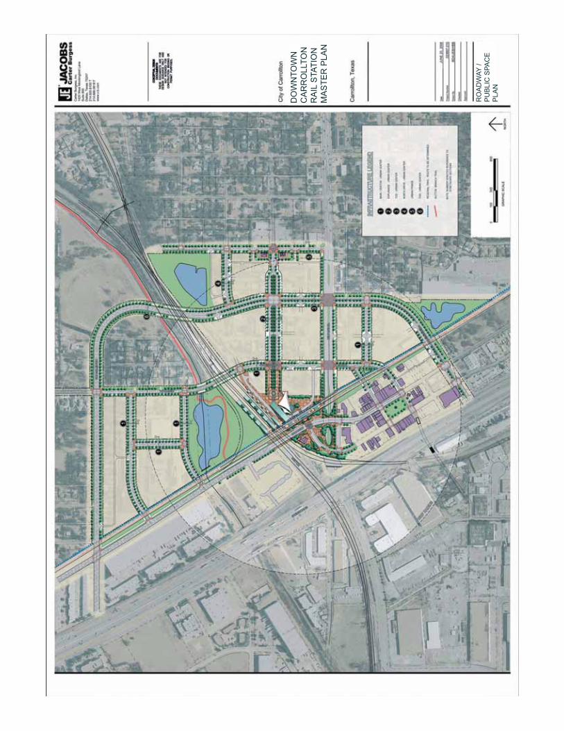
DO
WN
TOW
N
CA
RR
OLL
TON
R
AIL
STA
TIO
N
MA
STE
R P
LAN
RO
AD
WAY
/ P
UB
LIC
SPA
CE
P
LAN

DO
WN
TOW
N
CA
RR
OLL
TON
R
AIL
STA
TIO
N
MA
STE
R P
LAN
OA
K S
TRE
ET
ES
PLA
NA
DE
2 LA
NE
- U
RB
AN
CE
NTE
R S
TRE
ET
TOD
CO
NN
EC
TOR
- U
RB
AN
2 LA
NE
- U
RB
AN
CE
NTE
R S
TRE
ET
2 LA
NE
- U
RB
AN
FR
ING
E S
TRE
ET
TOD
CO
NN
EC
TOR
- FR
ING
E
SE
E R
OA
DW
AY /
PU
BLI
C S
PAC
E
PLA
N F
OR
KE
Y R
EFE
RE
NC
ES

DO
WN
TOW
N
CA
RR
OLL
TON
R
AIL
STA
TIO
N
MA
STE
R P
LAN

Downtown Carrollton Rail Station Master Plan | Phase Two | April 2009
6. Mercer Freight Yard Plan / Pro� le
6. Mercer Freight Yard Plan / Pro� le

DO
WN
TOW
N
CA
RR
OLL
TON
R
AIL
STA
TIO
N
MA
STE
R P
LAN

Trac
k Le
ngth
Com
paris
on -
Exis
ting
Mer
cer Y
ard
and
Prop
osed
Eas
t Bel
t Lin
e Si
te
DO
WN
TOW
N
CA
RR
OLL
TON
R
AIL
STA
TIO
N
MA
STE
R P
LAN

Downtown Carrollton Rail Station Master Plan | Phase Two | April 2009
7. Gateway Drawings
7. Gateway Drawings
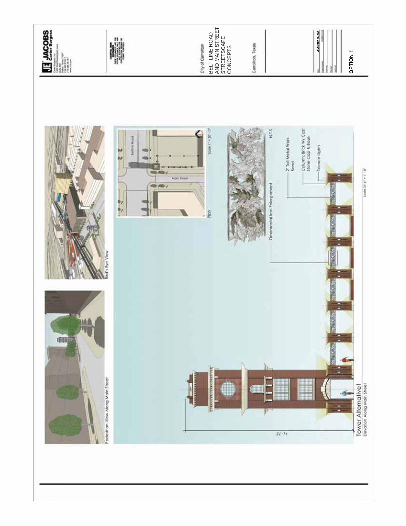
BE
LT L
INE
RO
AD
A
ND
MA
IN S
TRE
ET
STR
EE
TSC
AP
EC
ON
CE
PTS

BE
LT L
INE
RO
AD
A
ND
MA
IN S
TRE
ET
STR
EE
TSC
AP
EC
ON
CE
PTS


Downtown Carrollton Rail Station Master Plan | Phase Two | April 2009
8. Cost Estimate Summary
8. Cost Estimate Summary

D o w n t o w n C a r r o l l t o n S t a t i o n M a s t e r P l a nE s t i m a t e o f P r o b a b l e C o n s t r u c t i o n C o s t sJuly 2, 2008
SummaryPhase 1 Phase 2 Phase 3A Phase 3B Total
Infrastructure $5,440,623 $17,857,339 $31,374,929 $7,581,069 $62,253,960
Transit Hall $9,185,575 $9,185,575
Stations (by others) $8,679,933 $0
East Belt Line Yard $7,782,378 $7,782,378
Public Parking $5,328,000 $5,328,000
$5,440,623 $30,967,717 $49,240,437 $7,581,069 $84,549,913
Notes:
Master Plan / Infrastructure
This estimate is based on JCB Master Plan and Infrastructure Plan dated June 2, 2008.
This estimate is based on unit prices updated in May, 2008.
Estimate is for public facilities and infrastructure in public right of way only.
Cost for DART/Transit parking is not included. Carried as part of privated development costs
Estimate does not include land cost, land maintenance, interest, legal, financing, marketing, etc.
All costs included design fees, design contingencies appropriate to construction type, construction and construction contingencies
Estimate for transit stations do not include railroad relocations or trackwork
Costs do not include internal administrative cost for City of Carrollton, DART and other agencies.
Estimate does not include environmental reports or wetlands determinations.
Costs of a flood study and FEMA processing are not included in this estimate.
Cost estimate does not assume any city inspection fees will be assessed on the project.
This estimate was prepared without the benefit of geotechnical data.
This estimate does not include environmental reports or wetlands determinations.
East Belt Line Yard
Dismantling and salvage of existing Mercer Yard is not included
Track lengths include adjustments (reduction) to account for cleanouts
Trackwork costs based on LTK estimate dated May 1, 2008

TRANSIT HALL SUMMARY
PROJECT NAME: Carrollton Downtown Rail Station Masterplan NET DEVELOPABLE ACREAGE: N/A NO. OF LOTS: N/ATOWN: July 2, 2008 TOTAL GROSS ACREAGE: 76.5 CREATED BY: CJH
JOB NUMBER: 023607.010 CREATED: 03-Jun-08 CHECKED BY: KFS
FILE NAME: CE_6.3.08.xls PRINTED: 10-Dec-08 REVISED BY:
SUMMARY
Phase 1 Phase 2 Phase 3A Phase 3B TOTAL
I. TRANSIT HALL $0.00
I1 BUILDING ENCLOSURE $3,555,130.00
I2 TENISLE STRUCTURE $2,510,000.00
I3 MONUMENTAL STAIR $417,280.00 $0.00
SUB-TOTAL: $0.00 $0.00 $6,482,410.00 $0.00 $6,482,410.00
DESIGN FEES: 12% $0.00 $0.00 $777,889.20 $0.00 $777,889.20
DESIGN CONTINGENCIES: 15% $0.00 $0.00 $972,361.50 $0.00 $972,361.50
SUB-TOTAL: $0.00 $0.00 $8,232,660.70 $0.00 $8,232,660.70
CONSTRUCTION CONTINGENCIES 10% $0.00 $0.00 $823,266.07 $0.00 $823,266.07
GEOTECHNICAL & MATERIALS TESTING: 2% $0.00 $0.00 $129,648.20 $0.00 $129,648.20
TOTAL CONSTRUCTION COSTS: $0.00 $0.00 $9,185,574.97 $0.00 $9,185,574.97
Master Plan
Master Plan
MASTER PLAN

STATIONS SUMMARY (STATIONS BY OTHERS)
PROJECT NAME: Carrollton Downtown Rail Station Masterplan NET DEVELOPABLE ACREAGE: N/A NO. OF LOTS: N/ATOWN: July 2, 2008 TOTAL GROSS ACREAGE: 76.5 CREATED BY: CJH
JOB NUMBER: 023607.010 CREATED: 03-Jun-08 CHECKED BY: KFS
FILE NAME: CE_6.3.08.xls PRINTED: 10-Dec-08 REVISED BY:
SUMMARY
Phase 1 Phase 2 Phase 3A Phase 3B TOTAL
J. STATIONS
J1 ELEVATED PEDESTRAIN CONCOURSE $1,761,782.00 $1,761,782.00
j2 CROSSTOWN STATION $2,442,546.00 $2,442,546.00
j3 FRISCO STATION $2,117,546.00 $2,117,546.00
SUB-TOTAL: $0.00 $0.00 $6,321,874.00 $0.00 $6,321,874.00
DESIGN FEES: 8% $0.00 $0.00 $505,749.92 $0.00 $505,749.92
DESIGN CONTINGENCIES: 15% $0.00 $0.00 $948,281.10 $0.00 $948,281.10
SUB-TOTAL: $0.00 $0.00 $7,775,905.02 $0.00 $7,775,905.02
CONSTRUCTION CONTINGENCIES 10% $0.00 $0.00 $777,590.50 $0.00 $777,590.50
GEOTECHNICAL & MATERIALS TESTING: 2% $0.00 $0.00 $126,437.48 $0.00 $126,437.48
TOTAL CONSTRUCTION COSTS: $0.00 $0.00 $8,679,933.00 $0.00 $8,679,933.00
EAST BELT LINE YARD SUMMARY
PROJECT NAME: Carrollton Downtown Rail Station Masterplan NET DEVELOPABLE ACREAGE: N/A NO. OF LOTS: N/ATOWN: July 2, 2008 TOTAL GROSS ACREAGE: 76.5 CREATED BY: LTK
JOB NUMBER: 023607.010 CREATED: 03-Jun-08 CHECKED BY: AWZ
FILE NAME: CE_6.3.08.xls PRINTED: 10-Dec-08 REVISED BY:
SUMMARY
Phase 1 Phase 2 Phase 3A Phase 3B TOTAL
A. YARD TRACKWORK $1,490,541.00 $1,490,541.00
B. AFFILIATED TRACKWORK $1,288,890.50 $1,288,890.50
C. REHABILITATED TRACKWORK $238,136.00 $238,136.00
D. BUILDINGS $602,000.00 $602,000.00
E. SITE DEVELOPMENT $1,747,590.00 $1,747,590.00
SUB-TOTAL: $0.00 $5,367,157.50 $0.00 $0.00 $5,367,157.50
DESIGN FEES: 10% $0.00 $536,715.75 $0.00 $0.00 $536,715.75
DESIGN CONTINGENCIES: 20% $0.00 $1,073,431.50 $0.00 $0.00 $1,073,431.50
SUB-TOTAL: $0.00 $6,977,304.75 $0.00 $0.00 $6,977,304.75
CONSTRUCTION CONTINGENCIES 10% $0.00 $697,730.48 $0.00 $0.00 $697,730.48
GEOTECHNICAL & MATERIALS TESTING: 2% $0.00 $107,343.15 $0.00 $0.00 $107,343.15
TOTAL CONSTRUCTION COSTS: $0.00 $7,782,378.38 $0.00 $0.00 $7,782,378.38
Master Plan
Master Plan

Downtown Carrollton Rail Station Master Plan | Phase Two | April 2009
9. Public / Private Finance Plan
9. Public / Private Finance Plan

Down
town
Sta
tion
Publ
ic /
Priv
ate
Fina
nce
Plan
City
of C
arro
llton,
TX
Augu
st 19
, 200
8

Downtown Carrollton Rail Station Master Plan | Phase Two | April 2009
10. Railroad Coordination Meeting Notes
10. Railroad Coordination Meeting Notes

���������������� ��������� �� � �� �� ���� � �� � ��� ��� � � ���� ��� � �� � ��� �� ��� !�"#� � � � � � � � ��� �"�� ����� � � $�� ���� �%�� ��%�� �
Meeting Minutes
Date: November 30, 2007 Time: 9:00AM Location: City of Carrollton
Project: Carrollton Downtown Rail Station
Master Plan
023607.010 Re: Phase 2 Kick-Off
Mercer Relocation Attendees: Tom Neville, DART Kay Shelton, DART Wayne Friesner, DART Tim Wells, LTK Cesar Molina, COC Allan Zreet, C&B Peter Braster, COC Tom Hammons, COC Marc Guy, COC ITEMS DISCUSSED:
1. The Scope of Work for Phase 2 was reviewed. The scope of work outline follows:
Task 7: Rail Station Complex Alternatives Task 8: Railroad/Passenger Service Development Task 9: Development/Financial Analysis Task 10: Mixed-Use Development Plan Task 11: Rail Station Complex Schematics Task 12: Public Transit Funding Sources Task 13: Presentation Materials Task 14: Final Report Task 15: Website Update Support
$25,000 of the Task 8 was completed in Phase 1 under a limited notice to proceed in order to provide an evaluation of Mercer Yard Alternatives. An additional task will be required in Phase 2 to complete the Mercer Yard relocation to a schematic level.
2. Mercer Yard Status & Development Tom Neville indicated that the equipment maintenance shop could be relocated to the Mockingbird Yard, per suggestion by DGNO. Tom also mentioned that DGNO thought they could move current Mercer Yard classification work to Mockingbird, potentially alleviating the need for a multi-track yard. Space availability at Mockingbird for the shop and additional classification work needs further investigation.

���������������� ��������� �� � �� �� ���� � �� � ��� ��� � � ���� ��� � �� � ��� �� ��� !�"#� � � � � � � � ��� �"�� ����� � � $�� ���� �%�� ��%�� �
The current yard layout for the East Belt Line location included yard access leads on the east and west ends of the yard to improve the yard function over the current Mercer Yard layout which is stub ended. The double ended yard layout created a steep grade on the east yard lead that DGNO expressed unacceptability at the last meeting on October 2, 2006 and recently to Tom Neville. The stub end yard may improve track grades in the yard and for the yard leads. DART will discuss the concept of a stub end yard with DGNO prior to JCB/LTK developing an alternative layout. [T. Neville, DART]. Jacobs Carter Burgess/LTK will investigate an alternative layout for the East Belt Line location using a stub end yard similar to the existing condition.
3. Further Mercer Yard Development
In order to complete more detailed yard layout and confirm track profiles the following information will be needed: Track Survey
Boundary and topo survey Utilities survey Verification of industrial spur track usage Confirmation of use of City of Carrollton Property Verification of City of Carrollton property usage (fuel depot) DGNO Track/Yard Standards
DART will provide the following information: DGNO Track Charts, Mockingbird Yard Layout DGNO Yard/Track Standards. [T. Neville, DART] Timing and availability on use of the City’s fueling site will be confirmed with Mark Randall, Manager of Fleet Services [C. Molina, COC]
4. Contract Modifications Jacobs Carter Burgess will add Task 8b to the Scope of Services to include the following work for advancement of the Mercer Yard relocation: [A. Zreet, JCB]
8b.1 East Belt Line Yard Survey 8b.2 East Belt Line Yard Layout Alternatives 8b.3 Preferred East Belt Line Yard Plan 8b.4 DGNO yard operations meetings 8b.5 Facilitation of Yard Location Sign-off by DART & DGNO 8b.6 Columbian Country Club Mitigation
5. Columbian Country Club Status.
The club intends to remain in operations but is willing to work with the city to redevelop an entrance of Kelly Blvd to allow use of the club property south of the Cotton Belt line.
The city intends to purchase the property and provide an allowance for access modifications. The city will allow an access easement for the club until the yard relocation is initiated (possibly 3-4 years)
Submitted by : Allan Zreet 12/4/07

���������������� ��������� �� � �� �� ���� � �� � ��� ��� � � ���� ��� � �� � ��� �� ��� !�"#� � � � � ��� �"�� ����� � � $�� ���� �%�� ��%�� �
Meeting Minutes
Date: February 26, 2008 Time: 10:00 AM Location: City of Carrollton
Project: Carrollton Downtown Rail Station
Master Plan
023607.010 Re: Revised East Belt Line Yard Layout
Attendees: Cesar Molina, COC Tim Wells, LTK Tom Hammons, COC Allan Zreet, JCB Marcos Fernandez, COC Peter Braster, COC Tom Neville, DART Numa Bulot, DART Copy: File ITEMS DISCUSSED The proposed East Beltline Yard layout has been updated based on survey data completed by JCB in early February. A proposed layout for a double ended yard was reviewed discussed in terms of profile, replacement track capacity and customer service. The layout assumes the following:
� 700’ ramp at 1.5% grade � Raising track for 200’ west of Kelly Blvd. � 1400’ 1% grade at yard � Raising of Kelly Blvd by 2 feet.
Discussed lowering of Kelly to grade separate. Would allow tracks to be raised up to 10’ providing < 1% grade. Would require lowering of Kelly minimum of 10’. Drainage would require sumps. Consider long sidings between Josey and Kelly to reduce storage tracks in the yard. A double end yard layout cannot be achieved without violation of DGNO criteria and severe cost constraints to re-grade tracks east and west of the yard. JCB/LTK is to develop a single yard replicating existing conditions at Mercer Yard. Mercer Yard layout is to be baseline for costs. If additional capacity or double end access can be achieved, carry as separate costs. Assume maintenance pit is relocated to Mockingbird Yard. Engine track will still be needed.

���������������� ��������� �� � �� �� ���� � �� � ��� ��� � � ���� ��� � �� � ��� �� ��� !�"#� � � � � ��� �"�� ����� � � $�� ���� �%�� ��%�� �
Submitted by: Allan Zreet, C&B
2/28/08
Attachments: Mercer Yard Layout Yard Track Profile East Belt Line Yard Plan

���������������� ��������� �� � �� �� ���� � �� � ��� ��� � � ���� ��� � �� � ��� �� ��� !�"#� � � � � ��� �"�� ����� � � $�� ���� �%�� ��%�� �
Meeting Minutes
Date: May 6, 2008 Time: 1:30 PM Location: DGNO Office
Project: Carrollton Downtown Rail Station
Master Plan
023607.010 Re: Revised East Belt Line Yard Layout
Attendees: Cesar Molina, COC Clint Martin, RailAmerica Tom Neville, DART Darryl Gabriel, RA Jim Kuntz, DGNO Lonnie Blaydes, Blaydes Consulting Sandy Cox, DGNO Tim Wells, LTK John Rogers, DGNO Allan Zreet, JCB Nathaniel Morgan, DGNO/CEPC Copy: File ITEMS DISCUSSED A presentation was made of the revisions to the proposed East Beltline Yard layout based on comments by DART and DGNO at previous meetings. A schematic yard layout, track profiles and site cross sections were presented. The revisions presented are intended to resolve yard grading and access issues discussed at previous meetings. The layout provides for duplication of all tracks at Mercer Yard with provision for future storage track expansion. 1. Comments by DGNO follow:
� Make more tracks double ended - DGNO is willing to reduce the number of tracks in the yard to achieve better access.
� Creating a longer yard body footprint by having a short steeper grade on the west end. A 1.5 percent grade from Kelly Boulevard for the first 700 feet is acceptable
� Have the mainline/yard lead switches with remote control machines (DTMFs), enabling trains to make the moves into the yard without stopping
� Install a split point derail on the down hill yard lead
� Upgrade the track from downtown Carrollton to the yard for 25-30 mph
� Provide for yard lighting, fencing around the site, and other reasonable security set-ups

���������������� ��������� �� � �� �� ���� � �� � ��� ��� � � ���� ��� � �� � ��� �� ��� !�"#� � � � � ��� �"�� ����� � � $�� ���� �%�� ��%�� �
� DGNO is interested in moving the shop functions to Mockingbird Yard. Most of the infrastructure for a shop is in place at Mockingbird with the primary hurdle is setting up an oil and water separator system.
� DGNO needs a crew building of approximately 500 - 800 square feet. The facilities will require an office with desk, copyt/fax and a single restroom
� DGNO projects needing train crew parking of 10 spots, locating on west side of yard by street is OK
� An earthen berm will be needed at the west end of the yard tracks to protect the City of Carrollton water tanks.
2. DGNO provided a sketch with proposed modifications including the following:
� 4 double-ended body tracks as long as possible � Add an additional double-ended track to serve as a RIP � Add an additional outer stub track to serve for transloading. � straight yard ladder containing all the turnouts and larger turnouts.
The sketch suggests the unit quantities of track materials may be comparable to the existing Mercer Yard.
3. The above requests can be accommodated within the scope of the currently proposed yard layout. The requests also appear to compensate DGNO for additional operating and risk exposure created by moving the yard up the "hill." Additional development will be required to incorporate the requested modifications. While this development is beyond the scope of the current City of Carrollton study, the modifications can be incorporated in advanced planning of the yard.
4. DGNO indicated that flagging costs will be needed for yard construction. If new track work can be kept beyond 25 feet from the nearest track, flagging will not be required reducing costs.
5. DGNO requested that the existing two miles of track from downtown Carrollton may require upgrading to
achieve a speed of 25-30 mph. The cost of this upgrade will be evaluated by JCB/LTK but may be within current contingencies.
6. A preliminary budget of approximately $7.5 million was reviewed. The budget will be updated to include
items discussed however the costs should not change significantly. 7. The proposed yard layout presented will provide an operational rail yard meeting DGNO’s criteria and
operations requirements (subject to requested modifications documented above). Based on the outcome of the meeting, the City of Carrollton may begin negotiations for purchase of the property for future yard construction assuming that DART will be willing to compensate the city for the land acquisition.
Submitted by: Allan Zreet, C&B 5/30/08
Attachments: Yard Track Profile
East Belt Line Yard Plan