Disaster Risk Reduction -...
4
Key Messages Floods pose the most significant threat to Banda Aceh city, and it is anticipated that its impacts would be further exacerbated under projected climate scenarios Early warning systems need to be established to reduce the impacts of floods in Banda Aceh The city requires a climate-sensitive disaster management plan, with a focus on flood management, that can draw on the assessments of loss and damage at the national and provincial level Establishment of emergency response and rescue teams equipped with required tools and transport facilities in order to access all areas in Banda Aceh city is the need of the hour The city also needs to improve resilience of community by capacity building, knowledge transfer and information dissemination Strengthening the ongoing initiatives of incorporating weather anomalies into planning and decision making by the government is the need of the hour Disaster Risk Reduction Towards Flood Resilience in Banda Aceh, Indonesia City Introduction Banda Aceh is the capital and largest city in the province of Aceh (refer Figure 1). It is located on the island of Sumatra and has an elevation of 35 metres. The city covers an area of 64 square kilometres and had a population of 219,070 Figure 1: Location of Banda Aceh in Indonesia Aceh North Sumatra West Sumatra Riau Riau Islands Jambi South Sumatra Bangka- Belitung Bengkulu Lampung Jakarta Banten West Java Central Java Yogyakarta East Java Bali West Nusa Tenggara East Nusa Tenggara West Kalimantan Central Kalimantan South Kalimantan East Kalimantan North Sulawesi Gorontalo Central Sulawesi West Sulawesi South Sulawesi South East Sulawesi Maluku North Maluku West Papua Papua North Kalimantan Banda Aceh INDONESIA Photo Credit: Google images Impact of Tsunami in 2004 More than 2/3rd of city destroyed 61,065 people dead and missing 21,751 houses destroyed 302 km of roads destroyed 9 market buildings destroyed 25 health facilities destroyed
Transcript of Disaster Risk Reduction -...

Key Messages
�� Floods pose the most significant threat to Banda Aceh city, and it is anticipated that its impacts would be further exacerbated under projected climate scenarios
�� Early warning systems need to be established to reduce the impacts of floods in Banda Aceh
�� The city requires a climate-sensitive disaster management plan, with a focus on flood management, that can draw on the assessments of loss and damage at the national and provincial level
�� Establishment of emergency response and rescue teams equipped with required tools and transport facilities in order to access all areas in Banda Aceh city is the need of the hour
�� The city also needs to improve resilience of community by capacity building, knowledge transfer and information dissemination
�� Strengthening the ongoing initiatives of incorporating weather anomalies into planning and decision making by the government is the need of the hour
Disaster Risk Reduction Towards Flood Resilience in Banda Aceh, Indonesia
City IntroductionBanda Aceh is the capital and largest city in the province of Aceh (refer Figure 1). It is located on the island of Sumatra and has an elevation of 35 metres. The city covers an area of 64 square kilometres and had a population of 219,070
Figure 1: Location of Banda Aceh in Indonesia
AcehNorth Sumatra
West Sumatra
Riau Riau Islands
Jambi
South Sumatra
Bangka-Belitung
Bengkulu
Lampung Jakarta
BantenWest Java
Central Java
YogyakartaEast Java Bali
West Nusa Tenggara
East Nusa Tenggara
West Kalimantan
Central Kalimantan
South Kalimantan
East Kalimantan
North SulawesiGorontalo
Central Sulawesi
West Sulawesi
South Sulawesi
South East Sulawesi
Maluku
North Maluku West
Papua
Papua
NorthKalimantan
Banda AcehINDONESIA
Phot
o Cr
edit:
Goo
gle i
mag
es
Impact of Tsunami in 2004
�� More than 2/3rd of city destroyed
�� 61,065 people dead and missing
�� 21,751 houses destroyed
�� 302 km of roads destroyed
�� 9 market buildings destroyed
�� 25 health facilities destroyed
people, according to the 2010 census. The city has a population density of 3,457/km2. The city is divided into nine administrative divisions.
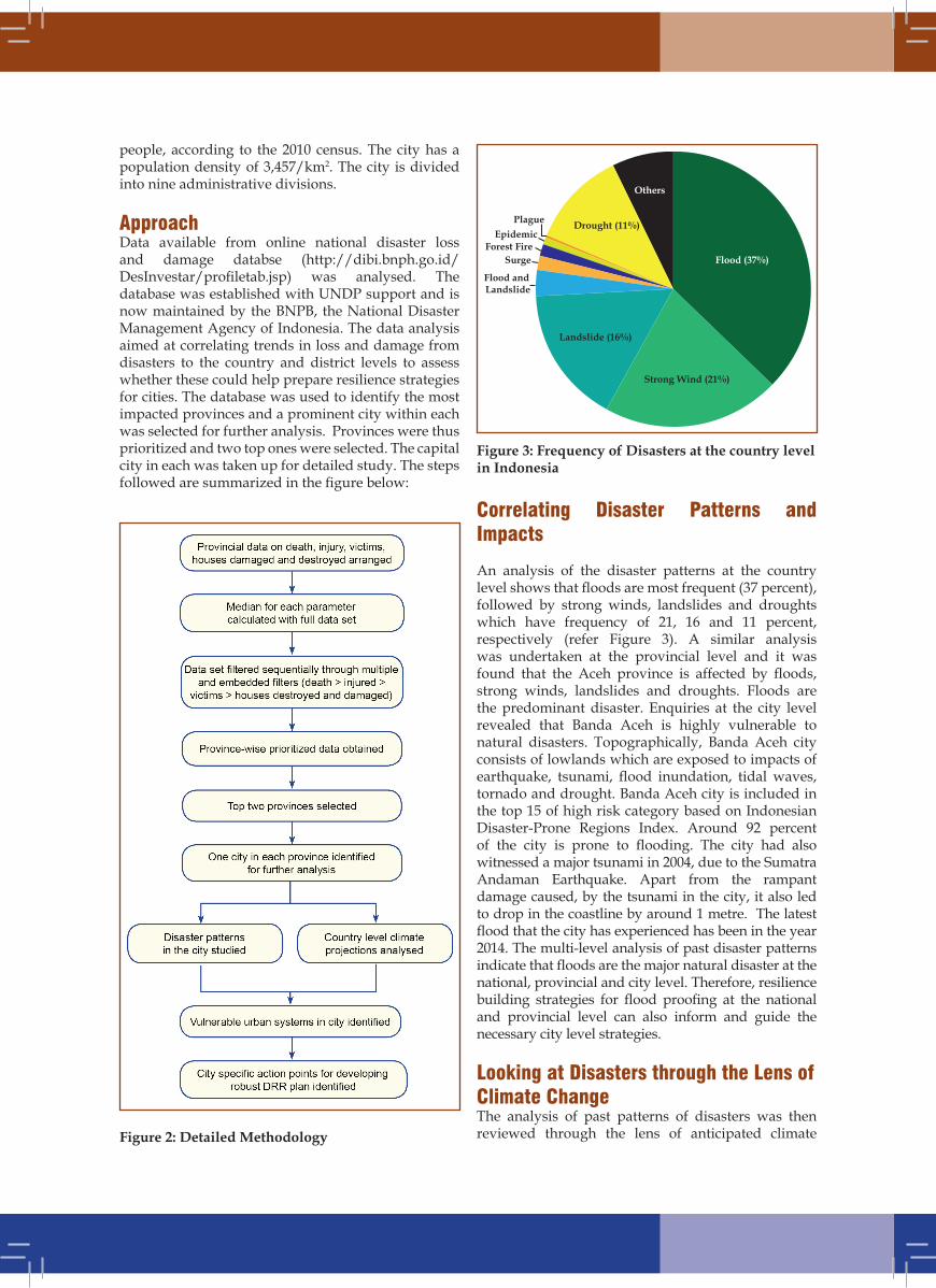
ApproachData available from online national disaster loss and damage databse (http://dibi.bnph.go.id/DesInvestar/profiletab.jsp) was analysed. The database was established with UNDP support and is now maintained by the BNPB, the National Disaster Management Agency of Indonesia. The data analysis aimed at correlating trends in loss and damage from disasters to the country and district levels to assess whether these could help prepare resilience strategies for cities. The database was used to identify the most impacted provinces and a prominent city within each was selected for further analysis. Provinces were thus prioritized and two top ones were selected. The capital city in each was taken up for detailed study. The steps followed are summarized in the figure below:
Figure 3: Frequency of Disasters at the country level in Indonesia
Correlating Disaster Patterns and Impacts
An analysis of the disaster patterns at the country level shows that floods are most frequent (37 percent), followed by strong winds, landslides and droughts which have frequency of 21, 16 and 11 percent, respectively (refer Figure 3). A similar analysis was undertaken at the provincial level and it was found that the Aceh province is affected by floods, strong winds, landslides and droughts. Floods are the predominant disaster. Enquiries at the city level revealed that Banda Aceh is highly vulnerable to natural disasters. Topographically, Banda Aceh city consists of lowlands which are exposed to impacts of earthquake, tsunami, flood inundation, tidal waves, tornado and drought. Banda Aceh city is included in the top 15 of high risk category based on Indonesian Disaster-Prone Regions Index. Around 92 percent of the city is prone to flooding. The city had also witnessed a major tsunami in 2004, due to the Sumatra Andaman Earthquake. Apart from the rampant damage caused, by the tsunami in the city, it also led to drop in the coastline by around 1 metre. The latest flood that the city has experienced has been in the year 2014. The multi-level analysis of past disaster patterns indicate that floods are the major natural disaster at the national, provincial and city level. Therefore, resilience building strategies for flood proofing at the national and provincial level can also inform and guide the necessary city level strategies.
Looking at Disasters through the Lens of Climate ChangeThe analysis of past patterns of disasters was then reviewed through the lens of anticipated climate Figure 2: Detailed Methodology
Others
Drought (11%)PlagueEpidemic
Forest FireSurge
Flood and Landslide
Landslide (16%)
Strong Wind (21%)
Flood (37%)
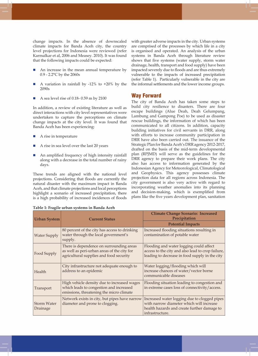
Table 1: Fragile urban systems in Banda Aceh
Urban System Current StatusClimate Change Scenario: Increased
PrecipitationPotential Impacts
Water Supply 80 percent of the city has access to drinking water through the local government’s supply.
Increased flooding situations resulting in contamination of potable water
Food Supply
There is dependence on surrounding areas as well as peri-urban areas of the city for agricultural supplies and food security
Flooding and water logging could affect access to the city and also lead to crop failure, leading to decrease in food supply in the city
HealthCity infrastructure not adequate enough to address to an epidemic
Water logging/flooding which will increase chances of water/vector borne communicable diseases
TransportHigh vehicle density due to increased wages which leads to congestion and increased emissions, threatening the micro climate
Flooding situation leading to congestion and in extreme cases loss of connectivity/access.
Storm Water Drainage
Network exists in city, but pipes have narrow diameter and prone to clogging.
Increased water logging due to clogged pipes with narrow diameter which will increase health hazards and create further damage to infrastructure.
change impacts. In the absence of downscaled climate impacts for Banda Aceh city, the country level projections for Indonesia were reviewed (refer Karmalkar et al, 2006 and Measey. 2010). It was found that the following impacts could be expected:
�� An increase in the mean annual temperature by 0.9 - 2.2°C by the 2060s
�� A variation in rainfall by -12% to +20% by the 2090s
�� A sea level rise of 0.18- 0.59 m by 2100
In addition, a review of existing literature as well as direct interactions with city level representatives were undertaken to capture the perceptions on climate change impacts at the city level. It was found that Banda Aceh has been experiencing:
�� A rise in temperature
�� A rise in sea level over the last 20 years
�� An amplified frequency of high intensity rainfall along with a decrease in the total number of rainy days.
These trends are aligned with the national level projections. Considering that floods are currently the natural disaster with the maximum impact in Banda Aceh, and that climate projections and local perceptions highlight a scenario of increased precipitation, there is a high probability of increased incidences of floods
with greater adverse impacts in the city. Urban systems are comprised of the processes by which life in a city is organised and operated. An analysis of the urban systems in Banda Aceh through literature review shows that five systems (water supply, storm water drainage, health, transport and food supply) have been impacted severely due to floods and are thus extremely vulnerable to the impacts of increased precipitation (refer Table 1). Particularly vulnerable in the city are the informal settlements and the lower income groups.
Way ForwardThe city of Banda Aceh has taken some steps to build city resilience to disasters. There are four escape buildings (Alue Deah, Deah Gelumpang, Lambung and Gampong Poe) to be used as disaster rescue buildings, the information of which has been communicated to all citizens. In addition, capacity building initiatives for civil servants in DRR, along with efforts to increase community participation in DRR have also been carried out. The issuance of the Strategic Plan for Banda Aceh’s DRR agency 2012-2017, drafted on the basis of the mid-term developmental plan (RPJMD) will serve as the guidelines for the DRR agency to prepare their work plans. The city also has access to information generated by the Indonesian Agency for Meteorological, Climatological and Geophysics. This agency possesses climate projection data for all regions across Indonesia. The city government is also very active with regard to incorporating weather anomalies into its planning and decision-making, which is exemplified from plans like the five years development plan, sanitation
This document has been developed as part of a project on disaster risk reduction, funded by UNDP Bangkok Regional Hub.
For more information, please contact:
ICLEI - Local Governments for Sustainability, South AsiaGround Floor, NSIC-STP Complex, NSIC BhawanOkhla Industrial Estate, New Delhi - 110020, IndiaTel: +91-11-4106 7220; Fax: +91-11-4106 7221E-mail: [email protected]; Web: http://southasia.iclei.org/ www.facebook.com/ICLEISouthAsia; www.twitter.com/ICLEISouthAsia
master plan, Qanun Banda Aceh city No.4 year 2009 concerning Spatial Planning of Banda Aceh city 2009-2029 and Qanun Banda Aceh city No. 3 year 2011 concerning Organisation Structure and Working Procedure of local DRR agency. The residents as well as city officials are actively involved in measures with regard to waste water and solid waste management, along with taking up initiatives on transportation and health issues. Though the city does not have a disaster management plan, a mitigation action plan exists at the provincial level.
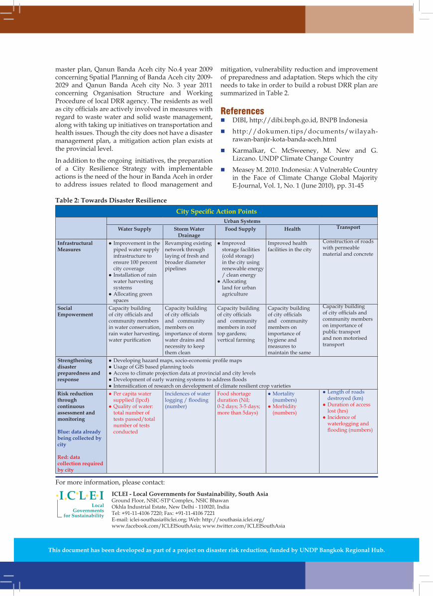
In addition to the ongoing initiatives, the preparation of a City Resilience Strategy with implementable actions is the need of the hour in Banda Aceh in order to address issues related to flood management and
mitigation, vulnerability reduction and improvement of preparedness and adaptation. Steps which the city needs to take in order to build a robust DRR plan are summarized in Table 2.
References�� DIBI, http://dibi.bnph.go.id, BNPB Indonesia
�� http://dokumen.tips/documents/wilayah-rawan-banjir-kota-banda-aceh.html
�� Karmalkar, C. McSweeney, M. New and G. Lizcano. UNDP Climate Change Country
�� Measey M. 2010. Indonesia: A Vulnerable Country in the Face of Climate Change Global Majority E-Journal, Vol. 1, No. 1 (June 2010), pp. 31-45
Table 2: Towards Disaster ResilienceCity Specific Action Points
Urban SystemsWater Supply Storm Water
DrainageFood Supply Health Transport
Infrastructural Measures
l Improvement in the piped water supply infrastructure to ensure 100 percent city coverage
l Installation of rain water harvesting systems
l Allocating green spaces
Revamping existing network through laying of fresh and broader diameter pipelines
l�Improved storage facilities (cold storage) in the city using renewable energy / clean energy
l Allocating land for urban agriculture
Improved health facilities in the city
Construction of roads with permeable material and concrete
Social Empowerment
Capacity building of city officials and community members in water conservation, rain water harvesting, water purification
Capacity building of city officials and community members on importance of storm water drains and necessity to keep them clean
Capacity building of city officials and community members in roof top gardens; vertical farming
Capacity building of city officials and community members on importance of hygiene and measures to maintain the same
Capacity building of city officials and community members on importance of public transport and non motorised transport
Strengthening disaster preparedness and response
l Developing hazard maps, socio-economic profile mapsl Usage of GIS based planning toolsl Access to climate projection data at provincial and city levelsl Development of early warning systems to address floodsl Intensification of research on development of climate resilient crop varieties
Risk reduction through continuous assessment and monitoring
Blue: data already being collected by city
Red: data collection required by city
l Per capita water supplied (lpcd)
l Quality of water: total number of tests passed/total number of tests conducted
Incidences of water logging / flooding (number)
Food shortage duration (Nil;0-2 days; 3-5 days; more than 5days)
l Mortality (numbers)
l Morbidity (numbers)
l Length of roads destroyed (km)
l Duration of access lost (hrs)
l Incidence of waterlogging and flooding (numbers)